ASMARA: AFRICA’S MODERNIST CITY - …s... · historic urban landscape ... as part of wider and...
20
ASMARA: AFRICA’S MODERNIST CITY Candidature for UNESCO World Heritage Listing
Transcript of ASMARA: AFRICA’S MODERNIST CITY - …s... · historic urban landscape ... as part of wider and...

1
ASMARA: AFRICA’S MODERNIST CITY
Candidature for UNESCO World Heritage Listing
2
CONTENTS
1. Preamble
2. Description of the Nominated Property
3. Justification for Inscription 4. Management System of Asmara
5. Conclusion
6. Signatures
3
6
10
15
18
19

3
1. Preamble
The State of Eritrea is signatory to three major UNESCO administered Conventions: the World Heritage Convention of 1972: the 2003 Convention on the Safeguarding of the Intangible Cultural Heritage; and the 1954 Convention for the Protection of Cultural Property in the Event of Armed Conflict. On 30th September 2015 Eritrea also enacted its first national heritage protection laws, titled: “Cultural and Natural Heritage Proclamation”. As cited in the proclamation, the sustainable protection, safeguarding, preservation, conservation, promotion, and dissemination of knowledge and practices in relation to the country’s cultural and natural heritage is beneficial for the social, economic, intellectual, artistic and cultural development of current and succeeding generations. The recognition of cultural diversity and fostering of cultural economies through legal instruments is vital for the sustainable development and safeguarding of heritage.
On 1st February 2016, the State of Eritrea submitted its first ever application to UNESCO for inscription on the World Heritage List (WHL). The nominated site was the country’s modernist capital, Asmara. The 1,300-page Nomination Dossier represents the distillation of nearly two decades of collaborative research by professionals from a wide range of disciplines in Eritrea and overseas, supported by many national and international government agencies. This paper summarizes the enormous quantity of work contained in the Nomination Dossier and its most important propositions as to why Asmara is significant as a World Heritage Site.
Asmara is an outstanding example of a colonial capital that bears witness to the universal encounter with modernity in the 20th century and consequent postcolonial experiences. The historic urban landscape embodies in a whole
city the unity of innovative urban planning and modernist architecture combined with local natural and cultural conditions. An urban planning process based on functional and racial zoning demonstrates the Italian colonial response from the late-19th century to the challenges of modern urban requirements in a highland African setting. The architectural character exemplifies a period of intense development in the 1930s that coincided with the global proliferation and artistic apogee of pre-war modernism and its various forms. The research challenges conventional perceptions based on universalistic norms, inviting a reassessment of how colonial heritage and modernism are perceived beyond the Eurocentric gaze.
Eritrea’s decision to conserve Asmara’s colonial era architecture represents a profoundly different attitude towards architectural heritage and its interpretation and treatment compared with many other post-colonial settings. Asmara’s nomination also presents an opportunity to encourage critical reflections on cultural relations and heritage globally, and to promote stability and prosperity locally. In addition, Asmara has the potential to contribute to a World Heritage global strategy to redress the comparative under-representation of African and modernist sites on the WHL.
The government of Eritrea has initiated several programmes and projects to preserve, conserve and safeguard the nation’s cultural and natural heritage and transmit it to future generations. The State of Eritrea has established and implemented appropriate measures to protect and manage Asmara’s historic urban landscape. The Central Region Administration, the Ministry of Education and the Commission of Culture and Sports have also jointly initiated and worked in collaboration to achieve the Asmara Heritage Project’s (AHP) objectives.

4
The AHP was founded in 2014 under the auspices of the Central Region Administration. The AHP is responsible for the production of the Nomination Dossier, the Integrated Management Plan (2016-2021), Disaster Risk Management Framework, the Urban Conservation Master Plan
(UCMP, 2017), the Asmara Planning Norms and Technical Regulation (APNTR, 2017). AHP has also completed a comprehensive building, open public spaces and infrastructure survey (over 4,300 sites surveyed), which will provide the basis for future heritage listing and management.
The Cathedral on Harnet Avenue, designed by Oreste Scanavini and completed in 1923.


6
2. Description of the Nominated Property
Eritrea is located in the Horn of Africa and attained formal independence in May 1993. It is bordered by Sudan to the northwest; Ethiopia to the south; Djibouti to the southeast; and the Red Sea to the north and north east. The country is subdivided into six administrative regions (Zobas), Asmara is the capital city and governed under the Central Region Administration.
Asmara – pronounced “Assmera” in Tigrinya – literally means “The women brought unity to the four villages”. Asmara was originally established during the 7th Century around the area where the present St Mary’s (Mariam Tsion) church
(commonly referred to as Enda-Mariam) is located. It was earlier on known as ‘Arbate-Asmera’, an ancient highland village with four settlement areas i.e. Geza-Asmea, Geza-Gurtom, Geza-Shilele and Geza-Serensir. The four settlements used to live independently of each other and had separate churches i.e. Gheza Asmea St-Kirkos; Geza-Gurtom St-Gabriel; Gheza-Shilele St-George (Biet-Giorgis); and Geza-Serensir St Mikael. They were however commonly linked to the church of Mariam-Tsion. Notwithstanding the harmonious life the four settlements enjoyed among each other, they were frequently attacked and pillaged by outside raiders and intruders. As legend has it,
Fig 1: National map showing the location of Asmara in the context of Eritrea.

7
Fig 2: Regional map showing the location of Asmara in the Central Region Administrative Zone.
during one year of severe drought, they gathered together at the church of Mariam-Tsion to pray to the Almighty for rain. On this occasion, the women took the opportunity to persuade their husbands to unite their four villages for a stronger defense against their common enemies. A new name was henceforth adopted: “Arbaete-Asmera” or “the Four United”. With the passage of time the name Arbaete-Asmera was abridged to the present ‘Asmera’ or ‘Asmara’. For Eritreans, Asmara is not just their capital city, but an object of love; an icon of unity with a very strong social bondage and attachment. This intangible aspect of Asmara’s cultural significance is critical to the nomination of the city for world heritage listing as part of wider and richer historiography than merely modernist architecture and planning.
Asmara, Africa’s Modernist City, is the capital of Eritrea, in the Horn of Africa (see Fig 1). The city is located in the centre of the country in the Zoba Maekel Administration Region on a plateau 2,300 m above sea level at the edge of an escarpment that forms part of the great East African rift system. For the location of Asmara at national and regional level see Fig 1 and Fig 2 respectively.
The proposed World Heritage Site of Asmara comprises the city’s ‘historic’ centre founded on the site of an ancient local settlement and developed during the years of Italian occupation from 1889-1941. The evolution of the urban plan over this period subject to local climate, topographical, political and cultural features has produced one of the most complete early-modernist built environments in the world. As an outcome of a cumulative planning process over decades, Asmara’s layout is an embodiment of the universal encounter with modernity in the 20th century in an African context. The site extends from the indigenous quarter of Abbashawel in the north to the industrial and residential districts of Gejeret and Tiravolo in the south, and from the edge of the escarpment in the east to ‘Forto’ and the Italian cemetery in the west. Contained within this total urban setting are the successive phases of early-modern urban planning that defined Asmara’s layout and the majority of buildings and structures that give the city its modernist architectural character. In the detailed description in the Nomination Dossier, the site is separated into three thematic categories: Urban Planning; Modernist Architecture; and the African Context.

8
Fig 3: Boundary Map, showing the boundaries of the Nominated Property, Buffer Zone and Protected Zone
A Buffer Zone surrounds the nominated property and follows urban and natural features (the city limits up to the peaks of surrounding hills and the escarpment edge) and urban districts (industrial and more recent residential zones on the city’s southern outskirts and residential developments to the north) (see Fig 3).
A Protected Zone encircles the eastern and northern perimeters of the Buffer Zone. This is designed to protect the ‘green belt’ of the escarpment edge which forms a prominent and picturesque backdrop to the city (see Fig 3).


10
3. Justification for Inscription
The modernist city of Asmara is an outstanding example of a colonial capital that bears witness to the universal encounter with modernity in the 20th century and consequent postcolonial experiences. The historic urban landscape embodies in a whole city the unity of innovative urban planning and modernist architecture combined with local natural and cultural conditions. An urban planning process based on functional and racial zoning demonstrates the Italian colonial response from the late 19th century to the challenges of modern urban requirements in a highland African setting. The architectural character exemplifies a period of intense development in the 1930s that coincided with the global proliferation and artistic apogee of pre-war modernism and its various forms. The result is a total urban landscape characterised by its human-scale and mixed uses, built forms, and activities, including well-defined open spaces, cinemas, shops, banks, religious structures, public and private offices, industrial facilities, and residences. The integrity and authenticity of Asmara’s functional, aesthetic and cultural values have been retained through a protracted struggle for independence and subsequently assimilated into a national consciousness in which Asmara features centrally.
3.1 Criteria under which the site is proposed:
The historic centre of Asmara is proposed for inscription as an outstanding example of a capital city that embodies the unity of early town planning principles and modernist architecture combined with local natural and cultural conditions consistent with its highland African setting. The site is proposed for inscription under the following criteria:
Criterion (ii): Asmara exhibits an outstanding example of the interchange of cultural influences
brought about by the encounter with modernity in an African context. The exchange is expressed in the unity of an innovative urban planning process and distinguished Modernist architecture combined with local natural and cultural conditions to create a distinctive urbanism based on human scale.
Criterion (iii): As a well-preserved total urban landscape and modern capital of Eritrea, Asmara bears exceptional testimony to the universal aspiration for and attainment of national self-determination founded on the protracted development of indigenous cultural and political consciousness through multiple encounters with regional civilizations and colonial experiences. Asmara was once a centre of established cultural traditions and trading networks spanning the region, before becoming the locus of uniquely varied foreign agendas of global significance before and during the Second World War and throughout the Cold War.
Criterion (iv): Asmara is an outstanding example of the transition in architecture and town planning at the turn of the 20th century in response to the universal encounter with modernity in an African context. The synthesis of modern town planning and architecture in a total urban landscape is an exemplar of early modernism adapted to local cultural and geographic conditions. As an urban landscape, Asmara encapsulates key stages of modernity’s development and principal characteristics, including colonialism and global conflict, scientific responses to planning and infrastructure, rapid technological and urban development, and pioneering transportation and communication.
Statement of IntegrityAll the significant architectural structures and the original urban layout, including most of the

11
characteristic features and public spaces, have been retained in their entirety. The site has also retained its historical, cultural, functional and architectural integrity with their elements largely intact and generally in good condition. The only negative impacts have been the occasional inapt restoration of older structures and the construction of some buildings in the late 20th century that are inappropriate in size, scale or character. Despite continuing developmental pressures, the establishment of the ‘Historic Perimeter’ around the centre of the city since 2001 and the imposition of a moratorium on new construction within this perimeter by the municipal authorities have safeguarded the site’s integrity.
The integrity of the intangible attributes associated with the indigenous community that has inhabited parts of the site for centuries has been maintained through a process of cultural continuity that, despite successive waves of foreign influence, has been successfully assimilated into a modern national consciousness and a national capital.
Statement of AuthenticityAsmara’s combination of innovative town planning and modernist architecture in an African context represent important and early developmental phases of town planning and architectural modernism and therefore possess a high level of authenticity.
The creation of Asmara’s urban plan coincided with the establishment of the modern profession of town planning; while the subsequent accretion of the city’s modernist architecture, characterized by the specifically Italian interpretation known as Rationalism, corresponded with the pre-war peak of modernism. Climatic, cultural, economic and political conditions over subsequent decades have been favourable in retaining the artistic, material and functional values of the city’s architectural elements, which include cinemas, apartment buildings, villas, petrol stations, factories, churches, and public buildings.The authenticity of local intangible attributes manifest in language, cultural practices, national identity, and sense of place have been retained through Asmara’s evolution from an indigenous centre of economy and administration, through a colonial capital, to a modern capital of an independent state.
3.2 Innovative Urban Planning ProcessAsmara’s innovative urban plan was laid out at the start of the 20th century, coinciding with the birth of the modern profession of town planning. Central to this new way of envisioning city planning in the early 20th century was the radial street pattern, which usurped the uniform grid to become the staple language of European and American planners for its efficiency and the opportunities it afforded in the creation of picturesque views, dramatic vistas, civic plazas, scenic spaces, and monumental sites. The radial city provided a rich and fertile ground for architecture and it was functional too. Radial street patterns afforded faster and more efficient circulation than a grid. Asmara’s planners recognised the benefits of modern planning, adopting their principles and combining them with elements of the gridiron system and adapting them to local topographical conditions. They also adopted the modern theory of zoning, which was a salient feature of the contemporaneous Garden Cities Movement. Asmara’s undulating topography created by volcanic basalt dike swarms which pass through the Plain of Asmara did not suit a rigid gridiron system. Local physical and cultural conditions as much as contemporaneous developments in town planning theory and practice internationally informed Asmara’s physical characteristics. In this uniquely African context the amalgamation of local natural and cultural conditions and modern town planning created the continent’s first modernist city.
Asmara is not a one-off urban plan, but rather the result of a process of innovative urban planning. The first three decades of Italian occupation in Eritrea provided the foundation on which the subsequent intense development of Asmara occurred and for its subsequent materialisation as a truly modernist city. The years 1896 to 1922 saw the design and initial execution of various urban plans addressing defining elements that informed the subsequent urban planning of the fledging colonial town of Asmara. In the first years of the 20th century, the early development of Asmara was characterised by a comparatively unimaginative grid system. The use of a grid was a device often used to impose order on the urban landscape and was a feature of modern planning in America and keenly adopted by European

12
colonialists in the 19th century, who extended its programme to exploit racial agendas.
Asmara’s 1902 plan focused primarily on improving public hygiene and concentrated only on the Italian community that was growing up around Campo Cintato, placing less emphasis on other public works and ignoring the indigenous areas. The 1908 Asmara plan, however, addressed the entire city and adopted the contemporary theory of zoning. In 1908, four distinct urban quarters were defined: European only, a ‘mixed’ quarter for Europeans, other foreigners, indigenous population and industrial zone. The following year further plans were ratified for the detailed development of various zones. The formalisation of the 1913 plans can be seen in the drawings by Cavagnari dated 1916. The purpose of these urban plans was to provide a pleasant and functional urban environment for the Italians, while also containing and controlling the native population.
When the architect Vittorio Cafiero prepared another Master Plan in 1938, he was aware of the new racial laws imposed by Mussolini and both provided a reason for and made it necessary to implement certain changes to make the city “tidy and functional”. In carrying out the plan, Cafiero emphasized the zoning of the city to distinguish its varied functions. Certain practical considerations of balancing the requirements of commercial, industrial, residential and leisure areas needed attention, but central to the plan was the separation of the races. All the evolved urban plans contributed to form the urban structure that is the collective product of planning, temporal and cultural processes
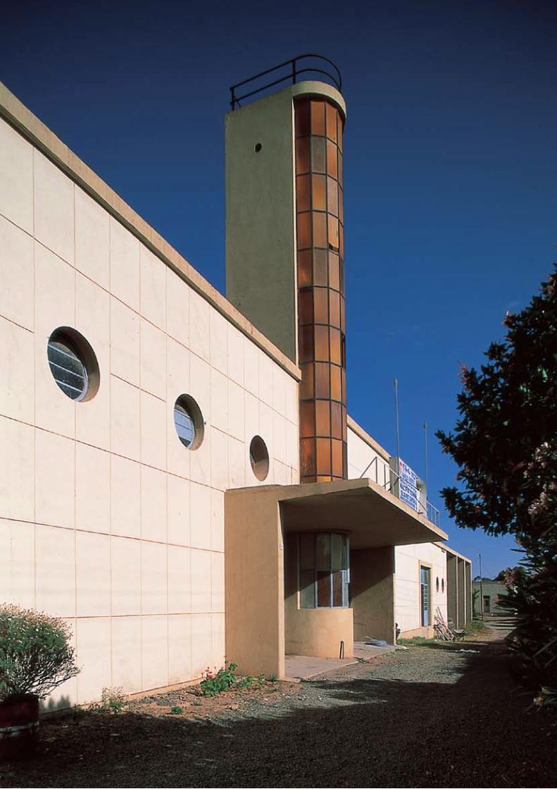
3.3 Modernist ArchitectureAsmara’s modernist architecture represents one of the most complete collections of its genre in the world. As a total urban ensemble, Asmara bears exceptional testimony to the formative stage of one distinct strand of modernism: Rationalism. Hundreds of buildings designed and constructed from 1935–41 possess the characteristics of Rationalism, which emerged in Italy with Giuseppe Terragni’s design for the Novocomum Apartments in Como (1927–29) and reached its apogee in 1936 with the completion of the celebrated Casa del Fascio, also by Terragni and
also in Como. Rationalist architecture embraced the new machine age and was uncompromising in its promotion of aesthetic purity and geometric simplicity in built forms, volumes and masses. The defining characteristic of Asmara’s Rationalist architecture is witnessed in the profusion of pure geometric volumes, asymmetric and abstract forms, and a lack of ornamentation in the design of cinemas, shops, banks, religious structures, public and private offices, industrial facilities, and residences.
In Europe architectural modernism was expressed in new materials of glass and concrete, but in Eritrea, where such materials were comparatively expensive, many of the modernist buildings were built using local materials and made to appear modern. Although reinforced concrete was available and frequently used, many buildings in Asmara used large quantities of local basalt rendered in lime plaster to give the appearance of concrete or to create modern geometric forms befitting the modern machine age, albeit constructed using traditional materials.
Asmara’s unique architectural value is derived not only from the prevalence of Rationalism. The city also possesses other expressions of modernism, including Futurism, as well as earlier articulations of architectural modernity such as Novecento and neo-traditional styles recalling Classical, Lombard, Romanesque, Renaissance, Gothic, medieval and even vernacular forms. Collectively, Asmara’s architectural character is therefore broad and fairly represents the transformation in architecture during the early-20th century from tradition to modernism.
The architectural eclecticism that defined the early-20th century was swept away in Eritrea by Italy’s invasion of Ethiopia in 1935, heralding an extreme encounter with modernity that concluded with Italy’s defeat by the Allies in 1941. The quantity and ubiquity of modernist structures designed and built in Asmara from 1935–41 has created an outstanding example of an urban landscape that illustrates a significant stage not simply in the development of architecture and town-planning but also in human history. Asmara provided a setting in a unique African context where modern ideas in architecture and planning from Europe could be designed and realised when at home on

13
the eve of the Second World War, attention and resources were being diverted from construction to destruction – modernism’s omnipresent bedfellows. Asmara’s architectural heritage was concealed from the world by subsequent events that neither bolstered nor undermined the integrity of the city’s physical character but which added significantly to its intangible heritage.
3.4 African Context Beyond the physical attributes of Asmara’s innovative urban plan and modernist architecture, Asmara is an outstanding example of the interchange of cultural influences brought about by the encounter with modernity in an African context. The built environment embodies the expression of native, cultural and local identity through interaction with successive foreign forces and colonisers over decades that culminated in
the universal aspiration for and attainment of a national identity. Asmara’s historic urban landscape not only encapsulates key stages of modernity’s development and its principal characteristics (colonial encounters, rapid technological and urban development, transportation and communication, cultural and political consciousness, conflict and national identity), it also evidences highly innovative and experimental architecture drawn from local precedents. In summary, Asmara can be seen as an urban ensemble and cultural landscape defined by a wide-range of human experiences that defined the twentieth century and culminated in the city becoming the nation’s capital following independence in 1991. As the political and spiritual centre of Eritrean national identity, Asmara has helped define a people as much as they have defined it.
Former villa (1938), architect unknown.


15
4. The Management System of Asmara
4.1 Central Region Administration
The Central Region Administration is in charge of all preservation and conservation activities within its jurisdiction. Under the Central Region Administration, the Department of Public Works Development (DPWD) is one of the key departments dealing with urban development, infrastructure, maintenance of road networks and pedestrian areas, issuing building permits for new and old buildings, supervision of construction works for the entire city and technical archival documentation. To implement its duties the DPWD has three divisions:-
• Building and supervision division;• Roads and maintenance division, and;• Urban planning division.
These three divisions have their own defined roles and responsibilities. The building and supervision division is responsible for building design and permits, issuing various construction permits including occupation permits; monitoring and supervising construction work and compliance with building regulations. The roads and maintenance division is responsible for maintenance of existing and new road works; traffic management; installation of traffic signage and street lighting. The urban planning division is in charge of developing regional and city wide urban development strategies and the implementation programme; to collect and analyse relevant data on planning, socio-economics, and demographics, that are essential for urban development planning; surveying and mapping works, and the collection and compilation of data on historical buildings.
4.2. Asmara Heritage Project (AHP)The newly established agency Asmara Heritage Project (AHP) is responsible for the preparation
of the Nomination Dossier for inscription on the World Heritage List, the Integrated Management Plan (IMP) and Urban Conservation Master Plan (2017). The IMP is also proposed to expand AHP mandate in supervising and monitoring the historic perimeter. Another important recently established organ is the Steering Committee, whose mandate is to give strategic guidance in protecting related activities. The AHP has produced an Integrated Management Plan (IMP) for Asmara (2016). The main aim of the IMP for the site is to promote the sustainable management of the nominated site so that its Outstanding Universal Values (OUVs) are conserved over time and transferred to future generations. The overall objective of IMP is to ensure that an appropriate management plan is formulated and duly implemented for the conservation, protection and valorisation of the site through the development of appropriate conservation strategies and action plan measures and a mechanism through which the site will be managed, enhanced and valorised by all stakeholders.
The IMP outlines the vision, overall goals, objective, guiding principles and strategies with regard to the conservation and protection of the nominated site. The major strategic intervention areas envisaged for the implementation of the IMP are grouped under ten themes: Integrated Conservation Plan, Maintenance of Historic Buildings, Infrastructures and Services, Rehabilitation and Recovery, Mobility and Traffic, Socio-Economic Development Pressure, Tourism and Visitor Management, Protected Areas, Risk Preparedness and Disaster Mitigation, Institutional and human capacity development. Each theme is presented with its respective rationale and planning, implementation and monitoring and evaluation strategies and actions. The IMP also highlights the existing institutional framework

16
to manage the site, institutional collaboration among various institutions at national and regional levels, community involvement and participation in the implementation of the IMP, capacity development, and the implementation programme. This is proposed to be achieved by establishing an appropriate institution or organ responsible for the management of the site. The institution or organ to be established will need to be supported by government, private, local and international institutions and the participation of the various communities. In addition, it will need to be supported by an appropriate fund and adequately staffed.
Eritrea took measures to protect and manage Asmara’s historic urban landscape have been established and implemented. AHP has conducted extensive surveys to provide the necessary baseline information for managing and monitoring the nominated property. A comprehensive inventory of buildings infrastructure and open spaces in the nominated property and Buffer Zone was conducted by the AHP from early-2014 – late-2015. The inventory forms the basis of an overall assessment of the state of conservation and provides evidence of the benchmark conditions for future restoration and maintenance. Over 4,300 buildings, 257 roads and 38 open spaces were surveyed by the end of 2015. The survey forms were designed to provide an overall assessment
of all the properties (buildings, streets, and infrastructure and open spaces). A heritage building database using Geographical Information System (GIS) has been set up to assist in the monitoring of the state of conservation. The records kept in the heritage building inventory include condition of the buildings, state of infrastructure and public open spaces as well as recording proposed and actual interventions that have taken place since construction.
The AHP has also organised a wide range of community engagement activities. Brochures in three languages (Tigrinya, Arabic and English) have been prepared and circulated to the general public in various meetings and exhibitions to raise public awareness and promote Asmara’s candidacy for UNESCO World Heritage listing. In addition, various stakeholders meetings and workshops have been conducted and group discussions held. The process has also entailed extensive stakeholder engagement and consultation with local residents including four successive exhibitions at the annual Eritrea Expo (visited by hundreds of thousands of people); printing and dissemination of multilingual brochures and information leaflets; interviews on the media, including television, radio and newspapers; hosting public and professional workshops; and intensive international exposure to reach global audiences including the Eritrean diaspora.
Former Società Anonima Alfa Romeo (SAAR) (1937).

18
5. Conclusion
Eritrea’s current application to UNESCO for Asmara’s inclusion on the World Heritage List for its outstanding modernist architecture and urban planning and its exceptional testimony of the universal aspiration for and attainment of national self-determination goes beyond merely pursuing international recognition for its cultural assets. Asmara’s nomination also presents an opportunity to encourage critical reflections on cultural relations and heritage globally, and to promote stability and prosperity locally. In addition, Asmara has the potential to contribute to UNESCO’s global strategy of redressing the comparative under-representation of African and modernist sites on the WHL.
Cinema Impero (1937), designed by Mario Messina.

6. Signatures

Prepared by the Asmara Heritage Project (April 2017)
© Asmara Heritage Project. Photographs by Edward Denison.