Asian Regional Activities Regional Activities Tadashi Tsuyuki (MRI/JMA) Acting Chair of Asian...
27
Asian Regional Activities Tadashi Tsuyuki (MRI/JMA) Acting Chair of Asian Regional Committee The ninth session of THORPEX/ICSC 21-22 September 2011, Geneva, Switzerland
Transcript of Asian Regional Activities Regional Activities Tadashi Tsuyuki (MRI/JMA) Acting Chair of Asian...

Asian Regional Activities
Tadashi Tsuyuki (MRI/JMA)
Acting Chair of Asian Regional Committee
The ninth session of THORPEX/ICSC21-22 September 2011, Geneva, Switzerland

Asian Regional Committee
• Established in May 2003.• Member countries:
China, India, Japan, Republic of Korea, Russia.• Main target phenomena:
Tropical cyclones, heavy monsoon precipitation, sand and dust storms, MJO.
• Major regional campaigns– T-PARC summer 2008: China, Japan, Korea– T-PARC winter 2008/2009: Russia

The 3rd Asian THORPEX Science Symposium (2-4 June 2010, Seogwipo, Korea)
• Nearly 70 participants from China, Japan, Korea, Russia and USA.
• 30 oral presentations and 10 posters.• Prof. Russ Elsberry gave an invited talk “Typhoon-ocean
field experiment ITOP 2010: An extension of TPARC/TCS-08 to improve typhoon forecasts”.
• Dr. Jim Caughey presented “Recent developments in the THORPEX programme”.
• TIGGE-related research: – Predictability of high-impact weather using TIGGE data, – Upgraded TIGGE archive center of CMA, – TIGGE activities of KMA.

The 7th ARC meeting(5 June 2010, Seogwipo, Korea)
• 7 ARC members out of 10 attended along with Prof. Elsberry, Dr. Caughey and observers.
• It was agreed that – Asian THORPEX Science Symposium is held every two
years,– NWP WG and GIFS-TIGGE WG are set up as more
frequent and effective communication structures among ARC member countries,
– ARC supports the Severe Weather Forecast Demonstration Project (SWFDP) in Southeast Asia with TIGGE applications , to demonstrate the capability of TIGGE database for operational forecasts.

THORPEX activities in China
• Observation experiment of mesoscale predictability on summer rainstorm around Beijing area (Oct. 2007-).– June-August, with intensive observation July 20- August 20. – Adaptive observation system for sensitive areas are set up.
• South China Heavy Rainfall Experiment (SCHeREX) (2008-2009).– May 1-June 10 (southern China), June 10-July 20 (Yangtse
River valleys and Huai River Valley) – It has led to establishment of mesoscale observing
networks in south China, with enhanced capacity to observe precipitation systems at meso-β scale.
• Support of Shanghai World Expo 2010 with TIGGE typhoon ensemble prediction products.

Future Plans of THORPEX-China
• To enhance the Beijing TIGGE archive center– Better customer interface and more convenient service.– Promotion of the development of TIGGE CXML typhoon
demonstration projects.• The 3rd Tibetan Plateau Experiment for Atmospheric
Science– Enhancement of the understanding of the plateau impacts
on China’s and global weather and climate.• Field Experiment on Convective Clouds and Heavy
Monsoon Rainfall– Follow-up of SCHeREX– It aims at improving cloud models, assimilation cloud
parameters, and thus raising the capacity for heavy rainfall prediction in South China

FDP of TCs over the North Indian Ocean
Objectives To demonstrate the ability of various NWP models to assess the genesis,
intensification and movement of tropical cyclones over the north Indian ocean. To incorporate modification into the models which could be specific to the Bay
of Bengal.
Schedule(i) Pre-pilot phase : Oct-Nov. 2008, 2009(ii) Pilot phase : Oct-Nov. 2010, 2011 (iii) Final phase : Oct-Nov. 2012
Enhanced observations • Sagar Kanya cruise,• Enhanced AWS network of the coast,• 5 activated buoy observations,• Oceansat-II observations,• Microwave imagery products,• Tropical Cyclone module in Synergie System. Area of FDP Cyclones

SAARC STORM Programme(Severe Thunderstorm Observations and Regional Modeling)
ObjectivesTo build appropriate operational early warning systems for highly damaging severe thunderstorms around the eastern and north-eastern parts of India
Participating countries• Bangladesh• Bhutan• India• Nepal
Schedule•2006-2011: PILOT campaigns•2012-2013: Main program Area of STORM Programme

Recent Updates of JMA-EPS Revisions of the singular vector (SV) method of
Typhoon EPS (May 2010)- Positive impact on spread-skill relationship of TC track forecasts.
Introduction of stochastic perturbations in physics tendency to One-week EPS and Typhoon EPS (December 2010)- Nearly neutral impact on TC track forecasts.
Reduced amplitude of initial perturbations (IPs) and extension of IPs into the southern hemisphere in one-week EPS (March 2011)- Positive impact on ensemble spread and forecast skill.
Providing the analysis at 00UTC to TIGGE database (August 2011)- Following Action 8.6.1 of the 8th GIFS-TIGGE WG meeting report.

TIGGE-related Research in Japan• Yamaguchi, M., and S.J. Majumdar, 2010: Using TIGGE data to
diagnose initial perturbations and their growth for tropical cyclone ensemble forecasts, Mon. Wea. Rev., 138, 3634–3655.
• Yamaguchi, M., D. S. Nolan, M. Iskandarani, S. J. Majumdar, M. S. Peng, and C. A. Reynolds, 2011: Singular vectors for tropical cyclone-like vortices in a nondivergent barotropic framework, J. Atmos. Sci. (Accepted)
• Yamaguchi, M., S. Hoshino, and T. Nakazawa, 2011: Tropical cyclone track prediction in the western North Pacific using TIGGE data, Quart. J. Roy. Meteor. Soc. (Submitted)
• Matsueda, M., 2011: Predictability of Euro-Russian blocking in summer of 2010, Geophys. Res. Lett., 38, L06801.
• Matsueda, M., and H. Endo, 2011: Verification of medium-range MJO forecasts with TIGGE, Geophys, Res. Lett., 38, L11801.

National Center for Intensive Observation of Severe Weather
Latitude : 34.55 °Longitude : 126.56 °Sea level height : 14 mArea : 3,069 ㎡
The Boseong National Center for Intensive Observation (NCIO) of Severe Weather wasopened on April, 2010 since it had relocated from the center at Haenam where observationshad commenced from 2003.
Milestones2001.11 Promoted to establish the NCIO
2003. 4 Opened the NCIO
2008. 5 Signed an MOU between the GwangjuRegional Meteorological Administrationand Boseong-Gun, which agrees for therelocation of the NCIO from Haenam toBoseong
2009. 1 Carried out the relocation of NCIO fromHaenam to Boseong
2010. 4 Completed the relocation andreinstallation of the observationinstruments from Haenam to Boseong
2010. 7 Started to observe and monitor severeweather continuously in Boseong

Enhance the Boseong NCIO into a highly advanced
observation center in East Asia to mitigate damages due to
severe weather phenomena
MRR ORG
RDM CLM
ATSO
Installation
⇒ MRR(‘02~), ORG(’02~), WPR(‘02~),
Autosonde(‘02~), Radiometet(‘07~)
⇒ Ceilometer(‘10.06~)
⇒ Disdrometer(‘’11.03~)
WPR
ORGMRRRDMCLM
Disdrometer
National Center for Intensive Observation of Severe Weather

“Analysis for effects of topographies and city environments on the weather in metropolitan areas”
Period: 14 August to 4 September 2010 (22 days) Goals
• To investigate relationships of frequency, amount, and intensity of rainfall with urbanization
• To understand physical mechanisms of severe weather accompanied by heavy rainfall• To examine effects of urbanization and topography on changes in precipitation
processes
[Site Distribution]
Equipments Interval Location
Radiosonde(RAOB) 6h Incheon airport, Dongducheon,
YangpyeongMicro Rain Radar
(MRR) Continuously Incheon airport, Dongducheon, Yangpyeong
Sky picture (TSI) 6h Incheon airport
YangpyeongGPS (GPS) Continuously Incheon, Seoul
WXT-510 (WXT) Continuously Incheon airportRain gauge
(RGE) Continuously Incheon airport
ProbeX-2010 (PRedictability & OBservation EXperiment of Korea)

Predictability of High Impact Weather Using TIGGE data
• Calculate Brier Score of ECMWF, UKMO, NCEP, GE• June~August 2009
Brier Score
1mm/24hr 25mm/24hr 50mm/24hr
2009070912 OBS 24hr accu. rainfall
Case Study ( 12UTC 09 July 2009) RMSE of MSLP
Consistency of MSLP

Further Plan Ⅰ: Establish the Targeted Observation System
Targeted Observation Strategy System
Retrieval of sensitivity region
Setting the response region
Targeted observation : Radiosonde, MRR, GPS etc.
Determining the location for the observation
Used as input to numerical model Enhancing model
performance
Flowchart of Real-time adjoint sensitivity strategy
00z 12z 00z 12z 00z06z 18z 06z 18z
Datadownload Calculation
Decision Observation !!!
0h 10.5h6h 15.5h6.5h
Pre-process Post-process& Upload
Ti Ta Tv
48 h 48 h
-48h, Decide obs. points & targeted obs. !!!

Further Plan Ⅱ: Ship Based Observation
• Specification• Gross Tonnage : 498 ton• Length Overall : 64.32 m• Breadth : 9.40 m• Maximum speed : 33㎞/h (18 knots)• Cruising speed : 31㎞/h (16.5 knots)
• Observation Equipment• ASAP : Upper air observation• Conductivity Temperature Depth recoder (CTD)• Acoustic Doppler Current Profiler (ADCP)
Gisang-1
Period: June to September 2011 Region: Western and southern sea (sensitivity region) Goals
• To enhance the predictability of severe weather phenomena as performing the observation in the sea where the observation site is rare
• To assess the performance of the Targeted Observation Strategy System
“Upper air observation in the sensitivity region using the Targeted Observation Strategy System”

Boseong Yeosu
Period: December 2011 Region: Incheon Equipments: Radiosonde, MRR, GPS etc. Goals
• To improve the predictability and the reinforcement of early-surveillance skill on the heavy snowfall
2011: “To Improve the predictability on the heavy snowfall”
2012: “Support the Expo 2012 Yeosu Korea, to provide customized weather information”
Period: 12 May to 12 August, 2012 Region: Yeosu Equipments: Radiosonde, MRR, GPS etc. Goals
• To support the successful hosting of the Expo 2012 Yeosu Korea
Further Plan Ⅲ: ProbeX-2011 and 2012

Optimal interpolation Z500 RMS error fieldReponded to Optimal Design configuration
60 80 100 120 140 160 180
. Поле ошибок восстановления поля Н500 (м) по данным достаточной аэрологической сети АТР из 42 станц
Долгота
40
50
60
70
80
Шир
ота
23955
31168
21432
20674
25594
31873
29282
32215
25042
20292
24125 24266
30554
2347223330
23552
36096
28698
23933
28225
24507
24817 2494430054 31004
24343
24959
31510
25913
31369
2540024688
25123 25173
3238932618
25954
2194621824
25563
31977
32150
5
25
45
65
85
105
60 80 100 120 140 160 18040
50
60
70
80
Optimization of Siberian RAOB
(Courtesy of Dr Pokrovsky)

A mixed FDP/RDP•The main focus is on kilometric-scale. •short-range winter forecasting over complex terrain.
Forecast time range and resolutions•Deterministic: 36 hours or more.
FDP: 2 km RDP: 0.5-1 km•Ensemble: 72 hours.
FDP: 7 km RDP: 2 km
Timetable•Pre-trial: 2011/12 winter•Trial: 2012/13 winter•Olympics: 2014 winter
FROST-2014: Forecasting and Research: the Olympic Sochi Testbed
(Courtesy of Dr Tsyrulnikov)

Kick-off meeting: Sochi, Russia, 1-3 March 2011.Confirmed participants:
•Russian Weather Service•COSMO•DWD (Germany)•ARPA (Italy)•Environment Canada•TIGGE-LAM•HIRLAM•NOAA•ZAMG (Austria), FMI, Uni Helsinki•Vaisala
Other participants are kindly invited
FROST-2014: Forecasting and Research: the Olympic Sochi Testbed
(Courtesy of Dr Tsyrulnikov)

ARC Plans
• The eighth ARC meeting (9 December 2011, Tokyo)– On an occasion of the Second Asia/Oceania
Meteorological Satellite Users' Conference (6 - 9 December 2011, Tokyo)
• TIGGE support of SWFDP in Southeast Asia (2012-2013)
• The forth Asian THORPEX science symposium (To be determined)
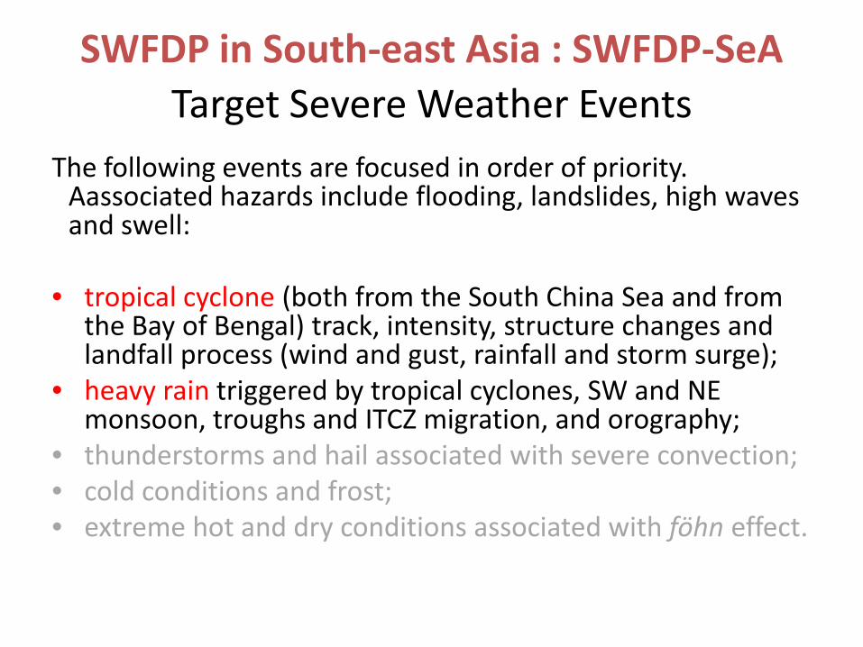
Target Severe Weather EventsThe following events are focused in order of priority.
Aassociated hazards include flooding, landslides, high waves and swell:
• tropical cyclone (both from the South China Sea and from the Bay of Bengal) track, intensity, structure changes and landfall process (wind and gust, rainfall and storm surge);
• heavy rain triggered by tropical cyclones, SW and NE monsoon, troughs and ITCZ migration, and orography;
• thunderstorms and hail associated with severe convection;• cold conditions and frost;• extreme hot and dry conditions associated with föhn effect.
SWFDP in South-east Asia : SWFDP-SeA

SWFDP in South-east Asia : SWFDP-SeA NMCs Cambodia Lao PDR Thailand Viet Nam
Global Centres CMA JMA KMA
Regional Centres Hanoi (regional forecast support) Hong Kong (training and technical support) RSMCs Tokyo and New Delhi (Tropical Cyclone/Typhoon forecasting support)
• July 2011: Preparatory Training Workshop (Hong Kong)
• Oct 2011: Regional Subproject Management Team Meeting
(Hanoi, Vietnam)
• Q1/Q2 2012: Start Field Phase (from rainy season)
• Q1/Q2 2013: End Field Phase
• Q4 2013: Complete Evaluation

TIGGE Support of SWFDP-SeA
JMA will provide two types GIFS-TIGGE products for Severe Weather Forecast Demonstration Project in Southeast Asia.
1. Tropical cyclone track in the western North Pacific (TIGGE CXML data)
2. Severe weather potential such as heavy precipitation

Products for severe weather potential -heavy precipitation-
It maps the area where the ensemble prediction systems of ECMWF, JMA, NCEP and UKMO predict heavy precipitation. The red (orange, yellow, blue) color shows all (3, 2, 1) centers predict heavy precipitation.
MCGE stands for Multi Center Grand Ensemble

Case 3: heavy rainfall in Japan (July 2011)
observation
Railway track before heavy rain No railway track after heavy rain!
Niigata, Japan (30th July)

Case 3: heavy rainfall in Japan (July 2011)
+ 6-dayforecast
+ 5-dayforecast
The heavy rainfall was highly predictableeven in 6-day forecasts.
・Tokyo


![Asian Carp Regional Coordinating Committee [TITLE] [Author] [Date]](https://static.fdocuments.net/doc/165x107/56649ebb5503460f94bc335b/asian-carp-regional-coordinating-committee-title-author-date.jpg)