ASIAN ALPINE E-NEWS · First ascents on virgin summits in Gangga, Sichuan Team Austria-Spain 15...
50
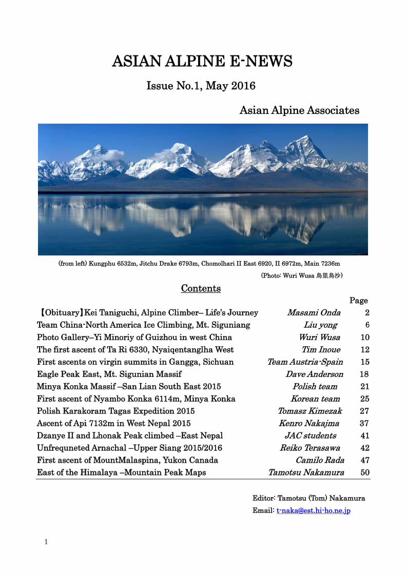
1 ASIAN ALPINE E-NEWS Issue No.1, May 2016 Asian Alpine Associates (from left) Kungphu 6532m, Jitchu Drake 6793m, Chomolhari II East 6920, II 6972m, Main 7236m (Photo: Wuri Wusa 烏里烏沙) Contents Page 【Obituary】 Kei Taniguchi, Alpine Climber– Life’ s Journey Masami Onda 2 Team China-North America Ice Climbing, Mt. Siguniang Liu yong 6 Photo Gallery–Yi Minoriy of Guizhou in west China Wuri Wusa 10 The first ascent of Ta Ri 6330, Nyaiqentanglha West Tim Inoue 12 First ascents on virgin summits in Gangga, Sichuan Team Austria-Spain 15 Eagle Peak East, Mt. Sigunian Massif Dave Anderson 18 Minya Konka Massif –San Lian South East 2015 Polish team 21 First ascent of Nyambo Konka 6114m, Minya Konka Korean team 25 Polish Karakoram Tagas Expedition 2015 Tomasz Kimezak 27 Ascent of Api 7132m in West Nepal 2015 Kenro Nakajma 37 Dzanye II and Lhonak Peak climbed –East Nepal JAC students 41 Unfrequneted Arnachal –Upper Siang 2015/2016 Reiko Terasawa 42 First ascent of MountMalaspina, Yukon Canada Camilo Rada 47 East of the Himalaya –Mountain Peak Maps Tamotsu Nakamura 50 Editor: Tamotsu (Tom) Nakamura Email: [email protected]
Transcript of ASIAN ALPINE E-NEWS · First ascents on virgin summits in Gangga, Sichuan Team Austria-Spain 15...
1
ASIAN ALPINE E-NEWS
Issue No.1, May 2016
Asian Alpine Associates
(from left) Kungphu 6532m, Jitchu Drake 6793m, Chomolhari II East 6920, II 6972m, Main 7236m
(Photo: Wuri Wusa烏里烏沙)
Contents
Page
【Obituary】Kei Taniguchi, Alpine Climber– Life’s Journey Masami Onda 2
Team China-North America Ice Climbing, Mt. Siguniang Liu yong 6
Photo Gallery–Yi Minoriy of Guizhou in west China Wuri Wusa 10
The first ascent of Ta Ri 6330, Nyaiqentanglha West Tim Inoue 12
First ascents on virgin summits in Gangga, Sichuan Team Austria-Spain 15
Eagle Peak East, Mt. Sigunian Massif Dave Anderson 18
Minya Konka Massif –San Lian South East 2015 Polish team 21
First ascent of Nyambo Konka 6114m, Minya Konka Korean team 25
Polish Karakoram Tagas Expedition 2015 Tomasz Kimezak 27
Ascent of Api 7132m in West Nepal 2015 Kenro Nakajma 37
Dzanye II and Lhonak Peak climbed –East Nepal JAC students 41
Unfrequneted Arnachal –Upper Siang 2015/2016 Reiko Terasawa 42
First ascent of MountMalaspina, Yukon Canada Camilo Rada 47
East of the Himalaya –Mountain Peak Maps Tamotsu Nakamura 50
Editor: Tamotsu (Tom) Nakamura
Email: [email protected]
2
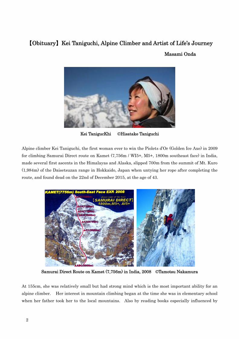
【Obituary】Kei Taniguchi, Alpine Climber and Artist of Life’s Journey
Masami Onda
Kei TanigucKhi ©Hisatake Taniguchi
Alpine climber Kei Taniguchi, the first woman ever to win the Piolets d’Or (Golden Ice Axe) in 2009
for climbing Samurai Direct route on Kamet (7,756m / WI5+, M5+, 1800m southeast face) in India,
made several first ascents in the Himalayas and Alaska, slipped 700m from the summit of Mt. Kuro
(1,984m) of the Daisetsuzan range in Hokkaido, Japan when untying her rope after completing the
route, and found dead on the 22nd of December 2015, at the age of 43.
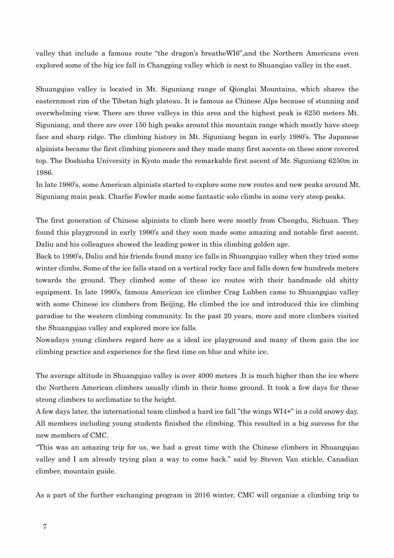
Samurai Direct Route on Kamet (7,756m) in India, 2008 ©Tamotsu Nakamura
At 155cm, she was relatively small but had strong mind which is the most important ability for an
alpine climber. Her interest in mountain climbing began at the time she was in elementary school
when her father took her to the local mountains. Also by reading books especially influenced by

3
Naomi Uemura, a Japanese arctic explorer active in 1970s. She was world-class alpine climber but
preferred to define herself as a “traveler” or “explorer” than a “climber”. Since she climbed with
curiosity in exploring the beauty of nature and local culture, it is not hard for us to imagine that she
did not like to be categorized just as a “climber.”
She attended Meiji University, the same university Uemura graduated from, and joined the Cycling
Club but her interest in climbing mountains was already in her mind. “I always felt the urge to climb
when I saw mountains while riding.” After graduating she joined a local mountaineering club and
started her climbing career. In 2001, climbed Denali (6,194m) via the west buttress and found herself
to be strong at high altitudes. During the same time also joined several adventure races and her
name became to be known as one of the top female athletes in the field. “Adventure races are what
taught me team dynamics.” Not only the race, she was strong in the mountains but said she never
train herself. It was a mystery among friends, but one winter day, received a message saying she
went for “walk” and soloed 3 routes just because the “weather was beautiful.”. Usually normal
climbers climb these routes with rope, one per day. “I don’t like competing.” she said. “I find climbing
interesting because it forces me to deal with strengths and weaknesses inside myself and not
because I must or for the sake of competition.”
Year 2001, when she first climbed Denali, was a big change year of her life. She quit her permanent
job after 2 years of working and became a freelance company facilitator and mountain tour guide
altering her lifestyle to where to spend most of the time in the mountains. This set the stage for the
next stride of her career. Around this period, another important change was occurring in the
Japanese alpine climbing community. A group of next generation of young alpine climbers, including
Yusuke Sato and Yokoyama “Jumbo” Katsutaka (who would later be known world-wide as the
“Girigiri Boys”) started to become active. Kei was well accepted and loved among the group and they
shared experiences and technique with each other which accelerates to deepen her alpine climbing
skills which is difficult to master just from “textbooks.”
A few years later, Kei embarked on a number of expeditions with long time climbing partner Kazuya
Hiraide. In 2004, the north west side of Spantik (7,028m), and the north face of Laila Peak (6,096m)
in Pakistan. In 2005 second ascent of the east ridge of Mustagh Ata (7,546m) in China, and the new
route on the north face of Shivling (6,543m) in India. And in 2008 the new route on the southeast
face of the remote peak of Kamet (7,756m) in India, for which they won the 2009 Piolet d’Or. They
continued with attempts in 2009 unclimbed east face up until 100m under from the summit of
Gaurishankar (7,134m) in China, and in 2011 first traverse from south to west side of Naimona’nyi
(7,694m) in China. In 2013, they summited Diran (7,266m) from west ridge and tried Shispare
(7,611m) unclimbed south west face up to 5,800m, in Pakistan.

4
She loved Alaska and visited several times. In 2008 climbed 4 hard routes around Ruth glacier
including second ascent via the Worrior’s Way (VM5R A0, 21 pitches) on Mt.Grosvenor with Hiroki
Suzuki. And in 2011 traversed Kahiltna Peak via unstable knife-edge ridge with Yasuhiro Hanatani,
trying to retrace all the way up to Denali to commemorate her friends who were lost in 2008 while
attempting an enchainment of the Kahiltna Peak and the Cassin Ridge.
From 2013, she partnered with Junji Wada. Their first expedition was to Alaska in 2014, 38 days at
Ruth glacier without meeting anybody all through the expedition. They climbed new routes named
Wasabi Concerto (AI4 M5+ R) and Wasabi Sonatine (WI4 M4) on the northeast buttress of Peak
11,300, Wasabi Prelude (V 60 degrees) on the south face and Wasabi Nocturne (WI4 AI5 M5) on the
east face of Mt. Dan Beard. They call the climbs as “Wasabi quartette” and were nominated for the
Piolets d’Or Asia 2014. Then in the autumn of 2015 they attempted the unclimbed peak Pandra
(6,850m) in Nepal which were unable to summit on and were planning to try again the following post
monsoon in 2016.
Kei leading around 6,950m of Gaurishankar (7,134m) in China, 2009 Photo By Kazuya Hiraide
Not only personal, she paticipated “official” expeditions. For the 8000m “cleaning” expeditions led by
Ken Noguchi, she joined as a manager in 2002 and 2003. In 2006 summited Manaslu (8,163m) and in
2007 summited Everest (8,858m) with the team. She loved working with Ken and Sherpa in the
expedition but later mentioned “I would choose to attempt silent peaks.” She also led young female
climbers’ expedition offered by Japanese Alpine Club to the yet unclimbed Mansail Peak (6,235m) in
Nepal in 2014 and led the inexperienced young group to the summit.
She enjoyed life at home in Japan between expeditions. After living in Tokyo for about 20 years, she
moved to a small cabin near the Yatsugatake mountain range in 2014. Since she was a fan of art and
loved to visit museums mainly locates in Tokyo, she had been hesitant to move but soon after said “I
should have moved away from Tokyo earlier to live near the mountains.”. She loved living simply in
the woods among the beauty and blessings of nature.
For about 15 years she afforded her living and expeditions by working as freelance company

5
facilitator and trekking guide. She had several offers by sponsors but refused to be sponsored easily
and only selected gears which she found reliable. “I love working as a facilitator.” she said and shared
her experiences gained in extreme fields. “I would like to be the best facilitator to navigate people to
recognize their personal potential and team dynamics.”
She put extensive effort into finding potential and team dynamics for herself and others. “I carefully
choose who to rope with and once we roped together I find the best way as a team to climb.”. In
2009, at the Piolets d’Or meeting in Chamonix, she roped with Peter Habeler, who was a hero of hers
from his legendary achievements. Mr. Habeler thankfully shared his story. “It was a really tough
route I got stuck and Kei leaded us. As it always is with great Individuals like Kei, she took it very
lightly, not making any comments about getting stuck.”. She wrote in her diary it was a great
experience roping with him and was impressed by his strong spirit to look for future adventure.
Since she had experience studying in the US for a year after high school, she had good
communication skills, not only speaking English but expressing her thoughts verbally. The next
year she was invited again by the Piolets d’Or in 2010, as a judge.
Like her climbing style, she often mentioned she prefer not to leave any pitons nor titles behind, even
in her life. She was like an artist expressing her passion for the beauty by drawing a line both on
the mountains also on her path.
On the 13th of March, 2016, 3 months after her accident, Kei‘s memorial was held in Aoyama, Tokyo.
Her family and around 500 people from various fields gathered and mourn over the great loss of our
friend, world class alpine climber and an artist of life’s journey.
Kei Taniguchi: Alpine climber, facilitator, mountain tour guide. Born July 14th, 1972. The first
woman to win the Piolets d’Or in 2009 for climbing the new route on Kamet (7,756m) in India in 2008.
Winner of Piolets d’Or Asia in 2014 for climbing “Wasabi quartette” in Alaska. Died in an accident at
Mt. Kuro of Hokkaido, Japan on December 22, 2015 at age 43. “Being with The Mountain” Alpinist
Magazine Issue 52, 2015. http://www.alpinist.com/doc/web15y/wfeature-being-with-the-mountain
Kei heading unclimbed south face of Naimona’nyi (7,694m) in China, 2011 Photo By Kazuya Hiraide

6
International Team China-North America 2016
Ice Climbing in Shuangqiao valley, Mt. Siguning Range, Sichuan
Liu yong 劉勇, Sichuan University
International ice climbing team attended the Chinese & North American ice climbing exchanging
program conducted in Mt. Siguniang range of Qionglai Mountains, Sichuan, China. The following is
a report of Liu yong.
In early February, 2016, a small group of Canadian and American ice climbers which was led by
Steven Swenson, a former President of American Alpine Club arrived to the Shuangqiao valley, a
most reputed ice climbing field in China.
The five foreign climbers joined the team for a 10 days climbing trip with the Chinese ice climbers,
which was organized by the Chinese Mountain Club (CMC) and two ice climbers from Hong Kong
joined as well.
This was an ice climbing exchanging program between Northern American climbers and Chinese
climbers. In October 2015, Daliu (Liu yong), a Chairman of Chinese Mountain Club was invited to
attend the Banff mountain film festival in Canada and he met Steven Swenson in Banff, and they
met up in Chamonix in 2012 at the Piolet d’Or as Daliu acted as a jury and Steven won the prize for
the first ascent of Saser Kangri ll (7518m). The two old friends made a decision that they would start
a climbing exchanging program between the Chinese and North American climbers.
Three Chinese strong ice climbers include Daliu, Zhaozhongjun and Bater, and nine members from
CMC (Chinese Mountain Club) joined this program held in their home climbing playground, the
beautiful Tibetan mountain range.
As soon as they arrived at Shuangqiao valley in the late afternoon, 18th of February, Daliu and
Steven Swenson roped up and climbed a 67 meters ice fall called “five colour ice”, Canadian climber
Steven Earl Van Sickle and American climber Alexis Manfred Berg climbed a 45 meters WI4+ ice
wall (Swiss knife). Both of the two teams finished their climbing before sunset.
As a part of the exchanging program, the northern American climbers gave three days ice climbing
course to the members of CMC which finally led those young climbers to successfully climb some long
multi-pitches steep ice falls. Most of the young Chinese climbers never climbed outside of China
before, and it was probably first time for them to climb with North American ice climbers. It took
little longer time than usual for them to exchange their climbing skill and their thought of different
ice based on their different language and culture background. But it must be a wonderful experience.
The rest of the 10 days trip, the American and Canadian climbers climbed some attactive vertical ice
falls with Daliu, Zhaozhongjun and Bater. They climbed many of the famous ice falls in Shuangqiao
7
valley that include a famous route “the dragon’s breatheWI6”,and the Northern Americans even
explored some of the big ice fall in Changping valley which is next to Shuanqiao valley in the east.
Shuangqiao valley is located in Mt. Siguniang range of Qionglai Mountains, which shares the
easternmost rim of the Tibetan high plateau. It is famous as Chinese Alps because of stunning and
overwhelming view. There are three valleys in this area and the highest peak is 6250 meters Mt.
Siguniang, and there are over 150 high peaks around this mountain range which mostly have steep
face and sharp ridge. The climbing history in Mt. Siguniang began in early 1980’s. The Japanese
alpinists became the first climbing pioneers and they made many first ascents on these snow covered
top. The Doshisha University in Kyoto made the remarkable first ascent of Mr. Siguniang 6250m in
1986.
In late 1980’s, some American alpinists started to explore some new routes and new peaks around Mt.
Siguniang main peak. Charlie Fowler made some fantastic solo climbs in some very steep peaks.
The first generation of Chinese alpinists to climb here were mostly from Chengdu, Sichuan. They
found this playground in early 1990’s and they soon made some amazing and notable first ascent.
Daliu and his colleagues showed the leading power in this climbing golden age.
Back to 1990’s, Daliu and his friends found many ice falls in Shuangqiao valley when they tried some
winter climbs. Some of the ice falls stand on a vertical rocky face and falls down few hundreds meters
towards the ground. They climbed some of these ice routes with their handmade old shitty
equipment. In late 1990’s, famous American ice climber Crag Lubben came to Shuangqiao valley
with some Chinese ice climbers from Beijing, He climbed the ice and introduced this ice climbing
paradise to the western climbing community. In the past 20 years, more and more climbers visited
the Shuangqiao valley and explored more ice falls.
Nowadays young climbers regard here as a ideal ice playground and many of them gain the ice
climbing practice and experience for the first time on blue and white ice.
The average altitude in Shuangqiao valley is over 4000 meters .It is much higher than the ice where
the Northern American climbers usually climb in their home ground. It took a few days for these
strong climbers to acclimatize to the height.
A few days later, the international team climbed a hard ice fall ”the wings WI4+” in a cold snowy day.
All members including young students finished the climbing. This resulted in a big success for the
new members of CMC.
“This was an amazing trip for us, we had a great time with the Chinese climbers in Shuangqiao
valley and I am already trying plan a way to come back.” said by Steven Van stickle, Canadian
climber, mountain guide.
As a part of the further exchanging program in 2016 winter, CMC will organize a climbing trip to

8
Canadian mountain range. The Chinese climbers will hopefully climb some of the huge ice with the
local climbers as an international team.
International Team Photo Mimi On top of anchor of “five color ice fall” Photo Daliu
Caoch team, from left, Daliu (China), Steven van Sickle (Canada),
Steven Swenson (America), Alexis Manfred Berg (Canada), Erik Holsten
(America) Rafal Aleksander (Canada) Photo Mimi

9
Five color ice fall
Alexis M. Berg is on “Xuebergkou” W15 Photo Zhao Zhongjun Daliu ice climbing

10
Photo Gallery–Yi Minority 彝族 in Guizhou, west China 2016
Wuri Wusa烏里烏沙
11

12
The first ascent of Ta Ri 6330m
Joint expedition to Nyainqentanglha West
Kobe University and Chinese University of Geosciences, Wuhan: October 2015
Tim (Tatsuo) Inoue
Attempt to Bada Ri (Pata Kangri 6516m) and the first ascent of Ta Ri (6330m)
The joint expedition was organized to celebrate the 100 anniversary of the Alpine Club of Kobe University
established in 1915. This is the third joint expedition held by the two universities. Que-er Shan 6168m (Sichuan) in
1986 and Lopchin Feng6805m (Kangri Garpo) in 2009 were successfully done as the first ascents.
The name of Bada Ri comes from Tibetan
pronunciation “Pa” and” Ta” which means “pig or boar”
and “tiger or snow leopard”. “Ri” means mountain, but
snow and ice covered mountain is called “Kangri” by
Tibetan. And “Pa Ta” had translated into Chinese
pinyin “Bada”. It is better to name “Pata Kangri” to this
mountain. When we came back to the base camp “Ta Ri”
was named by the local people after they knew our first
ascent of the peak.
Bada Ri is the last un-climbed over 6500m peak in the
Nyainqentanglha West Mountains located in the
middle of the range. The peak is hidden by many other
peaks and stands in the deep north end of Bada Qu
valley. No explorer and climber had been entered in the
valley until we came in 2015.
On October 23, the base camp (BC; 5250m) was set
up on the brown meadow near the confluence of two
glacier valleys in the Bada Qu. 7 Japanese (2 students)
led by chief leader Tim Inoue and climbing leader
Takeru Yamada, 2 Tibetan climbers and 7 Chinese(5
students) led by co-leader Prof. Dong Fan were
assembled. It took 3 days to carry stuff to BC by 14
yaks from the temporary base camp (TBC; 4800m) at
the road end in the Bada Qu upper valley of Natsu
Village.
On October 27, after 3 days route finding and carrying
stuff to the camp-1 (5700m on the South-west Bada
Glacier), 6 members tried summit push. At 4:18 AM,
they started in the dark and went up on the left flank
of the glacier to the south-west ridge of Bada Ri. The
steep slope of the route was covered by hard ice. 30m
and 100m ropes were fixed on the wall.
At 9:02, they reached the snow covered shoulder peak on the south-west ridge of Bada Ri. The GPS indicated
6330m.
From the shoulder peak, the sharp snow covered ridge goes down 10 to 20 meters to a col and again rises to the
summit. 3 of attack members tried to climb the ridge, but they could not make the summit because of piled loose rocks
on the summit ridge caused by resent dry climate of the mountains. Packed thin snow evaporated by the sun shine
was breakable and made stacked rocks unstable. The icy steep slopes of the both side of the ridge were avalanche
washed. They understood that climbing to the summit means suicide.
The weather was perfect during our expedition, blue sky every day, a few times small snow fall, but no pile up snow.
Route Map
Bada Qu and the route to Ta Ri and Bada Ri

13
Ta Ri 6330m and Bada Ri 6516m To the summit of Ta Ri, Chagla and
Qungmo Kangri in the far back
On the summit of Ta Ri 6330m
On October 29, we returned Lhasa. The Chinese Tibet Mountaineering Association (CTMA) invited us to a
cerebration dinner party. The first ascent of Ta Ri was officially certified by CTMA.
After the earthquake of Nepal in April, All Himalaya Expedition was cancelled and there was only our expedition to
Tibet in the autumn of 2015. CTMA said, it will be open in the next spring.
Field research of peaks in the Nyainqentanglha West Mountains
The Nyainqentanglha West Mountains runs from the north-east to the south-west with about 280km length. The
Nam Tso (4729m), the highest elevation salty lake in the world, lies on the northern sides of the mountains. The
mountain range is relatively popular in
Tibet.
Two of 7000m-peaks, Nyainqentanglha
Shan (7162m) and Qungmo Kangri
(7048m), were already climbed.
However, over 200 peaks captured by
Google earth and ASTER GDEM which
are over 6000m-peaks are located in the
range and most of peaks are unclimbed.
Golden Dragon (6614m) and Samdain
Kang Sang (6590m) are well known and
already climbed. There is only one
unclimbed peak over 6500m, Bada Ri
(6516m). According to our research,
around 30 peaks were already climbed
and many unclimbed peaks are sleeping
in the range.
The author’s parties has been studying peaks and have identified peaks from the“View Point as below. through our
research tour in 2014 and 2015.
◆View Point:The summit of Ta Ri 6330m
The 360 degree panorama picture taken on the top of Ta Ri (6330m), where ACKU 2015 expedition party climbed
provides good profiles of many hidden peak in the middle area of Nyainqentanglha West Mountains. Five peaks of
Bada Ri was unveiled. NW-100 (6360m), Boring (6384m) and Chagla (6428m) on the Ridge of Gurin Qu / Gilha Qu
divide opened their faces to us.
Map-1 Nyainqentanglha West & View Points

14
Five peaks of Bada Ri Group
NW-100 has 6428m elevation in Google earth. We thought it was suspicious because a few pictures taken from the
View Point-1 and 2 shows that the peak looks much higher than the nearest two peaks, NW-101 and NW-102. The
ASTER GDEM data provided us 6360m. The height of 6360m is likely close to the real elevation of it.
◆View Point: Kyizi ridge
One better place is the View Point-Kyizi ridge that is on the ridge between NW-108 and NW-160 just west of Kyizi.
Tibet Mountaineering School (TMS) has often held their training on Kyizi. Mr. Deqing Ouzhu who is our expedition
member, a graduated school boy of TMS and a student of CUGW took pictures from the View Point-6 in October 2015.
NW-100, NW-101 (6251m) and NW-102 (6144m) in the deep valley of Gilha Qu are captured. Both pictures from Ta Ri
and the View Point-6 give us clear identification of the peaks.
Contact: Tim Inoue e-mail: [email protected]
From the View Point-6
15
First ascents on virgin summits in the “Alps of Tibet”
Gangga Massif, Shaluli Shan Range, Sichuan
Team-Austria and Spain
The mountain ranges of East Tibet, part of Sichuan province, China, were described by the
legendary Japanese explorer Tomatsu Nakamura as the “Alps of Tibet” and are considered as
one the last frontiers of mountaineering. Inspired by his work an Austrian-Spanish expedition,
organized by Gerald Boess, Judith Fall and Paul Niel, left for three weeks to explore and climb
in Western Sichuan, precisely the eastern ranges of the Gangga massif.
There they discovered the main mountain to be a large snow and ice peak, named “Dechok
Phodrang” by local monks, meaning “Palace of the highest bliss”. In cold and clear winter
conditions, with temperatures reaching as low as -15 C°, the team, lead by Simon and Martin
Elias, managed to open two new routes on the Northwest face and climb its two main summits:
On Nov. 4th 2015, following a night in high camp located in a large rock cave the rope teams
braved a local earthquake to climb a great snow and ice route that traverses the whole face to
reach the rocky north summit, being measured at 5550m (1).
Four days later, the climbers headed for the main summit. Despite overnight snow fall, they
ploughed for almost twelve hours through knee and hip deep snow up a couloir, climbed a large
serac fall and stood eventually on the 5632m peak (2).
Austrian filmmakers Lothar Hofer and Martin Sochor were part of the expedition - a
documentary about the ascent and exploration is due to be published in first half 2016.
The team expresses gratitude to their supporters: Bergans of Norway and Manner; Tomatsu
Nakamura; Jiyue Zhang and Alex Tang from Earth Expeditions and all the friendly and
welcoming people of East Tibet.
(1) "Austrian-Spanish Classic” D+ (800m)
North Summit, Dechok phodrang (5550m)
GPS: 31.45241N/ 99.99883E
FA: 4.11.2015: G. Boess, M. Elias, S. Elias, J. Fall, L. Hofer, P. Niel
Start of the route at high camp 4740m
(2) “Dechok Direct" D+ (1000m)
Central Summit, Dechok phodrang (5632m)

16
GPS: 31.449167N/ 99.997778E
FA: 8.11.2015: G. Boess, M. Elias, S. Elias, J. Fall, L. Hofer, P. Niel
Start of the route at bottom of the mountain: 4610m
Expedition Members: Gerald Boess, Martin Elias, Simon Elias, Judith Fall, Lothar Hofer, Paul
Niel, Martin Sochor

17
Gangga Massif – Dechok phodran SW face (Photo: Paul Niel)
Eastern rim of Gangga Massif – Pk 5690m (left) & Dechok phodrang 5662m (right) E face (T. Shiro)

18
Eagle Peak East –Mt. Siguniang Massif, Qionglai Mountain
Dave Anderson
I first saw Eagle Peak East (5,300m) in the fall of 2013 after completing the first ascent
of Dayantianwo in the Shuangqiao Valley, China (Three Sheep Bring Prosperity, 600m
5.10
While enjoying the spectacular view from the summit, my wife Szu-ting Yi and I noticed
a large shark’s tooth spire just to the North. We later learned the mountain was part of
the Eagle Rock group, a prominent trio of rock towers that rise above Bai Haizi Lake.
Eagle Peak East had only one published ascent by a Japanese team in 2007 which
followed the lower angled southwest face. The Japanese climbers also referred to the
peak as Wagrusei.
On September 12, 2015, we returned to the Shuangqiao Valley and established a base
camp at the foot of Eagle Peak East. The weather was unsettled. We experienced
precipitation in the form of rain and snow almost every day of the expedition. We
initially attempted a route up the south face following a central chimney and crack
system. The line turned out to be the main drainage for the upper section of the peak
which made for challenging wet climbing. In addition, we found numerous bolts and
pitons on the first two pitches from an unknown previous attempt. Not wanting to follow
someone else’s route in a water spout, we rappelled and looked for other ascent options.
We eventually settled on a route up the south-east face, fixed four ropes and then
waited for a break in the weather. On Sept 23 we jugged our fix ropes to our high point
and continued up past sparsely protected steep slabs. At a large ledge system we
traversed to the east ridge and followed featured granite to the top. We rappelled our
route arriving back at our basecamp after 18 hours of effort. No bolts or pins were
placed during the ascent or descent. We called the route Secret Moon Cake (5.10R,
760m) after the delicious pastry cakes that people in China enjoy during the Mid
Autumn festival.

19

20
Climbing route on Eagle Peak East

21
Minya Konka Massif - San Lian South East 2015
Climbers from Poland: Marcin Rutkowski, Wojciech Ryczer, Rafał Zając.
Destination: China, Minya Konks, San Lian South East (6,200+m), east face.
On 2015.10.16 we arrived in Chengdu. Next day we took a bus to Moxi, a mountain resort and gate to
the Hailuogou National Park. On 2015.10.19 we took the national park bus and cable car to reach
the lower (ca 3400m) part of the glacier flowing from the feet of Minya Konka. We hired several
porters for that day but they failed to take our loads to the altitude we had been hoping to achieve.
That meant we had to spend the next 2 days on ferrying loads to the base camp at 4150m.
Over another few days we transported tents, gear and food to the rim (ca 4400m) of the glacier
flowing from the feet of San Lian. Then we managed to navigate that glacier to find a relatively safe
way to the base of the East Face (ca 5260m) where we wanted to start our climb.
After another round of transport we went down to rest in our base camp for two days (2015.11.2-3).
On 2015.11.05 we were back at the base. On 2015.11.06 Wojtek led the first rock pitch (ca M7) and
fixed a rope for the next day. On 2015.10.07 we jugged the pitch and started climbing. Initially it was
mainly thin, aerated and sun bleached ice, we’d rate it WI5 R on several sections. After dusk we
veered left and had to abseil one pitch to find a place to bivy. It took quite of bit of time and effort to
hack a platform big enough for our tent.
2015.10.08 In the morning we got back onto our line and after a number of ice and mixed pitches and
a bit of traversing we managed to establish ourselves in a steep snowy gully. There we found a ledge
decent for a sitting bivy for three and we eagerly took that opportunity.
2015.10.09. On the third day of climbing we followed the steepening gully to an even steeper rocky
arête capped with loose snow. It gave us a hard time really as it offered steps of drytool bouldering
with backpack shouldering at 6000m altitude. Snow protection proved very much limited to
psychological support while the rock was shattered and crumble. In one place we decided to
circumnavigate the edge of the arête below it (around M5) but it took long enough to make us bivy
one more time. Around 11p.m. Wojtek accidently sent his sleeping bag down to the base of the climb
but luckily the temps were tolerable and there was no wind.
2015.10.09. We climbed an M6 pitch back up to the arête. Then after a few more exposed pitches we
stood on the corniced summit ridge. The views were stunning but we quickly traversed over the
South East summit (6200+m) to the col (6180m) separating it from the Central summit (6488m).
From there we abseiled down the north face, mainly on ice threads. Around 1 a.m. we reached a large
snow field (a tier of the glacier between the East and the Central summit) and started walking down.
When it got steeper again we got into a crevassed area and Rafal, who was going first, fell into one.
Luckily the rope caught him after 15m free fall. As soon as the partners built solid snow anchors

22
Rafal jugged up to to safety. After that we decided to bivy one more time in our tent.
2015.11.11. On the fifth day we found a way down the glacial maze and took some abseils between
the rock pillars and seracs. Thus we reached a relatively safe part of the glacier to come back to the
base of the climb (ca 5260m) in the evening.
Then over the next 2 days we returned to our base camp at 4150m. 2015.11.14 we went back to Moxi
with our porters’ help and on 2015.11.18 we were back home in Poland. We are quite satisfied with
the outcome as we managed to climb a beautiful route on a virgin summit. We’d rate it around ED2,
M7, WI5, R and ca. 1600m of length. We called it Hard Camping.
Our special thanks goes to Piotr Xięski and Janusz Majer for their selfless support and
public-spirited work for the benefit of the Polish mountaineering development. Marcin Rutkowski
Wojtek Ryczer Rafał Zając
Lindsay Griffin’s note for the AAJ
Climbing activity in this decade on the peaks constituting the watershed ridge running south from
Minya Konka has given rise to some confusion over their nomenclature. From 1929-1931 the range
was visited by the Swiss geologist Arnold Heim, who at the time was a professor at the Sun Yat-Sen
University in China. In 1930 he was accompanied by Eduard Imhof, a Swiss cartographer, who
surveyed the area, made a map, measured the height of Minya Konka, and confirmed the existence
of its three principal glaciers.
The most prominent feature visible from the gateway Hailuogou Glacier is the last high peak at the
southern end of the ridge, Peak 6,410m. Heim and Imhof chose to give this mountain the name Mt.
Tai (Tai Shan), after Tai Chi–Chao, one of the university team who accompanied the expedition and,
from an organizational perspective, made it possible. This peak has appeared on recent sketch maps
with the Chinese name Jinyin Shan (Gold-Silver Mountain). The other prominent feature when
viewed from the lower Hailuogou is a three-peaked mountain, Peak 6,368m, which Heim and Imhof
designated Mt. Chu, after Chu Chia-Hua, another university member who accompanied the
expedition. This mountain has also become known as Sanlian Feng (Three Lotus Flowers Peaks),
presumably (like the name Jinyin) as a consequence of the major development of the Hailuogou
Glacier for domestic tourism. Additional confusion has been caused by the attribution of the name
Mt. Chu to surveyed points further north on the watershed ridge, including Peaks 6,468m and even
6,684m, although these are respectively difficult and impossible to see from the Hailuogou Valley.
The 1981 Swiss expedition which made the first ascent of Tai Shan followed the convention of Heim
and Imhof, and, if one maintains this nomenclature, then the summits on the main ridge, from south
to north, should be referred to as Tai Shan (6,410m), Chu Shan (Sanlian Southeast, Sanlian Central,
Sanlian Main (6,368m)), Peak 6,468m, Peak 6,460m (western top of Peak 6,468m), Long Shan
(Dragon Mountain, 6,684m), and Minya Konka (7,556m). Point 6,858m, close to Minya Konka and
sometimes misidentified as Longshan, has no prominence and cannot be considered a separate top.

23
San Lian Peaks: Left end is South East Peak 6200+m east face climbed by Polish team

24
Climbing route
On the summit ridge

25
First ascent of Nyambo Konka 6114m of Minya Konka Range
On 28th October 2015 – Korean Expedition
Jeju Nyambo Konka first ascent expedition - members: Total 9 members led by Sung-kyu,
Gang - climbing route: SE Face~NW Ridge - Summit date: 18:00PM 28th October 2015(local
time)
Summit members: Young-yong Kim (climbing leader), Jong-jin Kang, Dong-jin Kim
Climbed Route Map
Nyambo Konka
26
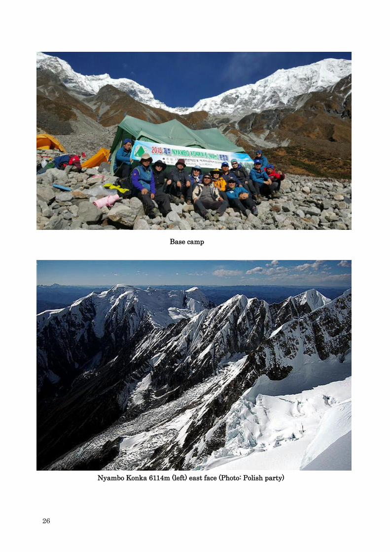
Base camp
Nyambo Konka 6114m (left) east face (Photo: Polish party)
27
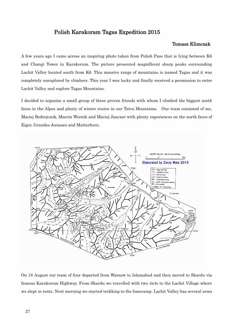
Polish Karakoram Tagas Expedition 2015
Tomasz Klimczak
A few years ago I came across an inspiring photo taken from Polish Pass that is lying between K6
and Changi Tower in Karakorum. The picture presented magnificent sharp peaks surrounding
Lachit Valley located south from K6. This massive range of mountains is named Tagas and it was
completely unexplored by climbers. This year I was lucky and finally received a permission to enter
Lachit Valley and explore Tagas Mountains.
I decided to organize a small group of three proven friends with whom I climbed the biggest north
faces in the Alpes and plenty of winter routes in our Tatra Mountains. Our team consisted of me,
Maciej Bedrejczuk, Marcin Wernik and Maciej Janczar with plenty experiences on the north faces of
Eiger, Grandes Jorasses and Matterhorn.
On 18 August our team of four departed from Warsaw to Islamabad and then moved to Skardu via
famous Karakorum Highway. From Skardu we travelled with two 4x4s to the Lachit Village where
we slept in tents. Next morning we started trekking to the basecamp. Lachit Valley has several arms

28
on the east side and we needed to choose the one with best faces to climb, close water and flat area
for our tents. We finally managed to find a decent but not very flat place under the moraine at about
4000m above sea with two splendid 6000m peaks.

29

30
After getting acclimatized we set for some a real adventure. Our first aim was the peak soaring on
the left side from the basecamp. We set off at about midday and before nightfall we set up an advance
basecamp (ABC) under the sersac at 5000m which was securing us from stonewalls and avalanches.
That night was spent in bivi sacs as the weather was supposed to stay good. However during the
night it started to snow and by morning we were all covered with a thick white duvet. It was still
snowing heavily and first avalanches were getting loose on the slopes. The decision was instant and
half an hour later we were going down surprised that some crevasses were already covered.
After the weather cleared on 4th September we pushed again for the same goal. This time we took
two light tents and made them under the same serac at 5000m. Next morning we overslept and
started to climb at about 7am. We planned our route on the north face of the mountain as we believed
it to be in good condition. From the glacier we climbed simultaneously for about 300m traversing
leftward iced slopes. From the end of traverse we climbed up easy iced slopes up to the rocks with
some fun ice gullies. The night caught us on the small ridge. We felt quite tired and decided to spend
the rest of night on a tiny ledge at 5600m. The summit ridge seemed not too far. Leaving the
basecamp we had had a good forecast for the next couple of days. At about 2 am it suddenly started to
snow and kept on through the dawn. We made a difficult decision to continue up despite weather
breakdown. The first pitch after bivi was leading through a tricky thin ice and offered a long runout
on unprotected 15mm thick verglas that was falling off if I hit to strong. After another two pitches we
31
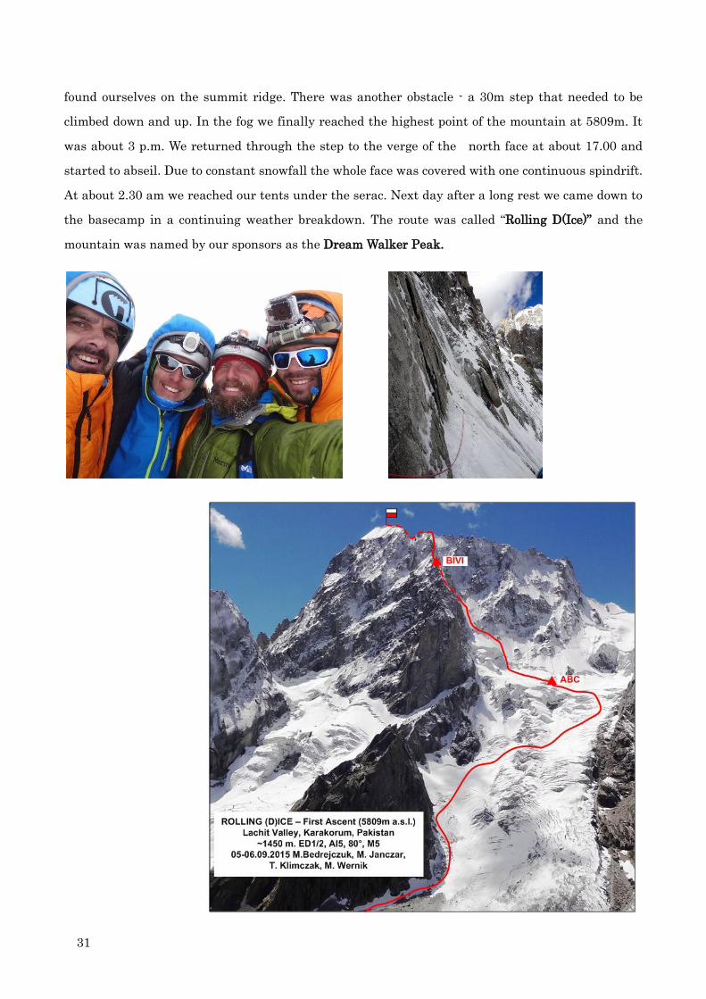
found ourselves on the summit ridge. There was another obstacle - a 30m step that needed to be
climbed down and up. In the fog we finally reached the highest point of the mountain at 5809m. It
was about 3 p.m. We returned through the step to the verge of the north face at about 17.00 and
started to abseil. Due to constant snowfall the whole face was covered with one continuous spindrift.
At about 2.30 am we reached our tents under the serac. Next day after a long rest we came down to
the basecamp in a continuing weather breakdown. The route was called “Rolling D(Ice)” and the
mountain was named by our sponsors as the Dream Walker Peak.

32
Following two days of recovery in BC we packed our backpacks and set off to explore another arm of
Lachit Valley. As a reward the neighboring arm of Lachit Valley turned out very beautiful with
spectacular views over virgin 6000m summits. There also were many flat grassy spots for basecamp
with water. Only the faces were a bit further than from our BC. The next day we moved to 5000m
and spent second night on the glacier, surrounded by beautiful unclimbed summits. Our initial plan
was to make some easy ascents on those peaks and explore as much as possible. From the bivi we
could clearly see the perfectly vertical north face of the highest peak in Tagas massive. It was a
soaring tower difficult from all sides with airy ridges and pointing summit – the great dream of every
alpinist. Because of its character we gave it a working name – the Ogre. Looking at it from our
tents made us lose any doubts that climbing this summit would be the main goal of our expedition
and the essence of alpinism which we knew. The Ogre had a promising ice couloir on the north-east
face and it was also easily accessible from our BC. We quickly counted days that were left and
realized that the only chance to climb the Ogre was to return to BC now and give up all other peaks.
So we packed our tents and reached BC in the evening.
Within the next few days we established ABC under the foot of 1,5km high north-east face of Ogre.
The steep couloir collected everything that was falling off the face. It was however well hidden from
sunrays
On 18th September after lunch we went to ABC. Next morning we hit the face taking bivisacs and
food for four nights. Looking from the bottom our route seemed quite steep and we did not expect to
find spots for tents. We climbed again in a team of four which takes more time but enables the load of
equipment to be shared more evenly. On the other hand our couloir was the most obvious route in the
valley. The first pitch led us through a small serac at the start and then we climbed simultaneously
until the first steep ice. The next pitches offered enjoyable ice climbing. That day was a 15m long
section of almost vertical ice with 30cm of snow plastered on. At about 11pm we dug a comfortable
platform in a snow.
On the next day at about 9 am we continued climbing reaching a rock band with some fun M5 terrain.
Late after the dark we found a small spot (small for four people) and spent a second night there. The
next day we climbed together through easy gullies until the ice steepened in a chimney that was
leading to the summit ridge. When I was following him I realized the chimney was overhanging and
the ice became frozen sand. We were just below 6000m and it was difficult to catch a breath making
M7- with a backpack. The next pitch was short but also not too easy, offering some M6 moves in an
overhanging chimney. The final pitch led us through a small snow cornice and there we were on the

33
saddle at 6004m after climbing the north-east face. Obviously we planned to keep going onto the
summit. It was about 3.30pm and the weather went bad. We could not see the ridge laying ahead and
decided to check the forecast with the basecamp. Because of bad weather forecast, we needed one
full day to get to the summit and return to the saddle. We started to abseil and late at night we
reached our first bivi. On the next day in a still good weather we continued abseiling. Only one
stance on entire route was protected with a rock. After 27 abseils from ice threads and pitons we
touched the glacier and came down to ABC. At about 17.30 we returned to basecamp. On the same
night it started to snow heavily and continued for the next couple of days. The route was called
“Polish Couloir” and ended at the saddle. The summit of Ogre is still unclimbed.
Our expedition to TheTagas Mountains was an excellent and inspiring experience. There are many
beautiful virgin peaks to climb within a relatively short distance from the village.
Surroundings of the Lachit Valley (Tagas Group, K6 Group)
Jerzy Wala, translated by Monika Hartman
In October 1992, late Adam Zachwieja, a chemist, sport pilot and traveller, took a photo of the
panorama of peaks from the plateau over the settlement of Khapalu (Khaplu). The panorama I saw
aroused my interest because of its outstanding mountain landscape – as well as of its absence in the

34
mountaneering literature. The interest was increased by E. Koblmuller’s photos taken from K6 (7281
m) and by Wojciech Kurtyka’s ones from the trekking to the Nangmah Valley in the summer of 2000.
I was intrigued and thus the idea of elaborating the topography of this area under the name of the
“Tagas Group” was conceived, with the name derived from the village located at the opening of the
central valley, the point of the confluence between the valley stream and the Saltoro River.
In 2004, a publication entitled ”Tagas Group. Topography of the Mountain Group”. Edition 1, Kraków
2004 was released, containing the entire information on this area available at the time. The later
Polish Expeditions – of K. Bełczyński and M. Tomaszewski in 2003, of Jan Kuczera and Tomasz
Polok to the Nanmah Valley in 2005, of Łukasz Depta, Andrzej Głuszek and Piotr Sztaba to Changi
Tower in 2010, and, especially, the Bulgarian expeditions of 2011 and 2012 to the Khane Valley
allowed us to expand the topographic publication. Supplements were issued, therefore: ”Tagas Group.
The Khane Valley and its Surroundings”. Supplement 1 - in 2012, and the subsequent “Tagas Group.
The Khane Valley and its Surroundings” Supplement 2 - in 2014. They were made in cooperation
with Janusz Majer. The Lachit Lungma Valley and its surroundings were almost entirely unknown
in mountaineering literature and remained unexplored. It was only in 2015 that the mountaineers
from the Warsaw Mountaineering Club, whom I had inspired with the interest in the area, managed
to obtain the permission of the Pakistani authorities to enter the Lachit Valley and climb there. The
abundance of the topographic material brought by Marcin Wernik, a participant of the expedition,
motivated me, together with Janusz Majer, to elaborate the third supplement to the publication,
containing quite a considerable section of the Tagas Group. Only the following valleys and their
surroundings have not yet been fully explored: Tagas Lungma, Tsino Valley and Second Lachit
Valley.
Despite the fact that altitudes are not great there - only a few peaks exceed the height of 6000 m - the
high mountain landscape and mountaneering values of the Tagas Group are in no way inferior to the
most interesting sections of Karakoram. In 2015, apart from the Polish expedition, an Italian one
operated in the Lachit Lungma Valley, contributing to the further documentation of the
surroundings of the valley.
In the proximity of the road to Hushe, along the paved road leading from Skardu to Kamarding and,
from there, along the Kaberi River Valley, towards the Kaberi Glacier and Kondus Glacier, access to
the described Tagas Group and the Lachit Lungma Valley is presently significantly easier.
Unfortunately, the names of locations in the region of the Lachit Lungma Valley have not been
identified. Therefore, the map depicting the Polish activity in the valley is marked with provisional
terms allowing for the description of the area. The names of peaks and passes come from the
expedition participants or were coined by the author of Map 2.
The area of the Tagas Group is presented in greater detail only on the available G.S.USSR 1:100 000

35
and 1:200 000 maps. The mountains can also be vieweed in the Google Earth programme. It has to be
explained that the terrain relief in these images is highly generalised due to the use of the automatic
image analysis for terrain modelling. The terrain model, on which the satellite images are
superimposed, is based on a grid of squares used in automatic processing. In the high mountain
terrain presented, minor sheer fragments are not properly captured, together with their heights.
Marcin Wernik’s photographs indicate that the Tagas Group area is made up mainly of
metamorphic rock, including gneiss and crystalline shale, characterised by perpendicular rock
formations generated by erosion. There may also be granite and other volcanic rocks there. The
Lachit Lungma Valley area is used by the natives as a pasture for yaks. In the neighbourhood of a
shepherd farmhouse, the Polish Base Camp was established for the expedition. The name is marked
on Map 2. It was accepted by the expedition liaison officer, so it may perpetuate in further
mountaineering exploration of the valley. Hopefully, the English names translatable to the local
languages, given to previously nameless objects, will largely be accepted.
The geographic grid from the map for G.S.USSR 1:200 000 was used for the elaborated orographic
maps. The map of the Tagas Group of 2004 was based on ”Northern Areas of Pakistan. Satellite
Image Map in the scale 1:500 000. All objects such as peaks and alps were marked with arabic
numerals, which, added to photographs, allow for their swift identification, both on the orographic
map and in the terrain description.
In 2004, I prepared a topographic description of a part of Karakoram in a separate notebook, which I
entitled ”K6 Group”. I included an orographical map of this mountain subgroup belonging to the
Masherbrum Mountain Group. In the late 2015, I and Janusz Majer received photographs from the
Polish expedition to the Lachit Lungma Valley. We decided then to elaborate Supplement 2 to the
publication ”K6 Group”. It includes the south-eastern part of the K6 mountain subgroup from the
Polish Col pass (5901 according to the GPS) up to the Kondus River. The pass was given its name in
Supplement 1, elaborated following the expedition organised by the Kraków Mountaineering Club in
2010, which attempted an ascent of Changi Tower (6475 m, 32) along the north-western ridge. This is
an area never mentioned as visited by mountaineers in literature.
In the centre of K6 Group there is a massif officially known as Baltistan Peak. Its greatest elevation
was marked with the symbol K6 (7281 m). A south-eastern ridge branches out from it, towards the
Polish Col pass. Behind the pass there is an eminent alp, the height of which was determined by an
Austrian expedition to be 6500 m and named Changi Tower. In 2015, Americans ascended it along its
north-western ridge and measured its height by means of an aneroid, obtaining the result of 6475 m.
A a quite unremarkable alp in Google Earth images, Changi Tower is in reality the highest
monolithic elevation in the area bearing that name. It may become the goal of many expeditions

36
exploring new variants of climbing routes. On the western and northern side there are high rock
walls with a slight addition of mixed snow and rock terrain, however, on the eastern side the snow of
the cirque called Changi Cwm reaches quite high and the wall itself is covered with snow to a greater
extent. Access to the eastern wall of Changi Tower requires a longer walk along the East Lachit
Glacier, starting from the settlement of Lachit at the opening of the Lachit Lungma Valley. So far,
nobody has achieved this.
A side ridge branches out of Changi Tower towards south, separating the Lachit Glacier from the
East Lachit Glacier. The glaciers received their names in the publication ”K6 Group” of 2004. The
ridge and its side branches are thick with soaring steeples most probably composed of metamorphic
rock. The cirques between the side ridges are filled with glacier tongues merging with the tongue of
the East Lachit Glacier on the south-eastern side and with the Lachit Glacier on the western side.
A long ridge with many peaks and side branches extends from Changi Tower (6475 m, 32), at first
towards the east and then towards the south. Between them there are cirques filled by cirque
glaciers and cirque-valley ones. Lachit Lungma and Kaberi Lungma valleys cut deep into the
mountain plinth of the Central Karakoram. This is visible in the photographs and Google Earth
images. The basins draining water from glaciers located high are steep and narrow.
The name of the river flowing out of the large Kaberi Glacier and Kondus Glacier is problematic. On
the map of the W.H.Workman and Bullock Workman expeditions of 1911 and 1912 it is
named ”Kaberi”, while the glacier from which it flows is called the ”Kaberi Glacier”. On the east it
merges with a glacier called ”Kaberi or Kondus”. On later maps, naming the stream as ”Kondus
River” was perpetuated. However, satellite images clearly demonstrate that the name of the stream
in the Workmans’ map was correct. Kaberi Glacier fills the valley, blocking the end of the tongue of
the glacier now called Kondus Glacier. This is evident in the LANDSAT image. Thus, the name of the
stream should stem from the name of the glacier from which it really flows.
From the north-east, the main ridge surrounds the upper level of the glacier called the ”East Lachit
Glacier” in the previous publications, as well as in the satellite image published in AAJ. 2005 (see p.
32). The glacier fills four cirques separated by side ridges. The highest peak in the area is marked
as 55 (6381 m). There is one more peak of 6161 m in the vicinity, marked as 71.
Towards south, a twisted ridge descends well below 6000 m. However, even in this ridge there is a
very prominent peak, marked as 90. It most probably reaches the height of almost 6000 m. It is
visible in the photos taken by M. Wernik, a participant of the Polish expedition to the Lachit Valley
in 2015. Reaching it from the south-west from the Lachit Lungma Valley is hard, the route leading
along a steep narrow ravine with rocky brinks. Approach may be more convenient from the east, but,
so far, the area is inaccessible for mountaineering expeditions. The peak is named Karmading Brakk
from the name of Karmading settlement (see map 1). The whole area is thick with alps and steeples.

37
Ascent of Api 7132m in West Nepal 2015
Japanese Expedition – September to October, 2015
Kenro Nakajima
Members: Kazuya Hiraide, Kenro Nakajima, Takuya Mitoro
Expedition period: 35 days from September 27 to October 31
Climbing history of Api 7132m
The Api-Nampa massif is located about 300km northwest of Pokara in the extreme northwestern rim
of Nepal and is now protected as a nature conservation area. The region was visited by Westerners in
1899, 1905, and 1936, but the peak was not attempted until 1953 on a visit by W. H. Murray a
Scottish Mountaineer with John Tyson. This attempt was unsuccessful, as was another, by Italians,
in 1954 which resulted in the death of two expedition members. The first ascent of Api was made by
The Doshisha University Alpine Club of Japan in 1960 having completed the Northwest Face route
attempted by the 1954 party. Katsutoshi Hirabayashi and a Sherpa stood atop. In 1980 a British
Army Mountaineering Association expedition made an attempt to climb the peak by the south face
reaching within a few hundred meters of the summit. December 24, 1983 Polish climbers Tadeusz
Piotrowski and Andrzej Bieluń made the first winter ascent. The Himalayan Index lists three more
ascents of the peak, in 1978, 1996 and 2001.
Japanese Expedition 2015
We came to Api-Nampa massif with an objective of the first ascent of the southwest face of Api and a
traverse from the west peak to the main summit. On April 25 fierce earthquake happened and
aftershocks continued in Nepal. Nevertheless western part of Nepal did not suffered from large
damages. Our travel agency asked us to visit Nepal for climbing as it would contribute to support
Nepalese people.
We left Kathmandu by a bus on September 30 and on October 5 arrived at DhauloOdar (bus, jeep,
and caravan-porters/donkeys) and set up south BC (south side). Nakajima suffered from altitude
sickness on the way. We could reach a place for south BC more easily than anticipated. To our
surprise, however, naked southwest face looked “black” with almost no snow and ice clad. The
conditions were different from the picture that we had brought from Japan. When a Giri-giri Boy’s
party attempted in spring of 2012, they were much annoyed by bad weather and unstable snow
conditions. This information led us to make a challenge in a season of good weather and much snow.
But it was doubtful whether our decision is a right approach. We ascended the east ridge for

38
acclimatization and reconnaissance of descent route after climbing the southwest face. Sunshine was
strong and stone falling was incessant. The east ridge was difficult to climb as often appearing in the
Himalaya and must be not easy to descend.
October 8, cloudy after fine, south BC (08:00) – Camel’s hump – 5200m (14:30)
October 9, fine and cloudy, 5200m (06:15) – couloir (06:30) – col (08:15) – 5550m (10:30)
October 10, cloudy after fine, 5550m (05:50) – col (07:15) – 5250m (08:30) – BC (12:15)
We returned to south BC after three days reconnaissance without positive prospect for the southwest
face. The lower half of the southwest face was uncertainly exposed to stone-falls. Climbing is too
dangerous. We were discouraged. However we were unable to return home with no crops. Hiraide
proposed an idea that we should turn northward as the first ascent was made from the northern side.
There remained no other choice. We decided to ascend Api from to northern side carrying 10 days
gears and supplies from south BC. We crossed a col between Api and Nampa to the northern side.
Although we investigated several routes from the northern side, we finally took the same route as
the first ascent.
October 16, fine-cloudy-foggy-snow, south BC (08:40 – Upper hump (13:00) – 5200m (15:30)
October 17, fine, 5200m (05:30) – col (07:30) – glacier terminus (11:00) – Kharka (14:40)
October 18, Cloudy-fine, Kharka (06:50) – Reconnoitering glacier (10:15–14:20) – Chhuagaru (14:50)
October 19, fine, Chhuagaru (06:30) – north BC (13*30)
October 20, fine, north BC (06:30) – Upper moraine (08:45) – Upper plateau (11:05) – Attack camp
(14:30)
October 21, fine, Attack camp (06:30) – Top of Api 7132m (10;30) – Attack camp (14:30) – north BC
(16:00)
October 28, returned to Kathmandu
North face of Api 7132m (Doshisha University Alpine Club)

39
Api southwest face Api north face
Descending ice fall On the summit of Api
View from top of Api to north (left-mountains in India, right-Namunani, far right- Kailash)
View from top of Api to south (left-Nampa, Bohaie, far left-Saipal)

40

41
Dzanye II and Lhonak Peak Climbed–East Nepal
Japanese Alpine Club student expedition 2015
In autumn 2015, a JAC Student Section party consisted of 6 members made 2 first ascents in
north-east area of Kangchenjunga: Dzanye II 6318m and Lhonak Peak 6070m, both included among
those peaks newly lifted by Nepali authority in spring 2014.
The area surrounding Dzanye I 6710m, the peak first climbed in 1949 by Swiss party, remained
almost untrod since then. The party identified Dzanye II through Google earth satellite photos and
their own GPS measurement, along with the base location announced by Nepali bureau.
The party leader, Takanori Mashimo (21 years old), who had once visited this area in 2013, put
forward this first-fruits-seeking expedition, after hard cheer-up of the Section’s young colleagues
mostly desperately submissive and illiterate.
Squeezed among 20 candidates off those lack of initiative spirits, the following five eventually
remained as final participants: Kotaro Miyatsu (24), Kenta Kimura (21), Shin-nosuke Ashikari (22),
Shun Katsurai (20), and Takehiro Nozawa (20).
The expedition took place following dairy:
September 9, 2015 March-in started at Taplejung, after 2days bus trip left Kathmandu
September 17, Arrived at Lhonak
October 4, Reached the top of Dzanye II, after 3 camps established in-between, while
another 1 camp for Lhonak Peak ascent.
October 15, Returned at Kathmandu
As for their climbing routes, attached route map shows in detail.
They did not use sherpa and porters at all during the climbing scene as their principle;
“Do everything by yourselves”. All consisted of the twenties aged members, this explorative-minded
party is fully educative on purpose as well, being so boastfully reported on top pages of recent JAC
monthly publication.
In old days in JAC, it was rather common that everybody so fervently desired to aim at the blank of
the maps, which spirits made JAC a majestic national-based club. Nowadays the club seems to be
more concerned with social events/undertakings, or regard famous mountains chasing only
worthwhile.
Phases of the times have changed, and even a mere coverage of overlooked map blanks really means
valuable before speaking of superb technique etc. (Text: Kei Kurachi)

42
Unfrequented Arunachal Pradesh
The Upper Siang 2015/2016 –Northeast Frontier, India
Reiko Terasawa

43
A friend of mine in India, who visited more than 50 times Arunachal Pradesh during 14 years,
tempted me to travel through the same region in September 2015 and February 2016. The journey in
late September of 2015 was from Simong heading to Ekodumbing (Riu Tala at about 4,000m) located
in the border of Yingkiong where Tibetan Buddhists, Christians and Hindu villagers live together.
However incessant heavy rain hindered our progress to go farther beyond a point of just one day
march to the destination.
This area used to be owned by the Simong community. Vegetation varies from a tropical plant to that
of the Frigid Zone, sometimes new species are discovered. Rare animals such as takin and Mithun
inhabit. Nature worship and Shamanism are prevalent. Adi tribe of Simong is a land of Adi tribe’s
animal and plant hunting. A myth of goddess of Tibetan Buddhists, Dorje Pagmo tells that “head is
Kangri Garpo, both breasts are Namcha Barwa and Gyala Peri and lower body is Pemako called
Yang Sang or Upper Siang.” Difference in culture causes a fight and conflict.
On February 15, we flew from Delhi to Digrugarh, where we crossed Brahmaputra to Pasighat by a
regular service boat. In 2015 the river had been crossed in 30 minutes, while in 2016 it took two
hours because lower water level. We arrived at Donyi Polo Tea Estate of Oyang in the dark. A spring
fiesta for praying good harvest, Ali Aye Ligan coincidently began, it continued for five days and we
joined the fiesta for three days, visited home to home drank Apon (local wine) and ate rice-cake with
smoked poke for celebrating the fiesta. A couple of days were lost.

44
Bridge under construction over Brahmaputra between Dibrugarh and Pasighat
Ekodumbing headed in 2015

45
Tecca chantrieri Gelling, car road end Tuting new monastery
From February 19 we proceeded in a hurry to catch up the delay. In the first day we drove from
Pasighat to Komsing along the right bank of River Siang, a road NH229 under large expansion work
which leads to Tawang. From there we crossed Boleng–Pangkang by a jeep road and then arrived at
Deki Tea Estate of Moying in the dark. This Estate invited a Japanese specialist for study and
research of tea. Yingkiong was viewed in the opposite side of the river.
Adi house in Simong Adi old men and woman
On February 20, we crossed a suspension bridge to visit Yingkiong, headqurter in this district. It
was a memorial day of the 30th anniversary of Arunachal Pradesh. Adi tribe put up a flag of tribe
<Donyi Pole> similar to Japanese national flag, Hinomaru. In the afternoon we hurried in rain and
fog to Pussing–Bomdo and we stayed at a villager’s house in Janbo on the ridge. Many Adi gathered
to just have a look of Japanese. My friend showed pictures taken in 1956–1959 when Mr. Nalni D
Jayal was assigned to this place. Villagers could explain persons and places on the picture. These
hinted few changes in Adi’s life-style for 60 years. Although it was raining February 21 was the last
day in our schedule for reaching Gelling. We intently drove a bad mountain road. As approaching to
Tuting, Tibetan Buddhism color became dominant. A large shining golden monastery was

46
constructed. Many of Adi have been turned from the town and villages and live in jungles. At the
time of China-India war in 1962, all the villages were burned. We were touched that a half naked old
Adi had remembered Mr. Jayal’ss having come to this place. We found the place where he had lived,
but no building in those days remained. Instead there was a stylish public house. Meanwhile Abi’s
houses were commonly made of bamboo and banana leaves even nowadays.
Wild Mithun Adi couple in Simong
In Tuting there was a army camp which was largest in Upper Siang. New airport was under
construction. We headed to Gelling though we were annoyed by convoys of the army. A vehicle road
had been connected only up to Tuting until four years ago. However, Modhi administration extended
the road to Gulling for strengthen army being prepared for invasion of China. We arrived at Gulling
in rain and thunder. From the road terminus, we must walk to the village, but in view of danger of
land-slides in return we gave up going farther and stayed a Tibetan house at Kopu. On February 22,
also it was raining but not heavily. We headed to Moying for return by the same way avoiding a risk
of widely taking place land-slides of NH513 on the left bank of River Siang.
Permit issue: On-line application to the state government is possible submitting application form
with a portrait photo, passport and copy of visa mentioning places of travel. In our case this time,
however, we used a local agent. Permit is issued in 5 – 7 days after sending application. Application
fee is US$50 + agent fee. (Information is as on January 25, 2016)
It is noted that irrespective of strong objection by the State Government, Arunachal Pradesh State
has became a state under direct control and administration of the President on January 26, 2016. We
must watch how this new policy is implemented and would affect and influence the tourism in the
remote frontier such as the Upper Siang.

47
First ascent of Mount Malaspina
Saint Elias Mountains, Yukon, Canada.
Camilo Rada
On August 4th our team composed by Natalia Martinez and Camilo Rada, as part of our Uncharted
Project (previously climbing Cordillera de Sarmiento in 2012, Mount Sarmiento in 2013 and Aguilera
Volcano in 2014, the last two pre-nominated to the Piolet d'Or award) flew into the Seward Glacier in
Kluane National Park, close to Mount Saint Elias. After traversing 12 km we established a base
camp near the base of Mount Malaspina, distinguished with the awkward title of "highest named
unclimbed mountain of North America", and with no doubt one of the most prominent and attractive
unclimbed summits of the continent. (Perhaps the highest unclimbed, depending on one´s definition
of mountain adopted.) As far as we know it was seriously attempted only once, in 1976 by a
Polish-Alaskan expedition through the west ridge (AAJ 1978, pp. 542).
After 3 days exploring the heavily crevassed glacier flowing from Malaspina to Seward, we finally
discarded every option through the glacier. We were forced to hug an edge of the glacier exposed to

48
avalanches, but where avalanche debris filled the crevasses. Crossing that section in the early
morning, we established a high camp near the north face of the mountain, on August 9th.
We experienced bad weather and avalanche risk at the high camp, forcing us to abandon and never
reoccupy the camp. Several areas of the high glacier basin near the wall seemed safe, yet seracs
falling 1,000 m straight from the top of the north face were capable of launching ice and snow
projectiles over the area of our camp. We decided to abandon the camp after being hit by strong
winds and heavy spray a serac avalanche. We found a few TV-sized pieces of ice around camp with
short tracks, suggesting that one of them landed just 4 meters away of our tent.
Once the weather improved, the summit push started from base camp on August 13th at 00:40 h.
After 3 hours we reached the high camp deposit and continued towards the col between Mount Baird
and Malaspina. The access to the col was extremely exposed to avalanches, rock and serac falls,
therefore was done quickly at the hours before dawn. At 7 am we started the climb towards the col,
running diagonally under a hanging glacier. We climbed the first 300 meters of snow and ice (45 to
60 degrees) in simultaneous. A small serac fall occurred nearby. Next we reached the easy col slopes
with 2 pitches of 55-65° of ice. After resting we resumed climbing a ramp of 350 meters leading to
Malaspina's East shoulder, consisting of a very sustained slope involving 9 pitches on 50-65 degrees
on snow and ice with a final cornice with short vertical steps.
We reached the shoulder (3,377 m) shortly after midnight and built a igloo-like bivouac shelter
surrounded by the breathtaking spectacle of a northern lights storm. The next day (15th) at 10 am
we continued towards the summit covering easy snow slopes and few technical steps to overcome few
bergshrunds. After a false summit, we finally summit at 2 pm with the GPS reading 3,756 meters.
The view was dominated by the overwhelmingly large Malaspina Glacier, in fact the largest "Pie de
mont" glacier in the world and an extremely outstanding feature in the area. This was accompanied
by views to Mount Saint Elias to the West, The Logan massif to the North and Vancouver, Augusta,
Cook and Fairweather to the East. The descent followed the same line and involved 15 rappels, half
of them between low clouds, winds and heavy spindrift. We reached base camp again at 8 am on
August 16th after 55 hours on the mountain.
Summary:
On August 15th 2015 Natalia Martinez and Camilo Rada made the first ascent of Mount Malaspina
(3,776 meters) from the North via East col and East ridge (1900 m, TD*, AI2, 55-65°).

49
Kashkawuish Glacier dominating in the entrance of Kiuena National Park
Base Camp North face of Malaspina
Mount Logan

50
East of the Himalaya-Mountain Peak Maps
Alps of Tibet & Beyond
Tamotsu (Tom) Nakamura
This book widely covers the last frontier yet explored. Author has compiled 24 years
discoveries and research in a gigantic volume well documented, perfectly illustrated by
53 maps with 540 pictures of fascinating least-known mountains. It will be an essential
reference work for many generations. (published in January, 2016)