Ashtech Promark 700 Datasheet 651
4
The Perfect Network RTK Rover: Lightweight, Rugged and Simply Reliable ProMark ™ 700
-
Upload
miftahus-siddiq -
Category
Documents
-
view
26 -
download
4
description
manual tutorial ashtech GPS
Transcript of Ashtech Promark 700 Datasheet 651

The Perfect Network RTK Rover:Lightweight, Rugged and Simply Reliable
ProMark™ 700
Pro
Mar
k 70
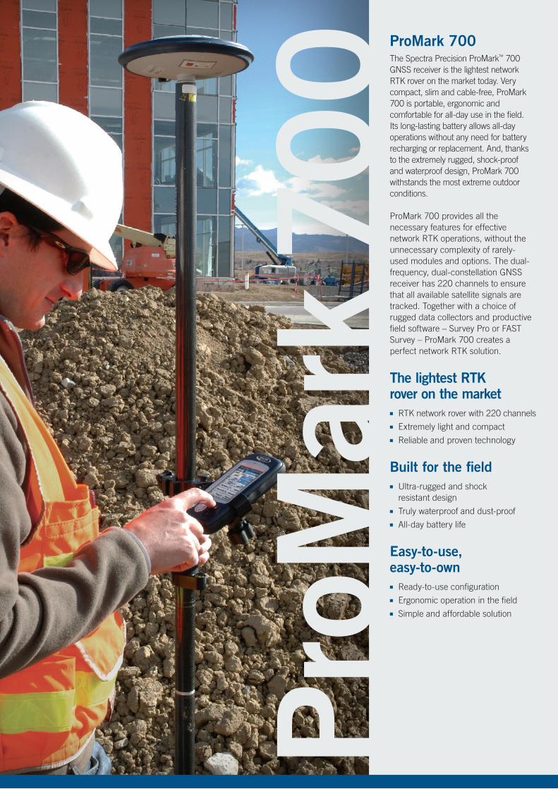
0 ProMark 700The Spectra Precision ProMark™ 700 GNSS receiver is the lightest network RTK rover on the market today. Very compact, slim and cable-free, ProMark 700 is portable, ergonomic and comfortable for all-day use in the field. Its long-lasting battery allows all-day operations without any need for battery recharging or replacement. And, thanks to the extremely rugged, shock-proof and waterproof design, ProMark 700 withstands the most extreme outdoor conditions.
ProMark 700 provides all the necessary features for effective network RTK operations, without the unnecessary complexity of rarely-used modules and options. The dual-frequency, dual-constellation GNSS receiver has 220 channels to ensure that all available satellite signals are tracked. Together with a choice of rugged data collectors and productive field software – Survey Pro or FAST Survey – ProMark 700 creates a perfect network RTK solution.
The lightest RTK rover on the market ■■ RTK network rover with 220 channels■■ Extremely light and compact ■■ Reliable and proven technology
Built for the field■■ Ultra-rugged and shock
resistant design ■■ Truly waterproof and dust-proof ■■ All-day battery life
Easy-to-use, easy-to-own ■■ Ready-to-use configuration■■ Ergonomic operation in the field■■ Simple and affordable solution

Choice of Data Collectors Pair the ProMark 700 receiver with a choice of data collectors, field and office software to create a robust, ready-to-use, cable-free RTK solution. With such features as large color touch screens, SDHC memory slots, cellular modems, WLAN and Bluetooth™ wireless technologies, you can choose from among the following data collectors:
■■ The MM10 Data Collector: A very lightweight but rugged design, with extremely long battery life (over 20 hours) making it a perfect tool for long surveying jobs
■■ The T41™ Data Collector: A rugged, connected, slim and compact handheld, offering class-leading performance with a high-resolution outdoor readable display
■■ The Ranger™ 3 Data Collector: An ultra-rugged field terminal with full alphanumeric keyboard, for use in tough outdoor environments
■■ The ProMark™ 100 Data Collector: A rugged GNSS handheld that can also be used for additional work such as pre-survey and GIS data collection
Survey Pro Field Software Survey Pro field software provides you with a complete set of capabilities for all your survey projects. It’s fast, reliable and easy to use. It provides unparalleled integration, data integrity, and efficiency. Survey Pro software is offered in a variety of modules to best fit the job, and features can be added as needed. Survey Pro is unmatched in its capabilities and is one of the reasons it has been a top choice of surveyors for more than 20 years.
FAST Survey Field Software Advanced FAST Survey field software meets the most demanding survey requirements. It includes topographic features typically associated with dual-frequency GNSS surveying, and provides extensive data formats and local coordinate system support. Added options make it possible to interact with a wide range of survey instruments and accessories to run complete survey jobs, including site calibration, stake out, and survey projects where total stations are used.
SCAN THIS CODE FOR MORE
INFORMATION
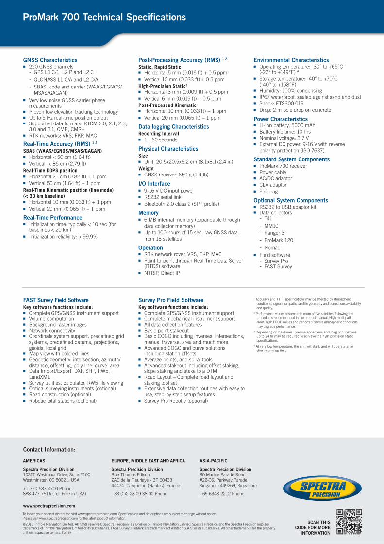
GNSS Characteristics■■ 220 GNSS channels
- GPS L1 C/1, L2 P and L2 C - GLONASS L1 C/A and L2 C/A- SBAS: code and carrier (WAAS/EGNOS/
MSAS/GAGAN) ■■ Very low noise GNSS carrier phase
measurements ■■ Proven low elevation tracking technology■■ Up to 5 Hz real-time position output ■■ Supported data formats: RTCM 2.0, 2.1, 2.3,
3.0 and 3.1, CMR, CMR+■■ RTK networks: VRS, FKP, MAC
Real-Time Accuracy (RMS) 1 2
SBAS (WAAS/EGNOS/MSAS/GAGAN) ■■ Horizontal < 50 cm (1.64 ft) ■■ Vertical < 85 cm (2.79 ft)
Real-Time DGPS position ■■ Horizontal 25 cm (0.82 ft) + 1 ppm■■ Vertical 50 cm (1.64 ft) + 1 ppm
Real-Time Kinematic position (fine mode) (< 30 km baseline)■■ Horizontal 10 mm (0.033 ft) + 1 ppm ■■ Vertical 20 mm (0.065 ft) + 1 ppm
Real-Time Performance■■ Initialization time: typically < 10 sec (for
baselines < 20 km)■■ Initialization reliability: > 99.9%
Post-Processing Accuracy (RMS) 1 2
Static, Rapid Static ■■ Horizontal 5 mm (0.016 ft) + 0.5 ppm ■■ Vertical 10 mm (0.033 ft) + 0.5 ppm
High-Precision Static3
■■ Horizontal 3 mm (0.009 ft) + 0.5 ppm ■■ Vertical 6 mm (0.019 ft) + 0.5 ppm
Post-Processed Kinematic ■■ Horizontal 10 mm (0.033 ft) + 1 ppm ■■ Vertical 20 mm (0.065 ft) + 1 ppm
Data logging CharacteristicsRecording Interval■■ 1 - 60 seconds
Physical CharacteristicsSize■■ Unit: 20.5x20.5x6.2 cm (8.1x8.1x2.4 in)
Weight■■ GNSS receiver: 650 g (1.4 lb)
I/O Interface■■ 9-16 V DC input power■■ RS232 serial link■■ Bluetooth 2.0 class 2 (SPP profile)
Memory■■ 6 MB internal memory (expandable through
data collector memory) ■■ Up to 100 hours of 15 sec. raw GNSS data
from 18 satellites
Operation■■ RTK network rover: VRS, FKP, MAC ■■ Point-to-point through Real-Time Data Server
(RTDS) software ■■ NTRIP, Direct IP
Environmental Characteristics■■ Operating temperature: -30° to +65°C
(-22° to +149°F) 4
■■ Storage temperature: -40° to +70°C (-40° to +158°F)
■■ Humidity: 100% condensing ■■ IP67 waterproof, sealed against sand and dust ■■ Shock: ETS300 019■■ Drop: 2 m pole drop on concrete
Power Characteristics■■ Li-Ion battery, 5000 mAh ■■ Battery life time: 10 hrs ■■ Nominal voltage: 3.7 V ■■ External DC power: 9-16 V with reverse
polarity protection (ISO 7637)
Standard System Components■■ ProMark 700 receiver■■ Power cable■■ AC/DC adaptor■■ CLA adaptor■■ Soft bag
Optional System Components■■ RS232 to USB adaptor kit■■ Data collectors
- T41- MM10- Ranger 3- ProMark 120
- Nomad■■ Field software
- Survey Pro- FAST Survey
FAST Survey Field SoftwareKey software functions include:■■ Complete GPS/GNSS instrument support ■■ Volume computation ■■ Background raster images ■■ Network connectivity ■■ Coordinate system support: predefined grid
systems, predefined datums, projections, geoids, local grid
■■ Map view with colored lines ■■ Geodetic geometry: intersection, azimuth/
distance, offsetting, poly-line, curve, area ■■ Data Import/Export: DXF, SHP, RW5,
LandXML ■■ Survey utilities: calculator, RW5 file viewing ■■ Optical surveying instruments (optional) ■■ Road construction (optional) ■■ Robotic total stations (optional)
Survey Pro Field SoftwareKey software functions include:■■ Complete GPS/GNSS instrument support■■ Complete mechanical instrument support■■ All data collection features■■ Basic point stakeout■■ Basic COGO including inverses, intersections,
manual traverse, area and much more■■ Advanced COGO and curve solutions
including station offsets■■ Average points, and spiral tools■■ Advanced stakeout including offset staking,
slope staking and stake to a DTM■■ Road Layout – Complete road layout and
staking tool set■■ Extensive data collection routines with easy to
use, step-by-step setup features■■ Survey Pro Robotic (optional)
1 Accuracy and TTFF specifications may be affected by atmospheric conditions, signal multipath, satellite geometry and corrections availability and quality.
2 Performance values assume minimum of five satellites, following the procedures recommended in the product manual. High multi-path areas, high PDOP values and periods of severe atmospheric conditions may degrade performance.
3 Depending on baselines, precise ephemeris and long occupations up to 24 hr may be required to achieve the high precision static specifications.
4 At very low temperature, the unit will start, and will operate after short warm-up time.
ProMark 700 Technical Specifications
To locate your nearest distributor, visit www.spectraprecision.com. Specifications and descriptions are subject to change without notice. Please visit www.spectraprecision.com for the latest product information.
©2013 Trimble Navigation Limited. All rights reserved. Spectra Precision is a Division of Trimble Navigation Limited. Spectra Precision and the Spectra Precision logo are trademarks of Trimble Navigation Limited or its subsidiaries. FAST Survey, ProMark are trademarks of Ashtech S.A.S. or its subsidiaries. All other trademarks are the property of their respective owners. (1/13)
Contact Information:
AMERICAS
Spectra Precision Division10355 Westmoor Drive, Suite #100Westminster, CO 80021, USA
+1-720-587-4700 Phone888-477-7516 (Toll Free in USA)
EUROPE, MIDDLE EAST AND AFRICA
Spectra Precision DivisionRue Thomas EdisonZAC de la Fleuriaye - BP 6043344474 Carquefou (Nantes), France
+33 (0)2 28 09 38 00 Phone
ASIA-PACIFIC
Spectra Precision Division80 Marine Parade Road #22-06, Parkway Parade Singapore 449269, Singapore
+65-6348-2212 Phone
www.spectraprecision.com