As per the EIA Notification 15th January 2016...
21
1 Minor Mineral Ordinary Soil Mine (Proposed Project) Village : Jambusar, Ta : Jambusar, Dist : Bharuch (Gujarat) Production Capacity : 1,00,000TPA Area : 05-99-12 Ha. Proposal For Environmental Clearance As per the EIA Notification 15th January 2016 Proponent Sh Indravadan Rana, S/O Sh Girishbhai Rana At : Jambusar, Sr. No. 1824/A Paiky, Taluka : Jambusar, Dist : Bharuch Mo :- +91 9824218590
Transcript of As per the EIA Notification 15th January 2016...

1
Minor Mineral Ordinary Soil Mine
(Proposed Project)
Village : Jambusar, Ta : Jambusar, Dist : Bharuch (Gujarat)
Production Capacity : 1,00,000TPA
Area : 05-99-12 Ha.
Proposal
ForEnvironmental Clearance
As per the EIA Notification 15th January 2016
Proponent
Sh Indravadan Rana,S/O Sh Girishbhai Rana
At : Jambusar, Sr. No. 1824/A Paiky,
Taluka : Jambusar, Dist : Bharuch
Mo :- +91 9824218590
2
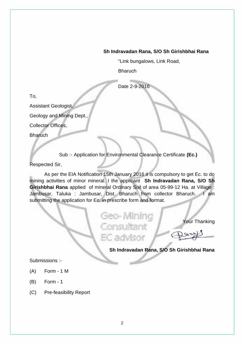
Sh Indravadan Rana, S/O Sh Girishbhai Rana
“Link bungalows, Link Road,
Bharuch
Date 2-9-2016
To,
Assistant Geologist,
Geology and Mining Dept.,
Collector Offices,
Bharuch
Sub :- Application for Environmental Clearance Certificate (Ec.)
Respected Sir,
As per the EIA Notification 15th January 2016 it is compulsory to get Ec. to domining activities of minor mineral. I the applicant Sh Indravadan Rana, S/O ShGirishbhai Rana applied of mineral Ordinary Soil of area 05-99-12 Ha. at Village :Jambusar, Taluka : Jambusar, Dist. Bharuch from collector Bharuch. I amsubmitting the application for Ec. in prescribe form and format.
Your Thanking
Sh Indravadan Rana, S/O Sh Girishbhai Rana
Submissions :-
(A) Form - 1 M
(B) Form - 1
(C) Pre-feasibility Report

3
(A)
FROM - 1 M
APPLICATION FOR MINING OF MINOR MINERALS UNDER CATEGORY "B2"FOR LESS THAN AND EQUAL TO FIVE HECTARE
Basic Information:-
(viii) Name of the Mining Lease site Sh Indravadan Rana, S/O ShGirishbhai Rana
(ix) Location / site (GPS Co-ordinates) Jambusar/22° 0'49.77"N 72°47'18.67"E
(x) Size of the Mining Lease (Hectare) 05-99-12 Hectare(xi) Capacity of Mining Lease (TPA) 1,00,000TPA(xii) Period of Mining Lease Approximately 5 Years(xiii) Expected cost of the Project Approximately 10.00 Lacs.(xiv) Contact Information 98242 18590
Environmental Sensitivity:-
Sr.No.
Area Distance inKilometer/Details
1. Distance of project site from nearest rail or roadbridge over the concerned River, Rivulet, Nallahetc,
Distance from thenearest bridge over theRiver is about 7.39 Km
2. Distance from infrastructural facilitiesRailway line 4.41 KmNational Highway 4.52 Km N.H. No. 228State Highway 4.52 Km S.H. No. 6Major District Road 4.52 Km N.H. No. 228Any Other Road Jambusar 0.09 Km
Gramya Marg.Electric Transmission Line pole or tower Electric Pole is 3.72 Km
away from leaseboundary.
Canal or check dam or reservoirs or lake orponds
Check dam 4.09 km awayfrom lease boundary.
In-take for drinking water pump house Drinking water tankJambusar.
Intake for Irrigation canal pumps None3. Areas protected under international
conventions, national or local legislation for theirecological, landscape, cultural or other relatedvalue
None
4. Areas which are important or sensitive forecological reasons - Wetlands, watercourses orother water bodies, coastal zone, biospheres,
None

4
mountains, forests5. Areas used by protected, important or sensitive
species of flora or fauna for breeding, nesting,foraging, resting, over wintering, migration
None
6. Inland, coastal, marine or underground waters Underground water levelis below 200 Mtr.
7. State, National boundaries None8. Routes or facilities used by the public for access
to recreation or other tourist, pilgrim areasNone
9. Defence installations None10. Densely populated or built-up area, distance
from nearest human habitationJambusar is about 3.72Km away from leaseboundary.
11. Areas occupied by sensitive man-made landuses (Hospitals, Schools, Places of worship,community facilities)
Jambusar is about 3.72Km away from leaseboundary.
12. Areas containing important, high quality orscarce resources (ground water resources,surface resources, forestry, agriculture,fisheries, tourism, minerals)
None
13 Areas already subjected to pollution orenvironmental damage. (those where existinglegal environmental standards are exceeded)
No critically polluted areain the periphery of 10.00Km from lease boundary.
14. Areas susceptible to natural hazard which couldcause the project to present environmentalproblems (earthquakes, subsidence, landslides,erosion, flooding or extreme or adverse climaticconditions)
None
15. Is proposed mining site located over or nearfissure / fracture for ground water recharge
No, Proposed miningproject will not affectground water rechargesystem.
16. Whether the proposal involves approval orclearance under the following Regulations orActs, namely :
None
(a) The Forest (Conservation) Act, 1980 None(b) The Wildlife (Protection) Act, 1972 None(c) The Coastal Regulation Zone Notification,
2011.None
If yes, details of the same and their status to begiven.
17. Forest land involved (hectares) None.18. Whether there is any litigation pending against
the project and/or land in which the project ispropose to be set up ?
No Litigation is pendingagainst the lease area /applicant of this leasearea in not any court oflaw as per our bestknowledge.
(a) Name of the Court -

5
(b) Case No. -(c) Orders or directions of the Court, if any,
and its relevance with the proposedproject.
-
(Signature of ProjectProponent)
Sh Indravadan Rana, S/O ShGirishbhai Rana
At:Jambusar
Ta: Jambusar
Dist: Bharuch
6
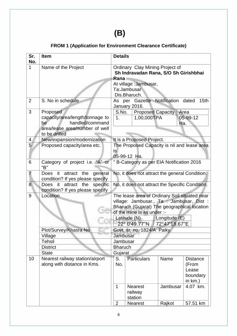
(B)FROM 1 (Application for Environment Clearance Certificate)
Sr.No.
Item Details
1 Name of the Project Ordinary Clay Mining Project ofSh Indravadan Rana, S/O Sh Girishbhai
RanaAt village :Jambusar,Ta:JambusarDis.Bharuch.
2 S. No in schedule As per Gazette Notification dated 15thJanuary 2016.
3 Proposedcapacity/area/length/tonnage tobe handled/commandarea/lease area/number of wellto be drilled
S.No. Proposed Capacity Area1. 1,00,000TPA 05-99-12
Ha.
4 New/expansion/modernization It is a Proposed Project.5 Proposed capacity/area etc. The Proposed Capacity is nil and lease area
is05-99-12 Ha.
6 Category of project i.e. “A” or“B”
" B-Category as per EIA Notification 2016
7 Does it attract the generalcondition? If yes please specify
No, it does not attract the general Condition.
8 Does it attract the specificcondition? If yes please specify
No, it does not attract the Specific Condition.
9 Location The lease area of Ordinary Soil situated nearvillage: Jambusar., Ta : Jambusar, Dist :Bharuch (Gujarat) The geographical locationof the mine is as under :-Latitude (N) Longitude (E)22° 0'49.77"N 72°47'18.67"E
Plot/Survey/Khasra No Govt. sr. no. 1824/A Paiky.Village JambusarTehsil JambusarDistrict BharuchState Gujarat
10 Nearest railway station/airportalong with distance in Kms.
S.No.
Particulars Name Distance(FromLeaseboundaryin km.)
1 Nearestrailwaystation
Jambusar 4.07 km.
2 Nearest Rajkot 57.51 km
7
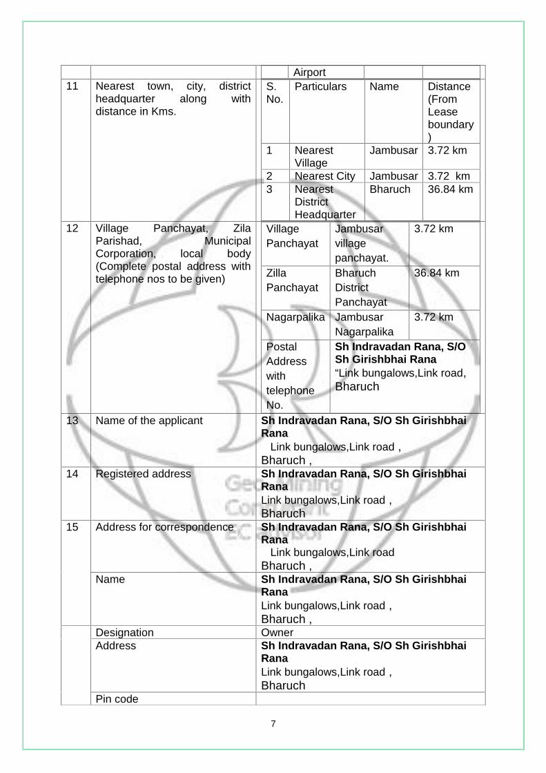
Airport11 Nearest town, city, district
headquarter along withdistance in Kms.
S.No.
Particulars Name Distance(FromLeaseboundary)
1 NearestVillage
Jambusar 3.72 km
2 Nearest City Jambusar 3.72 km3 Nearest
DistrictHeadquarter
Bharuch 36.84 km
12 Village Panchayat, ZilaParishad, MunicipalCorporation, local body(Complete postal address withtelephone nos to be given)
VillagePanchayat
Jambusarvillagepanchayat.
3.72 km
ZillaPanchayat
BharuchDistrictPanchayat
36.84 km
Nagarpalika JambusarNagarpalika
3.72 km
PostalAddresswithtelephoneNo.
Sh Indravadan Rana, S/OSh Girishbhai Rana“Link bungalows,Link road,Bharuch
13 Name of the applicant Sh Indravadan Rana, S/O Sh GirishbhaiRana
Link bungalows,Link road ,Bharuch ,
14 Registered address Sh Indravadan Rana, S/O Sh GirishbhaiRanaLink bungalows,Link road ,Bharuch
15 Address for correspondence Sh Indravadan Rana, S/O Sh GirishbhaiRana
Link bungalows,Link roadBharuch ,
Name Sh Indravadan Rana, S/O Sh GirishbhaiRanaLink bungalows,Link road ,Bharuch ,
Designation OwnerAddress Sh Indravadan Rana, S/O Sh Girishbhai
RanaLink bungalows,Link road ,Bharuch
Pin code

8
E-mail [email protected] 09824218590Fax No --
16 Details of alternative sitesexamined, if any. Location ofthese sites should be shown ona topo sheet
No. Mineral Ordinary Soil is naturallyoccurring resource and this is a site specificproject. Hence no alternative can be chosen.
17 Interlinked Project N.A.18 Whether separate application
for interlinked project has beensubmitted?
N.A.
19 If yes date of submission N.A.20 If no reason N.A.21 Whether the proposal involves
approval/ clearance under: ifyes, details of the same andtheir status to be given.
No
The Forest (Conservation) Act,1980?
There is no reserve orprotected forest within 10.00km periphery of lease area.
N.A
The Wildlife (Protection) Act,1972?
There is no Wildlife sanctuarywithin 10.00 km periphery oflease area
N.A
Eco-Sensitivity zone within10.00 km periphery of leasearea
N.A
The C.R.Z. Notification, 1991? There is no C.R.Z. within 10.00 km peripheryof lease area.
22 Whether there is anyGovernment order/policyrelevant/ relating to site
N.A.
23 Forest Land involved? N.A.24 Whether there is any litigation
pending against the projectand / or land in which theproject is propose to be set upName of courtCase noOrder/directions of the court,
No other litigation is pending in the any courtof law as per our best knowledge.

9
1. Construction, operation or decommissioning of the project involving actions, which willcause physical changes in the locality (topography, land use, changes in water bodies,etc)
Sr.No.
Information/Checklistconfirmation
Yes/No?
Details there of with approximatequantity/rate wherever possiblewith source of information of data
1.1 Permanent or temporarychange in land use, landcover or topographyincluding increase inintensity of land use (withrespect to local land useplan)
No Land will be used for collection ofOrdinary Soil for filling purpose ininfrastructures; it does not involveany permanent change in thetopography of the permit hold area.
1.2 Clearance of Proposed land,vegetation and buildings?
No There is no tree or Proposedstructure on the proposed site.Hence no clearance is required.
1.3 Creation of new land uses? No N.A.1.4 Pre-construction
investigations e.g. boreholes, Clay testing?
No Not Applicable
1.5 Construction works? No Not Applicable1.6 Demolition works? No Not Applicable1.7 Temporary sites used for
construction works orhousing of constructionworkers?
No Workers are hired from nearbyvillages so no housing facility isrequired. However, temporary restshelters will be provided at the site.
1.8 Above ground buildings,structures or earthworksincluding linear structures,cut and fill or excavations
No Not Applicable
1.9 Underground works includingmining or tunneling?
No Not Applicable
1.10 Reclamation works? No No reclamation work will be done1.11 Dredging? No Ordinary Soil mining will be done.
1.12 Offshore Structures? No There will be no off shore structures.
1.13 Production andmanufacturingprocesses?
No Nil
if any and its relevance withthe Proposed project.
25 Expected cost of the project Rs.2,00,000 /-

10
Sr.No.
Information/Checklistconfirmation
Yes/No?
Details there of with approximatequantity/rate wherever possiblewith source of information of data
1.14 Facilities for storage ofgoods or materials?
yes Not required.
1.15 Facilities for treatment ordisposal of solid waste orliquid effluents?
No No need for treatment or disposal ofsolid waste and liquid effluents.
1.16 Facilities for long termhousing of operationalworkers?
No Not Applicable
1.17 New road, rail or sea trafficduring construction oroperation?
No Not Applicable
1.18 New road, rail, airwaterborne or other transportinfrastructure including newor altered routes andstations, ports, airports etc?
No Not Applicable
1.19 Closure or diversion ofProposed transport routes orinfrastructure leading tochanges in trafficmovements?
No Not applicable
1.20 New or diverted transmissionlines or pipelines?
No N.A.
1.21 Impoundment, damming,culverting, realignment orother changes to thehydrology of watercourses oraquifers?
No N.A.
1.22 Stream crossings? No N.A.1.23 Abstraction or transfers of
water form ground or surfacewaters?
No Not Required
1.24 Changes in water bodies orthe land surface affectingdrainage or run-off?
No The mining will be up to 1.5 mtrsonly which will not intersect theground water level or water. bodies.
1.25 Transport of personnel ormaterials for construction,operation ordecommissioning?
No In the operation phase Ordinary Soilwill be excavated by manual only.
1.26 Long-term dismantling ordecommissioning orrestoration works?
No Not Applicable
11
Sr.No.
Information/Checklistconfirmation
Yes/No?
Details there of with approximatequantity/rate wherever possiblewith source of information of data
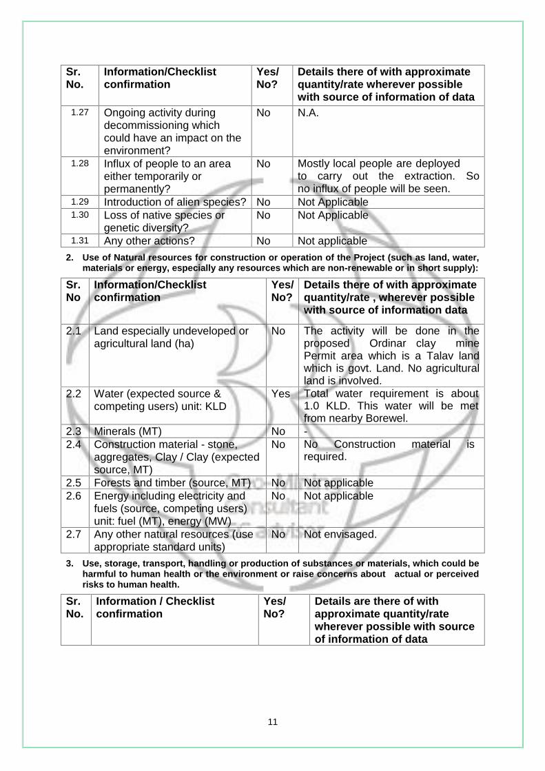
1.27 Ongoing activity duringdecommissioning whichcould have an impact on theenvironment?
No N.A.
1.28 Influx of people to an areaeither temporarily orpermanently?
No Mostly local people are deployedto carry out the extraction. Sono influx of people will be seen.
1.29 Introduction of alien species? No Not Applicable1.30 Loss of native species or
genetic diversity?No Not Applicable
1.31 Any other actions? No Not applicable2. Use of Natural resources for construction or operation of the Project (such as land, water,
materials or energy, especially any resources which are non-renewable or in short supply):
Sr.No
Information/Checklistconfirmation
Yes/No?
Details there of with approximatequantity/rate , wherever possiblewith source of information data
2.1 Land especially undeveloped oragricultural land (ha)
No The activity will be done in theproposed Ordinar clay minePermit area which is a Talav landwhich is govt. Land. No agriculturalland is involved.
2.2 Water (expected source &competing users) unit: KLD
Yes Total water requirement is about1.0 KLD. This water will be metfrom nearby Borewel.
2.3 Minerals (MT) No -2.4 Construction material - stone,
aggregates, Clay / Clay (expectedsource, MT)
No No Construction material isrequired.
2.5 Forests and timber (source, MT) No Not applicable2.6 Energy including electricity and
fuels (source, competing users)unit: fuel (MT), energy (MW)
No Not applicable
2.7 Any other natural resources (useappropriate standard units)
No Not envisaged.
3. Use, storage, transport, handling or production of substances or materials, which could beharmful to human health or the environment or raise concerns about actual or perceivedrisks to human health.
Sr.No.
Information / Checklistconfirmation
Yes/No?
Details are there of withapproximate quantity/ratewherever possible with sourceof information of data
12
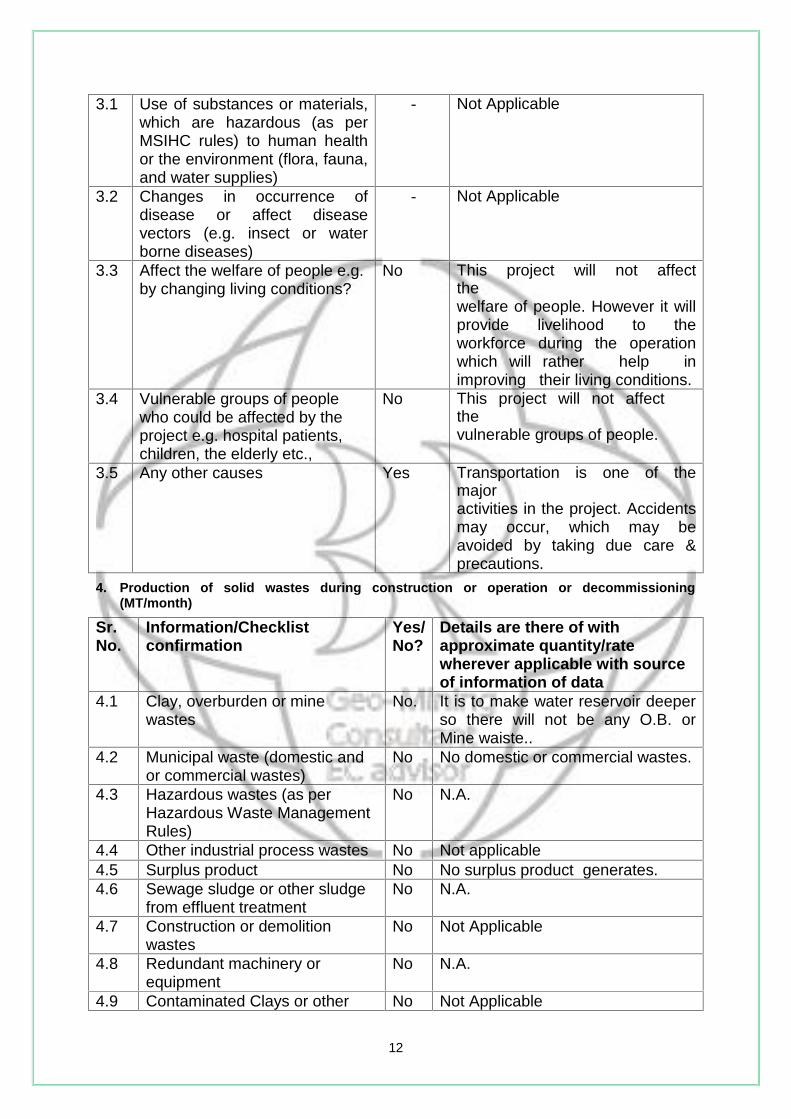
3.1 Use of substances or materials,which are hazardous (as perMSIHC rules) to human healthor the environment (flora, fauna,and water supplies)
- Not Applicable
3.2 Changes in occurrence ofdisease or affect diseasevectors (e.g. insect or waterborne diseases)
- Not Applicable
3.3 Affect the welfare of people e.g.by changing living conditions?
No This project will not affectthewelfare of people. However it willprovide livelihood to theworkforce during the operationwhich will rather help inimproving their living conditions.
3.4 Vulnerable groups of peoplewho could be affected by theproject e.g. hospital patients,children, the elderly etc.,
No This project will not affectthevulnerable groups of people.
3.5 Any other causes Yes Transportation is one of themajoractivities in the project. Accidentsmay occur, which may beavoided by taking due care &precautions.
4. Production of solid wastes during construction or operation or decommissioning(MT/month)
Sr.No.
Information/Checklistconfirmation
Yes/No?
Details are there of withapproximate quantity/ratewherever applicable with sourceof information of data
4.1 Clay, overburden or minewastes
No. It is to make water reservoir deeperso there will not be any O.B. orMine waiste..
4.2 Municipal waste (domestic andor commercial wastes)
No No domestic or commercial wastes.
4.3 Hazardous wastes (as perHazardous Waste ManagementRules)
No N.A.
4.4 Other industrial process wastes No Not applicable4.5 Surplus product No No surplus product generates.4.6 Sewage sludge or other sludge
from effluent treatmentNo N.A.
4.7 Construction or demolitionwastes
No Not Applicable
4.8 Redundant machinery orequipment
No N.A.
4.9 Contaminated Clays or other No Not Applicable
13
Sr.No.
Information/Checklistconfirmation
Yes/No?
Details are there of withapproximate quantity/ratewherever applicable with sourceof information of data
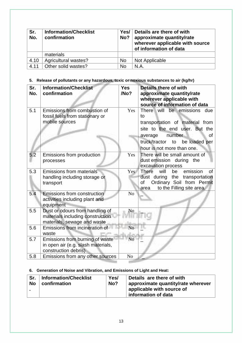
materials4.10 Agricultural wastes? No Not Applicable4.11 Other solid wastes? No N.A.
5. Release of pollutants or any hazardous, toxic or noxious substances to air (kg/hr)
Sr.No.
Information/Checklistconfirmation
Yes/No?
Details there of withapproximate quantity/ratewherever applicable withsource of information of data
5.1 Emissions from combustion offossil fuels from stationary ormobile sources
Yes There will be emissions duetotransportation of material fromsite to the end user. But theaverage number oftruck/tractor to be loaded perhour is not more than one.
5.2 Emissions from productionprocesses
Yes There will be small amount ofdust emission during theexcavation process
5.3 Emissions from materialshandling including storage ortransport
Yes There will be emission ofdust during the transportationof Ordinary Soil from Permitarea to the Filling site area.
5.4 Emissions from constructionactivities including plant andequipment
No _
5.5 Dust or odours from handling ofmaterials including constructionmaterials, sewage and waste
No _
5.6 Emissions from incineration ofwaste
No _
5.7 Emissions from burning of wastein open air (e.g. slash materials,construction debris)
No _
5.8 Emissions from any other sources No _
6. Generation of Noise and Vibration, and Emissions of Light and Heat:
Sr.No.
Information/Checklistconfirmation
Yes/No?
Details are there of withapproximate quantity/rate whereverapplicable with source ofinformation of data

14
6.1 From operation ofequipment e.g. engines,ventilation plant, crushers
- Not Applicable
6.2 From industrial or similarprocesses
- Not Applicable
6.3 From construction ordemolition
- Not Applicable
6.4 From blasting or piling - Not Applicable6.5 From construction or
operational traffic- Not Applicable
6.6 From lighting or coolingsystems
- Not Applicable
6.7 From any other sources - Not Applicable7. Risks of contamination of land or water from releases of pollutants into the
ground or into sewers, surface waters, groundwater, coastal waters or thesea
Sr.No.
Information/Checklistconfirmation
Yes/No?
Details are there of withapproximate quantity/ratewherever applicable with sourceof information of data
7.1 From handling, storage, useor spillage of hazardousmaterials
- Not Applicable
7.2 From discharge of sewage orother effluents to water or theland (expected mode andplace of discharge)
- Not Applicable
7.3 By deposition of pollutantsemitted to air into the land orinto water
Yes Only dust emission is expectedinto air due to movement ofvehicles. However dust suppressionwill be done by sprinkling water.
7.4 From any other sources No -7.5 Is there a risk of long term
build up of pollutants in theenvironment from thesesources?
No -
8. Risk of accidents during construction or operation of the Project, whichcould affect human health or the environment
Sr.No.
Information/Checklistconfirmation
Yes/No? Details are there of withapproximate quantity/ratewherever applicable withsource of information of data
8.1 From explosions, spillages, firesetc from storage, handling, useor production of hazardoussubstances
No No such activity is envisaged.
8.2 From any other causes Yes Risk of accidents is expected

15
Sr.No.
Information/Checklistconfirmation
Yes/No? Details are there of withapproximate quantity/ratewherever applicable withsource of information of dataduring transportation and duringloading of minerals intotrucks/tractors.
8.3 Could the project be affected bynatural disasters causingenvironmental damage e.g.floods, earthquakes, landslides,cloudburst etc)?
Yes The mine lease area lies inSeismicZone III which is prone toearthquakes. However there areno built in structures at the sitewhich would affect the mining.
9. Factors which should be considered (such as consequential development)which could lead to environmental effects or the potential for cumulativeimpacts with other Proposed or planned activities in the locality
Sr.No.
Information/Checklistconfirmation
Yes/No? Details are there of withapproximate quantity/ratewherever applicable withsource of information of data
9.1 Lead to development ofsupporting. Facilities , ancillarydevelopment or developmentstimulated by the project whichcould have impact on theenvironment e.g.: supportinginfrastructure (roads, powersupply, waste or waste watertreatment, etc.) housingdevelopment extractiveindustries supply industries,(other)
- Not Applicable
9.2 Lead to after-use of the site,which could have an impact onthe environment
- Not Applicable
9.3 Set a precedent for laterdevelopments
- Not Applicable
9.4 Have cumulative effects due toproximity to other Proposed orplanned projects with similareffects
- Not Applicable
10. Environmental SensitivitySr.No
Area Name /identity
Aerial distance (within 10 km) fromProposed location boundary
1 Areas protected under
international
Nil -

16
Sr.No
Area Name /identity
Aerial distance (within 10 km) fromProposed location boundary
conventions, national
or local legislation for
their ecological,
landscape, cultural or
other related value
2 Areas which are
important or sensitive
for ecological reasons -
Wetlands,
watercourses or other
water bodies, coastal
zone, biospheres,
mountains, forests
Nil -
3 Areas used by
protected, important or
sensitive species of
flora or fauna for
breeding, nesting,
foraging, resting, over
wintering, migration
Nil -
4 Inland, coastal, marine
or underground waters
No Not Applicable
5 State, National
boundary
No Not Applicable
6 Routes or facilities
used by the public for
access to recreation or
other tourist, pilgrim
areas
No Not Applicable
7 Defense installations No Not Applicable
8 Densely populated or Yes Nearest village Jambusar (Population

17
Sr.No
Area Name /identity
Aerial distance (within 10 km) fromProposed location boundary
built-up area 800) is about 3.72 km.
9 Areas occupied by
sensitive man-made
land uses (hospitals,
schools, places of
worship, community
facilities)
Yea All facilities available at city Bharuch
which is 36.84 km away from lease area.
10 Areas containing
important, high quality
or scarce resources
(ground water
resources, surface
resources, forestry,
agriculture, fisheries,
tourism, minerals)
Nil
-
11 Areas already
subjected to pollution
or environmental
damage. (those where
Proposed legal
environmental
standards are
exceeded)
Nil -
12 Areas susceptible to
natural hazard which
could cause the project
to present
environmental
problems
(earthquakes,
subsidence, landslides,
Yes The water level in river may fluctuate
depending on the rainfall intensity.
According to BMTPC Vulnerability Atlas
(earthquake), the study area falls in a
Zone-III.
There is no incidence of landslide but in
2001 a major incidence of earth quake
was there.

18
Sr.No
Area Name /identity
Aerial distance (within 10 km) fromProposed location boundary
erosion, flooding or
extreme or adverse
climatic conditions)
There is no date available flooding of the
area.
(IV).Proposed Terms of Reference for EIA studies
We request you to consider our project as B2 category project looking to tiny scale of ourproject and negligible potential of environmental impacts.
“I hereby given undertake that the data and information given in the application andenclosures are true to the best of my knowledge and belief and I am aware that if any part ofthe data and information submitted is found to be false or misleading at any stage, theproject will be rejected and clearance given, if any project will be revoked at our risk andcost.”
Date :- 2-09-2016Place :-Bharuch.
Signature of the applicant
Sh Indravadan Rana, S/O Sh Girishbhai RanaAt : Jambusar,
Taluka : Jambusar,Dist : Bharuch,
19
NOTE :
1. The projects involving clearance under Coastal Regulation Zone Notification.
1991 shall submit with the application a C.R.Z. map duly demarcated by one
of the authorized agencies. showing the project activates, w.r.t. C.R.Z. (at the
stage of TOR) and the recommendations of the State Coastal Zone
Management Authority (at the stage of EC). Simultaneous action shall also be
taken to obtain the requisite clearance under the provisions of the C.R.Z.
Notification, 1991 for the activities to be located in the CRZ.
2. The projects to be located within 10 km of national Parks. Sanctuaries.
Biosphere Reserves, Migratory Corridors of Wild Animals, the project
proponent shall submit the map duly authenticated by Chief Wildlife Warden
showing these features vis-à-vis the project location and the
recommendations or comments of the Chief Wildlife Warden thereon (at the
stage of EC)".
3. All correspondence with the Ministry of Environment & Forests including
submission of application for TOR/Environmental Clearance, subsequent
clarification, as may be required from time to time, participation in the EAC
Meeting on behalf of the project proponent shall be made by the authorized
signatory only. The authorized signatory should also submit a document in
support of his claim of being an authorized signatory for the specific project".

20
Annexure-1

21