
ARTICLE 2. DEFINITIONS AND RULES OF … RELEASE DRAFT MAY 2015 Shreveport/Caddo 2-3 Unified...
21
PUBLIC RELEASE DRAFT MAY 2015 Shreveport/Caddo 2-1 Unified Development Code PUBLIC RELEASE DRAFT – MAY 2015 Article 2. Definitions and Rules of Measurement ARTICLE 2. DEFINITIONS AND RULES OF MEASUREMENT 2.1 RULES OF INTERPRETATION 2.2 DEFINITION OF GENERAL TERMS 2.3 RULES OF MEASUREMENT 2.1 RULES OF INTERPRETATION The terms in the text of this Code must be interpreted in accordance with the following rules of construction: a. The singular number includes the plural, and the plural the singular. b. The present tense includes the past and future tenses, and the future tense includes the present. c. The terms “must,” “shall,” and “will” are mandatory, while the word “may” is permissive. d. The terms “must not,” “will not,” “shall not,” and “may not” are prohibiting. e. The masculine gender includes the feminine and neuter. f. Whenever a defined word or term appears in the text of this Code, its meaning must be construed as set forth in the definition. Words not defined must be interpreted in accordance with the definitions considered to be normal dictionary usage. g. The following abbreviations are used within this Code: i. "GFA" is an abbreviation for “gross floor area.” ii. “ft” is an abbreviation for “feet.” iii. “N/A” is an abbreviation for “not applicable.” iv. "sf" is an abbreviation for “square feet.” v. "SF-D" is an abbreviation for “single-family - detached.” iv. "SF-A" is an abbreviation for “single-family - attached.” vii. "2F" is an abbreviation for “two-family.” viii. "TH" is an abbreviation for “townhouse.” ix. "MF" is an abbreviation for “multi-family.” 2.2 DEFINITION OF GENERAL TERMS 172 Meander Line. The 172 Meander Line applies to Cross Lake, determined by survey, where specific rules and regulations regarding ownership, use, and construction of the Shreveport Code of Ordinances apply. Appendix B: 172 Meander Line Survey for Reference shows the survey used to determine location. EDITOR’S NOTE: We will include a copy of the survey in the final document as an Appendix. Abut. To share a common wall or lot line without being separated by a street or alley. Accessibility Ramp. A ramp or similar structure that provides wheelchair or similar access to a structure. Accessory Structure. A structure located on the same lot as the principal building, which may be detached or attached, that is incidental to the use of the principal building. Accessory Use. A use of land or a structure, or portion thereof, customarily incidental and subordinate to the principal use of the land or structure. An accessory use is prohibited without the principal use to which it is related.
Transcript of ARTICLE 2. DEFINITIONS AND RULES OF … RELEASE DRAFT MAY 2015 Shreveport/Caddo 2-3 Unified...
PUBLIC RELEASE DRAFT MAY 2015
Shreveport/Caddo 2-1 Unified Development Code PUBLIC RELEASE DRAFT – MAY 2015 Article 2. Definitions and Rules of Measurement
ARTICLE 2. DEFINITIONS AND RULES OF MEASUREMENT 2.1 RULES OF INTERPRETATION 2.2 DEFINITION OF GENERAL TERMS 2.3 RULES OF MEASUREMENT
2.1 RULES OF INTERPRETATION
The terms in the text of this Code must be interpreted in accordance with the following rules of construction:
a. The singular number includes the plural, and the plural the singular.
b. The present tense includes the past and future tenses, and the future tense includes the present.
c. The terms “must,” “shall,” and “will” are mandatory, while the word “may” is permissive.
d. The terms “must not,” “will not,” “shall not,” and “may not” are prohibiting. e. The masculine gender includes the feminine and neuter.
f. Whenever a defined word or term appears in the text of this Code, its meaning must be construed as
set forth in the definition. Words not defined must be interpreted in accordance with the definitions considered to be normal dictionary usage.
g. The following abbreviations are used within this Code:
i. "GFA" is an abbreviation for “gross floor area.” ii. “ft” is an abbreviation for “feet.” iii. “N/A” is an abbreviation for “not applicable.”
iv. "sf" is an abbreviation for “square feet.” v. "SF-D" is an abbreviation for “single-family - detached.” iv. "SF-A" is an abbreviation for “single-family - attached.” vii. "2F" is an abbreviation for “two-family.”
viii. "TH" is an abbreviation for “townhouse.” ix. "MF" is an abbreviation for “multi-family.”
2.2 DEFINITION OF GENERAL TERMS 172 Meander Line. The 172 Meander Line applies to Cross Lake, determined by survey, where specific rules and regulations regarding ownership, use, and construction of the Shreveport Code of Ordinances apply. Appendix B: 172 Meander Line Survey for Reference shows the survey used to determine location. EDITOR’S NOTE: We will include a copy of the survey in the final document as an Appendix. Abut. To share a common wall or lot line without being separated by a street or alley. Accessibility Ramp. A ramp or similar structure that provides wheelchair or similar access to a structure. Accessory Structure. A structure located on the same lot as the principal building, which may be detached or attached, that is incidental to the use of the principal building. Accessory Use. A use of land or a structure, or portion thereof, customarily incidental and subordinate to the principal use of the land or structure. An accessory use is prohibited without the principal use to which it is related.
PUBLIC RELEASE DRAFT MAY 2015
Shreveport/Caddo 2-2 Unified Development Code PUBLIC RELEASE DRAFT – MAY 2015 Article 2. Definitions and Rules of Measurement
Addition/Enlargement. Construction that increases the size of a structure in terms of building footprint, height, or floor area. Alley. A public right-of-way that normally affords a secondary means of access to abutting property. Amateur (HAM) Radio Equipment. An amateur (HAM) radio station licensed by the Federal Communications Commission (FCC), including equipment such as, but not limited to, a tower or building-mounted structure supporting a radiating antenna platform and other equipment. Ancillary. In regard to principal uses per Article 5, a structure or use that provides support and/or is typically integral to a principal structure or use. Apiary. A structure for the keeping of honeybees. Aquaculture/Aquaponics. A structure designed for the farming of aquatic organisms such as fish, crustaceans, mollusks, and aquatic plants under controlled conditions Arbor. A freestanding structure to support vines or trained climbing plants. Architectural Feature. A part or projection that contributes to the aesthetics of a structure, exclusive of signs, that is not necessary for the structural integrity of the structure or to make the structure habitable. Awning. A roof like structure typically made of cloth, metal, or other material attached to a frame that extends from and is supported by a building. Awnings are typically erected over a window, doorway, or building front and they may be raised or retracted to a position adjacent to the building. Attention Getting Device. Sails, pennants, banners, and similar devices or ornamentations designed to attract attention. Flags of nations, states, and cities, or fraternal, religious and civic organizations, permanent commercial flags, or temporary holiday decorations are not considered attention getting devices. Certain types of attention getting devices are specifically prohibited by this Code in Article 9. Balcony. A roofed or unroofed platform that projects from the exterior wall of a structure above the ground floor, which is exposed to the open air, has direct access to the interior of the building, and is not supported by posts or columns extending to the ground. Banner - Exhibition. A sign that is printed or displayed upon flexible material with or without frames in conjunction with a special exhibit for an educational facility, government building, or cultural facility. Base Flood Elevation (BFE). The computed elevation to which floodwater is anticipated to rise during the base flood. BFEs are shown on Flood Insurance Rate Maps (FIRM) and on the flood profiles. The BFE is the regulatory requirement for the elevation or floodproofing of structures. Base Floor Elevation Lowest floor is defined by the National Flood Insurance Program (NFIP) as the lowest floor of the lowest enclosed area, including a basement. An unfinished or flood resistant enclosure, usable solely for parking of vehicles, building access or storage in an area other than a basement area is not considered a building's lowest floor, provided that such enclosure is not built so as to render the structure in violation of the applicable non-elevation design requirements. Basement. That portion of a building included between the upper surface of its floor and the upper surface of the floor next above, having one-half or more of its height below the average elevation of the finished lot grade adjoining the building. Bay Window. A window that projects outward from the structure, which does not rest on the building foundation or on the ground. Berm. An earthen mound designed to provide visual interest on a site, screen undesirable views, reduce noise, or fulfill other similar purposes. Billboard. A sign advertising products, goods, services, facilities, events or attractions not made, sold, used, served or available on the lot displaying such sign or a sign owned by a person, corporation, or other entity that engages in the business of selling the advertising space on that sign.

PUBLIC RELEASE DRAFT MAY 2015
Shreveport/Caddo 2-3 Unified Development Code PUBLIC RELEASE DRAFT – MAY 2015 Article 2. Definitions and Rules of Measurement
Block. Defined in Section 2.3. Blockface. Defined in Section 2.3. Blue Roof. A roof designed to store water and discharge rainfall. Buffer Yard. Land area with landscape plantings and other components used to separate one use from another and to shield or block noise, lights, or other nuisances. Build-To Line (BTL). Defined in Section 2.3. Build-To Zone (BTZ). Defined in Section 2.3. Build-To Percentage. Defined in Section 2.3. Building. Any structure used or intended for supporting or sheltering any use or occupancy. Building Envelope. The three-dimensional space within which a structure is permitted to be built on a lot and which is defined by regulations governing building setbacks, maximum height, and bulk, by other regulations, and/or by any combination thereof. Building Coverage. Defined in Section 2.3. Building Height. Defined in Section 2.3. Building Line. A line measured at the building wall of a structure between parallel lot lines. For the purposes of establishing a building line, the building wall does not include permitted encroachments of architectural features, such as bay windows, eaves, and steps and stoops. Business. An occupation, employment, or enterprise that occupies time, attention, labor and materials, where merchandise is exhibited or sold, or where services are offered. Caliper. Defined in Section 2.3. Canopy - Non-Structural. A roof-like non-structural cover that projects from the wall of a structure with support posts that extend to the ground. Canopy - Structural. A permanent structure that serves as an overhanging shelter or shade that forms the structure of a building and is constructed in such a manner as to allow pedestrians or vehicles to pass underneath. Carport. An open-sided roofed vehicle shelter, usually formed by extension of the roof from the side of a building, but may be freestanding. Chicken Coop. A structure where hens are kept. Chimney. A vertical shaft of reinforced concrete, masonry or other approved material enclosing one or more flues, for the purpose of removing products of combustion from solid, liquid, or gaseous fuel. Coldframe Structure. A transparent roofed enclosure constructed low to the ground used to protect plants from excessively cold or wet weather. It functions similar to a greenhouse to help extend the growing season. Co-Location. Placement of wireless telecommunications equipment from more than one service or service provider on a single tower or site. Commercial Message. Any sign, wording, logo, or other representation that directly or indirectly, names, advertises, or calls attention to a business, product, service or other commercial activity. Contiguous. See abut. Contour Line. Contour lines denote elevation or altitude and depth on maps.

PUBLIC RELEASE DRAFT MAY 2015
Shreveport/Caddo 2-4 Unified Development Code PUBLIC RELEASE DRAFT – MAY 2015 Article 2. Definitions and Rules of Measurement
Conservation Design. A subdivision technique intended to preserve natural and environmentally sensitive areas while allowing for clustered residential development. Cross-Access. A vehicular and/or pedestrian connection between abutting properties that connects the two sites and allows vehicles and/or pedestrians to travel between sites without the having to exist to the street. Cutoff. The point at which all light rays emitted by a lamp, light source or luminaire are generally eliminated (cutoff) at a specific angle above the ground, acknowledging that some light trespass may occur. Day. A calendar day. Deck. A roofless outdoor space built as an aboveground platform projecting from the wall of a structure and connected by structural supports at grade or by the structure. Development. The construction, reconstruction, conversion, structural alteration, relocation, or enlargement of any structure, any mining, excavation, landfill or land disturbance, or any change in use, or alteration or extension of the use, of land. Driveway. A pathway for motor vehicles from a street to a lot used only for service purposes or for access to the lot. Dwelling. A structure, or portion thereof, designed or used exclusively for human habitation, including single-family dwellings - detached and attached, two-family dwellings, townhouse dwellings, and multi-family dwellings, but excluding manufactured homes and hotels. Dwelling Unit. A structure or portion of a structure providing complete, independent living facilities for one or more persons, including permanent provisions for living, sleeping, eating, cooking, and sanitation. Easement. See definition of servitude. Eave. The projecting lower edges of a roof overhanging the wall of a structure. Encroachment. The extension or placement of any structure, or a component of such, into a required setback or right-of-way. Erect. To build, construct, attach, hang, place, suspend, or affix. Exterior Lighting. The illumination of an outside area or object by any man-made device that produces light by any means. Exterior Stairwell. One or more flights of stairs, and the necessary landings and platforms connecting them, to form a continuous passage from the entryway of a floor or level to another in a structure located on the exterior of a principal building. Fence. A structure used as a boundary, screen, separation, means of privacy, protection or confinement, and is constructed of wood, plastic, metal, wire mesh, masonry, or other similar material and is used as a barrier. Fence - Open. A fence that has, over its entirety, more than 50% of the superficial surface consisting of regularly distributed openings. Fence - Solid. A fence that has, over its entirety, no distributed openings. A shadowbox design fence is considered a solid fence. A chain link fence with slats is not considered a solid fence. Fixture. The assembly that houses the lamp or lamps, which may include all or some of the following parts: a housing, a mounting bracket or pole socket, a lamp holder, a ballast, a reflector or mirror, and/or a refractor or lens. Flood Zone. Geographic areas that the Federal Emergency Management Agency (FEMA) has defined according to varying levels of flood risk. These zones are depicted on the Flood Insurance Rate Map (FIRM) or Flood Hazard Boundary Map. Each zone reflects the severity or type of flooding in the area. Garage. A structure, either attached or detached, used for the parking and storage of vehicles as an accessory use to a residence. Garage does not include a parking structure.

PUBLIC RELEASE DRAFT MAY 2015
Shreveport/Caddo 2-5 Unified Development Code PUBLIC RELEASE DRAFT – MAY 2015 Article 2. Definitions and Rules of Measurement
Gazebo. A freestanding outdoor structure designed for recreational use and not for habitation. Glare. Light emitting from a luminaire with an intensity great enough to reduce a viewers’ ability to see, cause discomfort, and, in extreme cases, cause momentary blindness. Grade. Defined in Section 2.3. Green Roof. A building roof partially or completely covered with vegetation and a growing medium, planted over a waterproofing membrane. It may also include additional layers such as a root barrier and drainage and irrigation systems. Greenhouse (Accessory). A structure constructed chiefly of glass, glasslike or translucent material, cloth, or lath, which is devoted to the protection or cultivation of flowers or other tender plants. Gross Floor Area (GFA). Defined in Section 2.3. Hedge. A row of closely planted shrubs, bushes, or any kind of plant forming a boundary. Home Occupation. Any activity customarily carried out for gain by a resident, conducted as an accessory use in the resident's dwelling unit. Illumination System. The totality of the equipment installed to provide exterior lighting on a developed property. Illumination system includes all structures, canopy, pole, and ground-mounted luminaires, including all wiring, circuitry, and other devices installed to create exterior lighting. Impervious Surface Coverage. Defined in Section 2.3. Infrastructure. Facilities and services needed to sustain residential, commercial, industrial, institutional, and other activities. Internal Illumination (Sign). Illumination from a light source that is contained within a sign. Intensity of Use. Square feet of gross floor area, number of dwelling units, number of employees, or other factor used as a basis for requiring off-street parking or loading facilities. Lamp. The component of a luminaire that produces the actual light. Lamp Wattage. The amount of power of a lamp expressed in watts. Lighting. Defined in Section 2.3. Light, Direct. Light emitted directly from the lamp, off a reflector or reflector diffuser, or through the refractor or diffuser lens of a luminaire. Light, Indirect. Direct light that has been reflected or has scattered off of other surfaces. Light Trespass. The shining of light produced by a luminaire beyond the boundaries of the property on which it is located. Loading Berth. A space within a loading facility exclusive of driveways, aisles, maneuvering areas, ramps, columns, landscape, and structures for the temporary parking of a commercial delivery vehicle while loading or unloading goods or materials. Lot. Defined in Section 2.3. Lot Area. Defined in Section 2.3. Lot, Corner. Defined in Section 2.3. Lot Depth. Defined in Section 2.3. Lot, Interior. Defined in Section 2.3.

PUBLIC RELEASE DRAFT MAY 2015
Shreveport/Caddo 2-6 Unified Development Code PUBLIC RELEASE DRAFT – MAY 2015 Article 2. Definitions and Rules of Measurement
Lot Line. Defined in Section 2.3. Lot Line, Corner. Defined in Section 2.3. Lot Line, Front. Defined in Section 2.3. Lot Line, Interior. Defined in Section 2.3. Lot Line, Rear. Defined in Section 2.3. Lot Line, Street. Defined in Section 2.3. Lot, Through. Defined in Section 2.3. Lot Width. Defined in Section 2.3. Luminaire. A complete lighting unit consisting of a light source and all necessary mechanical, electrical, and decorative parts. Luminaire, Cut-Off Type. A luminaire containing elements such as shields, reflectors, or refractor panels that direct and cut off a direct view of the light source at a cut off angle. Marquee. A permanent roof-like structure constructed of durable material extending from the wall of a structure with no supports extending to the ground with a portion of the structure dedicated to sign area that may be changed. Modular Home. Modular buildings and modular homes are not considered manufactured homes, and refer to a method of construction. Modular buildings and modular homes are built in multiple sections called modules at a facility and then delivered to the site where the modules are set onto the building's foundation and joined together to make a single building. Modular buildings and modular homes must conform to all zoning requirements for the dwelling type and must meet all building code requirements. Manufactured homes are a principal use and defined in Section 5.3. Multi-Tenant Retail Center. A group of two or more commercial establishments that is planned, owned, and/or managed as a single property. The two main configurations of multi-tenant retail centers are large shopping centers/malls and strip centers. Nonconforming Lot. A lot of record that at one time conformed to the lot dimension requirements (lot area, lot width, lot depth) of the zoning district in which it is located but because of subsequent amendments to the Code no longer conforms to the applicable lot dimensions. Nonconforming Sign. A sign that once conformed to zoning district regulations but because of subsequent amendments to the Code no longer conforms to applicable sign regulations. Nonconforming Site Element. A site development element, such as landscape, fences or walls, lighting, and parking, that at one time conformed to the requirements of this Code, but because of subsequent amendments, has been made nonconforming. Nonconforming Structure. A principal or accessory structure that once conformed to zoning district regulations but because of subsequent amendments to the Code no longer conforms to applicable dimensional standards. Nonconforming Use. The use of a structure or land that at one time was an allowed use within a zoning district but because of subsequent amendments to the Code is no longer allowed. Non-Residential Use. A structure or land arranged, designed, used, or intended to be used for non-residential uses, which includes, but is not limited to, retail, office, entertainment, recreation, public, institutional, and other non-residential uses. Structures with dwellings above ground floor non-residential uses are considered mixed-use development and considered a non-residential use for the purposes of this Code. Off-Street Parking. The storage space for an automobile on premises other than streets or rights-of-way.

PUBLIC RELEASE DRAFT MAY 2015
Shreveport/Caddo 2-7 Unified Development Code PUBLIC RELEASE DRAFT – MAY 2015 Article 2. Definitions and Rules of Measurement
Open Space. That portion of land, either landscaped or left unimproved, which is used to meet active or passive recreation or spatial needs, and/or to protect water, air, or plant resources. Outdoor Display and Sales Area. Part of a lot used for outdoor sales and/or display of goods accessory to the principal use. Outlot. An area of land set aside within a retail center for a separate principal building that shares a circulation system and may share common parking with the larger retail center development but is separated from the principal building or buildings, typically located along the property line. Overlay District. A district established in the Code that is superimposed on one or more zoning districts or parts of zoning districts. The standards and requirements associated with an overlay district may be more or less restrictive than those in the underlying districts. Owner. Any person, including the owner of the title or a mortgage whose interest is shown of record in the mortgage and conveyance records of Caddo Parish; a person shown as owner in the records of the tax assessor of the parish in which the property is situated; or the agent of any such person and those in possession of a dwelling, dwelling unit or premises. Parapet. The extension of a false front or wall above a roof-line. Parkway. That part of the pedestrian way that if designated for street trees, landscape, transit stops, street lights, outdoor dining, site furnishings, and the like, as well as for motorists to access cars parked at the curb. Parkway may also be referred to as neutral ground. Party Wall. A wall starting from the foundation and extending continuously through all stories to or above the roof that separates one building from another, but is in joint use by each building. Patio. A hard surface designed and intended for recreational use by people and not used as a parking space. Performance Standards. A set of criteria or limits relating to elements that a particular use or process must either meet or may not exceed. Pergola. A freestanding, open structure that forms a partially shaded pedestrian walkway, passageway, or sitting area, and is constructed of a semi-open roof and vertical posts that support cross-beams and a sturdy open lattice. It may also be used as an extension of a building entryway. Pervious Paving. A range of sustainable materials and techniques for permeable paving with a base and sub-base that allow the movement of stormwater through the surface. Gravel and loose rock are not considered pervious paving. Porch. An architectural feature that projects from the exterior wall of a structure, has direct access to the street level of the building, and is covered by a roof or eaves. Porch – Unenclosed. A porch that is open on all sides that do not abut a principal building wall. Porch – Enclosed. A porch enclosed by walls, screens, lattice or other material. A screened-in porch is an enclosed porch. Property Line. See lot line. Principal Building. A non-accessory structure in which a principal use of the lot on which it is located is conducted. Principal Use. The main use of land or structures as distinguished from an accessory use. Raceway. A mounting bar or similar device that is used to attach channel letters to a building. Raceways often conceal the electrical components of channel letter signs. Railroad Right-of-Way. A strip of land with tracks and auxiliary facilities for track operation, but not including depots, loading platforms, stations, train sheds, warehouses, car shops, car yards, locomotive shops, or water towers.
PUBLIC RELEASE DRAFT MAY 2015
Shreveport/Caddo 2-8 Unified Development Code PUBLIC RELEASE DRAFT – MAY 2015 Article 2. Definitions and Rules of Measurement
Residential Use. A structure arranged, designed, used, or intended to be used for residential occupancy by one or more families or households, which includes, but is not limited to, the following types: single-family – detached and attached, two-family, townhouse, and multi-family dwellings. Structures with dwellings above ground floor non-residential uses are considered mixed-use development, which are considered a non-residential use for the purposes of this Code. Right-of-Way. A strip of land dedicated for use as a public way. In addition to the roadway, it typically incorporates the curbs, parkways, sidewalks, and shoulders. Roofline. The top edge of a roof or building parapet, whichever is higher, excluding any cupolas, pylons, chimneys or minor projections. Satellite Dish Antenna. A dish antenna designed for transmitting signals to a receiver or receiving station or for receiving television, radio, data, communication or other signals from other antennas, satellites or other services. Servitude. Land designed by lawful agreement between the owner(s) of the land and a person(s) for a specified use only by such person(s). Servitude may also be referred to as an easement. Setback. Defined in Section 2.3. Setback, Front. Defined in Section 2.3. Setback, Interior Side. Defined in Section 2.3. Setback, Corner Side. Defined in Section 2.3. Setback, Rear. Defined in Section 2.3. Shed. An accessory structure, often purchased pre-built or as a kit in pre-fabricated sections, that is not designed to be served by heat or plumbing and does not need to be placed on a permanent foundation. A shed is typically intended to store lawn, garden, or recreational equipment. Sign. Any identification, description, illustration, or device illuminated or non-illuminated that is visible to the public from adjoining streets or adjoining properties and that directs attention to a product, service, place, activity, person, institution, business, or solicitation, including any permanently installed or situated merchandise; or any emblem, painting, banner, pennant, placard, temporary sign, lights, balloons or other device designed to attract attention, advertise, identify or convey information. Building details that are an integral part of the overall architectural design of a building or works of art accessory to a building are not be considered signs. Sign, Animated. Any sign that uses movement or change of lighting to depict action or create a special effect or scene. Animated signs include video screens, television screens, plasma screens, and holographic displays, but do not include electronic message center signs. Sign Area. Defined in Section 2.3. Sign, Cabinet Box Wall. A type of wall sign constructed in the form of a cabinet or box where the sign face is not an integral part of the structure and is specifically designed to allow the sign face to be changed repeatedly, which may or may not be internally illuminated. A cabinet box wall sign does not include pan-faced wall signs, molded wall signs, or similar designs. Generally, a cabinet box wall sign is designed by applying vinyl printed with the sign message onto acrylic sheets and then inserted into the cabinet. Sign, Construction. Any sign identifying individuals or companies involved in design, construction, demolition, financing, or development when placed upon the premises where construction or development is ongoing. Sign, Directional. A sign used to convey directions and other information to direct the public, such as entrance or exit. Sign, Directory. A sign for a multi-tenant development that conveys tenant information to pedestrians and/or motorists who have entered the site. Sign, Electronic Message. A sign or component of a sign that uses LED illumination systems or other similar electronic components to form a message(s) that are electronically programmed or modified by electronic processes.
PUBLIC RELEASE DRAFT MAY 2015
Shreveport/Caddo 2-9 Unified Development Code PUBLIC RELEASE DRAFT – MAY 2015 Article 2. Definitions and Rules of Measurement
Sign, Flashing. Any illuminated sign that contains an intermittent or flashing light source or that changes light intensity in sudden transitory bursts, but do not include electronic message center signs. Sign, Freestanding. Any sign on a frame, pole, or other support structure that is not attached to any building. Sign, Ghost. A painted wall sign that remains from an earlier time or advertises the use of a building that provides evidence of the history of the use of the building or activities of the community. Sign Height. Defined in Section 2.3. Sign, Menuboard. A sign displaying goods or services available as part of the drive-through lane of a drive-through facility. Sign, Moving. Any sign that revolves, rotates, swings, undulates, or otherwise attracts attention by moving parts, whether operated by mechanical equipment or by natural sources, not including flags or banners. Sign, Portable. Any sign not permanently attached to the ground, a building, or other structure and is readily movable. Any sign attached to a sign structure with wheels is considered a portable sign. Portable signs do not include those types of temporary signs or non-permanently attached signs that are specifically permitted by this Code, such as certain attention-getting devices and A-frame signs. Sign, Projecting. Any sign that is attached to a building or other structure and extends beyond the line of the building or structure or beyond the surface of that portion of the building or structure to which it is attached by more than 15 inches. Sign, Roof. Any sign erected, constructed, and maintained above the parapet on a building with a flat roof or above the fascia board on a building with a pitched roof. Sign, Snipe. A sign painted, pasted or otherwise affixed to any tree, rock, retaining wall, fence, utility pole, hydrant, bridge, sidewalk, curb or street, bench, or trash receptacle. Logos and labels located on mechanical equipment, recycling bins, trash containers or dumpsters, which are part of the equipment as manufactured and/or installed, are not snipe signs. Sign Structure. Any structure that supports a sign, including any decorative cover. Sign, Wall. A single-faced sign attached generally flush or parallel to the wall of a building that projects less than 15 inches. Sign, Window. A sign posted, painted, placed, or affixed in or on a window exposed to public view. A sign that is interior to the building that faces a window exposed to public view that is located within two feet of the window face is a window sign for the purposes of calculating the total area of all window signs. Merchandise used in a window display is not considered a window sign. Special Flood Hazard Area (SFHA). The land area covered by the floodwaters of the base flood on National Flood Insurance Program (NFIP) maps. The SFHA is the area where the NFIP's floodplain management regulations must be enforced and the area where the mandatory purchase of flood insurance applies. Stacking Space. A space specifically designed and designated as a waiting area for vehicles patronizing a drive-through facility or service bay. Stoop. An exterior floor typically, constructed of stone, concrete, and/or masonry, with a finished floor elevation higher than the adjacent ground level, often with steps leading up to it, and utilized primarily as an access platform to a structure. A stoop may be roofed and designed with railings, but cannot be enclosed. Street. A public or private right-of-way that affords a primary means of vehicular access to abutting property, but does not include alleys or driveways. Structural Alteration. Any change, other than incidental repairs, which would prolong the life of supporting members of a structure, such as the addition, removal, or alteration of bearing walls, columns, beams, girders or foundations.

PUBLIC RELEASE DRAFT MAY 2015
Shreveport/Caddo 2-10 Unified Development Code PUBLIC RELEASE DRAFT – MAY 2015 Article 2. Definitions and Rules of Measurement
Structure. A combination of materials to form a construction for use, occupancy, or ornamentation, whether installed on, above, or below, the surface of land or water. Swimming Pool. A receptacle for water and/or an artificial pool of water over 24 inches in depth, either at a private residence intended only for the use of the individual owner, his family and friends, or at a multi-tenant development intended only for the use of the tenants of the building and their families and friends. Trellis. A lattice frame made of bars of wood or metal, fixed to a wall, to support vines or trained climbing plants. Unified Control. The combination of two or more tracts of land wherein each owner has agreed that his tract of land will be developed under the same development approvals. Use. The purpose or activity for which the land or structure is designed, arranged, or intended, or for which it is occupied or maintained. Wall. A constructed solid barrier of concrete, stone, brick, tile, or similar type of material that closes, marks, or borders a field, yard, or lot, and that limits visibility and restricts the flow of air and light. Waters. All surface waters including all waters of the territorial sea, tidewaters, all inland waters of any river, stream, brook, pond, or lake, and wetlands, as well as all groundwater. White Roof. A roof designed to deliver high solar reflectance, reducing heat transfer to the building and the ability to radiate absorbed, or non-reflected solar energy. Yard. Defined in Section 2.3. Yard, Front. Defined in Section 2.3. Yard, Interior Side. Defined in Section 2.3. Yard, Corner Side. Defined in Section 2.3. Yard, Rear. Defined in Section 2.3. Zoning Lot. A lot or combination of lots within a single block, which is designated by its owner or developer to be used, developed, or built upon as a unit. A zoning lot may or may not coincide with a lot of record. Zoning Map. The map or maps that are a part of this Code and which delineate the boundaries of all mapped zoning districts within the physical boundary of the Planning Area.

PUBLIC RELEASE DRAFT MAY 2015
Shreveport/Caddo 2-11 Unified Development Code PUBLIC RELEASE DRAFT – MAY 2015 Article 2. Definitions and Rules of Measurement
2.3 RULES OF MEASUREMENT
This section provides the rules of measurement for the dimensional standards and locational characteristics within the Code.
A. Block and Blockface
1. A block is a tract of land bounded by streets, or a combination of streets and railroad rights-of-way,
shorelines of waterways, or municipal boundary lines. 2. Blockface is measured as that portion of a block or tract of land facing the same side of a single
street and lying between the closest intersecting streets.
FIGURE 2-1: BLOCK AND BLOCKFACE
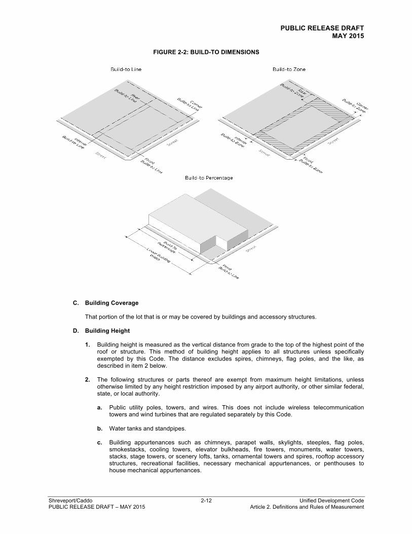
B. Build-To Dimensions
1. A build-to line (BTL) is the set dimension on a lot, measured from the applicable lot line, where a
certain percentage of the building frontage must be located.
2. A build-to zone (BTZ) is an area on a lot where a certain percentage of the building frontage must be located, measured as a minimum and maximum range from the applicable lot line.
3. A build-to percentage specifies the percentage of the building facade that must be located within a
build-to zone. Facade articulation, such as window or wall recesses and projections, is not counted against the required build-to percentage.
PUBLIC RELEASE DRAFT MAY 2015
Shreveport/Caddo 2-12 Unified Development Code PUBLIC RELEASE DRAFT – MAY 2015 Article 2. Definitions and Rules of Measurement
FIGURE 2-2: BUILD-TO DIMENSIONS
C. Building Coverage
That portion of the lot that is or may be covered by buildings and accessory structures.
D. Building Height
1. Building height is measured as the vertical distance from grade to the top of the highest point of the
roof or structure. This method of building height applies to all structures unless specifically exempted by this Code. The distance excludes spires, chimneys, flag poles, and the like, as described in item 2 below.
2. The following structures or parts thereof are exempt from maximum height limitations, unless
otherwise limited by any height restriction imposed by any airport authority, or other similar federal, state, or local authority.
a. Public utility poles, towers, and wires. This does not include wireless telecommunication
towers and wind turbines that are regulated separately by this Code. b. Water tanks and standpipes.
c. Building appurtenances such as chimneys, parapet walls, skylights, steeples, flag poles,
smokestacks, cooling towers, elevator bulkheads, fire towers, monuments, water towers, stacks, stage towers, or scenery lofts, tanks, ornamental towers and spires, rooftop accessory structures, recreational facilities, necessary mechanical appurtenances, or penthouses to house mechanical appurtenances.

PUBLIC RELEASE DRAFT MAY 2015
Shreveport/Caddo 2-13 Unified Development Code PUBLIC RELEASE DRAFT – MAY 2015 Article 2. Definitions and Rules of Measurement
FIGURE 2-3: BUILDING HEIGHT
3. A story is that portion of a building between the upper surface of any floor and the upper surface of
the floor next above, including any portion of a building used for human occupancy between the topmost floor and the roof.
FIGURE 2-4: STORY HEIGHT
E. Caliper
Tree caliper is the diameter of a tree trunk, measured at four and one-half feet above the adjacent ground.
PUBLIC RELEASE DRAFT MAY 2015
Shreveport/Caddo 2-14 Unified Development Code PUBLIC RELEASE DRAFT – MAY 2015 Article 2. Definitions and Rules of Measurement
F. Grade
A reference plane representing the average of finished ground level adjoining the building at all exterior walls. When the finished ground level slopes away from the exterior walls, the reference plane is established by the lowest points within the area between the building and the lot line or, when the lot line is more than six feet from the building, between the building and a point six feet from the building.
G. Gross Floor Area (GFA)
The gross floor area (GFA) of a structure is the sum of the gross horizontal areas of all floors of the structure as measured from the exterior faces of the exterior walls or from the centerline of walls separating two buildings.
H. Impervious Surface Coverage
1. Impervious surface coverage is a measure of intensity of land use that represents the portion of a
site that is occupied by structures, pavement, and other impervious surfaces that do not allow for the absorption of water into the ground. Maximum impervious surface of a lot is calculated as the percentage of all impervious surface area against the total area of the lot.
2. When pervious paving is used, it is calculated at a reduced percentage of impervious coverage, as
follows:
a. Pervious concrete and open grid paving systems are calculated as 50% impervious surface, provided that no barrier to infiltration is installed beneath the material. Open grid pavers must be installed on a sand base, without an impervious liner, to qualify.
b. Other types of pervious surfaces, such as permeable pavers, porous asphalt, or gravel-crete,
are credited based upon field performance data and coefficients of permeability provided by the manufacturer.
I. Lighting
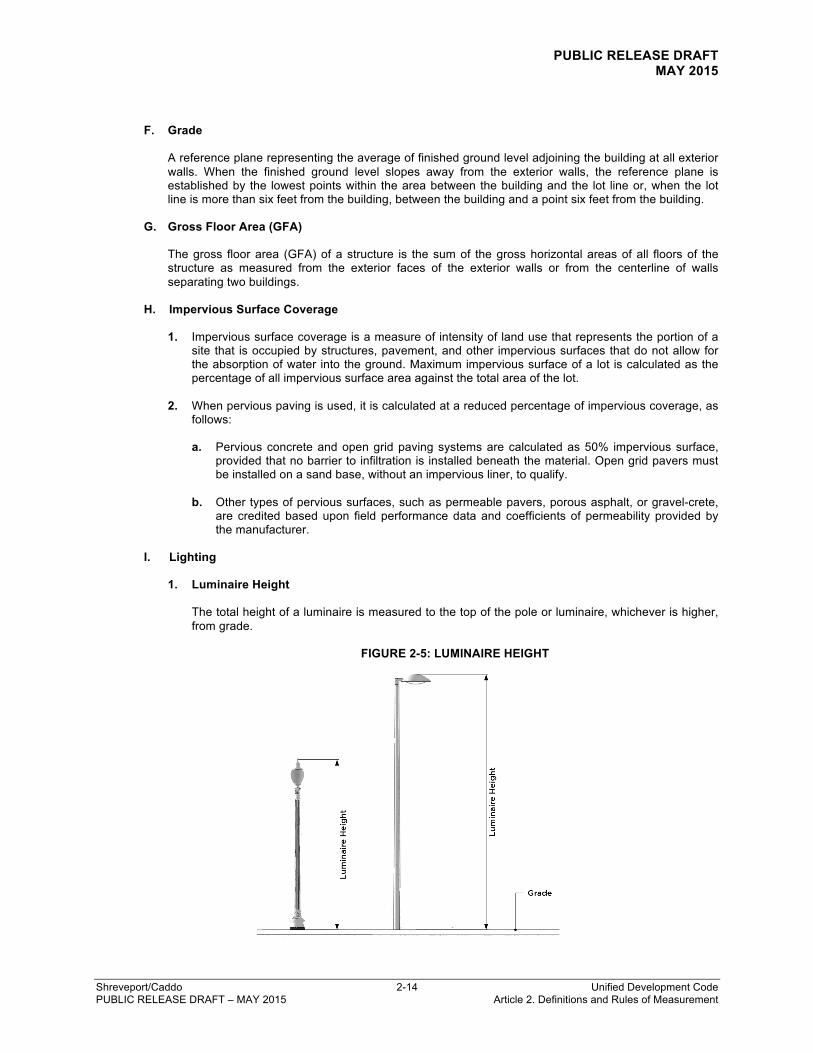
1. Luminaire Height
The total height of a luminaire is measured to the top of the pole or luminaire, whichever is higher, from grade.
FIGURE 2-5: LUMINAIRE HEIGHT
PUBLIC RELEASE DRAFT MAY 2015
Shreveport/Caddo 2-15 Unified Development Code PUBLIC RELEASE DRAFT – MAY 2015 Article 2. Definitions and Rules of Measurement
2. Footcandle
A footcandle (FC) is a unit of illumination produced on a surface, all points of which are one foot from a uniform point source of one standard candle. Footcandle is measured utilizing a direct reading, portable light meter mounted in a horizontal position.
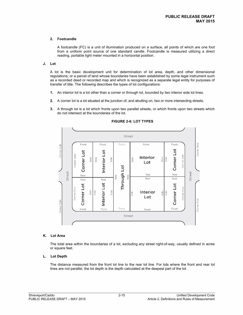
J. Lot
A lot is the basic development unit for determination of lot area, depth, and other dimensional regulations; or a parcel of land whose boundaries have been established by some legal instrument such as a recorded deed or recorded map and which is recognized as a separate legal entity for purposes of transfer of title. The following describes the types of lot configurations:
1. An interior lot is a lot other than a corner or through lot, bounded by two interior side lot lines.
2. A corner lot is a lot situated at the junction of, and abutting on, two or more intersecting streets. 3. A through lot is a lot which fronts upon two parallel streets, or which fronts upon two streets which
do not intersect at the boundaries of the lot.
FIGURE 2-6: LOT TYPES
K. Lot Area
The total area within the boundaries of a lot, excluding any street right-of-way, usually defined in acres or square feet.
L. Lot Depth
The distance measured from the front lot line to the rear lot line. For lots where the front and rear lot lines are not parallel, the lot depth is the depth calculated at the deepest part of the lot.
PUBLIC RELEASE DRAFT MAY 2015
Shreveport/Caddo 2-16 Unified Development Code PUBLIC RELEASE DRAFT – MAY 2015 Article 2. Definitions and Rules of Measurement
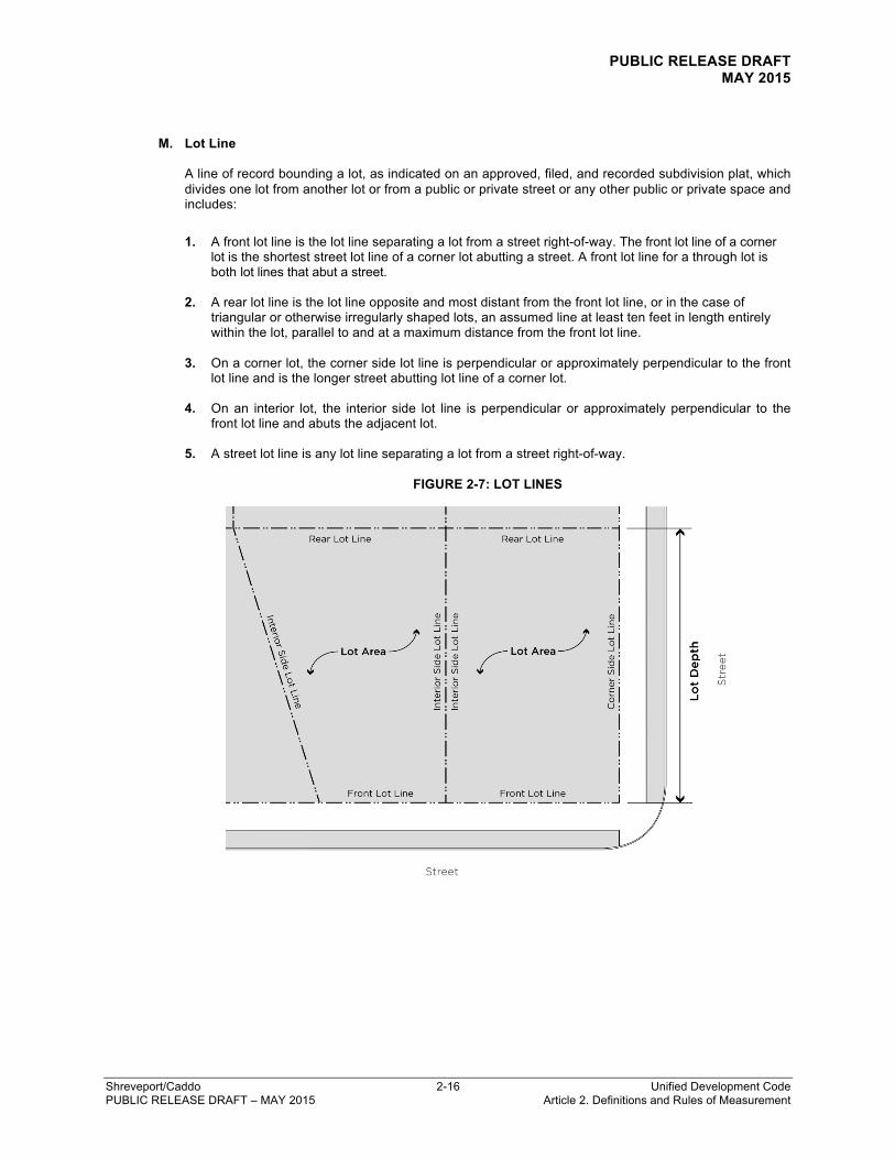
M. Lot Line
A line of record bounding a lot, as indicated on an approved, filed, and recorded subdivision plat, which divides one lot from another lot or from a public or private street or any other public or private space and includes: 1. A front lot line is the lot line separating a lot from a street right-of-way. The front lot line of a corner
lot is the shortest street lot line of a corner lot abutting a street. A front lot line for a through lot is both lot lines that abut a street.
2. A rear lot line is the lot line opposite and most distant from the front lot line, or in the case of
triangular or otherwise irregularly shaped lots, an assumed line at least ten feet in length entirely within the lot, parallel to and at a maximum distance from the front lot line.
3. On a corner lot, the corner side lot line is perpendicular or approximately perpendicular to the front
lot line and is the longer street abutting lot line of a corner lot.
4. On an interior lot, the interior side lot line is perpendicular or approximately perpendicular to the front lot line and abuts the adjacent lot.
5. A street lot line is any lot line separating a lot from a street right-of-way.
FIGURE 2-7: LOT LINES
PUBLIC RELEASE DRAFT MAY 2015
Shreveport/Caddo 2-17 Unified Development Code PUBLIC RELEASE DRAFT – MAY 2015 Article 2. Definitions and Rules of Measurement
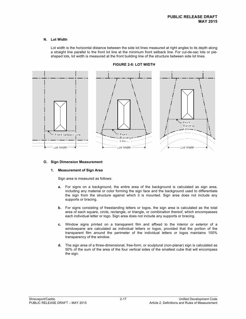
N. Lot Width
Lot width is the horizontal distance between the side lot lines measured at right angles to its depth along a straight line parallel to the front lot line at the minimum front setback line. For cul-de-sac lots or pie-shaped lots, lot width is measured at the front building line of the structure between side lot lines.
FIGURE 2-8: LOT WIDTH
O. Sign Dimension Measurement
1. Measurement of Sign Area
Sign area is measured as follows:
a. For signs on a background, the entire area of the background is calculated as sign area,
including any material or color forming the sign face and the background used to differentiate the sign from the structure against which it is mounted. Sign area does not include any supports or bracing.
b. For signs consisting of freestanding letters or logos, the sign area is calculated as the total
area of each square, circle, rectangle, or triangle, or combination thereof, which encompasses each individual letter or logo. Sign area does not include any supports or bracing.
c. Window signs printed on a transparent film and affixed to the interior or exterior of a
windowpane are calculated as individual letters or logos, provided that the portion of the transparent film around the perimeter of the individual letters or logos maintains 100% transparency of the window.
d. The sign area of a three-dimensional, free-form, or sculptural (non-planar) sign is calculated as
50% of the sum of the area of the four vertical sides of the smallest cube that will encompass the sign.

PUBLIC RELEASE DRAFT MAY 2015
Shreveport/Caddo 2-18 Unified Development Code PUBLIC RELEASE DRAFT – MAY 2015 Article 2. Definitions and Rules of Measurement
FIGURE 2-9: SIGN AREA
2. Measurement of Sign Height
For freestanding signs, height is calculated as the vertical distance measured from the ground adjacent to where the sign is to be installed to the highest point of the sign.
FIGURE 2-10: SIGN AREA
PUBLIC RELEASE DRAFT MAY 2015
Shreveport/Caddo 2-19 Unified Development Code PUBLIC RELEASE DRAFT – MAY 2015 Article 2. Definitions and Rules of Measurement
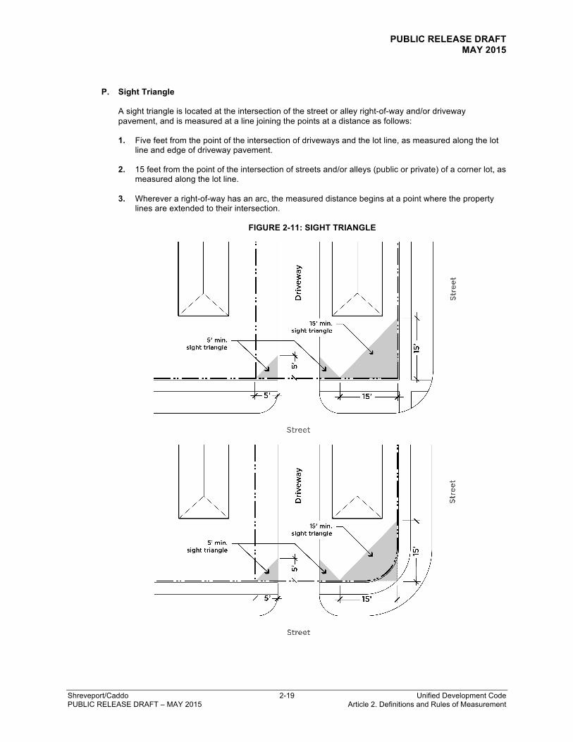
P. Sight Triangle
A sight triangle is located at the intersection of the street or alley right-of-way and/or driveway pavement, and is measured at a line joining the points at a distance as follows:
1. Five feet from the point of the intersection of driveways and the lot line, as measured along the lot
line and edge of driveway pavement.
2. 15 feet from the point of the intersection of streets and/or alleys (public or private) of a corner lot, as measured along the lot line.
3. Wherever a right-of-way has an arc, the measured distance begins at a point where the property
lines are extended to their intersection.
FIGURE 2-11: SIGHT TRIANGLE
PUBLIC RELEASE DRAFT MAY 2015
Shreveport/Caddo 2-20 Unified Development Code PUBLIC RELEASE DRAFT – MAY 2015 Article 2. Definitions and Rules of Measurement
Q. Yards and Setbacks
A yard is the open space area between the building line of a principal building and the adjoining lot lines. A required setback is the required minimum distance a principal building must be located from a lot line, which is unoccupied and unobstructed by any portion of a principal building or accessory structure, unless permitted by this Code, and may be equal to or lesser than a yard. A setback is located along a lot line for the minimum depth specified by the zoning district in which such lot is located. A build-to zone or build-to line is considered a required setback.
1. Front Yard and Front Setback
A front yard is located between a principal building line and the front lot line. A front setback is the required minimum distance per the zoning district that a principal building must be located from the front lot line. The front yard and front setback extend the full width of the lot between side lot lines measured perpendicular to the front lot line.
2. Interior Side Yard and Interior Side Setback
An interior side yard is located between a principal building line and the interior side lot line. An interior side setback is the required minimum distance per the zoning district that a principal building must be located from the interior side lot line. The interior side yard and interior side setback extend along the interior side lot line between the front and rear yard and setback, measured perpendicular to the interior side lot line. For townhouse developments, the interior side yard and interior side setback are applicable to end units only. For semi-detached dwellings, the interior side yard and interior side yard setback do not apply to the lot line where the party wall is located.
3. Corner Side Yard and Corner Side Setback
A corner side yard is located between a principal building line and the corner side lot line. A corner side setback is the required minimum distance per the zoning district that a principal building must be located from the corner side lot line. The corner side yard and corner side setback extend along the corner side lot line between the front yard or front setback and the rear lot line, measured perpendicular to the corner side lot line.
4. Rear Yard and Rear Setback
A rear yard is located between a principal building line and the rear lot line. A rear setback is the required minimum distance per the zoning district that a principal building must be located from the rear lot line. The rear yard and rear setback extend between interior side lot lines, measured perpendicular to the rear lot line. In the case of a corner lot, the rear yard and rear setback extend between the interior side lot line to the required corner side setback for the, measured perpendicular to the rear lot line.

PUBLIC RELEASE DRAFT MAY 2015
Shreveport/Caddo 2-21 Unified Development Code PUBLIC RELEASE DRAFT – MAY 2015 Article 2. Definitions and Rules of Measurement
FIGURE 2-12: YARDS AND SETBACKS


![California Rules of Court Reorganization · Chapter 2. Definitions and Scope of Rules 2.3 New Definitions Repealed 200.2 Construction of terms 2.10 New Scope of rules [Reserved] Repealed](https://static.fdocuments.net/doc/165x107/5e1d657dba18f7659d52ee40/california-rules-of-court-reorganization-chapter-2-definitions-and-scope-of-rules.jpg)

