Argyll and Bute Site Reference Map - Mid Argyll … · Landscape Capacity Study March 2010 6 Site...
29
Argyll and Bute GILLESPIES Landscape Capacity Study March 2010 6 Site Reference Map - Mid Argyll
Transcript of Argyll and Bute Site Reference Map - Mid Argyll … · Landscape Capacity Study March 2010 6 Site...

Argyll and Bute
GILLESPIES
Landscape Capacity Study
March 2010 6
Site Reference Map - Mid Argyll

Argyll and Bute
GILLESPIES
Landscape Capacity Study
March 2010 7
Map Key
Areas with potential to accommodate development, subject to criteria, without damaging the landscape character of the area
Areas where development is generally unacceptable and would have an adverse impact upon the landscape character of the area
Key viewpoints
All plans at 1:10,000 and orientated north unless stated otherwise.

Argyll and Bute
GILLESPIES
Landscape Capacity Study
March 2010 60
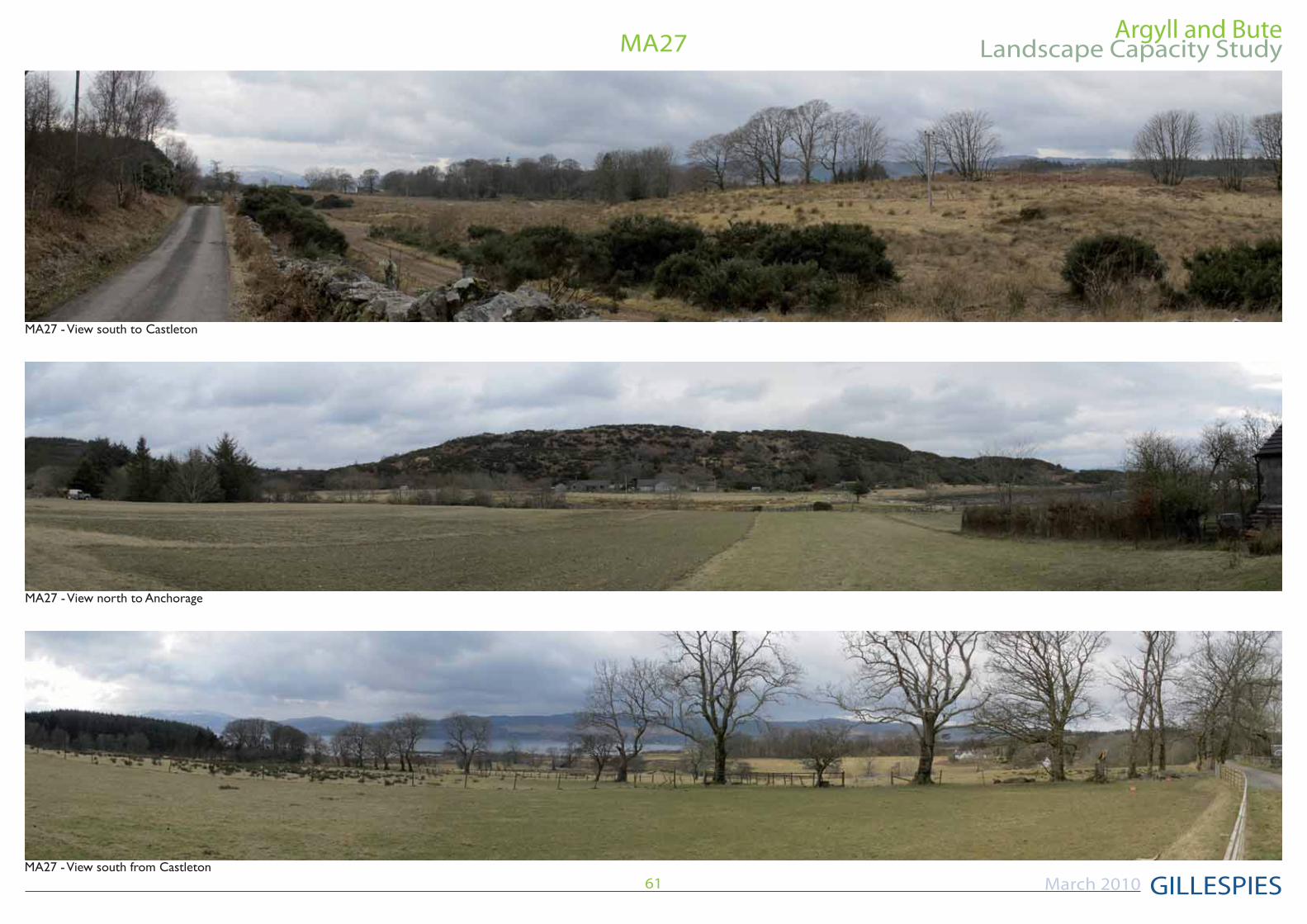
MA27
Scale 1:10,000 at A3
Reproduced from the Ordnance Survey 1:25,000 scale map
MA27:CASTLETON Site Description
which forms the sites northern boundary. There are a number of dwellings within the site which are accessed by minor roads and tracks from the A83. At its highest point the site rises to 40m AOD to the north of Anchorage.
The site is a mosaic of rough grazing land, deciduous woodland and coniferous commercial
western parts of the site.
There are panoramic views south from Castleton and from Anchorage.
Scenic QualityMedium
Sensitivity to ChangeMedium
Capacity to Absorb Development
Areas with potential to absorb development(Orange Areas)
Anchorage. Development should be sited adjacent to existing access tracks, avoiding
planting to anchor it to the existing landscape structure.This should be limited to three or four properties to avoid over-development.
A83 bounded by the recently felled commercial forestry. It should be associated with new broadleaved planting to create a landscape framework and be limited to three or four properties to avoid over-development. Development should be located adjacent to the existing access track.
would be perceived as a cluster.
Areas not recommended for development(Red Areas)
south.
could leave development exposed.
it will be visible in the wider landscape and would be at variance with the existing development pattern.
Argyll and Bute
GILLESPIES
Landscape Capacity Study
March 2010 61
MA27

Argyll and Bute
GILLESPIES
Landscape Capacity Study
March 2010 62
MA28
Scale 1:10,000 at A3
Reproduced from the Ordnance Survey 1:25,000 scale map
MA28:PORT ANN Site Description
Rocky Mosaic LCT.
This site is located to the west of Port Ann and is accessed by track. It is bisected by an overhead transmission line which runs northeast / south-west across the site.
The site comprises forestry north of the access track which bisects the site. Southwest of this is an area of rough grazing land with an area of commercial forestry and a lochan in the south west corner.
The site is dissected by a number of streams
Scenic QualityMedium
Sensitivity to Change
Capacity to Absorb DevelopmentNone
Areas not recommended for development(Red Areas)
unsettled and development would adversely change the landscape character of the site.

Argyll and Bute
GILLESPIES
Landscape Capacity Study
March 2010 63
MA28

Argyll and Bute
GILLESPIES
Landscape Capacity Study
March 2010 64
MA29Scale 1:10,000 at A3
Reproduced from the Ordnance Survey 1:25,000 scale map
MA29:EAST KAMES Site Description
Rocky Mosaic LCT.
This site is located to the south of Lochgair and is bisected by the A83. It contains a number of dwellings at Middle Kames, East Kames and Newhouse in the north of the site.
In the southern half of the site, to the west of the A83 there is an area of commercial forestry which is dissected by tracks. To the east of A83 there are some patches of commercial forestry and rough grazing land. An overhead transmission line crosses the site in a north/ south direction.
The site is dissected by a number of streams
There are panoramic views west from the central area of the site.
Scenic QualityMedium
Sensitivity to Change
Capacity to Absorb DevelopmentLimited
Areas with potential to absorb development(Orange Areas)
the cottage to the south of Newhouse where the addition of new dwellings would be perceived as part of the existing cluster.
Areas not recommended for development(Red Areas)
as felling cycles could leave development exposed.
too prominent within the landscape.

Argyll and Bute
GILLESPIES
Landscape Capacity Study
March 2010 65
MA29
Argyll and Bute
GILLESPIES
Landscape Capacity Study
March 2010 66
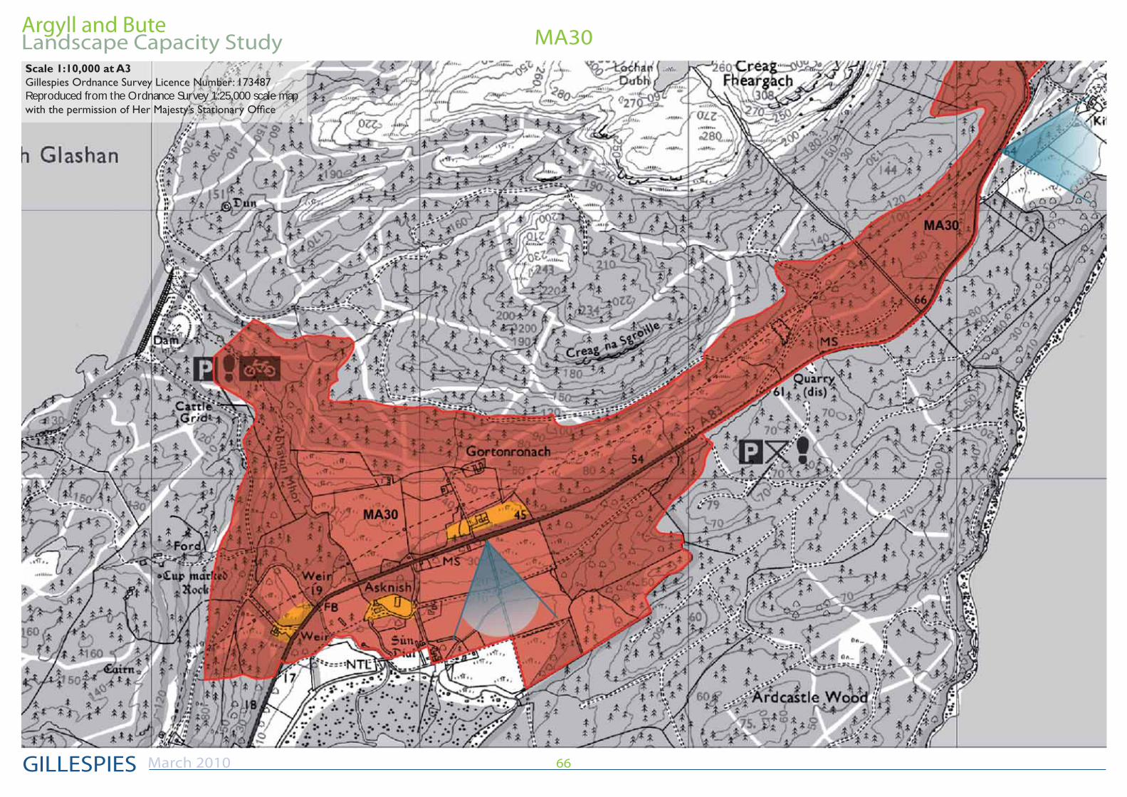
MA30Scale 1:10,000 at A3
Reproduced from the Ordnance Survey 1:25,000 scale map

Argyll and Bute
GILLESPIES
Landscape Capacity Study
March 2010 67
MA30Scale 1:10,000 at A3
Reproduced from the Ordnance Survey 1:25,000 scale map

Argyll and Bute
GILLESPIES
Landscape Capacity Study
March 2010 68
MA30Scale 1:10,000 at A3
Reproduced from the Ordnance Survey 1:25,000 scale map

Argyll and Bute
GILLESPIES
Landscape Capacity Study
March 2010 69
MA30MA30:ASKNISH TO BARR
Site Description
Rocky Mosaic LCT.
This long site is bisected by the A83 and mainly comprises commercial forestry interspersed in a few places with areas of rough grazing. It is dissected by numerous streams. The site is also bisected by an overhead transmission line for much of its length.
There are numerous dwellings within the site; at Asknish and
in the north. There is an archeological feature south of Asknish and a Cup and Ring Mark Rock south of Barr.
Scenic QualityMedium
Sensitivity to Change
Capacity to Absorb DevelopmentLimited
Areas with potential to absorb development(Orange Areas)
and Barr where it would be perceived with existing development as a cluster. Development should be limited to three or four units at each location to prevent over-development.
adjacent to the weir in the south. This should be associated with new broadleaved tree planting to anchor the new development to the existing landscape structure. Development should be limited to two or three units at each location to prevent over-development.
Areas not recommended for development(Red Areas)
as felling cycles could leave development exposed.
rough grazing land south of Barr as it would require extensive earthworks and would alter the landscape character of the area.
Argyll and Bute
GILLESPIES
Landscape Capacity Study
March 2010 70
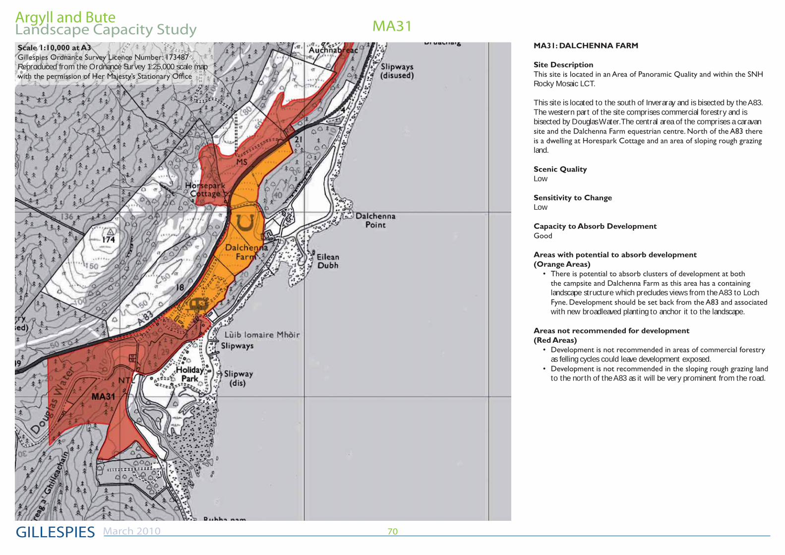
MA31Scale 1:10,000 at A3
Reproduced from the Ordnance Survey 1:25,000 scale map
MA31: DALCHENNA FARM
Site Description
Rocky Mosaic LCT.
This site is located to the south of Inveraray and is bisected by the A83. The western part of the site comprises commercial forestry and is bisected by Douglas Water. The central area of the comprises a caravan
land.
Scenic QualityLow
Sensitivity to ChangeLow
Capacity to Absorb Development
Areas with potential to absorb development(Orange Areas)
landscape structure which precludes views from the A83 to Loch
with new broadleaved planting to anchor it to the landscape.
Areas not recommended for development(Red Areas)
as felling cycles could leave development exposed.
to the north of the A83 as it will be very prominent from the road.

Argyll and Bute
GILLESPIES
Landscape Capacity Study
March 2010 71
MA31

Argyll and Bute
GILLESPIES
Landscape Capacity Study
March 2010 72
MA32, MA33Scale 1:10,000 at A3
Reproduced from the Ordnance Survey 1:25,000 scale map
MA32: BUSHANG
Site Description
--
ing land. Along the western perimeter the site begins to rise up the slopes of Blaran Buidhe and comprises commercial forestry. The site is bisected
There are a number of dwellings within the site; Deer Park Cottages to the north west and Bushang to the south.
There are panoramic views south from the site to Loch Shira.
Scenic QualityMedium
Sensitivity to ChangeMedium
Capacity to Absorb DevelopmentLimited
Areas with potential to absorb development(Orange Areas)
Deer Park Cottage where it would be perceived as a cluster. Development should be limited to one or two for at each location to prevent over-development.
between the track north to the bridge and the track to Deer Park Cottages. It should be associated with new broadleaved planting.
Areas not recommended for development(Red Areas)
as felling cycles could leave development exposed. This area is also steeply sloping.
not recommended for development because it doesn’t possess a landscape structure which can accommodate development discreetly.

Argyll and Bute
GILLESPIES
Landscape Capacity Study
March 2010 73
MA32, MA33MA33: DROCHAID GEAR-ABHAINN
Site Description
-ern boundary by the A83. The majority of the comprises sloping rough grazing land. There is one cottage located in the north of the site.
There are panoramic views south from the site to Loch Shira.
Scenic Quality
Sensitivity to ChangeMedium
Capacity to Absorb DevelopmentLimited
Areas with potential to absorb development(Orange Areas)
where it would be perceived as a cluster. It should be limited to one property to prevent over-development.
Areas not recommended for development(Red Areas)
recommended for development because it doesn’t possess a landscape structure which can accommodate development discreetly.

Argyll and Bute
GILLESPIES
Landscape Capacity Study
March 2010 74
MA34+MA35
Scale 1:10,000 at A3
Reproduced from the Ordnance Survey 1:25,000 scale map
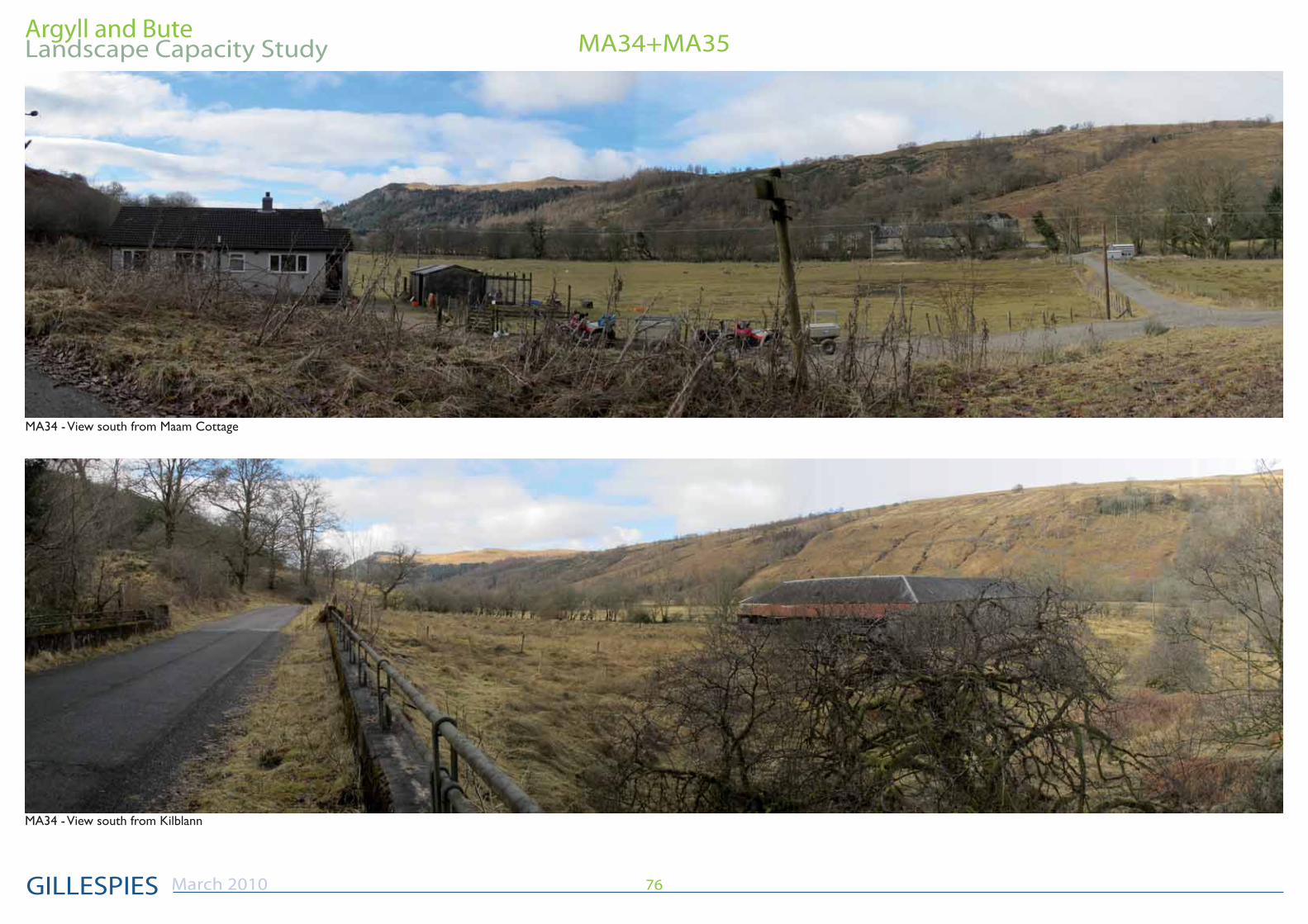
MA34: MAAM
Site Description
private track. It contains two dwellings at Maam and Stucscardan.
To the west of the access track the land rises steeply to the east and comprises commercial coniferous forestry. To the east of the access track
Scenic QualityMedium
Sensitivity to ChangeMedium
Capacity to Absorb DevelopmentLimited
Areas with potential to absorb development(Orange Areas)
be perceived as a cluster. It should be associated with existing and new broadleaved tree planting to anchor it to the existing landscape structure. Development should be limited to one or two units to prevent over-development
Areas not recommended for development(Red Areas)
the west of the access track as extensive earthworks would need to be undertaken, changing the character of the landscape.
to preserve the relatively unsettled character of the glen.
be visually prominent within the wider landscape.

Argyll and Bute
GILLESPIES
Landscape Capacity Study
March 2010 75
MA34+MA35Scale 1:10,000 at A3
Reproduced from the Ordnance Survey 1:25,000 scale map
MA35: KILBLAAN
Site Description
private track. It contains two dwellings at Maam Cottage and Kilblaan.
To the east of the access track the land rises steeply to the east and com-prises moorland and stands of deciduous woodland. To the west of the
Scenic QualityMedium
Sensitivity to ChangeMedium
Capacity to Absorb DevelopmentLimited
Areas with potential to absorb development(Orange Areas)
and Kilblann where it would be perceived as a cluster. It should be associated with new broadleaved tree planting to link it to the existing landscape structure and should also be set back from the river edge. Development should be limited to one or two units at each location to prevent over-development.
Areas not recommended for development(Red Areas)
the east of the access track as extensive earthworks would need to be undertaken, changing the character of the landscape.
Argyll and Bute
GILLESPIES
Landscape Capacity Study
March 2010 76
MA34+MA35

Argyll and Bute
GILLESPIES
Landscape Capacity Study
March 2010 77
MA34+MA35

Argyll and Bute
GILLESPIES
Landscape Capacity Study
March 2010 78
MA36Scale 1:10,000 at A3
Reproduced from the Ordnance Survey 1:25,000 scale map
MA36: CLACHAN FARM
Site Description
This site is located on the eastern side of the glen at the head of Loch
streams. The majority of the site comprises rough grazing land.
The southern part of the site contains a number of dwellings located in clusters to the west of the A83. At the northern end of the site there is a garden centre and a restaurant/farm shop with associated car parking. This area is bisected by an overhead transmission line
Scenic QualityMedium
Sensitivity to ChangeMedium
Capacity to Absorb DevelopmentLimited
Areas with potential to absorb development(Orange Areas)
cottages. It should be associated with new broadleaved tree planting to anchor it to the existing landscape structure. Development should be limited to one or two units at each location to prevent over-development
Areas not recommended for development(Red Areas)
area and existing housing clusters to avoid coalescence.
steep to accommodate new development. On the steeper slopes development would be too visually prominent in the wider area,
earthworks would be required to create development platforms and access.

Argyll and Bute
GILLESPIES
Landscape Capacity Study
March 2010 79
MA36
Argyll and Bute
GILLESPIES
Landscape Capacity Study
March 2010 80
MA37
Scale 1:10,000 at A3
Reproduced from the Ordnance Survey 1:25,000 scale map

Argyll and Bute
GILLESPIES
Landscape Capacity Study
March 2010 81
MA37
Scale 1:10,000 at A3
Reproduced from the Ordnance Survey 1:25,000 scale map

Argyll and Bute
GILLESPIES
Landscape Capacity Study
March 2010 82
MA37

Argyll and Bute
GILLESPIES
Landscape Capacity Study
March 2010 83
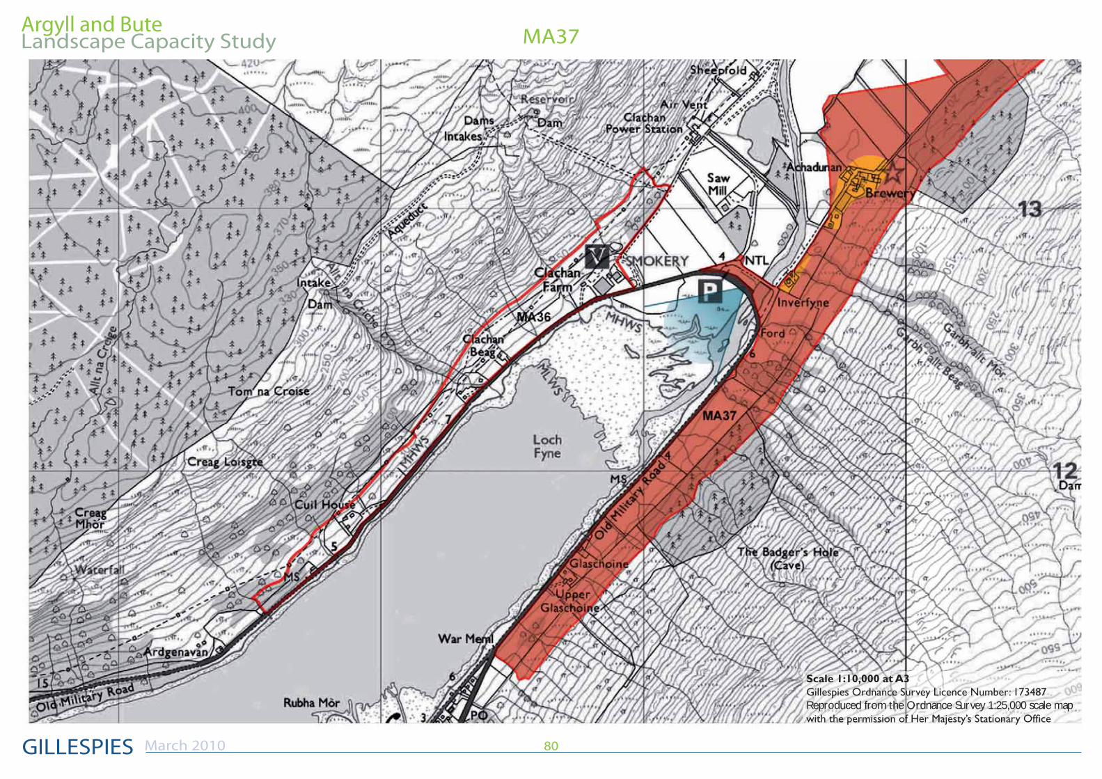
MA37MA37: INVERFYNE
Site Description
boundaries and some small stands of commercial coniferous forestry. The site is bounded on the east by the 50m contour.
Achaduran accessed by a private road. North of Achaduran there is one cottage located in a prominent position to the east of the track. There is a power line which crosses the northern half of the site.
There are panoramic views throughout the site.
Scenic Quality
Sensitivity to Change
Capacity to Absorb DevelopmentLimited
Areas with potential to absorb development(Orange Areas)
it will be perceived as a cluster with new broadleaved tree planting to anchor it to the existing landscape structure. Development should be limited to one or two units at each location to prevent over-development.
Areas not recommended for development(Red Areas)
structure which is capable of accommodating development in this relatively unsettled landscape.
exposed.
the steeper slopes development would be too visually prominent in the wider area, particularly from the
and access.

Argyll and Bute
GILLESPIES
Landscape Capacity Study
March 2010 84
MA38
Scale 1:10,000 at A3
Reproduced from the Ordnance Survey 1:25,000 scale map
MA37: GLENFYNE LODGE
Site Description
to the northwest and is dissected by a number of streams. The majority of the site comprises rough grazing land. There are areas of deciduous tree planting some small stands of commercial coniferous forestry. The
the south and is accessed by private road.
The site contains two dwellings, Mark Park in the south west and
There are panoramic views throughout the site.
Scenic Quality
Sensitivity to Change
Capacity to Absorb DevelopmentLimited
Areas with potential to absorb development(Orange Areas)
and can be integrated with existing tree planting. Development should be limited to one or two units at each location to prevent over-development.
Areas not recommended for development(Red Areas)
there isn’t an existing landscape structure which is capable of accommodating development in this relatively unsettled landscape.
be visually prominent within the wider landscape.
as felling cycles could leave development exposed.

Argyll and Bute
GILLESPIES
Landscape Capacity Study
March 2010 85
MA38

Argyll and Bute Landscape Capacity Study
March 2010
GILLESPIES21 Carlton Court,
Glasgow, G5 9JP
Tel: 0141 420 8200
Fax:0141 429 8796
e-mail:[email protected]
Mid-Argyll and Inveraray