AREA Little Grass - Feather...
130
MANAGEMENT AREA 15 Little Grass District: La Porte Acreage: 21,085 Total 15,306 or 73b PNF Description The Little Grass Management Area extends from Little Grass Valley Reservoir to Pilot Peak. northwest boundary is the Fowler Peak-Chimney Rock ridge. Prominent features are Bunker Hill Ridge, Gibsonville Ridge, Goat Mountain, and Little Grass Valley Reservoir. Counties. Terrain consists of moderately steep slopes with narrow, gently rolling ridgetops. Elevations range from 4,400 to 7,460 feet. Soils are moderately to highly erodible. Instability risk is low. except for isolated debris slides and mudflows in saturated pyroclastic material. The area drains both to Slate Creek, a tributary of the Yuba River, and to the South Fork of the Feather through the reservoir. Vegetation consists of true fir and mixed conifer intermingled with brush. since the construction of the reservoir and residences on surrounding private lands. spotted owl territories and a bald eagle management zone are in the area. Golden eagles, pine marten and black bear are common, and black- tail deer of the Mooretown herd utilize the entire area for summer range and migration. The reservoir has a trophy trout fishery, but only modest numbers of rainbow trout inhabit the headwaters of the South Fork of the Feather River. This portion of the Little Grass Valley Recreation Area has four campgrounds, a swimming site, a boat launching site, and a 5 mile lakeshore trail. Other facilities are in Area #13. The Pacific Crest Trail extends 11 miles along the northern boundary of the area. Dispersed winter sports are snowmobiling and cross-country skiing, and a semi-private alpine and cross country ski area is proposed for private land near Silvertip Springs subdivision. A portion of the "Little Grass Valley", "Mt. Fillmore", and "Onion Valley" range allotments are in this unit. Mt. Fillmore is an active cattle allotment. Little Grass is an inactive cattle allotment due to livestock control problems and conflicts with recreation use. Valley is an inactive sheep allotment. Timber management is intensive on commercial forest land for both salvage and green sawtimber harvest. Soils are moderately productive. The southeast boundary is Slate Creek, and the It is in both Plumas and Sierra Fire frequency was recently low but has increased dramatically Osprey nest at the reservoir, and portions of two Onion 4-203
Transcript of AREA Little Grass - Feather...
MANAGEMENT AREA 15
Little Grass District: La Porte Acreage: 21,085 Total
15,306 or 73b PNF
Description
The L i t t l e Grass Management A r e a extends from L i t t l e Grass Valley Reservoir t o P i l o t Peak. northwest boundary is the Fowler Peak-Chimney Rock ridge. Prominent features are Bunker H i l l Ridge, Gibsonville Ridge, Goat Mountain, and L i t t l e Grass Valley Reservoir. Counties.
Terrain consists of moderately s teep slopes with narrow, gently ro l l i ng ridgetops. Elevations range from 4,400 to 7,460 feet. So i l s are moderately t o highly erodible. In s t ab i l i t y r i s k is low. except fo r isolated debris s l i des and mudflows i n saturated pyroclast ic material. The area drains both t o S la t e Creek, a t r ibu tary of the Yuba River, and t o the South Fork of the Feather through the reservoir.
Vegetation consists of t rue fir and mixed conifer intermingled with brush. since the construction of the reservoir and residences on surrounding pr ivate lands. spotted owl t e r r i t o r i e s and a bald eagle management zone are i n the area. Golden eagles, pine marten and black bear are common, and black- t a i l deer of the Mooretown herd u t i l i z e the e n t i r e area for summer range and migration. The reservoir has a trophy t rout f ishery, but only modest numbers of rainbow trout inhabit the headwaters of the South Fork of the Feather River.
This portion of the L i t t l e Grass Valley Recreation Area has four campgrounds, a swimming site, a boat launching si te, and a 5 mile lakeshore trail. Other facilities are i n Area #13. The Pacific Crest T r a i l extends 11 miles along the northern boundary of the area. Dispersed winter sports are snowmobiling and cross-country ski ing, and a semi-private alpine and cross country s k i area is proposed f o r pr ivate land near S i lve r t ip Springs subdivision.
A portion of the " L i t t l e Grass Valley", " M t . Fillmore", and "Onion Valley" range allotments are i n t h i s unit . M t . Fillmore is an active cattle allotment. L i t t l e Grass is an inact ive cattle allotment due to livestock control problems and conf l ic t s with recreation use. Valley is an inact ive sheep allotment. Timber management is intensive on commercial fores t land fo r both salvage and green sawtimber harvest. Soi l s are moderately productive.
The southeast boundary is S la t e Creek, and the
It is i n both Plumas and S ie r r a
F i re frequency was recently low but has increased dramatically
Osprey nes t a t the reservoir, and portions of two
Onion
4-203

Intensive hydraulic and placer mining has occurred. activity is moderate to high, consisting of both s m a l l and large operations.
Current mining
4-204

MANAGEMENT AREA 15 Little Grass
GENERAL DIRECTION STANDARDS AND GUIDELINES
Recreation Provide developed recreation facilities/programs to meet demand ( la) .
Visual Resources Maintain pleasing visual corridors
Cultural Resources Protect s ignif icant properties and interpret selected properties (3a).
Wildlife Protect and improve emphasis species habi ta t (5a).
Range Suspend use on areas highly valued for other purposes (6a).
Maintain L i t t l e Grass Valley Recreation area: employ Rx-5 and Rx-6.
Apply Rx-10 and Rx-14 to the Quincy-LaPorte Road viewshed. L i t t l e Grass Valley Reservoir, and the PCT.
Protect and provide interpre- ta t ion of Onion Valley properties and cemeteries.
Enhance t rout spawning habi ta t i n t r i bu ta r i e s t o L i t t l e Grass Valley Reservoir.
Maintain o r enhance deer summer range habi ta t for the Mooretown deer herd.
Maintain or enhance pine marten habi ta t capabi l i ty i n timber compartments 327. 328 and 337.
Exclude l ivestock from the South Fork developed recreation sites.
Establish and monitor condition and trend t ransects and complete an analysis t o determine the long term s t a tus of the Onion Valley Allotment.
4-205

MANAGEMENT AREA 15 Little Grass
GENERAL DIRECTION STANDARDS AND GUIDELINES
Examine the v i a b i l i t y of the L i t t l e Grass Valley Allotment and e i t h e r re ta in , abandon, or combine the allotment with the surrounding allotments.
Timber Obtain regulated timber yields through unevenage s i lv i cu l tu ra l systems (7a&b).
Water Imurove water Yield i n the Red Fi r
Rehabili tate selected deter iorat ing watersheds t o improve water quali ty (lob) .
Minerals and Materials Provide for recreat ional gold panning and dredging (l3a).
Withdraw important Forest material sources from mineral entry (l3a).
F a c i l i t i e s Upgrade fores t a r t e r i a l s and co l lec tors ( l7a ) .
Provide cost-eff ic ient support facil i t ies (17a).
Manage the Bald M t . timber compart- ment using single-tree and group select ion s i lv i cu l tu ra l methods.
Employ Forestwide Standards and Guidelines: WATER, Water Use and Need.
Rehabili tate the S la te Creek and South Fork Feather River watersheds t o improve water qual i ty suf f ic ien t fo r the beneficial uses i n coopera- t ion with C a l i f . DFG and other land owners.
Recommend withdrawal from mineral entry: South Fork of the Feather River from its i n l e t t o L i t t l e Grass Valley Reservoir upstream t o 1/2 m i l e above the bridge.
Recommend withdrawal from mineral entry: S i t e #53-35 - "Union Keys tone Gravels"
Cooperatively reconstruct the Quincy-LaPorte Road as a par t of the Forest Highway System under County jur isdict ion.
Continue t o develop the L i t t l e Grass Valley access roads t o support the timber and recreation programs.
4-206

MANAGEMENT ARFA 15 Little Grass
GENERAL DIRECTION STANDARDS AND GUIDELINES
Develop and implement a long term plan for the Pilot Peak lookout.
Improve the administrative facil- ities at Little Grass Valley Lake.
4-207

Managment Area 15 PRESCRIPTION ALLOCATION
Prescriptions Acres Rx-5. Recreation Area 4376 Rx-6. Developed Recreation S i t e 124 Rx-7. Minimal Management 1792 Rx-8. Semi-primitive Area 377 Rx-9. Riparian 1/ 620 Rx-10. Visual Retention 3981 Rx-11. Bald Eagle Habitat 440 Rx-12. Spotted O w l Habitat 275 Rx-13. Goshawk Habitat 100 Rx-14. Visual P a r t i a l Retention 1074 Rx-15. Timber Emphasis
Total
WILDLIFE HABITAT ALLOCATIONS
2767 15306
Species Te r r i t o r i e s Compartment Comments Bald Eagle 2 327.328 Potential a t L i t t l e Grass
Valley Reservoir Goshawk Osprey Osprey
2 328,329 1 328 2 327
Existing Potential
SENSITIVE PLANT LOCATIONS
Species Compartment Arabis constancei 332 Silene inv isa 332 Veronica cus ick i i 332
SERAL STAGE (DIVERSITY) TARGETS
Habitat Type Target Acres (Minimum) Per Stage Mixed conifer 579 Ponderosa pine 15 Red fir 115
RANGE ALLOTMENT STRATEGIES
Allotment Name Grazing Strategy L i t t l e Grass Valley B Mount Fillmore Onion Valley
- - - - - - - - 1/ Acreage overlaps other Rx.
B B
4-208

4-209
. ~
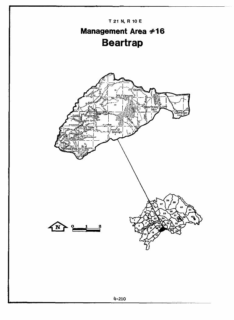
T 21 N, R 10 E
Management Area #I6
Beartrap
~
~
~~ ~~
4-210

MANAGEMENT AREA 16
Bear trap
District: L a Porte Acreage: 15,954 Total 14,760 or 92% PNF
Description
The Beartrap Management Area lies between Canyon and S la t e Creeks from Grass Fla t t o the McRae Ridge. It is i n Plumas and S ie r r a Counties and i n the extreme southeast portion of the Dis t r ic t . M t . Fillmore, M t . Etna, and Table Rock are prominent features.
Terrain consists of steep slopes with both broad and nearly knife- edged ridgetops. Elevations range from 4,400 t o 7.715 f ee t . So i l e rod ib i l i t y is moderate on the f l a t t e r ridgetops and very high on the s teeper canyon slopes. moderate. The Canyon and Slate Creek watersheds are both t r ibu tary t o the Yuba River upstream from Bullards B a r Reservoir.
Vegetation consists of mixed conifer and t rue f i r with brushfields. Although fires were common i n the 1880's and go's, fire frequency is now low, and f i r e s are of low intensi ty and slow-moving. Due to the impacts of past mining, only s m a l l numbers of rainbow trout e x i s t i n most l o c a l streams. However, Canyon Creek has excellent water qua l i ty and supports a large population of f i sh .
Recreation is dispersed: mostly hunting, camping, and fishing. The Pacific Crest T r a l crosses the area, and three Forest trails are included.
A portion of the " M t . Fillmore" range allotment is i n t h i s un i t . Timberland access t o the s ignif icant post-f i re second-growth timber is limited.
Remains of several major towns of the "Northern Mines," as w e l l as extensive placer and hydraulic diggings of the 1850-1890 era, are present. over 600 mining claims ex i s t , and 18 are large-scale operations with approved plans of operation. This includes "Gardner Point", largely on pr iva te land near Grass F la t with some appurtenant ac t iv i ty on PNF land.
Risk of mass in s t ab i l i t y is generally low t o
Most of the Beartrap unroaded area is i n t h i s area.
This area has a high level of mining ac t iv i ty :
4-211

MANAGEMENT AREA 16 Beartrap
GENERAL DIRECTION STANDARDS AND GUIDELINES
Recreation Provide for semi-primitive recreation ( la) .
Provide for dispersed recreation (la).
Visual Resources Maintain pleasing visual corridors (24.
Cultural Resources Protect significant properties and interpret selected historical and N.R. properties (3a).
Water Improve water yield in the Red Fir zone (loa).
Rehabilitate selected deteriorating watersheds to imrpove water quality (lob).
Facilities Upgrade forest arterials and collectors (17a).
Maintain the character of the Beartrap semi-primitive area: employ Rx-8.
Maintain the Poker Flat and Mt. Fillmore 4WD roads.
Apply Rx-14 to those areas viewed as foreground from the PCT.
Develop a management plan for How- land Flat, other townsites. and area cemeteries. Intensify pre- vention of site vandalism.
Maintain the integrity of the old single land portion of the Johns- ville/Gibsonville Road over Etna Saddle (4.5 miles). Establish standards for preservation main- tenance with Sierra County.
Employ Forestwide Standards and Guidelines: WATER, Water Use and Need
Rehabilitate the Slate and Canyon Creek watersheds to improve water quality sufficient for the bene- ficial uses in cooperation with Calif. DFG and other land owners.
Cooperatively reconstruct and surface the Gibsonville Rd. under county jurisdiction.
4-212

MANAGEMENTAREA16 ' Beartrap
GENERAL DIRECTION STANDARDS AND GUIDELINES
Cooperate with Sierra County to eliminate the Poker Flat Rd. from their system.
Reconstruct replacement crossings on Slate (St. Louis), Pearson, and Cedar Grove Creeks to facilitate timber objectives.

Management Area 16 PRESCRIPTION ALLOCATION
Prescr ipt ions Acres Rx-7. Minimal Management 2418 Rx-8. Semi-primitive Area 3421 RX-9. Riparian 1/ 367 Rx-10. Visual Retention 129 Rx-12. Spotted O w l Habitat 660 RX-13. Goshawk Habitat 100 RX-14. Visual P a r t i a l Retention 479 Rx-15. Timber Emphasis 7553
Total 14,760
WILDLIFE HABITAT ALLOCATIONS
Species Te r r i t o r i e s Compartment Comments Spotted O w l 1 333 SOTC E-3: overlaps MA's #18 Goshawk 2 316,322 SOHA
SENSITIVE PLANT LOCATIONS
Species Compartment Arabis constancei 332 Silene inv i sa 332 t 333
SERAL STAGE (DIVERSITY) TARGETS
Habitat Type Target Acres (Minimum) Per Stage Black oak 20 Mixed conifer 527 Ponderosa pine 14 Red f i r 148
RANGE ALLOTMENT STRATEGIES
Allotment Name Grazing Strategy Mount Fillmore B
- - - - - - - - I/ Acreage overlaps other Rx.
4-214


T 2 0 N , R e E
Management Area S17
Poverty
I 4-216
MANAGEMENT AREA 17
Poverty
District: La Porte Acreage: 18.930 Total 13,211 or 70% PNF
Description
The Poverty Management Area lies between Canyon and S l a t e Creeks from Grass F la t t o Stowman Ravine, encompassing the old mining communities of Port Wine, Queen City, Poverty H i l l , and Scales. It is i n S ier ra , Yuba, and Plumas Counties.
Terrain consists of broad ridgetops and s teep slopes dropping i n t o S l a t e Creek, Canyon Creek, and Rock Creek, a l l t r i bu ta r i e s of the Yuba River upstream from Bullards Bar Reservoir. Elevations range from 2,700 t o 5,600 fee t . i n s t a b i l i t y ranges from low on most of the f la t ridgetops t o high on the s teep canyon slopes of S la te Creek and Canyon Creek.
Vegetation consists of mixed conifer and t rue f i r with scat tered brush-fields. Fire frequency is low, but the topography and vegetation of Canyon Creek and Sla te Creek create a high potent ia l fo r la rge fires. This area i s a summer range for blacktai l deer of the Mooretown herd. The Canyon Creek watershed a l so provides winter range. Pa r t s of two spotted owl and goshawk t e r r i t o r i e s are included i n the area. S l a t e Creek hosts only a modest population of rainbow and brown trout due to mining and hydroelectric development. Canyon Creek is an excel lent t rou t f ishery due t o high water qual i ty and lack of dams.
Recreational ac t iv i t i e s are dispersed, consisting of hunting, camping, and fishing.
A portion of the " M t . Fillmore" range allotment is i n t h i s un i t . Timber management is intensive on commercial fores t land.
Cultural remains of h i s to r i c mining towns near the North Yuba River and of ranches i n the heart of the area tha t supplied them fresh food are present. today.
Soi l s are highly t o very highly erodible. Risk of
Many small placer and f i v e large gold operations continue
4-217

MANAGEMENT AREA 17 Poverty
GENERAL DIRECTION STANDARDS AND GUIDELINES
Cultural Resources Protect s ign i f i can t propert ies and in te rpre t se lec ted N.R. propert ies ( 3 4 .
Wildlife Protect and improve emphasis species hab i t a t (5a).
Water Rehabili tate se lec ted de te r iora t ing watersheds t o improve water qua l i ty (lob).
Minerals and Materials Withdraw important Forest material sources from mineral entry ( l3a).
Fac i l i t i e s Provide cos t e f f i c i e n t support facil i t ies (l7a).
Protect and provide interpretat ion of Port Wine, other h i s tor ica l sites, and area cemetaries.
Maintain or enhance deer winter range fo r the Downieville Herd.
Maintain or enhance pine marten habi ta t capabili ty i n timber compartments 318 and 319.
Rehabilitate the Slate and Canyon Creek watersheds t o improve water quali ty suff ic ient for the bene- f i c i a l uses i n cooperation with Calif . DFG and other land owners.
Recommend withdrawal from mineral entry: S i t e #53-23 - "Poverty H i l l "
Reconstruct the approach t o the Slate Creek Bridge and widen the bridge to accomodate "low boy" traffic.
4-218

Management Area 17 PRESCRIPTION ALLOCATION
Prescriptions Acres Rx-7. Minimal Management 1765 Rx-9. Riparian 1/ 545 Rx-10. Visual Retention 1604 Rx-12. Spotted Owl Habitat 2101 Rx-13. Goshawk Habitat 100
Rx-15. Timber Emphasis 6756 Rx-14. Visual Partial Retention 891
Total 13 I 217
WILDLIFE HABITAT ALLOCATIONS
Species Ter r i to r ies Compartment Comments Spotted O w l 2 318,319 SOHA'S D - 1 and D-2 Goshawk 2 318.319 SOHA
SENSITIVE PLANT LOCATIONS
Species Compartment Darlingtonia cal i fornica 319 Drosera rotundifolia 312 Viola tomentosa 312
SERAL STAGE (DIVERSITY) TARGETS
Habitat Type Target Acres (Minimum) Per Stage Black oak 60 Mixed conifer 583
RANGE ALLOTMENT STRATEGIES
Allotment Name Grazing Strategy Mount Fillmore B
- - - -- - - - 1/ Acreage overlaps other Rx.
4-219

T 22 N. R 10 E
Management Area *18
Turkeytown
District: L a Porte
MANAGEMENT AREA la Turkeytown
Acreage: 17,593 Total 17,081 or 97% PNF
Description
The Turkeytown Management Area i s e a s t of P i l o t Peak, M t . Etna, and the Fingerboard and west of Nelson Creek and McRae Ridge i n Plumas and S ie r r a Counties.
Terrain consists of steep slopes with both narrow ro l l i ng and sharp knife-edged ridges. Landslides have occurred within t h i s un i t along and above the major streams. Soi l s have moderate t o high e rodib i l i ty . Risk of i n s t a b i l i t y is moderate t o high due t o the presence of unstable younger volcanics overlying more res i s tan t bedrock on s teep slopes. The e n t i r e area is within the watershed of Nelson Creek, a t r ibutary of the Middle Fork of the Feather River.
Vegetation consists of t rue fir and mixed conifer stands intermingled with large brushfields and rock outcrops. Typically, fires are not intense and spread slowly. The area is summer deer range for t h e Sloat herd and blackbear habi ta t . Goshawk nesting t e r r i t o r i e s are pFesent, a s well as par ts of three spotted owl t e r r i t o r i e s . Nelson Creek, a California Wild Trout Stream, and its West Branch are major spawning and nursery streams and supply substant ia l cold water t o the Middle Fork of the Feather River. High populations of t rou t inhabit both Nelson Creek and the Middle Fork.
Recreation is dispersed, consisting of fishing, camping, hunting, and backpacking, u t i l i z ing two fores t trails and the Pac i f ic Crest T r a i l . Portions of the Beartrap the and Dixon Creek unroaded areas are present.
A portion of the "Onion Valley" range allotment is i n t h i s un i t . Large timber sa l e s did not occur here u n t i l the ear ly 1970's.
The earliest mining complexes for the e n t i r e surrounding area are i n t h i s management area. operations.
A prominent feature is Blue Nose Mountain.
Elevations range from 4,000 t o 7,460 feet.
Mining ac t iv i ty is now high, with many small Five large-scale projects are i n the planning stage.
4-221

MANAGEMENT AREA 18 Turkeytown
GENERAL DIRECTION STANDARDS AND GUIDELINES
Recreation Provide f o r semi-primitive recreation ( la) .
Visual Resources Maintain pleasing v isua l corr idors ( 2 4 .
Cultural Resources Protect significant propert ies and in te rpre t selected h i s t o r i c a l and N.R. propert ies (3c).
Wildlife Protect and improve emphasis species hab i t a t (5a).
Maintain the character of the Beartrap and Dixon Creek semi- primitive areas: employ Rx-8. Provide f ishing access trails t o Nelson Creek.
Apply Rx-10 and Rx-14 t o the Quincy-LaPorte Rd. and Nelson Creek viewsheds. Apply Rx-14 t o the Nelson Creek Wild Trout Stream. Apply Rx-14 t o the West Branch Nelson Creek, McRae Meadow, and the PCT.
Develop a plan t o protect and pro- vide in te rpre ta t ion of isolated gravesites.
Maintain the i n t e g r i t y of the remaining portions of the old Johnsville-Gibsonville road from Etna Saddle t o Plumas-Eureka State Park, allowing for development of turnouts as needed between the Plumas/Sierra county l i n e and the A-Tree turnoff. Establish standards fo r preservation maintenance and m a x i m u m road width with Sierra and Plumas Counties.
For projects a f f ec t ing the Nelson Creek Wild Trout Stream, coordinate with C a l i f . DFG; prepare and implement a Wild Trout habi ta t management plan. Maintain s u f f i - c ient flows i n Nelson Creek t o meet needs of the Wild Trout fishery.
Maintain or enhance pine marten
MANAGEMENT AREA 18 Turkeytown
GENERAL DIRECTION STANDARDS AND GUIDELINES
habi ta t cauabi l i tv i n the P i l o t Peak area bf timber compartment 336
Range Suspend grazing on areas valued f o r other purposes (6a).
Water Improve water yield i n the Red F i r zone (loa).
Protect and, where necessary, improve water quali ty (loa) .
Minerals and Materials Protect wild t rout habi ta t (l3a).
Withdraw important Forest material sources from mineral entry (l3a).
Lands Consolidate ownership i n Wild Trout Stream watersheds (16a).
Establish and monitor conditions and trend t ransects , and complete an analysis t o determine the long term s ta tus of the Onion Valley Allotment.
Employ Forestwide Standards and Guidelines: WATER, Water U s e and Need.
Prepare and implement a water qual i ty monitoring plan f o r Nelson Creek.
Restore Nelson Creek watersheds where degradation is af fec t ing t rou t habitat . par t icu lar ly o ld mining disturbances.
Recommend withdrawal of the Wild Trout Stream portion of Nelson Creek from mineral entry.
Assure tha t operating plans min- imize disturbance t o f i s h hab i t a t , streamside vegetation, and scenic qua l i ty of Nelson Creek.
Recommend withdrawal from mineral entry: S i t e #53-22 - "Fingerboard Pi t" .
Attempt t o acquire pr iva te land i n the Nelson Creek watershed t o improve water qua l i ty f o r Wild Trout management.
4-223

Management Area 18 PRESCRIPTION ALLOCATION
Prescriptions Acres Rx-7. Minimal Management 427 Rx-8. Semi-primitive Area 4316 Rx-9. Riparian 1/ 688 Rx-10. Visual Retention 1547 Rx-12. Spotted O w l Habitat 1177 Rx-13. Goshawk Habitat 200 Rx-14. Visual P a r t i a l Retention 1833 Rx-15. Timber Emphasis 7581
Total 17,081
WILDLIFE HABITAT ALLOCATIONS
Species Territories Compartment Comments Spotted O w l 3 339,340 SOHA' s E-2,E-3.P-3
Goshawk 2-4 336 overlaps MA's #16,33.35
SENSITIVE PLANT LOCATIONS
Species Compartment Silene iv i sa 336 Chenopodium gigantospermum 336 Lupinus dalesiae 340
SERAL STAGE (DIVERSITY) TARGETS
Habitat Type Target Acres (Minimum) Per Stage Black oak 10 Mixed conifer Red fir
649 189
RANGE ALLOTMENT STRATEGIES
Allotment N a m e Grazing Strategy
Onion Valley B
------- - 1/ Acreage overlaps o ther Rx.
4-224

Quincy Ranger District
Management Area
19. North Fork
20. Rich
21. Silver
22. Third Water
23. Grizzly Ridge
24. Volcano
25. Bear
4-227
4-233
4-239
4-247
4-251
4-259
4-265
4-225
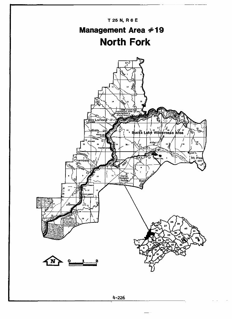
T 2 5 N , R 6 E
Management Area #lQ
North Fork

MANAGEMFNT AREA 19
North Fork
District: Quincy Acreage: 32.363 Total 30,298 or 94% PNF
Description
The North Fork Management Area is located on both side of the North Fork of the Feather River Canyon from Elephant Butte on the west, upstream to Yellow Creek on the north side of the river and to Mt. Pleasant on the south side. Wilderness is included.
Slopes are generally steep on both sides of the Canyon. range from 2,200 feet on the west to 6.900 on Mt. Pleasant. Most soils are rocky, shallow, and highly erodible where deeply weathered on steep slopes. slopes due to debris slides and avalanche chutes. Serpentine soils are unproductive and highly erodible.
South-facing slopes, north of the river, are primarily covered with mixed conifers, hardwoods, and brush; north-facing slopes are covered with mixed conifers and brush. This area has a history of large fires occurring in the fall when down-canyon winds are blowing. It provides winter range for the Bucks Mountain deer herd. Spotted owl territories are included. California Wild Trout Stream.
Fishing was a major recreation attraction prior to the development of the power projects. Recreation now involves camping, sightseeing, fishing, and hunting. PNF facilities consist of two developed campgrounds and the Pacific Crest and other trails. Chips Creek unroaded area is present.
No grazing occurs in this area because of steep terrain and lack of suitable range. is in the northern end of the area. limited due to limited access and volume.
There is a history of intensive mining along the North Fork and the tributaries.
The North Fork Canyon is both a scenic and transportation corridor for Highway 70 and the Union Pacific Railroad mainline and a hydroelectric powerline corridor. There are three P.G.& E. powerhouses (Rock Creek, Belden, and Bucks) and one dam (Rock Creek Forebay) on the river. A number of new hydroelectric projects have been proposed in recent years.
It is all in Plumas County. A portion of the Bucks Lake
Elevations
Landslide susceptibility is high to extreme on the steeper
Yellow Creek in the Chips Creek roadless area is a
A portion of the
A small portion of the vacant Mosquito Creek allotment Timber harvesting has been very
Small dredging operations are now common.
4-227
MANAGEMENT AREA 19 North Fork
GENERAL DIRECTION STANDARDS AND GUIDELINES
Recreation Improve and (la) - expand the trail system
Provide developed recreation facil i t ies/programs t o meet demand ( 1 4 .
Provide f o r semi-primitive recreat ion ( la ) .
Provide f o r dispersed recreation ( la ) .
Maintain the two PCT trailheads near Belden. Construct vault toilets. Cooperate with CalTrans during Yellow Creek Bridge replacement t o secure a safe equestrian and hiker crossing.
Warn users of fo re s t f ire hazard, vehicle traffic on Hwy. 70, and t r a ins on the U.P.R.R. tracks. Inform users of pr iva te land boundaries, and discourage camping between Belden and Three Lakes.
Coordinate t r a i l management with the Lassen NF fo r shared routes with uses conforming t o Appendix 0.
Close the ex is t ing 4WD road extending northerly along the PCT from Three Lakes.
Repair the Chambers Creek T r a i l Bridge.
Maintain the North Fork Cmpgrds.; employ fix-6.
Maintain the semi-primitive char- ac te r of the Chips Creek area: employ fix-8.
Provide f ishing access t r a i l s t o Yellow Creek.
Apply Rx-1 t o the Bucks Lake Wilderness A r e a .
4-228

MANAGEMENT AREA 19 North Fork
_____
GENERAL DIRECTION STANDARDS AND GUIDELINES
Visual Resources Maintain pleasing visual corridors (2a) . 70 viewshed. Minimize visual
Apply Rx-10 and Rx-14 t o the Hwy. . .
impacts of electric transmission l i nes and the UP mainline.
Meet a VQO of Retention along Yellow Creek.
Cultural Resources In te rpre t selected h is tor ica l propert ies (3a)
Wildlife Protect and improve emphasis species habi ta t (5a).
I n i t i a t e interpretat ion of California-Utah Wagon Road along U.P. Railroad fo r PCT users.
Develop and interpret the Rich Bar Cemetary.
Interpret the Kellog Ravine T r a i l .
For projects affect ing the Yellow Creek Wild Trout Stream, coordin- ate with C a l i f . DFG; prepare and implement a wild t rou t habi ta t management plan. Maintain suf f ic ien t flows i n Yellow Creek t o meet needs of the Wild Trout f ishery . Maintain o r enhance deer summer and winter range habi ta t fo r the Bucks Mountain Herd.
Cooperate with C a l i f . Dept. of Fish and Game, Caltrans, and Union Pacif ic R.R. t o remove f i s h bar r ie rs blocking upstream migration i n t o the t r i b u t a t i r e s of the North Fork of the Feather River.
4-229
MANAGEMENT AREA 19 North Fork
GENERAL DIRECTION STANDARDS AND GUIDELINES
pange Suspend grazing in areas valued for other purposes (6a).
Water ImDrove water yield in the Red Fir
Protect water quality (loa).
Minerals and Materials Protect Wild Trout habitat (13a)
Provide for recreational gold panning and dredging (l3a).
Lands Allow use of surplus PNF water sources if private source development is not feasible (16b).
Eliminate Mosquito Creek Allotment due to change in vegetation type.
Apply Forestwide Standards and Guidelines: WATER, Water Use and Need.
Prepare and implement a water quality monitoring plan for Yellow Creek.
Recommend withdrawal of Yellow Creek from mineral entry.
Evaluate operating plans to assure minimum disturbance to fish habitat, streamside vegetation, and scenic quality of Yellow Creek.
Recommend withdrawal of the North Fork and the East Branch of the North Fork of the Feather River from mineral entry.
Allow development of surplus PNF water shources in the Feather River Canyon for use of the Feather River Service District. Encourage development of the sources on private land if feasible.
4-230
Management Area 19 PRESCRIPTION ALLOCATION
Prescriptions Acres Rx-1. Wilderness 9646 k - 6 . Developed Recreation Site 28 Rx-7. Minimal Management 6940 Rx-8. Semi-primitive Area 10100 Rx-9. Riparian 1/ 828 Rx-10. Visual Retention 1978 Rx-12. Spotted Owl Habitat 900 Rx-14. Visual Partial Retention 3482 Rx-15. Timber Emphasis 218
Total 33292
WILDLIFE HABITAT ALLOCATIONS
Species Territories Compartment Comments Spotted Owl 2 622 SOHA'S N-2 and P-1
SENSITIVE PLANT LOCATIONS
Species Compartment Lewisia cantelowii 622 Cypripedium californicum 622 Cypripedium fasciculatum 622
SERAL STAGE (DIVERSITY) TARGETS
Habitat Type Target Acres (Minimum) Per Stage Black oak 398 Mixed conifer Ponderosa pine Red fir
997 45 28
RANGE ALLOTMENT STRATEGIES
Allotment Name Grazing Strategy Mosquito Creek Eliminate
i P
------- - I/ Acreage overlaps other Rx.
4-231

T 25 N, R 8 E
Management Area R20
Rich
MANAGEMENT AREA 20
Rich
District: Quincy
Description
Acreage: 43,608 Total 37.613 or 86% PNF
The Rich Management Area extends along the East Branch of the North Fork of the Feather River from the Yellow Creek road to Indian Creek. The North Fork forms a portion of the northwest boundary. entirely within Plumas County.
Slopes are gentle in the upper elevations but drop off steeply to the canyon bottoms. 6,300 at both Red Hill and Rush Creek Hill. occurs m the western portion. Most soils are rocky, shallow, and highly erodible where deeply weathered on steep slopes. Landslide susceptibility is high to extreme on the steeper slopes due to debris slides and avalanche chutes. highly erodible. East Branch or to the Rush Creek tributary.
Vegetation consists of hardwoods and brush on steep slopes and mixed conifers in the moist drainages and on those areas with deeper soils. Fires have burned from the canyon bottoms to the upper slopes, and fire scars of all ages are readily evident throughout. Approximately 9,500 acres are winter range for the Bucks Mountain Deer Herd. Parts of two spotted owl territories are included. Rush Creek was formerly a major spawning stream for the North Fork fishery.
Fishing was a major recreation activity prior to the development of the many power projects and Highway 70. Camping, sightseeing, hiking, and hunting now prevail. within the area.
Portions of "Mosquito Creek, " "Cherry Peak," and "Round Valley" allot- ments are included. continue to the present.
Mining, both placer and lode, was active from 1850 until the 1930's. Most of the gold camps have disappeared, while others evolved into small residential areas on both private and public land. Large scale gold exploration is occurring at Rich Gulch and many small dredges work the area's stream bottoms.
Both the North Fork and its East Branch are transportation, scenic and utility corridors that encompass Highway 70, the Union Pacific Railroad, and numerous powerlines. proposed in this area.
The area is
Elevations range from 2,300 at the Feather River to A wide band of serpentine
Serpentine soils are unproductive and The area drains directly to the North Fork and its
Currently there are four developed campgrounds
Major timber harvests began in the 1950's and
New hydroelectric projects have recently been
4-233
MANAGEMF” AREA 20 Rich
GENERAL DIRECTION STANDARDS AND GUIDELINES
Recreation Provide developed recreation facil i t ies/programs t o meet demand (la).
Encourage privately-operated public recreation ( l a ) .
Visual Resources Maintain pleasing v isua l corr idors (2a).
Cultural Resources Inperpret se lec ted h i s to r i ca l and N.R. p roper t ies (3a).
Wildlife Protect and improve emphasis species h a b i t a t (5a).
Range Suspend grazing on for- other purposes
areas valued ( 6 4 .
Maintain the North Fork Recreation Area: employ Rx-5 and -6.
Expand the in te rpre t ive program a t the campground amphitheater.
Pending resu l t s of a Future Use Determination i s sue new special Use Permits f o r the Twain Store and Pine Aire Motel as needed.
Consider entering i n t o a concessionaire agreement f o r operation and maintenance of the Halsted Campground.
Apply Fix-10 and Fix-14 t o the Hwy. 70 and Caribou Road viewsheds. Minimize visual impacts of elec- t r i c transmission l i n e s and the Up Railroad.
Develop in te rpre t ive sites a t Rich B a r and Halsted.
Maintain or enhance deer winter range for the Bucks Mtn. herd.
Improve the Rush Creek fishery i n cooperation with C a l i f . DFG.
Eliminate Cherry Peak, Mosquito Creek and Round Valley allotments due t o changes i n vegetation types.
4-234

MANAGEMFNT ARM 20 Rich
GENERAL DIRECTION STANDARDS AND GUIDELINES
Water Protect or. where necessary, improve water quality (loa).
Minerals and Materials Provide for recreational gold panning and dredging (13a).
Assure protection of surface resources during mining plan approval (l3a).
Lands Allow agency use of PNF lands where the public i n t e re s t is served (16b).
Allow use of surplus PNF water sources i f pr ivate source development is not feasible (16b).
Fac i l i t i e s Uuarade forest arterials and coilectors (17a).
Provide cost-efficient support facilities (17a).
Rehabilitate Rush Creek i n cooperation with C a l i f . DFG, Cal Trans, and Plumas Co.
Recommend withdrawal from mineral entry; the North Fork Feather River downstream from the Caribou Powerhouse. and the e n t i r e E a s t Branch North Fork.
Thoroughly evaluate plans f o r mineral development i n the vicin- i t y of Rich Gulch and require measures t o protect a l l affected areas.
Provide fo r agency radio system use of Red H i l l .
Allow development of surplus PNF water sources i n the Feather River Canyon f o r use of the Feather River Water Service Dis t r ic t . Encourage devel- opment of the sources on pr i - vate land if feasible .
Reconstruct and surface the Caribou Road from Hwy. 70 t o the old rai l road bridge a t Queen Lily Cmpgrd . Remove the Red H i l l Lookout tower cab and stairway; use the tower t o support a PNF microwave f a c i l i t y .
4-235
Management Area 20 PRESCRIPTION ALLOCATION
Prescriptions Acres Rx-5. Recreation Area 280 Rx-6. Developed Recreation Site Rx-7. Minimal Management Rx-9. Riparian 1/ Rx-10. Visual Retention Rx-12. Spotted Owl Habitat Rx-14. Visual Partial Retention Rx-15. Timber Emphasis
40 9590 1343 8322 3453 7043
8923 Total 37.651
WILDLIFE HABITAT ALLOCATIONS
Species Territories Compartment Comments Spotted Owl 2 609 and 615 SOHA'S Q-1 and Q-3;
Golden Eagle 1 615 Kingsbury Ravine overlaps MA #21 and 27
SENSITIVE PLANT LOCATIONS
Species Compartment Arabis constancei 616 Mondardella stebbensii 609,614 Lupinus dalesiae 609, 615. 616.614 Penstemon personatus 610 Lewisia cantelowii 616, 614 Sedum albomarginatum 616, 614 Cypripedium fasciculatum 609,614,615,616 Cypripedium californicum 615 Darlingtonia californica 609 Drosera rotundifolia 609 Astragalus webberi 609, 615 Senecio Eurycephalus var. lewisrosei 616
- 1/ Acreage overlaps other RX.
4-236

Management Area 20 (cont'd) PRESCRIPTIONS ALLOCATION
SERAL STAGE (DIVERSITY) TARGETS
Habitat Type Black oak 134 Mixed conifer 1559 Ponderosa pine 146
Target Acres (Minimum) Per Stage
RANGE ALLOTMENT STRATEGIES
Grazing Strategy Allotment Name Cherry Peak Eliminate Mosquito Creek Eliminate Round Valley Eliminate
4-237

T 24 N, R 8 E
Management Area # 2 1
MANAGEMENT AREA 21
Silver
Dis t r ic t : Quincy
Description
Acreage: 33,207 Total 27,942 o r 85% PNF
The Si lver Management Area is located north of the Bucks Lake Road extending from Spanish Peak t o Quincy. County. The Bucks Lake Wilderness extends over the extreme western portion of the area.
Slopes are generally moderate with a few incised canyons. Elevations range from 3,430 f e e t at Quincy t o 7.017 feet a t Spanish Peak. outcrops of serpentine with shallow and i n f e r t i l e s o i l s cross the western portion of the area. With th i s exception, s o i l s are generally moderately deep and productive, except near Spanish Peak, where extensive glaciat ion has left bedrock outcrops. large s l ides i n g lac ia l moraines near Spanish Peak. by Spanish Creek and its t r ibu tar ies , flowing t o the E a s t Branch of the North Fork of the Feather River.
Vegetation is almost ent i re ly mixed conifer with some red fir at the higher elevations near Si lver Lake. The Butterf ly Botanical Area, es- tablished December 8, 1976. through regulations of the Secretary of Agriculture, occupies about 500 acres i n the northeast portion of the area. winds. A bald eagle management zone, spotted owl and goshawk t e r r i t o r i e s are present. Approximately 4,300 acres are Sloat Deer Herd winter range.
Camping, f ishing, hunting, hiking, snowmobiling, cross-country ski ing and ice skating are a l l popular i n the area. Snake and Si lver Lakes. Lake area, and the Pacific Crest T r a i l crosses the extreme western pa r t of the area through the Wilderness.
Grazing was heavy i n parts of the area i n the 1800's. Valley" allotment was active from 1920 t o the mid-1960's. the val ley is now a ru ra l res ident ia l community. short ly after the turn of the century and continues.
Placer and lode mining was very act ive i n the 1800's. hydraulically mined u n t i l the 1880's, and water qual i ty of Spanish Creek. ac t iv i ty .
There are a number of travel and u t i l i t y corridors within the area. Plumas County operates a sanitary land f i l l s i te a t Gopher H i l l near Spanish Creek.
It is en t i r e ly within Plumas
Isolated
Ins t ab i l i t y r i s k is low, except for i so la ted The area is drained
Pas t f i r e s have burned from the southwest under prevailing summer
Developed campgrounds are a t A number of trails are i n the glaciated S i lver
The "Butterfly
Timber harvesting i n the area s t a r t ed
Many areas were some continue t o degrade the
There i s no current major mining
Native American rel igious and gathering sites are present.
4-239

MANAGEMENT AREA 21 Silver
GENERAL DIRECTION STANDARDS AND GUIDELINES
Recreation Provide for dispersed recreation (la).
Improve trails to meet demand (la)
Provide developed recreation facilities/programs to meet demand (14.
Allow ORV's wherever user conflict or resource damage is unlikely (1b).
Visual Resources Maintain pleasing visual corridors
Wildlife Protect and improve emphasis species habitat (5a).
Apply Rx-1 to the Bucks Lake Wilderness Area.
Maintain the Gold Lake and Rock Lake trails.
Maintain the Silver Lake and Snake Lake Campgrounds; employ Rx-6.
Construct by the year 2030: - 2 family campgrounds and a boat ramp at Snake Lake. - a family campground and boat ramp at Silver Lake. - Spanish Creek Campground
Investigate the Silver Lake domes- tic water supply status and recom- mend change, if appropriate, to the State Department of Health Services.
Areas closed to ORV use include Butterfly Valley, Snake Lake, and the Bucks Lake Wilderness.
Apply Rx-10 and Rx-14 to the Bucks Lake Road, Silver Lake, and Snake Lake viewsheds.
Maintain or enhance deer winter range for Sloat herd.
Maintain goose nesting structures at Snake Lake;-construct additional structures at Snake and Smith Lakes.
4-240

MANAGEMENT AREA 21 Silver
GENERAL DIRECTION STANDARDS AND GUIDELINES
Range Suspend use on selected areas highly valued for other purposes ( 6 4 .
Timber Protect unique botanic values (7a,20b).
Water Protect and, where necessary, improve water quali ty (loa).
Improve water yield i n the Red F i r zone (loa).
Maintain the Butterfly Valley Botanical Area water supply (loa).
Provide su i tab le Bald Eagle habi ta t i n the Snake Lake area i n compliance with approved t e r r i t o r y management plans.
Eliminate Butterfly Valley allotment due t o changes i n vegetation type.
Withdraw the But te r f ly Valley Botanical Area from regulated timber harvest; permit sale of fores t products that enhance the botanic values; allow no herbicide application.
S tab i l ize the primary sediment sources along Spanish Creek, Wapaunsie Creek, and L i t t l e Schneider Creek t o prevent fu r the r water qual i ty degradation.
Assure that Plumas County operates the Gopher H i l l l a n d f i l l site i n accordance with Special Use Permit conditions and S t a t e standards.
Employ Forestwide Standards and Guidelines: WATER, Water Use and Need.
Investigate the relationship of geology t o subsurface water flow, and use t h i s information t o prevent a l te ra t ion of the hydrologic regime from adjacent management a c t i v i t i e s .
4-241

MANAGEMENT AREA 21 Silver
GENERAL DIRECTION STANDARDS AND GUIDELINES
Minerals and Materials Provide f o r recreat ional gold panning and dredging (l3a).
Protect unique botanic values ( 1 3 4 .
Withdraw important Forest material sources from mineral entry (l3a).
Lands Consolidate ownership and dispose of designated lands f o r community expansion (16a).
Fac i l i t i e s Upgrade fo re s t arterials and coi lectors (17a) . Provide cos t -e f f ic ien t support f a c i l i t i e s (17a).
F i re and Fuels U s e fire suppression strategies and t a c t i c s - t h a t least d i s t i r b the unique f lo ra and hydrologic regime of the Butterf ly Valley Botanical Area (18b).
Special Areas Protect unique botanic values (20b).
Recommend withdrawal from mineral entry: Spanish Creek downstream from Oakland Camp.
Recommend withdrawal of the Butterf ly Valley Botanical Area from mineral entry.
Recommend continued withdrawal from mineral entry: S i t e #56-10 "Gopher H i l l "
Consider making NF lands i n T24, R 9 , sec. 2,3,10,11; and T25, R 9 , sec 34,35 available for exchange.
Reconstruct the Snake Lake Road.
Provide parking, signing, and possibly san i ta ry facilities as needed, t o protect the botanic values of the Butterfly Valley Botanical Area.
Obtain approval from the Forest Supervisor f o r emergency use of dozers i n the Butterf ly Valley Botanical Area.
Preserve and enhance the botanic values of the Butterfly Valley Botanical Area (formal Special In t e re s t Area).
4-242
MANAGEMENT AREA 21 Silver
GENERAL DIRECTION STANDARDS AND GUIDELINES
Encourage only botanic study and enjoyment. By signing and enforcement, prohibit overnight camping in the Butterfly Valley Botanical Area.
Undertake no publicity campaigns but depend on dissemination of information through professional circles and by responses to publlc inquiries.
Inhibit unauthorized collecting and digging by adequate signing and prosecution of violators. Allow collection of plants or other biological specimens by permit in accordance with FS regulations.
4-243
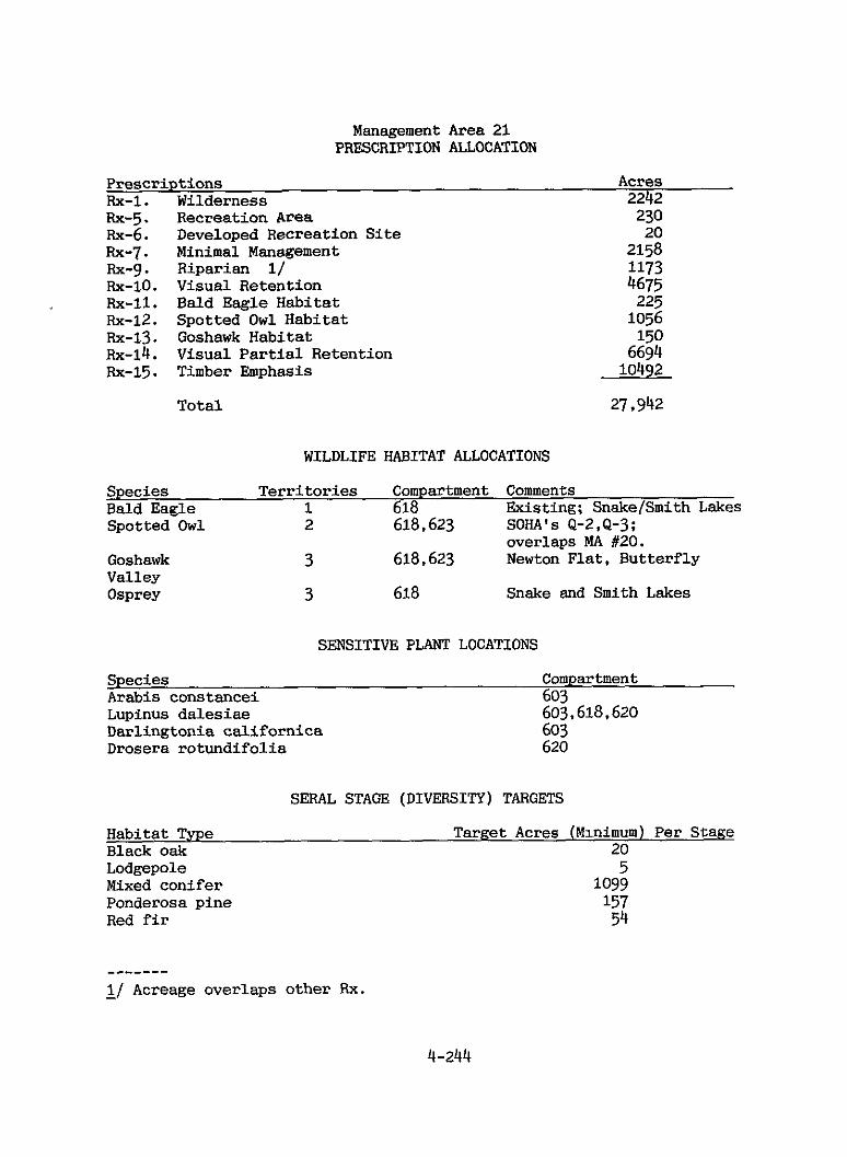
Management Area 21 PRESCRIPTION ALLOCATION
Rx-5. Rx-6. Rx-7. Rx-g . Rx-lo. Rx-11. Rx-12. Rx-13. Rx-14. Rx-15.
Prescriptions Acres Rx-1. Wilderness 2242
Recreation Area 230 Developed Recreation S i t e 20 Minimal Management 2158 Riparian 11 1173 Visual Retention 4675 Bald Eagle Habitat Spotted O w l Habitat Goshawk Habitat Visual P a r t i a l Retention Timber Emphasis
Total
225 1056 150 6694 10492
27.942
WILDLIFE HABITAT ALLOCATIONS
Species Te r r i t o r i e s Compartment Comments Bald Eagle 1 618 Existing; SnakefSmith Lakes Svotted O w l 2 618,623 SOHA'S Q-2,Q-3;
Goshawk Valley Osprey
overlaps MA #20. 3 618,623 Newton Fla t , But terf ly
3 618 Snake and Smith Lakes
SENSITIVE PLANT LOCATIONS
Species Compartment Arabis constancei 603 Lupinus dalesiae 603,618,620 Darlingtonia ca l i forn ica 603 Drosera rotundifol ia 620
SERAL STAGE (DIVERSITY) TARGETS
Habitat Type Target Acres (Minimum) Per Stage Black oak 20 Lodgepole Mixed conifer Ponderosa pine Red f i r
5 1099 157 54
------- - 1/ Acreage overlaps other Rx.
4-244

Management Area 21 PRESCRIPTION ALLOCATION
RANGE ALLOTMENT STRATEGIES
Allotment Name Grazing Strategy Butterfly Valley Eliminate
Figure 4-6
Butterfly Valley Botanical Area
T 25 N, R 9 E
4-245

~ ~~ ~
T 23 N, R 8 E
Management Area #22
Third Water
4-246
~~
MANAGEMENT AREA 22
Third Water
Distr ic t : Quincy
Description
Acreage: 32,318 To ta l 30,439 or 94% PNF
The Third Water Management Area is located south of Meadow Valley. extends from Bucks Summit easter ly t o near Claremont Peak and southerly from Meadow Valley to the r i m of the Middle Fork of the Feather River canyon.
Slopes are generally moderate with a few incised canyons. range from 3,460 feet at Spanish Creek t o 6,250 f e e t j u s t south of Bucks Summit. area. deep and productive. Middle Fork and northward v ia Rock Creek and others t o Spanish Creek, a North Fork tributary.
Vegetation is mostly mixed conifer with some red f ir at higher elevations. 1920's. although frequent f i r e s formerly burned up i n t o t h i s area from the Middle Fork. P a r t s of two spotted owl t e r r i t o r i e s are present. Approximately 2,700 acres at lower elevations are Sloat Deer Herd winter range, and the area contains summer range fo r the Bucks Mountain and Sloat herds.
Recreation is generally dispersed, although there is one small developed campground at Deanes Valley. Summer use is frequent, some winter use occurs. A small par t (127 acres) of the Middle Fork unroaded area is included.
Grazing was heavy over much of the area u n t i l the 1940's, but it has since declined t o one small family operation. The "Bear Creek" grazing allotment covers much of the area. Significant timber harvest began i n the 1940's. and the area is now one of the primary timber growing areas on t h i s d i s t r i c t .
Mining has occurred since the 1850's, and larger operations have been intermittent. Present dredger use is limited by the small s i z e of streams.
It
It is ent i re ly within Plumas County.
Elevations
A wide band of serpentine runs through the eastern half of the With t h i s exception, so i l s i n the area are generally moderately
Drainage is both southward v i a Bear Creek t o the
Only one major fire has occurred i n t h i s area since the
4-247

MANAGEMENT AREA 22 Third Water
GENERAL DIRECTION STANDARDS AND GUIDELINES
Recreation Provide developed recreation facil i t ies/programs to meet demand ( l a ) .
Provide for semi-primitive recreation (la).
Visual Resources Maintain pleasing visual corridors ( 2 4 .
Cultural Resources Protect and in t e rp re t h i s t o r i c a l properties
selected ( 3 4 .
Wildlife Protect and improve emphasis species hab i t a t (5a).
Timber Otain h g u l a t e d timber y ie lds through unevenage s i l v i c u l t u r a l systems (7a&b).
Water Improve water y ie ld i n the Red Fi r zone ( loa ) .
Maintain the Deanes Valley Cmpgrd: employ Fix-6.
Maintain the character of the Middle Fork semi-primitive area: employ Rx-8.
Apply Fix-10 and Rx-14 to the Bucks Lake Road and the B i g Creek Road viewsheds.
Maintain the B e a r Creek Guard Station i n a state of "arrested decay." Provide interpretation.
Maintain or enhance deer winter range for the Sloat herd.
Manage the Deans Timber Compart- ment using single-tree and group selection s i lv i cu l tu ra l methods.
See Forestwide Standards and Guidelines: Water, Water Need and Use.
4-248

Management Area 22 PRESCRIPTION ALLOCATION
Prescriptions Rx-6. Developed Recreation S i t e Rx-7. Minim2 Management Rx-8. Semi-primitive Area Rx-9. Riparian 1/ FIX-10. Visual Retention Rx-13. Goshawk Habitat Rx-14. Visual Pa r t i a l Retention Rx-15. Timber Emphasis
Total
Acres 7
1177 127 1280 5769 100
13007 10252
30.439
WILDLIFE HABITAT ALLOCATIONS
Species Ter r i to r ies Compartment Comments Goshawk 2 605,612 Spotted O w l 1 613 SOHA K-1; overlaps MA #25.
SENSITIVE PLANT LOCATIONS
Species Compartment Arabis constancei 602,619 Penstemon personatus 605,619 Vaccinium Coccinium 605
SERAL STAGE (DIVERSITY) TARGETS
Habitat Type Target Acres (Minimum) Per Stage Black oak 5 Mixed conifer Ponderosa pine Red f i r
1327 139 44
RANGE ALLOTMENT STRATEGIES
Allotment Name Grazing S t r a t e a Bear Creek C
------- - 11 Acreage overlaps other Rx.
4-249

IIII 0 1 2 3
MANAGEMENT AREA 23
Grizzly Ridge
Dis t r ic t : Quincy
Description
Acreage: 58,312 Total 34,386 or 59% PNF
The Grizzly Ridge Management Area extends northeast of Quincy and Highway 70 t o Grizzly Ridge from Indian Creek t o Lee Summit. Plumas County, and includes the town of Quincy. Prominent fea- tures are Argentine Rock and Taylor Rock.
Terrain is moderately sloping from Grizzly Ridge t o the val ley of Estray, Greenhorn, and Spanish Creeks - a l l t r ibu tary t o the North Fork of the Feather River. Midslope s o i l s are very deeply weathered, moderately erodible, and eas i ly rutted. The Cash" area has act ive i n s t a b i l i t y features, but otherwise the r i s k of i n s t a b i l i t y is low t o moderate. Isolated slumps do occur. Rock t o 2,880 feet at the Greenville "Y".
Vegetation is predominately mixed conifer, but red f i r is common above 6,000 feet. the southerly aspect. Hough. aspect (facing the sun and the prevail ing wind), the continuous slope, substant ia l fue ls , and proximity t o igni t ion sources.
Because of the proximity t o American Valley, Maidu Indian and e a r l y settler cu l tura l sites are numerous.
Recreation is dispersed and occurs i n both summer and winter. semi-developed site is present at Brady's Camp.
A portion of the "Grizzly Mountain" grazing allotment i s i n t h i s area. Throughout t h i s century the area has been a major timber producer. productivity i s moderate.
I n the northwest edge of the area, adjacent t o Highway 89 and Indian Creek, i s Soda Rock, a unique and continually-forming deposit of multi-colored t raver t ine. Mineral springs, s t a l a c t i t e s , sinkholes, and terraced traver- t i n e pools are of geologic in t e re s t and have been a focus of Maidu Indian mythology. decorative building stone.
Evidence of earlier mining is found throughout the area.
It is en t i r e ly within
Elevations range from 7.340 feet near Taylor
The area i s key winter range for the Sloat Deer Herd due t o A S t a t e G a m e Refuge e x i s t s i n the v i c in i ty of M t .
The area has had several major fires because of the southwestern
One
Soil
A portion of the deposit i s being commercially mined f o r
4-251

Mt. Hough is an important electronic communications and fire lookout site. The main peak is used for service band radio systems. miles west is used for high-powered commercial boradcasting. Pacific Railroad as well as State Highways 70 and 89 traverse the southwestern boundary of the area.
Another site 1 3/4 The Union
4-252

MANAGEMENT AREA 23 Grizzly Ridge
GENERAL DIRECTION STANDARDS AND GUIDELINES
Recreation Provide developed recreation facilities/programs t o meet demand ( la ) .
( l a ) . Provide f o r dispersed recreation
Visual Resources Maintain pleasing visual corridors ( 2 4 .
Maintain high visual quali ty i n SIA's (2a).
Cultural Resources Protect and in te rpre t selected h i s to r i ca l and National Register properties (3a) .
Wildlife Maintain species v i ab i l i t y (5a).
Timber Protect unique scenic and cul tural values (7a.20b).
Maintain the Brady's Cmpgrd; employ Rx-6.
Protect and enhance hiking and cross-country skiing on the top of Grizzly Ridge.
Apply Rx-10 and Rx-14 t o the Hwy. Hwy 70, Hwy 89, Chandler Rd., and Quincy viewsheds.
Apply Rx-10 t o the Soda Rock Geological Area. Maintain the visual screen around the quarry and revegetate disturbed areas.
Protect and enhance the Maidu dance house complex a t Quincy junction.
Maintain the Walker Tramway documentary site.
Develop interpretat ion of Maidu mythology at Soda Rock.
Protect use of Soda Rock mineral pools by bandtailed pigeons.
Maintain o r enhance winter range f o r the Sloat deer herd: coordinate with fuel treatments.
Remove only hazardous trees a t the Soda Rock Geologic SIA.
4-253

MANAGEMENT AREA 23 Grizzly Ridge
GENERAL DIRECTION STANDARDS AND GUIDELINES
Water Rehabi l i ta te selected deter iorat ing S tab i l ize the primary sediment watersheds t o improve water qual i ty sources within the Greenhorn (lob). Creek watershed i n cooperation
with Calif. DFG, CALTRANS, Union Pacific, and other land owners.
Within the Soda Rock SIA, prevent erosion tha t endangers water qual i ty and the Indian Creek fishery. Establish ground cover on disturbed areas and unstable fill slopes t o prevent erosion and s l iding. Prevent the dumping of mine wastes onto the floodplain of Indian Creek.
Protect Indian Creek water qual i ty (loa) .
Improve water y i e ld i n the Red F i r See Forestwide Standards and zone (loa). Guidelines: WATER, Water Uses
and Needs.
Minerals and Materials Protect unique geologic, scenic, Recommend withdrawal from mineral and c u l t u r a l values (l3a). entry: Soda Rock Geologxal Area.
Manage as follows:
Administer quarry operations i n accordance with the approved Plan of Operations consistent with the October 1981 Decision Notice (as modified). Authorize extraction of t raver t ine within established l i m i t s .
Require another Plan of Operations f o r any mining of gravel deposits, consistent with the intent of protecting the geologic and cu l tura l features.
Ensure t h a t mined areas are back- f i l l e d su f f i c i en t t o eliminate hazardous cutslopes.
4-254

MANAGEMENT AREA 23 Grizzly Ridge
GENERAL DIRECTION STANDARDS AND GUIDELINES
Provide f o r recreational gold panning and dredging (l3a).
Lands Consolidate ownership and dispose of designated lands for community expansion (16a).
Allow agency and commercial use of PNF lands where use of other lands is infeas ib le and the public i n t e re s t is served (16b).
F a c i l i t i e s Provide cost-eff ic ient support .. f a c i l i t i e s (l7a).
Special Areas Protect unique geologic, scenic, and cu l tura l values (20b).
Recommend withdrawal from mineral entry: Spanish Creek below Oakland Camp.
Consider making NF lands i n T24. Rg. sec. 1,2; "24, Rl0,sec 6,8,9, 15.16,17,22; T25, R9 , sec. 36; avai lable f o r exchange.
Manage M t . Hough as a service radio electronic site and w e s t M t . Hough as a commercial broadcast e lectronic s i t e .
Remove Argentine Lookout.
Upgrade the S.O. water system, resurface compound parking l o t , and reconstruct f a c i l i t i e s as required i n the Master Plan.
Classify the 30 acre Soda Rock Area as a Geological Area (formal Special In te res t Area s t a t u s ) . Seek designation as a National Natural Landmark. Once mining is completed, construct trails and in te rpre t ive s igns f o r public use.
4-255

Management Area 23 PRESCRIPTION ALLOCATION
Prescr ipt ions Rx-6. Developed Recreation S i t e Rx-7. Minimal Management Rx-9. Riparian 1/ Rx-10. Visual Retention Rx-12. Spotted O w l Habitat Rx-13. Goshawk Habitat Rx-14. Visual P a r t i a l Retention Rx-15. Timber Emphasis
Tot a1
Acres 38
WILDLIFE HABITAT ALLOCATIONS
Species Ter r i to r ies Compartment Comments Spotted O w l 1 601 SOHA J-1: D r y Taylor Creek Goshawk 4 601,604,606,
61 1 Golden Eagle 1 601
SENSITIVE PLANT LOCATIONS
Species Compartment Arabis constancei 601 Lupinus dalesiae Penstemon personatus I v e s i a webberi
601,604,611 606 601
SERAL STAGE (DIVERSITY) TARGETS
Habitat Type Target Acres (Minimum) Per Stage Black oak 277 Lodgepole Mixed conifer Ponderosa pine Red f ir
11 1229 101 95
RANGE ALLOTMENT STRATEGIES
Allotment Name Grazing Strategy Grizzly Mountain B
- - - - - - - - 1/ Acreage overlaps other Rx.
4-256

Figure 4-7
Soda Rock Geologic Area
T 2 5 N , R 9 E

~~ ~- ~~
T 24 N, R 10 E
Management Area #24
Volcano
4-258 ~
MANAGEMENT AREA 24
Volcano District: Quincy Acreage: 20,507 Total
16,169 or 79% PNF
Description
The Volcano Management area lies south of Quincy and Highway 70 to the Middle Fork of the Feather River between Claremont Peak and Lee Summit. It is entirely within Plumas County. Prominent features are Claremont and East Claremont Peaks, Cutler Meadow, and the Middle Fork, a Federally-designated Wild and Scenic River.
Terrain is quite variable. Soils are shallow, unproductive, and highly erodible on southern exposures and moderately to well developed, productive, and moderately erodible on north aspects. The south half drains into the Middle Fork, and the north half is in the Mill and Greenhorn Creek watersheds, tributaries of the North Fork of the Feather River.
Vegetation is mainly mixed conifer, with a small amount of red fir on Claremont. There have been no major fires in recent years, but, historically, fires burned into this area from the Middle Fork. area contains part of three spotted owl territories and habitat for the Sloat deer herd.
Recreation is dispersed and there are no developed sites. This reach of the Middle Fork of the Feather River is managed as a "scenic" zone. A portion of the Middle Fork unroaded area is present.
Cutler Meadow was once grazed by sheep, but no grazing has taken place since 1963. Feather River Experimental Forest (since discontinued), and the area continues to be an important timber producer. and productive, except on the steeper slopes.
Intermittent mining has occurred since the 1850's. Currently, it consists of dredging on the Middle Fork, especially in the vicinities of Fells Flat and the Quincy-La Porte Road crossing.
Elevations range from 3.440 feet to 6,952 feet.
The
Approximately 5,000 acres are winter range.
Major timber harvesting began during the 1930's on the
Soils are moderately deep
4-259

MANAGEMENT AREA 24 Volcano
GENERAL DIRECTION STANDARDS AND GUIDELINES
Recreation Enhance recreation use and protect the Middle Fork of the Feather River ( la) .
Provide f o r semi-primitive recreat ion ( la ) ,
Visual Resources Maintain pleasing visual corridors
Wildlife Protect and improve emphasis species hab i t a t (5a).
Range_ Suspend grazing on areas valued fo r o ther purposes (6a).
Water Rehabi l i ta te selected watersheds t o improve ( lob) .
deter iorat ing water quali ty
Minerals and Materials Protect unique geologic and scenic - values ( 13a j . .
Manage the Scenic and Wild Zones consistent with the Wild and Scenic Rivers A c t : employ Rx-2. Construct the following by the year 2000 :
Fe l l s F l a t Family Cmpgrd. Quincy-La Porte Road Access Point
Maintain the character of the Middle Fork semi-primitive area: employ Rx-8.
Apply Rx-10 and Rx-14 t o the Quincy-La Porte Rd and the MFFR viewsheds.
Maintain or enhance deer winter range f o r the Mooretown and Sloat herds.
Eliminate English Bar Allotment due t o the changing of Forest Service ownership as a r e su l t of land exchanges.
S t ab i l i ze the primary sediment sources within the Greenhorn Creek watershed i n cooperation with C a l i f . DFG, CALTRANS, Union Pacific, and other land owners.
Recommend withdrawal from mineral entry: the L i t t l e Volcano Area.
4-260

MANAGEMENT AREA 24 Volcano
GENERAL DIRECTION STANDARDS AND GUIDELINES
Lands Allow commercial and agency use of PNF lands if public interest is served (16b) . as a commercial broadcast
Manage Claremont Peak as a service radio electronic site and Massack
electronic site.
4-261

Management Area 24 PRESCRIPTION ALLOCATION
Prescriptions Acres Rx-2. Wild and Scenic River 1308 Rx-6. Developed Recreation S i t e 11 Rx-7. Minimal Management 854 &-8. Semi-primitive Area 373 Rx-9. Riparian 1/ 644 Rx-10. Visual Retention 3752 Rx-12. Spotted O w l HabitaC 3400 Rx-13. Goshawk Habitat 150 Rx-14. Visual P a r t i a l Retention 1545 Rx-15. Timber Emphasis 4776
Tot a1 16,169
WILDLIFE HABITAT ALLOCATIONS
Species Ter r i to r ies Compartment Comments Spotted Owl 4 607,608,617 SOHA'S G - 1 ,G-Z,G-3,U-l ;
overlaps MA's #14,22,25,33 Goshawk 3 607,608,617
SENSITIVE PLANT LOCATIONS
Species Compartment Arabis constancei 607 Lupinus da les iae 607,608
SERAL STAGE (DIVERSITY) TARGETS
Habitat Type Target Acres (Minimum) Per Stage Black oak 22 Mixed conifer 739 Ponderosa pine 20 Red f i r 29
RANGE ALLOTMENT STRATEGIES
Allotment Name Grazing S t r a t e m English B a r Eliminate
- 1/ Acreage overlaps other Rx.
4-262

4-263
T 2 4 N R Q E
Management Area #25
Bear
~ 4-264 ~~ ~~~~~ ~~~~~
~~
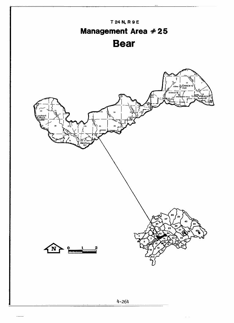
MANAGEMENT AREA 25
Bear
Dis t r ic t : Quincy Acreage: 13,632 Total 13,091 or 96% PNF
Description
The Bear Management Area lies i n the Bear Creek and Middle Fork of the Feather River canyons between Lookout Rock and L i t t l e Volcano. en t i r e ly within Plumas County. sect ion of the Middle Fork, a Federally-designated Wild and Scenic River.
Slopes are generally steep with shallow, rocky, and unproductive so i l s . Elevations range from 2.790 feet i n the Middle Fork Canyon t o 6,994 on top of Claremont Peak. a high r i s k of debris s l iding.
The area is covered with brush, non-commercial hardwoods, and some mixed-conifer stands. During the last century and ea r ly i n the 1900's f i r e s were common, but there have been no major fires recently. The area contains par t of two spotted owl t e r r i t o r i e s and, a t the lower elevations, is winter range f o r the Mooretown Deer Herd.
Recreation is dispersed, including hiking, f ishing, camping and gold panning. Middle Fork Canyon t o the r iver . Fork unroaded area.
A portion of the "Bear Creek" cattle allotment is included. Timber harvesting has been l imited t o the extreme upper slopes except f o r some recent salvage ac t iv i ty v i a helicopter.
Placer and lode mining has been intermit tent since the 1850's. 4wD roads provide access t o a f e w i so la ted mining sites i n the bottom of the canyon.
It is The southern boundary is the Wild
Soi l s a r e highly erodible, and steep slopes have
The Pacif ic Crest T r a i l and others extend from the top of the Most of the area is within the Middle
Three
4-265
MANAGEMENT AREA 25 Bear
GENERAL DIRECTION STANDARDS AND GUIDELINES
Recreation Enhance recrea t ion use and pro tec t Manage the Wild Zone consistent the Middle Fork of the Feather River ( la ) . Rx-2. I n s t a l l t o i l e t s at
Wild-and Scenic River Act: employ
Butte Bar.
Prohibit motorized use except on the Deadman Springs and L o s t Cabin Springs 4WD roads. Provide for 4WD parking at the junction of t h e Deadman Springs 4WD road and the PCT.
Provide f o r dispersed recreat ion Encourage PCT use. Warn users of ( l a ) . the loca l fores t f ire hazard.
Discourage camping between Bear Creek and Lookout Rock: publicize concentration of ratt lesnakes.
Provide f o r semi-primitive experiences ( l a ) .
Maintain the character of the Middle Fork semi-primitive area: employ Rx-8.
Visual Resources Maintain pleasing v isua l corr idors ( 2 4 . MFFR viewshed.
Apply Rx-10 and Rx-14 t o the
Wildlife Protect and improve emphasis Maintain or enhance deer winter species h a b i t a t (5a). range f o r the Mooretown herd.
Maintain habi ta t a t L i t t l e Volcano for the Juniper Cave Snail .
Minerals and Materials Protect unique geologic and scenic values ( l3a). entry: L i t t l e Volcano area.
Recommend withdrawal from mineral
Special Areas Protect unique geologic and scenic values (18b). L i t t l e Volcano and its caverns:
Preserve the unique character of
employ Rx-7. Preserve and in te rpre t the unique view of the
4-266

MANAGEMENT AREA 25 Bear
GENERAL DIRECTION STANDARDS AND GUIDELINES
MFF'R Wild and Scenic River. Improve the access. Provide informational signs. Protect the caverns from vandalism.

Management Area 25 PRESCRIPTION ALLOCATION
Prescriptions Acres Rx-2. Wild and Scenic River 2251 Rx-7. Minimal Management 124 Rx-8. Semi-primitive Area 7133 Rx-9. Riparian I/ 677 Rx-10. Visual Retention 192 Rx-12. Spotted Owl Habitat , 64
t Rx-14. Visual Partial Retention 1262 Fix-15. Timber Emphasis 2065
Total 13,091
WILDLIFE HABITAT ALLOCATIONS
Species Te r r i t o r i e s Compartment Comments Spotted Owl 1 621 SOHA'S G - 3 and K-1;
overlaps MA's #14 and 24
SENSITIVE PLANT LOCATIONS
Species Compartment Penstemon personatus 621 Lupinus dalesiae 621
SERAL STAGE (DIVERSITY) TARGETS
Habitat Type Target Acres (Minimum) Per Stage Black oak 131 Mixed conifer 521
RANGE ALLOTMENT STRATEGIES
Allotment N a m e Grazing Strategy Bear Creek C
- - - - - - - - 1/ Acreage overlaps other Rx.
4-268

Greenville Ranger District
Management Area
26. Butt Lake
27. Indian Valley
28. Lights Creek
29. Antelope
30. Ward
4-271
4-275
4-281
4-285
4-295
4-269
T 2 6 N , R 8 E
Management Area #26
Butt Lake

MANAGEMENT AREA 26
Butt Lake
District: Greenville Acreage: 42,590 Total 34.267 or 80% PNF
Description
The Butt Lake Management Area extends south from the Lake Almanor D a m t o the North Fork of the Feather River and upper Rush Creek. Most of the area is i n Plumas County, and 128 acres are i n Lassen County. The major feature of the area is Butt Valley Reservoir.
Terrain is rugged and rocky with steep canyons. 4,100 f e e t t o 6.100 feet. The area is bisected and drained by the North Fork of the Feather River and Rush Creek (a t r ibu tary of the E a s t Branch of the North Fork) and the i r t r ibutar ies . So i l s are generally moderately erodible. Risk of landslide is moderate overal l , but high t o extreme i n s teep canyons.
Vegetation consists primarily of mixed conifers. average of 45 f i r e s per decade averaging s l igh t ly over f i v e acres each. The Butt Lake area is habitat for several pa i r s of bald eagles, and s i x osprey territories and three spotted o w l t e r r i t o r i e s are present. An additional bald eagle te r r i to ry and another osprey t e r r i t o r y are elsewhere i n the area. Deer from the East Tehama and Bucks Mountain deer herds summer i n the area.
Butt Lake Recreation Area has substantial recreation use. PG&E operates several campgrounds a t the Lake, but no PNF facilities are i n the area.
Portions of the "Mosquito Creek" and "Round Valley" grazing allotments are i n the area. Timber harvesting is a continuing use.
Mining has occurred i n the Seneca area since the ear ly 1900's. and numerous mines continue t o operate. More may be developed.
A l l waters flowing from and through the area are used t o generate power.
Elevations range from
The mea has an
4-271

MANAGEMENT AREA 26 Butt Lake
GENERAL DIRECTION STANDARDS AND GUIDELINES
Recreation Provide developed day-use recreation facilities t o meet demand ( la ) .
Provide developed recreation faci l i t ies /programs t o meet demand ( la) .
Expand the t ra i l system t o meet demand ( la ) .
Visual Resources Maintain pleasing visual corr idors ( 2 4 .
Cultural Resources Protect and i n t e r p r e t selected h i s to r i ca l sites (3a).
Wildlife Protect and improve emphasis species hab i t a t (5a).
Range Suspend grazing i n areas valued f o r other purposes.
Water Protect and, where necessary, improve water qua l i t y ( loa) .
Minerals and Materials Provide for recreat ion gold panning - - and dredging (l3a).
Prohibit camping a t the Canyon Dam boat launch. Develop camping on the opposite s ide of Hwy 89.
Maintain the Butt Lake Recreation area; employ Rx-5.
Provide a f ishing access t r a i l be- tween Lake Almanor dam and Seneca.
Apply Rx-10 and Rx-14 t o the Cari- bou Road, Hwys. 89 and 147, Lake Almanor and Butt Lake viewsheds.
Protect and provide interpretat ion of the Swiss Mine and complex, and the Butt Valley Cemetary.
Improve Rush Creek fishery i n cooperation with Calif DFG.
Improve waterfowl nesting habi ta t i n Long Valley.
Introduce peregrine falcons i n t o su i tab le habi ta t .
Eliminate Mosquito Creek Allotment due t o changes i n vegetation types.
Rehabili tate Rush Creek i n coopera- t ion with C a l i f . DFG and Plumas Co.
Recommend withdrawal for mineral entry: the North Fork of the Feather River below Caribou.
4-272

Management Area 26 PRESCRIPTION ALLOCATION
Prescriptions Acres Rx-5. Recreation Area 1940 Rx-7. Minimal Management Rx-9. Riparian 1/ Rx-10. Visual Retention Rx-11. Bald Eagle Habitat Rx-12. Spotted Owl Habitat Rx-14. Visual P a r t i a l Retention Rx-15. Timber Emphasis
Total
1711 1211 6121 5331 7788 8136 3240 34267
WILDLIFE HABITAT ALLOCATIONS
Species Ter r i to r ies Compartment Comments Bald Eagle 4 227,228 Existing Bald Eagle 2 227,228 Potent ia l ; Butt Lake, Lake Almanor Spotted Owl 4 224,226,227 SOHA'S R-Z,X-l,X-Z,X-3;
228 overlaps MA #27 Osprey 6 227 Butt Lake Osprey 2 228 Seneca, Canyon Dam
SENSITIVE PLANT LOCATIONS
Species Compartment Penstemon personatus 225 Lupinus dalesiae 224, 227 Sedum albomarginatum 224 Cypripedium californicum 225 Cypripedium fasciculatum 225,226,228
SERAL STAGE (DIVERSITY) TARGETS
Habitat Type Target Acres (Minimum) Per Stage Black oak 68 Mixed conifer 1617 Ponderosa pine 21 Lodgepole 4
RANGE ALLOTMENT STRATEGIES
Allotment Name Grazing Stratepy Mosquito Creek Eliminate Round Valley B
- 1/ Acreage overlaps other Rx.
4-273

T 2 6 N, R Q E
Management Area #27
Indian Valley

MANAGEMENT AREA 27
Indian Valley
District: Greenville
Description
Acreage : 52,820 Total 30,992 or 59% PNF
The Indian Valley Management Area extends north from Mt. Hough to the Forest boundary. The Indian Valley floor, outside the Forest boundary, is predominantly in private ownership and includes large ranches and the communities of Greenville, Crescent Mills, and Taylorsville. The northwest corner of the area reaches Canyondam at Lake Almanor. Most of the area is in Plumas County, but 325 acres are in Lassen County. Prominent features include Keddie Peak and Dyer Mountain on the north. Keddie Point on the east, Mount Hough on the south, Rattlesnake Hill in the west, and Indian Creek, Wolf Creek, and Round Valley Reservoir.
Terrain ranges from the flat alluvial valley floor to increasingly steep surrounding slopes. Elevations range from 3,000 feet at the confluence of Indian and Spanish Creeks to 7,500 feet at Keddie Peak. The area is drained by Indian Creek and Wolf Creek, a tributary to Indian Creek, which are tributary to the East Branch of the North Fork of the Feather River. Soils are moderately erodible. Risk of instability is generally low. except for debris slides and avalanche chutes below Mt. Hough.
Forests are mixed conifer, but red and white fir predominate on Keddie Ridge and Mount Hough. stands of white fir and Douglas fir with scattered sugar pine. Historically, relatively little acreage has burned in this area, yet the 1979 Will Fire burned 3100 acres on Keddie Ridge, and the 1980 Point Fire burned 400 acres in the southwestern corner. Blacktail deer of the Sloat herd use the lower elevations for winter range. eagle management zone and spotted owl territories are included.
Recreation facilities include a Plumas County campground on PNF land near Greenville and a private campground and PNF day-use area at Round Valley Reservoir. unroaded areas are present.
A portion of the "Round Valley" grazing allotment lies within the area. Timber production colitinues to be important here.
Some lode mining has occurred, and there is a proposal to develop a large mining operation.
The area is traversed by both State Route 89 and the Union Pacific Railroad, and paved county roads circle and cross the valley floor. Round Valley Reservoir supplies water to the Greenville water system.
The north slope of Mount Hough has extensive
A part of a bald
Portions of the Grizzly Peak and Keddie Ridge
MANAGEMENT AREA 27 Indian Valley
GENERAL DIRECTION STANDARDS AND GUIDELINES
Recreation Provide developed recreation faci l i t ies /programs t o meet demand ( la ) .
Provide f o r semi-primitive experiences ( l a ) .
Visual Resources Maintain pleasing v isua l corridors
Cultural Resources Protect cu l tura l / re l ig ious sites ( 3 4 .
Wildlife Protect and improve emphasis species hab i t a t (5a).
f(ange Suspend grazing on for other purposes
Maintain the Round Valley Picnic area; employ Rx-6.
Maintain the character of the Griz- z ly Peak and Keddie Ridge semi- primitive areas: employ Rx-8.
Apply Rx-10 and Rx-14 to Hwy. 89, and the Lake Antelope viewsheds.
Develop a management plan for s ig- n i f i can t cul tural / re l igious sites i n Indian Valley, and along Indian Creek. In te rpre t as appropriate.
Maintain or enhance deer winter range fo r the Sloat herd.
Improve waterfowl nesting habi ta t a t Round Valley Reservoir and Long Valley.
Maintain or enhance Bald Eagle habi ta t s u i t a b i l i t y i n the Canyon- dam portion of TC #232.
lands valued ( 6 4 . due t o subdivisioA encroachment
Eliminate Round Valley Allotment
and loss of forage base.
Timber Obtain regulated timber yields through unevenage s i l v i c u l t u r a l systems (7a&b). group se lec t ion s i lv icu l tura l
Manage the Indian Fal ls Timber Com- partment using single-tree and
methods.
4-276

MANAGEMENT AREA 27 Indian Valley
GENERAL DIRECTION STANDARDS AND GUIDELINES
Water Protect and, where necessary. improve water qual i ty (loa)-.
Minerals and Materials Provide fo r recreation gold panning and dredging (13a) and protect water qua l i ty (loa).
Lands Consolidate ownershin and disDose of designated l k d s j16a) .
Acquire threatened or endangered species habi ta t (16a).
Adjust right-of-way t o protect threatened or endangered species habi ta t (16a).
F a c i l i t i e s Provide cost-eff ic ient suuuort -. f a c i l i t i e s (l7a).
Special Areas Protect unique scenic values (20b).
Cooperate with S ta t e and County agencies, pr ivate par t ies and companies t o s t a b i l i z e and rehabi l i ta te Wolf Creek and its t r ibu tar ies .
Recommend withdrawal from mineral entry: Wolf Creek upstream from Greenville, 1/4 m i l e width.
Consider making lands i n T27, R8. sec. 14,15,22: T27, R9 , sec. 21, 26, 29, 34, 35: and T27, Rl0,sec. 32. 36 available fo r exchange.
Attempt t o acquire pr ivate lands adjacent t o the Bald Eagle Terri tory on the south s ide of Round Valley Reservoir.
Renegotiate the road right-of-way i n T26, R9, sec. 16 and 22 t o facilitate bald eagle protection.
Prepare a plan for use and maintenance of f a c i l i t i e s t o be retained a t the Canyondam Work Center and the Greenville Work Center.
Preserve and enhance the scenic values of the Crystal Lake - M t . Hough area: employ Rx-7. Provide minimal access and f a c i l i t i e s . Allow low impact timber harvest ac t iv i t i e s . L i m i t road access t o the saddle above the lake.
Management Area 27 PRESCRIPTION ALLOCATION
Prescriptions Acres Rx-5. Recreation Area 1229 Rx-6. Rx-7. Rx-8. Rx-9. Rx-lo. Rx-11. 'Rx-12. ~x-13. Rx-14. Rx-15.
Developed Recreation Site Minimal Management Semi-primitive Area Riparian 1/ Visual Retention Bald Eagle Habitat Spotted Owl Habitat Goshawk Habitat Visual Partial Retention Timber Emphasis
42 2347 125 1135 5525 400 2294 100
12959 5971
Tot a1 30992
WILDLIFE HABITAT ALLOCATIONS
Species Territories Compartment Comments Bald Eagle 1 229 Existing Goshawk 2 223.229 Curtis Ravine, Round Val ley Golden Eagle 2 223,230 Osprey 6 229.232 Spotted Owl 3 223,230,232 SOHA'S Q-1 ,R-2,R-3
SENSITIVE PLANT LOCATIONS
Species Compartment Arabis constancei 229 Lupinus dalesiae 223 Ivesia webberi 233 Astragalus webberi 222 I 233
-- - - - - - - 1/ Acreage overlaps other Rx.

Management Area 27 (cont’d) PRESCRIPTION ALLOCATION
SERAL STAGE (DIVERSITY) TARGETS
Habitat Type Target Acres (Minimum) Per Stage Black oak 64 Mixed conifer 1425 Ponderosa pine 26 Red fir 7 Big sagebrush 7
RANGE ALLOTMENT STRATEGIES
Allotment Name Grazing Strategy Round Valley Eliminate
4-279

Management Area #28
Lights Creek
0 1 2 3 4 & II1LI
4-280

MANAGEMENT AREA 28
Lights Creek
Dis t r i c t : Greenville
Description
The Lights Creek Management *ea is locate '
Acreage: 60,055 Total 49,396 or 72% PNF
northeast of Indian Valley. It extends from Indian Creek i n Genesee Valley near M t . Jura northward, between Keddie Point and Kettle Rock, t o the Forest boundary. Most i s i n Plumas County, but 1,336 acres are i n Lassen County. North A r m of Indian Valley and along Upper Lights Creek are privately-owned. Kettle Rock is the prominent feature of the area.
Lands i n the
Terrain ranges from f l a t a l luv ia l Indian Valley t o extremely s teep slopes. majority of the area lies within the Lights Creek Drainage, a t r ibutary of Indian Creek. Soi l e rodib i l i ty i s medium t o high. Mass i n s t a b i l i t y features are prevalent i n the young volcanics of the Moonlight and Lights Creek drainages, but r i s k is generally low t o moderate.
Forests are mixed conifer, grading t o white and red fir at higher elevations. 350 acres per decade since 1940. No known threatened or endangered p lan t or animal species a re present, but p a r t s of three spotted owl territories are included. The area provides cri t ical winter range f o r the Indian Valley Unit of the Sloat deer herd.
Dispersed hunting and fishing occurs throughout the area.
The "Lights Creek" and portions of the "Lone Rock" and "Taylor Lake" grazing allotments l i e within the area. The area has been and is an important timber producer: the northern portion is very productive timberland.
The area has been mined for both copper and gold. The Engel Mine was a large copper producer, and large deposits a r e known t o still be present.
Native American religious sites are present.
Elevations range from about 3,500 feet t o over 7,800 feet. The
The area has experienced an average of 80 wildf i res burning Lightning is the major cause.
Extraction by both open p i t and shaf t is a future poss ib i l i ty .
'
4-281

MANAGEMENT AREA 28 Lights Creek
GENERAL DIRECTION STANDARDS AND GUIDELINES
Recreation Use ouuortunities f o r remote develbped recreation ( la) .
Cultural Resources Protect and enhance selected re l ig ious areas (2a) .
Wildlife Protect and improve emuhasis species habi ta t (5a). -
Water Improve water y ie ld i n the Red Fir zone (loa).
Protect and, where necessary, improve water qua l i ty ( loa).
Lands Consolidate ownership and dispose of designated lands (16a).
F a c i l i t i e s Provide cost-eff ic ient support facilities (17a).
Special Areas Protect unique scenic and geologic values (20b).
Through a permit system o r by pr iva te concessionaire, use the Red Rock Lookout for public recreational accommodation.
Protect and provide interpre- t a t ion of known Native American re l ig ious sites.
Maintain o r enhance deer winter range for the Sloat herd.
See Forestwide Standards and Guidelines; WATER, Water Use and Need.
Cooperate with S ta te and County agencies, private par t ies , and companies t o s t ab i l i ze and r ehab i l i t a t e the Morton Creek and the West Branch of Lights Creek watersheds.
Consider making lands i n T27, R10, sec. 2, 3, 4, 9, 10, 11, 14, 15; TZ7, R11, sec.2; T28, R10, sec. 24,
avai lable for exchange. 25, 33, 35; T28, R11. set. 28. 35
Develop and implement a master plan fo r the Red Rock Lookout.
Maintain the scenic and geologic values of the Kettle Rock - Taylor Lake area. Attempt t o acquire pr iva te lands.

Management Area 28 PRESCRIPTION ALLOCATION
Prescriptions Acres Rx-7. Minimal Management 4276
Rx-9. Riparian I/ 1715
Rx-12. Spotted Owl Habitat 4400
Rx-14. Visual Partial Retention 6269
Total 49.396
~ x - 8 . Semi-primitive Area 474 Rx-lo. Visual Retention 3538 ~x-13. Goshawk Habitat 100
Rx-15. Timber Emphasis -3!XEL
WILDLIFE HABITAT ALLOCATIONS
Species Territories Compartment Comments Spotted O w l 4 201,204, SOHA'S R-3,S-l,S-2,S-3;
210,212,213 overlaps MA #27 Goshawk 2 210,212 Golden Eagle 1 215 Peters Creek Drainage Prairie Falcon 1 201 Red Rock
SERAL STAGE (DIVERSITY) TARGETS
Habitat T.me Target Acres (Minimum) Per Stage Black oak 153 Mixed conifer 2144 Ponderosa pine 37 Perennial range 5 Red fir 89
RANGE ALLOTMENT STRATEGIES
Allotment Name Grazing Stratem Lights Creek B Taylor Lake B Lone Rock C
- - - - - - - - 1/ Acreage overlaps other Rx.
4-283
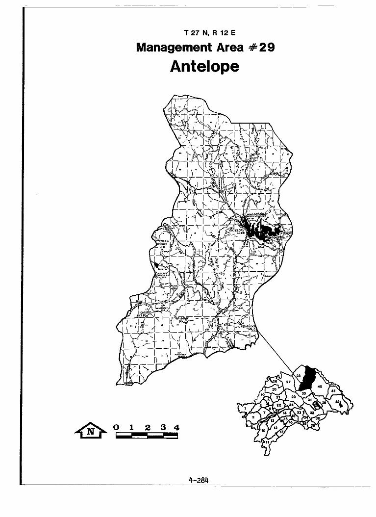
T 27 N, R 12 E
Management Area #29
Antelope
0 1 2 3 4 &-
MANAGEMENT AREA 29
Antelope
District: Greenville
Description
Acreage: 80,771 Total 73,645 or 91% PNF
The Antelope Management Area extends from Babcock Peak and Genesee Valley north to the Forest boundary between Red Rock and Thompson Peak. Most is in Plumas County, but 417 acres are in Lassen County. features are Antelope Lake, Taylor Lake, Red Rock, the Diamond Mountains, Thompson Peak, Eisenheimer Peak, Kettle Rock, Wheeler Peak, Lone Rock Valley, Franks Valley, Babcock Peak, and Wildcat Ridge.
Terrain is gentle to moderately steep. near Genesee Valley to 7,795 feet at Thompson Peak. predominate and are highly erodible. moderate, except in areas of rock slides in the southwest portion and non-marine sediments in the northwest portion. The latter often cause sedimentation of the headwaters of Indian Creek. Some debris sliding occurs on the steep slopes of Kettle Rock. The area is drained by Indian Creek and its tributaries. flowing to the North Fork of the Feather River.
Forests are mixed conifers, with some stands of pure red and white fir around Red Rock and Kettle Rock, and include small areas of eastside pine in the northeastern portions. in the last three decades: the 2.250 acre "Big" burn of 1966 in the Wildcat Ridge area and 1,400 acres of the 6.000 acre "Elephant" fire of 1981 in the Babcock Peak area. of three spotted owl territories are in this area. Approximately 4,000 acres at lower elevations are winter range for the Sloat deer herd, and the area provides summer range for portions of the Sloat and Doyle herds.
Antelope Lake is a prime recreation area with ever increasing use from Susanville and Reno. of slightly over 1.000 persons, boat launches, picnic areas, historical and interpretive sites, and fishing access improvements. A store is operated by the private sector on PNF land under Special Use Permit. A part of the Thompson Peak unroaded area is in the northeast portion of the area.
All of the "Antelope Lake" and "Hungry Creek", and portions of the "Antelope Community", "Lone Rock", "Taylor Lake, " and "Jenkins" grazing allotments are included. Timber production continues.
Mining has occurred in the past but current activity is minimal.
Prominent
Elevations range from 3,690 feet Granitic soils
Risk of instability is low to
Two major forest fires occurred here
A bald eagle management area and parts
Existing sites include campgrounds with a capacity
4-285

MANAGEMENT AREA 29 Antelope
GENERAL DIRECTION STANDARDS AND GUIDELINES
Recreation Provide developed recreation facil i t ies/programs t o meet demand (14.
Reduce conf l ic t s between recrea- t i o n i s t s and prevent damaging use of the Antelope Lake Recreation Area ( la ) .
Encourage privately-operated public recreation ( la ) .
Maintain the Antelope Lake Rec- reation Area: employ Rx-5 and -6.
Expand the interpretive program a t the Antelope amphitheater.
Develop camping along Indian Creek between Genesee Valley and Antelope Reservoir.
Conduct a study of recreation area t o determine level and kind of recreational experience tha t should be provided t o t h i s complex.
Permit overnight beaching of boats only a t designated areas adjacent t o campgrounds at Antelope Reservoir.
Restrict wheeled vehicles t o ex is t - i ng roads and trails i n the Antel- ope Lake Recreation Area and the Diamond Mountain ORV Closure Areas as shown on the Off Road Vehicle Closure Plan for the Preferred Alternative map.
Perform a Future Use Determination fo r the Antelope Lake general s t o r e when the current Special Use Permit expires. Evaluate the f e a s i b i l i t y of similar operations a t other locations.
Ident i fy f a c i l i t i e s that may be operated more eff ic ient ly by the pr ivate sector: prepare Future Use determinations and contract accordingly.
4-286

MANAGEMFN AREA 29 Antelope
GENERAL DIRECTION STANDARDS AND GUIDELINES
Use opportunities fo r remote developed recreation (la).
Provide for semi-primitive recreation (la).
Provide for dispersed hunting (la).
Visual Resources Maintain pleasing visual corridors
Cultural Resources Protect significant properties (34.
Wildlife Protect and improve emphasis species habitat (5a).
Through a permit system or by private concession, use the Kettle Rock Lookout for public recreational accommodation.
In conjunction with the LNF, maintain the Thompson Peak semi- primitive area; employ Rx-8.
In cooperation with the Calif. DFG, establish a "Diamond Mountain Limited Vehicular Access Area" as shown on Figure 4-8. Annually designate at least 7000 acres of the area for roadless deer hunting.
Prohibit motorized vehicles in the designated acreage at times deter- mined in coordination with DFG.
Apply Rx-10 and Rx-14 to the Janesville-Antelope-Taylorsville Road and the Antelope Reservoir viewsheds.
Develop an interpretive plan for the pioneer cabin, historic groves, and cultural use around Antelope Lake.
Maintain o r enhance deer winter range for the Sloat herd.
Improve trout habitat in Indian Creek between Antelope Reservoir and Flournoy Bridge.

MANAGEMENT AREA 29 Antelope
GENERAL DIRECTION STANDARDS AND GUIDELINES
Range Suspend use on areas highly valued - . f o r other purposes (6a).
Water Improve water y ie ld i n the Red F i r zone (loa).
Pro tec t and, where necessary, improve water qual i ty ( loa ) .
F a c i l i t i e s Provide roads necessary t o meet developed recreation demand (l7a).
Provide cost-eff ic ient support facilities (lj'a).
I n cooperation with C a l i f . DFG, develop a f i sher ies management plan for Antelope Reservoir.
Improve waterfowl nesting habi ta t at Antelope Reservoir.
Maintain or enhance w e t meadow/ willow habi ta t capabili ty i n the beaver ponds adjacent t o L i t t l e Antelope Creek f o r Willow Flycatcher enhancement.
Exclude livestock from developed sites i n the Antelope Lake Recreation Area.
See Forestwide Standards and Guidelines: WATER, Water Use and Need.
Rehabili tate watersheds of the Middle Hungry, Indian, and Lone Rock Creeks.
Reconstruct and surface the North Antelope Drive.
Develop a master plan for the Boulder Creek Cmpgrd. and Admin. S i t e and Lone Rock Cmpgrd. Implement as needed t o support a c t i v i t i e s .
Maintain the Kettle Rock Lookout, or remove, as needed for purposes of Recreation above.
4-288

MANAGEMENT AREA 29 Antelope
GENERAL DIRECTION STANDARDS AND GUIDELINES
Minerals and Materials Provide fo r recreational gold panning and dredging (13a).
Lands Consolidate ownership and dispose of designated lands (16a).
Special Areas Protect unique scenic and geologic values (18b)
Protect unique botanic values (2Ob) .
Recommend withdrawal from mineral entry: Indian Creek downstream from Antelope Reservoir, and remainder of Antelope Lake Recreation Area not previously withdrawn.
Consider making lands i n T27. R 1 1 , sec. 12; T27. R12, sec. 6.7: T28, R12, sec. 31 available f o r exchange.
Maintain the scenic and geologic values of the Kettle Rock-Taylor Lake area. Attempt t o acquire pr ivate lands.
Protect and enhance thru prescribed f ire or other effect ive means the Modoc (Baker) cypress groves i n the Mud Lake and Wheeler Peak areas. Provide interpretat ion service f o r the public. Recommend the areas for possible RNA status: employ Rx-17.
Maintain some unique westside vegetation of the Diamond Mtn. area.
4-289
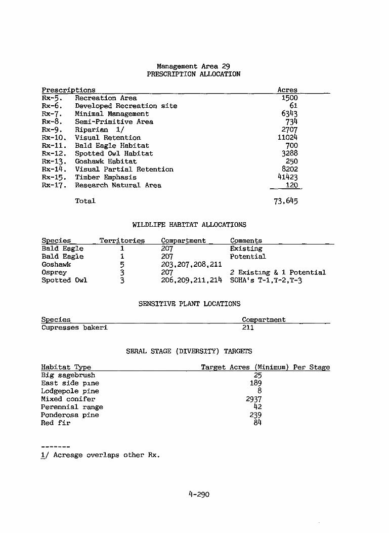
Management Area 29 PRESCRIPTION ALLOCATION
Prescr ipt ions Acres Rx-5. Recreation Area 1500 Rx-6. Rx-7. Rx-8. Rx-g . Rx-lo. Rx-11. Rx-12. Rx-13. Rx-14.
Rx-17. RX-15.
Developed Recreation s i t e Minimal Management Semi-primitive Area Riparian 1/ Visual Retention Bald Eagle Habitat Spotted O w l Habitat Goshawk Habitat Visual Pa r t i a l Retention Timber Emphasis Research Natural Area
Total
61 6343 734 2707 11024 700 3288 250 8202 41423 120
73 I 645
WILDLIFE HABITAT ALLOCATIONS
Species Te r r i t o r i e s Compartment Comments Bald Eagle 1 207 Existing Bald Eagle 1 207 Potential Goshawk 5 203,207,208,211 Osprey 3 207 2 Existing & 1 Potential Spotted O w l 3 206,209,211,214 SOHA’S T-1.T-2,T-3
SENSITIVE PLANT LOCATIONS
Species Compartment Cupresses bakeri 211
SERAL STAGE (DIVERSITY) TARGETS
Habitat Type Target Acres (Minimum) Per Stage Big sagebrush 25 E a s t s ide pine 189 Lodgepole pine 8 Mixed conifer 2937 Perennial range 42 Ponderosa pine 239 Red f i r 84
- - - - - - - - 1/ Acreage overlaps other Rx.
4-290

Management Area 29 PRESCRIPTION ALLOCATION
RANGE ALLOTMENT STRATEGIES
Allotment Name Grazing Strate= Antelope Lake B Hungry Creek B Taylor Lake B Lone Rock C Antelope Community D Jenkins D
4-291

Figure 4-8
Diamond Mountain Limited Vehicular Access Area T 27/28 N, R11112 E
Figure 4-9
Mud Lake Modoc Cypress Recommended Research Natural Area T 27 N, R 11 E T 26 N, R 11 E
4-292

4-293

~
T 2 5 & R R I E
Management Area #30
Ward
4-294 ~~~ ~~ ~
~~
MANAGEMENT AREA 30
Ward District: Greenville
Description
Acreage: 35,525 Total 31,397 or 88% PNF
The Ward Management Area extends south from Genesee Valley and Last Chance Creek t o M t . Ingal ls and the Grizzly Ridge. It is within Plumas County.
Terrain is moderately steep t o steep. Genesee Valley t o 7,780 feet on Grizzly Ridge and 8,372 feet at Mt.Ingalls, highest point on the Forest. yons of L i t t l e Grizzly, Red Clover, and L a s t Chance Creeks. So i l s vary grea t ly with the parent material: granitics i n the east, metavolcanics i n the west, and marine and non-marine sediments and volcanics i n the cent ra l area. dramage, and erodible decomposed granite is present i n the L a s t Chance and Red Clover watersheds. Rock ta lus slopes and avalanche chutes are common on Grizzly Ridge.
Forest species composition and density are equally diverse. inhabi t the lower elevations, with ponderosa pine dominating the southern exposures and Douglas f ir dominating the north slopes. The t rue firs pre- v a i l a t mid and higher elevations, yet Jeffrey pine dominates where s o i l i s shallow or on exposed south and west slopes. Ridge, pure stands of red f ir with occasional western white pine and mountain hemlock (only on Ingal ls) are present.
F i res are infrequent and small i n the area. l ightning f i r e s and one camper-caused fire. were less than 1/4 acre, and the remaining 40% were under 10 acres. spotted owl t e r r i t o r y i s present. summer i n the area. Most streams are t rou t f i sher ies , except f o r L i t t l e Grizzly Creek which is sterile as a r e su l t of pol lutants from the old Walker Mine.
Dispersed recreation occurs, but no developed recreation f a c i l i t i e s are provided.
Portions of the "Jenkins" and " M t . Ingalls" c a t t l e range allotments are present, but nei ther has s ign i f icant usable range.
Most of t h i s area, except for the Grizzly Peak roadless area, produces timber. However, surface rock i n the western metavolcanic s o i l s i n h i b i t s regeneration tree plant ing of significant areas of otherwise moderately t o highly productive timberland.
The M t . Inga l l s area is mineralized, has been heavily mined i n the pas t , and current ly is being explored for gold and copper.
Elevations range from 3,600 feet i n
The area is traversed by the steepsided can-
Unstable slopes occur i n the C l e a r Water area of the Red Clover
Mixed conifers
On M t . Inga l l s and Grizzly
From 1970-79 there were 24 Sixty percent of a l l fires
A Deer from the Doyle and Sloat herds
Effor ts t o rehabi l i ta te the stream have begun.
A portion of the Grizzly Peak unroaded area is included.
4-295
MANAGEMENT AREA 30 Ward
GENERAL DIRECTION STANDARDS AND GUIDELINES
Recreation Provide f o r semi-primitive and other recreat ion ( l a ) .
A l l o w O R V ' s wherever user conf l i c t or resource damage is unl ikely ( Ib)
Visual Resources Maintain pleasing v isua l corr idors ( 2 4 .
Wildlife Protect and improve emphasis species h a b i t a t (5a).
Water Protect and, where necessary, improve water qua l i t y ( loa) .
Improve water y i e ld i n the Red F i r zone (loa).
Special Areas Protect unique scenic values (20b).
Maintam the character of the Grizzly Peak semi-primitive area; employ Rx-8.
Protect and enhance hiking and cross-country ski ing on the top of Grizzly Ridge.
Designate the remainder of the as "open" to ORV's .
Apply Rx-10 and Rx-14 t o the Antelope Lake viewshed.
Maintain or enhance deer winter range for the Sloat herd.
Cooperate with the S ta t e i n regarding the water qual i ty of L i t t l e Grizzly Creek.
See Forestwide Standards and Guidelines: WATER, Water Uses and Needs.
Maintain Devils's Punch Bowl scenic quality.
4-296

Management Area 30 PRESCRIPTION ALLOCATION
Prescriptions Acres Rx-7. Minimal Management 1697 Rx-8. Semi-primitive Area 3051 Rx-9. Riparian 1/ 1065 Rx-10. Visual Retention 2734 Rx-12. Spotted O w l Habitat 2200 Rx-13. Goshawk Habitat 100 Rx-14. Visual P a r t i a l Retention 3811 Rx-15. Timber Emphasis 17804
Tot a1 31 t 397
WILDLIFE HABITAT ALLOCATIONS
Species Ter r i to r ies Compartment Comments Spotted O w l 3 218,219 SOHA'S I-1,1-2, and 1-3 Goshawk 2 218,219
SERAL STAGE (DIVERSITY) TARGETS
Habitat Type Target Acres (Minimum) Per Stage Black oak 9 Eastside pine 26 Mixed conifer 1341 Red fir 128
RANGE ALLOTMENT STRATEGIES
Allotment Name Grazing Strategy M t . Ingal ls B Jenkins D
- -- - -- - - 1/ Acreage overlaps other Rx.
4-297

4-298

Beckwourth Ranger District
Management Area
31. M t . Ingalls 4-301
32. Penman Peak 4-305
33. Nelson Creek
34. Mohawk
4-311
4-317
35. Lakes Basin 4-321
36. Dotta
37. Lake Davis
38. Beckwourth
39. Haskell
4-329
4-335
4-339
4-345
4-299


MANAGEMENT AREA 31
Mt. Ingalls
District: Beckwourth Acreage: 36.596 Total 33,501 or 92% PNF
Description
The M t . Ingal ls Management Area is between M t . Ingal ls and Grizzly Ridge, extending westward t o near Argentine Rock and eastward t o Smith Peak and Bagley Pass. It is ent i re ly within Plumas County.
Terrain is gentle t o moderately steep. erodible, and r i sk of i n s t a b i l i t y is generally low. Elevations range from 5,000 f t . t o 8,372 f t . a t M t . Ingal ls . Watersheds include Red Clover and L i t t l e Grizzly Creeks, t r ibu tar ies to Indian Creek and the North Fork of the Feather River, and B i g Grizzly Creek, t r ibu tary t o the Middle Fork of the Feather River i n S ier ra Valley v i a Lake Davis, a domestic water supply f o r the community of Portola. L i t t l e Grizzly Creek is sterile due t o inflow from the abandoned Walker Mine.
The fores t type var ies with increasing elevation from ponderosa and Jeffrey pine t o mixed conifer and t o red fir. poten t ia l for large, damaging f i r e s : numerous small l ightning f i r e s have occurred. There are productive f i sher ies i n most streams, except L i t t l e Grizzly Creek. Goshawk and bald eagles occur within the area. zone is included.
Prehis tor ic and h i s to r i c cu l tura l resources are common.
No developed recreation sites are provided, but many dispersed hunter camps are present.
Portions of the "Grizzly Mountain". "Chase". "Chase Enclosure", "Grizzly Valley" and "Grizzly Valley Community" allotments are present. The area i s an important timber producer.
Until the 1930's. copper was produced from the Walker Mine, and several thousand people inhabited the area.
Red Clover Creek forms the northeast boundary.
Soi l s are moderately t o highly
The area has a low
It is summer range f o r the Sloat and Doyle Deer Herds.
A bald eagle management
Recent exploration has occurred.
4-301

MANAGEMENT AREA 31 Mt. lngalls
GENERAL DIRECTION STANDARDS AND GUIDELINES
Recreation Provide f o r dispersed recreat ion
Cultural Resources Protect and i n t e r p r e t selected h i s t o r i c a l and N.R. sites (3a).
Water Maintain and, where necessary, improve water qua l i t y ( loa) .
Improve water y i e ld i n the Red F i r zone (loa).
Encourage hiking and cross-country ski ing on the top of Grizzly Ridge. Inventory campsites and preserve during resource use ac t iv i ty .
Maintain the Walker Tramway documentary site.
Maintain restorat ion s t ruc tures on Big Grizzly Creek.
I n any Plan of Operations developed for the Walker Mine t a i l i ngs pr ior t o 1995, require inclusion of a restorat ion plan tha t includes analysis and reasonable control of copper leaching t o L i t t l e Grizzly Creek. I f t h i s does not occur, withdraw from mineral entry and rehabi l i ta te by year 2000.
Cooperate with the Calif. R.W.Q.C.B. t o improve qua l i ty of water contaminated by Walker Mine drainage. Allow no fur ther degra- dation of L i t t l e Grizzly Creek.
Rehabili tate Oldhouse Creek.
In cooperation with C a l i f . DFG, S.C.S., and pr ivate land owners, s t ab i l i ze the stream channels of the Red Clover Creek watershed.
See Forestwide Standards and Guidelines: WATER, Water Uses and Needs.
4-302
Management Area 31 PRESCRIPTION ALLOCATION
Prescriptions Acres Rx-7. Minimal Management 2278 Fix-9. Riparian 1/- Fix-10. Visual Retention Fix-11. Bald Eagle Habitat Rx-12. Spotted O w l Habitat Fix-13. Goshawk Habitat Rx-14. Visual P a r t i a l Retention Rx-15. Timber Emphasis
Total
1488 1178 176 817 100 3542 25410 33.501
WILDLIFE HABITAT ALLOCATIONS
Species Territories Compartment Comments Bald Eagle 1 119 Overlaps MA's 36,37 Goshawk 2 104,126
SENSITIVE PLANT LOCATIONS
Species Compartment Trifolium lemmonii 119
SEPAL STAGE (DIVERSITY) TARGETS
Habitat Type B i g sagebrush 25
Target Acres (Minimum) Per Stage
Eastside pine 34 Lodgepole Mixed conifer Ponderosa pine Red f i r
49 1147 112 258
RANGE ALLOTMENT STRATEGIES
Allotment Name Grazing Strategy Grizzly Mountain B Chase Chase Enclosure Grizzly Valley Grizzly Valley Community
B D C C
- - - - .. - - - 1/ Acreage overlaps Rx.
T24N,R12E
Management Area #32 Penman Peak

MANAGEMENT AREA 32
Penman Peak
District: Beckwourth
Description
The Penman Peak Management *ea is located
Acreage: 52,418 Total 33.489 or 63% PNF
'tween the Middle Fork of the Feather River ana Grizzly Ridge from Lee Summit on the west t o B i g Grizzly Creek on the east . of Sloat , Cromberg, Blairsden, Delleker. and Portola are within or adjacent t o the area, and numerous residences are along the southern boundary. The area i s qui te v i s ib l e from these developments, S t a t e Highway 70, and Plumas Eureka S ta t e Park.
It is within Plumas County. The communities
Terrain is gentle t o moderately steep. 7.700 feet. Pyroclastic s o i l s i n the south ha l f of the area are highly erodible and moderately t o highly unstable. watersheds of the area, some providing domestic water supplies, are a l l t r ibu tary t o the Middle Fork of the Feather River.
Forested areas are primarily mixed conifer, with ponderosa and Jeffrey pine dominating the lower elevations. Pr ivate lands and S ta t e Highway 70 create a high pgtent ia l f o r large, damaging fires as evidenced by the recent Sloat and Dell Fires. range for the Sloat deer herd and productive f i she r i e s i n some streams. Spotted owl t e r r i t o r i e s are present.
The area has one developed recreation si te - Jackson Creek Campground and picnic area - and several dispersed hunter camps. A recreational zone of the Middle Fork of the Feather Wild and Scenic River cons t i tu tes the south boundary of the area.
The en t i r e "Long Valley" and "Willow Creek" grazing allotments and a major par t of the "Humbug" allotment a re included. over the en t i re area, and timber production continues. the forest are non-commercial or low site.
Whereas extensive placer mining ac t iv i ty used t o occur i n the Cromberg area, there has been v i r tua l ly none i n recent years.
Elevations range from 4,100 t o
The several small
The area provides key winter and summer
--*- ~ . &
Logging- has occurred Large areas of

MANAGEMENT AREA 32 Penman Peak
GENERAL DIRECTION STANDARDS AND GUIDELINES
Recreation Encourage recrea t ion use and protect the Middle Fork of the Feather River ( la) .
Provide developed recreat ion facil i t ies/programs t o meet demand while reducing u n i t costs ( la) .
Provide f o r dispersed recreation ( W .
Visual Resources Maintain pleasing v i sua l corridors ( 2 4 .
Wildlife Protect and improve emphasis species hab i t a t (5a).
Water Protect and, where necessary, improve water qua l i ty ( loa).
Improve water y i e l d i n the Red F i r zone ( loa) .
Lands Consolidate ownership and dispose of designated lands (16a).
Manage the Recreation Zone con- s i s t e n t with the Wild and Scenic Rivers Act; employ Rx-2. Construct r i v e r access a t t he following locations by year 2030: Highway 89, Penman. Mohawk, and Blairsden.
Remove the Jackson Creek Campground and Picnic Area when a major expen- d i tu re is required, but maintain the Middle Fork t ra i lhead .
Inventory campsites along the Long Valley Creek T r a i l and appropri- a t e l y preserve during resource use ac t iv i ty .
Apply Rx-10 and Rx-14 t o the Lake Davis Road, the MFFR, and the Hwy. 70 viewsheds.
Maintain or enhance deer winter range for t he S loa t Herd. Provide fawning h a b i t a t i n the Lake Davis, Jackson, and Grizzly Ridge areas.
S tab i l ize the Willow Creek watershed.
See Forestwide Standards and Guidelines: WATER, Water Uses and Need.
Consider making NF lands i n T23, R11, Sec. 10, 11; T23, R l 3 ; Sec. 33, 34, 35; and T22, R l 3 , Sec. 4 , 5, 6 , 7, 8 ava i lab le for exchange.
4-306

Management Area 32 PRESCRIPTION ALLOCATION
Prescriptions Acres Rx-2. Wild and Scenic River 1177 Rx-6 Rx-7. Rx-g . Rx-10 . Rx-12. R~-13. Rx-14. RX-15.
Developed Recreation S i t e Minimal Management Riparian 11 Visual Retention Spotted O w l Habitat Goshawk Habitat Visual Partial Retention Timber Emphasis
6 1584 1129 4334 2200 200
15565 8423
Total 33489
WILDLIFE HABITAT ALLOCATIONS
Species Terr i tor ies Compartment Comments Spotted O w l 2 114,123 SOHA'S H-1 and H-2;
Goshawk 4
Golden Eagle 1 P r a i r i e Falcon 1
overlaps MA #3l 114,120,122 123 123 122
SENSITIVE PLANT LOCATIONS
Species Compartment Lupinus dalesiae 120,123
SERAL STAGE (DIVERSITY) TARGETS
Habitat Type Target Acres (Minimum) Per Stage Black oak 10 Eastside pine 192 Mixed conifer 1302 Juniper 10 Ponderosa pine 110 Red fir 37
- - - - - - - - 1/ Acreage overlaps Rx.

Management Area 32 (cont'd) PRESCRIPTION ALLOCATION
RANGE ALLOTMENT STRATEGIES
Allotment Name Grazing Strategy Humbug C Long Valley Willow Creek
B B
4-308


T 23 N, R 11 E
Management Area 4433 Nelson Creek
0
4-310
MANAGEMENT AREA 33
Nelson Creek
Dis t r i c t : Beckwourth Acreage: 34,553 Total 23,882 or 69% PNF
Description
The Nelson Creek Management Area extends south from the Middle Fork of the Feather River t o the Forest boundary between Nelson Creek and McRae Ridge on the west and Plumas-Eureka S ta te Park and Cromberg on the eas t . property is i n the northeast. Prominent features are Eureka Peak, McRae Meadow, and B i g H i l l .
The area is gently t o moderately-sloped uplands and s teep canyons. Elevations range from 3,840 feet t o 7.447 feet. drainage divide; the west drains to Nelson Creek and the east drains to Jamison and Poplar Creeks. These are a l l t r i bu ta r i e s of the Middle Fork of the Feather River. Soi l s are medium t o highly erodible. The r i s k of landsl ides from disturbance is low t o moderate. except along the steep Middle Fork canyon where s l i des are common.
Vegetation consis ts primarily of mixed-conifer and t rue f ir fo re s t s and montane chaparral. Meadows are present at the headwaters of E a s t Nelson Creek. The fire hazard is mostly low t o moderate due t o high elevations and northerly aspects. acres of prime mixed-conifer fo re s t , and 1,100 acres have s ince been re-planted.
The area provides summer and t ransi tory range, and winter range along the Feather River, f o r the Sloat deer herd. Spotted owl t e r r i t o r i e s are present , as a re two very productive t rou t f i sher ies : Nelson Creek and the Middle Fork of the Feather River. Both are California- designated Wild Trout Streams.
Recreation is dispersed, generally confined t o f i sh ing and mining along Nelson Creek and the Middle Fork. The Middle Fork Wild and Scenic River is designated as both "scenic" and "recreational" here. No developed campgrounds or facilities are i n the area, although the Pac i f ic Crest T r a i l passes through the southwest portion. A p a r t of the Beartrap unroaded area lies i n the southwest portion also.
The "Johnsville-Nelson Creek" grazing allotment and the "Poplar Valley" Special Use Pasture are included. Since 1935. the area has been a producer of timber.
The area along Nelson Creek has been and continues t o be mined. suct ion dredging is common, and both lode and placer claims are present.
It is en t i r e ly within Plumas County. Most of the pr iva te
Eureka Ridge forms a
I n 1934. the Nelson Creek fire destroyed 19,000
Small
4-311

MANAGEMENT AREA 33 Nelson Creek
GENERAL DIRECTION STANDARDS AND GUIDELINES
Recreation Encourage recreation use and protect-the Middle Fork of the Feather River (la) .
Provide for dispersed recreation (la).
Provide for semi-primitive recreation (la).
Allow ORV's wherever user conflict or resource damage is unlikely (1b).
Visual Resources Maintain pleasing visual corridors
Cultural Resources Protect selected historical and N.R. properties (3a).
Manage the Scenic and Recreation Zones consistent with the Wild and Scenic Rivers Act; employ Rx-2. Construct river access at the following locations by the year 2030: Carmack Mine, Sloat Bridge, and Sloat Swimming Hole.
Provide parking areas and fishing access trails to Nelson Creek.
Maintain the character of the Beartrap semi-primitive area: employ Rx-8.
Exclude 4WD's along the East Branch Branch of Nelson Creek in the vicinity of McRae Meadows.
Apply Rx-10 and Rx-14 to the Hwy. 70. Quincy-La Porte Road, and MFFR viewsheds.
Apply Rx-14 along Nelson Creek upstream from the confluence of the East and West Branches. Also apply Rx-14 along the East Branch and to McRae Ridge.
Maintain the integrity of the remaining portions of the old Johnsville-Gibsonville Road from Etna Saddle to Plumas-Eureka State Park, allowing for development of turnouts as needed between the Plumas/Sierra county line and the A-Tree turnoff.
4-312

MANAGEMENT AREA 33 Nelson Creek
GENERAL DIRECTION STANDARDS AND GUIDELINES
Establish standards for preser- vation maintenance and m a x i m u m road width with S ie r r a and Plumas Counties.
Wildlife Protect and improve harvest species For projects affecting the Nelson habi ta t (5a). Creek Wild Trout Stream, coordinate
with C a l i f . DFG; prepare and implement a Wild Trout habi ta t m a n - agement plan. Maintain su f f i c i en t flows i n Nelson Creek t o meet needs of the Wild Trout fishery.
Maintain o r enhance deer winter range for the Sloat herd.
Maintain o r enhance wet meadow/ willow habi ta t capabi l i ty i n McRae meadow.
Range Suspend use on areas valued for other purposes (6a). Meadow except by pack animals and
Permit no l ivestock use of McRae
t r a i l i n g sheep.
Eliminate Johnsville-Nelson Creek allotment due t o loss of t rans i tory range.
Water Protect and, where necessary, improve water qual i ty (loa).
Prepare and implement a water qual i ty monitoring plan fo r Nelson Creek.
Restore Nelson Creek watersheds where degradation is affect ing t rout habi ta t , par t icu lar ly o ld mining disturbances.
Minerals and Materials Protect Wild Trout habitat ( l3a) . Recommend withdrawal of Nelson
Creek from mineral entry.

MANAGEMENT AREA 33 Neason Creek
GENERAL DIRECTION STANDARDS AND GUIDELINES
Evaluate operating plans to assure minimum disturbance to fish habi- tat, streamside vegetation, and scenic quality of Nelson Creek.
Lands Consolidate ownership in Wild Trout Attempt to acquire lands in the stream watersheds (16a). Nelson Creek watershed.
Facilities Reduce new road impact (l7a). Design and implement timber access
to minimize road density near Nelson Creek: construct no roads in or across the SMZ below the Johnsville-Gibscnville Road crossing.
Close or temporarily close all roads not needed for resource management activities near Nelson Creek.
Cooperate with Plumas County to transfer jurisdiction on the "A Tree" access road.
4-314

Management Area 33 PRESCRIPTION ALLOCATION
Prescriptions Acres Rx-2. Wild and Scenic River 980 Rx-7. Minimal Management 1824 Rx-8. Semi-Primitive Area 738 Rx-9. Riparian 1/ 1044 Rx-10. Visual Retention 2551 Rx-12. Spotted Owl Habitat 2450 Rx-14. Visual Partial Retention 3861 Rx-15. Timber Emphasis 11478
Total 23,882
WILDLIFE HABITAT ALLOCATIONS
Species Territories Compartment Comments Spotted Owl 3 102,105,113, SOHA'S E-1,E-2,U-1;
115 overlaps MA' s #18,24,35 Spotted Owl 2 105,115 SOHA E
SENSITIVE PLANT LOCATIONS
Species Compartment Lupinus dalesiae 102,105
SERAL STAGE (DIVERSITY) TARGETS
Habitat Type Target Acres (Minimum) Per Stage Black oak 43 Mixed conifer 835
Red fir 285 Ponderosa pine 16
RANGE ALLOTMENT STRATEGIES
Allotment Name Grazing Strategy Johnsville-Nelson Creek Eliminate
- - - - - - - - 1/ Acreage overlaps other Rx.
4-315

T22 N, R 12 E
Management Area #34
Mohawk

MANAGEMENT AREA 34
Mohawk
District: Beckwourth
Description
Acreage: 14,302 Total 6.447 or 45% PNF
The Mohawk Management Area extends southwest of the Middle Fork of the Feather River between Layman Camp and the Gold Lake Highway to Plumas-Eureka State Park. The State Park is comprised of 2,763 acres. prominent feature is the Recreation Zone of Middle Fork of the Feather Wild and Scenic River, near which are the developing communities of Graeagle, Blairsden, Mohawk, and Plumas-Eureka Estates.
Terrain is gentle. to 7,447 feet at Eureka Peak. Soils are generally shallow and moderately to highly erodible. Risk of instability is generally low, except in some glacial materials. Smith, and Jamison Creeks) are major tributaries of the Middle Fork.
Young-growth mixed conifer and white fir stands make up the majority of the area's forests. Six large fires over 100 acres each have collectively burned 22.000 acres since 1918. A portion of the area is key winter range for the Sloat deer herd. Jamison, Smith, and Gray Eagle Creeks are important spawning tributaries of the Middle Fork.
Dispersed and private developed recreation is substantial along the Middle Fork. Visually sensitive areas, comprising 50% of the area, are those seen from Highways 70 and 89, the Johnsville and Gold Lake Roads, and the various communities. which surrounds the historic mining community of Johnsville.
Part of the "Johnsville-Nelson Creek" allotment is present. Timber continues to be produced in the area.
Extensive gold mining activity has occurred along Jamison Creek from 1850 to the present.
A
Elevations range from 4.200 feet along the Middle Fork
The three major drainages within the area (Gray Eagle,
The 12-unit Camp Layman Summer Home Tract occupies 13 acres.
Alpine skiing has been developed within the State Park,
4-317

MANAGEMENT AREA 34 Mohawk
GENERAL DIRECTION STANDARDS AND GUIDELINES
Recreation Encourage recreat ion use and p ro tec t the Middle Fork of the Feather River ( la) .
Continue privately-operated public recreat ion ( l a ) .
Visual Resources Maintain pleasing v 2a) .
iual corr
Range Suspend use on areas valued f o r o ther purposes (6a).
Wildlife Pro tec t and improve emphasis species h a b i t a t (5a) .
rs
Lands Consolidate ownershiD and disDose of designated lands 116~1).
F a c i l i t i e s Provide cos t -e f f ic ien t support f a c i l i t i e s ( 1 7 4 .
Manage the Recreation Zone consistent with the Wild and Scenic Ribers Act: employ Rx-2.
Construct r iver access f a c i l i t i e s a t Layman Bar, Graeagle, and Mohawk by the year 2030.
Pending the resul ts of a Future U s e Determination issue a new 20- year permit for Layman Bar Resort when exis t ing permit terminates.
Perform a Future Use Determination fo r the Camp Layman Recreation R e s - idence Tract during the planning period.
Apply Rx-10 and Rx-14 t o the MFFR, Hwy. 89, and the Johnsville Road viewsheds.
Eliminate the Johnsville-Nelson Creek allotment due t o loss of t ransi tory range
Maintain or enhance deer winter range for the Sloat herd.
Considering making NF lands i n T22, R12, sec. 8 and 9 avai lable f o r exchange.
Construct PNF microwave f a c i l i t i e s a t the Mohawk RS.
Develop a f a c i l i t y master plan for ohawk R.S. Implement as needed.
4-318

Management Area 34 PRESCRIPTION ALLOCATION
Prescriptions Acres Rx-2. Wild and Scenic River 653 Rx-5. Recreation Area Rx-6. Developed Recreation Site Rx-7. Minimal Management Rx-9. Riparian 1/ Rx-IO. Visual Retention Rx-14. Visual Partial Retention Rx-15. Timber Emphasis
300 20 268 258 1014 ~~
3795 397
Total 6.447
WILDLIFE HABITAT ALLOCATIONS
Species Territories Compartment Comments Spotted Owl 1 118 SOHAF-2; overlaps MA's #35 & 39
SENSITIVE PLANT LOCATIONS
Species Compartment Drosera rotundifolia 128
SERAL STAGE (DIVERSITY) TARGETS
Habitat Type Target Acres (Minimum) Per Stage Black oak 5 Mixed conifer 270 Ponderosa pine 41
RANGE ALLOTMENT STRATEGIES
Allotment Name Grazing Strategy Johnsville-Nelson Creek Eliminate
- - - - - - - - 1/ Acreage overlaps other Rx.
4-319
>
. T 21 N, R 12 E
Management Area #35 Lakes Basin
~~
4-320

MANAGEMENT AREA 35
Lakes Basin
Dis t r ic t : Beckwourth
Description
The Lakes Basin Management Area ex ends south
Acreage: 11.960 Total 11.653 or 97% PNF
f Plumas-Eureka S ta t e Park t o the Yuba-Feather River drainage divide ( the Forest boundary) and i s bounded on the e a s t by the Gold Lake Highway. County, but 2.658 acres are i n S ier ra County. Gold Lake, M t . Washington and M t . E l w e l l .
Most i s i n Plumas Prominent features a r e
The area contains numerous small snow ponds and over twenty lakes, ranging i n s i z e from three acres to the 500 acre Gold Lake. g lac ia l action is responsible for much of the topography and f o r the large amount of smooth, exposed rock. U-shaped Florentine Canyon i n the northwest t o a broad, f la t g l ac i a l moraine i n the southeast occupied by Snag and Goose Lakes. separated by sharp peaks and ridges of exposed rock. Elevations range from 5,200 feet i n lower Gray Eagle Creek t o 7,812 f e e t on top of M t . E l w e l l , and most of the area is above 6,000 feet. Soi l s are th in , rocky and generally highly erodible. due t o the dominant glaciated terrain. Smith, Gray Eagle, and Frazier Creeks, t r i bu ta r i e s t o the Middle Fork of the Feather River. water f o r the town of Graeagle.
Vegetation is sub-alpine and varies considerably from thick stands of red f ir t o dense brushfields with scattered Jeffrey pine on areas of shallow so i l . Numerous small w e t meadows and scat tered stands of lodgepole pine and aspen are i n the wetter areas. hemlock occur on the higher ridges and peaks, and western white pine is scat tered throughout. habi ta t and species. Most of the lakes and streams contain t rou t and are heavily fished. Spotted owl t e r r i t o r i e s are included. Deer from the Sloat herd summer i n the area.
Heavy use for hunting, gathering, tool making, and seasonal camping, occurred i n preh is tor ic times, and evidence is common. Petroglyphs occur i n the Lakes Basin Campground and are l i s t e d on the National Register of Histor ic Places. Evidence of ea r ly mining is present i n the area, such as cabins, a d i t s , t a i l ings , machinery, and small dams which formed many of the lakes.
A combination of var iable topography and vegetation, numerous lakes and streams, and exposed rock give the area an exceptional visual qua l i ty and high recreational value.
Past
Topography var ies from the s teep
Valleys are
Landslide occurrence is generally low, The area is drained by Jamison,
Long Lake on Gray Eagle Creek provides domestic
Pockets of mountain
The area has an equal d ivers i ty of wildl i fe
4-321
The Lakes Basin Recreation Area was established i n 1926 by the Secretary of Agriculture, requi r ing tha t the area be used for recreation purposes and t h a t other uses not impair the recreat ional values. most, but not a l l of the area has been withdrawn from mineral entry, and harvesting of timber on a regular basis has not been practiced.
Recreation faci l i t ies include a 24-unit campground, a group campground, 30 miles of trail connecting most of the lakes, three s m a l l resorts operating under spec ia l use permits, an overlook a t Frazier Fa l l s , and, at Gold Lake, a boat ramp, picnic area, heavily-used undeveloped camping area, and an eques t r ian resor t on both pr iva te and PNF land. the Lakes Basin unroaded area is included.
A portion of the "Mount Haskell" grazing allotment is i n t h i s area.
Consequently,
Most of
Figure 4-1 0
Lakes Basin Recreation Area Proposed Boundary Change
- - Present boundary - Proposed boundary
4-322

MANAGEMENT AREA 35 Lakes Basin
GENERAL DIRECTION STANDARDS AND GUIDELINES
Recreation Provide developed recreation Maintain the Lakes Basin Recrea- facilities/programs to meet demand (la).
tion Area: employ Rx-5 and -6.
Construct the following by 2030:
Snag Lake Family Campground Haven Lake Fisherman Access Goose Lake Fisherman Access Gold Lake Equestrian Campground Gold Lake Family Campground Gold Lake Trailhead Edwards Cabin Documentary Site Forest Queen Mine Documentary
Gold Lake 4WD Camp Gold Lake Boat Access Cmpgrd Gold Lake Observation Site Gold Lake R.V. Disposal Site
Site
Encourage privately-operated public Pending the results of a Future Use recreation (la). determination issue new 20-year
permits for the Graeagle and the Gold Lake Resorts as needed.
Pending the results of a Future Use Determination issue an interim 10-year permit for the Elwell Lodge. Lakes Basin complex that includes Elwell Lodge, Lakes Basin Cmpgrd and Trailhead, and archaeological properties. At completion, issue a new 20-year permit for the Elwell Lodge consistent with the plan.
Provide for dispersed recreation Recommend to the Secretary of (la). Agriculture amendment of the
Lakes Basin Area boundary as shown on Figure 4-10.
Prepare a site plan for the
4-323

MANAG!ZMFNT ARM 35 Lakes Basin
GENERAL DIRECTION STANDARDS AND GUIDELINES
Provide fo r semi-primitive experiences (la) .
Allow O R V ' s wherever user conf l ic t or resource damage is unlikely (1b).
Visual Resources Maintain pleasing visual corridors
Cultural Resources Protect and i n t e r p r e t selected N.R. properties (3a) .
Wildlife Protect and improve emphasis species habi ta t (5a).
Range SusDend use on areas hichlv valued - " for-other purposes (6a).
Timber To protect recreat ion values, use appropriate spec ia l cut t ing methods (7b&c).
Minerals and Materials Protect recreational values ( l3a).
Maintain the character of the Gold Lake semi-primitive area; employ Rx-8.
Confine wheeled O R V ' s t o desig- nated routes. Allow motorized over-the-snow t r ave l , but consider res t r ic t ing t o designated areas i f confl ic ts develop with other users or resources.
Apply Rx-10 and Rx-14 to the Gold Lake Hwy. and Lakes Basin Recreation Area viewsheds.
Resolve confl ic ts endangering the Lakes Basin Petroglyphs and associated sites.
Maintain pine marten habi ta t capabili ty i n the Lakes Basin compartment.
Exclude livestock from the e n t i r e Lakes Basin Recreation Area.
Harvest timber only f o r salvage purposes, t o remove safety hazards, t o contruct or improve recreation, or i f visual experiences are en- hanced. Timber sales ex is t ing be- fore the expansion of the Lakes Basin boundaries w i l l be honored.
Recommend withdrawal from mineral entry of remaining portion of the area not now withdrawn.
4-324

MANAGEMENT AREA 35 Lakes Basin
GENERAL DIRECTION STANDARDS AND GUIDELINES
Lands Retain a l l lands c ruc ia l t o Disuose of no Federal land i n ~~
recreation management (16a). t h i s Management Area.
Fire and Fuels Use fire suppression s t ra tegy and Obtain pr ior approval f o r tac t ics tha t l e a s t alter the emergency use of the following: landscape or d i s tu rb the land surface (18b). Forest Supervisor approval:
Heliport construction Dozers. Helispot construction Retardant, other than short-term
Wheeled vehicles. or fugitive-dye.
U s e low-impact suppression t a c t i c s , including reliance upon na tura l bar r ie rs , unless more d i r e c t a t tack is necessary t o pro tec t l i fe or adjacent property values.
I f long-term landscape disturbance is minimized, use portable pumps and chainsaws. Favor use of water over d i r ec t disturbance tactics; favor cold- t ra i l ing over hand-line construction.
Undertake no pre-suppression ac t iv i ty tha t dis turbs the land surface.
Obliterate temporary incident camps, hel ispots , evidence and damage from vehicles, and other disturbance as an emergency f ire suppression action.
Develop guidelines f o r use of
agement Action Plan.
Use prescribed fire t o preserve wildland value (18a). prescribed f i r e i n the F i r e M a n -
4-325

Management Area 35 PRESCRIPTION ALLOCATION
Prescr ipt ions Acres Rx-5. Recreation Area 1435 Rx-6. Developed Recreation S i t e 30 Rx-7. Minimal Management 3502 Rx-8. Semi-primitive Area 5059 Rx-9. Riparian 1/ 705 Rx-10. Visual Retention 1394 Rx-12. Spotted O w l Habitat 99 Rx-14. Visual Partial Retention 65 Rx-15. Timber Emphasis 69
Total 11.653
WILDLIFE HABITAT ALLOCATIONS
Species Te r r i t o r i e s Compartment Comments Spotted O w l 2 105,113,117 SOHA'S E-1 and F-2;
overlaps M A ' s #33 and 34
SENSITIVE PLANT LOCATIONS
Species Compartment S i lene inv isa 113
SERAL STAGE (DIVERSITY) TARGETS
Habitat Type Target Acres (Minimum) Per Stage Lodgepole 23
Red fir 132 Mountain hemlock a
- - - - - - - - 11 Acreage overlaps other Rx.
4-326

4-327
T 24 N, R 14 E
Management Area #36
Dotta
MANAGEMENT A R M 36
Dotta
District: Beckwourth Acreage: 51.069 Total 40,772 or 80% PNF
Description
The Dotta Management Area extends northwesterly from Beckwourth t o encompass Red Clover Valley. Prominent features are Red Clover Valley, the Long Ridge from Horton Canyon t o Reconnaissance Peak and Bald Rock, Red Clover Creek, Dotta Canyon, and Crocker R i d g e . It is en t i r e ly within Plumas County,
Terrain ranges from f l a t meadowland i n Clover Valley t o steep rocky bluffs i n the Reconnaissance Peak area. Elevations range from 5,480 t o 7,631 feet . Soi l s vary and, except for the gran i t ic areas, have low t o moderate erodibi l i ty . Risk of i n s t ab i l i t y IS generally low. The southern portion drains toward the Middle Fork of the Feather River i n S ier ra Valley: the majority is i n the watershed of Red Clover Creek, a t r ibutary of Indian Creek and the North Fork of the Feather. Forests are mixed conifers a t the higher elevations and ponderosa/ Jeffrey pine at the lower elevations. grasses, sagebrush, bi t terbrush, manzanita, and wyethia. I n addition t o the 20.541 acre Bonta F i r e i n August 1931, the area has had numerous, small l ightning fires. and a bald eagle management zone is included.
Cultural resources are primarily h is tor ica l , including old rai l road grades, cabin sites, ranches, and the Crocker Guard Station.
The area has one low standard camping area - Crocker Campground - and many dispersed hunter camps. heavy hunting of deer.
Par t s of the "Chase" and "Chase Enclosure" allotments, a l l of the "Bacher", "Bulson" , "Horton Canyon East". "Horton Canyon South", "Dotta Neck", "Mapes Canyon", "Bald Rock", "Arms" and "Burnham" allotments, and the "Thompson Valley", "Clover Valley" and "Bonta" special use pastures are present. Timber production from the area continues, although some stands are non-commercial. Fuelwood ava i lab i l i ty w i l l increase with new roads and logging ac t iv i ty .
No mineral deposits or mining ac t iv i t i e s of any significance occur.
Other vegetation consis ts of
It is within the Doyle deer herd summer range,
Recreation is mostly l i g h t f i sh ing and
4-329
MANAGEMENT AREA 36 Dotta
GENERAL DIRECTION STANDARDS AND GUIDELINES
Recreation Provide f o r dispersed recreation ( la ) .
Provide developed recreat ion faci l i t ies /programs t o meet demand w h i l e reducing u n i t cos ts ( l a ) .
Visual Resources Maintain pleasing v i sua l corridors ( 2 4 .
Cul tural Resources Pro tec t se lec ted h i s t o r i c a l p roper t ies (3a).
Pro tec t important Native American r e l ig ious areas (3a).
Wildlife Pro tec t and improve emphasis species hab i t a t (5a).
Range Expand range product ivi ty as demand - . and economic f e a s i b i l i t y - warrant ( 6 ~ ) .
Riparian Areas Improve streams i n de te r iora t ing condition (ga) .
Inventory hunter campsites and appropriately pro tec t during resource use a c t i v i t i e s .
Maintain the Crocker Cmpgrd; employ Rx-6, but operate as self-service f a c i l i t y . Close when a major expenditure is required.
Apply RX-IO and Rx-14 t o the Highway 70 viewshed.
Maintain Crocker Guard Stat ion i n a state of "arrested decay" as defined i n the EIS Glossary, allowing for interim PNF use as needed.
Allow no improvements on Sugar Loaf.
Maintain o r enhance fawning habi ta t i n the Mapes Canyon, Reconnaissance Peak, and Crocker Ridge areas.
Employ RX-16 on lands so allocated t h r u annual range improvement scheduling.
I n cooperation with the landowner, prepare and implement an operation and maintenance plan f o r Dotta Reservoir.

MANAGEMENT AREA 36 Dotta
GENERAL DIRECTION STANDARDS AND GUIDELINES
Water Maintain and, where necessary, In cooperation with Calif. DFG, improve water qual i ty (loa). S.C.S. and pr ivate land owners,
s t ab i l i ze the stream channels of the Red Clover Creek watershed.
F a c i l i t i e s Provide cost-efficient support Replace the Dixie Creek Bridge. facilities (17a).
4-331

Management Area 36 PRESCRIPTION ALLOCATION
Prescr ipt ions Acres Rx-6. Developed Recreation S i t e 11 Rx-7. Minimal Management Rx-9. Riparian 1/ Rx-10. Visual Retention Rx-11. Bald Eagle Habi ta t Rx-13. Goshawk Habitat Rx-14. Visual. P a r t i a l Retention Rx-15. Timber Emphasis
15181 1761 1634 72 50
4961 19463
Total 40.772
WILDLIFE HABITAT ALLOCATIONS Species T e r r i t o r i e s Compartment Comments Bald Eagle 1 107 Overlaps MA's 31.31 Goshawk 1 104 Golden Eagle 1 124 P r a i r i e Falcon 1 109
SENSITIVE PLANT LOCATIONS
Species Compartment Trifolium lemmonii 106,109
SERAL STAGE (DIVERSITY) TARGETS
Habitat Type Target Acres (Minimum) Per Stage Black oak 43 B i g sagebrush Eastside pine Mixed conifer Juniper
263 1158 461 80
-- - - - - - - 1/ Acreage overlaps o the r Rx.
4-332
![Eternal Feather - [Piano]](https://static.fdocuments.net/doc/165x107/563db914550346aa9a99ce50/eternal-feather-piano.jpg)