Area Based Upgrading of Human Settlement - LTH · Area Based Upgrading of Human Settlement The...
20
1 Area Based Upgrading of Human Settlement The fishing villages of Penjaringan and Cilincing districts M.I. Ririk Winandari Architect, Lecturer, and Researcher Department of Architecture, Trisakti University, Jakarta, Indonesia Introduction Indonesia is one of the largest fish producing country in the world. Ironically, as the main actor, most of fishermen live in poverty. They live in groups in a formal or informal settlement. The two largest fishing villages in Jakarta located in Penjaringan and Cilincing sub districts. The main problem in both areas is deterioration of environmental quality due to population growth and low awareness of the environment. The Government efforts to improve the environment by relocation to other area or housing flats development paying less attention to the fishermen needs. However, most of them who have been relocated back to their original place. The aim of this paper is to discuss and suggest how to improve the fisherman life through education, research, and dedication to community.
Transcript of Area Based Upgrading of Human Settlement - LTH · Area Based Upgrading of Human Settlement The...
1
Area Based Upgrading of Human Settlement
The fishing villages of Penjaringan and Cilincing districts
M.I. Ririk Winandari
Architect, Lecturer, and Researcher
Department of Architecture, Trisakti University, Jakarta, Indonesia
Introduction Indonesia is one of the largest fish producing country in the world. Ironically, as
the main actor, most of fishermen live in poverty. They live in groups in a formal
or informal settlement. The two largest fishing villages in Jakarta located in
Penjaringan and Cilincing sub districts. The main problem in both areas is
deterioration of environmental quality due to population growth and low
awareness of the environment. The Government efforts to improve the
environment by relocation to other area or housing flats development paying less
attention to the fishermen needs. However, most of them who have been relocated
back to their original place. The aim of this paper is to discuss and suggest how to
improve the fisherman life through education, research, and dedication to
community.
M.I. Ririk Winandari
2
1 Shelter Situation Analysis
1.1 Basic General Data
Indonesian Geography and Administration
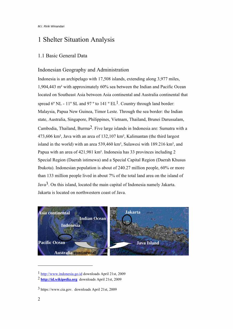
Indonesia is an archipelago with 17,508 islands, extending along 3,977 miles,
1,904,443 m² with approximately 60% sea between the Indian and Pacific Ocean
located on Southeast Asia between Asia continental and Australia continental that
spread 6º NL - 11º SL and 97 º to 141 º EL1. Country through land border:
Malaysia, Papua New Guinea, Timor Leste. Through the sea border: the Indian
state, Australia, Singapore, Philippines, Vietnam, Thailand, Brunei Darussalam,
Cambodia, Thailand, Burma2. Five large islands in Indonesia are: Sumatra with a
473,606 km², Java with an area of 132,107 km², Kalimantan (the third largest
island in the world) with an area 539,460 km², Sulawesi with 189.216 km², and
Papua with an area of 421,981 km². Indonesia has 33 provinces including 2
Special Region (Daerah istimewa) and a Special Capital Region (Daerah Khusus
Ibukota). Indonesian population is about of 240.27 million people, 60% or more
than 133 million people lived in about 7% of the total land area on the island of
Java3. On this island, located the main capital of Indonesia namely Jakarta.
Jakarta is located on northwestern coast of Java.
1 http://www.indonesia.go.id downloads April 21st, 2009 2 http://id.wikipedia.org downloads April 21st, 2009 3 https://www.cia.gov. downloads April 21st, 2009
Asia continental
Australia continental
Indonesia
Java Island
Jakarta
Pacific Ocean
Indian Ocean

Fishing settlements in North Jakarta
3
Figure 1: Indonesia and Java Island. Source: Google earth.com
Figure 2: Jakarta City, Penjaringan district and Cilincing district. Source: Google earth.com
Penjaringan and Cilincing General Data
Jakarta is a province that consists of 5 cities and one district. One of them
called North Jakarta that covers an area which most of them are located across the
north coast of Java. In North Jakarta municipality located two Jakarta ports
namely Tanjung Priuk and Sunda Kelapa. A Sunda Kelapa port is a part of
Penjaringan sub district and Tanjung Priuk port is a part of Cilincing sub district.
Both of them are part of North Jakarta Municipality which is the largest fishing
village in Jakarta located.
Penjaringan sub district and Cilincing sub district have 0 - 2 meters height
from surface of the sea with comprises under surface of the sea in several places
which are consists of swamps. This area is prone to flooding due to the flow from
other places or the high tide of the sea and as a result of the 9 rivers and 2 canals
flood.
Penjaringan sub district has a 35.49 km² area consists of 5 sub district
(Indonesian: kelurahan). The land is influenced by tidal sea water with alluvial,
regosol, and grumusol type that make it unstable. Physically, this area consists of
land, dam, swamp, rice field, and protected mangrove forest4. Cilincing sub
district has a 39.7 km² area consists of 7 sub districts. Both of them have a
geographic land changes because of swamp and dam hoarding (for the settlement
4 Penjaringan in figures, 2008
Penjaringan district
Cilincing district
1 2 1
2

M.I. Ririk Winandari
4
population, development of public facilities, and social facilities) that sometimes
caused the flooding5.
Table 1: Demography6.
No Municipality & sub district
Area km²
Population (people) Density (People/km²)
Household
Male Female Total
1 Jakarta Utara
Municipality
139,6 612.389 585.581 1.197.970 8.584 340.362
2 Penjaringan sub
district
35,49 29.493 26.690 56.183 14.208 16.311
3 Cilincing Sub
district
39,7 16.342 15.918 32.260 3.881 9.219
The table above shows that Penjaringan has a higher number of population,
density, and the household rather than Cilincing. This is caused by area that
Cilincing broader than Penjaringan with lower population density.
Demography and Health
In Indonesia, Total fertility rate in 2009 was 2.31 children born/woman. Birth rate
in 2008 was 19.24 births/1,000 population and 6.24 deaths/1,000 population.
Table 2 shows that the male mortality rate slightly higher than women7.
Table 2: Health8.
No Gender Infant mortality (deaths/1000 live births)
Life expectancy (years)
Male 34.93 68.26
Female 24.77 73.38
Total 29.97 70.76
Communities maintain awareness of the environment is low. The rivers and
canals in this area are used as a place to waste disposal and a public toilet that
make the water flow obstructed. Procurement of health facilities consist of
government maternity hospital, private maternity hospital, public health centre,
public health clinic, public medical clinic, teeth medical clinic, midwife service,
5 Cilincing in figures, 2008 6 Jakarta Utara in figures, 2008 7 https://www.cia.gov. downloads April 21st, 2009 8 https://www.cia.gov. downloads April 21st, 2009
Fishing settlements in North Jakarta
5
laboratories clinic, dispensaries, optic, integrated service post, and medicine store.
Based on Hariyadi’s paper (2006), type of diseases that generally found in this
area are infectious disease cholera, measles and other diseases caused by bacteria
or water that is less environmental sanitation. Since 1999, Indonesian government
work to prevent of diseases measles, BCG, cholera, disease due to mosquitoes,
tetanus, and polio9.
Economy
Most of Cilincing’s and Penjaringan’s people working as fisherman, industrial
laborer, and trader. They spent their money of 100,000 IDR - 500,000 IDR per
month to fulfill their consumption of food and non foods. Fulfillment of daily
needs met through the nearest market. Less than 10% had been budgeted for
health care. People in Penjaringan district working as fisherman (20.82%),
industrial laborer (42.05%), businessman (22:07%), and trader. Most of them are
migrant fishermen from Indramayu, Cirebon, and Tegal with 24.14% as a settle
and fisherman fishing boat owners at a time and 75.86% as unsettle fisherman and
fishing workers at a time10.
1.2 Shelter Related Fact and Figures
Access to Shelter
Penjaringan and Cilincing has growth rapidly and physically changes because of
population growth and urbanization. This is increasing population density as well
as the number of buildings. The number of building in both of this area reached to
105616 with the following details: 62992 permanent buildings, 26329 semi
permanent buildings, and 16285 temporary buildings with an average of 4 family
members in one house. There are 3152 units stack house, 13017 units real estate,
and 10 apartment buildings too. According to the number of buildings and
household, the housing deficit is 13081 units. Details of housing stock for each
sub-sub-district can be seen in table 3.
9 Hariyadi, Demography and Social Economics 2006 10 Jakarta Utara in Figures, 2008

M.I. Ririk Winandari
6
Table 3: Housing stock11.
No Sub district Housing stock (unit) Housing deficit (unit)
Permanent Semi permanent
temporary Multi-storey
1 Penjaringan 39.022 7.743 2.523 2.644 5.541
2 Cilincing 23.970 18.586 13.762 508 7.540
The percentage of ownership in Penjaringan district is divided into ownership,
the purpose of land, and the use of land. Most of building ownership in fishing
settlement is private property and another is rent. Stack house generally are
rented.
Table 4: Land area12.
No Sub district Ownership (%) Land area status
Ownership Purpose of land
Use of land registered Not registered
1 Penjaringan 26.68 28.74 5.67 61.10 38.90
2 Cilincing 21.88 7.73 12 41.61 58.39
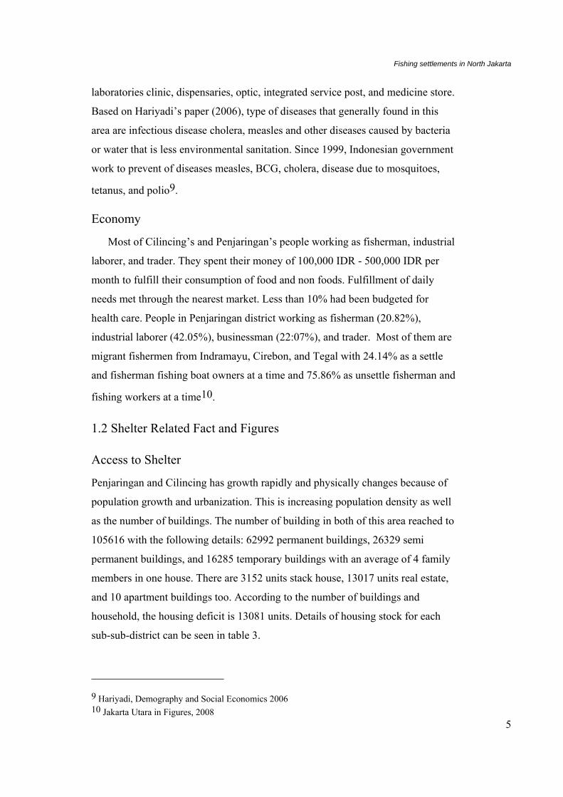
Some fishermen housing was built illegally at the river flood plain, estuary
side, and the beach. Development is done with pilling up swamp, dam or estuary.
This is in violation of technical rules, ecology and administrative. Most of
fishermen housing located in the land, another by boat, and no buildings are on
the sea. Generally, building form is a stilt building or multi-storey building.
Building material made of concrete, steel, and some of the wood.
Figure 3: temporary. Semi permanent
11 Jakarta Utara in figures, 2008 12 Jakarta Utara in figures, 2008
Fishing settlements in North Jakarta
7
Figure 4: permanent multi storey
Access to and cost of Basic Services/Infrastructure
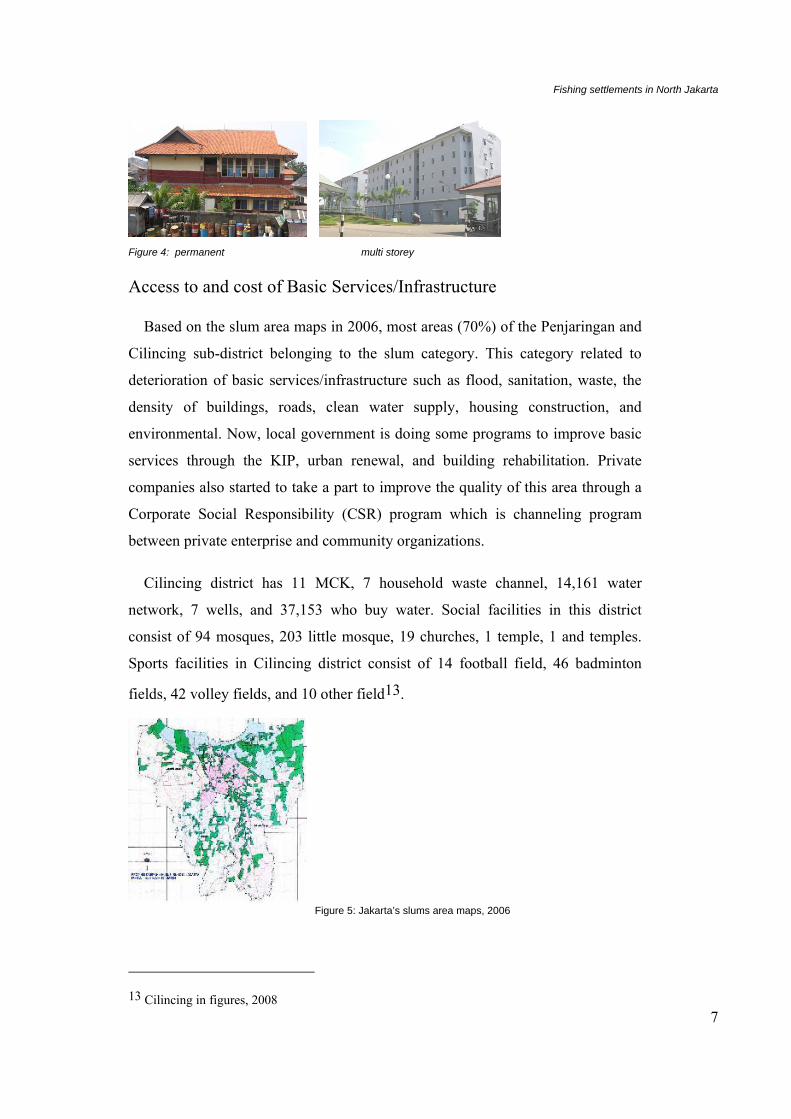
Based on the slum area maps in 2006, most areas (70%) of the Penjaringan and
Cilincing sub-district belonging to the slum category. This category related to
deterioration of basic services/infrastructure such as flood, sanitation, waste, the
density of buildings, roads, clean water supply, housing construction, and
environmental. Now, local government is doing some programs to improve basic
services through the KIP, urban renewal, and building rehabilitation. Private
companies also started to take a part to improve the quality of this area through a
Corporate Social Responsibility (CSR) program which is channeling program
between private enterprise and community organizations.
Cilincing district has 11 MCK, 7 household waste channel, 14,161 water
network, 7 wells, and 37,153 who buy water. Social facilities in this district
consist of 94 mosques, 203 little mosque, 19 churches, 1 temple, 1 and temples.
Sports facilities in Cilincing district consist of 14 football field, 46 badminton
fields, 42 volley fields, and 10 other field13.
Figure 5: Jakarta’s slums area maps, 2006
13 Cilincing in figures, 2008
M.I. Ririk Winandari
8
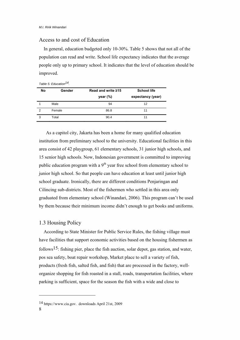
Access to and cost of Education In general, education budgeted only 10-30%. Table 5 shows that not all of the
population can read and write. School life expectancy indicates that the average
people only up to primary school. It indicates that the level of education should be
improved.
Table 5: Education14.
No Gender Read and write ≥15 year (%)
School life expectancy (year)
1 Male 94 12
2 Female 86.8 11
3 Total 90.4 11
As a capitol city, Jakarta has been a home for many qualified education
institution from preliminary school to the university. Educational facilities in this
area consist of 42 playgroup, 61 elementary schools, 31 junior high schools, and
15 senior high schools. Now, Indonesian government is committed to improving
public education program with a 9th year free school from elementary school to
junior high school. So that people can have education at least until junior high
school graduate. Ironically, there are different conditions Penjaringan and
Cilincing sub-districts. Most of the fishermen who settled in this area only
graduated from elementary school (Winandari, 2006). This program can’t be used
by them because their minimum income didn’t enough to get books and uniforms.
1.3 Housing Policy According to State Minister for Public Service Rules, the fishing village must
have facilities that support economic activities based on the housing fishermen as
follows15: fishing pier, place the fish auction, solar depot, gas station, and water,
pos sea safety, boat repair workshop, Market place to sell a variety of fish,
products (fresh fish, salted fish, and fish) that are processed in the factory, well-
organize shopping for fish roasted in a stall, roads, transportation facilities, where
parking is sufficient, space for the season the fish with a wide and close to
14 https://www.cia.gov. downloads April 21st, 2009

Fishing settlements in North Jakarta
9
housing, the house was built as the home array maisonet with 42 sq m for each
unit. Space located under the stairs for fishermen work space. Location is not
exposed to sea water tide. The priority area for the fishermen has the following
conditions16:
Dirty environmental conditions.
Contaminate the surrounding waters.
Low accessibilities to fishing areas or isolated, for example because
located in the border countries and small islands isolated.
Poor communities.
Prone to fire disasters.
Vulnerable to abrasion including waves, tsunami and wind.
An area that is in or near a fishing port development plans, and industry
fishery.
1.4 Actors in Shelter Delivery and their Roles
The actors involves in shelter delivery are the national government, local
government, private-sector housing producers, community organization and
research institution. The national government which consists of several agents
provides regulations for housing systems.
State Minister for Public Housing: Responsible for setting housing standards
and policies and overseeing the implementation of housing
Ministry of Public Works: Responsible for the planning and development of
housing infrastructure
National Land Agency: Supervise the suitability of land for housing
National public housing companies: Develop housing for low income people
Private sector: develops housing for upper and middle income people.
In general, communities built their house by themselves. The research institutions
are doing research such as predict the housing need, the appropriate space area,
housing form, facilities required, infrastructure, and technology that make it easier
15 State Minister for Public Service Rules, 2000 16 Ministry of Housing of Republic of Indonesia Rules Number 15/PERMEN/M/2006

M.I. Ririk Winandari
10
for people to achieve house. The institutions committed to apply the knowledge to
help the urban people to make their lives better.
1.5 Shelter Design
Fishing settlement has a special character that is different from the other
settlements based on the need for life and livelihood. Generally, fishermen always
want to close with their livelihood as a fisherman in the sea (near their boat and
workplace in the estuary side, river side, or coast). They live in groups in order to
keep each other as a consequence of the household that often left home for several
days or weeks. Fishing settlements developed with special facilities such as docks,
fish auction, gas station, fish market, and boat service workshop which could
accommodate boats fishing activities. Widiarso (2002) describes that most of the
settlement stood on the top of the area tidal sea water, have a stilt form and the
road environment17.
Initially, these settlements were built only for those who work as fishermen.
Until now, according to the ID card, all building owners work as fishermen.
Definition of the fishermen themselves associated with ship activities. All people
involved in the process of fish considered to be fishermen. Thus, not only those
who catch fish in the sea called the fishermen but also of all traders, boat owners,
even the manager associated with the auction results of the sea.
Based on the working time at sea, fishermen in Cilincing and Penjaringan areas
can be classified into 3 types:
• Fishermen who take fish in daily time.
• Fishermen who take fish for 1 week to 2 month at the sea.
• Fishermen who take scallop and fishing pond (only 2-5 hours a day).
17 Widiarso, Tata Lingkungan Kampung Nelayan dari Etnik Masyarakatnya, 2002
Figure 5: Fishermen house location based on the type of fishermen in Muara Angke Legend: A: Fishermen who take scallop and fishing pond B: Fishermen who take fish in daily time and for 1 week to 2 month at the sea. Facilities map in Muara Angke fishing settlement. Legend: 1. TPI, docks, ice factories, gas station. 2. Tours fish grilled / fried, fresh fish markets, fish processing factory. 3. Post sea security, terminal, and parking for vehicles. 4. Traditional public markets. 5. Processing shellfish stew and boat garage. 6. Salted fish processing. 7. Primary School. 8. Fishing boat parking area (along riverside)
1
2
3 4
5
6
7
A
B
Fishing settlements in North Jakarta
11
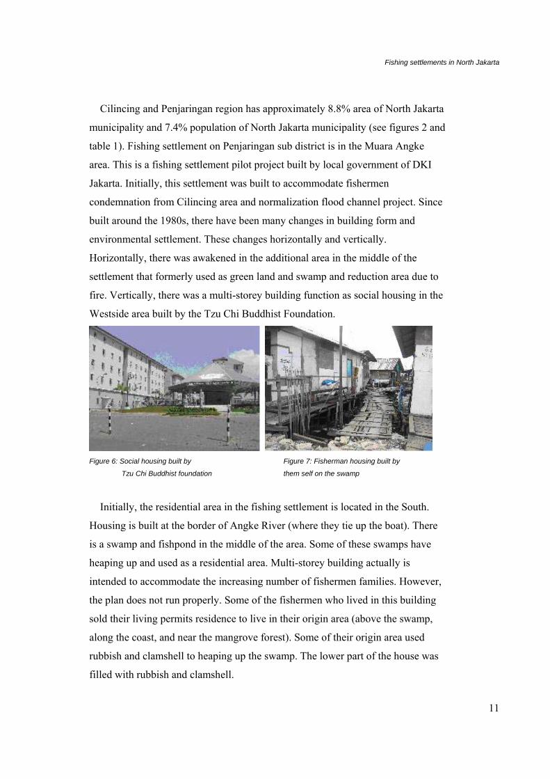
Cilincing and Penjaringan region has approximately 8.8% area of North Jakarta
municipality and 7.4% population of North Jakarta municipality (see figures 2 and
table 1). Fishing settlement on Penjaringan sub district is in the Muara Angke
area. This is a fishing settlement pilot project built by local government of DKI
Jakarta. Initially, this settlement was built to accommodate fishermen
condemnation from Cilincing area and normalization flood channel project. Since
built around the 1980s, there have been many changes in building form and
environmental settlement. These changes horizontally and vertically.
Horizontally, there was awakened in the additional area in the middle of the
settlement that formerly used as green land and swamp and reduction area due to
fire. Vertically, there was a multi-storey building function as social housing in the
Westside area built by the Tzu Chi Buddhist Foundation.
Figure 6: Social housing built by Figure 7: Fisherman housing built by
Tzu Chi Buddhist foundation them self on the swamp
Initially, the residential area in the fishing settlement is located in the South.
Housing is built at the border of Angke River (where they tie up the boat). There
is a swamp and fishpond in the middle of the area. Some of these swamps have
heaping up and used as a residential area. Multi-storey building actually is
intended to accommodate the increasing number of fishermen families. However,
the plan does not run properly. Some of the fishermen who lived in this building
sold their living permits residence to live in their origin area (above the swamp,
along the coast, and near the mangrove forest). Some of their origin area used
rubbish and clamshell to heaping up the swamp. The lower part of the house was
filled with rubbish and clamshell.
M.I. Ririk Winandari
12
Fishing settlement on Cilincing sub-district has a rapid growth because of
population and urbanization from Indramayu, Cirebon and Banten area. This
caused the environment quality to be down. Both of Cilincing and Penjaringan
area has 3% from North Jakarta municipality with 5% population (see figure 2).
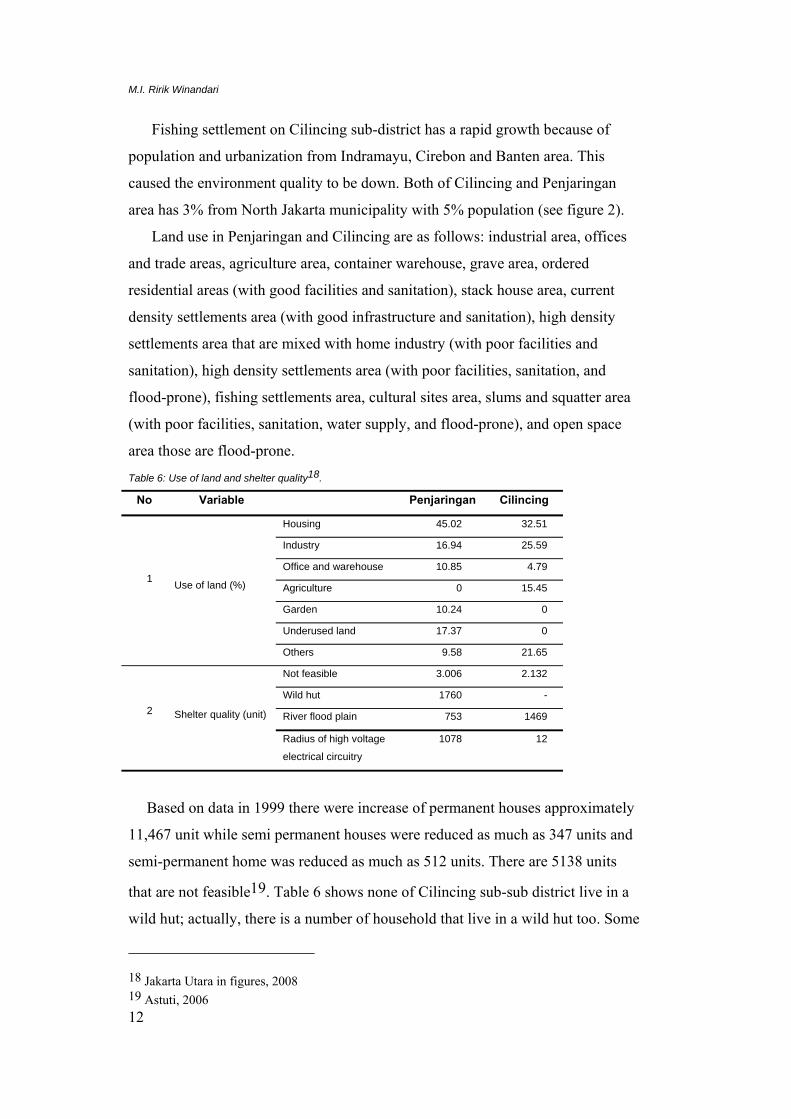
Land use in Penjaringan and Cilincing are as follows: industrial area, offices
and trade areas, agriculture area, container warehouse, grave area, ordered
residential areas (with good facilities and sanitation), stack house area, current
density settlements area (with good infrastructure and sanitation), high density
settlements area that are mixed with home industry (with poor facilities and
sanitation), high density settlements area (with poor facilities, sanitation, and
flood-prone), fishing settlements area, cultural sites area, slums and squatter area
(with poor facilities, sanitation, water supply, and flood-prone), and open space
area those are flood-prone.
Table 6: Use of land and shelter quality18.
No Variable Penjaringan Cilincing
1
Use of land (%)
Housing 45.02 32.51
Industry 16.94 25.59
Office and warehouse 10.85 4.79
Agriculture 0 15.45
Garden 10.24 0
Underused land 17.37 0
Others 9.58 21.65
2
Shelter quality (unit)
Not feasible 3.006 2.132
Wild hut 1760 -
River flood plain 753 1469
Radius of high voltage
electrical circuitry
1078 12
Based on data in 1999 there were increase of permanent houses approximately
11,467 unit while semi permanent houses were reduced as much as 347 units and
semi-permanent home was reduced as much as 512 units. There are 5138 units
that are not feasible19. Table 6 shows none of Cilincing sub-sub district live in a
wild hut; actually, there is a number of household that live in a wild hut too. Some
18 Jakarta Utara in figures, 2008 19 Astuti, 2006
Fishing settlements in North Jakarta
13
buildings in fisherman settlements have a low environmental quality, especially
stilt houses. The cellar stilt filled with rubbish and clamshell.
The buildings generally functions as a dwelling house as well as a place to
work such as repairing and storing the fishing equipment and cultivating fish haul.
Most of them have a terrace at the front or back of the house which is used for
work and socializing with other people and use brick or wood as a wall material.
Wood bridge is use to connecting between buildings and roads. There are 2836
household in 2247 buildings which live in river flood plain and 1090 numbers of
household which live in radius of high voltage electrical circuitry.
The condition of inland water consists of salty inland water and polluted sea
water. Because of this, people in this area difficult to use the land water for their
daily life. The land which easily affected by flood was 0.1 km². Most of them
have been anticipated flooding.
2 Organization Trisakti University, is the only private university in Indonesia established by
the Government of the Republic of Indonesia on 29 November 1965 through a
decree from the Minister of Higher Education and Science (PTIP) 013/dar No.
1965 signed by Dr. Sjarif Thajeb. It is the largest private universities in Indonesia
with nine faculties and graduates school and has over 30,000 students currently
enrolled with commitment to prepare students for future challenges. As a private
university that is not subsidized by the government, every student pays for the
education. There are available scholarships for outstanding students from Trisakti
University itself, the Indonesian government and several private or state
companies.
As a university, Trisakti University working in 3 levels consists of education
and teaching, research, and dedication to the community. First, lecturer that
working in this institution committed to give the best learning activities for
students. Second, researcher that working in this institution doing research based
on their specialized background. In department of architecture, the research focus
on structures, the history of architecture, and city and the settlements, such as
predict the housing need, the appropriate space areas, housing forms, required
facilities, infrastructure, and technology that make it easier for people to achieve
M.I. Ririk Winandari
14
house. Third, Trisakti as institution committed to applied the knowledge and
research to help the urban people (especially for poor people in 5 areas in Jakarta)
to make their lives better through the advising.
3 Shelter Problem Generally, fishing settlements grows naturally and does not consider the water
border area such as coastal, river, or estuary. Some of them were built illegally.
Fishing settlement condition that closest with mangrove forest, river, coast and
fishermen’s habits that throw away their trash directly into water causing river or
estuary silting up and water pollution. Mangrove forest, river, and estuary
reduction was caused by illegally housing in waterfront area. Settlement
development is done by pilling up swamp, dam or estuary with the shell skin or a
mound of trash that is in violation of technical rules, ecology, and administrative.
The environment quality not only decreased by flooding but also by
population growth and limited land in this area. This can be seen from the
building density and estuary constriction that is used for settlement expansion.
The Government has undertaken efforts to improve the environment by relocation
to Indramayu and development of housing flats for the fishermen. New
settlements designed and built by the government paying less attention to the
fishermen needs. There is a lack of facility in their new settlement such as fish
auction, boat service workshop and placed far away from their workplace (± 151
km between existing settlement in Jakarta and new settlement in Indramayu).
However, most of the fishermen who have been relocated back to the place in
Cilincing and Penjaringan district because of that thing.
Generally, those buildings that were built by the government and the private
sector don’t involve the fishermen in the process of planning and design. This has
been affected the design, function, and ownership changes that are compliance
with their need. Fishing settlement in Penjaringan district has the horizontal and
vertical changed since built in 1980. Horizontally, there are constructed area
expansion on the green open space or swamp area and reduction in other areas due
to fire settlement. Vertically, there are stack house built by the Indonesian
Government and the Tzu Chi Buddhist Foundation to accommodate the increased
of family fishermen same as to avoid the swamps hoarding. At this time the stack
Fishing settlements in North Jakarta
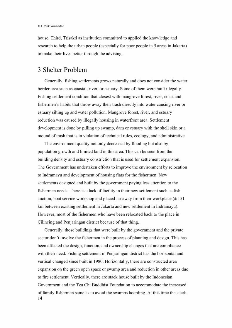
15
house buildings or settlements provided for fishermen are changed of ownership
or rented to the employees and laborers. Fishermen who originally lived in the
stack house sell their permits and stay in their old settlement that closed to the
water. This makes the old settlement overcrowding because of overpopulated and
deteriorated on quality life.
Figure 8: Overpopulated settlement
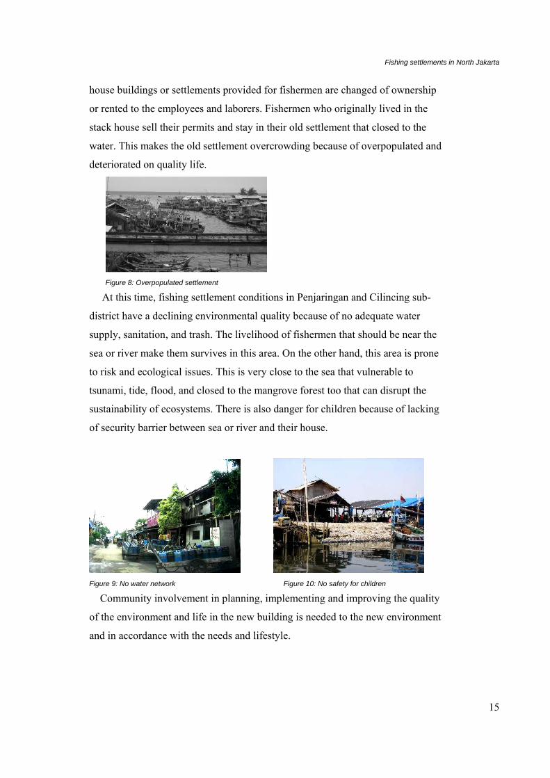
At this time, fishing settlement conditions in Penjaringan and Cilincing sub-
district have a declining environmental quality because of no adequate water
supply, sanitation, and trash. The livelihood of fishermen that should be near the
sea or river make them survives in this area. On the other hand, this area is prone
to risk and ecological issues. This is very close to the sea that vulnerable to
tsunami, tide, flood, and closed to the mangrove forest too that can disrupt the
sustainability of ecosystems. There is also danger for children because of lacking
of security barrier between sea or river and their house.
Figure 9: No water network Figure 10: No safety for children
Community involvement in planning, implementing and improving the quality
of the environment and life in the new building is needed to the new environment
and in accordance with the needs and lifestyle.
M.I. Ririk Winandari
16
4 Proposal for Change and Improvement Two types of fishing settlement based on the land status are formal and informal
settlement. Both of them can be upgrade to a better quality through participatory
upgrading settlement and proper infrastructure. Informal settlements should be
maintained for not disrupt the ecosystem and national rules moreover their
existence expected to improve the local conditions. In the forced condition, they
can be moved to another place called resettlement in accordance with their
livelihood. The important things that must be considered are: fishermen
livelihood, ecological issue, and risk.
According to pro-poor urban settlement and housing design, Department of
architecture, Trisakti University committed to apply the knowledge to help the
low-income households especially fishermen in 3 levels consist of education and
teaching, research, and dedication to the community. Some program could be
arranged as follows:
1. Education and teaching.
• Increasing awareness and understanding of the problems associated with the
fishing community especially low-income households.
• Increasing responsibility to teaches on how to apply in the pro-poor urban
settlement, housing, and sustainable design, so that poor people do not evict
their original place and have the opportunity to improve their life.
Fishing settlements in North Jakarta
17
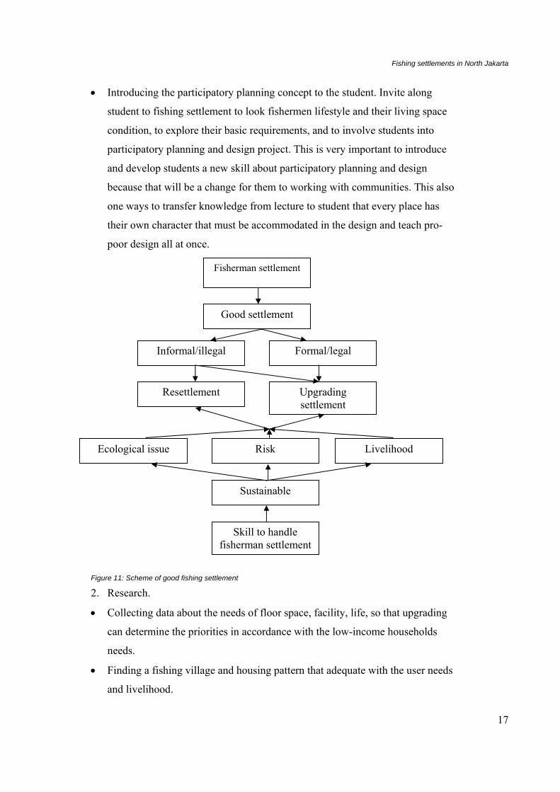
• Introducing the participatory planning concept to the student. Invite along
student to fishing settlement to look fishermen lifestyle and their living space
condition, to explore their basic requirements, and to involve students into
participatory planning and design project. This is very important to introduce
and develop students a new skill about participatory planning and design
because that will be a change for them to working with communities. This also
one ways to transfer knowledge from lecture to student that every place has
their own character that must be accommodated in the design and teach pro-
poor design all at once.
Figure 11: Scheme of good fishing settlement
2. Research.
• Collecting data about the needs of floor space, facility, life, so that upgrading
can determine the priorities in accordance with the low-income households
needs.
• Finding a fishing village and housing pattern that adequate with the user needs
and livelihood.
Fisherman settlement
Informal/illegal Formal/legal
Good settlement
Resettlement Upgrading settlement
Skill to handle fisherman settlement
Sustainable
Ecological issue Livelihood Risk
M.I. Ririk Winandari
18
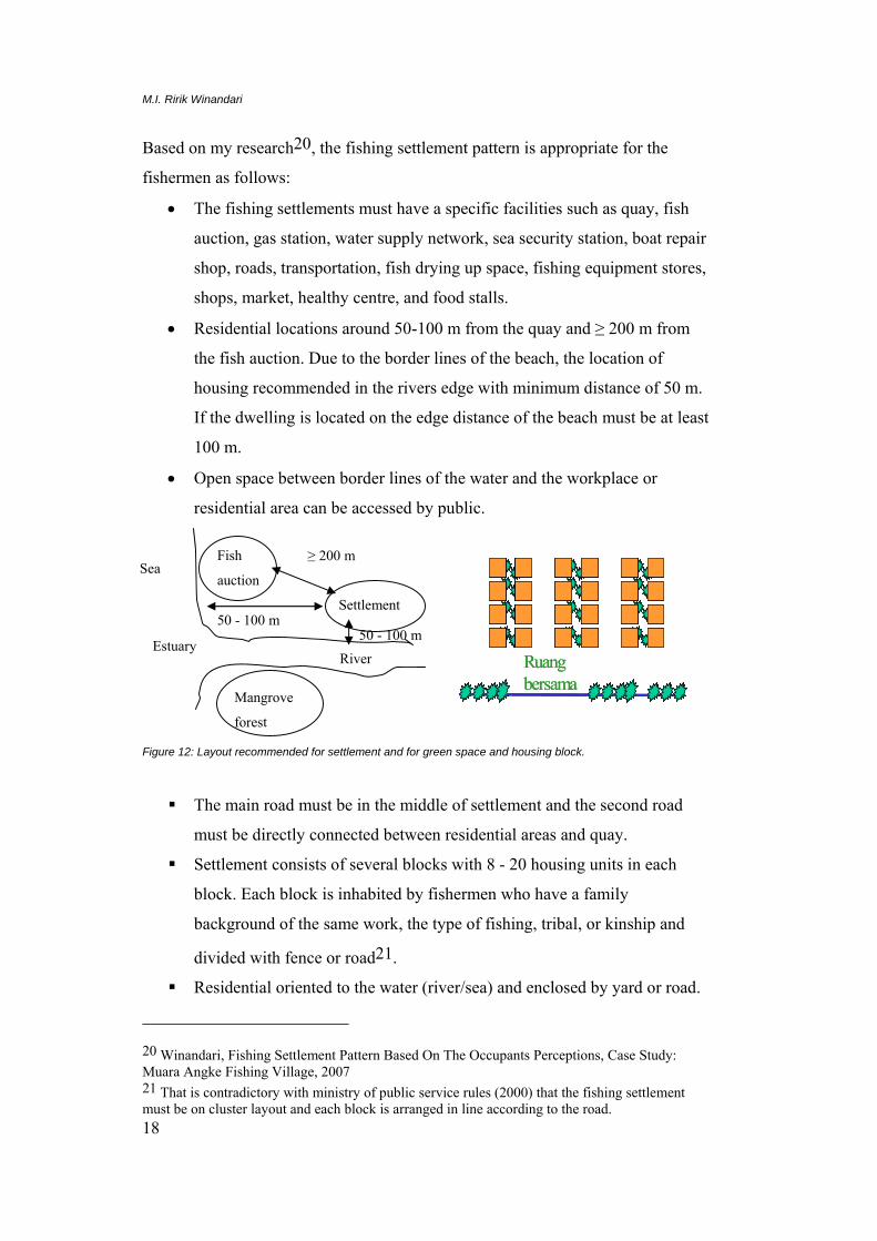
Based on my research20, the fishing settlement pattern is appropriate for the
fishermen as follows:
• The fishing settlements must have a specific facilities such as quay, fish
auction, gas station, water supply network, sea security station, boat repair
shop, roads, transportation, fish drying up space, fishing equipment stores,
shops, market, healthy centre, and food stalls.
• Residential locations around 50-100 m from the quay and ≥ 200 m from
the fish auction. Due to the border lines of the beach, the location of
housing recommended in the rivers edge with minimum distance of 50 m.
If the dwelling is located on the edge distance of the beach must be at least
100 m.
• Open space between border lines of the water and the workplace or
residential area can be accessed by public.
Ruang bersamaRuang bersama
Figure 12: Layout recommended for settlement and for green space and housing block.
The main road must be in the middle of settlement and the second road
must be directly connected between residential areas and quay.
Settlement consists of several blocks with 8 - 20 housing units in each
block. Each block is inhabited by fishermen who have a family
background of the same work, the type of fishing, tribal, or kinship and
divided with fence or road21.
Residential oriented to the water (river/sea) and enclosed by yard or road.
20 Winandari, Fishing Settlement Pattern Based On The Occupants Perceptions, Case Study: Muara Angke Fishing Village, 2007 21 That is contradictory with ministry of public service rules (2000) that the fishing settlement must be on cluster layout and each block is arranged in line according to the road.
Fish
auction
Settlement
Sea
Mangrove
forest
≥ 200 m
Estuary River
50 - 100 m 50 - 100 m

Fishing settlements in North Jakarta
19
Green area recommended in the riverside, roadside, in front of the house,
but not in the middle block, the corner block, or the middle settlement.
3. Dedication to the community.
Socialize participatory planning to the poor people community and the benefits
of the mangrove areas and pursue them to preserve the mangrove forest and to
keep the water clean.
Continuing to improve design facilities such as sanitary and utility through a
technical assistance (a part of the process of participatory planning and
development) so that implementation can be adequate with the healthy housing
standard.
Continuing multidisciplinary programs in research and applications that have
been carried out by the University of Trisakti through research institutions and
community service agencies such as working closely with the government and
the private sector to make a mangrove ecological tourism area and allow
Occupant to participate this activity.
References
No name
2008 Jakarta Utara in Figures. Jakarta: BPS-Statistics Jakarta Utara
Municipality. BPS Catalogue number: 1403 3175.
No name
2008 Penjaringan in Figures. Jakarta: BPS-Statistics Jakarta Utara Municipality.
BPS Catalogue number: 1403 3175 010.
No name
2008 Cilincing in Figures. Jakarta: BPS-Statistics Jakarta Utara Municipality.
BPS Catalogue number: 1403 3175 060.
Hariyadi
2006 Demography and Social Economics: Society Payment Ability and Basic
Health Services Facilities and Referral in the Province of Jakarta.
Yogyakarta: Health Services Management Center. Faculty of Medicine.
Gadjah Mada University. http://kihariyadi.blogspot.com/

M.I. Ririk Winandari
20
Astuti, Sri. Utami, Titi. Yodhakersa, Wahyu
2006 Jakarta’s Sea Water Investigation Growth Impact. Jakarta: Proceeding -
Impact Studies Reciprocal Form of the City and Housing in Indonesia and
the Global Environment.
Widiarso, Tulus,
2002 Tata Lingkungan Kampung Nelayan dari Etnik Masyarakatnya, presented
on ethnic architecture Seminar, Jakarta
Winandari, Maria Immaculata Ririk
2007 Fishing Settlement Pattern Based On The Occupants Perceptions, Case
Study: Muara Angke Fishing Village. AGORA Journal, December 2006
The Faculty of Civil Engineering and Planning, Trisakti University
No name
2009 http://www.indonesia.go.id downloads April 21st, 2009
No name
2009 http://id.wikipedia.org downloads April 21st, 2009
No name
2009 http://www.cia.gov. Downloads April 21st, 2009
No name
2000 State Minister for Public Service rules
No name
2009 http://www.kemenpera.go.id/pp.asp, download April 20th