Are You suprised ? - Bangalore...
21
Curriculum Vitae Name : Dr. T. J. Renuka Prasad Date of Birth and age : 13-01-1958, 58 years Address for communication : Professor Department of Geology Jnanabharathi Campus Bangalore University Bangalore – 560 056 Karnataka, India. Residential Address : P-5, J.B.Campus Bangalore University Bangalore 560056 Contact Details : +919845392748 080-22961385/23212977® [email protected] [email protected] Blogs : drtjrprasad.podbean.com vasundhara.podbean.com Qualification : M.Sc., M.Phil., Ph.D. Employment: Sl. No. Designation Period Organisation 1. Research Assistant 1981 –82 (one year) ISRO., Govt of India, Bangalore, India 2. Research Assistant 1982-83 (one year) Dept. of Geology Bangalore University , Bangalore, India. 3. Lecturer 1983-91 - do- 4. Reader in Geology 1991-99 - do-
Transcript of Are You suprised ? - Bangalore...

Curriculum Vitae
Name : Dr. T. J. Renuka Prasad
Date of Birth and age : 13-01-1958, 58 years
Address for communication : Professor
Department of Geology
Jnanabharathi Campus
Bangalore University
Bangalore – 560 056
Karnataka, India.
Residential Address : P-5, J.B.Campus
Bangalore University
Bangalore 560056
Contact Details : +919845392748
080-22961385/23212977®
Blogs : drtjrprasad.podbean.com
vasundhara.podbean.com
Qualification : M.Sc., M.Phil., Ph.D.
Employment:
Sl.
No.
Designation Period Organisation
1. Research Assistant 1981 –82 (one year) ISRO., Govt of
India, Bangalore,
India
2. Research Assistant 1982-83 (one year) Dept. of Geology
Bangalore
University ,
Bangalore, India.
3. Lecturer 1983-91 - do-
4. Reader in Geology 1991-99 - do-

5. Professor of Geology 1999- to date - do-
6. OSD, Bangalore University
Land Protection (Additional
charge)
2010 – 2012 - do -
7. Coordinator, Bio-park,
Bangalore University
2014 – to date -do-
Research or Technical career
a). Research projects completed
Sl.
No.
Title of the Project/work Sponsoring Agency Status
1. Hydrogeological Study of Shimsha
River Basin in Karnataka
University Grants
Commission
Completed
2. Hydrogeological Investigations in
Maddur and Malavalli Taluks,
Mandya District Karnataka
M/s. Chamundeswari
Sugar Company,
Bangalore. Karnataka.
Completed
3. Hydrogeological Study around
Pavagada Taluk, Mandya District,
Karnataka.
M/s PSSK Ltd.
Pandavapura, Karnataka,
India.
Completed
4. Geophysical Survey around Kolar. SC/ST Corporation,
Government of Karnataka.
Completed
5. Geological set up in and around
Agastya International foundation
campus, Kuppam
Agastya International
foundation
Completed
6. Hydrogeological investigation at
Bidar
Completed
7. Harnessing Groundwater at Five
catchments in Jnanabharathi campus,
Bangalore University, Bangalore
Central Ground Water
Board
Completed
8. Development of Biopark in
Bangalore University
Bangalore University Completed
9. Aquifer assessment through pumping
and slug test and providing technical
assistance for implementation of
Component of Hydorlogy project
Watershed Development
Department, Govt.of
Karnataka, World Bank
Project
On going
B). Ph.D. Programmes

Sl.
No.
Title of the Ph.D. Research
Programme
Name of the Research
Scholar Status
1. Hydrogeological study of Bangalore
District using Remote Sensing
Techniques.
S. M. Nagaraj Completed
2. Hydrogeological study of
Channagirihalla and Soppinahalla
watersheds using Remote Sensing and
GIS Techniques.
H. V. Shashibhushan
Kumar Completed
3. Artificial Recharge Techniques in
Gneissic Terrain in Parts of Kolar
District.
K. R. Suryanarayana Completed
4. Municipal waste Disposal Practices and
their Impacts on Groundwater Quality
in Bangalore Metropolitan Region
Mohd. Ali Farooqi Completed
5. Comprehensive Watershed
Management Studies of “Yale
Mallappa Shetty Kere Watershed Using
Remote Sensing and GIS Technique”
Bangalore North
G.S.Chandan On going
6. Comprehensive Hydrological Studies
of North Bangalore Metropolitan
Region using Remote Sensing and
Geographic Information System
Techniques”.
Ramesh Dikpal
Completed &
Thesis
submitted
7. Comprehensive Hydrological Studies
of North Bangalore Metropolitan
Region using Remote Sensing and
Geographic Information System
Techniques”.
Krishna Murthy B N
Completed &
Thesis
submitted
8. Comprehensive Hydrological Studies
in Chintamani taluk, Chikkaballapur
District Using Remote Sensing and
Geographic Information System
Techniques
Nandeesh V On going
9. Forest Hydrology in South-East dry
Agro-climatic Zones of Karnataka
Using Remote Sensing & GIS”.
Jagadish M. Kattimani On going
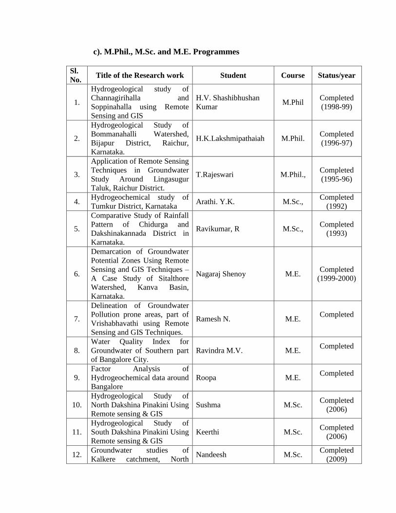
c). M.Phil., M.Sc. and M.E. Programmes Sl.
No. Title of the Research work Student Course Status/year
1.
Hydrogeological study of
Channagirihalla and
Soppinahalla using Remote
Sensing and GIS
H.V. Shashibhushan
Kumar M.Phil
Completed
(1998-99)
2.
Hydrogeological Study of
Bommanahalli Watershed,
Bijapur District, Raichur,
Karnataka.
H.K.Lakshmipathaiah M.Phil. Completed
(1996-97)
3.
Application of Remote Sensing
Techniques in Groundwater
Study Around Lingasugur
Taluk, Raichur District.
T.Rajeswari M.Phil., Completed
(1995-96)
4. Hydrogeochemical study of
Tumkur District, Karnataka Arathi. Y.K. M.Sc.,
Completed
(1992)
5.
Comparative Study of Rainfall
Pattern of Chidurga and
Dakshinakannada District in
Karnataka.
Ravikumar, R M.Sc., Completed
(1993)
6.
Demarcation of Groundwater
Potential Zones Using Remote
Sensing and GIS Techniques –
A Case Study of Sitalthore
Watershed, Kanva Basin,
Karnataka.
Nagaraj Shenoy M.E. Completed
(1999-2000)
7.
Delineation of Groundwater
Pollution prone areas, part of
Vrishabhavathi using Remote
Sensing and GIS Techniques.
Ramesh N. M.E. Completed
8.
Water Quality Index for
Groundwater of Southern part
of Bangalore City.
Ravindra M.V. M.E. Completed
9.
Factor Analysis of
Hydrogeochemical data around
Bangalore
Roopa M.E. Completed
10.
Hydrogeological Study of
North Dakshina Pinakini Using
Remote sensing & GIS
Sushma M.Sc. Completed
(2006)
11.
Hydrogeological Study of
South Dakshina Pinakini Using
Remote sensing & GIS
Keerthi M.Sc. Completed
(2006)
12. Groundwater studies of
Kalkere catchment, North Nandeesh M.Sc.
Completed
(2009)

Bangalore using Electrical
Resistivity Survey, Remote
Sensing & GIS
13.
Hydrogeochemical study
around Hebbal Valley,
Bangalore North.
Kashyap M.Sc. Completed
(2009)
14. Forest Hydrology of southern
semi arid zone, Karnataka. Jagadish M Kattimani M.Sc.
Completed
(2010)
15. Hydrogeologial studies of
Karaikal Dt., T N Chandra Mouli M.Sc.
Completed
(2014)
16. Hydrogeologial studies of
Nagapattinam Dt., T N Mustafa M.Sc.
Completed
(2014)
17. Hydrogeochemistry of
Pavagada tq., Tumkur Dt. Shravani M.Sc.
Completed
(2015)
Courses offered: The following branches of Geology has been offered to M.Sc.Geology
and M.Sc.Applied Geology courses both Theory and Practicals.
1. Hydrogeology
2. Geophysical survey
3. Geo-statistics
4. RS & GIS
5. Structural Geology
6. Engineering Geology
Labs Developed:
1. Instrumental in the development of high end Computer lab with
emphasis on Remote Sensing & GIS in the Chairmanship of
Prof.G.Srinivas using DRS funds.. Five work stations have been
imported from Singapore. State of the art softwares like ERDAS
Imagine, ArcGIS, Mapinfo procured along with a bunch of softwares
which included Rockworks, Geochemist Work Bench, Ground Water
Modeling Software (GMS), Resix, Golden Surfer, Igpet. XRF lab
2. Instrumental in obtaining additional grants from the University funds
to install XRF procured under DST special assistance amd a new
Geochemistry lab has been constructed at the same time.
Specialisations: Water Resources – Surface Water, Groundwater, Water Quality,
Computer Applications - Remote Sensing and GIS techniques, Geostatistics, Modelling
Consultancy projects: Developed the Consultancy wing to work in the following areas
of interest and wide coverage was given using the media and brought several consultancy
projects to the Department. For details: Consultancy in the Geology Department
Geological/Structural Mapping

Ground Water Exploration
Remote sensing & GIS
Chemical Analysis of Water, Soil & Rocks
Thin section/ Polish section Making
Consultancy carried out for educational purpose and concessions extended to poor people
especially in Hydro-geological surveys. Students of M.Sc. Geology and Applied
Geology also participated in these programmes and got the field experience. The
following few are mention worthy:
1. Geological Survey for the Dam construction purpose near Gokak falls,
Belgaum (negotiated with Secon Co.and sent a team of teachers)
2. Several Hydrogeological studies in and around Bangalore specially to
locate Borewell sites for agricultural purpose. (Team of Research
Scholars and students participated in the week end programmes) For
details of one of the projects: Hydrogeological Studies.
3. Thin section for microscopic studies for GSI and IBM
4. A GIS Data base of Surface and Subsurface features of Agasthya
Campus, A.P.(non profitable) to make models for educating school
children. For further details: Agastya GIS Database (Control + click
Blue to follow link in soft copy; visit drtjrprasad.podbean.com or
vasundhara.podbean.com in case of Hard copy)
Computer skills: Various Computer Applications has been attempted using different
programming languages and packages for the Hydrological studies.
Platform & Hardware: Main Frame (IISc), Mini (Civil Engg, IISc) and Workstation
(GIS lab, Department of Geology) and Desktop from 8086, 286, 386, 486 and Pentium
systems in the Department of Geology.
Software: Worked in the different Operating System environments like DOS, Unix,
Xenix and Windows. Programming Languages like Basic – GW Basic, QBasic; Watfor,
MS-Fortran, RMFortran and Visual Fortran; C and C+ used effectively. Following are
the few works carried out: Time Series Analysis of Rainfall Analysis using Main Frame
with Fourier, Autocorrelation and Moving Average technique. Contours generated using
Fortran in the DOS environment with dot matrix out put with Characters filling in
between the contours. Multivariate Analysis of different maps using Principal
Component Analysis, Factor Analysis, Cluster Analysis and Trend Surface Analysis has
been done.
Packages: Statgraph, Lotus, Quatrapro, Excel and SPSS for Statistical Analysis; Iddrisi, ,
Erdas Imagine, Geomedia for Remote Sensing; MapInfo ArcGIS for GIS; Rockware,
GMS for Groundwater Modeling; Resix for Resistivity data Analysis; Google Earth, and
Google Earth pro for Mapping purposes and MS Office for general purposes.
Popularising Earth Info System : An attempt has been made to popularize the Earth
Science among the Schools/College students. Multimedia presentation and interactive
sessions conducted. Invited to the Department and provided a feel of different
laboratories. As a part of it, Govt.Science College were taken to field work at Bababudan
Hills. Teachers and research scholars had knowledge exchange programme with college
teachers and students also. Jnanadri Trekking has been conducted to showcase the
Jnanabharathi campus to get a feel of Mother Earth, Hydrogeological projects,
Environmental aspects. Lot of college and school children participated in the programme
apart from NGOs’ and Public.
Accreditations: Tank Rejuvenation and Water bodies development, Expert adviser in the
cases of Lok Adalat, Govt.of Karnataka, Adviser to BDA, BBMP in the management of
Earth Resources specially Drainage Net work and water bodies.
Interests: Reading Novels, Watching Art Movies, Member of Suchitra Film Society and
attended Bangalore Film Festivals and International Film Festival of India regularly.
Participating in Film Festivals, Traveling to cover Hill stations, Beaches, Snow fields.
Discussion on various subjects. Counseling related to Education and Social relevant
aspects.
Week End Field Work: Initiated a new programme in the department after assuming as
Chairman, M.Sc Geology and Applied Geology students are learning in the field on week
ends. First semester students attended 13 weeks in the 16 weeks semester. Teachers have
shown interest in the programme and research students also participated in the
programme. Registrar was kind enough to sanction the vehicle hiring charges for the
purpose. A photo album has been made and presented at the end of the semester. For
details: Week end field work
Alumni Association: As a part of NAAC requirements attempted to make an Alumni
Association which was not exist till recent days. Various organizations have been
contacted and a data base of Bangalore University employees mail IDs and Contact nos.
has prepared and as a result more than 150 members enrolled. Several meetings
conducted and valuable work experience shared with the students and staff of the Dept.
Registration of the Association is pending.
Trainings Organised: As a Chairman of the Department thought of getting real time
work exposure to the students. Institutes like Central Ground Water Board, Atomic
Minerals Division, RRSSC (ISRO) have been used effectively. Hands on experience in
Hydrological Studies, Uranium Exploration and Remote Sensing respectively has been
provided to the students in different batches.
.
List of Publications
1. Geohydrogeological studies of Shimsha River Basin in Karnataka (with
G.Srinivas), Proc. Sem. “Hydrological Incvestigations During The Last Years
in India”. May 23-24, 1982, Waltair.
2. Geomorphologica Studies of Shimsha River Basin in Karnataka, (Abs) Proc. 70th
Indian Science Congress, Tirupati, India, 1983.
3. Spectral Analysis of Rainfall Over Shimsha River Basin in Karnataka (Abs)
Proc. Sem. On Hydrogeology, Hydrabad, 1983.
4. Study of Precipitation Trends in Shimsha River Basin in Karnataka (with G.
Srinivas and C. Naganna), Trans. Inst. Indian Geographers, Vol. 6, No.2f July
1984.
5. Study of some Chemical Parameters of Ggroundwater From The Area Around
Shabanur, Davanagere Taluk, Karnataka (with N. Shadakshara swamy),
Hydrology Journal of IAH, Vol.X, No.4, Sept-dec., 1987.
6. Groundwater Exploration, Exploitation and Management Problems in Hard Rock
Terrains A Case Study of Shimsha Basin in Karnataka, India ( with C.
Natganna, G.Srinivas and K.L Narahari Rao) accepted for presentation in the
Int. Symp. On Groundwater Development: Quantity and quality, Valencia,
Spain, 1989.
7. Geohydrological studies of Shimsha river Basin in Karnataka ( with G. Srinivas),
in “Studies in Earth Sciences”, Prof. C. Naganna Feliciation Volume, 1990,
Bangalore University, pp. 101-110.
8. Hydrogeochemistry of Shimsha River Basin in Karnataka (with G.Srinivas)
(Abs), Seventh Ind. Geol. Cong., 31st Dec. 1989 to 2
nd Jan 1990, Bangalore,
pp.69-70.
9. Significance of Deep seated aquifers in Over Exploted Crystalline terrain,
Bangalore University – A case study (with T.M.Hunse and M.A. Farooqui.
Proc. Of workshop on Groundwater, CGWB, Bangalore Oct.97).
10. Hydrogeomorphological study of Channagirihalla and Soppinahalla watersheds,
Channagiri Taluk, Karnataka.(with H.V. Shashibhushan Kumar) Proc of
Workshop on Groundwater, CGWB, Bangalore, Feb, 2000.

11. Hydrogeological study of Channagirihalla and Soppinahalla Watersheds,
Channagiri Taluk, Using Remote Sensing and GIS Techniques. Stockholm 2000
Water Symposium, Sweden
12. An Integrated Remote Sensing and GIS Techniques for Delineation of
Groundwater Potential Zones – A Case study of Channagirihalla and
Soppinahalla Watersheds, Karnataka.(with Shashibhushan Kumar, H. V),
Nat.Sym.Advances in Remote Sensing Technology with special emphasis on
High Resolution Imagery, Dec 11-13,2001,Space Application Centre, ISRO,
Ahemdabad. For details: ISRO-SAC-National Workshop (Control + click Blue
to follow link)
13. Delineation of Groundwater Pollution prone area, Part of Vrishabhavathi Basin
by Drastic Index Method, Using GIS. Int. Workshop of Integrated Water
Management, 21st – 23
rd June, 2001, Bangalore (with N. Ramesh)
14. Renuka Prasad T. J., and Delineation of Groundwater otential Zones using
Remote Sensng and GIS Techniques – A Case Study of Sitaltore Watershed,
Kanva Basin, Karnataka. Int. Conference “Environment, Energy, Technology,
Development and Society’s Response & XXIII Indian Inst. Geog. Meet, 1st – 3
rd
Dec. 2001, Varanasi (with Nagaraj Shenoy and Shashibhushan Kumar)
15. Delineation of ground water potential zones in Yale Mallappa Shetty Kere
watershed using Remote sensing and GIS. (Seminar on “EMERGING TRENDS
IN GEOTECHNOLOGY” challenges and opportunities, organized by Global
Academy of Technology & Geological Society of India, Bangalore on 7th
& 8th
Nov2008) Abstract volume. Dr. T J Renukaprasad* and Chandan G.S
**
16. Contamination of ground water in the Northern part of Yele Mallappa Shetty
Kere Watershed, Bangalore North taluk, using Remote Sensing and
GIS.(Chandan G.S, Prabhudev M.V), IISc., Bangalore 2010.
17. Study of Third-Order drainage basins of Yale Mallappa Shetty Kere (YMSK)
watershed using GIS (with Chandan. G.S) Abstract Volume IIG 30th
Conference, Bangalore University, 2011
18. Artificial Recharge Zone delineation in the forest regions of part of Dry
Agroclimatic Zones of Karnataka Using Remote Sensing and GIS (Jagadish
Kattimani and Chandan). Proceedings of International Seminar on Water,
Health and Sanitation, UVCE (Civil), Bangalore University, Bangalore. 2011.
19. Morphometric Studies of Fourth order Sub-Basins (FOSB’s) in North Bangalore
Metropolitan Region using Remote Sensing and Geographic Information system

Techniques, (Ramesh L Dikpal) ISSN (Online): 2279-0055, International
Journal of Emerging Technologies in Computational and Applied Sciences,
5(2), June-August 2013, pp. 134-140
20. Time Sries Analysis Of Rainfall & Water Management In The South-East Dry
Agro Climatic Zones Of Karnataka Using RS & GIS (J M Kattimani), Proceed. ICE_WWISH-2013,Bangalore
21. Groundwater Contamination And Pollution Prone Zones Of Northern Part Of
Yale Mallappa Shetty Kere (Ymsk) Watershed, Bangalore North Using Remote
Sensing And GIS, (Chandan G S) ISSN NO 2320-5407 International Journal of
Advanced Research (2014), Volume 2, Issue 1, 996-1006
22. Time Series Analysis of Rainfall in North Bangalore Metropolitan Region using
Remote Sensing & Geographic Information System Techniques (Ramesh L Dikpal)
ISSN 2320-5407 International Journal of Advanced Research (2014), Volume 2, Issue 4 ,824-832
23. Study of Urbanization and its effect on Water resources in Yale Mallappa
Shetty Kere watershed, Bangalore North taluk using Remote Sensing and GIS
(Chandan G.S), International Journal of Emerging Technologies in
Computational and Applied Sciences, 7(3), December 2013- February, 2014,
pp. 295-300
24. Morphometric Analysis of Cauvery Sub-watershed of South Bangalore
Metropolitan Region of Karnataka, India (with Krishnamurthy et al)
International Journal of Advanced Research (2014), Volume 2, Issue 4, 60-67, ISSN
2320-5407
25. SEASONAL VARIATION OF NITRATE IN NATURAL WATER OF
BANGALORE NORTH (with Rudreshkumar et al) International Journal of
Advanced Research (2014), Volume 2, Issue 11, 1120-1122, ISSN 2320-5407
26. Application of Factor Analysis in the Analysis of Groundwater Quality of Bangalore North
Taluk.( under review) 27. “Groundwater Chemistry of South Karaikal and Nagapattinam Districts,
Tamilnadu, India” (with Chandramouli) IJETCAS, Issue 9, Volume 3, pp. 218-
223, June-August, 2014
28. “Physico-chemical analysis of groundwater covering the parts of
Padmanabhanagar, Bangalore Urban District” IJETCAS, Issue 9, Volume 3,
pp. 229-236, June-August, 2014
PAPERS UNDER PREPARATION: Few Doctoral programmes and Dissertation
carried out resulted in good database and papers are in the publication stage. The
following are the papers about to communicate to Journal for publication:
1. Morphometric Analysis of Yale Mallappa Shetty Kere watershed.
2. Comparision of Decadal Water Quality of Tumkur District with the recent
days (Sreedhara )
3. Ground Water Studies of Kalkere Catchment using Electrical Resistivity
Survey, Remote Sensing and GIS (Chandan & Nandeesh Kumar )
4. Delineation of Groundwater Potential Zones of North Bangalore
Metropolitan Region, using RS/GIS techniques.(Krishna Murthy)
5. Hydrogeochemistry of _Post monsoon of Yele Mallappa Shetty Kere
6. Hydro_Geochem_Premonsoon of Yele Mallappa Shetty Kere
7. Study of water quality of selected waterbodies around southern part of Yele
Mallappa Shetty Kere
8. Change detection of LULC using RS techniques of Yale Mallappa Shetty
Kere Watershed
9. Contamination of groundwater in in Bangalore Metropolitan Region due to
municipal waste and factor analysis to determine the controlling factors
(Mohd. Ali Farooqi)
10. Delineation of Groundwater Potential Zones of Yele Mallappa Shetty Kere
using RS_GIS technique
11. Delineatiion of Pollution Vulnerable Zones of Bangalore Metropolitan
Region using RS & GIS Technique(Mohd. Ali Farooqi)
12. Ground Water Studies of part of Yele Mallappa Shetty Kere Watershed
using Electrical Resistivity Survey
13. Delineation of Groundwater Potential Zones of Chintamani taluk using
RS/GIS techniques (Nandeesh V)
14. Forest Hydrology in Dry Agroclimatic Zones of Karnataka using Remote
Sensing and GIS (Jagadeesh M Kattimani)

15. Delineation of Groundwater Potential Zones of south Bangalore
Metropolitan Region using RS/GIS techniques.(Ramesh Dikpal)
16. Change detection of waterbodies in Yele Mallappa Shetty Kere Watershed.
17. Fourier analysis of Rainfall of Kolar District (Sooryanarayana )
18. Seasonal variation of Hydrogeochemistry of Yele Mallappa Shetty Kere
Watershed
19. Factor analysis of water chemistry of Tumkur District (Sreedhara )
20. Factor analysis of ground water chemical data of Yele Mallappa Shetty Kere
Watershed
21. Delineation of Groundwater Potential zones of Tumkur District using RS
and GIS (Sreedhara)
22. Artificial Recharge Techniques in Granite Gneiss Terrain in part of Kolar
District, Karnataka (K R Sooryanarayana )
Memoir/Manuals/Reports/Album: (Control + click Blue to follow link)
1. Study of Drainages and Water Bodies and Groundwater around Bangalore
along with water auditing and budgeting using Remote Sensing & GIS.
Memoir - Water Problems in Bangalore – A fastest growing Cities of India,
JGSI, Bangalore.
2. Editor of Proceedings of the Workshop on REAPPRAISAL OF MINING &
ENVIRONMENTAL ISSUES, Dept.of Geology, Bangalore University, 2006.
For details: Impact of Mining on Environment
3. Draft Manual of Bio-park, Bangalore University, 2007. For details:
International Year of Planet Earth.
4. A Report on Spatial Information & Database of Jnana Bharathi
CampusBangalore University Using Remote Sensing and GIS. For details: Bangalore University Land Encroachment; Bangalore University Land
Encroachment Legal Issues
5. Article on Recycling of Tertiary treated water of Vrishabhavathi stream by
multilayered filtering and wet land technique (part of University Potential of

Excellence programme). For further details visit: Water Purification &
Recycling.
6. Photo Album of Land Encroachment of Jnanabharathi Campus, Bangalore
University. For details: Bangalore University Land Encroachment Photo
Album.
Website Blog & Articles: (Control + click all Blue to follow link)
The following articles are published in the Web blog - http://drtjrprasad.podbean.com and http://vasundhara.podbean.com
1. Bangalore University Land Encroachment Legal Issues Apr 10th, 2012 –
Grabbing of land of Jnana bharathi campus, Bangalore University by
encroachers and related legal status. A pdf file is also uploaded to get
important Maps and Statistics.
2. Bangalore University Land Encroachment Apr 10th, 2012. A pdf is also
uploaded showing the extent of Land Encroachment of Bangalore University
along with related Maps and Photographs.
3. Cycling & Recycling in Bangalore University May 15th, 2011:Two activities
undertaken by Bangalore University related to Environmental aspects. A Pdf
file showing the terrain of Bangalore University is uploaded.
4. Bio-Park May 8th, 2011: Illustration of Bio-park of Bangalore University with
photos and maps. A ppt presentation is uploaded to get a feel of Jnanabharathi
Bio-park.
Workshops conducted: (Control + click all Blue to follow link in soft copy or visit
drtjrprasad.podbean.com or vasundhara.podbean.com in case of Hard copy)
1. Convener of National Workshop on “REAPPRAISAL OF MINING &
ENVIRONMENTAL ISSUES” in Department of Geology, Bangalore
University. (02/02/2007- 04/02/2007). For details: Impact of Mining on
Environment
2. Convener of International Year of Planet Earth 2007-2009. A draft manual
of Bangalore University Bio-park has been released. A Draft Manual released
and Jnanadri Trekking has been conducted to create awareness about Mother
Earth. For further details: International Year of Planet Earth

3. Special Invitee in the Advisory Committee of Biopark meetings, Bangalore
University, Bangalore.
4. Member of Organising Committee of International Workshop on
“Sequence Stratigraphy” in Department of Geology, Bangalore University,
2006
5. Member of Organising Committee of International Workshop on
“Sequence Stratigraphy” in Department of Geology, Bangalore University,
2012.
Professional Experience
1. Seventy fourth Indian Science Congress Seminar, Jan. 1987, Bangalore.
2. Seventh Indian Geological Congress and National Seminor on 31st Dec.1989 to
2nd
Jan. 1990, Bangalore.
3. Workshop on Artificial Recharge in hard rock terrain, organised by Central
Groundwater Board (CGWB), Bangalore, 1992.
4. Training Course on Remote Sensing Applications to Water Resources (4 weeks).
Conducted by NRSA, Dept. of Space, Government of India, Hydrabad, from 4th
Oct. 1993 to 29 Oct 1993.
5. Short Course on Applied fluvial Geomorphology, Sponsored by DST at Dept. of
Geology, Dibrugarh University, from March 4 –11, 1999, at Dibrugarh.
6. Workshop on Groundwater Management organsied by Central Ground Water
Board, Bangalore, Feb.2000
7. Attended and Presented a paper on Water bodies around Bangalore in 24th
Annual Conference of Institute of Indian Geographers” organized by Department
of Geography, BHU. Varanasi (2005)
8. Seminar on Emerging trends in Geotechnology, Challenges & Opportunities,
Global Academy of Technology & Geological Society of India, 7 & 8th
Nov,
2008.
9. Attended workshop on Action plan for “Rejuvenation and Sustenance of
Arkavathi River basin”, organized by Global Academy of Technology &
Geological Society of India, Bangalore at Jnanajothi auditorium on 25th July
2009.
10. Attended workshop on “How to Save Lakes of Bangalore” organized by Arghyam
organization at Sir.C.V.Raman Institute. Bangalore.
11. Attended and Presented a paper on Water bodies around Bangalore in 30th
Annual Conference of Institute of Indian Geographers” organized by Department
of Geography, Pune University, Pune. (2009)
12. Attended and Presented a paper on Morphometry in “XXXI Annual Conference
of Institute of Indian Geographers” organized by Department of Geography,
Bangalore university, Bangalore. (19-21st February, 2010)
13. Attended and Presented a paper on Groundwater contamination in “Lake 2010:
Symposium on Wetlands, Biodiversity and Climate change” organized by
Center for Ecological studies, IISc–Bangalore. (22-24th December 2010)
14. Workshop on “Tunneling for Bangalore Metro and its impact on subsurface
safety and Groundwater situation in the project area” Translation of the paper
“Geo-hydrological studies along the Metro-Rail Alignment in Bangalore by
M. Sekhar & M. S. Mohan Kumar, Indian Institute of Science”, to Kannada
and presented to Print & Electronic Media along with the Public and answered
the queries regarding Impact on Groundwater due to Metro construction.
Affiliation with Professional bodies and Societies
1. Life Member – Association of Exploration Geophysicists, Hydrabad, India.
2. Member – Indian Academy of Sciences, Bangalore.
3. Life member – ISRS, Dehradun.
4. Life member – IAH, Roorki.
5. Life Member – Geological Society of India
Involvement in the Journal Publications:
1. Executive committee member, Journal UGIT, Dept.of Geography, Bangalore
University
2. Executive committee member, Geo-eye, e-Journal, Dept.of Geography,
Bangalore University.
3. International Editorial Advisory Board Member, IJEE, NITK, Suratkal.
Academic participation
1. Member of Board of Appointments in Karnatak University, Dharwar,
Karnataka
2. Member of Board of Appointments in S.V. University, Tirupati, A.P.
3. Member of Board of Appointments in Yogi Vemana University, Cuddapah,
A.P.

4. Member of Board of Appointments in Osmania University, Hyderabad, A.P.
5. Member of Board of Appointments in Shollapur, Maharastra.
6. Member Board of Studies, Geoinformatics, Mangala Gangortri, University of
Mangalore, Karnataka.
7. Member Board of Studies, Davanagere University, Karnataka.
8. Member of Board of Studies in Yogi Vemana University, Cuddapah, A.P.
9. Member of Board of Studies, Dept.of Env.Science, Gulbarga University,
Karnataka.
10. Member (Co-opted) of Board of Studies, Dept. of Geography, Bangalore
University, Bangalore to Introduce Computer courses for Post Graduate
students
11. Member of Board of Studies, Dept. of Geology, Bangalore University,
Bangalore (Internal)
12. Member of Board of Examiners, Geoinformatics, Mangala Gangortri,
University of Mangalore, Karnataka.
13. Member of Board of Examiners, Geoinformatics, Mangala Gangortri,
University of Mangalore, Karnataka.
14. Member of Board of Examiners, Manasa Gangotri, University of Mysore,
Karnataka.
15. Member of Board of Examiners, Karnatak University, Dharwar, Karnataka.
16. Member of Board of Examiners in Yogi Vemana University, Cuddapah, A.P.
17. Member of Board of Examiners, Dept.of Env.Science, Gulbarga University,
Karnataka.
18. Member of Board of Examiners in Osmania University, Hyderabad, A.P.
19. External Examiner, KSRAC, VTU, Karnataka.
20. Instrumental in Building Remote Sensing and Geographic Information System
lab in the Department of Geology, Bangalore University, Bangalore.
21. Proficiency has been gained in the Programming languages
(especially FORTRAN) and GIS techniques to the Groundwater application.
22. Member, Technical Co-ordination Committee of Central Sector Scheme for
study of recharge to groundwater in the Bangalore University.
23. Member, Statutes Committee for Career Advancement Scheme (CAS) for
Teaching Staff of Bangalore University.
24. Member, Statutes Committee for Interviews of Career Advancement Scheme
(CAS) for Teaching Staff of Bangalore University.
Adjudicator role in the Doctoral programme of Sister Universities:
1. Kuvempu University, Shankara ghatta, Shimoga
2. Karnatak University, Dharwar
3. Uiversity of Mysore, Mysore
4. Osmania University, Hyderabad.
5. S.V.University, Tirupati.
Courses Instituted: (Control + click all Blue to follow link)
1. M.Sc. Geoinformatics: As a Chairperson of the Dept. of Geology as well as
instrumental person in the development of the Geoinformatics lab and
working in the same field for several years taken forward the dream of my
earlier Chairman Prof.G.Srinivas and instituted the course in M.Sc.
Geoinformatics in the Dept.of Geology and the course is kept in abeyance. For
further details: Geoinformatics Course
2. Five Year Integrated M.Sc. Earth & Atmospheric Sciences: To attract young
and able minds to Universities after plus 2, one of the five year courses of the
Bangalore University is Integrated Five Year M.Sc. course in Earth and
Atmospheric Studies and worked as a Co-ordinator to institute the same and it
is not yet operative. Click for details: Integrated Five Year M.Sc.Earth &
Atmos.Science
Study Tours/Field Programmes:
1. North India trip to M.Sc. Geology and Applied Students during 1985, 1987,
1989, 1994, 2000, 2004
2. Field camp at Holenarasipura, 1992
3. Field camp at Chitra Durga, 2012.
4. Jnanadri Trekking for School and College Students/IT/BT professionals to
create awareness about Mother Earth, Water Conservation, and importance of
Bio-diversity.
5. Field work to B.Sc. students of Govt.Science College around Bababudangiri.
6. Week end programmes in the field with the students and research scholars.
Official participation (other than Univesities)
1. Member, Selection of Scientist-C, Central Ground Water Board, 2009, UPSC,
New Delhi.
2. Member P-T Board Geologists Examination 2011, UPSC, New Delhi.
3. Expert – Board of Selection Committee, ISRO, Bangalore 2010
4. Expert – Board of Selection Committee, ISRO, Bangalore 2012
5. Member – Technical committee, KSRSAC, 2011, Bangalore
6. Member – Technical committee, KSRSAC, 2012, Bangalore
7. Member – Tank Rejuvenation Committee, BDA, Bangalore
8. Expert – Water conservation and Management discussion, BDA, Bangalore.
9. Member – Biodiversity Board, BBMP, Bangalore.
10. Expert – Water conservation and Management discussion, Lok Adalat,
Karnataka High Court, Bangalore.
11. Expert – Water contamination around Bangalore discussion, Lok Adalat,
Karnataka High Court, Bangalore.
12. Expert - Water supply to Bangalore City using Surface Water Bodies – Centre
for Sustainable Development, Bangalore
13. Observer of Examinations at Kolkata Centre, Correspondence course of
Bangalore University.
14. Member – LIC of several affiliated colleges, Bangalore University
15. Member – LIC of several study cenres of Bangalore University in Kolkatta,
Gurudaspur, Indore, Mumbai, Surat, Cochin, Coimbatore,
16. Expert Report - Hydrogeological study of selected watersheds around
Bangalore using Remote Sensing and GIS. Urbanization effects on
drainages and tanks have been studied, Lok Adalat, High Court of
Karnataka.
17. Groundwater pollution studies with special reference to heavy metals in
Hebbal valley. Report submitted to Lok-Adalat High-Court, GOK
18. Workshop on Natural Resource Management, Bangalore Regional
Commissioner office , Bangalore.
19. Demonstration about Tanks & Drainages management around Bangalore at
Center for Sustainable Development Bangalore-
20. Development of Herbal Waterbodies (Kalyanies) around Kunigal
Ranganabetta - Worked with Dr. A.N. Yellappa Reddy.
21. Watershed management around Shivanasamudra using RS & GIS. Field visit
with Dr. A.N. Yellappa Reddy.
22. Skill development of Science teaching to High school teachers conducted by
Karnataka Rajya Vignana Parishat at Davanagere -
23. Skill development of Science teaching to High school teachers conducted by
Karnataka Vignana Parishat at Chitradurga -
24. Workshop at Science Centre, Tumkur 2012
25. Panel Discussion Member of National Workshop on “Inter Linking of
rivers” in the Christ Collage Bangalore, 2007.
26. Demo to Architecture students of Details of DEM generation using Google
and Grid overlay to get the height data of Jnana Bharathi campus,
Bangalore University.
27. Special Invitee to deliver a lecture in the Summit on “Agenda for
Bengaluru Infrastructure Development” (Abide) GOK – “Management of
Water bodies and Drainage Net work.”
28. Special Invitee to Arkavathy River Rejuvenation programme organized by
Arghyam, Bangalore.
29. Management of Water bodies in and around Bangalore, presentation in the
Centre for Sustainable Development.
30. Lecture in the Tranining programme on Sustainability of Drinking Water
Sources – Organised by CGWB & Panchayat Raj Engineering Dept.,GOK.
31. Study of Hydrogeological setup of Yale Mallappa Shetty Kere watershed -
Report submitted to Lok-Adalat High-Court, GOK.
32. Presentation of Geo-tourism in Karnataka, workshop organized by Geological
Society of India, Bangalore on 25th
May, 2013.
33. Lecture on “Management of Surface and Ground Water in and around
Bangalore”, HNMC, organized by Science Forum, National College,

Bangalore on 12th
Jun, 2013.
34. Invitee by Lok Adalat, High Court of Karnataka to participate in the
discussion on “Geo-Tourism” on May 31st, 2013.
35. Lecture delivered in the “Science Forum”, National College, Bangalore on
Management of Surface and Ground water in and around Bangalore on 12th
June, 2013.
36. Chief Guest in the Inaugural function of Workshop on Aquiffer Mapping and
Ground Water Status, CGWB, Bangalore on 17th
Feb, 2014 and delivered a
lecture on Groun Water Status and Management.
Television Programmes:
1. DoorDarshan, Bangalore – On the Eve of EARTH DAY celebration,
discussion on Earth and its environment in the morning programme
“BELAKU”. (2006)
2. Press conference by University – About the new Five year Course introduced
in the University on Integrated M.Sc.course, as Coordinator of the course.
3. TV9 Kannada, Bangalore – On the day of Tsunami 2006, panel discussion on
causes and warning systems of Tsunami for about 3 hrs along with phone in
programme with viewers in Kannada.
4. TV9 English, Bangalore – One hour programme in English on the day of
Tsunami 2006, interviewed as Earth Scientist about causes and prediction of
Tsunami along with Astrologer and other fellow Scientists.
5. TV9 News, Bangalore – An outdoor Chatting with Civil Engineer Mr.Prahlad
Ayengar from USA about Tsunami, El Nino effect and etc for about 30 mins.
6. Samaya TV, Bangalore – Discussion on contribution of Dr.A.N.Yellappa
Reddy, Environmentalist to realize the dream of Bio-park, Bangalore
University.
7. TV9, Bangalore – Expert views about the Drainage system in Bangalore and
its status. The mismanagement of stream network due to urbanization and
reasons for flooding of stream water to houses and a famous temple Sri Gali
Anjaneya Temple in particular.
8. Suvarna News TV – On the eve of Environment day 2012, interviewed about
waste management and water resources management.
9. Press Conference with all the Major Medias in Bangalore – About Report
submitted by me on Land Encroachment of Jnanabharathi Campus, Bangalore
University. Wide coverage and awareness created about the Land grabbers
and loss to University property.
10. TV9 Kannada, Bangalore – Etu Ediratu, a programme of Questions by Invited
Audience and Answers by Experts about present day status of Universities,
appointment of Vice Chancellors and role of Government

Ph.D.THESIS & PROJECT REPORT EVALUATION: Several Ph.D.
Thesis and Project reports have been evaluated as an Adjudicator and the following is
selected few from the point of society needs.
1. Landslide Hazard Analysis & Zonation mapping in parts of Western Ghats of
Karnataka using Remote Sensing & GIS, Kuvempu University.
2. Fluvio-Geomorphological changes of the Ganga River in Bihar State Using
Remote Sensing Techniques by Ami Jyotindra Desai ( M.S. University of Baroda)
3. RS & GIS approach for creation of Decision support system for the development
of Identified Micro-watersheds in Udupi District of Karnataka. By K.S. Ramesh,
ISRO (Kuvempu University)
4. Hydrogeological Studies of Bhaskar Rao Kunta Watershed, of Damaracherla
Mandal, Nalgonda District by ( Dr.K. Srinivasa Reddy, SV University).
5. Groundwater Investigations, Development & Management in Tribal Tracts of
Utnoor area, Adilabad Dt., A.P, India by Ramakrishnan Desai, Osmania
University.
6. Geology, Exploration & Environmental aspects of the limestone mining around
Yana Village of Banaganapalle Mandal, Kurnool Dt., A.P, India, using RS&GIS
by Y.Prabhakara Reddy, S.V.University, Tirupati.
7. Influence of Rainwater Harvesting on water table in and around Hyderabad, A.P.,
India by P.Chandrashekar, Osmania University.
8. Environmental Assessment on Groundwater Quality in and around Miryalaguda,
Nalgonda Dt., A.P. by M.Venkateshwarlu, Osmania University.
9. Hydrogeochemical studies of Maneru and Godavari Sub-basins of Godavari
Valley- Karimnagar Dt., A.P. by Gasiganti Mohan, Osmania University.
10. Bhavya.B.K, KSRSAC, Identification and Area Estimation of Horticulture
Plantations Using Satellite Remote sensing and GIS techniques.
11. Use of Geoinformatics for Sectorial Analysis – A case study of Udupi Dt.,
Karnataka State, India by Rajesh.K., Mangalore University.
Social Networks: Sharing, learning and updating information about Water Resources:
India Water Portal Twitter, facebook, linkedIN. Selected few important followers and
following details of Twitter.
Twitter Following: (Control + click all Blue to follow link)
NEPAD Water @NEPADWater
NEPAD Water Centres of Excellence are African higher edu institutions or science
councils undertaking #water research. Also Tweeting #African Water-sector Global Water (GWC) @global_water
Global Water Challenge is a coalition of groups that together are leading a global movement tackling
the water crisis.
World Bank @WorldBank
The official World Bank Twitter feed. The World Bank's mission is to fight poverty with passion and
professionalism for lasting results
Save the Water™ @SaveTheWater
The mission of STW™ is to conduct water research to identify toxic chemicals harmful to humans and
the environment; and to protect our water from contaminants.
Climate Reality @ClimateReality
Reality. It's not an opinion.
Water.org @Water
Safe water & the dignity of a toilet, for all, in our lifetime.
NOAA @NOAA
NOAA provides science, service, and stewardship to protect life and property and conserve and
protect the Earth's natural resources. (Formerly @usnoaagov)
Twitter followers:
Global Warming @GlobalWarming36
All the latest breaking news about Global Warming
NEPAD Water @NEPADWater
NEPAD Water Centres of Excellence are African higher edu institutions or science councils
undertaking #water research. Also Tweeting #African Water-sector #news