ArcPy Function Index - Ian...
153
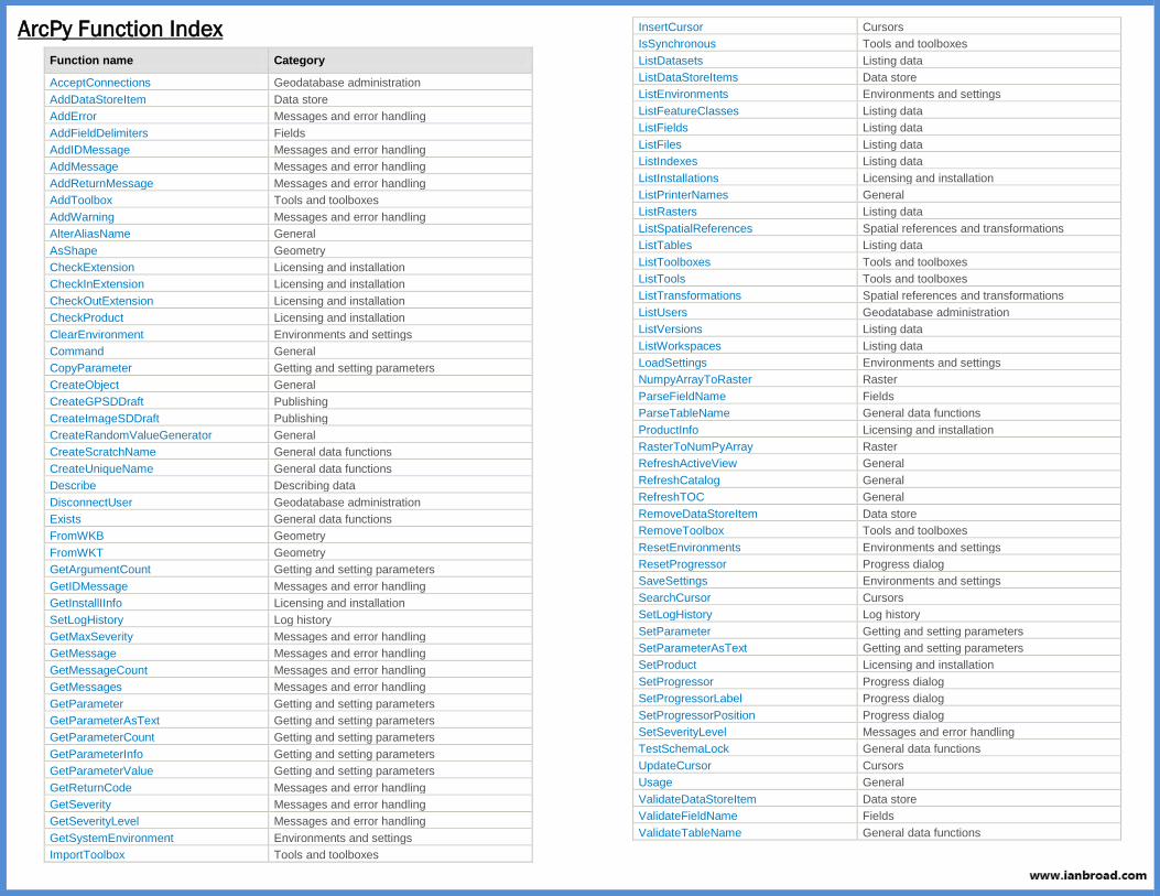
ArcPy Function Index Function name Category AcceptConnections Geodatabase administration AddDataStoreItem Data store AddError Messages and error handling AddFieldDelimiters Fields AddIDMessage Messages and error handling AddMessage Messages and error handling AddReturnMessage Messages and error handling AddToolbox Tools and toolboxes AddWarning Messages and error handling AlterAliasName General AsShape Geometry CheckExtension Licensing and installation CheckInExtension Licensing and installation CheckOutExtension Licensing and installation CheckProduct Licensing and installation ClearEnvironment Environments and settings Command General CopyParameter Getting and setting parameters CreateObject General CreateGPSDDraft Publishing CreateImageSDDraft Publishing CreateRandomValueGenerator General CreateScratchName General data functions CreateUniqueName General data functions Describe Describing data DisconnectUser Geodatabase administration Exists General data functions FromWKB Geometry FromWKT Geometry GetArgumentCount Getting and setting parameters GetIDMessage Messages and error handling GetInstallIInfo Licensing and installation SetLogHistory Log history GetMaxSeverity Messages and error handling GetMessage Messages and error handling GetMessageCount Messages and error handling GetMessages Messages and error handling GetParameter Getting and setting parameters GetParameterAsText Getting and setting parameters GetParameterCount Getting and setting parameters GetParameterInfo Getting and setting parameters GetParameterValue Getting and setting parameters GetReturnCode Messages and error handling GetSeverity Messages and error handling GetSeverityLevel Messages and error handling GetSystemEnvironment Environments and settings ImportToolbox Tools and toolboxes InsertCursor Cursors IsSynchronous Tools and toolboxes ListDatasets Listing data ListDataStoreItems Data store ListEnvironments Environments and settings ListFeatureClasses Listing data ListFields Listing data ListFiles Listing data ListIndexes Listing data ListInstallations Licensing and installation ListPrinterNames General ListRasters Listing data ListSpatialReferences Spatial references and transformations ListTables Listing data ListToolboxes Tools and toolboxes ListTools Tools and toolboxes ListTransformations Spatial references and transformations ListUsers Geodatabase administration ListVersions Listing data ListWorkspaces Listing data LoadSettings Environments and settings NumpyArrayToRaster Raster ParseFieldName Fields ParseTableName General data functions ProductInfo Licensing and installation RasterToNumPyArray Raster RefreshActiveView General RefreshCatalog General RefreshTOC General RemoveDataStoreItem Data store RemoveToolbox Tools and toolboxes ResetEnvironments Environments and settings ResetProgressor Progress dialog SaveSettings Environments and settings SearchCursor Cursors SetLogHistory Log history SetParameter Getting and setting parameters SetParameterAsText Getting and setting parameters SetProduct Licensing and installation SetProgressor Progress dialog SetProgressorLabel Progress dialog SetProgressorPosition Progress dialog SetSeverityLevel Messages and error handling TestSchemaLock General data functions UpdateCursor Cursors Usage General ValidateDataStoreItem Data store ValidateFieldName Fields ValidateTableName General data functions
Transcript of ArcPy Function Index - Ian...
ArcPy Function Index
Function name Category
AcceptConnections Geodatabase administration
AddDataStoreItem Data store
AddError Messages and error handling
AddFieldDelimiters Fields
AddIDMessage Messages and error handling
AddMessage Messages and error handling
AddReturnMessage Messages and error handling
AddToolbox Tools and toolboxes
AddWarning Messages and error handling
AlterAliasName General
AsShape Geometry
CheckExtension Licensing and installation
CheckInExtension Licensing and installation
CheckOutExtension Licensing and installation
CheckProduct Licensing and installation
ClearEnvironment Environments and settings
Command General
CopyParameter Getting and setting parameters
CreateObject General
CreateGPSDDraft Publishing
CreateImageSDDraft Publishing
CreateRandomValueGenerator General
CreateScratchName General data functions
CreateUniqueName General data functions
Describe Describing data
DisconnectUser Geodatabase administration
Exists General data functions
FromWKB Geometry
FromWKT Geometry
GetArgumentCount Getting and setting parameters
GetIDMessage Messages and error handling
GetInstallIInfo Licensing and installation
SetLogHistory Log history
GetMaxSeverity Messages and error handling
GetMessage Messages and error handling
GetMessageCount Messages and error handling
GetMessages Messages and error handling
GetParameter Getting and setting parameters
GetParameterAsText Getting and setting parameters
GetParameterCount Getting and setting parameters
GetParameterInfo Getting and setting parameters
GetParameterValue Getting and setting parameters
GetReturnCode Messages and error handling
GetSeverity Messages and error handling
GetSeverityLevel Messages and error handling
GetSystemEnvironment Environments and settings
ImportToolbox Tools and toolboxes
InsertCursor Cursors
IsSynchronous Tools and toolboxes
ListDatasets Listing data
ListDataStoreItems Data store
ListEnvironments Environments and settings
ListFeatureClasses Listing data
ListFields Listing data
ListFiles Listing data
ListIndexes Listing data
ListInstallations Licensing and installation
ListPrinterNames General
ListRasters Listing data
ListSpatialReferences Spatial references and transformations
ListTables Listing data
ListToolboxes Tools and toolboxes
ListTools Tools and toolboxes
ListTransformations Spatial references and transformations
ListUsers Geodatabase administration
ListVersions Listing data
ListWorkspaces Listing data
LoadSettings Environments and settings
NumpyArrayToRaster Raster
ParseFieldName Fields
ParseTableName General data functions
ProductInfo Licensing and installation
RasterToNumPyArray Raster
RefreshActiveView General
RefreshCatalog General
RefreshTOC General
RemoveDataStoreItem Data store
RemoveToolbox Tools and toolboxes
ResetEnvironments Environments and settings
ResetProgressor Progress dialog
SaveSettings Environments and settings
SearchCursor Cursors
SetLogHistory Log history
SetParameter Getting and setting parameters
SetParameterAsText Getting and setting parameters
SetProduct Licensing and installation
SetProgressor Progress dialog
SetProgressorLabel Progress dialog
SetProgressorPosition Progress dialog
SetSeverityLevel Messages and error handling
TestSchemaLock General data functions
UpdateCursor Cursors
Usage General
ValidateDataStoreItem Data store
ValidateFieldName Fields
ValidateTableName General data functions

AcceptConnections (arcpy) Top
Summary
Allows an administrator to enable or disable the ability of nonadministrative users to make connections to an enterprise geodatabase.
Discussion
The AcceptConnections function is used by an administrative user to
temporarily block connections to an Enterprise geodatabase. This function is used to complement the Connections tab on an Enterprise geodatabase properties page found in ArcGIS for Desktop.
The AcceptConnections function must utilize an administrative
connection to the database.
If this function is attempted to be run by a nonadministrative user the function will fail.
Syntax AcceptConnections (sde_workspace, accept_connections)
Parameter Explanation Data
Type
sde_workspace The Enterprise geodatabase that will have its connection
property altered.
The connection properties specified in the Enterprise
Geodatabase must be the geodatabase administrator.
String
accept_connections Boolean value indicating if the geodatabase will accept
connections (True) or will not accept connections (False).
Boolean
Code Sample AcceptConnections example 1
The following example demonstrates how to prevent connections to a geodatabase.
import arcpy
arcpy.AcceptConnections("Database Connections/admin.sde", False)
AcceptConnections example 2 The following example demonstrates how to prevent connections to a geodatabase, disconnect active connections, then run a geodatabase compress.
import arcpy
# Set Admin workspace variable
admin_workspace = "Database Connections/admin.sde"
# Block connections
arcpy.AcceptConnections(admin_workspace, False)
# Disconnect users
arcpy.DisconnectUser(admin_workspace, 'ALL')
# Reconcile/Post using default parameters.
arcpy.ReconcileVersions_management(admin_workspace, 'ALL_VERSIONS',
'sde.DEFAULT', with_post='POST')
# Compress the geodatabase
arcpy.Compress_management(admin_workspace)
# Allow connections.
arcpy.AcceptConnections(admin_workspace, True)
Related Topics DisconnectUser ListUsers
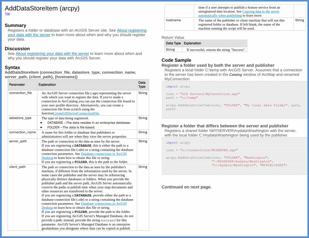
AddDataStoreItem (arcpy) Top
Summary
Registers a folder or database with an ArcGIS Server site. See About registering your data with the server to learn more about when and why you should register your data.
Discussion See About registering your data with the server to learn more about when and why you should register your data with ArcGIS Server.
Syntax AddDataStoreItem (connection_file, datastore_type, connection_name, server_path, {client_path}, {hostname})
Parameter Explanation Data
Type
connection_file An ArcGIS Server connection file (.ags) representing the server
with which you want to register the data. If you've made a
connection in ArcCatalog you can use the connection file found in
your user profile directory. Alternatively, you can create a
connection file from scratch using the
functionCreateGISServerConnectionFile.
String
datastore_type The type of data being registered.
DATABASE —The data resides in an enterprise database.
FOLDER —The data is file-based.
String
connection_name A name for this folder or database that publishers or
administrators will see when they view the server properties.
String
server_path The path or connection to the data as seen by the server.
If you are registering a DATABASE, this is either the path to a
database connection file (.sde) or a string containing the database
connection parameters. See Database connections in ArcGIS
Desktop to learn how to obtain this file or string.
If you are registering a FOLDER, this is the path to the folder.
String
client_path The path or connection to the data as seen by the publisher's
machine, if different from the information used by the server. In
some cases the publisher and the server may be referencing
physically distinct databases or folders. When you provide the
publisher path and the server path, ArcGIS Server automatically
corrects the paths at publish time when your map documents and
other resources are transferred to the server.
If you are registering a DATABASE, provide either the path to a
database connection file (.sde) or a string containing the database
connection parameters. See Database connections in ArcGIS
Desktop to learn how to obtain this file or string.
If you are registering a FOLDER, provide the path to the folder.
If you are registering ArcGIS Server's Managed Database, do not
provide a path; instead, provide the string managed for this
parameter. ArcGIS Server's Managed Database is an enterprise
geodatabase you designate where data can be copied at publish
String
time if a user attempts to publish a feature service from an
unregistered data location. See Copying data to the server
automatically when publishing to learn more.
hostname The name of the publisher or client machine that will use this
registered folder or database. If left blank, the name of the
machine running the script will be used.
String
Return Value
Data Type Explanation
String If successful, returns the string "Success".
Code Sample Register a folder used by both the server and publisher
Registers a local folder C:\temp with ArcGIS Server. Assumes that a connection to the server has been created in the Catalog window of ArcMap and renamed MyConnection.
import arcpy
conn = "GIS Servers/MyConnection.ags"
path = "c:/temp"
arcpy.AddDataStoreItem(conn, "FOLDER", "My local data folder", path,
path)
Register a folder that differs between the server and publisher
Registers a shared folder \\MYSERVER\mydata\Washington with the server, with the local folder C:\mydata\Washington being used by the publisher.
import arcpy
conn = "c:/connections/MYSERVER.ags"
arcpy.AddDataStoreItem(conn, "FOLDER", "Washington",
"//MYSERVER/mydata/Washington",
"c:/mydata/Washington", "MYPUBLISHER")
Continued on next page.
Register a database used by both the server and publisher Registers an enterprise database wilma used by both the server and the
publisher machines. Uses an .sde connection file, created when you add a database connection in the Catalog window of ArcMap.
import arcpy
server_conn = "c:/connections/MYSERVER.ags"
db_conn = "c:/connections/Connection to wilma.sde"
arcpy.AddDataStoreItem(server_conn, "DATABASE", "Wilma", db_conn,
db_conn)
Register a database that differs between the server and publisher
Registers an enterprise database wilma with the server, with the
database pebbles being used by the publisher.
import arcpy
server_conn = "c:/connections/MYSERVER.ags"
db_conn_serv = "c:/connections/Connection to wilma.sde"
db_conn_pub = "c:/connections/Connection to pebbles.sde"
arcpy.AddDataStoreItem(
server_conn, "DATABASE", "WilmaAndPebbles", db_conn_serv,
db_conn_pub)
Register a database as ArcGIS Server's Managed Database
Registers an enterprise database wilma as ArcGIS Server's Managed
Database. If a publisher attempts to publish a feature service from an unregistered data location, the data will be copied here.
import arcpy
server_conn = "c:/connections/MYSERVER.ags"
db_conn_serv = "c:/connections/Connection to wilma.sde"
arcpy.AddDataStoreItem(
server_conn, "DATABASE", "WilmaManaged", db_conn_serv, "managed")
Register a database using a connection string
Registers an enterprise database serverX with the server using a database
connection string.
import arcpy
server_conn = "c:/connections/MYSERVER.ags"
db_conn_string = u"PASSWORD=pwdX;SERVER=serverX;" + \
u"INSTANCE=sde:sqlserver:serverX;DBCLIENT=sqlserver;" + \
u"DB_CONNECTION_PROPERTIES=serverX;" + \
u"DATABASE=sde;USER=userX;AUTHENTICATION_MODE=DBMS"
arcpy.AddDataStoreItem(
server_conn, "DATABASE", "ServerX", db_conn_string,
db_conn_string)
Related Topics ListDataStoreItems RemoveDataStoreItem ValidateDataStoreItem

AddError (arcpy) Top
Summary
Creates a geoprocessing tool error message (Severity=2) that can be accessed by any of the GetMessages functions.
Syntax AddError (message)
Parameter Explanation Data Type
message The message to add. String
Code Sample AddError example
Add custom geoprocessing error message.
import arcpy
fc = arcpy.GetParameterAsText(0)
# Get the count from GetCount's Result object
feature_count = int(arcpy.GetCount_management(fc).getOutput(0))
if feature_count == 0:
arcpy.AddError("{0} has no features.".format(fc))
else:
arcpy.AddMessage("{0} has {1} features.".format(fc,
feature_count))
Related Topics AddIDMessage AddMessage AddReturnMessage AddWarning GetMessage GetMessageCount GetMessages GetReturnCode Writing messages in script tools Understanding message types and severity Understanding messages in script tools
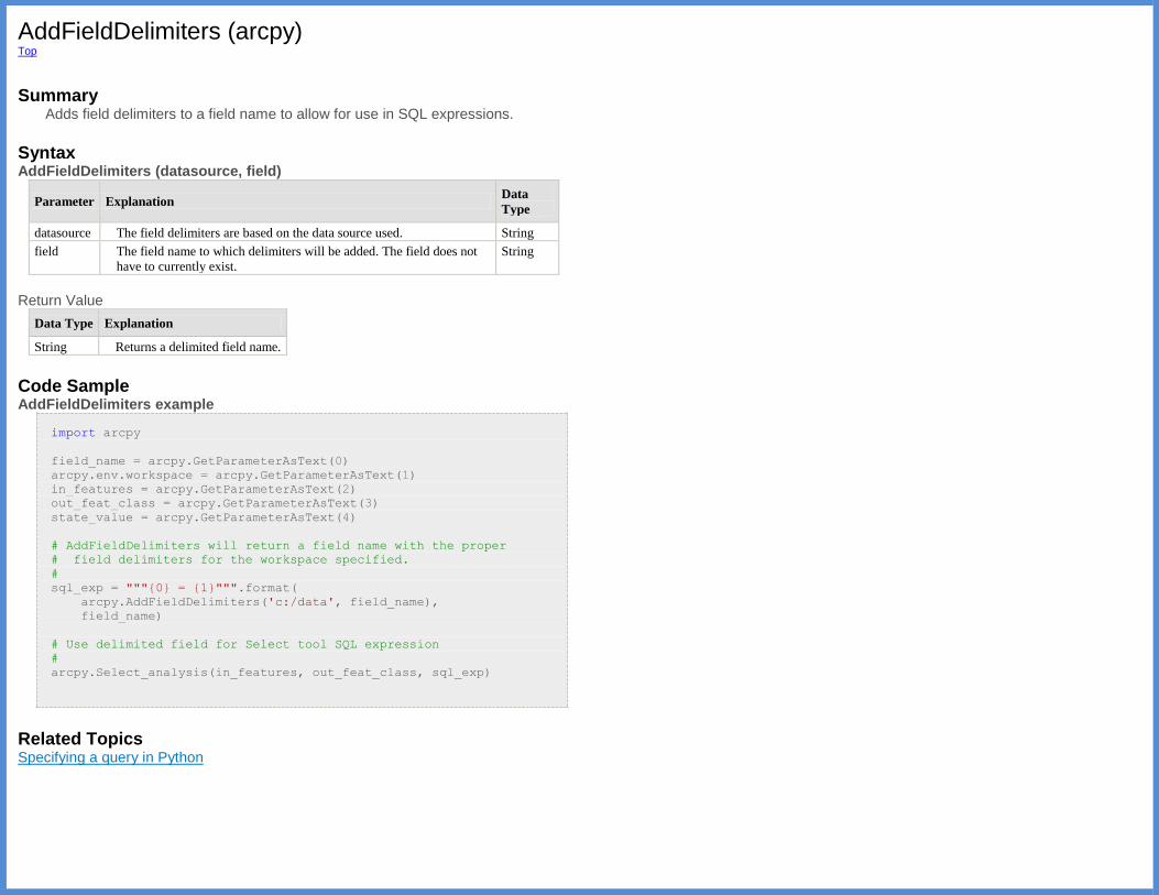
AddFieldDelimiters (arcpy) Top
Summary
Adds field delimiters to a field name to allow for use in SQL expressions.
Syntax AddFieldDelimiters (datasource, field)
Parameter Explanation Data
Type
datasource The field delimiters are based on the data source used. String
field The field name to which delimiters will be added. The field does not
have to currently exist.
String
Return Value
Data Type Explanation
String Returns a delimited field name.
Code Sample AddFieldDelimiters example
import arcpy
field_name = arcpy.GetParameterAsText(0)
arcpy.env.workspace = arcpy.GetParameterAsText(1)
in_features = arcpy.GetParameterAsText(2)
out_feat_class = arcpy.GetParameterAsText(3)
state_value = arcpy.GetParameterAsText(4)
# AddFieldDelimiters will return a field name with the proper
# field delimiters for the workspace specified.
#
sql_exp = """{0} = {1}""".format(
arcpy.AddFieldDelimiters('c:/data', field_name),
field_name)
# Use delimited field for Select tool SQL expression
#
arcpy.Select_analysis(in_features, out_feat_class, sql_exp)
Related Topics Specifying a query in Python
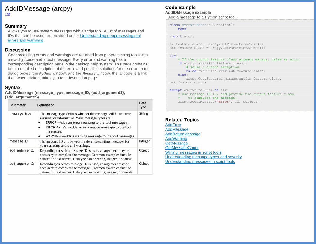
AddIDMessage (arcpy) Top
Summary
Allows you to use system messages with a script tool. A list of messages and IDs that can be used are provided under Understanding geoprocessing tool errors and warnings.
Discussion Geoprocessing errors and warnings are returned from geoprocessing tools with a six-digit code and a text message. Every error and warning has a corresponding description page in the desktop help system. This page contains both a detailed description of the error and possible solutions for the error. In tool dialog boxes, the Python window, and the Results window, the ID code is a link that, when clicked, takes you to a description page.
Syntax AddIDMessage (message_type, message_ID, {add_argument1}, {add_argument2})
Parameter Explanation Data
Type
message_type The message type defines whether the message will be an error,
warning, or informative. Valid message types are:
ERROR —Adds an error message to the tool messages.
INFORMATIVE —Adds an informative message to the tool
messages.
WARNING —Adds a warning message to the tool messages.
String
message_ID The message ID allows you to reference existing messages for
your scripting errors and warnings.
Integer
add_argument1 Depending on which message ID is used, an argument may be
necessary to complete the message. Common examples include
dataset or field names. Datatype can be string, integer, or double.
Object
add_argument2 Depending on which message ID is used, an argument may be
necessary to complete the message. Common examples include
dataset or field names. Datatype can be string, integer, or double.
Object
Code Sample AddIDMessage example
Add a message to a Python script tool.
class overwriteError(Exception):
pass
import arcpy
in_feature_class = arcpy.GetParameterAsText(0)
out_feature_class = arcpy.GetParameterAsText(1)
try:
# If the output feature class already exists, raise an error
if arcpy.Exists(in_feature_class):
# Raise a custom exception
raise overwriteError(out_feature_class)
else:
arcpy.CopyFeatures_management(in_feature_class,
out_feature_class)
except overwriteError as err:
# Use message ID 12, and provide the output feature class
# to complete the message.
arcpy.AddIDMessage("Error", 12, str(err))
Related Topics AddError AddMessage AddReturnMessage AddWarning GetMessage GetMessageCount Writing messages in script tools Understanding message types and severity Understanding messages in script tools

AddMessage (arcpy) Top
Summary
Creates a geoprocessing informative message (Severity=0) that can be accessed with any of the GetMessages functions.
Syntax AddMessage (message)
Parameter Explanation Data Type
message The message to add. String
Code Sample AddMessage example
Add custom informative message to the Python script tool.
import arcpy
fc = arcpy.GetParameterAsText(0)
# Get the count from GetCount's Result object
feature_count = int(arcpy.GetCount_management(fc).getOutput(0))
if feature_count == 0:
arcpy.AddError("{0} has no features.".format(fc))
else:
arcpy.AddMessage("{0} has {1} features.".format(fc,
feature_count))
Related Topics AddError AddIDMessage AddReturnMessage AddWarning GetMessage GetMessageCount GetMessages GetReturnCode Writing messages in script tools Understanding message types and severity Understanding messages in script tools
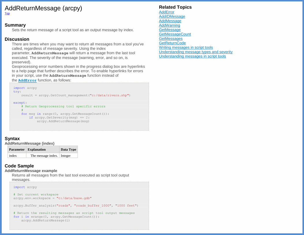
AddReturnMessage (arcpy) Top
Summary
Sets the return message of a script tool as an output message by index.
Discussion There are times when you may want to return all messages from a tool you've called, regardless of message severity. Using the index parameter, AddReturnMessage will return a message from the last tool
executed. The severity of the message (warning, error, and so on, is preserved). Geoprocessing error numbers shown in the progress dialog box are hyperlinks to a help page that further describes the error. To enable hyperlinks for errors in your script, use the AddReturnMessage function instead of
the AddError function, as follows:
import arcpy
try:
result = arcpy.GetCount_management("c:/data/rivers.shp")
except:
# Return Geoprocessing tool specific errors
#
for msg in range(0, arcpy.GetMessageCount()):
if arcpy.GetSeverity(msg) == 2:
arcpy.AddReturnMessage(msg)
Syntax AddReturnMessage (index)
Parameter Explanation Data Type
index The message index. Integer
Code Sample AddReturnMessage example
Returns all messages from the last tool executed as script tool output messages.
import arcpy
# Set current workspace
arcpy.env.workspace = "c:/data/base.gdb"
arcpy.Buffer_analysis("roads", "roads_buffer_1000", "1000 feet")
# Return the resulting messages as script tool output messages
for i in xrange(0, arcpy.GetMessageCount()):
arcpy.AddReturnMessage(i)
Related Topics AddError AddIDMessage AddMessage AddWarning GetMessage GetMessageCount GetMessages GetReturnCode Writing messages in script tools Understanding message types and severity Understanding messages in script tools

AddToolbox (arcpy) Top
Summary
Imports the specified toolbox into ArcPy, allowing for access to the toolbox's associated tools.
Note: Equivalent to the ImportToolbox function.
Discussion While any of the core ArcGIS toolboxes are accessible by default in a script, your own custom or third-party toolboxes must be added using ImportToolbox to use them in a script.
Other toolboxes may be found in any number of different folders or geodatabases, and may have many different origins; they may be toolboxes you have personally created, or are toolboxes created internally by your organization, or are toolboxes you have downloaded from sites like the Geoprocessing Resource Center. In any case, these toolboxes need to be imported into ArcPy in a one-step process before they can be used as tools in Python. Server toolboxes can also be added using a semicolon delimiter.
Server Syntax
Internet ArcGIS for Server URL;servicename;{username};{password}
Learn more about using a geoprocessing service in Python
Syntax AddToolbox (input_file, {module_name})
Parameter Explanation Data
Type
input_file The geoprocessing toolbox to be added to the ArcPy site package. String
module_name If the toolbox does not have an alias, the module_name is required.
When a tool is accessed through the ArcPy site package, the toolbox
alias where the tool is contained is a required suffix
(arcpy.<toolname>_<alias>). Since ArcPy depends on toolbox aliases
to access and execute the correct tool, aliases are extremely important
when importing custom toolboxes. A good practice is to always define
a custom toolbox's alias. However, if the toolbox alias is not defined, a
temporary alias can be set as the second parameter.
String
Return Value
Data Type Explanation
Module Returns the imported module.
If needed, tool names can be accessed from the module's __all__ property.
Code Sample AddToolbox example
Add the specified toolbox.
import arcpy
# Import custom toolbox
arcpy.AddToolbox("c:/tools/My_Analysis_Tools.tbx")
try:
# Run tool in the custom toolbox. The tool is identified by
# the tool name and the toolbox alias.
arcpy.GetPoints_myanalysis("c:/data/forest.shp")
except arcpy.ExecuteError:
print(arcpy.GetMessages(2))
Related Topics ImportToolbox Using tools in Python
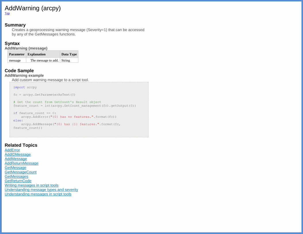
AddWarning (arcpy) Top
Summary
Creates a geoprocessing warning message (Severity=1) that can be accessed by any of the GetMessages functions.
Syntax AddWarning (message)
Parameter Explanation Data Type
message The message to add. String
Code Sample AddWarning example
Add custom warning message to a script tool.
import arcpy
fc = arcpy.GetParameterAsText(0)
# Get the count from GetCount's Result object
feature_count = int(arcpy.GetCount_management(fc).getOutput(0))
if feature_count == 0:
arcpy.AddError("{0} has no features.".format(fc))
else:
arcpy.AddMessage("{0} has {1} features.".format(fc,
feature_count))
Related Topics AddError AddIDMessage AddMessage AddReturnMessage GetMessage GetMessageCount GetMessages GetReturnCode Writing messages in script tools Understanding message types and severity Understanding messages in script tools
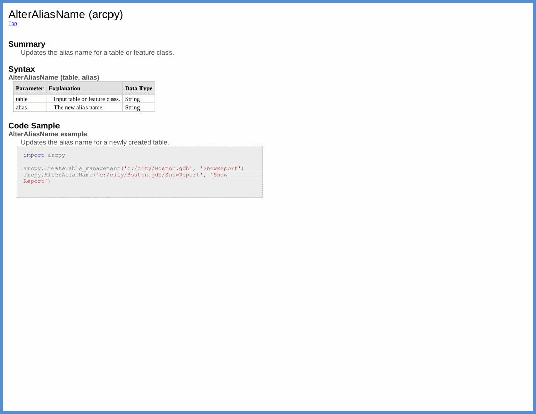
AlterAliasName (arcpy) Top
Summary
Updates the alias name for a table or feature class.
Syntax AlterAliasName (table, alias)
Parameter Explanation Data Type
table Input table or feature class. String
alias The new alias name. String
Code Sample AlterAliasName example
Updates the alias name for a newly created table.
import arcpy
arcpy.CreateTable_management('c:/city/Boston.gdb', 'SnowReport')
arcpy.AlterAliasName('c:/city/Boston.gdb/SnowReport', 'Snow
Report')

AsShape (arcpy) Top
Summary
Converts Esri JSON or GeoJSON to ArcPy geometry objects. GeoJSON is a geospatial data interchange format for encoding geographic data structures.
Syntax AsShape (geojson_struct, {esri_json})
Parameter Explanation Data
Type
geojson_struct The geojson_struct includes type and coordinates.
The following strings are included
for type: Point, LineString, Polygon, MultiPoint,
and MultiLineString.
Dictionary
esri_json Sets whether the input JSON is evaluated as Esri JSON or
GeoJSON. If True, the input is evaluated as Esri JSON.
(The default value is False)
Boolean
Return Value
Data
Type Explanation
Geometry AsShape returns a geometry object (PointGeometry, Multipoint, Polyline,
or Polygon) based on the input GeoJSON or esriJSON object.
import arcpy
geojson_point = {"type": "Point", "coordinates": [5.0,
5.0]}
point = arcpy.AsShape(geojson_point)
Code Sample AsShape example 1
Create a PointGeometry object using a GeoJSON object.
import arcpy
geojson_point = {
"type": "Point",
"coordinates": [5.0, 5.0]}
point = arcpy.AsShape(geojson_point)
AsShape example 2 Create a PointGeometry object using an Esri JSON object.
import arcpy
esri_json = {
"x": -122.65,
"y": 45.53,
"spatialReference": {
"wkid": 4326}}
# Set the second parameter to True to use an esri JSON
point = arcpy.AsShape(esri_json, True)
AsShape example 3
Create a Multipoint object using a GeoJSON object.
import arcpy
geojson_multipoint = {
"type": "MultiPoint",
"coordinates": [[5.0, 4.0], [8.0, 7.0]]}
multipoint = arcpy.AsShape(geojson_multipoint)
AsShape example 4
Create a Multipoint object using an Esri JSON object.
import arcpy
esri_json = {
"points" : [
[-97.06138, 32.837],
[-97.06133, 32.836],
[-97.06124, 32.834],
[-97.06127, 32.832]],
"spatialReference" : {"wkid" : 4326}}
# Set the second parameter to True to use an esri JSON
multipoint = arcpy.AsShape(esri_json, True)
Continued on next page. AsShape example 5
Create a Polyline object using a GeoJSON object.
import arcpy
geojson_linestring = {
"type": "LineString",
"coordinates": [[5.0, 4.0], [8.0, 7.0]]}
polyline = arcpy.AsShape(geojson_linestring)

AsShape example 6 Create a Polyline object using an Esri JSON object.
import arcpy
esri_json = {
"paths" : [
[[-97.08, 32.8], [-97.05, 32.6], [-97.06, 32.7],
[-97.07, 32.6]],
[[-97.4, 32.5], [-97.2, 32.75]]],
"spatialReference" : {"wkid" : 4326}}
# Set the second parameter to True to use an esri JSON
polyline = arcpy.AsShape(esri_json, True)
AsShape example 7
Create a multipart Polyline object using a GeoJSON object.
import arcpy
geojson_multilinestring = {
"type": "MultiLineString",
"coordinates": [
[[5.0, 4.0], [8.0, 7.0]],
[[4.0, 5.0], [7.0, 8.0]]]}
polyline = arcpy.AsShape(geojson_multilinestring)
AsShape example 8
Create a Polygon object using a GeoJSON object.
import arcpy
geojson_polygon = {
"type": "Polygon",
"coordinates": [
[[10.0, 0.0], [20.0, 0.0], [20.0, 10.0], [10.0, 10.0],
[10.0, 0.0]]]}
polygon = arcpy.AsShape(geojson_polygon)
AsShape example 9 Create a Polygon with a hole object using a GeoJSON object.
import arcpy
geojson_polygon = {
"type": "Polygon",
"coordinates": [
[[10.0, 0.0], [20.0, 0.0], [20.0, 10.0], [10.0, 10.0],
[10.0, 0.0]],
[[12.0, 2.0], [18.0, 2.0], [18.0, 8.0], [12.0, 8.0],
[12.0, 2.0]]]}
polygon = arcpy.AsShape(geojson_polygon)
Related Topics FromWKB FromWKT
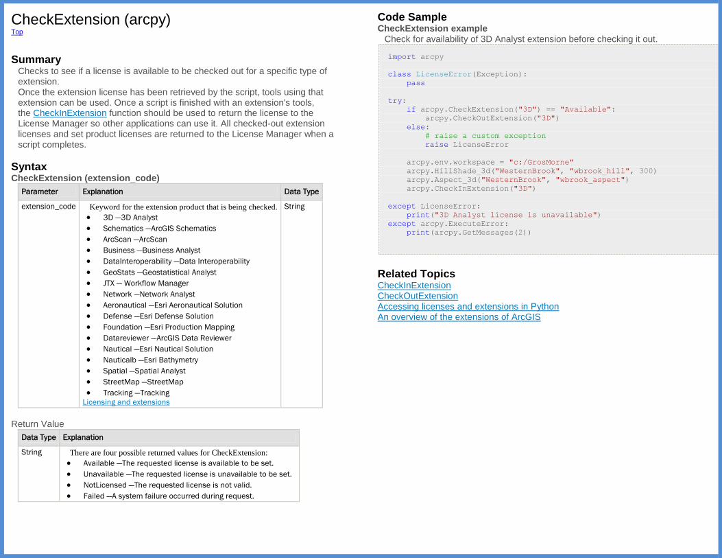
CheckExtension (arcpy) Top
Summary
Checks to see if a license is available to be checked out for a specific type of extension. Once the extension license has been retrieved by the script, tools using that extension can be used. Once a script is finished with an extension's tools, the CheckInExtension function should be used to return the license to the License Manager so other applications can use it. All checked-out extension licenses and set product licenses are returned to the License Manager when a script completes.
Syntax CheckExtension (extension_code)
Parameter Explanation Data Type
extension_code Keyword for the extension product that is being checked.
3D —3D Analyst
Schematics —ArcGIS Schematics
ArcScan —ArcScan
Business —Business Analyst
DataInteroperability —Data Interoperability
GeoStats —Geostatistical Analyst
JTX — Workflow Manager
Network —Network Analyst
Aeronautical —Esri Aeronautical Solution
Defense —Esri Defense Solution
Foundation —Esri Production Mapping
Datareviewer —ArcGIS Data Reviewer
Nautical —Esri Nautical Solution
Nauticalb —Esri Bathymetry
Spatial —Spatial Analyst
StreetMap —StreetMap
Tracking —Tracking
Licensing and extensions
String
Return Value
Data Type Explanation
String There are four possible returned values for CheckExtension:
Available —The requested license is available to be set.
Unavailable —The requested license is unavailable to be set.
NotLicensed —The requested license is not valid.
Failed —A system failure occurred during request.
Code Sample CheckExtension example
Check for availability of 3D Analyst extension before checking it out.
import arcpy
class LicenseError(Exception):
pass
try:
if arcpy.CheckExtension("3D") == "Available":
arcpy.CheckOutExtension("3D")
else:
# raise a custom exception
raise LicenseError
arcpy.env.workspace = "c:/GrosMorne"
arcpy.HillShade_3d("WesternBrook", "wbrook_hill", 300)
arcpy.Aspect_3d("WesternBrook", "wbrook_aspect")
arcpy.CheckInExtension("3D")
except LicenseError:
print("3D Analyst license is unavailable")
except arcpy.ExecuteError:
print(arcpy.GetMessages(2))
Related Topics CheckInExtension CheckOutExtension Accessing licenses and extensions in Python An overview of the extensions of ArcGIS
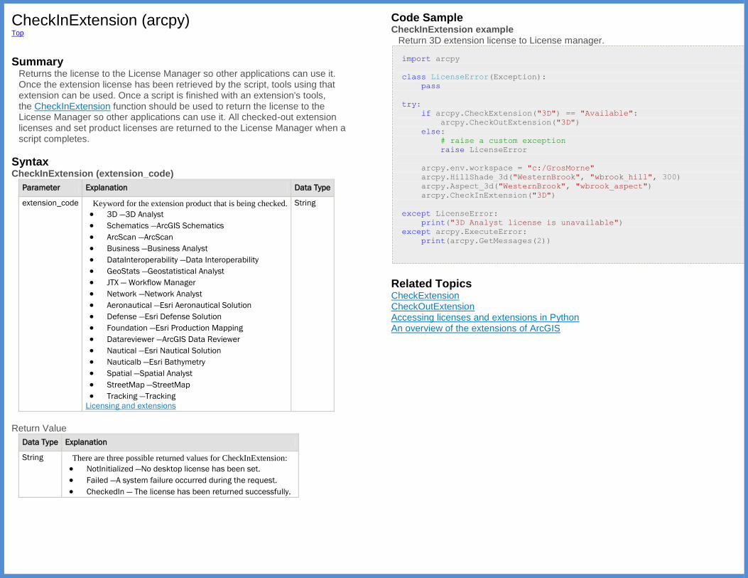
CheckInExtension (arcpy) Top
Summary
Returns the license to the License Manager so other applications can use it. Once the extension license has been retrieved by the script, tools using that extension can be used. Once a script is finished with an extension's tools, the CheckInExtension function should be used to return the license to the License Manager so other applications can use it. All checked-out extension licenses and set product licenses are returned to the License Manager when a script completes.
Syntax CheckInExtension (extension_code)
Parameter Explanation Data Type
extension_code Keyword for the extension product that is being checked.
3D —3D Analyst
Schematics —ArcGIS Schematics
ArcScan —ArcScan
Business —Business Analyst
DataInteroperability —Data Interoperability
GeoStats —Geostatistical Analyst
JTX — Workflow Manager
Network —Network Analyst
Aeronautical —Esri Aeronautical Solution
Defense —Esri Defense Solution
Foundation —Esri Production Mapping
Datareviewer —ArcGIS Data Reviewer
Nautical —Esri Nautical Solution
Nauticalb —Esri Bathymetry
Spatial —Spatial Analyst
StreetMap —StreetMap
Tracking —Tracking
Licensing and extensions
String
Return Value
Data Type Explanation
String There are three possible returned values for CheckInExtension:
NotInitialized —No desktop license has been set.
Failed —A system failure occurred during the request.
CheckedIn — The license has been returned successfully.
Code Sample CheckInExtension example
Return 3D extension license to License manager.
import arcpy
class LicenseError(Exception):
pass
try:
if arcpy.CheckExtension("3D") == "Available":
arcpy.CheckOutExtension("3D")
else:
# raise a custom exception
raise LicenseError
arcpy.env.workspace = "c:/GrosMorne"
arcpy.HillShade_3d("WesternBrook", "wbrook_hill", 300)
arcpy.Aspect_3d("WesternBrook", "wbrook_aspect")
arcpy.CheckInExtension("3D")
except LicenseError:
print("3D Analyst license is unavailable")
except arcpy.ExecuteError:
print(arcpy.GetMessages(2))
Related Topics CheckExtension CheckOutExtension Accessing licenses and extensions in Python An overview of the extensions of ArcGIS
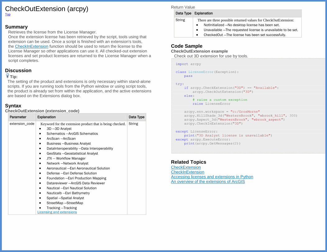
CheckOutExtension (arcpy) Top
Summary
Retrieves the license from the License Manager. Once the extension license has been retrieved by the script, tools using that extension can be used. Once a script is finished with an extension's tools, the CheckInExtension function should be used to return the license to the License Manager so other applications can use it. All checked-out extension licenses and set product licenses are returned to the License Manager when a script completes.
Discussion
Tip: The setting of the product and extensions is only necessary within stand-alone scripts. If you are running tools from the Python window or using script tools, the product is already set from within the application, and the active extensions are based on the Extensions dialog box.
Syntax CheckOutExtension (extension_code)
Parameter Explanation Data Type
extension_code Keyword for the extension product that is being checked.
3D —3D Analyst
Schematics —ArcGIS Schematics
ArcScan —ArcScan
Business —Business Analyst
DataInteroperability —Data Interoperability
GeoStats —Geostatistical Analyst
JTX — Workflow Manager
Network —Network Analyst
Aeronautical —Esri Aeronautical Solution
Defense —Esri Defense Solution
Foundation —Esri Production Mapping
Datareviewer —ArcGIS Data Reviewer
Nautical —Esri Nautical Solution
Nauticalb —Esri Bathymetry
Spatial —Spatial Analyst
StreetMap —StreetMap
Tracking —Tracking
Licensing and extensions
String
Return Value
Data Type Explanation
String There are three possible returned values for CheckOutExtension:
NotInitialized —No desktop license has been set.
Unavailable —The requested license is unavailable to be set.
CheckedOut —The license has been set successfully.
Code Sample CheckOutExtension example
Check out 3D extension for use by tools.
import arcpy
class LicenseError(Exception):
pass
try:
if arcpy.CheckExtension("3D") == "Available":
arcpy.CheckOutExtension("3D")
else:
# raise a custom exception
raise LicenseError
arcpy.env.workspace = "c:/GrosMorne"
arcpy.HillShade_3d("WesternBrook", "wbrook_hill", 300)
arcpy.Aspect_3d("WesternBrook", "wbrook_aspect")
arcpy.CheckInExtension("3D")
except LicenseError:
print("3D Analyst license is unavailable")
except arcpy.ExecuteError:
print(arcpy.GetMessages(2))
Related Topics CheckExtension CheckInExtension Accessing licenses and extensions in Python An overview of the extensions of ArcGIS

CheckProduct (arcpy) Top
Summary
Checks to see if the requested license is available.
Syntax CheckProduct (product)
Parameter Explanation Data Type
product Product code for the product being checked.
arcview —ArcGIS for Desktop Basic product code
arceditor —ArcGIS for Desktop Standard product code
arcinfo —ArcGIS for Desktop Advanced product code
engine —Engine Runtime product code
enginegeodb —Engine Geodatabase Update product code
arcserver — Server product code
String
Return Value
Data Type Explanation
String There are five possible return values for CheckProduct:
AlreadyInitalized — License has already been set in the script.
Available — The requested license is available to be set.
Unavailable — The requested license is unavailable to be set.
NotLicensed — The requested license is not valid.
Failed — A system failure occurred during the request.
Code Sample CheckProduct example
Check to see if an ArcGIS for Desktop Advanced license is available.
import sys
import arcpy
arcpy.env.workspace = "c:/data/world.gdb"
if arcpy.CheckProduct("ArcInfo") == "Available":
arcpy.PolygonToLine_management("Lakes", "LakeLines")
else:
msg = 'ArcGIS for Desktop Advanced license not available'
print(msg)
sys.exit(msg)
Related Topics SetProduct ProductInfo Accessing licenses and extensions in Python
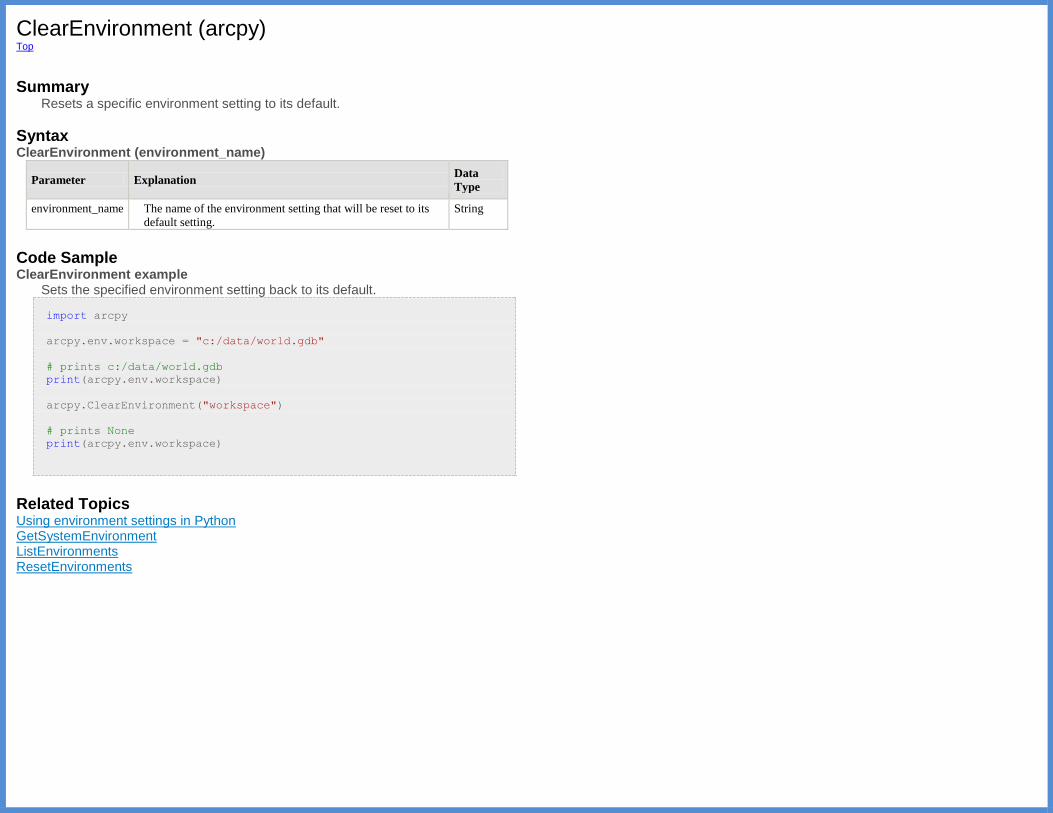
ClearEnvironment (arcpy) Top
Summary
Resets a specific environment setting to its default.
Syntax ClearEnvironment (environment_name)
Parameter Explanation Data
Type
environment_name The name of the environment setting that will be reset to its
default setting.
String
Code Sample ClearEnvironment example
Sets the specified environment setting back to its default.
import arcpy
arcpy.env.workspace = "c:/data/world.gdb"
# prints c:/data/world.gdb
print(arcpy.env.workspace)
arcpy.ClearEnvironment("workspace")
# prints None
print(arcpy.env.workspace)
Related Topics Using environment settings in Python GetSystemEnvironment ListEnvironments ResetEnvironments
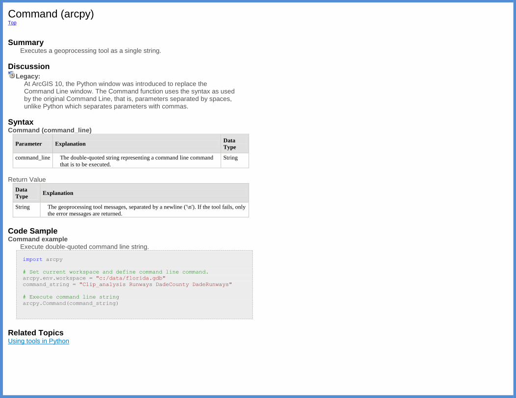
Command (arcpy) Top
Summary
Executes a geoprocessing tool as a single string.
Discussion
Legacy: At ArcGIS 10, the Python window was introduced to replace the Command Line window. The Command function uses the syntax as used by the original Command Line, that is, parameters separated by spaces, unlike Python which separates parameters with commas.
Syntax Command (command_line)
Parameter Explanation Data
Type
command_line The double-quoted string representing a command line command
that is to be executed.
String
Return Value
Data
Type Explanation
String The geoprocessing tool messages, separated by a newline ('\n'). If the tool fails, only
the error messages are returned.
Code Sample Command example
Execute double-quoted command line string.
import arcpy
# Set current workspace and define command line command.
arcpy.env.workspace = "c:/data/florida.gdb"
command_string = "Clip_analysis Runways DadeCounty DadeRunways"
# Execute command line string
arcpy.Command(command_string)
Related Topics Using tools in Python
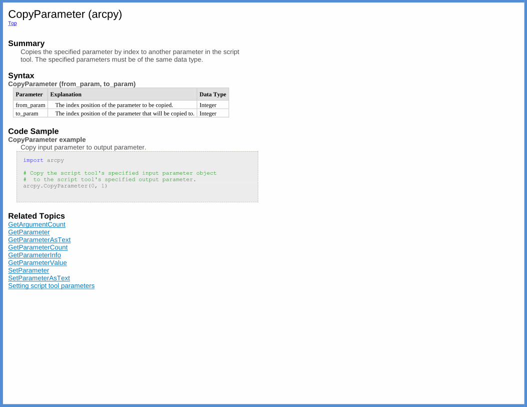
CopyParameter (arcpy) Top
Summary
Copies the specified parameter by index to another parameter in the script tool. The specified parameters must be of the same data type.
Syntax CopyParameter (from_param, to_param)
Parameter Explanation Data Type
from_param The index position of the parameter to be copied. Integer
to_param The index position of the parameter that will be copied to. Integer
Code Sample CopyParameter example
Copy input parameter to output parameter.
import arcpy
# Copy the script tool's specified input parameter object
# to the script tool's specified output parameter.
arcpy.CopyParameter(0, 1)
Related Topics GetArgumentCount GetParameter GetParameterAsText GetParameterCount GetParameterInfo GetParameterValue SetParameter SetParameterAsText Setting script tool parameters
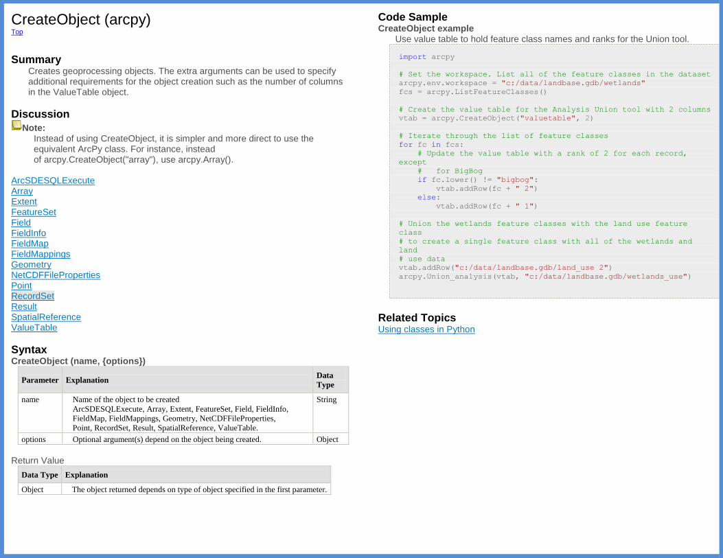
CreateObject (arcpy) Top
Summary
Creates geoprocessing objects. The extra arguments can be used to specify additional requirements for the object creation such as the number of columns in the ValueTable object.
Discussion
Note: Instead of using CreateObject, it is simpler and more direct to use the equivalent ArcPy class. For instance, instead of arcpy.CreateObject("array"), use arcpy.Array().
ArcSDESQLExecute Array Extent FeatureSet Field FieldInfo FieldMap FieldMappings Geometry NetCDFFileProperties Point RecordSet Result SpatialReference ValueTable
Syntax CreateObject (name, {options})
Parameter Explanation Data
Type
name Name of the object to be created
ArcSDESQLExecute, Array, Extent, FeatureSet, Field, FieldInfo,
FieldMap, FieldMappings, Geometry, NetCDFFileProperties,
Point, RecordSet, Result, SpatialReference, ValueTable.
String
options Optional argument(s) depend on the object being created. Object
Return Value
Data Type Explanation
Object The object returned depends on type of object specified in the first parameter.
Code Sample CreateObject example
Use value table to hold feature class names and ranks for the Union tool.
import arcpy
# Set the workspace. List all of the feature classes in the dataset
arcpy.env.workspace = "c:/data/landbase.gdb/wetlands"
fcs = arcpy.ListFeatureClasses()
# Create the value table for the Analysis Union tool with 2 columns
vtab = arcpy.CreateObject("valuetable", 2)
# Iterate through the list of feature classes
for fc in fcs:
# Update the value table with a rank of 2 for each record,
except
# for BigBog
if fc.lower() != "bigbog":
vtab.addRow(fc + " 2")
else:
vtab.addRow(fc + " 1")
# Union the wetlands feature classes with the land use feature
class
# to create a single feature class with all of the wetlands and
land
# use data
vtab.addRow("c:/data/landbase.gdb/land_use 2")
arcpy.Union_analysis(vtab, "c:/data/landbase.gdb/wetlands_use")
Related Topics Using classes in Python

CreateGPSDDraft (arcpy) Top
Summary
The function converts Result objects and result files (.rlt) into Service
Definition Draft (.sddraft) files.
Note: A draft service definition does not contain data. A draft service alone cannot be used to publish a service.
Discussion CreateGPSDDraft is the first step to automating the publishing of a
geoprocessing result to a GIS Server using ArcPy. The output created from the CreateGPSDDraft is a Service Definition Draft (.sddraft) file. A Service
Definition Draft is the combination of a result file or Result object, information
about the server, and a set of service properties. A Result object can be
created in a Python script by setting a variable to a tool execution, for example,
the following buffer result gets saved to a variable calledresult:
import arcpy
result = arcpy.Buffer_analysis("inPts", "output.shp", "100 Meters")
Result files can be created by right clicking a result in the Results window and choosing Save As.
Information about the server includes the server connection, server type being published to, the type of service being published, metadata for the service (Item info), and data references (whether or not data is being copied to the server). Service properties include geoprocessing and additional capabilities of the service such as Web Processing Services (WPS). The capabilities are not exposed as a parameter. If you need to modify the value (or any nonexposed parameter), you need to publish the sddraft first and modify the draft by editing
the .sddraft using XML libraries such as xml.dom.minidom. Please refer to
the example of modifying an sddraft for the usage of the library. Although the example is from a map service draft, you can use the same library and method for the GP service draft since it is an XML file. The function returns a Python dictionary containing errors and other potential issues that you should address prior to creating your Service Definition file. A Service Definition Draft can be authored without knowing the specific server connection information. In this case, the connection_file_path parameter
may be omitted; however, the server_type must be provided. A server
connection can be provided later when the Service Definition Draft is published using the Upload Service Definition tool. The Service Definition Draft can then be converted to a fully consolidated
Service Definition (.sd) file using the Stage Service tool. Staging compiles all
the necessary information needed to successfully publish the GIS resource. If your data is not registered with the server, the data will be added when the Service Definition Draft is staged. Finally, the Service Definition file can be
uploaded and published as a GIS service to a specified GIS server using the Upload Service Definition tool. This step takes the Service Definition file, copies it onto the server, extracts required information, and publishes the GIS resource. For more information, see the An overview of the Publishing toolset.
Syntax CreateGPSDDraft (result, out_sddraft, service_name, {server_type}, {connection_file_path}, {copy_data_to_server}, {folder_name}, {summary}, {tags}, {executionType}, {resultMapServer}, {showMessages}, {maximumRecords}, {minInstances}, {maxInstances}, {maxUsageTime}, {maxWaitTime}, {maxIdleTime})
Parameter Explanation Data
Type
result [result,...]
A reference to one or multiple Result objects or result
files (.rlt) on disk. Multiple results must be supplied in a
list format. The following example demonstrates multiple
results as input to the CreateGPSDDraft function.
import arcpy
r1 = arcpy.Buffer_analysis("inPts",
"output.shp", "100 Meters")
r2 =
arcpy.GetCount_management("FireStations")
arcpy.CreateGPSDDraft([r1, r2],
"output.sddraft", "myservice")
Result
out_sddraft A string that represents the path and file name for the output
Service Definition Draft (.sddraft) file.
String
service_name A string that represents the name of the service. This is the
name people will see and use to identify the service. The
name can only contain alphanumeric characters and
underscores. No spaces or special characters are allowed.
The name cannot be more than 120 characters in length.
String
server_type A string representing the server type. If
a connection_file_path parameter is not supplied,
then a server_type must be provided. If
aconnection_file_path parameter is supplied, then
the server_type is taken from the connection file. In this
case, you can chooseFROM_CONNECTION_FILE or skip
the parameter entirely.
ARCGIS_SERVER —ArcGIS for Server server type
FROM_CONNECTION_FILE —Get
the server_type as specified in
the connection_file_path parameter
(The default value is ARCGIS_SERVER)
String
connection_file_path A string that represents the path and file name to the ArcGIS
for Server connection file (.ags).
String
copy_data_to_server A Boolean that indicates whether the data referenced in
the result will be copied to the server or not.
The copy_data_to_server parameter is only used if
the server_type is ARCGIS_SERVER and
Boolean
the connection_file_path isn't specified. If
the connection_file_path is specified, then the
server's registered data stores are used. For example, if the
data in the result is registered with the server,
then copy_data_to_serverwill always be False.
Conversely, if the data in the result is not registered with
the server, then copy_data_to_server will always
be True.
(The default value is False)
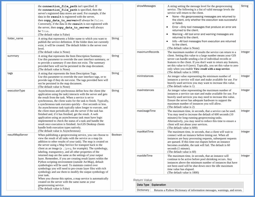
folder_name A string that represents a folder name to which you want to
publish the service definition. If the folder does not currently
exist, it will be created. The default folder is the server root
level.
(The default value is None)
String
summary A string that represents the Item Description Summary.
Use this parameter to override the user interface summary, or
to provide a summary if one does not exist. The summary
provided here will not be persisted in the map document.
(The default value is None)
String
tags A string that represents the Item Description Tags.
Use this parameter to override the user interface tags, or to
provide tags if they do not exist. The tags provided here will
not be persisted in the map document.
(The default value is None)
String
executionType Asynchronous and synchronous define how the client (the
application using the task) interacts with the server and gets
the result from the task. When a service is set to
synchronous, the client waits for the task to finish. Typically,
a synchronous task executes quickly—five seconds or less.
An asynchronous task typically takes longer to execute, and
the client must periodically ask the server if the task has
finished and, if it has finished, get the result. A web
application using an asynchronous task must have logic
implemented to check the status of a task and handle the
result once execution is finished. ArcGIS Desktop clients
handle both execution types natively.
(The default value is Asynchronous)
String
resultMapServer When publishing a geoprocessing service, you can choose to
view the result of all tasks with the service as a map (in
addition to other results of your task). The map is created on
the server using a Map Service for transport back to the
client as an image (a .jpeg, for example). The symbology,
labeling, transparency, and all other properties of the
returned map are the same as the settings of your output
layer. Remember, if you are creating result layers within the
Python scripting environment (outside ArcMap), default
symbologies will be used. To maintain control over
symbology you will need to pre-create layer files with rich
symbology and use them to modify the output symbology of
your task.
When you choose this option, a map service is automatically
created on the server with the same name as your
geoprocessing service.
(The default value is False)
Boolean
showMessages A string setting the message level for the geoprocessing
service. The following is a list of valid message levels the
service will return to the client.
None —No geoprocessing messages are returned to
the client, only whether the execution was successful
or failed.
Error —Only tool messages that produce an error are
returned to the client.
Warning —All tool error and warning messages are
returned to the client.
Info —All tool messages from execution are returned
to the client.
(The default value is None)
String
maximumRecords The maximum number of results the service can return to a
client. Setting this value to a large number means your GIS
server can handle sending a lot of individual records or
features to the client. If you don't want to return any features,
set this value to 0 (zero). Typically, you set this value to zero
only when you enable View result with a map service.
(The default value is 1000)
Integer
minInstances An integer value representing the minimum number of
instances a service will start and make available for use. For
heavily used services you may want to increase this value.
(The default value is 1)
Integer
maxInstances An integer value representing the maximum number of
instances a service can start and make available for use. For
heavily used services you may need to increase this value.
Ensure the server has adequate hardware to support the
maximum number of instances you will allow.
(The default value is 2)
Integer
maxUsageTime The maximum time, in seconds, that a service can be used.
You may need to increase the default of 600 seconds (10
minutes) for long-running geoprocessing tasks.
Alternatively, you may need to reduce this time to ensure a
client will not abuse your services.
(The default value is 600)
Integer
maxWaitTime The maximum time, in seconds, that a client will wait to
connect with an instance before timing out. When all
instances are busy processing requests, subsequent requests
are queued. If this time-out elapses before an instance
becomes available, the task will fail. The default is 60
seconds (1 minute).
(The default value is 60)
Integer
maxIdleTime The maximum time, in seconds, that an instance will
continue to be active before pool shrinking occurs. Any
instances above the minimum number of instances that have
not been used will be shut down once the idle maximum
time value has elapsed.
(The default value is 1800)
Integer
Return Value
Data Type Explanation
Dictionary Returns a Python Dictionary of information messages, warnings, and errors.

Code Sample CreateGPSDDraft example 1
The following script demonstrates the complete publishing of a geoprocessing service through Python scripting. Automating the publishing of geoprocessing services uses a combination of ArcPy functions and geoprocessing tools in the Publishing toolset. The workflow begins by executing a geoprocessing task that you want to publish. After you have successfully run the geoprocessing task, and have saved a result file, use the ArcPy function CreateGPSDDraft to create a service definition draft. Note that the Item Description, Summary, and Tags for the input geoprocessing result are overwritten using the summary and tags parameters. Next, you should analyze the service definition draft for issues that could prevent you from publishing successfully by using theAnalyzeForSD function. After analyzing the service definition draft and
addressing serious issues, it is time to stage the service definition. Staging takes the service definition draft and consolidates all the information needed to publish the service into a completeservice definition. Use the Stage_Service geoprocessing tool to stage the service definition. Finally, use the Upload_Service_Definition geoprocessing tool to upload the service definition to the server and publish the geoprocessing service.
import arcpy
result = "c:/gis/gp/Analysis.rlt"
connectionPath = "c:/gis/conections/myServer.ags"
sddraft = "c:/gis/gp/drafts/AnalysisDraft.sddraft"
sd = "c:/gis/gp/sd/AnalysisDraft.sd"
serviceName = "AnalysisService"
# Create service definition draft
arcpy.CreateGPSDDraft(
result, sddraft, serviceName, server_type="ARCGIS_SERVER",
connection_file_path=connectionPath, copy_data_to_server=True,
folder_name=None, summary="Analysis Service", tags="gp",
executionType="Synchronous", resultMapServer=False,
showMessages="INFO", maximumRecords=5000, minInstances=2,
maxInstances=3, maxUsageTime=100, maxWaitTime=10,
maxIdleTime=180)
# Analyze the service definition draft
analyzeMessages = arcpy.mapping.AnalyzeForSD(sddraft)
# Stage and upload the service if the sddraft analysis did not
# contain errors
if analyzeMessages['errors'] == {}:
# Execute StageService
arcpy.StageService_server(sddraft, sd)
# Execute UploadServiceDefinition
arcpy.UploadServiceDefinition_server(sd, connectionPath)
else:
# If the sddraft analysis contained errors, display them
print analyzeMessages['errors']
Continued on next page.

CreateGPSDDraft example 2 This example demonstrates the creation and publishing of the extract data workflow and ensures the data is registered with the server. The Extract Data task takes input layers and allows the user to extract an area of interest, convert to another output type and receive a zip file back as output. The Extract Data tool only uses layers as input. This example creates multiple layers using the Make Feature Layer tool, runs the tool, creates a service definition draft and uploads the service definition to be used in service creation. Any layer that was created in the Python session of the workflow will be considered as possible input in the final service and available as a choice selection.
import os
import arcpy
connPath = "c:/gis/conections/myServer.ags"
sddraft = "c:/gis/gp/drafts/ExtractionDraft.sddraft"
sd = "c:/gis/gp/sd/AnalysisDraft.sd"
serviceName = "DataExtractor"
arcpy.env.workspace = "c:/gis/citydata"
aoi = "c:/gis/citydata/extract.shp"
# Create layers which will be available as input
arcpy.MakeFeatureLayer_management('Wiarton.gdb/places/Cityhall',
'CityHall')
arcpy.MakeFeatureLayer_management('Wiarton.gdb/places/Airport',
'Airport')
arcpy.MakeFeatureLayer_management('Wiarton.gdb/places/FireStations',
'FireStations')
# Run the extract data task and assign it to the 'result' variable
# only the cityhall layer was used as input, but the airport and
# firestation layers will be used in the service creation
result = arcpy.ExtractDataTask_server(
"CityHall", aoi, "File Geodatabase - GDB - .gdb", "ESRI GRID -
GRID",
os.path.join(arcpy.env.scratchFolder, "output.zip"))
# Make sure the folder is registered with the server, if not, add
# it to the datastore
if arcpy.env.workspace not in [
i[2] for i in arcpy.ListDataStoreItems(connPath, 'FOLDER')]:
# both the client and server paths are the same
dsStatus = arcpy.AddDataStoreItem(
connPath, "FOLDER", "CityData", arcpy.env.workspace,
arcpy.env.workspace)
print("Data store : {0}".format(dsStatus))
# Create service definition draft
arcpy.CreateGPSDDraft(
result, sddraft, serviceName, server_type="ARCGIS_SERVER",
connection_file_path=connPath, copy_data_to_server=False,
folder_name=None, summary="Extraction Service",
tags="extract data, clip")
# Analyze the service definition draft
analyzeMessages = arcpy.mapping.AnalyzeForSD(sddraft)
# Stage and upload the service if the sddraft analysis did not
# contain errors
if analyzeMessages['errors'] == {}:
# Execute StageService
arcpy.StageService_server(sddraft, sd)
# Execute UploadServiceDefinition
upStatus = arcpy.UploadServiceDefinition_server(sd, connPath)
print("Completed upload")
else:
# If the sddraft analysis contained errors, display them
print(analyzeMessages['errors'])
Related Topics AnalyzeForSD CreateImageSDDraft CreateMapSDDraft

CreateImageSDDraft (arcpy) Top
Summary The CreateImageSDDraft function is the first step to automating the
publishing of a mosaic dataset or raster dataset as an Image Service using ArcPy. The output created from the CreateImageSDDraft is a Service
Definition Draft (.sddraft) file, which is a combination of a mosaic dataset in the geodatabase or a raster dataset, information about the server, and a set of service properties. This service definition draft can be staged as service definition then uploaded to a specified ArcGIS server as an image service. Information about the server includes the server connection or server type being published to, the type of service being published, metadata for the service (Item info), and data references (whether or not data is being copied to the server).
Note: A draft service definition does not contain data. A draft service alone cannot be used to publish a service.
Syntax CreateImageSDDraft (raster_or_mosaic_layer, out_sddraft, service_name, {server_type}, {connection_file_path}, {copy_data_to_server}, {folder_name}, {summary}, {tags})
Parameter Explanation Data
Type
raster_or_mosaic_layer The raster layer or mosaic layer that you want to publish. String
out_sddraft A string that represents the path and file name for the
output Service Definition Draft (.sddraft) file.
String
service_name A string that represents the name of the service. This is the
name people will see and use to identify the service. The
name can only contain alphanumeric characters and
underscores. No spaces or special characters are allowed.
The name cannot be more than 120 characters in length.
String
server_type A string representing the server type. If
a connection_file_path parameter is not supplied,
then a server_type must be provided. If
aconnection_file_path parameter is supplied, then
the server_type is taken from the connection file. In
this case, you can chooseFROM_CONNECTION_FILE or
skip the parameter entirely.
ARCGIS_SERVER —ArcGIS for Server server type.
FROM_CONNECTION_FILE —Get
the server_type as specified in
the connection_file_path parameter.
(The default value is ARCGIS_SERVER)
String
connection_file_path A string that represents the path and file name to
the ArcGIS for Server connection file (.ags).
(The default value is None)
String
copy_data_to_server A Boolean that indicates whether the source data
referenced by the mosaic dataset, the mosaic dataset itself,
or the raster dataset published as an image service will be
copied to the server or not.
The copy_data_to_server parameter is only used if the
server_type is ARCGIS_SERVER and
the connection_file_path isn't specified. If
theconnection_file_path is specified, then the server's
registered data stores are used. For example, if the
workspace that contains the source data referenced by the
mosaic dataset—the mosaic dataset itself or raster dataset
registered with the server—then copy_data_to_server will
always beFalse. Conversely, if the workspace that
contains the source data referenced by the mosaic
dataset—the mosaic dataset or raster dataset is not
registered with the server—then copy_data_to_server will
always be True.
False —The data will not be copied to the server.
This is the default.
True —The data will be copied to the server.
(The default value is False)
Boolean
folder_name A string that represents a folder name to which you want
to publish the service definition. If the folder does not
currently exist, it will be created. The default folder is the
server root level.
(The default value is None)
String
summary A string that represents the Item Description Summary.
Use this parameter to override the user interface summary
or to provide a summary if one does not exist.
(The default value is None)
String
tags A string that represents the Item Description Tags.
Use this parameter to override the user interface tags or to
provide tags if they do not exist.
(The default value is None)
String
Code Sample CreateImageSDDraft example 1
Create an image service definition draft file.
import arcpy
ws = "C:/workspace"
mdpath = os.path.join(ws, "fgdb.gdb/mdDEM")
con = os.path.join(ws, "myserver_6080 (publisher).ags")
service = 'dem_service'
sddraft = os.path.join(ws, service + '.sddraft')
arcpy.CreateImageSDDraft(mdpath, sddraft, service, 'ARCGIS_SERVER',
con, True, None, "Publish las MD",
"las,image service")
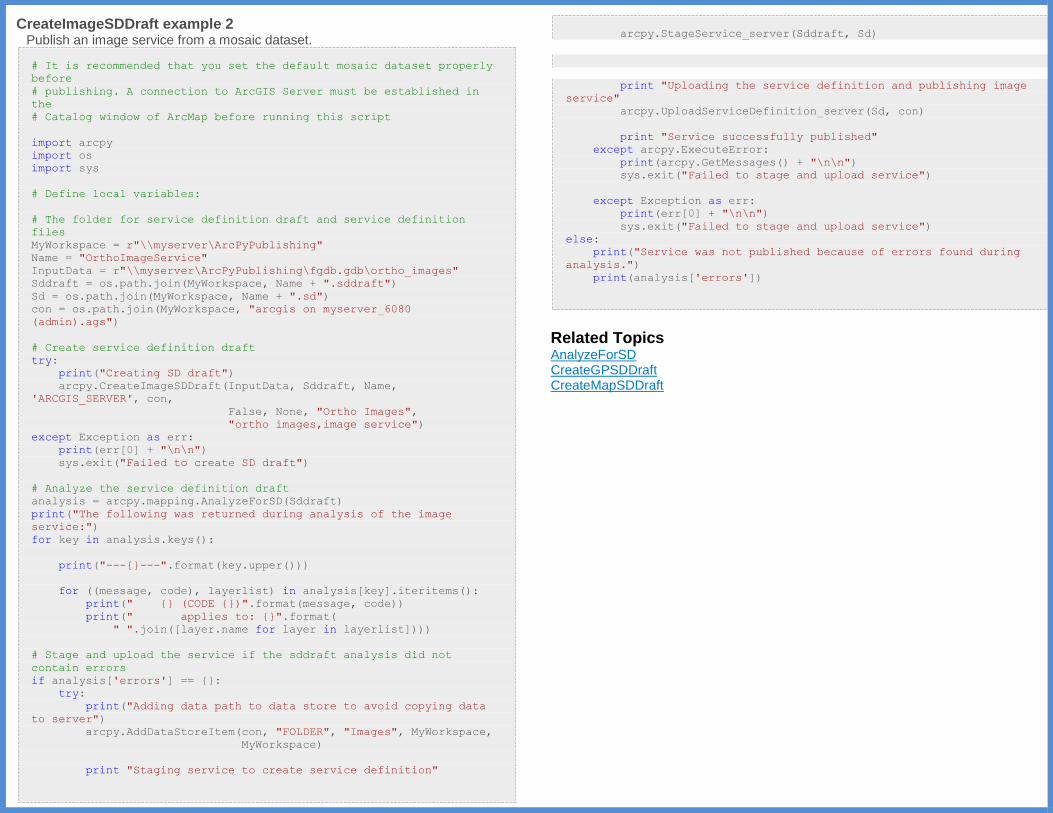
CreateImageSDDraft example 2
Publish an image service from a mosaic dataset.
# It is recommended that you set the default mosaic dataset properly
before
# publishing. A connection to ArcGIS Server must be established in
the
# Catalog window of ArcMap before running this script
import arcpy
import os
import sys
# Define local variables:
# The folder for service definition draft and service definition
files
MyWorkspace = r"\\myserver\ArcPyPublishing"
Name = "OrthoImageService"
InputData = r"\\myserver\ArcPyPublishing\fgdb.gdb\ortho_images"
Sddraft = os.path.join(MyWorkspace, Name + ".sddraft")
Sd = os.path.join(MyWorkspace, Name + ".sd")
con = os.path.join(MyWorkspace, "arcgis on myserver_6080
(admin).ags")
# Create service definition draft
try:
print("Creating SD draft")
arcpy.CreateImageSDDraft(InputData, Sddraft, Name,
'ARCGIS_SERVER', con,
False, None, "Ortho Images",
"ortho images,image service")
except Exception as err:
print(err[0] + "\n\n")
sys.exit("Failed to create SD draft")
# Analyze the service definition draft
analysis = arcpy.mapping.AnalyzeForSD(Sddraft)
print("The following was returned during analysis of the image
service:")
for key in analysis.keys():
print("---{}---".format(key.upper()))
for ((message, code), layerlist) in analysis[key].iteritems():
print(" {} (CODE {})".format(message, code))
print(" applies to: {}".format(
" ".join([layer.name for layer in layerlist])))
# Stage and upload the service if the sddraft analysis did not
contain errors
if analysis['errors'] == {}:
try:
print("Adding data path to data store to avoid copying data
to server")
arcpy.AddDataStoreItem(con, "FOLDER", "Images", MyWorkspace,
MyWorkspace)
print "Staging service to create service definition"
arcpy.StageService_server(Sddraft, Sd)
print "Uploading the service definition and publishing image
service"
arcpy.UploadServiceDefinition_server(Sd, con)
print "Service successfully published"
except arcpy.ExecuteError:
print(arcpy.GetMessages() + "\n\n")
sys.exit("Failed to stage and upload service")
except Exception as err:
print(err[0] + "\n\n")
sys.exit("Failed to stage and upload service")
else:
print("Service was not published because of errors found during
analysis.")
print(analysis['errors'])
Related Topics AnalyzeForSD CreateGPSDDraft CreateMapSDDraft
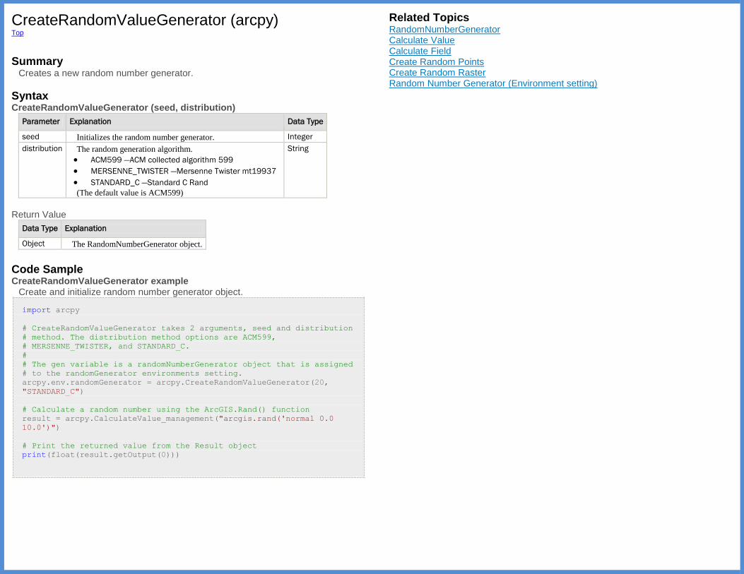
CreateRandomValueGenerator (arcpy) Top
Summary
Creates a new random number generator.
Syntax CreateRandomValueGenerator (seed, distribution)
Parameter Explanation Data Type
seed Initializes the random number generator. Integer
distribution The random generation algorithm.
ACM599 —ACM collected algorithm 599
MERSENNE_TWISTER —Mersenne Twister mt19937
STANDARD_C —Standard C Rand
(The default value is ACM599)
String
Return Value
Data Type Explanation
Object The RandomNumberGenerator object.
Code Sample CreateRandomValueGenerator example
Create and initialize random number generator object.
import arcpy
# CreateRandomValueGenerator takes 2 arguments, seed and distribution
# method. The distribution method options are ACM599,
# MERSENNE_TWISTER, and STANDARD_C.
#
# The gen variable is a randomNumberGenerator object that is assigned
# to the randomGenerator environments setting.
arcpy.env.randomGenerator = arcpy.CreateRandomValueGenerator(20,
"STANDARD_C")
# Calculate a random number using the ArcGIS.Rand() function
result = arcpy.CalculateValue_management("arcgis.rand('normal 0.0
10.0')")
# Print the returned value from the Result object
print(float(result.getOutput(0)))
Related Topics RandomNumberGenerator Calculate Value Calculate Field Create Random Points Create Random Raster Random Number Generator (Environment setting)

CreateScratchName (arcpy) Top
Summary
Creates a unique scratch path name for the specified data type. If no workspace is given the current workspace is used.
Discussion The scratch name will include a prefix of
Syntax CreateScratchName ({prefix}, {suffix}, {data_type}, {workspace})
Parameter Explanation Data
Type
prefix The prefix that is added to the scratchname. By default, a prefix of xx is
used.
(The default value is xx)
String
suffix The suffix added to the scratchname. This can be an empty double-
quoted string.
String
data_type The data type which will be used to create the scratchname. Valid
datatypes are:
Coverage —Only valid Coverage names are returned.
Dataset —Only valid Dataset names are returned.
FeatureClass —Only valid FeatureClass names are returned.
FeatureDataset —Only valid FeatureDataset names are returned.
Folder —Only valid Folder names are returned.
Geodataset —Only valid Geodataset names are returned.
GeometricNetwork —Only valid Geometric Network names are
returned.
ArcInfoTable —Only valid ArcInfo Table names are returned.
NetworkDataset —Only valid Network Dataset names are
returned.
RasterBand —Only valid Raster Band names are returned.
RasterCatalog —Only valid Raster Catalog names are returned.
RasterDataset —Only valid Raster Dataset names are returned.
Shapefile —Only valid Shapefile names are returned.
Terrain —Only valid Terrain names are returned.
Workspace —Only valid Workspace scratchnames are returned.
String
workspace The workspace used to determine the scratch name to be created. If not
specified, the current workspace is used.
String
Return Value
Data Type Explanation
String The unique scratch path name.
Code Sample CreateScratchName example
Create a unique scratch name for the derived output of the Buffer tool. This scratch name is then used as input to the Clip tool.
import arcpy
# Set workspace
#
arcpy.env.workspace = "C:/Data/Municipal.gdb"
# Create a scratch name for the Buffer tool output.
# The scratch name created will be include 'temp0.shp',
# If temp0.shp already exists, the number will be incremented
# until the name is unique in the workspace.
#
scratch_name = arcpy.CreateScratchName("temp",
data_type="Shapefile",
workspace=arcpy.env.scratchFolder)
# Execute Buffer tool, using scratch name for output
#
arcpy.Buffer_analysis("Roads", scratch_name, "1000 feet")
# Execute Clip tool, using scratch name for input
#
arcpy.Clip_analysis(scratch_name, "CityBoundary", "CityRoads")
# Delete scratch dataset
arcpy.Delete_management(scratch_name)
Related Topics CreateUniqueName

CreateUniqueName (arcpy) Top
Summary
Creates a unique name in the specified workspace by appending a number to the input name. This number is increased until the name is unique. If no workspace is specified, the current workspace is used.
Syntax CreateUniqueName (base_name, {workspace})
Parameter Explanation Data Type
base_name The base name used to create the unique name. String
workspace The workspace used for creation of the unique name. String
Return Value
Data
Type Explanation
String The unique name with a number appended to make it unique in the workspace. The
number starts at 0 and is incremented until it is unique.
Code Sample CreateUniqueName example
Creates a unique name for use with the Buffer and Clip tools.
import arcpy
# Set workspace
arcpy.env.workspace = "c:/data"
# Create a unique name for the Buffer tool's derived output.
unique_name = arcpy.CreateUniqueName("temp.shp")
# Use unique name for Buffer Tool output dataset name
arcpy.Buffer_analysis("roads.shp", unique_name, "100 feet")
# Clip output from Buffer tool with County Boundary to obtain
buffered roads
# in county.
arcpy.Clip_analysis(unique_name, "county.shp", "clipped_roads.shp")
Related Topics CreateScratchName
Describe (arcpy) Top
Summary
The Describe function returns a Describe object, with multiple properties, such
as data type, fields, indexes, and many others. Its properties are dynamic, meaning that depending on what data type is described, different describe properties will be available for use. Describe properties are organized into a series of property groups. Any particular dataset will acquire the properties of at least one of these groups. For instance, if describing a geodatabase feature class, you could access properties from the GDB FeatureClass,FeatureClass, Table, and Dataset property groups. All data, regardless of the data type, will always acquire the generic Describe Object properties.
Discussion Many data types include properties from other property groups. For instance, if describing a geodatabase feature class, you could access properties from the GDB FeatureClass, FeatureClass, Table, and Dataset property groups.
Note:
In some cases the object returned by Describe will not have all of the
properties that are documented for it. For example, the describe object for a Layer in ArcMap's table of contents will not have the layer property set. That
property only exists if you describe a .lyr file.
If you try to access a property that a Describe object does not have, it will
either throw an error or return an empty value (None, 0 or -1, or empty string). If you are uncertain of a particular property, you can use
Python's hasattr() function to check.
Describe Object Properties ArcInfo Workstation Item Properties ArcInfo Workstation Table Properties CAD Drawing Dataset Properties CAD FeatureClass Properties Cadastral Fabric Properties Coverage FeatureClass Properties Coverage Properties Dataset Properties dBASE Table Properties Editor Tracking Properties FeatureClass Properties File Properties
Continued on next page.
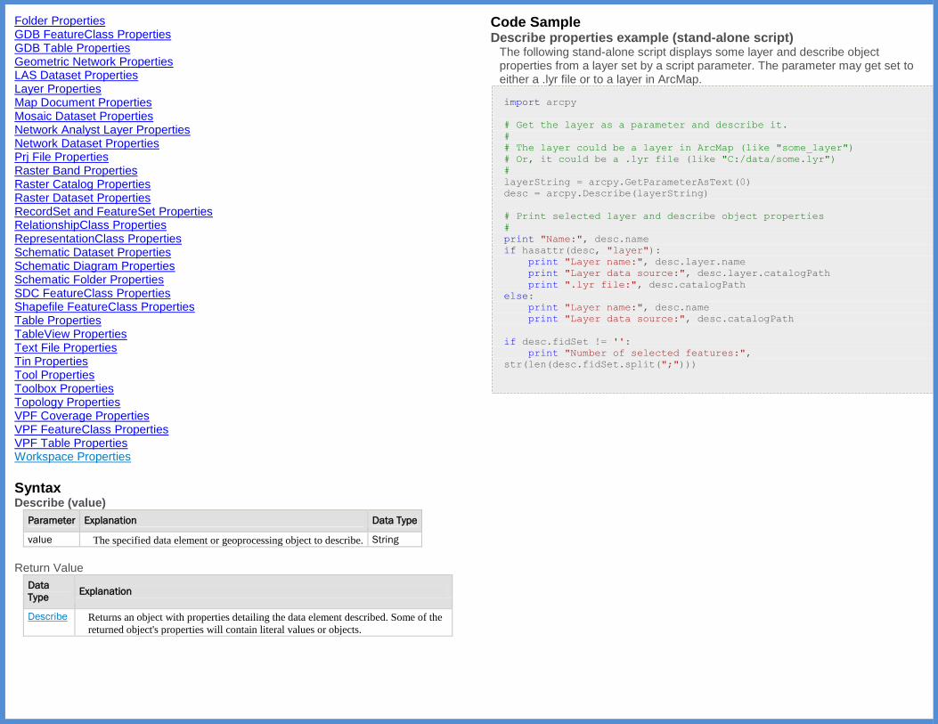
Folder Properties GDB FeatureClass Properties GDB Table Properties Geometric Network Properties LAS Dataset Properties Layer Properties Map Document Properties Mosaic Dataset Properties Network Analyst Layer Properties Network Dataset Properties Prj File Properties Raster Band Properties Raster Catalog Properties Raster Dataset Properties RecordSet and FeatureSet Properties RelationshipClass Properties RepresentationClass Properties Schematic Dataset Properties Schematic Diagram Properties Schematic Folder Properties SDC FeatureClass Properties Shapefile FeatureClass Properties Table Properties TableView Properties Text File Properties Tin Properties Tool Properties Toolbox Properties Topology Properties VPF Coverage Properties VPF FeatureClass Properties VPF Table Properties Workspace Properties
Syntax Describe (value)
Parameter Explanation Data Type
value The specified data element or geoprocessing object to describe. String
Return Value
Data
Type Explanation
Describe Returns an object with properties detailing the data element described. Some of the
returned object's properties will contain literal values or objects.
Code Sample Describe properties example (stand-alone script)
The following stand-alone script displays some layer and describe object properties from a layer set by a script parameter. The parameter may get set to either a .lyr file or to a layer in ArcMap.
import arcpy
# Get the layer as a parameter and describe it.
#
# The layer could be a layer in ArcMap (like "some_layer")
# Or, it could be a .lyr file (like "C:/data/some.lyr")
#
layerString = arcpy.GetParameterAsText(0)
desc = arcpy.Describe(layerString)
# Print selected layer and describe object properties
#
print "Name:", desc.name
if hasattr(desc, "layer"):
print "Layer name:", desc.layer.name
print "Layer data source:", desc.layer.catalogPath
print ".lyr file:", desc.catalogPath
else:
print "Layer name:", desc.name
print "Layer data source:", desc.catalogPath
if desc.fidSet != '':
print "Number of selected features:",
str(len(desc.fidSet.split(";")))
DisconnectUser (arcpy) Top
Summary
Allows an administrator to disconnect users who are currently connected to an Enterprise geodatabase.
Discussion The DisconnectUser function is used by an administrative user to disconnect
users from an Enterprise geodatabase. This function is used to complement the Connected users dialog box found in ArcGIS for Desktop.
The DisconnectUser function must utilize an administrative connection to
the database.
If this function is attempted to be run by a nonadministrative user the function will fail.
Selecting all users will disconnect all users other than the administrator connection used to execute the function or database.
Syntax DisconnectUser (sde_workspace, {users})
Parameter Explanation Data
Type
sde_workspace The Enterprise geodatabase containing the users to be
disconnected.
The connection properties specified in the Enterprise Geodatabase
must have administrative rights that allow the user to disconnect
other connections.
String
users [users,...]
Specifies which users will be disconnected from the geodatabase.
sde_id —The ID value returned from the ListUsers function
or the Connections tab in the Geodatabase Administration
dialog. This can be passed to the function as an individual
sde_id or a Python list containing multiple sde_ids.
ALL —Keyword specifying that all connected users should be
disconnected.
Note:
DisconnectUser will not disconnect the user who is
executing the function.
Integer
Code Sample DisconnectUser example 1
The following example demonstrates how to disconnect all users from a geodatabase.
import arcpy
arcpy.DisconnectUser("Database Connections/[email protected]", "ALL")
DisconnectUser example 2 The following example demonstrates how to run the command to disconnect a single user. In this example, the SDE ID is extracted based on the name of the user that the admin would like to disconnect from the list returned from the ListUsers function
import arcpy
admin_workspace = "Database Connections/[email protected]"
arcpy.env.workspace = admin_workspace
user_name = "GDB"
# Look through the users in the connected user list and get the SDE
ID.
# Use the SDE ID to disconnect the user that matches the username
variable
users = arcpy.ListUsers() # The environment is set, no workspace is
needed.
for item in users:
if item.Name == user_name:
arcpy.DisconnectUser(admin_workspace, item.ID)
DisconnectUser example 3
The following example demonstrates how to run the DisconnectUser command to disconnect multiple users.
import arcpy
# Set the admistrative workspace connection
admin_workspace = "Database Connections/[email protected]"
# Create a list of users to disconnect.
user_names = ["TRAVIS", "DEBBIE", "PHIL"]
# Get a list of connected users
connected_users = arcpy.ListUsers(admin_workspace)
# Loop through the list of connected users and execute DisconnectUser
# if the user name is in the userNamesList created earlier:
for user in connected_users:
if user.Name in user_names:
print('Disconnecting {0}'.format(user.Name))
arcpy.DisconnectUser(admin_workspace, user.ID)
Related Topics ListUsers

Exists (arcpy) Top
Summary
Determines the existence of the specified data object. Tests for the existence of feature classes, tables, datasets, shapefiles, workspaces, layers, and files in the current workspace. The function returns a Boolean indicating if the element exists.
Syntax Exists (dataset)
Parameter Explanation Data
Type
dataset The name, path, or both of a feature class, table, dataset, layer,
shapefile, workspace, or file to be checked for existence.
String
Return Value
Data Type Explanation
Boolean A Boolean value of True will be returned if the specified element exists.
Code Sample Exists example
Check for existence of specified data object.
import arcpy
# Set the current workspace
#
arcpy.env.workspace = "c:/base/data.gdb"
# Check for existence of data before deleting
#
if arcpy.Exists("roadbuffer"):
arcpy.Delete_management("roadbuffer")
Related Topics Checking for the existence of data
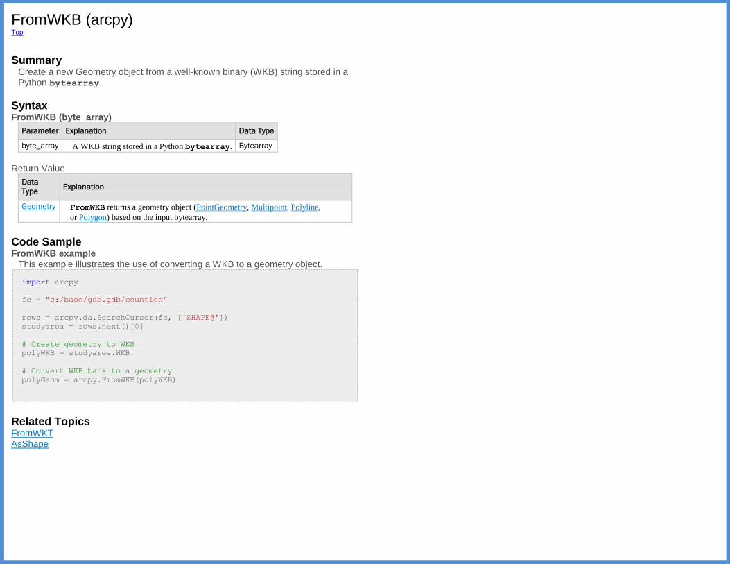
FromWKB (arcpy) Top
Summary
Create a new Geometry object from a well-known binary (WKB) string stored in a Python bytearray.
Syntax FromWKB (byte_array)
Parameter Explanation Data Type
byte_array A WKB string stored in a Python bytearray. Bytearray
Return Value
Data
Type Explanation
Geometry FromWKB returns a geometry object (PointGeometry, Multipoint, Polyline,
or Polygon) based on the input bytearray.
Code Sample FromWKB example
This example illustrates the use of converting a WKB to a geometry object.
import arcpy
fc = "c:/base/gdb.gdb/counties"
rows = arcpy.da.SearchCursor(fc, ['SHAPE@'])
studyarea = rows.next()[0]
# Create geometry to WKB
polyWKB = studyarea.WKB
# Convert WKB back to a geometry
polyGeom = arcpy.FromWKB(polyWKB)
Related Topics FromWKT AsShape
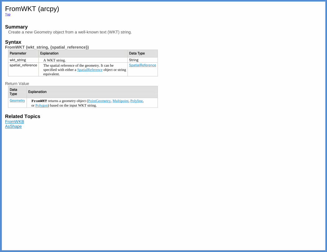
FromWKT (arcpy) Top
Summary
Create a new Geometry object from a well-known text (WKT) string.
Syntax FromWKT (wkt_string, {spatial_reference})
Parameter Explanation Data Type
wkt_string A WKT string. String
spatial_reference The spatial reference of the geometry. It can be
specified with either a SpatialReference object or string
equivalent.
SpatialReference
Return Value
Data
Type Explanation
Geometry FromWKT returns a geometry object (PointGeometry, Multipoint, Polyline,
or Polygon) based on the input WKT string.
Related Topics FromWKB AsShape

GetArgumentCount (arcpy) Top
Summary
Returns the number of arguments passed to the script.
Syntax GetArgumentCount () Return Value
Data Type Explanation
Integer The number of arguments passed to the script.
Code Sample GetArgumentCount example
Check for required number of arguments to run Clip tool and handle optional argument.
import sys
import arcpy
# Set workspace
arcpy.env.workspace = "c:/data/airport.gdb"
# Set local variables
in_features = arcpy.GetParameterAsText(0)
clip_features = arcpy.GetParameterAsText(1)
out_feature_class = arcpy.GetParameterAsText(2)
xy_tolerance = arcpy.GetParameterAsText(3)
# Check for required number of arguments
if arcpy.GetArgumentCount() < 3:
print("3 arguments required for Clip_analysis tool")
# Execute Clip tool
try:
arcpy.Clip_analysis(in_features, clip_features,
out_feature_class, xy_tolerance)
except arcpy.ExecuteError:
print(arcpy.GetMessages(2))
Related Topics CopyParameter GetParameter GetParameterAsText GetParameterCount GetParameterInfo GetParameterValue SetParameter SetParameterAsText Setting script tool parameters

GetIDMessage (arcpy) Top
Summary
Get the string of the error or warning ID message.
Discussion GetIDMessage allows you to access ArcGIS tool message codes for use in Python. These message codes are found are documented in Tool errors and warnings.
Syntax GetIDMessage (message_ID)
Parameter Explanation Data Type
message_ID The geoprocessing message ID. Integer
Return Value
Data Type Explanation
String The message string associated with the message ID.
Code Sample GetIDMessage example
Access a message string using GetIDMessage and add to the tool messages using AddMessage.
import arcpy
message = arcpy.GetIDMessage(84001)
# The returned value should be:
# u'Reading data....
arcpy.AddMessage(message)
Related Topics AddError AddIDMessage AddMessage AddReturnMessage AddWarning GetMessage GetMessageCount GetMessages GetReturnCode Writing messages in script tools Understanding message types and severity Understanding messages in script tools
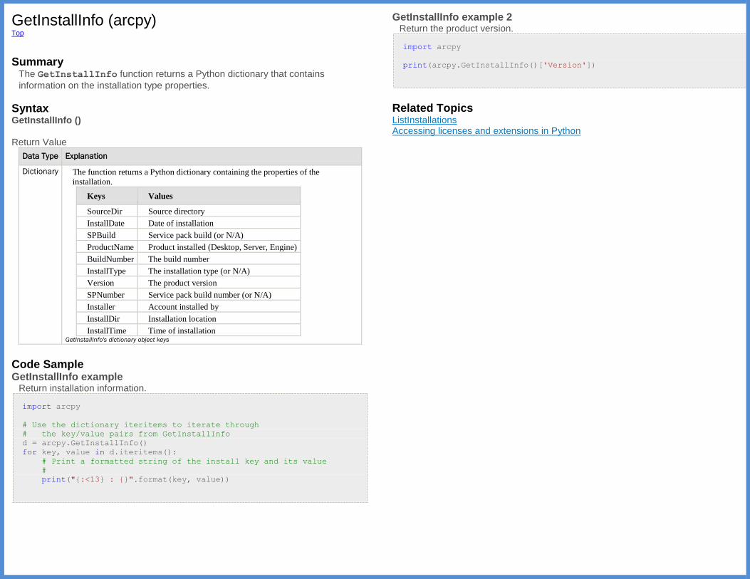
GetInstallInfo (arcpy) Top
Summary
The GetInstallInfo function returns a Python dictionary that contains
information on the installation type properties.
Syntax GetInstallInfo () Return Value
Data Type Explanation
Dictionary The function returns a Python dictionary containing the properties of the
installation.
Keys Values
SourceDir Source directory
InstallDate Date of installation
SPBuild Service pack build (or N/A)
ProductName Product installed (Desktop, Server, Engine)
BuildNumber The build number
InstallType The installation type (or N/A)
Version The product version
SPNumber Service pack build number (or N/A)
Installer Account installed by
InstallDir Installation location
InstallTime Time of installation GetInstallInfo's dictionary object keys
Code Sample GetInstallInfo example
Return installation information.
import arcpy
# Use the dictionary iteritems to iterate through
# the key/value pairs from GetInstallInfo
d = arcpy.GetInstallInfo()
for key, value in d.iteritems():
# Print a formatted string of the install key and its value
#
print("{:<13} : {}".format(key, value))
GetInstallInfo example 2
Return the product version.
import arcpy
print(arcpy.GetInstallInfo()['Version'])
Related Topics ListInstallations Accessing licenses and extensions in Python

SetLogHistory (arcpy) Top
Summary
For script tools and stand-alone scripts (scripts run outside of an ArcGIS application), you can enable or disable history logging using the SetLogHistory function.
The history log file is an Extensible Markup Language (XML) file that contains information about each geoprocessing operation. The information contained in the log file is essentially the same as that found in the Results window.
Syntax SetLogHistory (log_history)
Parameter Explanation Data Type
log_history True, to enable geoprocessing logging history and False, to disable. Boolean
Code Sample SetLogHistory example
Turn off geoprocessing log history.
import arcpy
arcpy.SetLogHistory(False)
Related Topics GetLogHistory Viewing tool execution history
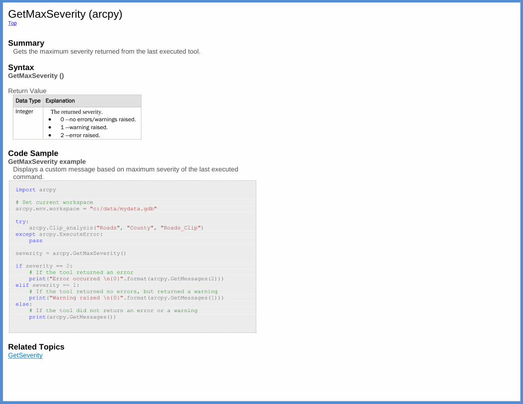
GetMaxSeverity (arcpy) Top
Summary
Gets the maximum severity returned from the last executed tool.
Syntax GetMaxSeverity () Return Value
Data Type Explanation
Integer The returned severity.
0 —no errors/warnings raised.
1 —warning raised.
2 —error raised.
Code Sample GetMaxSeverity example
Displays a custom message based on maximum severity of the last executed command.
import arcpy
# Set current workspace
arcpy.env.workspace = "c:/data/mydata.gdb"
try:
arcpy.Clip_analysis("Roads", "County", "Roads_Clip")
except arcpy.ExecuteError:
pass
severity = arcpy.GetMaxSeverity()
if severity == 2:
# If the tool returned an error
print("Error occurred \n{0}".format(arcpy.GetMessages(2)))
elif severity == 1:
# If the tool returned no errors, but returned a warning
print("Warning raised \n{0}".format(arcpy.GetMessages(1)))
else:
# If the tool did not return an error or a warning
print(arcpy.GetMessages())
Related Topics GetSeverity
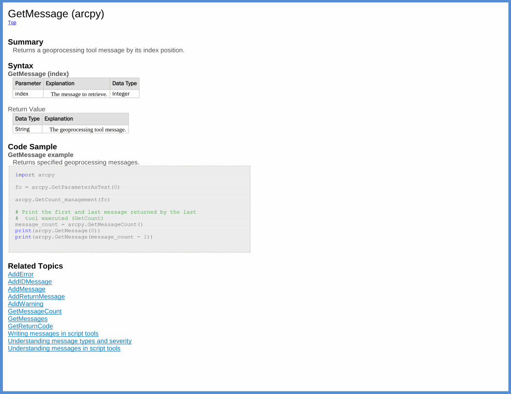
GetMessage (arcpy) Top
Summary
Returns a geoprocessing tool message by its index position.
Syntax GetMessage (index)
Parameter Explanation Data Type
index The message to retrieve. Integer
Return Value
Data Type Explanation
String The geoprocessing tool message.
Code Sample GetMessage example
Returns specified geoprocessing messages.
import arcpy
fc = arcpy.GetParameterAsText(0)
arcpy.GetCount_management(fc)
# Print the first and last message returned by the last
# tool executed (GetCount)
message_count = arcpy.GetMessageCount()
print(arcpy.GetMessage(0))
print(arcpy.GetMessage(message_count - 1))
Related Topics AddError AddIDMessage AddMessage AddReturnMessage AddWarning GetMessageCount GetMessages GetReturnCode Writing messages in script tools Understanding message types and severity Understanding messages in script tools
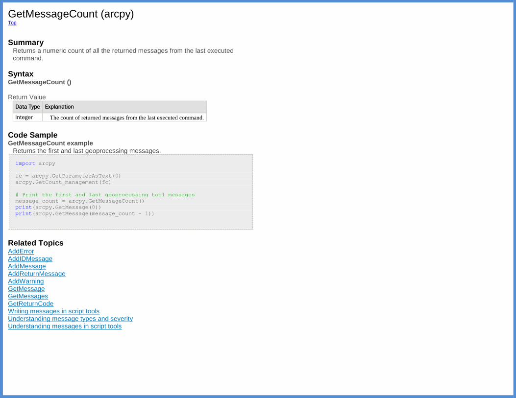
GetMessageCount (arcpy) Top
Summary
Returns a numeric count of all the returned messages from the last executed command.
Syntax GetMessageCount () Return Value
Data Type Explanation
Integer The count of returned messages from the last executed command.
Code Sample GetMessageCount example
Returns the first and last geoprocessing messages.
import arcpy
fc = arcpy.GetParameterAsText(0)
arcpy.GetCount_management(fc)
# Print the first and last geoprocessing tool messages
message_count = arcpy.GetMessageCount()
print(arcpy.GetMessage(0))
print(arcpy.GetMessage(message_count - 1))
Related Topics AddError AddIDMessage AddMessage AddReturnMessage AddWarning GetMessage GetMessages GetReturnCode Writing messages in script tools Understanding message types and severity Understanding messages in script tools

GetMessages (arcpy) Top
Summary
Returns the geoprocessing messages from a tool by specified severity level.
Syntax GetMessages ({severity})
Parameter Explanation Data Type
severity The severity level of messages to return.
0 —messages returned.
1 —warning messages returned.
2 —error messages returned.
Not specifying a severity will return all types of messages.
(The default value is 0)
Integer
Return Value
Data Type Explanation
String The geoprocessing tool messages, separated by a newline ('\n').
Code Sample GetMessages example
Returns the geoprocessing messages.
import arcpy
fc = arcpy.GetParameterAsText(0)
arcpy.GetCount_management(fc)
# Print all of the geoprocessing messages returned by the
# last tool (GetCount)
print(arcpy.GetMessages())
Related Topics AddError AddIDMessage AddMessage AddReturnMessage AddWarning GetMessage GetMessageCount GetReturnCode Writing messages in script tools Understanding message types and severity Understanding messages in script tools
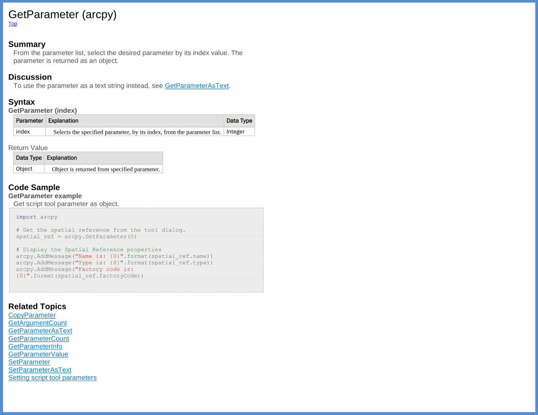
GetParameter (arcpy) Top
Summary
From the parameter list, select the desired parameter by its index value. The parameter is returned as an object.
Discussion To use the parameter as a text string instead, see GetParameterAsText.
Syntax GetParameter (index)
Parameter Explanation Data Type
index Selects the specified parameter, by its index, from the parameter list. Integer
Return Value
Data Type Explanation
Object Object is returned from specified parameter.
Code Sample GetParameter example
Get script tool parameter as object.
import arcpy
# Get the spatial reference from the tool dialog.
spatial_ref = arcpy.GetParameter(0)
# Display the Spatial Reference properties
arcpy.AddMessage("Name is: {0}".format(spatial_ref.name))
arcpy.AddMessage("Type is: {0}".format(spatial_ref.type))
arcpy.AddMessage("Factory code is:
{0}".format(spatial_ref.factoryCode))
Related Topics CopyParameter GetArgumentCount GetParameterAsText GetParameterCount GetParameterInfo GetParameterValue SetParameter SetParameterAsText Setting script tool parameters
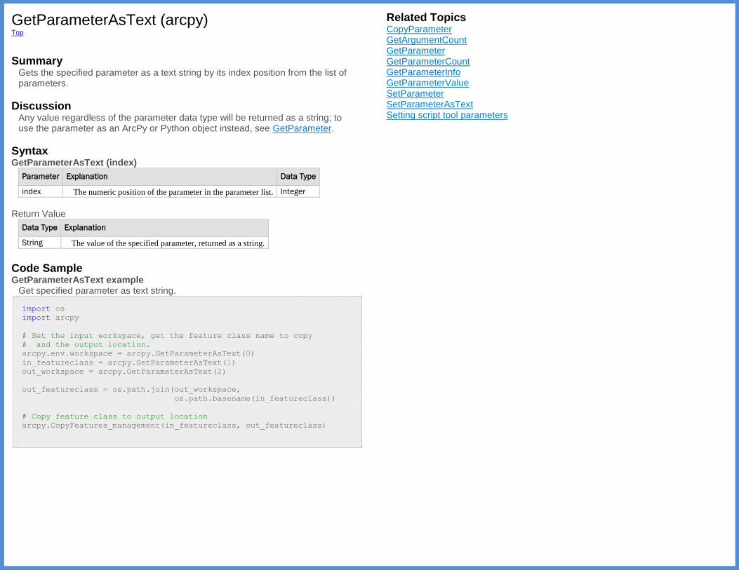
GetParameterAsText (arcpy) Top
Summary
Gets the specified parameter as a text string by its index position from the list of parameters.
Discussion Any value regardless of the parameter data type will be returned as a string; to use the parameter as an ArcPy or Python object instead, see GetParameter.
Syntax GetParameterAsText (index)
Parameter Explanation Data Type
index The numeric position of the parameter in the parameter list. Integer
Return Value
Data Type Explanation
String The value of the specified parameter, returned as a string.
Code Sample GetParameterAsText example
Get specified parameter as text string.
import os
import arcpy
# Set the input workspace, get the feature class name to copy
# and the output location.
arcpy.env.workspace = arcpy.GetParameterAsText(0)
in_featureclass = arcpy.GetParameterAsText(1)
out_workspace = arcpy.GetParameterAsText(2)
out_featureclass = os.path.join(out_workspace,
os.path.basename(in_featureclass))
# Copy feature class to output location
arcpy.CopyFeatures_management(in_featureclass, out_featureclass)
Related Topics CopyParameter GetArgumentCount GetParameter GetParameterCount GetParameterInfo GetParameterValue SetParameter SetParameterAsText Setting script tool parameters

GetParameterCount (arcpy) Top
Summary
Returns a count of the parameter values for the specified tool. If the tool is contained in a custom toolbox, use ImportToolbox to access the custom tool.
Syntax GetParameterCount (tool_name)
Parameter Explanation Data
Type
tool_name The name of the tool for which the number of parameters will be
returned.
String
Return Value
Data Type Explanation
Integer The number of parameters for the specified tool.
Code Sample GetParameterCount example
Returns the number of tool parameters.
import arcpy
# Returns 7
print(arcpy.GetParameterCount("Buffer_analysis"))
Related Topics CopyParameter GetArgumentCount GetParameter GetParameterAsText GetParameterInfo GetParameterValue SetParameter SetParameterAsText Setting script tool parameters
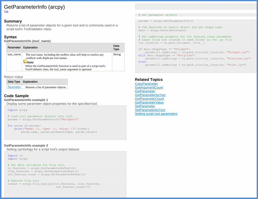
GetParameterInfo (arcpy) Top
Summary
Returns a list of parameter objects for a given tool and is commonly used in a script tool's ToolValidator class.
Syntax GetParameterInfo (tool_name)
Parameter Explanation Data
Type
tool_name The tool name. Including the toolbox alias will help to resolve any
conflicts with duplicate tool names.
Note:
When the GetParameterInfo function is used as part of a script tool's
ToolValidator class, the tool_name argument is optional.
String
Return Value
Data Type Explanation
Parameter Returns a list of parameter objects.
Code Sample GetParameterInfo example 1
Display some parameter object properties for the specified tool.
import arcpy
# Load tool parameter objects into list.
params = arcpy.GetParameterInfo("HotSpots")
for param in params:
print("Name: {}, Type: {}, Value: {}".format(
param.name, param.parameterType, param.value))
GetParameterInfo example 2
Setting symbology for a script tool's output dataset.
import os
import arcpy
# Set data variables for Clip tool.
in_features = arcpy.GetParameterAsText(0)
clip_features = arcpy.GetParameterAsText(1)
out_feature_class = arcpy.GetParameterAsText(2)
# Execute Clip tool
output = arcpy.Clip_analysis(in_features, clip_features,
out_feature_class)[0]
# Get parameter objects
params = arcpy.GetParameterInfo()
# Use describe on result object and get shape type.
desc = arcpy.Describe(output)
# Set symbology property for out_feature_class parameter
# Layer files are located in same folder as the .py file
lyr_location = os.path.dirname(__file__)
if desc.shapeType == "Polygon":
params[2].symbology = os.path.join(lyr_location, "Polygon.lyr")
elif desc.shapeType == "Polyline":
params[2].symbology = os.path.join(lyr_location, "Polyline.lyr")
else:
params[2].symbology = os.path.join(lyr_location, "Point.lyr")
Related Topics CopyParameter GetArgumentCount GetParameter GetParameterAsText GetParameterCount GetParameterValue SetParameter SetParameterAsText Setting script tool parameters
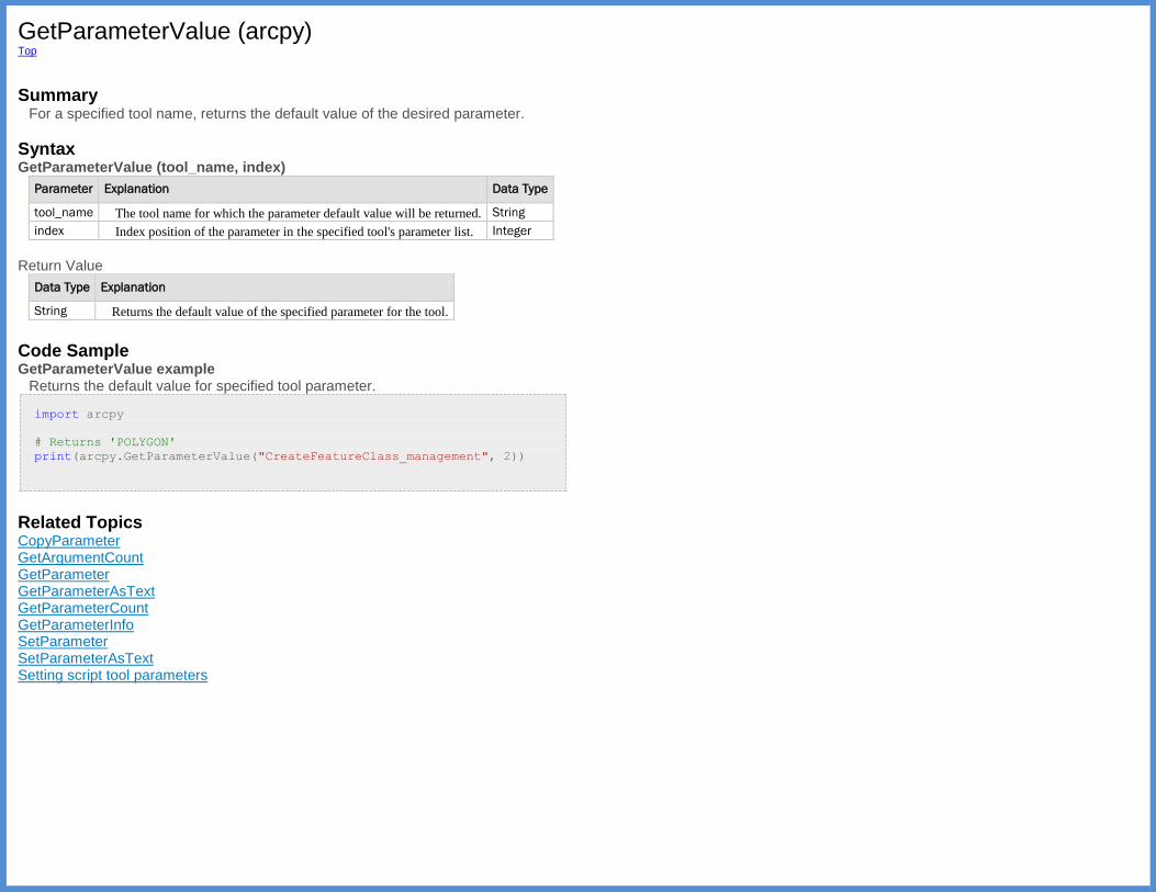
GetParameterValue (arcpy) Top
Summary
For a specified tool name, returns the default value of the desired parameter.
Syntax GetParameterValue (tool_name, index)
Parameter Explanation Data Type
tool_name The tool name for which the parameter default value will be returned. String
index Index position of the parameter in the specified tool's parameter list. Integer
Return Value
Data Type Explanation
String Returns the default value of the specified parameter for the tool.
Code Sample GetParameterValue example
Returns the default value for specified tool parameter.
import arcpy
# Returns 'POLYGON'
print(arcpy.GetParameterValue("CreateFeatureClass_management", 2))
Related Topics CopyParameter GetArgumentCount GetParameter GetParameterAsText GetParameterCount GetParameterInfo SetParameter SetParameterAsText Setting script tool parameters

GetReturnCode (arcpy) Top
Summary
Return the message error code by index. If the message for the specified index is a warning or informative message the function will return a 0; if the message is an error the function will return a value other than 0.
Syntax GetReturnCode (index)
Parameter Explanation Data
Type
index The specified position of the message in the returned list of messages,
warnings, or errors.
Integer
Return Value
Data Type Explanation
Integer The return code of the message at the specified index position.
Code Sample GetReturnCode example
Returns the severity code for the specified message.
import arcpy
arcpy.env.workspace = "c:/census/data.gdb"
arcpy.Erase_analysis("housing", "income", "low_income")
# Return the return code of the message in index
# position 3 (4th message)
print(arcpy.GetReturnCode(3))
Related Topics AddError AddIDMessage AddMessage AddReturnMessage AddWarning GetMessage GetMessageCount GetMessages Writing messages in script tools Understanding message types and severity Understanding messages in script tools
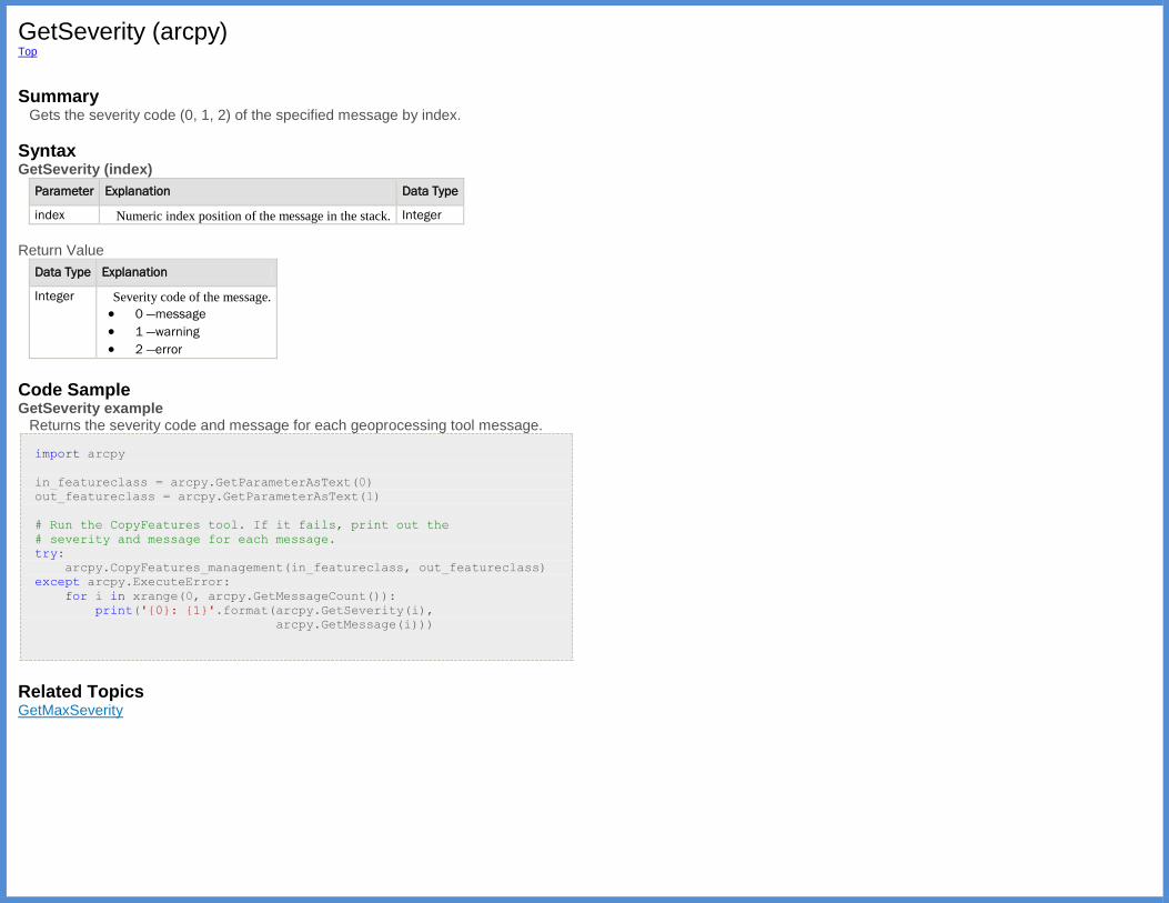
GetSeverity (arcpy) Top
Summary
Gets the severity code (0, 1, 2) of the specified message by index.
Syntax GetSeverity (index)
Parameter Explanation Data Type
index Numeric index position of the message in the stack. Integer
Return Value
Data Type Explanation
Integer Severity code of the message.
0 —message
1 —warning
2 —error
Code Sample GetSeverity example
Returns the severity code and message for each geoprocessing tool message.
import arcpy
in_featureclass = arcpy.GetParameterAsText(0)
out_featureclass = arcpy.GetParameterAsText(1)
# Run the CopyFeatures tool. If it fails, print out the
# severity and message for each message.
try:
arcpy.CopyFeatures_management(in_featureclass, out_featureclass)
except arcpy.ExecuteError:
for i in xrange(0, arcpy.GetMessageCount()):
print('{0}: {1}'.format(arcpy.GetSeverity(i),
arcpy.GetMessage(i)))
Related Topics GetMaxSeverity
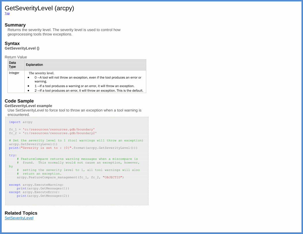
GetSeverityLevel (arcpy) Top
Summary
Returns the severity level. The severity level is used to control how geoprocessing tools throw exceptions.
Syntax GetSeverityLevel () Return Value
Data
Type Explanation
Integer The severity level.
0 —A tool will not throw an exception, even if the tool produces an error or
warning.
1 —If a tool produces a warning or an error, it will throw an exception.
2 —If a tool produces an error, it will throw an exception. This is the default.
Code Sample GetSeverityLevel example
Use SetSeverityLevel to force tool to throw an exception when a tool warning is encountered.
import arcpy
fc_1 = 'c:/resources/resources.gdb/boundary'
fc_2 = 'c:/resources/resources.gdb/boundary2'
# Set the severity level to 1 (tool warnings will throw an exception)
arcpy.SetSeverityLevel(1)
print("Severity is set to : {0}".format(arcpy.GetSeverityLevel()))
try:
# FeatureCompare returns warning messages when a miscompare is
# found. This normally would not cause an exception, however,
by
# setting the severity level to 1, all tool warnings will also
# return an exception.
arcpy.FeatureCompare_management(fc_1, fc_2, "OBJECTID")
except arcpy.ExecuteWarning:
print(arcpy.GetMessages(1))
except arcpy.ExecuteError:
print(arcpy.GetMessages(2))
Related Topics SetSeverityLevel

GetSystemEnvironment (arcpy) Top
Summary
Gets the specified system environment variable value, such as "TEMP".
Discussion When using GetSystemEnvironment to retrieve the "TEMP" environment variable's value, GetSystemEnvironment will cycle through "TEMP", "TMP" and "MW_TMPDIR" environment variables and return the first value it finds.
Syntax GetSystemEnvironment (environment)
Parameter Explanation Data Type
environment The name of the system environment variable. String
Return Value
Data Type Explanation
String Returns the value of the specified system environment variable as a string.
Code Sample GetSystemEnvironment example
Return the specified system environment variable value.
import arcpy
# Set the scratchWorkspace environment to the value returned
# from the system environment variable TEMP
arcpy.env.scratchWorkspace = arcpy.GetSystemEnvironment("TEMP")
Related Topics ListEnvironments
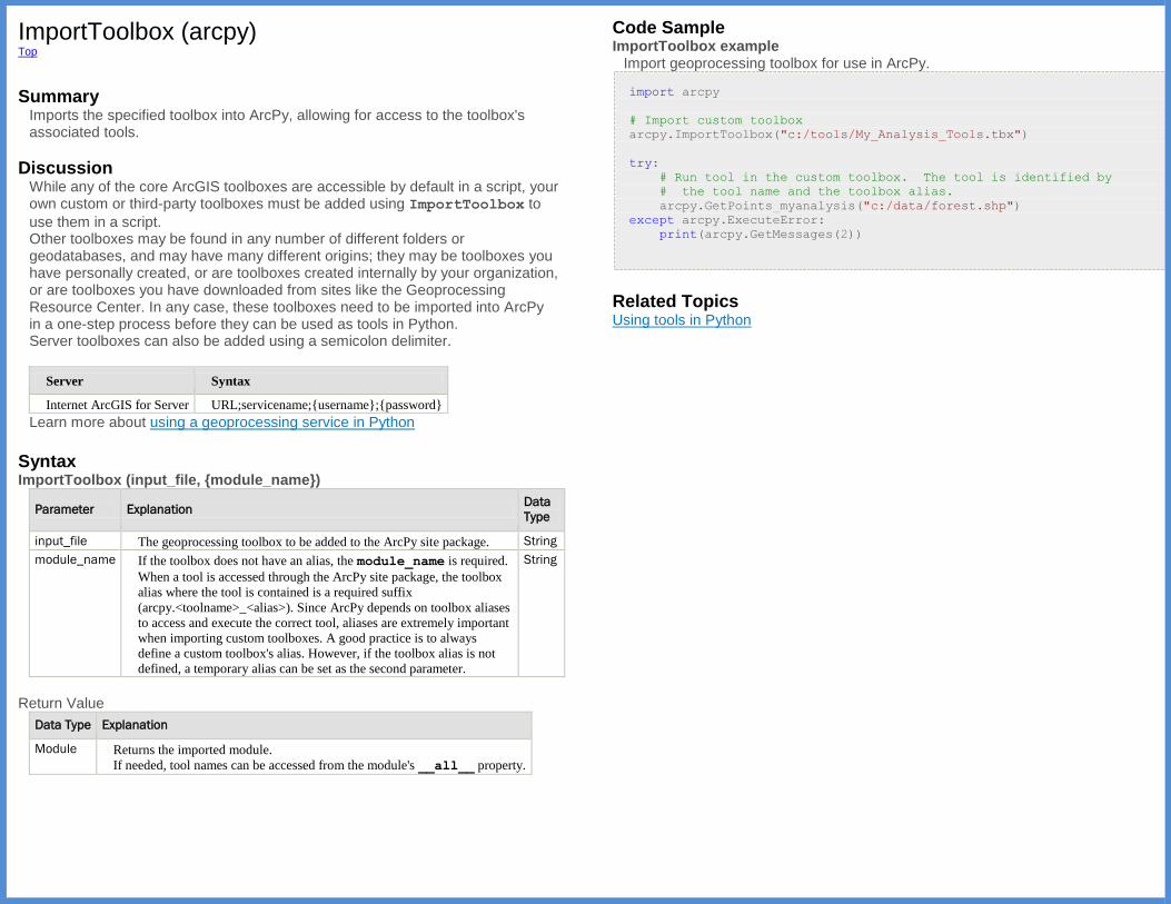
ImportToolbox (arcpy) Top
Summary
Imports the specified toolbox into ArcPy, allowing for access to the toolbox's associated tools.
Discussion While any of the core ArcGIS toolboxes are accessible by default in a script, your own custom or third-party toolboxes must be added using ImportToolbox to
use them in a script. Other toolboxes may be found in any number of different folders or geodatabases, and may have many different origins; they may be toolboxes you have personally created, or are toolboxes created internally by your organization, or are toolboxes you have downloaded from sites like the Geoprocessing Resource Center. In any case, these toolboxes need to be imported into ArcPy in a one-step process before they can be used as tools in Python. Server toolboxes can also be added using a semicolon delimiter.
Server Syntax
Internet ArcGIS for Server URL;servicename;{username};{password}
Learn more about using a geoprocessing service in Python
Syntax ImportToolbox (input_file, {module_name})
Parameter Explanation Data
Type
input_file The geoprocessing toolbox to be added to the ArcPy site package. String
module_name If the toolbox does not have an alias, the module_name is required.
When a tool is accessed through the ArcPy site package, the toolbox
alias where the tool is contained is a required suffix
(arcpy.<toolname>_<alias>). Since ArcPy depends on toolbox aliases
to access and execute the correct tool, aliases are extremely important
when importing custom toolboxes. A good practice is to always
define a custom toolbox's alias. However, if the toolbox alias is not
defined, a temporary alias can be set as the second parameter.
String
Return Value
Data Type Explanation
Module Returns the imported module.
If needed, tool names can be accessed from the module's __all__ property.
Code Sample ImportToolbox example
Import geoprocessing toolbox for use in ArcPy.
import arcpy
# Import custom toolbox
arcpy.ImportToolbox("c:/tools/My_Analysis_Tools.tbx")
try:
# Run tool in the custom toolbox. The tool is identified by
# the tool name and the toolbox alias.
arcpy.GetPoints_myanalysis("c:/data/forest.shp")
except arcpy.ExecuteError:
print(arcpy.GetMessages(2))
Related Topics Using tools in Python
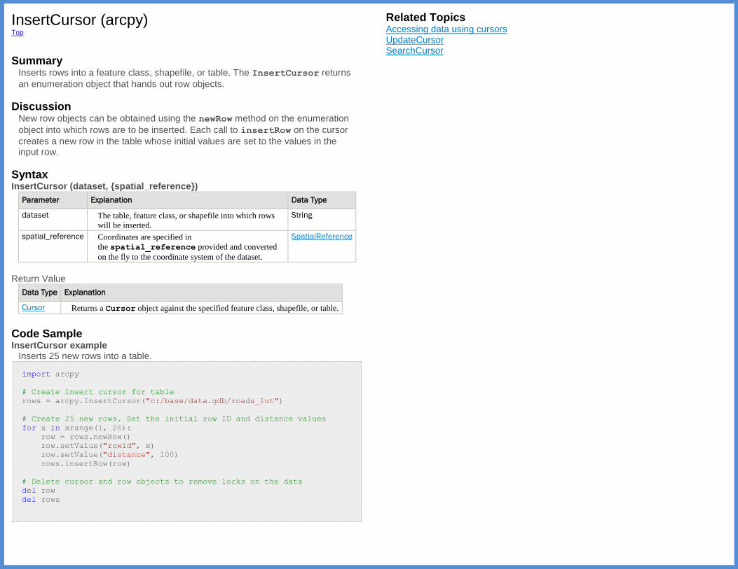
InsertCursor (arcpy) Top
Summary
Inserts rows into a feature class, shapefile, or table. The InsertCursor returns
an enumeration object that hands out row objects.
Discussion New row objects can be obtained using the newRow method on the enumeration
object into which rows are to be inserted. Each call to insertRow on the cursor
creates a new row in the table whose initial values are set to the values in the input row.
Syntax InsertCursor (dataset, {spatial_reference})
Parameter Explanation Data Type
dataset The table, feature class, or shapefile into which rows
will be inserted.
String
spatial_reference Coordinates are specified in
the spatial_reference provided and converted
on the fly to the coordinate system of the dataset.
SpatialReference
Return Value
Data Type Explanation
Cursor Returns a Cursor object against the specified feature class, shapefile, or table.
Code Sample InsertCursor example
Inserts 25 new rows into a table.
import arcpy
# Create insert cursor for table
rows = arcpy.InsertCursor("c:/base/data.gdb/roads_lut")
# Create 25 new rows. Set the initial row ID and distance values
for x in xrange(1, 26):
row = rows.newRow()
row.setValue("rowid", x)
row.setValue("distance", 100)
rows.insertRow(row)
# Delete cursor and row objects to remove locks on the data
del row
del rows
Related Topics Accessing data using cursors UpdateCursor SearchCursor

IsSynchronous (arcpy) Top
Summary
Determines if a tool is running synchronous or asynchronous. When a tool is synchronous, the results are automatically returned, but no other action may be taken until the tool has completed. All non-server tools are synchronous. Server tools may beasynchronous, meaning that once the tool has been submitted to the server, other functionality can be run without waiting, and the results must be explicitly requested from the server.
Syntax IsSynchronous (tool_name)
Parameter Explanation Data Type
tool_name The name of the tool to determine if it is synchronous. String
Return Value
Data Type Explanation
Boolean A return Boolean value of True indicates the tool is synchronous.
Code Sample IsSynchronous example
Determine if a server tool is running synchronous.
import time
import arcpy
# Add server toolbox from a local ArcGIS for Server
arcpy.ImportToolbox("pondermatic;buffertools")
# Create and load a recordset object for the tool's input
record_set = arcpy.RecordSet()
record_set.load("c:/temp/lines.shp")
# Run the server tool
results = arcpy.BufferLines_mytools(record_set, "100")
# If the tool is asynchronous, wait until the task is finished
(status = 4)
if not arcpy.IsSynchronous("BufferLines"):
while results.status < 4:
time.sleep(0.1)
# Get output from task and export to a feature class on disk
result = results.getOutput(0)
result.save("c:/temp/bufferlines.shp")
Related Topics ListToolboxes ListTools Listing tools, toolboxes, and environment settings

ListDatasets (arcpy) Top
Summary
Lists all of the datasets in a workspace. Search conditions can be specified for the dataset name and dataset type to limit the list that is returned.
Discussion The workspace environment must be set first before using several of the List functions, including ListDatasets, ListFeatureClasses, ListFiles, ListRasters, ListTables, and ListWorkspaces.
Syntax ListDatasets ({wild_card}, {feature_type})
Parameter Explanation Data
Type
wild_card The wild card limits the results returned. If no wild card is specified,
all values are returned.
String
feature_type The feature type to limit the results returned by the wildcard
argument. Valid dataset types are:
Coverage —Only coverages.
Feature —Coverage or geodatabase dataset, depending on the
workspace.
GeometricNetwork —Only geometric network datasets.
Mosaic —Only mosaic datasets.
Network —Only network datasets.
ParcelFabric —Only parcel fabric datasets.
Raster —Only raster datasets.
RasterCatalog —Only raster catalog datasets.
Schematic —Only schematic datasets.
Terrain —Only terrain datasets.
Tin —Only TIN datasets.
Topology —Only topology datasets.
All —All datasets in the workspace. This is the default value.
(The default value is All)
String
Return Value
Data
Type Explanation
String A list containing dataset names returned from the function, limited by the wildcard
and feature type arguments.
Code Sample ListDatasets example
List Feature Dataset names that start with C.
import arcpy
arcpy.env.workspace = "c:/data"
# Print to the Interactive window all the feature datasets in the
# workspace that start with the letter C.
datasets = arcpy.ListDatasets("C*", "Feature")
for dataset in datasets:
print(dataset)
Related Topics Create lists of data
ListDataStoreItems (arcpy) Top
Summary
Returns a list of the folders or databases registered with an ArcGIS Server site.
Discussion See About registering your data with the server to learn more about when and why you should register your data with ArcGIS Server.
Syntax ListDataStoreItems (connection_file, datastore_type)
Parameter Explanation Data
Type
connection_file An ArcGIS Server connection file (.ags) for the server whose
registered databases or folders you want to list. If you've made a
connection in theCatalog window of ArcMap, you can use the
connection file found in your user profile directory. Alternatively,
you can create a connection file from scratch using the
function CreateGISServerConnectionFile.
String
datastore_type The type of data that you want to list.
DATABASE —Enterprise databases registered with the server
will be listed.
FOLDER —File-based data sources registered with the server
will be listed.
String
Return Value
Data
Type Explanation
String Returns the registered folders or databases as a list of lists of strings in the format
[store_name, server_data, publisher_data, type].
store_name—The alias of the folder or database as it is registered with the
ArcGIS Server site.
server_data—When listing folders, the path to the folder as seen by the server.
When listing databases, the connection properties as seen by the server.
publisher_data—When listing folders, the path to the folder as seen by the
publisher's machine. When listing databases, the connection properties as
seen by the publisher's machine.
type—If the publisher's machine and the server read the data out of the same
physical location, this is shared. If the publisher and server read the data out
of different physical locations, this isreplicated. If the data location is
registered as ArcGIS Server's Managed Database, this is managed.
Code Sample ListDataStoreItems example
Prints all folders registered with the ArcGIS Server site.
import arcpy
print("Registered FOLDER items are:")
for item in arcpy.ListDataStoreItems("GIS Servers/MyConnection.ags",
"FOLDER"):
print("Name: {}".format(item[0]))
print("Server's path: {}".format(item[1]))
print("Publisher's path: {}".format(item[2]))
if item[3] == "managed":
print("This is ArcGIS Server's Managed Database")
Related Topics AddDataStoreItem RemoveDataStoreItem ValidateDataStoreItem

ListEnvironments (arcpy) Top
Summary
The ListEnvironments function returns a list of geoprocessing environment names.
Syntax ListEnvironments ({wild_card})
Parameter Explanation Data
Type
wild_card The wild card limits the results returned. If no wild card is specified, all
values are returned.
import arcpy
# A wild_card of "*workspace" will return a list
including the
# workspace and scratchWorkspace environment
names
arcpy.ListEnvironments("*workspace")
String
Return Value
Data
Type Explanation
String The list returned from the function containing the
geoprocessing environment variable names, optionally limited by a wild card filter.
Code Sample ListEnvironments example
Lists the environment variable name and current value.
import arcpy
environments = arcpy.ListEnvironments()
# Sort the environment names
environments.sort()
for environment in environments:
# Format and print each environment and its current setting.
# (The environments are accessed by key from arcpy.env.)
print("{0:<30}: {1}".format(environment, arcpy.env[environment]))
Related Topics Using environment settings in Python ClearEnvironment GetSystemEnvironment ResetEnvironments Listing tools, toolboxes, and environment settings
ListFeatureClasses (arcpy) Top
Summary
Lists the feature classes in the workspace, limited by name, feature type, and optional feature dataset.
Discussion The workspace environment must be set first before using several of the List functions, including ListDatasets, ListFeatureClasses, ListFiles, ListRasters, ListTables, and ListWorkspaces.
Syntax ListFeatureClasses ({wild_card}, {feature_type}, {feature_dataset})
Parameter Explanation Data
Type
wild_card The wild card limits the results returned. If no wild card is
specified, all values are returned.
String
feature_type The feature type to limit the results returned by the wild card
argument. Valid feature types are:
Annotation —Only annotation feature classes are returned.
Arc —Only arc (or line) feature classes are returned.
Dimension —Only dimension feature classes are returned.
Edge —Only edge feature classes are returned.
Junction —Only junction feature classes are returned.
Label — Only label feature classes are returned.
Line —Only line (or arc) feature classes are returned.
Multipatch —Only multipatch feature classes are returned.
Node —Only node feature classes are returned.
Point —Only point feature classes are returned.
Polygon —Only polygon feature classes are returned.
Polyline —Only line (or arc) feature classes are returned.
Region —Only region feature classes are returned.
Route —Only route feature classes are returned.
Tic —Only tic feature classes are returned.
All — All datasets in the workspace. This is the default value.
(The default value is All)
String
feature_dataset Limits the feature classes returned to the feature dataset, if
specified. If blank, only stand-alone feature classes will be
returned in the workspace.
String
Return Value
Data
Type Explanation
String The list containing feature class names is returned from the function, limited by the
optional wild card, feature type, and feature dataset arguments.
Code Sample ListFeatureClasses example
Copy shapefiles to a geodatabase.
import os
import arcpy
# Set the workspace for the ListFeatureClass function
arcpy.env.workspace = "c:/base"
# Use the ListFeatureClasses function to return a list of
# shapefiles.
featureclasses = arcpy.ListFeatureClasses()
# Copy shapefiles to a file geodatabase
for fc in featureclasses:
arcpy.CopyFeatures_management(
fc, os.path.join("c:/base/output.gdb",
os.path.splitext(fc)[0]))
Related Topics Create lists of data

ListFields (arcpy Top
Summary
Lists the fields in a feature class, shapefile, or table in a specified dataset. The returned list can be limited with search criteria for name and field type and will contain field objects.
Syntax ListFields (dataset, {wild_card}, {field_type})
Parameter Explanation Data
Type
dataset The specified feature class or table whose fields will be returned. String
wild_card The wild card limits the results returned. If no wild card is specified, all
values are returned.
(The default value is None)
String
field_type The specified field type to be returned. Valid field types are:
All — All field types are returned. This is the default.
BLOB —Only field types of BLOB are returned.
Date —Only field types of Date are returned.
Double —Only field types of Double are returned.
Geometry —Only field types of Geometry are returned.
GlobalID —Only field types of GlobalID are returned.
GUID —Only field types of GUID are returned.
Integer —Only field types of Integer are returned.
OID —Only field types of OID are returned.
Raster —Only field types of Raster are returned.
Single —Only field types of Single are returned.
SmallInteger —Only field types of SmallInteger are returned.
String —Only field types of String are returned.
(The default value is All)
String
Return Value
Data Type Explanation
Field A list containing Field objects is returned.
Code Sample ListFields example
List field properties.
import arcpy
# For each field in the Hospitals feature class, print
# the field name, type, and length.
fields = arcpy.ListFields("c:/data/municipal.gdb/hospitals")
for field in fields:
print("{0} is a type of {1} with a length of {2}"
.format(field.name, field.type, field.length))
ListFields example 2
Generate a list of field names.
import arcpy
featureclass = "c:/data/municipal.gdb/hospitals"
field_names = [f.name for f in arcpy.ListFields(featureclass)]
Related Topics Create lists of data Using fields and indexes Field
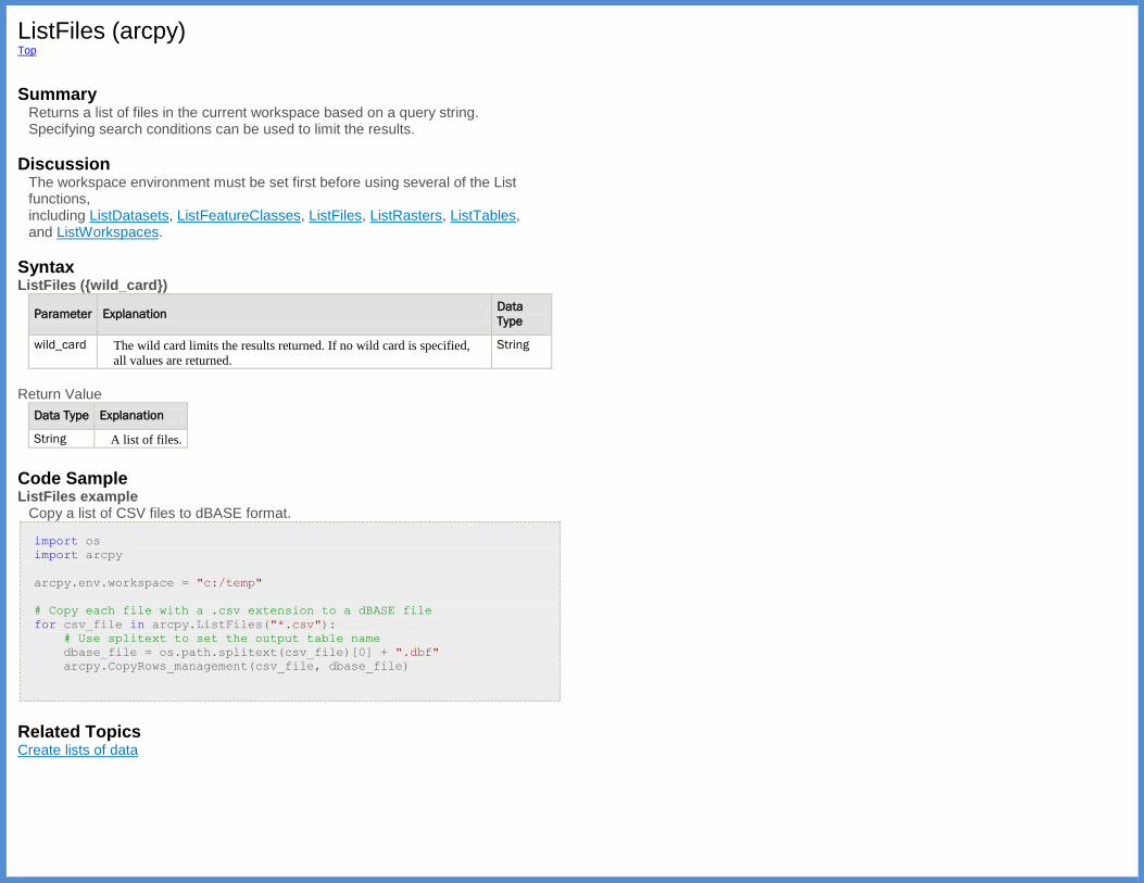
ListFiles (arcpy) Top
Summary
Returns a list of files in the current workspace based on a query string. Specifying search conditions can be used to limit the results.
Discussion The workspace environment must be set first before using several of the List functions, including ListDatasets, ListFeatureClasses, ListFiles, ListRasters, ListTables, and ListWorkspaces.
Syntax ListFiles ({wild_card})
Parameter Explanation Data
Type
wild_card The wild card limits the results returned. If no wild card is specified,
all values are returned.
String
Return Value
Data Type Explanation
String A list of files.
Code Sample ListFiles example
Copy a list of CSV files to dBASE format.
import os
import arcpy
arcpy.env.workspace = "c:/temp"
# Copy each file with a .csv extension to a dBASE file
for csv_file in arcpy.ListFiles("*.csv"):
# Use splitext to set the output table name
dbase_file = os.path.splitext(csv_file)[0] + ".dbf"
arcpy.CopyRows_management(csv_file, dbase_file)
Related Topics Create lists of data
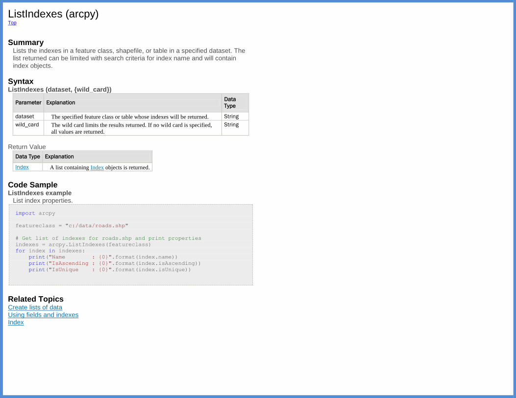
ListIndexes (arcpy) Top
Summary
Lists the indexes in a feature class, shapefile, or table in a specified dataset. The list returned can be limited with search criteria for index name and will contain index objects.
Syntax ListIndexes (dataset, {wild_card})
Parameter Explanation Data
Type
dataset The specified feature class or table whose indexes will be returned. String
wild_card The wild card limits the results returned. If no wild card is specified,
all values are returned.
String
Return Value
Data Type Explanation
Index A list containing Index objects is returned.
Code Sample ListIndexes example
List index properties.
import arcpy
featureclass = "c:/data/roads.shp"
# Get list of indexes for roads.shp and print properties
indexes = arcpy.ListIndexes(featureclass)
for index in indexes:
print("Name : {0}".format(index.name))
print("IsAscending : {0}".format(index.isAscending))
print("IsUnique : {0}".format(index.isUnique))
Related Topics Create lists of data Using fields and indexes Index
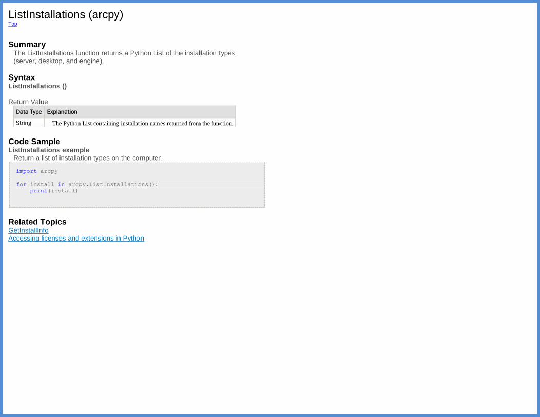
ListInstallations (arcpy) Top
Summary
The ListInstallations function returns a Python List of the installation types (server, desktop, and engine).
Syntax ListInstallations () Return Value
Data Type Explanation
String The Python List containing installation names returned from the function.
Code Sample ListInstallations example
Return a list of installation types on the computer.
import arcpy
for install in arcpy.ListInstallations():
print(install)
Related Topics GetInstallInfo Accessing licenses and extensions in Python
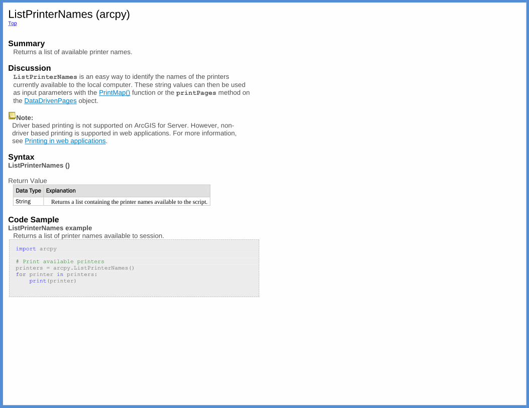
ListPrinterNames (arcpy) Top
Summary
Returns a list of available printer names.
Discussion ListPrinterNames is an easy way to identify the names of the printers
currently available to the local computer. These string values can then be used as input parameters with the PrintMap() function or the printPages method on
the DataDrivenPages object.
Note: Driver based printing is not supported on ArcGIS for Server. However, non-driver based printing is supported in web applications. For more information, see Printing in web applications.
Syntax ListPrinterNames () Return Value
Data Type Explanation
String Returns a list containing the printer names available to the script.
Code Sample ListPrinterNames example
Returns a list of printer names available to session.
import arcpy
# Print available printers
printers = arcpy.ListPrinterNames()
for printer in printers:
print(printer)
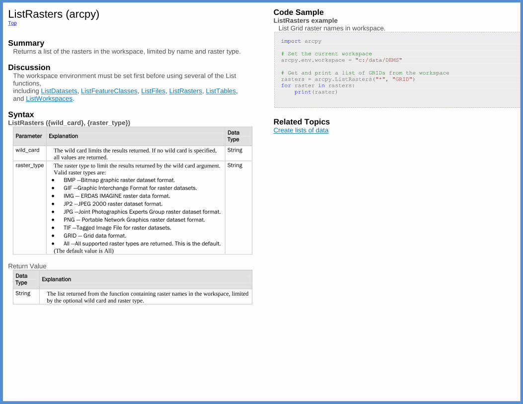
ListRasters (arcpy) Top
Summary
Returns a list of the rasters in the workspace, limited by name and raster type.
Discussion The workspace environment must be set first before using several of the List functions, including ListDatasets, ListFeatureClasses, ListFiles, ListRasters, ListTables, and ListWorkspaces.
Syntax ListRasters ({wild_card}, {raster_type})
Parameter Explanation Data
Type
wild_card The wild card limits the results returned. If no wild card is specified,
all values are returned.
String
raster_type The raster type to limit the results returned by the wild card argument.
Valid raster types are:
BMP —Bitmap graphic raster dataset format.
GIF —Graphic Interchange Format for raster datasets.
IMG — ERDAS IMAGINE raster data format.
JP2 —JPEG 2000 raster dataset format.
JPG —Joint Photographics Experts Group raster dataset format.
PNG — Portable Network Graphics raster dataset format.
TIF —Tagged Image File for raster datasets.
GRID — Grid data format.
All —All supported raster types are returned. This is the default.
(The default value is All)
String
Return Value
Data
Type Explanation
String The list returned from the function containing raster names in the workspace, limited
by the optional wild card and raster type.
Code Sample ListRasters example
List Grid raster names in workspace.
import arcpy
# Set the current workspace
arcpy.env.workspace = "c:/data/DEMS"
# Get and print a list of GRIDs from the workspace
rasters = arcpy.ListRasters("*", "GRID")
for raster in rasters:
print(raster)
Related Topics Create lists of data
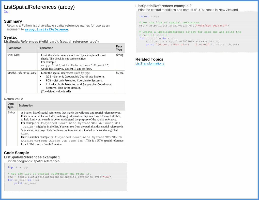
ListSpatialReferences (arcpy) Top
Summary
Returns a Python list of available spatial reference names for use as an argument to arcpy.SpatialReference.
Syntax ListSpatialReferences ({wild_card}, {spatial_reference_type})
Parameter Explanation Data
Type
wild_card Limit the spatial references listed by a simple wildcard
check. The check is not case sensitive.
For example, arcpy.ListSpatialReferences("*Eckert*")
would list Eckert I, Eckert II, and so forth.
String
spatial_reference_type Limit the spatial references listed by type.
GCS —List only Geographic Coordinate Systems.
PCS —List only Projected Coordinate Systems.
ALL —List both Projected and Geographic Coordinate
Systems. This is the default.
(The default value is All)
String
Return Value
Data
Type Explanation
String A Python list of spatial references that match the wildcard and spatial reference type.
Each item in the list includes qualifying information, separated with forward slashes,
to help limit your search or better understand the purpose of the spatial reference.
For example, u'Projected Coordinate Systems/World/Sinusoidal
(world)' might be in the list. You can see from the path that this spatial reference is
Sinusoidal, is a projected coordinate system, and is intended to be used at a global
extent.
Here is another example: u'Projected Coordinate Systems/UTM/South
America/Corrego Alegre UTM Zone 25S'. This is a UTM spatial reference
for a UTM zone in South America.
Code Sample ListSpatialReferences example 1
List all geographic spatial references.
import arcpy
# Get the list of spatial references and print it.
srs = arcpy.ListSpatialReferences(spatial_reference_type="GCS")
for sr_name in srs:
print sr_name
ListSpatialReferences example 2
Print the central meridians and names of UTM zones in New Zealand.
import arcpy
# Get the list of spatial references
srs = arcpy.ListSpatialReferences("*utm/new zealand*")
# Create a SpatialReference object for each one and print the
# central meridian
for sr_string in srs:
sr_object = arcpy.SpatialReference(sr_string)
print "{0.centralMeridian} {0.name}".format(sr_object)
Related Topics ListTransformations
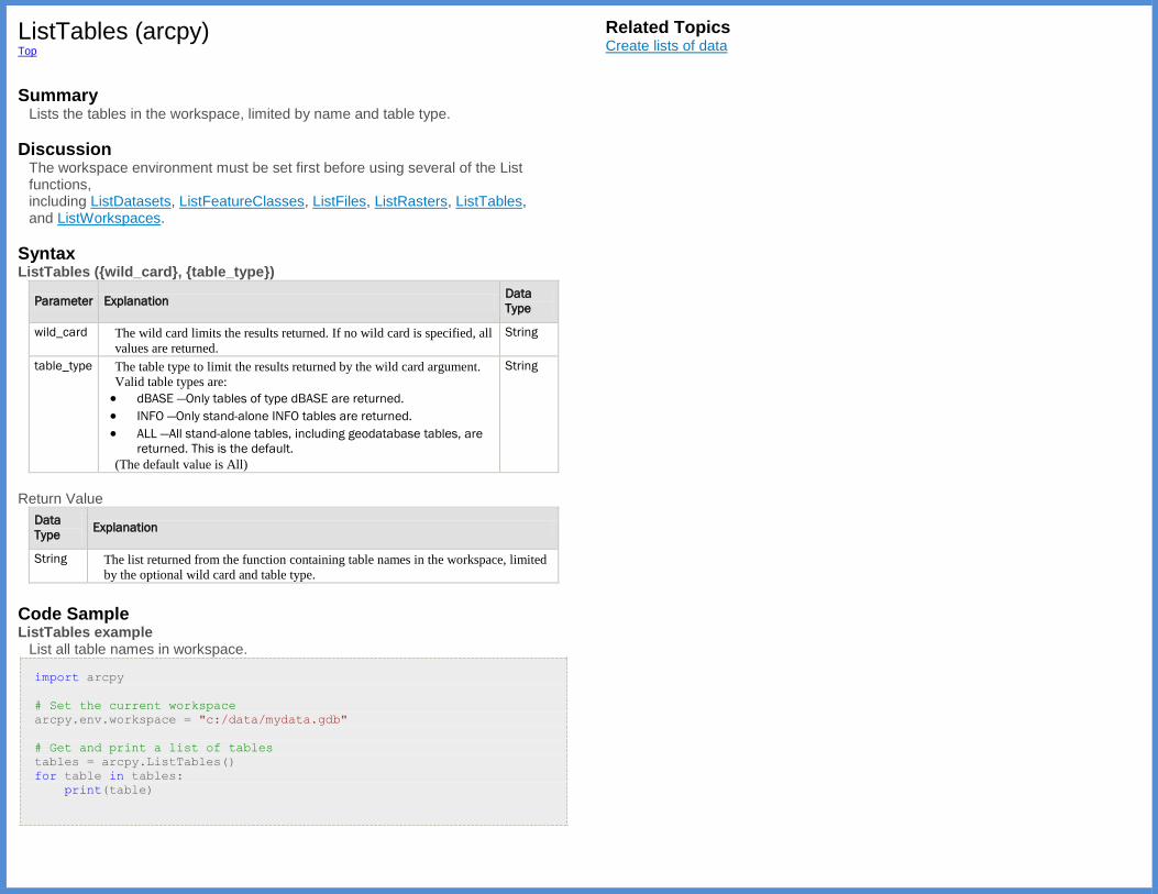
ListTables (arcpy) Top
Summary
Lists the tables in the workspace, limited by name and table type.
Discussion The workspace environment must be set first before using several of the List functions, including ListDatasets, ListFeatureClasses, ListFiles, ListRasters, ListTables, and ListWorkspaces.
Syntax ListTables ({wild_card}, {table_type})
Parameter Explanation Data
Type
wild_card The wild card limits the results returned. If no wild card is specified, all
values are returned.
String
table_type The table type to limit the results returned by the wild card argument.
Valid table types are:
dBASE —Only tables of type dBASE are returned.
INFO —Only stand-alone INFO tables are returned.
ALL —All stand-alone tables, including geodatabase tables, are
returned. This is the default.
(The default value is All)
String
Return Value
Data
Type Explanation
String The list returned from the function containing table names in the workspace, limited
by the optional wild card and table type.
Code Sample ListTables example
List all table names in workspace.
import arcpy
# Set the current workspace
arcpy.env.workspace = "c:/data/mydata.gdb"
# Get and print a list of tables
tables = arcpy.ListTables()
for table in tables:
print(table)
Related Topics Create lists of data
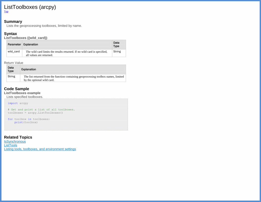
ListToolboxes (arcpy) Top
Summary
Lists the geoprocessing toolboxes, limited by name.
Syntax ListToolboxes ({wild_card})
Parameter Explanation Data
Type
wild_card The wild card limits the results returned. If no wild card is specified,
all values are returned.
String
Return Value
Data
Type Explanation
String The list returned from the function containing geoprocessing toolbox names, limited
by the optional wild card.
Code Sample ListToolboxes example
Lists specified toolboxes.
import arcpy
# Get and print a list of all toolboxes.
toolboxes = arcpy.ListToolboxes()
for toolbox in toolboxes:
print(toolbox)
Related Topics IsSynchronous ListTools Listing tools, toolboxes, and environment settings

ListTools (arcpy) Top
Summary
Lists the geoprocessing tools, limited by name.
Syntax ListTools ({wild_card})
Parameter Explanation Data
Type
wild_card The wild card limits the results returned. If no wild card is specified,
all values are returned.
String
Return Value
Data
Type Explanation
String The list returned from the function containing geoprocessing tool names, limited by
the optional wild card.
Code Sample ListTools example
Lists all tools in the specified toolbox.
import arcpy
# Create a list of tools in the Analysis toolbox
tools = arcpy.ListTools("*_analysis")
# Loop through the list and print each tool's usage.
for tool in tools:
print(arcpy.Usage(tool))
Related Topics IsSynchronous ListToolboxes Listing tools, toolboxes, and environment settings
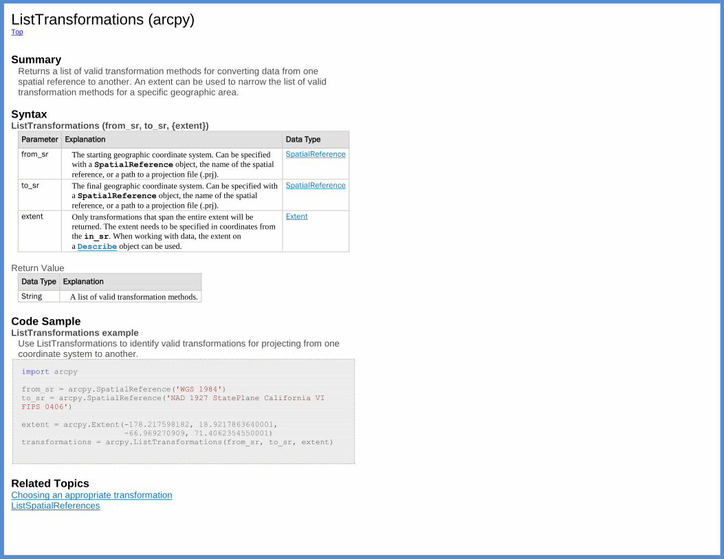
ListTransformations (arcpy) Top
Summary
Returns a list of valid transformation methods for converting data from one spatial reference to another. An extent can be used to narrow the list of valid transformation methods for a specific geographic area.
Syntax ListTransformations (from_sr, to_sr, {extent})
Parameter Explanation Data Type
from_sr The starting geographic coordinate system. Can be specified
with a SpatialReference object, the name of the spatial
reference, or a path to a projection file (.prj).
SpatialReference
to_sr The final geographic coordinate system. Can be specified with
a SpatialReference object, the name of the spatial
reference, or a path to a projection file (.prj).
SpatialReference
extent Only transformations that span the entire extent will be
returned. The extent needs to be specified in coordinates from
the in_sr. When working with data, the extent on
a Describe object can be used.
Extent
Return Value
Data Type Explanation
String A list of valid transformation methods.
Code Sample ListTransformations example
Use ListTransformations to identify valid transformations for projecting from one coordinate system to another.
import arcpy
from_sr = arcpy.SpatialReference('WGS 1984')
to_sr = arcpy.SpatialReference('NAD 1927 StatePlane California VI
FIPS 0406')
extent = arcpy.Extent(-178.217598182, 18.9217863640001,
-66.969270909, 71.4062354550001)
transformations = arcpy.ListTransformations(from_sr, to_sr, extent)
Related Topics Choosing an appropriate transformation ListSpatialReferences
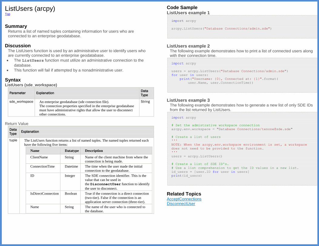
ListUsers (arcpy) Top
Summary
Returns a list of named tuples containing information for users who are connected to an enterprise geodatabase.
Discussion The ListUsers function is used by an administrative user to identify users who are currently connected to an enterprise geodatabase.
The ListUsers function must utilize an administrative connection to the
database.
This function will fail if attempted by a nonadministrative user.
Syntax ListUsers (sde_workspace)
Parameter Explanation Data
Type
sde_workspace An enterprise geodatabase (sde connection file).
The connection properties specified in the enterprise geodatabase
must have administrative rights that allow the user to disconnect
other connections.
String
Return Value
Data
Type Explanation
tuple The ListUsers function returns a list of named tuples. The named tuples returned each
have the following five items:
Name Datatype Description
ClientName String Name of the client machine from where the
connection is being made.
ConnectionTime Datetime The time when the user made the initial
connection to the geodatabase.
ID Integer The SDE connection identifier. This is the
value that can be used in
the DisconnectUser function to identify
the user to disconnect.
IsDirectConnection Boolean True if the connection is a direct connection
(two-tier). False if the connection is an
application server connection (three-tier).
Name String The name of the user who is connected to
the database.
Code Sample ListUsers example 1
import arcpy
arcpy.ListUsers("Database Connections/admin.sde")
ListUsers example 2
The following example demonstrates how to print a list of connected users along with their connection time.
import arcpy
users = arcpy.ListUsers("Database Connections/admin.sde")
for user in users:
print("Username: {0}, Connected at: {1}".format(
user.Name, user.ConnectionTime))
ListUsers example 3
The following example demonstrates how to generate a new list of only SDE IDs from the list returned by ListUsers.
import arcpy
# Set the admistrative workspace connection
arcpy.env.workspace = "Database Connections/[email protected]"
# Create a list of users
'''
NOTE: When the arcpy.env.workspace environment is set, a workspace
does not need to be provided to the function.
'''
users = arcpy.ListUsers()
# Create a list of SDE ID's.
# Use a list comprehension to get the ID values in a new list.
id_users = [user.ID for user in users]
print(id_users)
Related Topics AcceptConnections DisconnectUser
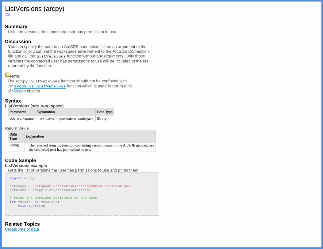
ListVersions (arcpy) Top
Summary
Lists the versions the connected user has permission to use.
Discussion You can specify the path to an ArcSDE connection file as an argument to the function or you can set the workspace environment to the ArcSDE Connection file and call the ListVersions function without any arguments. Only those
versions the connected user has permissions to use will be included in the list returned by the function.
Note:
The arcpy.ListVersions function should not be confused with
the arcpy.da.ListVersions function which is used to return a list
of Version objects.
Syntax ListVersions (sde_workspace)
Parameter Explanation Data Type
sde_workspace An ArcSDE geodatabase workspace. String
Return Value
Data
Type Explanation
String The returned from the function containing version names in the ArcSDE geodatabase
the connected user has permissions to use.
Code Sample ListVersions example
Gets the list of versions the user has permissions to use and prints them.
import arcpy
database = "Database Connections/toolboxDEFAULTVersion.sde"
versions = arcpy.ListVersions(database)
# Print the versions available to the user
for version in versions:
print(version)
Related Topics Create lists of data
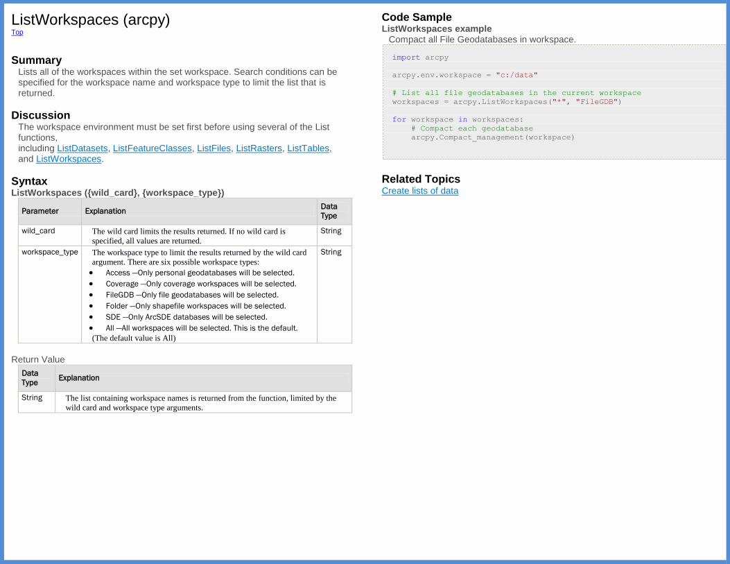
ListWorkspaces (arcpy) Top
Summary
Lists all of the workspaces within the set workspace. Search conditions can be specified for the workspace name and workspace type to limit the list that is returned.
Discussion The workspace environment must be set first before using several of the List functions, including ListDatasets, ListFeatureClasses, ListFiles, ListRasters, ListTables, and ListWorkspaces.
Syntax ListWorkspaces ({wild_card}, {workspace_type})
Parameter Explanation Data
Type
wild_card The wild card limits the results returned. If no wild card is
specified, all values are returned.
String
workspace_type The workspace type to limit the results returned by the wild card
argument. There are six possible workspace types:
Access —Only personal geodatabases will be selected.
Coverage —Only coverage workspaces will be selected.
FileGDB —Only file geodatabases will be selected.
Folder —Only shapefile workspaces will be selected.
SDE —Only ArcSDE databases will be selected.
All —All workspaces will be selected. This is the default.
(The default value is All)
String
Return Value
Data
Type Explanation
String The list containing workspace names is returned from the function, limited by the
wild card and workspace type arguments.
Code Sample ListWorkspaces example
Compact all File Geodatabases in workspace.
import arcpy
arcpy.env.workspace = "c:/data"
# List all file geodatabases in the current workspace
workspaces = arcpy.ListWorkspaces("*", "FileGDB")
for workspace in workspaces:
# Compact each geodatabase
arcpy.Compact_management(workspace)
Related Topics Create lists of data

LoadSettings (arcpy) Top
Summary
Loads environment settings from an environment settings file (text stored in an Extensible Markup Language [XML] schema). See also SaveSettings on how to save environment settings.
Syntax LoadSettings (file_name)
Parameter Explanation Data Type
file_name An existing XML file that contains environment settings. String
Code Sample LoadSettings example
Load settings from environment settings XML file.
import arcpy
# Load previously saved environment settings
#
arcpy.LoadSettings("C:/Data/MyCustomSettings.xml")
Related Topics SaveSettings
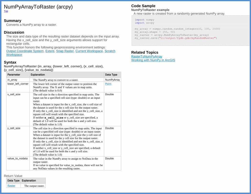
NumPyArrayToRaster (arcpy) Top
Summary
Converts a NumPy array to a raster.
Discussion The size and data type of the resulting raster dataset depends on the input array. Having the x_cell_size and the y_cell_size arguments allows support for rectangular cells. This function honors the following geoprocessing environment settings: Output Coordinate System, Extent, Snap Raster, Current Workspace, Scratch Workspace
Syntax NumPyArrayToRaster (in_array, {lower_left_corner}, {x_cell_size}, {y_cell_size}, {value_to_nodata})
Parameter Explanation Data Type
in_array The NumPy array to convert to a raster. NumPyArray
lower_left_corner The lower left corner of the output raster to position the
NumPy array. The X and Y values are in map units.
(The default value is 0.0)
Point
x_cell_size The cell size in the x direction specified in map units. The
input can be a specified cell size (type: double) or an input
raster.
When a dataset is input for the x_cell_size, the x cell size of
the dataset is used for the x cell size for the output raster.
If only the x_cell_size is identified and not the y_cell_size, a
square cell will result with the specified size.
If neither x_cell_size or y_cell_size are specified, a
default of 1.0 will be used for both the x and y cell size.
(The default value is 1.0)
Double
y_cell_size The cell size in y direction specified in map units. The input
can be a specified cell size (type: double) or an input raster.
When a dataset is input for the y_cell_size the y cell size of
the dataset is used for the y cell size for the output raster.
If only the y_cell_size is identified and not the x_cell_size, a
square cell will result with the specified size.
If neither x_cell_size or y_cell_size are specified, a default
of 1.0 will be used for both the x and y cell size.
(The default value is 1.0)
Double
value_to_nodata The value in the NumPy array to assign to NoData in the
output raster.
If no value is specified for value_to_nodata, there will not be
any NoData values in the resulting raster.
Double
Return Value
Data Type Explanation
Raster The output raster.
Code Sample NumPyToRaster example
A new raster is created from a randomly generated NumPy array.
import numpy
import arcpy
my_array = numpy.random.random_integers(0, 100, 2500)
my_array.shape = (50, 50)
my_raster = arcpy.NumPyArrayToRaster(my_array)
my_raster.save("c:/output/fgdb.gdb/myRandomRaster")
Related Topics RasterToNumPyArray Working with NumPy in ArcGIS
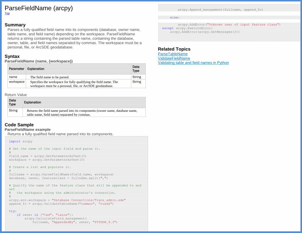
ParseFieldName (arcpy) Top
Summary
Parses a fully qualified field name into its components (database, owner name, table name, and field name) depending on the workspace. ParseFieldName returns a string containing the parsed table name, containing the database, owner, table, and field names separated by commas. The workspace must be a personal, file, or ArcSDE geodatabase.
Syntax ParseFieldName (name, {workspace})
Parameter Explanation Data
Type
name The field name to be parsed. String
workspace Specifies the workspace for fully qualifying the field name. The
workspace must be a personal, file, or ArcSDE geodatabase.
String
Return Value
Data
Type Explanation
String Returns the field name parsed into its components (owner name, database name,
table name, field name) separated by commas.
Code Sample ParseFieldName example
Returns a fully qualified field name parsed into its components.
import arcpy
# Get the name of the input field and parse it.
#
field_name = arcpy.GetParameterAsText(0)
workspace = arcpy.GetParameterAsText(0)
# Create a list and populate it.
#
fullname = arcpy.ParseFieldName(field_name, workspace)
database, owner, featureclass = fullname.split(",")
# Qualify the name of the feature class that will be appended to and
set
# the workspace using the administrator's connection.
#
arcpy.env.workspace = "Database Connections/Trans_admin.sde"
append_fc = arcpy.ValidateTableName("common", "roads")
try:
if owner in ["ted", "laura"]:
arcpy.CalculateField_management(
fullname, "AppendedBy", owner, "PYTHON_9.3")
arcpy.Append_management(fullname, append_fc)
else:
arcpy.AddError("Unknown user of input feature class")
except arcpy.ExecuteError:
arcpy.AddError(arcpy.GetMessages(2))
Related Topics ParseTableName ValidateFieldName Validating table and field names in Python

ParseTableName (arcpy) Top
Summary
Parses a table name into its components (database, owner, table) depending on the workspace. ParseTableName returns a string containing the parsed table name, with the database name, owner name, and table name separated by commas. This workspace must be a personal, file, or ArcSDE geodatabase.
Syntax ParseTableName (name, {workspace})
Parameter Explanation Data
Type
name Specifies which table will be parsed. String
workspace Specifies the workspace for fully qualifying the table name. The
workspace must be a personal, file, or ArcSDE geodatabase.
String
Return Value
Data
Type Explanation
String Returns the table name parsed into its components (owner name, database name,
table name) separated by commas.
Code Sample ParseTableName example
Parse a table name into its components.
import arcpy
# Get the name of the input field and parse it.
#
field_name = arcpy.GetParameterAsText(0)
workspace = arcpy.GetParameterAsText(0)
# Create a list and populate it.
#
fullname = arcpy.ParseTableName(field_name, workspace)
database, owner, featureclass = fullname.split(",")
# Qualify the name of the feature class that will be appended to and
set
# the workspace using the administrator's connection.
#
arcpy.env.workspace = "Database Connections/Trans_admin.sde"
append_fc = arcpy.ValidateTableName("common", "roads")
try:
if owner in ["ted", "laura"]:
arcpy.CalculateField_management(
fullname, "AppendedBy", owner, "PYTHON_9.3")
arcpy.Append_management(fullname, append_fc)
else:
arcpy.AddError("Unknown user of input feature class")
except arcpy.ExecuteError:
arcpy.AddError(arcpy.GetMessages(2))
Related Topics ValidateTableName ParseFieldName Validating table and field names in Python
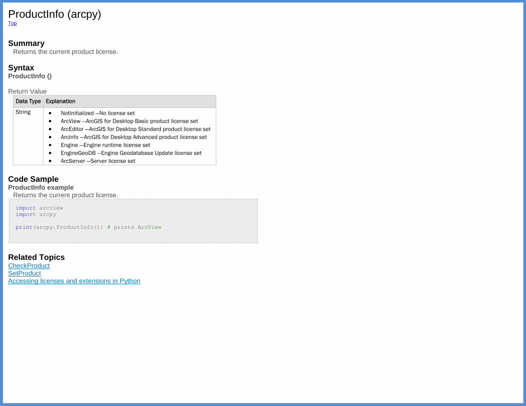
ProductInfo (arcpy) Top
Summary
Returns the current product license.
Syntax ProductInfo () Return Value
Data Type Explanation
String NotInitialized —No license set
ArcView —ArcGIS for Desktop Basic product license set
ArcEditor —ArcGIS for Desktop Standard product license set
ArcInfo —ArcGIS for Desktop Advanced product license set
Engine —Engine runtime license set
EngineGeoDB —Engine Geodatabase Update license set
ArcServer —Server license set
Code Sample ProductInfo example
Returns the current product license.
import arcview
import arcpy
print(arcpy.ProductInfo()) # prints ArcView
Related Topics CheckProduct SetProduct Accessing licenses and extensions in Python

RasterToNumPyArray (arcpy) Top
Summary
Converts a raster to a NumPy array.
Discussion A Python NumPy array is designed to deal with large arrays. There are many existing Python functions that have been created to process NumPy arrays, the most noted being contained in the SciPy scientific computing package for Python. You may want to convert an ArcGIS raster to a NumPy array to
1. Implement one of the many existing Python functions that can be applied to a NumPy array (for example, run filters on the data, perform multidimensional analysis, or utilize optimization routines).
2. Develop a custom function by accessing the individual cells within the NumPy array (for example, to implement neighborhood notation, change individual cell values, or run accumulative operators on an entire raster).
If the array definition (the lower left corner and the number of rows and columns) exceeds the extent of the in_raster, the array values will be assigned NoData.
If the lower_left_corner does not coincide with the corner of a cell, it will
automatically be snapped to the lower left of the nearest cell corner applying the same rules as the Snap Raster environment setting. This snapping action within the RasterToNumPyfunction is not to be confused with the Snap Raster
environment setting; the function only uses the same interaction; see: Learn more about how the Snap Raster environment works
Syntax RasterToNumPyArray (in_raster, {lower_left_corner}, {ncols}, {nrows}, {nodata_to_value})
Parameter Explanation Data
Type
in_raster The input raster to convert to a NumPy array. Raster
lower_left_corner The lower left corner within the in_raster from which to
extract the processing block to convert to an array. The x- and y-
values are in map units.
(The default value is origin of inRaster)
Point
ncols The number of columns from the lower_left_corner in
the in_raster to convert to the NumPy array.
(The default value is number of columns in inRaster)
Integer
nrows The number of rows from the lower_left_corner in
the in_raster to convert to the NumPy array.
(The default value is number of rows in inRaster)
Integer
nodata_to_value The value to assign the in_raster NoData values in the
resulting NumPy array. The data type depends on the type of
the in_raster.
If no value is specified, the NoData values in in_raster will
be assigned the value associated with NoData in in_raster.
Variant
Return Value
Data Type Explanation
NumPyArray The output NumPy array.
Code Sample RasterToNumPy example
A raster is converted to a NumPy array to calculate the percentage of the cell value in the entire raster row. A new raster is then created.
import arcpy
import numpy
my_array = arcpy.RasterToNumPyArray('C:/data/inRaster')
my_array_sum = my_array.sum(1)
my_array_sum.shape = (my_array.shape[0], 1)
my_array_perc = (my_array * 1.0) / my_array_sum
new_raster = arcpy.NumPyArrayToRaster(my_array_perc)
new_raster.save("C:/output/fgdb.gdb/PercentRaster")
Related Topics Working with NumPy in ArcGIS NumPyArrayToRaster
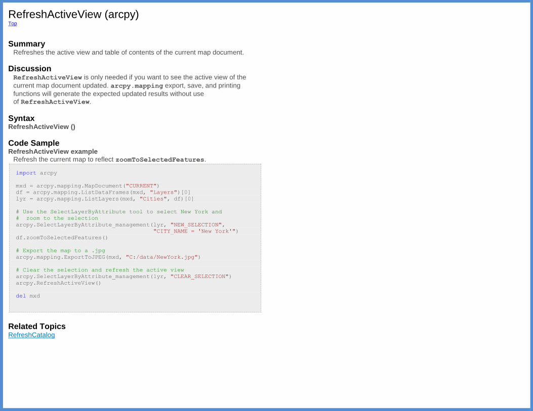
RefreshActiveView (arcpy) Top
Summary
Refreshes the active view and table of contents of the current map document.
Discussion RefreshActiveView is only needed if you want to see the active view of the
current map document updated. arcpy.mapping export, save, and printing
functions will generate the expected updated results without use of RefreshActiveView.
Syntax RefreshActiveView ()
Code Sample RefreshActiveView example
Refresh the current map to reflect zoomToSelectedFeatures.
import arcpy
mxd = arcpy.mapping.MapDocument("CURRENT")
df = arcpy.mapping.ListDataFrames(mxd, "Layers")[0]
lyr = arcpy.mapping.ListLayers(mxd, "Cities", df)[0]
# Use the SelectLayerByAttribute tool to select New York and
# zoom to the selection
arcpy.SelectLayerByAttribute_management(lyr, "NEW_SELECTION",
"CITY_NAME = 'New York'")
df.zoomToSelectedFeatures()
# Export the map to a .jpg
arcpy.mapping.ExportToJPEG(mxd, "C:/data/NewYork.jpg")
# Clear the selection and refresh the active view
arcpy.SelectLayerByAttribute_management(lyr, "CLEAR_SELECTION")
arcpy.RefreshActiveView()
del mxd
Related Topics RefreshCatalog
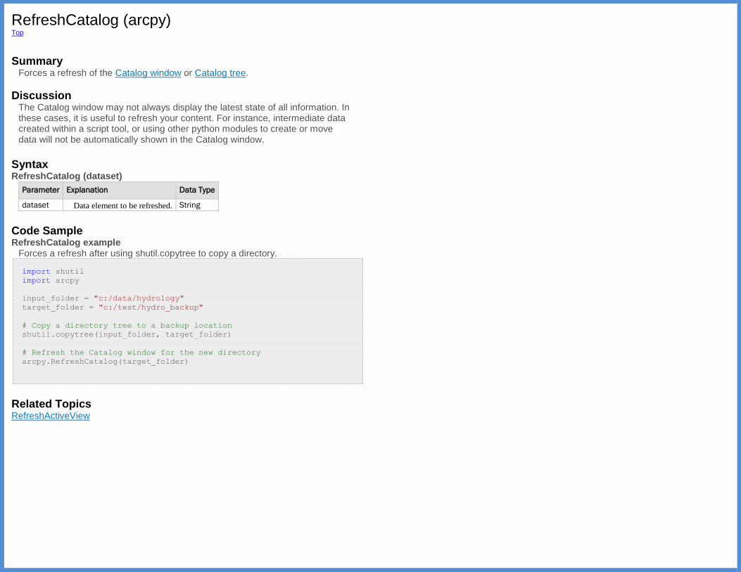
RefreshCatalog (arcpy) Top
Summary
Forces a refresh of the Catalog window or Catalog tree.
Discussion The Catalog window may not always display the latest state of all information. In these cases, it is useful to refresh your content. For instance, intermediate data created within a script tool, or using other python modules to create or move data will not be automatically shown in the Catalog window.
Syntax RefreshCatalog (dataset)
Parameter Explanation Data Type
dataset Data element to be refreshed. String
Code Sample RefreshCatalog example
Forces a refresh after using shutil.copytree to copy a directory.
import shutil
import arcpy
input_folder = "c:/data/hydrology"
target_folder = "c:/test/hydro_backup"
# Copy a directory tree to a backup location
shutil.copytree(input_folder, target_folder)
# Refresh the Catalog window for the new directory
arcpy.RefreshCatalog(target_folder)
Related Topics RefreshActiveView
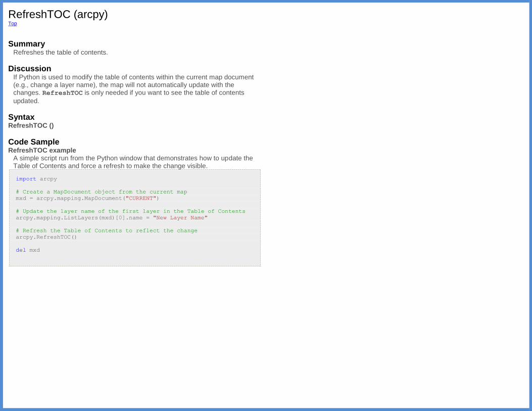
RefreshTOC (arcpy) Top
Summary
Refreshes the table of contents.
Discussion If Python is used to modify the table of contents within the current map document (e.g., change a layer name), the map will not automatically update with the changes. RefreshTOC is only needed if you want to see the table of contents
updated.
Syntax RefreshTOC ()
Code Sample RefreshTOC example
A simple script run from the Python window that demonstrates how to update the Table of Contents and force a refresh to make the change visible.
import arcpy
# Create a MapDocument object from the current map
mxd = arcpy.mapping.MapDocument("CURRENT")
# Update the layer name of the first layer in the Table of Contents
arcpy.mapping.ListLayers(mxd)[0].name = "New Layer Name"
# Refresh the Table of Contents to reflect the change
arcpy.RefreshTOC()
del mxd
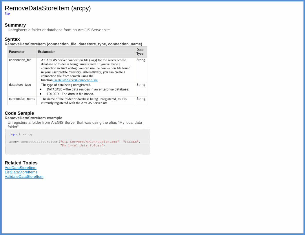
RemoveDataStoreItem (arcpy) Top
Summary
Unregisters a folder or database from an ArcGIS Server site.
Syntax RemoveDataStoreItem (connection_file, datastore_type, connection_name)
Parameter Explanation Data
Type
connection_file An ArcGIS Server connection file (.ags) for the server whose
database or folder is being unregistered. If you've made a
connection in ArcCatalog, you can use the connection file found
in your user profile directory. Alternatively, you can create a
connection file from scratch using the
functionCreateGISServerConnectionFile.
String
datastore_type The type of data being unregistered.
DATABASE —The data resides in an enterprise database.
FOLDER —The data is file-based.
String
connection_name The name of the folder or database being unregistered, as it is
currently registered with the ArcGIS Server site.
String
Code Sample RemoveDataStoreItem example
Unregisters a folder from ArcGIS Server that was using the alias "My local data folder".
import arcpy
arcpy.RemoveDataStoreItem("GIS Servers/MyConnection.ags", "FOLDER",
"My local data folder")
Related Topics AddDataStoreItem ListDataStoreItems ValidateDataStoreItem
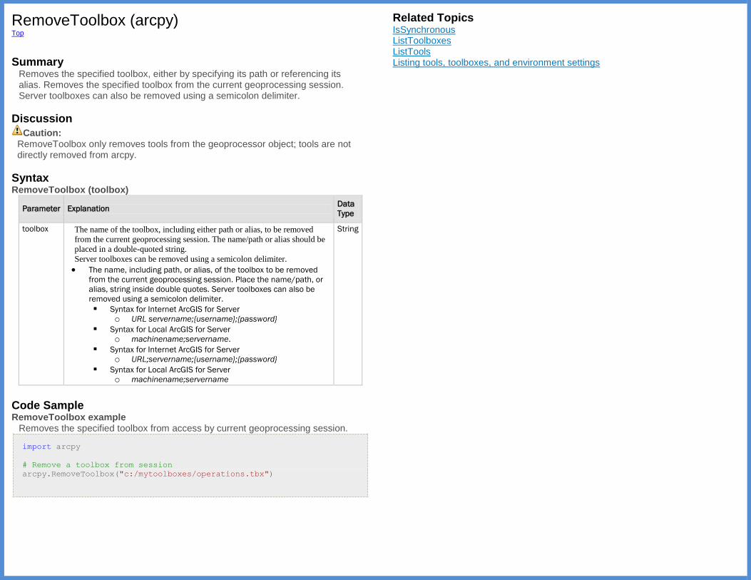
RemoveToolbox (arcpy) Top
Summary
Removes the specified toolbox, either by specifying its path or referencing its alias. Removes the specified toolbox from the current geoprocessing session. Server toolboxes can also be removed using a semicolon delimiter.
Discussion
Caution: RemoveToolbox only removes tools from the geoprocessor object; tools are not directly removed from arcpy.
Syntax RemoveToolbox (toolbox)
Parameter Explanation Data
Type
toolbox The name of the toolbox, including either path or alias, to be removed
from the current geoprocessing session. The name/path or alias should be
placed in a double-quoted string.
Server toolboxes can be removed using a semicolon delimiter.
The name, including path, or alias, of the toolbox to be removed
from the current geoprocessing session. Place the name/path, or
alias, string inside double quotes. Server toolboxes can also be
removed using a semicolon delimiter.
Syntax for Internet ArcGIS for Server
o URL servername;{username};{password}
Syntax for Local ArcGIS for Server
o machinename;servername.
Syntax for Internet ArcGIS for Server
o URL;servername;{username};{password}
Syntax for Local ArcGIS for Server
o machinename;servername
String
Code Sample RemoveToolbox example
Removes the specified toolbox from access by current geoprocessing session.
import arcpy
# Remove a toolbox from session
arcpy.RemoveToolbox("c:/mytoolboxes/operations.tbx")
Related Topics IsSynchronous ListToolboxes ListTools Listing tools, toolboxes, and environment settings
ResetEnvironments (arcpy) Top
Summary
Resets all environment settings to their default settings.
Syntax ResetEnvironments ()
Code Sample ResetEnvironments example
Resets all environment settings to their default values.
import arcpy
# Reset environment settings to default settings.
#
arcpy.ResetEnvironments()
Related Topics Using environment settings in Python ClearEnvironment GetSystemEnvironment ListEnvironments
ResetProgressor (arcpy) Top
Summary
Resets the progressor back to its initial state.
Syntax ResetProgressor ()
Code Sample ResetProgressor example
Reset progress dialog box to initial state.
import os
import arcpy
# Allow overwriting of output
arcpy.env.overwriteOutput = True
# Set current workspace
arcpy.env.workspace = "c:/data"
# Get a list of shapefiles in folder
fcs = arcpy.ListFeatureClasses()
# Find the total count of shapefiles in list
fc_count = len(fcs)
# Set the progressor
arcpy.SetProgressor("step", "Copying shapefiles to geodatabase...",
0, fc_count, 1)
# Create a file gdb to contain new feature classes
arcpy.CreateFileGDB_management(arcpy.env.workspace, "fgdb.gdb")
# For each shapefile, copy to a file geodatabase
for shp in fcs:
# Trim the '.shp' extension
fc = os.path.splitext(shp)[0]
# Update the progressor label for current shapefile
arcpy.SetProgressorLabel("Loading {0}...".format(shp))
# Copy the data
arcpy.CopyFeatures_management(shp, os.path.join("fgdb.gdb", fc))
# Update the progressor position
arcpy.SetProgressorPosition()
arcpy.ResetProgressor()
Related Topics SetProgressor SetProgressorLabel SetProgressorPosition Controlling the progress dialog box
SaveSettings (arcpy) Top
Summary
Saves environment settings to an environment settings file (text stored in an Extensible Markup Language [XML] schema). See also LoadSettings on how to load environment settings from an XML file.
Syntax SaveSettings (file_name)
Parameter Explanation Data
Type
file_name The XML file to be created that will store the current environment
settings.
String
Code Sample SaveSettings example
Save environment settings to an XML file.
import arcpy
arcpy.env.workspace = "c:/data/mydata.gdb"
arcpy.env.cellSize = 28
arcpy.env.compression = "LZ77"
# Save environment settings to XML file
arcpy.SaveSettings("c:/data/mycustomsettings.xml")
Related Topics LoadSettings

SearchCursor (arcpy) Top
Summary
The SearchCursor function establishes a read-only cursor on a feature class
or table. The SearchCursor can be used to iterate through row objects and
extract field values. The search can optionally be limited by a where clause or by field, and optionally sorted.
Discussion Search cursors are able to be iterated with a for loop or in a while loop using
the cursor's next method to return the next row. When using the next method
on a cursor to retrieve all rows in a table containing N rows, the script must make N calls to next. A call to next after the last row in the result set has been
retrieved returns None, which is a Python data type that acts here as a
placeholder. Using SearchCursor with a for loop.
import arcpy
fc = "c:/data/base.gdb/roads"
field = "StreetName"
cursor = arcpy.SearchCursor(fc)
for row in cursor:
print(row.getValue(field))
Using SearchCursor with a while loop.
import arcpy
fc = "c:/data/base.gdb/roads"
field = "StreetName"
cursor = arcpy.SearchCursor(fc)
row = cursor.next()
while row:
print(row.getValue(field))
row = cursor.next()
Syntax SearchCursor (dataset, {where_clause}, {spatial_reference}, {fields}, {sort_fields})
Parameter Explanation Data Type
dataset The feature class, shapefile, or table containing the
rows to be searched.
String
where_clause An optional expression that limits the rows returned in
the cursor. For more information on WHERE clauses
String
and SQL statements, see
About_building_an_SQL_expression.
spatial_reference When specified, features will be projected on the fly
using the spatial_reference provided.
SpatialReference
fields The fields to be included in the cursor. By default, all
fields are included.
String
sort_fields Fields used to sort the rows in the cursor. Ascending
and descending order for each field is denoted by A
and D.
String
Return Value
Data Type Explanation
Cursor A Cursor object that can hand out row objects.
Code Sample SearchCursor example
List field contents for Counties.shp. Cursor sorted by State Name and Population.
import arcpy
# Open a searchcursor
# Input: C:/Data/Counties.shp
# Fields: NAME; STATE_NAME; POP2000
# Sort fields: STATE_NAME A; POP2000 D
rows = arcpy.SearchCursor("c:/data/counties.shp",
fields="NAME; STATE_NAME; POP2000",
sort_fields="STATE_NAME A; POP2000 D")
# Iterate through the rows in the cursor and print out the
# state name, county and population of each.
for row in rows:
print("State: {0}, County: {1}, Population: {2}".format(
row.getValue("STATE_NAME"),
row.getValue("NAME"),
row.getValue("POP2000")))
Related Topics Accessing data using cursors UpdateCursor InsertCursor
SetLogHistory (arcpy) Top
Summary
For script tools and stand-alone scripts (scripts run outside of an ArcGIS application), you can enable or disable history logging using the SetLogHistory function.
The history log file is an Extensible Markup Language (XML) file that contains information about each geoprocessing operation. The information contained in the log file is essentially the same as that found in the Results window.
Syntax SetLogHistory (log_history)
Parameter Explanation Data Type
log_history True, to enable geoprocessing logging history and False, to disable. Boolean
Code Sample SetLogHistory example
Turn off geoprocessing log history.
import arcpy
arcpy.SetLogHistory(False)
Related Topics GetLogHistory Viewing tool execution history
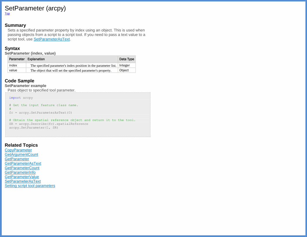
SetParameter (arcpy) Top
Summary
Sets a specified parameter property by index using an object. This is used when passing objects from a script to a script tool. If you need to pass a text value to a script tool, use SetParameterAsText.
Syntax SetParameter (index, value)
Parameter Explanation Data Type
index The specified parameter's index position in the parameter list. Integer
value The object that will set the specified parameter's property. Object
Code Sample SetParameter example
Pass object to specified tool parameter.
import arcpy
# Get the input feature class name.
#
fc = arcpy.GetParameterAsText(0)
# Obtain the spatial reference object and return it to the tool.
SR = arcpy.Describe(fc).spatialReference
arcpy.SetParameter(1, SR)
Related Topics CopyParameter GetArgumentCount GetParameter GetParameterAsText GetParameterCount GetParameterInfo GetParameterValue SetParameterAsText Setting script tool parameters
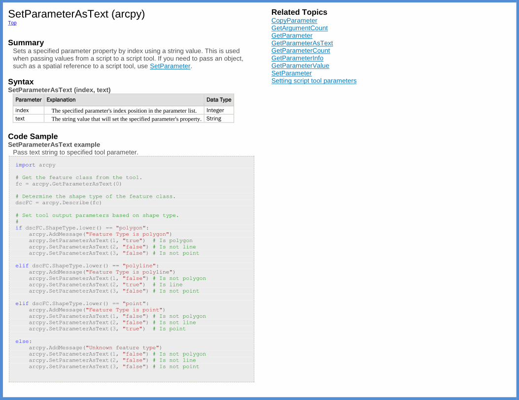
SetParameterAsText (arcpy) Top
Summary
Sets a specified parameter property by index using a string value. This is used when passing values from a script to a script tool. If you need to pass an object, such as a spatial reference to a script tool, use SetParameter.
Syntax SetParameterAsText (index, text)
Parameter Explanation Data Type
index The specified parameter's index position in the parameter list. Integer
text The string value that will set the specified parameter's property. String
Code Sample SetParameterAsText example
Pass text string to specified tool parameter.
import arcpy
# Get the feature class from the tool.
fc = arcpy.GetParameterAsText(0)
# Determine the shape type of the feature class.
dscFC = arcpy.Describe(fc)
# Set tool output parameters based on shape type.
#
if dscFC.ShapeType.lower() == "polygon":
arcpy.AddMessage("Feature Type is polygon")
arcpy.SetParameterAsText(1, "true") # Is polygon
arcpy.SetParameterAsText(2, "false") # Is not line
arcpy.SetParameterAsText(3, "false") # Is not point
elif dscFC.ShapeType.lower() == "polyline":
arcpy.AddMessage("Feature Type is polyline")
arcpy.SetParameterAsText(1, "false") # Is not polygon
arcpy.SetParameterAsText(2, "true") # Is line
arcpy.SetParameterAsText(3, "false") # Is not point
elif dscFC.ShapeType.lower() == "point":
arcpy.AddMessage("Feature Type is point")
arcpy.SetParameterAsText(1, "false") # Is not polygon
arcpy.SetParameterAsText(2, "false") # Is not line
arcpy.SetParameterAsText(3, "true") # Is point
else:
arcpy.AddMessage("Unknown feature type")
arcpy.SetParameterAsText(1, "false") # Is not polygon
arcpy.SetParameterAsText(2, "false") # Is not line
arcpy.SetParameterAsText(3, "false") # Is not point
Related Topics CopyParameter GetArgumentCount GetParameter GetParameterAsText GetParameterCount GetParameterInfo GetParameterValue SetParameter Setting script tool parameters

SetProduct (arcpy) Top
Summary
The SetProduct function defines the desktop license. SetProduct returns
information on the license.
Legacy: The product level should be set by importing the appropriate product module (arcinfo, arceditor, arcview, arcserver, arcenginegeodb, or
arcengine) prior to importing arcpy. The SetProduct function is a legacy
function and cannot set the product once arcpy has been imported. For scripts using the arcgisscripting module, the
equivalent SetProduct method is still supported.
Discussion
Tip: The setting of the product and extensions is only necessary within stand-alone scripts. If you are running tools from the Python window or using script tools, the product is already set from within the application, and the active extensions are based on the Extensions dialog box.
Syntax SetProduct (product)
Parameter Explanation Data Type
product Product code for the product being set.
arcview —ArcGIS for Desktop Basic product code
arceditor —ArcGIS for Desktop Standard product code
arcinfo —ArcGIS for Desktop Advanced product code
engine —Engine Runtime product code
enginegeodb —Engine Geodatabase Update product code
arcserver — Server product code
String
Return Value
Data
Type Explanation
String The function returns the status on the product license. There are four possible
values:
CheckedOut —License successfully set.
AlreadyInitialized —License has already been set.
NotLicensed —The license is not valid or available.
Failed —A system failure occurred during the set request.
Code Sample SetProduct example
Sets an ArcGIS for Desktop Basic product license using the arcview module.
# Set the ArcGIS for Desktop Basic product by importing the arcview
module.
import arcview
import arcpy
arcpy.env.workspace = "c:/data/SanDiego.gdb"
arcpy.CreateRasterDataset_management(
arcpy.env.workspace, "LandUse", "30", "8_BIT_UNSIGNED",
"Freeways", 1)
Related Topics CheckProduct ProductInfo Accessing licenses and extensions in Python
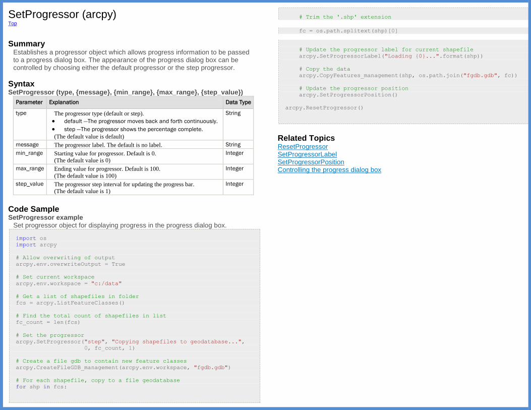
SetProgressor (arcpy) Top
Summary
Establishes a progressor object which allows progress information to be passed to a progress dialog box. The appearance of the progress dialog box can be controlled by choosing either the default progressor or the step progressor.
Syntax SetProgressor (type, {message}, {min_range}, {max_range}, {step_value})
Parameter Explanation Data Type
type The progressor type (default or step).
default —The progressor moves back and forth continuously.
step —The progressor shows the percentage complete.
(The default value is default)
String
message The progressor label. The default is no label. String
min_range Starting value for progressor. Default is 0.
(The default value is 0)
Integer
max_range Ending value for progressor. Default is 100.
(The default value is 100)
Integer
step_value The progressor step interval for updating the progress bar.
(The default value is 1)
Integer
Code Sample SetProgressor example
Set progressor object for displaying progress in the progress dialog box.
import os
import arcpy
# Allow overwriting of output
arcpy.env.overwriteOutput = True
# Set current workspace
arcpy.env.workspace = "c:/data"
# Get a list of shapefiles in folder
fcs = arcpy.ListFeatureClasses()
# Find the total count of shapefiles in list
fc_count = len(fcs)
# Set the progressor
arcpy.SetProgressor("step", "Copying shapefiles to geodatabase...",
0, fc_count, 1)
# Create a file gdb to contain new feature classes
arcpy.CreateFileGDB_management(arcpy.env.workspace, "fgdb.gdb")
# For each shapefile, copy to a file geodatabase
for shp in fcs:
# Trim the '.shp' extension
fc = os.path.splitext(shp)[0]
# Update the progressor label for current shapefile
arcpy.SetProgressorLabel("Loading {0}...".format(shp))
# Copy the data
arcpy.CopyFeatures_management(shp, os.path.join("fgdb.gdb", fc))
# Update the progressor position
arcpy.SetProgressorPosition()
arcpy.ResetProgressor()
Related Topics ResetProgressor SetProgressorLabel SetProgressorPosition Controlling the progress dialog box
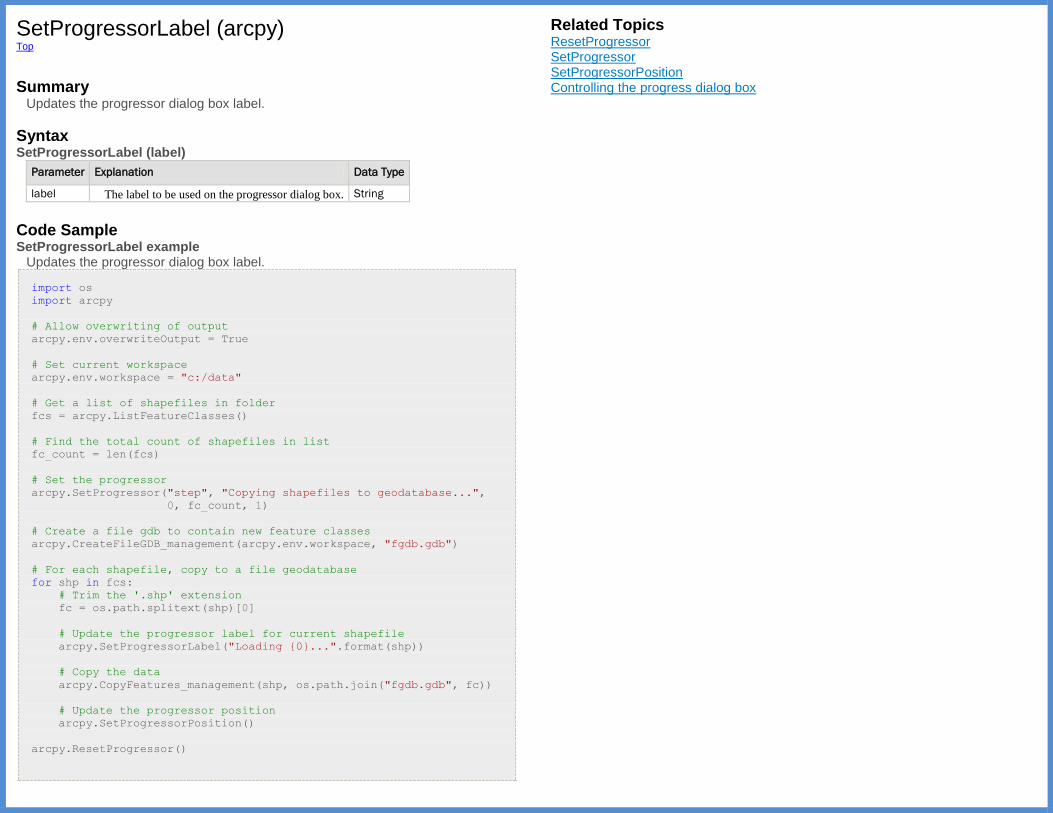
SetProgressorLabel (arcpy) Top
Summary
Updates the progressor dialog box label.
Syntax SetProgressorLabel (label)
Parameter Explanation Data Type
label The label to be used on the progressor dialog box. String
Code Sample SetProgressorLabel example
Updates the progressor dialog box label.
import os
import arcpy
# Allow overwriting of output
arcpy.env.overwriteOutput = True
# Set current workspace
arcpy.env.workspace = "c:/data"
# Get a list of shapefiles in folder
fcs = arcpy.ListFeatureClasses()
# Find the total count of shapefiles in list
fc_count = len(fcs)
# Set the progressor
arcpy.SetProgressor("step", "Copying shapefiles to geodatabase...",
0, fc_count, 1)
# Create a file gdb to contain new feature classes
arcpy.CreateFileGDB_management(arcpy.env.workspace, "fgdb.gdb")
# For each shapefile, copy to a file geodatabase
for shp in fcs:
# Trim the '.shp' extension
fc = os.path.splitext(shp)[0]
# Update the progressor label for current shapefile
arcpy.SetProgressorLabel("Loading {0}...".format(shp))
# Copy the data
arcpy.CopyFeatures_management(shp, os.path.join("fgdb.gdb", fc))
# Update the progressor position
arcpy.SetProgressorPosition()
arcpy.ResetProgressor()
Related Topics ResetProgressor SetProgressor SetProgressorPosition Controlling the progress dialog box
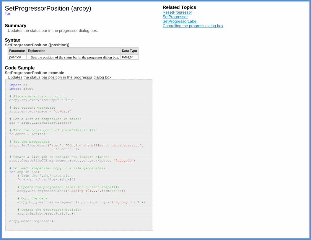
SetProgressorPosition (arcpy) Top
Summary
Updates the status bar in the progressor dialog box.
Syntax SetProgressorPosition ({position})
Parameter Explanation Data Type
position Sets the position of the status bar in the progressor dialog box. Integer
Code Sample SetProgressorPosition example
Updates the status bar position in the progressor dialog box.
import os
import arcpy
# Allow overwriting of output
arcpy.env.overwriteOutput = True
# Set current workspace
arcpy.env.workspace = "c:/data"
# Get a list of shapefiles in folder
fcs = arcpy.ListFeatureClasses()
# Find the total count of shapefiles in list
fc_count = len(fcs)
# Set the progressor
arcpy.SetProgressor("step", "Copying shapefiles to geodatabase...",
0, fc_count, 1)
# Create a file gdb to contain new feature classes
arcpy.CreateFileGDB_management(arcpy.env.workspace, "fgdb.gdb")
# For each shapefile, copy to a file geodatabase
for shp in fcs:
# Trim the '.shp' extension
fc = os.path.splitext(shp)[0]
# Update the progressor label for current shapefile
arcpy.SetProgressorLabel("Loading {0}...".format(shp))
# Copy the data
arcpy.CopyFeatures_management(shp, os.path.join("fgdb.gdb", fc))
# Update the progressor position
arcpy.SetProgressorPosition()
arcpy.ResetProgressor()
Related Topics ResetProgressor SetProgressor SetProgressorLabel Controlling the progress dialog box
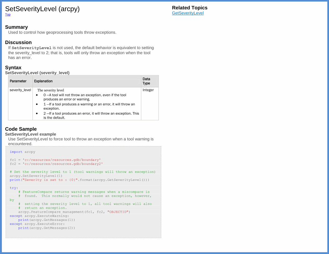
SetSeverityLevel (arcpy) Top
Summary
Used to control how geoprocessing tools throw exceptions.
Discussion If SetSeverityLevel is not used, the default behavior is equivalent to setting
the severity_level to 2; that is, tools will only throw an exception when the tool has an error.
Syntax SetSeverityLevel (severity_level)
Parameter Explanation Data
Type
severity_level The severity level
0 —A tool will not throw an exception, even if the tool
produces an error or warning.
1 —If a tool produces a warning or an error, it will throw an
exception.
2 —If a tool produces an error, it will throw an exception. This
is the default.
Integer
Code Sample SetSeverityLevel example
Use SetSeverityLevel to force tool to throw an exception when a tool warning is encountered.
import arcpy
fc1 = 'c:/resources/resources.gdb/boundary'
fc2 = 'c:/resources/resources.gdb/boundary2'
# Set the severity level to 1 (tool warnings will throw an exception)
arcpy.SetSeverityLevel(1)
print("Severity is set to : {0}".format(arcpy.GetSeverityLevel()))
try:
# FeatureCompare returns warning messages when a miscompare is
# found. This normally would not cause an exception, however,
by
# setting the severity level to 1, all tool warnings will also
# return an exception.
arcpy.FeatureCompare_management(fc1, fc2, "OBJECTID")
except arcpy.ExecuteWarning:
print(arcpy.GetMessages(1))
except arcpy.ExecuteError:
print(arcpy.GetMessages(2))
Related Topics GetSeverityLevel

TestSchemaLock (arcpy) Top
Summary
Tests if a schema lock can be acquired for a feature class, table, or feature dataset. Tools that alter schema will require a schema lock to be placed on the input data. The Add Field tool is an example of such a tool. If the tool requires a schema lock and is unable to aquire one at the time of execution, an appropriate error message is returned. Scripts that use such tools should test if a schema lock can be acquired on the input data. The TestSchemaLock function will not actually apply a schema lock on the input data, but will return a Boolean.
Syntax TestSchemaLock (dataset)
Parameter Explanation Data Type
dataset The input data to be tested if a schema lock can be applied. String
Return Value
Data Type Explanation
Boolean Returns a Boolean indicating if a schema lock can be applied to the input dataset.
The possible Boolean values are:
True —A schema lock can be applied to the dataset.
False —A schema lock cannot be obtained on the dataset.
Code Sample TestSchemaLock example
Returns a Boolean True if exclusive lock can be applied to dataset.
import arcpy
data = arcpy.GetParameterAsText(0)
# Test if a schema lock can be applied, and if so, add a new field
#
if arcpy.TestSchemaLock(data):
arcpy.AddField_management(data, "Flag", "LONG")
else:
print("Unable to acquire the necessary schema lock to add the new
field")
Related Topics Rules for working with schema locks

UpdateCursor (arcpy) Top
Summary
The UpdateCursor function creates a cursor that lets you update or delete
rows on the specified feature class, shapefile, or table. The cursor places a lock on the data that will remain until either the script completes or the update cursor object is deleted.
Discussion Update cursors are able to be iterated with a for loop or in a while loop using
the cursor's next method to return the next row. When using the next method
on a cursor to retrieve all rows in a table containing N rows, the script must make N calls to next. A call to next after the last row in the result set has been
retrieved returns None, which is a Python data type that acts here as a
placeholder. Using UpdateCursor with a for loop.
import arcpy
fc = "c:/data/base.gdb/roads"
field1 = "field1"
field2 = "field2"
cursor = arcpy.UpdateCursor(fc)
for row in cursor:
# field2 will be equal to field1 multiplied by 3.0
row.setValue(field2, row.getValue(field1) * 3.0)
cursor.updateRow(row)
Using UpdateCursor with a while loop.
import arcpy
fc = "c:/data/base.gdb/roads"
field1 = "field1"
field2 = "field2"
cursor = arcpy.UpdateCursor(fc)
row = cursor.next()
while row:
# field2 will be equal to field1 multiplied by 3.0
row.setValue(field2, row.getValue(field1) * 3.0)
cursor.updateRow(row)
row = cursor.next()
Syntax UpdateCursor (dataset, {where_clause}, {spatial_reference}, {fields}, {sort_fields})
Parameter Explanation Data Type
dataset The feature class, shapefile, or table containing the
rows to be updated or deleted.
String
where_clause An optional expression that limits the rows returned in
the cursor. For more information on WHERE clauses
and SQL statements,
seeAbout_building_an_SQL_expression.
String
spatial_reference Coordinates are specified in
the spatial_reference provided and converted
on the fly to the coordinate system of the dataset.
SpatialReference
fields [fields,...]
The fields to be included in the cursor. By default, all
fields are included.
String
sort_fields Fields used to sort the rows in the cursor. Ascending
and descending order for each field is denoted by A
and D.
String
Return Value
Data Type Explanation
Cursor A Cursor object that can hand out row objects.
Code Sample UpdateCursor example
Update field values in feature class, based on another field's value.
import arcpy
# Create update cursor for feature class
rows = arcpy.UpdateCursor("c:/data/base.gdb/roads")
# Update the field used in buffer so the distance is based on the
# road type. Road type is either 1, 2, 3 or 4. Distance is in meters.
for row in rows:
# Fields from the table can be dynamically accessed from the
# row object. Here fields named BUFFER_DISTANCE and ROAD_TYPE
# are used
row.setValue("BUFFER_DISTANCE", row.getValue("ROAD_TYPE") * 100)
rows.updateRow(row)
# Delete cursor and row objects to remove locks on the data
del row
del rows
Related Topics Accessing data using cursors SearchCursor InsertCursor

Usage (arcpy) Top
Summary
Returns the syntax for the specified tool or function.
Discussion Complete help information for a tool, including complete parameter descriptions, can be extracted by using the __doc__ property.
import arcpy
print(arcpy.Buffer_analysis.__doc__)
Syntax Usage (tool_name)
Parameter Explanation Data Type
tool_name The tool name to display the syntax. String
Return Value
Data Type Explanation
String Returns a string containing the specified tool's syntax.
Code Sample Usage example
Print specified tool's syntax.
import arcpy
print(arcpy.Usage("Buffer_analysis"))
print(arcpy.Usage("MakeFeatureLayer_management"))
Related Topics Using tools in Python
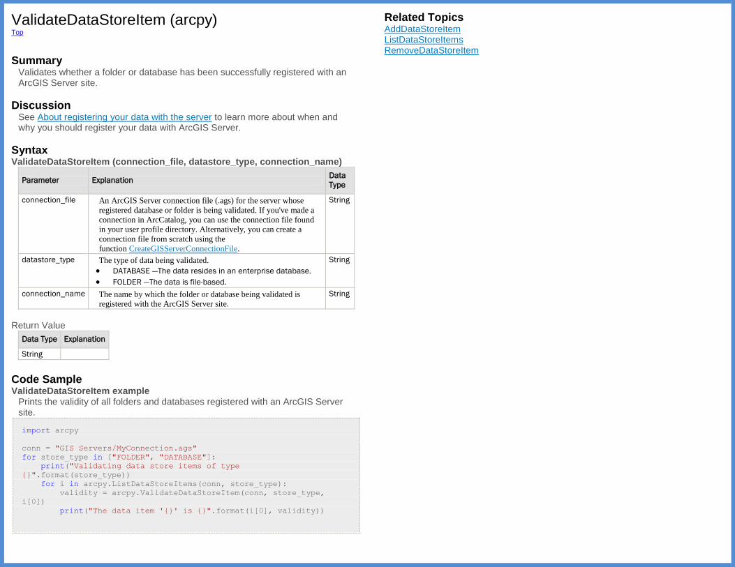
ValidateDataStoreItem (arcpy) Top
Summary
Validates whether a folder or database has been successfully registered with an ArcGIS Server site.
Discussion See About registering your data with the server to learn more about when and why you should register your data with ArcGIS Server.
Syntax ValidateDataStoreItem (connection_file, datastore_type, connection_name)
Parameter Explanation Data
Type
connection_file An ArcGIS Server connection file (.ags) for the server whose
registered database or folder is being validated. If you've made a
connection in ArcCatalog, you can use the connection file found
in your user profile directory. Alternatively, you can create a
connection file from scratch using the
function CreateGISServerConnectionFile.
String
datastore_type The type of data being validated.
DATABASE —The data resides in an enterprise database.
FOLDER —The data is file-based.
String
connection_name The name by which the folder or database being validated is
registered with the ArcGIS Server site.
String
Return Value
Data Type Explanation
String
Code Sample ValidateDataStoreItem example
Prints the validity of all folders and databases registered with an ArcGIS Server site.
import arcpy
conn = "GIS Servers/MyConnection.ags"
for store_type in ["FOLDER", "DATABASE"]:
print("Validating data store items of type
{}".format(store_type))
for i in arcpy.ListDataStoreItems(conn, store_type):
validity = arcpy.ValidateDataStoreItem(conn, store_type,
i[0])
print("The data item '{}' is {}".format(i[0], validity))
Related Topics AddDataStoreItem ListDataStoreItems RemoveDataStoreItem

ValidateFieldName (arcpy) Top
Summary
Takes a string (field name) and a workspace path and returns a valid field name based on name restrictions in the output geodatabase. All invalid characters in
the input string will be replaced with an underscore (_). The field name
restrictions depend on the specific database used (Structured Query Language [SQL] or Oracle).
Syntax ValidateFieldName (name, {workspace})
Parameter Explanation Data
Type
name The field name to be validated. If the optional workspace is not
specified, the field name is validated against the current workspace.
String
workspace An optional specified workspace to validate the field name against. The
workspace can be a file system or a personal, file, or ArcSDE
geodatabase.
If the workspace is not specified, the field name is validated using
the current workspace environment. If the workspace environment has
not been set, the field name is validated based on a folder workspace.
String
Return Value
Data
Type Explanation
String Returns a string containing the valid field name, based on either the current or
specified workspace.
Code Sample ValidateFieldName example
Returns a valid field name based on the workspace.
import arcpy
import os
class ShapeError(Exception):
pass
try:
# Get the input feature class and make sure it contains polygons.
#
in_fc = arcpy.GetParameterAsText(0)
if arcpy.Describe(input).shapeType != "Polygon":
# Raise a custom exception
raise ShapeError("Input does not contain polygons")
# Get the new field name and validate it.
#
field_name = arcpy.GetParameterAsText(1)
field_name = arcpy.ValidateFieldName(field_name,
os.path.dirname(in_fc))
# Add the new field and calculate the value.
#
arcpy.AddField_management(in_fc, field_name, "DOUBLE")
arcpy.CalculateField_management(in_fc,
field_name,
"!shape.area! / !shape.length!",
"PYTHON_9.3")
except ShapeError as err:
print(err[0])
except arcpy.ExecuteError:
print(arcpy.GetMessages(2))
Related Topics ValidateTableName ParseFieldName Validating table and field names in Python
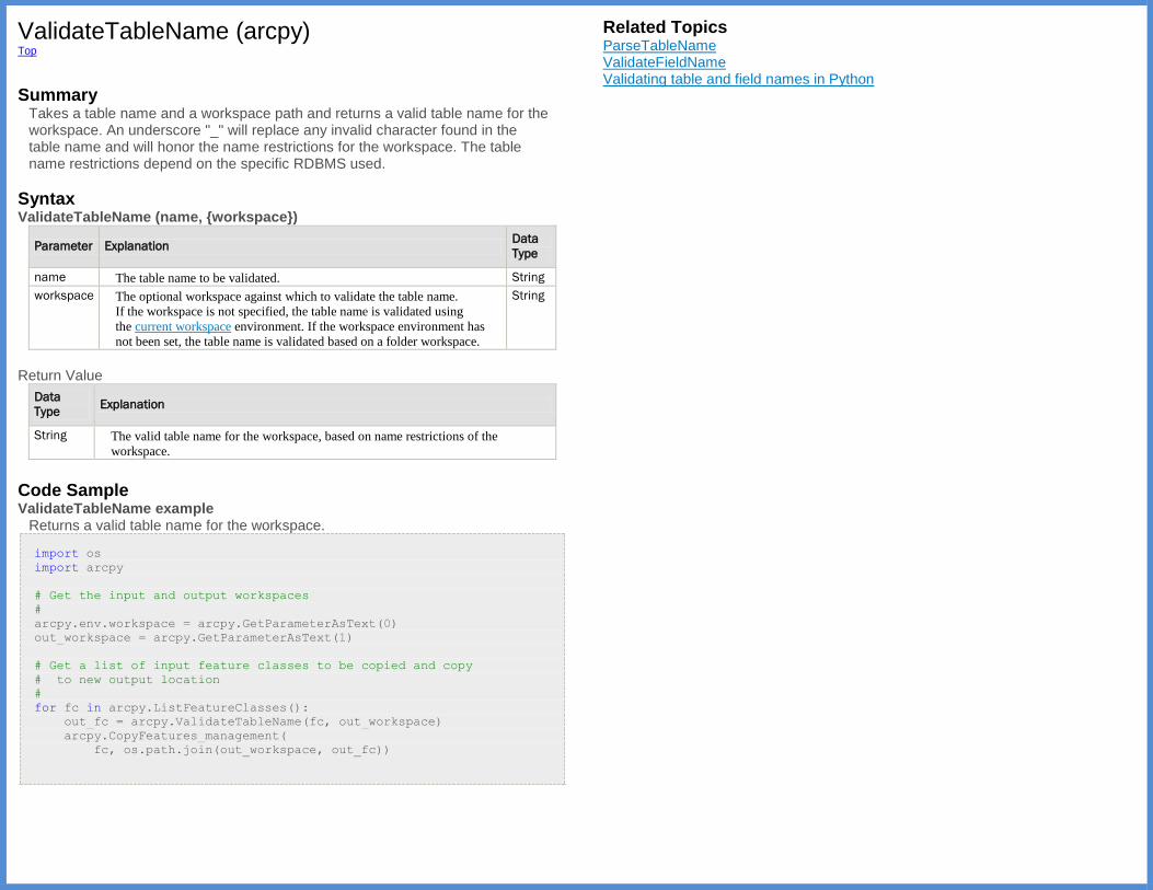
ValidateTableName (arcpy) Top
Summary
Takes a table name and a workspace path and returns a valid table name for the workspace. An underscore "_" will replace any invalid character found in the table name and will honor the name restrictions for the workspace. The table name restrictions depend on the specific RDBMS used.
Syntax ValidateTableName (name, {workspace})
Parameter Explanation Data
Type
name The table name to be validated. String
workspace The optional workspace against which to validate the table name.
If the workspace is not specified, the table name is validated using
the current workspace environment. If the workspace environment has
not been set, the table name is validated based on a folder workspace.
String
Return Value
Data
Type Explanation
String The valid table name for the workspace, based on name restrictions of the
workspace.
Code Sample ValidateTableName example
Returns a valid table name for the workspace.
import os
import arcpy
# Get the input and output workspaces
#
arcpy.env.workspace = arcpy.GetParameterAsText(0)
out_workspace = arcpy.GetParameterAsText(1)
# Get a list of input feature classes to be copied and copy
# to new output location
#
for fc in arcpy.ListFeatureClasses():
out_fc = arcpy.ValidateTableName(fc, out_workspace)
arcpy.CopyFeatures_management(
fc, os.path.join(out_workspace, out_fc))
Related Topics ParseTableName ValidateFieldName Validating table and field names in Python
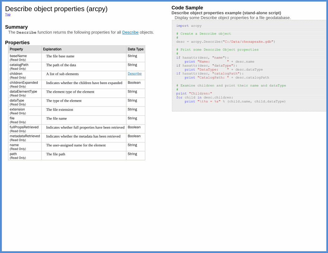
Describe object properties (arcpy) Top
Summary
The Describe function returns the following properties for all Describe objects.
Properties
Property Explanation Data Type
baseName (Read Only)
The file base name String
catalogPath (Read Only)
The path of the data String
children (Read Only)
A list of sub elements Describe
childrenExpanded (Read Only)
Indicates whether the children have been expanded Boolean
dataElementType (Read Only)
The element type of the element String
dataType (Read Only)
The type of the element String
extension (Read Only)
The file extension String
file (Read Only)
The file name String
fullPropsRetrieved (Read Only)
Indicates whether full properties have been retrieved Boolean
metadataRetrieved (Read Only)
Indicates whether the metadata has been retrieved Boolean
name (Read Only)
The user-assigned name for the element String
path (Read Only)
The file path String
Code Sample Describe object properties example (stand-alone script)
Display some Describe object properties for a file geodatabase.
import arcpy
# Create a Describe object
#
desc = arcpy.Describe("C:/Data/chesapeake.gdb")
# Print some Describe Object properties
#
if hasattr(desc, "name"):
print "Name: " + desc.name
if hasattr(desc, "dataType"):
print "DataType: " + desc.dataType
if hasattr(desc, "catalogPath"):
print "CatalogPath: " + desc.catalogPath
# Examine children and print their name and dataType
#
print "Children:"
for child in desc.children:
print "\t%s = %s" % (child.name, child.dataType)
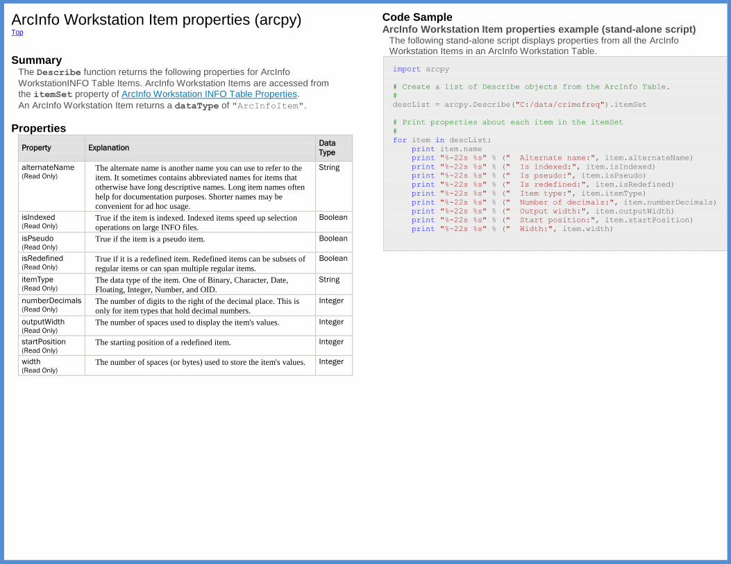
ArcInfo Workstation Item properties (arcpy) Top
Summary
The Describe function returns the following properties for ArcInfo
WorkstationINFO Table Items. ArcInfo Workstation Items are accessed from the itemSet property of ArcInfo Workstation INFO Table Properties.
An ArcInfo Workstation Item returns a dataType of "ArcInfoItem".
Properties
Property Explanation Data
Type
alternateName (Read Only)
The alternate name is another name you can use to refer to the
item. It sometimes contains abbreviated names for items that
otherwise have long descriptive names. Long item names often
help for documentation purposes. Shorter names may be
convenient for ad hoc usage.
String
isIndexed (Read Only)
True if the item is indexed. Indexed items speed up selection
operations on large INFO files.
Boolean
isPseudo (Read Only)
True if the item is a pseudo item. Boolean
isRedefined (Read Only)
True if it is a redefined item. Redefined items can be subsets of
regular items or can span multiple regular items.
Boolean
itemType (Read Only)
The data type of the item. One of Binary, Character, Date,
Floating, Integer, Number, and OID.
String
numberDecimals (Read Only)
The number of digits to the right of the decimal place. This is
only for item types that hold decimal numbers.
Integer
outputWidth (Read Only)
The number of spaces used to display the item's values. Integer
startPosition (Read Only)
The starting position of a redefined item. Integer
width (Read Only)
The number of spaces (or bytes) used to store the item's values. Integer
Code Sample ArcInfo Workstation Item properties example (stand-alone script)
The following stand-alone script displays properties from all the ArcInfo Workstation Items in an ArcInfo Workstation Table.
import arcpy
# Create a list of Describe objects from the ArcInfo Table.
#
descList = arcpy.Describe("C:/data/crimefreq").itemSet
# Print properties about each item in the itemSet
#
for item in descList:
print item.name
print "%-22s %s" % (" Alternate name:", item.alternateName)
print "%-22s %s" % (" Is indexed:", item.isIndexed)
print "%-22s %s" % (" Is pseudo:", item.isPseudo)
print "%-22s %s" % (" Is redefined:", item.isRedefined)
print "%-22s %s" % (" Item type:", item.itemType)
print "%-22s %s" % (" Number of decimals:", item.numberDecimals)
print "%-22s %s" % (" Output width:", item.outputWidth)
print "%-22s %s" % (" Start position:", item.startPosition)
print "%-22s %s" % (" Width:", item.width)
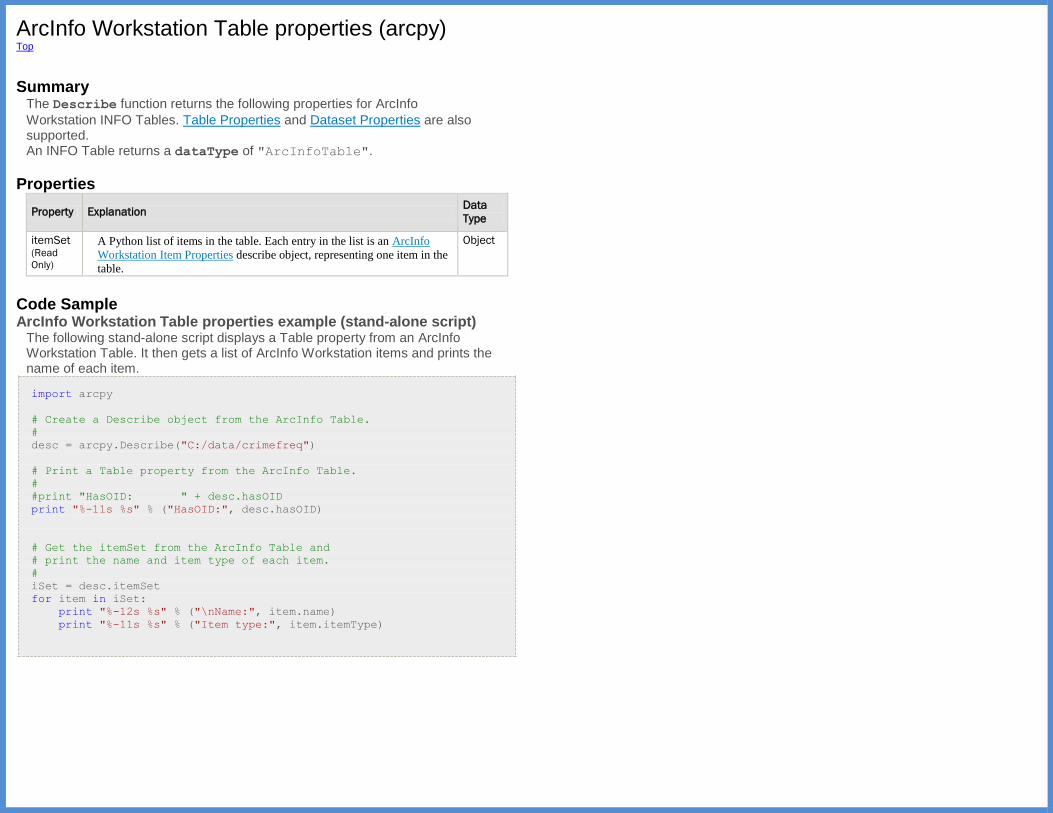
ArcInfo Workstation Table properties (arcpy) Top
Summary
The Describe function returns the following properties for ArcInfo
Workstation INFO Tables. Table Properties and Dataset Properties are also supported. An INFO Table returns a dataType of "ArcInfoTable".
Properties
Property Explanation Data
Type
itemSet (Read
Only)
A Python list of items in the table. Each entry in the list is an ArcInfo
Workstation Item Properties describe object, representing one item in the
table.
Object
Code Sample ArcInfo Workstation Table properties example (stand-alone script)
The following stand-alone script displays a Table property from an ArcInfo Workstation Table. It then gets a list of ArcInfo Workstation items and prints the name of each item.
import arcpy
# Create a Describe object from the ArcInfo Table.
#
desc = arcpy.Describe("C:/data/crimefreq")
# Print a Table property from the ArcInfo Table.
#
#print "HasOID: " + desc.hasOID
print "%-11s %s" % ("HasOID:", desc.hasOID)
# Get the itemSet from the ArcInfo Table and
# print the name and item type of each item.
#
iSet = desc.itemSet
for item in iSet:
print "%-12s %s" % ("\nName:", item.name)
print "%-11s %s" % ("Item type:", item.itemType)
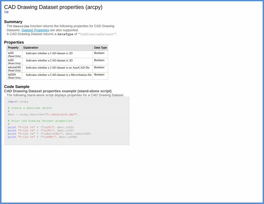
CAD Drawing Dataset properties (arcpy) Top
Summary
The Describe function returns the following properties for CAD Drawing
Datasets. Dataset Properties are also supported. A CAD Drawing Dataset returns a dataType of "CadDrawingDataset".
Properties
Property Explanation Data Type
is2D (Read Only)
Indicates whether a CAD dataset is 2D Boolean
is3D (Read Only)
Indicates whether a CAD dataset is 3D Boolean
isAutoCAD (Read Only)
Indicates whether a CAD dataset is an AutoCAD file Boolean
isDGN (Read Only)
Indicates whether a CAD dataset is a MicroStation file Boolean
Code Sample CAD Drawing Dataset properties example (stand-alone script)
The following stand-alone script displays properties for a CAD Drawing Dataset.
import arcpy
# Create a describe object
#
desc = arcpy.Describe("C:/data/arch.dgn")
# Print Cad Drawing Dataset properties
#
print "%-12s %s" % ("is2D:", desc.is2D)
print "%-12s %s" % ("is3D:", desc.is3D)
print "%-12s %s" % ("isAutoCAD:", desc.isAutoCAD)
print "%-12s %s" % ("isDGN:", desc.isDGN)
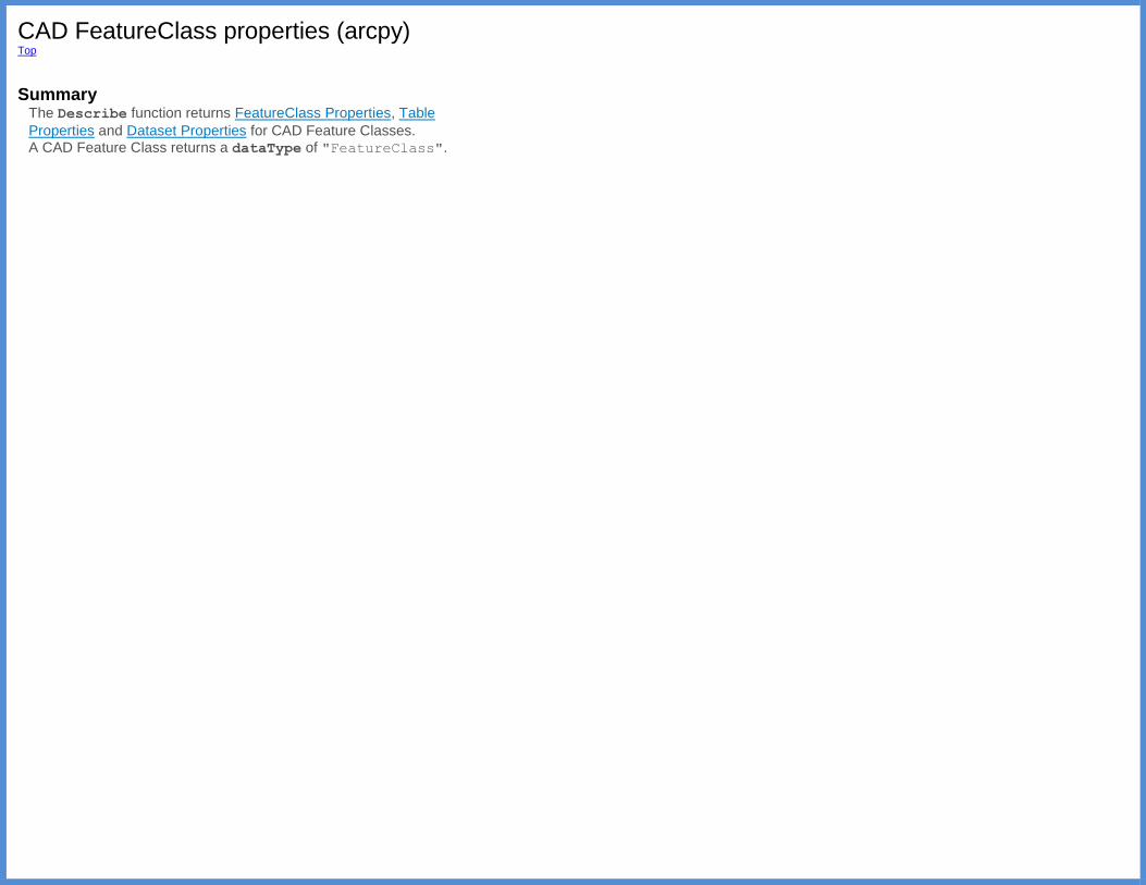
CAD FeatureClass properties (arcpy) Top
Summary
The Describe function returns FeatureClass Properties, Table
Properties and Dataset Properties for CAD Feature Classes. A CAD Feature Class returns a dataType of "FeatureClass".
Cadastral Fabric properties (arcpy) Top
Summary
The Describe function returns the following properties for Cadastral
Fabrics. Dataset Properties are also supported.
Properties
Property Explanation Data
Type
bufferDistanceForAdjustment (Read Only)
The distance used to generate a buffer
around the job parcels. This buffer defines
the adjustment area.
Double
compiledAccuracyCategory (Read Only)
The default accuracy category for compiled
parcels in this cadastral fabric. Category
values range from 1 to 7, inclusively.
Integer
defaultAccuracyCategory (Read Only)
The default accuracy category for the whole
cadastral fabric. Category values range from
1 to 7, inclusively.
Integer
maximumShiftThreshold (Read Only)
Coordinate changes will be written if the
shift is greater than this tolerance value.
Double
multiGenerationEditing (Read Only)
True if Cadastral Fabrics greater than one
level below default can be edited.
Boolean
multiLevelReconcile (Read Only)
True if reconciling and posting with an
ancestor more than one generation above the
working version is allowed.
Boolean
pinAdjustmentBoundary (Read Only)
True if points on the adjustment area
boundary should be pinned.
Boolean
pinAdjustmentPointsWithinBoundary (Read Only)
True if nonadjusted points within the
adjustment area should be pinned.
Boolean
surrogateVersion (Read Only)
The name of the surrogate version if
applicable. Indicates if the cadastral fabric is
a surrogate version.
If set, the cadastral fabrics can be edited in
the surrogate version and its immediate
children. If not set, fabric editing can only
be performed in the default version and its
immediate children. The surrogate default
version functionality is only available to
versions newer than version 1.
String
type (Read Only)
The cadastral fabric type.
0 —Map type, which allows flexible
point editing.
1 —Survey type, which prevents
flexible point editing.
Integer
version (Read Only)
The schema version of the cadastral fabric
system tables.
Schema version ArcGIS version
1 9.3, 9.3.1
2 10.0
3 10.1
Integer
writeAdjustmentVectors (Read Only)
True if adjustment vectors should be
written.
Boolean
Coverage FeatureClass properties (arcpy) Top
Summary
The Describe function returns the following properties for Coverage Feature
Classes. FeatureClass Properties, Table Properties and Dataset Properties are also supported. A Coverage Feature Class returns a dataType of "CoverageFeatureClass".
Properties
Property Explanation Data
Type
featureClassType (Read Only)
The feature class types.
Point
Arc
Polygon
Node
Tic
Annotation
Section
Route
Link
Region
Label
File
String
hasFAT (Read Only)
True if the coverage feature class has a Feature Attribute Table
(FAT) and False if it does not.
Boolean
topology (Read Only)
Indicates the state of the coverage feature class topology.
NotApplicable —The topology is not supported by this
feature class.
Preliminary —Topology is preliminary.
Exists —Topology exists.
Unknown —Topology status is unknown.
String
Code Sample Coverage FeatureClass properties example (stand-alone script)
The following stand-alone script displays properties for a Coverage FeatureClass.
import arcpy
# Create describe object from a coverage feature class
#
desc = arcpy.Describe("C:/data/tongass1/polygon")
# Print coverage feature class properties
#
print "%-17s %s" % ("featureClassType:", desc.featureClassType)
print "%-17s %s" % ("hasFAT:", desc.hasFAT)
print "%-17s %s" % ("topology:", desc.topology)

Coverage properties (arcpy) Top
Summary
The Describe function returns the following properties for Coverages. Dataset
Properties are also supported. A Coverage returns a dataType of "Coverage".
Properties
Property Explanation Data Type
tolerances (Read Only)
Tolerances is a property set that includes:
fuzzy
dangle
ticMatch
edit
nodeSnap
weed
grain
snap
Object
Code Sample Coverage properties example (stand-alone script)
The following stand-alone script displays tolerance properties for a coverage.
import arcpy
# Create a describe object from a coverage
desc = arcpy.Describe("C:/data/tongass1")
# Get the tolerances property set from the describe object
tolProps = desc.tolerances
# Print all eight tolerance properties
print "Tolerances"
print "=========="
print "%-10s %s" % ("fuzzy:", tolProps.fuzzy)
print "%-10s %s" % ("dangle:", tolProps.dangle)
print "%-10s %s" % ("ticMatch:", tolProps.ticMatch)
print "%-10s %s" % ("edit:", tolProps.edit)
print "%-10s %s" % ("nodeSnap:", tolProps.nodeSnap)
print "%-10s %s" % ("weed:", tolProps.weed)
print "%-10s %s" % ("grain:", tolProps.grain)
print "%-10s %s" % ("snap:", tolProps.snap)

Dataset properties (arcpy) Top
Summary
The Describe function returns the following properties for Datasets.
Dataset properties are available in many types of Describe objects.
Properties
Property Explanation Data Type
canVersion (Read Only)
Indicates whether the dataset can be versioned Boolean
datasetType (Read Only)
Returns the type of dataset being described
Any
Container
Geo
FeatureDataset
FeatureClass
PlanarGraph
GeometricNetwork
Topology
Text
Table
RelationshipClass
RasterDataset
RasterBand
TIN
CadDrawing
RasterCatalog
Toolbox
Tool
NetworkDataset
Terrain
RepresentationClass
CadastralFabric
SchematicDataset
Locator
String
DSID (Read Only)
The ID of the dataset Integer
extent (Read Only)
The Extent object Extent
isVersioned (Read Only)
Indicates whether the dataset is versioned Boolean
MExtent (Read Only)
A space-delimited string (MMin MMax) String
spatialReference (Read Only)
Returns the SpatialReference object for the dataset SpatialReference
ZExtent (Read Only)
A space-delimited string (ZMin ZMax) String
Code Sample Dataset properties example (stand-alone script)
The following stand-alone script displays some dataset properties for a shapefile.
import arcpy
# Create a Describe object from the shapefile
#
desc = arcpy.Describe("C:/temp/xy.shp")
# Print dataset properties
#
print("Dataset Type: {0}".format(desc.datasetType))
print("Extent:\n XMin: {0}, XMax: {1}, YMin: {2}, YMax: {3}".format(
desc.extent.XMin, desc.extent.XMax, desc.extent.YMin,
desc.extent.YMax))
print("MExtent: {0}".format(desc.MExtent))
print("ZExtent: {0}".format(desc.ZExtent))
print("Spatial reference name:
{0}:".format(desc.spatialReference.name))
dBase Table properties (arcpy) Top
Summary
The Describe function returns Table Properties and Dataset Properties for
dBase Tables. A dBase Table returns a dataType of "DbaseTable".
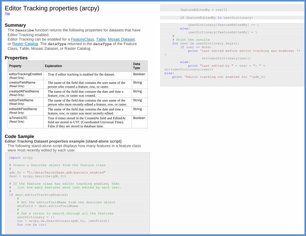
Editor Tracking properties (arcpy) Top
Summary
The Describe function returns the following properties for datasets that have
Editor Tracking enabled. Editor Tracking can be enabled for a FeatureClass, Table, Mosaic Dataset, or Raster Catalog. The dataType returned is the dataType of the Feature
Class, Table, Mosaic Dataset, or Raster Catalog.
Properties
Property Explanation Data
Type
editorTrackingEnabled (Read Only)
True if editor tracking is enabled for the dataset. Boolean
creatorFieldName (Read Only)
The name of the field that contains the user name of the
person who created a feature, row, or raster.
String
createdAtFieldName (Read Only)
The name of the field that contains the date and time a
feature, row, or raster was created.
String
editorFieldName (Read Only)
The name of the field that contains the user name of the
person who most recently edited a feature, row, or raster.
String
editedAtFieldName (Read Only)
The name of the field that contains the date and time a
feature, row, or raster was most recently edited.
String
isTimeInUTC (Read Only)
True if times stored in the CreatedAt field and EditedAt
field are stored in UTC (Coordinated Universal Time).
False if they are stored in database time.
Boolean
Code Sample Editor Tracking Dataset properties example (stand-alone script)
The following stand-alone script displays how many features in a feature class were most recently edited by each user.
import arcpy
# Create a Describe object from the feature class
#
gdb_fc = "C:/data/ParcelBase.gdb/parcels_enabled"
desc = arcpy.Describe(gdb_fc)
# If the feature class has editor tracking enabled, then
# list how many features were last edited by each user.
#
if desc.editorTrackingEnabled:
#
# Get the editorFieldName from the describe object
whoField = desc.editorFieldName
#
# Use a cursor to search through all the features
userDictionary = {}
cur = arcpy.da.SearchCursor(gdb_fc, [whoField])
for row in cur:
featureEditedBy = row[0]
if featureEditedBy in userDictionary:
userDictionary[featureEditedBy] += 1
else:
userDictionary[featureEditedBy] = 1
#
# Print the results
for user in userDictionary.keys():
if user == None:
print 'Last edited before editor tracking was enabled: '+
\
str(userDictionary[user])
else:
print "Last edited by " + user + ": " +
str(userDictionary[user])
else:
print 'Editor tracking not enabled for '+gdb_fc
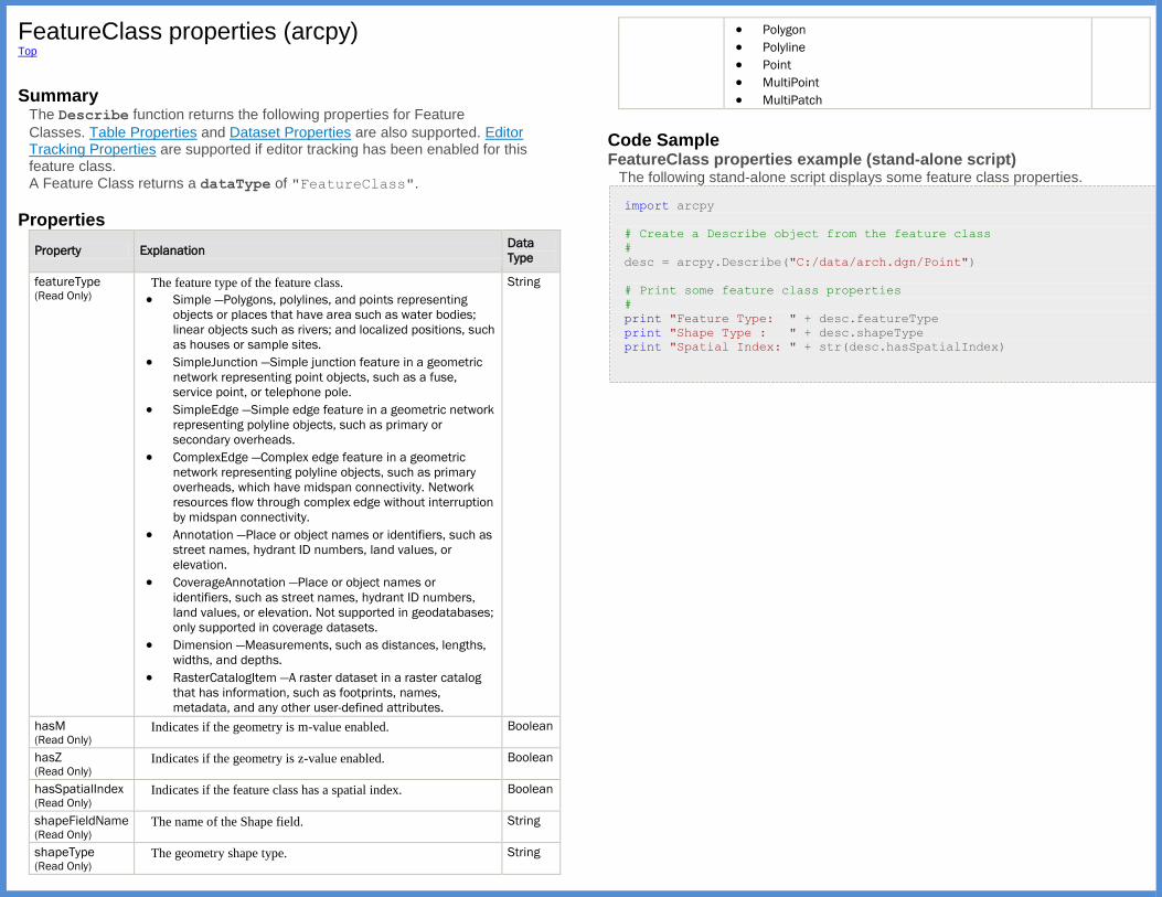
FeatureClass properties (arcpy) Top
Summary
The Describe function returns the following properties for Feature
Classes. Table Properties and Dataset Properties are also supported. Editor Tracking Properties are supported if editor tracking has been enabled for this feature class. A Feature Class returns a dataType of "FeatureClass".
Properties
Property Explanation Data
Type
featureType (Read Only)
The feature type of the feature class.
Simple —Polygons, polylines, and points representing
objects or places that have area such as water bodies;
linear objects such as rivers; and localized positions, such
as houses or sample sites.
SimpleJunction —Simple junction feature in a geometric
network representing point objects, such as a fuse,
service point, or telephone pole.
SimpleEdge —Simple edge feature in a geometric network
representing polyline objects, such as primary or
secondary overheads.
ComplexEdge —Complex edge feature in a geometric
network representing polyline objects, such as primary
overheads, which have midspan connectivity. Network
resources flow through complex edge without interruption
by midspan connectivity.
Annotation —Place or object names or identifiers, such as
street names, hydrant ID numbers, land values, or
elevation.
CoverageAnnotation —Place or object names or
identifiers, such as street names, hydrant ID numbers,
land values, or elevation. Not supported in geodatabases;
only supported in coverage datasets.
Dimension —Measurements, such as distances, lengths,
widths, and depths.
RasterCatalogItem —A raster dataset in a raster catalog
that has information, such as footprints, names,
metadata, and any other user-defined attributes.
String
hasM (Read Only)
Indicates if the geometry is m-value enabled. Boolean
hasZ (Read Only)
Indicates if the geometry is z-value enabled. Boolean
hasSpatialIndex (Read Only)
Indicates if the feature class has a spatial index. Boolean
shapeFieldName (Read Only)
The name of the Shape field. String
shapeType (Read Only)
The geometry shape type. String
Polygon
Polyline
Point
MultiPoint
MultiPatch
Code Sample FeatureClass properties example (stand-alone script)
The following stand-alone script displays some feature class properties.
import arcpy
# Create a Describe object from the feature class
#
desc = arcpy.Describe("C:/data/arch.dgn/Point")
# Print some feature class properties
#
print "Feature Type: " + desc.featureType
print "Shape Type : " + desc.shapeType
print "Spatial Index: " + str(desc.hasSpatialIndex)
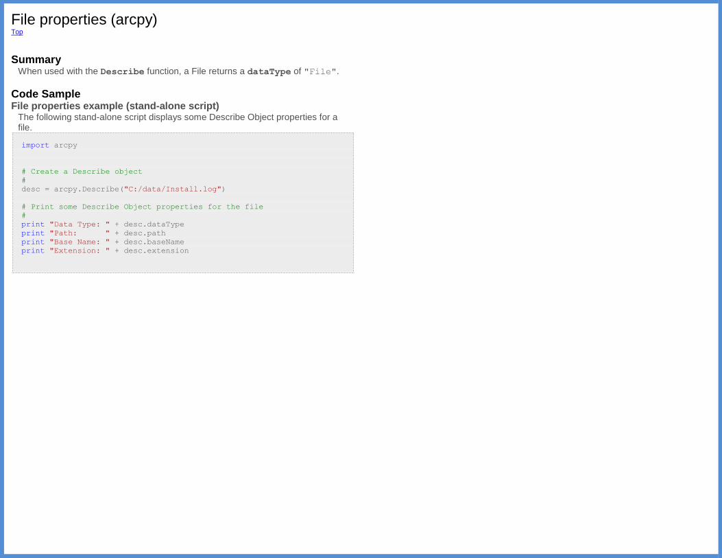
File properties (arcpy) Top
Summary
When used with the Describe function, a File returns a dataType of "File".
Code Sample File properties example (stand-alone script)
The following stand-alone script displays some Describe Object properties for a file.
import arcpy
# Create a Describe object
#
desc = arcpy.Describe("C:/data/Install.log")
# Print some Describe Object properties for the file
#
print "Data Type: " + desc.dataType
print "Path: " + desc.path
print "Base Name: " + desc.baseName
print "Extension: " + desc.extension

Folder properties (arcpy) Top Summary
The Describe function returns Workspace Properties for Folders.
A Folder returns a dataType of "Folder".
Code Sample Folder properties example (stand-alone script)
The following stand-alone script displays some properties for a folder.
import arcpy
# Create a Describe object
#
desc = arcpy.Describe("C:/data")
# Print the dataType and a workspace property
#
print "Data Type: " + desc.dataType
print "Workspace Type: " + desc.workspaceType
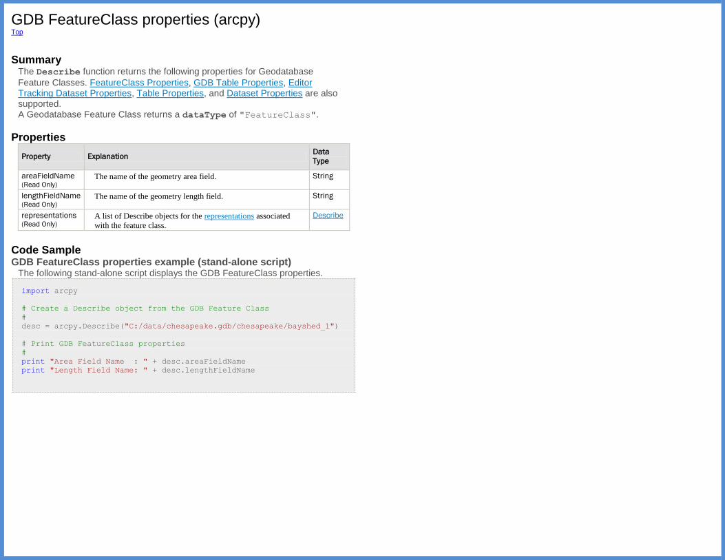
GDB FeatureClass properties (arcpy) Top
Summary
The Describe function returns the following properties for Geodatabase
Feature Classes. FeatureClass Properties, GDB Table Properties, Editor Tracking Dataset Properties, Table Properties, and Dataset Properties are also supported. A Geodatabase Feature Class returns a dataType of "FeatureClass".
Properties
Property Explanation Data
Type
areaFieldName (Read Only)
The name of the geometry area field. String
lengthFieldName (Read Only)
The name of the geometry length field. String
representations (Read Only)
A list of Describe objects for the representations associated
with the feature class.
Describe
Code Sample GDB FeatureClass properties example (stand-alone script)
The following stand-alone script displays the GDB FeatureClass properties.
import arcpy
# Create a Describe object from the GDB Feature Class
#
desc = arcpy.Describe("C:/data/chesapeake.gdb/chesapeake/bayshed_1")
# Print GDB FeatureClass properties
#
print "Area Field Name : " + desc.areaFieldName
print "Length Field Name: " + desc.lengthFieldName

GDB Table properties (arcpy) Top
Summary
The Describe function returns the following properties for Geodatabase
Tables. Editor Tracking Dataset Properties, Table Properties, and Dataset Properties are also supported. A Geodatabase Table returns a dataType of "Table".
Properties
Property Explanation Data
Type
aliasName (Read Only)
The alias name for the table. String
defaultSubtypeCode (Read Only)
The default subtype code. String
extensionProperties (Read Only)
The properties for the class extension. Object
globalIDFieldName (Read Only)
The name of the GlobalID field. String
hasGlobalID (Read Only)
Indicates whether the table has a GlobalID field. Boolean
modelName (Read Only)
The model name for the table. String
rasterFieldName (Read Only)
The name of the raster field. String
relationshipClassNames (Read Only)
The names of the Relationship Classes that this table
participates in.
String
subtypeFieldName (Read Only)
The name of the subtype field. String
versionedView (Read Only)
The name of a Versioned View for a versioned feature
class.
String
Code Sample GDB Table properties example (stand-alone script)
The following stand-alone script displays some properties of a GDB table.
import arcpy
# Create a Describe object from the GDB table.
#
desc = arcpy.Describe("C:/data/chesapeake.gdb/munich")
# Print GDB Table properties
#
print "%-22s %s" % ("AliasName:", desc.aliasName)
print "%-22s %s" % ("DefaultSubtypeCode:", desc.defaultSubtypeCode)
print "%-22s %s" % ("GlobalIDFieldName:", desc.globalIDFieldName)
print "%-22s %s" % ("ModelName:", desc.modelName)
print "%-22s %s" % ("RasterFieldName:", desc.rasterFieldName)
print "%-22s %s" % ("RelationshipClassNames:",
desc.relationshipClassNames)
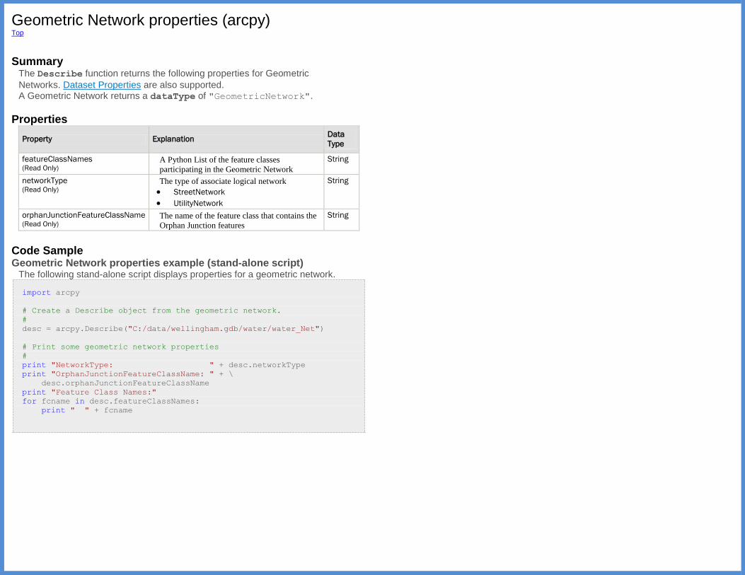
Geometric Network properties (arcpy) Top
Summary
The Describe function returns the following properties for Geometric
Networks. Dataset Properties are also supported. A Geometric Network returns a dataType of "GeometricNetwork".
Properties
Property Explanation Data
Type
featureClassNames (Read Only)
A Python List of the feature classes
participating in the Geometric Network
String
networkType (Read Only)
The type of associate logical network
StreetNetwork
UtilityNetwork
String
orphanJunctionFeatureClassName (Read Only)
The name of the feature class that contains the
Orphan Junction features
String
Code Sample Geometric Network properties example (stand-alone script)
The following stand-alone script displays properties for a geometric network.
import arcpy
# Create a Describe object from the geometric network.
#
desc = arcpy.Describe("C:/data/wellingham.gdb/water/water_Net")
# Print some geometric network properties
#
print "NetworkType: " + desc.networkType
print "OrphanJunctionFeatureClassName: " + \
desc.orphanJunctionFeatureClassName
print "Feature Class Names:"
for fcname in desc.featureClassNames:
print " " + fcname

LAS Dataset properties (arcpy) Top
Summary
The Describe function returns the following properties for LAS
dataset files. File Properties and Dataset Properties are also supported. A LAS Dataset returns a dataType of "LasDataset".
Properties
Property Explanation Data
Type
constraintCount (Read Only)
The number of surface constraint features referenced by
the LAS dataset.
Long
fileCount (Read Only)
The number of LAS files referenced by the LAS dataset. Long
hasStatistics (Read Only)
Indicates if statistics had been calculated for the LAS files
referenced by the LAS dataset.
Boolean
needsUpdateStatistics (Read Only)
Indicates if statistics are out-of-date or had not been
calculated. Returns false if statistics are up-to-date.
Boolean
pointCount (Read Only)
The number of data points in the LAS files referenced by
the LAS dataset.
Long
usesRelativePath (Read Only)
Indicates if the LAS dataset references its data elements
using relative paths.
Boolean
Code Sample LAS Dataset properties example (stand-alone script)
The following script demonstrates the application of LAS dataset properties.
import arcpy
desc = arcpy.Describe(r'E:\GIS_Data\lidar\test_bmore.lasd')
if desc.usesRelativePath:
pathType = 'Relative'
else: pathType = 'Absolute'
# Determine state of statistics
if desc.needsUpdateStatistics:
if desc.hasStatistics:
statistics = 'Out-of-date'
else:
statistics = 'Missing'
else:
statistics = 'Current'
print 'LAS Dataset Name: {0} \r'\
'Point Count: {1} \r'\
'Surface Constraint Count: {2} \r'\
'Path Type: {3} \r'\
'Statistics Status: {4}'.format(desc.basename, desc.pointCount,
desc.constraintCount, pathType,statistics)
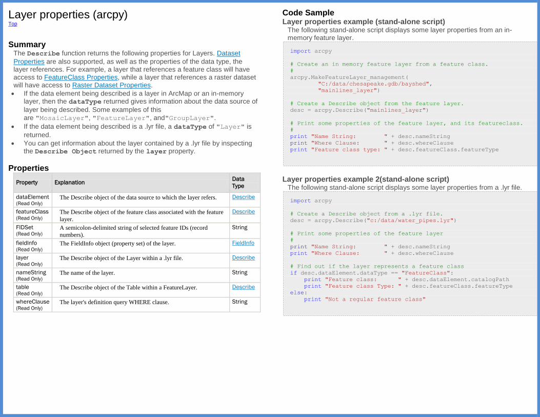
Layer properties (arcpy) Top
Summary
The Describe function returns the following properties for Layers. Dataset
Properties are also supported, as well as the properties of the data type, the layer references. For example, a layer that references a feature class will have access to FeatureClass Properties, while a layer that references a raster dataset will have access to Raster Dataset Properties.
If the data element being described is a layer in ArcMap or an in-memory layer, then the dataType returned gives information about the data source of
layer being described. Some examples of this
are "MosaicLayer", "FeatureLayer", and"GroupLayer".
If the data element being described is a .lyr file, a dataType of "Layer" is
returned.
You can get information about the layer contained by a .lyr file by inspecting the Describe Object returned by the layer property.
Properties
Property Explanation Data
Type
dataElement (Read Only)
The Describe object of the data source to which the layer refers. Describe
featureClass (Read Only)
The Describe object of the feature class associated with the feature
layer.
Describe
FIDSet (Read Only)
A semicolon-delimited string of selected feature IDs (record
numbers).
String
fieldInfo (Read Only)
The FieldInfo object (property set) of the layer. FieldInfo
layer (Read Only)
The Describe object of the Layer within a .lyr file. Describe
nameString (Read Only)
The name of the layer. String
table (Read Only)
The Describe object of the Table within a FeatureLayer. Describe
whereClause (Read Only)
The layer's definition query WHERE clause. String
Code Sample Layer properties example (stand-alone script)
The following stand-alone script displays some layer properties from an in-memory feature layer.
import arcpy
# Create an in memory feature layer from a feature class.
#
arcpy.MakeFeatureLayer_management(
"C:/data/chesapeake.gdb/bayshed",
"mainlines_layer")
# Create a Describe object from the feature layer.
desc = arcpy.Describe("mainlines_layer")
# Print some properties of the feature layer, and its featureclass.
#
print "Name String: " + desc.nameString
print "Where Clause: " + desc.whereClause
print "Feature class type: " + desc.featureClass.featureType
Layer properties example 2(stand-alone script)
The following stand-alone script displays some layer properties from a .lyr file.
import arcpy
# Create a Describe object from a .lyr file.
desc = arcpy.Describe("c:/data/water_pipes.lyr")
# Print some properties of the feature layer
#
print "Name String: " + desc.nameString
print "Where Clause: " + desc.whereClause
# Find out if the layer represents a feature class
if desc.dataElement.dataType == "FeatureClass":
print "Feature class: " + desc.dataElement.catalogPath
print "Feature class Type: " + desc.featureClass.featureType
else:
print "Not a regular feature class"
Map Document properties (arcpy) Top
Summary
When used with the Describe function, a Map Document returns
a dataType of "MapDocument".
The MapDocument class from the arcpy.mapping module can be used to get
additional information about a map document.
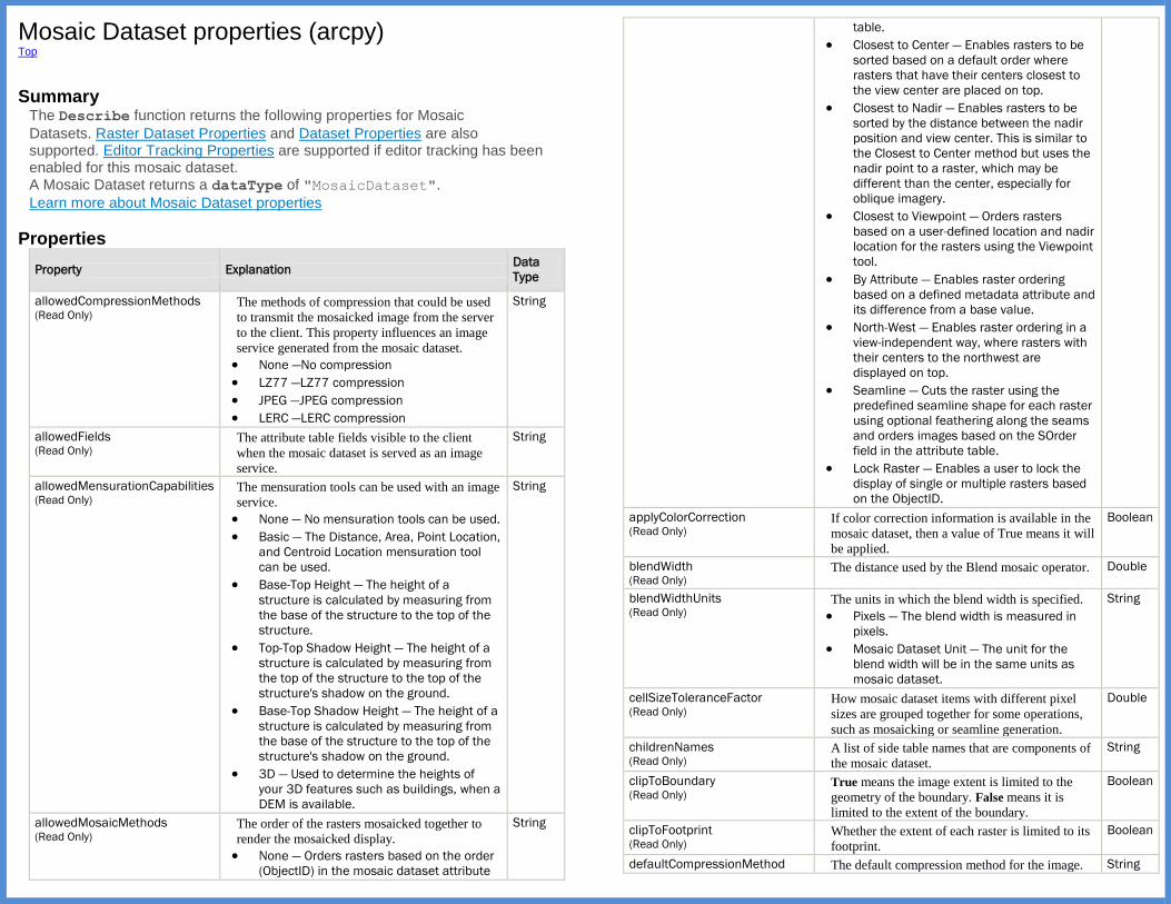
Mosaic Dataset properties (arcpy) Top
Summary
The Describe function returns the following properties for Mosaic
Datasets. Raster Dataset Properties and Dataset Properties are also supported. Editor Tracking Properties are supported if editor tracking has been enabled for this mosaic dataset. A Mosaic Dataset returns a dataType of "MosaicDataset".
Learn more about Mosaic Dataset properties
Properties
Property Explanation Data
Type
allowedCompressionMethods (Read Only)
The methods of compression that could be used
to transmit the mosaicked image from the server
to the client. This property influences an image
service generated from the mosaic dataset.
None —No compression
LZ77 —LZ77 compression
JPEG —JPEG compression
LERC —LERC compression
String
allowedFields (Read Only)
The attribute table fields visible to the client
when the mosaic dataset is served as an image
service.
String
allowedMensurationCapabilities (Read Only)
The mensuration tools can be used with an image
service.
None — No mensuration tools can be used.
Basic — The Distance, Area, Point Location,
and Centroid Location mensuration tool
can be used.
Base-Top Height — The height of a
structure is calculated by measuring from
the base of the structure to the top of the
structure.
Top-Top Shadow Height — The height of a
structure is calculated by measuring from
the top of the structure to the top of the
structure's shadow on the ground.
Base-Top Shadow Height — The height of a
structure is calculated by measuring from
the base of the structure to the top of the
structure's shadow on the ground.
3D — Used to determine the heights of
your 3D features such as buildings, when a
DEM is available.
String
allowedMosaicMethods (Read Only)
The order of the rasters mosaicked together to
render the mosaicked display.
None — Orders rasters based on the order
(ObjectID) in the mosaic dataset attribute
String
table.
Closest to Center — Enables rasters to be
sorted based on a default order where
rasters that have their centers closest to
the view center are placed on top.
Closest to Nadir — Enables rasters to be
sorted by the distance between the nadir
position and view center. This is similar to
the Closest to Center method but uses the
nadir point to a raster, which may be
different than the center, especially for
oblique imagery.
Closest to Viewpoint — Orders rasters
based on a user-defined location and nadir
location for the rasters using the Viewpoint
tool.
By Attribute — Enables raster ordering
based on a defined metadata attribute and
its difference from a base value.
North-West — Enables raster ordering in a
view-independent way, where rasters with
their centers to the northwest are
displayed on top.
Seamline — Cuts the raster using the
predefined seamline shape for each raster
using optional feathering along the seams
and orders images based on the SOrder
field in the attribute table.
Lock Raster — Enables a user to lock the
display of single or multiple rasters based
on the ObjectID.
applyColorCorrection (Read Only)
If color correction information is available in the
mosaic dataset, then a value of True means it will
be applied.
Boolean
blendWidth (Read Only)
The distance used by the Blend mosaic operator. Double
blendWidthUnits (Read Only)
The units in which the blend width is specified.
Pixels — The blend width is measured in
pixels.
Mosaic Dataset Unit — The unit for the
blend width will be in the same units as
mosaic dataset.
String
cellSizeToleranceFactor (Read Only)
How mosaic dataset items with different pixel
sizes are grouped together for some operations,
such as mosaicking or seamline generation.
Double
childrenNames (Read Only)
A list of side table names that are components of
the mosaic dataset.
String
clipToBoundary (Read Only)
True means the image extent is limited to the
geometry of the boundary. False means it is
limited to the extent of the boundary.
Boolean
clipToFootprint (Read Only)
Whether the extent of each raster is limited to its
footprint.
Boolean
defaultCompressionMethod The default compression method for the image. String
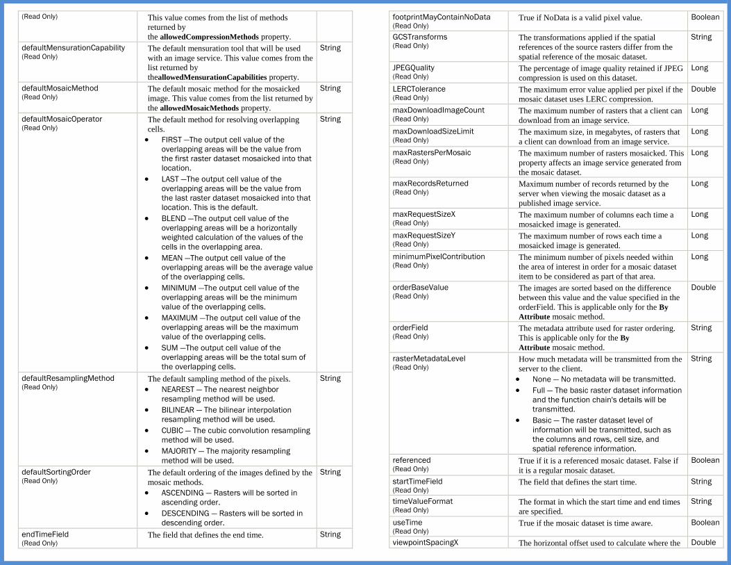
(Read Only) This value comes from the list of methods
returned by
the allowedCompressionMethods property.
defaultMensurationCapability (Read Only)
The default mensuration tool that will be used
with an image service. This value comes from the
list returned by
theallowedMensurationCapabilities property.
String
defaultMosaicMethod (Read Only)
The default mosaic method for the mosaicked
image. This value comes from the list returned by
the allowedMosaicMethods property.
String
defaultMosaicOperator (Read Only)
The default method for resolving overlapping
cells.
FIRST —The output cell value of the
overlapping areas will be the value from
the first raster dataset mosaicked into that
location.
LAST —The output cell value of the
overlapping areas will be the value from
the last raster dataset mosaicked into that
location. This is the default.
BLEND —The output cell value of the
overlapping areas will be a horizontally
weighted calculation of the values of the
cells in the overlapping area.
MEAN —The output cell value of the
overlapping areas will be the average value
of the overlapping cells.
MINIMUM —The output cell value of the
overlapping areas will be the minimum
value of the overlapping cells.
MAXIMUM —The output cell value of the
overlapping areas will be the maximum
value of the overlapping cells.
SUM —The output cell value of the
overlapping areas will be the total sum of
the overlapping cells.
String
defaultResamplingMethod (Read Only)
The default sampling method of the pixels.
NEAREST — The nearest neighbor
resampling method will be used.
BILINEAR — The bilinear interpolation
resampling method will be used.
CUBIC — The cubic convolution resampling
method will be used.
MAJORITY — The majority resampling
method will be used.
String
defaultSortingOrder (Read Only)
The default ordering of the images defined by the
mosaic methods.
ASCENDING — Rasters will be sorted in
ascending order.
DESCENDING — Rasters will be sorted in
descending order.
String
endTimeField (Read Only)
The field that defines the end time. String
footprintMayContainNoData (Read Only)
True if NoData is a valid pixel value. Boolean
GCSTransforms (Read Only)
The transformations applied if the spatial
references of the source rasters differ from the
spatial reference of the mosaic dataset.
String
JPEGQuality (Read Only)
The percentage of image quality retained if JPEG
compression is used on this dataset.
Long
LERCTolerance (Read Only)
The maximum error value applied per pixel if the
mosaic dataset uses LERC compression.
Double
maxDownloadImageCount (Read Only)
The maximum number of rasters that a client can
download from an image service.
Long
maxDownloadSizeLimit (Read Only)
The maximum size, in megabytes, of rasters that
a client can download from an image service.
Long
maxRastersPerMosaic (Read Only)
The maximum number of rasters mosaicked. This
property affects an image service generated from
the mosaic dataset.
Long
maxRecordsReturned (Read Only)
Maximum number of records returned by the
server when viewing the mosaic dataset as a
published image service.
Long
maxRequestSizeX (Read Only)
The maximum number of columns each time a
mosaicked image is generated.
Long
maxRequestSizeY (Read Only)
The maximum number of rows each time a
mosaicked image is generated.
Long
minimumPixelContribution (Read Only)
The minimum number of pixels needed within
the area of interest in order for a mosaic dataset
item to be considered as part of that area.
Long
orderBaseValue (Read Only)
The images are sorted based on the difference
between this value and the value specified in the
orderField. This is applicable only for the By
Attribute mosaic method.
Double
orderField (Read Only)
The metadata attribute used for raster ordering.
This is applicable only for the By
Attribute mosaic method.
String
rasterMetadataLevel (Read Only)
How much metadata will be transmitted from the
server to the client.
None — No metadata will be transmitted.
Full — The basic raster dataset information
and the function chain's details will be
transmitted.
Basic — The raster dataset level of
information will be transmitted, such as
the columns and rows, cell size, and
spatial reference information.
String
referenced (Read Only)
True if it is a referenced mosaic dataset. False if
it is a regular mosaic dataset.
Boolean
startTimeField (Read Only)
The field that defines the start time. String
timeValueFormat (Read Only)
The format in which the start time and end times
are specified.
String
useTime (Read Only)
True if the mosaic dataset is time aware. Boolean
viewpointSpacingX The horizontal offset used to calculate where the Double

(Read Only) center of the area of interest (display view) is
when you click an arrow button on
the Viewpointdialog box. These values are
calculated in the units of the spatial reference
system of the mosaic dataset. This is applicable
only for the Closest to Viewpoint mosaic method.
viewpointSpacingY (Read Only)
The vertical offset used to calculate where the
center of the area of interest (display view) is
when you click an arrow button on
the Viewpoint dialog box. These values are
calculated in the units of the spatial reference
system of the mosaic dataset. This is applicable
only for the Closest to Viewpoint mosaic method.
Double
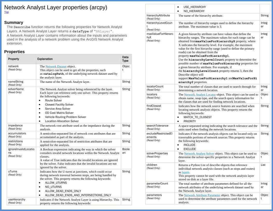
Network Analyst Layer properties (arcpy) Top
Summary
The Describe function returns the following properties for Network Analyst
Layers. A Network Analyst Layer returns a dataType of "NALayer".
A Network Analyst Layer contains information about the inputs and parameters used in the analysis of a network problem using the ArcGIS Network Analyst extension.
Properties
Property Explanation Data
Type
network (Read Only)
The Network Dataset object.
This object can be used to get all the properties, such
as catalogPath, of the underlying network dataset used by
the analysis layer.
Objec
t
nameString (Read Only)
The name of the Network Analyst layer. String
solverName (Read Only)
The Network Analyst solver being referenced by the layer.
Each layer can reference only one solver. This property returns
the following keywords:
Route Solver
Closest Facility Solver
Service Area Solver
OD Cost Matrix Solver
Vehicle Routing Problem Solver
Location-Allocation Solver
String
impedance (Read Only)
The network cost attribute used as the impedance during the
analysis.
String
accumulators (Read Only)
A semicolon-separated list of network cost attributes that are
accumulated as part of the analysis.
String
restrictions (Read Only)
A semicolon-separated list of restriction attributes that are
applied for the analysis.
String
ignoreInvalidLocatio
ns (Read Only)
A Boolean expression indicating the way in which the solver
considers invalid network locations within the Network Analyst
classes.
A value of True indicates that the invalid locations are ignored
by the solver. False indicates that the invalid locations are not
ignored by the solver.
Boole
an
uTurns (Read Only)
Indicates how the U-turns at junctions, which could occur
during network traversal between stops, are being handled by
the solver. This property returns the following keywords:
ALLOW_UTURNS
NO_UTURNS
ALLOW_DEAD_ENDS_ONLY
ALLOW_DEAD_ENDS_AND_INTERSECTIONS_ONLY
String
useHierarchy (Read Only)
Indicates if the Network Analyst Layer is using Hierarchy. This
property returns the following keywords:
String
USE_HIERARCHY
NO_HIERARCHY
hierarchyAttribute (Read Only)
The name of the hierarchy attribute. String
hierarchyLevelCoun
t (Read Only)
The number of hierarchy ranges used to define the hierarchy
attribute. The maximum value is 3.
Integ
er
maxValueForHierarc
hyX (Read Only)
A given hierarchy attribute can have values that define the
hierarchy ranges. The maximum values for each range can be
obtained frommaxValueForHierarchyX property, where
X indicates the hierarchy level. For example, the maximum
value for the first hierarchy range (used to define the primary
roads) can be obtained from the
property maxValueForHierarchy1.
Use the hierarchyLevelCount property to determine the
possible number of maxValueForHierarchy properties for
a given hierarchy attribute. For example, if
the hierarchyLevelCount property returns 3, then the
Describe object will
support MaxValueForHierarchy1 andMaxValueForHi
erarchy2 properties.
Integ
er
locatorCount (Read Only)
The total number of classes that are used to search through for
determining a network location.
Integ
er
locators (Read Only)
The Network Analyst Locator object. This object can be used to
obtain name, snap type, and the search query information for
the classes that are used for finding network locations.
Objec
t
findClosest (Read Only)
Indicates how the network source features are searched when
locating network analysis objects. This property returns the
following keywords:
MATCH_TO_CLOSEST
PRIORITY
String
searchTolerance (Read Only)
A space-separated string indicating the search tolerance and the
units used when finding the network locations.
String
excludeRestrictedEl
ements (Read Only)
Indicates if the network analysis objects can be located only on
traversable portions of network sources This property returns
the following keywords:
INCLUDE
EXCLUDE
String
solverProperties (Read Only)
The Network Analyst Solver object. This object can be used to
determine the solver-specific properties in a Network Analyst
layer.
Objec
t
children (Read Only)
Returns a Python List of describe objects that reference
individual network analysis classes (such as stops and routes)
as layers.
This property cannot be used with the network analysis layer
stored on disk as a layer file.
List
parameterCount (Read Only)
The total number of attribute parameters defined for all the
network attributes of the underlying network dataset used by
the Network Analyst layer.
Integ
er
parameters (Read Only)
The Network Attribute Parameter object. This object can be
used to determine the attribute parameters used for the network
analysis.
Objec
t
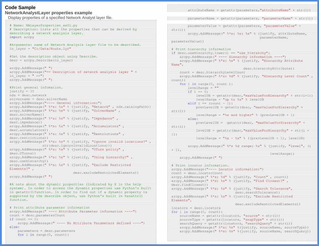
Code Sample NetworkAnalystLayer properties example
Display properties of a specified Network Analyst layer file.
# Name: NALayerProperties_ex01.py
# Description: Lists all the properties that can be derived by
describing a network analysis layer.
import arcpy
#Arguments: name of Network Analysis layer file to be described.
in_layer = "C:/Data/Route.lyr"
#Get the description object using Describe.
desc = arcpy.Describe(in_layer)
arcpy.AddMessage(" ")
arcpy.AddMessage("== Description of network analysis layer " +
in_layer + " ==")
arcpy.AddMessage(" ")
#Print general infomation.
justify = 35
nds = desc.network
solvername = desc.solverName
arcpy.AddMessage("---- General information:")
arcpy.AddMessage(" %*s: %s" % (justify, "Network" , nds.catalogPath))
arcpy.AddMessage(" %*s: %s" % (justify, "SolverName" ,
desc.solverName))
arcpy.AddMessage(" %*s: %s" % (justify, "Impedance" ,
desc.impedance))
arcpy.AddMessage(" %*s: %s" % (justify, "Accumulators" ,
desc.accumulators))
arcpy.AddMessage(" %*s: %s" % (justify, "Restrictions" ,
desc.restrictions))
arcpy.AddMessage(" %*s: %s" % (justify, "Ignore invalid locations?" ,
str(desc.ignoreInvalidLocations)))
arcpy.AddMessage(" %*s: %s" % (justify, "UTurn policy" ,
desc.UTurns))
arcpy.AddMessage(" %*s: %s" % (justify, "Using hierarchy?" ,
desc.useHierarchy))
arcpy.AddMessage(" %*s: %s" % (justify, "Exclude Restricted
Elements?" ,
desc.excludeRestrictedElements))
arcpy.AddMessage(" ")
#A note about the dynamic properties (indicated by X in the help
system). In order to access the dynamic properties use Python's built
in getattr()function. In order to find out if a dynamic property is
supported by the describe object, use Python's built in hasattr()
function.
# Print attribute parameter information
arcpy.AddMessage(" ---- Attribute Parameter information ----")
count = desc.parameterCount
if count == 0:
arcpy.AddMessage(" ---- No Attribute Parameters defined ----")
else:
parameters = desc.parameters
for i in range(0, count):
attributeName = getattr(parameters,"attributeName" + str(i))
parameterName = getattr(parameters, "parameterName" + str(i))
parameterValue = getattr(parameters, "parameterValue" +
str(i))
arcpy.AddMessage(" %*s: %s: %s" % (justify, attributeName,
parameterName,
parameterValue))
# Print hierarchy information
if desc.useHierarchy.lower() == "use_hierarchy":
arcpy.AddMessage(" ---- Hierarchy information ----")
arcpy.AddMessage(" %*s: %s" % (justify, "Hierarchy Attribute
Name",
desc.hierarchyAttribute))
count = desc.hierarchyLevelCount
arcpy.AddMessage(" %*s: %d" % (justify, "Hierarchy Level Count" ,
count))
for i in range(0, count ):
levelRange = ""
if i == 0:
levelUB = getattr(desc,"maxValueForHierarchy" + str(i+1))
levelRange = "up to %s" % levelUB
elif i == (count - 1):
prevLevelUB = getattr(desc, "maxValueForHierarchy" +
str(i))
levelRange = "%s and higher" % (prevLevelUB + 1)
else:
prevLevelUB = getattr(desc, "maxValueForHierarchy" +
str(i))
levelUB = getattr(desc,"maxValueForHierarchy" + str(i +
1))
levelRange = "%s - %s" % ((prevLevelUB + 1), levelUB)
arcpy.AddMessage(" %*s %d range: %s" % (justify, "level", (i
+ 1),
levelRange))
arcpy.AddMessage(" ")
# Print locator information.
arcpy.AddMessage("---- Locator information:")
count = desc.locatorCount
arcpy.AddMessage(" %*s: %d" % (justify, "Count" , count))
arcpy.AddMessage(" %*s: %s" % (justify, "Find Closest?" ,
desc.findClosest))
arcpy.AddMessage(" %*s: %s" % (justify, "Search Tolerance",
desc.searchTolerance))
arcpy.AddMessage(" %*s: %s" % (justify, "Exclude Restricted
Elements",
desc.excludeRestrictedElements))
locators = desc.locators
for i in range(0, count):
sourceName = getattr(locators, "source" + str(i))
sourceType = getattr(locators, "snapType" + str(i))
searchQuery = getattr(locators, "searchQuery" + str(i))
arcpy.AddMessage(" %*s: %s" %(justify, sourceName, sourceType))
arcpy.AddMessage(" %*s: %s" %(justify, sourceName, searchQuery))
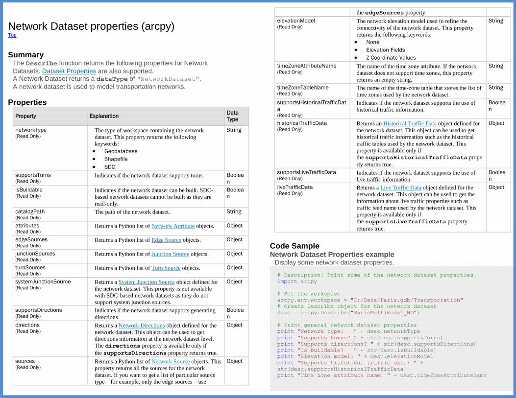
Network Dataset properties (arcpy) Top
Summary
The Describe function returns the following properties for Network
Datasets. Dataset Properties are also supported. A Network Dataset returns a dataType of "NetworkDataset".
A network dataset is used to model transportation networks.
Properties
Property Explanation Data
Type
networkType (Read Only)
The type of workspace containing the network
dataset. This property returns the following
keywords:
Geodatabase
Shapefile
SDC
String
supportsTurns (Read Only)
Indicates if the network dataset supports turns. Boolea
n
isBuildable (Read Only)
Indicates if the network dataset can be built. SDC-
based network datasets cannot be built as they are
read-only.
Boolea
n
catalogPath (Read Only)
The path of the network dataset. String
attributes (Read Only)
Returns a Python list of Network Attribute objects. Object
edgeSources (Read Only)
Returns a Python list of Edge Source objects. Object
junctionSources (Read Only)
Returns a Python list of Junction Source objects. Object
turnSources (Read Only)
Returns a Python list of Turn Source objects. Object
systemJunctionSource (Read Only)
Returns a System Junction Source object defined for
the network dataset. This property is not available
with SDC-based network datasets as they do not
support system junction sources.
Object
supportsDirections (Read Only)
Indicates if the network dataset supports generating
directions.
Boolea
n
directions (Read Only)
Returns a Network Directions object defined for the
network dataset. This object can be used to get
directions information at the network dataset level.
The directions property is available only if
the supportsDirections property returns true.
Object
sources (Read Only)
Returns a Python list of Network Source objects. This
property returns all the sources for the network
dataset. If you want to get a list of particular source
type—for example, only the edge sources—use
Object
the edgeSources property.
elevationModel (Read Only)
The network elevation model used to refine the
connectivity of the network dataset. This property
returns the following keywords:
None
Elevation Fields
Z Coordinate Values
String
timeZoneAttributeName (Read Only)
The name of the time zone attribute. If the network
dataset does not support time zones, this property
returns an empty string.
String
timeZoneTableName (Read Only)
The name of the time-zone table that stores the list of
time zones used by the network dataset.
String
supportsHistoricalTrafficDat
a (Read Only)
Indicates if the network dataset supports the use of
historical traffic information.
Boolea
n
historicalTrafficData (Read Only)
Returns an Historical Traffic Data object defined for
the network dataset. This object can be used to get
historical traffic information such as the historical
traffic tables used by the network dataset. This
property is available only if
the supportsHistoricalTrafficData prope
rty returns true.
Object
supportsLiveTrafficData (Read Only)
Indicates if the network dataset supports the use of
live traffic information.
Boolea
n
liveTrafficData (Read Only)
Returns a Live Traffic Data object defined for the
network dataset. This object can be used to get the
information about live traffic properties such as
traffic feed name used by the network dataset. This
property is available only if
the supportsLiveTrafficData property
returns true.
Object
Code Sample Network Dataset Properties example
Display some network dataset properties.
# Description: Print some of the network dataset properties.
import arcpy
# Set the workspace
arcpy.env.workspace = "C:/Data/Paris.gdb/Transportation"
# Create Describe object for the network dataset
desc = arcpy.Describe("ParisMultimodal_ND")
# Print general network dataset properties
print "Network type: " + desc.networkType
print "Supports turns? " + str(desc.supportsTurns)
print "Supports directions? " + str(desc.supportsDirections)
print "Is buildable? " + str(desc.isBuildable)
print "Elevation model: " + desc.elevationModel
print "Supports historical traffic data: " +
str(desc.supportsHistoricalTrafficData)
print "Time zone attribute name: " + desc.timeZoneAttributeName
print "Time zone table name: " + desc.timeZoneTableName
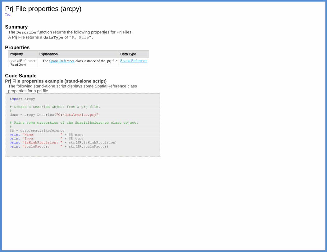
Prj File properties (arcpy) Top
Summary
The Describe function returns the following properties for Prj Files.
A Prj File returns a dataType of "PrjFile".
Properties
Property Explanation Data Type
spatialReference (Read Only)
The SpatialReference class instance of the .prj file SpatialReference
Code Sample Prj File properties example (stand-alone script)
The following stand-alone script displays some SpatialReference class properties for a prj file.
import arcpy
# Create a Describe Object from a prj file.
#
desc = arcpy.Describe("C:\data\mexico.prj")
# Print some properties of the SpatialReference class object.
#
SR = desc.spatialReference
print "Name: " + SR.name
print "Type: " + SR.type
print "isHighPrecision: " + str(SR.isHighPrecision)
print "scaleFactor: " + str(SR.scaleFactor)
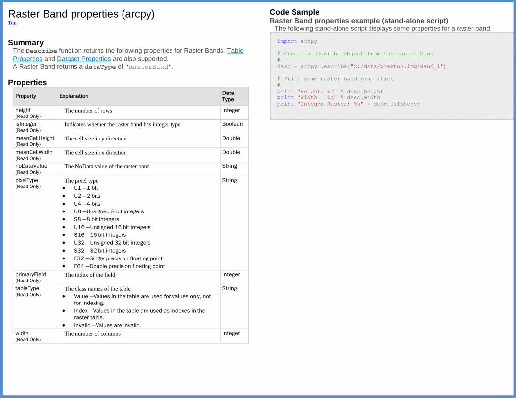
Raster Band properties (arcpy) Top
Summary
The Describe function returns the following properties for Raster Bands. Table
Properties and Dataset Properties are also supported. A Raster Band returns a dataType of "RasterBand".
Properties
Property Explanation Data
Type
height (Read Only)
The number of rows Integer
isInteger (Read Only)
Indicates whether the raster band has integer type Boolean
meanCellHeight (Read Only)
The cell size in y direction Double
meanCellWidth (Read Only)
The cell size in x direction Double
noDataValue (Read Only)
The NoData value of the raster band String
pixelType (Read Only)
The pixel type
U1 —1 bit
U2 —2 bits
U4 —4 bits
U8 —Unsigned 8 bit integers
S8 —8 bit integers
U16 —Unsigned 16 bit integers
S16 —16 bit integers
U32 —Unsigned 32 bit integers
S32 —32 bit integers
F32 —Single precision floating point
F64 —Double precision floating point
String
primaryField (Read Only)
The index of the field Integer
tableType (Read Only)
The class names of the table
Value —Values in the table are used for values only, not
for indexing.
Index —Values in the table are used as indexes in the
raster table.
Invalid —Values are invalid.
String
width (Read Only)
The number of columns Integer
Code Sample Raster Band properties example (stand-alone script)
The following stand-alone script displays some properties for a raster band.
import arcpy
# Create a Describe object from the raster band
#
desc = arcpy.Describe("C:/data/preston.img/Band_1")
# Print some raster band properties
#
print "Height: %d" % desc.height
print "Width: %d" % desc.width
print "Integer Raster: %s" % desc.isInteger
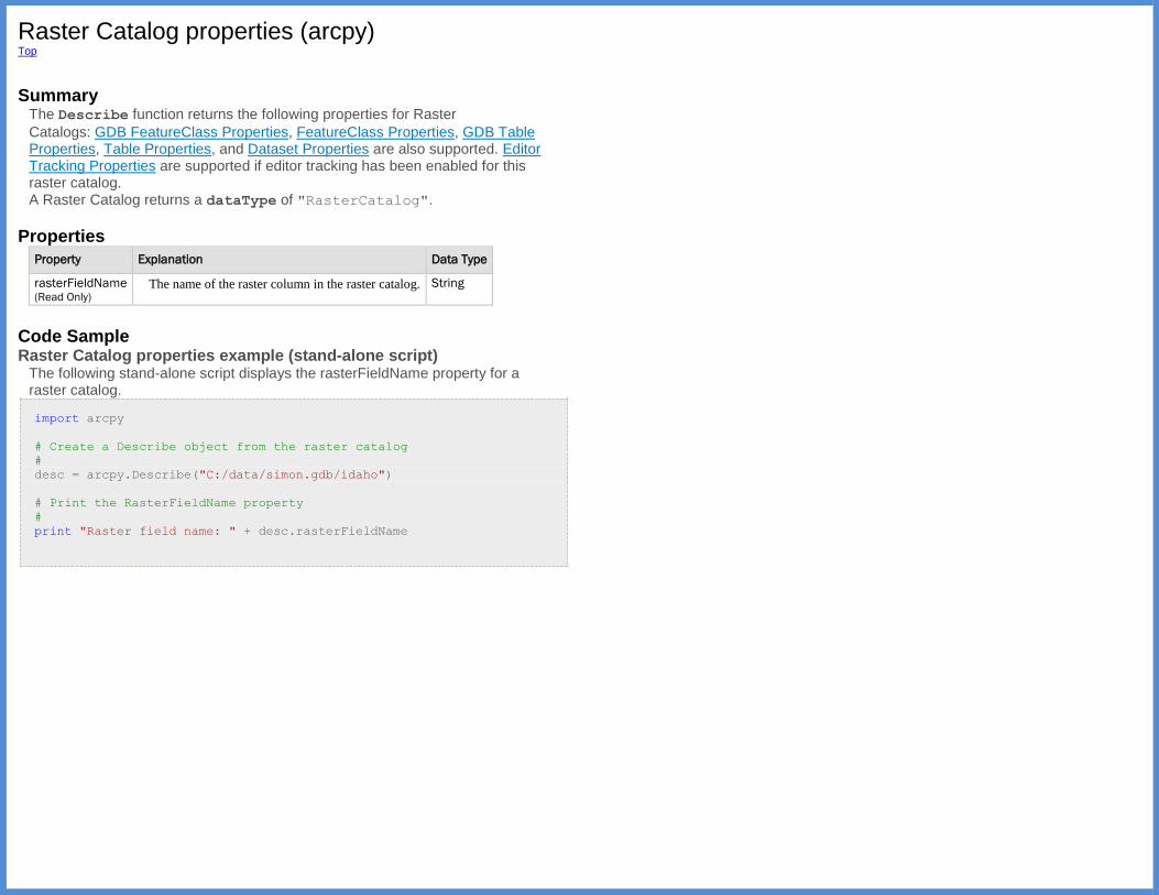
Raster Catalog properties (arcpy) Top
Summary
The Describe function returns the following properties for Raster
Catalogs: GDB FeatureClass Properties, FeatureClass Properties, GDB Table Properties, Table Properties, and Dataset Properties are also supported. Editor Tracking Properties are supported if editor tracking has been enabled for this raster catalog. A Raster Catalog returns a dataType of "RasterCatalog".
Properties
Property Explanation Data Type
rasterFieldName (Read Only)
The name of the raster column in the raster catalog. String
Code Sample Raster Catalog properties example (stand-alone script)
The following stand-alone script displays the rasterFieldName property for a raster catalog.
import arcpy
# Create a Describe object from the raster catalog
#
desc = arcpy.Describe("C:/data/simon.gdb/idaho")
# Print the RasterFieldName property
#
print "Raster field name: " + desc.rasterFieldName
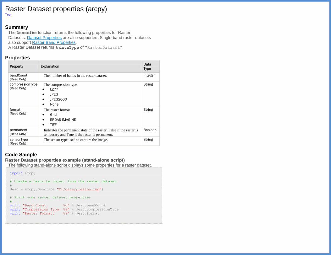
Raster Dataset properties (arcpy) Top
Summary
The Describe function returns the following properties for Raster
Datasets. Dataset Properties are also supported. Single-band raster datasets also support Raster Band Properties. A Raster Dataset returns a dataType of "RasterDataset".
Properties
Property Explanation Data
Type
bandCount (Read Only)
The number of bands in the raster dataset. Integer
compressionType (Read Only)
The compression type
LZ77
JPEG
JPEG2000
None
String
format (Read Only)
The raster format
Grid
ERDAS IMAGINE
TIFF
String
permanent (Read Only)
Indicates the permanent state of the raster: False if the raster is
temporary and True if the raster is permanent.
Boolean
sensorType (Read Only)
The sensor type used to capture the image. String
Code Sample Raster Dataset properties example (stand-alone script)
The following stand-alone script displays some properties for a raster dataset.
import arcpy
# Create a Describe object from the raster dataset
#
desc = arcpy.Describe("C:/data/preston.img")
# Print some raster dataset properties
#
print "Band Count: %d" % desc.bandCount
print "Compression Type: %s" % desc.compressionType
print "Raster Format: %s" % desc.format

RecordSet/FeatureSet properties (arcpy) Top
Summary
The Describe function returns the following properties for instances
of RecordSet and FeatureSet. Table Properties and Dataset Properties are also supported by both. In addition, FeatureSet supports FeatureClass Properties. Many of these properties will be empty unless the RecordSet or FeatureSet has
been populated by calling its load method.
A RecordSet returns a dataType of "RecordSet".
A FeatureSet returns a dataType of "FeatureSet".
A REST client (such as a web application that uses a geoprocessing service) uses JSON streams to exchange data with a Service End point. You can use
the json or pjson property for generating test input for a service or to examine
the JSON representation of features and tables that are used by an ArcGIS REST Service. For an example of this, see Using a service in Python scripts.
Note: For typical ArcPy use, passing a table or feature class as an argument to a service is faster than passing the JSON string representation of the same table or feature class.
Properties
Property Explanation Data
Type
json (Read
Only)
A JSON string representing the table or feature class that underlies the
arcpy.RecordSet or arcpy.FeatureSet.
String
pjson (Read
Only)
Pretty JSON. A JSON string formatted to be easily readable. This string is
a little larger because it includes extra newline and whitespace characters.
String
Code Sample FeatureSet properties example (stand-alone script)
The following stand-alone script loads a feature class into an arcpy.FeatureSet, then prints the pjson string.
import arcpy
# Describe a populated arcpy.FeatureSet
#
fSet = arcpy.FeatureSet()
fSet.load("C:\data\moad.gdb\Water_Bodies")
desc = arcpy.Describe(fSet)
# print a JSON representation
print (desc.pjson)
RelationshipClass properties (arcpy) Top
Summary
The Describe function returns the following properties for Relationship
Classes. Also supported are GDB Table Properties, Table Properties, and Dataset Properties. A Relationship Class returns a dataType of "RelationshipClass".
Properties
Property Explanation Data
Type
backwardPathLabel (Read Only)
The backward path label for the relationship class. String
cardinality (Read Only)
The cardinality for the relationship class.
OnetoOne
OneToMany
ManyToMany
String
classKey (Read Only)
Class key used for the relationship class.
Undefined
ClassID
ClassCode
String
destinationClassNames (Read Only)
A list containing the names of the destination classes. String
forwardPathLabel (Read Only)
The forward path label for the relationship class. String
isAttachmentRelationship (Read Only)
Indicates if the relationship class represents a table
attachment.
Boolean
isAttributed (Read Only)
Indicates if the relationships in this relationship class
have attributes.
Boolean
isComposite (Read Only)
Indicates if the relationship class represents a
composite relationship in which the origin object class
represents the composite object.
Boolean
isReflexive (Read Only)
Indicates if the origin and destination sets intersect. Boolean
keyType (Read Only)
Key type for the relationship class.
Single
Dual
String
notification (Read Only)
The notification direction for the relationship class.
None
Forward
Backward
Both
String
originClassNames (Read Only)
A list containing the names of the origin classes. String
Code Sample RelationshipClass properties example (stand-alone script)
The following stand-alone script displays properties for a relationship class.
import arcpy
# Create a Describe object
#
desc = arcpy.Describe("C:/data/moad.gdb/West/bapCompAttRel")
# Print relationship class properties
#
print "%-25s %s" % ("Backward Path Label:", desc.backwardPathLabel)
print "%-25s %s" % ("Cardinality:", desc.cardinality)
print "%-25s %s" % ("Class key:", desc.classKey)
print "%-25s %s" % ("Destination Class Names:",
desc.destinationClassNames)
print "%-25s %s" % ("Forward Path Label:", desc.forwardPathLabel)
print "%-25s %s" % ("Is Attributed:", desc.isAttributed)
print "%-25s %s" % ("Is Composite:", desc.isComposite)
print "%-25s %s" % ("Is Reflexive:", desc.isReflexive)
print "%-25s %s" % ("Key Type:", desc.keyType)
print "%-25s %s" % ("Notification Direction:", desc.notification)
print "%-25s %s" % ("Origin Class Names:", desc.originClassNames)

RepresentationClass properties (arcpy) Top
Summary
The Describe function returns the following properties for Representation
Classes. Dataset Properties are also supported. Describe properties for Representation Classes can be obtained from either
the GDBFeatureClass.representations property or the DescribeObject.children property of a GDB FeatureClass. A Representation Class returns a dataType of "RepresentationClass".
Properties
Property Explanation Data
Type
overrideFieldName (Read Only)
The name of the Override field. String
requireShapeOverride (Read Only)
Indicates if a shape override is required for feature
representations.
Boolean
ruleIDFieldName (Read Only)
The name of the RuleID field. String
Code Sample RepresentationClass properties example (stand-alone script)
The following stand-alone script displays properties for all the representation classes in a feature class.
import arcpy
# Create a Describe object
#
desc = arcpy.Describe("C:/data/moad.gdb/Water_Bodies")
# Print RepresentationClass properties for each representation
# in the feature class.
#
for child in desc.representations:
if child.datasetType == "RepresentationClass":
print child.name
print "\t%-25s %s" % ("Override field name:",
child.overrideFieldName)
print "\t%-25s %s" % ("Shape override required:",
child.requireShapeOverride)
print "\t%-25s %s" % ("RuleID field name:",
child.ruleIDFieldName)
Schematic Dataset properties (arcpy) Top
Summary
The Describe function returns Dataset Properties for Schematic Datasets.
A Schematic Dataset returns a dataType of "SchematicDataset".

Schematic Diagram properties (arcpy) Top
Summary
The Describe function returns the following properties for Schematic
Diagrams. Dataset Properties are also supported. A Schematic Diagram returns a dataType of "SchematicDiagram".
Properties
Property Explanation Data
Type
diagramClassName (Read Only)
The name of the schematic diagram class associated with the
diagram.
String
Code Sample Schematic Diagram properties example (stand-alone script)
The following stand-alone script displays the diagramClassName property of a schematic diagram.
import arcpy
# Create a Describe object for a schematic diagram
#
desc = arcpy.Describe("C:/data/blanding.gdb/CityPower/Feeders/Feeder
0801-Rice Creek")
# Print the diagram class name property
#
print "Diagram Class Name: " + desc.diagramClassName
Schematic Folder properties (arcpy) Top
Summary
The Describe function returns Dataset Properties for Schematic Folders.
A Schematic Folder returns a dataType of "SchematicFolder".

SDC FeatureClass properties (arcpy) Top
Summary
The Describe function returns GDB FeatureClass Properties, FeatureClass
Properties, GDB Table Properties, Table Properties, and Dataset Properties for SDC Feature Classes. A SDC Feature Class returns a dataType of "FeatureClass".
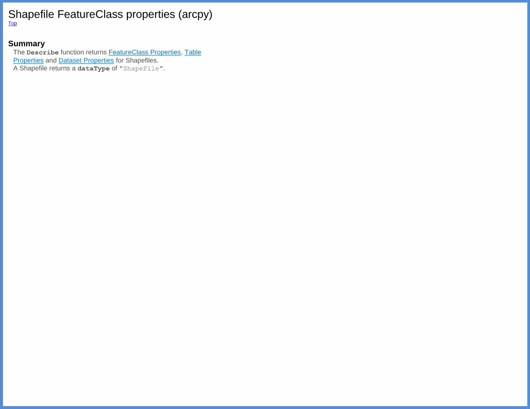
Shapefile FeatureClass properties (arcpy) Top
Summary
The Describe function returns FeatureClass Properties, Table
Properties and Dataset Properties for Shapefiles. A Shapefile returns a dataType of "ShapeFile".
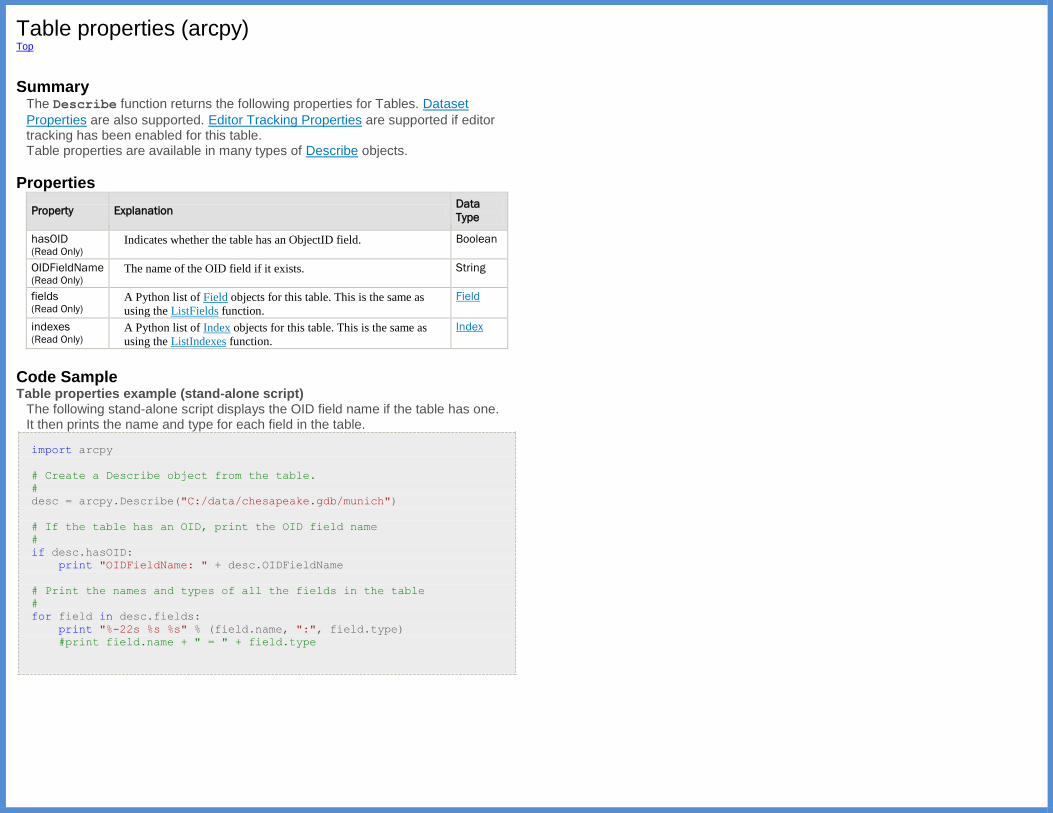
Table properties (arcpy) Top
Summary
The Describe function returns the following properties for Tables. Dataset
Properties are also supported. Editor Tracking Properties are supported if editor tracking has been enabled for this table. Table properties are available in many types of Describe objects.
Properties
Property Explanation Data
Type
hasOID (Read Only)
Indicates whether the table has an ObjectID field. Boolean
OIDFieldName (Read Only)
The name of the OID field if it exists. String
fields (Read Only)
A Python list of Field objects for this table. This is the same as
using the ListFields function.
Field
indexes (Read Only)
A Python list of Index objects for this table. This is the same as
using the ListIndexes function.
Index
Code Sample Table properties example (stand-alone script)
The following stand-alone script displays the OID field name if the table has one. It then prints the name and type for each field in the table.
import arcpy
# Create a Describe object from the table.
#
desc = arcpy.Describe("C:/data/chesapeake.gdb/munich")
# If the table has an OID, print the OID field name
#
if desc.hasOID:
print "OIDFieldName: " + desc.OIDFieldName
# Print the names and types of all the fields in the table
#
for field in desc.fields:
print "%-22s %s %s" % (field.name, ":", field.type)
#print field.name + " = " + field.type
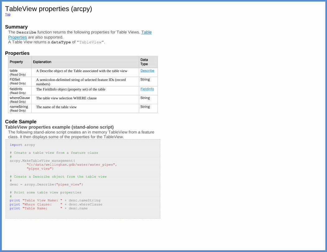
TableView properties (arcpy) Top
Summary
The Describe function returns the following properties for Table Views. Table
Properties are also supported. A Table View returns a dataType of "TableView".
Properties
Property Explanation Data
Type
table (Read Only)
A Describe object of the Table associated with the table view Describe
FIDSet (Read Only)
A semicolon-delimited string of selected feature IDs (record
numbers)
String
fieldInfo (Read Only)
The FieldInfo object (property set) of the table FieldInfo
whereClause (Read Only)
The table view selection WHERE clause String
nameString (Read Only)
The name of the table view String
Code Sample TableView properties example (stand-alone script)
The following stand-alone script creates an in memory TableView from a feature class. It then displays some of the properties for the TableView.
import arcpy
# Create a table view from a feature class
#
arcpy.MakeTableView_management(
"C:/data/wellingham.gdb/water/water_pipes",
"pipes_view")
# Create a Describe object from the table view
#
desc = arcpy.Describe("pipes_view")
# Print some table view properties
#
print "Table View Name: " + desc.nameString
print "Where Clause: " + desc.whereClause
print "Table Name: " + desc.name
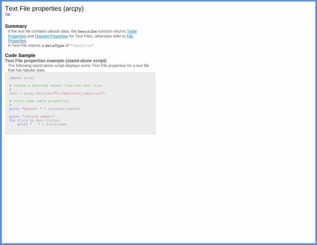
Text File properties (arcpy) Top
Summary
If the text file contains tabular data, the Describe function returns Table
Properties and Dataset Properties for Text Files, otherwise refer to File Properties. A Text File returns a dataType of "TextFile".
Code Sample Text File properties example (stand-alone script)
The following stand-alone script displays some Text File properties for a text file that has tabular data.
import arcpy
# Create a Describe object from the text file.
#
desc = arcpy.Describe("C:/data/evac_table.txt")
# Print some table properties
#
print "HasOID: " + str(desc.hasOID)
print "\nField names:"
for field in desc.fields:
print " " + field.name
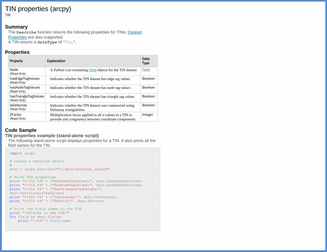
TIN properties (arcpy) Top
Summary
The Describe function returns the following properties for TINs. Dataset
Properties are also supported. A TIN returns a dataType of "Tin".
Properties
Property Explanation Data
Type
fields (Read Only)
A Python List containing Field objects for the TIN dataset Field
hasEdgeTagValues (Read Only)
Indicates whether the TIN dataset has edge tag values Boolean
hasNodeTagValues (Read Only)
Indicates whether the TIN dataset has node tag values Boolean
hasTriangleTagValues (Read Only)
Indicates whether the TIN dataset has triangle tag values Boolean
isDelaunay (Read Only)
Indicates whether the TIN dataset was constructed using
Delaunay triangulation
Boolean
ZFactor (Read Only)
Multiplication factor applied to all z-values in a TIN to
provide unit congruency between coordinate components
Integer
Code Sample TIN properties example (stand-alone script)
The following stand-alone script displays properties for a TIN. It also prints all the field names for the TIN.
import arcpy
# Create a Describe object
#
desc = arcpy.Describe("C:/data/antelope_island")
# Print TIN properties
print "%-21s %s" % ("HasEdgeTagValues:", desc.hasEdgeTagValues)
print "%-21s %s" % ("HasNodeTagValues:", desc.hasNodeTagValues)
print "%-21s %s" % ("HasTriangleTagValues:",
desc.hasTriangleTagValues)
print "%-21s %s" % ("IsDelaunay:", desc.isDelaunay)
print "%-21s %s" % ("ZFactor:", desc.ZFactor)
# Print the field names in the TIN
print "\nFields in the TIN:"
for field in desc.fields:
print "\t%s" % field.name

Tool properties (arcpy) Top
Summary
The Describe function returns Dataset Properties for Tools.
A Tool returns a dataType of "Tool".
Toolbox properties (arcpy) Top
Summary
The Describe function returns Dataset Properties for Toolboxes.
A Toolbox returns a dataType of "ToolBox".
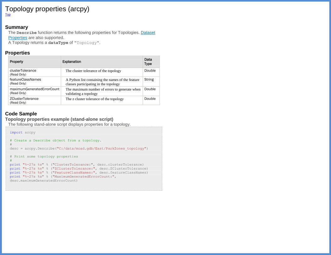
Topology properties (arcpy) Top
Summary
The Describe function returns the following properties for Topologies. Dataset
Properties are also supported. A Topology returns a dataType of "Topology".
Properties
Property Explanation Data
Type
clusterTolerance (Read Only)
The cluster tolerance of the topology Double
featureClassNames (Read Only)
A Python list containing the names of the feature
classes participating in the topology
String
maximumGeneratedErrorCount (Read Only)
The maximum number of errors to generate when
validating a topology
Double
ZClusterTolerance (Read Only)
The z cluster tolerance of the topology Double
Code Sample Topology properties example (stand-alone script)
The following stand-alone script displays properties for a topology.
import arcpy
# Create a Describe object from a topology.
#
desc = arcpy.Describe("C:/data/moad.gdb/East/ParkZones_topology")
# Print some topology properties
#
print "%-27s %s" % ("ClusterTolerance:", desc.clusterTolerance)
print "%-27s %s" % ("ZClusterTolerance:", desc.ZClusterTolerance)
print "%-27s %s" % ("FeatureClassNames:", desc.featureClassNames)
print "%-27s %s" % ("MaximumGeneratedErrorCount:",
desc.maximumGeneratedErrorCount)

VPF Coverage properties (arcpy) Top
Summary
The Describe function returns Dataset Properties for VPF Coverages.
A VPF Coverage returns a dataType of "VPFCoverage".
VPF FeatureClass properties (arcpy) Top
Summary
The Describe function returns FeatureClass Properties, Table Properties,
and Dataset Properties for VPF Feature Classes. A VPF Feature Class returns a dataType of "FeatureClass".
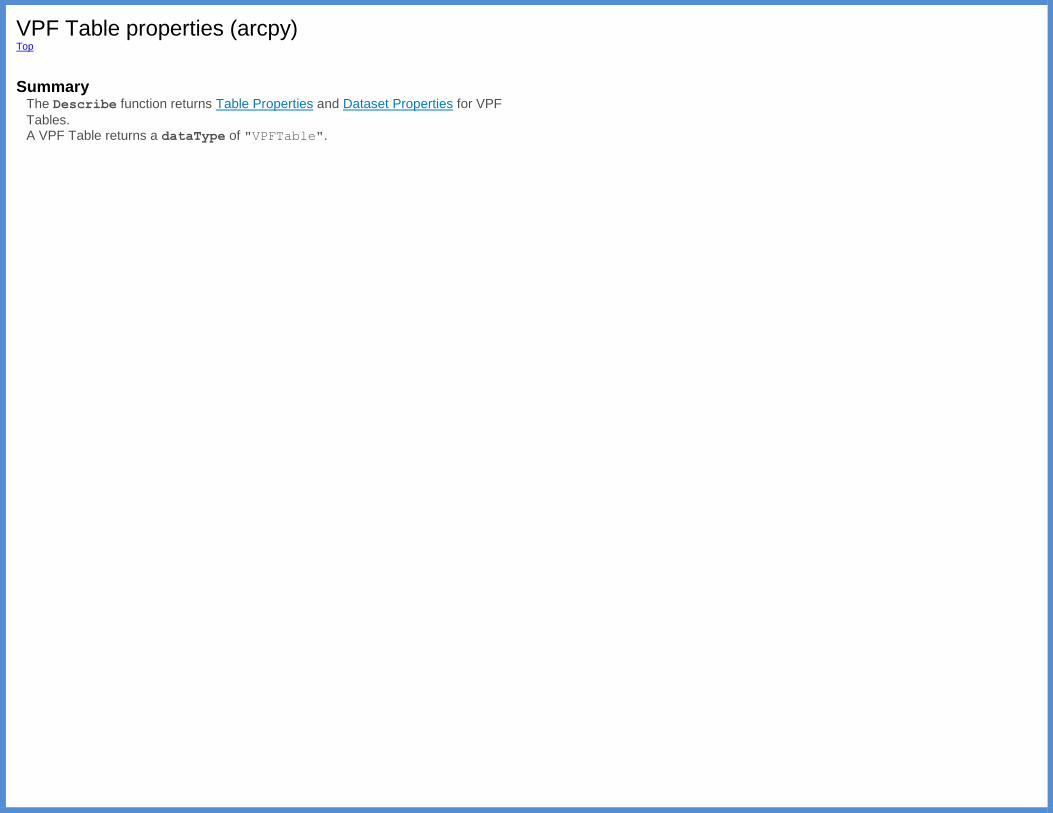
VPF Table properties (arcpy) Top
Summary
The Describe function returns Table Properties and Dataset Properties for VPF
Tables. A VPF Table returns a dataType of "VPFTable".
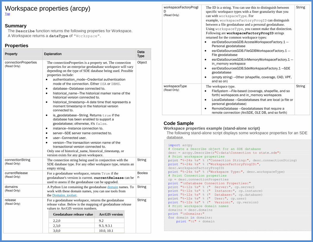
Workspace properties (arcpy) Top
Summary
The Describe function returns the following properties for Workspace.
A Workspace returns a dataType of "Workspace".
Properties
Property Explanation Data
Type
connectionProperties (Read Only)
The connectionProperties is a property set. The connection
properties for an enterprise geodatabase workspace will vary
depending on the type of SDE database being used. Possible
properties include:
authentication_mode—Credential authentication
mode of the connection. Either OSA or DBMS.
database—Database connected to.
historical_name—The historical marker name of the
historical version connected to.
historical_timestamp—A date time that represents a
moment timestamp in the historical version
connected to.
is_geodatabase—String. Returns true if the
database has been enabled to support a
geodatabase; otherwise, it's false.
instance—Instance connection to.
server—SDE server name connected to.
user—Connected user.
version—The transaction version name of the
transactional version connected to.
Only one of historical_name, historical_timestamp, or
version exists for any given workspace.
Object
connectionString (Read Only)
The connection string being used in conjunction with the
SDE database type. For any other workspace type, returns an
empty string.
String
currentRelease (Read Only)
For a geodatabase workspace, returns True if the
geodatabase's version is current. currentRelease can be
used to assess if the geodatabase can be upgraded.
Boolea
n
domains (Read Only)
A Python List containing the geodatabase domain names. To
work with these domain names, you can use tools from
the Domains_toolset.
String
release (Read Only)
For a geodatabase workspace, returns the geodatabase
release value. Below is the mapping of geodatabase release
values to ArcGIS version numbers.
Geodatabase release value ArcGIS version
2,2,0 9.2
2,3,0 9.3, 9.3.1
3,0,0 10.0, 10.1
String
workspaceFactoryProgI
D (Read Only)
The ID is a string. You can use this to distinguish between
specific workspace types with a finer granularity than you
can with workspaceType. For
example, workspaceFactoryProgID can distinguish
between a file geodatabase and a personal geodatabase.
Using workspaceType, you cannot make that distinction.
Following are workspaceFactoryProgID strings
returned for the common workspace types:
esriDataSourcesGDB.AccessWorkspaceFactory.1 —
Personal geodatabase
esriDataSourcesGDB.FileGDBWorkspaceFactory.1 —
File geodatabase
esriDataSourcesGDB.InMemoryWorkspaceFactory.1 —
in_memory workspace
esriDataSourcesGDB.SdeWorkspaceFactory.1 —SDE
geodatabase
(empty string) —Other (shapefile, coverage, CAD, VPF,
and so on)
String
workspaceType (Read Only)
The workspace type.
FileSystem —File-based (coverage, shapefile, and so
forth) workspaces and in_memory workspaces
LocalDatabase —Geodatabases that are local (a file or
personal geodatabase)
RemoteDatabase —Geodatabases that require a
remote connection (ArcSDE, OLE DB, and so forth)
String
Code Sample Workspace properties example (stand-alone script)
The following stand-alone script displays some workspace properties for an SDE database.
import arcpy
# Create a Describe object for an SDE database
desc = arcpy.Describe(r"C:data\Connection to state.sde")
# Print workspace properties
print "%-24s %s" % ("Connection String:", desc.connectionString)
print "%-24s %s" % ("WorkspaceFactoryProgID:",
desc.workspaceFactoryProgID)
print "%-24s %s" % ("Workspace Type:", desc.workspaceType)
# Print Connection properties
cp = desc.connectionProperties
print "\nDatabase Connection Properties:"
print "%-12s %s" % (" Server:", cp.server)
print "%-12s %s" % (" Instance:", cp.instance)
print "%-12s %s" % (" Database:", cp.database)
print "%-12s %s" % (" User:", cp.user)
print "%-12s %s" % (" Version:", cp.version)
# Print workspace domain names
domains = desc.domains
print "\nDomains:"
for domain in domains:
print "\t" + domain