ARCHAEOLOGICAL INVESTIGATIONS AT SALT SPRINGS...
151
ARCHAEOLOGICAL INVESTIGATIONS AT SALT SPRINGS (8MR2322), MARION COUNTY, FLORIDA Jason M. O’Donoughue, Kenneth E. Sassaman, Meggan E. Blessing, Johanna B. Talcott, and Julie C. Byrd Technical Report 11 Laboratory of Southeastern Archaeology Department of Anthropology University of Florida USFS Acc# LKGF00436
Transcript of ARCHAEOLOGICAL INVESTIGATIONS AT SALT SPRINGS...

ARCHAEOLOGICAL INVESTIGATIONS AT SALT SPRINGS (8MR2322), MARION COUNTY, FLORIDA
Jason M. O’Donoughue, Kenneth E. Sassaman, Meggan E. Blessing, Johanna B. Talcott, and Julie C. Byrd
Technical Report 11 Laboratory of Southeastern Archaeology
Department of Anthropology University of Florida
USFS Acc# LKGF00436

ARCHAEOLOGICAL INVESTIGATIONS AT SALT SPRINGS (8MR2322), MARION COUNTY, FLORIDA
Jason M. O’Donoughue Kenneth E. Sassaman Meggan E. Blessing Johanna B. Talcott
Julie C. Byrd
Technical Report 11 Laboratory of Southeastern Archaeology
Department of Anthropology University of Florida
Gainesville, FL 32611
USFS Acc# LKGF00436
March 2011

© 2011 Department of Anthropology, University of Florida
all rights reserved
Cover photo of trench excavation in near-shore deposits at Salt Springs (8MR2322), Marion County, Florida, July 2009.
ii

Management Summary Under 1A-32 permit 0809.110 issued by the Florida Bureau of Archaeological Research, and through cooperation of the St. Johns Water Management District and generous support of the U.S. Forest Service (USFS), the Laboratory of Southeastern Archaeology (LSA), Department of Anthropology, University of Florida, conducted archaeological investigations in a near-shore portion of site 8MR2322 that was exposed during improvements to Salt Springs Recreation Area. Mitigative excavations by archaeologists of the National Park Service (NPS) met the immediate compliance needs of USFS, but the coffer dam installed to replace the shoreline bulkhead exposed a portion of a near-shore deposit with good stratigraphic integrity and excellent organic preservation. Through consent of all concerned parties, LSA archaeologists excavated an eight-meter-long trench through this deposit to expose cross-sectional profiles and to collect samples for laboratory analysis. Revealed in the trench were three distinct strata, each with age estimates that suggests both progradation and vertical accretion of midden deposits over a period of roughly 6600–5800 years ago. Both the upper shell-bearing strata and underlying sands with anthropogenic materials appear to have been deposited in standing water, with only the upper portion possibly subject to periodic drying from fluctuations in the level of the spring pool. Well preserved wood beneath the deepest anthropogenic deposits suggest that artesian flow of the spring dates back to at least 9000 years ago. Differential drying of the upper shell stratum (post-5900 years ago) may explain the limited preservation of plant remains compared to underlying sands, which were rich in wood debris, hickory nutshell, various seeds, squash parts, and other plant remains. Bone density was actually greater in the shell, but overall the shell-bearing and sand strata yielded very similar vertebrate assemblages. Artifact density was likewise greater in the shell than in the sand, with the vast majority of artifacts consisting of the by-products of biface production in the last unit of deposition. On balance, ~800 years of anthropogenic accumulation in the near-shore waters of the Salt Springs pool reflects a relatively consistent accumulation of the remains of animals and plants together with artifacts of the Middle Archaic Mount Taylor period. The addition of freshwater shellfish after ~6400 years ago represents either a change in subsistence practice or the progradation of shell outward into the water as it accumulated higher on the adjacent land. Given the lack of associated changes in nonshell food remains, the latter scenario seems most likely. Additional, specialized analyses (e.g., stable isotopes, micromorphology of sediment), coupled with integration of the NPS results, will improve the perspective on environmental and cultural change, but for now the best-supported conclusion is that conditions and activities at Salt Springs from ca. 6600-5800 years ago were relatively stable. This preliminary study attests to the analytical quality of the near-shore deposits at Salt Springs and thus the continuing need to preserve their integrity by protecting them from unnecessary human impact.
iii

Acknowledgments Archaeological excavations at 8MR2322 were conducted under 1A-32 permit 0809.110 issued by Bureau of Archaeological Research (BAR), Division of Historic Resources, Florida Department of State. We thank BAR Archaeologist Louis D. Tesar and State Archaeologist Ryan J. Wheeler for their support of this project. We are also grateful for the cooperation of the St. Johns Water Management District, notably Sandy McGee, Mike Register, and Brian Abrams. Personnel of the U.S. Forest Service (USFS) were particularly generous with logistical and technical assistance. USFS Archaeologist Ray Willis lent his expertise and support to every aspect of the field work, as did USFS engineers Kamal Otman and Jerry Boyer. The administrative support of USFS Heritage Program Manager Rhonda L. Kimbrough and Ocala National Forest District Ranger Rick Lint is also greatly appreciated. National Park Service archaeologist Mike Russo alerted us to the opportunity to test at Salt Springs, for which we owe a debt of thanks. Mike also generously provided photographs and information on his own work at the site. The crew at Salt Springs endured difficult conditions and long work days to ensure the success of this project. We are grateful to Asa Randall, Zack Gilmore, Meggan Blessing, Julie Byrd, Alisa French, and Erik Johanson for joining us in some of the most intensive field work we have ever experienced. Our thanks also to Johanna Talcott for traveling to the field site from Penn State to oversee the processing of bulk samples for botanical materials. Julie Byrd of Florida State University not only worked hard in the field but also visited the Laboratory of Southeastern Archaeology to examine bone tools from the excavation. Catherine Aust did the heavy lifting of sorting the bulk samples we returned to the lab, and was assisted by students Alisa French, A. J. Gottschalk, Leah Cary, Ed Zegarra, Blake Stinson, Macarena Santos, Sami Kattan, Lauren Andrito, Kirsten Motonari, Sallie Dehler, Kathryn King, Erin Harris-Parks, Matt Marino, Kathryn Cook, Summer Jupin, Elena Thomas, Hayley Singleton, and Anna Binder. Accommodations in the field were provided by our field school hosts, the Juniper Club of Louisville, Kentucky. Administrative staff of the Department of Anthropology, University of Florida ensured smooth operations. We are especially grateful to Office Manager Karen Jones for her fiscal oversight of the project and to Chair Allan Burns for administrative support. Funding for this project was provided by the Hyatt and Cici Brown Endowment for Florida Archaeology.
iv
Contents Management Summary ...................................................................................................... iii Acknowledgments.............................................................................................................. iv Chapter 1. Introduction and Research Orientation ..............................................................1 Chapter 2. Environmental and Archaeological Background .............................................11 Chapter 3. Methods and Results of Field Investigation.....................................................33 Chapter 4. Material Culture ...............................................................................................49 Chapter 5. Zooarchaeological Assemblage........................................................................65 Chapter 6. Paleoethnobotanical Assemblage.....................................................................87 Chapter 7. Conclusions ....................................................................................................105 References Cited ..............................................................................................................115 Appendix A: Catalog ......................................................................................................129 Appendix B: Radiocarbon Data ......................................................................................143
v

vi

CHAPTER 1 INTRODUCTION AND RESEARCH ORIENTATION
Kenneth E. Sassaman
In July 2009, the Laboratory of Southeastern Archaeology (LSA), Department of
Anthropology, University of Florida, participated in a collaborative effort to investigate archaeological materials impacted by improvements to the recreational facilities at Salt Springs in Marion County, Florida. Located on the Ocala National Forest, Salt Springs Recreation Area is under the jurisdiction of the U.S. Forest Service (USFS). Mitigative excavations at an archaeological site (8MR2322) surrounding the spring pool were undertaken in the Spring of 2009 by Michael Russo of the Southeast Archaeological Center, National Park Service (Figure 1-1). That effort was successful in sampling the shoreline deposits impacted directly by facility improvements, but adjacent near-shore deposits—typically submerged in the spring pool—fell outside the area of potential impact and were thus not subject to mitigative excavation. A coffer dam emplaced to install a new bulkhead around the pool exposed these near-shore deposits, revealing as well the vulnerability of this portion of the site to the indirect impacts attending continued public use of the spring. Through cooperation of the USFS and with authorization of the Bureau of Archaeological Research (1A-32 Permit 0809.110) and the St. Johns Water Management District, LSA archaeologists excavated an eight-meter long trench through the exposed near-shore deposits to reveal a stratified midden spanning roughly 6600–5800 years ago. This report summarizes the methods and results of this investigation, including analyses of organic and inorganic remains, as well as the stratigraphic interpretation informed by a series of eight radiometric age estimates.
The archaeological deposits revealed in the LSA trench excavation are
exceptionally well preserved, well stratified, and of rare analytical value for reconstructing not only the details of human life thousands of years ago, but also the changing environmental conditions of the spring and its immediate environs. The deposits date to the Middle Archaic Mount Taylor period (ca. 7300–4600 cal B.P.), a time of significant cultural and environmental change. In the annals of Florida archaeology, the Mount Taylor period was ushered in by the emergent wetland biomes of generally warm and moist mid-Holocene climate (Milanich 1994:84; Miller 1998). The collection and presumed consumption of freshwater shellfish is among the most conspicuous evidence of this aquatic way of life, amounting to accumulations of gigantic proportions in many locations in the St. Johns River valley. Ridges and mounds consisting of shell and varying amounts of associated remains (i.e., artifacts, vertebrate faunal remains, paleofeces, plant remains, ash, charcoal, clastic matrix, and human interments) were located on lagoons and channels of the St. Johns River, along the shores of lakes in the watershed, and at the heads of major springs, such as Salt Springs.
Like freshwater shell deposits throughout the middle St. Johns region, those of
Mount Taylor age were mined for construction fill in the early half of the last century (e.g., Milanich 1994:90). We are fortunate that naturalists and antiquarians of the 19th century recorded observations on many sites before they were mined (e.g., Wyman 1875;
1
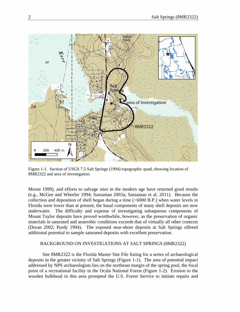
2 Salt Springs (8MR2322)
Figure 1-1. Section of USGS 7.5 Salt Springs (1994) topographic quad, showing location of 8MR2322 and area of investigation. Moore 1999), and efforts to salvage sites in the modern age have returned good results (e.g., McGee and Wheeler 1994; Sassaman 2003a; Sassaman et al. 2011). Because the collection and deposition of shell began during a time (>6000 B.P.) when water levels in Florida were lower than at present, the basal components of many shell deposits are now underwater. The difficulty and expense of investigating subaqueous components of Mount Taylor deposits have proved worthwhile, however, as the preservation of organic materials in saturated and anaerobic conditions exceeds that of virtually all other contexts (Doran 2002; Purdy 1994). The exposed near-shore deposits at Salt Springs offered additional potential to sample saturated deposits with excellent preservation.
BACKGROUND ON INVESTIGATIONS AT SALT SPRINGS (8MR2322) Site 8MR2322 is the Florida Master Site File listing for a series of archaeological
deposits in the greater vicinity of Salt Springs (Figure 1-1). The area of potential impact addressed by NPS archaeologists lies on the northeast margin of the spring pool, the focal point of a recreational facility in the Ocala National Forest (Figure 1-2). Erosion to the wooden bulkhead in this area prompted the U.S. Forest Service to initiate repairs and

Introduction and Research Orientation 3
Figure 1-2. View of Salt Springs Recreation Area facing northeast, showing location of wooden bulkhead and area of archaeological investigations by NPS and LSA (ca. 2006 photo modified by author from http://travel.webshots.com/photo/1546028957084561839csjRcT).
improvements that had potential for disturbing archaeological deposits along the shoreline. NPS archaeologists headed by Michael Russo focused their efforts in the area directly behind the wooden bulkhead in the box shown in Figure 1-2. Revealed in 34 m2 of block excavation were the basal remnants of a shell-bearing midden underlain by midden deposits lacking shell but rich in plant remains and organic artifacts, all dating to the Mount Taylor period (Figure 1-3). A coffer dam used to draw down water in the spring pool (Figure 1-4), plus sump pumps in the area of excavation, enabled NPS archaeologists to retrieve materials that were otherwise fully saturated in groundwater. Large pieces of wood; antler, bone, and wooden artifacts; abundant vertebrate fauna; and diverse plant remains were collected. Among the plant remains are seeds and rind fragments of squashes and gourds, abundant hickory nutshell, and a variety of seeds and other parts of diverse edible resources.
Upon completion of the NPS investigations, Russo contacted the author to suggest that additional testing may be warranted in an area between the newly installed concrete bulkhead and the coffer dam that contained a remnant of the once-submerged near-shore

4 Salt Springs (8MR2322)
Figure 1-3. National Park Service crew excavating saturated midden beneath shell deposits at northeast end of the Salt Springs pool (photo courtesy of Michael Russo, NPS).
Figure 1-4. View of Salt Springs pool facing east, showing coffer dam (blue structure), emplaced concrete bulkhead, and area of archaeological investigations.
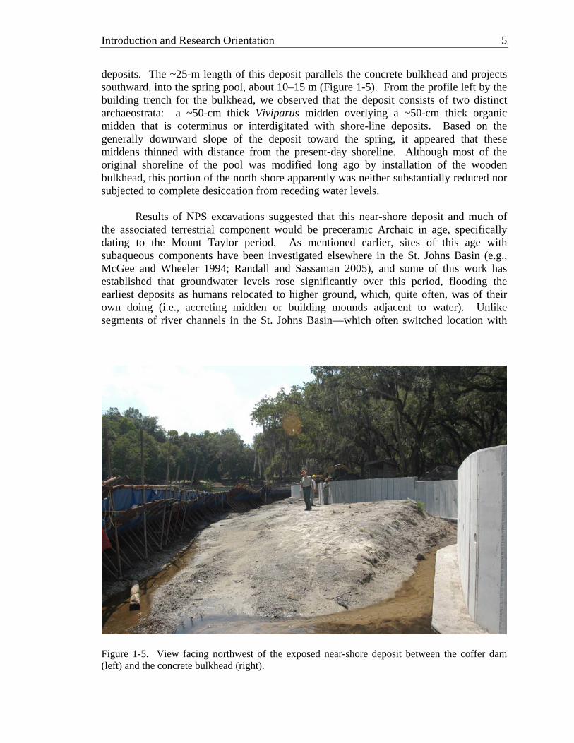
Introduction and Research Orientation 5
deposits. The ~25-m length of this deposit parallels the concrete bulkhead and projects southward, into the spring pool, about 10–15 m (Figure 1-5). From the profile left by the building trench for the bulkhead, we observed that the deposit consists of two distinct archaeostrata: a ~50-cm thick Viviparus midden overlying a ~50-cm thick organic midden that is coterminus or interdigitated with shore-line deposits. Based on the generally downward slope of the deposit toward the spring, it appeared that these middens thinned with distance from the present-day shoreline. Although most of the original shoreline of the pool was modified long ago by installation of the wooden bulkhead, this portion of the north shore apparently was neither substantially reduced nor subjected to complete desiccation from receding water levels.
Results of NPS excavations suggested that this near-shore deposit and much of
the associated terrestrial component would be preceramic Archaic in age, specifically dating to the Mount Taylor period. As mentioned earlier, sites of this age with subaqueous components have been investigated elsewhere in the St. Johns Basin (e.g., McGee and Wheeler 1994; Randall and Sassaman 2005), and some of this work has established that groundwater levels rose significantly over this period, flooding the earliest deposits as humans relocated to higher ground, which, quite often, was of their own doing (i.e., accreting midden or building mounds adjacent to water). Unlike segments of river channels in the St. Johns Basin—which often switched location with
Figure 1-5. View facing northwest of the exposed near-shore deposit between the coffer dam (left) and the concrete bulkhead (right).

6 Salt Springs (8MR2322)
changes in water levels—Florida’s springs have remained fixed in location because of underlying lithology. Water levels were certainly subject to change, but the bigger springs, fed by the Floridan Aquifer, were less vulnerable to local changes than smaller ones, fed by near-surface aquifers. Salt Springs is a second-magnitude spring, perhaps of intermediate vulnerability. Oral accounts of the effects of recent droughts on spring flow at Salt Springs suggest it is subject to short-term (e.g., seasonal), as well as long-term changes in groundwater and precipitation.
RESEARCH ORIENTATION The near-shore remnant at Salt Springs offers good opportunity to collect data on
two interrelated processes: (1) changes in water levels and attendant aquatic ecology; and (2) the accumulation of anthropogenic deposits. Clearly the latter depends on the former to some extent, but we do not assume that the aquatic plant and animal remains that humans deposited near the shoreline were collected exclusively from the spring pool and its associated run and wetlands. That is, we do not assume that the anthropogenic deposits along the shoreline of the spring pool are a direct proxy for local environments, although we acknowledge that they are indicative of the greater resource catchment of the middle St. Johns valley. As Jason O’Donoughue discusses in Chapter 2 of this report, spring pools are productive biomes in many respects but they pale in comparison to other wetland biomes in the region in the support of shellfish, fishes, and other aquatic resources of value to humans.
Regarding changes in water levels in the spring, multiple scales of variation bear
relevance to this study. At the highest level of abstraction, springs and other surface water features in peninsular Florida emerged and became increasingly abundant over the course of the early to middle Holocene as sea levels and groundwater rose. Archaeological remains have been useful in establishing the timing and consequence of increasingly wetter conditions in Florida. As noted earlier, the Mount Taylor period, beginning around 7300 cal B.P., is believed to signal the onset of intensive riverine adaptations in the region (Miller 1998). Without a doubt, communities of the Mount Taylor tradition made good use of aquatic resources throughout the valley, and they have long been presumed to be the first to collect freshwater shellfish in abundance. However, occupations in the region predating the Mount Taylor tradition (as well as early Mount Taylor occupations) have been obscured by rising water levels. We know, for instance, that artifacts dating to the early Holocene have been recovered in abundance at submerged sites in Lake George and Crescent Lake (Sassaman 2003b), and potential early Holocene shell deposits have been reported from Lake George (Michael Faught, personal communication, 2010). Thus, we suggest that the timing and consequence of rising water in Florida may be biased toward the visibility of archaeological remains. This is not to say that water levels did not rise since the early Holocene and affect the availability of aquatic resources and places of human inhabitation, but we have to be careful not to conflate the visibility of Mount Taylor remains with the onset of productive aquatic biomes. As O’Donoughue outlines in Chapter 3, the near-shore deposit at Salt Springs suggests that water levels have been close to present levels well before the onset of the Mount Taylor period.
Introduction and Research Orientation 7
Changes in water levels in the spring at lesser scales of observations show that the magnitude of change is not all that remarkable. Using spring discharge data compiled by the USGS (see Chapter 2), variance since 1929 around a mean value of 79.7 ft3/second is only about 12 percent, with a minimum value of 54 ft3/second and maximum value of 107 ft3/second. This same rate of fluctuation is registered on an annual basis, with lowest discharge in the drier winter months and highest discharge in the wetter summer months. Of course, extended periods of discharge that deviate from historic records are expected at scales ranging from decades to centuries in the ancient past, but these need to be reconstructed from data sources independent of the accumulation of human food remains.
The accumulation of anthropogenic deposits follows rhythms and structural
constraints that vary somewhat independently from the availability of inhabitable land and food resources. In this regard, we have observed two contrasting patterns in the formation of Mount Taylor shell-bearing deposits. For one, shellfish remains and associated materials have accumulated in locations of presumed residence (e.g., ACI 2001; McGee and Wheeler 1994; Randall 2007). These are typically stream or lake-side shell-bearing deposits with abundant vertebrate fauna, artifacts, paleofeces, and other evidence of repeated, intensive land use. On the other hand, freshwater shell was also deposited in locations that may have started off as places of residence, but appear to have been abandoned and then revisited as locations of ritual practice (Randall 2010; Sassaman and Randall n.d.). Inferences about ritual practice have been received with skepticism (e.g., Marquardt 2010), but whether or not shell was emplaced for purposes other than refuse disposal, since at least 5500 cal B.P. and evidently much earlier, Mount Taylor communities mounded earth and shell over human interments to create some of the oldest burial mounds in North America (Aten 1999; Endonino 2010). Complicating the picture is the apparent conflation of categories that modern observers have regarded as “scared” and “secular” dimensions of ancient life, that is, the use of shell and earth (largely sand, but also muck) as a medium for “capping” both human interments, as well as occupational surfaces and other types of presumed “mundane” deposits. All such practices might be regarded as “historical” insofar as they entail the engagement of remains of past practices and its materialization in ways that create or erase social memory (Randall 2010).
With these sorts of conceptual challenges for archaeological interpretation,
investigations into shell deposits of Mount Taylor age must be approached with an open mind and free of assumptions about the direct relationship between shellfish and the aquatic potential of particular locations on the landscape. Springs introduce an additional dimension of variability because they do not appear to be as vulnerable as stream segments, lagoons, and ponds to fluctuations in climate, plus, they embody qualities that garnered special attention in the sensibilities of ancient people, just as they do today. It follows that high-order springs may register greater sustainability for humans than locations lacking a fixed, reliable source of water. At the same time, as O’Donoughue discusses in Chapter 2, they have their limitations, ecologically. It will thus be interesting, as research on springs progresses, to compare the thresholds of ecological sustainability against the gravity of tradition that had communities returning to springs despite their ecological limitations.

8 Salt Springs (8MR2322)
Irrespective of the loftier issues outlined to this point, our work at Salt Springs was designed to collect data that would complement results of the NPS effort. Samples collected in the mitigative work by Russo and colleagues came from a transect of units that paralleled the shoreline. Although the stratigraphic nature of these samples provide some chronological control, cross-sectional views are needed to establish any lateral trends of the deposit. By their very nature, shoreline deposits under changing water levels are transgressive. Being basin-like, the spring pool is conducive to mostly orthogonal transgression (i.e., perpendicular to the shoreline). Progradational trends in anthropogenic deposition at the shoreline can assume a variety of patterns independent of water levels, but again, the basal midden remnant in question appears to have been saturated since it was deposited, so progradation in sync with shoreline transgression is expected.
To collect the stratigraphic and paleoenvironmental data needed to reconstruct the depositional history of exposed deposits, a 1-m-wide trench was excavated through the approximate center of the near-shore remnant and oriented perpendicular to the shoreline. The trench was segmented into 1 x 1-m units. The existing escarpment of the truncated deposit running parallel to the wall trench was first cut vertically to establish the stratigraphic sequence at the north end of the trench. Excavation of 1 x 1-m units then proceeded in “leap frog” fashion. Alternating these initial tests enabled us to maximize profile exposures to determine the integrity and sequencing of the deposits for purposes of sampling from the remaining units.
After mapping all profiles, the remaining units were excavated by stratigraphic
units within macrostrata. All of the fill of these intervening units was waterscreened with 1/8-inch hardware cloth and large samples (~10–20 liters) of all definitive strata were collected for flotation and fine-screen processing off-site. It is from these bulk samples that most of the analytically useful organic remains were recovered.
Analyses of recovered materials reported here are but a first step toward the
development of comprehensive datasets and their integration with the NPS results. Of primary importance in all such analyses is documentation and interpretation of the stratigraphic context of the deposits. This is provided in Chapter 3 of this report, supported by a series of eight radiometric assays that confirm that the near-shore deposits accreted both vertically and horizontally, outward from the shoreline and into the pool. Three distinct macrostrata are documented, including two with shell and a third, underlying sand stratum lacking shell but rich in other anthropogenic remains. Basic descriptive analyses of the material culture, vertebrate fauna, and plant remains are provided in Chapters 4–6 of this report. Additional analyses of the animal and plant remains (e.g., isotopic analyses of shell for water temperature proxies) and soil samples, including blocks extracted for micromorphology, await attention in the future.
To briefly anticipate the results of this effort, the near-shore deposits tested at Salt
Springs formed over a span of up to 800 years (6600–5800 cal B.P.) in three distinct stratigraphic units. Material culture recovered from the trench was concentrated in the

Introduction and Research Orientation 9
latest shell deposit, but with the exception of a few pottery sherds and historic era items in the upper levels, all of it is consistent with materials dating the Mount Taylor era.
The inventory of plant and animal remains exhibit variations across strata that
appear to be largely a result of site formational or taphonomic factors, as opposed to changing ecologies or cultural practices. This is possibly the case for shellfish itself. That is, the apparent introduction of shell in the upper strata of the trench may be more apparent than real. Keeping open the possibility that shellfish was added to the inventory of food remains after an early period of occupation (which is the case at other Mount Taylor sites in the region [Randall 2010; Sassaman 2003a; Sassaman et al. 2011]), it is certainly possible that shellfish that was at first deposited back from the shoreline eventually prograded southward into the water as it accumulated upward. This issue is taken up in Chapter 2 with our review of historic photographs of the site, and again in our concluding chapter.
CONCLUSION
A eight-meter-long trench excavated through the remnant of a near-shore deposit
in the spring pool at Salt Springs revealed a stratified Mount Taylor midden with remarkable organic preservation. Whereas this multicentury record of deposition at the shoreline of the spring pool holds great potential for monitoring changes in water levels, aquatic ecology, and cultural practices through time, the results of analyses to date suggest that little actually changed. Future analyses involving physiochemical properties of shell, bone, plant remains, and sediment may alter this perspective, as may comparisons with the results of work conducted at Salt Springs by NPS archaeologists. Thus, this report is but the beginning of a multistage, interdisciplinary project to extract as much information as possible from what is arguably one of the most inaccessible, yet best preserved aspects of Florida’s ancient past—its wet-site deposits.

10 Salt Springs (8MR2322)
CHAPTER 2 ENVIRONMENTAL AND ARCHAEOLOGICAL CONTEXTS
Jason M. O’Donoughue
This chapter situates the project area in its environmental and archaeological contexts. However, rather than taking a generalized, regional view of the environment and culture history, we focus instead on the geology, hydrology, and ecology of freshwater springs, particularly as these pertain to the archaeology of the Mount Taylor period.
ENVIRONMENTAL CONTEXT
The Salt Springs Recreation area is situated in eastern Marion County, in the town of Salt Springs (Fig. 1-1). Lake Kerr lies just to the west, separated from the spring by a narrow (ca. 300 m) isthmus of land. Salt Springs lies at the eastern edge of the Marion Upland, a relatively narrow ridge characterized by Pleistocene sand dunes, extending from the Mount Dora Ridge to the western flank of Lake George. Lake George is located to the east, connected to Salt Springs by a meandering spring run over 8 km long. Lake George, a part of the St. Johns River system, is the second largest lake in Florida, approximately 19 km long and 10 km wide, with an average depth of 3 meters. Salt, Silver Glen, and Juniper springs feed into the St. Johns River along the western shore of Lake George.
The St. Johns is the largest river in Florida, emanating from its headwaters near
Vero Beach and meandering north for some 500 km to its mouth at Jacksonville (Miller 1998). This is a relatively slow moving, low gradient river with an elevation drop of only 8 meters over its course. The St. Johns has an anabranching pattern, with multiple channels separated by permanent islands and numerous lakes, lagoons, and floodplain wetlands. The river can be divided into three segments. The Upper (southern) portion runs from the headwaters to near Sanford in central Florida. The Middle St. Johns River is located between Lake Monroe and Lake George, where the course of the river is offset to the west. The Lower portion runs from north of Lake George to the mouth at Jacksonville, where the channel expands rapidly and is influenced by ocean tides. Precipitation and surface runoff are the primary water sources feeding the St. Johns River system, though numerous springs in the Upper and Middle reaches provide water from the Floridan Aquifer System.
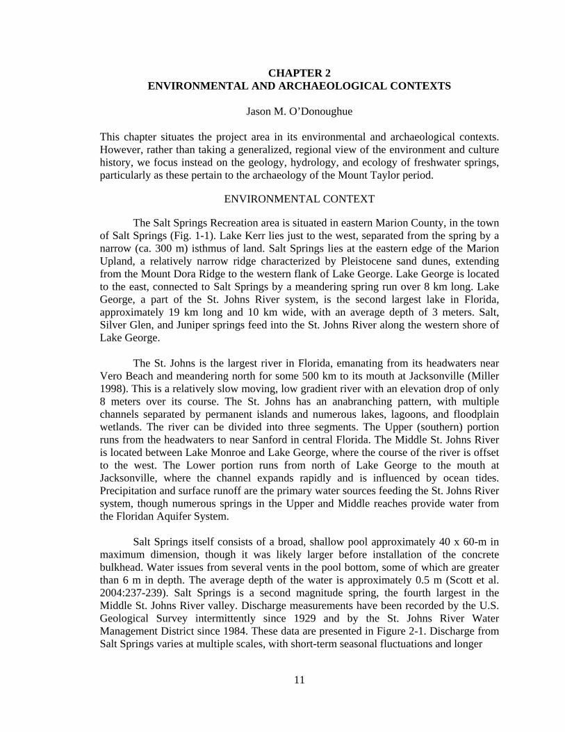
Salt Springs itself consists of a broad, shallow pool approximately 40 x 60-m in maximum dimension, though it was likely larger before installation of the concrete bulkhead. Water issues from several vents in the pool bottom, some of which are greater than 6 m in depth. The average depth of the water is approximately 0.5 m (Scott et al. 2004:237-239). Salt Springs is a second magnitude spring, the fourth largest in the Middle St. Johns River valley. Discharge measurements have been recorded by the U.S. Geological Survey intermittently since 1929 and by the St. Johns River Water Management District since 1984. These data are presented in Figure 2-1. Discharge from Salt Springs varies at multiple scales, with short-term seasonal fluctuations and longer
11

12 Salt Springs (8MR2322)
Figure 2-1. Long term hydrograph showing measured discharge (ft3/s) at Salt Springs. Data from the St. Johns River Water Management District and U.S. Geological Survey. term multi-annual to decadal cycles. However, over the period of record recorded values are generally between 60 and 100 ft3/s, and the mean is relatively stable at 79.8 ft3/s. It appears from the data available that average discharge at Salt Springs has not decreased over the past 80 years, despite increasing draw-downs of the Floridan Aquifer System over the course of the 20th century.
Ultimately, springs are the point of discharge for groundwater residing in Florida’s aquifers. The following sections briefly review the hydrogeology of these aquifers, focusing on those factors that influence spring flow, before turning to a consideration of the hydroecology of springs and its implications for gastropod availability.
Hydrogeology of Florida Springs
Florida boasts one of the highest concentrations of freshwater springs on the planet, with over 700 springs documented and perhaps hundreds more yet to be recorded (Scott et al. 2004). Ultimately, the presence and distribution of springs is controlled by the physiography and geologic framework of the state. Most are concentrated in northwest Florida, where the carbonate rocks of the Floridan Aquifer System (FAS) are not confined by overlying layers of sediment. However, numerous springs are also found

Environmental and Archaeological Contexts 13
in the middle and upper portions of the St. Johns River valley, where confining sediments are generally less than 100 feet thick.
The three major aquifer systems in Florida are the Floridan, the Intermediate, and the Surficial Aquifer Systems (Miller 1986; Reese and Richardson 2008). These aquifers are separated by confining units—typically impermeable layers of clay—which limit or prevent the transmission of water between them. The Surficial Aquifer System (SAS) consists of sands, silts, shell, and some limestone and sandstone. This aquifer is as thick as 400 feet in some portions of the state, but is completely absent in areas of northwest Florida where the Floridan Aquifer System is present at the surface (Miller 1997; Reese and Richardson 2008). The Intermediate Aquifer System (IAS) extends from the base of the SAS to the uppermost confining unit of the FAS. In many places the IAS is comprised predominantly of fine-grained materials with little accessible water. In these areas it is referred to as the Intermediate Confining Unit (ICU) since it retards water transmission between the SAS and FAS. This is the case in the vicinity of Salt Springs, where the Hawthorn Group forms the ICU.
The Floridan Aquifer System consists of a thick sequence of highly permeable carbonate rocks (i.e., limestone and dolomite) that are bounded above and below by less permeable materials. It ranges in thickness from less than 200 feet in the panhandle to over 3,400 feet thick in the central and southern peninsula (Miller 1997). The FAS can be divided vertically into an Upper (UFA) and Lower (LFA) aquifer, which are separated by a middle confining (or semi-confining unit). The UFA is the source of most of the springs in Florida, and is used extensively as a source of potable water (Miller 1997). The porosity and permeability, elevation, stratigraphic position, and degree of confinement of the UFA vary considerably across the state. The Lower Floridan Aquifer is perhaps most poorly understood portion of the Floridan Aquifer system, due to its deep burial and the presence of saline water (Miller 1986).
Karst Geomorphology and Hydrology. Karst terrain, such as that of northern peninsular Florida, develops in regions underlain by carbonate rocks (e.g., limestone and dolomite) and is characterized by numerous surface and subsurface solution features—such as sinkholes, caves, springs, sink-rise streams, conduits, and fractures—that impart a distinctive hydrology (Lane 1986). The primary geomorphic agent in karst terrains is water, particularly through chemical weathering of carbonate rocks. This process is driven by precipitation and the movement of groundwater, which in turn is controlled by gradients in hydrostatic pressure and the permeability of rocks and surrounding sedimentary matrix.
The hydrologic cycle of karst aquifers can be conceptually divided into processes of recharge, flow, and discharge. Precipitation is the main source of recharge to karst aquifers. Precipitation may enter the groundwater system through closed basins (sinkholes, lakes, etc.) that recharge the aquifer directly, or by diffuse percolation through overlying soil or sediment, entering the aquifer through fractures and matrix pores of the underlying rock. Allogenic recharge occurs when the karst aquifer captures water (typically through swallets or sinks) from surface streams that drain non-karst portions of

14 Salt Springs (8MR2322)
the landscape. These streams transport water that would not otherwise enter the karst aquifer (White 2002).
The flow of groundwater in karst aquifers is driven by gradients in pressure and temperature, which are in turn are closely related to recharge and discharge. There are generally considered to be three pathways for water transmission or flow: intergranular (or matrix) porosity, small fractures, and large conduits or caverns (Martin and Dean 2001; White 2002). The difference between these pathways is largely one of scale. Matrix porosity refers to the intergranular pore spaces in un-fractured bedrock. Fractures consist of small mechanical apertures, including such features as joints and bedding planes, which range in size from 50µm to 1 cm (White 2002). Openings or pathways that have been enlarged by dissolution to greater than 1 cm are referred to as conduits.
The distribution and abundance of these pathways in a given portion of an aquifer can have dramatic effects on permeability and flow. In general, intergranular porosity is thought to provide much of the water storage within the aquifer, while conduits provide for the majority of flow (Martin and Dean 2001; White 2002). However, many studies of karst aquifers have focused on areas of dense, relatively impermeable rock. In these karst regions flow between the matrix and conduits is relatively restricted. As a result, springs have been conceptualized as a direct output of subsurface flow through conduits, with little regard given to the potential input from flow through small fractures or matrix pores (Florea and Vacher 2006; Martin and Dean 2001; Moore et al. 2009; Screaton et al. 2004).
Springs are the primary discharge point for groundwater in karst aquifers (Scott,
et al. 2004; White 2002). Springs may be subdivided into several types on the basis of size, source of water, or discharge mechanism (White 2002:90). The springs of Florida are generally of two types: seep (or water table), and karst (or artesian) springs. Seep springs occur when water percolating through surficial soils and sediments encounters an impermeable layer. The water moves laterally along this layer until it reaches a point of lowered elevation and emerges at the surface. Karst or artesian springs appear where groundwater emerges at the surface due to pressure. These comprise the bulk of the 700+ identified springs in Florida (Scott et al. 2004:8-9). Karst springs in Florida occur where the potentiometric surface of the FAS is higher than the ground surface and the confining unit overlying the aquifer is either absent or breached.
Factors Affecting Spring Discharge
The intensity of artesian flow in karst springs is pressure dependent. This pressure fluctuates both temporally and spatially as a result of several factors that vary within and between individual spring recharge basins: precipitation, sea level, topography, soil characteristics, distribution of other karst features, and variations in the physical properties of the aquifer (e.g., permeability; Scott et al. 2004).
Karst can be divided into two main types—eogenetic and telogenetic—on the
basis of age and porosity (Florea and Vacher 2006). Eogenetic karst is young and has not been deeply buried, while telogenetic karst is much older, having undergone processes of

Environmental and Archaeological Contexts 15
deep burial and subsequent erosion and exposure. These types differ in their physical characteristics, geochemistry, and hydrology. Of particular relevance to hydrology and spring flow are differences in matrix permeability, which decrease roughly with age. As a result of its deep burial and compaction, the matrix permeability of telogenetic karst is significantly less than that of eogenetic karst (Florea and Vacher 2006). The karst of Florida is eogenetic; it was formed in the Eocene and Oligocene (25 to 50 Ma) and has not been deeply buried (Florea and Vacher 2006; Miller 1986; Reese and Richardson 2008). While traditional models of karst hydrology minimize the impact of matrix permeability on spring hydrology, it may have a much greater effect on springs issuing from eogenetic karst (Martin and Dean 2001; Moore et al. 2009; Screaton et al. 2004).
Current understanding of spring flow dynamics emphasizes precipitation as the
main driver of discharge variation (Knowles et al. 2002; White 2002). However, many generalized models are derived from areas of telogenetic karst. Spring hydrology in regions of eogenetic karst, such as Florida, may differ significantly (Florea and Vacher 2006, 2007). Springs of eogenetic karst tend to have lower amplitude variation in discharge, longer lag time in response to precipitation events, and greater buffering of high frequency events (i.e., less “flashiness”). Spring flow in eogenetic karst is less affected by individual precipitation events, which may not substantially recharge the FAS. Rather, high-intensity storms and seasonal, annual, and decadal precipitation cycles appear to exert greater influence. These differences are likely the result of higher matrix permeability in eogenetic karst aquifers and the concomitantly greater accessibility of stored water. In addition, deepwater upwelling can contribute significant amounts of water to spring discharge (Moore et al. 2009). Thus, discharge at springs may include both water that entered the aquifer relatively recently and much older waters, recharged as much as 20,000–26,000 years ago (Plummer 1993; Toth and Katz 2006).
At longer temporal scales changing sea-levels and the resulting fluctuations in
hydrostatic pressure in the FAS also influence spring flow. During the late Pleistocene sea-level rose rapidly from a minimum several millennia earlier, and reached 18 m below present by ca. 10,000 years ago (Balsillie and Donoghue 2004; Otvos 2004). Sea level continued to rise over the course of the Holocene, although less rapidly, stabilizing within a few meters of modern levels by approximately 6,000 cal BP. Though the overall trend was toward rising seas, the sequence was punctuated by reversals and (potentially) higher than present stands. Thus, the inhabitants of Florida would have experienced transgressing shorelines and increasing surface water over the course of the late Pleistocene to mid-Holocene.
Clearly, such drastically reduced sea-level implicates lower hydrostatic pressure within the FAS and thus fewer active springs in the state. However, several factors indicate that the correlation between sea-level and spring flow is far from straightforward. Recent efforts to model the response of the UFA hydraulic head indicates that hydrostatic pressure in the aquifer may require up to 1,000 years to stabilize after sea level rise (Hughes et al 2009). This is primarily due to the complexity of the aquifer, including numerous aquicludes and variations in permeability. Thus, even though

16 Salt Springs (8MR2322)
sea levels might have reached near modern levels by approximately 6000 BP, the conditions in the aquifer may not have done so for another millennium.
Molluskan Bioecology and Spring Water Chemistry
The dominant species of mollusk in archaeological shell deposits of the St. Johns River valley is the banded mystery snail (Viviparus georgianus). Remains of the apple snail (Pomacea paludosa) and freshwater bivalves (Unionidae sp.) are commonly present in lower frequencies. Viviparus georgianus are distributed east of the Mississippi river as far north as Massachusetts (Browne 1978). They are typically found in the quieter waters of ponds, lakes, and sloughs along the margins of flowing water bodies (Clench and Turner 1956). Colonies can be located in either mud or sand substrate. Though wide ranging, there are several parameters of Viviparus bioecology that impose constraints on habitat and population density. These are reviewed below in conjunction with data on spring water chemistry to determine the suitability of springs as habitats for Viviparus colonies.
In general, the primary ecological productivity of springs is highly variable, and dependent on such factors as water depth, velocity, and clarity (Odum 1957a). Water quality data were compiled from the St. Johns River Water Management District and the Florida Geological Survey (Scott et al. 2004). Table 2-1 presents these data from the five largest springs in the Middle St. Johns River valley (Silver Glen, Salt, Ponce de Leon, Alexander, and Blue), and from nearby Silver Springs. Data are presented as mean values over the period of record, typically 30 to 50 years through 2005.
Dissolved oxygen content is often used as a measure of primary productivity and
the overall health of a water body. Due to the anoxic conditions in the Floridan Aquifer System, spring waters usually exhibit low dissolved oxygen content. Dissolved oxygen is also important as it is a potentially limiting factor for animals respiring through gills. For example fish populations in spring pools are typically composed of species tolerant of low oxygen conditions (McKinsey and Chapman 1997). Prosobranch snails, such as Viviparus, respire through gills rather than lungs, and thus are restricted to water bodies with adequate dissolved oxygen content (Brown 2001; Brown et al. 1989; Lobinske et al. 1997). It is notable that in the springs surveyed here, dissolved oxygen is below the threshold of 5 mg/L threshold established by several state and national standards for shellfish propagation and harvesting (e.g., Florida Administrative Code Rule 62-302; U.S. Environmental Protection Agency 1988). Florida springs appear to exhibit little seasonal variation in dissolved oxygen content, though concentrations typically increase gradually down spring runs (Odum 1957a, b). This suggests that the water discharging from springs lacks sufficient oxygen to support dense populations of Viviparus. In contrast, dissolved oxygen in the St. Johns River itself does vary seasonally, but typically maintains a relatively high annual mean. For example, the St. Johns River just upstream of Lake George had a mean of 5.5 mg/L from 2002–2008 (U.S. Environmental Protection Agency 2009).

Environmental and Archaeological Contexts 17
Table 2-1. Summary Water Chemistry from Selected Springs in the Middle SJRV. Dissolved O2 (mg/L) Ca (mg/L) Na (mg/L) pH
Alexander Spring 1.13 44.7 130.8 7.73 Blue Spring 0.45 61.2 205.0 7.40 Ponce de Leon Spring 0.46 46.1 69.0 7.53 Salt Springs 2.63 152.0 919.2 7.49 Silver Glen Springs 3.66 71.1 271.5 7.76 Silver Springs 2.38 70.8 6.0 7.41
Despite the constraints posed by anoxic water conditions, certain features of spring water are conducive to Viviparus colonization. In general, mollusk population densities are positively correlated with both pH and high concentrations of calcium (required for the construction and maintenance of shell architecture), and negatively correlated with high sodium concentrations (Brown 2001; Dillon 2000). All of the springs examined here have high concentrations of calcium and (consequently) slightly alkaline conditions. Only Salt Springs has a significant concentration of sodium, which may be a limiting factor there.
In addition to water chemistry there is another factor which may prove limiting to
Viviparus availability. Viviparus is primarily a filter feeder (though it can graze as well), surviving on phytoplankton and other suspended organic matter (Brown et al. 1989; Jokinen et al. 1982). Springs are renowned for their clean, clear waters. Thus we might expect that they have relatively low levels of suspended organic matter, at least at the head. This supposition is borne out by FGS measurements; none of the five springs reviewed here exhibited detectable levels of suspended solids (Scott et al. 2004). This lack of potential food sources, coupled with low dissolved oxygen, likely renders springs marginal habitats (at best) for Viviparus. More likely habitats would seem to be large lakes or wetlands fed by the springs, where organic detritus and dissolved oxygen would be plentiful. Indeed, a study of Bayou Manchac in Louisiana, which contained ample organic detritus and dissolved oxygen, found populations of Viviparus subpurpureus (a closely related species) with densities in excess of 1,700 individuals/m2 (Brown, et al. 1989). The influx of alkaline, calcium enriched spring waters would further enhance the suitability of these habitats for Viviparus reproduction and growth.
This is not to suggest that Viviparus colonies would be unsustainable in springs,
but rather that springs are unlikely to provide a bounty of molluskan resources for human exploitation. Distributional studies support these findings. Data concerning Viviparus georgianus populations are conspicuously absent from most springs in the region. However, Odum (1957b) recorded small populations of Viviparus in Silver Springs. The highest population density recorded there was a mere 11 individuals/m2. In contrast, Lake Jessup, located to the south of the study area in the St. Johns River valley, yielded Viviparus georgianus populations in excess of 1,100 individuals/m2 (Ali et al. 2003).

18 Salt Springs (8MR2322)
ARCHAEOLOGICAL CONTEXT OF FLORIDA SPRINGS
Behold, for instance, a vast circular expanse before you, the waters of which are so extremely clear as to be diaphanous or transparent as the ether; the margin of the basin ornamented with a great variety of fruitful and floriferous trees, shrubs, and plants, the pendant golden Orange dancing on the surface of the pellucid waters, the balmy air vibrating with the melody of the merry birds, tenants of the encircling aromatic grove.
–William Bartram, visiting Salt Springs in August, 1774 (1996:150) Florida’s freshwater springs are valued today for both their cultural and ecological significance, as recreational retreats and natural treasures. The cool, clear waters provide respite from oppressive Florida summers and, on weekends and holidays, are often the locale of substantial gatherings of people. Ecologically, they are seen as unique and “pristine” habitats in need of protection from development and pollution. Further, springs are windows into the Floridan Aquifer System and thus provide important indicators of the health and status of Florida’s drinking water.
Springs were no doubt important places to people of the past as well. Indeed, they figure prominently in archaeological reconstructions of the settlement and subsistence patterns, particularly with regards to the late Pleistocene and early to mid-Holocene denizens of the state. However, where the people of the past are concerned, it is typically only the ecological significance of springs that is deemed relevant. Springs are seen as point resources that were important as sources of fresh water, contributors to productive aquatic ecosystems, and attractors of large game. The potential cultural significance of springs is not generally subject to archaeological consideration. In the following we briefly review the archaeological remains and inferences associated with karst features like springs and sinkholes. Following this is a summary of previous archaeological investigations of Salt Springs. Finally, we review of historic photographs of the spring in order to make inferences regarding the disposition of the area prior to late 20th-century land alteration.
Karst Archaeology in Florida
Florida is today characterized by abundant surface water ensconced in a variety of hydrological features. Water bodies are moving or still, ephemeral or permanent, replenished from above and below. However, the late Pleistocene Paleoindian (ca. 13,000-11,400 cal B.P.) inhabitants of peninsular Florida no doubt encountered a markedly different landscape (Watts et al. 1996; Watts and Hansen 1988). Current reconstructions indicate that sea level was some 80 m lower than present, resulting in significantly lowered ground water, reduced surface water availability, and xeric vegetative communities (Balsillie and Donoghue 2004; Otvos 2004). Relatively few terrestrial sites of this era are known from the interior of Florida, and Holocene sea-level rise has obliterated or obscured the Paleoindian coastal record (Milanich 1994; Thulman 2009). However, underwater investigations off the Gulf Coast of Florida have documented Paleoindian archaeological sites at a significant distance from the modern coast (Dunbar 1988; Faught 2002).
Environmental and Archaeological Contexts 19
Most well-documented inland sites of the Paleoindian period occur in association with karst features. The Page-Ladson site is an 8-m deep stratified deposit in and around a submerged sinkhole in the Aucilla River system (Dunbar et al. 1988; Webb 2006). Excavations there documented a substantial late Pleistocene and early Holocene record. Archaeological materials recovered include well preserved organics, lithic tools, modified bone, and the remains of Pleistocene megafauna. With radiocarbon dates as early as 15,000 cal BP, this is one of the earliest documented Paleoindian sites in the greater southeastern United States.
Two sites in southwest Florida, near Sarasota, have produced similar evidence for Paleoindian occupation in proximity to karst features. Despite their names, neither Warm Mineral Spring nor Little Salt Spring are flowing, artesian springs like those discussed above. Rather, these are cenotes: deep, inundated sinkholes. Paleoindian materials at Little Salt Spring were recovered from subaqueous deposits upwards of 26 m below the current spring surface (Clausen et al. 1979). The documented inventory includes bone, wood, and antler tools, and the remains of an extinct species of giant land tortoise that was burned after being dispatched with a wooden spear. Radiocarbon assays suggest these remains are in excess of 13,000 years old.
Similar materials were recovered from organic sediments 13 m beneath the
surface of Warm Mineral Spring (also a cenote), located just 3 km to the south of Little Salt Spring (Clausen et al. 1975). Here human remains have been recovered from the subaqueous deposits that date to at least 12,000 cal BP. Notably, these were not terrestrial deposits that were subsequently inundated by rising waters, but were materials purposefully deposited in the water (Clausen et al. 1979).
Closer to the St. Johns River valley, Paleoindian artifacts and Pleistocene fauna
have been recovered from Silver Springs (Hoffman 1983; Neill 1958), and are frequently recovered from the Santa Fe and Ichetucknee rivers in north central Florida (Thulman 2009). The headwaters of the Ichetucknee River are formed by the Ichetucknee Springs group, while the Santa Fe River system incorporates numerous karst features, including sinkholes and several first-magnitude springs.
The Oasis Model of Paleoindian settlement was first proposed by Neill (1964) and
later elaborated on by Dunbar (1991). This model was posited to explain the association of Paleoindian artifacts and Pleistocene megafauna with karst springs and sinkholes. Given the arid climatic conditions prevailing in Florida during the Late Pleistocene, it is argued that these features were some of the few locales where fresh water would be readily and reliably available. As such, Paleoindian populations may have been tethered to these places, frequently revisiting them in the course of their subsistence pursuits. These places would also have attracted large game in search of water, thus affording people ample hunting opportunities as well. This model has recently been evaluated by Thulman (2009:271), who concludes that “reliable water sources were the strongest environmental constraint on the occupation patterns [of Paleoindians].”
20 Salt Springs (8MR2322)
It is traditionally argued that this settlement pattern remained relatively unchanged through the Early Holocene, though the constraint posed by fresh water availability would have ameliorated gradually over the ensuing millennia, opening up new areas for exploitation (Milanich 1994). It was not until the mid-Holocene and the inception of the Mount Taylor era that this pattern changed to one of riverine adaptation and more sedentary settlement. Archaeological sites dating to this period are much more numerous in the St. Johns River valley, suggesting a population influx as people abandoned the interior highlands and adopted riverine lifeways. Again, springs are implicated as an important component of this lifestyle.
The Mount Taylor period (ca. 7300–4600 cal B.P.) is traditionally defined by the
presence of large shell deposits lacking in pottery which often encase human interments and objects of nonlocal origin (Goggin 1952:40-43; Milanich 1994:87-93). As noted above, the dominant species of mollusk in these deposits is the banded mystery snail (Viviparus georgianus). Remains of the apple snail (Pomacea paludosa) and freshwater bivalves (Unionidae sp.) are commonly present as well, often in discrete deposits. A suite of artifact types is characteristic of Mount Taylor assemblages, though to some degree these crosscut boundaries with the preceding Early Archaic and subsequent Late Archaic Orange period. Thus it is the presence of shell that delimits the onset of the Mount Taylor period, and the appearance of pottery that signals its terminus. Recent work has further clarified this definition, and led to refinements in chronology and our understanding of Mount Taylor lifeways (e.g., Endonino 2010; Randall 2010; Wheeler et al. 2000). Mount Taylor assemblages are typified by bone, shell, and antler tools, with a relative paucity of lithic materials. Where present, lithic hafted bifaces are largely consistent with the Newnan horizon (Bullen 1975). Later Mount Taylor assemblages (e.g., Endonino 2009, 2010) often contain items that originated far from the St. Johns River valley, such as soapstone and greenstone from the interior Piedmont, Strombus gigas from southern Florida, and stone beads that evidence connections as far away as Mississippi.
As is the case with Paleoindian sites, Mount Taylor shell deposits are often
associated with karst landscape features. Subaqueous deposits of Mount Taylor age have been recorded at Groves’ Orange Midden (8VO2601), an extension of the Old Enterprise complex (McGee and Wheeler 1994; Russo et al. 1992). This site is located on the shore of Lake Monroe, at the mouth of a short (ca. 300 m) run emanating from Green Springs. Here basal sands were overlain by Viviparus shell deposits, a layer of well-developed peat, and an upper Viviparus shell matrix (McGee and Wheeler 1994:340-342). Based on the level of preservation of organic materials, McGee and Wheeler argue that deposition likely occurred in the water.
Radiocarbon assays indicate that deposition began at ca. 6900 cal B.P., and that
the shell matrix deposits prograded out into the water over time. The genesis of the peat layer dividing the upper and lower shell matrix deposits is contentious. Though the excavators interpret the presence of peat as indicating lowered lake levels due to a sea-level low stand, Randall (2010:138) suggests that a stable hydroperiod (i.e., degree and duration of surface/near surface saturation) allowed peat formation. Radiocarbon determinations suggest that the deposit spans nearly the entirety of the Mount Taylor
Environmental and Archaeological Contexts 21
period, with deposition initiated as early as 6900 cal B.P. and persisting nearly continuously through the early-ceramic Orange period.
At Blue Springs (8VO43) a preceramic Mount Taylor era midden was discovered
beneath significant Orange period deposits (Sassaman 2003a). Dating from ca. 5300-4600 cal B.P., the Mount Taylor deposits consist of a basal shell-free, organically enriched sand beneath a modest shell-bearing deposit. Abundant faunal remains, charcoal, and occasional lithic and marine shell tools attest to intensive daily habitation in this locale.
Similar evidence of daily habitation has been documented at Silver Glen Springs-Locus A (Randall 2010:321-327). This is a Mount Taylor era shell ridge, measuring some 200 m long by 75 m wide, fronting the spring run. Occupation of this locale began prior to 6300 cal B.P. The terminus of occupation is unclear as the upper portions of the ridge were mined for shell. While a basal shell-free midden has not been documented here, deposition did involve the “capping” of early shell deposits with a thick layer of brown sand. Developed soil horizons and traces of root casts indicate the presence of multiple surfaces within the ridge deposits, suggesting to Randall that habitation was not continuous, but intermittent and punctuated by periods of extended abandonment. Other Mount Taylor shell deposits occur at Gemini Springs and Ponce de Leon Springs in Volusia County and (possibly) Alexander Springs in Lake County. The Gemini Springs Midden (8VO4378; Estabrook and Weant 1993) is comprised of at least one meter of shell midden which contains basal Mount Taylor deposits. This site, which does not exhibit significant topographic relief, is relatively small, measuring approximately 40 x 45 m, though it may have been truncated by modern dredging of the spring run. Two Newnan bifaces were recovered, along with Orange and St. Johns pottery.
Mount Taylor deposits at Ponce de Leon Springs (8VO30) have been obscured by 19th- and 20th-century land alteration, but apparently included a shell ridge encasing human burials at the spring head (Denson et al. 1995). The Florida Master Site File indicates that archaeological remains of Mount Taylor affinity exist at Alexander Springs as well. These include sites 8LA27, 8LA74, and 8LA1849 (subaqueous). However, the available reports do not indicate the presence of Mount Taylor components (Dorian 1981; Dunbar 2003). Slightly further afield, two sites incorporated into the Middle Archaic pond burial tradition are associated with karst features. The slough adjacent to Little Salt Spring is estimated to contain the remains of over 1000 individuals of Middle Archaic age (Clausen et al. 1979). A large mid-Holocene pond mortuary has also been documented at Republic Groves, where at least 37 individuals were interred in a swamp fed by three springs (Purdy 1991:167-177; Wharton et al. 1981).
Miller (1992, 1998) has suggested that spring-flow is the key factor in explaining the appearance of shell sites on the St. Johns River, as the onset of artesian spring flow

22 Salt Springs (8MR2322)
provided the ecological conditions that underwrote the riverine adaptation characteristic of the Mount Taylor way of life. Miller posits that as sea level reached near modern levels by approximately 5000–6000 years ago hydrostatic pressure within the Floridan aquifer reached a tipping point, resulting in the onset of artesian flow from springs. This new input of fresh water significantly contributed to the formation of the St. Johns River and the development of ecologically productive aquatic biomes. As humans were drawn in greater numbers to the St. Johns River valley they “mapped on” to these habitats, making particular use of the newly abundant shellfish. The vast piles of inedible molluscan remains left on the banks of the St. Johns is taken as evidence of this riverine focus (Milanich 1994).
Miller’s argument is based on the significant contribution of freshwater springs to the flow of the St. Johns River. The input of freshwater springs is estimated to constitute up to one third of the discharge of the river. He reasons that without the input of springs the St. Johns River would not have been flowing under the lowered sea levels of the late Pleistocene and early Holocene. However, this model invokes a simplistic notion of causality between rising sea levels, increased hydrostatic pressure in the Florida Aquifer System, and spring flow. As the discussion above illustrates, the karst hydrology of the FAS, while no doubt affected by sea level, is exceedingly complex. It is unlikely that a threshold was reached beyond which artesian flow occurred. Given that the springs of the region vary in elevation, conduit depth, and connectedness to the FAS, initial artesian flow may have been heterogeneous, time transgressive, and punctuated. Further, fluctuations in precipitation, groundwater mixing, lag in aquifer response, and matrix permeability indicate that generalized models must be tested with local, empirical evidence.
Previous Archaeological Investigations at Salt Springs
The earliest description of archaeological remains in the area is provided by John Bartram, who visited Salt Springs on January 24, 1766. While his description does not indicate the presence of a shell “bluff” or “ridge” either along the run or at the spring itself, the elder Bartram does note aboriginal use of the area: “we landed to search the head springs, and passed through an orange-grove and an old field of the Florida Indians” (1942:44). Nearly ten years later, in August 1774, John’s son William Bartram (1996:146) revisited Salt Springs, describing an “ancient landing place” and again an old Indian field. Jeffries Wyman (1875), purveyor of invaluable early descriptions of St. Johns River shell sites, apparently did not visit Salt Springs, perhaps owing to the length and shallow depth of portions of the run. However, in the early 1890s Clarence B. Moore (1999:84) explored at least a portion of Salt Springs run (Figure 2-1). Moore notes the presence of two shell sites on the north side of the run, the first (8MR2) about 1/2 of a mile from the mouth at Lake George, and the second another ½ mile up the run (8MR1). Site 8MR2 was described as a shell deposit some 200 yards long by 100 yards wide. Shell was piled to a height of 4-5 feet at the bank, attaining a maximum height of ten feet at its peak. Moore excavated a 5.5 x 5-foot square to a depth of 3.5 feet. Pottery was confined to the surface loam, but near the base of the excavation were recovered both a

Environmental and Archaeological Contexts 23
bone “awl” and “a lance-head of graceful pattern, perfect in every respect” (Moore 1999:85). It is unclear if Moore undertook any further excavations at this site, he states simply that “other excavations yielded nothing of marked interest” (Moore 1999:85). Moore described 8MR1 as a shell deposit of irregular thickness. The size of the site is not given. Shell was only visible in the eroding bank; no surficial expression was apparent. This suggested to Moore that shell was used to infill an irregular ground surface in this locale. Moore apparently did not conduct any excavations here, nor did he continue further up the run to the spring pool. In the early 1930s the Civilian Conservation Corps (CCC) investigated several sites in the vicinity of Salt Springs (Abshire et al. 1935). The CCC conducted excavations at numerous sites throughout the Ocala National Forest. A map displaying the locations of these investigations shows six “shell mounds” adjacent to Salt Springs run, distributed from the spring head to Lake George (Figure 2-2). All but one are located on the north side of the run. Though six sites appear on the map, only two are described in the report.
The larger of the two is identified as a “klokkenmodding” on the north side of the run, approximately five miles from the headwaters of the spring. The description provided suggests that this is likely the same site described and excavated by Moore (i.e., 8MR2). The site consisted of a shell deposit some 430 feet long, ranging in width from 70–220 feet. Shell deposits were at least seven feet thick. It is unclear if CCC members conducted any excavations here. They did, however, make collections from the site as shell was being removed for road construction in the area. Recovered artifacts include lithic, bone, and antler points; hammerstones; bone pins; shell tools; a marine shell vessel; and a cache of six shell discs (beads?) in the sands beneath the shell.
Three possible bannerstones were recovered: one complete, one fragment, and one perform. These are described as “gabled” stones with drilled, longitudinal holes. Pottery was exceedingly rare, but included plain, incised, and check-stamped sherds. In addition, one human burial was recorded, apparently encased in concreted shell. The description of the site and collected materials strongly suggest that this site was a Mount Taylor shell ridge.
The second site described by the CCC members is a small “shell area” near the
mouth of Salt Springs run at Lake George. It is unclear if this site is recorded in the Florida Master Site Files. This deposit exhibited little surface relief. Pottery was more abundant at this locale and was primarily check-stamped. Faunal remains and lithic debitage were also recovered, but no formal tools.
Prior to National Park Service and University of Florida test excavations in 2009,
the most extensive professional archaeological work at the Salt Springs Recreation Area was a survey conducted by South Arc in 1993 (Dickinson and Wayne 1994). As a result of this survey site number 8MR2322 was assigned (Figure 2-1). This site is bounded by SR 19 on the west, low-lying wetlands to the east, and extends almost to the Forest

24 Salt Springs (8MR2322)
Figure 2-2. Aerial photograph showing the location of Salt Springs and associated archaeological sites. Aerial imagery courtesy of the Marion County Board of County Commissioners. Service property lines on the north and south. Site 8MR2322 encompasses and supersedes three previously recorded sites in the Salt Springs Recreation Area: 8MR4, 8MR770, and 8MR810. A fourth, the historic W.C. Townsend home (8MR473) is located in an outparcel adjacent to the recreation area. Site 8MR4 was identified by John Goggin in 1951 on the south side of the spring. Archaeological remains extended into the spring pool and included Orange, St. Johns, and unidentified pottery, as well as lithic materials. Survey in advance of a telephone transmission line in 1992 identified 8MR770 in the

Environmental and Archaeological Contexts 25
right-of-way of SR 19. This site, located in uplands just to the west of the spring, contained Middle Archaic through St. Johns era components. The site number 8MR810 was assigned to submerged archaeological materials within the spring itself (Dickinson and Wayne 1994).
The 1993 South Arc survey covered 140 acres in the uplands surrounding the spring pool. A total of 1523 shovel tests were excavated on a 20-m grid laid out over the project area. The survey recovered a nearly continuous distribution of archaeological remains across the project area, with materials representing virtually the entire sweep of prehistory. However, Early and Middle Archaic materials were relatively scarce; the investigators suggest that occupation began in earnest during the ceramic Archaic Orange period, and reached their apogee during St. Johns I times. A 160 x 120-m area to the north and west of the spring pool was selected for more detailed testing to assess the integrity of the archaeological deposits and the degree of modern disturbance. The 2009 LSA excavations were located immediately adjacent to this area. Prior investigations by Forest Service personnel, coupled with the testimony of local informants suggested that much of this portion of the recreation area had been filled, perhaps with midden material mined from 8MR2 (see above). Shovel tests were excavated on a 10-m grid, and three 1 x 1-m test units were emplaced adjacent to the concrete bulkhead. The results confirmed that the area had been subject to historic and modern disturbance, but also revealed intact archaeological deposits beneath ca. 30–100 cm of redeposited fill. Further, this testing indicated the presence of shell midden deposits north of the spring that extended into the spring pool. These intact deposits contained high densities of prehistoric artifacts, and the highest concentration of thermally altered lithic materials in the project area, suggesting the presence of a substantial preceramic Archaic component.
The ubiquity of archaeological materials in the vicinity of Salt Springs suggested to the investigators there was a “pattern of repeated occupation of the uplands adjacent to the spring throughout prehistoric periods” (Dickinson and Wayne 1994:xvi). Further, though the Recreation Area had been subject to modern and historic disturbance, they concluded that the majority of the archaeological deposits were intact. As a result, it was recommended that the previously recorded sites be dissolved into one large multi-component site, which is considered to be significant and eligible for the National Register of Historic Places.
Historic Photos
Unfortunately, no mention is made by early observers of archaeological shell
deposits at the spring pool, and, by the time professionals got involved, much of the land adjacent to the pool was altered. However, historic photos of the Salt Springs area provide some insight on the condition and configuration of the pool and its shoreline before bulkheads and other infrastructure were installed. Such photos are stored in the digital archives of the Florida Memory Project (www.floridamemory.com). Administered by the Division of Library and Information Services, Florida Department of State, these

26 Salt Springs (8MR2322)
archives contain 19 photographs of the spring and vicinity dating from 1930 to the 1970s. More than a third of the photos were taken by a photographer from Metro-Goldwyn-Mayer (MGM) Studios in Hollywood. In 1938 MGM purchased the rights to Marjorie Keenan Rawlings Pulitzer-Prize-winning novel The Yearling, which was published that same year. Although MGM suspended production on the film until after World War II, a team of art directors traveled to north-central Florida in 1939-40 scouting locations with Rawlings. Salt Springs was one of the locations of which MGM photographs are archived by the state.
The oldest photo in the archives was taken by Herman Gunter a decade before the
MGM crew arrived (Figure 2-3). This view of the spring pool faces west, showing a relatively steep bank peppered with mature hardwood trees. To the right (north) side of this photo it would appear that ground cover up the slope was lighter in color than the ground cover of the rest of the slopes shown. Whether this is shell or simply light-colored sands cannot be determine from this photo.
A pair of photographs dating to 1935 is not archived by the Florida Memory
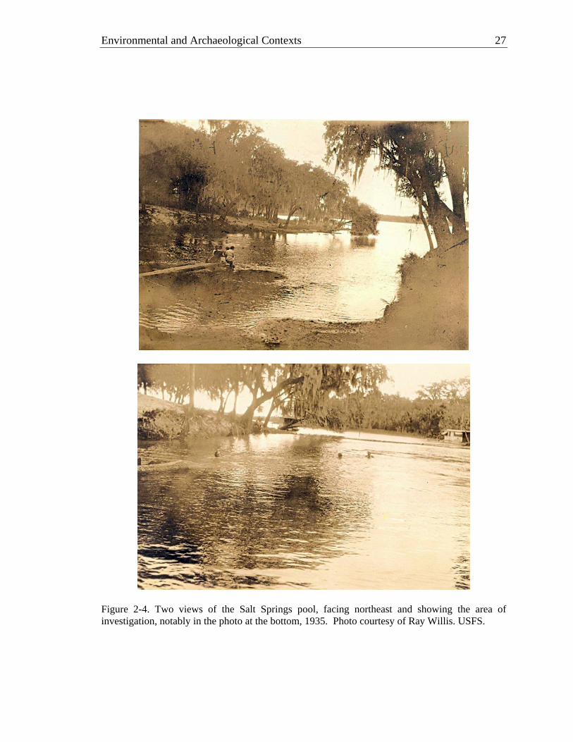
Project but was provided by USFS Archaeologist Ray Willis (Figure 2-4). Facing northeast at two different scales and slightly different angles, these shots include the area of archaeological investigation, most clearly in the bottom photo. The swimmers in this shot are west of the area tested in 2009 by LSA. It would appear that the bank in this area was covered in shell.
Figure 2-3. View of Salt Springs pool, facing west, 1930. Photo by Herman Gunter, courtesy of Florida Memory Project.
Environmental and Archaeological Contexts 27
Figure 2-4. Two views of the Salt Springs pool, facing northeast and showing the area of investigation, notably in the photo at the bottom, 1935. Photo courtesy of Ray Willis. USFS.

28 Salt Springs (8MR2322)
Five years later the MGM photographer would capture a similar view of the northeast area of the spring pool, where the LSA trench was emplaced (Figure 2-5). Here again we can see a relatively smooth shoreline contour, with a surface that appears to be covered in shell. A shallow escarpment just above the water level attests to shoreline erosion, most likely a function of fluctuating water. The three large hardwood trees along this shore remind us of a potential source of mass wasting when they topple.
A second view of the spring pool facing northwest affirms the accentuated
hillslope to the right (north), as well as an apparent drop in slope moving west, toward the boat pictured in the pool (Figure 2-6). Combining the views of this and the previous photo, it would appear that the northeast bank of the spring pool housed a relatively large, mounded deposit with shell at the surface. Although the relief evident in these photos does not come close to the shoreline relief observed at intact Mount Taylor shell mounds in the region (e.g., 8VO41, 8VO214; Sassaman 2003a; Randall and Sassaman 2005), it seems likely that this rise in terrain is largely anthropogenic, and not simply a natural rise with a veneer of midden across the top. This is roughly the same area that produced the
Figure 2-5. View of the Salt Springs pool, facing northeast, 1940. Photo by Metro-Goldwyn-Mayer, courtesy of Florida Memory Project.

Environmental and Archaeological Contexts 29
Figure 2-6. View of the Salt Springs pool, facing northwest and showing the accentuated sideslope of the bank to the right (north), 1940. Photo by Metro-Goldwyn-Mayer, courtesy of Florida Memory Project. greatest number of Mount Taylor artifacts in shovel testing conducted by SouthArc (Dickinson and Wayne 1994:157-194)).
One additional MGM photo of note is a shot of unknown location that may be the
north slope of the spring pool, at the locus of accentuated, presumably anthropogenic relief (Figure 2-7). Although the specific location of this terrain is unknown, it would seem to contain shell deposition. What appears to be shell is exposed along the surface in various places along a highly eroded hillslope. Mature, hardwood trees have kept this slope from being more severely dissected.

30 Salt Springs (8MR2322)
Finally, two photos taken by Charles Foster in 1941 echo the imagery seen in earlier photos and predate the construction of the wooden bulkhead seen in the Figure 1-2. The view to the east seen in Figure 2-8 affirms that the location of archaeological investigations was just to the east of the presumed anthropogenic rise along the north shore. The view to the northwest (Figure 2-9) provides a good perspective on the natural contours of the slopes surrounding most of the spring pool, plus shows again the possible shell scatter at the surface to the right (north).
To summarize, historic photos of the Salt Springs pool and surrounding terrain
support the inference that an anthropogenic deposit with shell at the surface was situated on the north bank of the pool, just to the west of the area of archaeological investigations. Although this may not qualify as a shell mound in the sense of Hontoon Dead Creek (8VO214) and Live Oak (8VO41) mounds, it appears to consist of accumulated shell in a relatively discrete area. The closet extant analog might be seen in the shell deposit known as Blue Spring Oxbow Mound (8VO44; Randall and Sassaman 2005:178-180), just to the south of Blue Spring, which is estimated to be 45 m in length, 8 m wide, and 2.5–3-m high.
Figure 2-7. View of what may be the north slope of the spring pool, showing probable anthropogenic deposit, 1940. Photo by Metro-Goldwyn-Mayer, 1940 Courtesy of Florida Memory Project.
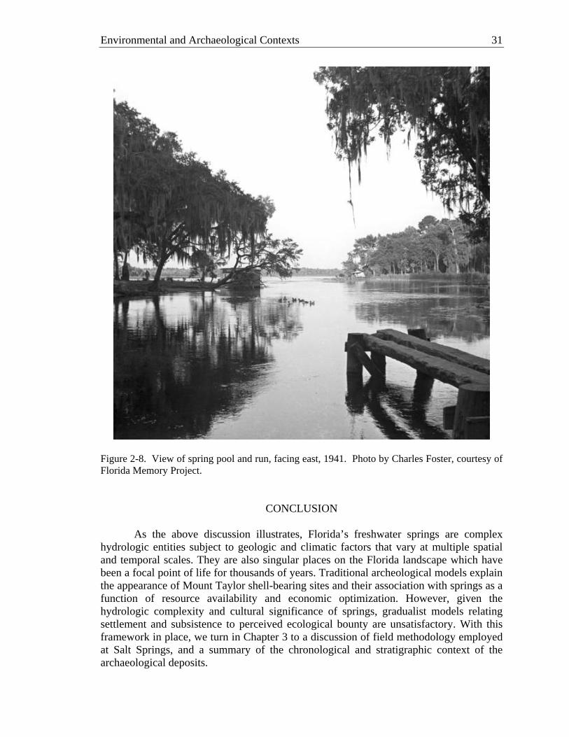
Environmental and Archaeological Contexts 31
Figure 2-8. View of spring pool and run, facing east, 1941. Photo by Charles Foster, courtesy of Florida Memory Project.
CONCLUSION
As the above discussion illustrates, Florida’s freshwater springs are complex hydrologic entities subject to geologic and climatic factors that vary at multiple spatial and temporal scales. They are also singular places on the Florida landscape which have been a focal point of life for thousands of years. Traditional archeological models explain the appearance of Mount Taylor shell-bearing sites and their association with springs as a function of resource availability and economic optimization. However, given the hydrologic complexity and cultural significance of springs, gradualist models relating settlement and subsistence to perceived ecological bounty are unsatisfactory. With this framework in place, we turn in Chapter 3 to a discussion of field methodology employed at Salt Springs, and a summary of the chronological and stratigraphic context of the archaeological deposits.

32 Salt Springs (8MR2322)
Figure 2-9. View of spring pool, facing northwest, 1941. Photo by Charles Foster, courtesy of Florida Memory Project.

CHAPTER 3 METHODS AND RESULTS OF FIELD INVESTIGATION
Jason M. O’Donoughue
Numerous archaeological sites located within the Salt Springs Recreation Area are recorded collectively in the Florida Master Site File (FMSF) as 8MR2322. Similar to other freshwater springs (e.g., Alexander Springs [Dunbar 2003]), Salt Springs includes deposits that extend from terrestrial to subaqueous contexts. As discussed in Chapter 1, the excavation of a trench with heavy machinery, and installation of a new bulkhead around the spring pool severed the subaqueous portion of one of these deposits from its terrestrial component. While the terrestrial shoreline deposits are protected by the concrete retaining wall and fill, the subaqueous channel deposits continue to be susceptible to erosion from human foot traffic and fluvial dynamics. A testing strategy was devised by the Laboratory of Southeastern Archaeology (LSA) to document the vulnerable archaeological materials, investigate the depositional history of the near-shore midden, and collect samples amenable to fine-grained paleoenvironmental analyses. A variety of techniques were employed, including topographic mapping, stratigraphic excavation, bulk sampling, and percussion coring. This chapter summarizes the results of this multifaceted testing strategy.
SITE DISPOSITION
Excavating saturated archaeological deposits provides logistical challenges rarely encountered at terrestrial sites. Testing of this orphaned midden remnant was facilitated by the coffer dam and pumping system installed by the Forest Service during construction. The coffer dam held the waters of the spring pool away from the shore while the pumps removed seeping water, effectively drawing down the surface of the water some 2 m in a localized area.
The net effect of draining the area behind the coffer dam was the exposure of a
saturated midden component, truncated on the landward side. Archaeological materials, including shellfish, vertebrate fauna, and even botanical matter were observed in the escarpment exposed by the excavation of the construction trench. Stratification of the deposits was evident, minimally comprising a ca. 50-cm thick shell midden, composed primarily of Viviparus georgianus, overlying organically-enriched midden sands. Covering much of the surface was a layer of clean sand, apparently emplaced by Forest Service personnel to mitigate erosion of the midden.
TOPOGRAPHIC MAPPING
Topographic mapping of the midden and surrounding terrain was undertaken both to provide spatial control for our investigations and to facilitate Forest Service management of the subaqueous portion of the midden once it was re-flooded. An east-west baseline was established on the elevated terrestrial surface to the north of the retaining wall, oriented roughly parallel to the spring run at 65 degrees west of magnetic north. The western endpoint of this baseline, Datum A, was assigned grid coordinates
33

34 Salt Springs (8MR2322)
N100.00 E100.00 and an arbitrary surface elevation of 10.060 m. Datum B was established 30 m to the east, with coordinates N100.00 E130.00 at an elevation of 9.097 m. Three-foot-long sections of galvanized steel conduit were emplaced in the ground to mark the locations of the datum points. This floating grid was georeferenced to UTM coordinates using a Magellan MobileMapper™ CX differential GPS.
All topographic mapping was undertaken with a Nikon Total Station DTM-310.
In sum, over 200 points were collected. Recorded features included the locations of the excavation trench, cores, and retaining wall. In addition to mapping the current surface of the deposit, several points were recorded to map the top of the midden beneath overburden sands. This was accomplished by excavating small holes into the emplaced sands until midden deposits were reached.
The surficial expression of the midden is a lobe-shaped area elevated
approximately 1.5 meters over the surrounding channel bed (Figure 3-1). Although we did not document the lateral subsurface extent of archaeological deposits, the elevated area measures roughly 30 x 20 m, with its long axis oriented parallel to the spring run. The northern aspect of the midden was truncated by the construction trench, and thus the steep escarpment visible there is not a natural feature. The layer of modern, emplaced sand overlying the midden deposits varies from as much as 30-cm thick at the apex of the deposit to just a few centimeters along the southern apron.
TRENCH EXCAVATION
Earlier work by the National Park Service (NPS) effectively documented the nature of the landward deposits, their age, and the potential for well-preserved organic materials. As noted above, two macrostrata were identified prior to excavations based on the results of NPS excavations and observations of the eroding north escarpment: an upper shell-bearing midden and a lower deposit of organically enriched, shell-free midden sands. NPS excavations further indicated that the deposit dated primarily to the preceramic Archaic Mt. Taylor era (7300–4600 cal BP).
Because the NPS excavation block was oriented parallel to the spring channel
(Figure 3-1), it lacked the transverse stratigraphic perspective needed to address the histories of anthropogenic and fluvial deposition and relate them to fluctuating water levels and shoreline transgression. The excavation strategy for LSA investigations was designed to reveal a viewshed into the structure of deposits perpendicular to the shore. To this end, a 1 x 8-m trench was laid out near the center of the subaqeous midden deposit, where it appeared to be the thickest. The trench was oriented roughly perpendicular to the shoreline, and was subdivided into eight 1 x 1-m test units, numbered 1–8 sequentially from north to south. Test units were excavated in a leap-frog fashion to delineate the stratigraphy of the deposit and facilitate the excavation of intervening TUs by stratigraphic units. To this end, excavation commenced simultaneously in TUs 8, 6, and 4, with excavation of TU2 following shortly thereafter. As the goal of these initial soundings was the exposure of profiles to guide subsequent excavation, each of these units was excavated in arbitrary 10-cm thick levels, after

Methods and Results of Field Investigation 35
Fi
gure
3-1
. Top
ogra
phic
map
of s
ubaq
ueou
s po
rtion
of S
alt S
prin
gs (8
MR
2322
), sh
owin
g lo
catio
ns o
f Uni
vers
ity o
f Fl
orid
a ex
cava
tion
trenc
h an
d co
res,
and
Nat
iona
l Par
k Se
rvic
e ex
cava
tion
bloc
k.

36 Salt Springs (8MR2322)
removal of modern overburden (sand). However, in some cases excavation levels were terminated early where obvious changes in the nature of the deposits were encountered (e.g., where shell abundance or matrix composition changed abruptly). This was done to avoid combining materials from discrete stratigraphic units.
To further aid stratigraphic delineation, the existing northern escarpment of the
midden was cut vertically and cleaned to expose the profile. Fill from the north escarpment was not removed in arbitrary levels, but was segregated based on the observed macrostratigraphic units (i.e., shell-bearing and shell-free deposits).
Fill from the initial test units (those excavated in arbitrary levels: TUs 2, 4, 6, and 8) and the northern escarpment was water-screened through ¼-inch hardware cloth. All artifacts were collected and bagged by provenience, and kept saturated when abundant botanical remains were recovered.
The profiles of the initial test units and the north escarpment were used to guide
excavations in TUs 1, 3, 5, and 7. These test units were excavated by 10-cm-thick levels within stratigraphic units. Fill from these test units was passed through 1/8-inch hardware cloth. All materials that did not pass through the screen were collected and bagged by provenience. In addition, from each excavated level a ca. 15 liter bulk sample was collected and kept saturated for fine-screen processing and secondary analysis off-site. This sampling strategy was employed to maximize the recovery of organic materials.
Regardless of excavation strategy, the initial step in excavating each test unit was the removal of ca. 5–20 cm of modern, emplaced sand (overburden). Once the surface of the underlying midden deposit was exposed, excavation proceeded using trowels, with all matrix collected in 5-gallon buckets for transport to the water-screening operation. Excavation levels were delineated alphabetically, beginning at the top with level “A.” This first layer was used to level the surface of the test unit, and thus was not uniformly 10-cm thick in most cases.
Difficulties with seeping groundwater were expected due to the saturated,
subaqueous nature of the deposits. However, the Forest Service coffer dam and pump system kept the test units relatively free of standing water until the drawn down surface of the local water table was intercepted. Excavation of each test unit was halted when this surface was reached and standing water began to accumulate. As such the base of the trench was not defined by the presence of culturally “sterile” deposits but by our inability to excavate below the water surface.
Three percussion cores were emplaced adjacent to the trench to investigate sub-
trench deposits. Two of the cores were successfully recovered (Core 1 & 2) while the third was compromised during extraction (Core 3). The sequence of deposits observed in the cores recapitulates the recorded stratigraphy in the trench, but also offered insight into deposits that could not be reached during trench excavations.

Methods and Results of Field Investigation 37
Artifact Recovery
As expected from previous work at this locale, and from previous excavations in saturated contexts, trench excavations encountered abundant organic and inorganic material remains. A water screening operation was established upslope near the Forest Service bathhouses. This location was chosen to allow access to water spigots while minimizing the possibility of sediment washing back into the spring. However, the distance between trench excavations and the water-screening operation necessitated transport of 5-gallon buckets of fill in a pickup truck. To ensure proper collection and recording all buckets were flagged with the appropriate provenience information (test unit number, excavation level, etc.) and a completed provenience tag was placed in the bottom of the bucket.
The bulk samples collected from TUs 1, 3, 5, and 7 were brought back to the LSA
for processing. These samples were kept saturated to ensure that no organic materials were degraded due to desiccation. The total volume of each sample was recorded prior to water-screening through 0.5 mm mesh. The samples were then fractionated using 4 mm, 2 mm, and 0.5 mm U.S.A. Standard Test Sieves (numbers 5, 10, and 35, respectively). The largest of these fractions (>4 mm) was then sorted, with all botanical materials kept saturated in glass jars and all other materials allowed to dry. The smaller fractions were left saturated and unsorted, pending specialist analyses (see chapters 5 and 6).
Table 3-1 presents a summary of the materials recovered through ¼-inch water-
screening of TUs 2, 4, 6, and 8 and the north escarpment. Table 3-2 summarizes the materials from the >4 mm fraction of the bulk samples recovered from TUs 1, 3, 5, and 7. Sorting and cataloging of the 1/8-inch water-screen samples are in progress, and thus the results are not available for comparison here.
Discounting the abundant shell recovered, unmodified vertebrate fauna was by far
the most commonly encountered class of material remains in the trench, totaling over 12 kg in the samples analyzed thus far. As expected, few pottery sherds were recovered, and those that were came from the uppermost excavation levels or the disturbed northern escarpment. Concreted shell and matrix was also concentrated in the upper excavation levels, and particularly in the northern half of the trench. This likely attests to periodic aerial exposure and desiccation of portions of the midden under fluctuating water levels.
The remaining material culture inventory is standard fare for Mount Taylor era
sites. Marine shell, sharks teeth, lithic debitage and tools, and modified bone were found throughout the trench, but were typically more frequent in the southern half (i.e., TUs 5–8). Bivalve shell was similarly more abundant in the southern half. Chapter 4 discusses the inventory of material culture in more detail.
Trench Stratigraphy
Macrostratigraphic units were delineated in the field using roman numerals. As noted above, two macrostrata were observed prior to trench excavation. Stratum I

38 Salt Springs (8MR2322)
Table 3-1. Inventory of Artifacts and Other Materials1 Recovered from ¼-inch Water-Screen at 8MR2322, by Test Unit (all weights in grams) North TU2 TU4 TU6 TU8 Total Escarpment
Pottery Sherd n 1 1 2 wt. 2.5 0.6 3.1 Lithic Tool n 1 7 6 14 wt. 4.4 162.3 53.8 220.5 Debitage n 4 18 17 61 69 169 wt. 2.4 11.4 7.6 131.0 91.3 243.7 Shark Tooth n 1 2 3 wt. 0.7 1.8 2.5 Marine Shell Unmodified n 2 2 4 wt. 5.6 4.2 9.8 Modified n 1 2 3 wt. 789.8 13.9 803.7 Antler Unmodified n 1 3 4 wt. 11.9 61.1 73.0 Modified n 5 5 2 2 14 wt. 14.2 84.3 9.2 16.8 124.5 Modified Bone n 2 9 18 11 40 wt. 1.6 16.7 32.3 26.2 76.8 Vertebrate Fauna n 2904 5294 4282 5987 3114 21,581 wt. 915.5 1655.4 1807.5 3021.3 2176.7 9576.4 Paleofeces n 69 41 256 226 592 wt. 99.2 24.9 131.6 72.9 328.6 Historic n 1 2 1 8 12 wt. 2.4 4.4 0.2 3.1 10.1
1excluding botanical materials, 2.3 g of burned clay, 330.8 g of concretions, 4 land snails (4.3 g), 4 pieces sandstone (16.5 g), and 37 pieces of miscellaneous stone (86.3 g).
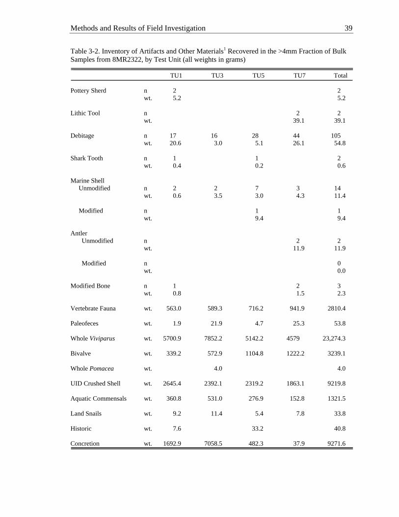
Methods and Results of Field Investigation 39
Table 3-2. Inventory of Artifacts and Other Materials1 Recovered in the >4mm Fraction of Bulk Samples from 8MR2322, by Test Unit (all weights in grams) TU1 TU3 TU5 TU7 Total
Pottery Sherd n 2 2 wt. 5.2 5.2 Lithic Tool n 2 2 wt. 39.1 39.1 Debitage n 17 16 28 44 105 wt. 20.6 3.0 5.1 26.1 54.8 Shark Tooth n 1 1 2 wt. 0.4 0.2 0.6 Marine Shell Unmodified n 2 2 7 3 14 wt. 0.6 3.5 3.0 4.3 11.4 Modified n 1 1 wt. 9.4 9.4 Antler Unmodified n 2 2 wt. 11.9 11.9 Modified n 0 wt. 0.0
Modified Bone n 1 2 3 wt. 0.8 1.5 2.3 Vertebrate Fauna wt. 563.0 589.3 716.2 941.9 2810.4 Paleofeces wt. 1.9 21.9 4.7 25.3 53.8 Whole Viviparus wt. 5700.9 7852.2 5142.2 4579 23,274.3 Bivalve wt. 339.2 572.9 1104.8 1222.2 3239.1 Whole Pomacea wt. 4.0 4.0 UID Crushed Shell wt. 2645.4 2392.1 2319.2 1863.1 9219.8 Aquatic Commensals wt. 360.8 531.0 276.9 152.8 1321.5 Land Snails wt. 9.2 11.4 5.4 7.8 33.8 Historic wt. 7.6 33.2 40.8 Concretion wt. 1692.9 7058.5 482.3 37.9 9271.6
40 Salt Springs (8MR2322)
consists of shell-bearing deposits in the upper portion of the midden, while Stratum II encompasses the underlying shell-free midden sands. While Stratum II was maintained as a single stratigraphic unit during testing, our initial exposures led to the subdivision of Stratum I into several constituent strata. These subdivisions, denoted with subsidiary alphanumeric designations (i.e., IA-1, IA-2, IB), were based primarily on changes in the abundance and species composition of the shell component, and on changes in the nonshell matrix. In total, five strata were recognized in the trench and an additional four strata were observed in percussion cores. The trench profiles were both hand-drawn and recorded with high resolution, close-interval photographs. The west profile of the trench, including both the digitized drawing and a composite photograph, is presented in Figure 3-2. Figure 3-3 provides photographs of the percussion cores and relates them the trench stratigraphy, while Table 3-3 provides descriptions of the stratigraphic units. Sub-Midden Alluvium. Strata III–VI were observed only in percussion cores. These appear to represent water-lain deposits that are largely lacking anthropogenic sediment inputs. Variations in the fluvial regime at Salt Springs are registered by changes in these deposits, which are broadly composed of layers of clean, light grey sand alternating with more heterogeneous layers. Stratum VI is a relatively thin (ca. 6–8 cm), homogenous deposit of light grey sand with only moderate amounts of organic matter. Above this is Stratum V, a banded/laminated deposit of brown and grey loamy sands, which is capped by another thin layer of light grey sand (Stratum IV). The uppermost of these deposits is Stratum III, a heterogeneous layer of brown and grey sands that lacks the banding evident in Stratum V. Organic materials (i.e., faunal and botanical remains) are well preserved throughout these deposits, though they are markedly more abundant in Strata III and V. Shell-Free Midden. Emplaced atop the fluvial deposits are organically enriched sands largely devoid of shell, dubbed Stratum II. This unit consists of contorted layers of stacked and interdigitated sand lenses, varying in color from grey to black. These sands are often stained with colloidal organic matter and contained moderate amounts of vertebrate faunal remains, lithic flakes, and both charred and uncharred macrobotanicals (e.g., wood, hickory nut, seeds, and charcoal). Thus, what separates Stratum II from the underlying fluvial deposits is the inclusion of anthropogenic materials. The top of Stratum II is undulating and decreases in elevation away from the shore. However, the trench excavation did not reach the base of this deposit, so it is unknown if it thins with distance from the shore as well.
Shell-Midden Deposits. Lying unconformably over the midden sands of Stratum II is Stratum IB. This is a relatively thin (ca. 5–15 cm) layer of grey sand and shell that was observed in TUs 1–6 and in the percussion cores. Overlying Stratum IB is Stratum IA, a shell midden deposit upwards of 50-cm thick that contained very-dark brown to grey organically stained sands with abundant Viviparus shell and localized lenses of bivalve shell. Pomacea shell was relatively rare, but several concentrations were encountered. Stratum IA was divided into Stratum IA-1 and IA-2 during profile mapping on the basis of slight color and textural variations in the matrix. Stratum IA-2 is slightly darker and finer than Stratum IA-1. The contact between the two is diffuse in places,

41
Figure 3-2. Grid West profile of the trench at 8MR2322. A) Composite photograph. B) Profile drawing. C) Schematic of excavation levels in each test unit


Methods and Results of Field Investigation 43
Figure 3-3. Strata observed in percussion cores 1 (left) & 2 (right), in relation to trench stratigraphy.
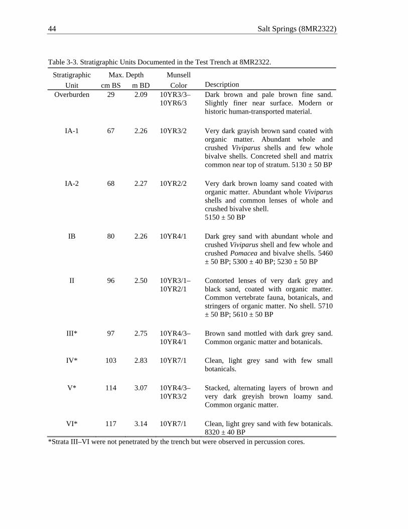
44 Salt Springs (8MR2322)
Table 3-3. Stratigraphic Units Documented in the Test Trench at 8MR2322.
Stratigraphic Max. Depth Munsell Unit cm BS m BD Color Description
Overburden 29 2.09 10YR3/3– 10YR6/3
Dark brown and pale brown fine sand. Slightly finer near surface. Modern or historic human-transported material.
IA-1 67 2.26 10YR3/2 Very dark grayish brown sand coated with
organic matter. Abundant whole and crushed Viviparus shells and few whole bivalve shells. Concreted shell and matrix common near top of stratum. 5130 ± 50 BP
IA-2 68 2.27 10YR2/2 Very dark brown loamy sand coated with organic matter. Abundant whole Viviparus shells and common lenses of whole and crushed bivalve shell. 5150 ± 50 BP
IB 80 2.26 10YR4/1 Dark grey sand with abundant whole and
crushed Viviparus shell and few whole and crushed Pomacea and bivalve shells. 5460 ± 50 BP; 5300 ± 40 BP; 5230 ± 50 BP
II 96 2.50 10YR3/1–
10YR2/1 Contorted lenses of very dark grey and black sand, coated with organic matter. Common vertebrate fauna, botanicals, and stringers of organic matter. No shell. 5710 ± 50 BP; 5610 ± 50 BP
III* 97 2.75 10YR4/3–
10YR4/1 Brown sand mottled with dark grey sand. Common organic matter and botanicals.
IV* 103 2.83 10YR7/1 Clean, light grey sand with few small botanicals.
V* 114 3.07 10YR4/3–
10YR3/2 Stacked, alternating layers of brown and very dark greyish brown loamy sand. Common organic matter.
VI* 117 3.14 10YR7/1 Clean, light grey sand with few botanicals.
8320 ± 40 BP *Strata III–VI were not penetrated by the trench but were observed in percussion cores.

Methods and Results of Field Investigation 45
but dips noticeably away from the shore, suggesting that Stratum IA-2 was deposited partially overtop of and to the south of Stratum IA-1.
CHRONOLOGY AND DEPOSITIONAL HISTORY
The stratigraphic units described above provided the framework for excavation and analysis. In addition, their disposition and structure were used to infer paleohydrological histories and depositional practices. The abundance of well-preserved organic materials suggests that the majority of the deposits encountered in the trench have been saturated since initial deposition. However, the presence of concreted shell, coupled with a lower frequency of organic remains in the uppermost levels of TUs 1–6 indicate that some portions of the midden were subject to periodic aerial exposure and drying.
The morphology of Stratum II further supports the inference that anthropogenic materials were deposited subaqueously. As detailed above, Stratum II was composed of stacked layers of grey and black sands. The top of Stratum II and the constituent sand lenses have a contorted or rippled appearance, consistent with their mobilization and deposition in an active open-water environment.
Each of the strata described above dips and (in most cases) thins with distance
away from the shore. While the position of Stratum IA-2 relative to Stratum IA-1 is consistent with the progradation of the deposit towards the spring run over time, it is unclear from a purely stratigraphic standpoint whether individual strata were deposited en masse, accreted vertically, or in a progradational fashion. To this end, a series of eight AMS radiocarbon assays were obtained to investigate the chronology and depositional history of the midden (Table 3-3; Appendix B).
Given the excellent preservation of organic remains in the midden, potentially
datable samples were plentiful. The selection of samples for dating was strategic: the first six samples focused on obtaining two assays from solid contexts in each of the major stratigraphic units defined in the trench (i.e., Strata IA, IB, and II). To investigate the sequence of deposition within each strata one sample was taken from the shoreward (northern) side of the strata and one from the spring-ward side. This strategy allowed us to investigate the chronology of deposition both vertically and horizontally. All of these assays were obtained from charred hickory nut fragments recovered from bulk samples taken from the basal portion of each strata. Though other botanical materials were plentiful, hickory nut was selected for consistency and to reduce error associated with dating old wood.
Two additional assays were obtained on samples recovered from Core 1, which
was located 50 cm west of the SW corner of TU8 (Figure 3-1). These samples included a large wood fragment at the juncture between Strata V and VI at 110 cmbs, and a charcoal fragment from the base of the shell-bearing deposits (i.e., Stratum IB, 35 cmbs). All conventional 14C dates were calibrated using the Calib program (version 6.0, Stuiver and

46 Salt Springs (8MR2322)
Reimer 1993) and the IntCal09 calibration curve (Reimer et al. 2009). Both the conventional 14C determination and the 2-sigma calibrated range are reported below.
The deepest deposits investigated here (Strata III–VI) were penetrated only by our
coring operation. A sample of wood from the top of Stratum VI returned a date of 8320 ± 40 BP (9460–9140 cal BP). Stratum VI is the lowest layer of water-lain sands we were able to reach in our cores. The sample of wood submitted for dating was uncharred, organically stained and well preserved, supporting the inference that it was deposited and buried under water. This indicates that water was flowing from Salt Springs over 9,000 years ago, several millennia earlier than typically thought (e.g., Miller 1992).
The basal shell deposit (Stratum IB) in Core 1 returned a date of 5300 ± 40 BP
(6190–5940 cal BP). Thus, 72 cm of fluvial sediment were deposited over the course of some 3000 to 3500 years, yielding an average sedimentation rate of 2.0–2.4 cm/century. While this evidences relatively slow, gradual accumulation of sediment, it is not outside the range of variation recorded in other fluvial settings in North America (Ferring 1986), and can be explained by the minimal sediment load being carried by the spring as it emerges from the aquifer.
As noted above, changes in the character of these deposits register changes in the
fluvial regime of the spring. Strata III and V both contain abundant organic matter and macrobotanicals, and, at least in Stratum V, exhibit fine laminations and a slightly silty texture consistent with quiet, slack-water deposition. Meanwhile, Strata IV and VI, which are largely clean deposits of light grey sand, may reflect periods of increased flow from the spring and the consequent flushing of organic matter and fine sediment. Alternatively they may represent periods of desiccation under lowered water levels.
Previous work on the terrestrial portion of the midden established that it was
largely a preceramic deposit dating to the Mount Taylor period (ca. 7300–4600 cal BP). This temporal placement was confirmed by our work, both in the paucity of pottery recovered and in the radiocarbon assays. Based on 2-sigma calibrated ranges, the anthropogenic deposits investigated in the trench were emplaced over a period of some 400 to 900 years in the interval 6640–5750 cal BP. However, since no dates were obtained from the uppermost levels of Stratum IA, 5750 cal BP should not be regarded as the terminal date of deposition.
The radiocarbon sequence obtained from the trench bears out the inferred order of
deposition. Though there is slight overlap at the 2-sigma range, none of the dates are out of sequence. Samples from the lowest deposits exposed in the trench, Stratum II, returned the oldest dates: 5710 ± 50 BP (6640–6400 cal BP) and 5610 ± 50 BP (6490–6300 cal BP). Slightly younger dates were obtained from Stratum IB, the lowermost shell-bearing deposit, at 5460 ± 50 BP (6400–6130 cal BP) and 5230 ± 50 BP (6180–5910 cal BP). These assays are in agreement with the date from Stratum IB obtained from Core 1 (see above), and suggest that initial shell deposition began sometime after ca. 6400 cal BP. The matrix of Stratum IB is slightly coarser than the strata above or below it, and organic staining is less apparent. Similar to strata IV and VI, this may be registering deposition in

Methods and Results of Field Investigation 47
a higher velocity fluvial environment, perhaps associated with a storm or flooding event, or simply an extended period of increased discharge from the spring. The basal portion of Stratum IA, the uppermost unit, was dated to 5150 ± 50 BP (6000–5750 cal BP) and 5130 ± 50 BP (5990–5750 cal BP).
While comparison of the radiocarbon assays between stratigraphic units confirms
the observed vertical sequence of deposition, comparison of the assays within each strata can inform about the horizontal expansion of the deposit. In each case the date obtained closer to the shore is older than the date(s) obtained closer to the spring. Taken together, these data suggest that these anthropogenic deposits prograded outward, away from the shore. This progradation was followed by the establishment of a new depositional regime closer to the shore, over top of the previous deposits. This pattern is most strongly expressed in Strata II and IB, where overlap between the dates is less than a century. The two dates from Stratum IA are virtually contemporaneous. However, as noted above, the position of Stratum IA-2 relative to IA-1 is indicative of progradational deposition. Thus, the tightly clustered dates of Stratum IA may indicate an increase in the tempo of deposition rather than a change in its mode.
The assays within each stratigraphic unit overlap at the 2-sigma level, so
contemporaneity cannot be statistically ruled out. Thus, the above scenario is highly likely, and supported by the available stratigraphic and radiocarbon data, but it is not a certainty. Alternatively, the deposits may have accreted vertically through fluvial mobilization and deposition of sediments, but this does not appear to be the case.
CONCLUSION
Excavation of an 8 m trench by the LSA confirmed the presence of an intact, subaqueous archaeological deposit dating to the preceramic Archaic Mount Taylor period. Stratigraphic interpretations and radiocarbon assays indicate that this anthropogenic deposit grew progradationally and did not outpace rising water levels. That is, materials were deposited largely, if not wholly, in a subaqueous environment. This inference is supported by the presence of well-preserved organic remains and the disposition of sediments which indicate fluvial action. Data from the percussion cores indicate that artesian flow at Salt Springs was established by at least 9,100 years ago. This conclusion is in direct conflict with archaeological models that implicate the onset of spring flow in the establishment of productive aquatic habitats during the mid-Holocene, the development of settlement and subsistence practices oriented towards the exploitation of riverine biomes, and the consequent collection and consumption of freshwater shellfish (e.g., Miller 1992, 1998).
The earliest anthropogenic deposits, dated to 6640–6300 cal BP, are intriguing in
that they are of Mount Taylor age but devoid of shell. It appears that shellfish were added to the cultural repertory sometime after 6400 cal BP. This phenomenon has been observed at other springs in the middle St. Johns River valley (e.g., Sassaman 2003a), yet Mount Taylor sites documented elsewhere began accumulating shell nearly a millennia earlier, so the practice was hardly unknown in the region. It is unclear, however, whether the basal shell strata uncovered in our test trench truly reflect the onset of shellfish

48 Salt Springs (8MR2322)
deposition at Salt Springs. It remains possible that shell was being deposited elsewhere—perhaps in the terrestrial portion of the site—in concert with the deposition of the shell-free Stratum II subaqueously. In either case, perhaps the more salient question is why shells were deposited beside the spring at all, given the disjuncture between spring water chemistry and the bio-ecological requirements of gastropods (Chapter 2). We will return to these alternatives and their implications in the concluding chapter, after presentation of the material analyses in Chapters 4 through 6.

CHAPTER 4 MATERIAL CULTURE
Kenneth E. Sassaman, Jason M. O’Donoughue, and Julie C. Byrd
Inventories of excavated material culture and associated organic remains were provided in Tables 3-1 and 3-2 of the previous chapter. Extracting from these tables all items of human manufacture or modification (and not counting any of the vertebrate fauna or shell that was collected, processed, and deposited but not drafted into uses other than consumption), we have a total inventory of 365 artifacts. Flaked stone artifacts comprise the vast majority (80.8%) of the assemblage, followed by examples of modified bone (11.8%), modified antler (3.8%), shark teeth (1.4%), modified marine shell (1.1%), and pottery sherds (1.1%). Notably, most of the material culture from the trench came from units at the south end and were concentrated in shell strata of Mount Taylor age. The small assemblage of pottery sherds (n = 4) and items dating to the past century (e.g., herty cup fragments, scrap metal, glass) were generally confined to upper levels of units, either in the overburden emplaced on the shell or in the top portion of the upper shell stratum. By and large, the material culture collected from the trench at 8MR2322 dates to the Mount Taylor era and it fits comfortably in the inventory of Mount Taylor material culture known for the region (Wheeler et al. 2000).
This chapter provides a descriptive account of all material culture recovered from the trench excavation of 8MR2322, organized by type and starting with the assemblage of flaked stone artifacts. Analyses of faunal remains and ethnobotanical remains are reported in Chapters 5 and 6, respectively.
FLAKED STONE
The entire lithic artifact assemblage from the trench at 8MR2322 consists of flaked stone items, all made from marine chert and nearly all derived from the production of bifacial implements. The assemblage consists of 295 items, 279 of which are lithic debitage. Thirteen of the remaining 16 artifacts are fragments of bifaces, mostly preform fragments. None of the biface fragments are terribly diagnostic of particular culture-historical phases or traditions, although two notched items are reminiscent of Early Archaic types. Given the context of the vast majority of the assemblage, biface production involving mid- to late-stage reduction took place during the Middle Archaic period, specifically during the interval of 6000–5750 cal B.P.
Table 4-1 provides metric data on all bifacial implements in the assemblage,
which are shown in Figure 4-1 along with two of the three flakes exhibiting use alteration or unifacial edge modification (Figure 4-1c, d). These latter items and the inventory of debitage are described below following consideration of the biface inventory.
Bifaces and Biface Preforms
Twelve lithic artifacts from the trench excavation of 8MR2322 exhibit flake scars consistent with a bifacial industry, and a thirteenth (Figure 4-1n) item bears evidence of
49

50 Salt Springs (8MR2322)
bifacial flaking but was evidently utilized as a hammer and possibly a flake core (Table 4-1). All but two of the bifacial items in the lithic assemblage are preform fragments. The exceptions include the basal portions of two small hafted bifaces with transverse breaks of the blades. The one shown in Figure 4-1a appears to be a recycled item whose basal element remains intact but with a blade that has been steeply retouched unifacially along its lateral margins. The tip of the narrow blade has been removed by a transverse (hinge?) break whose fracture plane appears to have been scarred slightly from use. In plan, the retouched form has an attenuated blade that suggests it was recycled for use as a drill, although its cross-section is plano-convex from steep unifacial retouch. The haft element is otherwise unaffected by recycling, revealing a slightly concave base and well-defined basal ears of what presumably was a corner-notched form. Slight grinding is evident along the basal and remnant notch margins of the tool.
Table 4-1. Attributes and Metric Characteristics of Flaked Stone Artifacts Recovered from Test Units (TUs) of Trench at 8MR2322. Max. Max. Max. Fig. 4-1 Length Width Thickness Wt. Prov-Cat# letter Description Condition (mm) (mm) (mm) (g) TU6B-2 n core/hammer whole 64.7 52.2 33.9 121.3 TU6D-2 b hafted biface crazed/tip removed 26.5 21.5 7.9 4.1 TU6D-3 m biface preform midsection 50.6 39.7 11.4 22.2 TU6D-3 f biface preform tip 20.7 16.7 6.5 1.7 TU6D-3 j biface preform tip 35.2 25.2 8.5 5.1 TU6D-3 i biface preform edge fragment 36.6 23.7 6.8 4.7 TU6D-3 e biface preform edge fragment 28.7 18.3 7.2 3.2 TU7IA-B-1 o biface preform tip removed 55.0 54.9 11.3 35.1 TU8B-1 l biface preform tip 43.3 37.5 12.4 19.0 TU8B-1 g biface preform tip 22.8 26.2 6.7 2.9 TU8C-1 h biface preform tip 44.2 31.1 6.4 7.3 TU8C-1 k biface preform tip 45.8 36.6 12.1 16.0 TU8C-1 a hafted biface recycled/tip removed 30.0 25.8 8.9 5.8

Material Culture 51
Figure 4-1. Select flaked stone artifacts from test units of trench at 8MR2322. (a, h, k: TU8C; b, e, f, i, j, m: TU6D; c: TU4B; d, o: TU7-IA-B; g, l: TU8B; n: TU6B).

52 Salt Springs (8MR2322)
The only other hafted biface is a corner- to side-notched form that was severely burned, resulting in a crenated fracture that removed the tip (Figure 4-1b). Crazing from heat is evident across both faces of this item, as are possible potlid fractures and related heat damage. In its pre-fracture form, this biface would have been a relatively small tool whose blade was reduced by lateral retouch. The notches and slightly convex base of the haft element were lightly ground. In general form, this artifact resembles the hafted biface fragment from TU8 described above (Figure 4-1a), both of which show greater affinity to the corner- and side-notched tradition of the early Holocene (e.g., Bolen, Kirk) than to the mid-Holocene Mount Taylor tradition of stemmed bifaces (e.g., Florida Archaic Stemmed, Newnan). Still, both items came from levels in Stratum IA-2, dated securely to 6000–5750 cal B.P. Given the earlier age estimate we obtained on wood from sediment below Stratum 1A-2, as well an assay obtained on wood by Russo from its near-shore counterpart, it seems likely that significant early Holocene (ca. 9500–8000 cal B.P.) use of the greater Salt Springs area accounts for these notched forms. Scavenging and recycling of lithic materials abandoned by predecessors is not at all uncommon in locations removed from geological sources of toolstone (Sassaman 1993). Missing is any direct evidence of recycling, such as double patination, although the subaqueous context of these items may have rehydrated flake scars that would otherwise have shown differential weathering.
Ten fragments of bifaces from the trench are classified as “preforms” because
they exhibit advanced shaping and thinning but lack the consistent edge retouch of finished and maintained tools. All such items are consistent with preforms in the range of 8–10 cm in length and 4–6 cm in width, well within the range of the Newnan and Florida Archaic Stemmed types (Bullen 1975:32). Seven of the ten fragments are apparently tips, with the larger among them indicative of excurvate blade morphology. None of the fragments exhibit morphology indicative of basal or haft configuration, with the possible exception of one classified as a tip fragment (Figure 4-1f) that may very well be a stem fragment.
The largest preform fragment is an apparent proximal portion with its distal aspect
removed by a transverse hinge fracture (Figure 4-1o). Subsequent flaking of the fracture plane has obliterated some of the edge morphology of the item. Likewise, broad, shallow flake scars along the opposite edge has resulted in asymmetry that obscures the overall shape of the preform as it approached a late stage of reduction. Irrespective of form, this item is noteworthy for providing evidence for thermal alteration. On the face opposite the one shown in Figure 4-1o are flake scars with glossy texture adjacent to earlier flake scars with a matte finish. The latter is indicative of reduction prior to thermal alteration, the former reduction after heating. The transverse fracture plane noted earlier likewise has a glossy surface indicative of post-heating breakage.
A relatively large midsection fragment gives further indication of the morphology
of preforms reduced on site (Figure 4-1m). This is a late-stage preform with two perverse fractures of the blade, a type of fracture often seen in the pressure retouch of final edge reduction (Johnson 1979). Narrow, parallel flake scars along both edges attest to late-

Material Culture 53
stage reduction, and they generally follow an alternate pattern that resulted in a twisted cross-section of the blade. Unequivocal evidence of thermal alteration is not observed.
The six preform tip fragments in the assemblage range from earlier (e.g., Figure
4-1k, l) to later (e.g., Figure 4-1g, h) stages of reduction. Four broke from lateral snaps of the blade, while the other two have compound fracture planes, one possibly induced by heating (Figure 4-1j). Two of the late-stage tips with fine edge retouch have small vugs or impurities exposed on fracture planes that likely account for their lateral breaks (Figure 4-1g, h). As noted earlier, one preform fragment classified as a tip (Figure 4-1f) is possibly a snapped haft element from an intended stemmed biface.
The remaining three items with bifacial retouch in Table 4-1 include two “edge”
fragments of uncertain morphology (Figure 4-1e, i). One of these (Figure 4-1e) may very well be a stem fragment that was retouched along the fracture plane after breaking. Both pieces show edge retouch or modification that suggests they were drafted into expedient use after breaking.
The thick, oval bifacial implement shown in Figure 4-1n is classified as a
“core/hammer” because it clearly shows scars from bifacial reduction and thus could have been a source of flakes or a core tool, as well battering on one end that suggests it was used as a hammerstone. The item shows a variety of impurities and varied textures that may have undermined its potential for bifacial reduction but actually enhanced its potential for battering.
Retouched/Utilized Flakes
Aside from occasional biface fragments that exhibit retouch or utilization of fracture planes, only three lithic artifacts in the trench assemblage show traces of use alteration. Two shown in Figure 4-1 display edge scarring that likely resulted from use as scraping implements. One has a limited area of use alteration that resulted in a steep, slightly concave edge (Figure 4-1d), while the other has extensive use alteration resulting in an irregular morphology that includes both concave and convex edges (Figure 4-1c). The third item (not illustrated) is a thick flake fragment with unifacial retouch resulting in a slightly convex edge.
Debitage
A total of 279 pieces of lithic debitage was recovered from all matrix that has
been sorted from the trench excavation of 8MR2322 (Table 4-2). Broken down by recovery method, 174 pieces were found in levels that were processed by ¼-inch screening, and another 105 were taken from the >4-mm fraction of bulk samples. Because the sorted fraction of the bulk samples is considerably finer (ca. 1/6-inch) than the material processed by ¼-inch screens, the two subsamples cannot be compared without qualification. In the discussion below, we isolate for comparisons subsamples of similar recovery (Table 4-3) and avoid comparisons subject to the biases of differential recovery.
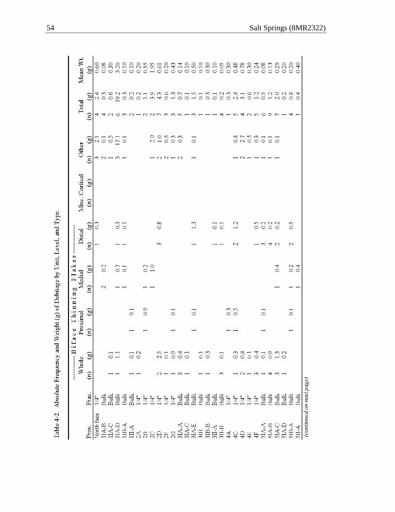
54 Salt Springs (8MR2322)

Material Culture 55

56 Salt Springs (8MR2322)
Table 4-3. Absolute Frequencies and Mean Values of Lithic Flakes by Type and Test Unit (TU) for All TUs Processed by 1/4-Inch Screening Only, 8MR2322. TU2 TU4 TU6 TU8 Total Biface Thinning Flakes Whole (n) 5 7 15 23 52 (g) 3.7 1.2 22.3 28.9 56.1 Proximate (n) 2 2 8 3 15 (g) 1.0 0.8 5.6 10.1 17.5 Medial (n) 2 8 9 19 (g) 1.2 11.6 9.9 22.7 Distal (n) 3 3 10 10 26 (g) 0.8 1.7 19.9 13.7 36.1 Misc. Cortical (n) 5 2 7 (g) 21.2 4.3 25.5 Other (n) 6 5 15 22 48 (g) 4.7 3.9 50.4 24.4 83.4 Total (n) 18 17 61 69 165 (g) 11.4 7.6 131.0 91.3 241.3 Mean Wt. (g) 0.63 0.45 2.15 1.32 1.46 Density (n/level) 2.57 2.83 10.17 23.00 7.50 Density (g/level) 1.63 1.27 21.80 30.43 10.97
Irrespective of recovery biases, the entire debitage assemblage is consistent with the bifacial reduction activities evident in the preform assemblage described earlier. Over two-thirds (n = 193) of the entire assemblage consists of flakes of bifacial retouch. In general, these are flakes that exhibit one or more of the following characteristics: lipped platform, dorsal flake scars running parallel to length, feather termination, and curved longitudinal cross-section. Hinge or step terminations, flat cross-sections, and platforms lacking a lip can also characterize bifacial thinning flakes, so the classification is fraught with ambiguity. Still, taken as a whole assemblage, there is little to recommend that lithic reduction activities other than biface production contributed to the

Material Culture 57
accumulation of debitage in the trench. Compared to locations closer to sources of lithic raw material, the assemblage is admittedly meager. However, compared to assemblages distant for sources of toolstone (>20 km), the assemblage is actually quite robust.
Flakes are generally small and lack cortical surfaces, indicative of mid- to late-
stage biface reduction. In comparing the average weight of flakes from levels that were sampled in bulk and those screened on site through ¼-inch mesh, it would appear that microdebitage is present throughout all levels, although underrepresented in the latter subsamples. A preponderance of microdebitage would suggest that in addition to tool production, on-site lithic activities included edge retouch of bifaces. Countering that argument is the virtual lack of exhausted bifacial tools in the trench. Whereas this may simply be a sample bias, the balance of evidence points to primarily tool production activities and little in the way of tool maintenance and replacement.
Comparing the distribution of debitage across units processed by ¼-inch
screening (Table 4-3), we find the same trend for concentrations in the southern units of the trench as we did with bifaces. Flakes are not only more numerous in units to the south (TUs 6, 8), they show greater average weight than units to the north (TUs 2, 4). Converted as density values, flakes in southern units occur four to nine times greater than in northern units when calculated by count per level, and 13 to 24 times greater when calculate by weight. TU8 shows the highest density using either measure.
MODIFIED BONE AND ANTLER
Fifty-two pieces of modified bone and antler were recovered from trench units processed by ¼-inch screen (Table 4-4). An additional two pieces were collected from the North Face of the trench and another three modified items were recovered from the bulk samples reported in Chapter 5, but these are excluded from the inventory provided in Table 4-4. Artifact classes include bone pins, bone awls, bone splinters, socketed antler points, snapped antler tines, and miscellaneous cut bone and antler. Large mammal bones were most often selected for modification, and deer metapodials and antlers were the most preferred elements. Representative examples of the modified bone and antler items are illustrated in Figure 4-2.
Bone Pins
Bone pin fragments account for 30.8 percent (n = 16) of the modified bone/antler assemblage (Figure 4-2a-e, i). Eleven pieces of bone refit into a maximum of five items, only two of which are complete after refitting (Figure 4-2b, c). Counting the remaining five small pieces as representative of discrete items, the assemblage contains a maximum of 10 bone pins.
Bone pins are defined as items that were highly modified and usually well polished, retaining none or very little of the bone’s cortical or medullary surfaces. The majority of the pins are elongated and round in cross-section, and none are decorated. The one exception to a rounded cross-section is a wide, spatulate item that is well
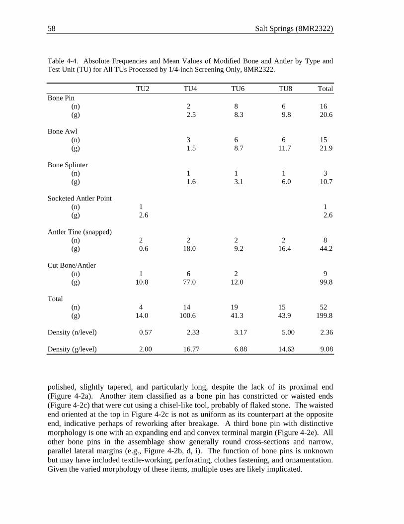
58 Salt Springs (8MR2322)
Table 4-4. Absolute Frequencies and Mean Values of Modified Bone and Antler by Type and Test Unit (TU) for All TUs Processed by 1/4-inch Screening Only, 8MR2322. TU2 TU4 TU6 TU8 Total Bone Pin (n) 2 8 6 16 (g) 2.5 8.3 9.8 20.6 Bone Awl (n) 3 6 6 15 (g) 1.5 8.7 11.7 21.9 Bone Splinter (n) 1 1 1 3 (g) 1.6 3.1 6.0 10.7 Socketed Antler Point (n) 1 1 (g) 2.6 2.6 Antler Tine (snapped) (n) 2 2 2 2 8 (g) 0.6 18.0 9.2 16.4 44.2 Cut Bone/Antler (n) 1 6 2 9 (g) 10.8 77.0 12.0 99.8 Total (n) 4 14 19 15 52 (g) 14.0 100.6 41.3 43.9 199.8 Density (n/level) 0.57 2.33 3.17 5.00 2.36 Density (g/level) 2.00 16.77 6.88 14.63 9.08
polished, slightly tapered, and particularly long, despite the lack of its proximal end (Figure 4-2a). Another item classified as a bone pin has constricted or waisted ends (Figure 4-2c) that were cut using a chisel-like tool, probably of flaked stone. The waisted end oriented at the top in Figure 4-2c is not as uniform as its counterpart at the opposite end, indicative perhaps of reworking after breakage. A third bone pin with distinctive morphology is one with an expanding end and convex terminal margin (Figure 4-2e). All other bone pins in the assemblage show generally round cross-sections and narrow, parallel lateral margins (e.g., Figure 4-2b, d, i). The function of bone pins is unknown but may have included textile-working, perforating, clothes fastening, and ornamentation. Given the varied morphology of these items, multiple uses are likely implicated.

Material Culture 59
Figure 4-2. Select worked antler and bone from ¼-inch screened units of trench, 8MR2322: Bone pins (a-e, i); bone awls (f-h, j); bone splinters (k, l); socketed antler point (m); snapped antler tines (p-r); cut antler (n, s); cut bone (o). (a. TU8C; b-d. TU6D; e. North Face, Str. II; f, g. TU8B; h. TU8D; i, j, l. TU8C; k. TU6E; m. TU2G; n. TU2F; o. TU6B; p. TU4E; q, r. TU8B; s. TU4D).

60 Salt Springs (8MR2322)
Bone Awls and Splinters Bone awls and splinter tools comprise 34.6 percent of the modified bone (n = 15 and 3, respectively). Awls are defined here as pointed implements of variable form made from mammal long bone that retains some of its surface morphology, notably the deepest parts of the medullary channel (e.g., Figure 4-2f-h, j). Splinters are similar to awls in tip morphology but lack any significant alteration of the shaft beyond splitting, and thus usually retain the irregular morphology of longitudinal fracture (e.g., Figure 4-2k, l). Use-wear on awls and splinters is typically confined to the pointed, distal end and is indicative of punching and possibly rotary action.
In her analysis of the modified bone from the trench, Julie Byrd had originally classified several of the forms in this class as “bone points.” These include pointed items with well-shaped symmetrical tips (e.g., Figure 2-4h) that lack any obvious traces of use alteration consistent with punching or rotary action. Such items may very well have been mounted onto shafts and used as projectiles or other food-capturing technology, but given the lack of haft elements among them, we are reluctant to infer a projectile function. If these indeed were used as projectiles, we need to establish direct evidence for the manner of hafting, bearing in mind that they may have been parts of composite tools, such as compound spears or hooks (e.g., Walker 2000). Plus, if some of these items were in fact used as projectile tips, their delivery may implicate weaponry not known for the Archaic period (e.g., bows and blow guns). No matter the manner of delivery, the narrow, smooth margins of these awl-like items may have required some type of barb to prevent it from dislodging after penetration, especially if used on fish.
Socketed Antler Points and Snapped Antler Tines
Nine items (17.3 percent) in the trench assemblage consist of deer antler tines that
have been cut and/or snapped from the beam and often further modified to achieve forms conducive to hafting and projectile uses. Only one of these items bears the tell-take socket of an antler projectile point. In Figure 4-2m, this proximal fragment is shown in “exploded” view to reveal the countersinking of its socket. Although this artifact may have come out of the ground in one piece, it fractured into four upon drying. The fracture that removed its tip, however, appears to be an old break and the tip was not recovered. It follows that this basal section was detached from its shaft for replacement after suffering tip damage in use elsewhere.
In further support of this inference is evidence for antler projectile manufacture.
The cut and snapped tine shown in Figure 4-2p has a well smoothed base with a small, shallow “starter” hole, presumably for further hollowing. Some of the pearls on the exterior surfaces have been partially ground, although many retain a good deal of mass that stands in sharp relief of the surface. Several other snapped tines, such as those shown in Figure 4-2q, r, may have likewise been destined for projectile manufacture, although often these have curvature that would require considerable tip modification. Whatever the actual use of antler tines, lateral breaks such as these rarely occur naturally (Jin and Shipman 2010:98–99), so they were either intended to create blanks for use

Material Culture 61
and/or further modification, or they represent the waste by-product of manufacturing involving the beam alone (e.g., making an antler billet). Obviously, the two are not exclusive and it seems reasonable to assume that all parts of the antler were drafted into use as needs dictated.
Miscellaneous Cut Bone and Antler
Nine items (17.3 percent) in the assemblage are classified as miscellaneous cut
bone and antler. Included in this group is a sawed and snapped deer metapodial (Figure 4-2o), consistent with materials discarded during bone tool manufacture (Wheeler and McGee 1994:360). Cut antler includes a cut and snapped antler tine (Figure 4-2n), collected after shedding then cut close to the burr. Such discard is unnecessary for making an antler billet and is more likely a product of antler point manufacture. Another item of antler is an especially long tine that was chiseled at the proximal end (Figure 4-2m). The lateral snap of this item appears to be postdepositional.
MODIFIED SHARK TEETH
Five shark teeth were recovered from the trench at 8MR2322, but only one shows
clear signs of modification. A nearly complete shark tooth has two holes drilled at opposite ends of the root, a form known from Mount Taylor assemblages throughout the region (Wheeler and McGee 1994: 357; Wheeler et al. 2000:148). Two other whole shark teeth (both of family Carcharhinidae; one of which is tiger shark [Galeocerdo cuvieri]) were recovered from the trench, although neither bears evidence of modification. The remaining two specimens are root portions without crowns. The use of shark teeth, perforated or not, appears to have been utilitarian, but some may have been ornaments.
MODIFIED MARINE SHELL
Trench excavations yielded 22 pieces of marine shell, four of which show signs of
modification or use. Prominent among the modified pieces is a large lightning whelk (Busycon contarium) that has its columnella removed and a large hole in the whorl due to heat attrition (Figure 4-3). This is an example of what Webster (1970) and Wheeler and McGee (1994:365), 368) call a shell “receptacle,” and we refer to similarly as a “vessel.” Clearly, the specimen shown in Figure 4-3 was used directly over a fire, presumably to heat its contents. Similar vessels with direct evidence of heating and with holes resulting from thermal attrition have been recovered from several Mount Taylor contexts. Two examples each from Blue Spring Midden B (8VO43; Sassaman 2003a) and Silver Glen (8LA1; Sassaman et al. 2011), three from Groves Orange (Wheeler and McGee 1994:365) and “several” from Lake Monroe Outlet Midden (8VO53; ACI 2001:7–16) were all made from lightning whelk and all have direct evidence for use over fire. Although the lightning whelk is among the largest of the Busycon spp. available (cf. Busycon carica), the whorl of even the largest of these could not hold much more than one liter of material. It is thus hard to imagine that shell vessels were utilized to process large quantities of anything. Perhaps they were drafted into special uses, such as

62 Salt Springs (8MR2322)
Figure 4-3. Burned-out vessel made from shell of lightning whelk (Busycon contarium). preparing medicines or poisons. It is noteworthy that only left-opening shells were used as vessels, while right-opening shells were commonly drafted into use as edged tools. Although the difference in size and whorl thickness between left- and right-opening shells no doubt determined to some extent their technical utility, the most common shell cup used to consume “black drink” during Mississippian times was the lightning whelk, whose left-oriented spiral may have conveyed ritual significance (Milanich 1979). Besides the lack of adornment often seen on “black drink” cups, the Mount Taylor
Material Culture 63
examples, like that from Salt Springs, differ from these later ritual vessels in being used directly over fire. Not coincidentally, marine shell vessels of the Mount Taylor period all but disappear after pottery was introduced in the region, ca. post 4200 B.P.
The only other modified marine shell artifact of note is the detached bit end of a
Busycon cutting-edge tool, what Goggin (1950) referred to as Type X. This is the end of siphonal canal, most likely from the shell of Busycon carica, which was steeply beveled. These were hafted tools for presumably heavy-duty wood working.
POTTERY
Four small sherds of pottery were recovered from the trench excavation of
8MR2322. Three of the sherds show traces of fiber-tempering, placing them in the Orange period that started ca. 4200 B.P. The final specimen is a nondescript sand-tempered sherd. All of the fiber-tempered sherds came from the upper levels of units towards the north end of the trench; the sand-tempered sherd came from the upper level of Test Unit 8, at the south end of the trench.
CONCLUSION
There are few well documented Mount Taylor assemblages in the immediate area
of Salt Springs (Sassaman et al. 2011), but compared to the inventory of material culture known for the greater region (Wheeler et al. 2000), the trench assemblage from 8MR2322 is fairly typical of the long-lived Mount Taylor tradition. Recent research by Endonino (2010) and Beasley (2008) provides grounds for dividing Mount Taylor into two phases, the latter beginning around 4900 B.P. or 5600 cal B.P. The attributes that distinguish what Endonino (2008, 2010) calls the Thornhill Lake Phase (5600–4500 cal B.P.) from what came before are largely those of mortuary practice and nonlocal material culture, apparently the result of long-distance interactions. Some of the more local and mundane aspects of Mount Taylor culture likely changed too, but data are too few to say. The Salt Springs assemblage is thus an important data point for fleshing out the material inventory of Mount Taylor practices during the centuries before major cultural change.
In drawing some generalizations about the material culture revealed by the trench,
we are reminded of the biases of differential recovery between the shell strata and the underlying sands. Both contained relatively abundant cultural debris, but we were not able to penetrate into subshell sands in the south end of the trench. Knowing how dense artifacts were in the subshell sands to the northeast of the trench—excavated by Russo and colleagues of the National Park Service—we hesitate to say that the sand stratum in the trench had less material culture than the overlying shell. Notwithstanding sample bias, the highest density of material culture in the trench was clearly in Stratum IA-2, the shell stratum at the south end of the trench. Dating to ca. 5150 B.P. (ca. cal 6000–5750 cal B.P.), the Stratum IA-2 assemblage is the latest deposit uncovered in the trench and clearly contained the highest density of material culture.

64 Salt Springs (8MR2322)
A noteworthy feature of the late Early Mount Taylor assemblage from Stratum IA-2 is the assemblage of bifacial preforms and associated debitage indicative of tool production. The entire lithic assemblage, although small, is consistent with mid- to late-stage preform reduction, but showing little evidence of tool replacement, use, and maintenance. The only “complete” bifaces in the assemblage are two reworked items with morphological and technological affinity to Early Archaic side-notched traditions such as Bolen. As discussed earlier, we have good reason to suspect that early Holocene use of Salt Springs was substantial, but we also have good reason to suspect that the occurrences of these tools in a Mount Taylor assemblage was due to scavenging on the part of these later occupants, as opposed to any mixing in the trench of early and late components.
Although there is little evidence for the use and replacement of hafted bifaces in
the trench assemblage, the associated inventory of worked bone and antler hints at organic elements of weaponry that may have been more routinely drafted into projectile service. We have no firm basis for inferring projectile functions for any of the worked items other than a single socketed antler tine, but suspect that much of the antler and some of the bone debris that has been worked to a point at one end may very well have been components of projectile weaponry. Because bone and especially antler is more evenly distributed between the sand and shell strata in the trench than is flaked stone, we may be witnessing evidence for greater use of stone over bone/antler towards the end of the Early Mount Taylor phase.
Missing from the Mount Taylor lithic assemblage is any indication of a
microlithic industry. The Lake Monroe Outlet Midden (8VO53) produced an abundance of microliths (some reported as Jaketown perforators by ACI 2001:2–8). Likewise, recent testing at Silver Glen Spring (8MR123) just south of Salt Springs has produced an impressive assemblage of microliths (Randall and O’Donoughue 2011). We do not have an age estimate for the latter assemblage, but the one from 8VO53 dates to after 5000 B.P., during the Thornhill Lake phase. If microliths were used in the manufacture of disc beads (cf. ACI 2001:10–5), along with other tasks, their present may be a proxy of production for ritual or exchange purposes. Disc shell beads were among the various items included in graves of the Thornhill Lake phase (Endonino 2010), and perhaps their production to satisfy this demand (and perhaps extralocal demand) led to a specialized tool form that may not have seen much application in the Early Mount Taylor phase.
Finally, the use of marine shell vessels may likewise signal more sweeping
change in Mount Taylor culture. Examples from well dated contexts cluster between 5000 and 4000 (radiocarbon) B.P., making the Salt Springs example among the oldest in good context. We have not seen shell vessels such as this from shell-bearing deposits in the middle St. Johns dating from ca. 6000 and 5000 B.P. It appears likely that this form, like the stepped-up production of shell beads, may be enveloped by the rituality of the Thornhill Lake phase. A thorough investigation of the formal, temporal, and geographic distribution of shell vessels is clearly warranted.

65
CHAPTER 5 ZOOARCHAEOLOGICAL ASSEMBLAGE
Meggan E. Blessing
This chapter reports the results of vertebrate bone analysis from selected bulk samples of the trench at 8MR2322. A total of 11 samples were examined, comprising 155.9 liters of fill. Samples were chosen to examine changes in depositional practices across time and space, and to facilitate comparisons of food choice between the shell-bearing strata and the sand. The results will be placed in a regional context by considering Groves’ Orange Midden, the only other Mount Taylor zooarchaeological assemblage to have been examined from a submerged context (Wheeler and McGee 1994), and Blue Spring Midden B, the only other comparable assemblage analyzed from a freshwater spring (Sassaman 2003a).
The invertebrate assemblage from Salt Springs were not included in this analysis
for several reasons. Recent data suggests that the large-scale consumption of shellfish cannot be taken as a given. Isotopes on human collagen suggest Mount Taylor peoples were not eating molluscs on the scale implied by the largest sites (Tucker 2009), and may have utilized death assemblages in the construction of these deposits (Blessing 2010). Discerning between snails that were likely consumed as opposed to those that were collected dead relies on a number of data points across depositional contexts. Indices of this sort are beyond the scope of this analysis, but in recognizing that at least some of the shellfish comprising these deposits could have been procured for reasons extending beyond sustenance argues against the wholesale inclusion of all shellfish species within zooarchaeological analyses prior to understanding the circumstances surrounding their collection. Otherwise, invertebrates will always eclipse the contribution of the vertebrate classes across all measures of quantification (NISP, MNI, Wt., Biomass, Meat Wt.), effectively masking the importance of these resources in Mount Taylor foodways. As noted in Chapter 3, the earliest occupations of spring runs were not necessarily centered on shellfish resources (see also O’Donoughue 2010). For those spring-side Mount Taylor sites whose vertebrate assemblages have been analyzed (e.g., Sassaman 2003a), there are no major differences in the dietary contribution of the vertebrate classes between shell-free and shell-bearing strata.
Similar concerns crosscut the nature of submerged deposits, which opens up the possibility for natural death assemblages to be intermixed with or mistaken for cultural materials. Admittedly, the processes framing the deposition of some individuals within the sand are ambiguous. For example, an osprey identified in the northern half of this stratum was associated with other cultural materials, but is represented by a nearly complete specimen, and there is no direct evidence of human processing. Without such evidence it is hard to say whether the bird died naturally and was an incidental inclusion, or was deposited in the water by a human. Fishes are the species most likely to be confused for cultural material in submerged deposits. Indeed, small, shoreline fishes such as topminnows are present in the assemblage. Rarely comprising more than one percent of the total fish NISP for any given strata, the proportion of individuals is slightly more

66 Salt Springs (8MR2322)
substantial ranging between roughly 4 (n = 11) and 6 percent (n = 9). It is not clear if fishes from this family were routinely consumed, but it does not seem likely. If they do not represent fishes that died naturally, topminnows could signal species primarily used for bait, or could be from the stomach contents of larger fish. It is also possible that they are frequent in the <2mm fractions, but even if this proves to be true, their presence would have no bearing on the results presented here. In spite of these examples, the majority of the analyzed fauna from the Salt Springs samples appear to be the outcome of human activity. Perhaps most telling regarding the origins of this assemblage is the fact that comparisons with other affiliated sites in the valley indicate that its composition fits comfortably with ones deposited terrestrially (e.g., Sassaman 2003a).
METHODS Zooarchaeological material chosen for analysis were first taken from the six bulk
samples from which hickory nutshell was dated by AMS assay (see Chapter 3). These bulk samples were passed through 4 mm and 2 mm nested sieves, and all vertebrate bone greater than 2 mm in size was analyzed. Volumetrically, the bulk samples varied only 1–2 liters of one another, but the samples are not evenly distributed throughout the trench. The greatest number came from TU5, accounting for 56.6 liters of the total fill analyzed, and TU3 with 43.2 liters. The smallest number of samples came from TU1 and TU7, which account for 27.3 liters and 28.8 liters, respectively. The integrity of samples from the upper portion of TU1 was somewhat suspect. Subsequent samples were chosen to fill in spatial and temporal gaps not addressed in the AMS-dated samples. These additions were confined to those recovered in bulk, but future analyses may want to include the ¼-inch and 1/8-inch samples processed in the field. Some of these are known to contain species not represented in the bulk samples, and in filling in the analytical gaps, can help to elucidate trends that currently are not fully understood.
Analysis of zooarchaeological material followed the guidelines of Reitz and Wing (1999). Samples were sorted into six classes, Chondricthyes, Actinopterygii, Amphibia, Reptilia, Aves, and Mammalia. Unidentifiable fragments were assigned to the order Vertebrata. Identifications to lower taxonomic levels were facilitated by the comparative collection in the Environmental Archaeology Laboratory at the Florida Museum of Natural History. Taxon, element, portion, side, modification, presence of burning, fusion, count, and weight were recorded for all identified material. Individual elements were identified to the lowest taxonomic level possible, but the degree to which this was achievable varied across the different classes. Identification depended on several factors including the degree of completeness of individual elements, the number of genera and species within a particular family, and their representation in the museum’s comparative collection, ideally encompassing a range of sizes.
In tabulating the number of individual specimens (NISP), bones that cross-mended were counted as a single element. Mandibles and associated teeth were also counted as one specimen. Although each stratum within each test unit was analyzed and quantified separately for NISP and weight, sample fractions and arbitrary levels within strata were analyzed together when determining the minimum number of individuals
Zooarchaeological Assemblage 67
(MNI). Similarly, the spatial units in the sand stratum were analytically collapsed to account for any bone displacement that may have occurred via wave action and other disturbances. The potential for single individuals to occur in different test units was kept in mind while determining MNIs for the shell-bearing strata as well.
Paired elements were the basis for quantifying the minimum number of individuals (MNI), but size and condition were factors as well. Multiple comparative specimens of the same species, exhibiting a range of sizes, were used to attain as accurate a number of individuals as possible. Although not necessarily typical of zooarchaeological practice, in several instances individuals were tabulated for taxonomic levels higher than genus or species. One example of this is the freshwater catfishes, which are represented by a number of conspecifics in the middle St. Johns River valley. Able to differentiate between the two genera only on a handful of elements, I kept all others at Ictaluridae. Despite my inability to verify species at this level, I could discern different individuals (mainly through size differences), accounting for elements that may have paired with lower taxa. A similar logic was used for Lepomis sp., Clupeidae, Muridae, Rodentia, Caudata, and Aves. This limited ability to make identifications at the species level, necessitated the discussion of large families such as catfish, and sunfish, and the minnows and suckers as groups. Behaviorally, there is a good bit of overlap for the related species regarding habitat and substrate preferences, feeding, and peak activity, so their differentiation at the morphological level may not be entirely necessary under time and budget constraints. Analytically, fragmentary bones that could be assigned to a particular class (e.g., Aves and Mammalia), but lacked the specific landmarks necessary for identification to lower taxonomic levels were separated into small, medium, and large categories. These designations were collapsed when tabulating relative frequencies, MNI, and other ratios.
Summary data on the stratigraphic and spatial distributions of the different taxa are categorized in a way that highlights patterning seen at a finer scale. Turtles, as the most commonly exploited reptile, are reported separately from snakes and “other reptiles.” This last category contains unidentified reptiles and alligator, both of which occur in trace amounts. Likewise, “other mammal” is quantified separately from deer. For one, the density and size of deer elements has the potential to throw off mammal weights, even with a small NISP. Secondly, the potential for deer to signal extra-domestic consumption, coupled with a value that extends beyond its status as a food resource (e.g., raw material for tools) seems to warrant the examination of this taxon as its own category.
RESULTS
As a whole, the Salt Springs vertebrate assemblage is a consummate representation of a lifestyle long-established for Mount Taylor peoples (e.g., Wyman 1875; Russo et al. 1992), and is centered on species readily available in the spring run and nearby Lake George. Table 5-1 provides the species list for the submerged aspect of the site, along with absolute and relative frequencies of NISP and MNI. The assemblage contains 39,704 elements, from which 64 taxa were identified, and subsequently sorted

68 Salt Springs (8MR2322)
Table 5-1. Relative and Absolute Frequencies of Total Vertebrate Fauna by General Taxa, Salt Springs (8MR2322).
Number of Individual Specimens (NISP)
Minimum Number of Individuals (MNI)
n % n % UID Vertebrate 15,141 38.1 n/a n/aFish 22,162 55.8 545 75.4Amphibian 21 0.1 10 1.4Reptile* 17 0.0 5 0.7Turtle 1597 4.0 96 13.3Snake 333 0.8 13 1.8Bird 46 0.1 12 1.7Mammal 339 0.9 30 4.1Deer 48 0.1 12 1.7Total 39,704 100.0 723 100.0
*includes alligator
into 723 individuals. Diversity and equitability were calculated using the Shannon-Weaver (1949) and Sheldon (1969) formulae. The overall diversity (H' = 3.35) is high, despite the dominance of fishes, and evenly distributed (V' = 0.82), as a good amount of taxa are represented by similar numbers of individuals.
There are two additional species not represented in the analyzed bulk samples that
were noted in the field and then subsequently confirmed. These include bobcat (Lynx rufus), and cormorant (Phalocrocorax sp.), represented by one individual each. These individuals are from ¼-in and 1/8-in samples that were water-screened in the field, and highlight the potential for an even greater species richness to be obtained from the site.
Table 5-2 list summary data by general taxa for the entire assemblage. Bone unidentifiable beyond the order Vertebrata comprised 38 percent (n = 15,141) of the assemblage. The bulk of this is concentrated in the < 4 mm samples and is highly fragmented. Unidentifiable elements from the larger fraction mostly include shafts that could not be confidently assigned to either mammal or bird, and smaller pieces that could have been either mammal or reptile. Fish elements generally seem to stand out due to their unique morphology, and thus, were the most easily identified vertebrate, regardless of fragmentation. While it could be argued that the dominance displayed by the fishes is biased in this respect, it is not likely that additional identifications beyond the taxonomic level of Vertebrata would drastically change the contributions of the other vertebrate classes. This observation is particularly salient when looking at the frequencies among the number of individuals within each class. Fishes contribute more than 75 percent (n = 545) of the total. They are followed by reptiles (specifically turtles), mammals, birds, and amphibians, respectively. Overall, this is an aquatic-focused assemblage, even if we were to exclude the fishes. The turtles are represented mostly by spring or lake-dwelling species, alligator accounts for the majority of “other reptiles,” and the birds, thus far, are dominated by waterfowl regarding the total number of individuals.

Zooarchaeological Assemblage 69
Table 5-2. Absolute and Relative Frequencies of Vertebrate Fauna for Assemblage, Salt Springs (8MR2322).
Scientific Name
Common Name
Number of Individual Specimens (NISP)
Minimum Number of Individuals (MNI)
n % n % Vertebrata UID Vertebrate 15,133 38.1 0 0.0 Condrichthyes Shark 3 <0.1 2 0.3 Dasyatus sabina Atlantic Stingray 9 <0.1 2 0.3 Actinopterygii Ray-Finned Fish 17,132 43.1 0 0.0 Lepisosteus sp. Gar 1431 3.6 35 4.8 Amai calva Bowfin 180 0.5 22 3.0 Anguilla rostrata American Eel 23 0.1 8 1.1 Clupeidae Shad/Herring 120 0.3 32 4.4 Esox sp. Pickerel 42 0.1 24 3.3 Cypriniformes Minnow/Sucker 73 0.2 0 0.0 Notemigonus crysoleucas Golden Shiner 137 0.3 40 5.5 Erimyzon sucetta Lake Chubsucker 235 0.6 59 8.2 Ictaluridae Catfish 255 0.6 34 4.7 Ameiurus sp. Bullhead 36 0.1 17 2.4 Ameiurus natalis Yellow Bullhead 12 <0.1 11 1.5 Ameiurus nebulosus Brown Bullhead 10 <0.1 9 1.2 Fundulidae Topminnow 48 0.1 25 3.5 Centrarchidae Sunfish 1671 4.2 0 0.0 Pomoxis nigromaculatus Black Crappie 5 <0.1 4 0.6 Micropterus salmoides Large-Mouth Bass 173 0.4 76 10.5 Chaenobryttus gulosus Warmouth 12 <0.1 10 1.4 Lepomis sp. Bream 201 0.5 70 9.7 Lepomis macrochirus Bluegill 4 <0.1 2 0.3 Lepomis microlophus Shellcracker 340 0.9 54 7.5 Mugil spp. Mullet 10 <0.1 8 1.1 Caudata Salamander 18 <0.1 7 1.0 Amphiuma means Two-Toed Amphiuma 1 <0.1 1 0.1 Siren sp. Siren 1 <0.1 1 0.1 Anura Frog 1 <0.1 1 0.1 Testudines Turtle 1269 3.2 0 0.0 Chelydra serpentina Snapping Turtle 8 <0.1 6 0.8 Kinosternidae Mud/Musk Turtle 58 0.1 2 0.3 Kinosternon sp. Mud Turtle 42 0.1 20 2.8 Kinosternon baurii Florida Mud Turtle 2 <0.1 1 0.1 Sternotherus sp. Musk Turtle 77 0.2 25 3.5 Emydidae Pond Turtle 25 0.1 5 0.7 Terrapene carolina Box Turtle 3 <0.1 3 0.4 Pseudemys sp. Cooter 19 <0.1 11 1.5 Trachemys scripta Slider 1 <0.1 1 0.1 Deirochelys reticularia Chicken Turtle 2 <0.1 2 0.3 Gopherus polyphemus Gopher Tortoise 7 <0.1 5 0.7 Apalone ferox Soft-Shelled Turtle 84 0.2 15 2.1 Squamata Lizard 2 <0.1 1 0.1 Alligator mississippiensis American Alligator 10 <0.1 4 0.6 Serpentes Snake 326 0.8 9 1.2 Colubridae Colubrid Snake 6 <0.1 3 0.4 Viperidae Pit Viper 1 <0.1 1 0.1 Aves Bird 38 0.1 7 1.0 Anatidae Swan, Geese, Duck 1 <0.1 0 0.0 Anas sp. Marsh Duck 1 <0.1 2 0.3 Anas sp. cf. discor Blue-Winged Teal 1 <0.1 1 0.1 Aythya collaris Ring-Necked Duck 1 <0.1 1 0.1 Pandion haliaetus Osprey 3 <0.1 1 0.1 Meleagris galapavo Wild Turkey 1 <0.1 1 0.1 Mammalia Mammal 265 0.7 3 0.4

70 Salt Springs (8MR2322)
Table 5-2. continued.
Scientific Name
Common Name
Number of Individual Specimens (NISP)
Minimum Number of Individuals (MNI)
n % n %
Didelphis virginiana Opossum 13 <0.1 3 0.4 Rodentia Rodent 15 <0.1 1 0.1 Sylvilagus sp. Rabbit 12 <0.1 6 0.8 Sciurus sp. Squirrel 4 <0.1 2 0.3 Muridae Rat/Mouse 4 <0.1 1 0.1 Neotoma floridana Florida Wood Rat 3 <0.1 3 0.4 Sigmodon hispidus Hispid Rat 7 <0.1 5 0.7 Procyon lotor Raccoon 14 <0.1 5 0.7 Lontra canadensis River Otter 2 <0.1 1 0.1 Odocoileus virginianus White-Tailed Deer 48 0.1 12 1.7 Total 39,704 100.0 723 100.0
Table 5-3 lists the absolute and relative frequencies of NISP and MNI by general
taxa for the three major stratigraphic units. At this juncture in the analysis, I did not consider the results from Stratum IA-1 separately from Stratum IA-2, which comprises the southern half of the uppermost shell deposit. Relative frequencies at the level of general taxa do not show any appreciable differences among the three strata, so analytically combining IA-1 and IA-2 does not seem to affect aspects of food choice through time. Spatial differences between these deposits are, however, noteworthy and will be further discussed below. As with patterning witnessed at the assemblage level, fish contribute both the largest percentage of bone and number of individuals across the three strata. They are followed by considerably smaller amounts of turtle, and mammal, with trace occurrences of bird and amphibian. Again, the centrality of fish in Mount Taylor foodways is even more apparent when considering bone that could be identified to only class or lower (Table 5-4), the relative frequencies of which remain virtually unchanged across the three strata.
Looking within fishes for the different species represented (Table 5-5), members
of the sunfish family stand out amongst all others. Clearly preferred, large mouth bass (Micropterus salmoides), bream (Lepomis sp.), and shellcracker (Lepomis microlophus) dominate the fish assemblage through time, with only modest changes in the proportions of NISP and MNI. The NISP of gar (Lepisosteus sp.) is inflated by the presence of scales, and when approached as individuals, they comprise less than the cyprinids (Erimyzon sucetta and Notemingonus crysoleucas) and catfish (Ictaluridae), respectively. Their position as the fourth most frequently exploited species is challenged only in Stratum IA wherein the number of shad/herring (Clupeidae) individuals from the sand more than doubles, making up a little more than 8 percent (n = 22) of the stratum’s species composition. The total number of specimens increases for both catfish and bowfin (Amia calva) from the sand to the shell, but without corresponding increases in the number of individuals, suggesting that a greater number of identifiable parts were being deposited in shell. The proportion of eel (Anguillla rostrata) individuals nearly tripled through time, but even then they only account for approximately 2 percent (n = 6) of the total.

Zooarchaeological Assemblage 71
Table 5-3. Absolute and Relative Frequencies of Vertebrate Fauna by General Taxa and Stratum, Salt Springs (8MR2322).
Number of Individual Specimens (NISP)
Minimum Number of Individuals (MNI)
n % n % STRATUM IA Vertebrate 7952 41.3 n/a n/aUID Fish 7741 40.2 n/a n/aFish 2370 12.3 269 75.6Amphibian 4 0.0 4 1.1Reptile* 15 0.1 4 1.1Turtle 800 4.2 47 13.2Snake 132 0.7 8 2.2Bird 20 0.1 5 1.4Mammal 216 1.1 13 3.7Deer 24 0.1 6 1.7Total 19,274 100.0 356 100.0 STRATUM IB Vertebrate 4501 49.4 n/a n/aUID Fish 3115 34.2 n/a n/aFish 1087 11.9 132 79.0Amphibian 4 0.0 2 1.2Reptile 0 0.0 0 0.0Turtle 264 2.9 21 12.6Snake 72 0.8 2 1.2Bird 9 0.1 2 1.2Mammal 57 0.6 4 2.4Deer 11 0.1 4 2.4Total 9120 100.0 167 100.0 STRATUM II Vertebrate 2688 23.8 n/a n/aUID Fish 6276 55.5 n/a n/aFish 1573 13.9 143 71.5Amphibian 13 0.1 4 2.0Reptile 2 0.0 1 0.5Turtle 533 4.7 29 14.5Snake 129 1.1 3 1.5Bird 17 0.2 5 2.5Mammal 66 0.6 13 6.5Deer 13 0.1 2 1.0Total 11,310 100.0 200 100.0
*includes alligator

72 Salt Springs (8MR2322)
Table 5-4. Absolute and Relative Frequencies of Vertebrate Fauna by Identifable Taxa and Stratum, Salt Springs (8MR2322).
Number of Individual Specimens (NISP)
Minimum Number of Individuals (MNI)
n % n % STRATUM IA Fish 10,111 89.3 269 75.6Amphibian 4 0.0 4 1.1Reptile* 15 0.1 4 1.1Turtle 800 7.1 47 13.2Snake 132 1.2 8 2.2Bird 20 0.2 5 1.4Mammal 216 1.9 13 3.7Deer 24 0.2 6 1.7Total 11,322 100.0 356 100.0 STRATUM IB Fish 4202 91.0 132 79.0Amphibian 4 0.1 2 1.2Reptile 0 0.0 0 0.0Turtle 264 5.7 21 12.6Snake 72 1.6 2 1.2Bird 9 0.2 2 1.2Mammal 57 1.2 4 2.4Deer 11 0.2 4 2.4Total 4619 100.0 167 100.0 STRATUM II Fish 7894 91.0 143 71.5Amphibian 13 0.2 4 2.0Reptile 2 0.0 1 0.5Turtle 533 6.2 29 14.5Snake 129 1.5 3 1.5Bird 17 0.2 5 2.5Mammal 66 0.8 13 6.5Deer 13 0.2 2 1.0Total 8622 100.0 200 100.0
*includes alligator
No other noteworthy frequency changes exist for the remainder of the species, but some of them still bear mention. Mullet (Mugil sp.), Stingray (Dasyatus sabina), and Shark (Chondrichthyes) stand out as saltwater species. Mullet and stingray certainly are common, and notably, permanent residents of Lake George, but they can also be found in the spring run. Because of this availability, it is somewhat surprising that they occur in only trace amounts. Both bull (Charcarhinus leucas) and tiger (Galeocerdo cuvieri) sharks have been seen in the St. Johns (www.theriverreturns.org), but they are not permanent residents by any means. Certainly, tiger shark teeth have been identified at the

Zooarchaeological Assemblage 73
Table 5-5. Absolute and Relative Frequencies of Fish by General Taxa, Salt Springs (8MR2322).
Number of Individual Specimens (NISP)
Minimum Number of Individuals (MNI)
n % n % STRATUM IA Shark 2 0.1 1 0.4 Gar 513 21.6 17 6.3 Bowfin 93 3.9 9 3.3 Eel 17 0.7 6 2.2 Shad 97 4.1 22 8.2 Pike 20 0.8 13 4.8 Shiner 64 2.7 21 7.8 Sucker 110 4.6 31 11.5 Shiner/Sucker 39 1.6 0 0.0 Catfish 167 7.0 33 12.3 Topminnow 23 1.0 11 4.1 Sunfish 1219 51.4 100 37.2 Mullet 6 0.3 5 1.9 Total 2370 100.0 269 100.0 STRATUM IB Shark 1 0.1 1 0.8 Ray 8 0.7 1 0.8 Gar 319 29.3 9 6.8 Bowfin 51 4.7 6 4.5 Eel 3 0.3 1 0.8 Shad 6 0.6 5 3.8 Pike 12 1.1 6 4.5 Shiner 25 2.3 6 4.5 Sucker 52 4.8 12 9.1 Shiner/Sucker 7 0.6 0 0.0 Catfish 74 6.8 23 17.4 Topminnow 7 0.6 5 3.8 Sunfish 521 47.9 57 43.2 Mullet 1 0.1 1 0.8 Total 1087 100.0 132 100.0 STRATUM II Ray 1 0.1 1 0.7 Gar 599 38.1 9 6.3 Bowfin 36 2.3 7 4.9 Eel 3 0.2 1 0.7 Shad 17 1.1 5 3.5 Pike 10 0.6 5 3.5 Shiner 48 3.1 13 9.0 Sucker 73 4.6 16 11.1 Shiner/Sucker 27 1.7 1 0.7 Catfish 72 4.6 16 11.1 Topminnow 18 1.1 9 6.3 Sunfish 666 42.3 59 41.0 Mullet 3 0.2 2 1.4 Total 1573 100.0 144 100.0

74 Salt Springs (8MR2322)
site, in addition to what are probably bull shark teeth (see Chapter 4). The likelihood that they were caught locally, however, is pretty small. Most probably, these teeth came from sharks procured along the coast. Whether they were directly accessed by riverine groups, or exchanged with costal residents is not known.
As a general group, the relative frequencies of turtles are practically invariant through time (Table 5-3). Changes in the proportions of the different species do exist, however (Table 5-6). Overall, mud (Kinosternon sp.) and musk (Sternotherus sp.) turtles dominate the assemblage for both the total number of elements and individuals. This pattern holds despite decreases in the latter category from the sand to the uppermost stratum of shell. Even though the ratio of NISP to MNI actually increases for both pond and soft-shelled turtles, the difference in this same measure for mud and musk turtles from Stratum II to Stratum IA is larger. The decrease in the number of kinosternid individuals through time is also compounded by the increase in the number of individuals Table 5-6. Absolute and Relative Frequencies of Turtle by Species, Salt Springs (8MR2322).
Number of Individual
Specimens (NISP)
Minimum Number of
Individuals (MNI) n % n % STRATUM IA Snapping Turtle 6 3.8 4 8.5Mud/Musk Turtle 68 43.0 22 46.8Box Turtle 1 0.6 1 2.1Pond Turtle 28 17.7 9 19.1Gopher Tortoise 4 2.5 3 6.4Soft-Shelled Turtle 51 32.3 8 17.0Total 158 100.0 47 100.0 STRATUM IB Snapping Turtle 1 2.2 1 4.8Mud/Musk Turtle 19 41.3 9 42.9Box Turtle 2 4.3 2 9.5Pond Turtle 9 19.6 5 23.8Gopher Tortoise 2 4.3 1 4.8Soft-Shelled Turtle 13 28.3 3 14.3Total 46 100.0 21 100.0 STRATUM II Snapping Turtle 1 0.8 1 3.4Mud/Musk Turtle 92 74.2 18 62.1Box Turtle 0 0.0 0 0.0Pond Turtle 10 8.1 5 17.2Gopher Tortoise 1 0.8 1 3.4Soft-Shelled Turtle 20 16.1 4 13.8Total 124 100.0 29 100.0

Zooarchaeological Assemblage 75
across all other taxa. The sources of variation behind these changes are currently unknown, but to reduce them to differential habitat exploitation through time is not entirely feasible because most of the aquatic species of turtle, with the exception of the snappers, could have been found in the spring run.
The proportions of “other reptiles,” snakes, birds, “other mammals,” and deer
NISPs remain virtually the same through the transition to the deposition of shell (Table 5-3). Changes in the proportions of individuals for these same categories are subtle as well. While these general taxa are always present at Mount Taylor sites, their overall importance tends to be eclipsed by fishes and turtles. With regards to the entire assemblage (Table 5-1), these taxa never exceed more than 1.1 percent of the total elements, nor do they comprise more than 5 percent of the total individuals. This pattern generally holds stratigraphically as well, although the proportion of other mammal individuals is nearly 7 percent of the total in Stratum II.
Overall, there are no fundamental differences between the inventories of vertebrate fauna from the sand and from the shell. The presence of shellfish in Strata IA and IB is unlikely to represent the practices of a different community of people, nor is it likely to signal a resource that was incorporated into the diet in the face of major ecological change. Otherwise, we would expect to see corresponding drops in the proportions of other important species. The diversity and equitability indices are very similar for the three strata, indicating samples that are highly diverse with even distributions of individuals among the different taxa (Table 5-7). On balance, it would appear then that the presence of shell in the upper units of the trench is a matter of spatial shifts in zones of deposition, and represents the progradation of shellfish remains into the water over time. Nevertheless, we cannot completely rule out the possibility that the shellfish represent a previously unexploited resource, a scenario that is contingent upon having a better understanding of what is happening within the terrestrial portions of the site. Granted, if indeed this is the case, and the transition from the sand to the shell truly represents a later-period addition, it was not attended by any major changes in the contributions of the vertebrate fauna classes. The stability of these taxa suggests that procurement of aquatic shellfish was not solely tied to subsistence practices.
Table 5-7. Equitability of Vertebrate Fauna by Strata, Salt Springs (8MR2322).
S
loges
H'
V'
STRATUM IA 46 3.83 3.32 0.87
STRATUM IB 40 3.69 3.21 0.87
STRATUM II 39 3.66 3.19 0.87

76 Salt Springs (8MR2322)
Although not necessarily speaking to changes in food choice through time, variation in the fauna across strata seem to reflect transitions in depositional practices. Notably, the relative frequency of unidentifiable bone increases from 23.8 percent (n = 2688) in the sand to 41.3 percent (n = 7952) in Stratum IA. Attending these changes is an approximately 20 percent decrease in the proportion of unidentified fishes. Importantly, the NISP and MNI of fishes identified to the level of family or lower remain relatively stable through time. It is possible that the addition of shell helped to stabilize the upper deposits, effectively preventing the removal of smaller and more fragmented pieces of bone via water transport. This scenario does not, however, explain changes in the representation of unidentifiable fish parts. This latter phenomenon seems to be tied to an increase in the amount of identifiable parts being deposited. What is more, the amount of unidentified bone in the < 4mm fractions from the sand and shell strata indicate that the samples are not significantly different from one another. In other words, large quantities of small pieces of bone were not necessarily being carried away from their original position in the sand, suggesting that something other than taphonomic processes are responsible for the differences in the relative frequencies among the strata.
As it does not seem that bone from the sand was being redeposited elsewhere, the rate of vertebrate fauna deposition was more intensive in the shell strata (Table 5-8). This discrepancy cannot be accounted for by a greater amount of fragmented bone either. As noted above, the diversity and equitability values among the three strata are very similar to one another, but Stratum IA is slightly higher than Strata IB and II, due to a greater number of identified species. Not surprisingly, we are 95 percent confident that the differences in the MNIs between the sand and the shell are statistically significant, and not simply a by-product of volumetric differences. If the MNIs were evenly distributed among the strata, we would expect those from the sand to make up roughly 36 percent of the total number of individuals, since this is the volumetric proportion taken up by the analyzed fill from this stratum.
Table 5-8. Density of Vertebrate Fauna by Stratum Composition, Salt Springs (8MR2322).
Volume (L)
NISP/L
WT.(g)/L
Shell 99.1 286.52 11.82
Sand 56.8 199.12 7.64
What these changes entail in terms of human practice is not entirely clear, but it is
possible that the vertebrate fauna from Strata IA and IB is primarily associated with secondary midden. Following Sassaman’s (2003a) logic at Blue Spring Midden B, we might expect to see differences between the sand and the shell in the ratios of NISP to MNI, and amount of burning. The ratios of NISP to MNI for the two major stratigraphic

Zooarchaeological Assemblage 77
units are slightly different, registering as 55.9:1 in the shell and 57.7:1 in the sand. These differences are hardly significant, however, are do those between the ratio of unburned to burned bone (15.1 and 19.6). In fact, there is very little burned bone in the assemblage overall, comprising only 6.2 percent (n = 2453) of the total NISP.
Whatever the sources of variation might be there is some evidence from the
vertebrate fauna to reaffirm the division of Stratum IA into separate depositional units. Stratum IA-1 encapsulates the first 50 cm or so of TU1 and TU3, but is only encountered about 40 cm into TU5. Confined to the southern end of the trench, Stratum IA-2 contains the upper levels of TU5 and all of those in TU7. The differences are somewhat subtle and noted only after excavation, but vary along the lines of deposit structure, texture, and composition, and not attributable to taphonomic processes. Notably, the majority of the other artifacts recovered in excavations came from Stratum IA-2, including a large lightning whelk vessel, several different kinds of lithics, and a number of broken and whole bone tools (see Chapter 4). If only making comparisons at the level of general taxa, the changes in vertebrate fauna frequencies might seem insignificant (Table 5-9). Table 5-9. Absolute and Relative Frequencies of Vertebrate Fauna by General Taxa from Stratum IA-1 and Stratum IA-2, Salt Springs (8MR2322).
Number of Individual Specimens (NISP)
Minimum Number of Individuals (MNI)
n % n % STRATUM IA-1 Vertebrates 2419 36.0 n/a n/aUID Fish 2695 40.1 n/a n/aFish 1283 19.1 94 78.3Amphibian 0 0.0 0 0.0Reptile* 5 0.1 2 1.7Turtle 196 2.9 14 11.7Snake 56 0.8 2 1.7Bird 6 0.1 1 0.8Mammal 56 0.8 5 4.2Deer 9 0.1 2 1.7Total 6725 100.0 120 100.0 STRATUM IA-2 Vertebrates 5533 42.7 n/a n/aUID Fish 5046 38.9 n/a n/aFish 1505 11.6 175 74.5Amphibian 4 0.0 4 1.7Reptile* 10 0.1 2 0.9Turtle 604 4.7 32 13.6Snake 76 0.6 3 1.3Bird 14 0.1 4 1.7Mammal 160 1.2 9 3.8Deer 15 0.1 6 2.6Total 12,967 100.0 235 100.0
*includes alligator

78 Salt Springs (8MR2322)
But these patterns are probably not about food choices per se. We know they are eating the same food. Rather it is the context of consumption and the processing of those remains that seem to account for the differences. Gross level comparisons between the two stratigraphic units do indicate that the diversity of Stratum IA-2 (H' = 3.30) is slightly higher than Stratum IA-1 (H' = 3.12). This latter unit is slightly more equitable (V' = 0.90) than Stratum IA-2 to the south (V' = 0.88) due to the more even distribution of its MNIs between the various species represented. Examinations at the finer scale of species distributions between the two units are somewhat revealing (Table 5-10, Table 5-11). Table 5-10. Absolute and Relative Frequencies of Fish by General Taxa, Salt Springs (8MR2322).
Number of Individual
Specimens (NISP)
Minimum Number of
Individuals (MNI) n % n % STRATUM IA-1 Shark 0 0.0 0 0.0 Ray 0 0.0 0 0.0 Gar 207 23.9 5 5.3 Bowfin 21 2.4 2 2.1 Eel 3 0.3 3 3.2 Shad/Herring 11 1.3 5 5.3 Pike 10 1.2 5 5.3 Shiner 18 2.1 9 9.6 Sucker 52 6.0 12 12.8 Shiner/Sucker 20 2.3 0 0.0 Catfish 58 6.7 15 16.0 Topminnow 3 0.3 1 1.1 Sunfish 461 53.3 36 38.3 Mullet 1 0.1 1 1.1 Total 865 100.0 94 100.0 STRATUM IA-2 Shark 2 0.1 1 0.6 Ray 0 0.0 0 0.0 Gar 306 20.3 12 6.9 Bowfin 72 4.8 7 4.0 Eel 14 0.9 3 0.8 Shad/Herring 86 5.7 17 1.7 Pike 10 0.7 8 4.6 Shiner 46 3.1 12 6.9 Sucker 58 3.9 19 10.9 Shiner/Sucker 19 1.3 0 0.0 Catfish 109 7.2 19 10.9 Topminnow 20 1.3 10 5.7 Sunfish 758 50.4 63 36.0 Mullet 5 0.3 4 2.3 Total 1505 100.0 132 100.0

Zooarchaeological Assemblage 79
Table 5-11. Absolute and Relative Frequencies of Turtle by General Taxa, Salt Springs (8MR2322).
Number of Individual
Specimens (NISP)
Minimum Number of
Individuals (MNI) n % n % STRATUM IA-1 Snapping Turtle 1 2.3 1 7.1Mud/Musk Turtle 30 69.8 8 57.1Box Turtle 1 2.3 1 7.1Pond Turtle 2 4.7 1 7.1Gopher Tortoise 1 2.3 0 0.0Soft-Shelled Turtle 8 18.6 3 21.4Total 43 100.0 14 100.0 STRATUM IA-2 Snapping Turtle 5 4.3 3 9.4Mud/Musk Turtle 38 33.0 14 43.8Box Turtle 0 0.0 0 0.0Pond Turtle 26 22.6 8 25.0Gopher Tortoise 3 2.6 2 6.3Soft-Shelled Turtle 43 37.4 5 15.6Total 115 100.0 32 100.0
For most of the represented species of fishes between Strata IA-1 and IA-2, there
are no mentionable changes in their proportions, and only a difference of one for the total number of species exploited. Shad and herring, however, have a noticeably higher NISP and MNI in the southern depositional unit (IA-2). The greatest number of elements occur in TU7 (n = 78), and moderate amounts are found in TU5 (n = 21). The same pattern can be seen with the distribution of the number of individuals, (n = 13) and (n = 4). Only a handful of shad and/or herring were recovered from TU3 (n = 4), which not surprisingly came from only one individual. The slight decrease for fishes as a whole moving towards the south is likely tied to the increase in certain species of turtles. For the 51 soft-shelled turtle elements represented in this deposit, 30 of them are located in TU7, while the other 21 are divided nearly evenly between TU3 and TU5. Of the 28 pond turtle elements, 10 are located in the upper level of TU5 and 16 are located in TU7.
The higher number of shad in Stratum IA-2 could be tied to procurement events
that took place during the spawning season, which for most species begins sometime between late winter and spring (Lee et al. 1980). Ethnohistorical accounts (Rostlund 1952) from throughout the Southeast attest to the importance of shad in Native American foodways, which were valued for both their flesh and their roe. Likewise the differential distribution of turtles may be tied to seasonal differences in the availability of species, but it could also be a product of the context of consumption. Currently, it is not clear if these deposits are tied to household-related activities, or much larger-scale events. The patterning seen in Stratum IA-2 is intriguing, but would benefit from the addition of other
80 Salt Springs (8MR2322)
samples. Contact with the water table prevented further excavation into TU7 beyond approximately 50 cm, so the ¼-inch samples form TU6 and TU8 may be able to fill in the analytical gaps and provide further information in this respect. Choosing between these alternative scenarios probably also relies on patterning amongst the size, structure, and composition of associated shellfish species, especially the banded mystery snails (Viviparus georgianus). There is evidence demonstrating significant size differences between banded mystery snails associated with village contexts, versus those that were incorporated into mounded deposits (Sassaman and Randall n.d.). Changes in the frequencies of other shellfish species like the Florida apple snail (Pomacea paludosa) and freshwater bivalve (Unionidae) might also vary with depositional context and lend insight into the sources of variation linked to these deposits.
The composition of the assemblage squares nicely with others from the region.
Results reported by Wheeler and McGee (1994) on the >4 mm fauna from the submerged context at Groves’ Orange Midden fall within the range of variation witnessed at Salt Springs (Table 5-12). At the assemblage level, fish encompass more than 75 percent of the total number of individuals. Turtles are the second most frequent vertebrate class, and are followed by snakes, mammals, amphibians, and birds. A similar pattern is also witnessed at Blue Spring Midden B, which also contains shell-free deposits and provides another point of comparison for the sand stratum at Salt Springs (Table 5-13). In spite of the sample size differences between the two sites, the proportions of the vertebrate classes from the respective sand strata are nearly identical. The relative frequencies of the fishes are strikingly similar as well (Table 5-14). What is more, the fauna from the shell-bearing portions of the site show no significant differences with the fauna from the sand (Sassaman 2003a). The similarity between these different contexts at Blue Spring Midden B reiterates the patterns established at Salt Springs.
One species recovered from Salt Springs that, to my knowledge, has not been identified elsewhere in the region is osprey (Pandion haliaetus). These large, predatory birds are a common site in the area, but apparently were not regularly eaten. As mentioned earlier, the processes surrounding the deposition of this animal are somewhat ambiguous. It is not clear if the bird was actually captured, or died naturally. It is reasonable to expect other aspects of the osprey, such as their feathers, to have value extending beyond their suitability as a food source.
Most of the fish species in this assemblage would have been readily available in
the spring run. Exceptions include bowfin and shad, which were more likely procured from Lake George. Eels are abundant in Florida’s lakes and rivers, but the ones that live in springs generally reside in caves and crevices (Stamm 2008). They are also primarily nocturnal. Eels are behaviorally unique in other important ways compared to the fishes routinely procured by Mount Taylor communities. For one, they have the ability to traverse dry land. Furthermore, they reside in freshwater for the majority of their lives, but are ultimately catadromous and undergo a series of morphological transformations before returning to the Sargasso Sea to spawn. Taking place in the fall, the journeys back

Zooarchaeological Assemblage 81
Table 5-12. Absolute and Relative Frequencies of >4 MM Vertebrate Fauna by General Taxa from Groves’ Orange Midden, (8VO2601) and Salt Springs, (8MR2322).
Minimum Number of Individuals (MNI)
n % GROVES’ ORANGE MIDDEN Fish 223 78.2Amphibian 8 2.8Reptile 0 0.0Turtle 21 7.4Snake 14 4.9Bird 6 2.1Mammal 11 3.9Deer 2 0.7Total 285 100.0 SALT SPRINGS SHELL Fish 401 76.7Amphibian 6 1.1Reptile 4 0.8Turtle 68 13.0Snake 10 1.9Bird 7 1.3Mammal 17 3.3Deer 10 1.9Total 523 100.0 SALT SPRINGS SAND Fish 144 72.0Amphibian 4 2.0Reptile 1 0.5Turtle 28 14.0Snake 3 1.5Bird 5 2.5Mammal 13 6.5Deer 2 1.0Total 200 100.0
to salt water result in potentially massive migrations. It is possible that their small numbers could be attributed to a relative inaccessibility, but at the very least, Salt Springs residents could have taken advantage of these spawning migrations when individuals are aggregated. Sampling strategies are probably not responsible for small numbers either, as other Mount Taylor zooarchaeological assemblages rarely contain large numbers of eels (see Sassaman 2003a). It is more likely that eels’ unique behaviors were perceived as occupying a liminal space, effectively restricting access to them along the lines of cultural proscriptions. Perhaps then the individuals in this assemblage were only incidentally procured, and taken while seeking other kinds of fish.
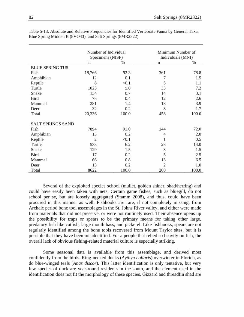
82 Salt Springs (8MR2322)
Table 5-13. Absolute and Relative Frequencies for Identified Vertebrate Fauna by General Taxa, Blue Spring Midden B (8VO43) and Salt Springs (8MR2322).
Number of Individual
Specimens (NISP)
Minimum Number of
Individuals (MNI) n % n % BLUE SPRING TU5 Fish 18,766 92.3 361 78.8Amphibian 12 0.1 7 1.5Reptile 8 <0.1 5 1.1Turtle 1025 5.0 33 7.2Snake 134 0.7 14 3.1Bird 78 0.4 12 2.6Mammal 281 1.4 18 3.9Deer 32 0.2 8 1.7Total 20,336 100.0 458 100.0 SALT SPRINGS SAND Fish 7894 91.0 144 72.0Amphibian 13 0.2 4 2.0Reptile 2 <0.1 1 0.5Turtle 533 6.2 28 14.0Snake 129 1.5 3 1.5Bird 17 0.2 5 2.5Mammal 66 0.8 13 6.5Deer 13 0.2 2 1.0Total 8622 100.0 200 100.0
Several of the exploited species school (mullet, golden shiner, shad/herring) and could have easily been taken with nets. Certain game fishes, such as bluegill, do not school per se, but are loosely aggregated (Stamm 2008), and thus, could have been procured in this manner as well. Fishhooks are rare, if not completely missing, from Archaic period bone tool assemblages in the St. Johns River valley, and either were made from materials that did not preserve, or were not routinely used. Their absence opens up the possibility for traps or spears to be the primary means for taking other large, predatory fish like catfish, large mouth bass, and pickerel. Like fishhooks, spears are not regularly identified among the bone tools recovered from Mount Taylor sites, but it is possible that they have been misidentified. For a people that relied so heavily on fish, the overall lack of obvious fishing-related material culture is especially striking.
Some seasonal data is available from this assemblage, and derived most
confidently from the birds. Ring-necked ducks (Aythya collaris) overwinter in Florida, as do blue-winged teals (Anas discor). This latter identification is only tentative, but very few species of duck are year-round residents in the south, and the element used in the identification does not fit the morphology of these species. Gizzard and threadfin shad are

Zooarchaeological Assemblage 83
Table 5-14. Relative and Absolute frequencies of Fish by General Taxa, Blue Spring Midden B (8VO43) and Salt Springs (8MR2322).
Number of Individual Specimens
(NISP)
Minimum Number of
Individuals (MNI) n % n % BLUE SPRING MIDDEN B Shark 3 0.1 3 0.8 Ray 2 <0.1 2 0.5 Gar 957 20.0 18 4.8 Bowfin 231 4.9 17 4.5 Eel 23 0.5 6 1.6 Shad/Herring 68 1.4 11 2.9 Pike 44 0.9 16 4.3 Shiner 248 5.2 30 8.0 Sucker 249 5.2 37 9.9 Shiner/Sucker 0 0.0 0 0.0 Catfish 323 6.8 39 10.4 Topminnow 0 0.0 0 0.0 Sunfish 2591 54.5 189 50.5 Mullet 14 0.3 6 1.6 Total 4753 100.0 374 100.0 SALT SPRINGS SHELL Shark 3 0.1 1 0.8 Ray 8 0.2 1 0.8 Gar 832 24.1 9 6.8 Bowfin 144 4.2 6 4.5 Eel 20 0.6 1 0.8 Shad/Herring 103 3.0 5 3.8 Pike 32 0.9 6 4.5 Shiner 89 2.6 6 4.5 Sucker 162 4.7 12 9.1 Shiner/Sucker 46 1.3 0 0.0 Catfish 241 7.0 23 17.4 Topminnow 30 0.9 5 3.8 Sunfish 1740 50.3 57 43.2 Mullet 7 0.2 1 0.8 Total 3457 100.0 132 100.0 SALT SPRINGS SAND Shark 0 0.0 0 0.0 Ray 1 0.1 1 0.7 Gar 599 38.1 9 6.3 Bowfin 36 2.3 7 4.9 Eel 3 0.2 1 0.7 Shad/Herring 17 1.1 5 3.5 Pike 10 0.6 5 3.5 Shiner 48 3.1 13 9.0 Sucker 73 4.6 16 11.1 Shiner/Sucker 27 1.7 1 0.7 Catfish 72 4.6 16 11.1 Topminnow 18 1.1 9 6.3 Sunfish 666 42.3 59 41.0 Mullet 3 0.2 2 1.4 Total 1573 100.0 144 100.0
84 Salt Springs (8MR2322)
year-round residents in the St. Johns, but the American shad, hickory shad, and blueback herring are anadromous species that ascend the river in order to reproduce typically during the late winter through spring (http://research.myfwc.com). Historically, annual shad and herring runs are associated with an enormous bounty, important not only for people, but aquatic predators as well. Although I was not able to confidently identify clupeid vertebrae beyond the level of family, morphological differences beyond size suggest there are several different species of shad and/or herring in the Salt Springs assemblage, particularly in the shell.
The subadult white-tailed deer from Stratum IB is anywhere from 1 to 1.5 years old, and was most likely captured sometime during the late spring through fall. The fragmentary nature of these seasonal indicators is supplemented by information gathered from the botanical assemblage (see Chapter 6). Hickory nuts were found throughout the sand stratum, and signal a typically fall resource. On balance, people were potentially depositing materials at Salt Springs year-round, and certainly at the site anywhere from two-thirds to three-fourths of the year. Missing from the vertebrate assemblage is a bona fide summer marker, but considering the relatively mild climate of subtropical Florida, this absence is not entirely surprising. Nailing down this part of the year most likely requires measures coming from other independent sources, such as the botanicals found at the site (Chapter 6), or isotopic signatures derived from mollusc shell chemistry.
CONCLUSION The Salt Springs vertebrate fauna assemblage is a highly diverse, and well-preserved cross-section of a lifestyle with considerable time depth in the river valley. Clearly centered on the procurement of aquatic resources, freshwater shellfish have long assumed to be the cornerstone of Mount Taylor subsistence economies. Certainly, shellfish were being eaten, but the scale of this consumption and the species involved is currently unknown. Without independent lines of data for identifying the remains of shellfish that were collected for food versus those that were collected dead, it is misleading to include the invertebrates within zooarchaeological analyses focused on subsistence practices. Otherwise, the contributions of the vertebrate classes get lost in the background. When examined on their own, the vertebrate fauna demonstrate that fishes are paramount. They routinely account for more than 75 percent of the total individuals, making fishes a more likely candidate for hallmark status than aquatic molluscs.
The overall picture is one of continuity through time. Changes in the proportions of the vertebrate classes are modest, and the composition of the fauna from the sand and the shell are virtually indistinguishable from one another. Similar patterns are seen elsewhere, specifically Blue Spring Midden B. The presence of shellfish in the upper strata of the trench most likely represents changes in spatial zones of deposition through time, but for now, we should leave open the possibility that they are a late-addition resource. Even if the latter scenario proves to be true, the addition of shellfish apparently had no bearing on an already established subsistence regime, suggesting that aquatic invertebrates were not the defining element of Mount Taylor foodways.
Zooarchaeological Assemblage 85
Variation within and across taxa does seem to suggest, however, changes in depositional practices. The rate of vertebrate fauna deposition was greater in the shell, and cannot be explained through volumetric differences alone. Likewise, the increase in fragmented bone within the shell is more likely a result of the practices leading up to its deposition rather than a by-product of taphonomic processes taking place in the sand. The distribution of fauna within Stratum IA currently supports the division of this deposit into two separate units. Encapsulating a rather robust sample, the Salt Springs assemblage nonetheless represents only a small window into the processes surrounding the procurement and deposition of vertebrate fauna at the site. Certainly, data from the terrestrial portions are necessary to better understand trends observed in the samples analyzed here.

86 Salt Springs (8MR2322)

CHAPTER 6 PALEOETHNOBOTANICAL ASSEMBLAGE
Johanna B. Talcott
Twenty-eight bulk sediment samples from strata of four alternating 1 x 1-m test units (TUs 1, 3, 5, and 7) of the trench at Salt Springs (8MR2322) were analyzed at the Environmental Archaeology Laboratory, Department of Anthropology, The Pennsylvania State University. Sample processing and analyses were conducted by the author, with considerable input and guidance from Dr. Lee A. Newsom, specialist in Paleobotany and Paleoethnobotany. An inventory of the individual bulk samples with their respective provenience information and volumetric measures can be found in Table 6-1.
MATERIALS AND METHODS
All bulk sediment samples underwent initial processing at the Laboratory of Southeastern Archaeology (LSA). Samples were first placed into a self-contained Flote-Tech flotation system and agitated in water to eliminate a majority of the soil matrix. Samples were then washed through nested geological sieves to divide them into size fractions (4 mm, 2 mm, and .425 mm1) that facilitated further processing, sorting, and analysis. The 4-mm fractions were separated entirely into different components (i.e., artifacts, faunal and botanical materials, etc.) and the 2-mm and .425-mm fractions were completely scanned in consecutive small batches placed in water in a glass petrie dish under a stereoscopic dissecting microscope (4x–30x magnification). All fruits, seeds and any other potentially identifiable botanical remains including wood, charcoal, thorns, flower parts, and inflorescences were removed from the samples for further analysis. Additional informative materials were also retained, including insect galls and tests, algal fruiting bodies, and fungal spores. Extracted materials were then transported to the Environmental Archaeology Laboratory at Penn State for further analysis.
Plant remains were assigned to the lowest possible taxonomic levels using a
variety of resources. This included published seed and plant identification manuals (Baxter and Copeland 2008; Delorit 1970; Martin and Barkley 1961), pertinent floras (Godfrey and Wooten 1979, 1980; Wunderlin and Hansen 2003), online resources (USDA-ARS 2011; Wunderlin and Hansen 2011) and the comparative collection housed in the Environmental Archaeology Laboratory. Most specimens could be definitively or provisionally assigned to the rank of family, and in many cases to genus or species. The abbreviation “cf.” is used to denote taxonomic assignments of a lesser degree of certainty. That is, the archaeological specimen strongly resembles the comparative materials, but is not identical, and may represent a different species or subspecies within the genus. A number of specimens are recognized as morphologically distinct, however it is not currently possible to assign them any taxonomic designation. These specimens have been categorized as “UNID” (unidentified) and numerically and categorically listed (e.g., UNID taxon 1 seed). Each of these specimens has been described and recorded
1 Conventional paleoethnobotanical methods typically include a 1 mm fraction sieve, however this screen size was forgone in order to expedite processing. 87

88 Salt Springs (8MR2322)
Table 6-1. Volume of Bulk Samples and Absolute Frequencies and Density Ratios of Seeds and Carbonized Wood by Test Unit and Strata of Trench at Salt Springs (8MR2322).
Provenience
Test Unit (TU)
Str-Level Bag
Sample Volume (liters)
Total Carb. Wood Count
Total Carb. Wood Weight
(g)
Total Carb. Wood
Density (gm/ltr)
Total Seed
Count
Total Seed Density
(seeds/ltr)
TU1 IA-A 36 13.5 5 0.2 0.01 6 0.44 IA-B 41 13.9 7 0.3 0.02 1 0.07 IA-C 55 13.9 61 4.39 IA-D 64 14.0 106 1.9 0.14 32 2.29 IB-A 70 13.8 173 4.1 0.30 29 2.10 II-A 78 13.3 413 9.3 0.70 14 1.05 II-B 84 14.0 480 86.2 6.16 47 3.36
Subtotal 96.4 1184 102.0 1.06 190 1.97
TU3 IA-A 34 13.2 1 0.1 0.01 2 0.15 IA-B 38 13.5 1 0.07 IA-C 44 13.2 16 0.3 0.02 42 3.18 IA-D 57 12.0 59 0.9 0.08 16 1.33 IA-E 63 14.1 206 4.9 0.35 88 6.24 IB-A 54 15.4 140 2.9 0.19 19 1.23 IB-B 61 13.0 411 8.4 0.65 8 0.62 II-A 75 14.6 796 30.0 2.05 231 15.82 II-B 82 14.5 194 13.38
Subtotal 123.5 1629 47.5 0.38 601 4.87
TU5 IA-A 52 12.8 5 0.3 0.02 2 0.16 IA-B 69 14.0 22 0.6 0.04 14 1.00 IA-C 77 14.4 22 0.5 0.03 81 5.63 IA-D 83 14.2 105 2.8 0.20 0.00 IA-E 86 13.8 1918 46.0 3.33 55 3.99 IB-A 90 13.9 488 15.9 1.14 288 20.72 II-A 93 14.9 1611 121.2 8.13 374 25.10
Subtotal 98.0 4171 187.6 1.91 814 8.31
TU7 IA-A 30 14.4 94 3.6 0.25 130 9.03 IA-B 43 14.0 200 9.2 0.66 442 31.57 IA-C 51 no vol. 316 14.8 382 IA-D 58 14.7 200 5.2 0.35 95 6.46 IA-E 65 14.8 991 46.2 3.12 92 6.22
Subtotal 57.9 1801 79.0 1.36 1141 19.71 TOTAL 375.8 8785 416.1 1.11 2746 7.31

Paleoethnobotanical Assemblage 89
with the expectation of future analysis and eventual identification. The descriptor “indeterminate” indicates botanical materials that lack any sufficient diagnostic characters that may be used to ascertain a taxonomic affiliation (i.e. unidentifiable).
Wood identifications were not a component of the current analysis and represent a
potential area of future investigation. The majority of the samples yielded significant quantities of carbonized wood fragments (see Table 6-1) and several samples also contained uncarbonized environmental woody debris. Additional analysis on the wood and charcoal remains could provide important information about local environmental conditions during the time period the site was occupied, as well as insight into human selective behaviors of fuel wood and wood resources.
The resulting data of this current study will ultimately be integrated with the
botanical data from the National Park Service excavations that were conducted in the spring of 2009 under the direction of Dr. Michael Russo. Numerous botanical samples (including three column samples) were drawn from those excavations and are currently undergoing processing and analysis by Dr. Lee A. Newsom (Co-PI) and the author (task agreement no. J3992-09-0503).
RESULTS
The 28 bulk sediment samples yielded an abundance of diverse plant remains,
which is the anticipated outcome of archaeobotanical sampling in submerged, anaerobic strata. Overall, 2641 seeds and other propagules were examined and categorized and are representative of 31 distinct botanical taxa. Additionally, eight unidentified, unique morphotypes were recognized and given the “UNID” designations explained above.
The concentrations and number of types of seeds and other propagules in TU1,
TU3, and TU5 increased significantly in the deeper levels (Table 6-1). The uppermost levels (associated with dense shell deposits and a fluctuating water table) contain sparse archaeobotanical materials and are dominated by taxa with seeds that have robust testae (seed coats), such as hackberry2, elderberry, and passionflower, or the remains are thoroughly carbonized (e.g. palmetto and Poaceae 1) (Table 6-2). The deepest levels, which comprised the submerged, shell-free sandy midden, contain a much broader diversity of seeds, including more delicate propagules (e.g., groundcherry, wild cucumber, and gourd/squash).
Consisting exclusively of Stratum IA-2, TU7 does not exhibit the stratigraphic
trend in concentrations of archaeobotanical remains observed in other units; rather the quantities of botanical materials are more uniformly distributed throughout the stratum. TU7 is the richest in botanical remains overall, in terms of both raw counts of seeds and propagules (n = 1141) and seed density (19.71 seeds/liter), and also has the second highest number of distinct taxa represented (n = 19). TU5 exhibited the greatest diversity with 25 different taxa, and has the second highest number of propagules (n = 814) and
2 Celtis sp. (hackberry) is commonly associated with shell middens. This taxon is notably absent from the deepest strata that predate the shell accumulation in the trench.

90 Salt Springs (8MR2322)

Paleoethnobotanical Assemblage 91

92 Salt Springs (8MR2322)

Paleoethnobotanical Assemblage 93

94 Salt Springs (8MR2322)
second highest density (8.31 seeds/liter). TU3 has the next highest number of propagules and density (n = 601 and 4.87 seeds/liter, respectively), followed by TU1 with 190 propagules and a density of 1.97 seeds/liter.
A comprehensive list of all identified plant taxa from the 28 Salt Springs samples is provided in Table 6-3 along with their respective growth habit and habitat information. Nearly all of the taxa can serve one or several economic uses for humans and most are known archaeologically and/or ethnohistorically in Florida and/or the Southeastern United States at large (Austin 2004). Table 6-4 summarizes the potential economic applications of the taxa represented in the Salt Springs archaeobotanical materials.
Out of the 31 identified taxa, ten are arboreal (trees and shrubs): Celtis sp. (hackberry), Sambucus canadensis (elderberry), Crataegus sp. (hawthorn), Gaylussacia sp. (huckleberry), Quercus sp. (oaks), Carya sp. (hickories), Magnolia grandiflora (southern magnolia), Myrica cerifera (syn. Morella cerifera), Sabal sp. (palmetto), and Serenoa repens (saw palmetto). Vines and lianas are represented by five different taxa: Cucurbita sp. (gourd/squash), Lagenaria sp. (bottle gourd) and Melothria pendula (wild cucumber) of the Cucurbitaceae family, Passiflora cf. incarnata (purple passionflower) and Vitis/Ampelopsis sp. (grape/peppervine). Two of the Cucurbitaceae genera, gourd/squash and bottle gourd, are of particular interest and significance because they may represent cultivated or managed plant taxa. This possibility will be discussed in further detail below.
Terrestrial herbs that occupy a variety of dry to moist environments include
Amaranthaceae (amaranth family), Chenopodium sp. (goosefoot), Acalypha sp. (threesead mercury/copperleaf), Poaceae (grass family), Phytolacca americana (pokeweed), Plantago sp. (common plantain), Polygonaceae (knotweed family), Portulaca sp. (purslane), and Physalis sp. (groundcherry). Four taxa from the Cyperaceae family represent terrestrial wetland herbs and include Carex sp. (sedge), Cladium jamaicense (swamp sawgrass), Rhynchospora sp. (beaksedge) and Scirpus sp. (bulrush). One single aquatic herb, Brasenia schreberi (watershield), was recovered from three of the bulk sediment samples.
Ubiquity is a simple presence/absence measure that characterizes the prevalence
of taxa within an archaeobotanical assemblage. It is expressed as the percentage of samples in which an individual taxon is present. Ubiquity values for the Salt Springs bulk sediment samples are listed on Table 6-3. The most ubiquitous taxa in this archaeobotanical assemblage are elderberry, palmetto, oak, hickory, passionflower, gourd/squash, hackberry, grape, blackberry, saw palmetto and groundcherry. The majority of identifiable remains were in fresh (uncharred) condition, however extensive charring of botanical materials was noted in TU5, STR IB-A and II-A (Bags 90 and 93). This is associated with a notable increase in the density of carbonized wood (also detected in the deepest strata of TU1).
Five highly degraded seed fragments recovered from Bags 75, 78, 82 and 84 are
remarkably similar in size, shape, color and texture to modern comparative specimens of Plantago major (Plantaginaceae), the common plantain. The assignment of

Paleoethnobotanical Assemblage 95
Table 6-3. Taxa List from Salt Springs Archaeobotanical Assemblage.
Family Genus, Species Vernacular Habit Habitat Ubi-quity
Arboreal Taxa
Sabal sp. palmetto trees and shrubs
Scrubs; savannas; moist to wet hammocks and swamps
78%Arecaceae
Serenoa repens saw palmetto trees and shrubs
Wet to dry flatwoods and hammocks
26%
Cannabaceae Celtis sp. hackberry deciduous trees
Shell middens; floodplain forests; dry to mesic, rocky, upland hammocks
30%
Caprifoliaceae Sambucus canadensis
elderberry small tree or large shrub
Wet, open hammocks; floodplain forests; swamps; and wet, disturbed sites
81%
Ericaceae cf. Gaylussacia sp.
huckleberry deciduous or evergreen shrubs
Acidic swamps, bogs, marshes; flatwoods
4%
Fagaceae Quercus sp. oak trees Scrubs; sandhills; flatwoods; mixed mesic hammocks; floodplain forests
52%
Juglandaceae Carya sp. hickory trees Dry, deciduous to mesic hammocks; floodplain forests; scrub and xeric sandhills
44%
Magnoliaceae Magnolia grandiflora
southern magnolia
large, evergreen tree
Upland forests; ravine slopes and bottoms; mesic to hydric hammocks; floodplains
4%
Myricaceae Myrica cerifera (Syn. Morella cerifera)
wax myrtle small tree or shrub
Fresh to slightly brackish wetlands; inter-dune swales; pine savannas, cypress-gum ponds and swamps; hydric hammocks; upland mixed hardwoods
4%
Crataegus sp. hawthorn trees and shrubs
4%Rosaceae
Rubus sp. blackberry shrubs
Moist to wet hammocks; swamps; floodplain forests; pond margins
26%
Vines and Lianas Cucurbita sp. gourd/squash perennial
vines 37%
Lagenaria sp. bottle gourd perennial vines
11%
Cucurbitaceae
Melothria pendula
wild cucumber slender, trailing, low-climbing, perennial vines
Various dry to moist, disturbed habitats
4%

96 Salt Springs (8MR2322)
Table 6-3. continued.
Family Genus, Species Vernacular Habit Habitat Ubi-quity
Vines and Lianas, continued Passifloraceae Passiflora cf.
incarnata purple passionflower
perennial herbs and climbing vines
Various dry to moist habitats
41%
Vitaceae Vitis/Ampelopsis sp.
Wild grape/peppervine
lianas (woody vines)
Various wooded habitats 26%
Terrestrial herbs, dry-moist
amaranth family
herbs 4%Amaranthaceae/ Chenopodiaceae
Chenopodium sp.
Goosefoot herbs
Moist to wet areas; floodplains; disturbed habitats
11%
Euphorbiaceae cf. Acalypha sp. Threeseed mercury/ copperleaf
forb/herb Moist, disturbed habitats 4%
Poaceae 1 charred, robust spikelet
4%
Poaceae 2 infloresence
grasses annual or perennial herbs
Various habitats
4%
Phytolaccaceae Phytolacca americana
pokeweed coarse, glabrous, perennial herb
Various well-drained to wet, disturbed habitats
7%
Plantaginaceae cf. Plantago common plantain
perennial herb Disturbed sites 15%
Polygonaceae knotweed family
perennial herbs
various dry to wet, disturbed habitats
4%
Portulacaceae Portulaca sp. Purslane annual herb dry to moist, disturbed sites 4%
Solanaceae cf. Physalis sp. Groundcherry perennial herb Floodplain forests; open hammocks; sandhills and flatwoods
26%
Terrestrial herbs, wetlands
cf. Carex sedge perennial herbs
7%
Cladium jamaicense
swamp sawgrass
leafy-stemmed perennial herb
7%
cf. Rhynchospora
beaksedge annual or perennial herbs
4%
Cyperaceae
cf. Scirpus bulrush perennial herbs
Various mesic to wet habitats; freshwater or brackish
15%
Aquatic herbs
Cabombaceae Brasenia schreberi
water-shield aquatic herb freshwater lakes, ponds, slow streams
15%

Paleoethnobotanical Assemblage 97
Table 6-3. continued.
Family Genus, Species Vernacular Habit Habitat Ubi-quity
Habits and Habitats Unknown
UNID taxon 1 anthers
15%
UNID taxon 2 seed
4%
UNID taxon 3 seed
4%
UNID taxon 4 seed
4%
UNID taxon 5 bract
4%
UNID taxon 6 thorn
4%
UNID taxon 7 bract
4%
UNID taxon 8 seed
4%
(Godfrey and Wooten 1979, 1980; Wunderlin and Hansen 2003)
Table 6-4. Potential Economic Uses of Taxa from the Salt Springs Bulk Sediment Samples.
Taxon Vernacular Potential Economic uses Fruiting Season
cf. Acalypha sp. threeseed mercury/ copperleaf
medicinal fruits Summer-fall
Amaranthaceae/ Chenopodiaceae
amaranth family edible seeds and greens
Brasenia schreberi water-shield none documented Summer
cf. Carex sedge basketry materials Spring-summer
Carya sp. hickories edible nuts; dyes; construction and basketry materials
Spring
Celtis sp. hackberry edible fruits and seeds; medicinal bark and fruits; abortifascient; construction materials
Spring
Chenopodium sp. goosefoot edible seeds and greens; Eastern Woodlands domesticate - C. berlandieri
Spring-summer
Cladium jamaicense swamp sawgrass medicinal fruit; edible apical meristem; stem - medicine blowing tube; basketry materials
Summer-fall
Crataegus sp. hawthorn edible fruit; medicinal bark and roots Spring

98 Salt Springs (8MR2322)
Table 6-4. continued.
Taxon Vernacular Potential Economic uses Fruiting Season
Cucurbita sp. gourd/squash edible fruits and seeds; containers, vessels, scoopers, ladles; rattles
Spring-summer
cf. Gaylussacia sp. huckleberries edible fruits; medicinal fruits Spring
Lagenaria sp. bottle gourd edible fruits and seeds; medicinal fruit, seeds and roots; containers, cooking vessels, scoopers, ladles; rattles
Spring-summer
Magnolia grandiflora
southern magnolia medicinal bark; construction materials Spring-summer
Melothria pendula wild cucumber edible fruits; medicinal leaves Spring-fall
Myrica cerifera (Syn. Morella cerifera)
wax myrtle flammable wax; seasoning; medicinal bark Spring-fall
Passiflora cf. incarnata
purple passionflower
edible fruits and seeds; medicinal roots Spring-summer
cf. Physalis sp. groundcherry edible fruits; medicinal fruits, leaves and sap
Year round
Phytolacca americana
pokeweed edible vegetable; dye; medicinal berries, leaves and roots
Spring-fall
cf. Plantago common plantain medicinal Spring-summer
Poaceae grasses edible grains, basketry materials
Polygonaceae knotweed family medicinal Spring-fall
Portulaca sp. purslane medicinal Spring-fall
Quercus sp. oaks edible nuts; dyes; construction and basketry materials; oils
Spring
cf. Rhynchospora beaksedge none documented
Rubus sp. blackberry edible fruits; medicinal roots and leaves Spring
Sabal sp. palmetto thatch; edible fruits and vegetable; fibers; fish poison
Spring-fall
Sambucus canadensis
elderberry edible flowers; medicinal fruits Spring-fall
cf. Scirpus bulrush fibers; basketry materials Year round
Serenoa repens saw palmetto thatch; edible fruits and vegetable; fibers; fish poison; basketry materials
Spring-summer
Vitis/Ampelopsis sp. wild grape/ peppervine
edible fruits and vegetable; medicinal fruits and leaves
Spring-summer
Austin 2004; USDA-ARS 2011

Paleoethnobotanical Assemblage 99
Plantaginaceae cf. Plantago is highly tentative given the small sample size and immensely degraded condition of the seeds. Figure 6-1 depicts a micrograph comparing six modern Plantago major seeds to three of the archaeological specimens from Bag 75.
DISCUSSION
The disparities in archaeobotanical remains between different test units and
between strata within individual excavation units most likely reflect differential preservation of the organic materials under different taphonomic conditions rather than variation in the selection and use of biotic resources by site occupants. For the deposits closest to shore (i.e., TUs 1 and 3), it is presumed that many of the same taxa present in the deeper, subshell strata and not the uppermost shell strata were utilized at least somewhat consistently throughout the occupation of the Salt Springs site, but differential preservation from repeated periods of aqueous inundation and drying, as well as mechanical weathering of the sediments and materials, have eliminated much of the evidence of their use. Nonetheless, the sizeable assemblage from TU7—the farthest from the shoreline and least subject to intermittent drying—is also the latest to accumulate in the trench, making its comparison to the older, deeper strata a reliable indicator of relative change, or lack thereof, through the ca. 800 years of near-shore accumulation.
Several taxa produce soft, fleshy fruits that are likely to have been consumed as
foodstuffs, including passionflower, grape, blackberry, wild cucumber, and palmetto.
Figure 6-1. Modern Plantago major (common plantain) seeds (bottom row) and archaeological cf. Plantago specimens (top row).

100 Salt Springs (8MR2322)
Oak and hickory nuts have been documented both archaeologically and ethnohistorically as a valuable source of nutrition throughout the Eastern Woodlands (Abrams and Nowacki 2008; Gardner 1997), however the abundance, ubiquity and condition (i.e. largely whole and not lacking edible parts) of both taxa in the samples from the NPS Salt Springs excavations suggest that the presence of these taxa largely indicate environmental debris. The oak and hickory remains from these samples are mostly fragmentary, not lacking edible portions, and are relatively sparse in comparison. Some specimens are charred, which may be indicative of human processing, but ultimately it is difficult to make a fully informed determination regarding their function and use. Leaves of some of the herbaceous species, such as goosefoot and pokeweed, as well as the leaves of the grape/peppervine, can be consumed as a vegetable. The goosefoot from these samples is closely related to the taxon that was domesticated as a food crop in the Eastern Woodlands during the Archaic period, however the seeds lack morphological features (e.g., truncate margin) that would be indicative of domestication (Smith 2005a, 2006, 2009).
The most ubiquitous taxon in this assemblage by a large margin is elderberry
(Figure 6-2), which is present, sometimes in very large amounts, in 87 percent of the samples. This may be at least partially a function of the tough, sclerenchymatous seed coat that would readily facilitate long-term preservation of elderberry seeds in the archaeological record, whereas other botanical materials might rapidly decompose. This may certainly be the case in the upper strata closest to the shoreline, where there is a relative dearth of other taxa represented. The ubiquity of elderberry may also be
Figure 6-2. Archaeological Sambucus canadensis (elderberry) seeds.

Paleoethnobotanical Assemblage 101
attributable to its myriad medicinal uses and reflects frequent exploitation by the human inhabitants of the Salt Springs site. Elderberry berries, roots, bark and leaves contain cyanogenic glycosides that have anti-inflammatory, antibacterial, diuretic, diaphoretic and laxative properties, and is documented in numerous ethnohistorical accounts (Austin 2004:593). Elderberry fruits are mildly toxic if consumed fresh.
Archaeological evidence for the use of elderberry as a medicinal plant during the
Archaic period was discovered at the Windover Pond burial site (Doran 2002). A sample taken from the abdominal area of an adult female skeleton with evidence of extensive bone cancer and osteoarthritis contained 2,753 elderberry seeds, as well as remains from nightshade (Solanum sp.) and holly (Ilex sp.) (both taxa also have medicinal properties) and seeds from other soft, pulpy fruits. Nearly all of the seeds in the abdominal sample were whole, suggesting that the berries were not chewed (as might be expected if they were consumed fresh), but more likely ingested whole as part of a liquid medicinal concoction just prior to the individual’s death (Newsom 2002:201).
In the deepest strata of all four excavation units, elderberry is associated with
large numbers of seeds from other fleshy fruits such as passionflower, blackberry, palmetto, groundcherry, and grape/peppervine. It is indeed feasible that if a large quantity of elderberry fruits, possibly along with other fleshy fruits and medicinal plant structures (i.e. root, bark, leaves), were crushed and then brewed, steeped or fermented into a beverage, that considerable amounts of whole and fragmentary seeds would remain as dregs in the bottoms of vessels used for cooking or consumption. The dregs might then be dumped into a hearth or midden context for disposal. It is difficult to say with any certainty that this is an accurate explanation for the concentrations of elderberry and other seeds in these samples, however it can be assumed that if the fruits from these taxa were consumed whole and fresh, that the seeds would have entered the digestive systems of those consuming them and been retained within feces rather than freely deposited into a midden. The conditions in these submerged contexts are excellent for the preservation of paleofeces (and indeed, many specimens were recovered), however none were analyzed in the course of this study. The samples from TU5, STR IB-A and II-A (Bags 90 and 93) that exhibited a high degree of charring and were associated with increased carbonized wood density may be indicative of a single episode of secondarily deposited materials swept up from a hearth.
Seed remains and a single button (pericarp flower scar) of two important economic plant taxa from the family Cucurbitaceae, Lagenaria sp. (bottle gourd) and Cucurbita sp. (gourd/squash), are present throughout the Salt Springs bulk sediment samples. Both were recovered exclusively from the deeper strata, which is most likely a function of the preservation bias discussed above. Gourd/squash is fairly ubiquitous (37 percent) while bottle gourd is only present in three samples (11 percent ubiquity). Bottle gourd and gourd/squash are among the earliest and most widely geographically distributed economic plant species. Both taxa were components of the Eastern Horticultural Complex (Smith 2005b; Smith and Yarnell 2009) and cultivated in the earliest Mesoamerican proto-agricultural economies (Flannery 1986; MacNeish 1992; Smith 1997, 2005a). Gourd/squash is known to have been endemic to Florida well before the arrival of humans (Newsom et al. 1993; L. A. Newsom, personal communication,

102 Salt Springs (8MR2322)
2010), however the New World origin of the bottle gourd, which is known to have originated in Africa (Decker-Walters et al. 2004), remains relatively poorly understood. There are two prevailing theories regarding how bottle gourd was dispersed into the New World. Ancient DNA analysis suggests that New World bottle gourds were introduced fully domesticated by colonizing Paleoindians (Erickson et al. 2005). Another potential mechanism for the dispersal of bottle gourd into Florida and the rest of the New World is that mature wild fruits drifted on ocean currents to the North American Atlantic and/or Gulf coasts directly from Africa and/or South America, where it was then retrieved by humans and broadly dispersed inland and beyond (Heiser 1979; Newsom 2002). One issue confusing the question of bottle gourd domestication is the uncertain criteria typically used to classify archaeological bottle gourds as either wild or domesticated, given a dearth of archaeological evidence and the existence of only one known extant wild bottle gourd population in the world (Decker-Walters et al. 2004). Provided the thin, friable rind of this wild bottle gourd (estimated at 1–1.5 mm) and of other closely related species of Lagenaria, a rind thickness threshold of 2 mm is commonly used, based on the assumption that humans actively selected for thicker rind during the process of bottle gourd domestication (Erickson et al. 2005). In the wild, bottle gourds benefit from a thinner rind, to ensure that a fully matured bottle gourd will easily break open and its seeds will be dispersed. Before the invention of pottery, dried bottle gourds would have served as portable, lightweight and readily replenishable containers, and a thicker rind would have been preferable to increase stability and reduce breakage and loss. Bottle gourd was present at numerous archaeological sites in Japan and China by at least 9000 years BP in both wild and domesticated forms, as determined by rind thicknesses (Fuller et al. 2010). Most bottle gourd rind remains recovered from the New World, including Florida3, have rind thicknesses between 2 and 7 mm, which provides the basis for the assertion that they entered the New World already domesticated (Erickson et al. 2005).
The limited bottle gourd remains found in this analysis are highly fragmentary; no whole seeds were recovered. However, it was possible to ascertain a general idea of the morphology of the bottle gourd seeds based on this limited data. The seeds are consistent in size and shape with archaeological specimens recovered from other sites within Florida, which have previously been considered wild due to their considerably smaller size than most domesticated bottle gourd seeds and lack of certain morphological features (Cutler 1978; Newsom 1987, 1994, 2002). However, the range of variation of modern domesticated bottle gourds, in terms of fruit, seed and flower morphology, is immense (Heiser 1973, 1979) and, as noted by Newsom and Scarry (2002), there is exceptionally limited evidence (archaeological and modern comparative) with which to assess such characterizations. The bottle gourd rind thicknesses from the previous Salt Springs excavations mostly fell below the 2 mm domestication threshold, but this may reflect normal variation of individual bottle gourd fruits (whether wild or domesticated) (Talcott 2010). The domestication status of the Salt Springs bottle gourd seed assemblage is considered unknown, pending further analyses.
3 A nearly whole bottle gourd from the Windover Pond site in northern Florida varied in rind thickness from 2.35-3.45 mm, with a mean thickness of 3.0 mm (Newsom 2002:203). Rind thickness measurements from the Groves’ Orange Midden site are: 1.62 mm, 2.30 mm, 2.94 mm and 2.45 mm (Newsom 1994:415).

Paleoethnobotanical Assemblage 103
Gourd/squash is relatively ubiquitous throughout the samples, however the majority of these remains are highly fragmented and degraded, with only portions of the marginal bulge or sinus remaining. Bag 93 (TU 5, STR II-A) is an exception to this, with 11 whole or nearly whole seeds available for more definitive taxonomic assignment and some limited morphometric analyses (Figure 6-3). These few, mostly whole gourd/squash seeds are morphologically similar to Cucurbita pepo ssp. ovifera, based on the smoothly curving seed margins, blunted seed sinus and nearly rounded shape (Decker and Newsom 1988; Newsom et al. 1993; Newsom and Scarry 2002). The mean length of eight of these seeds is 8.88 mm and the mean width of three seeds is 5.90 mm. These dimensions are consistent with those of the numerous Cucurbita seeds recovered from the NPS excavations at Salt Springs (mean length: 8.08 mm; mean width: 5.49 mm; n=104) (Talcott 2010:48).
Figure 6-3. Archaeological Cucurbita sp. (gourd/squash) seeds.
Both Cucurbita assemblages from Salt Springs are notably smaller, on the average, than assemblages recovered from other Florida archaeological wet sites, including two that predate human occupation (Talcott 2010:48). Average lengths and widths of Cucurbita seeds from Hontoon Island, Grove’s Orange Midden, Page-Ladson, and Pineland Old Mound range from 9.28 mm to 9.88 mm and 6.27 mm to 6.65 mm, respectively (Newsom 1987, 1994, 2006; Newsom and Scarry 2002). It is possible that

104 Salt Springs (8MR2322)
some populations of gourd/squash were grown or managed at the Salt Springs site for specialized purposes (such as fishnet floats or ceremonial rattles) that would have warranted the maintenance of smaller-fruited gourd/squashes. It is also possible that these seeds are representative of a not yet described landrace or cultivar that has subsequently been manipulated into larger sizes or left (escaped) human possession and gone extinct.
Low-level production of wild biotic resources is increasingly considered in
archaeological investigations of populations that might be conventionally described as strictly non-agricultural hunter-gatherers, given the absence of clearly domesticated plant taxa (Lepofsky 2009; Lepofsky and Lertzman 2008; Smith 2001; Talcott 2010). Gourd/squash and bottle gourd represent two taxa that are ideally suited for casual maintenance and cultivation by semi-sedentary or mobile populations (Hanselka 2010). Ongoing fine-grained chronological and morphometric analyses on the Salt Springs gourd/squash and bottle gourd assemblages, as well as further archaeological investigations aimed towards understanding the biogeography and New World origins of the bottle gourd, are anticipated to shed light on this subject and reveal whether both taxa were undergoing active maintenance and cultivation, and perhaps incipient domestication, that induced changes in seed size and morphology over time.
SEASONALITY
All of the identifiable taxa have flowering/fruiting periods in spring-summer or summer-fall (Table 6-4). If the assumption is held that the botanical materials from the Salt Springs bulk sediment samples were deposited principally through anthropogenic rather than natural means, it is reasonable to infer that the site may have been inhabited seasonally – from the spring to the fall – rather than serving as a sedentary, year-round settlement. It should be recognized, however, that the mere absence of data supporting winter habitation is insufficient in making this a definitive conclusion and additional analyses are necessary for completely answering such questions of sedentism and seasonality.
CONCLUSION The abundant and diverse Salt Springs botanical assemblage strongly underscores the value of investigations into Florida’s submerged archaeological deposits. The assemblage is dominated by taxa that are both naturally occurring in moist or riparian environments and also served a broad array of economic functions. This assemblage may be considered reasonably representative of Archaic subsistence practices and is consistent with results from previous research (e.g. Newsom 1987, 1994, 2002; Newsom and Scarry 2002). The abundance of elderberry is notable for its documented medicinal purposes. The presence of gourd/squash and bottle gourd contribute to ongoing investigations into the biogeography and domestication status of both taxa. Continued investigations into similar submerged contexts throughout Florida will be critical for obtaining a more complete picture of Archaic lifeways and the complexities of prehistoric exploitation of botanical resources.
CHAPTER 7 CONCLUSIONS
Kenneth E. Sassaman, Jason M. O’Donoughue,
Meggan E. Blessing, and Johanna B. Talcott Archaeological excavations at Salts Springs (8MR2322) in 2009 investigated well preserved shoreline and near-shore deposits dating to the Middle Archaic Mount Taylor period (ca. 7300–4600 cal B.P.). An 8-m-long trench excavated by a crew of the Laboratory of Southeast Archaeology (LSA) bisected a near-shore deposit exposed by a coffer dam emplaced to repair infrastructure of the recreation area. Well-stratified midden exposed in the trench spans the interval 6600–5800 cal B.P. and registers the deposition of shell-rich matrix over shell-free sands, both containing artifacts, animal bone, and plant remains.
All of midden in the trench appears to have been deposited in open water and has since remained submerged or at least saturated, with the exception of the upper portion closest to shore, which occasionally dried with periodic drawdows of the spring pool. Regrettably, we know little about the formation and structure of terrestrial deposits at this site. We do know, however, that the near-shore deposit we uncovered prograded outward toward the spring pool, as it accreted upward, much like the Mount Taylor deposits at Groves Orange Midden (McGee and Wheeler 1994). We also know that this process elapsed over several centuries, apparently gradually, with no obvious instances of massive deposition, such as we have seen at Mount Taylor mounds in and around Hontoon Island (Randall and Sassaman 205; Sassaman 2003a). If we were to suggest that the stratigraphic break evident in the addition of shellfish remains to the midden reflected a major change in subsistence or ecology, we would be at a loss for substantiating the claim with independent data. Indeed, the 800 or so years of near-shore deposition seems to have elapsed with no major changes in water levels, nor in the accumulation of vertebrate fauna and plant remains.
In this closing chapter we explore a few of the implications of our Salt Springs project for a broader understanding of Mount Taylor history. Recent work in Mount Taylor archaeology has centered on monument construction and related ritual practice (Beasley 2008; Endonino 2010; Randall 2010). This new direction is a radical departure from studies that have emphasized the ecological dimensions of Mount Taylor culture. As reviewed in Chapter 1, Mount Taylor has long been regarded as the outcome of environmental changes enabling the emergence and florescence of freshwater aquatic habitat in northeast Florida (e.g., Miller 1998). Although there may be abundant evidence for the association between intensified riverine/lacustrine settlement and wetter conditions in the early to mid-Holocene, we hesitate to assign causality to such an association because we lack good precision on the initial timing of riverine/lacustrine settlement, and, thanks to recent work on Mount Taylor monuments, we appreciate that factors besides subsistence influenced the deposition of shell. We are thus skeptical of the notion that the onset of shellfishing signals an emergent new subsistence regime in
105
106 Salt Springs (8MR2322)
the St. Johns Basin because it appears to have been directed occasionally toward demands other than eating.
DEPOSITION OF SHELL
Taken at face value, the profile of near-shore deposits at Salt Springs suggests that
shellfish were added to an established, aquatic-based subsistence regime. Radiometric assays enable us to estimate that this apparent change ensued about 6300–6200 cal B.P., some three centuries after anthropogenic deposition began to accumulate along the edge of the spring pool. If we had excavated a small, square test unit (i.e., “telephone booth”) and retrieved a subsistence column, we may have been persuaded by the textbook stratigraphy to infer that shellfish were added late to the menu because they were either not available prior to 6300–6200 cal B.P., or because they were a low-ranking food choice, adopted only when the returns on higher-ranking foods diminished (i.e., diet breadth model). Let us consider these two assertions in light of Mount Taylor deposits elsewhere in the region.
The Timing and Context of the Region’s Oldest Shell Deposits
Figure 7-1 illustrates the two-sigma ranges of radiometric assays from organic matter collected from Mount Taylor contexts in the middle St. Johns region. Most of the data points shown in this graph are from shell-bearing contexts, although a few are from sub-shell-midden strata, such as the two from Stratum II at Salt Springs. The oldest assays on shell strata come from sites on and around Hontoon Island (Sassaman 2003a; Randall 2007; Randall and Sassaman 2005; Sassaman and Randall n.d.), some 65 km southwest of Salt Springs. Ten assays from these sites fall in the range of ca. 7400–6700 cal B.P., all but one associated with massive accumulations of shell at Hontoon Dead Creek (8VO214) and Live Oak mounds (8VO41).
Two other locations contain anthropogenic shell deposits as old as or slightly
younger than those in the Hontoon Island locality. The basal, subaqueous sand stratum at Groves Orange Midden (8VO2601) produced datable organics coeval with mound accumulation at Hontoon Dead Creek and Live Oak mounds, although McGee and Wheeler (1994) decline to interpret these as primary deposition. Whether the result of primary or secondary deposition, artifacts and food remains were recovered in these subaqueous sands and unless the organic matter dated was unaffiliated with human activity, the age estimates stand as early Mount Taylor activities at the site, including the deposition of freshwater shell (mostly Viviparus).
The third location of early shellfish deposits is Harris Creek (8VO24) on Tick
Island, some 45 km southwest of Salt Springs and 18 km northwest of Hontoon Island. Known for its mortuary mound complex consisting of alternating shell, sand, muck, and burial clusters, Harris Creek was first a locus of occupation resulting in a shell-bearing midden that was later buried by the mound (Aten 1999). Radiometric dating of Harris Creek components remains problematical, but if the four AMS assays on human bone obtained recently by Tucker (2009) are accepted uncritically, then the mortuary

Conclusions 107
Figure 7-1. Radiometric assays from sites of Mount Taylor age in the middle St. Johns River valley, shown as two-sigma ranges of calibrated age. Bars in grey pertain to shell-free deposits; all others signify assays associated with the remains of freshwater shellfish.
program dates as early as the shell mounds upriver, making the underlying shell midden even earlier. Even if we were to lay aside these assays due to potential incompatibility with assays obtained on wood or charcoal, we still have the age estimates obtained by Ripley Bullen—who salvaged burials from the site as it was being mined for shell—that likewise suggest that the underlying shell midden dates to the earliest centuries of

108 Salt Springs (8MR2322)
shellfish collection and deposition in the region. Parenthetically, if Harris Creek represents a region-wide program of mortuary mounds involving shell, then Hontoon Dead Creek and Live Oak mounds—two of the few mounds that escaped mining—may likewise have mortuary complexes encased in shell.
More than sufficient data are available to conclude that the onset of shellfish
collection and deposition in the greater St. Johns region predates the first appearance of shell in the trench at Salt Springs by a full millennium. It follows that the appearance of shell in the Salt Springs trench does not coincide with the onset of ecological conditions suited to shellfish production in the region. However, the apparent late appearance of shell in the trench at Salt Spring may indeed signal a local change in the availability of freshwater shellfish, a point to which we will return in the section on subsistence below.
The Structure and Scale of Early Shell Deposition
Before continuing with any consideration of the food value of shellfish and what
this may have to say about local and regional ecologies, we are compelled to consider variation in the structure and scale of shell deposition at Mount Taylor sites. The oldest shell deposits in the region are from massive accumulations with internal structure indicative of nonrandom deposition. Those pertaining to human interments (e.g., Harris Creek) clearly fit this bill, but so too do those without clear evidence of mortuary uses (e.g., Live Oak and Hontoon Dead Creek mounds). Age estimates on mound sequences as deep at 5 m suggest that some mounded deposits accumulated rapidly, in as little as a couple of centuries (Sassaman and Randall n.d.), and they include shell strata consisting of unusually small Viviparus shells, little associated vertebrate fauna, and limited clastic matrix.
As big and as purposeful these early mounds may have been, they appear to have
started off as locations of dwelling (like Harris Creek), places that received primary and secondary deposits of shell intermixed with vertebrate fauna, ash, plant remains, paleofeces, earth, and artifacts. Asa Randall (2007, 2010) has documented what these initial midden deposits may have looked like at Hontoon Dead Creek village (8VO215), just south of Hontoon Dead Creek Mound. In size, shape, and composition, these deposits have the appearance of house mounds. Crushed shell lenses attest to trampling and related processes of communition along successive, stacked surfaces.
No matter the context and purpose of deposition, as shell continued to be
emplaced in the same locations, growing higher with successive loads, it necessarily expanded outward. Naturally, side slopes eventually reached the water’s edge for deposits emplaced proximate to shorelines. We have seen enough of these stream- and lake-side deposits to know that the landward edges of mounded shell are generally sharply demarcated from the surrounding substrate and topography. In contrast, the waterfront facies consist of commingled primary and secondary refuse, often with crushed shell lenses indicative of trampling. Both the progradation of midden/mound deposits outward and fluctuations in water levels are registered in these shoreline deposits, as is occasionally evidence of human traffic in and out of the water.
Conclusions 109
The initial shell stratum in the trench at Salt Springs (Stratum IB) has the consistency of trampled shell and it contains considerable animal and plant remains. We imagine that this was the initial expansion of midden apron associated with a house mound just to the north of the shoreline. Based on AMS age estimates, little accumulated in the location of the trench over two to three centuries, and it may very well have been a longstanding pathway in and out of the water. The overlying shell stratum (Stratum IA) was laid down much more rapidly than before, commencing shortly after 6000 cal B.P. Shell was likely being piled up in the same location as the house mound, but we do not have any clear sense of the scale of these depositional events. However, it does not appear that shell was emplaced over midden deposits in the manner of Harris Creek, Hontoon Dead Creek, or Live Oak mounds. That is, the upper shell stratum in the trench at Salt Springs does not vary in any significant fashion from what lies beneath it in terms of associated food debris, artifacts, and the like. If anything, the upper shell stratum, particularly at the south end of the trench, reflects more intensive midden deposition because it encases some of the densest vertebrate faunal remains, and the vast majority of the stone and bone/antler artifacts. As discussed in Chapter 6, the relatively limited plant remains in the upper shell stratum is most likely due to differential preservation attending fluctuations in water levels that exposed the northern end of the trench deposit. We underscore that the same shell stratum at the southern end of the trench housed a paleoethnobotanical assemblage not much different than those from the sands below.
There is little to recommend that the addition of shell in the trench profile of Salt
Springs signals a major change in the depositional practices of inhabitants or in the regional availability of shellfish. We would imagine that shellfish were collected throughout the history of Mount Taylor use of the site, but during the first couple of centuries it did not find its way to this particular location. Whereas this may be seen simply as a matter of site formation—the unintended consequence of piling shell higher—we underscore that Mount Taylor communities quite often piled shell up intentionally (over burials, as well as “abandoned” settlements), and whether ritualized or not, they were often fastidious with the emplacement of shell at locations of presumed habitation. Thus, while we cannot substantiate the assertion that the upper stratum of shell in the trench was emplaced as part of a broad restructuring of the shoreline landscape (e.g., capping a locus of habitation, or devoting it to human interment), we suspect it signals eventful change and note again that it appears to have elapsed without any measurable change in subsistence.
SUBSISTENCE AND ECOLOGY
As is now widely acknowledged, the vertebrate faunal assemblages of Mount
Taylor middens in the St. Johns region are dominated by the remains of fish. As discussed in Chapter 5, fish are often swamped by shellfish, even when fine-screened recovery allows for the maximum representation of the former (e.g., Russo et al. 1992). If we allow that most, if not all, of the shellfish found at Mount Taylor sites was consumed, then by setting aside this resource in calculating the relative frequencies of animal food resources, we indeed have introduced a terrible bias. But the opposite may

110 Salt Springs (8MR2322)
be even more debilitating: to count as food every gastropod and clam shell at the site, when we simply do not know that to be the case.
To apply the logic of subsistence to the interpretation of plant and animal remains
at Salt Springs is to consider that every edible resource in the shell, bone, and plant inventory had nutritional benefits and that these benefits could be compared to the costs of acquiring and processing them to determine their relative rank in the diet. As applied in the diet breadth model, this logic enables a cost-benefit analysis that would explain the nonrandom use of all available edible resources. Again, this would appear to be a reasonable hypothesis to explain the adoption of shellfish, both regionally and at the local level. However, we have absolutely no supporting evidence to suggest that shellfish were adopted because other, higher-ranking options suffered comparatively less return through time (e.g., resource depression). As far as Mount Taylor history is concerned, shellfish were always collected and deposited along the St. Johns, just not always (or even mostly) because they were eaten.
The overall pattern of subsistence we can infer from the vertebrate fauna and
plant remains from the trench is one of continuity. Can we take this further to suggest that the local environment was equally stable over the ca. 800 years of deposition in the trench? Perhaps. We acknowledge that water levels in the pool have fluctuated since the time the trench deposits were laid, although we do not believe they were dry much before or during the ca. eight centuries of deposition. We also acknowledge that midden accumulation no doubt had its own effects on local ecology, yet apart from enhanced habitat for hackberry trees, no measurable outcomes are found in plant and animal remains from the site.
Establishing that the pool at Salt Springs was well-watered long before the Mount
Taylor period and that it did not undergo any major disruptions over the centuries of use registered in midden deposition says nothing about the suitability of the immediate habitat for resources of economic value. An implicit assumption in analyses of hunter-gatherer diet is that food resources are collected from the immediate environment (with the possible exception of large game, which may have required long forays from locations of habitation). Whereas the assumption of local collecting may be acceptable for just about every aquatic animal resource in the Salt Spring inventory, spring pools themselves are not necessarily the best locations for Viviparus (see Chapter 2). Granted, excellent habitat for Viviparus can be found only short distances down the spring run, where higher levels of dissolved oxygen, greater detritus, and lower salt levels exist. Transporting Viviparus is of course not difficult due to its small size and weight, but we hasten to note that under logic that discounts the rank of foods as relative costs increase, Viviparus was either more valuable than its limited food capacity would suggest or its use at Salt Springs truly signifies a level of intensification attending diminished returns on other foods, again an outcome for which we have no evidence.
It is likely that Viviparus was transported to the near-shore location of the spring
pool from locations downstream in the run or in Lake George. If this were done simply to fulfill subsistence demands we have to accept that its food value was relatively high.

Conclusions 111
If other factors besides food value were at play, the relative costs and benefits of Viviparus could not be compared to other aquatic resources without qualification.
The assemblage of plant remains mirrors the overall stability in subsistence
inferred from the vertebrate fauna, once, that is, we account for taphonomic biases that limited the preservation of plant remains in the upper, near-shore aspect of trench deposits. Included in the diverse mix of plant remains are seeds of elderberry and other species with known medicinal properties. Based on the condition of these seeds and their concentration in certain levels of the deposit, a reasonable hypothesis for their use, as described in Chapter 6, is that they were processed into a beverage. In this regard it is interesting to note that although elderberry seeds occurred throughout the better-preserved parts of the near-shore deposit, they were especially abundant in the vicinity of the burned gastropod shell with thermal attrition (see Chapter 4). Perhaps a precursor to the ritual consumption of Ilex (Black Drink) was a concoction of elberberry and other medicinals.
These exceptions to strictly food uses for plants and animals remind us that the
accumulation of anthropogenic deposits around the spring boil was not likely to be a direct proxy for local environments and nonreflexive, daily consumption. Lacking better evidence for expressly ritualized uses of Salt Springs during the Mount Taylor period, we are unable to continue this line of argumentation and must await further analyses of both the remains recovered from the trench and the results of NPS excavations along the shoreline, just to the northeast of the trench. In the meantime, we are reminded by ongoing work at Silver Glen Springs to the south that spring pools were at least sometimes drafted into use as cemeteries, apparently late in the Mount Taylor period.
MOUNT TAYLOR CULTURE HISTORY
The chronological sequence of the near-shore deposits at Salt Springs fits
squarely in the middle of Mount Taylor culture history (Figure 7-1). Salt Springs is also one of the more northerly occurrences of Mount Taylor shell-bearing sites in the dense cluster known for the middle St. Johns valley. Moreover, it is among the earliest well-dated spring components in the inventory of dated sites in Figure 7-1. The chronology of Silver Glen Springs, just to the south, is beginning to take shape with ongoing work, but even though it has an early Mount Taylor component along the Spring Run (8LA1W-Locus A), the accumulation of shell and human interments along the margin of the spring pool appears to date a few centuries later (Randall and O’Donoughue 2011).
A century or two after the last shell deposit in the trench at Salt Springs was
emplaced, Mount Taylor culture underwent a revolution that warrants the recognition of a different phase, known today as the Thornhill Lake phase (ca. 5600–4500 cal B.P.; Endonino 2010). From what we can ascertain to this point, the Thornhill Lake phase embodies a florescence of rituality involving human interments and depositional practices emphasizing sand over shell and individuals over collectives. It also involved the incorporation of nonlocal materials and objects from as far away as Mississippi (beads), South Carolina (bannerstones), and south Florida (Strombus gigas), among other locales.
112 Salt Springs (8MR2322)
No doubt the changes we attribute to this phase coincide with some significant environmental changes (most likely wetter climate), but nothing that appears to have fundamentally altered the articulation of humans with resources, largely aquatic, on which they had relied for millennia. Places changed, indeed, as some sites were abandoned and others, like the namesake site (Thornhill Lake), transformed. Places like Lake Monroe Outlet Midden appear as established villages with structured workspace and hints of craft production. Multiple other places crop up as loci of sustained living, including intensive use of spring runs and pools, such as Silver Glen Springs and Run, and Blue Springs.
The broad patterns of this culture change are beginning to take shape and they
clearly entailed some major restructuring of the distribution of communities across the region. The perspective we have from Salt Springs dates no later than the century or two before the Thornhill Lake phase and thus offers a potential baseline for measuring changes at the local, domestic context, that is, to gauge how sweeping ritual change articulated with daily practice. Little in the cultural remains recovered from the trench anticipates the material changes associated with Thornhill Lake ritual. It may be worth noting, however, that the Busycon shell vessel from Stratum IA-2 signals one possible object of nonsubsistence application, perhaps, as the paleoethnobotanical assemblage hints, medicinal applications. Although the chronology of these objects remains sketchy, we have seen enough secure contexts to suggest that the thermal uses of shell vessels intensified during the Thornhill Lake phase.
Missing from the material assemblage at Salt Springs is any indication of the bead
industry: no actual beads, bead blanks, or the microliths used to perforate them. Mirroring the microlithic industry of Lake Monroe Outlet Midden is an assemblage recently unearthed from the upland portion of Silver Glen Springs (Randall and O’Donoughue 2011). The trench at Salt Springs may have simply not intercepted beads or evidence for bead production, especially considering that Mount Taylor communities appear to have partitioned space with a degree of regiment (Randall 2010). The Salt Springs trench also lacked anything nonlocal, save for the chert used to manufacture bifaces. We did not seek expert determination on the provenance of the chert recovered from the trench, but can attest that it is likely from a single source or closely related multiple sources.
If Salt Springs continued to be a locus of activity during the Thornhill Lake
phase—and it may very well have—then we might expect it to have received human interments, in the fashion of Silver Glen Springs and DeLeon Springs. Whether it did or not may have more to do with the history of prior occupation than to the goings-on of the Thornhill Lake phase. That is, so much of what we recognize as ritual in the Mount Taylor tradition (writ large) can be interpreted as historical practice: the cultural production of the present and the future with reference to the past. Places of dwelling often became places of public ritual so seamlessly that we have to imagine that the separation we impose between the two realms of existence found no purchase in the minds of those who experienced it.

Conclusions 113
CONCLUSION The results reported herein are only a start to a process that will entail more
specialized and detailed analysis of the materials recovered in the near-shore deposits of Salt Springs, as well as integration with the results of NPS investigations on the adjacent shoreline. As has long been the case in Florida archaeology, wet sites prove to contain an array of organic matter that is underrepresented in terrestrial contexts most accessible to archaeologists. NPS archaeologists recovered a much larger assemblage of wood, seeds, nutshell, and other plant parts than we did in the trench, and mostly from the sand stratum beneath shell. Ongoing work with the paleoethnobotanical assemblage will not only enhance the ability to detect ecological and cultural change when shell first appears but also contribute to research on the biogeography and domestication status of gourd/squash and bottle gourd. Further analysis of possible medicinal uses of plant such as elderberry should likewise prove insightful and perhaps shed new light on uses to which Busycon shell vessels were put.
New fieldwork has been undertaken and continues at Silver Glen Springs
(Randall and O’Donoughue 2011) just as summer field schools continue along the south side of the spring run, locus of some of the largest shell deposits in northeast Florida (Sassaman et al. 2011). As data accumulate from the shoreline and near-shore deposits surrounding springs and their runs, we will do well to question entrenched assumptions about the collection and deposition of shell. Springs clearly factored significantly in the ritual practices of Mount Taylor communities, as they did for countless others, before and since. To the extent that they map onto ecologies in ways that ensured sustained habitation or some such measure of “success,” we might be inclined to describe their ritual as “nature religion.” However, that is presuming far more than we know and so we continue to advocate the judicious testing of sites such as Salt Springs to fill in the details of histories yet to be told.

114 Salt Springs (8MR2322)

REFERENCES CITED
Abrams, Marc D., and Gregory J. Nowacki 2008 Native Americans as Active and Passive Promoters of Mast and Fruit Trees in
the Eastern USA. The Holocene 18(7):1123-1137. Abshire, A. B., Alden L. Potter, Allen A. Taylor, Clyde H. Neel, Walter H. Anderson, John I. Rutledge, and Stevenson B. Johson
1935 Some Further Papers on Aboriginal Man in the Neighborhood of the Ocala National Forest. Civilian Conservation Corps, Ocala, Florida.
Ali, Arshad, Richard J. Lobinske, Jan Frouz, and Robert J. Leckel, Jr.
2003 Spatial and Temporal Influences of Environmental Conditions on Benthic Macroinvertebrates in Northeast Lake Jesup, Central Florida. Florida Scientist 66:69-83.
Archaeological Consultants, Inc.
2001 Phase III Mitigative Excavations at Lake Monroe Outlet Midden (8VO53), Volusia County, Florida. Report Submitted to U.S. Department of Transportation Federal Highway Administration and Florida Department of Transportation District Five, Sarasota.
Aten, Lawrence E.
1999 Middle Archaic Ceremonialism at Tick Island, Florida: Ripley Bullen's 1961 Excavation at the Harris Creek Site. The Florida Anthropologist 52:131-200.
Austin, Daniel F.
2004 Florida Ethnobotany. CRC Press, Boca Raton. Balsillie, James H., and Joseph F. Donoghue
2004 High Resolution Sea-Level History for the Gulf of Mexico since the Last Glacial Maximum. Report of Investigations 103. Florida Geological Survey, Tallahassee.
Bartram, John
1942 Diary of a Journey through the Carolinas, Georgia, and Florida from July 1, 1765, to April 10, 1766. Transactions of the American Philosophical Society 33. The American Philosophical Society, Philadelphia.
Bartram, William
1996 Travels and Other Writings. Library of America, New York. Baxter, Doris, and Lawrence O. Copeland
2008 Seed Purity and Taxonomy: Application of Purity Testing Techniques. Michigan State University Press, East Lansing.
115

116 Salt Springs (8MR2322)
Beasley, Virgil Roy, III 2008 Monumentality during the Mid-Holocene in the Upper and Middle St. Johns
River Basins, Florida. Ph.D. dissertation, Department of Anthropology, Northwestern University, Evanston, Illinois.
Blessing, Meggan E.
2010 For Whom the Shell Tolls: The Use of Death Assemblages in the Deposition of Freshwater Shellfish. Paper presented at the 67th Annual Meeting of the Southeastern Archaeological Conference, Lexington, KY.
Brown, Kenneth M.
2001 Mollusca: Gastropoda. In Ecology and Classification of North American Freshwater Invertebrates, edited by James H. Thorp and Alan P. Covich, pp. 297-330. Academic Press, San Diego.
Brown, Kenneth M., Dennis Varza, and Terry D. Richardson
1989 Life Histories and Population Dynamics of Two Subtropical Snails (Prosobranchia:Viviparidae). Journal of the North American Benthological Society 8:222-228.
Browne, Robert A.
1978 Growth, Mortality, Fecundity, Biomass and Productivity of Four Lake Populations of the Prosobranch Snail, Viviparus Georgianus. Ecology 59:742-750.
Bullen, Ripley P.
1975 A Guide to the Identification of Florida Projectile Points. Kendall Books, Gainesville, Florida.
Clausen, Carl J., H. K. Brooks, and Al B. Wesolowsky
1975 The Early Man Site at Warm Mineral Springs, Florida. Journal of Field Archaeology 2:191-213.
Clausen, C. J., A. D. Cohen, Cesare Emiliani, J. A. Holman, and J. J. Stipp
1979 Little Salt Spring, Florida: A Unique Underwater Site. Science 203:609-614. Clench, William J., and Ruth D. Turner
1956 Freshwater Mollusks of Alabama, Georgia, and Florida, from the Escambia to the Suwannee River. Bulletin of the Florida State Museum, Biological Sciences 1:97-239.
Cutler, Hugh C.
1978 Appendix D: Two Kinds of Gourds from Key Marco. In The Material Culture of Key Marco Florida, edited by Marion S. Gilliland, pp. 255-256. University Press of Florida, Gainesville.

References Cited 117
Decker, Deena S., and Lee A. Newsom 1988 Numerical Analysis of Archaeological Cucurbita pepo seeds from Hontoon
Island, Florida. Journal of Ethnobiology 8(1):35-44. Decker-Walters, Deena S., Mary Wilkins-Ellert, Sang-Min Chung, and Jack E. Staub
2004 Discovery and Genetic Assessment of Wild Bottle Gourd [Lagenaria siceraria (Mol.) Standley: Cucurbitaceae] from Zimbabwe. Economic Botany 58(4):501-508.
Delorit, Richard J.
1970 Illustrated Taxonomy Manual of Weed Seeds. Agronomy Publications, River Falls.
Denson, Robin L., Gary D. Ellis, and Russell Dorsey
1995 Archaeological Survey of De Leon Springs State Recreation Area. Ellis Archaeology, Lecanto, Florida.
Dickinson, Martin F., and Lucy B. Wayne
1994 Cultural Resources Survey and Assessment, Salt Springs Recreation Area, Marion County, Florida. SouthArc, Gainesville, Florida.
Dillon, Robert T.
2000 The Ecology of Freshwater Molluscs. Cambridge University Press, Cambridge.
Doran, Glen H. (editor)
2002 Windover: Multidisciplinary Investigations of an Early Archaic Florida Cemetery. University Press of Florida, Gainesville.
Dorian, Alan
1981 Cultural Resources Survey Report 11. U.S. Forest Service, Tallahassee. Dunbar, James S.
1988 The Types and Potentials of Underwater Archaeological Resources in Florida. The Florida Anthropologist 41:435-441.
1991 Resource Orientation of Clovis and Suwannee Age Paleoindian Sites in
Florida. In Clovis: Origins and Adaptations, edited by Robson Bonnichsen and Karen L. Turnmire, pp. 185–213. Center for the Study of the First Americans, Oregon State University, Corvallis.
2003 Alexander Springs Inspection of August 4, 2003. Bureau of Archaeological
Research, Tallahassee, Florida.
118 Salt Springs (8MR2322)
Dunbar, James S., Michael K. Faught, and S. David Webb 1988 Page/Ladson (8JE591) - an Underwater Paleo-Indian Site in Northwestern
Florida. The Florida Anthropologist 41:442-452. Endonino, Jon C.
2008 The Thornhill Lake Archaeological Research Project: 2005-2008. The Florida Anthropologist 61:149-165.
2010 Thornhill Lake: Hunter-Gatherers, Monuments, and Memory. Ph.D. disserta-
tion, Department of Anthropology, University of Florida, Gainesville. Erickson, David L., Bruce D. Smith, Andrew C. Clarke, Daniel H. Sandweiss, and Noreen Tuross
2005 An Asian Origin for a 10,000-Year-Old Domesticated Plant in the Americas. Proceedings of the National Academy of Sciences 102(51):18315-18320.
Estabrook, Richard W., and Laura M. Weant
1993 Cultural Resource Assessment Survey of the Gemini Springs Project Site Volusia County, Florida. Janus Research, St. Petersburg, Florida.
Faught, Michael K.
2002 Submerged Paleoindian and Archaic Sites of the Big Bend, Florida. Journal of Field Archaeology 29:273-290.
Ferring, C. Reid
1986 Rates of Fluvial Sedimentation: Implications for Archaeological Variability. Geoarchaeology 1:259-274.
Flannery, Kent V.
1986 Guila Naquitz: Archaic Foraging and Early Agriculture in Oaxaca, Mexico. Academic Press, Orlando.
Florea, Lee J., and H. L. Vacher
2006 Springflow Hydrographs: Eogenetic Vs. Telogenetic Karst. Ground Water 44:352-361.
2007 Eogenetic Karst Hydrology: Insights from the 2004 Hurricanes, Peninsular
Florida. Ground Water 45:439-446. Fuller, Dorian Q., Leo Aoi Hosoya, Yunfei Zheng, and Ling Qin
2010 A Contribution to the Prehistory of Domesticated Bottle Gourds in Asia: Rind Measurements from Jomon Japan and Neolithic Zhejiang, China. Economic Botany
64(3):260-265.

References Cited 119
Gardner, Paul S. 1997 The Ecological Structure and Behavioral Implications of Mast Exploitation
Strategies. In People, Plants and Landscapes: Studies in Paleoethnobotany, edited by Kristen J. Gremillion, pp. 161-178. University of Alabama Press, Tuscaloosa.
Godfrey, Robert K., and Jean W. Wooten
1979 Aquatic and Wetland Plants of the Southeastern United States, Monocotyledons. University of Georgia Press, Athens.
1980 Aquatic and Wetland Plants of the Southeastern United States, Dicotyledons.
University of Georgia Press, Athens. Goggin, John M.
1952 Space and Time Perspectives in Northern St. Johns Archaeology, Florida. University Press of Florida, Gainesville.
Hanselka, J. Kevin
2010 Informal planting of squashes and gourds by rural farmers in southwestern Tamaulipas, Mexico, and implications for the local adoption of food production in prehistory. Journal of Ethnobiology 30:31-51.
Heiser, Jr., Charles B.
1973 Variation in the Bottle Gourd. In Tropical Forest Ecosystems in Africa and South America, edited by Betty J. Meggars, Edward S. Ayensu and W. Donald Duckworth, pp. 121-128. Smithsonian Institution Press, Washington, D. C.
1979 The Gourd Book. University of Oklahoma Press, Norman.
Hoffman, Charles A. 1983 A Mammoth Kill Site in the Silver Springs Run. The Florida Anthropologist
36:83-87. Hughes, J. D., H. L. Vacher, and Ward E. Sanford
2009 Temporal Response of Hydraulic Head, Temperature, and Chloride Concentrations to Sea-Level Changes, Floridan Aquifer System, USA. Hydrogeology Journal 17:793-815.
Jin, Jennie J. H., and Pat Shipman
2010 Documenting Natural Wear on Antlers: A First Step in Identifying Use-Wear on Purported Antler Tools. Quaternary International 211:91-102.
Johnson, Jay K.
1979 Archaic Biface Manufacture: Production Failures, a Chronicle of the Misbegotten. Lithic Technology 8(2):25-35.

120 Salt Springs (8MR2322)
Jokinen, Eileen H., Jeffrey Guerette, and Robert W. Kortmann 1982 The Natural History of an Ovoviviparous Snail, Viviparus Georgianus (Lea),
in a Soft-Water Eutrophic Lake. Freshwater Invertebrate Biology 1(4):2-17. Knowles, Leel, Jr., Andrew M. O'Reilly, and James C. Adamski
2002 Hydrogeology and Simulated Effects of Ground-Water Withdrawals from the Floridan Aquifer System in Lake County and in the Ocala National Forest and Vicinity, North-Central Florida. Water-Resources Investigations Report 02-4207. U.S. Geological Survey, Tallahassee, Florida.
Lane, Ed
1986 Karst in Florida. Special Publication 29. Florida Geological Survey Tallahassee.
Lee, David S., Carter R. Gilbert, Charles H. Hocutt, Robert E. Jenkins, Don E. McAllister, Jay R. Stauffer, Jr.
1980 Atlas of North American Freshwater Fishes. Publication No. 1980-12. North Carolina Biological Survey. North Carolina State Museum of Natural History, Raleigh.
Lepofsky, Dana
2009 The Past, Present, and Future of Traditional Resource and Environmental Management. Journal of Ethnobiology 29(2):161-166.
Lepofsky, Dana, and Ken Lertzman
2008 Documenting Ancient Plant Management on the Northwest of North America. Botany 86:129-145.
Lobinske, Richard J., Arshad Ali, and I. Jack Stout
1997 Benthic Macroinvertebrates and Selected Physio-Chemical Parameters in Two Tributaries of the Wekiva River, Central Florida, USA. Medical Entomology and Zoology 48:219-231.
McGee, Ray M., and Ryan J. Wheeler
1994 Stratigraphic Excavations at Groves' Orange Midden, Lake Monroe, Volusia County, Florida: Methodology and Results. The Florida Anthropologist 47:333-349.
McKinsey, Deborah M., and Lauren J. Chapman
1998 Dissolved Oxygen and Fish Distribution in a Florida Spring. Environmental Biology of Fishes 53:211-223.
MacNeish, Richard S.
1992 The Origins of Agriculture and Settled Life. University of Oklahoma Press, Norman.

References Cited 121
Marquardt, William H. 2010 Shell Mounds in the Southeast: Middens, Monuments, Temple Mounds,
Rings, or Works? American Antiquity 75:551-570. Martin, Jonathan B., and Randolph W. Dean
2001 Exchange of Water between Conduits and Matrix in the Floridan Aquifer. Chemical Geology 179:145-165.
Milanich, Jerald T.
1979 Origins and Prehistoric Distributions of Black Drink and the Ceremonial Shell Drinking Cup. In Black Drink: A Native American Tea, edited by C. M. Hudson, pp. 83-119. University of Georgia Press, Athens.
1994 Archaeology of Precolumbian Florida. University Press of Florida,
Gainesville. Miller, James A.
1986 Hydrogeologic Framework of the Floridan Aquifer System in Florida and in Parts of Georgia, Alabama, and South Carolina. Professional Paper 1403-B. U.S. Geological Survey, Washington, D.C.
1997 Hydrogeology of Florida. In The Geology of Florida, edited by Anthony F.
Randazzo and Douglas S. Jones, pp. 69-88. University Press of Florida, Gainesville.
Miller, James J.
1992 Effects of Environmental Change on Late Archaic People of Northeast Florida. The Florida Anthropologist 45:100-106.
1998 An Environmental History of Northeast Florida. University Press of Florida,
Gainesville. Moore, Clarence B.
1999 The East Florida Expeditions of Clarence Bloomfield Moore. University of Alabama Press, Tuscaloosa.
Moore, Paul J., Jonathan B. Martin, and Elizabeth J. Screaton
2009 Geochemical and Statistical Evidence of Recharge, Mixing, and Controls on Spring Discharge in an Eogenetic Karst Aquifer. Journal of Hydrology 376:443-455.
Neill, Wilfred T.
1958 A Stratified Early Site at Silver Springs, Florida. The Florida Anthropologist 11:33-52.

122 Salt Springs (8MR2322)
1964 The Association of Suwannee Points and Extinct Animals in Florida. The Florida Anthropologist 17:17-32.
Newsom, Lee A.
1987 Analysis of Botanical Remains from Hontoon Island (8VO202), Florida: 1980-1985 Excavations. The Florida Anthropologist 40(13):47-84.
1994 Archaeobotanical Data from Grove’s Orange Midden (8VO2601), Volusia
County, Florida. The Florida Anthropologist 47(4):404-417. 2002 The Paleoethnobotany of the Archaic Mortuary Pond. In Windover:
Multidisciplinary Investigations of an Early Archaic Florida Cemetery, edited by Glen H. Doran, pp. 191-210. University Press of Florida, Gainesville.
2006 The Paleoecological Implications of Macrophytic Data from the Page-Ladson
Site. In First Floridians and Last Mastodons: The Page-Ladson Site on the Aucilla River, edited by S. David Webb, pp.182-211. Springer, New York.
Newsom, Lee A., and C. Margaret Scarry
2002 Homegardens and Mangrove Swamps: Archaeobotanical Research at the Pineland Site Complex, Lee County, Florida. In The Archaeology of Pineland: A Coastal Southwest Florida Village Complex, A.D. 100-1600 edited by Karen J. Walker and William H. Marquardt. Monograph 3. Institute of Archaeology and Paleoenvironmental Studies, Florida Museum of Natural History, Gainesville.
Newsom, Lee A., S. David Webb, and James S. Dunbar
1993 History and Geographic Distribution of Cucurbita pepo Gourds in Florida. Journal of Ethnobiology 13(1):75-97.
O’Donoughue, Jason M.
2010 Shell Springs Eternal. Paper presented at the 67th Annual Meeting of the Southeastern Archaeological Conference, Lexington, KY.
Odum, Howard T.
1957a Primary Production Measurements in Eleven Florida Springs and a Marine Turtle-Grass Community. Limnology and Oceanography 2:85-97.
1957b Trophic Structure and Productivity of Silver Springs, Florida. Ecological
Monographs 27:55-112. Otvos, Ervin G.
2004 Holocene Gulf Levels: Recognition Issues and an Updated Sea-Level Curve. Journal of Coastal Research 20:680-699.

References Cited 123
Plummer, L. Neil 1993 Stable Isotope Enrichment in Paleowaters of the Southeast Atlantic Coastal
Plain, United States. Science 262:2016-2020. Purdy, Barbara A.
1991 The Art and Archaeology of Florida's Wetlands. CRC Press, Boca Raton. 1994 Excavations in Water-Saturated Deposits at Lake Monroe, Volusia County,
Florida: An Overview. The Florida Anthropologist 47:326-332. Randall, Asa R.
2007 St. Johns Archaeological Field School 2005: Hontoon Island State Park. Technical Report 7. Laboratory of Southeastern Archaeology, Department of Anthropology, University of Florida, Gainesville.
2010 Remapping Histories: Preceramic Archaic Community Construction along the
Middle St. Johns River, Florida. Ph.D. dissertation, Department of Anthropology, University of Florida, Gainesville.
Randall, Asa R., and Jason M. O’Donoughue
2011 Archaeological Investigations at Silver Glen Springs (8MR123). Technical Report 13. Laboratory of Southeastern Archaeology, Department of Anthropology, University of Florida, Gainesville.
Randall, Asa R., and Kenneth E. Sassaman
2005 St. Johns Archaeological Field School 2003-2004: Hontoon Island State Park. Technical Report 6. Laboratory of Southeastern Archaeology, Department of Anthropology, University of Florida, Gainesville.
Reimer, P. J., M. G. L. Baillie, E. Bard, A. Bayliss, J. W. Beck, P. G. Blackwell, C. Bronk Ramsey, C. E. Buck, G. S. Burr, R. L. Edwards, M. Friedrich, P. M. Grootes, T. P. Guilderson, I. Hajdas, T. J. Heaton, A. G. Hogg, K. A. Hughen, K. F. Kaiser, B. Kromer, F. G. McCormac, S. W. Manning, R. W. Reimer, D. A. Richards, J. R. Southon, S. Talamo, C. S. M. Turney, J. van der Plicht, and C. E. Weyhenmeyer
2009 Intcal09 and Marine09 Radiocarbon Age Calibration Curves, 0–50,000 Years Cal Bp. Radiocarbon 51:1111-1150.
Reese, Ronald S., and Emily Richardson
2008 Synthesis of the Hydrogeologic Framework of the Floridan Aquifer System and Delineation of a Major Avon Park Permeable Zone in Central and Southern Florida. Scientific Investigations Report 2007-5207. U.S. Geological Survey, Washington, D.C.
Reitz, Elizabeth J., and Elizabeth S. Wing
1999 Zooarchaeology. Cambridge University Press, Cambridge.

124 Salt Springs (8MR2322)
Rostlund, Erhard 1952 Freshwater Fish and Fishing in Native North America. University of
California Press, Berkeley. Russo, Michael, Barbara A. Purdy, Lee A. Newsom, and Ray M. McGee
1992 A Reinterpretation of Late Archaic Adaptations in Central-East Florida: Groves’ Orange Midden (8VO2601). Southeastern Archaeology 11:95-108.
Sassaman, Kenneth E.
1993 Early Woodland Settlement in the Aiken Plateau: Archaeological Investigations at 38ak157, Savannah River Site, Aiken County, South Carolina. Savannah River Archaeological Research Papers 3.
2003a St. Johns Archaeological Field School 2000-2001: Blue Spring and Hontoon
Island State Parks. Technical Report 4. Laboratory of Southeastern Archaeology, Department of Anthropology, University of Florida.
2003b Crescent Lake Archaeological Survey, 2002: Putnam and Flagler Counties,
Florida. Technical Report 5. Laboratory of Southeastern Archaeology, Department of Anthropology, University of Florida, Gainesville.
Sassaman, Kenneth E., and Asa R. Randall
n.d. Shell Mounds of the Middle St. Johns Basin, Northeast Florida. In The Origins of New World Monumentality, edited by Richard L. Burger and Robert M. Rosenswig. University Press of Florida, Gainesville (in press).
Sassaman, Kenneth E., et al.
2011 St. Johns Archaeological Field School 2007-10: Silver Glen Run. Technical Report 12. Laboratory of Southeastern Archaeology, Department of Anthropology, University of Florida, Gainesville (in preparation).
Scott, Thomas M., Guy H. Means, Rebecca P. Meegan, Ryan C. Means, Sam B. Upchurch, R. E. Copeland, James Jones, Tina Roberts, and Alan Willet
2004 Springs of Florida. Bulletin 66. Florida Geological Survey, Tallahassee. Screaton, Elizabeth, Jonathan B. Martin, Brian Ginn, and Lauren Smith
2004 Conduit Properties and Karstification in the Unconfined Floridan Aquifer. Ground Water 42:338-346.
Shannon, Claude E., and Warren Weaver
1949 The Mathematical Theory of Communication. University of Illinois Press, Urbana.
Sheldon, Andrew L.
1969 Equitability Indices: Dependence on the Species Count. Ecology 50:466-467.

References Cited 125
Smith, Bruce D. 1997 Reconsidering the Ocampo Caves and the Era of Incipient Cultivation in
Mesoamerica. Latin American Antiquity 8(4):342-383. 2001 Low-Level Food Production. Journal of Archaeological Research 9(1):1-43. 2005a Reassessing Coxcatlan Cave and the Early History of Domesticated Plants in
Mesoamerica. Proceedings of the National Academy of Sciences 102(27):9438-9445.
2005b Rivers of Change: Essays on Early Agriculture in Eastern North America.
Smithsonian Institution Press, Washington, D.C. 2006 Eastern North America as an Independent Center of Domestication.
Proceedings of the National Academy of Sciences 103(33):12223-12228. 2009 Resource Resilience, Human Niche Construction, and the Long-term
Sustainability of Pre-Columbian Subsistence Economies in the Mississippi River Valley Corridor. Journal of Ethnobiology 29(3):167-183.
Smith, Bruce D., and Richard A. Yarnell
2009 Initial Formation of an Indigenous Crop Complex in Eastern North America at 3800 B.P. Proceedings of the National Academy of Sciences 106(16):6651-6566.
Stamm, Doug
2008 The Springs of Florida. Pineapple Press, Sarasota. Stuiver, Minze, and Paula J. Reimer
1993 Extended 14C Database and Revised Calib Radiocarbon Calibration Program. Radiocarbon 35:215-230.
Talcott, Johanna B.
2010 Wild Biotic Resource and Llandscape Management: Theoretical Considerations, Ethnographic and Archaeological Evidence, Including a Case Study from Prehistoric Florida. Unpublished Master’s thesis, Department of Anthroplogy, The Pennsylvania State University, University Park.
Toth, David, and Brian Katz
2006 Mixing of Shallow and Deep Groundwater as Indicated by the Chemistry and Age of Karstic Springs. Hydrogeology Journal 14:827-847.
Thulman, David K.
2009 Freshwater Availability as the Constraining Factor in the Middle Paleoindian Occupation of North-Central Florida. Geoarchaeology 24:243-276.

126 Salt Springs (8MR2322)
Tucker, Bryan D. 2009 Isotopic Investigations of Archaic Period Subsistence and Settlement in the St.
Johns River Drainage, Florida. Ph.D. Dissertation, University of Florida, Gainesville.
U.S. Department of Agriculture, Agricultural Research Service
2011 Germplasm Research Information Network (GRIN). Electronic document, http://www.ars-grin.gov/, accessed January, 2011.
U.S. Environmental Protection Agency
1998 Water Quality Standards Criteria Summaries: A Compilation of State/Federal Criteria. U.S. Environmental Protection Agency, Office of Water Regulations and Standards, Washington D.C.
2009 Proposed Total Maximum Daily Loads for the St. Johns River above Lake
George, Wbid 2893z Nutrients and Dissolved Oxygen. U.S. Environmental Protection Agency, Region 4, Atlanta.
Walker, Karen J.
2000 The Material Culture of Precolumbian Fishing: Artifacts and Fish Remains from Coastal Southwest Florida. Southeastern Archaeology 19(1):24-45.
Watts, William A., Eric C. Grimm, and T. C. Hussey
1996 Mid-Holocene Forest History of Florida and the Coastal Plain of Georgia and South Carolina. In Archaeology of the Mid-Holocene Southeast, edited by Kenneth E. Sassaman and David G. Anderson, pp. 28–40. University Press of Florida, Gainesville.
Watts, William A., and Barbara C.S. Hansen
1988 Environments of Florida in the Late Wisconsin and Holocene. In Wet Site Archaeology, edited by Barbara A. Purdy, pp. 307–323. The Telford Press, Caldwell, New Jersey.
Webb, S. David (editor)
2006 First Floridians and Last Mastodons: The Page-Ladson Site in the Aucilla River. Springer, New York.
Webster, William J.
1970 A New Concept for the Busycon Shell Receptacle. The Florida Anthro-pologist 23:1-7.
Wharton, Barry, George Ballo, and Mitchell Hope
1981 The Republic Groves Site, Hardee County, Florida. The Florida Anthropologist 34:59-80.

References Cited 127
Wheeler, Ryan J., and Ray M. McGee 1994 Report of Preliminary Zooarchaeological Analysis: Groves’ Orange Midden.
The Florida Anthropologist 47:393-403. Wheeler, Ryan J., Christine L. Newman, and Ray M. McGee
2000 A New Look at the Mount Taylor and Bluffton Sites, Volusia County, with an Outline of the Mount Taylor Culture. The Florida Anthropologist 53:133-157.
White, William B.
2002 Karst Hydrology: Recent Developments and Open Questions. Engineering Geology 65:85-105.
Wunderlin, Richard P., and Bruce F. Hansen
2003 Guide to the Vascular Plants of Florida, Second Edition. University Press of Florida, Gainesville.
2011 Atlas of Florida Vascular Plants. Electronic document, http://florida.
plantatlas.usf.edu, accessed January, 2011. Wyman, Jeffries
1875 Fresh-Water Shell Mounds of the St. John’s River, Florida. Memoir 4. Peabody Academy of Science, Salem.

128 Salt Springs (8MR2322)

129
APPENDIX A CATALOG

130 Salt Springs (8MR2322)
Bag Prov. Lev/Str Recovery Size
Grade Material Description N Wt. (g) Notes 1.01 TU8 A 1/4" 1/4" Lithic Lithic Debitage 9 6.7 1.02 TU8 A 1/4" 1/4" Botanical Botanicals 28 3.3 1.03 TU8 A 1/4" 1/4" Other Paleofeces 16 7.6 1.04 TU8 A 1/4" 1/4" Fauna Unmodified
vertebrate fauna 175 81.8
1.05 TU8 A 1/4" 1/4" Lithic Miscellaneous stone 3 4.8 1.06 TU8 A 1/4" 1/4" Other Concretion 3 23.8 1.07 TU8 A 1/4" 1/4" Historic UID Metal 7 2.7 2.01 TU8 B 1/4" 1/4" Lithic Biface 2 21.9 2.02 TU8 B 1/4" 1/4" Fauna Modified bone 4 6.7 2.03 TU8 B 1/4" 1/4" Lithic Lithic Debitage 22 34.6 2.04 TU8 B 1/4" 1/4" Fauna Antler 2 35.5 2.05 TU8 B 1/4" 1/4" Botanical Botanicals 43 9.1 Charred 2.06 TU8 B 1/4" 1/4" Fauna Unmodified marine
shell 2 4.2
2.07 TU8 B 1/4" 1/4" Historic UID Metal 1 0.4 2.08 TU8 B 1/4" 1/4" Other Paleofeces 153 42.9 2.09 TU8 B 1/4" 1/4" Fauna Unmodified
vertebrate fauna 878 640.6
2.10 TU8 B 1/4" 1/4" Lithic Miscellaneous stone 17 40.2 2.11 TU8 B 1/4" 1/4" Pottery UID crumb sherd 1 0.6 2.12 TU8 B 1/4" 1/4" Fauna Modified antler 2 16.4 2.13 TU8 B 1/4" 1/4" Lithic Modified flake 1 2.8 Unifacial edge 3.01 TU6 A 1/4" 1/4" Fauna Modified bone 1 0.7 3.02 TU6 A 1/4" 1/4" Other Paleofeces 1 2.4 3.03 TU6 A 1/4" 1/4" Lithic Lithic Debitage 1 0.6 3.04 TU6 A 1/4" 1/4" Botanical Botanicals 11 3.6 3.05 TU6 A 1/4" 1/4" Historic Herty Cup fragment 1 0.2 Body sherd 3.06 TU6 A 1/4" 1/4" Fauna Unmodified
vertebrate fauna 313 84.7
3.07 TU6 A 1/4" 1/4" Other Concretion 2 9.6 3.08 TU6 A 1/4" 1/4" Lithic Miscellaneous stone 3 8.0 4.01 TU4 A 1/4" 1/4" Historic Herty Cup fragment 2 4.4 Body sherd 4.02 TU4 A 1/4" 1/4" Fauna Modified antler 1 5.8 4.03 TU4 A 1/4" 1/4" Fauna Unmodified
vertebrate fauna 355 150.8
4.04 TU4 A 1/4" 1/4" Lithic Lithic Debitage 1 0.3 4.05 TU4 A 1/4" 1/4" Botanical Charcoal 1 0.1 4.06 TU4 A 1/4" 1/4" Other Concretion 5 4.1 4.07 TU4 A 1/4" 1/4" Other Paleofeces 5 14.3 4.08 TU4 A 1/4" 1/4" Botanical Botanicals 3 0.0 4.09 TU4 A 1/4" 1/4" Lithic Miscellaneous stone 1 3.1 5.01 TU8 C 1/4" 1/4" Lithic Biface 2 23.3 5.02 TU8 C 1/4" 1/4" Fauna Modified bone 4 10.7 5.03 TU8 C 1/4" 1/4" Fauna Modified marine
shell 2 13.9 Sooted
5.04 TU8 C 1/4" 1/4" Botanical Botanicals 110 35.4 5.05 TU8 C 1/4" 1/4" Lithic Lithic Debitage 34 40.1 5.06 TU8 C 1/4" 1/4" Other Paleofeces 31 16.2 5.07 TU8 C 1/4" 1/4" Fauna Unmodified
vertebrate fauna 1027 608.1
6.01 TU6 B 1/4" 1/4" Fauna Unmodified vertebrate fauna
52 11.1
6.02 TU6 B 1/4" 1/4" Other Concretion 4 4.6

Appendix A: Catalog 131
Bag Prov. Lev/Str Recovery Size Grade
Material Description N Wt. (g) Notes
6.03 TU6 B ¼” ¼” Lithic Miscellaneous stone 2 0.9 6.04 TU6 B ¼” ¼” Botanical Botanicals 7 1.4 6.05 TU6 B ¼” ¼” Botanical Wood 8 0.5 7.01 TU2 A ¼” ¼” Fauna antler 1 11.9 7.02 TU2 A ¼” ¼” Fauna Unmodified
vertebrate fauna 526 185.6
7.03 TU2 A ¼” ¼” Lithic Lithic Debitage 1 0.2 7.04 TU2 A ¼” ¼” Other Concretion 14 25.6 7.05 TU2 A ¼” ¼” Other Burned clay 1 1.2 7.06 TU2 A ¼” ¼” Lithic Miscellaneous stone 1 0.3 7.07 TU2 A ¼” ¼” Botanical Botanicals 5 1.1 8.01 TU4 B ¼” ¼” Fauna Modified bone 6 10.2 8.02 TU4 B ¼” ¼” Lithic Modified flake 1 4.4 8.03 TU4 B ¼” ¼” Fauna Modified antler 1 1.2 8.04 TU4 B ¼” ¼” Fauna Unmodified
vertebrate fauna 538 227.9
8.05 TU4 B ¼” ¼” Botanical Charcoal 13 1.5 8.06 TU4 B ¼” ¼” Other Concretion 20 15.2 8.07 TU4 B ¼” ¼” Other Paleofeces 11 4.6 9.01 TU6 B ¼” ¼” Fauna Modified bone 4 12.6 9.02 TU6 B ¼” ¼” Lithic Lithic core 1 121.8 9.03 TU6 B ¼” ¼” Lithic Lithic Debitage 18 6.9 9.04 TU6 B ¼” ¼” Botanical Botanicals 10 1.2 9.05 TU6 B ¼” ¼” Other Paleofeces 117 32.0 9.06 TU6 B ¼” ¼” Fauna Unmodified
vertebrate fauna 1316 373.9
9.07 TU6 B ¼” ¼” Fauna Modified antler 1 0.9 10.01 TU8 C ¼” ¼” Lithic Biface 1 5.8 Possible drill 10.02 TU8 C ¼” ¼” Lithic Lithic Debitage 4 9.9 10.03 TU8 C ¼” ¼” Fauna antler 1 25.6 10.04 TU8 C ¼” ¼” Fauna Modified bone 2 7.3 Awl, mended 10.05 TU8 C ¼” ¼” Fauna UID land snail 3 0.9 10.06 TU8 C ¼” ¼” Botanical Botanicals 32 3.2 10.07 TU8 C ¼” ¼” Other Paleofeces 15 4.2 10.08 TU8 C ¼” ¼” Fauna Unmodified
vertebrate fauna 472 177.2
11.01 TU8 D ¼” ¼” Fauna Modified bone 1 1.3 11.02 TU8 D ¼” ¼” Botanical Botanicals 41 5.9 11.03 TU8 D ¼” ¼” Other Paleofeces 11 2.0 11.04 TU8 D ¼” ¼” Fauna Unmodified
vertebrate fauna 562 669.0
11.05 TU8 D ¼” ¼” Lithic Miscellaneous stone 4 7.4 12.01 N.F. I ¼” ¼” Fauna Shark tooth 1 0.7 Modified 12.02 N.F. I ¼” ¼” Pottery Orange Plain
pottery sherd 1 2.5
12.03 N.F. I ¼” ¼” Botanical Botanicals 11 0.8 12.04 N.F. I ¼” ¼” Lithic Lithic Debitage 2 1.0 12.05 N.F. I ¼” ¼” Fauna Unmodified
vertebrate fauna 1429 445.0
12.06 N.F. I ¼” ¼” Other Concretion 15 21.5 13.01 TU2 B ¼” ¼” Lithic Lithic Debitage 2 1.1 13.02 TU2 B ¼” ¼” Fauna Unmodified
vertebrate fauna 1299 443.7
13.03 TU2 B ¼” ¼” Other Paleofeces 9 53.9

132 Salt Springs (8MR2322)
Bag Prov. Lev/Str Recovery Size
Grade Material Description N Wt. (g) Notes 13.04 TU2 B ¼” ¼” Fauna Euglandina rosea 1 3.4 13.05 TU2 B ¼” ¼” Botanical Botanicals 15 3.8 13.06 TU2 B ¼” ¼” Lithic Miscellaneous stone 3 15.2 13.07 TU2 B ¼” ¼” Other Concretion 44 54.7 13.08 TU2 B ¼” ¼” Fauna Modified antler 1 0.3 14.01 TU6 C ¼” ¼” Void Void Void Void Deaccessioned 14.02 TU6 C ¼” ¼” Lithic Lithic Debitage 14 45.9 14.03 TU6 C ¼” ¼” Fauna Shark tooth 1 0.7 14.04 TU6 C ¼” ¼” Fauna Alligator tooth(?) 1 0.3 14.05 TU6 C ¼” ¼” Fauna Unmodified
vertebrate fauna 1551 665.8
14.06 TU6 C ¼” ¼” Botanical Charcoal 28 2.2 14.07 TU6 C ¼” ¼” Other Concretion 10 5.4 14.08 TU6 C ¼” ¼” Other Paleofeces 94 80.2 15.01 TU4 C ¼” ¼” Lithic Lithic Debitage 5 2.4 15.02 TU4 C ¼” ¼” Fauna Unmodified
vertebrate fauna 846 325.4
15.03 TU4 C ¼” ¼” Other Concretion 22 35.2 Bone and shell 15.04 TU4 C ¼” ¼” Other Paleofeces 1 0.3 15.05 TU4 C ¼” ¼” Lithic Sandstone 1 1.1 Possibly burned 15.06 TU4 C ¼” ¼” Botanical Charcoal 18 1.5 16.01 TU2 C ¼” Void Void Void Void Void Deaccessioned 16.02 TU2 C ¼” ¼” Lithic Lithic Debitage 2 3.9 16.03 TU2 C ¼” ¼” Fauna Unmodified
vertebrate fauna 1272 435.4
16.04 TU2 C ¼” ¼” Botanical Charcoal 3 0.1 16.05 TU2 C ¼” ¼” Other Concretion 31 16.6 Bone and shell 16.06 TU2 C ¼” ¼” Other Paleofeces 31 36.5 16.07 TU2 C ¼” ¼” Lithic Miscellaneous stone 2 8.2 17.01 N.F. II ¼” ¼” Fauna Unmodified
vertebrate fauna 1287 397.6
17.02 N.F. II ¼” ¼” Botanical Charcoal 46 1.7 17.03 N.F. II ¼” ¼” Lithic Lithic Debitage 1 0.7 Lithic chunk 17.04 N.F. II ¼” ¼” Other Concretion 1 0.1 17.05 N.F. II ¼” ¼” Botanical Wood 4 36.0 18.01 TU6 C PP Fauna Modified marine
shell 1 789.8 Sooted
19.01 TU6 D ¼” ¼” Fauna Modified bone 9 11.7 Bone pins 19.02 TU6 D ¼” ¼” Lithic Hafted biface 1 4.1 19.03 TU6 D ¼” ¼” Lithic Biface 5 37.1 Biface
fragments 19.04 TU6 D ¼” ¼” Lithic Lithic Debitage 24 65.5 19.05 TU6 D ¼” ¼” Void Void Void Void Deaccessioned 19.06 TU6 D ¼” ¼” Void Void Void Void Deaccessioned 19.07 TU6 D ¼” ¼” Fauna Unmodified marine
shell 2 5.6
19.08 TU6 D ¼” ¼” Lithic UID ground stone 1 2.2 19.09 TU6 D ¼” ¼” Other Paleofeces 44 17.0 19.10 TU6 D ¼” ¼” Fauna Unmodified
vertebrate fauna 1166 1211.2
19.11 TU6 D ¼” ¼” Botanical Botanicals 22 3.3 Charred 19.12 TU6 D ¼” ¼” Other Concretion 8 25.2 19.13 TU6 D ¼” ¼” Fauna Modified antler 1 8.3
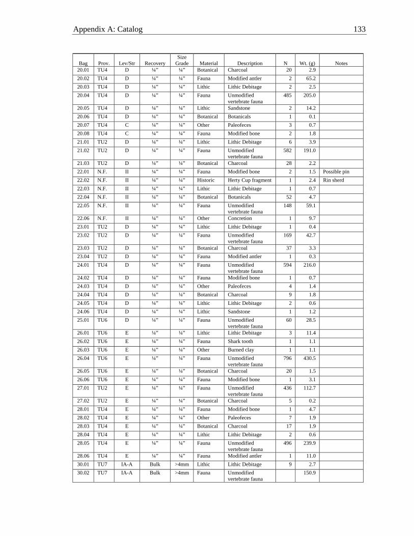
Appendix A: Catalog 133
Bag Prov. Lev/Str Recovery Size
Grade Material Description N Wt. (g) Notes 20.01 TU4 D ¼” ¼” Botanical Charcoal 20 2.9 20.02 TU4 D ¼” ¼” Fauna Modified antler 2 65.2 20.03 TU4 D ¼” ¼” Lithic Lithic Debitage 2 2.5 20.04 TU4 D ¼” ¼” Fauna Unmodified
vertebrate fauna 485 205.0
20.05 TU4 D ¼” ¼” Lithic Sandstone 2 14.2 20.06 TU4 D ¼” ¼” Botanical Botanicals 1 0.1 20.07 TU4 C ¼” ¼” Other Paleofeces 3 0.7 20.08 TU4 C ¼” ¼” Fauna Modified bone 2 1.8 21.01 TU2 D ¼” ¼” Lithic Lithic Debitage 6 3.9 21.02 TU2 D ¼” ¼” Fauna Unmodified
vertebrate fauna 582 191.0
21.03 TU2 D ¼” ¼” Botanical Charcoal 28 2.2 22.01 N.F. II ¼” ¼” Fauna Modified bone 2 1.5 Possible pin 22.02 N.F. II ¼” ¼” Historic Herty Cup fragment 1 2.4 Rin sherd 22.03 N.F. II ¼” ¼” Lithic Lithic Debitage 1 0.7 22.04 N.F. II ¼” ¼” Botanical Botanicals 52 4.7 22.05 N.F. II ¼” ¼” Fauna Unmodified
vertebrate fauna 148 59.1
22.06 N.F. II ¼” ¼” Other Concretion 1 9.7 23.01 TU2 D ¼” ¼” Lithic Lithic Debitage 1 0.4 23.02 TU2 D ¼” ¼” Fauna Unmodified
vertebrate fauna 169 42.7
23.03 TU2 D ¼” ¼” Botanical Charcoal 37 3.3 23.04 TU2 D ¼” ¼” Fauna Modified antler 1 0.3 24.01 TU4 D ¼” ¼” Fauna Unmodified
vertebrate fauna 594 216.0
24.02 TU4 D ¼” ¼” Fauna Modified bone 1 0.7 24.03 TU4 D ¼” ¼” Other Paleofeces 4 1.4 24.04 TU4 D ¼” ¼” Botanical Charcoal 9 1.8 24.05 TU4 D ¼” ¼” Lithic Lithic Debitage 2 0.6 24.06 TU4 D ¼” ¼” Lithic Sandstone 1 1.2 25.01 TU6 D ¼” ¼” Fauna Unmodified
vertebrate fauna 60 28.5
26.01 TU6 E ¼” ¼” Lithic Lithic Debitage 3 11.4 26.02 TU6 E ¼” ¼” Fauna Shark tooth 1 1.1 26.03 TU6 E ¼” ¼” Other Burned clay 1 1.1 26.04 TU6 E ¼” ¼” Fauna Unmodified
vertebrate fauna 796 430.5
26.05 TU6 E ¼” ¼” Botanical Charcoal 20 1.5 26.06 TU6 E ¼” ¼” Fauna Modified bone 1 3.1 27.01 TU2 E ¼” ¼” Fauna Unmodified
vertebrate fauna 436 112.7
27.02 TU2 E ¼” ¼” Botanical Charcoal 5 0.2 28.01 TU4 E ¼” ¼” Fauna Modified bone 1 4.7 28.02 TU4 E ¼” ¼” Other Paleofeces 7 1.9 28.03 TU4 E ¼” ¼” Botanical Charcoal 17 1.9 28.04 TU4 E ¼” ¼” Lithic Lithic Debitage 2 0.6 28.05 TU4 E ¼” ¼” Fauna Unmodified
vertebrate fauna 496 239.9
28.06 TU4 E ¼” ¼” Fauna Modified antler 1 11.0 30.01 TU7 IA-A Bulk >4mm Lithic Lithic Debitage 9 2.7 30.02 TU7 IA-A Bulk >4mm Fauna Unmodified
vertebrate fauna 150.9

134 Salt Springs (8MR2322)
Bag Prov. Lev/Str Recovery Size
Grade Material Description N Wt. (g) Notes 30.03 TU7 IA-A Bulk >4mm Fauna Unmodified marine
shell 2 3.1
30.04 TU7 IA-A Bulk >4mm Other Paleofeces 6.0 30.05 TU7 IA-A Bulk >4mm Lithic Sandstone 1 9.4 30.06 TU7 IA-A Bulk >4mm Lithic Miscellaneous stone 2 6.3 30.07 TU7 IA-A Bulk >4mm Fauna Euglandina rosea 6 1.4 30.08 TU7 IA-A Bulk >4mm Fauna Mesa Rams-horn 9.0 30.09 TU7 IA-A Bulk >4mm Fauna Rams-horn 0.6 30.10 TU7 IA-A Bulk >4mm Fauna Elimia spp. 33.1 30.11 TU7 IA-A Bulk >4mm Fauna UID land snail 2.8 30.12 TU7 IA-A Bulk >4mm Fauna Whole Viviparus 830.3 30.13 TU7 IA-A Bulk >4mm Fauna Crushed Viviparus 305.8 30.14 TU7 IA-A Bulk >4mm Fauna Bivalve 263.9 30.15 TU7 IA-A Bulk >4mm Fauna Crushed apple snall 89.5 30.16 TU7 IA-A Bulk >4mm Fauna UID crushed shell 57.9 30.17 TU7 IA-A Bulk >4mm Other Concretion 19.0 30.18 TU7 IA-A Bulk >4mm Botanical Botanicals 34.01 TU3 IA-A Bulk >4mm Fauna Unmodified
vertebrate fauna 36.0
34.02 TU3 IA-A Bulk >4mm Lithic Lithic Debitage 5 0.7 34.03 TU3 IA-A Bulk >4mm Lithic Miscellaneous stone 1 0.2 34.04 TU3 IA-A Bulk >4mm Other Paleofeces 3 0.4 34.05 TU3 IA-A Bulk >4mm Fauna UID land snail 0.5 34.06 TU3 IA-A Bulk >4mm Fauna Bivalve 45.6 34.07 TU3 IA-A Bulk >4mm Fauna Crushed apple snall 41.9 34.08 TU3 IA-A Bulk >4mm Fauna Elimia spp. 42.8 34.09 TU3 IA-A Bulk >4mm Fauna Mesa Rams-horn 15.1 34.10 TU3 IA-A Bulk >4mm Fauna Whole Viviparus 1132.2 34.11 TU3 IA-A Bulk >4mm Fauna Crushed Viviparus 225.9 34.12 TU3 IA-A Bulk >4mm Fauna UID crushed shell 25.0 34.13 TU3 IA-A Bulk >4mm Other Concretion 5126.3 34.14 TU3 IA-A Bulk >4mm Botanical Botanicals 35.01 TU6 F ¼” ¼” Fauna Unmodified
vertebrate fauna 733 215.6
35.02 TU6 F ¼” ¼” Lithic Lithic Debitage 1 0.7 35.03 TU6 F ¼” ¼” Botanical Charcoal 12 0.7 35.04 TU6 F ¼” ¼” Fauna Modified bone 3 4.0 36.01 TU1 IA-A Bulk >4mm Fauna Unmodified
vertebrate fauna 54.3
36.02 TU1 IA-A Bulk >4mm Lithic Miscellaneous stone 2 2.1 36.03 TU1 IA-A Bulk >4mm Fauna UID land snail 0.1 36.04 TU1 IA-A Bulk >4mm Fauna Euglandina rosea 7.3 36.05 TU1 IA-A Bulk >4mm Fauna Mesa Rams-horn 18.4 36.06 TU1 IA-A Bulk >4mm Fauna Elimia spp. 53.3 36.07 TU1 IA-A Bulk >4mm Fauna Bivalve 91.2 36.08 TU1 IA-A Bulk >4mm Fauna Crushed apple snall 74.8 36.09 TU1 IA-A Bulk >4mm Fauna Whole Viviparus 1424.0 36.10 TU1 IA-A Bulk >4mm Fauna Crushed Viviparus 615.8 36.11 TU1 IA-A Bulk >4mm Fauna UID crushed shell 24.6 36.12 TU1 IA-A Bulk >4mm Other Concretion 862.2 36.13 TU1 IA-A Bulk >4mm Historic Glass 2 5.4
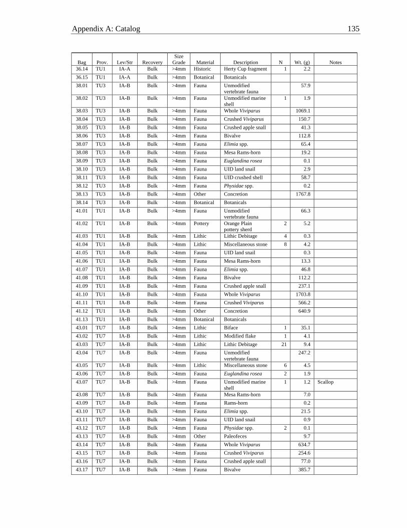
Appendix A: Catalog 135
Bag Prov. Lev/Str Recovery Size
Grade Material Description N Wt. (g) Notes 36.14 TU1 IA-A Bulk >4mm Historic Herty Cup fragment 1 2.2 36.15 TU1 IA-A Bulk >4mm Botanical Botanicals 38.01 TU3 IA-B Bulk >4mm Fauna Unmodified
vertebrate fauna 57.9
38.02 TU3 IA-B Bulk >4mm Fauna Unmodified marine shell
1 1.9
38.03 TU3 IA-B Bulk >4mm Fauna Whole Viviparus 1069.1 38.04 TU3 IA-B Bulk >4mm Fauna Crushed Viviparus 150.7 38.05 TU3 IA-B Bulk >4mm Fauna Crushed apple snall 41.3 38.06 TU3 IA-B Bulk >4mm Fauna Bivalve 112.8 38.07 TU3 IA-B Bulk >4mm Fauna Elimia spp. 65.4 38.08 TU3 IA-B Bulk >4mm Fauna Mesa Rams-horn 19.2 38.09 TU3 IA-B Bulk >4mm Fauna Euglandina rosea 0.1 38.10 TU3 IA-B Bulk >4mm Fauna UID land snail 2.9 38.11 TU3 IA-B Bulk >4mm Fauna UID crushed shell 58.7 38.12 TU3 IA-B Bulk >4mm Fauna Physidae spp. 0.2 38.13 TU3 IA-B Bulk >4mm Other Concretion 1767.8 38.14 TU3 IA-B Bulk >4mm Botanical Botanicals 41.01 TU1 IA-B Bulk >4mm Fauna Unmodified
vertebrate fauna 66.3
41.02 TU1 IA-B Bulk >4mm Pottery Orange Plain pottery sherd
2 5.2
41.03 TU1 IA-B Bulk >4mm Lithic Lithic Debitage 4 0.3 41.04 TU1 IA-B Bulk >4mm Lithic Miscellaneous stone 8 4.2 41.05 TU1 IA-B Bulk >4mm Fauna UID land snail 0.3 41.06 TU1 IA-B Bulk >4mm Fauna Mesa Rams-horn 13.3 41.07 TU1 IA-B Bulk >4mm Fauna Elimia spp. 46.8 41.08 TU1 IA-B Bulk >4mm Fauna Bivalve 112.2 41.09 TU1 IA-B Bulk >4mm Fauna Crushed apple snall 237.1 41.10 TU1 IA-B Bulk >4mm Fauna Whole Viviparus 1703.8 41.11 TU1 IA-B Bulk >4mm Fauna Crushed Viviparus 566.2 41.12 TU1 IA-B Bulk >4mm Other Concretion 640.9 41.13 TU1 IA-B Bulk >4mm Botanical Botanicals 43.01 TU7 IA-B Bulk >4mm Lithic Biface 1 35.1 43.02 TU7 IA-B Bulk >4mm Lithic Modified flake 1 4.1 43.03 TU7 IA-B Bulk >4mm Lithic Lithic Debitage 21 9.4 43.04 TU7 IA-B Bulk >4mm Fauna Unmodified
vertebrate fauna 247.2
43.05 TU7 IA-B Bulk >4mm Lithic Miscellaneous stone 6 4.5 43.06 TU7 IA-B Bulk >4mm Fauna Euglandina rosea 2 1.9 43.07 TU7 IA-B Bulk >4mm Fauna Unmodified marine
shell 1 1.2 Scallop
43.08 TU7 IA-B Bulk >4mm Fauna Mesa Rams-horn 7.0 43.09 TU7 IA-B Bulk >4mm Fauna Rams-horn 0.2 43.10 TU7 IA-B Bulk >4mm Fauna Elimia spp. 21.5 43.11 TU7 IA-B Bulk >4mm Fauna UID land snail 0.9 43.12 TU7 IA-B Bulk >4mm Fauna Physidae spp. 2 0.1 43.13 TU7 IA-B Bulk >4mm Other Paleofeces 9.7 43.14 TU7 IA-B Bulk >4mm Fauna Whole Viviparus 634.7 43.15 TU7 IA-B Bulk >4mm Fauna Crushed Viviparus 254.6 43.16 TU7 IA-B Bulk >4mm Fauna Crushed apple snall 77.0 43.17 TU7 IA-B Bulk >4mm Fauna Bivalve 385.7
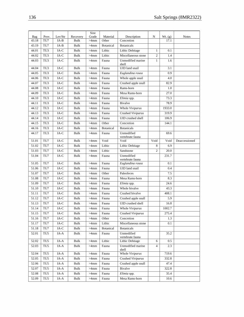
136 Salt Springs (8MR2322)
Bag Prov. Lev/Str Recovery Size
Grade Material Description N Wt. (g) Notes 43.18 TU7 IA-B Bulk >4mm Other Concretion 17.1 43.19 TU7 IA-B Bulk >4mm Botanical Botanicals 44.01 TU3 IA-C Bulk >4mm Lithic Lithic Debitage 1 0.1 44.02 TU3 IA-C Bulk >4mm Lithic Miscellaneous stone 2 1.4 44.03 TU3 IA-C Bulk >4mm Fauna Unmodified marine
shell 1 1.6
44.04 TU3 IA-C Bulk >4mm Fauna UID land snail 3.1 44.05 TU3 IA-C Bulk >4mm Fauna Euglandina rosea 0.9 44.06 TU3 IA-C Bulk >4mm Fauna Whole apple snail 4.0 44.07 TU3 IA-C Bulk >4mm Fauna Crushed apple snall 82.9 44.08 TU3 IA-C Bulk >4mm Fauna Rams-horn 1.0 44.09 TU3 IA-C Bulk >4mm Fauna Mesa Rams-horn 27.0 44.10 TU3 IA-C Bulk >4mm Fauna Elimia spp. 73.3 44.11 TU3 IA-C Bulk >4mm Fauna Bivalve 78.9 44.12 TU3 IA-C Bulk >4mm Fauna Whole Viviparus 1933.0 44.13 TU3 IA-C Bulk >4mm Fauna Crushed Viviparus 319.9 44.14 TU3 IA-C Bulk >4mm Fauna UID crushed shell 106.9 44.15 TU3 IA-C Bulk >4mm Other Concretion 144.1 44.16 TU3 IA-C Bulk >4mm Botanical Botanicals 44.17 TU3 IA-C Bulk >4mm Fauna Unmodified
vertebrate fauna 69.6
51.01 TU7 IA-C Bulk >4mm Void Void Void Void Deaccessioned 51.02 TU7 IA-C Bulk >4mm Lithic Lithic Debitage 8 6.9 51.03 TU7 IA-C Bulk >4mm Lithic Sandstone 2 20.0 51.04 TU7 IA-C Bulk >4mm Fauna Unmodified
vertebrate fauna 231.7
51.05 TU7 IA-C Bulk >4mm Fauna Euglandina rosea 0.1 51.06 TU7 IA-C Bulk >4mm Fauna UID land snail 0.4 51.07 TU7 IA-C Bulk >4mm Other Paleofeces 7.5 51.08 TU7 IA-C Bulk >4mm Fauna Mesa Rams-horn 8.3 51.09 TU7 IA-C Bulk >4mm Fauna Elimia spp. 24.6 51.10 TU7 IA-C Bulk >4mm Fauna Whole bivalve 43.3 51.11 TU7 IA-C Bulk >4mm Fauna Crushed bivalve 408.1 51.12 TU7 IA-C Bulk >4mm Fauna Crushed apple snall 5.9 51.13 TU7 IA-C Bulk >4mm Fauna UID crushed shell 16.8 51.14 TU7 IA-C Bulk >4mm Fauna Whole Viviparus 1002.7 51.15 TU7 IA-C Bulk >4mm Fauna Crushed Viviparus 275.4 51.16 TU7 IA-C Bulk >4mm Other Concretion 1.3 51.17 TU7 IA-C Bulk >4mm Lithic Miscellaneous stone 0.1 51.18 TU7 IA-C Bulk >4mm Botanical Botanicals 52.01 TU5 IA-A Bulk >4mm Fauna Unmodified
vertebrate fauna 35.2
52.02 TU5 IA-A Bulk >4mm Lithic Lithic Debitage 6 0.5 52.03 TU5 IA-A Bulk >4mm Fauna Unmodified marine
shell 4 2.3
52.04 TU5 IA-A Bulk >4mm Fauna Whole Viviparus 719.6 52.05 TU5 IA-A Bulk >4mm Fauna Crushed Viviparus 332.8 52.06 TU5 IA-A Bulk >4mm Fauna Crushed apple snall 47.4 52.07 TU5 IA-A Bulk >4mm Fauna Bivalve 322.8 52.08 TU5 IA-A Bulk >4mm Fauna Elimia spp. 35.4 52.09 TU5 IA-A Bulk >4mm Fauna Mesa Rams-horn 10.6
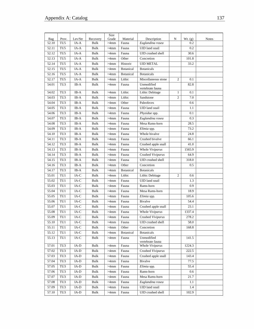
Appendix A: Catalog 137
Bag Prov. Lev/Str Recovery Size
Grade Material Description N Wt. (g) Notes 52.10 TU5 IA-A Bulk >4mm Fauna Euglandina rosea 0.2 52.11 TU5 IA-A Bulk >4mm Fauna UID land snail 0.2 52.12 TU5 IA-A Bulk >4mm Fauna UID crushed shell 30.6 52.13 TU5 IA-A Bulk >4mm Other Concretion 101.8 52.14 TU5 IA-A Bulk >4mm Historic UID METAL 33.2 52.15 TU5 IA-A Bulk >4mm Botanical Botanicals 52.16 TU5 IA-A Bulk >4mm Botanical Botanicals 52.17 TU5 IA-A Bulk >4mm Lithic Miscellaneous stone 2 0.1 54.01 TU3 IB-A Bulk >4mm Fauna Unmodified
vertebrate fauna 82.8
54.02 TU3 IB-A Bulk >4mm Lithic Lithic Debitage 1 0.1 54.03 TU3 IB-A Bulk >4mm Lithic Sandstone 2 7.0 54.04 TU3 IB-A Bulk >4mm Other Paleofeces 0.6 54.05 TU3 IB-A Bulk >4mm Fauna UID land snail 1.1 54.06 TU3 IB-A Bulk >4mm Fauna Physidae spp. 0.1 54.07 TU3 IB-A Bulk >4mm Fauna Euglandina rosea 0.3 54.08 TU3 IB-A Bulk >4mm Fauna Mesa Rams-horn 28.5 54.09 TU3 IB-A Bulk >4mm Fauna Elimia spp. 73.2 54.10 TU3 IB-A Bulk >4mm Fauna Whole bivalve 24.8 54.11 TU3 IB-A Bulk >4mm Fauna Crushed bivalve 66.1 54.12 TU3 IB-A Bulk >4mm Fauna Crushed apple snall 41.0 54.13 TU3 IB-A Bulk >4mm Fauna Whole Viviparus 1565.9 54.14 TU3 IB-A Bulk >4mm Fauna Crushed Viviparus 64.9 54.15 TU3 IB-A Bulk >4mm Fauna UID crushed shell 318.0 54.16 TU3 IB-A Bulk >4mm Other Concretion 0.5 54.17 TU3 IB-A Bulk >4mm Botanical Botanicals 55.01 TU1 IA-C Bulk >4mm Lithic Lithic Debitage 2 0.6 55.02 TU1 IA-C Bulk >4mm Fauna UID land snail 1.3 55.03 TU1 IA-C Bulk >4mm Fauna Rams-horn 0.9 55.04 TU1 IA-C Bulk >4mm Fauna Mesa Rams-horn 18.9 55.05 TU1 IA-C Bulk >4mm Fauna Elimia spp. 105.6 55.06 TU1 IA-C Bulk >4mm Fauna Bivalve 54.4 55.07 TU1 IA-C Bulk >4mm Fauna Crushed apple snall 23.1 55.08 TU1 IA-C Bulk >4mm Fauna Whole Viviparus 1337.4 55.09 TU1 IA-C Bulk >4mm Fauna Crushed Viviparus 278.2 55.10 TU1 IA-C Bulk >4mm Fauna UID crushed shell 58.0 55.11 TU1 IA-C Bulk >4mm Other Concretion 168.8 55.12 TU1 IA-C Bulk >4mm Botanical Botanicals 55.13 TU1 IA-C Bulk >4mm Fauna Unmodified
vertebrate fauna 141.5
57.01 TU3 IA-D Bulk >4mm Fauna Whole Viviparus 1224.3 57.02 TU3 IA-D Bulk >4mm Fauna Crushed Viviparus 222.5 57.03 TU3 IA-D Bulk >4mm Fauna Crushed apple snall 143.4 57.04 TU3 IA-D Bulk >4mm Fauna Bivalve 77.5 57.05 TU3 IA-D Bulk >4mm Fauna Elimia spp. 55.4 57.06 TU3 IA-D Bulk >4mm Fauna Rams-horn 0.6 57.07 TU3 IA-D Bulk >4mm Fauna Mesa Rams-horn 21.7 57.08 TU3 IA-D Bulk >4mm Fauna Euglandina rosea 1.1 57.09 TU3 IA-D Bulk >4mm Fauna UID land snail 1.4 57.10 TU3 IA-D Bulk >4mm Fauna UID crushed shell 102.9

138 Salt Springs (8MR2322)
Bag Prov. Lev/Str Recovery Size
Grade Material Description N Wt. (g) Notes 57.11 TU3 IA-D Bulk >4mm Other Concretion 10.9 57.12 TU3 IA-D Bulk >4mm Other Paleofeces 19.8 57.13 TU3 IA-D Bulk >4mm Botanical Botanicals 57.14 TU3 IA-D Bulk >4mm Fauna Unmodified
vertebrate fauna 113.7
58.01 TU7 IA-D Bulk >4mm Fauna Unmodified vertebrate fauna
227.3
58.02 TU7 IA-D Bulk >4mm Void Void Void Void Deaccessioned 58.03 TU7 IA-D Bulk >4mm Lithic Lithic Debitage 6 7.1 58.04 TU7 IA-D Bulk >4mm Lithic Miscellaneous stone 2 0.5 58.05 TU7 IA-D Bulk >4mm Other Paleofeces 1.7 58.06 TU7 IA-D Bulk >4mm Fauna UID land snail 0.1 58.07 TU7 IA-D Bulk >4mm Fauna Euglandina rosea 0.1 58.08 TU7 IA-D Bulk >4mm Fauna Rams-horn 0.1 58.09 TU7 IA-D Bulk >4mm Fauna Mesa Rams-horn 10.3 58.10 TU7 IA-D Bulk >4mm Fauna Elimia spp. 21.5 58.11 TU7 IA-D Bulk >4mm Fauna Bivalve 59.8 58.12 TU7 IA-D Bulk >4mm Fauna Crushed apple snall 5.0 58.13 TU7 IA-D Bulk >4mm Fauna Whole Viviparus 1660.1 58.14 TU7 IA-D Bulk >4mm Fauna Crushed Viviparus 578.8 58.15 TU7 IA-D Bulk >4mm Other Concretion 0.5 58.16 TU7 IA-D Bulk >4mm Botanical Botanicals 58.17 TU7 IA-D Bulk >4mm Fauna Antler 2 11.9 61.01 TU3 IB-B Bulk >4mm Fauna Unmodified
vertebrate fauna 55.6
61.02 TU3 IB-B Bulk >4mm Lithic Lithic Debitage 1 0.3 61.03 TU3 IB-B Bulk >4mm Lithic Miscellaneous stone 3 0.9 61.04 TU3 IB-B Bulk >4mm Other Paleofeces 0.1 61.05 TU3 IB-B Bulk >4mm Fauna Rams-horn 0.4 61.06 TU3 IB-B Bulk >4mm Fauna Mesa Rams-horn 12.6 61.07 TU3 IB-B Bulk >4mm Fauna Elimia spp. 41.4 61.08 TU3 IB-B Bulk >4mm Fauna Whole bivalve 6.9 61.09 TU3 IB-B Bulk >4mm Fauna Crushed bivalve 77.9 61.10 TU3 IB-B Bulk >4mm Fauna Crushed apple snall 14.5 61.11 TU3 IB-B Bulk >4mm Fauna Whole Viviparus 474.0 61.12 TU3 IB-B Bulk >4mm Fauna Crushed Viviparus 182.3 61.13 TU3 IB-B Bulk >4mm Other Concretion 6.0 61.14 TU3 IB-B Bulk >4mm Botanical Botanicals 63.01 TU3 IA-E Bulk >4mm Fauna Unmodified
vertebrate fauna 69.3
63.02 TU3 IA-E Bulk >4mm Lithic Lithic Debitage 3 1.5 63.03 TU3 IA-E Bulk >4mm Other Paleofeces 0.6 63.04 TU3 IA-E Bulk >4mm Fauna Rams-horn 0.7 63.05 TU3 IA-E Bulk >4mm Fauna Mesa Rams-horn 15.3 63.06 TU3 IA-E Bulk >4mm Fauna Elimia spp. 37.1 63.07 TU3 IA-E Bulk >4mm Fauna Whole bivalve 8.8 63.08 TU3 IA-E Bulk >4mm Fauna Crushed bivalve 73.6 63.09 TU3 IA-E Bulk >4mm Fauna Crushed apple snall 32.3 63.10 TU3 IA-E Bulk >4mm Fauna Whole Viviparus 453.7 63.11 TU3 IA-E Bulk >4mm Fauna Crushed Viviparus 217.1 63.12 TU3 IA-E Bulk >4mm Other Concretion 2.9
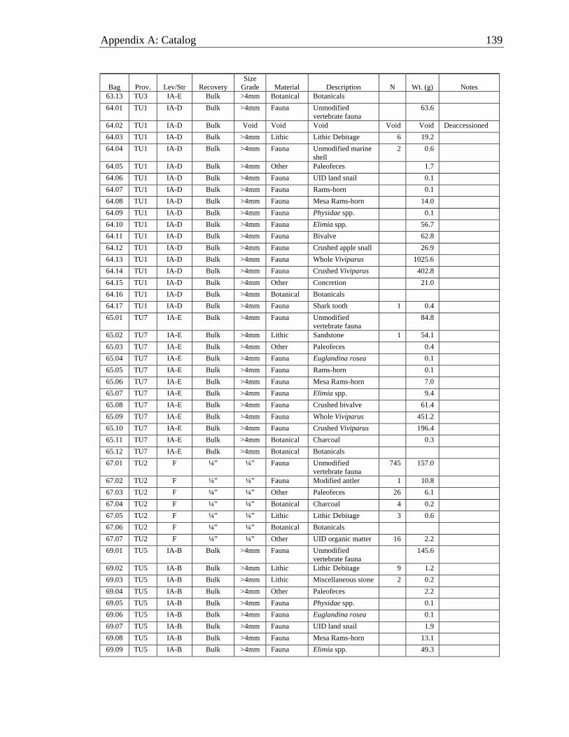
Appendix A: Catalog 139
Bag Prov. Lev/Str Recovery Size
Grade Material Description N Wt. (g) Notes 63.13 TU3 IA-E Bulk >4mm Botanical Botanicals 64.01 TU1 IA-D Bulk >4mm Fauna Unmodified
vertebrate fauna 63.6
64.02 TU1 IA-D Bulk Void Void Void Void Void Deaccessioned 64.03 TU1 IA-D Bulk >4mm Lithic Lithic Debitage 6 19.2 64.04 TU1 IA-D Bulk >4mm Fauna Unmodified marine
shell 2 0.6
64.05 TU1 IA-D Bulk >4mm Other Paleofeces 1.7 64.06 TU1 IA-D Bulk >4mm Fauna UID land snail 0.1 64.07 TU1 IA-D Bulk >4mm Fauna Rams-horn 0.1 64.08 TU1 IA-D Bulk >4mm Fauna Mesa Rams-horn 14.0 64.09 TU1 IA-D Bulk >4mm Fauna Physidae spp. 0.1 64.10 TU1 IA-D Bulk >4mm Fauna Elimia spp. 56.7 64.11 TU1 IA-D Bulk >4mm Fauna Bivalve 62.8 64.12 TU1 IA-D Bulk >4mm Fauna Crushed apple snall 26.9 64.13 TU1 IA-D Bulk >4mm Fauna Whole Viviparus 1025.6 64.14 TU1 IA-D Bulk >4mm Fauna Crushed Viviparus 402.8 64.15 TU1 IA-D Bulk >4mm Other Concretion 21.0 64.16 TU1 IA-D Bulk >4mm Botanical Botanicals 64.17 TU1 IA-D Bulk >4mm Fauna Shark tooth 1 0.4 65.01 TU7 IA-E Bulk >4mm Fauna Unmodified
vertebrate fauna 84.8
65.02 TU7 IA-E Bulk >4mm Lithic Sandstone 1 54.1 65.03 TU7 IA-E Bulk >4mm Other Paleofeces 0.4 65.04 TU7 IA-E Bulk >4mm Fauna Euglandina rosea 0.1 65.05 TU7 IA-E Bulk >4mm Fauna Rams-horn 0.1 65.06 TU7 IA-E Bulk >4mm Fauna Mesa Rams-horn 7.0 65.07 TU7 IA-E Bulk >4mm Fauna Elimia spp. 9.4 65.08 TU7 IA-E Bulk >4mm Fauna Crushed bivalve 61.4 65.09 TU7 IA-E Bulk >4mm Fauna Whole Viviparus 451.2 65.10 TU7 IA-E Bulk >4mm Fauna Crushed Viviparus 196.4 65.11 TU7 IA-E Bulk >4mm Botanical Charcoal 0.3 65.12 TU7 IA-E Bulk >4mm Botanical Botanicals 67.01 TU2 F ¼” ¼” Fauna Unmodified
vertebrate fauna 745 157.0
67.02 TU2 F ¼” ¼” Fauna Modified antler 1 10.8 67.03 TU2 F ¼” ¼” Other Paleofeces 26 6.1 67.04 TU2 F ¼” ¼” Botanical Charcoal 4 0.2 67.05 TU2 F ¼” ¼” Lithic Lithic Debitage 3 0.6 67.06 TU2 F ¼” ¼” Botanical Botanicals 67.07 TU2 F ¼” ¼” Other UID organic matter 16 2.2 69.01 TU5 IA-B Bulk >4mm Fauna Unmodified
vertebrate fauna 145.6
69.02 TU5 IA-B Bulk >4mm Lithic Lithic Debitage 9 1.2 69.03 TU5 IA-B Bulk >4mm Lithic Miscellaneous stone 2 0.2 69.04 TU5 IA-B Bulk >4mm Other Paleofeces 2.2 69.05 TU5 IA-B Bulk >4mm Fauna Physidae spp. 0.1 69.06 TU5 IA-B Bulk >4mm Fauna Euglandina rosea 0.1 69.07 TU5 IA-B Bulk >4mm Fauna UID land snail 1.9 69.08 TU5 IA-B Bulk >4mm Fauna Mesa Rams-horn 13.1 69.09 TU5 IA-B Bulk >4mm Fauna Elimia spp. 49.3

140 Salt Springs (8MR2322)
Bag Prov. Lev/Str Recovery Size
Grade Material Description N Wt. (g) Notes 69.10 TU5 IA-B Bulk >4mm Fauna Bivalve 460.3 69.11 TU5 IA-B Bulk >4mm Fauna Crushed apple snall 97.4 69.12 TU5 IA-B Bulk >4mm Fauna Whole Viviparus 1255.7 69.13 TU5 IA-B Bulk >4mm Fauna UID crushed shell 283.5 69.14 TU5 IA-B Bulk >4mm Other Concretion 106.7 69.15 TU5 IA-B Bulk >4mm Botanical Botanicals 69.16 TU5 IA-B Bulk >4mm Fauna Shark tooth 1 0.2 70.01 TU1 IB-A Bulk >4mm Fauna Unmodified
vertebrate fauna 134.2
70.02 TU1 IB-A Bulk >4mm Lithic Lithic Debitage 3 0.3 70.03 TU1 IB-A Bulk >4mm Fauna UID land snail 0.1 70.04 TU1 IB-A Bulk >4mm Fauna Physidae spp. 0.1 70.05 TU1 IB-A Bulk >4mm Fauna Rams-horn 0.1 70.06 TU1 IB-A Bulk >4mm Fauna Mesa Rams-horn 7.6 70.07 TU1 IB-A Bulk >4mm Fauna Elimia spp. 24.9 70.08 TU1 IB-A Bulk >4mm Fauna Bivalve 18.6 70.09 TU1 IB-A Bulk >4mm Fauna Crushed apple snall 37.6 70.10 TU1 IB-A Bulk >4mm Fauna Whole Viviparus 210.1 70.11 TU1 IB-A Bulk >4mm Fauna Crushed Viviparus 300.3 70.12 TU1 IB-A Bulk >4mm Botanical Botanicals 71.01 TU2 G ¼” ¼” Fauna Unmodified
vertebrate fauna 265 87.3
71.02 TU2 G ¼” ¼” Lithic Lithic Debitage 3 1.3 71.03 TU2 G ¼” ¼” Other UID waxy material 1 0.1 71.04 TU2 G ¼” ¼” Botanical Botanicals 71.05 TU2 G ¼” ¼” Other Paleofeces 3 2.7 71.06 TU2 G ¼” ¼” Fauna Modified antler 2 2.6 Socketed 75.01 TU3 II-A Bulk >4mm Fauna Unmodified
vertebrate fauna 95.9
75.02 TU3 II-A Bulk >4mm Lithic Lithic Debitage 1 0.1 75.03 TU3 II-A Bulk >4mm Other Paleofeces 2 0.4 75.04 TU3 II-A Bulk >4mm Botanical Botanicals 77.01 TU5 IA-C Bulk >4mm Fauna Unmodified
vertebrate fauna 95.6
77.02 TU5 IA-C Bulk >4mm Lithic Lithic Debitage 7 2.0 77.03 TU5 IA-C Bulk >4mm Lithic Miscellaneous stone 7 8.7 77.04 TU5 IA-C Bulk >4mm Fauna Unmodified marine
shell 1 0.4
77.05 TU5 IA-C Bulk >4mm Fauna UID land snail 1.0 77.06 TU5 IA-C Bulk >4mm Fauna Physidae spp. 0.3 77.07 TU5 IA-C Bulk >4mm Fauna Euglandina rosea 0.4 77.08 TU5 IA-C Bulk >4mm Fauna Rams-horn 0.3 77.09 TU5 IA-C Bulk >4mm Fauna Mesa Rams-horn 19.8 77.10 TU5 IA-C Bulk >4mm Fauna Elimia spp. 50.0 77.11 TU5 IA-C Bulk >4mm Fauna Crushed apple snall 41.0 77.12 TU5 IA-C Bulk >4mm Fauna Bivalve 180.3 77.13 TU5 IA-C Bulk >4mm Fauna Whole Viviparus 1485.4 77.14 TU5 IA-C Bulk >4mm Fauna Crushed Viviparus 389.9 77.15 TU5 IA-C Bulk >4mm Fauna UID crushed shell 43.8 77.16 TU5 IA-C Bulk >4mm Other Concretion 261.6 77.17 TU5 IA-C Bulk >4mm Botanical Botanicals

Appendix A: Catalog 141
Bag Prov. Lev/Str Recovery Size
Grade Material Description N Wt. (g) Notes 78.01 TU1 II-A Bulk >4mm Fauna Unmodified
vertebrate fauna 48.0
78.02 TU1 II-A Bulk >4mm Lithic Lithic Debitage 2 0.2 78.03 TU1 II-A Bulk >4mm Botanical Botanicals 82.01 TU3 II-B Bulk >4mm Fauna Unmodified
vertebrate fauna 8.5
82.02 TU3 II-B Bulk >4mm Lithic Miscellaneous stone 3 0.3 82.03 TU3 II-B Bulk >4mm Lithic Lithic Debitage 4 0.2 82.04 TU3 II-B Bulk >4mm Botanical Botanicals 83.01 TU5 IA-D Bulk >4mm Lithic Lithic Debitage 1 0.2 83.02 TU5 IA-D Bulk >4mm Lithic Miscellaneous stone 6 2.8 83.03 TU5 IA-D Bulk >4mm Fauna Unmodified marine
shell 2 0.3
83.04 TU5 IA-D Bulk >4mm Other Paleofeces 0.5 83.05 TU5 IA-D Bulk >4mm Fauna UID land snail 1.1 83.06 TU5 IA-D Bulk >4mm Fauna Physidae spp. 0.1 83.07 TU5 IA-D Bulk >4mm Fauna Rams-horn 0.1 83.08 TU5 IA-D Bulk >4mm Fauna Mesa Rams-horn 7.8 83.09 TU5 IA-D Bulk >4mm Fauna Bivalve 66.0 83.10 TU5 IA-D Bulk >4mm Fauna Elimia spp. 40.3 83.11 TU5 IA-D Bulk >4mm Fauna Crushed apple snall 23.4 83.12 TU5 IA-D Bulk >4mm Fauna Whole Viviparus 830.7 83.13 TU5 IA-D Bulk >4mm Fauna Crushed Viviparus 422.8 83.14 TU5 IA-D Bulk >4mm Fauna UID crushed shell 40.8 83.15 TU5 IA-D Bulk >4mm Other Concretion 0.4 83.16 TU5 IA-D Bulk >4mm Botanical Botanicals 83.17 TU5 IA-D Bulk >4mm Fauna Unmodified
vertebrate fauna 131.4
84.01 TU1 II-B Bulk >4mm Fauna Unmodified vertebrate fauna
55.1
84.02 TU1 II-B Bulk >4mm Lithic Miscellaneous stone 2 0.8 84.03 TU1 II-B Bulk >4mm Other Paleofeces 0.2 84.04 TU1 II-B Bulk >4mm Botanical Botanicals 86.01 TU5 IA-E Bulk >4mm Fauna Unmodified
vertebrate fauna 88.4
86.02 TU5 IA-E Bulk >4mm Lithic Miscellaneous stone 5 0.7 86.03 TU5 IA-E Bulk >4mm Other Paleofeces 0.9 86.04 TU5 IA-E Bulk >4mm Fauna UID land snail 0.3 86.05 TU5 IA-E Bulk >4mm Fauna Euglandina rosea 0.1 86.06 TU5 IA-E Bulk >4mm Fauna Rams-horn 0.5 86.07 TU5 IA-E Bulk >4mm Fauna Mesa Rams-horn 7.9 86.08 TU5 IA-E Bulk >4mm Fauna Elimia spp. 18.8 86.09 TU5 IA-E Bulk >4mm Fauna Crushed bivalve 64.6 86.10 TU5 IA-E Bulk >4mm Fauna Whole Viviparus 576.0 86.11 TU5 IA-E Bulk >4mm Fauna Crushed Viviparus 289.3 86.12 TU5 IA-E Bulk >4mm Other Concretion 3.6 86.13 TU5 IA-E Bulk >4mm Botanical Botanicals 88.01 TU4 F ¼” ¼” Fauna Unmodified
vertebrate fauna 968 442.5
88.02 TU4 F ¼” ¼” Lithic Lithic Debitage 5 1.2 88.03 TU4 F ¼” ¼” Lithic Miscellaneous stone 2 1.3 88.04 TU4 F ¼” ¼” Other Concretion 78 79.5
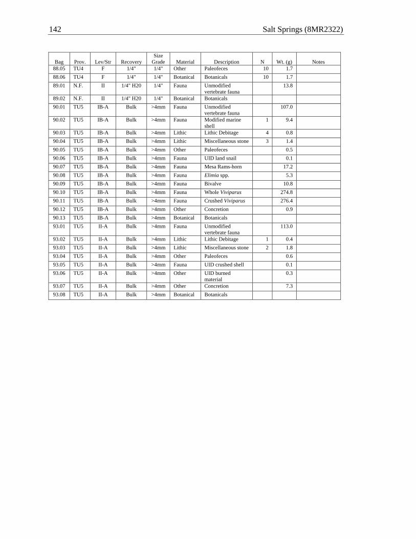
142 Salt Springs (8MR2322)
Bag Prov. Lev/Str Recovery Size
Grade Material Description N Wt. (g) Notes 88.05 TU4 F 1/4" 1/4" Other Paleofeces 10 1.7 88.06 TU4 F 1/4" 1/4" Botanical Botanicals 10 1.7 89.01 N.F. II 1/4" H20 1/4" Fauna Unmodified
vertebrate fauna 13.8
89.02 N.F. II 1/4" H20 1/4" Botanical Botanicals 90.01 TU5 IB-A Bulk >4mm Fauna Unmodified
vertebrate fauna 107.0
90.02 TU5 IB-A Bulk >4mm Fauna Modified marine shell
1 9.4
90.03 TU5 IB-A Bulk >4mm Lithic Lithic Debitage 4 0.8 90.04 TU5 IB-A Bulk >4mm Lithic Miscellaneous stone 3 1.4 90.05 TU5 IB-A Bulk >4mm Other Paleofeces 0.5 90.06 TU5 IB-A Bulk >4mm Fauna UID land snail 0.1 90.07 TU5 IB-A Bulk >4mm Fauna Mesa Rams-horn 17.2 90.08 TU5 IB-A Bulk >4mm Fauna Elimia spp. 5.3 90.09 TU5 IB-A Bulk >4mm Fauna Bivalve 10.8 90.10 TU5 IB-A Bulk >4mm Fauna Whole Viviparus 274.8 90.11 TU5 IB-A Bulk >4mm Fauna Crushed Viviparus 276.4 90.12 TU5 IB-A Bulk >4mm Other Concretion 0.9 90.13 TU5 IB-A Bulk >4mm Botanical Botanicals 93.01 TU5 II-A Bulk >4mm Fauna Unmodified
vertebrate fauna 113.0
93.02 TU5 II-A Bulk >4mm Lithic Lithic Debitage 1 0.4 93.03 TU5 II-A Bulk >4mm Lithic Miscellaneous stone 2 1.8 93.04 TU5 II-A Bulk >4mm Other Paleofeces 0.6 93.05 TU5 II-A Bulk >4mm Fauna UID crushed shell 0.1 93.06 TU5 II-A Bulk >4mm Other UID burned
material 0.3
93.07 TU5 II-A Bulk >4mm Other Concretion 7.3 93.08 TU5 II-A Bulk >4mm Botanical Botanicals

APPENDIX B RADIOCARBON DATA
143
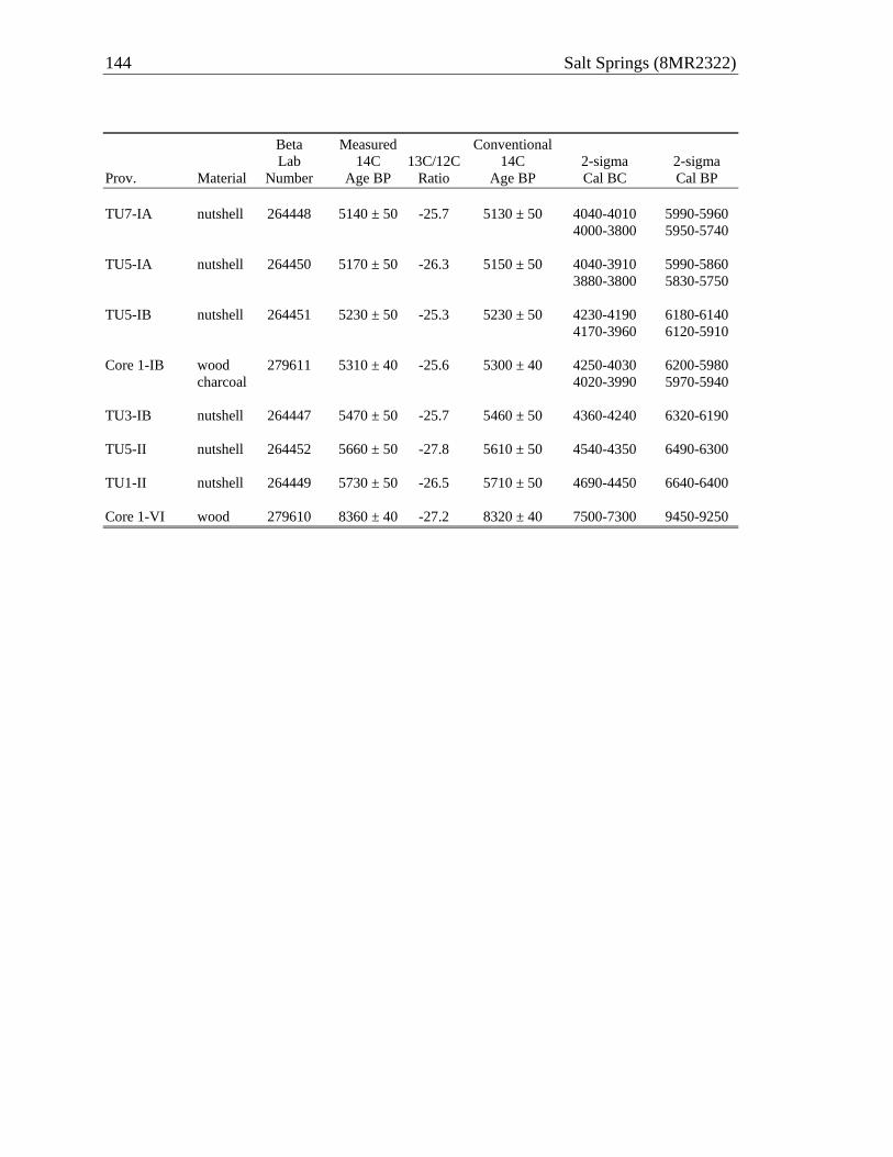
144 Salt Springs (8MR2322)
Beta Measured Conventional Lab 14C 13C/12C 14C 2-sigma 2-sigma Prov. Material Number Age BP Ratio Age BP Cal BC Cal BP TU7-IA nutshell 264448 5140 ± 50 -25.7 5130 ± 50 4040-4010 5990-5960 4000-3800 5950-5740 TU5-IA nutshell 264450 5170 ± 50 -26.3 5150 ± 50 4040-3910 5990-5860 3880-3800 5830-5750 TU5-IB nutshell 264451 5230 ± 50 -25.3 5230 ± 50 4230-4190 6180-6140 4170-3960 6120-5910 Core 1-IB wood 279611 5310 ± 40 -25.6 5300 ± 40 4250-4030 6200-5980 charcoal 4020-3990 5970-5940 TU3-IB nutshell 264447 5470 ± 50 -25.7 5460 ± 50 4360-4240 6320-6190 TU5-II nutshell 264452 5660 ± 50 -27.8 5610 ± 50 4540-4350 6490-6300 TU1-II nutshell 264449 5730 ± 50 -26.5 5710 ± 50 4690-4450 6640-6400 Core 1-VI wood 279610 8360 ± 40 -27.2 8320 ± 40 7500-7300 9450-9250