Magadha and Mahabharata : Archaeological indications from Rajgir Area - by B.R. Mani

197
ArchAeologicAl investigAtions At AreA A, enfield town centreChris mayo and peter boyer
sUMMArY
This paper discusses the results of archaeological investigations undertaken during the redevelopment of Enfield Town Centre between 2001 and 2005. The archaeological investigations forming part of the development programme were funded by Costain Engineering and Construction Ltd, with Gifford & partners Ltd commissioned as the principal archaeo-logical contractors. Pre-Construct Archaeology Ltd undertook the fieldwork on behalf of Gifford & Partners Ltd.
Enfield has a long history, with roots in the Roman settlement established near Ermine Street in Bush Hill Park. The area continued to be inhabited during the Anglo-Saxon period and it was recorded in Domesday as part of the manor of Geoffrey de Mandeville. By this time the area was extensively cultivated, and the remains of ridge and furrow field systems of medieval date have been recognised in earlier fieldwork. Due in part to the town’s location close to the former Roman road, Ermine Street, it grew in importance during the Middle Ages. It had significant royal and court connections in the Tudor period but sided with the Parliamentarians during the Civil War. The 18th century witnessed a period of decline, but the coming of the railways revived its fortunes, and it was amalgamated as a London Borough in 1956. Enfield Town is centred on the original village green, and the area considered in this paper was located close to the heart of the medieval manor, known locally as the ‘Palace’.
introdUction
As part of redevelopment plans for Enfield Town Centre, four areas were defined for improvement (A—D, Fig 1). Archaeological evaluations were conducted in all of these. Area A was to the south of Church Street, delimited by London Road to the east and Sydney Road to the west. It lay within the ancient floodplain of the River Lea, and excavations in the three evaluation trenches (not illustrated on Fig 2) uncovered natural River Terrace gravels overlain by ‘Enfield Silt brickearth’. This was sealed by medieval and post-medieval soil horizons with evidence of post-medieval pitting and structures. A further evaluation was conducted here in 2002, as well as to the south of Cecil Road (in Area B). Much of the north of Area A had been taken up by 19th/20th-century structures, some of which were associated with a late 19th-century gasworks. The latter had truncated and contaminated much of the earlier cultural deposits and features. Three further evaluation trenches (Eval 1—3) were excavated in Area A, which were designed to target parts of the site outside of the footprint of the gasworks. Following the first stage of this evaluation work, it was decided to open a wider space around Evaluation Trench 2, to increase the area of archaeological features exposed. This became Excavation Trench 2 (Ex 2) (Mayo 2005). This report concentrates on the archaeological findings from Area A, which

Chris mayo and peter boyer198
Fig. 1 Site Location
The Site
GreaterLondon
197250
5330
00
195700
5330
00ENFIELD TOWN
Church Street
Cecil Rd
Southbury Road
Bak
erSt
reet
Will
ow R
oad
New R
iver
A110
London Road A
105 Lincoln Road
Carrs Lane
Old
Par
k A
venu
e
Settlement
A105
A110
Town Park
Area D
Area A
Area B
Area C
Enfield Town
EnfieldChase
N
0 500m
Fig 1. Site location

Archaeological Investigations at Area A, Enfield Town Centre 199
covered approximately 2,550m2 and centred on National Grid Reference TQ 3282 9650 (SDY01) (Fig 2). The site archive will be deposited with the Museum of London’s Archaeological Archive and Research Centre (LAARC).
geologY And topogrAphY
The underlying geology of the site comprises Eocene London Clay overlain by Quaternary Terrace (Taplow) Gravel, which in turn is overlain by Quaternary brickearth deposits (Gifford & Partners 1999, 9). The 2002 work revealed the surface of the gravel to lie at
NCHURCH STREETTHE TOWN
EvaluationTrench 3
EvaluationTrench 1
EvaluationTrench 2
ExcavationTrench 2
LON
DO
N RO
AD
CECIL ROAD
Area ASite Boundary
SYD
NEY
RO
AD
19653053
2820
196420
5328
20
50m0
Fig. 2 Area A Trench Locations
Fig 2. Trench locations within Area A

Chris mayo and peter boyer200
between 31.31m OD (Eval 3) and 30.41m OD (Eval 2). This represents a slope from west to east, consistent with the known topography of the underlying ground. In Trench Ex 2 a deposit of brickearth overlay the natural gravel, which was recorded at an upper level of 30.62m OD. The site lay on relatively flat ground, bounded to the north by Enfield Town, to the east by London Road, to the south by Cecil Road, and to the west by Sydney Road. To the east, the natural ground slopes down into the valley of the River Lea.
ArchAeologicAl And historicAl bAckgroUnd
Prehistoric activity in the vicinity is repres-ented mostly by chance finds of Palaeolithic and Mesolithic hand-axes, and other lithic artefacts, though some of the discoveries have been reported in more detail (eg Grinsell 1950; Bishop 2002). Evidence of earlier pre-historic activity is more focused around the River Lea to the south and north-east. Later prehistoric finds are very sparse but include an arrowhead found in 1836, and a little further afield, an Iron Age hillfort has been recorded at Bush Hill to the south-east. At Innova Park, some 5km north-east of the study site, evidence for Bronze Age and Iron Age activity is associated with an earlier palaeochannel of the River Lea, including evidence for possible fish-traps of Iron Age date (Ritchie et al 2009). Other Iron Age sites have been recognised at a greater distance to the east, such as the hillforts at Loughton Camp and Amesbury Banks in Epping Forest (Gillam 1973).
Roman finds within 1km of the site have been found predominantly to the south-east and include a number of chance discoveries, including funerary remains. Roman Ermine Street ran north—south within 1.5km to the east and evidence for burials, including a lead coffin, could be indicative of settlements locally, although these have not been identified. Occupation remains of 1st to 4th-century date were found at Landseer Road, possible cremations west of Seventh Avenue, and an enclosure, floors, a beam slot, ditches, postholes, pits, a well and a corn drier of 1st to 4th-century date with an extensive and rich finds assemblage at Lincoln Road (Smith 1903; Gentry et al 1977).
Archaeological evidence for an Anglo-Saxon presence in Enfield is very sparse, although a buckle of Middle Saxon date was found at Lincoln Road to the south-east (Going 1984). A village at Enfield Green (now The Town) was mentioned in Domesday as being in the manor of Geoffrey de Mandeville; before that, and in 1065, it was held by Ansgar, Master of the Horse to Edward the Confessor (Jones & Drayton 1984, 7). Royal visits to the manor were infrequent in the earlier medieval period, although the proximity of Enfield Green to the hunting reserve of Enfield Chase would have maintained royal interest in the area. An excavation prior to construction of the Palace Gardens shopping centre in 1977, to the west of the site, revealed late 12th-century pottery and gravel surfaces (Armitage & Ivens 1978).
By the 14th century a large manor house of the Worcesters and a church were in existence at Enfield Green, with a village centred around these; the manor of Enfield became royal property in 1420 (Jones & Drayton 1984, 7). By the 16th century the village had increased in size. The medieval manor house known as Elsing Hall became part of the lands of the Duchy of Lancaster in 1539 and was superseded by a substantial structure that was to become Enfield Palace (immediately west of the site), a three-sided court standing in 7 acres of land with a barn, stables, orchards, gardens and a timber croft (Pugh 1976, 225; Pam 1990, 36). Tudor walls, features and artefacts attributed to the Palace were found during excavations completed in 1977. By the 1630s the land around the Palace was being encroached upon by building work. In 1663, Dr Robert Uvedale, a keen botanist, who constructed numerous outbuildings to house his plants, founded a private boarding school on part of the Palace site; this closed in 1896. He also planted one of the first cedar of Lebanon trees in England (Fig 3) in the grounds (Jones & Drayton 1984, 21).
His tenancy was short-lived, for in 1683 the property passed to the City of London and then, over the next hundred years, to various other occupants. A good deal of the Palace itself and a number of the outbuildings were largely demolished during 1791—2. The refurbished remains were used for the

Archaeological Investigations at Area A, Enfield Town Centre 201
Fig 3. Engraving of 1793 showing Doctor Uvedale’s cedar tree and the ?east wing of Enfield Palace (from Lysons 1795)
boarding school for much of the 19th century and a number of extensions were added. It was briefly used as a post office at the turn of the 20th century and later as a Conservative club; convalescent soldiers were entertained there during the First World War. It was finally demolished in 1927 (Jones & Drayton 1984, 23—4; Pugh 1976, 225, 257).
Rail links to London were built between 1840 and 1910. With the improved infrastructure came increased urbanisation including the setting up of light and heavy industry, and housing; a gasworks was in operation on a different part of the site between 1852 and 1882 (Pam 1992, 128—9). Following this, historic maps show a Baptist Tabernacle present between 1896 and 1914. During the course of the 20th century the locale around and including the study site became further developed, mostly with shops and housing, including the construction in 1928 of Pearsons shopping centre to the west.
enfield town centre in prehistorY
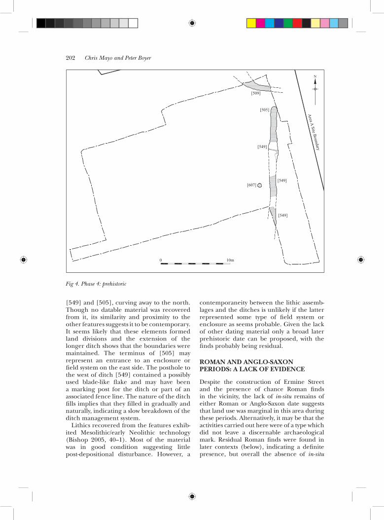
Evidence for prehistoric activity in Ex 2 confirms that the area was being used during this period, although no occupation areas could be directly located. A settlement in the vicinity was hinted at by a series of ditches and a posthole (Fig 4). One north—south-aligned ditch [549] was concave in profile, and measured at least 12.0m in length, up to 1.1m wide and 0.5m deep. The primary fill did not contain datable material, but a secondary fill included burnt and struck flint. This feature was extended to the north by a gully [505] with its northern terminus measuring 4.8m long by 0.8—0.9m wide and up to 0.4m deep. Its fill contained a flint flake and occasional charred wheat grains. These ditches together extended for at least 17.0m. A third linear cut [509] with a similar profile was offset from the terminus by 2.0m. It was aligned approximately east—west and set perpendicular to the first two ditches,
Chris mayo and peter boyer202
0 10m
N
[607]
[549]
[549]
[549]
[505]
[509]
Area A Site Boundary
Fig. 4 Phase 4: Prehistoric
[549] and [505], curving away to the north. Though no datable material was recovered from it, its similarity and proximity to the other features suggests it to be contemporary. It seems likely that these elements formed land divisions and the extension of the longer ditch shows that the boundaries were maintained. The terminus of [505] may represent an entrance to an enclosure or field system on the east side. The posthole to the west of ditch [549] contained a possibly used blade-like flake and may have been a marking post for the ditch or part of an associated fence line. The nature of the ditch fills implies that they filled in gradually and naturally, indicating a slow breakdown of the ditch management system.
Lithics recovered from the features exhib-ited Mesolithic/early Neolithic technology (Bishop 2005, 40—1). Most of the material was in good condition suggesting little post-depositional disturbance. However, a
contemporaneity between the lithic assemb-lages and the ditches is unlikely if the latter represented some type of field system or enclosure as seems probable. Given the lack of other dating material only a broad later prehistoric date can be proposed, with the finds probably being residual.
roMAn And Anglo-sAXon periods: A lAck of evidence
Despite the construction of Ermine Street and the presence of chance Roman finds in the vicinity, the lack of in-situ remains of either Roman or Anglo-Saxon date suggests that land use was marginal in this area during these periods. Alternatively, it may be that the activities carried out here were of a type which did not leave a discernable archaeological mark. Residual Roman finds were found in later contexts (below), indicating a definite presence, but overall the absence of in-situ
Fig 4. Phase 4: prehistoric
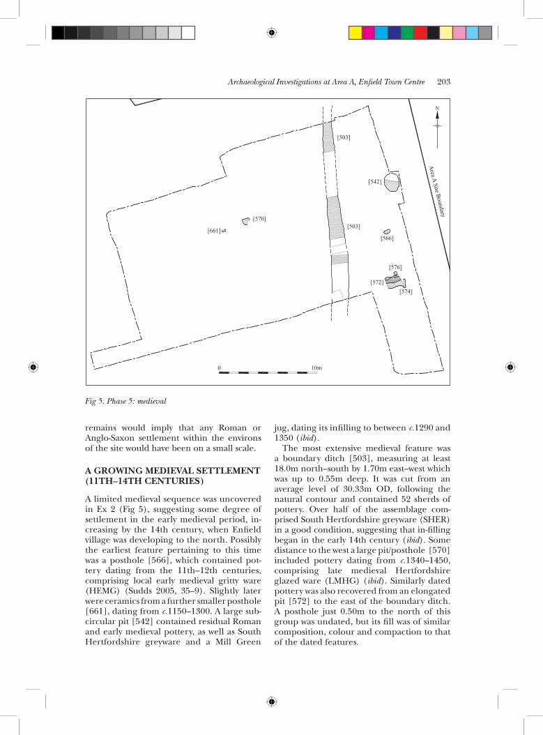
Archaeological Investigations at Area A, Enfield Town Centre 203
Fig. 5 Phase 5: Medieval
0 10m
[574][572]
[576]
[566]
[503]
[503]
[542]
[661]
[570]
Area A Site Boundary
N
Fig 5. Phase 5: medieval
remains would imply that any Roman or Anglo-Saxon settlement within the environs of the site would have been on a small scale.
A growing MedievAl settleMent (11th—14th centUries)
A limited medieval sequence was uncovered in Ex 2 (Fig 5), suggesting some degree of settlement in the early medieval period, in-creasing by the 14th century, when Enfield village was developing to the north. Possibly the earliest feature pertaining to this time was a posthole [566], which contained pot-tery dating from the 11th—12th centuries, comprising local early medieval gritty ware (HEMG) (Sudds 2005, 35—9). Slightly later were ceramics from a further smaller posthole [661], dating from c.1150—1300. A large sub-circular pit [542] contained residual Roman and early medieval pottery, as well as South Hertfordshire greyware and a Mill Green
jug, dating its infilling to between c.1290 and 1350 (ibid).
The most extensive medieval feature was a boundary ditch [503], measuring at least 18.0m north—south by 1.70m east—west which was up to 0.55m deep. It was cut from an average level of 30.33m OD, following the natural contour and contained 52 sherds of pottery. Over half of the assemblage com-prised South Hertfordshire greyware (SHER) in a good condition, suggesting that in-filling began in the early 14th century (ibid). Some distance to the west a large pit/posthole [570] included pottery dating from c.1340—1450, comprising late medieval Hertfordshire glazed ware (LMHG) (ibid). Similarly dated pottery was also recovered from an elongated pit [572] to the east of the boundary ditch. A posthole just 0.50m to the north of this group was undated, but its fill was of similar composition, colour and compaction to that of the dated features.

Chris mayo and peter boyer204
Fig. 6 Phase 6: 1400-1600
0 10m
[588][584] [653]
[645][678]
[641]
[586]
[657]
[672][655]
[564]
[582]
[544]
[627][629]
[615]
[578]
[623][604]
[568]
retainedditch[503]
[554]
[541]
Area A Site Boundary
N
The sparse distribution of archaeological features suggests that the activity here was not particularly intensive. The evidence indicates land divisions (both ditches and fencing-lines) and waste disposal in keeping with an area on the outskirts of Enfield Village. However the contemporaneity of the village origins and the cutting of the north—south ditch demonstrate the managed development of early Enfield’s immediate hinterland.
A tUdor townscApe, A pAlAtiAl Aspect (15th—16th centUries)
By 1400—1600 Enfield Village was more dev-eloped and the medieval manor house had become a grand three-range residence to the west of the site. Remains of this date in Ex 2 include postholes and drainage features, and perhaps represent evidence for activity within the Palace grounds. Some features
contained dating evidence whilst others are attributed to this phase by association. The 14th-century north—south ditch [503] was still open in the 15th century as indicated by the presence of late medieval Hertfordshire glazed ware (LMHG) and transitional red-wares (LMSR) in its fill (Sudds 2005, 35—9). Set at 90 degrees to the ditch on its western side was an alignment of seven postholes, whilst three additional postholes formed a perpendicular north—south alignment (Fig 6). The likelihood is that these fence lines further delimited the land to the west of the boundary ditch.
A further five postholes were located on the west side of Ex 2. These were in close proximity to a north—south-aligned gully [586] and an east—west-aligned beam slot [653]. The latter was 6.0m long by 0.45m wide and 0.10m deep. No postholes were associated with the wall footing, nor were any returns to the feature visible. Its position, in
Fig 6. Phase 6: 1400—1600

Archaeological Investigations at Area A, Enfield Town Centre 205
alignment with the fence line formed by the dated east—west postholes discussed above, suggests a link to that boundary. One of the postholes contained pottery, dating to c.1480—1650 (ibid).
At the northern edge of Ex 2 a large pit [554] measured at least 7.0m by 6.2m, and was 0.64m deep. It contained pottery dating to c.1400—1600, including late medieval Hertfordshire glazed wares (LMHG) and late medieval transitional redwares (LMSR) (ibid); its size, shape and the gravel deposits cut by it imply that it was a gravel extraction pit. Following its infilling in the 15th century a further pit [604] containing burnt material [605] was cut into the top of the large boundary ditch [503]. It contained two fills; the first comprised loose charcoal, while the second constituted a clay silt, which appeared scorched. Pottery from both dated from the 13th to 15th centuries, including an unsourced cauldron sherd in a fine micaceous fabric that may originate locally or perhaps in Essex (ibid). Given its apparent rapid backfilling, it seems that it was isolated, possibly for the disposal of rubbish, although it may originally have served as a hearth, or the remains of such were disposed in it. An elongated, sub-oval pit containing pottery dating to the period 1400—1600 was the only feature found on the eastern side of the large boundary ditch.
The presence of all but a single feature dated from 1400 to 1600 to the west of the boundary ditch suggests that during the period of early growth of the Tudor Palace this ditch formed a limit to the activity on that side, though the possibility of it being the eastern margin of the Palace grounds is unproven. It is possible that the activity identified was within the grounds of the Palace, but it may relate to peripheral roadside pursuits on an early precursor to London Road, only c.5.0m to the east of the ditch.
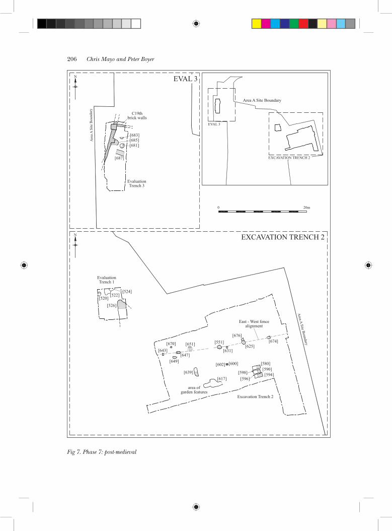
doMesticitY, horticUltUre And indUstrY (lAte 16th—19th centUries)
Later post-medieval features were found in all trenches. In Ex 2 (Fig 7) these included postholes, pits and evidence for horticultural work, such as gullies and possible spade marks.
In Eval 1 (Fig 7) a large gravel extraction pit was found, while Eval 3 contained rubbish pits (Fig 7). In Ex 2 a series of postholes or small pits was on a roughly east—west alignment. They contained finds dating from the late 16th to 18th centuries, predominantly from the end of the 17th century. This appears to have formed another fence line. No further features were found to the north of this, and it may have formed the northern boundary. To the south of the pit/posthole alignment, a sub-rectangular pit [639] contained ceramic building material (CBM) dating from 1666—1800 (Brown 2005, 43—7), and a small re-cut posthole [602] contained pieces dated 1664—1725 (ibid). Three parallel rectangular bedding trenches, [580], [590] and [594], were found at the southern edge of Ex 2. Two stakeholes, [596] and [598], were positioned to the west. Pottery of 19th-century date was recovered from these, and further 19th-century artefacts were found within the layer of an area of spade marks.
In Eval 1 four pits were excavated, of which three, [520], [522] and [524], were 19th-century domestic waste pits. The fourth, [526], measured at least 4.5m by 2.0m by at least 2.0m deep. It contained CBM and pottery broadly dated as post-medieval, inc-luding Border ware (BORDY), Post-medieval fine redware (PMFR), Post-medieval black-glazed redware (PMBL), sherds of Tin-glazed ware (TGW), Westerwald stoneware (WEST PURP), and Post-medieval redware (PMR), and is likely to have served for gravel extraction.
In Eval 3 a small sub-rectangular pit [683] contained medieval pottery, but also CBM dating from c.1450—1700. However, its position, shape and fill closely resembled those of two adjacent pits [681] and [685], which contained 19th-century clay tobacco pipe, and it is therefore phased as part of the same group. The pits are likely to have been for 19th-century waste disposal to the rear of properties facing onto Church Street. Two of the clay tobacco pipe bowls bore the stamp ‘J LAMBERT EDMONTON’ (Fig 8), a local maker (Jarrett 2005, 42). To the south the remains of an east—west-aligned brick culvert [687] were found. Finds included 19th-century pottery, suggesting that it was in use until that time. It is tempting to think, given the position of the Palace to the west, that
Chris mayo and peter boyer206
Fig.7 Phase 7: Post-medieval
[683][685][681]
[687]
C19thbrick walls
Are
a A S
ite B
ound
ary
N
EvaluationTrench 3
[526]
EvaluationTrench 1
[643][670] [651]
[647][649]
[639][617]
area ofgarden features
[551][676]
[631][625]
[602] [600]
[674]
[580][590][594]
[596][598]
Excavation Trench 2
Area A Site Boundary
Area A Site Boundary
EVAL 3
EXCAVATION TRENCH 2
EVAL 3
EXCAVATION TRENCH 2
0 20m
N
East - West fencealignment
[524][522]
[520]
Fig 7. Phase 7: post-medieval

Archaeological Investigations at Area A, Enfield Town Centre 207
the culvert may have been an installation for a later version of the building.
discUssion
The investigations have revealed prehistoric, medieval and post-medieval land-use, on the relatively high ground formed by the natural brickearth capping the Terrace Gravels. Prehistoric activity was represented along London Road in Ex 2 by a north—south-aligned ditch that had been extended northwards. An entrance to a possible enclos-ure may have been formed between this and another, east—west-aligned ditch. Artefacts from these features date from the Mesolithic or early Neolithic periods, but it is likely that the ditches were elements of later prehistoric field or enclosure systems and that the lithic finds were residual. Archaeological invest-igations to the east of the site at Plevna Road in Edmonton revealed field systems of late Neolithic or early Bronze Age date (Bishop 2006).
Medieval features comprised a north—south ditch and various pits and postholes. These indicated isolated and sparse activity dating to the 11th to 13th centuries. As Enfield Village developed to the north in the 14th century, activity on the site became more pronounced, with the cutting of the ditch and pitting on its east side. The ditch was most likely a boundary. By the 14th century the manor house had also been established to the west. It is not known if the 14th-century ditch near London Road, in Ex 2, was related to its founding.
In Ex 2 numerous postholes were found,
which dated from c.1400—1600. These can be conjectured to have formed an east—west fence line with another perpendicular to it. A burnt rubbish pit and large gravel extraction pit were among the features of this period. The archaeology revealed the zoning of areas that were likely to have been either within the Palace grounds or just on its periphery, and that these areas were used for quarrying and isolated pitting. Two possible gullies in Ex 2 could not be directly linked with a structure, but could have served a low-level horticultural purpose – an activity that could be expected away from the Palace itself and therefore something that may have happened in this marginal area.
During the 17th century land around the Palace was gradually developed, notably with the construction of outbuildings by Robert Uvedale. Various postholes in Ex 2 dated to the last quarter of the 17th century, just before Uvedale vacated the Palace. It is possible (though unlikely, see below) that the postholes, which formed an east—west fence alignment, were a land division for Uvedale’s ‘nursery’.
Other features dating from the 19th cent-ury in Ex 2, Eval 1 and Eval 3 took the form of isolated rubbish pits, gravel extraction pits, bedding trenches and postholes: all can be related to ‘backyard’ activity behind buildings fronting onto Church Street and London Road. Pottery collected from the post-medieval features includes a quantity of sponged Pearlware products (Sudds 2005), suggesting the proximity of a population of lower socio-economic status.
An interesting facet of the investigations
Fig 8. a: Clay pipes; b: Detail of maker’s mark
A B

Chris mayo and peter boyer208
is the apparent longevity of boundaries identified in Eval 2 and Ex 2. Ditches on cardinal alignments may have delimited the edges of a later prehistoric enclosure. During the medieval period a north—south-aligned boundary ditch was excavated in close proximity to the prehistoric one. Fence lines of Tudor date were seen running north—south and east—west, and there was also an east—west-aligned post-medieval fence line. The consistency of these alignments is less surprising from the medieval period onwards, given that London Road is likely to have been in existence from that time onwards to define the position of roadside activity. Furthermore the fact that the 14th-century ditch was open until at least the 15th century shows the maintenance of boundaries across the medieval and Tudor periods. The similarity of alignment between the prehistoric ditch and the medieval and later features may be coincidental, but there is also a possibility that this area formed an important, long-standing boundary.
Nothing that could be directly associated with the Tudor Palace was found during the investigation. A post-17th-century culvert in Eval 3 may have been a service drain for one of the post-medieval successors to the Palace, and it has been suggested (above) that some of the postholes excavated may have belonged to a fence line associated with the cultivation of Robert Uvedale’s exotic plants. However, Jones and Drayton (1984, 21) suggest that Uvedale’s gardens would have occupied areas to the south and west of the house. Excavations in the 1970s revealed elements of the Palace to be situated to the west of the study site (Armitage & Ivens 1978). This would also suggest that Uvedale’s gardens lay to the west. The complete lack of Tudor remains in Eval 3, the closest trench in the study area to the 1970s excavations, either demonstrates that the area had been subject to later disturbance, or more likely, that the Palace did not extend this far to the east.
AcknowledgeMents
Pre-Construct Archaeology Ltd would like to thank Gifford, in particular Sean Steadman and Phil Emery, for commissioning the work, and Costain Engineering and Development
Ltd, particularly Simon Williams, for kindly funding the work, and help on site. Thanks are also extended to Kim Stabler of GLAAS for monitoring the work. The authors would like to thank Jon Butler for project management and Frank Meddens for post-excavation management and editing. Thanks also to Nathalie Barrett for the survey work, Adrian Nash for the CAD-work, the finds department for processing the artefacts, and Lisa Lonsdale and Rob Nicholson for technical support. Further thanks are extended to the specialists who contributed to the post-excavation programme: Barry Bishop, John Brown, Märit Gaimster, Chris Jarrett, Frank Meddens, Berni Sudds and Alys Vaughan-Williams. Finally thanks are due to the excavation staff: John Crisp, Mary Ellen Crothers, Richard Humphrey, Dan Miller, Denise Mulligan and Chris Pickard.
bibliogrAphY
ARMITAGE & IVENS (1978), P Armitage & J Ivens ‘Excavation at Palace Gardens, Enfield, 1977’ London Archaeologist 3 (6), 143—8
BISHOP (2002), B J Bishop ‘A Bout Coupé handaxe from Enfield in the lower Lea Valley’ Lithics 23, 43—7
BISHOP (2005), B J Bishop ‘Appendix 4: lithics assessment’ in Mayo 2005
BISHOP (2006), B J Bishop ‘Excavations at Lower Edmonton and the prehistoric development of the lower Lea Valley’ Trans London Middlesex Archaeol Soc 56, 1—26
BROWN (2005), J Brown ‘Appendix 6: building material assessment’ in Mayo 2005
GENTRY et al (1977), A Gentry, J Ivens & H McLean ‘Excavations at Lincoln Road, London Borough of Enfield, November 1974—March 1976’ Trans London Middlesex Archaeol Soc 28, 101—89
GIFFORD & PARTNERS (1999), Gifford & Partners Enfield Town Centre Development Phase II: Environmental, Geotechnical and Archaeological Desk Study Gifford & Partners Report B1553A/R01
GILLAM (1973), G Gillam Prehistoric and Roman Enfield — A Summary of Prehistoric and Roman Archaeology of the London Borough of Enfield Enfield Archaeological Society Research Report 3
GOING (1984), C Going ‘A Middle Saxon buckle from Lincoln Road, Enfield’ London Archaeologist 5, 301—2
GRINSELL (1950), L V A Grinsell ‘A stone axe of Scandinavian type from Enfield’ Trans London Middlesex Archaeol Soc 10 (3), 308—9

Archaeological Investigations at Area A, Enfield Town Centre 209
JARRETT (2005), C Jarrett ‘Appendix 5: clay tobacco pipe assessment’ in Mayo 2005
JONES & DRAYTON (1984), I K Jones & I W Drayton The Royal Palaces of Enfield Enfield Archaeological Society Research Report 4
LYSONS (1795), D Lysons ‘Enfield’ The Environs of London: volume 2: County of Middlesex, 278—334; viewed online, URL: http://www.british-history.ac.uk/report.aspx?compid=45413
(accessed: 12/11/2007)MAYO (2005), C Mayo Assessment of an
Archaeological Evaluation at Enfield Town Centre (Area A), London Borough of Enfield Gifford & Partners Report B1553A/096/R010
PAM (1990), D Pam A History of Enfield, Volume One — Before 1837. A Parish Near London
PAM (1992), D Pam A History of Enfield, Volume Two — 1837 to 1914. A Victorian Suburb
PUGH (1976), R B Pugh (ed) Victoria History of the County of Middlesex. Volume V
RITCHIE et al (2009), K Ritchie et al ‘Envir-onment and land use in the Lower Lea Valley c.12,500 bc—c.ad 600: Innova Park and the former Royal Ordnance Factory Enfield’ Trans London Middlesex Archaeol Soc 59, 1—38
SMITH (1903), R A Smith ‘Note on a discovery of Roman interments at Enfield’ Proc Society of Antiquaries of London 19, 206—10
SUDDS (2005), B Sudds ‘Appendix 3: pottery assessment’ in Mayo 2005
WESSEX ARCHAEOLOGY (2007), ‘Wessex Arch-aeology Innova Park’ http://www.wessexarch.co.uk/projects/Middlesex/enfield/innova
(accessed 30/04/07)

210