ARCHAEOLOGICAL FIELD NOTEBOOK 2004 - … Field Unit Notebook 2009.pdf · significant amount of...
89
ARCHAEOLOGICAL FIELD NOTEBOOK 2009 A RECORD OF THE PROJECTS OF THE : BRIGHTON AND HOVE ARCHAEOLOGICAL SOCIETY FIELD UNIT
-
Upload
phungkhanh -
Category
Documents
-
view
216 -
download
0
Transcript of ARCHAEOLOGICAL FIELD NOTEBOOK 2004 - … Field Unit Notebook 2009.pdf · significant amount of...
ARCHAEOLOGICAL FIELD NOTEBOOK 2009
A RECORD OF THE PROJECTS OF THE :
BRIGHTON AND HOVE ARCHAEOLOGICALSOCIETY FIELD UNIT

Introduction Page 1 of 1
INTRODUCTION
The new 2009 season of field work proved to be very active one with the BHAS Field Unitinvolved in excavations, field walking and geophysics. Once again Sussex Universitystudent projects were supported by the team with digs at Falmer and Plumpton. The mainexcavations were focused at Rocky Clump and Ovingdean with a small excavation on partof Hove lawns being part of a heritage week-end.
Geophysics played a major part in the society activities this year with projects at BeaconHill, Rottingdean investigating mounds observed by the Brighton rangers, a new survey atOvingdean and an investigation in the medieval platform located at Piddingworth north ofStanmer. Field walking took place at Ovingdean in the field north of Roedean school.
Once again the Young Archaeologists Club (YAC) joined the BHAS diggers at Ovingdeanand training for new members of the BHAS field unit continued throughout the year.
Finds processing and days schools have been a continuing part of the educational processand post excavation. Good numbers of people turned up for the finds processing at thePatcham Community Centre venue with finds from Peacehaven, Ovingdean and RockyClump being marked and catalogued.
It has been an extremely eventful year for the BHAS Field Unit and 2010 promises to bejust as interesting and active.
Hard copies of this report are passed to Mr G.Bennett at Brighton and Hove PlanningDepartment, Casper Johnson, the County Archaeologist, Brighton Museum, BarbicanHouse, the East Sussex Records Office and the National Monuments Records Office atSwindon. CD-Rom copies are produced by the Society’s web master Mr Martin Devereuxand are made available to the field unit members and others who desire a copy.
John Funnell 18th December 2010

Contents Page 1 of 1
CONTENTS
EXCAVATIONS
1. Rocky Clump, Stanmer, Brighton-A Romano-British Farmstead-Interim Report2009
2. Ovingdean – The Medieval ‘Manorial’ Complex – Interim Report 2009
3. Coldean – Excavations of a Roman Ditch
4. Plumpton Excavations – A student project
5. Falmer Excavations – A student project
GEOPHYSICS
1. Beacon Hill, Rottingdean2. Ovingdean – The Allotments3. Piddingworth Manor, Stanmer
FIELD WALKING
1. Field Walking at Roedean North Field
MISCELLANEOUS
1. Barcombe – A Find of a Palaeolithic Hand Axe
ARCHAEOLOGICAL WATCHING BRIEFS
1. 50 Wolseley Road, Coldean
2. Bishopstone
3. 10 Brangwyn Avenue
4. 28 Grand Crescent, Satldean
5. Whitehawk Hill, Neolithic Causewayed Enclosure
BHAS FIELD UNIT ATTENDANCE RECORD
ACKNOWLEDGEMENTS
INDEX UPDATED 2009

Rocky Clump Page 1 of 6
EXCAVATIONS AT ROCKY CLUMP, STANMER - INTERIM REPORT 2009
Introduction
The excavations at Rocky Clump were quite limited this year due to other projects takingprecedence (Fig 1). The site was visited for a number of weeks in the spring (April 4th -May 30th) and a return visit took place in the autumn (October 4th - December 8th). Thefocus of the excavations this season was in two locations, the main thrust was northwardsfrom the Bones trench, and southwards and westwards in the east trench. A good numberof diggers turned out and several new features were uncovered producing someinteresting finds of metal work and glass.
The Bones Trench
In 2008 the excavations in the ‘bones‘ trench had developed an interesting deeper level asit progressed northwards, the depth of top soil being much more than the normal 200mm.At the end of that season a distinct number of stratigraphical layers could already beobserved. The layers varied in colour and texture with interlaced layers of dark soil and flintlying over much lighter chalky deposits in the lower depths. The new area was divided outinto 2 metre square grid squares that ran from west to east and given context numbers917, 918, 919 and 920 (the latter being on the east side of the excavation.). Context 917was expected to reveal another 2 metre length of the north/south ditch. Metal detectingimmediately north of he new excavation section produced 2 Roman coins, both barbarousradiates. Roman pottery in several forms was recovered from the upper layers includingseveral pieces of samian ware.
The stratigraphical layers showed a distinct drop on the west side so that the lowest layerat the west end was much deeper than that on the east side (Fig 2.) On the west side ofthe section the base contour rose until it met with the junction of the large north/southditch. The upper layer (a) produced several pieces of metalwork and an interesting amountof pottery. The finds varied from layer to layer with some of the middle layers producingvery little, possibly indicating rapid back filling during ancient times. One layer produced asignificant amount of snail shells probably suggesting that this layer bad lain open toelements for some time and that the filling in of the depression was undertaken at varyingstages.
The lower layers proved to be the most interesting. As the excavation progressed in depthvarious collections of butchered bone were found in differing locations, and while some ofthe lower fills were quite soft others were quite hard and difficult to excavate. Among themost interesting finds from the upper layers were a large piece of tegula roofing tile context920C, a small piece of marble from context 925 and 4 pieces of samian ware from context920D.
The lower layers had a number of distinct concentrations of finds of butchered bone andamong these were context 925 which was thought to be a possible pit, but this later provedto be a shallow deposit focused in one area. Other pit features, contexts 930 and 931 laterproved to be one larger pit. Bone concentrations were also noted in contexts 933 and 935,which proved to be the south edge of a cobbled flint floor.

Rocky Clump Page 2 of 6
Rocky Clump Page 3 of 6
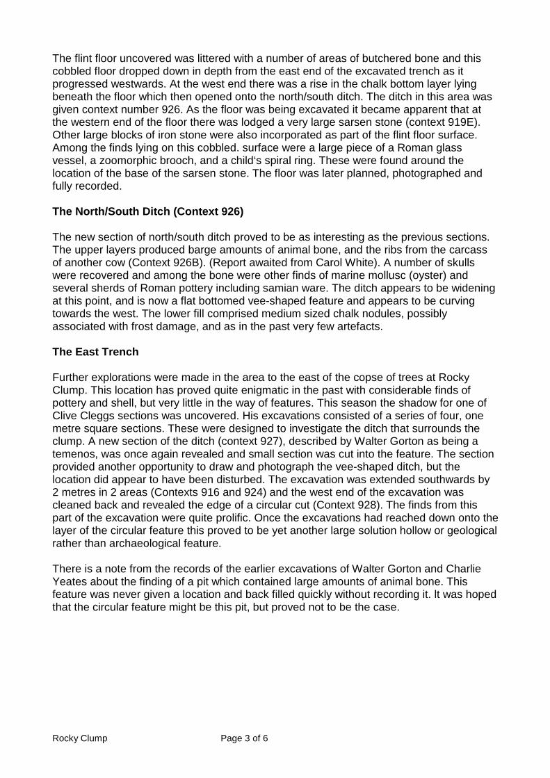
The flint floor uncovered was littered with a number of areas of butchered bone and thiscobbled floor dropped down in depth from the east end of the excavated trench as itprogressed westwards. At the west end there was a rise in the chalk bottom layer lyingbeneath the floor which then opened onto the north/south ditch. The ditch in this area wasgiven context number 926. As the floor was being excavated it became apparent that atthe western end of the floor there was lodged a very large sarsen stone (context 919E).Other large blocks of iron stone were also incorporated as part of the flint floor surface.Among the finds lying on this cobbled. surface were a large piece of a Roman glassvessel, a zoomorphic brooch, and a child‘s spiral ring. These were found around thelocation of the base of the sarsen stone. The floor was later planned, photographed andfully recorded.
The North/South Ditch (Context 926)
The new section of north/south ditch proved to be as interesting as the previous sections.The upper layers produced barge amounts of animal bone, and the ribs from the carcassof another cow (Context 926B). (Report awaited from Carol White). A number of skullswere recovered and among the bone were other finds of marine mollusc (oyster) andseveral sherds of Roman pottery including samian ware. The ditch appears to be wideningat this point, and is now a flat bottomed vee-shaped feature and appears to be curvingtowards the west. The lower fill comprised medium sized chalk nodules, possiblyassociated with frost damage, and as in the past very few artefacts.
The East Trench
Further explorations were made in the area to the east of the copse of trees at RockyClump. This location has proved quite enigmatic in the past with considerable finds ofpottery and shell, but very little in the way of features. This season the shadow for one ofClive Cleggs sections was uncovered. His excavations consisted of a series of four, onemetre square sections. These were designed to investigate the ditch that surrounds theclump. A new section of the ditch (context 927), described by Walter Gorton as being atemenos, was once again revealed and small section was cut into the feature. The sectionprovided another opportunity to draw and photograph the vee-shaped ditch, but thelocation did appear to have been disturbed. The excavation was extended southwards by2 metres in 2 areas (Contexts 916 and 924) and the west end of the excavation wascleaned back and revealed the edge of a circular cut (Context 928). The finds from thispart of the excavation were quite prolific. Once the excavations had reached down onto thelayer of the circular feature this proved to be yet another large solution hollow or geologicalrather than archaeological feature.
There is a note from the records of the earlier excavations of Walter Gorton and CharlieYeates about the finding of a pit which contained large amounts of animal bone. Thisfeature was never given a location and back filled quickly without recording it. lt was hopedthat the circular feature might be this pit, but proved not to be the case.

Rocky Clump Page 4 of 6
The ‘Bones‘ Trench Extension (Fig 2.)
In October 2009 the BHAS team returned to Rocky Clump and began a new extension tothe bones trench. lt was now essential to find the north and east extents of the cobbled flintfloor. New contexts of 2 metre square sections were set out and allocated context numbers936-940 inclusively. These areas were being excavated until the site closed down inDecember 2009. The new areas produced a small number of finds of pottery, but very littleelse. However, there is still much more fill to be removed before the floor level is reachedin this location, but chalk is already appearing on the north side of the excavation whichmay indicate the extent of the north side of the floor.

Rocky Clump Page 5 of 6
Conclusions
The 2009 season of excavations at Rocky Clump has once again provided newinformation about low status Romano-British farmsteads. The small excavation in thebones trench provided more evidence for rural farming activity and possibly the location ofa Roman butchery site, judging by the copious amounts of bone being recovered. The rarefinds of brooches and Roman glass from the lower levels also show the potential for similarfinds in the future. The richness of the finds and their rarity raises questions about lifestyles, trade and the quality of life for the humble people of this period.
The flint cobbled floor with the large elevated sarsen stone at the west end and coveredwith butchered bone could, with imagination, been construed as a possible ‘chopping‘block. The depression in the floor could be to dram the blood from such enterprises. Thereis a slight problem with the adjacent north/south ditch being used as a dram for thispurpose as it is slightly higher than the floor level, so must have been created for someother purpose. There is no staining on the large sarsen stone providing evidence for suchactivities, although tool marks can be discerned.
A chronological sequence has been determined by the various layers of chalk deposited.The digging of the north/south ditch overlay the lower fills above the flint floor, and thesechalk upcasts were in turn covered later by the further in filling of the cobbled floor. Thesunken floor surface was the earlier feature covered by the digging of the later north/southditch. We still do not understand why the north/south ditch was being cut, but can assumethat it was part of a newer field system. This raises the question about what washappening on the flint floor, were the activities associated with it no longer required andthus making it redundant, or was it's location moved elsewhere, only further investigationsmay provide answers.
As the season progressed and the field unit returned to Rocky Clump in the autumn anumber of changes had occurred to the features in the bones trench. Weathering over thesummer had had some effect. The south edge of the cobbled floor now appeared to havechange in configuration. Originally the floor was recorded to have a straight edge along thesouthern side, but now at the western end of the feature there now appeared to be adistinct curved area. The curvature was enhanced in definition by a number of the ironstones, which were mentioned earlier in the report as being part of the floor surface. Thecurved section had the large sarsen block at its western end with the cobbled floorcontinuing in a linear fashion eastwards under the baulk. David Rudling, our local Romanexpert, visited the site in the autumn and suggested that the circular feature may be aRoman well.
Excavations at Rocky Clump in 2010
The excavations will continue in 2010 seeking the north and east boundaries of the ‘floor‘and possible well, and sections will then be cut to examine the features in more detail. Theeast trench continues to be enigmatic providing lots of finds and questions. Will we findthat elusive pit full of animal bones noted in the archive of the early excavations? Orpossibly more features associated with the possible ‘shrine‘ site. A small geophysicalsurvey conducted north of the ‘bones trench shows quite clearly that the north/south ditchcontinues for a further 40 metres and more, but more importantly a new area of lowresistance. The new area of low resistance is once again located east of die largenorth/south ditch and appears rectangular in shape, only further investigations will revealwhat these features are, and how they relate to the current known Roman landscape.

Rocky Clump Page 6 of 6
The scale of the 2009 season of excavations has been enhanced by the adding of mid-week digging. A number ofBI4AS people have now retired and with Mark Gillingham andBrenda Collins leading and directing it has allowed more excavation and speedierprogress.
The author would like to thank all of the BHAS people who have turned out in all types ofinclement weather, including snow showers. lt certainly shows the commitment of theBHAS membership
John Funnell 10th January 2010

Ovingdean Page 1 of 35
EXCAVATIONS AT OVINGDEAN 2009 - INTERIM REPORT
Introduction
Early in 2009 a brief of work for a major archaeological undertaking at Hog Croft Field,Ovingdean was compiled and presented to Mr Casper Johnson, the County Archaeologist,and Mr Geoff Bennett of Brighton and Hove City Council. (Fig 1.) The plan was to uncoverand reveal the complexity of features revealed in previous seasons (Funnell), extend theexcavation northwards to reveal more archaeological remains and endeavour to discovertheir significance and purpose. A vast amount of information has been provided by theevidence from earlier investigations, but a more composite and extended excavation wouldbring together all these elements into a better understanding of the archaeologicalremains.
The proposal was to start with a more detailed excavation of the ‘manor’ house, and thenexcavate systematically northwards towards the location of the possible detached kitchen.Additional investigations would encompass the banks surrounding the medieval enclosurein an attempt to date them, and to examine a number of geophysical anomalies observedin resistivity surveys located outside of the medieval enclosure in areas to the west of theenclosure and down in the valley bottom. County Hall had also requested a possibleintervention into an area where it is believed part of the film ‘Oh What a Lovely War’ wasrecorded, in an attempt to find more contemporary archaeology. This section is located inthe north east section of the field. The excavation was planned to be carried out overseveral years. The specification of the excavation was to remove the top soil, uncover thearray of features and plan them. The plan was then with the minimum of intervention toseek out a chronological sequence and date range for the features, and hopefullyunderstand the purpose for the various ditches, pits and earthen banks.
It was early into the excavation that Brighton and Hove City Council changed the landusage at Ovingdean into a High Level Stewardship (HLS) Scheme. The CountyArchaeologist informed the society that this change would now restrict the excavation andonly a focused investigation of the manor house would be allowed at this time. It was alsoproposed, after a site visit by the County Archaeologist, that sections of the house from turflevel downwards should remain untouched, this would allow archaeologists in the future tofurther investigate the house at Ovingdean and be able to re-assess the findings from thisseason. A plan was made to cut sections that would effectively provide a detailed sectionthrough the house in both north/south and east/west directions (Fig 2.), (Fig 3.) and (Fig3a.)
The BHAS Field Unit returned to Ovingdean in May 2009. The area to be excavated, alongwith sufficient excess land for a spoil heap, was marked out and an electric fence waserected. The purpose of this fence was to keep the small herd of cows kept in the fieldaway from deep sections that could cause them harm if they fell in to the sections. Afurther safety measure incorporated an inner fence of red and white tape around theboundaries of the excavation, to make people aware that they were entering a hazardouszone. The excavation then began in earnest with the removal and stacking of turf fromabove the house location. The house location had been well documented from theprevious investigations in 2003 – 2008. Once the area was open context numbers wereallocated numbering from 200 in the south/west corner through to 234 in the south/westcorner (Fig 4.). Each context section measured 2 metres by 2 metres, and finds collectedfrom each section were given bags with these distinct numbers. The top soil wassystematically removed until the walls underneath were revealed. Sections were then cut

Ovingdean Page 2 of 35
in various locations to investigate the cellar below and the chalk surface surrounding thewalls. Wherever possible the same context numbers were retained during the sections, butthen more finely defined in chronological sequences by adding additional suffixes of a, b,c, with ‘a ‘being the upper layer and b and c lower levels. The upper top soil consisted of avery fine, light brown silty loam.

Ovingdean Page 3 of 35

Ovingdean Page 4 of 35

Ovingdean Page 5 of 35

Ovingdean Page 6 of 35

Ovingdean Page 7 of 35
The Excavations
The Manor House Walls (Fig 5.)
The main purpose of the 2009 excavation had been prompted by the wall finds from theinvestigations in 2003, 2006 and 2008. The north/east corner of the house had beenuncovered, possible steps into a cellar revealed inside the house, and a chronologicalsequence showing a number of stages or phases for building activity and renovation orregeneration. In 2008 the south/west corner of the house had been revealed and was quitedifferent to the walls found in the north/east corner. It was an obvious requirement of thenew investigation to find out when these changes had occurred and how or why they hadhappened.
The walls were revealed and from the first outset it was visibly obvious that a number ofchanges had occurred to the original structure. The most significant wall was the one tothe north. It was in the central region of the north wall that the wall achieved its maximumwidth of 1.4 metres and it was also in this area that a beam or door slot was located. Thispoint is deemed to be the main upper entrance to the house. Post holes found during the2006 excavations, in the chalk to the north of this door, may indicate that the building hada porch (Funnell).
The North Wall
The north wall is effectively divided into 3 sections. The central area, as previouslydescribed is the thickest part of the house, and it changes at both the west and east ends.The west end of the wall steps down to only 84cms in width, but is of the same materialconstruction. The east end of the north wall is dramatically different. The thickness of thewall at the east end is only 58cms and along with a well constructed north/east corner is awell defined later construction. The wall in the north/east section is only 30cms deep and isconstructed above a layer which is a combination of a flint rubble and chalk loam fill. Thewest end of this section of wall has been bonded into the thickest section of the north wall,utilising the door slot in this location as a key. The central thicker wall was excavated downto the cellar floor, but the west end of this wall was only partially excavated in depth downto just below a large flint, cobbled floor surface. All sections of the north wall used largeflint nodules and mortar for their construction, although the later smaller thickness east endof the wall used more refined mortar and smaller pebble stones in the mortar mixture.
The West Wall
The west wall is quite solid in construction but varies along its full width from 85cms on thesouth side to 1.05 metres on the north side. The wall was fully exposed in contexts 200,202 and 206 but only excavated to the top surface in context 204. The west wall has beenpartially removed in the south section, but at a lower depth the wall has an inner protrudingridge, also noted on the south wall, that could indicate a much wider original thickness.

Ovingdean Page 8 of 35
The East Wall
The east wall, like the north wall, has at least two phases. The earlier medieval thick wallwas still retained on the south side and on the south/east corner. The wall at this pointmeasured 1.0 metre in width. The north section leading to the north/east corner retainedthe same width as the east end of the north wall at 58cms. Both walls were of flint andmortar construction, but the feature was decidedly less stable than the walls on the northand west sides. The junction between the north and south section walls was not verysound with various sections of patching and repair using flint nodules (Contexts 241, 242,243 and 244). Numerous amounts of loose flint nodules were found to the east of this wall.The junction of the two walls was not well constructed and the flint nodules could easily beprised out of position and the mortar was of very poor quality. The junction of the twosections of the east wall was marked with a brown stain on the flint nodules. This stain ranin conjunction with a shallow ditch noted on the inside of the wall running westwards for ashort distance. Attached to the outside of the east wall was a small square walled feature,which is the location of a possible garderobe. The depth of wall on the north sectionmeasured only 30cms while the thicker wall on the south side carried on down to the cellarfloor. The walls were chased down into the cellar depths in contexts 226, 227 and 233.
The South Wall
The south wall was a most curious collection of wall features. The width of the wall variedalong its length from 1.11 metre at the west end to 90cms in the central section and to64cms at the east end. The south east section was not well mortared, and the flint nodulesappeared quite loose. The central and south west sections were very solid and wellconstructed with an inner ridge noted in context 219 at a lower depth similar to the onenoted in context 202 on the west wall. The south wall had a curious outer ridge, on thesouth side of the wall that varied in width as it progressed eastwards. The west end of thisridge measured 33cms but that diminished to only 10cms in the south/west outer corner. Anumber of bricks of 18th or 19th century date (pers. Comm. Luke Barber) were cementedinto the inner section of the south wall in a number of locations. The bricks were laterremoved at the suggestion of Luke Barber and proved to be the infill of a pair of southfacing medieval windows (Fig 16. Profile R-R)

Ovingdean Page 9 of 35
The Corners of the Building
The North East Corner (Context 226) (Fig 5.)
The north east corner of the building was the best preserved and youngest of the group. Itwas not substantial in thickness as mentioned but was well constructed. It overlay a lowerfill of flint nodules and chalky loam, and this fill, in turn this fill overlay the thicker medievalwalls that were still present at a lower depth. The deeper walls were well preserved on theeast side of the building, but the north section had been robbed of much of the thickerolder lower wall. The upper, later corner consisted of an outer corner block of Caen stone,while the inner section was constructed of a pair of carved chalk blocks. The north/eastcorner had been the first to be uncovered in the 2006 season of excavations.

Ovingdean Page 10 of 35
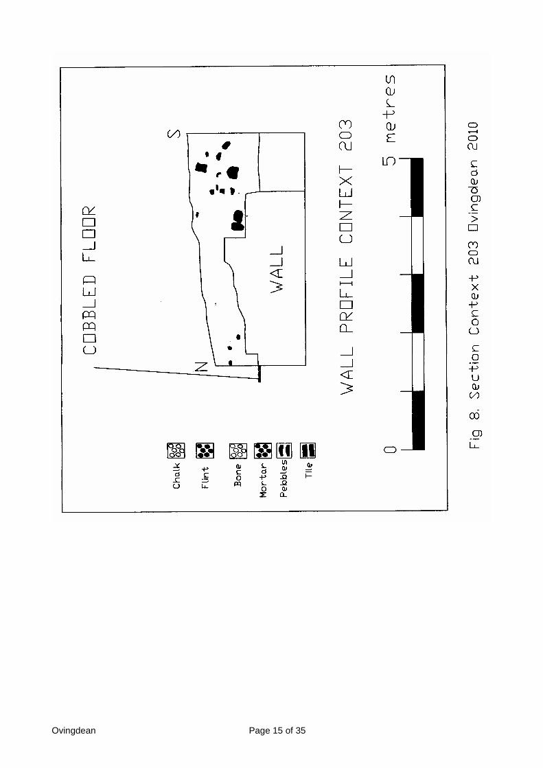
The South West Corner (Context 203)
The south west corner of the building was partially uncovered and excavated in 2008, andit was the dramatic difference to the north/east corner that prompted the 2009investigations. In 2008 the corner was revealed and the interior of the wall excavated to adepth of 1 metre. The corner is of a solid flint and mortar build, but there were no interiorcornerstones, only a rough circular pit remaining. The inside of the walls in this corner hadbeen robbed, and it was obvious that the hole in the corner was used as a positionalplatform for robbing and prising out the flint nodules for re-use. The corner was excavatedto a depth of 1.2 metres, but digging stopped as the loose fill proved to be unstable andhealth and safety issues arose. Among the new finds in this location was a coin of GeorgeIII.
The South East Corner (Context 228)
This corner was untouched and was left in-situ for future archaeologists to investigate. Apair of 18th of 19th century bricks were noted embedded into the inner section of the corner,but are unlikely to be part of a bricked up window in that location.
The North West Corner (Context 207) (Fig 18.)
The north/west corner of the building was originally going to remain untouched. Theexcavations had revealed the junction of the north and west walls and it showed to be offlint and mortar construction. Adhering to the corner of both north and west walls was theremains of the later large beach pebbled cobbled floor, noted as a floor surface in varyinglocations around the building and also in the interior section. A change of policy wasadopted when it was deemed possible that part of the original medieval corner may havebeen still preserved below that cobbled floor. After recording, photographing and drawingthe corner a section of the flint cobbled floor was removed to investigate the layers below.As the excavation progressed a number of large carved chalk cornerstone blocks wereuncovered. One of the blocks measured 33cms x 30cms x 14cms thick. All of the blockshad been prised away from the corner, and none were found in-situ. The excavationprogressed down for only a small depth once several corner pieces had been founddisturbed. The outer facing corner appeared to have a small buttress aligned against thenorth wall (Context 237), below context 209, but upon excavation proved to be a veryshallow feature.

Ovingdean Page 11 of 35
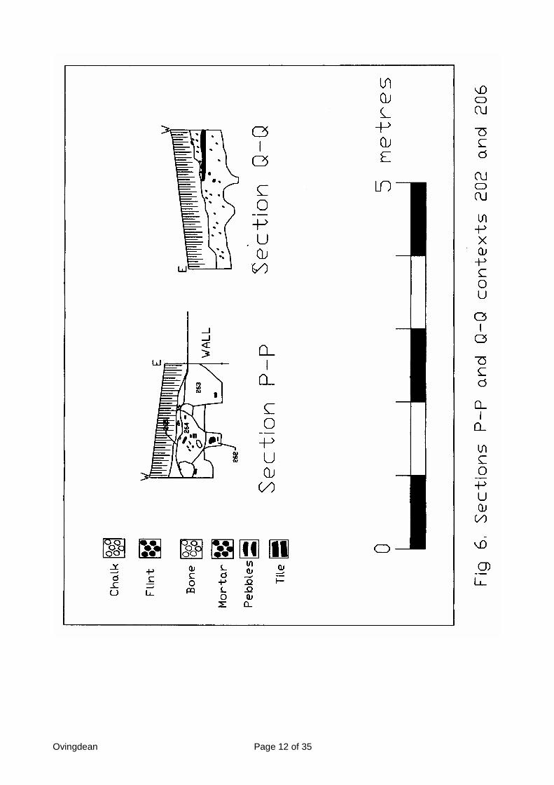
The Outer Fills (Fig 6 Sections P-P & Q-Q and Fig 18 Section H-H))
From the outset of the original excavations it was always suspected that the complex ofbuildings at Ovingdean, located within the medieval enclosure, were built on top of anartificially created chalk platform. The chalk for this platform is believed to have beenderived from a quarry located on the east facing side of Cattle Hill. During previous diggingseasons various features had been observed to have been cut into chalk, but in everycase the chalk was not the solid natural geology known from this region. During the 2009season the chalk was uncovered on both the west and north sides, with the depositlocated on the outer side of the building walls. In the area surrounding the south/westcorner of the house excavation showed steps and variations in depths to the chalkdeposits. A number of sondages were sunk in the south/west corner of context 200 andeither side of context 204 in contexts 202 and 206.
The sondages revealed a number of vertical and vee-shaped ditches cut into the chalk,and the nature of the ditches showed elements of change, with a single ditch in context206 becoming a double ditch in context 202. A step in the south/west corner revealed thatthe chalk in that area was part of a series of layers of chalk and loam like fills. The chalkwas a succession of different layers cut by later ditches. The ditches (contexts 262 and263) had several fills, with red roofing tile very noticeable in the upper fill tending to showassociation with later contemporary activities.
However, it was a sondage cut into the chalk deposit on the north side of the building,context 210 that provided the most conclusive evidence. The 50cms wide sondage cutfrom the outer wall surface towards the excavation baulk produced finds in the fill ofmarine mollusc, medieval glazed pottery and a medieval metal plumb bob.
Ovingdean Page 12 of 35

Ovingdean Page 13 of 35
The Garderobe (Context 273) (Fig 7. Section S-S)
The east side of the building was quite enigmatic, with many large, loose flint nodules,especially around the junction of the two sections of poorly bonded walls. The fills to theeast of the east wall had produced numerous flint nodules that had either been robbed orlay scattered during a demolition process. A small extension to the excavation boundary inthat area was cut to seek evidence for a possible wall or buttress noted in the resistivitysurvey of 1999. It was during this process that a small square enclosure was foundabutting the east wall. The small feature had curved corners on the south/west andnorth/east corners and it was constructed with a mixture of carved chalk blocks and largeflint nodules. The walls were quite thin measuring only 10cms and the depth of the featurewhich was cut into the outer chalk deposits was 56cms. The feature aligned with a brownstain noted at the wall junction in this location.
The South West Corner Sondage Context 203 (Fig 8.) and (Fig 9. Section C-C)
The South west interior corner of the building had been partially excavated in the 2008season, when it revealed the circular pit inside the corner, associated with possible stonerobbing. The area had produced evidence for a Georgian and Victorian rubbish pit, with acoin of Charles II also being found in the layers. The back fill from the 2008 excavationwas removed in 2009 and a deeper sondage excavated to a depth of 1.4 metres. Thestratigraphy from 2008 was revealed once again, showing vestiges of an inner flint cobbledfloor created from large blue beach pebbles. The lower depth being excavated revealedthe inside face of the west wall as a distinct and clean face, with a disturbed flint layerabove (Fig 8.) The upper fill in this context (Contexts 200/202) was clearly visible as anupper layer of chalk loam with numerous amounts of red roofing tile. The area wasdesignated as a rubbish pit in earlier reports and was a deposit located above the largeflint cobbled floor. Below the flint cobbled floor there was a layer of hard compressedchalk, and it appears that this was the bedding surface for the flint floor. Below thecompressed chalk layer was a fill of loose rubble and mortar. It was the instability of therubble layer that caused the excavation to cease at the level it did for health and safetyreasons. The section did produce quite an interesting stratigraphy with a clearchronological sequence.
There was a very odd pit/post hole cut into the wall in the south west corner (context 142)and it can only be assumed that this was associated with the demolition process or flintand stone removal in this corner, for there were no other similar features to suggest it waspart of another structure.
The Excavations of the Interior of the Building
Permission was granted for several sondages to be cut into the cellar of the building. Theobjective of these interventions was to seek the depth of the medieval floor surface, revealany possible dating evidence and to examine the interior of the walls. A sondage had beencut into the cellar during the 2006 excavations and this had revealed two in-situ sheepskeletons. One of the skeletons was removed and the other left in-situ for future referenceand location. The new sondages would allow for sections to be drawn of the stratigraphicallayers in both directions. The sondages were planned to be stepped for health and safetyreasons and were restricted to 1 metre widths.

Ovingdean Page 14 of 35
Ovingdean Page 15 of 35

Ovingdean Page 16 of 35

Ovingdean Page 17 of 35
Sondage Context 211 (Fig 10. Section I-I) and (Fig 11. Section J-J)
The sondage in context 211 was restricted to a depth of only 80cms. It revealed the innersurface of the early medieval wall, and a ridge similar to ones found in other locations atcontext 200, 2002, and 219. The ridge in context 211 appeared to show that the upperthinner section of wall was actually not a robbed surface but a construction feature with thelower section much wider than the upper. Both sections of this wall were constructedtogether and there was no distinct separation of the two other than the stepping back. Thisparticular sondage was stopped at a higher depth because of the restricted length of theexcavation being only 1 metre, the same as the width and thus reducing the ability to digdown any deeper.
Sondage Contexts 218, 219 and 223 (Figs 12 Section D-D & Fig 13 Section E-E)
The sondage contexts 218, 219 and 223 were 1 metre in width, and were an ‘L’ shapedconfiguration running along the west side of contexts 219 and 218 and along the north sideof contexts 218 and 223. The sondage produced further evidence for the firm inner ridgeon the medieval wall at a lower depth, similar to those found on contexts 200, 202 and211. A pair of contemporary 18th or 19th century bricks appeared to form a possible stepleading into the building, but at the suggestion of Luke Barber the bricks were removedusing a mattock and this revealed the interior facets of a medieval south facing window. Asimilar set of bricks further to the east in context 224 proved to be a similar feature. Thewindows appear to be based centrally east to west in the building (Pers. Comm.. KeithEdgar). The sondages were cut using a stepped down method to the in-situ medieval floor.The fill consisted of demolition rubble consisting of a mixture of grit, mortar and large flintnodules, with occasional piece of dressed chalk. The sondage was completed once thefirm nature of the adjacent demolition fills had been asserted, but even then safety officerswere appointed above the deeper sections in case of emergency. The interior proved to beof a single fill, there was no evidence for any stratigraphical variations, clearly indicatingthat the demolition was a very rapid and speedy exercise. The fill did, however, revealsignificant amounts of small rodent and bird bones and close to the level above themedieval floor other larger animal bones were found, vestiges of a large collection ofanimal bones found in sondages context numbers 222 and 227. This ‘L’ shaped sondagerevealed part of the interior of the south wall, while the remaining sections of the sondageswere simply cuts through the fills of the cellar layers.

Ovingdean Page 18 of 35

Ovingdean Page 19 of 35

Ovingdean Page 20 of 35

Ovingdean Page 21 of 35

Ovingdean Page 22 of 35
Sondage Contexts 217, 222 and 227 (Fig 14. Section F-F)
This section of sondage numbers incorporated the section excavated earlier during the2006 excavations. This 1 metre square section had been located in new context number217. Using the information from the previous dig the fill was removed down till a plasticsheeting covering indicated the depth of the old excavation, and the location of the in-situsheep burial. The sondage was extended eastwards into context location 227, but a 1metre baulk was left between part of context 227 and the next eastward context number232. Once the excavation had reached the level of the earlier excavation and startedmoving eastwards it quickly became apparent that there was an extremely large deposit ofanimals bones lying against the inside of the north wall of the cellar of the building. Theanimals were articulated burials, and were obviously piled one upon the other. The bonedeposits were photographed and recorded. The animal remains consisted of a mixture ofcreatures which included horned sheep, possible goat, dog and a ferret or rodent likeanimal (Pers. Comm. Carol White). The bones are now being processed by the BHASbones team and a report will be attached to any later publications. The medieval floor levelhad previously been found in context 226 so the depth of animal bone could be accuratelygauged and removed with care down onto the medieval floor surface. A few sherds ofmedieval pottery were found among the lower bone deposits. Animal bone could still beobserved in the baulks on the south side (context 222 south section) and in the baulk tothe east between contexts 222 and 227. The 218/223 sondage had found only a fewanimal bones associated with this cluster and so we can confirm that because of the fewnoted in the 218/223 sondage the extent of the animal carcasses could be discerned. Thesouth side of contexts 222 and 227 was partially excavated and stepped to a width of50cms as a safety precaution.
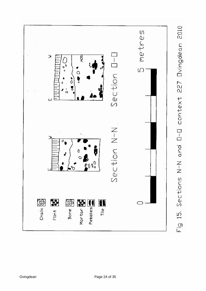
Sondage 227 (Fig 15. Sections N-N & O-O)
The east side of the cellar was investigated by a 2 metre square sondage focused oncontext 227. This sondage traced the east wall down to the medieval floor level. The eastwall of the building in this area was far from sound, and it was quite easy to prise large flintnodules away from the structure. A small area of loose rubble was noted in the north/eastsection of the upper wall, and this proved to have an alignment with the area of brownstaining noted earlier across the junction of the two east wall sections. A small section ofthis rubble was removed but no finds were recovered. The north facing, east facing andsouth facing sections of this sondage consisted of cellar fills with only the west facingsection being the medieval wall.
There was some concern during the excavation about the floor as it appeared to bedeeper in the adjacent context 226, but when a good selection of finds of medieval potterywere forthcoming it later proved to be a pit, (context 277), cut into the medieval floor. Thepit was quite useful as it created a section showing the relationship of the wall to the floor,and provided a chronological sequence that meant that a new section did not have to becut. The fill of this sondage proved to be exactly the same as the others, except 226 andconsisted of grit, rubble, mortar and large flint nodules.

Ovingdean Page 23 of 35
Ovingdean Page 24 of 35

Ovingdean Page 25 of 35
Pit Context 277 (Fig 16.)
The pit found in the lower levels of context 227 was 1 metre wide and 1.4 metres in lengthgoing from the east wall westwards. The feature had rounded corners on the north/westand south/west side and was quite rounded all around except at the east wall where thecut was vertical and on the same alignment as the wall. The fill of the pit was a very darksilty substance and contained a considerable number of sherds of medieval pottery.
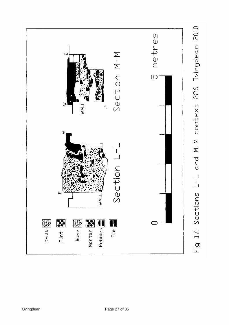
Sondage 226 (Fig 17. Sections L-L & M-M)
One of the first areas in the cellar to be investigated was sondage 226. The reason for thiswas a number of photographs from the 2006 excavation that tended to suggest that stepsmay have been partially revealed in that north/east corner which could possibly lead downto the cellar floor. Context 226 measured 2 metres square and the sound nature of the filldid not mean that the stepped excavation technique needed to be used. However, as theexcavation progressed a large chunk of mortared and rendered masonry was uncovered.Originally the shape and vertical nature of the item suggested a possible corridor within thecellar, but as the depth increased voids appeared below the masonry and it proved to bethe vestige of a wall, possibly from part of the upper building. The north section or southfacing part of the north wall in this context also had a smaller section of mortared andrendered wall in the interior that had heightened the possibility of this possible corridor, butthis vestige despite being in-situ and still held in position was quite small, and may indicatethat some of the cellar wall was rendered. A metre width baulk was left between contexts226, 221 and 222 to ensure that the large section of masonry was safely held in its place,as it would have been extremely heavy was considered too dangerous to move.
The sondage was excavated down onto the medieval floor level. On the east wall theexcavations clearly revealed a chronological sequence of walls. What had originally beenperceived as cellar steps proved to be the lower, solid vestiges of the early medieval wall,with a later wall constructed above it. On the north side a similar chronological sequencecould also be noted, but there was no trace of the larger medieval walls at the bottom. Themedieval walls could also be observed as having been robbed on the north/east side, ametre or so to the west. What became noticeable was that while the upper and newersection was complete the lower medieval wall had been constructed quite differently. Theearly conclusions about the north/east corner were that it had not been a continuous wall,as in the other three corners, but was an abutted corner. This form of corner would havebeen quite an odd and unusual method of construction. The fill of this sondage was slightlydifferent to the other cellar fills consisting still of grit, rubble and mortar but with a greaternumber of large flint nodules noticeably focused in that location.
There were few finds in the rubble layer, with the exception of rodent and small bird bones,but from a few millimetres above the excavated floor surface was uncovered a 14th centurymedieval ‘dripping’ pan and a few other sherds of medieval pottery.

Ovingdean Page 26 of 35
Ovingdean Page 27 of 35

Ovingdean Page 28 of 35

Ovingdean Page 29 of 35
The ‘Medieval’ Cellar Floor
The floor of the medieval building at Ovingdean proved to be constructed of a level andcompact layer of chalk. The small pit in context 227, located up to and against the eastwall, partially sectioned this floor, but no attempt was made to cut right through the floorinto the possible natural chalk deposits. The floor remained relatively level throughout thevarious sondages created in the cellar interior at context numbers 218, 219, 222, 226, 227and 232.
The North/East Corner Excavations North of the Wall
The north east corner of the building proved to be the most interesting feature tounderstand. The abutted method of east and north wall construction was consideredunsound, even for medieval building construction. A small extension to the excavation wasset up outside of the building and north of the north wall. The extension was restricted bythe location of the spoil heap, but it was essential to understand what was happening inthis north/east corner. It was decided that it was important to retain the in-situ later andupper walls as perfectly preserved as possibly. It was deemed unsatisfactory to try andundermine this less solid construction in that location, where there appeared to be novestige of the earlier medieval wall in the lower depths.
The narrow section was rapidly excavated down through a gritty fill down to a chalk level,which proved to be quite an odd section. As the excavation progressed a hard platformwas revealed, about 1 metre in width and stepped in places. The entrance to the cellar hadbeen found in the north east corner of the building. The north end of the east wall was notexposed as this would have undermined the later wall, but the concrete surface confirmedthat the building did at one time have a door in this location. The cellar entrance wouldhave been accessed by either series of steps (not found) or a possible vee shaped rampgoing northwards. A ramp of this description was visible in the south facing section. Thetime restriction did not allow for the moving of the large spoil heap to examine the areafurther, but the vee-shaped section was quite distinct with a fill of grit cutting through chalklayers on the west and east sides.
The Finds from the Excavations
The small sections that had been cut in previous seasons into the cellar deposits hadfailed to recover anything dramatic, other than in the small later rubbish pit in thesouth/west corner of the building. This season proved to be no different. The upper layersproduced an interesting collection of mother of pearl pieces and a vast collection of rodentand small bird bones. There were finds of dressed stone, a few pieces of medieval floorand roofing tile but very little pottery. The few sherds of pottery did come from well sealedstratigraphical deposits and may be used for some dating purposes, although the potteryfound from the cellar floor could have come from a later date and will not effectivelyprovide an accurate date for the house construction. The most useful finds were recoveredfrom the chalk deposits surrounding the house. Pottery from the sondage fill to the northcould give some dating as to when the platform was created. A fine whetstone was foundin the pit context 273. The most interesting finds are obviously the collection of animalbones found from the cellar floor. The upper layers still abound with large quantities ofcontemporary red roofing tile, and an uplifted turf in context 222 uncovered a 20th century‘charm’ bracelet. The finds will be the subject of a detailed study over the next few yearsand more detailed reports will be issued upon completion. During the excavation a numberof thin bricks, some with glazed faces were recovered (contexts 219, 223 and 232), the

Ovingdean Page 30 of 35
items are presently believed to be of Tudor date, and a visit to houses close by notedsimilar bricks in-situ in standing buildings. It may be possible to date when these buildingswere constructed and perhaps add another phase to the chronological sequence alreadyprepared.
The Construction Materials
The medieval building was constructed using a mixture of large flint nodules, smaller flintnodules, grit and mortar. The flints used in the wall construction were in the mainunknapped, but a few had been knapped in some isolated locations. The floor wasconstructed of compact chalk. The upper, later walls in the north/east corner were differentin using smaller flint nodules. The mortar did vary in constituents with finer material beingused for the later walls in the north/east corner. A number different types of mortar, somebeing blue in colour or yellow were used during later renovations, but only an expert of thesubject would possibly be able to give a more detailed analysis and possible dating for theworks carried out using this material.
Conclusions
The medieval house at Hog Croft field Ovingdean has proved to be a fascinating study, ofmedieval archaeology. It is now possible to confirm details of what lies beneath the soil atOvingdean and has answered some of the many questions raised by the previousincursions made by BHAS. The dimensions of the building have now been confirmed andthe nature and variation in the wall construction gives some insight into the complexity ofthe chronological sequence. The archaeology has once again confirmed several phases ofconstruction, with subtle interludes discerned by renovation work and later additionalbuilding materials.
The excavation of several areas into the chalk deposits surrounding the building confirmswhat was previously suspected and that is that the enclosure is located on an artificiallycreated platform of chalk. It is highly possible that the chalk comes from the chalk quarrylocated on the east facing side of Cattle Hill, but without further investigations in this areaand subsequent dating material this can only be conjecture. The platform has had severalinterventions over the various small excavations conducted by BHAS from 2003 to 2009,and in each investigation the finds recovered from the fills has hinted at a number of layersof deposited chalk. Finds have been recovered from all of the chalk features excavated.This season glazed 13th century pottery and metal plumb bob were found within the chalkcontexts.
The exposure of several layer of chalk and loamy soils in the south west corner of theexcavation, outside of the south/west building, have supported the evidence for the chalkto be fills rather that natural. It was also observed how the chalk overlay various ditchfeatures. All of those features excavated produced evidence for a complex series ofactivities during their deposition. It is impossible, without further investigations, todetermine the precise plan of these features and the reason for their creation. The ditchescould be associated with the original building construction or equally associated with laterrenovations, and possible attempts at some form of protective scaffolding when thebuilding may have began to deteriorate and perhaps fall apart.
The walls have always remained the key to the phasing at Ovingdean, tied in with thevariations in methods of construction. There is still some element of uncertainty regardingthe early dating of construction of the medieval phasing and subsequent demolition. The

Ovingdean Page 31 of 35
renovations and use of later building materials is now well understood, although anaccurate dating for the renovations is impossible to determine.The medieval walls are substantial, up to 1.4 metres in width, and this does suggest alarge two storied building. The construction of a large cellar or undercroft tends to indicatea significant structure. It is difficult to determine the method of construction but theevidence does point to a visible sequence of events. The cellar floor of compact chalkwould appear to be the foundation with the walls being constructed on top of this base.This is visible in the pit cut in medieval times or later exposing the floor underneath theeast wall. It would appear that the surrounding fill may have been deposited first, butequally it could have been added later. The outside walls do not have any evidence forshuttering, but the controlled and consistently level faces of the inner walls do suggesteither internal shuttering or experienced builders.
The lower sturdy walls still remain in-situ on all sides with the exception of the area to thewest of what would have been the cellar entrance. In this location the wall is very unsoundand certainly the area excavated does suggest that some flint robbing had taken place,this is also supported by the evidence for the removal of large stone pieces in thesouth/west and north/west corners of the building.
One feature of the building is the step or ridge found on both the west and south walls, butis noticeably missing on the north and east walls. The ridge on the south wall ties in withthe bottom level of the medieval windows and suggests that the cellar was considerabletaller. The ridges could have afforded a strong base for any timber supports for a woodenfloor, but unless medieval buildings had carpentry methods that allowed for supports ononly two adjacent sides, which is highly unlikely, means that certain construction elementsare missing. Further research will be undertaken to study medieval structures and seekparallels for the methods found at Ovingdean.
One of the peculiar aspects of the building is the outer ridge running along the outer faceof the south wall. This lip or ridge is not consistent and varies in width along the wholelength of the wall. The constructive method clearly shows that it is not a sequence but oneand part of the same original wall. There is no additional outer ridge on any of the othersides. The windows in the south wall were solid pieces set into the basic flint nodule matrixand it is anticipated that they would have continued vertically upwards, but to what heightcannot be known. The upper part of the walls is fairly consistent all around with theexception of the north/east corner, and it is the upper walls that show the most extensiveevidence for stone robbing. There was some very ephemeral evidence for a possible puttlog hole in the interior face of the north wall (context 281) but a single putt log hole is quitesuspect and may be the feature of some later activity.
The house has its maximum width on the north, along with the entrance or door cill. Onceagain further research will be required to study medieval dwellings as it is generallyconsidered that medieval buildings had entrances on both the north and south sides. AtOvingdean there is no evidence for an entrance on the south side, and the height of thecellar window opening would tend to suggest that one in that location would have been inan elevated position. The entrance on the north side is supported by post hole evidencethat does suggest a possible porch or timber cover over the door. The question that stillremains is why is there no direct link from a south entrance of the house to the northentrance of the church. It would have been thought that the route from house to churchwould have been more direct. One possibility is that a timber framed exit from the southside of the house may have been constructed, only further investigations could confirmthis.

Ovingdean Page 32 of 35
The evidence for a large flint and stone building has been substantiated by additional findsof carved and dressed stone, mainly of chalk. Chalk is known as a soft stone and whileeasy to be shaped would not have a long life expectancy, or be particularly strong understress, especially on a building that had more than one floors, but at Ovingdean it appearsto have an important constituent of the building fabric.
The north/east cellar entrance was excavated to a depth of 1.4 metres and at that depthclearly indicates that a solid wooden door and surrounding architraves and decorationwould have made the cellar much higher and that much of the upper levels had beenremoved, this is also observed in the base facets of the windows in the south wall. The fullheight of the cellar or building will never be known. The north/east corner is alone inproviding an early chronological sequence of construction, but it is the early phase that isreally important. The north/east corner of the cellar consisted of a solid wall on the eastwall, with no visible sign of a return towards the west. The wall came out straightnorthwards and terminated, although this was not confirmed by excavation due toconcerns about undermining the later less substantial walls above. The entrance to thecellar was north facing and was an integral part of the north/east corner. The large, solidmedieval walls then continued westwards expanding into the maximum width at the centralarea of the north wall, where the main north entrance to the house is deemed to belocated. Some stone or flint nodules from the north wall had been removed in thenorth/east corner and had left this section unstable. This instability restricted furtherincursions to reveal the in-situ remains of the early wall. What the excavations did revealwas a solid flint and mortar constructed exit, with shallow, mortared steps leading out ofthe cellar going northwards. The section remaining in the south facing baulk showed a veeshaped cut into the chalk, but due to the spoil heap location it was not possible to theextend the excavation and seek out evidence for an entrance ramp or steps.
The garderobe is believed to have been located abutting the east wall of the house. Theevidence for this was in the square shaped feature constructed in that location sunk intothe chalk below and against the east wall. The garderobe could have been utilised usingan upper outflow, but no evidence for this remains. The brown staining found in thislocation could be associated with its use, and while the fluids would have drained away itwould have required regular servicing to have removed any solids. There was no evidencefor this, but soils samples have been taken away for further investigation and analysis.
Throughout the excavation what has been noted is a comparison of areas of solid androbust walls combined with others alternatively weak and crumbling. The north, west andsouth walls are all very solid and robust, but the east wall is very weak and crumbly withpoor mortar and a very weak north/east corner where the cellar entrance added to aweakness in the house design. The house was built upon a very unsound foundation on aless than solid base of imported chalk, and surrounded by a weak mixture of chalk andloamy fills. The east wall would have begun to crumble quite early on, and it was probablythis unsound wall that precipitated the demolition of the house.
The fill of the cellar is comprised almost completely of flint nodules, grit and mortar. Thematerials suggest that the construction of the house was similar to that of the adjacentchurch which still stands, but that structure was created on a solid surface comprised ofnatural chalk, not imported as with the house. The cellar fill contained numerous pieces ofcarved stone, mainly chalk and an extremely large chunk of masonry originally consideredpart of a corridor in the cellar. This very odd location could possibly be a local feature ofthe interior, associated with the large collection of animal bones, but upon reflection this is

Ovingdean Page 33 of 35
highly unlikely being suspended as it were over a very unsound lower deposition of moreof the demolition material, containing numerous voids. The most likely explanation for thelarge chunk of masonry is that it is a small vestige of one of the upper walls of the housecast down, but retaining its bonding and preserving the solid rendering of some of the flintnodules from that upper wall. It is pure coincidence that a small amount of similarrendering was revealed on the south facing interior wall in the same location, creating thisillusion of a corridor. Among the other finds were copious amounts of rodent and small birdbone. It would be impossible to determine how and when they were there, but throughoutthe excavation and in all levels the small bones were recovered. It is possible that somederived from the medieval period living in the rafters and cellar. Those among the debrismust be considered as creatures surviving among the building rubble after the demolitionprocess. It was virtually impossible to determine which bones were from which period,other than those found at the extreme lower levels just above the floor surface, but eventhen there could be some doubt.
The medieval cellar floor was found to be littered with animal remains lying against thenorth wall of the building. A total of 15 sheep burials, two dogs and a possible ferret wereliterally lying in one pile. The collection of animals is quite bizarre and raises a number ofquestions about why they are there. It is possible that disease is a factor, and the initialbone examination has noted some diseased bones among the finds, but would not thepeople of the house have dispersed such animals with either burning or burying them insome safer distant location? The bones may be an indication of possible food storage. Intimes of dire need dog meat would be just as important as any other. The collection ofbone could be associated with hunting or for the gathering of animals from pasture. Whatis certain is that they were in the cellar when it was demolished and not added later. Whythey were in the cellar will never be really answered. Wooden items would have beenexpected to be found in cellars, but no evidence in the form of metal banding for winecasks was found. It appears that anything of real value had been removed prior to thedemolition process. There was very little pottery found other than the collection buried in apit in context 227, again it begs the question why was a pit dug in this cellar. The onlymajor recovery was of a medieval dripping pan close to the cellar entrance which at leastprovides an accurate date for when the building may have been demolished.
The later phases can be broken down into several renovations and re-usage of whatremained after demolition. The north/east corner indicates a period of activity when thenewer thinner wall was being constructed to reform the house into a solid unit once again,but without using the cellar and lower levels. The thinner, but well constructed wallappears to be associated with the higher and later floor constructed of large blue/grey flintcobbles. A section of the central medieval door section was channelled out down to thelevel of the newer thinner wall to make them level with the new wall being constructed. Inthe south/west corner a linear flattened and smooth face close to the south/west corner isalso probably associated with a later timber framed building or barn. The cobbled floor wasconstructed over another upper compact chalk floor similar to the earlier medieval one.This floor had the cobbles compressed against the higher thinner medieval walls, abovethe lower protruding ridges on the west and south faces. Vestiges of this floor have beenleft in-situ. A number of bricks of 18th century dating, used for patching some walls, may beused to possibly date this phase of the building at Ovingdean. The mortar used during thisperiod is a distinctive bright yellow. Another blue mortar appears to be associated with aneven later renovation period when the walls were once again being patched up.
Exactly when the later building went out of use is uncertain, or how long the timber buildingwas used, or its purpose. It may also have been an animal shelter, but there is no

Ovingdean Page 34 of 35
historical source to indicate anything about a building in Hog Croft period during theGeorgian or Victoria periods when it is believed it may have been constructed. Thesouth/west corner of the building possesses what can only be described as a rubbish pit,with material and coins from the Georgian, Victorian and Edwardian periods beingrecovered. Among other items collected from this same pit are 19th century roofing tile,medieval floor tiles, bone, metalwork, a medieval bone comb along with severalcontemporary pieces which show a continuation of use over a long period. It is uncertainas to whether the pit was a factor within the building, or was used after the timber framehad been removed and any subsequent void used for depositing rubbish. The final phaseis the field being used as work shop for when St Wulfran’s church was re-roofed onseveral occasions. Several finds of contemporary artefacts including finger rings, boyscout badges, Shippam paste jars and other jewellery have been recovered from justbelow the turf.
We do not know what type of roof the house had, but it can be assumed that it wasprobably Horsham slab. Several pieces of Horsham stone were recovered from the fill ofthe house, mainly in the upper layers, but the stone could equally have come from thechurch roof where vestiges of this stone still comprised part of the church roof and onlylater being changed to contemporary red tiles.
The excavations at Ovingdean in 2009 have provided some extremely interesting findsthat require greater study. The one frustrating factor was the complete lack of anymedieval coinage in any of the fills, or indeed any of the earlier excavations. The findshave provided us with a little insight into the medieval diet, the stone tells us about some ofthe construction methods, and the collapse of the building raises some questions aboutmedieval building integrity. We are now aware of the dimensions and depths of theremaining walls at Ovingdean. There is a striking similarity with another Godfrey dePierrepoint manor house at Portslade. Both houses use the same materials and havesimilar wall thickness. It is possible that the same workmen constructed both buildings(Packham).
The site at Ovingdean will never be fully understood unless the whole complex isuncovered and the copious features of pits, post holes and ditches investigated. Theexcavation of the house has allowed a more detailed appreciation of what lies below theturf at Ovingdean close to the cemetery wall at S Wulfran’s church. However, exactly howthe house and the church fits into the broader and more complex picture can only beknown when details of the other timber framed buildings and suspected rubbish pits areexamined. It is still not known whether the timber framed building found in the centre of themedieval complex, a building that produced some very fine metal finds, was being usedwhile the stone building was being constructed, or used later when the stone building wasbeing demolished.

Ovingdean Page 35 of 35
Chronological Sequence based upon evidence so far recovered
1. Creation of the artificial chalk platform to house the medieval complex2. The excavation of the pit for the house and cellar foundations - late 12th century3. The building of the house and the cellar, and a possible porch on the north side4. Main occupation period 13th century.5. The demolition of the house, with the rubble being poured into the cellar. Early 14th
century6. The creation of a smaller low key building or barn, requiring extensive renovation
and new walls on the north/east corner. The creation of a large stone pebbled floorand a timber framed structure leaving few clues for dating, but supported by thelevelling of some area to an even surface for such a wooden structure.
7. Subtle renovations in various locations noted by changes in the style of mortar.8. Change of use to a rubbish pit, when the low status building was still in use, or after
the timber frame hade been removed for use in other locations 19th century9. The use of Hog Croft field as a workshop for when the church was re-roofed. 19th
and early 20th century.
The excavations at Hog Croft Field, Ovingdean in 2009 have been successful in accuratelyplanning the walls, understanding the phasing sequences, revealing the cellar floor andfinding artefacts that effectively date the period of occupation. The pottery recovered thisseason still effectively dates the main occupation at Ovingdean to being during the 13th
century AD. The date of the demolition of the building is still debatable and may becomeclearer after a more detailed analysis of the finds. The reason for the large bone depositionin the cellar will no doubt provide interesting debate and the final phases of Georgian andVictorian depositions may be better understood after more detailed studies of historicalrecords and ancient maps. The outstanding question is exactly when the building wasconstructed, and how it relates to the broader panoramic perspective of the whole of themedieval complex. The answer to this question will require further archaeologicalinvestigations.
Acknowledgements
The author would like to thank Mr Geoff Bennett of Brighton and Hove City Council and MrDavid Carr tenant farmer at Ovingdean for allowing access to the lands, to CasperJohnson, Greg Chuter and Luke Barber for their support and recommendations during theexcavation, to Norman Phippard, Mark Gillingham and Brenda Collins for their leadershipduring my absences and to Paul Collins for organising and assisting with the back filling,and finally to all the members of the Brighton and Hove Archaeological Society whoundertook the digging and recording.
References:-
Funnell J.D. 2002 ‘Field Notebook of the Brighton & Hove Archaeological Society’
Funnell J.D. 2003 ‘Field Notebook of the Brighton & Hove Archaeological Society’
Funnell J.D. 2006 ‘Field Notebook of the Brighton & Hove Archaeological Society’
Funnell J.D. 2008 ‘Field Notebook of the Brighton & Hove Archaeological Society’
Packham A.B. 1934 ‘Portslade Manor House’ Sussex Arch Colls. 75, pp 1-18
Coldean Roman Ditch Page 1 of 2
A ROMAN DITCH IN THE GARDEN OF 50 WOLSELEY ROAD. COLDEAN
Introduction
During a watching brief at 50 Wolseley Road , Coldean in January 2009 while no featureswere observed in a planned extension to the house, a ditch was noted in the soakaway,only a few metres away to the north/east (TQ328086). After a request was made to thehouse owner he allowed a small excavation in the garden to determine the date of thefeature and the collection of any finds.
The Excavation
A small (2m x 1m) trench was dug adjacent to the soakaway to confirm and define theditch.The overburden of garden loam was at a depth of approx 25 cm across the trench Thiswas followed by approx 10 cm of loam mixed with a large number of chalk flecks whichagain was spread evenly across the trench. Below this and immediately above the ditchwas a light loam chalk free fill up to a maximum depth of approx 15 cm. There was then achalky fill of just under 40 cm (with some larger chalk pieces towards the base of thetrench).The “V” shaped flat bottomed ditch had a width of 1.45 cm at the top and a width at itsbase of 20 cm.
The Finds (from the excavation)
Pottery
Nineteen sherds were recovered during the excavation of this small trench.Two sherds were found in the upper layers, one being a piece of East Sussex ware andthe other a sherd which appears to be fire damaged,7 small sherds were recovered from the upper ditch fill, 4 of these being East Sussexware. The other 3 were coarseware, one being a rim fragment.However, the remaining 12 sherds were all recovered from the chalky fill at a depth ofapprox 60/70 cm and were all of the same fine cream coloured fabric, possibly from theWickham Barn pottery production site north of Lewes (G Chuter pers.comm). This siteoperated from approximately 250-350 AD.
Bone
A single cattle vertebra was found at a depth of 70 cm at approx the same depth as the 12pieces of fineware. It has been identified as the atlas vertebra from an adult animal (CarolWhite pers comm.).
Flint
Sixteen pieces of struck flint were found during the excavation.7 flakes were found in the upper layers, 3 being hard hammer struck and 4 soft hammer.Six were white/grey patinated and the other blue/white patinated.The other 9 flakes were found in the ditch fill, 4 being hard hammer struck and 5 softhammer. The 4 hard hammer flakes were all found in the lower ditch fill at a depth ofapprox 65/75 cm. All 9 pieces were white/grey patinated except for one soft hammer flakewhich was blue/white patinated.
Coldean Roman Ditch Page 2 of 2
All 16 flakes, except 3 of the soft hammer ones, had some cortex remaining. None of theflakes were diagnostic and all appear residual to the site. It seems likely that all are likelyto date to the late Neolithic/early Bronze Age.
In addition to the flakes, 3 pieces of fire cracked flint were found in the upper layers and 5pieces found in the ditch fill.
Glass
Part of the neck of a pale green coloured small glass bottle was found in the upper layersbut has not yet been identified.
Shell
Although some fragments of oyster shell were found in the upper layers, these are likely torelate to relate comparatively recent use of the land.A limpet shell was also found in the upper layers.
Conclusion
Coldean has long been known as an area of Romano British activity with a number of findsdiscovered when the estate was built in the 1950’s. These included a 1st or 2nd centurycremation urn found only two houses away at 54 Wolseley Road.A small scale excavation carried out two years ago by BHAS in nearby Nanson Road alsorevealed evidence of Romano British occupation. The Romano British farmstead site atRocky Clump in Stanmer Park excavated over many years by BHAS is approxiamately1km from Wolseley Road.
Although of very limited scale, the Wolseley Road excavation clearly revealed a “V”shaped flat bottomed ditch which is typical of the Romano British period. If they are fromthe Wickham Barn pottery production site, the 12 pieces of fine ware in the early fillsuggest that the ditch was still open in the3rd century.
The ditch is located close to the site of other similar features and an examination of thesite plan from the 1950’s plan (Funnell) clearly shows that it is part of a ditch found duringthe earlier excavations. Other right angled ditches in the same location may indicate thelocation of a Roman enclosure.
The finds will form part of an exhibition at the Coldean Library being organised by BrightonMuseum. The finds will return to the museum after the display has ended.
Acknowledgements
The Brighton and Hove Archaeological Society would like to thank the house owner MrJason Collins for allowing access to his garden and to those members of the BHAS FieldUnit who conducted the excavation.
Reference:-
Funnell J.D. , ‘Excavations in Coldean 1950’ (Forthcoming)

Plumpton Excavation Page 1 of 1
PLUMPTON EXCAVATIONS 2009
Several members of the BHAS Field Unit joined David Millum, a student at SussexUniversity, for his excavations located west of the Plumpton race course in May 2009
A geophysical study had produced possible evidence for the location of a Roman roadrunning down the hill towards the Roman villa site at Plumpton College.
The excavation consisted of a single trench measuring approximately 12 metres long and1 metre wide. The top soil was removed and finds of terraces of flint were found in theopen trench, but not sufficient to prove that it was the location of a Roman road. The findsfrom the small excavation included Mesolithic flintwork, including a core, as well as a fewsherds of Roman and possibly Saxo-Norman wares.
A copy of the student dissertation has been passed to the County Archaeologist. A pfdcopy of the report is on the CD version of the 2009 Brighton and Hove ArchaeologicalSociety Field Notebook.
John Funnell 17th May 2009

Falmer Lane Page 1 of 1
FALMER LANE EXCAVATIONS 2009
Several members of the BHAS Field Unit joined Vincenzo Poppito, a student atSussex University, for his excavations across the lane that runs from Falmervillage to St Mary Farm. The trackway is deemed to be of ancient origin and theexcavation was an attempt to date the feature.
The excavation, conducted in August of 2009, consisted of a single trenchmeasuring approximately 6 metres long and 1 metre wide. The cut was madeinto the steep sided bank and the clay with flint bedrock proved to be quitesterile. Above this layer in the upper part of the trench, and overlaying thenatural, was a deposit of chalk, which appears to be deliberately placed.
A copy of the student dissertation has been passed to the County Archaeologist.A pfd copy of the report is on the CD version of the 2009 Brighton and HoveArchaeological Society Field Notebook.
John Funnell 23rd December 2010

Geophysics – Rottingdean Page 1 of 5
A GEOPHYSICAL SURVEY AT BEACON HILL, ROTTINGDEAN 2009
Introduction
In March 2009 David Larkin one of the Brighton and Hove Countryside Rangers noted ashallow mound on Beacon Hill, Rottingdean. (TQ36500270). A flock of sheep that he hadbeen tending had reduced the grass to a level which was unusual for this part of the hill.The circular mound was quite distinct and located close to one of the known ScheduledNeolithic long barrows.
In late March 2009 the Brighton and Hove Archaeological Society Field Unit conducted aresistivity survey of the mound and the surrounding area. While the grids were being setout another slightly lower mound was also noted, immediately north/west of the firstfeature found. An additional 2 grids were set out to investigate both mounds. A total of 6full grids measuring 20 x 20 metres square were surveyed.
Methodology
The centre of the first circular mound was used as the centre for the first four squares.(Fig.1 and 1.a). The machine used was an RM15 resistivity meter. The measurementswere in Ohms and taken at 1 metre intervals. The results were downloaded using ‘Snuffler’data. (Fig 2.)
Conclusions
The results of the survey have produced images of a pair of distinct circular featuresidentified as areas of high resistance (White in colour). The images do lack a circle of lowresistance surrounding the mound. This would suggest that the mounds are not ancientbarrows or burial mounds. A circular feature noted in an earlier survey on Beacon Hill in2005 had a distinct ‘tail’, perhaps indicating that this could the location of an hithertounknown windmill (Funnell). The new mounds do have associated areas of low resistanceon their north/west and south/east sides respectively (Black in colour).
The mounds, while being distinct landscape features, do lack evidence that could clearlyidentify them as prehistoric in origin. It is possible that the features have association withSecond World War activities along this part of the south coast. A large mound locatednorth of the disused dew pond on Beacon Hill was known at the gun pit by localyoungsters. (Pers. Comm. Mark Gillingham).
The only way to clearly date the features would be to conduct some small excavations inthe hope of recovering some dateable material.
The Brighton and Hove Archaeological Society have conducted several geophysicalsurveys at Beacon Hill, and on each occasion have revealed interesting anomalies. TheSociety is planning to return to Beacon Hill again in 2010 to continue their investigations.The areas will be focused on lands being used for sheep grazing. It is hoped the closecropping of the grass may reveal new contours and subtle earthworks. The variousinvestigations will then be linked into one large panoramic landscape.

Geophysics – Rottingdean Page 2 of 5

Geophysics – Rottingdean Page 3 of 5

Geophysics – Rottingdean Page 4 of 5

Geophysics – Rottingdean Page 5 of 5
Acknowledgements
The author would like to thank Mr G.Bennett of the Brighton & Hove Planning Departmentfor allowing access to the land, to David Larkin for bringing the features to the Society’sattention and those members of the BHAS Field Unit who conducted the survey.
References:-
Funnell J.D. ‘Beacon Hill Geophysics-2005’ BHAS Field Notebook 2005
Funnell J.D. ‘Beacon Hill Geophysics-2006’ BHAS Field Notebook 2006
John Funnell 29th March 2009

Geophysics – Ovingdean Page 1 of 3
A GEOPHYSICAL SURVEY AT OVINGDEAN 2009
Introduction
In February 2009 Brighton and Hove City Council allotments division made the Brightonand Hove Archaeological Society aware of the creation of a new series of allotments atOvingdean. The new allotments are to be created west of the existing ones locatedimmediately south of the village, adjacent to the Greenways Road. (TQ35600355)
Ovingdean has been the subject of BHAS investigations over a number of years includingexcavation, field walking and resistivity surveying (Funnell). The village has produced findsfrom the prehistoric, Roman and medieval periods, focusing much on a medieval manorialcomplex located in the field immediately north of St Wulfran’s church. The location of themedieval village, mentioned in Domesday is still unknown. A view eastwards from the topof Cattle Hill, located west of the allotments, has noted a number of crop marks, possibleindicators of ground disturbance, fashioned in a ‘village’ shaped configuration in the valleybelow. The new allotments are immediately east of these marks. John Davies, a localhistorian, has noted that when the adjacent field to the south of the allotments had beenploughed in the past, large quantities of oyster shells had been brought to the surface. It ispossible that medieval, or even Roman rubbish pits may be located close by.
Methodology
A base line was set out along the fence line that is the south boundary of the newallotment area. The west boundary was an existing fence line. The first grid was locatedimmediately east of the north/south fence line. A total of 4 grids were surveyed. The fourthgrid was incomplete being only 18 metres in width, ending as it did at the west end of theexisting allotment fence. (Fig 1.)
The machine used was an RM15 resistivity meter. The measurements were in Ohms andtaken at 1 metre intervals. The results were downloaded using ‘Snuffler’ data. (Fig 2.) Thesurvey was conducted in light drizzle.
Conclusions
The resistivity survey conducted at the allotment area in Ovingdean failed to produceevidence for any activity during any period. The images were completely bland with onlythe location of two trees being highlighted. Despite this lack of imagery the BHAS field unitwill conduct a watching brief when the earth is turned to recover and record anyarchaeological features or artefacts that may noted.
A member of the BHAS Field Unit conducted a metal detecting exercise in the ploughedfield immediately south of the allotment area, while the resistivity was taking place, andnoted within 40 metres of the field boundary a large concentration of oyster shell. His findsincluded a number of coins of near contemporary date. The field was used for sheep dogtrials just after the Second World War and a number of marquees were frequently erected;it is possible that these coins are associated with theses events (Pers. Comm.M.Gillingham).

Geophysics – Ovingdean Page 2 of 3
Acknowledgements
The author would like to thank Mr Tim Read the Brighton & Hove City Allotments Officerfor bringing the development to the Society, Mr David Carr the tenant farmer for allowingaccess to his lands, Mr David Staveley for producing the images from the survey andthose members of the BHAS Field Unit who conducted the survey.
References:-
Funnell J.D. ‘BHAS Field Notebooks’ 1999, 2000, 2002, 2003, 2004 and 2006
John Funnell 27th March 2009

Geophysics – Ovingdean Page 3 of 3

Geophysics – Piddingworth Page 1 of 4
A GEOPHYSICAL SURVEY AT PIDDINGWORTH
Introduction
Piddingworth is located in a small valley north of the Upper Lodge car park in Stanmer.(TQ32501100). The valley contains a number of earthworks and trackways that lead downfrom the Ditchling Road to an enclosure in the valley below. Piddingworth has quite adetailed history and notes about the medieval manor have been published (Christie et al)which includes the names of people associated with the manor and its surrounding area.The earliest references are the mention of a Martin de Piddingworth in 1201 and 1204.
To the north of the medieval enclosure and trackway are the vestiges of a large barn, anda known water pipe line is capped here, which covers a large cistern. It is known thatduring the Second World War there were people living in houses located just north/west ofthe barn. These houses have subsequently been demolished and there is no evidence onthe ground, other than old maps, of their exact location. (Pers. Comm. Jim Driver).
In 2006 a visit was made to Piddingworth by the author and local retired woodsman JimDriver in August. It had been a particularly dry summer. Looking down from the top of thehill, and just east of the Ditchling road, towards the enclosure, the clear imprint of arectangular building was visible. The structure had dividing walls and it was visible on thesouth side of the enclosure. A series of crop marks also marked the location of twoditches, one going east/west the other north/south, the latter possibly being associatedwith the water tank known to be at the west end of the barn.
Methodology
The grid locations were set out using a total station with the first grid point located at thesouth/west corner of the survey and enclosure. A total of 9 grids, measuring 20 metressquare were set out. The grids totalled 3 going from north to south and three going east towest (Fig 1.) The enclosure measures about 90 metres in length from the south edge ofthe enclosure and trackway up to almost the wall of the barn in the north. East/west theenclosure is about 42 metres in width, so that the final 18 metre or so to the east wereoutside of the actual enclosure boundary, which is indicated by a steep drop.
The machine used was a TR Systems resistivity surveying meter. The measurementswere in Ohms and taken at 1 metre intervals. The images were downloaded and createdusing ‘Snuffler’ software. The weather during the week previous to the survey had beenquite wet.
Conclusions
During the survey it was noted that there were several ‘raised’ areas and a lack ofvegetation in some locations exposed a variety of building materials. Other areascontained numerous mole hills, which were investigated during the surveying, but thesesimple manourves revealed not a single sherd of pottery. The only find was a single flintcore, probably Mesolithic in date.
The images produced on the survey are a mixture of high and low readings (Fig 2).However, the survey produced no evidence for either the building or ditches observed inthat late summer a few years ago. The only clear definition is for a solid well defined edge

Geophysics – Piddingworth Page 2 of 4
along the east side of the enclosure. This is where the enclosure ends and drops down tothe natural ground surface. There are areas of high resistance, notably in the north sectionof the enclosure, and not where the ‘building’ was noted. During the survey building rubblewas observed in a number of locations. Over the past year the field has been the locationof feeding trays for quite a large herd of cattle. It is possible that extensive cattledisturbance has blurred the outline of the features.
Any future investigations will have to be through excavation test pits to prove or disprovethe possibility of vestiges of a building still remaining at Piddingworth.
Acknowledgements
The author would like to thank Mr G.Bennett of Brighton and Hove City Council, Tenantfarmer Mr David Robinson for allowing access to their lands and David and MerrynStaveley, Maria Gardiner and Bill Santer who organised and assisted with the surveying.
References:-
Christie F.R., Hill A., Johnston B., & Pepler H.D.C. 1937 ‘Ditchling’ St Dominic’s PressDitchling, Hassocks, Sussex.

Geophysics – Piddingworth Page 3 of 4

Geophysics – Piddingworth Page 4 of 4

Roedean Fieldwalking Page 1 of 9
FIELD WALKING AT ROEDEAN NORTH FIELD - INTERIM REPORT
Introduction
During February and March of 2009 members the Brighton and Hove ArchaeologicalSociety Field Unit conducted field walking as part of an ongoing research programmefocused on Ovingdean, Roedean and Beacon Hill, Rottingdean. The field walked is locatedimmediately north of Roedean School (TQ35250340). The weather was sunny on the twooccasions that the walking took place. The field had been ploughed in the late autumn andhad been left over the winter.
A tentative walk over survey of the field had been conducted late in 2007, as part of theinvestigations for an archaeological dissertation by a student at Sussex University. SomeRoman pottery, including rim sherds, fire cracked flint and marine shell had been observedin the field. The new field walking is close to a number of other projects conducted inprevious years and published in the BHAS Field Notebooks (Funnell). The finds from theprevious field walking from fields located south/east of the new project, had producedsignificant finds of Roman and Iron Age pottery, flintwork and fire-cracked flint.
Roedean School lies at the lower part of Cattle Hill, which is a prominent downland ridgelocated between the valleys of Roedean and Ovingdean. The field walking took place atthe southern end of this hill, which has a gentle upward slope going north from the schoolboundary fence line.
Methodology
A base line was set up along the bottom, southern, edge of the field. The field curves downat both the west and east ends in an arc, so the base line being visible from east to westleft small sections of the field below the base line to the south unexplored. A total of 16lines (A-P) were set out 20 metres apart. The first line A was measured in 10 metres fromthe east side of the field. The lines were walked in 20 metre transects and finds collectedfor each interval. The walking was in an uphill direction. The number of transects in eachline, except line A, was 12 complete 20 metre lengths, with the thirteenth being only apartial transect. The soil was extremely claylike to the east with a more predominantchalky loam texture to the west.
The finds were collected and sorted. The results have now been transferred to dot densitydiagrams (Figs 1-5).

Roedean Fieldwalking Page 2 of 9
The Finds
Flint Work
The field contained flintwork which consisted mainly of blue/grey or white patinated flintflakes. There were only a very few tools and cores. Most of the material consisted ofprimary flakes, with most pieces still retaining some cortex.
Total Flakes 220Retouched Flakes 3
Cores 4Scraper 1 1Piercer 1 1Notched Flake 1 1Hammerstone 1 1
Total Flint work 231 231
Fire-Cracked Flint Total 548Fire-Cracked Flint weight 10,062 (gms)
Pottery
The majority of sherds recovered from the walking were Roman and all were very abradedpieces. A few flint calcined Iron Age sherds were also found. The Roman fabrics werepredominantly East Sussex wares, but with some coarse sand tempered wares. Sherds ofSamian were recovered including a large, thick walled piece that was not decorated, butwas probably part of a bowl. One of the thicker pieces of Roman pottery could possibly bepart of an amphora. A number of sherds had a distinctly different fabric of coarse sand andflint temper and is considered to be medieval.
Total Roman Sherds 132 (89.7%) 2 pieces were Samian (0.013%)Iron Age 5 (.034%)Medieval 10 (.068%)
Total Sherds 147
Molluscs
The field contained a scatter of badly damaged marine molluscs. These were mainlyoyster with only three pieces of scallop being present.
Marine Mollusc
Oyster 26 FragmentsScallop 3 Fragments
Total Collection 29 pieces.

Roedean Fieldwalking Page 3 of 9
Miscellaneous Items
The field contained numerous contemporary pieces of roofing tile, brick fragments andslate. Also present were a variety of glass fragments and some modern metalworkincluding a horseshoe, some chain, an unidentified buckle and a few modern nails. Asingle clay pipe stem was also found. There were considerable quantities of contemporaryceramics and some stoneware vessel fragments.
A number of elongated beach pebbles were found and could possibly be rubbing stones,as several similar artefacts have been recovered from stratified Roman contexts. A singlewhetstone fragment was also found.
Conclusions
The field walking at Roedean has added important information to the broader panoramicpicture being gradually produced at Ovingdean through the continuing researchprogramme. The field walking over several years has brought together information thatgives us a greater perspective of ancient times. Whilst the small field walked this year hasnot produced results of any great archaeological significance the general disposition ofRoman and Iron Age pottery shows that there has been some ancient activity. Thecollection of struck flint and the large amount of fire-cracked flint, combined with the smallquantity of marine shells, is perhaps the most visual anomaly indicating that this field maystill possess some small vestiges of ancient settlement. The quantity of flint tools found isquite interesting, as most fields on the South Downs usually produce a percentage of suchartefacts but this field produced very few completed artefacts.
The fields south of Ovingdean village have generally produced large amounts ofprehistoric flintwork, fire-cracked flint and Iron Age, Roman and medieval pottery. The fieldwork is beginning to show that the concentration of finds from the Roman period tends tobe focused around the central and eastern side of the field walked in previous years,located immediately south/east of this years project. The pottery recovered from the newproject shows a distinct phasing out of ancient finds to the west of these fields. This is verynoticeable when the results from all of the field walking projects are linked together. It ispossible that there is a small outlying, house or presence focused on the locations of thefire-cracked flint and pottery, but only excavation could confirm this.
The location of the Iron Age and Roman sites hinted at by the various field walkingprojects is still eluding the researchers. Subsequent resistivity studies within the areas ofconcentration have failed to produce any results to confirm the presence of Roman walls,ditches or pits. However, the large quantities of Roman coins found during the 1970’s and1980’s clearly indicate that something important was located in lower Ovingdean.
A recent study of aerial photographs on Google Earth has produced the image of a welldefined enclosure in the lower field, opposite St Dunstans. Is this the location of thiselusive site? The Brighton and Hove Archaeological Society are planning to conduct moreresistivity surveys in this area once the crop has been removed. Hopefully geophysicalanomalies will produce further evidence for Roman activity in this part of Sussex and someunderstanding of the scale and nature of the settlement or possible trading centre.
The field walking in 2009 has produced an important addition to the archaeological recordwith the finds from the Roman period being fewer in quantity, suggesting that the westernboundary of Roman influence in Ovingdean has been reached.

Roedean Fieldwalking Page 4 of 9
Acknowledgements
The author would like to thank Mr David Carr the tenant farmer for allowing access to hislands, Mr G.Bennett of Brighton and Hove City Council, Mr Mark Gillingham for readingand amending the written report, and to those members of the BHAS Field Unit whoconducted the field walking.
References:-
Funnell J.D. ‘Fieldwalking at Ovingdean 2000’ BHAS Field Notebook 2000
Funnell J.D. ‘Fieldwalking at Ovingdean 2003’ BHAS Field Notebook 2003
Funnell J.D. ‘Ovingdean Walkover Survey 2007’ BHAS Field Notebook 2007
John Funnell 26th March 2009

Roedean Fieldwalking Page 5 of 9

Roedean Fieldwalking Page 6 of 9

Roedean Fieldwalking Page 7 of 9

Roedean Fieldwalking Page 8 of 9

Roedean Fieldwalking Page 9 of 9
Palaeolithic Axe Page 1 of 1
PALAEOLITHIC HAND AXE FOUND NEAR BARCOMBE.
It was while Brighton author David Bangs was conducting research for his book about thefreedom to roam guide in East Sussex that his girl friend, Jane Erin, noted an object in aploughed field they were passing (TQ40901540). The ploughed field is on land to the eastof Blunt’s Wood, near Barcombe, north of the stream that runs across this particular field.The object proved upon examination to be a Palaeolithic bi-face axe. The bi-face has amainly black/brown patination with a number of yellow/white striations. The axe was notcomplete, possibly having been broken in antiquity, but what remains measures 130mm inlength and 95mm in width and about 25mm maximum in thickness.
The axe is one of several recently found in this region. A very fine example, with a brownpatination, was excavated from a palaeo-channel at the Barcombe villa site a few yearsago. A similar object, with a blue/grey patination was found in a Roman context at Ringmerin 2007 (Chuter). The artefacts apparently derive from riverine gravel terraces that appearto have been exploited during this time of antiquity. (Pers. Comm.. Dr Matt Pope)
Dr Matthew Pope has examined the bi-face and confirms, due to the lack of a sealedprovenance, that it could be anywhere between 60,000 and 600,000 years old,.
The Brighton and Hove Archaeological Society would like to thank Mr Bangs for bringingthe object to their attention and to Jane Russell for illustrating the find.The bi-face has now been returned to Jane Erin. A report and drawing has been submittedto the Sussex Archaeological Society Collections.
References:-
Chuter G. ‘Excavations of a Romano-British site at the Ringmer Gliding Club’(Forthcoming)
John Funnell 27th December 2009

Watching Brief - Coldean Page 1 of 1
BRIGHTON & HOVE ARCHAEOLOGICAL SOCIETY - WATCHING BRIEF
Planning application no: BH2007/02975
Address: 50 Wolseley Road, Coldean, Brighton
Planning Officer: Ms Liz Holt
Name of Applicant: Mr Jason Collins
Date of watching brief: 8 January 2009
BHAS officers conducting watching brief: M. Gillingham & B.Collins
Results
The above property was visited between 12 noon and 3 pm on the 8~ January 2009.
The original garage had just been demolished to make way for a two storey extension. Thefoundation trench on the east side had been machined to a depth below the level of thenatural chalk. Nothing was visible in the section except for an old sewer trench which wasalso visible in the west foundation trench when this was machined out during the site visit.The rear foundation trench was also dug during the site visit and showed noarchaeological features in the section.However, two soakaway pits were dug in the rear garden and it appeared that the Westernone had cut through a ditch running north east /south West. No features were revealed inthe other soakaway.
Finds
There were very few as there was so much rubble on the site from the demolition of theold garage. lt was also not possible to have more than a cursory look at the builders‘ spoilheaps as these were largely covered with chalk lumps and rubble.
The only finds were
1 white patinated hard hammer struck flint flake with over 50% of cortex remaining.1 piece of fire cracked flint.
In view of the ditch revealed by the soakaway, the house owner very kindly agreed that asmall scale excavation could be carried out by BHAS and this was carried out the followingweek.
Watching Brief – Bishopstone Page 1 of 6
East Sussex County Council Archaeology Team - Watching Briefs
Address of site: 3 ROSEMOUNT CLOSE, BISHOPSTONE
Name of Owner of site: Mr & Mrs ShepherdName of Architect/Building Contractor:
County: East Sussex- Planning Authority: Lewes DistrictPlanning Ref: LW/08/1327
8 Fig OS Grid Ref: TQ: 4635000784
Date(s) of Watching Brief: 17th February 2009Name(s) of person(s) doing Watching Brief: Steve Corbett, Eva Corbett & Brenda Collins
100 word (maximum) summary:
An archaeological planning condition was put in place on the construction of an extensionon rear of the property. The site is situated close to an extensive multi period sitepreviously excavated at Bishopstone.
The foundation trenches were machine dug to a depth of 0.75metres and were 0.5metreswide cutting through an existing paved area. Adjacent to the house the foundationtrenches were dug to a depth of 1.5metres over a length of 0.75metres. The trench sectionrecorded a debris / hardcore layer below the former paved area c. 100 - 150mm thickbelow which was a mixture of brown and blue clay tuning to a orange sandy clay at thebottom of the trench.
A soak away was dug at the bottom of the garden 1.0metres by 1.0metres to a depth of1.25metres
The natural chalk geology was not exposed in either areas, the whole area appears to bemade up ground, dating from the time of construction of the property.
No archaeological features or deposits were observed and no archaeological artefactsrecovered (although the spoil was not examined).
Date: 26th March 2009
Prepared by: Steve Corbett
Copies to be sent to: The Planning Authority; The site owner, Historical EnvironmentRecord East Sussex County Council;

Watching Brief – Bishopstone Page 2 of 6
Finds
Context Description Finds Comment1 Loose hardcore layer,
100mm thick None Modern paving base
2 Brown/Blue clay None Made up ground
Site Plans
1 Site location

Watching Brief – Bishopstone Page 3 of 6
Site Plan

Watching Brief – Bishopstone Page 4 of 6
Site Photos
Hardcore surface under existing patio
Footing trench looking north-west

Watching Brief – Bishopstone Page 5 of 6
Footing trench looking north-east
South-east facing trench section

Watching Brief – Bishopstone Page 6 of 6
Soak away looking North-west

Watching Brief – Brangwyn Ave Page 1 of 1
BRIGHTON & HOVE ARCHAEOLOGICAL SOCIETY - WATCHING BRIEF
Planning application no: BH2009/00774
Address: 10 Brangwyn Avenue, Brighton
Planning Officer: Jonathan Puplett
Name of applicant: Mr Hadi Dabirraji
Date of watching brief: 2 September 2009
Results
The above property was first visited between 9 am and 10.30 am on Wednesday, the 2ndSeptember 2009. Trenches were being dug for the foundations of a side and rear extension tothe house. The first (south) trench was 4 metres long and 70 cm wide and was dug during theinspection to a depth of 1.5 metres. The entire depth of the trench was through “topsoil” withno trace of any chalk at the base of the trench.It therefore appeared likely from this first trench that the site of the rear extension was on“made-up” ground, i.e. on topsoil brought in to level the site when the house was constructedon the hillside.
It was therefore decided to return to the site the following morning to see if the rear (east)trench would also give the same result. This proved to be the case as did a further visit lateafternoon that day with the beginning of the trench on the north side.
A final inspection was made at 9 am on Monday, the 7th September 2009 by which time theremainder of the north trench had also been dug to a depth of 1.5 metres.
On all four inspections of the newly dug trenches, no trace of any chalk was seen at the baseof the trenches, nor was there any trace of features either at the base or in the sides of thetrenches.
Although a few pieces of struck flint and fire cracked flint were found in the excavated topsoil,there was nothing to indicate that these had not been brought in with the topsoil when the sitewas levelled.
Therefore, there appears little doubt that the rear of the property was built in the 1930’s on“made-up” ground with any archaeological features likely to be at least 1.5 metres below thecurrent land surface.

Watching Brief – Saltdean Page 1 of 1
BRIGHTON AND HOVE ARCHAEOLOGICAL SOCIETY - WATCHING BRIEF
PLANNING APPLICATION No:- BH2008/01371
ADDRESS:- 28 Grand Crescent, Saltdean
PLANNING OFFICER:- Mr Steve Lewis
NAME OF APPLICANT:- Mr A.Donner
DATE OF FIRST CONTACT FROM CONTRACTOR:- 20th August 2008
DATE OF WATCHING BRIEF:- 26th March 2009
BHAS OFFICER CONDUCTING WATCHING BRIEF:- Mr M.Gillingham
RESULTS OF EXAMINATION
Two site visits had been made previously, on 26/8/08 and 5/9/08 respectively, early onduring the building work.
A further visit was made on the 26/3/09 when a soakaway pit was dug in the rear garden.This was 1m x 1m and was dug to a depth of approximately 40 cm down to the solid chalk.However, the first 30 cm consisted mainly of builders’ rubble, presumably buried when thehouse was built.
There was therefore only approximately 10 cm of earth/chalky fill before the solid chalkwas reached. There were no cuts in the chalk and no features visible in the sides of the pit.
The trench leading to the soakaway pit was only being dug to a depth of about 30 cm andthe length dug in my presence contained virtually nothing but builders’ rubble.
The only find from the soakaway pit was:-
1 flint flake (hard hammer struck with white patination).
Mark Gillingham (Field Officer Brighton and Hove Archaeological Society)

Watching Brief – Whitehawk Page 1 of 3
AN ARCHAEOLOGICAL WATCHING BRIEF AT WHITEHAWK HILL, BRIGHTON,SEPTEMBER 2009
Ref TQ 329561104904
By John Funnell
Summary
An archaeological watch was kept on Whitehawk Hill while British Telecom contractors cuta 1 metre wide trench seeking the location of a metal cover. The purpose of the projectwas to seek and raise the level of the metal cover to make it more visible and easier tolocate for the future.
1. Introduction
1.1. The Brighton and Hove Archaeological Society were contacted by the contractorsMcNicholas to undertake a watching brief on Whitehawk Hill while they cut a smalltrench to re-locate the lost position of a metal cover for a British Telecom utilitycable trench.
1.2. The trench was outside of the boundary of the Scheduled Ancient Monument(SAM), but still within an area of archaeological sensitivity. (TQ 32960 04500). Thetrench was located immediately west of the television transmitter entrance, andclose to the entrance of a fenced allotment on the west side of the track that wasonce was called Whitehawk Hill Road.
1.3. The geology at Whitehawk Hill is a mixture of upper and middle chalk according tothe British Geological survey sheet 318/333
1.4. The watching brief encompassed the clearing of a small area seeking the originalcover location
1.5. The trench was located immediately west of the television transmitter mast
1.6. The watching brief was conducted by Mrs Brenda Collins and Mrs Dot McBrien ofthe Brighton and Hove Archaeological Society on the 9th September 2009
2. Archaeological and Historical Background
2.1. The Neolithic Causewayed enclosure was first recognised in the 19th century, butrecent building programmes have made inroads into the Neolithic panoramiclandscape with part of the west side of the hill obstructing the once uninterruptedviews from Worthing to Eastbourne. Whitehawk Hill is a visually striking platform,but the causewayed enclosure lies within a shallow saddle depression and wouldonly have been observed from the Downs immediately north of the site.
2.2. The first excavations were conducted by Curwen in 1929 when the construction ofthe Manor Hill road allowed an investigation into ditches and banks that formedpart of the enclosure. The finds from the excavation included animal bone, humanburials and the first decorated pottery in the British Isles.

Watching Brief – Whitehawk Page 2 of 3
2.3. Additional excavations were conducted by Curwen in 1932-3 and 1935 whenfurther evidence of palisades, gateways and pits and post holes were uncovered.Neolithic flintwork was a major feature of all the excavations.
2.4. A rescue archaeological investigation was conducted by Miles Russell of SouthEast Archaeology in 1991, which revealed and recorded a spur ditch runningwestwards down into the Craven Vale estate. The ditch terminated before a steepdrop. The BHAS have reported a number of illegal interventions on Whitehawk Hillduring the past decade. Recent site protection measures requiring the insertion of88 wooden bollards revealed evidence for another possible ditch surrounding themonument.
2.5. Whitehawk appears to have 3 stages of construction and was created in an area ofrecently cleared woodland. Carbon 14 dates from the primary silts of the ditchessuggest a construction date of 2750+130BC and 2695+95BC much later than thecausewayed enclosures at The Trundle and Offham Hill.
References:-
Butler C. 2009 ‘An Archaeological Watching Brief at Whitehawk Hill, Brighton, EastSussex.
Curwen E.C. 1937 ‘The Archaeology of Sussex’ Methuen, London.
Curwen E.C. 1934 ‘Excavations in Whitehawk Neolithic Camp, Brighton 1932-3’ TheAntiquaries Journal 14, 99-133
Curwen E.C. 1936 ‘Excavations at Whitehawk Camp, third season, 1935, SussexArchaeological Collections 77, 60-92.
Funnell J.D. 2003 ‘Field Notebook of the Brighton & Hove Archaeological Society’
Russell M et al ‘Excavations at Whitehawk Neolithic enclosure, Brighton, East Sussex1991-3’ Sussex Archaeological Collections 134, 39-61
BHAS Archaeology Report Autumn 2007 http/www.brightonarch.org.uk/3_18htm
Archaeological Methodology
An overburden of tree roots and brambles were removed using shovels only, the old coverwas eventually revealed and built up to a higher level. There was minimal intervention inthe surrounding area.

Watching Brief – Whitehawk Page 3 of 3
Results
The clearing of the small area found collections of dump building waste including bags oftarmac and cement, along with other contemporary rubbish. The clearance failed to revealany Neolithic or any other prehistoric features or finds.
Acknowledgements
The author would like to thank the members of the Brighton and Hove ArchaeologicalSociety, Mrs Brenda Collins and Mrs Dot McBrien, for conducting the watching brief and tothe contractors and Mr Greg Chuter of East Sussex County Council for allowing access tothe site.
John Funnell (Archaeological Co-ordinator Brighton and Hove Archaeological Society)
7th October 2009

Attendance Records Page 1 of 2
BRIGHTON AND HOVE ARCHAEOLOGICAL SOCIETY FIELD UNIT 2009
ATTENDANCE RECORD
John Funnell (Director) 69 Days BrightonDonna Angel 2 Days BrightonChristopher Allen 2 Days Burgess HillClive Bean 9 Days PortsladeAlexis Berker 1 Day BrightonDieter Berker 1 Day GermanyChristine Bien 4 Days WorthingJudith Billingham (G) 21 Days BrightonTony Birks (Dad) 1 Day Burgess HillFran Briscoe 20 Days BrightonLoella Bowles 2 Days Haywards HeathMartin Burns 1 Day WorthingKeith Butler (P)(S)(L) 6 Days WilmingtonSusan Butler (P)(S)(L) (Director) 6 Days WilmingtonMiranda Caillard 4 Days BerwickPeter Caillard 2 Days BerwickGavin Carey 3 Days KidderminsterMaureen Cauhern 5 Days BrightonGreg Chuter (Director) 2 Days EastbourneHelena Avery-Clark 1 Day BrightonBeth Clements 7 Days BrightonBrenda Collins (G)(W) 92 Days LancingMegan Collins 2 Days LancingPaul Collins (W)(M) 80 Days LancingEva Corbett (S)(G)(W) 19 Days EastbourneSteve Corbett (Director)(W) 19 Days EastbourneBob Crowhurst (F) 32 Days BrightonWayne Crowhurst 1 Day BrightonKeith Edger(G)(S)(L)(SP) 14 Days SouthwaterPenny Edgar 1 Day SouthwaterLisa Fisher (Director) 2 Days BrightonAnne FitzGerald 3 Days BrightonStefanie Freiling 11 Days GermanyMary Funnell 3 Days BrightonTim Gaensler-Devs 5 Days San FranciscoMaria Gardiner(E)(SP)(G)(W) 28 Days HoveMark Gillingham (Director)(W) 70 Days HoveJack Greenlees 1 Day Haywards HeathSue Grimstone 2 Days BrightonMerryn Greening 4 Days LeatherheadJade Harris 1 Day BrightonSue Hartridge 1 Day HassocksAnn Johnson 2 Days BrightonDavid Knowles 5 Days BrightonGinette Leech 13 Days BrightonRobert Levy 13 Days BrightonLisa Logan 4 Days BrightonCathy Lovell 1 Day Tunbridge Wells

Attendance Records Page 2 of 2
John Lowenthal 3 Days HoveDavid Ludwig 52 Days RustingtonRoger Luther 4 Days BrightonDot McBrien (S)(SP)(G)(W) 9 Days SomptingJoan MacGregor (G) 24 Days BrightonBarbara McKnee (S)(P)(SP) 4 Days ShorehamMark Melvin 5 Days WorthingBarry Mynott 1 Day ShorehamNadia Khalili-Nayer 22 Days ShorehamLucy Nesbitt 5 Days BrightonRob Nesbitt 5 Days BrightonJohn Nowiski 1 Day ManchesterElaine O’Neill 5 Days BrightonNorman Phippard (Director)(S)(G) 21 Days BrightonDon Richardson 2 Days LewesCharlotte Riding 16 Days HoveLinda Robinson 14 Days BrightonCameron Ross (S)(P) 3 Days AustraliaJane Russell 3 Days BrightonRuss Russell 1 Day BrightonAlison Sanders 2 Days RotherhamBill Santer (G)(Q)(M)(W) 27 Days SaltdeanCharlie Skilton 2 Days BrightonPamela Smith (G) 7 Days BrightonPaul Smith 4 Days BrightonSarah Smith 2 Days BrightonChristian Soenen 2 Days ParisEmoke Soprini 8 Days HungaryOliver stallard 2 Days HoveDavid Staveley(Director)(P)(S)(L)(G) 12 Days EastbourneSean Swann 1 Day BrightonSarah Tarrant 1 Day BrightonBob Washington (Director) 2 Days Bexhill-on-seaRae White 1 Day Crawley DownCarol White (SP)(Director) 12 Days NewhavenSue Worth 10 Days BrightonLinda Wright 19 Days Southwick
Total Attendance (Excluding Barcombe) but including Arlington
Total Days 912 (Male 53%) (Female 47%)
Total Number of Participants 84 People, not including the Young Archaeologists Club(YAC)
Codes (P) Planning (S) Section drawing (G) Geophysics (L) Surveying & levelling(E)Educational Officers (Q) Quarter master (F) Finds processing (Although finds processingcarried out by much of the team, those with (F) process considerable amounts of sitematerial) © Conservator (SP) Specialist Field(MD) Metal Detectorist).

Acknowledgements Page 1 of 1
ACKNOWLEDGEMENTS
The Archaeological Co-ordinator of the Brighton and Hove Archaeological Society FieldUnit would like to express appreciation to those who assisted with the Society’s fieldprojects during 2009.
Brighton and Hove City Council
Mr G.Bennett, Senior Planner Conservation, Brighton & Hove City Council
Mr David West, Home Farm, Stanmer.
Mr David Carr, Tenant Farmer Ovingdean
Mr Casper Johnson, County Archaeologist
Mr Greg Chuter, East Sussex County Council
Mr David Rudling University of Sussex
Mr K.Edgar, Ms C.White (Leader of the BHAS Bones Team), Ms M.Gardiner
Mr N.Phippard- Assistant Director of the BHAS Field Unit
Mr S.Corbett-Assistant Director of the BHAS Field Unit
Mr W.Santer, Mrs B.Collins & Mr M. Gillingham -Watching Brief Officers
Mr David Larkin Brighton and Hove City Countryside Ranger
Mr Jim and Mrs Betty Driver
And all members of the Brighton and Hove Archaeological Society Field Unit

Notebook Index Page 1 of 4
BHAS FIELD NOTEBOOK INDEX
Note that the dates shown (1993-2009) are an indicator of when the work was carried out,and not the date of publication.
A
Arlington-Excavations-2006 (A note)Arlington-Excavations-2007 (A note)Arlington-Excavations-2008 (A note)
B
Barcombe-A Palaeolithic Hand Axe-2009Beddingham – Roman and Prehistoric finds - 2008Beddingham – Saxon burials - 2008Beedings, West Sussex-Geophysics-2001Beedings ‘Castle’ Nutbourne-Geophysics-2001Beacon Hill, Rottingdean-Geophysics-2005Beacon Hill, Rottingdean-Geophysics-2006Beacon Hill, Rottingdean-Geophysics-2009Binstead, West Sussex-Geophysics-2001Binstead, West Sussex-Geophysics-2002Bishopstone- Watching Brief-2009Brangwyn Avenue 10, Brighton-Watching Brief-2009Brighton Roman Villa-Excavations-2003Brighton Roman Villa-Excavations-2004Bushy Bottom, Edburton Hill-Geophysics-2005
C
Chichester,Lavant Road-Geophysics-2001Coldean East Field-F/Walking-2001Coldean – Excavations of a Roman Ditch-2009Coldean Lane-Chalk Hill car park-Geophysics-2000Coldean-Nanson Road-Excavations-Iron Age pottery-2005Coldean-Saunders Hill-Watching Brief-Roman pottery-2001Coldean-Selba Close- A pit-2004Combe Hill, Eastbourne-Geophysics-2003
D
Devils Dyke- Saddlescombe Road-Excavation-1999Devils Dyke-Excavations (1999)-2001Ditchling Road, Brighton-Iron Age site-2002Duddleswell-Geophysics-2002
E
East Brighton-Excavation-Bronze Age Burial-2004Edburton Hill-Geophysics-2005

Notebook Index Page 2 of 4
F
Falmer – Excavations – (A note)-2009Falmer-Tales of 2000Falmer Hill, earthworks-2005Falmer, Stadium site-F/Walking-2006Ferring, West Sussex-Geophysics-2007Firle-Excavations-2006
G
Graffham, West Sussex ‘Thraves’-Geophysics-2003Grand Crescent 28, Saltdean-Watching Brief-2009
H
Henfield Parsonage-Geophysics-2003Hollingbury-F/Walking (1991) 2000Hollingbury Hill-fort-Geophysics-1998Hollingbury Hill-fort-Geophysics-2005Hollingbury Hill-fort-Geophysics-2006Hollingdean Lane-Watching Brief-Victorian rubbish dump-2007Horseshoe Plantation, Falmer – An Earthwork and Prehistoric Flintwork-2008Hove Recreation Ground-Flintwork-2002
L
Lewes Crescent, Brighton-A well or pit-2003Lewes Landport Site- Watching Brief - 2008Lewes-Malling Hill-Excavations-2005
M
Millbank Wood, Stanmer-Surveying-2004Millbank Wood, Stanmer-Surveying-2005
O
Old Boat Corner, Stanmer-Geophysics-2007Ovingdean, Cattle Hill-Geophysics-2004Ovingdean, Cattle Hill-Geophysics-2006Ovingdean, Coast Field-Geophysics-2002Ovingdean, Hog Croft Field-Excavations-Assessment-2002 (Interim Report)Ovingdean, Hog Croft Field-Excavations-The Manor House-2003 (Interim Report)Ovingdean, Hog Croft Field-Excavations-Manorial Complex-2006 (Interim Report)Ovingdean, Hog Croft Field-Excavations-Manorial Complex-2008 (Interim Report)Ovingdean, Hog Croft Field-Excavations-Manorial Complex-2009 (Interim Report)Ovingdean-North of St Wulfrans Church-Geophysics 1999Ovingdean, Pottery Report-2002Ovingdean-St Dunstan’s Field-F/Walking 2000Ovingdean-St Dunstan’s Field-F/Walking 2003Ovingdean-The allotments-A Geophysical Survey-2009

Notebook Index Page 3 of 4
Ovingdean-Walkover Survey-2007
P
Patcham Place- A well- 2001Patcham, Ladies Mile-Earthworks-2003Patching, near Worthing-Geophysics-1998Peacehaven Barrow-Excavations-2006Peacehaven Barrow-Excavations-2007Peacehaven Barrow-Excavations-2008Peacehaven-Dorothy Avenue-Watching Brief-Flintwork-2007Peacehaven-Halcombe Farm F/Walking 1999Peacehaven-Lower Hoddern Farm-F/Walking-2003Peacehaven-Lower Hoddern Farm-F/Walking-2004Perchinghill Barn-Deserted Medieval Village- Geophysics-2004Piddingworth Manor, Stanmer-A Geophysical Survey-2009Plumpton – Excavations – (A note) - 2009Plumpton, Warningore Farm-Geophysics-2006Portslade- Gardener Street-Underground cistern 1999Preston Drove-Watching Brief-Bone Finds-2006Preston Manor-North Side-Geophysics 1999Preston Manor-South Side-Geophysics 1999Pudding Bag Wood-Excavations 2000Pulborough ‘New Place’-Geophysics-2001
R
Ringmer-Excavations-2007Roedean- Underground Chamber WW2?-2001Roedean-Fieldwalking North of Roedean School-2009Rocky Clump, Stanmer-Excavations 1993-1994 (Interim Report)Rocky Clump, Stanmer-Excavations 1994-1995 (Interim Report)Rocky Clump, Stanmer-Excavations 1996 (Interim Report)Rocky Clump, Stanmer-Excavations 1997 (Interim Report)Rocky Clump, Stanmer-Excavations 1998 (Interim Report)Rocky Clump, Stanmer-Geophysics 1998Rocky Clump, Stanmer-Excavations 1999 (Interim Report)Rocky Clump, Stanmer-Geophysics 1999Rocky Clump, Stanmer-Excavations 2000 (Interim Report)Rocky Clump, Stanmer-Excavations 2001 (Interim Report)Rocky Clump, Stanmer-Excavations 2002 (Interim Report)Rocky Clump, Stanmer-Excavations 2003 (Interim Report)Rocky Clump, Stanmer-Excavations 2004 (Interim Report)Rocky Clump, Stanmer-Excavations 2005 (Interim Report)Rocky Clump, Stanmer-Excavations 2006 (Interim Report)Rocky Clump, Stanmer-Excavations 2007 (Interim Report)Rocky Clump, Stanmer-Excavations 2008 (Interim Report)Rocky Clump, Stanmer-Excavations 2009 (Interim Report)Rottingdean, Beacon Hill-Geophysics-2005Rottingdean, Beacon Hill-Geophysics-2006Rottingdean, Beacon Hill-Geophysics-2009

Notebook Index Page 4 of 4
S
Saltdean-seeWinton Avenue-2003Sea Henge at Medina Villas, Hove-2001Southover Street-Cellar/pit?-Watching brief-2004Southwick – Excavations of a Roman Wall - 2008Stanford Avenue, Brighton-Excavations 2001Stanmer Great Wood-Excavations 2000Stanmer Great Wood-Renovation of Cross Ridge Dyke-2007Stanmer, Old Boat Corner-Geophysics-2007Stanmer-Tales of-2000Stanmer Wood-Surveying-2001Stanmer Village-Stone-Watching brief-2004Staplefield - Geophysical Survey at ‘The Old Kennels’-2008
T
Telscombe Tye-Medieval Pottery-2003The Cliffe 26, Brighton- Watching Brief-2008Thraves, Graffham, West Sussex-Geophysics-2003
V
Varley Halls-A loom weight-2004Varley Halls-Excavations – (A note)- 2008Varley Halls-Excavations – Interim Report by Lisa Fisher-2008
W
Warningore Farm, Plumpton-Geophysics-2006West Burton, West Sussex-Geophysics-2002Whitehawk Hill-Earthwork disturbance-2003Whitehawk Hill-Neolithic Finds-2002Whitehawk Hill-Coolham Drive-Watching Brief-Flintwork-2006Whitehawk Hill – Watching Brief – 2008Whitehawk Hill – Watching Brief - 2009Wild Park-Finds from Earthworks-2001Winton Avenue, Saltdean-Watching Brief-Potter and flint work-2003Wolseley Road 50 – Watching Brief-2009Woodingdean-F/Walking-East Field-2007Woodingdean-Excavation-Cemetery Field-2004Woodingdean-Geophysics-Cemetery Field-2004Woodingdean-F/Walking-South Field-2005Worthing-Patching-Geophysics-1998
Hard copies of the above reports and Field Notebooks were deposited at Barbican HouseLibrary, East Sussex County Council, Brighton and Hove City Council PlanningDepartment and Brighton Museum. A number of copies were deposited at BrightonLibrary, the National Monuments Records Office, Swindon and at the East SussexRecords Office.
John Funnell 27th December 2010