
ARCHAEOLOGICAL EVALUATION REPORT I The · Project Premises ... Positive metal detector ......
41
ARCHAEOLOGICAL EVALUATION REPORT Phase I Archaeological Survey and Monitoring of The Weicking Property, 701,702,704, and 705 Arell Court, Alexandria, Virginia KC1 Project Number: 18043285 Preparedfor: Abramscm Properties 507 Wythe Street Alexandria, VA 2231 4 Prepared by: KC1 Technologies, Inc. 5001 Louise Drive, Suite 201 Mechanicsburg, PA 17055
-
Upload
hoangxuyen -
Category
Documents
-
view
221 -
download
0
Transcript of ARCHAEOLOGICAL EVALUATION REPORT I The · Project Premises ... Positive metal detector ......

ARCHAEOLOGICAL EVALUATION REPORT
Phase I Archaeological Survey and Monitoring of The Weicking Property, 701,702,704, and 705 Arell Court, Alexandria, Virginia
KC1 Project Number:
18043285
Prepared for:
Abramscm Properties 507 Wythe Street Alexandria, VA 2231 4
Prepared by:
KC1 Technologies, Inc. 5001 Louise Drive, Suite 201 Mechanicsburg, PA 17055

Archaeological Evaluation Report, Revised - October 2006 The Weicking Property KC1 No. 18043285
Phase I Archaeological Survey And Monitoring Of The Weicking Property, Lots 701,702,704, And 705
Are11 Court, Alexandria, Virginia
KC1 Project Number: 18043285
Prepared for: Abramson Properties
507 Wythe Street Alexandria, VA 223 14
Prepared by: KC1 Technologies, Inc.
5001 Louise Drive, Suite 201 Mechanicsburg, PA 17055
Authors: Jeffrey S&a, MS Michael Clem, MA
December 2005 Revised October 2006

Archamlogical Evaluation Report, Revised - October 2006 The Weicking Property KC1 No. 18043285
Management Summary
On behalf of Abramson Properties, KC1 Technologies, Inc. (KCI) conducted an intensive Phase I archaeological investigation of the Weicking Property (Lots 701, 702, 704, and 705 of Are11 Court) in the city of Alexandria, Virginia, in November 2004. The Phase I strategy consisted of systematic metal detecting, shovel testing, and test unit excavation at select locations. The investigation was undertaken to determine if significant archaeological resources were present on the property. Archival research had indicated that there was potential for the property to contain archaeological resources related to Civil War-era activities. Artifacts associated with the Civil War were recovered during the Phase I investigation, and were interpreted to be associated with the adjacent previously identified site, 44AX193. No cultural features were identified. However, due to the known historic use of the area and the existence of significant historic finds on neighboring parcels, KC1 recommended monitoring of clearing activities in the project area.
Archaeological monitoring was carried out in October 2005 during clearing of the project area parcels. The monitoring strategy included close interval pedestrian survey and systematic metal detecting. The monitoring portion of this project resulted in the identification of no cultural features, and only a handful of artifacts were added to the Phase I assemblage. The archaeological remains documented by this investigation are interpreted to be associated with sites 44AX193 and 44AX195, described as Civil War encampments. The results of intensive Phase I survey and monitoring combine to indicate that the potential of the Weicking property to contain significant intact archaeological resources is low. KC1 recommends no further archaeological work.

Archaeological Evaluation Report. Revised . October 2006 The Weicking Property KC1 No . 18043285
Table of Contents
................................................................................................................................................ Title Page i ............................................................................................................................ Management Summary ii ... .................................................................................................................................. Table of Contents 111
............................................................................................................................................. Introduction 1
Project Premises ...................................................................................................................................... 1
............................................................................................................................ Environmental Setting 1
.................................................................................................................................................. Methods -2
Results ..................................................................................................................................................... 4 Background Research Results ........................................................................................................ 4
General History ....................................................................................................................... 4 ........................................................................................................... Previous Investigations 5
Field Survey Results ........................................................... ... ........................................................... 6 AREA A .................................................................................................................................. 6
................................................................................................................................. AREA B -9
Survey Conclusions and Recommendations ........................................................................................ 1 5
Monitoring Results ............................................................................................................................... 1 5
Final Conclusions and Recommendations .......................................................................................... 1 6
References ........................................................................................................................................ 1 7
List of Appendices
Appendix A: Project Area Photographs Appendix B: Artifact Catalog Appendix C: Artifact Photographs
List of Figures
Figure 1 . Topographic coverage of project areas ................................................................................... 2
Figure 2 . Map of Area A ........................................................................................................................ 8
Figure 3 . Map of Area B .................................................................................................................. 1 0

Archaeological Evaluation Report, Revised - October 2006 The Weicking Property KC1 No. 18043285
Introduction
Abramson Properties (Abramson), contracted KC1 Technologies, Inc. (KCI) to conduct Phase I archaeological survey and monitoring of residential lots 701, 702, 704, and 705 in Arell Court, in west Alexandria, Virginia (Figure 1). These lots are collectively referred to as the Weicking Property and are proposed for development of single-family houses. For field reference the project area was divided into Areas A and B. Area A, consisting of Lots 704 and 705, is west of Area B (Lots 701 and 702). Background information indicated that the area had archaeological potential, which might provide insight into Civil War-era life and activities in west Alexandria. Therefore, this investigation was undertaken to determine if significant archaeological resources exist on the Weicking Property.
Michael Clem served as principal investigator and directed the archaeological survey, while Joseph Gingerich served as crew chief and John Blong served as field technician. Michael OYDonnell, a local Civil War expert, assisted them. Jeffrey Straka, who serves as the current project PI, conducted the archaeological monitoring. Mr. OYDonnell also assisted him.
Project Premises
This project was carried out in accordance with city of Alexandria requirements for conducting cultural resources investigations (Alexandria Archaeology 1996). KC1 acquired Archaeological Certification from the city of Alexandria prior to the commencement of fieldwork, and coordinated with Alexandria Archaeology throughout the project. This study was also conducted in accordance with standards and guidelines set forth by the Virginia Department of Historic Resources (VDHR 2003) and the Secretary of the Interior (NPS 1983). The work was conducted by KC1 staff members who meet or exceed the Secretary of Interior's Profesional QualiJica tions Standards for Archaeology published in 36 CFR 6 1, Appendix A.
Environmental Setting
The project area lies at the interface of the Outer Piedmont and Inner Coastal Plain physiographic provinces of Virginia. This area formed at the edge of a fast flowing non-tidal, glacial outwash river pre- 8500 BP, and perhaps earlier. By 5000 BP, sea level would likely have stabilized following the post- Pleistocene glacial melt.
The physiography and geomorphology of the area is most typical of the Coastal Plain, which is characterized by a series of unconsolidated outwash deposits of gravel, sand, silt, and clay dating from the Cretaceous. While the Coastal Plain does not contain primary lithic sources, secondary deposits of cobbles and gravels are common. Locally available lithic resources include quartz, silicified slate, and myriad cobbles of various lithic types.
Today, this region generally consists of uplands - the remnants of prehistoric marine terraces - dissected by drainages or intermittent streams. These drainages have incised the uplands creating multi-directional ridges that characterize local topography.
Slope in the project area ranges fi-om five to greater than ten percent. Small drainages, seeps and wet spots are found across the property. Project area vegetation consists of mature trees with a dense understory of greenbriar, multiflora rose, domestic and poison ivy, and other herbs (Appendix A: Plates 1-4). Trees include poplar, pin oak, holly, and pine. The oldest specimens appear to be approximately 75 years old.

Archaeological Evaluation Report, Revised - October 2006 The Weicking Property KC1 No. 18043285
Figure 1. Topographic coverage of project area and adjacent archaeological sites.
Archaeological Evaluation Report, Revised - October 2006 The Weicking Property KC1 No. 18043285
Methods
Background Research
Preliminary documentary research was conducted on the current project area and adjacent parcels. Previous archaeological survey and site information was reviewed at Alexandria Archaeology. Archival research was conducted to gather background information regarding previous cultural resources work in the area, to understand the historic use of the area - specifically Civil War-era use, and to incorporate this information into the strategy of the current study. Results of this research were discussed with Alexandria Archaeology in formulation of field methodology.
Metal Detection
An intensive systematic metal detection survey was conducted across the entire project area. Five-foot wide transects were followed, with the sweep of the detector overlapping the limits of the previous transect. Mr. Michael OYDonnell provided assistance with this portion of the survey. Mr. O'Donnell is an experienced metal detection specialist and local Civil War expert with vast knowledge of local encampments and artifacts. His expertise and assistance were greatly appreciated. Positive metal detector strikes were plotted in order to analyze artifact distributions. .Artifacts were excavated and collected by provenience and catalogued. Modern metal items recovered during the survey were catalogued and discarded. Assemblage data was analyzed and, through consultation with Alexandria Archaeology, the shovel testing strategy was devised.
Shovel Testing
One-foot diameter shovel tests pits (STPs) were systematically excavated at 30-foot intervals across the project area following the approximate locations suggested by Alexandria Archaeology. However, not all of the suggested STP locations were excavated, due to modern ground disturbance or standing water. Soil was screened through %-inch mesh hardware cloth, and artifacts were collected in stratigraphic levels. Location, profile, and cultural material recovered from each layer were recorded for each STP. STPs were backfilled following recordation.
STPs were excavated by natural soil layers at least 0.3 feet (10 cm) into culturally sterile subsoil. Soil profiles were drawn of representative units, with soil descriptions noted in standard soil terminology (A, Ap, B, C, etc.). Soil colors were described using the Munsell color chart. Results of STPs and metal detection survey were plotted and the distribution of artifacts was analyzed. Results were communicated to Alexandria Archaeology, and the placement of test units was decided based on this consultation.
Test Unit Excavation
Test units were excavated in areas considered to have the highest archaeological potential based on the metal detection and STP surveys. Test units were excavated by natural layer and documented with field notes, sketch plans, profiles, and photographs.
Monitoring
Archaeological monitoring was camed out following recommendations of the archaeological survey. Based on the results of subsurface testing and metal detection survey it was thought that cultural features, unidentified by shovel testing or metal detection, might exist. Therefore, lot clearing activities consisting of tree and understory removal, as well as surface grading, were monitored to identify artifact concentrations or cultural features. This was accomplished as archaeologists closely and safely monitored ground surfaces as they were cleared and graded by heavy machinery. Monitoring included observation of active clearing work, close interval pedestrian survey following clearing of areas, and metal detecting of

Archaeological Evaluation Report, Revised - October 2006 The Weicking Property KC1 No. 18043285
cleared areas. In the event that potential artifact concentrations or cultural features would be observed, clearing activity would be halted while archaeologists closely inspected suspected features.
Laboratory
Artifacts recovered from the project area were cleaned, catalogued, labeled and packaged in accordance with city of Alexandria Archaeological Standards (1996).
Historic artifacts were placed into four basic categories: glass, metal, ceramics, and miscellaneous. Ceramics were identified as to ware type, method of decoration, and separated into established types, following South (1977), Miller (1992) and Magid (1990). All glass was analyzed for color, method of manufacture, function, etc., and dated primarily on the basis of method of manufacture when the method could be determined (Hurst 1990). Metal and miscellaneous artifacts were generally described, and manufacture dates determined, if possible.
Results
Background Research Results
An initial review of Civil War-era maps plotted a Union battery north of the current project area. In addition, a rifle trench was plotted northwest of the property and Fort Williams was plotted on properties to the north, along with an historic plantation house and related features. In addition, previous archaeological investigations on neighboring properties identified features related to the fort and the defenses of Washington. A summary of the general history of the area, and a review of previous investigations are provided in the following pages.
General History
Jamestown, the first permanent English settlement in the New World, was established in 1607 by the Virginia Company of London (Salmon and Campbell 1994). Jamestown, initially a charter settlement, became a royal colony by 1625 when the King of England revoked the Virginia Company's charter. As settlement increased, the creation of counties and local governments became necessary. In 1645, Northumberland County was established between the Rappahannock and Potomac Rivers, enabling European settlement in the colony north of the Rappahannock (Jirikowic et al. 2004). Northumberland County evolved through the seventeenth and early eighteenth centuries, becoming Prince William County by 1730; finally, in 1742, Fairfax County was created from the northern part of Prince William County (Jirikowic et al. 2004). The current project area was originally in Fairfax County, approximately one mile west of the original boundaries of the town of Alexandria.
Until the end the seventeenth century, land in Virginia was typically granted to individuals by the Governor, under the authority of the King (Jirikowic et al. 2004). Many Virginia Land Grants became sprawling farms and tobacco plantations; the town of Alexandria got its start as a tobacco trading post and seaport known as Bellehaven (Jirikowic et al. 2004). The town of Alexandria was formed in 1749 by an Act of the Virginia General Assembly, and included the community of Bellehaven. The land comprising Alexandria was originally granted to Margaret Brent and Richard Howson, who sold the land to a Scotsman named John Alexander, the namesake of the town (Balicki et al. 2005).
When the decision was made to locate the nation's capital on the Potomac River, the Commonwealth of Virginia ceded ten square miles of land to the federal government in 1789, including the town of Alexandria, to be used as the permanent seat of the national govemment (Balicki et al. 2005). The boundaries of the federal District of Columbia were decided by President Washington, and, in 1801, Alexandria officially became part of the District (Balicki et al. 2005). The land west of the Potomac River

Archaeological Evaluation Report, Revised - October 2006 The Weicking Property KC1 No. 18043285
was later returned to the Commonwealth of Virginia (in 1846), becoming Alexandria County, separate from Fairfax County (Balicki et al. 2005; Jirikowic et al. 2004). In 1852, the town of Alexandria was chartered as a city, which made it politically and administratively independent of Alexandria County (Salmon and Campbell 1994).
The mid-late eighteenth century was a boom period for Alexandria. As population swelled, so, too, did the manufacturing, retail, and shipping industries. And, in 1795, the Company ofthe Faifla and Loudoun Turnpike Road was established to create a reliable farm-to-market road for transport of agricultural goods and commodities fiom western Fairfax County to the factories and ports of the town of Alexandria (Balicki et al. 2005; Daugherty et al. 1989). The road was called Little River Turnpike. Completed in 1806, it covered a distance of 34 miles (Daugherty et al. 1989).
The current project area is located on part of a 627-acre Virginia Land Grant, granted to John Carr and John Simpson in 1678 (Jirikowic et al. 2004). The Carr and Simpson Land Grant was subdivided at the same time the Little River Turnpike was constructed, likely in anticipation of growth and development opportunities along the roadway (Daugherty et al. 1989).
Josiah Watson purchased 300 acres of the Carr and Simpson Land Grant in 1791 (Daugherty et al. 1989). This area, known as Stump Hill, included the current project area. Watson went bankrupt in 1818, and, as a result, his land was divided into lots and resold; these lots changed hands frequently through the remainder of the early nineteenth century until General Samuel Cooper purchased twenty-one acres of Stump Hill property in the 1830s (Daugherty et al. 1989; Jirikowic et al. 2004). Cooper built a house near the top of the hill called Cameron.
On 23 May 1861, at the beginning of the Civil War, Virginia voted to secede fiom the Union. Confederate troops retreated fiom Alexandria on the morning of 24 May, as thousands of federal troops took the city without resistance. Alexandria was deemed not defendable by the Confederate leaders (Daugherty et al. 1989).
Union troops proceeded to build a circle of forts in defense of Washington. Three of these forts - Ft. Ward, Ft. Williams, and Ft. Worth - and several batteries were constructed around the western edge of Alexandria. Ft. Worth was located approximately one-half mile west of the current project area along Little River Turnpike; Ft. Williams was located less than one-half mile north of the project area near the intersection of Seminary Road and Quaker Lane; Ft. Ward was built approximately one-half mile northwest of Ft. Williams, on West Braddock Road.
Ft. Williams was built on land owned by General Samuel Cooper who had resigned his commission and joined the Confederate forces at the beginning of the Civil War (Balicki et al. 2005). Union troops referred to Cooper's land as "Traitor's Hill"; they destroyed Cameron and built Ft. Williams on the spot, even using material salvaged fiom Cameron (Jirikowic 2004: 14).
Afier the war, the city of Alexandria continued its expansion. By 191 5, hundreds of acres of Alexandria and Fairfax Counties had been annexed to the city, and annexation continued through the mid-twentieth century (Balicki et al. 2005). The land including the Weicking Property was annexed to the city of Alexandria fiom Fairfax County in 1952 (Jirikowic et al. 2005).
Previous Investigations
A review of survey records at Alexandria Archaeology found that previous cultural resources surveys were conducted on parcels adjacent to the Weicking Property. The area to the south and east was surveyed by Engineering-Science, Inc. (ESI; Daugherty et al. 1989). Also to the south, John Milner Associates, Inc. (JMA) surveyed an area for the Quaker Ridge housing development (Balicki et al. 2005). And a parcel to the north was surveyed by Thunderbird Archeological Associates, Inc. (TAA, Jirikowic et al. 2004).

Archaeological Evaluation Report, Revised - October 2006 The Weicking Property KC1 No. 18043285
In 1989, ESI surveyed a parcel immediately northwest of the intersection of North Quaker Lane and Duke Street for the proposed Quaker Village housing development. The ESI survey found largely disturbed project area soils, which contained a mixed, low-density deposit of nineteenth century artifacts and modern trash (Daugherty et al. 1989). This area, formerly the site of a single-family residence, was eventually recorded as archaeological site 44AX118 and had no apparent Civil War association (Jirikowic et al. 2004:35).
TAA recorded archaeological site 44AX193 north of the current project area (immediately north of Area B - Lots 701 and 702). The site was recorded during a survey of the western portion of 206 North Quaker Lane, and is described as a Civil War encampment of Union troops (Jirikowic et al. 2004). The site consisted of a dense scatter of historic artifacts associated with the Civil War, and a Crimean oven - a Civil War-era heating system.
JMA recorded archaeological site 44AX195 south of the current project area (immediately south of Area A). The site contains remnants of a Civil War encampment, a "Fall-of-1861 camp of New York militia" (Balicki et al. 2005). The JMA survey recorded nine features, including a Crimean oven - possibly used to heat a hospital tent, and a dense scatter of Civil War artifacts. Many New York regiments were known to have camped in the vicinity throughout the war, but 444x195 is thought to have been occupied by the 3gth NY infantry regiment, which has ties to the Crimean oven structure (Balicki et al. 2005).
Field Suwey Results
The Weiking Property project area was divided into Area A (consisting of Lots 704 and 705), at the western end of Arell Court, and Area B (consisting of Lots 701 and 702), east of Area A and north of Arell Court (Figures 2 & 3). Metal detector and shovel test surveys were conducted in both areas; test units were excavated only in Area B. Both areas were monitored during clearing activities. Results of field investigations are discussed below.
Several disturbed areas were noted in the project area. They included a modern trash dump in the northwestern portion of Area A and gravel and concrete dump in the eastern portion of Area A. The edges of the project area displayed disturbance fiom the construction of Arell Court. The cul-de-sac at the end of Arell Court appeared to have been created by extensive grading and filling (Appendix A: Plate 3). An occupied brick house exists on Lot 703 along Arell Court. The house dates to the 1950s. This structure is outside of the Weicking Property and will not be affected by this project.
AREA A
Survey in Area A was conducted within the limits of disturbance as well as within the tree preservation area at the western edge of the Lot 704 (STPs 5-9). A metal detector (MD) survey was conducted across portions of Area A and MD strikes were plotted (Figure 2). MD strikes 1-6 encountered fill deposits that contained modem material such as wire nails, a sewer grate, and a pipe. MD strikes 61-69 encountered an AolAp horizon, but also recovered modern material such as fence wire, wire roofing nail, beer can, cigarette lighter, and a pipe. Historic material related to the Civil War was recovered fiom MD strikes 70- 77, located in the western portion of Area A. Recovered artifacts included one metal button, one piece of lead shot, one Minie ball, two cut nails, a lamp regulator, and a possible iron buckle.
A total of 12 shovel tests were excavated in Area A. The shovel tests revealed fill deposits in STPs 1, 2, and 4-6. The fill generally consisted of dark yellowish brown silty clay loam to 1.7 ft below surface (bs) (1 and 2), or an olive gray to olive brown silty clay loam (4-6). STP 4 was terminated at 0.4 ft bs due to impenetrable rock and concrete. STPs 5 and 6 contained fill deposits to 1.1 and 0.9 ft below surface, directly over a B horizon of yellowish brown silty clay loam mottled with light olive brown clay loam.

Archaeological Evaluation Report, Revised - October 2006 The Weicking Property KC1 No. 18043285
The absence of an AIAp horizon here suggests the area has been graded or otherwise disturbed. The fill deposits contained modem materials such as plastic, cinder block, wire nail, and modern bottle glass. Two representative soil column profiles from Area A are illustrated below.
Column Projile 1 @om STP 1, Area A)
Depth b.s. Soil Horizon feet) Soil Description
AC (modern fill) 0- 1.7 OYR 414 dark yellowish brown, silty clay loam, clear irregular
B 1.7-3.0 10YR518 yellowish brown, silty clay loam, subangular blocky
End Test
Column Profile 2 @om S P 9, Area A)
Depth b.s. Soil Horizon feet) Soil Description
"s::T$:4 lOYR 312 very dark grayish brown, silt loam, irregular boundary. AoIAp 0-0.55 *'&-A-
<& a:&+vg $%< - B 0 . 5 5 - 1 . 5 p \ 2.5Y 516 light olive brown, clay loam mottled with lOYR
I8 yellowish brown, clay loam. End.
End Test
STPs 3 and 7-12 exhibited an AoIAp horizon over a B horizon. The typical profile, exemplified by STP 9, consisted of an AoIAp horizon of very dark grayish brown silt loam to 0.55 ft bs over a B horizon of light olive brown clay loam mottled with yellowish brown clay loam.
DESIGNATION: STP 9, Area A LANDSCAPE POSITION: Upland backslope SLOPE: 5 percent METHOD: Shovel test VEGETATION: Mixed herb understory ( 4 0 % GSV) DATE DESCRIBED: 17 November 2004 DESCRIBED BY: J. Gingerich REMARKS: Soils described saturated. Depths are below surface.
Depth Soil (feet) Horizon Description
0-0.55 Aol Ap 1 OYR 312 very dark grayish brown, silt loam, irregular boundary. 0.55-1.5 B 2.5Y 516 light olive brown, clay loam mottled with lOYR 518
yellowish brown, clay loam. End.
A low density of historic material was recovered from seven of the STPs in Area A. While a few of the artifacts dated to the 1 9 ~ century (whiteware, olive green bottle glass), none could be definitely associated with Civil War activities. NO features were identified.

Archaeological Evaluation Report, Revised - October 2006 The Weicking Property KC1 No. 18043285
KEY
1 . Negative STP
Positive STP
j Excavated MD Strike
SCALE
F t t l
Figure 2. Sketch map of Area A illustrating metal detector (MD) strikes and shovel test (STP) locations. Small black circles indicate unexcavated MD strikes, which were determined by the metal
detector operator to be false or modern trash strikes.
Archaeological Evaluation Report, Revised - October 2006 The Weicking Property KC1 No. 18043285
AREA B
Testing in Area B was conducted within the limits of disturbance and in the tree preservation area which comprised the northern quarter of Lots 701 and 702. Metal detector survey was conducted and strikes were plotted (Figure 3). Metal detector survey found a number of Civil War-related artifacts, as well as other mid-late nineteenth century artifacts. Historic material was recovered fi-om 57 of the strikes (see Table 1). A number of items could be directly associated with a military presence dating to the Civil War era, including Minie balls, a regulation government issue sheath for a Springfield bayonet, and hooks fiom standard 1855 Anny issue knapsacks. One significant artifact recovered during the metal detector survey was an 1843 German coin. The coin is a 2 !h Silber Groschen with a profile and inscription reading "FRIEDR. WILH. IV KOENIG V. PREUSSEN." Friedrich Wilhelm IV was the King of Prussia from 1840-1 861. The significance of this coin in relation to the project area is that many of the New York troops stationed in the area were German immigrants (Michael OYDonnell, personal communication).
Table 1. Artifact Assemblage fiom Metal Detector Survey in Area B. Architectural I Kitchen-Related I Arms I Clothing/Personal 25 cut nails 1 1 redware 1 7 Minie balls 1 3 brass knapsack
1 melted lead 1 German coin
3 unidentified nails
ActivitiedHardware 1 brass handle 1 iron hook 1 knob 1 brass fragment, probably part of lamp regulator 3 bolts 1 nut 1 staple 1 washer 1 staple 3 horseshoes 1 ox shoe
1 whiteware 3 ironstone 8 bottle glass 1 container glass 1 ~ewter moon
Following is an illustration of a representative soil profile fi-om Area B.
Column ProJle 2 @om SIP 22, Area B)
Depth b.s.
1 .22 caliber bullet 1 bayonet sheath 1 lead shot
Soil Horizon feet) AoIAp 0-0.6?
B 0.6-1.0 f
hooks 3 buttons 1 buckle lbrass shoelboot rivet
, silt loam, irregular boundary.
2.5Y 613 yellowish brown, silty clay.
End Test

Archaeological Evaluation Report, Revised - October 2006 The Weicking Property KC1 No. 18043285
Figure 3. Sketch map of Area B illustrating metal detector (MD) strikes, and shovel test (STP) and test unit (TU) locations. Small black circles indicate unexcavated MD strikes, which were
determined by the metal detector operator to be false or modern trash strikes.

Archaeological Evaluation Report, Revised - October 2006 The Weicking Propaty KC1 No. 18043285
A total of 34 STPs were excavated in Area B (Figure 3). Fill deposits were encountered in a number of STPs (1, 6, 11, 21, 29-31, 33 and 34). FIll consisted of light olive brown loam (2.5Y5/3), strong brown silty clay loam (7.5YR5/6), dark brown silt loam (10YR313) or dark yellowish brown sandy loam (10YR414). Fill contained modern debris, such as plastic and modern bottle glass, mixed with historic material. STPs 33 and 34 contained a dark brown loose loam directly over the B horizon. This upper horizon appeared to be out-of-context C horizon soil or fill; no artifacts were recovered. The absence of an Ao/Ap horizon here is indicative of grading or other disturbance in this area.
The remaining shovel tests in Area B generally exhibited an AoIAp horizon over a B horizon. The AoIAp horizon generally ranged from brown silt loam (10YR4/3) to dark yellowish brown silty clay loam (10YR4/4), and the B horizon generally ranged fiom light yellowish brown silty clay (2.5Y613) to yellowish brown clay loam-silty clay loam (lOYR516) to strong brown clay loam-silty clay loam (7.5YR516).
DESIGNATION: STP 22, Area B LANDSCAPE POSITION: Upland backslope SLOPE: 5-10 percent METHOD: Shovel test VEGETATION. Mixed herb understory (-40% GSV) DATE DESCRIBED: 1 1 November 2004 DESCRIBED BY: J. Gingerich REMARKS: Soils described wet. Depths are below surface.
Depth Soil (feet) Horizon Description
0-0.6 AoIAp lOYR 413 brown, silt loam, irregular boundary. 0.6-1 .O B 2.5Y 613 yellowish brown, silty clay. End.
A typical soil profile for Area B is represented by STP 22, with an AoIAp horizon of brown silt loam to a depth of 0.6 ft bs over a B horizon of yellowish brown silty clay. Some gleyed soils were encountered (STPs 15, 17, 25). A total of 18 STPs in Area B yielded historic artifacts (see Table 2). None of the artifacts could definitively be associated with the Civil War activities in the area. No features were identified.
After consultation with Alexandria Archaeology regarding the results of the metal detector and the shovel testing surveys, the excavation of backhoe trenches, as proposed in the Scope of Services, was determined unnecessary. The excavation of test units was determined sufficient to investigate areas of artifact concentration or potential features. A total of four test units were excavated in Area B.
Table 2. Artifact Assemblage from Shovel Test Pits in Area B Architectural 3 1 brick 15 unidentified nails 2 wire nails 5 windowpane
Kitchen-Related 33 bottle glass 6 container glass 9 whiteware 2 ironstone 4 stoneware 1 porcelain 1 unidentified ceramic
OtherIMisc. 1 leather, possible shoelboot part 3 unidentified iron 44 coal

Archaeological Evaluation Report, Revised - October 2006 The Weicking Property KC1 No. 18043285
Test Unit 1
TU 1 measured 3 ft by 3 ft and was excavated near MD 36, which had produced a large number of artifacts, including bone, glass, and a Minie ball. The density of material recovered in the Ap of MD 36 suggested the presence of a trash pit in this area. However, no evidence of any feature was found in the test unit.
The soil profile, detailed below, showed an Ao/C horizon of dark brown (10YR313) silt loam 0.4 ft thick over a buried Ap of dark yellowish brown (10YR414) silty clay loam to 0.9 ft bs over B horizon of strong brown (7.5YR516) clay loam. The thick Ao/C horizon above the plowzone is the result of slope wash (Appendix A: Plate 5).
DESIGNATION: TU 1 LANDSCAPE POSITION: Upland backslope SLOPE: 5-10 percent METHOD: Test unit VEGETATION: Mixed herb understory ( 4 0% GSV) DATE DESCRIBED. 19 November 2005 DESCRIBED BY: J. Gingerich REMARKS: Soils described wet. Depths are below surface.
Depth Soil (feet) Horizon Description 0-0.4 Ao/C lOYR 313 dark brown, silt loam, clear, irregular boundary. 0.4-0.9 A P ~ 1 OYR 414 dark yellowish brown, silty clay loam, irregular boundary.
7.5YR 516 strong brown, clay loam. End.
Column Projile 4 @om TUI, Area B)
Depth b.s. Soil Horizon
- End Test
A moderate density of artifacts was recovered. Architectural material included 10 brick fragments, one piece of mortar, and five cut nails. Food-related debris included seven whiteware sherds, one refined white earthenware sherd, one stoneware sherd, 29 shards of bottle glass, two oyster shell fragments, and one animal bone. The only military-related artifact was a .58 caliber Williams cleaner type I bullet from 1862, a patented barrel-cleaning bullet made with a zinc ring on its base.
Test Unit 2
TU 2, measuring 3 ft by 3 ft, was placed to investigate several unexcavated metal detector strikes in the center portion of Area B. The unit profile showed a profile similar to TU 1, with an overlying AoIC horizon of loose brown loam to 0.3 ft thick, a result of erosional deposition from slope wash (Appendix A: Plate 6). The underlying Apb was a dark yellowish brown silty clay loam to 1 A bs, over the B horizon of yellowish brown clay loam mottled with light yellowish brown clay loam.
An area of reddened soil was noted at 0.85 ft bs and designated Feature 1. Initially thought to be a possible fire pit, upon further excavation, the feature took on an amorphous shape angling downwards into

Archaeological Evaluation Report, Revised -October 2006 The Weicking Propm KC1 No. 18043285
the subsoil and was determined to not be cultural but probably the result of a tree burn. A very low density of artifacts was recovered from TU 2 (n=7), including two shards of bottle glass, two fragments of brick, one stoneware sherd, and two pieces of coal.
DESIGNATION: TU 2 LANDSCAPE POSITION: Upland backslope SLOPE: 5-10 percent METHOD: Test unit VEGETATION: Mixed herb understory (40% GSV) DATE DESCRIBED: 23 November 2005 DESCRIBED BY: J. Gingerich REMARKS: Soils described dry. Depths are below surface.
Depth Soil (feet) Horizon Description
0-0.3 AoIC 1 OYR 413 brown, silt loam, loose, clear, irregular boundary. 0.3-1 .O APb 1 OYR 414 dark yellowish brown, silty clay loam, irregular boundary.
1.0-1.3 B 2.5Y 613 yellowish brown, clay loam. End.
Column Pro$le 5 @om TU2, Area B)
Depth b.s. Soil Horizon
- End Test
Test Unit 3
TU 3, measuring 3 ft by 3 ft, was placed near the northern edge of Area B, where several surface depressions were observed and several positive metal detector strikes had been encountered. However, no evidence of Civil War-era structures or features was found.
The uppermost horizon consisted of a compact very dark grayish brown (10YR312) silt loam fill approximately 0.25 ft thick (Appendix A: Plate 7). The underlying Ap horizon was a dark yellowish brown (10YR4/4) silt loam to 0.65 ft bs. The underlying B horizon was a strong brown (7.5YR416) silty clay loam.
DESIGNATION: TLJ 3 LANDSCAPE POSITION: Upland backslope SLOPE: 5- 10 percent METHOD: Test unit VEGETATION: Mixed herb understory (40% GSV) DATE DESCRIBED: 29 November 2005 DESCRIBED BY: J. Gingerich REMARKS: Soils described dry. Depths are below surface.
Degth Soil (feet) Horizon Description
0-0.25 AoIC I OYR 413 brown, silt loam, loose, clear, irregular boundary. 0.25-0.65 APb lOYR 414 dark yellowish brown, silt loam, irregular boundary.
0.65-1 .O B 7.5YR 416 yellowish brown, silty clay loam. End.

Archaeological Evaluation Report, Revised - October 2006 The Weicking Property KC1 No. 18043285
Column Projlle 6 @om TU3, Area B)
Depth b.s. Soil Horizon C f e 4
- End Test
A low density (n=20) of artifacts was recovered from TU 3, including eight shards of bottle glass, one sherd of whiteware, and 11 pieces of coal.
Test Unit 4
TU 4 was placed in the southern portion of Area B to investigate the soils in this area and to view a larger profile than STPs provide. Due to wet conditions, it was excavated as a 2 by 2 Et square (Appendix A: Plate 8). As found in TUs 1 and 2, there was an overlying h6rizon of AoIC due to slopewash, consisting of a very dark grayish brown wet silt clay loam approximately 0.45 ft thick. This horizon lay directly over the B horizon of yellowish brown (10YR516) clay loam mottled with light yellowish brown (2.5Y614) clay loam. No features were encountered, and the only artifact recovered was one fragment of modern windowpane.
DESIGNATION: TU 4 LANDSCAPE POSITION: Upland backslope SLOPE: 5-1 0 percent METHOD: Test unit VEGETATION: Mixed herb understory ( 4 0 % GSV) DATE DESCRIBED: 29 November 2005 DESCRIBED BY: J. Gingerich REMARKS: Soils described saturated. Depths are below surface.
Depth Soil (feet) Horizon Description
0-0.45 Ao/C lOYR 3/3 very dark grayish brown, silt loam, loose, clear, irregular boundary.
0.45-1.0 B lOYR 516 yeIlowish brown, clay loam mottled with 2.5YR 614 light yellowish brown, clay loam. End.
Column ProJile 7 @om TU4, Area B)
Depth b.s. Soil Horizon feet)
Ao/C 0-0.1
End Test

Archaeological Evaluation Report, Revised - October 2006 The Weicking Property KC1 No. 18043285
Survey Conclusions and Recommendations
Phase I survey of the Weicking Property including metal detecting, shovel testing, and test unit excavation recovered historic artifacts, some of which are associated with Civil War-era activities. However, no cultural features were identified. The artifacts recovered during this survey are interpreted to be associated with archaeological sites 44AX193 and 44AX195, Civil War encampments. 44AX193 was identified by TAA (Jirikowic et al. 2004) during a survey of the parcel north of the current project area. The site consisted of a scatter of Civil War-period artifacts and a single feature, a brick structure identified as a Crirnean oven. 44AX195, another Civil War encampment, was identified by JMA (Balicki et al. 2005) during a survey of the property south of the current project area. This site also consisted of a Civil War- era artifact assemblage and also identified a Crimean oven feature.
Due to the known historic use of the area, the presence of substantial historic archaeological deposits on neighboring parcels, and following consultation with Alexandria Archaeology, KC1 recommended monitoring of clearing and grading activities in the project area. The task required an archaeological technician, with knowledge of the neighboring resources and the potential for cultural features, to observe all mechanical clearing and grading of soil within the project area. The technician had the responsibility of halting clearing and grading activity should a cultural feature be encountered. Any identified feature would have been tested by means decided in consultation with Alexandria Archaeology.
Monitoring Results
KC1 conducted archaeological monitoring of clearing activities in October 2005 (Appendix A: Plates 9 and 10). Methods included close interval (5 foot) pedestrian survey and metal detecting. Monitoring of Area A resulted in recovery of six artifacts: MD 78 through 83 (Table 3; Figure 2; Appendix B). Monitoring of Area B resulted in the recovery of two artifacts: MD 84 and 85 (Table 3; Figure 3; Appendix B).
These historic artifacts, as with the initial survey assemblage, are consistent with historic, specifically, Civil War-era, use of the land. And, like the survey assemblage, support the interpretation of association with archaeological sites 44AX 193 and 44AX 195, the Union encampment(s) identified on parcels surrounding the current project area in previous investigations (Balicki, et al. 2005; Jirikowic, et al. 2004). No features were identified during monitoring.
Table 3. Artifact Assemblage fkom Monitoring of Areas A and B. Misc 1 lead, unidentified 1 melted lead, unidentified 1 brass, unidentified (MD 84)
Arms 1 .54 caliber carbine bullet 1 .25 caliber bullet 1 melted lead bullet (MD 85)
Hardware 1 iron ax head
Clothing 1 button

Archaeological Evaluation Report, Revised - October 2006 The Weicking Prop@ KC1 No. 18043285
Final Conclusions and Recommendations
Intensive Phase I archaeological survey and subsequent archaeological monitoring of the Weicking Property resulted in the discovery of a low-density historic artifact scatter in disturbed context (fill and Ap horizon). No cultural features were identified. The artifact assemblage represents mid-late nineteenth century activity. Of specific interest are artifacts representative of Civil War-era military activities. Archival research found that two previously recorded sites, MAX193 and 44AX195 - both Civil War encampments, were located to the north and south, respectively, of the current project area.
Based on the proximity of these recorded Civil War encampment(s) to the current project area, the artifact assemblage recovered during the current study is interpreted to be associated with both. Further, sites #AX1 93 and 44AX 195 appear to be part of the same encampment, the remains of a single, large military encampment, which includes the area of the current study area.
The current project area is interpreted to have experienced low to moderate historic use, and the archaeological deposit is not intact. This is likely the result of three main factors. First, the Weicking Property is primarily located on sloping land, which may have discouraged construction of substantial features such as Crimean ovens. Second, intermittent drainages and seeps exist across the current project area creating wet ground that would likely have been avoided. Third, local informants have indicated that the surrounding area, including the current project area, has been heavily collected through the years. Based on the results of this investigation, it is the opinion of KC1 that the potential to encounter significant intact archaeological deposits in the Weicking Property is low. KC1 recommends no fUrther archaeological work.
Archaeological Evaluation Report, Revised - October 2006 The Weicking Property KC1 No. 18043285
References
Alexandria Archaeology 1996 The City of Alexandria Archaeological Standards. Alexandria Archaeology Publications.
Alexandria, Virginia,
Balicki, J., B. Corle, C. Goode, and L. Jones 2005 Archeological Investigations for Quaker Ridge Housing (44AXl95) Alexandria, Virginia. John
Milner Associates, Inc. Alexandria, Virginia
Daugherty, J., M. Pappas, J. Patton, and K. Prothro 1989 A Phase I Archaeological Investigation of the Quaker Village Site. Engineering-Science, Inc.
Washington, DC.
Hurst, G.J. 1990 US. Bottle Chronology. B.P. Bishop Museum, Honolulu, Hawaii.
Jirikowic, C., G.J. Hurst, and T. Bryant 2004 Phase I-Phase IIZ Archeological Investigations at 206 North Quaker Lane, Alexandria, Virginia.
Thunderbird Archeological Associates, Inc. Woodstock, Virginia.
Magid, B.H., ed. 1990 Alexandria Archaeology Artifact Code Books. Publication Number 1 1. Alexandria Archaeology
Publications, Alexandria, Virginia.
Miller, G. 1992 Refinement of South's Types and Median Dates. Manuscript held by the University of Delaware,
Center for Archaeological Research, Newark.
NPS (National Park Service) 1983 Archeology and Historic Preservation: B e Secretary of the Interior's Standards and Guidelines
for Preservation Planning, ZdentiJication, Evaluation, and Registration. Federal Register 48(190):44716-44742.
Salmon, E. and E. Campbell, eds. 1994 The Hornbook of Virginia History, 4' edition. The Library of Virginia, Richmond.
South, S. 1977 Method and Theory in Historical Archaeology. University of Illinois Press, Urbana.
VDHR (Virginia Department of Historic Resources) 2003 Guidelines for Conducting Cultural Resource Surveys in Virginia. Additional Guidance for the
Implementation of the Federal Standards. Virginia State Department of Historic Resources, Richmond. Virginia

Appendix A: Project Area Photographs


- ---- -- Clearing of Area B.

Appendix B: Artifact Catalog


37
37
38
, 39
39
AreaB
AreaB
AreaB
AreaB
AreaB
MD19
MD19
MD20
MD21
MD 21
2
1
1
1
1
nails, cut
unidentified iron
nail, cut
nail, cut
unidentified imn
probably nail or hook
probably nail or hook
1 1116/2004
1 111 612004
1 1/16/2004
11/16/2004
I 111 6/2004
JGIJB
JGIJB
JGIJB
JGIJB
JGIJB

1 60 1 Area B I MD 47 ( I


zea a slr LL AOIA~ 4 coal discarded 1 111 512004 JGIJB rea B STP 22 Ao/Ap 1 whiteware, plain 3 1/15/2004 JGIJB D Cmn*" . !* t. . - .. 95 A~MD JLTLJ HOlXP 1 bottle glass, ollve green 1 1/16/2004 JGNB
95 AreaB STP 23 AoIAp 1 coal discarded 1 111 6/2004 JGIJB nc A_. m . .. Y J 1 nrea a ~ 1 r ~5 AOIAP 1 flake, quartz 1 111 6/2004 JGIJB A< I 'real3 STP24 AoIAp 1 tested cobble 1 111 612004 JGIJB - D cw..n *r r r . m . - .. 97 AM- a l r ~ o n o ~ n p
97
97
97 "0
reaB
ye I tuea B
,,- I reaB
rea B .a D
, 98
99
, 99 ,,A
AreaB
AreaB
STP 26
STP 27
STP 27
STP 27 0- *"
YY
99 ,.n
ra 1 AI
k-u o i r ~ ~ X O I X ~
B
ea B -
k .
STP26
STP26
AoIAp
AoIAp
AolAp
AolAp . I .
98
Area B
AreaB . .. a
AreaB . -
- L
-
k
--P28 n *,,
YY
. 100
100
STP30
STP 30
AoIAp
AoIAp
2
2
1
2 .
STP28
STP28 " alr La
STP 28
bottle glass, amber
AolAp r... . , A . , :!! B , STP 29 , Fill IIApb , ; coal biscarded 11/16/2004 JG/JB
102 Areaa S I P ~ I ~111 ID
m e a n
d B
AreaB
Aolfill
Aolfill
I
5
2
brick
bottle glass, olive green
clay pigeon
coal . - - . -
AoIAp
AolAp .
AolAp
AolAp
7
1 1/17/2004
1 SII
STk L Y Flll llAPD .!
1
5
JGIJB
wale g h s , ohve green
brick
coal
crumbling ca. 114 bricks
thin
I
3
1
2
3
bottle glass, olive green
STP 29
whiteware, transfer printed
flake, quartz
nails, unidentified
discarded
discarded
$ms pebble, clear
bottle glass, amber
bottle glass, bright aqua
bottle glass, pale olive green
coal
1 111 6/2004 Fill l1Apb
JG/JB
1 111 612004
1111712004
1 111 7/2004
1 111 612004
1 111 6/2004
1 111 612004
11/16/2004
1 111 6/2004
1 111 612004
1 111 612004
modem
discarded
JGIJB
1
JG/JB
JGIJB
JGIJB
JGIJB
JGIJB
JGIJB
JGIJB
JGIJB
JGIJB
1 111 612004
1 1/16/2004
1 111 6/2004
1 1/16/2004
1 111 6/2004
brick
JGIJB
JGIJB
JGIJB
JGiJB
JGIJB
I 11/16/2004 JGIJB
Area B STP 31 Fill 112 1 ,, C _,... . .


Appendix C: Artifact Photographs
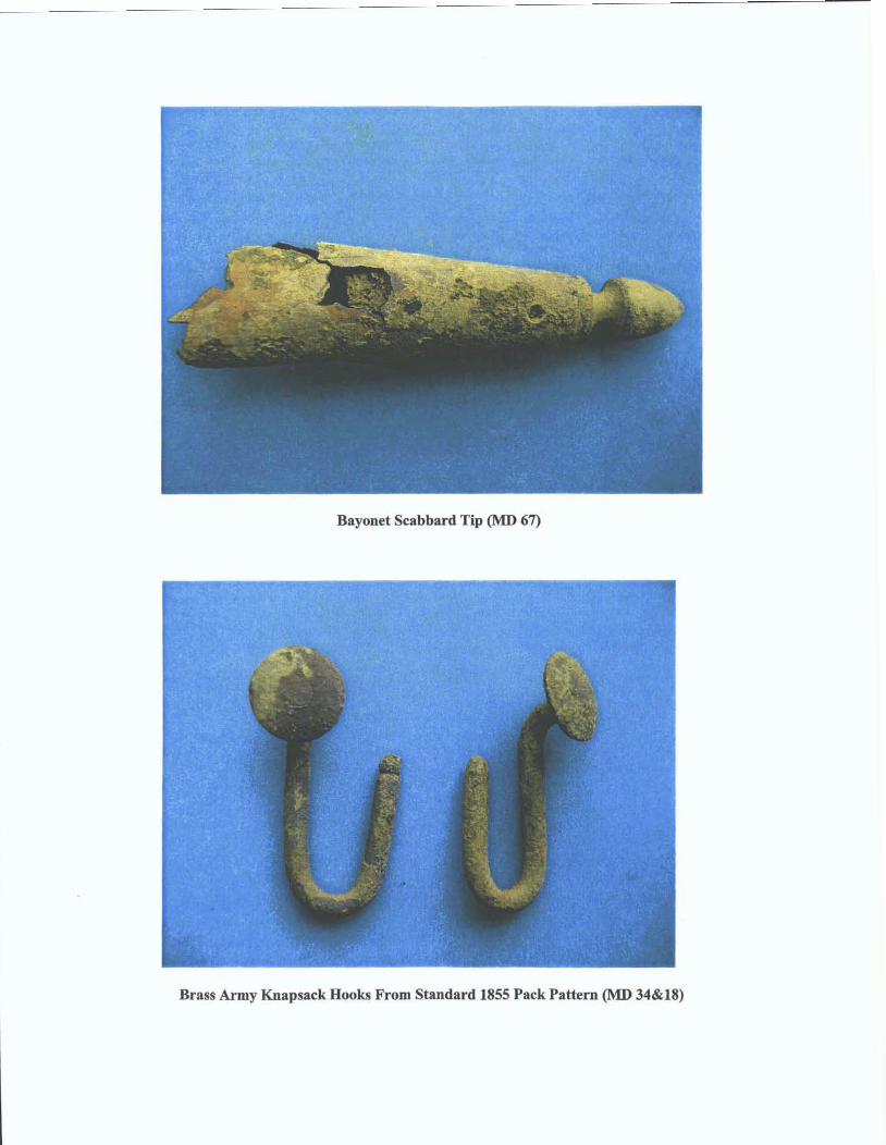
Bayonet Scabbard Tip (MD 67)
Brass Army Knapsack Hooks From Standard 1855 Pack Pattern 0 34&18)

German Silver Coin From 1843 (MD 70)
Pewter Spoon Frag. (MD63), Brass Furniture Handle 0 2 9 , Iron Button (MD64)

.58 Caliber 3-ring Minie Balls


