
ArcGIS Maps for SharePoint Installation and Configuration Guide › en › maps-for-sharepoint ›...
26
ArcGIS Maps for SharePoint Installation and Configuration Guide Copyright © 1995-2017 Esri. All rights reserved.
Transcript of ArcGIS Maps for SharePoint Installation and Configuration Guide › en › maps-for-sharepoint ›...

ArcGIS Maps for SharePointInstallation and ConfigurationGuide
Copyright © 1995-2017 Esri. All rights reserved.
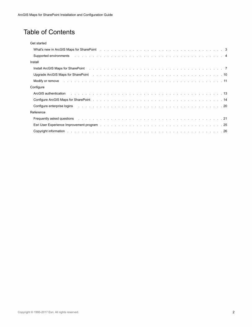
Table of Contents
Get started
What's new in ArcGIS Maps for SharePoint . . . . . . . . . . . . . . . . . . . . . . . . . . . . . . . . . . 3
Supported environments . . . . . . . . . . . . . . . . . . . . . . . . . . . . . . . . . . . . . . . . . 4
Install
Install ArcGIS Maps for SharePoint . . . . . . . . . . . . . . . . . . . . . . . . . . . . . . . . . . . . . 7
Upgrade ArcGIS Maps for SharePoint . . . . . . . . . . . . . . . . . . . . . . . . . . . . . . . . . . . . 10
Modify or remove . . . . . . . . . . . . . . . . . . . . . . . . . . . . . . . . . . . . . . . . . . . . 11
Configure
ArcGIS authentication . . . . . . . . . . . . . . . . . . . . . . . . . . . . . . . . . . . . . . . . . . 13
Configure ArcGIS Maps for SharePoint . . . . . . . . . . . . . . . . . . . . . . . . . . . . . . . . . . . . 14
Configure enterprise logins . . . . . . . . . . . . . . . . . . . . . . . . . . . . . . . . . . . . . . . . 20
Reference
Frequently asked questions . . . . . . . . . . . . . . . . . . . . . . . . . . . . . . . . . . . . . . . . 21
Esri User Experience Improvement program . . . . . . . . . . . . . . . . . . . . . . . . . . . . . . . . . . 25
Copyright information . . . . . . . . . . . . . . . . . . . . . . . . . . . . . . . . . . . . . . . . . . . 26
ArcGIS Maps for SharePoint Installation and Configuration Guide
Copyright © 1995-2017 Esri. All rights reserved. 2

What's new in ArcGIS Maps for SharePointDo you have an idea for a feature you'd like to see in ArcGIS Maps for SharePoint? Tell us about it at the ArcGIS Ideas site.
ArcGIS Maps for SharePoint 4.2 includes the following updates and enhancements:
• Apps rebranded as ArcGIS Maps for SharePoint.
• Added support for SharePoint Server 2016.
• ArcGIS Maps for SharePoint Online is now a single app that contains both the ArcGIS Maps app part and the ArcGIS Maps Locate
workflow.
• ArcGIS Maps for SharePoint Online is now supported in sub-sites.
• Enhanced security solution allows SharePoint administrators to use choose how to securely store ArcGIS credentials.
• Added support for ArcGIS Enterprise 10.5.
• Added support for vector tile basemaps.
• You can now add SharePoint lists and documents to an ArcGIS Maps app from sub-sites and sub-folders in a document library.
• ArcGIS Maps for SharePoint supports anonymously accessible map web parts on public-facing SharePoint sites.
• Enhanced user experience for adding SharePoint lists to a map.
• Enhanced user experience for app configuration and ArcGIS Maps Locate workflow.
• Multiple bug fixes and improvements.
ArcGIS Maps for SharePoint Installation and Configuration Guide
Copyright © 1995-2017 Esri. All rights reserved. 3

Supported environmentsArcGIS Maps for SharePoint is deployed as a farm solution (wsp) to Microsoft SharePoint.
For ArcGIS Maps for SharePoint to operate properly, Esri assumes an operational configuration of Microsoft SharePoint.
ArcGIS Maps for SharePoint is supported for use with the following:
• Microsoft SharePoint Server 2010
• Microsoft SharePoint Foundation 2010
• Microsoft SharePoint Server 2013
• Microsoft SharePoint Foundation 2013
• Microsoft SharePoint Server 2016
Esri tests ArcGIS Maps for SharePoint only in software environments certified or supported by Microsoft SharePoint; not all SharePoint-
supported environments have been tested or certified. For more information, see the Esri supported environments policy.
Note: ArcGIS Maps for SharePoint does not support SharePoint 2010 templates in SharePoint 2013.
ArcGIS Maps for SharePoint Installation and Configuration Guide
Copyright © 1995-2017 Esri. All rights reserved. 4

System requirements
See the system requirements for Microsoft SharePoint for information:
• Hardware and software requirements (SharePoint Server 2010)
• Hardware and software requirements (SharePoint 2013)
• Hardware and software requirements (SharePoint Server 2016)
ArcGIS
ArcGIS Maps for SharePoint requires an ArcGIS Online organizational subscription or an on-premises ArcGIS Enterprise deployment. It is
assumed that the authentication method used to access the platform has been properly configured by your ArcGIS administrator.
ArcGIS Maps for SharePoint 4.2 supports the following ArcGIS versions:
• ArcGIS Online—current version
• Portal for ArcGIS— 10.2 through 10.4.1
• ArcGIS Enterprise— 10.5
Required software
Before deploying ArcGIS Maps for SharePoint, the following prerequisites must be met:
• Microsoft SharePoint Server or Foundation, 2010 or 2013 or SharePoint Server 2016 correctly installed and configured
• The following MIME types must be present on the SharePoint server on which ArcGIS Maps for SharePoint is installed:
▪ .svg image/svg+sml
• Secure store service—By default, ArcGIS Maps for SharePoint uses the Secure Store Service (SSS) to secure ArcGIS credentials
and automatically generates a target application during installation; this is the recommended setting. If you don't want to use SSS
or if SSS is not available during installation, you must manually generate an encryption key after installation. For more information,
see Install ArcGIS Maps for SharePoint. If you choose to use SSS during installation, ensure the Secure Store Service is started
and that the service itself is properly configured.
• Follow these steps to access the Secure Store Service and generate a new key:
• On the Central Administration home page, in the Application Management section, click Manage service
applications.
• Click the Secure Store Service link.
• Click Generate New Key.
For details, see Configure the Secure Store Service in SharePoint 2013, Configure the Secure Store Service (SharePoint
Server 2010), or Configure the Secure Store Service in SharePoint Server 2016.
• Exit Central Administration.
• ArcGIS Enterprise—To successfully run the ArcGIS Maps Locate workflow in ArcGIS Enterprise, configure the geocoder service.
• SharePoint 2010—To successfully run the ArcGIS Maps Locate workflow in SharePoint 2010, download the certificatee from
ArcGIS Online or your ArcGIS Enterprise instance and import it to SharePoint.
Operating systems
ArcGIS Maps for SharePoint is supported for SharePoint 2010 and SharePoint 2013 on the following operating systems. See the Microsoft
SharePoint supported environments information to determine which versions of these operating systems are actively supported:
• Windows Server 2012
• Windows Server 2012 R2
• Windows Server 2008 R2 SP1
• Windows Server 2008 R2
Supported languages
ArcGIS Maps for SharePoint is available in the following languages:
Arabic, Chinese (simplified), Chinese (Traditional Hong Kong), Chinese (Tradition Taiwan), Czech, Danish, Dutch, English, Estonian,
Finnish, French, German, Greek, Hebrew, Indonesian, Italian, Japanese, Korean, Latvian, Lithuanian, Norwegian, Polish, Portuguese
(Brazil), Portuguese (Portugal), Romanian, Russian, Spanish, Swedish, Thai, Turkish, and Vietnamese.
ArcGIS Maps for SharePoint Installation and Configuration Guide
Copyright © 1995-2017 Esri. All rights reserved. 5
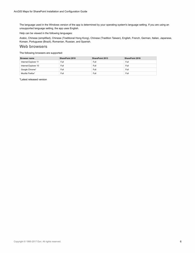
The language used in the Windows version of the app is determined by your operating system's language setting. If you are using an
unsupported language setting, the app uses English.
Help can be viewed in the following languages:
Arabic, Chinese (simplified), Chinese (Traditional Hong Kong), Chinese (Tradition Taiwan), English, French, German, Italian, Japanese,
Korean, Portuguese (Brazil), Romanian, Russian, and Spanish.
Web browsers
The following browsers are supported:
Browser name SharePoint 2010 SharePoint 2013 SharePoint 2016
Internet Explorer 11 Full Full Full
Internet Explorer 10 Full Full Full
Google Chrome* Full Full Full
Mozilla Firefox* Full Full Full
*Latest released version
ArcGIS Maps for SharePoint Installation and Configuration Guide
Copyright © 1995-2017 Esri. All rights reserved. 6

Install ArcGIS Maps for SharePointThe setup program included with ArcGIS Maps for SharePoint provides an easy way to deploy to your SharePoint installation.
Note: • Installing ArcGIS Maps for SharePoint requires administrative access to SharePoint.
Run the installer with elevated permissions to avoid errors
• Installing on a site that previously had a beta version of ArcGIS Maps for SharePoint
installed is not recommended. Before installing ArcGIS Maps for SharePoint, disable
and remove all components containing the beta software or create a new site.
ArcGIS Maps for SharePoint Installation and Configuration Guide
Copyright © 1995-2017 Esri. All rights reserved. 7

Included files
The ArcGIS Maps for SharePoint on-premises (SharePoint 2010, 2013, or 2016) installation includes the following files:
• Setup.exe—Installation program that allows you to deploy ArcGIS Maps for SharePoint to web applications and site collections in
your SharePoint farm.
• ESRI.ArcGIS.Mapping.SharePoint.wsp—SharePoint solution package that contains the ArcGIS Maps for SharePoint features,
resources, and configuration files.
• EnableAnonymousAccess.ps1—PowerShell script that enables anonymous access to SharePoint lists displayed within the ArcGIS
Maps app.
• Documentation—ArcGIS Maps for SharePoint includes a variety of documents to help you install, configure, and get started with
the apps. It also includes a guide for deploying language packs, and the license agreement.
• Language resource files—Setup resources for supported languages. To install ArcGIS Maps for SharePoint in a language other
than English, you must first install the English software, then download and install the appropriate language pack.
Install and deploy ArcGIS Maps for SharePoint on-premises
Follow these steps to deploy ArcGIS Maps for SharePoint.
1. Download and extract the contents of the ArcGIS Maps for SharePoint installation ZIP file to a location on the system where
SharePoint is installed.
2. Right-click the Setup.exe file and choose Run as Administrator to begin the installer. The installer performs a series of checks
to ensure that the installation will be successful. If a check fails, the installer provides information about the failure.
3. Once the checks have completed successfully, click Next.
If you receive a message that the Secure Store service has not started, start this service on your SharePoint server (not
applicable for SharePoint Foundation). See Supported environments for more information.
4. Read the End User License Agreement (EULA). If you agree to the terms of the EULA, check the check box and click Next.
5. Choose the web applications or site collections on which to enable ArcGIS Maps for SharePoint. In the Web Applications / Site
Collections tree, each top-level node represents a SharePoint web application, while each child node represents a site
collection. In the following example, ArcGIS Maps for SharePoint is targeted for deployment to the site collection located at
http://7win/sites/demo. Once you have selected the target web applications and site collections, click Next.
Note: If you target a web application, the ArcGIS Maps for SharePoint feature is available to all
site collections within that web application. Therefore, for site collections that are not
checked on this installer page but are within web applications that are checked, the
ArcGIS Maps for SharePoint feature is available but not activated.
6. Click Next to continue.
7. To participate in the Esri User Experience Improvement program, check the Allow Esri to collect information to improve
software check box.
ArcGIS Maps for SharePoint Installation and Configuration Guide
Copyright © 1995-2017 Esri. All rights reserved. 8

8. Click Next.
A log of the operations appears.
9. Click Close to close the setup program.
When the installation is complete, configure ArcGIS Maps for SharePoint
Install using PowerShell
Use the following PowerShell commands to manually install ArcGIS Maps for SharePoint. Be sure to replace the <placeholders> with the
information from your system.Add-SPSolution-LiteralPath C:\Software\ESRI.ArcGIS.Mapping.SharePoint.wspInstall-SPSolution ESRI.ArcGIS.Mapping.SharePoint.wsp-WebApplication http://<web application name>-GACDeploymentStart-Sleep 15Enable-SPFeature-identity "b432665a-07a6-4cc7-a687-3e1e03e92b9f"-URL http://<web application name>/sites/<MySiteCollectionName>
ArcGIS Maps for SharePoint Installation and Configuration Guide
Copyright © 1995-2017 Esri. All rights reserved. 9

Upgrade ArcGIS Maps for SharePointThe Setup.exe program included with ArcGIS Maps for SharePoint allows you to upgrade to the latest version. To upgrade, follow these
steps.
Note: You do not need to uninstall your previous version of ArcGIS Maps for SharePoint to upgrade to
a newer version.
Upgrade
1. Double-click the Setup.exe file to open it. Click Next in the ArcGIS Maps for SharePoint setup wizard.
The installer performs a series of checks to ensure that the installation will be successful. If a check fails, the installer provides
information about the failure.
2. When the checks have completed successfully, click Next.
3. Choose the Upgrade option and click Next.
The installer deploys and activates ArcGIS Maps for SharePoint to the selected site collections.
4. When the operation is complete, click Next to view the installation log.
5. Click Close to close the setup wizard.
Upgrade using PowerShell
Use the following PowerShell commands to remove the previous version of ArcGIS Maps for SharePoint and install the latest. Be sure to
replace the placeholders with the information from your system.
Disable-SPFeature-identity "b432665a-07a6-4cc7-a687-3e1e03e92b9f"-URL http://<web application name>/sites/<MySiteCollectionName>Uninstall-SPSolution–Identity ESRI.ArcGIS.Mapping.SharePoint.wsp–WebApplication http://<web application name>Start-Sleep 15Remove-SPSolution–Identity ESRI.ArcGIS.Mapping.SharePoint.wspWebContentInstaller.ps1 -uninstallAdd-SPSolution-LiteralPath C:\Software\ESRI.ArcGIS.Mapping.SharePoint.wspNet stop SPTimerV4Net start SPTimerV4Install-SPSolution ESRI.ArcGIS.Mapping.SharePoint.wsp-WebApplication http://<web application name> -GACDeploymentStart-Sleep 15Enable-SPFeature-identity "b432665a-07a6-4cc7-a687-3e1e03e92b9f"-URL http://<web application name>/sites/<MySiteCollectionName>
ArcGIS Maps for SharePoint Installation and Configuration Guide
Copyright © 1995-2017 Esri. All rights reserved. 10

Modify or removeModify
The Setup.exe program included with ArcGIS Maps for SharePoint allows you to easily modify which sites and web applications contain
ArcGIS Maps for SharePoint functionality. To modify your installation, complete the following steps:
1. Right-click the Setup.exe file and click Run as Administrator to begin the installer. The installer performs a series of checks to
see whether ArcGIS Maps for SharePoint has been installed and to ensure the installer can perform its functions. If a check fails,
the installer provides information about the failure.
2. Once the checks have completed successfully, click Next.
3. Select the Modify option and click Next.
4. Choose the web applications or site collections on which to enable or disable ArcGIS Maps for SharePoint. In the Web
Applications/Site Collections tree, each top-level node represents a SharePoint web application, while each child node
represents a site collection. In the following screen capture, ArcGIS Maps for SharePoint is being targeted for deployment to the
site collection located at http://7win/sites/demo.
If you target a web application, ArcGIS Maps for SharePoint is available to all site collections within that web application.
5. Once you have selected the target web applications and site collections, click Next. The installer deploys and activates ArcGIS
Maps for SharePoint to the selected site collections and deactivates ArcGIS Maps for SharePoint on any unchecked site
collections.
6. Once the operation completes, click Next to view a log of the operations or Close to close the setup program.
Remove
To remove ArcGIS Maps for SharePoint from your SharePoint farm, use the Setup.exe program included with the product. Follow the
steps below to uninstall ArcGIS Maps for SharePoint.
1. Right-click the Setup.exe file and click Run as Administrator to begin the installer. The installer performs a series of checks to
see whether ArcGIS Maps for SharePoint has been installed to ensure the installer can perform its functions. If a check fails, the
installer provides information about the failure.
2. Once the checks have completed successfully, click Next. The Modify or Remove dialog box appears.
3. Choose the Remove option and click Next. The installer retracts ArcGIS Maps for SharePoint from all site collections and
removes it from the SharePoint farm.
4. Once the operation completes, click Next to view a log of the operations or Close to close the setup program.
ArcGIS Maps for SharePoint Installation and Configuration Guide
Copyright © 1995-2017 Esri. All rights reserved. 11

Uninstall using PowerShell
Use the following PowerShell commands to uninstall ArcGIS Maps for SharePoint. Be sure to replace the placeholders with the
information from your system.Disable-SPFeature-identity "b432665a-07a6-4cc7-a687-3e1e03e92b9f"-URL http://<web application name>/sites/<MySiteCollectionName>Uninstall-SPSolution–Identity ESRI.ArcGIS.Mapping.SharePoint.wsp–WebApplication http://<web application name>Start-Sleep 15Remove-SPSolution–Identity ESRI.ArcGIS.Mapping.SharePoint.wsp
ArcGIS Maps for SharePoint Installation and Configuration Guide
Copyright © 1995-2017 Esri. All rights reserved. 12
ArcGIS authenticationArcGIS Maps for SharePoint works directly with an ArcGIS Online organization or with a ArcGIS Enterprise instance. Although users can
view the map without signing in, usage is limited to viewing and basic navigation of the map, and editing attributes in the dataset that
appear in pop-ups. Signing in to ArcGIS allows ArcGIS Maps for SharePoint to connect to the platform and enable full functionality of the
map.
The authentication method used to sign in is determined by the way you have set up security features for your ArcGIS Online organization
or ArcGIS Enterprise instance. ArcGIS Maps for SharePoint requires no specific steps to implement the authentication methods supported
by ArcGIS OnlineArcGIS Maps for SharePoint or ArcGIS Enterprise. For details about configuring the app, see Configure ArcGIS Maps for
SharePoint.
For more information about ArcGIS authentication and to ensure that security settings are properly implemented, refer to the
documentation for ArcGIS Online or ArcGIS Enterprise .
ArcGIS Online
ArcGIS Maps for SharePoint supports the following authentication methods for connecting to ArcGIS Online:
• Built-in accounts—Users enter their ArcGIS Online credentials. This results in the use of token-based authentication via OAuth
2.0.
• Enterprise logins—Enterprise logins are supported via Security Assertion Markup Language (SAML) 2.0. See Configure
enterprise logins for more information.
ArcGIS Enterprise
For detailed information on ArcGIS Enterprise authentication, see the Administrator Guide included with the ArcGIS Enterprise installation.
• Built-in accounts—Users enter their ArcGIS Enterprise credentials. This results in the use of token-based authentication via
OAuth 2.0. For ArcGIS Enterprise 10.3 and later, this is the default authentication method. See Configure ArcGIS Maps for
SharePoint for more information.
• Enterprise logins—Enterprise logins are supported via Security Assertion Markup Language 2.0 (SAML). The following
Enterprise identity providers are supported: Integrated Windows Authentication (IWA), Public Key Infrastructure (PKI), Lightweight
Directory Access Protocol (LDAP), and token-based authentication. See Configure enterprise logins for more information.
Note: If you use ArcGIS Enterprise configured with SAML, you will need to sign in to the App
Configuration using a built-in user, and then change the credentials to sign in using the
SAML user name and password.
ArcGIS Maps for SharePoint does not currently support IWA/PKI/LDAP authentication for
workflows (ArcGIS Maps Connect and ArcGIS Maps Locate workflows) for ArcGIS
Enterprise.
ArcGIS Maps for SharePoint Installation and Configuration Guide
Copyright © 1995-2017 Esri. All rights reserved. 13
Configure ArcGIS Maps for SharePointAs a SharePoint site collection administrator, you are responsible for configuring ArcGIS Maps for SharePoint. To begin, you generate
an encryption key that ensures that the ArcGIS credentials used to configure the map are stored securely; if you chose to use SSS
during installation, this is done automatically; otherwise, you must manually generate a key. You then specify the URL for your ArcGIS
Online organizational account or ArcGIS Enterprise instance. Finally, you specify the ArcGIS named user account used to validate the
map and charge credits consumed by the ArcGIS Maps for SharePoint workflows (Locate and Connect). You can also optionally set
options for the Esri User Experience Improvement program here.
The ArcGIS named user account specified during configuration is used to generate an app item in ArcGIS Online or ArcGIS Enterprise.
This app item is used for the following purposes:
• Generate an app token used by the ArcGIS Maps Locate workflow and ArcGIS Location field
• Generate an app token to allow guest users to view the map web part
• The app item's ID is used for OAuth 2.0 authentication for named users
When the ArcGIS credentials are set, users can view the map as guests, without needing to sign in to ArcGIS. Guest users have limited
access to the map; in addition to viewing publicly shared SharePoint content and publicly shared ArcGIS content that has been added to
the map, guest users can pan and zoom the map, turn layers on and off, and view pop-ups, but most functionality is restricted to viewing
only. In addition, the ArcGIS Maps Locate workflow is limited to using only public geocoders and publicly shared feature layers. To fully
interact with the map, users must sign in to ArcGIS using a named user account.
After you complete the app configuration, users can sign in as the named user in the ArcGIS Maps web part, using their own user
credentials. Any credits consumed by the app (for example, driving routes, infographics, etc.) are charged to the user's account.
Important: ArcGIS Maps for SharePoint supports different authentication methods; these procedures describe how to configure the app
with the default OAuth 2.0 authentication. For other authentication methods, see Configure enterprise logins.
Access ArcGIS Maps for SharePoint app configuration
Prerequisite:
You must be a SharePoint site collection administrator to access the ArcGIS Maps for SharePoint administration menu and configure
the app.
1. Browse to the Site Settings page of the site.
2. Under the ArcGIS Maps for SharePoint Administration heading, click Configuration Settings.
Note: If you receive an "Access denied" message when you open the App Configuration page,
you do not have site collection administrator privileges. Only site collection administrators
can perform the app configuration.
Generate an encryption key
Before you can configure ArcGIS Maps for SharePoint, you must generate an encryption key. This key ensures that the ArcGIS
credentials used to configure the app are stored securely.
By default, ArcGIS Maps for SharePoint uses the Secure Store Service (SSS) to secure ArcGIS credentials. An encryption key is
generated within a target application and stored in SSS, and all site collections will use this encryption key to secure ArcGIS credentials. If
ArcGIS Maps for SharePoint Installation and Configuration Guide
Copyright © 1995-2017 Esri. All rights reserved. 14

you don't want to use SSS, you can choose to manually generate an encryption key after installation. Using SSS is the recommended
setting for enhanced security.
During installation, a target application is automatically created with the ID "arcgismapsforsharepoint". SharePoint farm administrators can
manually create other target applications for this too if desired.
Create an SSS target application (optional)
During installation, if you choose to use Secure Store Service to secure ArcGIS credentials, ArcGIS Maps for SharePoint automatically
creates a target application in the Secure Store Service, with the ID "arcgismapsforsharepoint". All site collections are configured by
default to use this target application.
In some cases, the SharePoint farm administrator may want to manually create a different target application. Some reasons for creating
a manual target application include:
• The site collection administrator wants to use a dedicated target application for increased security.
• The ArcGIS Maps for SharePoint installer failed to properly create the default target application.
To manually create an SSS target application, do the following:
1. On the Central Administration home page, in the Application Management section, click Manage service applications.
2. Click the Secure store service application.
3. Click New to create a new target application.
4. Type a string in the Target Application ID field.
This value will be required during ArcGIS Maps for SharePoint configuration.
5. Provide a valid contact email address and set the Target Application Type to Group.
6. Click Next.
7. Remove the default username and password fields and click Add field. Type a field name and set the field type to Key. Check
the Masked check box and click Next to continue.
8. Set the web application pool account to be both administrator and member.
The application pool runs the web application that owns the SharePoint web application in which ArcGIS Maps for SharePoint
site collection is activated.
ArcGIS Maps for SharePoint Installation and Configuration Guide
Copyright © 1995-2017 Esri. All rights reserved. 15

Note: Be sure to add the web application pool identity user to the member group, not the
SharePoint site collection administrator; otherwise, you may receive an Access Denied
error.
9. Click OK to finish creating the target application.
10. After the target application is created, select it and click Set in the Central Administration application's ribbon to set the
encryption key for ArcGIS Maps for SharePoint.
11. In the Set credentials window, type a value in ekey field, then type it again to confirm.
You do not need to memorize this key.
12. Click OK to finish.
Use Secure Store Service
If you chose Use SSS during installation, the ArcGIS Maps App Configuration page shows the target application ID that was automatically
created during installation (arcgismapsforsharepoint). The encryption key is saved in this target application and there is no need to
manually create one. All related site collections will use this key to secure the ArcGIS credentials used to access content hosted on
ArcGIS Online or ArcGIS Enterprise.
ArcGIS Maps for SharePoint Installation and Configuration Guide
Copyright © 1995-2017 Esri. All rights reserved. 16

1. By default, ArcGIS Maps for SharePoint automatically creates a target application in the Secure Store Service, with the ID
"arcgismapsforsharepoint". If your SharePoint farm administrator has manually generated a different target application ID, type it
in the Target application field and click Test connection.
A green check mark beside the field indicates that the connection is working.
If the target application is not found, a red X and error message appear. Ask your SharePoint farm administrator to verify the
target application ID and try again.
2. When the connection is valid, click Set to start using the encryption key stored in the target application.
Note: In case of a security breach, the SharePoint farm administrator can use the Central
Administration application to reset the encryption key stored in the target application. This
will invalidate all existing ArcGIS credentials that were secured by the target application
and all site administrators will need to reconfigure ArcGIS credentials for their own site
collections.
Manually generate an encryption key
If you chose Do not use SSS during installation, you'll need to manually generate an encryption key for this site collection. This encryption
key is stored within the site collection and is not as secure as using SSS. You should use this option only if SSS is not available.
1. In the Encryption key section of the configuration page, click the Generate your own encryption key radio button.
2. Type a passphrase in the Passphrase field.
The passphrase must contain at least 6 characters, of which at least one must be a numerical digit, and one uppercase character
(for example, passWord1).
Important: Both the passphrase used to generate the encryption key and the username and password for the ArcGIS account
are case-sensitive.
3. Retype the passphrase to confirm.
4. Click Create key.
A message appears, stating that the encryption key was successfully generated.
ArcGIS Maps for SharePoint Installation and Configuration Guide
Copyright © 1995-2017 Esri. All rights reserved. 17

5. To generate a new key, click Refresh key.
6. Type the passphrase you entered previously and click Refresh.
The encrypted credentials are re-encrypted using the new key and the old key is discarded.
7. To generate a new key with a different passphrase, click New key and follow the steps outlined at the beginning of this workflow.
After you generate an encryption key, you can securely set the remaining app configuration settings.
Set the ArcGIS connection URL
1. In the ArcGIS or Portal URL field, type the URL for your ArcGIS Online organization or ArcGIS Enterprise instance.
2. If you are connecting directly to ArcGIS Online (meaning your instance has no subdomain), leave the default setting of
http://www.arcgis.com.
Note: To configure ArcGIS Maps for SharePoint to work with SSL-secured sites, change the
ArcGISConnection URL from HTTP to HTTPS.
If you are working in disconnected environment, such as when your internal network is behind a firewall, set this value to point to
your ArcGIS Enterprise instance. For example: https://<portalname>\<instance>.
3. Click Test connection.
A green check mark beside the field indicates that the connection is valid.
If the URL is not found, a red X and error message appear. Verify the URL and try again.
4. When the connection is valid, click Set to confirm the URL.
Set the ArcGIS credentials
ArcGIS Maps for SharePoint uses a single ArcGIS named user account to create an app item in ArcGIS Online or ArcGIS Enterprise.
This app item is used to generate an app token used to run the ArcGIS Maps Locate workflow and charge credits consumed by the
ArcGIS Maps for SharePoint workflows (Locate and Connect), and by the ArcGIS Location field. It also uses this account to enable
limited use for guest access.
The app item is protected in ArcGIS Online or ArcGIS Enterprise.
1. In the ArcGIS credentials section, click Set.
2. Under the App Configuration heading, click Set Credentials.
3. Type the username and password for the ArcGIS named user account.
Both the username and password are case-sensitive.
4. Click OK.
The App Configuration pane shows the user account currently specified.
5. To change the ArcGIS credentials to use a different account click Delete.
The ArcGIS sign in window opens.
6. Sign in using the credentials used when the account was initially set and click Sign in.
The saved ArcGIS are purged and the app item is removed from the ArcGIS Maps configuration.
7. Click Set to specify a new ArcGIS named user account.
8. To enable guest access by default, check the Start session with guest signed in by default check box.
If this option is unchecked, users will see a message on the map offering a choice of signing in to ArcGIS or continuing as a
guest. If this option is checked, users automatically access the map as guests. Guests can click Sign in above the map title bar at
any time to sign in with their named user account.
Guest users have limited access to the ArcGIS Maps Web Part. In addition to viewing SharePoint content and publicly shared
ArcGIS content that has been added to the map, guest users can pan and zoom the map, turn layers on and off, and view pop-
ups, but most functionality is restricted to viewing only. To fully interact with the map, users must sign in to ArcGIS using a named
user account
ArcGIS Maps for SharePoint Installation and Configuration Guide
Copyright © 1995-2017 Esri. All rights reserved. 18

Note: All map authoring tasks and activities that consume ArcGIS credits, such as adding maps
to SharePoint pages, adding ArcGIS layers to those maps, geoenabling SharePoint lists,
adding geoenabled layers to maps and layers, changing styling options, and so on,
require a named user account.
Set Esri User Experience Improvement options
Optionally participate in the Esri User Experience Improvement (EUEI) program. Check this box to provide anonymous information about
your system and how you use ArcGIS Maps for SharePoint. Clear the box to opt out of the program. For more information, see Esri User
Experience Improvement.
Troubleshoot App configuration
• If you're using Internet Explorer and the Sign In window appears but is blank, try the following:
• On the Internet Explorer Internet Options dialog box, click the Security tab and choose Trusted Sites.
• Check Enable Protected Mode.
• Click the Sites button and add https://*.arcgis.com or your ArcGIS Enterprise portal address.
• Restart Internet Explorer.
• If you have a ArcGIS Enterprise configured with SAML, you'll need to sign into App Configuration using a built-in user, change
the credentials, and sign in using the SAML username and password.
• Use Firefox or Chrome when setting the App Configuration credentials on SharePoint 2010 for IWA, PKI, or LDAP portals. When
using Firefox, first navigate to the portal itself and make sure to add the exception to trust the portal.
• If you receive the following message: "Unable to obtain master key," follow the steps below to generate a key within the
SharePoint Secure Store service:
• On the Central Administration home page, in the Application Management section, click Manage service
applications.
• Click the Secure Store Service link.
• Click Generate New Key.
ArcGIS Maps for SharePoint Installation and Configuration Guide
Copyright © 1995-2017 Esri. All rights reserved. 19

Configure enterprise loginsYou can specify your ArcGIS organization's subdomain to enable enterprise logins across your SharePoint site collection. Configuring
enterprise logins allows members of your organization to sign in to ArcGIS Maps for SharePoint using the same credentials they use to
access your enterprise information systems. The advantage of setting up enterprise logins is that members do not need to create
additional logins within the ArcGIS platform; instead, they can use the account that is already set up within their enterprise system.
Prerequisite:
You must be a SharePoint site collection administrator to access the ArcGIS Maps for SharePoint administration menu and configure
the app.
To configure enterprise login, do the following:
1. Navigate to the Site Settings page of the site.
2. Under the ArcGIS Maps for SharePoint Administration heading, click App Configuration.
The ArcGIS Maps for SharePoint configuration page opens.
3. Edit the value of the ArcGIS or Portal URL field to point to the subdomain of your ArcGIS Enterprise portal instance or ArcGIS
Online organization.
For example: https://<mysubdomain>.maps.arcgis.com
Enterprise login configuration is complete.
4. To disable enterprise login and revert to the default ArcGIS sign in method, reset the ArcGIS or Portal URL to
https://www.arcgis.com.
ArcGIS Maps for SharePoint Installation and Configuration Guide
Copyright © 1995-2017 Esri. All rights reserved. 20

Frequently asked questions• What are the licensing requirements for ArcGIS Maps for SharePoint?
• When running the ArcGIS Maps Locate workflow, the fields do not appear on the Choose the columns with location information
page.
• The ArcGIS Maps Locate workflow does not complete successfully when using a custom geocoder and ArcGIS Enterprise.
• How can I use Esri GeoEnrichment services?
• How do I connect to services in a firewalled environment?
• Why does ArcGIS Maps for SharePoint store properties in configuration lists?
• I created a new site collection within a web application that has ArcGIS Maps for SharePoint, but the components and
configuration lists are not available.
• Can I use existing lists with latitude-longitude data?
• How do I import Excel spreadsheets for use with ArcGIS Maps for SharePoint?
• Error message: Your browser configuration does not support sending secured content. Your sign-in was canceled to ensure
password safety.
• In SharePoint 2010, you receive one of the following error messages: An invalid ArcGIS Portal URL was entered. Please verify the
URL.Unable to access the authentication service.Your Workflow failed: The underlying connection was closed: Could not establish
trust relationship for the SSL/TLS secure channel.Your Workflow failed: Generating request token failed. System.Exception:
Generating token request failed.
• Users who are not signed in to a SharePoint site see a 403 (Forbidden) error when trying to view a page that contains an ArcGIS
Maps web part.
• Error message: Could not load file or assembly, Microsoft.SqlServer.Types, Version=11.0.0.0, Culture=neutral,
PublicKeyToken=89845dcd8080cc91, or one of its dependencies.
What are the licensing requirements for ArcGIS Maps for SharePoint?
ArcGIS Maps for SharePoint requires an ArcGIS Online organization plan or ArcGIS Enterprise. All users are required to have a Named
User license to work with ArcGIS and interact with the map.
While users can view the map as guests without needing to sign in, these users have limited access to the map: in addition to viewing
publicly shared ArcGIS Maps for SharePoint content and publicly shared ArcGIS content, guest users can pan and zoom the map, turn
layers on and off, and view pop-ups, but most functionality is restricted to viewing only.
When running the ArcGIS Maps Locate workflow, the fields do not appear on the Choose the columns with location information
page.
This issue can occur with Portal for ArcGIS 10.2.1 through 10.4.1 on Linux servers. If this occurs, ensure that the geocoding service used
is shared with everyone.
The ArcGIS Maps Locate workflow does not complete successfully when using a custom geocoder and ArcGIS Enterprise.
To successfully run the ArcGIS Maps Locate workflow in Portal for ArcGIS 10.3 through 10.4.1 or in ArcGIS Enterprise 10.5 and later,
configure the geocoder service according to the If the service is not from a federated server and requires credentials section in the
Configure utility services topic in your ArcGIS Enterprise documentation.
How can I use Esri GeoEnrichment services?
Esri GeoEnrichment services provide demographic and contextual data for features in your map. GeoEnrichment requires a subscription
to ArcGIS Online or configuration of GeoEnrichment on your installation of ArcGIS Enterprise.
How do I connect to services in a firewalled environment?
See Configure enterprise logins.
Why does ArcGIS Maps for SharePoint store properties in configuration lists?
Some shared properties used across ArcGIS Maps for SharePoint components are stored in lists at the site collection and site level to
provide flexibility and ease of use in configuration. Exposing the properties in lists accommodates scenarios where it is appropriate to
allow nonadministrative users to configure these properties and scenarios where these should only be editable by administrators. Users of
ArcGIS Maps for SharePoint components do not need edit rights to the configuration lists. Additionally, using lists for configuration
provides an intuitive, easy-to-use user interface (UI) that will be familiar to most SharePoint users.
ArcGIS Maps for SharePoint Installation and Configuration Guide
Copyright © 1995-2017 Esri. All rights reserved. 21
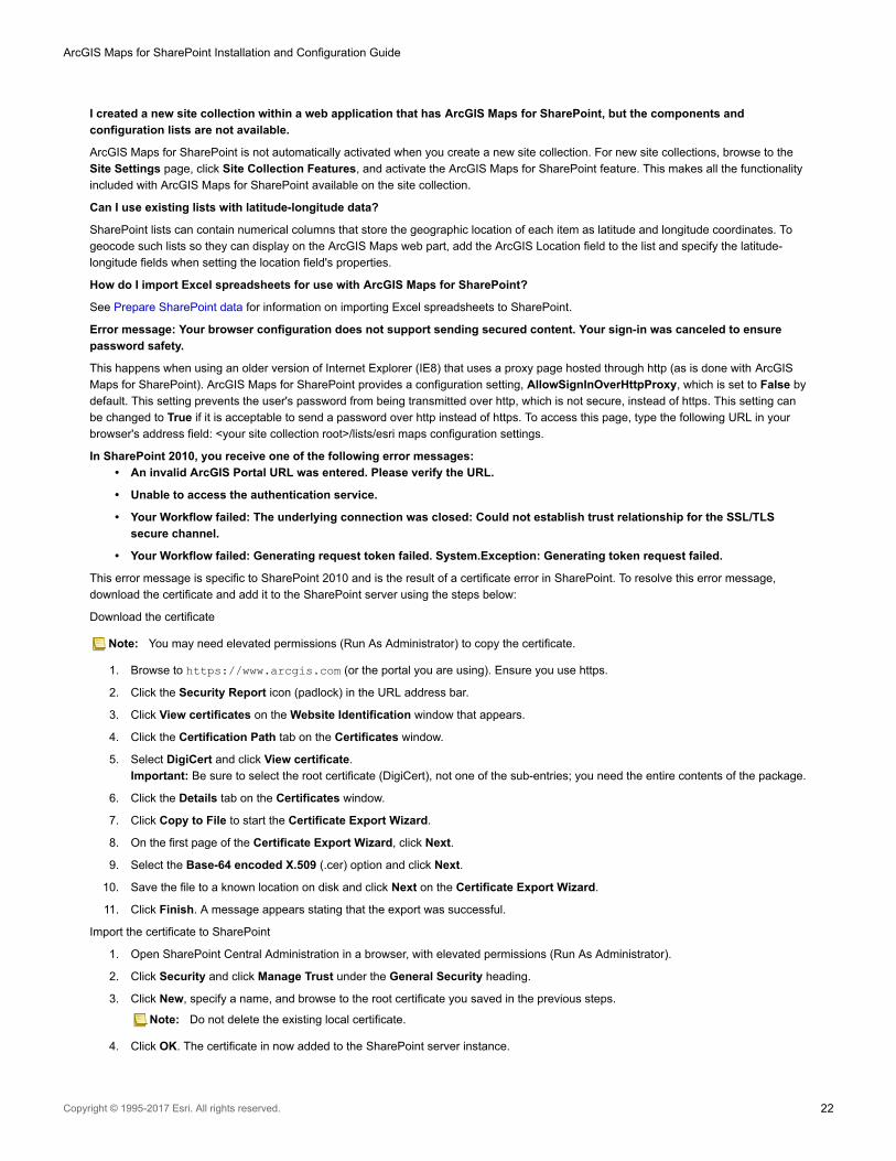
I created a new site collection within a web application that has ArcGIS Maps for SharePoint, but the components and
configuration lists are not available.
ArcGIS Maps for SharePoint is not automatically activated when you create a new site collection. For new site collections, browse to the
Site Settings page, click Site Collection Features, and activate the ArcGIS Maps for SharePoint feature. This makes all the functionality
included with ArcGIS Maps for SharePoint available on the site collection.
Can I use existing lists with latitude-longitude data?
SharePoint lists can contain numerical columns that store the geographic location of each item as latitude and longitude coordinates. To
geocode such lists so they can display on the ArcGIS Maps web part, add the ArcGIS Location field to the list and specify the latitude-
longitude fields when setting the location field's properties.
How do I import Excel spreadsheets for use with ArcGIS Maps for SharePoint?
See Prepare SharePoint data for information on importing Excel spreadsheets to SharePoint.
Error message: Your browser configuration does not support sending secured content. Your sign-in was canceled to ensure
password safety.
This happens when using an older version of Internet Explorer (IE8) that uses a proxy page hosted through http (as is done with ArcGIS
Maps for SharePoint). ArcGIS Maps for SharePoint provides a configuration setting, AllowSignInOverHttpProxy, which is set to False by
default. This setting prevents the user's password from being transmitted over http, which is not secure, instead of https. This setting can
be changed to True if it is acceptable to send a password over http instead of https. To access this page, type the following URL in your
browser's address field: <your site collection root>/lists/esri maps configuration settings.
In SharePoint 2010, you receive one of the following error messages:
• An invalid ArcGIS Portal URL was entered. Please verify the URL.
• Unable to access the authentication service.
• Your Workflow failed: The underlying connection was closed: Could not establish trust relationship for the SSL/TLS
secure channel.
• Your Workflow failed: Generating request token failed. System.Exception: Generating token request failed.
This error message is specific to SharePoint 2010 and is the result of a certificate error in SharePoint. To resolve this error message,
download the certificate and add it to the SharePoint server using the steps below:
Download the certificate
Note: You may need elevated permissions (Run As Administrator) to copy the certificate.
1. Browse to https://www.arcgis.com (or the portal you are using). Ensure you use https.
2. Click the Security Report icon (padlock) in the URL address bar.
3. Click View certificates on the Website Identification window that appears.
4. Click the Certification Path tab on the Certificates window.
5. Select DigiCert and click View certificate.
Important: Be sure to select the root certificate (DigiCert), not one of the sub-entries; you need the entire contents of the package.
6. Click the Details tab on the Certificates window.
7. Click Copy to File to start the Certificate Export Wizard.
8. On the first page of the Certificate Export Wizard, click Next.
9. Select the Base-64 encoded X.509 (.cer) option and click Next.
10. Save the file to a known location on disk and click Next on the Certificate Export Wizard.
11. Click Finish. A message appears stating that the export was successful.
Import the certificate to SharePoint
1. Open SharePoint Central Administration in a browser, with elevated permissions (Run As Administrator).
2. Click Security and click Manage Trust under the General Security heading.
3. Click New, specify a name, and browse to the root certificate you saved in the previous steps.
Note: Do not delete the existing local certificate.
4. Click OK. The certificate in now added to the SharePoint server instance.
ArcGIS Maps for SharePoint Installation and Configuration Guide
Copyright © 1995-2017 Esri. All rights reserved. 22

Users who are not signed in to a SharePoint site see a 403 (Forbidden) error when trying to view a page that contains an ArcGIS
Maps web part.
If you have a public-facing site collection that doesn't require users to sign in, if pages within that site collection contain ArcGIS Maps web
parts, you must enable anonymous access for the SharePoint site, and enable ArcGIS Maps guest access for users to be able to view the
map.
Tip: As a best practice, it is recommended that you use a dedicated SharePoint web application to
serve public-facing site collections.
To enable anonymous access in your SharePoint site collection, do the following:
• Enable SharePoint anonymous access on the web application level
• Enable SharePoint anonymous access on the site collection level
Enable SharePoint anonymous access on the web application level
You must be a SharePoint farm administrator to complete these tasks.
1. From SharePoint Central Administration, under Application Management, click Manage Web Applications.
The Web Applications page opens, listing available applications.
2. From the list, click the web application for which you want to enable anonymous access and, on the ribbon, click Authentication
Providers.
A window appears, showing the authentication providers available per zone. In a basic scenario, only the Default zone is listed.
3. Click Default.
The Edit Authentication window opens.
4. Check the Enable Anonymous Access checkbox and clear the Require Use Remote Interfaces permissions box if it is
checked.
5. Scroll to the bottom of the window and click Save. Close the Edit Authentication window and exit SharePoint Central
Administration.
6. Open SharePoint Management Shell with elevated permissions (Run as Administrator).
7. To allow users to add SharePoint data to an ArcGIS Maps web part, run the following script, replacing the values in brackets with
the URL of your web application:$webapp = Get-SPWebApplication <"http://myWebApplication">$webapp.ClientCallableSettings.AnonymousRestrictedTypes.Remove([microsoft.sharepoint.spweb], "GetSebwebsForCurrentUser")$webapp.ClientCallableSettings.AnonymousRestrictedTypes.Remove([microsoft.sharepoint.splist], "GetItems")$webapp.ClientCallableSettings.AnonymousRestrictedTypes.Remove([microsoft.sharepoint.splist], "GetChanges")$webapp.Update()
Enable SharePoint anonymous access on the site collection level
You must be a SharePoint site collection administrator to complete these tasks.
1. Navigate to one of the site collections you created under the configured web application and open the Site Settings page.
2.
3. Under the Users and Permissions section, click Site permissions.
4. From the ribbon, click Anonymous Access.
The Anonymous Access configuration window opens.
5. From the Anonymous users can access options, choose Entire Web Site.
6. Clear the Require Use Remote Interfaces permission check box and click OK.
A new group named Anonymous Users appears on the site permissions list. After these configurations are complete, anonymous
users that are unknown to both SharePoint and ArcGIS will be able to view ArcGIS Maps.
Error message: Could not load file or assembly, Microsoft.SqlServer.Types, Version=11.0.0.0, Culture=neutral,
PublicKeyToken=89845dcd8080cc91, or one of its dependencies.
When running the workflow to connect to external data, you may encounter the error message, Could not load file or assembly
Microsoft.SqlServer.Types, Version=11.0.0.0, Culture=neutral, PublicKeyToken=89845dcd8080cc91, or one of its dependencies. This error
message occurs on systems with SQL Server 2008, which does not always provide version 11 of the Microsoft.SqlServer.Types assembly.
This error message should only occur with SharePoint 2010. Follow the steps below to install version 11 of the Microsoft.SqlServer.Types
assembly to the Global Assembly Cache (GAC) of the SharePoint server machine.
1. Download the Microsoft SQL Server 2012 SP1 Feature Pack from http://www.microsoft.com/en-us/download/
details.aspx?id=35580.
ArcGIS Maps for SharePoint Installation and Configuration Guide
Copyright © 1995-2017 Esri. All rights reserved. 23

2. When prompted to choose the download, select ENU\x86\SQLSysClrTypes.msi or ENU\x64\SQLSysClrTypes.msi, depending on
whether the server is 32 bit (x86) or 64 bit (x64).
3. Save the file to the server machine and run it.
4. Restart IIS.
ArcGIS Maps for SharePoint Installation and Configuration Guide
Copyright © 1995-2017 Esri. All rights reserved. 24

Esri User Experience Improvement programEsri works continuously to improve its products and one of the best ways to find out what needs improvement is through customer
feedback. The Esri User Experience Improvement program (EUEI) allows you to contribute to the design and development of ArcGIS
Maps for SharePoint. The program collects information about your computer hardware and how you use ArcGIS Maps for SharePoint,
without interrupting your work. The program is completely voluntary and anonymous; none of the information collected is used to identify
or contact you.
The following questions and answers provide detailed information about the program.
• What happens when I participate in the EUEI program?
• What kind of data is collected?
• Does Esri collect information about other software on my system?
• Can I opt out of the program?
• Will Esri contact me about the program?
• What is the size of the generated report?
• How is my privacy protected if I choose to participate in the program?
What happens when I participate in the EUEI program?
Esri collects information about your computer and how you are using ArcGIS Maps for SharePoint. This information is stored in an
encoded file that is occasionally sent to Esri while you are working. The collection and submission method is completely unobtrusive and
has no impact on your use of the software.
What kind of data is collected?
Some examples of the data are hardware information, such as the version of your operating system, information about your graphics card,
the commands and tools you are using, how long you use the application, error report information, and so on. The EUEI program does not
collect any personal information related to you or your organization, such as your IP address, login information, or specifics about any data
you may be using.
Does Esri collect information about other software on my system?
No, the program does not actively collect any information outside ArcGIS Maps for SharePoint. However, some general information may
be collected from third-party software that extends ArcGIS.
Can I opt out of the program?
Yes, you can opt in or out at any time by changing the option in the ArcGIS Maps App Configuration pane. For more information, see
Change Esri User Experience Improvement settings.
Will Esri contact me about the program?
No. The EUEI program does not collect any personal or contact information that can be linked back to an individual user. The program is
completely anonymous.
What is the size of the generated report?
The EUEI program reports are generally small, averaging a few megabytes or less.
How is my privacy protected if I choose to participate in the program?
Esri respects your privacy and does not gather any personal information about you or your system. To properly aggregate and prioritize
the data, the program creates a globally unique identifier (GUID) that is stored on your computer. This ID allows the program to distinguish
between one hundred users providing feedback or one user who provides feedback a hundred times. The GUID is a randomly generated
number and is not used to identify you.
For more information, see the Esri Privacy Policy.
ArcGIS Maps for SharePoint Installation and Configuration Guide
Copyright © 1995-2017 Esri. All rights reserved. 25

Copyright informationCopyright © 1995-2017 Esri
All rights reserved
Published in the United States of America.
US GOVERNMENT CUSTOMER
The Products are commercial items, developed at private expense, provided to Customer under this Agreement. If Customer is a US
government entity or US government contractor, Esri licenses or provides subscriptions to Customer in accordance with this Agreement
under FAR Subparts 12.211/12.212 or DFARS Subpart 227.7202. Esri Data and Online Services are licensed or subscribed under the
same DFARS Subpart 227.7202 policy as commercial computer software for acquisitions made under DFARS. Products are subject to
restrictions, and this Agreement strictly governs Customer's use, modification, performance, reproduction, release, display, or disclosure of
Products. Agreement provisions that are inconsistent with federal law regulation will not apply. A US government Customer may transfer
Software to any of its facilities to which it transfers the computer(s) on which it has installed such Software. If any court, arbitrator, or board
holds that a US government Customer has greater rights to any portion of the Products under applicable public procurement law, such
rights will extend only to the portions affected.
Esri Trademarks
@esri.com, 3D Analyst, Address Coder, ArcAtlas, ArcCAD, ArcCatalog, ArcCOGO, ArcData, ArcDoc, ArcEdit, ArcEditor, ArcEurope,
ArcExplorer, ArcExpress, ArcGIS, ArcGlobe, ArcGrid, ArcIMS, ARC/INFO, ArcInfo, ArcInfo Librarian, ArcLessons, ArcLocation,
ArcLogistics, ArcMap, ArcNetwork, ArcNews, ArcObjects, ArcOpen, ArcPad, ArcPlot, ArcPress, ArcPy, ArcReader, ArcScan, ArcScene,
ArcSchool, ArcScripts, ArcSDE, ArcSdl, ArcSketch, ArcStorm, ArcSurvey, ArcTIN, ArcToolbox, ArcTools, ArcUSA, ArcUser, ArcView,
ArcVoyager, ArcWatch, ArcWeb, ArcWorld, ArcXML, AtlasGIS, AtlasWare, Avenue, BAO, Business Analyst, Business Analyst Online,
BusinessMAP, CityEngine, CommunityInfo, Database Integrator, DBI Kit, Drone2Map, EDN, Esri, Esri-Team GIS, Esri-The GIS Company,
Esri-The GIS People, Esri-The GIS Software Leader, FormEdit, GeoCollector, Geographic Design System, Geography Matters,
Geography Network, GIS by Esri, GIS Day, GIS for Everyone, GISData Server, JTX, Maplex, MapObjects, MapStudio, ModelBuilder,
MOLE, MPS-Atlas, PLTS, Rent-a-Tech, SDE, SML, Sourcebook·America, SpatiaLABS, Spatial Database Engine, StreetMap, Tapestry,
The Science of Where, the ARC/INFO logo, the ArcGIS Explorer logo, the Esri globe logo, the Esri Press logo, the GIS Day logo, Water
Writes, www.arcgis.com, www.esri.com, www.gisday.com, are trademarks, service marks, or registered marks in the United States, the
European Community, or certain other jurisdictions. CityEngine is a registered trademark of Procedural AG and is distributed under license
by Esri.
Other companies and products or services mentioned herein may be trademarks, service marks or registered marks of their respective
mark owners.
You may have received Products or Services that include Graph Editor Toolkit, Copyright © 1992-1999 Tom Sawyer Software, Berkeley,
California, All Rights Reserved and Tom Sawyer Visualization Ver. 8.0 Copyright © 1992-2009 Tom Sawyer Software, Berkeley, California,
All Rights Reserved.
ArcGIS Maps for SharePoint Installation and Configuration Guide
Copyright © 1995-2017 Esri. All rights reserved. 26