AQUATIC ECOLOGY ASSESSMENT - Amazon S3 · 2018-07-22 · Snowy 2.0 Exploratory Works Aquatic...
93
G AQUATIC ECOLOGY ASSESSMENT APPENDIX
Transcript of AQUATIC ECOLOGY ASSESSMENT - Amazon S3 · 2018-07-22 · Snowy 2.0 Exploratory Works Aquatic...

A P P E N D I X GAQUATIC ECOLOGY
ASSESSMENT
A P P E N D I X

Snowy 2.0 Exploratory Works Aquatic Ecology Assessment
18 July 2018 Cardno i
Snowy 2.0 Exploratory Works
Aquatic Ecology Assessment
59918111
Prepared for
EMM Consulting Pty Limited
13 July 2018

Snowy 2.0 Exploratory Works Aquatic Ecology Assessment
© Cardno. Copyright in the whole and every part of this document belongs to Cardno and may not be used, sold, transferred, copied or reproduced in whole or in part in any manner or form or in or on any media to any person other than by agreement with Cardno.
This document is produced by Cardno solely for the benefit and use by the client in accordance with the terms of the engagement. Cardno does not and shall not assume any responsibility or liability whatsoever to any third party arising out of any use or reliance by any third party on the content of this document.
59918111 | 13 July 2018 ii
Contact Information Document Information
Cardno (NSW/ACT) Pty Ltd
ABN 95 001 145 035
Level 9 - The Forum
203 Pacific Highway
St Leonards 2065
Australia
www.cardno.com
Phone +61 2 9496 7700
Fax +61 2 9496 7748
Prepared for EMM Consulting Pty Limited
Project Name Aquatic Ecology Assessment
File Reference 59918111_R001_Rev0_Sno
wy2.0_ExploratoryWorks_Aq
uaticEcologyAssessment_FI
NAL
Job Reference 59918111
Date 18 July 2018
Version Number 0
Author(s):
Dan Pygas
Senior Environmental Scientist
Effective Date 13/07/2018
Approved By:
Kevin Roberts
Senior Principal
Date Approved 13/07/2018
Document History
Version Effective Date Description of Revision Prepared by Reviewed by
0 13/07/2018 Final Dan Pygas Kate Reeds
Kevin Roberts

Snowy 2.0 Exploratory Works Aquatic Ecology Assessment
59918111 | 13 July 2018 iii
Executive Summary
Introduction
Snowy Hydro Limited (Snowy Hydro) proposes to develop a renewable electricity generation and storage project (Snowy 2.0) by linking Tantangara and Talbingo reservoirs with an underground hydro-electric power station. A series of underground tunnels would transport water between the reservoirs allowing alternate energy storage and generation depending on consumer demand. A staged approach to environmental impact assessment is being undertaken, with the Exploratory Works the first application to be submitted. The primary aim of the Exploratory Works is geotechnical investigation of the potential site of the power station and includes the excavation of an exploratory tunnel, construction of supporting surface infrastructure, and the construction of barge access facilities on Talbingo Reservoir. Cardno NSW/ACT (Cardno) was engaged by EMM Consulting (EMM), on behalf of Snowy Hydro, to undertake the Aquatic Ecology Assessment (AEA) to support the Exploratory Works EIS. The primary aims of the AEA were to characterise the aquatic habitat and biota that may be affected, assess the potential impacts and recommend control measures to minimise any identified impacts.
Existing Aquatic Ecology
Talbingo Reservoir and nearby Yarrangobilly River and Wallaces Creek provides aquatic habitat of ecological value for flora and fauna that could potentially be affected by these works. Talbingo Reservoir supports native species of fish and potentially threatened fish species although pest plant and fish (red fin perch, wild goldfish and eastern gambusia) species are also abundant. In particular, threatened trout cod have been stocked in Talbingo Reservoir as recently as 2016 and the reservoir provides suitable habitat for them. However, this species was not identified during field surveys or via DNA surveys. It is therefore unknown whether a self-sustaining population of this species is present. Similarly, suitable habitat for threatened Macquarie perch occurs in Talbingo Reservoir and in Yarrangobilly River. However, there are no-known records of this species here except for previous stocking undertaken over 10 years ago. This species was also not detected in electrofishing surveys or DNA analysis.
Yarrangobilly River and Wallaces Creek provide relatively undisturbed aquatic and riparian habitat. Although non-native species of fish (brown trout and rainbow trout) were abundant, climbing galaxias and other native species do occur in Yarrangobilly River and the vulnerable Murray crayfish was observed in Yarrangobilly River and Wallaces Creek during field surveys.
Impact Assessment
The Exploratory Works incorporates a range of design, control and management measures aimed at mitigating or minimising potential impacts on the aquatic environment and associated biota as far as practicable. These are outlined below:
> Standard sediment and erosion controls and buffer zones would be implemented to prevent sediment laden water entering Yarrangobilly River and Wallaces Creek during the construction phase. Process or waste water would not be discharged directly into these creeks at any time.
> Waste water and sewage would be suitably treated before discharge into Talbingo Reservoir. Discharge would occur only for the duration of exploratory works. Elevations in suspended sediments and turbidity during minor dredging works in the reservoir (undertaken to facilitate vessel access) would be managed by standard control measures. The subaqueous placement area would be located in an enclosed bay of the reservoir to limit mobilisation of sediments outside of the placement area.
> Displacement of aquatic habitat in Talbingo Reservoir due to construction of ramp facilities, dredging and placement of dredge and material excavated from the tunnel would largely be minimised and restricted to soft sediments. This habitat is abundant throughout the reservoir and the loss of a very small area is expected to have negligible impacts to aquatic ecology at this scale. Displacement of aquatic macrophytes and wood debris along the shorelines adjacent to subaqueous placement would be avoided due to placement no shallower than 3 m below minimum operating level (MOL) (i.e. where more valuable aquatic habitat, such as aquatic plants, would be less likely to occur). Mapping of aquatic habitat would also be undertaken to inform the areas of placement. Large excavated rocks would be placed within the reservoir to improve fish habitat. Wood debris removed during dredging would be relocated in the reservoir resulting in no net-loss of this habitat from the reservoir. A small amount of instream habitat would be displaced within Yarrangobilly River as part of the permanent crossing and very little riparian vegetation would be affected. A few hundred metres of third order ephemeral watercourse would be displaced due to the placement of excavated material. These watercourses are considered to be of minimal ecological value.

Snowy 2.0 Exploratory Works Aquatic Ecology Assessment
59918111 | 13 July 2018 iv
> New, temporary or upgraded waterway crossings will be designed to facilitate fish passage as appropriate for the type of waterway. The proposed permanent bridges on Yarrangobilly River and Wallaces Creek would not constitute barriers to fish passage. The design and construction of a temporary crossing across Yarrangobilly River is not expected to obstruct passage of fish, including Macquarie perch, if present. However, as a precaution, the temporary crossing would not be in place during October to January when Macquarie perch (if present) would be undertaking upstream spawning migration. New/upgraded crossings in ephemeral creek habitat would be designed and constructed in accordance with NSW DPI (Fisheries) policies and guidelines to ensure that fish passage is maintained as appropriate for the type of waterway.
> The water abstraction pump within Talbingo Reservoir will be located in deeper sections of the reservoir and the duration of water abstraction would be limited to the duration of Exploratory Works. The residual risk of entrainment of fish eggs and larvae via water extracted from Talbingo Reservoir is therefore expected to be low.
> Noise and vibration associated with geophysical surveys would be limited to a short duration (100 shots over a few days) and confined to an arm of the reservoir only. Due to this, the risk of harm to fish and invertebrates is expected to be low.
Predicted reductions in baseflow following interception of groundwater due to tunnel excavation are expected to be very small, and limited to marginal areas of aquatic habitat. Habitat connectivity of watercourses would not be expected. A worst case scenario of no more than 2.2 % reduction in baseflow is predicted due to interception of groundwater.
> Water quality controls that would be implemented to prevent any sedimentation or elevated turbidity in watercourses (a key potential risk to threatened and native species) would largely mitigate risks to key fish habitat and threatened species that do, or may, occur within the Study Area. In particular, impacts to Murray crayfish that is known to occur in Yarrangobilly River and Wallaces Creek are not expected
Recommendations to Minimise Residual Risks
The Exploratory Works includes several design and control measures aimed at avoiding and minimising potential impacts to water quality, aquatic habitats and aquatic biota. These include erosion and sediment controls, standard dredging controls and management of clean and process water on-site. These are described in detail in the associated technical reports. Additional control measures aimed at further minimising potential impacts to aquatic ecology have been recommended here and include the following
> Mapping of aquatic habitat within and adjacent to barge construction and dredging activities and the subaqueous placement area. This will include identification of aquatic vegetation and other sensitive habits and Key Fish Habitat that could be affected. The location of any burrows potential used by Murray Crayfish will also be identified. The results of the mapping will be used to refine the construction, dredging and placement works.
> Although considered to have a low probability of occurrence within Talbingo Reservoir (at least deeper sections), deployment of traps within and adjacent to barge construction, dredging and subaqueous placement areas and re-location of any Murray crayfish and other mobile invertebrates outside of the potential impact area would help minimise potential impacts to these biota.
> Controls for the water abstraction pump aimed at further minimising the risk of entrainment of fish eggs and larvae include installation of screens and minimisation of approach velocities, if feasible.
> Prior to commencement of seismic surveys, smaller releases of compressed air will be undertaken just below the surface. These are expected to discourage more mobile fish away from the area before greater magnitude and potentially more harmful releases of compressed air take place. Operators should be vigilant to potential harm to fish and invertebrates. If any harmed or dead biota are observed during works then this would result in the scaling back of works (e.g. magnitude, frequency and/or duration of releases).
Ongoing monitoring of water quality would be undertaken in Yarrangobilly River and Wallaces Creek during construction and operation of surface infrastructure and in Talbingo Reservoir during ramp construction, dredging and placement works. This monitoring would help ensure the controls described and in other technical reports are effective.
On the basis of the assessment of the existing aquatic environment and the description of the Exploratory Works this aquatic ecology assessment concludes that impacts would not significantly compromise the functionality, long-term connectivity or viability of habitats, or ecological processes within assemblages of biota beyond the small affected areas. The majority of impacts would be temporary or otherwise very minor.

Snowy 2.0 Exploratory Works Aquatic Ecology Assessment
59918111 | 13 July 2018 v
It is, however, important that the mitigation measures described here and in the assessments undertaken by other specialists aimed at minimising potential impacts on aquatic habitats and associated aquatic biota, are developed and implemented. Given successful implementation of these, residual impacts to aquatic ecology are considered to be at an acceptable level.
Snowy 2.0 Exploratory Works Aquatic Ecology Assessment
59918111 | 13 July 2018 vi
Table of Contents
1 Introduction 8
1.1 Background and Aims 8
1.2 Scope of Works 8
1.3 Project Overview 9
1.4 SEARs and Other Agency Requirements 16
2 Legislative Context 18
2.1 NSW Legislation 18
2.2 Commonwealth Legislation 18
2.3 Policies and Guidelines 19
3 Existing Environment 20
3.1 Desktop Review 20
3.2 Field Survey 28
3.3 Methods 29
3.4 Summary 37
4 Impact Assessment 38
4.1 Portal Construction Pad and Accommodation Camp 38
4.2 Exploratory Tunnel Excavation 41
4.3 Excavated Rock Management 41
4.4 Roads and Access 44
4.5 Barge Access and Other Infrastructure in Talbingo Reservoir 46
4.6 Key Threatening Processes 49
5 Avoidance, Mitigation and Minimisation 51
5.1 Portal Construction Pad and Accommodation Camp 51
5.2 Exploratory Tunnel Excavation 52
5.3 Excavated Rock Management 52
5.4 Roads and Access 54
5.5 Barge Access and Other Works in Talbingo Reservoir 55
5.6 Monitoring 56
6 Conclusion 57
7 References 58
Appendices
Appendix A RCE Inventory Criteria and Results
Appendix B Assessments of Significance
Tables
Table 1-1 Relevant matters raised in SEARs 16

Snowy 2.0 Exploratory Works Aquatic Ecology Assessment
59918111 | 13 July 2018 vii
Table 1-2 Government agency assessment recommendations 17
Table 3-1 Threatened aquatic ecology and their distribution Except for Murray crayfish no confirmed survey records of these species exist within the Study Area, though stocking records exist in the Study Area or just downstream for some (Section 3.1.5) 22
Table 3-2 Aquatic ecology survey sites, the watercourses they are located on and the survey methods relevant to the Exploratory Works. Note that limited flow at Sites 4 and 10 meant fish surveys were not possible at the time of sampling. 29
Table 3-3 Classification of key fish habitat according to sensitivity (NSW DPI (Fisheries) 2013a) 31
Table 3-4 Classification of waterways for fish passage criteria. Adapted from Tables 2 and 3 NSW DPI (Fisheries) 2013a 31
Table 3-5 Summary of Habitat Attributes of Watercourses at Each Site Visited 33
Table 3-6 Species and numbers of fish caught in Talbingo Reservoir and Watercourses in the Study Area35
Table 3-7 Likelihood of occurrence criteria 36
Table 3-8 Relevant aquatic species, populations and communities listed as threatened under state and federal legislation and their likelihood of occurrence in the Study Area 37
Table 4-1 Sizes of egg and lengths of larvae of threatened fish species with potential to occur in Talbingo Reservoir. Golden perch may also occur, but is not threatened. 40
Table 5-1 Potential Impacts and Mitigation Measures for Construction of the Construction Compound and Other Surface Infrastructure 51
Table 5-2 Potential Impacts and Mitigation Measures for Excavation of Exploratory Tunnel 52
Table 5-3 Potential Impacts and Mitigation Measures for Excavated Rock Management – Land Placement52
Table 5-4 Potential Impacts and Mitigation Measures for Excavated Rock Management – Subaqueous Placement 53
Table 5-5 Potential Impacts and Mitigation Measures for Road Access works and Watercourse Crossings54
Table 5-6 Potential Impacts and Mitigation Measures for Barge Access Structures and Other Works in Talbingo Reservoir 55
Figures
Figure 1-1 Overview of the Project and Study Area 10
Figure 1-2 Proposed Subaqueous Placement Areas in Talbingo Reservoir 13
Figure 1-3 Proposed Barge Infrastructure and Dredge Areas 15
Figure 3-1 Location of Survey Sites on Watercourses 30
Snowy 2.0 Exploratory Works Aquatic Ecology Assessment
59918111 | 13 July 2018 8
1 Introduction
1.1 Background and Aims
Snowy Hydro Limited (Snowy Hydro) proposes to develop Snowy 2.0, a large scale pumped hydro-electric storage and generation project which would increase hydro-electric capacity within the existing Snowy Mountains Hydro-electric Scheme (Snowy Scheme). This would be achieved by establishing a new underground hydro-electric power station that would increase the generation capacity of the Snowy Scheme by almost 50%, providing an additional 2,000 megawatts (MW) generating capacity, and providing approximately 350 gigawatt hours (GWh) of storage available to the National Electricity Market (NEM) at any one time, which is critical to ensuring system security as Australia transitions to a decarbonised NEM. Snowy 2.0 will link the existing Tantangara and Talbingo reservoirs within the Snowy Scheme through a series of underground tunnels and hydro-electric power station.
Snowy 2.0 has been declared to be Critical State Significant Infrastructure (CSSI) by the NSW Minister for Planning under the provisions of the NSW Environmental Planning and Assessment Act 1979 (EP&A Act) and is defined in Clause 9 of Schedule 5 of the State Environmental Planning Policy (State and Regional Development) 2011 (SRD SEPP). Separate applications and environmental impact statements (EIS) for different phases of Snowy 2.0 are being submitted under Part 5, Division 5.2 of the EP&A Act. The application for Exploratory Works is the first application for Snowy 2.0.
The purpose of the Exploratory Works for Snowy 2.0 is primarily to gain a greater understanding of the conditions at the proposed location of the power station, approximately 850 metres (m) below ground level. Understanding factors such as rock conditions (such as stress conditions) and ground temperature is essential to inform decisions about the precise location of the power station cavern and confirm the cavern construction methods.
Exploratory Works includes construction and establishment of infrastructure within or adjacent to Talbingo Reservoir, Yarrangobilly River and several watercourses that flow into these and that may be affected by Exploratory Works. The Study Area for the AEA includes Talbingo Reservoir, Yarrangobilly River and Wallaces Creek within and downstream of the Exploratory Works project area, and Lick Hole Creek and Sheep Station Creek, which are larger southern tributaries of Yarrangobilly River.
Cardno NSW/ACT (Cardno) was engaged by EMM Consulting (EMM), on behalf of Snowy Hydro, to undertake the Aquatic Ecology Assessment (AEA). The primary aims of the AEA are to:
> Characterise the aquatic ecology in the Study Area, including any threatened species listed under State and Commonwealth legislation, that may be impacted;
> Identify components of the project that have potential to impact aquatic ecology, what components of aquatic ecology may be affected, and the impact pathway; and
> Assess the potential impacts of the project on aquatic ecology and provide recommendations on any impact avoidance, minimisation and mitigation measures.
1.2 Scope of Works
The scope of the AEA includes:
> Review of relevant legislation, policies and guidelines pertaining to aquatic ecology;
> Review existing information on aquatic ecology in the Study Area which may be affected by Exploratory Works, including database searches of listed threatened and protected aquatic ecology in the Study Area and wider Murrumbidgee River Catchment;
> Prepare a table clearly identifying where in the AEA the relevant Secretary’s environmental assessment requirements (SEAR), have been addressed;
> Field survey of watercourses which may be affected by Exploratory Works to identify aquatic habitat, macrophytes and fish;
> Identify aquatic flora and fauna following review of existing information and field surveys which would be expected to use the Study Area;
> Assess the potential direct and indirect impacts on aquatic ecology during construction and operation of Exploratory Works, including potential impacts on listed threatened and protected species, endangered
Snowy 2.0 Exploratory Works Aquatic Ecology Assessment
59918111 | 13 July 2018 9
populations, aquatic vegetation and habitat, general ecological processes any potential cumulative impacts in a local and regional context; and
> Recommend measures to avoid, mitigate and / or minimise potential impacts on aquatic ecology.
This AEA has been prepared with reference to other technical reports that were prepared as part of the Exploratory Works EIS. The other relevant reports referenced in this AEA are listed below.
> Surface water assessment (EMM 2018a) – Appendix S of the EIS;
> Groundwater assessment (EMM 2018b) – Appendix J of the EIS;
> Terrestrial Ecology Assessment (EMM 2018c);
> Excavated rock emplacement areas assessment (SGME 2018) – Appendix Q of the EIS;
> Subaqueous excavated rock placement assessment (RHDHV 2018a) – Appendix E of the EIS;
> Barge access infrastructure (RHDHV 2018b) – Appendix E of the EIS; and
> Dredging and dredging impact assessment (RHDHV 2018c) – Appendix E of the EIS.
1.3 Project Overview
1.3.1 Location
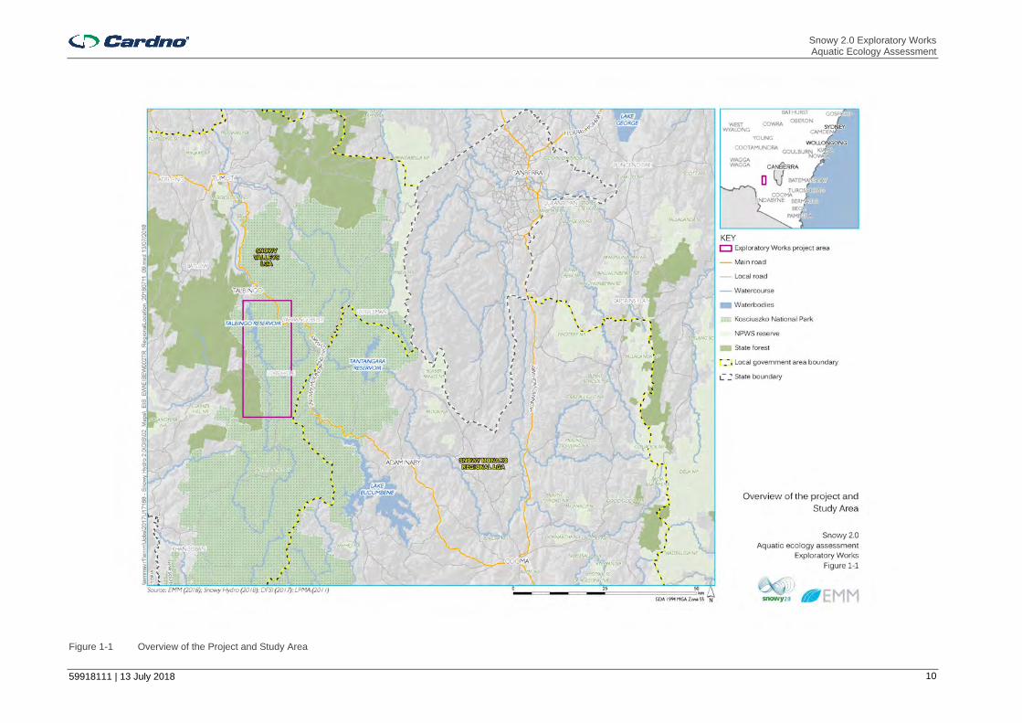
Snowy 2.0 and the Exploratory Works are within the Australian Alps of southern NSW (Figure 1.1). Snowy 2.0 is within both the Snowy Valleys and Snowy Monaro Regional local government areas (LGAs), and parts of Snowy 2.0 and the Exploratory Works are within Kosciuszko National Park (KNP). Most of the Exploratory Works would be located within the Ravine region of the KNP. This region is between Talbingo Reservoir to the north-west and the Snowy Mountains Highway to the east, which connects Cooma, Talbingo and Tumut. Talbingo Reservoir forms part of the current Snowy Scheme and is approximately 50 kilometres (km) north-west of Adaminaby and approximately 30 km east-north-east of Tumbarumba. It is popular for recreational activities such as fishing, water skiing and canoeing. There are several other communities and townships near the Exploratory Works project area, including Cabramurra and Adaminaby. Talbingo and Cabramurra were originally built for the original Snowy Scheme workers and their families. Adaminaby was relocated to alongside the Snowy Mountains Highway from its original location (now known as Old Adaminaby) in 1957 due to the construction of Lake Eucumbene.
1.3.2 Overview of Works
The Exploratory Works comprise:
> Establishment of an exploratory tunnel to the site of the underground power station for Snowy 2.0;
> Establishment of a portal construction pad;
> Excavated rock management, including subaqueous rock placement;
> Establishment of an accommodation camp;
> Road establishment and upgrades providing access and haulage routes during Exploratory Works;
> Establishment of barge access infrastructure to enable access and transport by barge on Talbingo reservoir; and
> Establishment of services infrastructure such as diesel-generated power and communication.
The workforce for the Exploratory Works will be up to approximately 200 people in total at peak construction. These workers will be accommodated within the construction accommodation camp proposed for a location at Lobs Hole.
Exploratory Works are expected to take about 34 months, with the exploratory tunnel expected to be completed by late 2021. It is expected that the construction works will be completed largely in parallel. However, road and access works are expected to be completed within the first six months from commencement. All Exploratory Works align with components of the main works for Snowy 2.0. However, should Snowy 2.0 not be approved or not progress, the Exploratory Works project area will need to be rehabilitated. Further detailed description of the Exploratory Works and anticipated rehabilitation activities are provided in the Exploratory Work EIS (EMM 2018).
Snowy 2.0 Exploratory Works Aquatic Ecology Assessment
59918111 | 13 July 2018 10
Figure 1-1 Overview of the Project and Study Area
Snowy 2.0 Exploratory Works Aquatic Ecology Assessment
59918111 | 13 July 2018 11
Components that have potential to affect aquatic ecology and that are considered in the AEA are outlined in Section 1.3.3. Further detail on these, potential associated impacts of aquatic ecology and recommended control measures are provided in Sections 4 and 5.
1.3.3 Aspects Relevant to Aquatic Ecology
Potential aquatic ecology issues have been identified based on a review of the proposed Exploratory Works and associated activities. This identification process has considered the proposed project activities and the types of impacts to the aquatic environment. The aspects relevant to this AEA are described below.
1.3.3.1 Portal Construction Pad and Accommodation Camp
The surface works required for Exploratory Works have potential to affect aquatic ecology indirectly. Surface works include construction of the portal construction pad, accommodation camp and supporting infrastructure including power and communication and other infrastructure and would typically include:
> Clearing of vegetation, typically using chainsaws, bulldozers and excavators;
> Stockpiling of construction materials and excavated rock;
> Road construction and upgrade of existing access roads including road widening and construction of drainage, retaining walls, gravel pavement overlay, installation of guideposts and guard fencing;
> Earthworks and construction using heavy machinery such as excavators and bulldozers;
> Surface storage, treatment and management of any groundwater intercepted during tunnel excavation;
> Sewage and wastewater storage and treatment on site with discharge to Talbingo Reservoir;
> Extraction of water from Talbingo Reservoir for potable and construction use on-site; and
> Storage and use of hydrocarbons and other chemicals on site with potential to harm aquatic life.
1.3.3.2 Exploratory Tunnel Excavation
An exploratory tunnel of approximately 3.1 km is proposed to provide early access to the location of the cavern where the hydroelectric plant would be located. The tunnel entrance would be east of the Yarrangobilly River and it would extend in a west direction to a depth of 850 m. The exploratory tunnel would be concrete-lined with permanent anchor support, and would incorporate a groundwater management system. The cross section shape and dimensions are designed to allow two-lane traffic for the removal of excavated material, along with additional space for ventilation and drainage of groundwater inflows. Groundwater intersected during tunnelling would be contained and transferred to the portal for treatment and management. Areas identified during forward probing with the potential for high groundwater flows may require management through a detailed grouting program or similar.
1.3.3.3 Excavated Rock Management
It is estimated that approximately 750,000 m3 of bulked rock and soil will be excavated, mostly from the exploratory tunnel and portal construction pad with additional quantities from road upgrade works. Subject to geochemical testing of the rock material, excavated rock will be placed either on land or as part of subaqueous placement within Talbingo Reservoir.
1.3.3.3.1 On Land Placement
Excavated materials will be placed in one of two rock emplacement areas (eastern and western) at Lobs Hole. The strategy for excavated rock management is for excavated material to be emplaced at two areas with the final placement of excavated material to be determined at a later date.
Consultation with NPWS throughout the design process has identified an opportunity for the proposed eastern emplacement area to form a permanent landform that enables greater recreational use of Lobs Hole following the completion of Snowy 2.0’s construction. It is envisaged that the proposed excavated rock emplacement area will provide, in the long-term, a relatively flat final landform suitable for camping and basic recreational facilities to be confirmed in consultation with NPWS.
The proposed eastern emplacement area has a capacity of up to 600,000 m3 of material. It will be approximately 25 m maximum depth and will be benched down to the northern edge of the emplacement which is setback 50 m from the Yarrangobilly River.
The proposed western emplacement area will be used to store excavated material should it not be able to be placed within the eastern emplacement area. It is envisaged this emplacement area will be used to store

Snowy 2.0 Exploratory Works Aquatic Ecology Assessment
59918111 | 13 July 2018 12
excavated materials suitable for re-use within the construction of Exploratory Works or for use by NPWS in KNP maintenance activities. All remaining material placed in this emplacement area will be removed following the completion of Exploratory Works.
The guiding principles for the design, construction method and management of emplacement areas undertaken for Exploratory Works have been as follows:
> Reducing potential for acid rock drainage from the excavated rock emplacement area entering the Yarrangobilly River or forming groundwater recharge;
> Avoid known environmental constraints; and
> Manage existing surface water flows from Lick Hole Gully.
The design and management of the emplacement areas have not yet been finalised due to the need for further investigations to determine the likely geochemical characteristics of the excavated material. Following further investigation and prior to construction of Exploratory Works a management plan will be prepared and implemented.
1.3.3.3.2 Subaqueous Placement
A trial program for the placement of excavated rock within Talbingo Reservoir is proposed. The program will be implemented in an appropriate section of Talbingo Reservoir in accordance with a detailed management plan based on an engineering method informed through the materials’ geochemistry and reservoir’s characteristics. The purpose of the program is to confirm the suitability of the emplacement method for future excavated rock material from the construction of Snowy2.0, should it proceed.
The rock for subaqueous placement will be taken from the excavated rock emplacement areas as described above. During excavation, rock would be tested to assess geochemical properties. Any rock assessed as unsuitable for subaqueous placement based on the prior geochemical and leachability testing would be separately stockpiled and not used in the program. Suitable (i.e. non-reactive material) would be transported and loaded to a barge, for placement at the deposition area. Suitable deposition locations have been identified for Exploratory Works and are shown indicatively on Figure 1-2. Up to 50,000 m3 of material would be placed within Plain Creek Bay. Existing water depths within the placement location vary from approximately 30 m to 5 m below MOL. Further placement may take place in Cascade Bay and Ravine Bay following review of placement in Plain Creek Bay. Cascade Bay is a side bay on the western side of Talbingo Reservoir to the north of Plain Creek Bay, located approximately 7 to 8km from the load out point at the barge ramp in Middle Bay. Maximum water depths in the bay are approximately 35m relative to Minimum Operating Level. Ravine Bay is a bay situated near the confluence of the Yarrangobilly and Tumut Rivers, located 2-3km from the load out point at the barge ramp in Middle Bay. Maximum water depths in the bay are approximately 25m relative to Minimum Operating Level. Only placement at Plain Creek Bay is assessed here.
All placement within the reservoir would occur within silt curtains and would be subject to a detailed monitoring regime including bathymetric survey both pre and post-placement, water quality monitoring during placement, and monitoring of aquatic habitat and biota, including recolonisation of benthic species and fish following placement. The management, mitigation and monitoring measures would be refined following the ongoing investigations as appropriate.
1.3.3.4 Roads and Access
1.3.3.4.1 Access Road Works
Several roads would be upgraded as part of Exploratory Works. Those with potential to affect aquatic ecology are:
> Lower Lobs Hole Ravine Road upgrade that crosses Lick Hole Creek;
> Lobs Hole Road upgrade adjacent to Yarrangobilly River. This upgrade includes the temporary and permanent crossings of the river (see below);
> Mine Trail Road upgrade that crosses Lick Hole Creek and Cave Gully;
> Mine Trail Road extension that includes the temporary and permanent crossing of Wallaces Creek; and
> Middle Bay Road adjacent to the Yarrangobilly River arm of Talbingo Reservoir.

Snowy 2.0 Exploratory Works Aquatic Ecology Assessment
59918111 | 13 July 2018 13
Figure 1-2 Proposed Subaqueous Placement Areas in Talbingo Reservoir

Snowy 2.0 Exploratory Works Aquatic Ecology Assessment
59918111 | 13 July 2018 14
1.3.3.4.2 Watercourse Crossings
Two new permanent and two temporary waterway crossings would be required as part of the Exploratory Works. Permanent bridges would be constructed at two locations; a new bridge (Wallaces Creek Bridge) is proposed at Wallaces Creek as part of the Mine Trail Road extension and one bridge upgrade (Camp Bridge) is proposed across the Yarrangobilly River as part of the Lobs Hole Road upgrade. The locations of proposed bridge works are shown in Figure 1.2. Permanent bridges would consist of steel girders with a composite deck. This is the most common type of permanent bridge constructed in and around the existing Snowy Scheme. The use of lightweight steel girders would speed up construction, are easy to transport and would permit the use of smaller‐scale lifting equipment at the construction site.
An existing crossing on Yarrangobilly River will be used as a temporary crossing while a new permanent bridge is built as part of Lobs Hole Road upgrade. The existing crossing will require the crossing level to be raised with rocks to facilitate vehicle passage. The rocks used to raise the crossing level will be removed and the crossing no longer used once the permanent bridge has been constructed. The new bridge (Camp Bridge) will be a permanent crossing and used for both Exploratory Works and Snowy 2.0 main works, should it proceed.
Establishment of a new permanent bridge at Wallaces Creek will require an initial temporary pre-fabricated ’Bailey bridge’ to be constructed, which will be removed before the end of the Exploratory Works.
WallacesNew and upgraded roads would also cross several unnamed tributaries of these watercourses. Two existing crossings would be upgraded on two third order northern tributaries of the Yarrangobilly River as part of the Middle Bay Road upgrade. Several crossings over first and second order tributaries would also be upgraded as part of this and the other road upgrades (Section 1.3.3.4.1).
1.3.3.5 Barge Access and Other Infrastructure in Talbingo Reservoir
To provide an alternative to road access, a barge option is proposed for bulky and heavy equipment, materials and for emergencies. During Exploratory Works, barges will be loaded at the northern barge ramp (Talbingo barge ramp), travel about 18 km along Talbingo Reservoir and be unloaded at the southern barge ramp (Middle Bay barge ramp) before returning to the north. Some loads may also be transported in the reverse direction.
Barge access infrastructure will comprise two dedicated barge ramps at Middle Bay and Talbingo Spillway, with a slope of approximately 1 vertical to 10 horizontal (1V: 10H) at each location. A navigation channel is also required adjacent to the Middle Bay barge ramp. Construction will involve:
> Geophysical and geotechnical investigation of the barge access area to inform detailed design;
> Site establishment and excavation of barge access area;
> Installation of precast concrete panels at the ramp location;
> Installation of bollards for mooring lines;
> Removal of trees and debris to establish a navigation channel allowing barge access; and
> Minor dredging to allow barge access at the reservoir minimum operating level.
To facilitate construction, laydown areas are proposed adjacent to the Middle Bay barge ramp and adjacent to the water inlet pipeline. Laydown will also be used within the footprint of the Talbingo barge ramp. These areas are shown on Figure 1-3.
Dredged material will be placed as part of the subaqueous placement program or within one of the designated on land rock emplacement areas. The infrastructure proposed for the Talbingo Spillway barge ramp and Middle Bay barge ramp is provided in Figure 1-3.
Dredging works would be required to achieve an appropriate operating depth for the barge ramps and to unload adjacent to the wharves during the entire water level range. Dredging of 35,000 m3 fine textured, predominantly coarse silts will also be undertaken to establish a navigation channel (approximately 50 m x 500 m) to ensure safe access to the Yarrangobilly Arm of the reservoir. Material dredged from the Talbingo barge ramp would be placed within the reservoir along adjacent shorelines, Dredged material from the navigation channel in Middle Bay may be disposed as part of subaqueous placement (Section 1.3.3.3.2). Dredge material may also be placed on land at Lobs Hole along with excavated rock (Section 1.3.3.3.1)
The following service infrastructure will also be constructed within Talbingo Reservoir to support the portal construction pad and accommodation camp:

Snowy 2.0 Exploratory Works Aquatic Ecology Assessment
59918111 | 13 July 2018 15
Figure 1-3 Proposed Barge Infrastructure and Dredge Areas
Snowy 2.0 Exploratory Works Aquatic Ecology Assessment
59918111 | 13 July 2018 16
> A subsurface communication cable linking Tumut 3 Power Station and the accommodation camp and the portal construction pad via Middle Bay; and
> A water services pipeline for the supply of potable water and discharge of waste water (including treated sewage) between Talbingo Reservoir, the exploratory tunnel portal, portal construction pad and accommodation camp.
Geophysical surveys are required within Talbingo Reservoir to inform the design of Middle Bay barge ramp and navigation channel. A survey line with geo-hydrophones will be deployed from a boat onto the reservoir bed. An airgun will be used to acquire seismic readings following release of compressed nitrogen. The airgun would be fired at or just above the bed of watercourse, spaced at approximate 8 m intervals. The radius of physical disturbance from each shot would be approximately 1 to 1.5 m.
1.4 SEARs and Other Agency Requirements
1.4.1 Critical State Significant Infrastructure Standard Secretary’s Environmental Assessment Requirements (SEARs)
When an application for approval of a declared Critical State Significant Infrastructure (CSSI) project is made, the Secretary of the Department of Planning and Environment (DPE) is required to issue environmental assessment requirements, or SEARs. The CSSI Standard Secretary’s Environmental Assessment Requirements (SEARs) (NSW DPE 2015a) provides the standard SEARs that may apply to CSSI projects and modifications to CSSI projects. SEARs specific to biodiversity include the requirement for consideration of Key Threatening Process (KTPs) (Section 3.1.6) listed under the Fisheries Management Act 1994 and Environment Protection and Biodiversity Conservation Act 1999 and consideration of the following literature directly applicable to aquatic ecology:
> Policy and Guidelines for Fish Habitat Conservation and Management – Update 2013 (DPI 2013a), Why do Fish Need to Cross the Road? (Fairfull and Witheridge 2003) and Fish Passage Requirements for Waterway Crossings (NSW Fisheries 2003) (Section 2.3); and
> Applicable Threatened Species Survey and Assessment Guidelines, for example Survey Guidelines for Australia’s Threatened Fish (Commonwealth of Australia 2011).
1.4.2 Project SEARs
This AEA has been prepared in accordance with the Secretary’s Environmental Assessment Requirements (SEARs) for Exploratory Works as well as relevant governmental assessment requirements, guidelines and policies, and in consultation with the relevant government agencies. Table 1-1 lists the matters relevant to this assessment and where they are addressed in this report,
Table 1-1 Relevant matters raised in SEARs
Requirement Section addressed
Description of the existing Environment Section 3
Description of how the project has been designed to avoid and minimise impacts Section 4
Assessment of the potential impacts of the project, including any cumulative impacts Section 4
An assessment of the impacts of the project on aquatic ecology, including impacts on key fish habitat and threatened species of fish
Section 4
To inform preparation of the SEARs, the Department of Planning and Environment (DPE) invited relevant government agencies to advise on matters to be addressed in the EIS. These matters were taken into account by the Secretary for DPE when preparing the SEARs. Table 1-2 lists specific requirements identified by government agencies and where they are addressed in this report.

Snowy 2.0 Exploratory Works Aquatic Ecology Assessment
59918111 | 13 July 2018 17
Table 1-2 Government agency assessment recommendations
Requirement Section addressed
EPA
Describe extent and condition of existing aquatic habitats including spawning, feeding, nursery, recruitment, migration, sensitive and other critically important habitats
Section 3.1.2
Assess the impacts of the development on the quantity and quality of water resources and connectivity between water sources, including but not limited to consideration of
1. Waste rock disposal including direct and indirect physical and biological impacts including the nature, temporal and spatial scales of expected impacts including from:
Temporary decreases in water transparency
Increased concentrations in suspended matter and sedimentations rates
Changes to bathymetry and sediment composition
Removal or burial of sessile and motile organisms that are unable to burrow up through the deposited layer
Changes to benthic community structures and habitats
Physical collision of the spoil with aquatic fauna
Alteration of current velocities and wave conditions affecting sediment regimes
Reduction in dissolved oxygen levels due to an increase in nutrient concentrations potentially resulting in anoxia/hypoxia.
The likely time scale of recovery or recolonisation after disposal, and the nature of recolonisation
The likelihood, scale and severity of residual impacts outside the primary impact zone.
2. Aquatic biodiversity and ecosystem quality, quantity, function and structure and access to habitat for spawning and refuge
Section 4.3.2.2

Snowy 2.0 Exploratory Works Aquatic Ecology Assessment
59918111 | 13 July 2018 18
2 Legislative Context
2.1 NSW Legislation
2.1.1 NSW Environmental Planning and Assessment Act 1979
The Environmental Planning and Assessment Act 1979 (EP&A Act) institutes a system of environmental planning and assessment in NSW and is administered by the NSW Department of Planning and Environment. Part 5, Division 5.2 outlines the environmental assessment and approval requirements for state significant infrastructure (SSI) can be declared to be critical (CSSI) if it is of a category that, in the opinion of the NSW Minister for the Environment, is essential for the State for economic, environmental or social reasons. The Exploratory Works is CSSI.
Section 5.23(3)(b) of the EP&A Act is relevant to aquatic ecology, which states that an order under Division 7 (Stop work orders) of Part 7A of the Fisheries Management Act 1994 (FM Act) cannot be made or given so as to prevent or interfere with the carrying out of approved CSSI.
The Minister for Planning and Environment’s approval is required for SSIs and CSSIs.
2.1.2 Fisheries Management Act 1994
The FM Act contains provisions for the conservation of fish stocks, key fish habitat, biodiversity, threatened species, populations and ecological communities. It regulates the conservation of fish, vegetation and some aquatic macroinvertebrates and the development and sharing of the fishery resources of NSW for present and future generations. The FM Act lists threatened species, populations and ecological communities under Schedules 4, 4A and 5. Schedule 6 lists key threatening processes (KTPs) for species, populations and ecological communities in NSW waters and declared critical habitat are listed in a register kept by the Minister of Primary Industries. Impacts to these species, population, communities, processes and habitats due to the Exploratory Works need to be considered. Assessment guidelines to determine whether a significant impact is expected are detailed in Section 220ZZ and 220ZZA of the FM Act.
Another objective of the FM Act is to conserve key fish habitats (KFH). These are defined as aquatic habitats that are important to the sustainability of recreational and commercial fishing industries, the maintenance of fish populations generally and the survival and recovery of threatened aquatic species. In freshwater systems, most permanent and semi-permanent rivers, creeks, lakes, lagoons, billabongs, weir impoundments and impoundments up to the top of the bank are considered KFH. Small headwater creeks and gullies that flow for a short period after rain and farm dams on such systems are excluded, as are artificial water bodies except for those that support populations of threatened fish or invertebrates. At a broad scale, key fish habitat relevant to the exploratory works includes the following:
> Permanently flowing rivers and creeks including those where the flow is modified by upstream dam(s), up to the top of the natural bank regardless of whether the channel has been physically modified;
> Intermittently flowing rivers and creeks that retain water in a series of disconnected pools after flow ceases including those where the flow is modified by upstream dam(s), up to the top of the natural bank regardless of whether the channel has been physically modified; and
> Any waterbody if it is known to support or could be confidently expected (based on predictive modelling) to support threatened species, populations or communities listed under the FM Act.
Impacts to KFH as a result of the Exploratory Works need to be considered. KFH is defined in sections 3.2.1 and 3.2.2 of the Policy and Guidelines for Fish Conservation and Management (NSW DPI, 2013) (Section 2.3.1).
2.2 Commonwealth Legislation
The Environment Protection and Biodiversity Conservation Act 1999 (EPBC Act) protects nationally and internationally important flora, fauna, ecological communities and heritage places, which are defined in the EPBC Act as Matters of National Environmental Significance (MNES). Under the EPBC Act, an action will require approval from the Minister for the Environment and Energy if the action has, will have, or is likely to have, a significant impact on MNES. Significant Impact Guidelines 1.1 – Matters of National Environmental Significance (Department of the Environment (DoE), 2013) have been developed to assist proponents in deciding if a Referral to the DEE would be required. The Referral process involves a decision on whether or
Snowy 2.0 Exploratory Works Aquatic Ecology Assessment
59918111 | 13 July 2018 19
not the action is a ‘controlled action’. When an action is declared a controlled action, approval from the Minister for the Environment is required. A Referral was submitted to DEE for Exploratory Works.
2.3 Policies and Guidelines
2.3.1 Policy and Guidelines for Fish Habitat Conservation and Management
The NSW DPI Policy and Guidelines for Fish Habitat Conservation and Management (Update 2013) (NSW DPI, 2013) replaces the Policy and Guidelines for Aquatic Habitat Management and Fish Conservation (NSW DPI, 1999) and the former Policy and Guidelines for Fish Friendly Waterway Crossings (NSW DPI 2003). These updated policies and guidelines are applicable to all planning and development proposals and various activities that affect freshwater ecosystems. The aims of the updated policies and guidelines are to maintain and enhance fish habitat for the benefit of native fish species, including threatened species in freshwater environments. The updated document assists developers, their consultants and government and non-government organisations to ensure their actions comply with legislation, policies and guidelines that relate to fish habitat conservation and management. It is also intended to inform land use and natural resource management planning, development planning and assessment processes, and to improve awareness and understanding of the importance of fish habitats and how impacts can be mitigated, managed or offset. The policies and guidelines outlined in this document are taken into account when NSW DPI assesses proposals for developments and other activities that affect fish habitats. The document contains:
> Background information on aquatic habitats and fisheries resources of NSW;
> An outline of the legislative requirements relevant to planning and development which may affect fisheries or aquatic habitats in NSW;
> General policies and classification schemes for the protection and management of fish habitats and an outline of the information that NSW DPI requires to be included in development proposals that affect fish habitat;
> Specific policies and guidelines aimed at maintaining and enhancing the free passage of fish through instream structures and barriers;
> Specific policies and guidelines for foreshore works and waterfront developments; and
> Specific policies and guidelines for the management of other activities that affect waterways.
NSW DPI focuses the application of the FM Act and FM Regulations and the policies and guidelines on KFH. It is important to note that aquatic habitats within first and second order gaining streams, sections of stream that have been concrete-lined or piped (excluding waterway crossings) and artificial ponds are not regarded as KFH unless they support a listed threatened species, population or ecological community or critical habitat. Categorisation and classification of KFH is achieved by determining fish habitat sensitivity (Type) and functionality (Class). The term ‘sensitivity’ refers to the importance of the habitat to the survival of fish and its ability to withstand disturbance while ‘functionality’ refers to the ability to provide habitat that is suitable for fish.
Fish habitat ‘Type’ is used within the policy and guideline to differentiate between permissible and prohibited activities or developments and for determining value in the event offsetting is required. Waterway ‘Class’ is used to assess the impacts of certain activities on fish habitats in conjunction with ‘Type’. The waterway ‘Class’ can also be used to make management recommendations to minimise impacts on different fish habitats (e.g. waterway crossings). Sensitivity ‘Types’ and waterway ‘Class’ classifications are provided in Section 3.3.1.3) and have been used to classify waterways in the Study Area.
2.3.2 Why Do Fish Cross the Road? Fish Passage Requirements for Waterway Crossings
NSW DPI (Fisheries) Why do Fish Need to Cross the Road? Fish Passage Requirements for Waterway Crossings (Fairfull and Witheridge, 2003) provides practical guidelines for the planning, design, construction and maintenance of waterway crossings aimed at minimising impacts on fish passage and aquatic ecology in general. It should be used in conjunction with the Policy and Guidelines for Fish Conservation and Management (NSW DPI, 2013) by outlining potential impacts of instream structures and design specifications/recommendations for crossings to avoid erecting barriers to fish passage.
Snowy 2.0 Exploratory Works Aquatic Ecology Assessment
59918111 | 13 July 2018 20
3 Existing Environment
3.1 Desktop Review
3.1.1 Database Searches
The following databases were searched for records of listed threatened aquatic species, populations and communities within the Murrumbidgee River Catchment:
> NSW DPI Fish communities and threatened species distribution of NSW (NSW DPI, 2016);
> NSW DPI Listed threatened species, populations and ecological communities website: http://www.dpi.nsw.gov.au/fishing/species-protection/conservation/what-current#key;
> Department of the Environment and Energy (DoEE) (formerly DoE) Protected Matters Search Tool (PMST): http://www.environment.gov.au/epbc/protected-matters-search-tool;
> Atlas of Living Australia: http://www.ala.org.au/;
> NSW Aquatic Pest and Disease Distribution: https://www.dpi.nsw.gov.au/fishing/pests-diseases/pest-disease-distribution;
> NSW WeedWise: http://weeds.dpi.nsw.gov.au/; and
> Bureau of Meteorology Groundwater Dependent Ecosystems Atlas: http://www.bom.gov.au/water/groundwater/gde/map.shtml.
Sensitive ecological sites (e.g. conservation areas, wetlands and other reserves) and areas protected by State and local environmental planning instruments (EPIs) due to their ecological significance were also identified using:
> NSW DPI Critical habitat register: http://www.dpi.nsw.gov.au/fisheries/species-protection/conservation/what/register;
> NSW DPI Key Fish Habitat (KFH) maps: http://www.dpi.nsw.gov.au/fishing/habitat/publications/pubs/key-fish-habitat-maps; and
> NSW National Parks and Wildlife Service: http://www.nationalparks.nsw.gov.au/visit-a-park.
Fish catch data from previous NSW DPI (Fisheries) surveys within the Study Area and immediately downstream (Blowering Dam and its tributaries) were also examined.
3.1.2 Aquatic Ecology of the Study Area
3.1.2.1 Habitat
The Study Area is within the Murrumbidgee River catchment and largely located within KNP. This catchment provides water for irrigation and hydro-electricity (Independent Scientific Committee, 2004). Reservoirs such as those in KNP which are used for hydro-electricity generation, including Talbingo Reservoir, are generally not considered ecologically significant as they are usually associated with disruptions to riverine communities and poor water quality. Benthic diversity in reservoirs is usually lower than in natural lakes (Timms 1980). The creation of Talbingo Reservoir is likely to have caused a shift in macroinvertebrate communities from one associated with lotic (flowing water) to lentic (still water).
The major waterbodies and watercourses within the Study Area are Talbingo Reservoir, Yarrangobilly River and Wallaces Creek (Figure 1.1). Talbingo Reservoir is approximately 15 km long and 1-2 km wide with its headwaters in the Tumut River, Yarrangobilly River and Wallaces Creek (all third or higher order watercourses). Smaller named third order tributaries of Yarrangobilly River include Lick Hole Creek and Cave Gully, which flow into the river from the south. Several unnamed first, second and third order tributaries also flow into Yarrangobilly River to the north and south. Further information on the aquatic ecology supported by each of these is provided in Sections 3.3.2. The riparian corridors of Yarrangobilly River and Tumut River have undergone substantial changes since European settlement. These mostly resulted from alterations to flow regimes and the introduction of exotic species (e.g. willow (Salix spp.)) (Independent Scientific Committee, 2004).
Blue Lake, a Ramsar wetland within the Snowy River Catchment, is located approximately 40 km south of Cabramurra and outside of the Study Area.

Snowy 2.0 Exploratory Works Aquatic Ecology Assessment
59918111 | 13 July 2018 21
3.1.2.2 Fish
Native fish communities in the waterways of KNP comprise of native short- and long-finned eels (Anguilla australis, A. reinhardtii), climbing galaxias (Galaxias brevipinnis), Australian smelt (Retropinna semoni), congolli (Pseudaphritis urvillii), mountain galaxias (G. olidus) and two-spined blackfish (Gadopsis bispinosus). Several sub-species of mountain galaxias are thought to be restricted to certain geographic ranges in KNP. Although native to NSW, climbing galaxias is a coastal species that has been translocated to the Tumut River catchment due to water transfer from the Snowy River Catchment as part of the current Snowy Hydro scheme (MDBC 2007a). Where it is a translocated species, climbing galaxias may threaten other native fish species, including other galaxiids, through competition for food or space. Golden perch (Macquaria ambigua) have also been stocked in Blowering Dam and Jounama Pondage as recently as 2017 (NSW DPI 2018b) and there is at least one recent report of this species been caught in Talbingo Reservoir by recreational anglers (Talbingo Fishing Club 2017). Several native threatened fish species have previously been also been stocked in Talbingo Reservoir and/or immediately downstream in Blowering Dam (Section 3.1.5)
Five exotic species are also prevalent in these waterways, including goldfish (Carassius auratus), mosquito fish (Gambusia holbrooki), redfin perch (Perca fluviatilis), brown trout (Salmo trutta) and rainbow trout (Oncorhynchus mykiss). The two latter are stocked in Talbingo Reservoir or immediately upstream in Tumut River and are popular with recreational fishers. Trout are known to prey on smaller native species (e.g. galaxids) and outcompete others.
Previous fish surveys undertaken by NSW DPI (Fisheries) identified redfin perch, wild goldfish, rainbow trout and the native northern river blackfish (Gadopsis marmoratus) in Talbingo Reservoir (a total of 4 survey days during 2004 to 2016). Northern river blackfish, Murray Crayfish, brown trout and redfin perch were caught in in Jounama Creek (just downstream of Talbingo Dam) during one day of survey in November 2016. Northern river blackfish, rainbow trout and brown trout were caught in Yarrangobilly River during one day in February of 2007 and in February 2016. Northern river blackfish is not listed as threatened, though its numbers and distribution have declined (MDBC 2007b). Threats to this species include smothering of eggs and spawning sites by sediment, and interactions with introduced species such as rainbow trout, brown trout and redfin perch, particularly predation and competition for food and habitat modifications such as removal of large woody debris.
Fish and macroinvertebrate species potentially occurring in the Study Area have also been identified via collection and examination of DNA in samples of water from these watercourses during February 2018 (EnviroDNA 2018). The following species were identified:
> Yarrangobilly River: non-native redfin perch, rainbow trout and brown trout and native two-spined blackfish (Gadopsis bispinosus), Murray crayfish, common yabby ((Cherax destructor) and freshwater shrimp (Paratya australiensis);
> Wallaces Creek: non-native rainbow trout and brown trout, native climbing galaxias (albeit not to this catchment), Murray crayfish and an unidentified spiny crayfish (Euastacus sp.) - possibly alpine spiny crayfish (Euastacus crassus); and
> Talbingo Reservoir: non-native redfin perch, rainbow trout, brown trout, wild goldfish, eastern gambusia and carp (Cyprinus carpio) and native shortfinned eel (Anguilla australis), a species of mountain galaxais (Galaxias sp.), golden perch (Macquaria ambigua), flathead gudgeon (Philypnodon grandiceps), Australian smelt (Retropinna semoni), common yabby ((Cherax destructor) and freshwater shrimp (Paratya australiensis).
Murray crayfish was reported at Site Tal1 in Talbingo Reservoir in EnviroDNA (2018) a few hundred metres downstream at the confluence with Yarrangobilly River. This could therefore reflect the presence of this species in Yarrangobilly River rather than Talbingo reservoir. Murray crayfish was not detected at any of the other 11 sites sampled in the reservoir. Similarly, water for analysis of DNA was collected from the edges of the reservoir, sometimes near the confluence of tributaries and may therefore be a reflection of their presence within the tributaries and not necessarily the reservoir. Threatened species of fish were not detected at any of the sites sampled in Yarrangobilly Reservoir, Wallaces Creek and Talbingo Reservoir. Murray cod and golden perch were detected just downstream of Talbingo Reservoir in Jounama Pondage. It is noted also that carp were detected at only one site and in apparent low abundance in Talbingo Reservoir, and it is unclear if or transport of DNA here from another location (e.g. transport of dead material via boating) (EnviroDNA 2018). Carp were not caught during surveys of the reservoir undertaken previously by NSW DPI (Section 3.1.2.2) or during the current study (Section 3.3.2.3)
Snowy 2.0 Exploratory Works Aquatic Ecology Assessment
59918111 | 13 July 2018 22
3.1.3 Water Quality
Water quality sampling in Talbingo Reservoir, Yarrangobilly River and Tumut River commenced for Snowy 2.0 in early 2018. March 2018 sampling indicated neutral pH, low carbonate (hardness and alkalinity), low Electrical conductivity (EC), low levels of suspended solids and low nutrient levels in Talbingo Reservoir. Median pH (7.9) was within ANZECC (2000) Default Trigger Values (DTVs) (pH 6.0 to pH 8.0) for southeast Australian reservoirs. EC was also comparable to DTVs. Nutrient levels were generally below detection limits and below DTVs, the only exception was the oxidised nitrogen 90th percentile (0.070 mg/L) which exceeded the DTV (0.010 mg/L). Concentrations of metals were below ANZECC (2000) guideline levels (trigger values for 95 % protection or low reliability levels) with the exception of copper and zinc. Copper ranged from below detection limits to 0.088 mg/L (90th percentile: 0.056mg/L). The guideline value for copper is 0.0014 mg/L and 7 of the 15 samples exceeded this guideline value. Zinc ranged from below detection limits to 0.068 mg/L (90th percentile 0.065mg/L). The guideline value for zinc is 0.008 mg/L and 11 of the 15 samples exceeded the guideline value.
Dissolved oxygen in Yarrangobilly River and Tumut River was sometimes recorded below the lower DTV (85 % saturation) but only slightly. EC in both rivers was within DTVs and pH in Yarrangobilly was comparable with DTVs. pH in Tumut River in April 2018 (pH 9.5) exceeded the upper DTV (pH 8.0) for southeast Australian upland rivers. Barium in Yarrangobilly River and Tumut River slightly exceeded the guideline value as did aluminium in Yarrangobilly River. Elevated copper and zinc concentrations were not identified in Yarrangobilly River or Tumut River near where they flowed into Talbingo Reservoir.
3.1.4 Key Fish Habitat
At the scale of entire watercourse, Talbingo Reservoir, Yarrangobilly River, Wallaces Creek, Lick Hole Creek, Cave Gully and third order and higher tributaries of Yarrangobilly River are KFH (NSW DPI 2018f). It is noted that the quality of aquatic habitat provided by these watercourses may vary considerably. In particular, that provided by lower order tributaries (such as Lick Hole Creek and Cave Gully) may be relatively limited. Lower order watercourses such as these with small catchments may be highly ephemeral (flow for a short period following rainfall only) and thus provide aquatic habitat of limited value. The first and second order tributaries that traverse the Study Area (Figure 1.1) are not mapped by NSW DPI as key fish habitat. At the scale of separate habitats within watercourse, each third and higher order watercourse may support ‘sensitive’ key fish habitat, such as wood debris and aquatic plants, as described in NSW DPI (2013a) (Section 2.3.1). Such habitat is more likely to occur in larger and more permanent watercourses such as Yarrangobilly River and Wallaces Creek.
3.1.5 Threatened Species
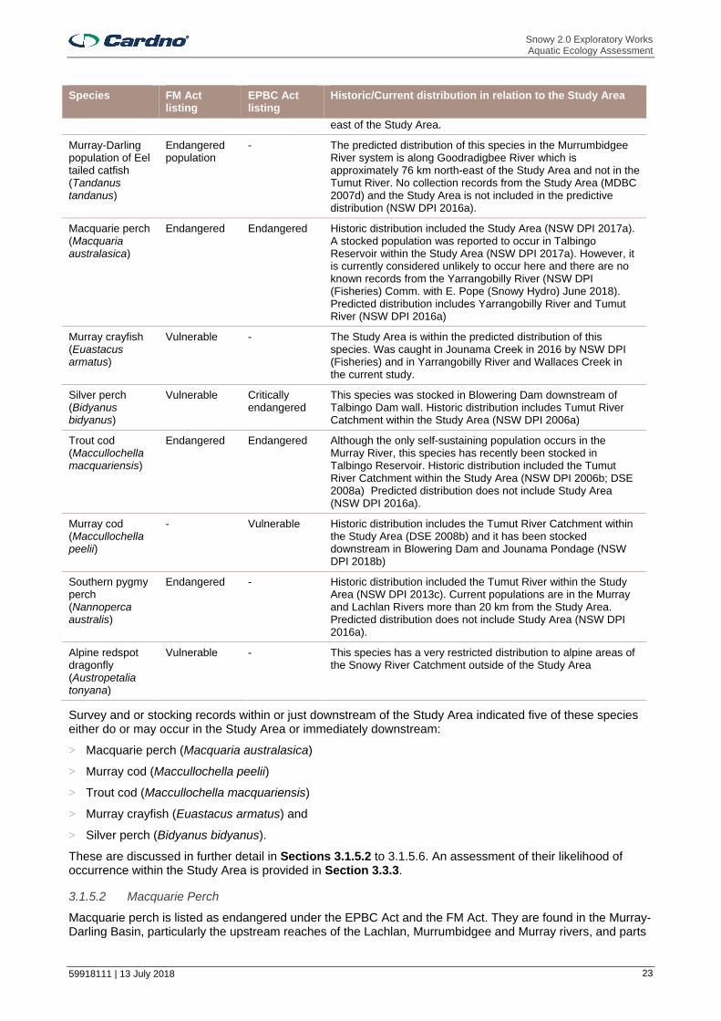
Twelve threatened aquatic species listed under the FM Act and/or EPBC Act may occur or occurred historically in the Murrumbidgee River Catchment. These and their historic/current distribution are detailed in Table 3-1.
Table 3-1 Threatened aquatic ecology and their distribution Except for Murray crayfish no confirmed survey records of these species exist within the Study Area, though stocking records exist in the Study Area or just downstream for some (Section 3.1.5)
Species FM Act listing
EPBC Act listing
Historic/Current distribution in relation to the Study Area
Flathead galaxias (Galaxias rostratus)
Critically endangered
Critically endangered
Considered locally extinct in the lower Murrumbidgee River with only very small populations recorded in the upper Murray River near Tintaldra and Albury more than 40 km south-west from the Study Area. Predicted distribution does not include Study Area (NSW DPI 2016a).
Hanley’s river snail (Notopala hanleyi)
Critically endangered
- No individuals were recorded from surveys (2005) in the Murrumbidgee River. This species is only known to occur in one location in NSW and two in South Australia. The location in NSW (Dareton) is over 500 km west of the Study Area.
Murray hardyhead (Craterocephalus fluviatilis)
Critically endangered
Endangered No viable populations are known in NSW and considered locally extinct in the Murrumbidgee River catchment. No collection records from the Study Area (MDBC 2007c).
Stocky galaxias (Galaxias tantangara)
Critically endangered
- Only known from the headwaters of Tantangara Creek, upstream of Tantangara Reservoir and is restricted to a four kilometre reach above a waterfall. This is approximately 10 km
Snowy 2.0 Exploratory Works Aquatic Ecology Assessment
59918111 | 13 July 2018 23
Species FM Act listing
EPBC Act listing
Historic/Current distribution in relation to the Study Area
east of the Study Area.
Murray-Darling population of Eel tailed catfish (Tandanus tandanus)
Endangered population
- The predicted distribution of this species in the Murrumbidgee River system is along Goodradigbee River which is approximately 76 km north-east of the Study Area and not in the Tumut River. No collection records from the Study Area (MDBC 2007d) and the Study Area is not included in the predictive distribution (NSW DPI 2016a).
Macquarie perch (Macquaria australasica)
Endangered Endangered Historic distribution included the Study Area (NSW DPI 2017a). A stocked population was reported to occur in Talbingo Reservoir within the Study Area (NSW DPI 2017a). However, it is currently considered unlikely to occur here and there are no known records from the Yarrangobilly River (NSW DPI (Fisheries) Comm. with E. Pope (Snowy Hydro) June 2018). Predicted distribution includes Yarrangobilly River and Tumut River (NSW DPI 2016a)
Murray crayfish (Euastacus armatus)
Vulnerable - The Study Area is within the predicted distribution of this species. Was caught in Jounama Creek in 2016 by NSW DPI (Fisheries) and in Yarrangobilly River and Wallaces Creek in the current study.
Silver perch (Bidyanus bidyanus)
Vulnerable Critically endangered
This species was stocked in Blowering Dam downstream of Talbingo Dam wall. Historic distribution includes Tumut River Catchment within the Study Area (NSW DPI 2006a)
Trout cod (Maccullochella macquariensis)
Endangered Endangered Although the only self-sustaining population occurs in the Murray River, this species has recently been stocked in Talbingo Reservoir. Historic distribution included the Tumut River Catchment within the Study Area (NSW DPI 2006b; DSE 2008a) Predicted distribution does not include Study Area (NSW DPI 2016a).
Murray cod (Maccullochella peelii)
- Vulnerable Historic distribution includes the Tumut River Catchment within the Study Area (DSE 2008b) and it has been stocked downstream in Blowering Dam and Jounama Pondage (NSW DPI 2018b)
Southern pygmy perch (Nannoperca australis)
Endangered - Historic distribution included the Tumut River within the Study Area (NSW DPI 2013c). Current populations are in the Murray and Lachlan Rivers more than 20 km from the Study Area. Predicted distribution does not include Study Area (NSW DPI 2016a).
Alpine redspot dragonfly (Austropetalia tonyana)
Vulnerable - This species has a very restricted distribution to alpine areas of the Snowy River Catchment outside of the Study Area
Survey and or stocking records within or just downstream of the Study Area indicated five of these species either do or may occur in the Study Area or immediately downstream:
> Macquarie perch (Macquaria australasica)
> Murray cod (Maccullochella peelii)
> Trout cod (Maccullochella macquariensis)
> Murray crayfish (Euastacus armatus) and
> Silver perch (Bidyanus bidyanus).
These are discussed in further detail in Sections 3.1.5.2 to 3.1.5.6. An assessment of their likelihood of occurrence within the Study Area is provided in Section 3.3.3.
3.1.5.2 Macquarie Perch
Macquarie perch is listed as endangered under the EPBC Act and the FM Act. They are found in the Murray-Darling Basin, particularly the upstream reaches of the Lachlan, Murrumbidgee and Murray rivers, and parts

Snowy 2.0 Exploratory Works Aquatic Ecology Assessment
59918111 | 13 July 2018 24
of south-eastern coastal NSW, including the Hawkesbury and Shoalhaven catchments (NSW DPI 2018). The draft National Recovery Plan for Macquarie perch (DEE 2017) identifies four self-sustaining populations as occurring in NSW, including the upper Murrumbidgee River below Tantangara Dam upstream of Gigerline Gorge, and Adjungbilly Creek in the Tumut River catchment. The other two are in the upper Lachlan River and Hawkesbury-Nepean River system. None of these are in the Study Area. Talbingo Reservoir has reportedly been stocked with Macquarie Perch in the past (Lintermans, 2007) and a stocked population was reported to occur in Talbingo Reservoir (NSW DPI 2017a). However, there are no records of it being stocked here in the last 10 years (NSW DPI 2013c; 2018b) and it is uncertain if a stocked population is currently present (Section 3.1.5) NSW DPI (2016a) indicates that the Tumut River and the lower Yarrangobilly River upstream of Talbingo Reservoir provide suitable habitat for this species though there are no known records for this species in these rivers (NSW DPI (Fisheries) Comm. with E. Pope (Snowy Hydro) June 2018). The present of suitable habitat in NSW DPI (2016a) is based on landscape and flow parameters and does not consider impacts of fish passage barriers, thermal pollution and pest fish etc. Macquarie perch was not caught in Yarrangobilly River during the relatively limited surveys (one day in February 2007 and one in February 2016) undertaken in Yarrangobilly Reservoir and in Talbingo Reservoir (4 days between 2004 and 2016) by NSW DPI (Section 3.1.2.2).
Macquarie perch prefer clear water and deep, rocky holes with extensive cover in the form of aquatic vegetation, large boulders, debris and overhanging banks (NSW DPI 2016b). They spawn in spring or summer and lay their eggs over stones and gravel in shallow, fast-flowing upland streams or flowing parts of rivers. Macquarie perch inhabiting impoundments would likely undertake upstream spawning migration in October to mid-January after which adults usually move from the streams to the lake. Migration may not be necessary in stream dwelling fish. Macquarie perch is an active predator of macroinvertebrates. While other large-bodied perch-like fish are generally higher-order ambush predators that may have limited range, the Macquarie perch tends to have a relatively larger linear (along shore) diel range (Ebner et al. 2010). A study in a Canberra reservoir found that Macquarie perch have a mean linear diel range of 516 m (± 89 S.E.) which suggests that discontinuous and small pools would not provide suitable habitat for this species (Ebner et al. 2010).
The draft National Recovery Plan (NSW DPI 2017a) contains further information on the biology, ecology, distribution and populations, decline and threats and recovery objectives and strategies and associated actions for this species. Identified threats include: habitat degradation, alien (non-native) fish, barriers to fish movement, altered flow and thermal regimes, disease; illegal / incidental capture and chemical water pollution. Recovery Strategies are:
> Conserve existing Macquarie perch populations;
> Protect and restore Macquarie perch habitat;
> Investigate threats to Macquarie perch populations and habitats;
> Establish additional Macquarie perch populations;
> Improve understanding of the biology and ecology of the Macquarie perch and its distribution and abundance; and
> Increase participation by community groups in Macquarie perch conservation.
The following Priority Action Statements for Macquarie perch (NSW DPI 2017) exist:
> Advice to consent and determining authorities;
> Collate and review existing information;
> Community and stakeholder liaison, awareness and education;
> Compliance / enforcement;
> Enhance, modify or implement Natural Resource Management planning processes to minimize adverse impacts on threatened species;
> Habitat rehabilitation;
> Pest eradication and control;
> Research / monitoring;
> Stocking / translocation; and
> Survey / mapping.

Snowy 2.0 Exploratory Works Aquatic Ecology Assessment
59918111 | 13 July 2018 25
3.1.5.3 Murray Cod
Murray cod is listed as vulnerable under the EPBC Act. It was formerly widespread and abundant in the lower and mid-altitude reaches of the Murray-Darling Basin and its historic distribution included the Tumut River Catchment within the Study Area. It now has a patchy distribution and abundance across its historic range (MDBA 2011a). It is found in diverse habitats including flowing and standing waters, small, clear, rocky streams on the inland slopes and uplands of the Great Dividing Range, large, turbid, meandering slow-flowing rivers, creeks, anabranches, and lakes and larger billabongs of the inland plains of the Murray Darling Basin (National Murray Cod Recovery Team 2010). Murray cod are usually found in association with large rocks, large snags and smaller structural woody habitat, undercut banks and over-hanging vegetation, but also frequent the main river channel and larger tributaries and anabranches. Commercial fisheries data indicate that natural populations declined in the 1920s and then again dramatically in the 1950s. Murray cod form breeding pairs prior to spawning and a spawning site or nest is selected, usually a sunken log in lowland rivers, or a submerged rock in upland streams. Murray cod have been recorded excavating and laying eggs in depressions in clay banks as well.
Both hatchery-bred and wild-caught individuals have been translocated and stocked within and outside the natural distribution range. It has been selectively stocked in river systems in NSW, Victoria and Western Australia, but has generally failed to establish itself in those areas. Over 100,000 Murray cod were stocked in Blowering Dam and Jounama Pondage (just downstream of Talbingo Dam) during 2009 to 2017 (NSW DPI 2018b), though no stocking records exist for Talbingo Dam during this time. Murray cod was not caught during the NSW DPI surveys in Talbingo Reservoir and Yarrangobilly River (Section 3.1.2.2)
Threats to Murray cod include habitat removal, modification and degradation, barriers to movement, altered river flow regimes and reduced water quality.
3.1.5.4 Trout Cod
Trout cod is listed as endangered under the FM Act and EPBC Act. They are usually associated with deeper pools and instream cover such as logs and boulders (MDBA 2011b). Trout cod were described originally from the Macquarie River and their historical distribution included the Tumut River Catchment within the Study Area. There is now only one self-sustaining population of trout cod remaining in the wild in the Murray River between Yarrawonga and Barmah (NSW DPI 2018c). Other populations are small translocated populations present in Cataract Dam, and in about 15 km of the upper reaches of Sevens Creek near Euroa in Victoria. Reasons for the decline of trout cod include habitat loss and degradation, impacts from introduced species and historical illegal fishing. This species has been reintroduced to several rivers in the Murray-Darling Basin as part of a long term stocking program that began in the late 1980s and during 2014 to 2016 approximately 14,000 were stocked into Talbingo Dam (NSW DPI 2018b). They were not caught during the NSW DPI surveys in Talbingo Reservoir and Yarrangobilly River (Section 3.1.2.2)
The National Recovery Plan (Trout Cod Recovery Team 2008) contains further information on the biology, ecology, distribution and populations, decline and threats and recovery objectives and strategies and associated actions for this species. The major current and suspected threats include: removal of large woody debris (desnagging), river regulation, barriers to fish movement, loss to irrigation, poor water quality; siltation, altered water temperatures (thermal pollution), predation and competition, recreational fishing, hybridisation, disease and low genetic diversity. Recovery Objectives are:
> Investigate key aspects of biology and ecology;
> Determine the growth rates and viability of populations;
> Identify and map habitat critical to survival;
> Investigate and control threatening processes;
> Manage Murray River population to ensure its continued sustainability natural and reintroduced populations to achieve self-sustainability;
> Manage Seven Creeks (Vic) population to ensure its continued sustainability;
> Manage Ovens River population to ensure its continued sustainability;
> Manage the Murrumbidgee River and Cotter River populations (ACT) to ensure their continued sustainability;
> Breed trout cod for reintroduction;
> Undertake reintroductions to establish new populations;
Snowy 2.0 Exploratory Works Aquatic Ecology Assessment
59918111 | 13 July 2018 26
> Encourage community awareness and support;
> Trial a stocked recreational fishery for trout cod in Victoria; and
> Manage Recovery Plan implementation.
The following Priority Action Statements for trout cod (NSW DPI 2017d) exist:
> Continue to implement the NSW DPI Trout Cod Recovery Plan which aims to recover the species to a position of natural viability;
> Maintain bans on the taking of trout cod in NSW, Victorian and ACT waters and enforce compliance with fishing regulations;
> Ensure that all fish stocking activities within the natural distribution of trout cod comply with the NSW Freshwater Fish Stocking Fishery Management Strategy;
> Educate the community about the protected status of trout cod and how they can assist with recovery of this species;
> Allocate environmental flows in regulated rivers to restore natural seasonal flow patterns, improve or maintain fish passage and reduce the impact of cold water pollution downstream of dams;
> Conserve and restore riparian (river bank) vegetation and use effective sediment and erosion control measures;
> Reinstate large woody debris at key sites;
> Continue the trout cod conservation stocking program; and
> Report any sightings of the species via the NSW DPI online form.
3.1.5.5 Murray Crayfish
Murray crayfish are listed as vulnerable under the FM Act. They are found in the Murray and Murrumbidgee rivers and many of their tributaries (NSW DPI 2013a) and the indicative distribution of this species includes the Study Area (NSW DPI 2016a). There are found in streams and rivers within deep flowing water among wood or rock cover near to clay banks that are used for burrowing (FSC 2013). They may also be found in some dams (NSW DPI 2018g) Murray crayfish were caught in Jounama Creek (just downstream of Talbingo Dam wall) by NSW DPI in November 2006 and in Yarrangobilly River and Wallaces Creek in the current study (Section 3.3.2.3). They have suffered considerable declines in range and distribution since European settlement. It is thought that a range of environmental factors have contributed to the reduction of the species. NSW DPI (2013b) lists a range of threats including those of potential relevance to Exploratory Works:
> Changes in water quality. In particular sedimentation that can fill deeper holes, smother snags and other cover, and bury clay banks required for burrowing and low dissolved oxygen concentrations such as those experienced in blackwater events after flooding;
> Habitat modification such as the construction of weirs and the creation extensive weir pools with altered bio-film composition and associated low flow (still water) environments that are thought to be unsuitable for Murray crayfish;
> Crayfish are sensitive to many commonly used pesticides and agrochemicals, and historical use of organochlorine pesticides such as DDT may have been particularly damaging. Agricultural pesticides are thought to have been a significant factor in the historical decline of Murray Crayfish.
Other threats include predation by introduced species such as trout (Salmo trutta and Oncorhynchus mykiss), Redfin perch (Perca fluviatilis) and carp (Cyprinus carpio), fishing and river regulation.
3.1.5.6 Silver Perch
Silver perch are listed as vulnerable under the FM Act. Silver perch were once widespread and abundant throughout most of the Murray-Darling river system and are found in lowland, turbid and slow flowing rivers (MDBA 2011d) and faster flowing streams (NSW DPI 2005a). While their historic range included the Murrumbidgee River (NSW DPI 2005a) and Tumut River Catchment within the Study Area (NSW DPI 2006a), they have now declined to small numbers and disappeared from most of their former range. Despite successful aquaculture programs and stocking in impoundments (including stocking in 2009/2010 in Blowering Dam downstream of Talbingo Dam) and some rivers, only one remaining secure and self-sustaining population occurs in NSW; in the central Murray River downstream of Yarrawonga Weir, and in
Snowy 2.0 Exploratory Works Aquatic Ecology Assessment
59918111 | 13 July 2018 27
several anabranches and tributaries (NSW DPI 2018d). The predictive distribution of this species does not include the Study Area (NSW DPI 2016a).
3.1.6 Key Threatening Processes
A key threatening Process (KTP) is a process that threatens, or may have the capability to threaten, the survival or evolutionary development of species, population or ecological community. KTPs are listed under the FM Act and EPBC Act. There are eight listed KTPs under the FM Act and 21 listed under the EPBC Act. Broadly, the KTPs include threats to threatened species, population and ecological communities as well as cause species, population or ecological communities to become threatened. Of these KTPs, six have potential to be triggered by the Exploratory Works. These include:
> Degradation or native riparian vegetation along New South Wales water courses (FM Act);
> Installation and operation of instream structures and other mechanisms that alter natural flow regimes of rivers and streams (FM Act);
> Removal of large woody debris from New South Wales rivers and streams (FM Act);
> Land clearance (EPBC Act);
> Loss and degradation or native plant and animal habitat by invasion of escaped garden plants, including aquatic plants (EPBC Act); and
> Novel biota and their impact on biodiversity (EPBC Act).
The assessment of these KTPs in relation to the project detailed in Section 4.6.
3.1.7 Groundwater Dependent Ecosystems
A review of the Groundwater Dependent Ecosystem Atlas reveals that the majority of waterways within the Study Area have potential for groundwater interaction (Bureau of Meteorology, 2018). These are aquatic groundwater dependent ecosystems (GDEs) which may rely on groundwater that has been discharged to the surface, for example, as baseflow or spring flow. An assessment of impacts to groundwater quality and availability is provided in (Groundwater Assessment 2018b). Terrestrial GDEs are addressed in the Terrestrial Ecology Assessment (EMM 2018c).
3.1.8 Pest Species
Based on the NSW Aquatic Pest and Disease Distribution map, the following aquatic pests and one known disease have been identified in the Murrumbidgee River catchment:
> Lernaea spp.
> Redfin perch;
> Carp;
> Goldfish;
> Oriental weatherloach (Misgurnus anguillicaudatus);
> Eastern gambusia; and
> Epizootic haematopoietic necrosis virus (EHNV).
Lernaea spp. (anchor worms), an exotic copepod (small crustacean), was suspected to occur within the catchment although no formal records are known. This genus of ectoparasite attaches to the skin, gills or sometimes the buccal cavity of the fish. In lentic environments burrowing into the fish can occur (Khalifa & Post, 1976). Fish can produce an inflammatory response in the dermis and musculature to the activities of this copepod and, in advanced cases, necrosis (Joy & Jones, 1973; Khalifa & Post, 1976). It often infests wild goldfish (MDBC 2007e), carp and farmed silver perch. The fate of the host is dependent on the site of penetration and severe infestations could result in, or contribute to, mortality. It often infests wild goldfish, carp, redfin perch and farmed silver perch but can also infect tadpoles, Murray cod and trout. Outbreaks of parasites from this genus have been linked to increased water temperatures and reduced flow (Kupferberg at al. 2009). Carp and redfin perch have been suggested to be the source of Australian population of this parasite (Linterman, 2002). Goldfish in the Canberra region are often heavily infected with this parasite.
Redfin perch are medium sized freshwater fish native to northern Europe (NSW DPI, 2018). They were introduced to Australia in the 1860s for angling, and are now widespread across much of NSW, ACT, Victoria, Tasmania, south-eastern South Australia and the south-western corner of Western Australia. Redfin

Snowy 2.0 Exploratory Works Aquatic Ecology Assessment
59918111 | 13 July 2018 28
perch are predators of other fish and invertebrates, can destroy recreational fisheries in enclosed waters by building up large numbers of stunted fish and eliminating other species, and can devastate native fish populations by carrying the EHNV. For these reasons, redfin are considered a serious pest and in December 2010 redfin were listed as a Class 1 noxious species in NSW.
Carp are a large introduced freshwater fish which are common throughout most of NSW (NSW DPI, 2018). They are well known as a pest because of their destructive bottom-feeding habits, which stir up sediments and affect water quality. Goldfish are related to carp (Family: Cyprinidae) and feed mostly on small shellfish and plant material (NSW DPI, 2018). They survive in still and sluggish water and are adaptive to a wide range of environmental conditions. Observations made by DPI research staff suggest that goldfish can be a food source for some predatory freshwater fish such as Murray cod. Despite being related to carp, little is known about the impact goldfish have on native fish, particularly in regard to competition for food, resources and habitat. However, one known impact in the transmission of diseases including goldfish ulcer disease (GUD) which do not appear to affect some native fish species (e.g. Murray cod). However, species such as trout cod and silver perch are potentially at risk. Goldfish are present in Talbingo Reservoir.
The oriental weatherloach is another highly adaptive species able to outcompete native species (NSW DPI, 2018). Waters with low dissolved oxygen are tolerated by the oriental weatherloach, which has the ability to swallow air and use atmospheric oxygen. The oriental weatherloach is able to burrow to escape predators, and move overland to disperse and colonise new water bodies. This species was not detected in the Study Area by (EnviroDNA 2018) or during surveys by NSW DPI.
Eastern gambusia are native to south-eastern United States of America (NSW DPI, 2018). This species has been associated with the decline of abundance / range of 35 fish species worldwide, including at least nine Australian native species such as gudgeons, hardyheads and some rainbow fish. They can behave aggressively towards other species by chasing and fin nipping, which can lead to secondary bacterial or fungal infections and potentially death of other fish. Eastern gambusia feed on a wide variety of foods, including insects such as ants and flies as well as aquatic beetles, bugs and other fauna, outcompeting native species. This species is also known to prey upon the eggs and juveniles of other fish species and have been linked to the decline of frog species, through the predation of tadpoles and adult frogs. Eastern gambusia are present within Talbingo Reservoir.
Epizootic Haematopoietic Necrosis Virus (EHNV) is an Australian type of iridovirus that is known to affect and be spread by wild populations of redfin perch and farmed rainbow trout. This strain also has the potential to negatively impact several native fish species of the Murray Darling Basin. It enters fish through the body surface or gastrointestinal tract, multiplies in the blood forming organs such as the spleen and kidney and destroys them in the process. The liver is also affected by the virus. Most infected fish are believed to quickly succumb and die. EHNV poses no known threat to humans. There has been no reported incidences of fish kills associated with EHNV in Talbingo Reservoir and it is unknown if the disease occurs here, although there have been outbreaks in nearby Blowering Reservoir (Whittington et al. 2011).
3.2 Field Survey
3.2.1 Objective
The primary objective of the field surveys was to obtain further detailed local information on the aquatic ecology present in the Study Area (i.e. the sections of watercourses and Talbingo Reservoir that could potentially be impacted by Exploratory Works). The findings would also help place in context the aquatic ecology in of the Study Area with that in the wider locality and regional area. The field surveys included:
> Aquatic habitat assessment including identification of channel morphology, substratum, aquatic plants (macrophytes) and riparian vegetation;
> Identification and classification of KFH in rivers, creeks and drainage lines within the Study Area using classification criteria in NSW DPI (Fisheries) (2013a);
> Fish and large mobile invertebrate surveys using boat-based electrofishing in Talbingo Reservoir (including the arms of Tumut and Yarrangobilly rivers) and backpack electrofishing in Yarrangobilly River and Middle Creek. Aquatic habitat assessment was also undertaken along sections of the reservoir banks.
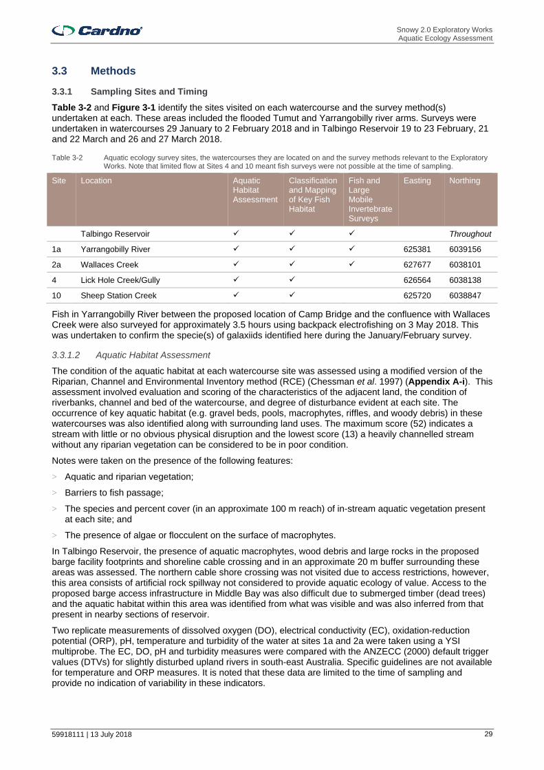
Snowy 2.0 Exploratory Works Aquatic Ecology Assessment
59918111 | 13 July 2018 29
3.3 Methods
3.3.1 Sampling Sites and Timing
Table 3-2 and Figure 3-1 identify the sites visited on each watercourse and the survey method(s) undertaken at each. These areas included the flooded Tumut and Yarrangobilly river arms. Surveys were undertaken in watercourses 29 January to 2 February 2018 and in Talbingo Reservoir 19 to 23 February, 21 and 22 March and 26 and 27 March 2018.
Table 3-2 Aquatic ecology survey sites, the watercourses they are located on and the survey methods relevant to the Exploratory Works. Note that limited flow at Sites 4 and 10 meant fish surveys were not possible at the time of sampling.
Site Location Aquatic Habitat Assessment
Classification and Mapping of Key Fish Habitat
Fish and Large Mobile Invertebrate Surveys
Easting Northing
Talbingo Reservoir Throughout
1a Yarrangobilly River 625381 6039156
2a Wallaces Creek 627677 6038101
4 Lick Hole Creek/Gully 626564 6038138
10 Sheep Station Creek 625720 6038847
Fish in Yarrangobilly River between the proposed location of Camp Bridge and the confluence with Wallaces Creek were also surveyed for approximately 3.5 hours using backpack electrofishing on 3 May 2018. This was undertaken to confirm the specie(s) of galaxiids identified here during the January/February survey.
3.3.1.2 Aquatic Habitat Assessment
The condition of the aquatic habitat at each watercourse site was assessed using a modified version of the Riparian, Channel and Environmental Inventory method (RCE) (Chessman et al. 1997) (Appendix A-i). This assessment involved evaluation and scoring of the characteristics of the adjacent land, the condition of riverbanks, channel and bed of the watercourse, and degree of disturbance evident at each site. The occurrence of key aquatic habitat (e.g. gravel beds, pools, macrophytes, riffles, and woody debris) in these watercourses was also identified along with surrounding land uses. The maximum score (52) indicates a stream with little or no obvious physical disruption and the lowest score (13) a heavily channelled stream without any riparian vegetation can be considered to be in poor condition.
Notes were taken on the presence of the following features:
> Aquatic and riparian vegetation;
> Barriers to fish passage;
> The species and percent cover (in an approximate 100 m reach) of in-stream aquatic vegetation present at each site; and
> The presence of algae or flocculent on the surface of macrophytes.
In Talbingo Reservoir, the presence of aquatic macrophytes, wood debris and large rocks in the proposed barge facility footprints and shoreline cable crossing and in an approximate 20 m buffer surrounding these areas was assessed. The northern cable shore crossing was not visited due to access restrictions, however, this area consists of artificial rock spillway not considered to provide aquatic ecology of value. Access to the proposed barge access infrastructure in Middle Bay was also difficult due to submerged timber (dead trees) and the aquatic habitat within this area was identified from what was visible and was also inferred from that present in nearby sections of reservoir.
Two replicate measurements of dissolved oxygen (DO), electrical conductivity (EC), oxidation-reduction potential (ORP), pH, temperature and turbidity of the water at sites 1a and 2a were taken using a YSI multiprobe. The EC, DO, pH and turbidity measures were compared with the ANZECC (2000) default trigger values (DTVs) for slightly disturbed upland rivers in south-east Australia. Specific guidelines are not available for temperature and ORP measures. It is noted that these data are limited to the time of sampling and provide no indication of variability in these indicators.

Snowy 2.0 Exploratory Works Aquatic Ecology Assessment
59918111 | 13 July 2018 30
Figure 3-1 Location of Survey Sites on Watercourses

Snowy 2.0 Exploratory Works Aquatic Ecology Assessment
59918111 | 13 July 2018 31
3.3.1.3 Key Fish Habitat Type and Stream Classifications
The classification of KFH type in the Study Area was determined using the criteria in NSW DPI (2013a) for freshwater habitat (Table 3-3). The waterway Class was determined using the criteria in Table 3-4.
Table 3-3 Classification of key fish habitat according to sensitivity (NSW DPI (Fisheries) 2013a)
Classification Habitat Type
Type 1 – highly sensitive key fish habitat
Freshwater habitats that contain in-stream gravel beds, rocks greater than 500 millimetres in two dimensions, snags greater than 300 millimetres in diameter or three metres in length, or native aquatic plants
Any known or expected protected or threatened species habitat or area of declared ‘critical habitat’ under the FM Act
Mound springs
Type 2 – Moderately sensitive key fish habitat:
Freshwater habitats and brackish wetlands, lakes and lagoons other than those defined in Type 1
Weir pools and dams up to full supply level where the weir or dam is across a natural waterway
Type 3 – Minimally sensitive key fish habitat
Freshwater habitats not included in Types 1 or 2
Ephemeral aquatic habitat not supporting native aquatic or wetland vegetation
Not considered key fish habitat
First and second order gaining streams (based on the Strahler method of stream ordering
Farm dams on first and second order streams or unmapped gullies
Agricultural and urban drain
Urban or other artificial ponds (e.g. evaporation basins, aquaculture ponds
Sections of stream that have been concrete-lined or piped (not including a waterway crossing)
Table 3-4 Classification of waterways for fish passage criteria. Adapted from Tables 2 and 3 NSW DPI (Fisheries) 2013a
Classification Characteristics of waterway type Minimum recommended crossing type
Additional design information
Class 1 – Major fish habitat
Marine or estuarine waterway or permanently flowing or flooded freshwater waterway (e.g. river or major creek), habitat of a threatened or protected fish species or ‘critical habitat’.
Bridge, arch structure or tunnel.
Bridges are preferred to arch structures.
Class 2 – Moderate fish habitat
Non-permanently flowing (intermittent) stream, creek or waterway (generally named) with clearly defined bed and banks with semi-permanent to permanent waters in pools or in connected wetland areas. Freshwater aquatic vegetation is present. Type 1 and 2 habitats present.
Bridge, arch structure, culvert(1) or ford.
Bridges are preferred to arch structures, box culverts and fords (in that order).
Class 3 – Minimal fish habitat
Named or unnamed waterway with intermittent flow and sporadic refuge, breeding or feeding areas for aquatic fauna (e.g. fish, yabbies). Semi-permanent pools form within the waterway or adjacent wetlands after a rain event. Otherwise, any minor waterway that interconnects with wetlands or other Class 1 - three fish habitats.
Culvert(2) or ford. Box culverts are preferred to fords and pipe culverts (in that order).
Class 4 – Unlikely fish habitat
Waterway (generally unnamed) with intermittent flow following rain events only, little or no defined drainage channel, little or no flow or free standing water or pools post rain events (e.g. dry gullies or shallow floodplain depressions with no aquatic flora present).
Culvert(3), causeway or ford.
Culverts and fords are preferred to causeways (in that order).
(1) High priority given to the ‘High Flow Design’ procedures presented for the design of these culverts—refer to the “Design Considerations” section of Fairfull and Witheridge (2003). (2) Minimum culvert design using the ‘Low Flow Design’ procedures; however, ‘High Flow Design’ and ‘Medium Flow Design’ should be given priority where affordable—refer to the “Design Considerations” section of Fairfull and Witheridge (2003). (3) Fish friendly waterway crossing designs possibly unwarranted. Fish passage requirements should be confirmed with NSW DPI.

Snowy 2.0 Exploratory Works Aquatic Ecology Assessment
59918111 | 13 July 2018 32
3.3.1.4 Fish and Large Mobile Invertebrates
Fish and larger mobile invertebrates (e.g. freshwater crayfish) at each watercourse site were sampled using a backpack electrofisher (model LR-24 Smith-Root). The electrofisher was operated in a variety of habitats including the edges of pools, riffles, amongst aquatic plants and woody debris with four two minute shots being performed at each site over approximately 200 m of watercourse length. Stunned fish were collected in a scoop net, identified and measured. All captured fish were handled with care to minimise stress, and released as soon as possible with the exception of non-native species that were euthanised in accordance with the scientific collection permit. Sampling was undertaken with consideration of the Australian Code of Electrofishing Practice (NSW Fisheries 1997), including the presence of an experienced electrofishing operator at all times.
Boat-based electrofishing was undertaken in Talbingo Reservoir using a Smith-Root 7.5 GPP boat mounted unit provided and operated by Austral Research and Consulting with assistance from Cardno staff. This targeted aquatic macrophytes, woody debris and large boulders and rock overhangs along the shallower edges of the reservoir, including the Tumut River arm and the Yarrangobilly River arm to the top of the supply level (on the day of sampling). Surveys were done in consideration of Survey Guidelines for Australia’s Threatened Fish (DSEWPC 2011).
3.3.2 Results
3.3.2.1 Aquatic Habitat
3.3.2.1.1 Watercourses
Results of the aquatic habitat assessment using the RCE method are provided in Appendix A-ii. Total scores ranged from 40 to 52 and were relatively high, indicative of undisturbed habitat. The only exception was Site 10 on Sheep Station Creek. This creek was dry at the time of sampling and was not scored for riffle/pool sequence and aquatic vegetation. It score high (3 or 4) in each other category. The other sites scored high (i.e. 4, no evidence of disturbance) in categories associated with the condition of riparian vegetation and/or channel morphology. Sections of Yarrangobilly River would have experienced disturbance due to historic mining (copper) and possibly agriculture. Disturbances would have included bankside modifications and vegetation clearing along several hundred metres of bank. Mine tailings also appear to have been stockpiled along some banks. Disturbed areas are now largely revegetated though some areas clear of larger trees remain. It is possible that some water contamination from the historic mine works and any tailings stockpiles may currently be present, however, while the results of the limited water quality sampling indicate concentrations of copper and zinc were elevated (Section 3.1.3), it is unclear if this is due to historic mining and/or a natural occurrence,
Table 3-5 summarises the habitat attributes of the watercourses at each site visited. It also includes the results of the KFH type and stream classifications (Section 3.3.1.3). Yarrangobilly River and Wallaces Creek are perennial and provide substantial aquatic ecology of value. Stream substratum consists of unconsolidated boulder, cobble, pebble and gravel substratum with little evidence of siltation. This substratum would provide important spawning habitat for many native species, including galaxiids and Macquarie perch, if present. They are also sensitive to potential sedimentation which can result in the filling of interstices. Watercourse edges were well vegetated with riparian plants including several mature trees apart from non-native blackberry which was present along Yarrangobilly River. Native trees and riparian vegetation helps to stabilise banks, trap sediments and provide a source of food and habitat (wood debris) for aquatic biota. Nearby tributaries of Wallaces Creek visited within the Study Area (Lick Hole Creek and Sheep Station Creek) were ephemeral and provided aquatic habitat of lower value. In particular Sheep Station Creek was dry at the time of sampling. Only minimal flow was present in Lick Hole Creek. In Cave Gully, a nearby tributary of Wallaces Creek, water consisted of disconnected pools with no visible flow. These watercourses would provide very limited habitat of fish, but would provide more valuable refuge for aquatic macroinvertebrates and potentially burrowing crayfish. No natural or artificial barriers to fish passage were identified on the sections of Yarrangobilly River and Wallaces Creek visited. Although no aquatic plants were observed in the sections of watercourses visited this was not surprising given the fast flowing water and lack of fine sediment here (which would discourage the establishment and growth of plants).
Examination of mean in-situ water quality data indicated:
> Temperature was 19.3 C in Yarrangobilly River and 19.3 in Wallaces Creek;
> EC was 131 µS/cm in Yarrangobilly River and 125 131 µS/cm in Wallaces Creek and within DTVs (30 µS/cm to 350 µS/cm);
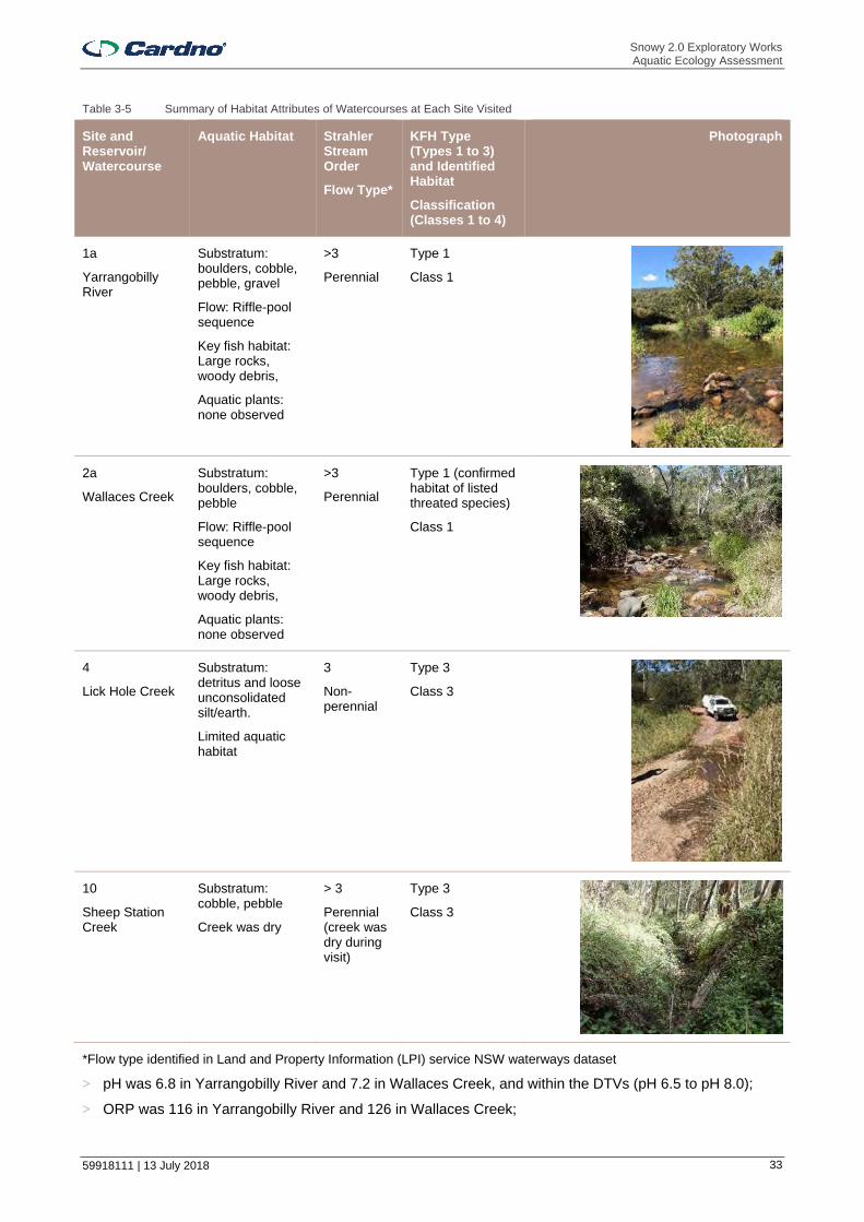
Snowy 2.0 Exploratory Works Aquatic Ecology Assessment
59918111 | 13 July 2018 33
Table 3-5 Summary of Habitat Attributes of Watercourses at Each Site Visited
Site and Reservoir/ Watercourse
Aquatic Habitat Strahler Stream Order
Flow Type*
KFH Type (Types 1 to 3) and Identified Habitat
Classification (Classes 1 to 4)
Photograph
1a
Yarrangobilly River
Substratum: boulders, cobble, pebble, gravel
Flow: Riffle-pool sequence
Key fish habitat: Large rocks, woody debris,
Aquatic plants: none observed
>3
Perennial
Type 1
Class 1
2a
Wallaces Creek
Substratum: boulders, cobble, pebble
Flow: Riffle-pool sequence
Key fish habitat: Large rocks, woody debris,
Aquatic plants: none observed
>3
Perennial
Type 1 (confirmed habitat of listed threated species)
Class 1
4
Lick Hole Creek
Substratum: detritus and loose unconsolidated silt/earth.
Limited aquatic habitat
3
Non-perennial
Type 3
Class 3
10
Sheep Station Creek
Substratum: cobble, pebble
Creek was dry
> 3
Perennial (creek was dry during visit)
Type 3
Class 3
*Flow type identified in Land and Property Information (LPI) service NSW waterways dataset
> pH was 6.8 in Yarrangobilly River and 7.2 in Wallaces Creek, and within the DTVs (pH 6.5 to pH 8.0);
> ORP was 116 in Yarrangobilly River and 126 in Wallaces Creek;

Snowy 2.0 Exploratory Works Aquatic Ecology Assessment
59918111 | 13 July 2018 34
> DO saturation was 88.0 % in Yarrangobilly River and 92.5 % in Wallaces Creek and slightly below the lower DTV (90 % saturation) in Yarrangobilly River; and
> Turbidity was 4.4 NTU in Yarrangobilly River and 2.5 NTU in Wallaces Creek and within DTVs (2 NTU to 25 NTU).
Compared with the ANZECC (2000) default trigger values (DTVs) for slightly disturbed upland rivers in south-east Australia, these limited data suggest that water quality in these watercourses is generally good.
3.3.2.1.2 Talbingo Reservoir
Talbingo Reservoir provides substantial aquatic habitat, and in particular extensive areas of wood debris (primarily submerged timber) and the non-native aquatic macrophyte Elodea Canadensis (elodea or Canadian pondweed) along shallow edges and embayments (Plates 1a and 1b). These habitats would provide important spawning, feeding, nursery and recruitment areas for fish. Only very small areas (a few metres square) of elodea and wood debris were present within the proposed footprint of the Talbingo barge ramp (Plate 1c). This area consisted primarily of unvegetated bare rock of low aquatic ecological value. Wood debris and elodea was present along many sections of Middle Bay shoreline (Plate 1b).
Plate 1 a) and b) Extensive areas of submerged aquatic plant Elodea Canadensis and wood debris throughout Talbingo Reservoir.
c) Talbingo reservoir shore at near the existing spillway and d) Talbingo reservoir shore at the proposed Middle Bay barge access location.
3.3.2.2 Key Fish Habitat Type and Stream Classifications
Yarrangobilly River and Wallaces Creek contained Type 1 Highly Sensitive KFH (large rocks and wood debris) and were classified Class 1 - Major Fish Habitat. Appropriate crossing structures for such watercourses are bridges, arch structure or tunnels, with bridges preferred to arch structures. Lick Hole and Sheep Station creeks contained Type 3 Minimally Sensitive KFH (due to their apparent ephemeral flow and absence of aquatic macrophytes at the sites visited) and were classified Class 3 - Minimal Fish Habitat. Appropriate crossings are culverts or fords. Although flooded waterways such as Talbingo Reservoir generally provide Type 2 - Moderately sensitive KFH, as a precautionary approach it should be considered Type 1 KFH due to the potential for wood debris and aquatic plants here to provide habitat for threatened species of fish.
a) b)
c) d)

Snowy 2.0 Exploratory Works Aquatic Ecology Assessment
59918111 | 13 July 2018 35
3.3.2.3 Fish and Large Mobile Invertebrates
Non-native brown trout were the most numerically dominant fish species caught in Yarrangobilly River and Wallaces Creek (Table 3-6). Non-native rainbow trout were also caught in these watercourses and the non-native red fin perch caught in Wallaces Creek. Native juvenile Galaxias sp. were caught in Yarrangobilly River and native Murray crayfish in Yarrangobilly River (just upstream of the Talbingo Reservoir water level during boat based electrofishing surveys) and in Wallaces Creek. In Talbingo Reservoir numerous red fin perch (mainly juvenile fish up to 5 cm in length) and eastern gambusia were caught amongst aquatic macrophytes. The identity of the juvenile Galaxias sp. could not be confirmed, though there is potential for these to be mountain galaxias (Galaxias olidus) or climbing galaxias. Climbing galaxais was caught in Yarrangobilly River just downstream of the confluence with Wallaces Creek during a subsequent electrofishing survey. All fish appeared healthy with no signs of disease or parasites.
Table 3-6 Species and numbers of fish caught in Talbingo Reservoir and Watercourses in the Study Area
Site
Clim
bin
g ga
laxi
as
(Gal
axia
s br
evip
inni
s)
Gal
axia
s sp
.
Bro
wn
trou
t
(Sal
mo
trut
ta)
Rai
nbo
w tr
out
(Onc
orhy
nch
us m
ykis
s)
Red
fin
per
ch
(Per
ca
fluvi
atili
s)
Eas
tern
ga
mb
usia
(G
ambu
sia
holb
rook
i)
Wild
gol
dfis
h
(Car
assi
us
aura
tus)
Mur
ray
cray
fish
(Eua
stac
us
arm
atus
)
Native Native Non-native
Non-native Non-native
(noxious)
Non-native Non-native Native
Listed Vulnerable
(FM Act)
Talbingo Reservoir
>200 10 30
1a Yarrangobilly River
4 33 1 1**
2a Wallaces Creek
42 3 2 4
4 Lick Hole Creek
No fish
10 Sheep Station Creek
Dry
Yarrangobilly River - Camp Bridge to confluence with Wallaces Creek
2 P P P
P = Present. *Native to Australia, non-native to the Yarrangobilly Catchment. **caught in Yarrangobilly River just upstream of Talbingo Reservoir water level.
Plate 2 a) Murray crayfish caught in Yarrangobilly River and Wallaces Creek and b) red fin perch caught in Talbingo Reservoir
a) b)
Snowy 2.0 Exploratory Works Aquatic Ecology Assessment
59918111 | 13 July 2018 36
3.3.3 Likelihood of Occurrence of Threatened Aquatic Species
An assessment of the likelihood of occurrence of all threatened species was undertaken to determine the potential for these species to occur within the Study Area. Table 3-7 provides the likelihood of occurrence criteria used in the assessment and Table 3-8 a summary of the findings. The likelihood of occurrence of the five species with potential to occur are as follows:
> Murray crayfish – Murray crayfish occurs in Yarrangobilly River and Wallaces Creek (Section 3.3.2.3), Murray crayfish may also occur in Talbingo Reservoir, however, as it is considered to prefer flowing streams and rivers, and due to the abundance of predatory redfin perch here, the probability of it occurring here is low. If it does occur, it is more likely to be found in shallower shore sections where it could construct burrows.
Table 3-7 Likelihood of occurrence criteria
Likelihood of occurrence
Criteria
Very unlikely ▪ No records within Study Area; ▪ Species restricted to certain geographical areas not within the Study Area; ▪ Species that have specific habitat requirements are not present in the Study Area; or ▪ Substantial natural barriers to movement exist between known populations and Study Area.
Low ▪ No recent records in the Study Area though it is within the potential historic, but not current, distribution range;
▪ Recent records or stocking downstream of the Study Area, though substantial natural barriers to movement exist between known populations/stocking and Study Area;
▪ Study Area contains potential habitat.
Moderate ▪ Has recently been recorded or stocked within the Study Area; ▪ Use habitats or resources present in the Study Area, though they may be in poor or disturbed
condition; ▪ Are unlikely to maintain self-sustaining populations, however may use resources within the Study
Area opportunistically or during migration.
High ▪ Has recently been recorded or stocked within the Study Area; ▪ Use habitat types or resources that are present in the Study Area that are abundance and/or in
good condition; ▪ Are known or likely to maintain self-sustaining populations in the Study Area; ▪ Are known or likely to visit the site during regular seasonal movements or migration.
> Trout cod – stocking records in Talbingo Reservoir suggest trout cod has a moderate chance of occurring. Predictive distribution maps and habitat requirements suggest Trout cod is unlikely to occur outside of Talbingo Reservoir.
> Macquarie perch – stocking records in Talbingo Reservoir suggest Macquarie perch has a moderate chance of occurring. Indicative distribution maps indicate Macquarie perch also has a moderate chance of occurrence in Yarrangobilly River. Habitat within Wallaces Creek, which is generally shallower with fewer large pools, is unlikely to provide suitable habitat for this species.
> Murray cod and Silver perch – it is unclear if the natural distribution of these species would have included the Study Area. Nevertheless, although substantial artificial barriers to movement exist (i.e. Talbingo Dam Wall and those further downstream), these species have been stocked in Blowering Dam and there is a possibility, albeit low, that they have also been introduced to Talbingo Reservoir.
Impacts on these species due to the Exploratory Works have been assessed using the factors of assessment / significant impact criteria (Appendix B). It is noted at this point that results of the environmental DNA analysis did not indicate the presence of any threatened species of fish in Yarrangobilly River, Wallaces Creek or Talbingo Reservoir (Section 3.1.2.2). This finding should be considered when assessing the potential risk to these species associated with Exploratory Works. However, a precautionary approach has been adopted with the interpretation of the environmental DNA analysis. It has not been used as the basis to rule out threatened species occurring, as it is based on one sampling event and does not consider seasonal variation in habitat use that could affect the occurrence of some species (e.g. Macquarie perch may not be present in Yarrangobilly River in February), as well as stability of DNA in the water.

Snowy 2.0 Exploratory Works Aquatic Ecology Assessment
59918111 | 13 July 2018 37
Table 3-8 Relevant aquatic species, populations and communities listed as threatened under state and federal legislation and their likelihood of occurrence in the Study Area
Species or Population FM Act status EPBC Act status Likelihood of occurrence
Macquarie perch Endangered Endangered Moderate
Murray cod Vulnerable Low
Trout cod Endangered Endangered Moderate (Talbingo Reservoir)
Low (Outside Talbingo Reservoir)
Murray crayfish Vulnerable
High (Yarrangobilly River and Wallaces Creek)
Low (Talbingo Reservoir)
Silver perch Vulnerable Low
3.4 Summary
Yarrangobilly River and Wallaces Creek support high value aquatic ecology and fish habitat including large boulders, unconsolidated cobble, pebble and gravel substratum, large wood debris and relatively complete riparian vegetation. Aquatic habitat in Yarrangobilly River and Wallaces Creek, in particular, is relatively undisturbed, though there has been some historic disturbance due to previous nearby mining. The limited water quality data collected suggest minimal current impacts to water quality.
Talbingo Reservoir, Yarrangobilly River, Wallaces Creek, Lick Hole Creek, Cave Gully and third order and higher tributaries of Yarrangobilly River are KFH. Talbingo Reservoir, Yarrangobilly River and Wallaces Creek supported Type 1 – Highly Sensitive Key Fish Habitat (primarily large wood debris, large rocks and/or aquatic plants that may also provide habitat for threatened species). Such habitat was not identified in Lick Hole Creek or Cave Gully and these provided Type 3 Minimally Sensitive KFH. Other third order watercourses within the Study Area are also likely to provide Type 3 KFH, while first and second order tributaries are unlikely to provide KFH.
The vulnerable Murray crayfish occurs in Yarrangobilly River and Wallaces Creek. Based on absence of preferred habitat in Talbingo Reservoir (flowing rivers and streams) it has a low probability of occurrence in the reservoir. Based on habitat assessment and stocking records, Macquarie perch is considered to have a moderate potential of occurrence in Yarrangobilly River and Talbingo Reservoir and trout cod a moderate chance of occurrence in Talbingo Reservoir. As such, potential impacts on these species due to Exploratory Works have been considered in detail. It is, however, unclear if any populations of Macquarie perch and trout cod are self-sustaining. Although no native species of fish including threatened species were sampled in the reservoir during electrofishing, several native species were detected via analysis of environmental DNA in waters (Section 3.1.2.2). Although no threatened species of fish were identified during electrofishing or via DNA, this does not preclude their presence; albeit if present, they are likely to be in low abundance.
Talbingo Reservoir also supports large areas of non-native aquatic plants and numerous non-native fish (red fin perch, wild goldfish and eastern gambusia). Non-native brown trout and rainbow trout were also abundant in Yarrangobilly River and Wallaces Creek, with only a few native Galaxias sp. caught during field surveys. Overall, the abundance and diversity of native fish fauna in the Study Area is poor. This is due to abundant non-native species, in particular trout and red fin, which would predate on native species of galaxiid and crayfish, including Murray crayfish. The fluctuations in water levels due to operation of Talbingo Dam wall and the associated periodic exposure of shallow aquatic habitats that would occur could also be influencing fish diversity in the reservoir.
Snowy 2.0 Exploratory Works Aquatic Ecology Assessment
59918111 | 13 July 2018 38
4 Impact Assessment
Exploratory Works could potentially affect the aquatic ecology in the Study Area, primarily sections of Yarrangobilly River, Wallaces Creek, and Talbingo Reservoir. This section describes the potential impacts to aquatic habitats and aquatic biota, listed threatened species and KTPs. The measures that will be used to minimise potential impacts on aquatic ecology are described in Section 5.
4.1 Portal Construction Pad and Accommodation Camp
4.1.1 Description of Impacting Processes
In the absence of control measures, construction activities and temporary operation of the accommodation camp have the potential to impact indirectly on aquatic ecology in the following ways:
> Increase in suspended sediment load within watercourses. Sediment loads in water following mobilisation of soils / sediments during heavy rainfall, over disturbed soils and sediments in areas where vegetation has been cleared and / or soil and construction material has been stockpiled may increase. Elevated suspended sediments and turbidity may be detrimental to aquatic habitat and biota via smothering and alteration of substratum, although turbidity may be naturally elevated at certain times of year
> Accidental release of chemicals and fuels (e.g. oils, hydraulic fluids and fuel from construction equipment) could result in the input of hydrocarbon and metal contaminants into watercourses. The accidental release into waterways of any pesticides, herbicides and sewage could also affect aquatic biota;
> Discharge of treated sewage or waste water to Talbingo Reservoir; and
> Entrainment and/or impingement of fish eggs and larvae due to extraction of water from Talbingo Reservoir to supply construction and potable water requirements.
There would be no direct displacement of aquatic habitat or any construction within or nearby watercourses due to construction of the portal construction pad and accommodation camp. There would be no direct disturbance of Yarrangobilly River and Wallaces Creek.
4.1.2 Impacts on Aquatic Habitat and Biota
The greatest potential risk to aquatic ecology is associated with changes to water quality in watercourses within the Study Area. However, the majority of these can be effectively managed via standard sedimentation and erosion controls during the construction stage and through development and implementation of a Sediment and Erosion Control Plan. Water quality monitoring will also be implemented to test the effectiveness of these controls and inform additional management decisions if acceptable turbidity levels are exceeded. Any planned releases of water would be limited to Talbingo Reservoir only and not to Yarrangobilly River and Wallaces Creek. Many of the potential impacts to the aquatic environment would also be temporary and limited to the initial phase of the Exploratory Works involving construction and earthworks. The risk of impacts to aquatic habitats and biota would be reduced following this initial work.
Standard controls would effectively remove coarse sediment and no sedimentation is expected in Yarrangobilly River and Wallaces Creek (EMM 2018b) that could otherwise smother aquatic habitat including that of the Murray crayfish, which is known to occur in these creeks. Any unforseen run-off into Yarrangobilly River and Wallaces Creek would likely be temporary and associated with substantial rainfall events only. The biota in creeks with unregulated water flow will be tolerant to increased levels of suspended sediments and turbidity at times when rainfall is naturally high. Associated high flows would also be expected to transport any coarse sediments out of the waterways. Unforseen release of sediment during periods of low flow, particularly during summer months, would be potentially more detrimental in the absence of any controls.
Controls may provide limited removal of fine and dispersive sediments and some runoff containing fine and dispersive sediments into receiving waters is expected. The mobilisation of fine sediments may increase turbidity resulting in reduced light penetration affecting aquatic macrophytes (though none were observed in the sections of Yarrangobilly River and Wallaces Creek inspected during field survey) and primary productivity. This may subsequently result in die back of vegetation and associated increase in nutrient concentrations following decomposition and may encourage excessive algal growth. It is expected that any surface run-off laden with fine and dispersive sediments entering the Yarrangobilly River during heavy rainfall events would be significantly diluted by river flows and would rapidly dissipate. Hence, no net change to turbidity in Yarrangobilly River is expected (EMM 2018b). Flocculants or coagulants could be added to sedimentation basins to enhance the removal of fine and dispersive sediments prior to discharge. If

Snowy 2.0 Exploratory Works Aquatic Ecology Assessment
59918111 | 13 July 2018 39
implemented, specialist advice would be required to ensure that appropriate agents, mixing techniques and monitoring measures are in place (EMM 2018b) as some flocculants/coagulants are highly toxic to aquatic life.
Controls will be implemented to prevent the release of wastewater that arises on-site into watercourses. This includes appropriate infrastructure to store and control water on site and avoid accidental discharges to Yarrangobilly River and Wallaces Creek and their tributaries. Separate stormwater and process water systems will be installed to manage and isolate these water streams. Process water areas will also be covered and bunded to prevent contaminants reaching stormwater. Clean water diversions will also be installed. All waste water would be treated and piped to Talbingo Reservoir for discharge. Measures have been outlined within the Surface Water Assessment (EMM 2018b) to minimise, manage and clean up spillages of fuels, oils and greases and appropriate storage and refuelling areas have been identified. Potential impacts associated with controlled discharge to Talbingo Reservoir can be managed through the appropriate treatment of process water prior to discharge. Accordingly, negligible receiving water impacts are expected (EMM 2018b).
Contaminants (if present) bound to sediments could be also be released during earthworks and transported into receiving waters via surface drainage lines where they could be detrimental to aquatic biota. Contamination could also arise during construction activities. The Phase 1 contamination assessment (EMM 2018) has included measures to minimise impacts from contamination.
Water soluble components of petroleum hydrocarbons include a variety of compounds that are potentially toxic to aquatic life (Clarke 1997). Pesticides and herbicides used for weed or pest control can also be particularly toxic to aquatic life. These could enter waterways following accidental release if stored or used incorrectly. It is unlikely that hydrocarbons could enter surface run-off from any leakages of vehicles using the access road due to the highly permeable nature of the soils. During rainfall, it is possible that hydrocarbon residue and spillages from the roads and tracks within the compound site could enter waterways via surface run-off. However, taking into account the proposed management measures and safeguards, the volumes of such in flows are likely to be very small.
Nutrient input from sewage (phosphates are also major constituents of some detergents) may also cause eutrophication in waterbodies. Eutrophication, or algal blooms, is a large rapid increase in the quantity of phytoplankton, especially blue-green algae (Cyanobacteria). This can result in the death of aquatic fauna including invertebrates and fish. During algal blooms, the decay of the phytoplankton consumes dissolved oxygen potentially resulting in hypoxic (low dissolved oxygen) or anoxic (absence of oxygen) conditions in the aquatic ecosystem. This, in turn, is likely to cause stress, suffocation and death of aquatic biota. Sewage would be appropriately treated to minimise such risks and there would be no discharge of any sewage to watercourses. Sewage from Exploratory Works would be stored and treated at an STP on-site at the accommodation camp prior to discharge to Talbingo Reservoir via the water utility pipeline connecting the accommodation camp to Middle Bay. The domestic sewage at the construction pad is not expected to be substantial and hence it will be tanked from the construction pad to accommodation camp facilities for treatment. Release of treated water into Talbingo Reservoir still has potential to result in changes in water quality in the reservoir, albeit much reduced compared with untreated sewage and is not expected to represent any substantial risk to aquatic ecology in the reservoir. During median summer flow conditions, discharge of treated sewage to the Yarrangobilly Arm of Talbingo Reservoir would result in nitrogen and phosphorus concentrations of 0.014 mg/L and 0.005 mg/L respectively (EMM 2018b). These are below the relevant DTVs in ANZECC (2000). During drought conditions, discharge is estimated to increase average nitrogen and phosphorus concentrations to 0.06 mg/L and 0.02 mg/L, respectively. The phosphorus concentration exceeds the DTV (0.010 mg/L). It is possible that elevated phosphorous levels could result in changes to the aquatic ecosystem during drought conditions. However, potential exceedances would be temporary and limited to the Yarrangobilly Arm of the reservoir. Thus, potential impacts to aquatic ecology due to short-term exceedances are expected to minor and localised. Ongoing monitoring of water quality and flow conditions in Talbingo Reservoir and Yarrangobilly River would be adequate to effectively manage this risk. Low phosphorus products will be used for washing activities controlled by site management (e.g. laundry services and mess hall) and encouraged (via education) for general use. Further, no material change to water quality in the greater reservoir is expected due to high inflows associated with the operation of the Snowy Scheme (EMM 2018b).
Provided stringent water quality controls are implemented, the risk of potential indirect impacts to aquatic ecology from mobilised sediment and other potential contaminants would be very low. Additional control measures to further minimise potential risks to aquatic ecology are provided in Section 5.
There is also a potential risk of entrainment of fish larvae and eggs due to extraction of potable water from Talbingo Reservoir for Exploratory Works. This would be pumped via a water services pipeline from Talbingo

Snowy 2.0 Exploratory Works Aquatic Ecology Assessment
59918111 | 13 July 2018 40
Reservoir at the Middle Bay. Although no native or threatened species of fish were sampled in the reservoir during electrofishing, several native species were identified as potentially occurring in the Study Area via analysis of DNA in waters (Section 3.1.2.2). The intake structure will be in the form of a submersible pump station. There is a risk of entrainment and impingement of fish larvae and eggs via the water pump. This risk will depend on the velocity of water approaching and through the pump and the aperture size of any screen guarding the pump. Locating the pump in deeper sections of the reservoir away from fish habitat and adopting appropriate aperture mesh sizes and approach velocities would help minimise these risks. A slow start procedure involving intial low velocities will also aim to deter fish and mobile fauna away from the intake, further reducing the likelihood of entrainment (Section 5).
4.1.3 Impacts on KFH and Threatened Species
Construction of the portal construction pad and accommodation camp would not include any works within watercourses, thus, there would be no direct impacts to KFH. There is potential for indirect effects due to any unplanned release of poor quality water (sediment laden and other waste water). In particular any accidental release of sediment laden water during storm events could result in sedimentation and smothering of sensitive KFH such as wood debris and rocks in Yarrangobilly River and Wallaces Creek. This could result in the smothering of rock interstices that provide habitat for the vulnerable Murray crayfish found in these waterways during the field survey. Any other reductions in water quality in these watercourses due to accidental release of poor quality water stored on site (e.g. the potential for nutrients in sewage to result in reduced DO if released to waterways) also have potential to affect the vulnerable Murray crayfish and the threatened Macquarie perch, which has a moderate likelihood of occurrence here. There is also potential for any trout cod, considered to have a moderate likelihood of occurrence in Talbingo Reservoir, to be affected by such changes in water quality, if they persist downstream. However, the risk of any residual impacts to water quality following implementation of the proposed water quality controls affecting KFH and threatened species would be very low (Appendix B). Additional control measures to further minimise potential risks to aquatic ecology are provided in Section 5.
The absence of threatened species in electrofishing and DNA analysis also does not preclude their presence, particularly Macquarie perch and trout cod for which stocking records exist. However, due to their apparent low abundance (if present at all), and life reproductive characteristics, risks associated with entrainment are likely to be very low. While eggs of Murray cod, trout cod and silver perch are only a few millimetres in diameter (Table 4-1), entrainment of eggs of the first two species and Macquarie perch is likely to be low due their reproductive characteristics. Murray cod and trout cod and lay adhesive eggs to cleared surfaces such as woody debris and rocks which would suggest they would be unlikely to be suspended in the water column and susceptible to entrainment. Macquarie perch lay adhesive eggs in shallow riffle sections of flowing streams (NSW DPI 2017c). Newly hatched yolk sac larvae shelter amongst pebbles (NSW DPI 2017a). The eggs of silver perch would likely be far more susceptible to potential entrainment, as these species spawn semi buoyant eggs which drift with river flow (Lintermans 2007). However, given that this species appears to have only one self-sustaining population in NSW, that in the central Murray River downstream of Yarrawonga Weir (Section 3.1.5.6) the risk of entrainment is likely to be very low. The risk of entrainment of larvae of these species is more difficult to predict, though would likely to be minimal if approach velocities are small (ideally 0.1 m/s or less). Entrainment of juveniles and adults is likely to be very small, as larger fish such as these would much stronger swimmers and be much more able to actively avoid being entrained.
Impacts to Murray crayfish, Macquarie perch and trout cod due to construction of the portal construction pad and accommodation camp are considered in detail in the Assessments of Significance for these species (Appendix B). The assessment indicated that associated significant impacts to these species are unlikely.
Table 4-1 Sizes of egg and lengths of larvae of threatened fish species with potential to occur in Talbingo Reservoir. Golden perch may also occur, but is not threatened.
Threatened Fish Species
Size of egg Length of larvae at hatching
Source
Trout cod Fertilised eggs are 2.5-3.6 mm in diameter 6.-8.8 mm Trout Cod Recovery Team (2008)
Murray cod Diameter of 2.5-3 mm for unfertilised eggs and 3-4 mm when fertilised and water hardened
9.5 -15 mm National Murray Cod Recovery Team (2010a)
Macquarie perch
1-2 mm 7 mm NSW DPI (2017a) Lintermans (2007)
Silver perch Fertilised eggs are about 2.8 mm in diameter 3-6 mm NSW DPI (2005a)

Snowy 2.0 Exploratory Works Aquatic Ecology Assessment
59918111 | 13 July 2018 41
4.2 Exploratory Tunnel Excavation
4.2.1 Description of Impacting Processes
Tunnel excavation will intercept groundwater which could result in reduced groundwater flows to nearby watercourses. These appear to be partially dependant on groundwater. The Surface Water Assessment (EMM 2018a) describes stream flow regimes in the Yarrangobilly River and Wallaces Creek using steam gauge data from Snowy Hydro-operated stream gauge at Lobs Hole. This gauge data indicates that the majority of annual stream flows occur in late winter and early spring. Stream flows progressively reduce over summer and are at their lowest in late summer and generally remain low until the winter months. This is a typical regime for rivers in the Australian Alps. Winter and spring runoff volumes were noticeably low in 1982 and 2006, following dry winter months. The lowest monthly flow on record was 390 ML/month, which occurred in February 1983 following an abnormally dry winter and spring/summer in 1982. These data indicate that permanent base flows are maintained in the river by groundwater discharges during drought conditions.
The Snowy 2.0 Exploratory Works Groundwater Assessment (EMM 2018b) assessed the reduction in baseflows in the Yarrangobilly River and other watercourses associated with groundwater seepage into the Exploratory Tunnel. The reduction in baseflows was predicted to be minor relative to the simulated baseflows in the Yarrangobilly River. Accordingly, the predicted reductions in baseflows are not expected to change the flow regimes in either the Yarrangobilly River or Wallaces Creek during normal and drought conditions.
4.2.2 Impacts on Aquatic Habitat and Biota
No change to the flow regimes of Yarrangobilly River and Wallaces Creek are predicted due to interception of groundwater by tunnelling. Thus, there would be no impacts on aquatic habitat or biota. Nevertheless, controls that would help minimise groundwater ingress into the tunnel are provided outlined in Section 5.
4.2.3 Impacts on KFH and Threatened Species
Given that only minimal impacts to water availability and flow are predicted, no significant impacts to KFH and threatened species are expected (Appendix B).
4.3 Excavated Rock Management
4.3.1 Description of Impacting Processes
Excavated rock will be placed in two placement areas on land and as part of subaqueous placement within Talbingo Reservoir. The on-land eastern placement area would be established within Lick Hole Creek and would result in the displacement of 450 m of this third order watercourse (SGMW 2018). Placement on land may affect aquatic ecology indirectly if sediment within the stockpile is mobilised and released to watercourses, for example, following surface run-off during rainfall. Other potential contaminants within the excavated material may also affect aquatic ecology if they are released to waterways via surface run off or leaching through the ground.
Subaqueous placement has potential to impact aquatic ecology via the following:
> Direct loss of aquatic habitat and associated biota due to displacement within the placement footprint;
> Reductions in water quality due to mobilisation of sediments in the water column resulting in indirect impacts on aquatic biota. This could include smothering of aquatic habitat as particles of sediment settle in the water column and reductions in light penetration due to elevated turbidity. Any contaminants in the placement material may also be toxic to aquatic life;
> Potential changed hydrodynamics in the reservoir due to alterations to the reservoir bed morphology following placement.
4.3.2 Impacts on Aquatic Habitat and Biota
4.3.2.1 Land Placement
The loss of 450 m of Lick Hole Creek due to establishment of the eastern placement would represent a relatively minimal overall impact to aquatic ecology. While impacts would be significant at the scale of the watercourse, in its existing state, it is highly ephemeral and provides limited habitat value for aquatic biota. Such habitat is abundant in the local and regional area and the loss of this section of watercourses is not expected to result in any cumulative impact to aquatic ecology. In addition, this gully potentially experiences contamination due to historic mining activities, which would further limit the value of aquatic habitat that it
Snowy 2.0 Exploratory Works Aquatic Ecology Assessment
59918111 | 13 July 2018 42
provides. Thus, the loss of this small area of aquatic habitat of limited value would have negligible consequences for aquatic ecology in the Study Area. (Section 5).
Given the strict water quality control measures that will be implemented to prevent release of poor quality water, the risk of indirect effects to aquatic ecology due to surface run-off and leaching of potential contaminants from the stockpiled material into waterways would be low. Under normal flow conditions water from Lick Hole Creek would infiltrate through the emplacement. Emplacement seepage is likely to be neutral to alkaline in pH and have low levels of salinity, suspended sediments, nutrients and metals (EMM 2018b). During high flows water would overflow via a diversion drain. The water quality of diverted flows is expected to be similar to the current water quality of Lick Hole Creek. Water inflows and outflows from the eastern emplacement will be progressively monitored to identify any change in water quality. This will include monitoring of flows, seepage rates, pH and EC up and downstream of the eastern emplacement. If water quality monitoring identifies that the eastern emplacement is posing an unacceptable risk to the receiving environment, contingency measures will be implemented.
4.3.2.2 Subaqueous Placement
Approximately 5.0 ha of aquatic habitat consisting of soft sediment and wood debris (submerged timber) would be buried beneath excavated rock within the Plain Creek Bay subaqueous spoil placement footprint (RHDHV 2018a). Associated benthic biota, which would provide food for macroinvertebrates and fish, within this area would also be lost. Sampling of benthic infauna in Talbingo Reservoir (2 replicate grab samples at each of 12 sites) indicated the soft sediment supported oligochaetes (80 % of individuals) followed by nematodes (13 % of individuals) and small numbers of chironomids and copepods. The few corbiculid molluscs, caddisfly and a mayfly were possibly of watercourse origin. These taxa are common and none are of conservation value though all would provide food for fish and other invertebrates. The potential for recovery of soft sediment biota is low given the likely depth of burial (> 1m) and the addition of much coarser material (rocks up to 1 m diameter). Ultimately, there would likely be a permanent change in aquatic habitat here. However, this area is a very small proportion (approximately 0.3 %) of the total reservoir area (approximately 1,935 ha) and its direct disturbance, while substantial at the local scale, would be negligible at the scale of the entire reservoir. Further, the addition of larger rocks would be expected to create new interstices and refuges for fish and macroinvertebrates. In particular, rocks may provide habitat for any trout cod and Murray cod and a hard surface suitable for attaching adhesive eggs. Artificial ‘reef balls’ have been placed in rivers and freshwater lakes to provide habitat for Murray cod and golden perch in the ACT (ACT Government 2017 and ABC News 2013). Although the rocks placed here would not be hollow like the ‘reef balls’, they would still be expected to provide habitat for native fish in the reservoir. Thus, there may be an increase in available fish habitat.
Impacts to wood debris and aquatic plants along shallow sections of the reservoir banks would be avoided as placement would be undertaken no shallower than 3 m below minimum operating level (MOL) (i.e. where important aquatic habitat, such as aquatic plants and macrophytes are unlikely to occur). Thus, there would be minimal, if any loss of this habitat and associated impacts to aquatic biota utilising this habitat. Aquatic habitat within and adjacent to the placement area would be mapped prior to placement to ensure any sensitive habitats are avoided (Section 5). Highly mobile fauna such as fish are unlikely to be directly affected by placement as they would be expected to actively avoid the area. Mobile macroinvertebrates may also be able to avoid burial, although some losses would be expected. Common yabby for example (identified in DNA surveys), may be less able to actively avoid placement. Placement within shallower shoreline sections where they are likely to occur will therefore be avoided to help minimise losses.
A proportion of the material is likely to comprise ‘fines’ (particles less than 63 microns) which could potentially be a source of turbidity. Deposition of mobilised sediments could also result in sedimentation and smothering of habitat outside of the placement footprint. There could also be reductions in light penetration due to increased suspended sediments and turbidity. The potential for this and associated impacts to aquatic ecology outside of the placement area is, however, low due given the proposed controls that would be implemented. These include:
> The proportion of fines would be restricted to a maximum of 10% of the placed material;
> Fines would be wetted prior to placement to assist settling;
> Material would be discharged into the water column via a fall pipe below the disposal barge to reduce any surface turbidity (exit of fall pipe minimum 5m below water surface);
> The disposal barge would be surrounded by a silt curtain and a second, exterior, silt curtain would be placed across the side bay used for the placement. The exterior silt curtain would not be removed until satisfactory water quality criteria within the placement area are met.

Snowy 2.0 Exploratory Works Aquatic Ecology Assessment
59918111 | 13 July 2018 43
The implementation of these controls would minimise elevated turbidity and suspended sediments within and outside the placement area and help ensure settlement of fines is localised to the placement area as far as practicable. Further, turbidity and suspended sediment transport within and outside the placement area is expected to be minimal due to the very low water currents here (typically in the range 0.01 m to 0.1 m per second). These controls and the low current velocity would also minimise the transport of any sediment bound contaminants. The potential for toxicity arising from the placement is low given that the material selected for placement would be non-acid forming, so placement of this material in the reservoir would not lead to water quality issues from acid generation. Characterisation of other potential contaminants would be undertaken to confirm the suitability of the material prior to placement within the reservoir. Rock will also be tested for its geotechnical properties and leachability. Any rock assessed as unsuitable for subaqueous placement would be separately stockpiled and not used in the program.
Suitable (i.e. non-reactive material) would be transported and loaded to barge, for placement at the deposition area. Trials will be undertaken to ensure no significant impacts to water quality. Placement areas have been selected at a spatial scale appropriate to incorporation of environmental controls. An associated water quality monitoring program will ensure that the nature and extent of impacts to water quality are minimised. The management, mitigation and monitoring measures would be refined as required following the ongoing investigations. Placement within a confined disposal area within Plain Creek Bay for the initial trial would also limit direct and indirect impacts compared with disposal over a wider area. The use of a dedicated discharge barge would also minimise surface turbidity during any subaqueous placement. The discharge barge would be fitted with a receiving well and fall pipe to discharge dredged material below the water surface to minimise surface turbidity. The discharge barge would also be enclosed within a silt curtain. Monitoring of turbidity (as a measure of total suspended solids) would be undertaken in accordance with a construction environmental management plan (CEMP) to ensure the efficacy of these control measures. Further, due to the very small area and enclosed nature of the placement area, any indirect impacts are likely to be very small at the scale of the entire reservoir. There is potential for some localised reductions in dissolved oxygen within the placement area due to release of any sediment bound nutrients contained within the dredge material. These could encourage the growth of oxygen consuming bacteria within the placement area. However, any reductions are expected to be minor due to the several controls (e.g. silt curtains) aimed at minimising the extent of any changes in water quality. They would also be temporary and any mobile are biota would be expected to actively avoid areas of reduced dissolved oxygen.
It is proposed that water quality criteria / trigger values would be established for key indicators based on the ANZECC (2000) tiered framework (RHDHV 2018). The criteria / trigger values would be finalised as part of the development of an approved environmental management plan for the trial. Changes to hydrodynamics in the reservoir due to placement are expected to be negligible (RHDHV 2018). Accordingly, no associated impacts to aquatic ecology are expected.
4.3.3 Impacts on KFH and Threatened Species
There is unlikely to be direct loss of KFH due to subaqueous placement. Placement would be undertaken in deeper sections of the reservoir where aquatic macrophytes are not expected to occur and, deeper sections would likely provide sub-optimal habitat compared with that in shallower sections. Smothering of KFH due to sedimentation following sediment mobilisation during placement could occur, however, implementation of standard control measures (primarily silt curtains and ongoing water quality monitoring during placement) would help ensure any smothering is minimised and localised as far as practicable.
Subaqueous placement is unlikely to represent a risk to threatened species of fish that may occur in the reservoir, particularly Macquarie perch and trout cod. There is unlikely to be a direct loss of their key habitat due to placement taking place in deeper sections of the reservoir and these fish would be able to actively avoid the disturbance area. Placement of large rocks may improve the value of habitat for these fish due to the refugia and hard substratum afforded. Murray crayfish are relatively less mobile that these fish and may be more susceptible to smothering under the placement material. Avoidance of placement within shallower areas would minimise the potential for impact to this species. Murray crayfish burrows are often constructed at shallow water edges where placement would not take place. In any case, this species is considered to have a lower probability of occurrence in Talbingo Reservoir than in Yarrangobilly River and Wallaces Creek. This is based on the absence of preferred flowing stream habitat and the absence of DNA of these species in water samples from Talbingo Reservoir (except at one site just downstream of the Yarrangobilly River confluence that is more likely to represented presence in the river than the reservoir). Impacts to Macquarie perch and trout cod due to subaqueous placement are considered in detail in the Assessments of Significance for these species (Appendix B). The assessment indicated that associated significant impacts to these species would be unlikely. Nevertheless, controls measures to help avoid potential impacts to Murray crayfish, in particular, are provided in Section 5.
Snowy 2.0 Exploratory Works Aquatic Ecology Assessment
59918111 | 13 July 2018 44
4.4 Roads and Access
4.4.1 Access Road Works
4.4.1.1 Description of Impacting Processes
Road upgrades and extensions have the potential to directly impact aquatic ecology in the following way:
> Road upgrades and extensions near watercourses may result in the disturbance of a small area of riparian vegetation; and
> Increase the potential for the sedimentation to occur in waterways due to surface run-off during rainfall.
Road design and maintenance in conjunction with erosion and sediment controls are expected to effectively remove coarse sediment and sedimentation in watercourses during construction and ongoing operation (EMM 2018b). Runoff of fine and dispersive sediments may drain into receiving waters although these would be significantly diluted by river flows and would rapidly dissipate. Hence, no change to water quality in Yarrangobilly River is expected (EMM 2018b).
4.4.1.2 Impacts on Aquatic Habitat and Biota
Any clearing of vegetation on the river banks as part of road upgrades / extensions could indirectly affect aquatic biota. Bankside or riparian vegetation provides a source of food and shelter for aquatic macroinvertebrates and fish. Riparian vegetation is also a source of instream habitat in the form of wood debris (snags) and detritus, provides shading over watercourses and stabilises banks. Clearing of vegetation within 50 m of watercourses will be avoided except for some minor clearing of riparian vegetation to facilitate bridge construction over Yarrangobilly River and Wallaces Creek and a further small area to facilitate the road upgrade on the southern bank of Yarrangobilly River. The loss / disturbance of this small area of riparian vegetation is expected to have minimal consequence for aquatic ecology given the abundance of this vegetation along adjacent sections of watercourse. All road works would also be designed and constructed in accordance with best practice and measures implemented to minimise surface-run off during construction and operation (Section 5). Thus, there would be low risk of any substantial input of suspended sediments to waterways and the associated risk to aquatic ecology would be low.
Bankside and in-stream works including removal of riparian vegetation during bridge construction could mobilise and release suspended sediment into waterways with associated impacts to aquatic habitat and biota, especially during rainfall.
4.4.1.3 Impacts on KFH and Threatened Species
There is unlikely to be direct loss of KFH due to access road works. However, implementation of standard control measures (primarily controls of turbid runoff during works) would help ensure any turbid runoff into nearby watercourses does not occur.
4.4.2 Watercourse Crossings
4.4.2.1 Description of Impacting Processes
The planned watercourse crossings have the potential to affect aquatic ecology in the following ways:
> The disturbance of river/creek beds and banks during bridge construction would mobilise sediments with associated potential reduction in water quality and impacts to aquatic ecology;
> Full or partial permanent barriers to fish passage associated with in-stream structures;
> Alterations to natural flow regimes associated with any damming effect and instream structures, if any; and
> Degradation of some of the riparian strip beneath the bridge structures.
4.4.2.2 Impacts on Aquatic Habitat and Biota
No instream structures would be required for bridge installation in Wallaces Creek, thus, there would be no permanent obstruction to fish passage or alteration to flow regimes. The installation of piers in Yarrangobilly River as part of the permanent bridge structure could obstruct fish passage if there was a build-up of debris (such as fallen trees and branches) around these structures. There would be no other permanant channel works to facilitate bridge construction. Other ongoing potential impacts to these watercourses are expected to be limited to potential degradation of a small area of riparian vegetation beneath the bridge structures. In particular, shading from the bridge structure may prevent or slow regrowth into this area, or encourage
Snowy 2.0 Exploratory Works Aquatic Ecology Assessment
59918111 | 13 July 2018 45
shade tolerant species to become established. Revegetation of disturbed areas with appropriate native species would help minimise the potential for any such impacts.
Some first, second and third order watercourse habitat may be displaced during the upgrade and widening of existing access tracks, in particular over Lick Hole Creek and Cave Gully as well as other unnamed tributaries of Yarrangobilly River. Lick Hole Creek and Cave Gully are ephemeral, would flow only after rainfall only (Section 3.3.2.1.1) and support aquatic habitat of limited ecological value, as is likely the case for other unnamed first, second and third order tributaries where crossing upgrades would take place. It is expected there would be negligible overall impact to the aquatic ecology of Study Area and the Yarrangobilly Catchment due to the small amount of habitat displacement that would occur in these watercourses. Even during flow following rainfall events, such ephemeral watercourses would be unlikely to provide important habitat for native fish. Thus, there would be little impact to these species due to any temporary obstruction of fish passage during construction of crossings (e.g. fords, culverts) and associated reductions in habitat connectivity due to barriers to fish passage. All new/upgraded crossings over unnamed tributaries would be designed and constructed in accordance with NSW DPI policies and guidelines (Section 2.3). Thus associated impacts to aquatic habitat and biota would be minimised as far as practicable.
No extensive in-stream works are proposed as part of permanent bridge construction. Bridges would be designed and constructed to span the entire width of each watercourse with abutments located outside of the channel. Construction of Camp Bridge over Yarrangobilly Bridge would require three in-stream piers to be installed. Camp Bridge would be constructed immediately to the north of the current ford road crossing and would require clearing of a small area of riparian vegetation. A small area of riparian vegetation would also be removed to facilitate construction of Wallaces Creek Bridge, though this would be a very small proportion of that present along the entire creek. Similarly, any in-stream aquatic habitat displaced temporarily during construction in each watercourse would be a very small proportion of the total area present.
The installation of the temporary crossing over Yarrangobilly River, in-stream bridge works and any other temporary structures such as coffer dams to hinder and possibly prevent movement of fish. Of these, the temporary crossing of the Yarrangobilly River has the greatest potential to impact fish passage as it would span the entire channel width. All species of fish would undertake short distance migration in search of food and habitat. Only one of the native species identified as potential occurring in the Study Area, Macquarie perch, is likely to undertake migration associated with reproduction. Macquarie perch undertake upstream spawning migration in October to mid-January (i.e. from impoundments such as Talbingo Dam to upstream spawning sites in shallower sections of Yarrangobilly River) (Section 3.1.5.2). This species was considered to have a moderate chance of occurrence in Talbingo Reservoir (having previously been stocked here). The reservoir and the Yarrangobilly River provide suitable habitat. The potential for the temporary crossing to obstruct fish passage would depend on how complete the barrier was and the timing of installation. To minimise impacts on fish passage, the temporary crossing would be designed so that no damming or weir effect is created and would include channels (either open or via culverts) that would allow some unobstructed water flow and allow fish to move upstream and downstream. Thus, the structure is not expected to result in a complete or permanent obstruction to fish passage. Construction and use of the temporary crossing should be restricted to periods outside the upstream migration of Macquarie perch (October to mid-January). A temporary bridge is also proposed over Wallaces Creek. This would be a ‘Bailey Bridge’ design. This would span the entire width of the creek and not include any instream structures. Thus, no obstruction to fish passage is expected to occur. There is not expected to be any significant impact to Murray crayfish due to reduced river connectivity during installation of the temporary bridge. Murray crayfish are not known to undertaken long distance migration for reproduction. The temporary bridge would not constitute a complete barrier to passage and would be a temporary structure. Thus, there would be no substantial or permanent obstruction to movement of Murray crayfish in Yarrangobilly River and no potential for any fragmentation of populations present there.
The temporary bridges will be designed to minimise disturbance to ground and waterways. Following construction of Wallaces Creek Bridge and Camp Bridge the temporary bridges will be removed and the areas rehabilitated. Following removal of any temporary structures, aquatic habitat and biota would be expected to recover rapidly following migration from nearby sections of undisturbed habitat. Any associated changes in hydrology would also be localised and temporary, though there is a small risk of changed hydrological conditions resulting in some localised bank de-stabilisation and potential sediment input into watercourses.
The permanent installation of in-stream piers as part of Camp Bridge crossing the Yarrangobilly River crossing is not expected to result in any substantial ongoing barrier to fish passage, though there is a risk that debris (such as tree branches) build up around the structure may be a hindrance to fish passage.

Snowy 2.0 Exploratory Works Aquatic Ecology Assessment
59918111 | 13 July 2018 46
Noise from heavy equipment and piling in or near the channel may also disturb fish and other biota, however, such disturbances would be temporary and localised to the immediate area.
All crossings should be selected and designed with reference to NSW DPI polices and guidelines (Section 2.3) to ensure the type of crossings is applicable to the waterway class and ensure minimal effects on fish passage (Section 5). Any large build-ups of debris potentially resulting in obstruction to fish passage should also be removed from the piers within Yarrangobilly River. Given these measures, the installation of crossings is not expected to limit access to habitats (such as gravel beds, large rocks and wood debris) that may be used for spawning and/or refuge
The clearing of vegetation on the river banks could also indirectly affect aquatic biota. Bankside or riparian vegetation provides a source of food and shelter for aquatic macroinvertebrates and fish. Riparian vegetation are also a source of instream habitat in the form of wood debris (snags) and detritus, provides shading over watercourses and stabilises banks. However, clearing of vegetation within 50 m of watercourses will be avoided except for some minor (likely10s m2) clearing of riparian vegetation to facilitate bridge construction over Yarrangobilly River and Wallaces Creek and to facilitate the road upgrade on the southern bank of Yarrangobilly River.
4.4.2.3 Impacts on KFH and Threatened Species
There may be a temporary and permanent loss of a small area (a few square metres) of KFH due to construction of the temporary and permanent crossings in Yarrangobilly River. Most likely large rocks and wood debris within the footprint of the temporary crossing and bridge piers. However, such habitat is abundant throughout the sections of river visited and the displacement of a small area due to crossing construction is not expected to result in any substantial or ongoing impact to threatened species that do or may occur here. Any large rocks and wood debris disturbed during construction would also be moved to nearby sections and there would be no net loss of this habitat from the river. Potential impacts to Macquarie perch and Murray cod due constructions of access roads and crossings are considered in detail in the Assessments of Significance for these species (Appendix B). The assessment indicated that associated significant impacts to these species are unlikely.
4.5 Barge Access and Other Infrastructure in Talbingo Reservoir
4.5.1 Description of Impacting Processes
Potential impacts to aquatic ecology associated with temporary barge access infrastructure and other works in Talbingo Reservoir include:
> Direct displacement of aquatic habitat within the dredging, and barge ramp structure footprints and placement locations;
> Mobilisation of sediments in the water column resulting in indirect impacts on aquatic biota through reductions in water quality and smothering of aquatic habitat as particles of sediment settle in the water column;
> Disturbance and release of any sediment bound contaminants contained within dredge material that may be toxic to aquatic biota;
> Temporary disturbances to fish and other aquatic fauna from underwater noise during dredging and pilling works;
> Increased risk of spills of fuels and oils into the reservoir associated with additional reservoir vessel traffic;
> Spread of pest aquatic plant species through the reservoir and to other waterbodies outside of the Study Area;
> Disturbance of riparian vegetation could have indirect impacts on aquatic habitat quality and influence abundance, distribution and health of aquatic biota; and
> Disturbance to aquatic habitat and biota due to release of compressed gas as part of in-reservoir geophysics surveys
4.5.2 Impacts on Aquatic Habitat and Biota
There would be a direct loss of aquatic habitat within the dredging and barge ramp structure footprints. Soft sediment habitat, aquatic macrophytes (albeit likely non-native) and wood debris within these areas would be displaced. As the depth of the reservoir bed would change following dredging, the aquatic habitat would be permanently altered, although soft-sediment biota similar to that currently present would be expected to
Snowy 2.0 Exploratory Works Aquatic Ecology Assessment
59918111 | 13 July 2018 47
rapidly re-colonise the dredge channel, albeit the assemblage may be somewhat different due to the greater depth here following dredging. The total area from which material would be dredged (3 ha at the navigation channel/Middle arm barge and 0.7 ha at the Talbingo barge ramp) is very small compared with the total area of reservoir (RHDHV 2018c). Such habitat was also abundant throughout the reservoir. Thus, the loss / alteration of the small amount of habitat due to dredging of the barge ramp locations and Middle Arm navigation channel is expected to have very low to negligible effect on the overall aquatic ecology of the reservoir. It is possible also that this habitat is within the operating range of the reservoir and thus may periodically dry out thereby limiting its value as aquatic habitat.
The placement of a small area (100s m2) of dredge material along the shorelines near the Talbingo barge ramp may displace shallow aquatic habitat including aquatic plants and wood debris. Again, such habitat is abundant throughout the reservoir and the loss of a small amount is expected to have negligible impact to aquatic habitat and biota. Aquatic habitat mapping prior to placement will ensure areas of sensitive habitat are avoided. The majority of the material dredged from the navigation channel would be placed within the subaqueous placement area. Potential impacts associated with placement here are assessed in Section 4.3.2.2. A very small (likely no more than a few square metres) of shoreline habitat and potentially some woody debris and non-native aquatic macrophytes would be lost due to placement of the communications cable. Displacement of this small amount of habitat would have negligible impact to aquatic ecology at the scale of the entire reservoir. Likewise, displacement of deeper and relatively low value soft-sediment habitat under the remainder of the cable footprint would have negligible impact on the overall aquatic ecology of the reservoir. It should be noted that the water levels within the reservoir can fluctuate by up to 10 m (maximum to minimum operating level), though over the last 20 years it has rarely dropped below 5 m from the full supply level. This indicates that the aquatic habitat within the proposed dredge areas (being relatively shallow) may not always be available to aquatic biota.
Indirect impacts to adjacent aquatic habitat and vegetation during dredging and ramp construction could occur due to changes in water quality (elevated suspended sediment and turbidity) and associated sedimentation following sediment mobilisation. Elevated turbidity and suspended sediments would attenuate light, limiting photosynthesis by aquatic plants and habitat and vegetation may also be smothered, further reducing light availability and growth. The mobilisation of any sediment bound nutrients could also result in the proliferation of pest algae, such as dinoflagellates, and reductions in dissolved oxygen. There is a very low risk of associated fish kills due to reductions in dissolved oxygen. The implementation of the several controls including silt curtains and ongoing water quality monitoring during works is expected restrict indirect impacts such as these to the areas directly affected by dredging, construction and placement of dredge material. To further minimise impacts to water quality the dredged material would not be drained at the dredging site. Vessels would be watertight to help minimise any loss of dredge material and would be equipped with spill clean-up equipment. The very low water velocities within the reservoir would also limit the potential for impacts to water quality outside the immediate area of disturbance.
Sediment testing within the navigation channel dredge location did not indicate any contamination with BTEX, pesticides PAHs, hydrocarbons or volatile organics with concentrations of all analytes below laboratory detection limits and NAGD guideline values (RHDHV 2018c). Concentrations of nickel and copper were detected above the NAGD screening levels though dilute acid extraction (DAE) of these metals indicated concentrations below the NAGD screening level suggesting these metals are unlikely to be bioavailable. Elutriate tests were used to investigate desorption of metals from sediment particulates to water. This indicated a dilution of 1:25 would be required for concentrations of chromium, copper, lead and zinc in the water column at the Plain Creek Bay placement site (i.e. subaqueous placement) to be below guidelines within four hours following placement of dredge material from the navigation channel. This dilution should be readily achievable and there is therefore a low risk of contamination to aquatic biota in Talbingo Reservoir. Examination of the Australian Soil Resource Information System (ASRIS) suggests the potential for occurrence of Acid Sulphate Soils, at least, in Talbingo Reservoir is low to extremely low (ASRIS 2018).
There is a risk of acoustic disturbance (noise and vibration) to aquatic biota associated with increased work vessel traffic and use of dredge and pilling equipment. Mobile fauna such as fish are likely to temporarily move outside the range of any acoustic disturbance but would return thereafter. Long-term effects on aquatic fauna are therefore not expected. The presence of dredging, barge access infrastructure and other vessels would increase the risk (albeit small) of hydrocarbon spills. The cumulative risk to aquatic biota associated with additional vessel traffic is also likely to be small given the reservoir is currently open to recreational use (primarily private fishers).
Vessels could also act as vectors for the transport of aquatic pests species within the reservoir and potentially to other watercourses outside the Study Area. Dredging works would result in the dislodgement of fragments of elodea, in particular, which if caught in dredging equipment and associated vessels could be transported off-site following completion of works. As elodea was present through the reservoir, the potential
Snowy 2.0 Exploratory Works Aquatic Ecology Assessment
59918111 | 13 July 2018 48
for further spread of this pest species within Talbingo is unlikely. A risk does exist to other watercourses outside the Study Area from transport of this plant off-site. Other aquatic pests, such as red fin perch and eastern gambusia, could also be transported off site and spread to other waterbodies. This risk can be adequately managed by following standard vehicle and boat hygiene practises.
Overall, given the relatively small areas of disturbance associated with dredging, pile and barge ramp structure footprints compared with the total area of reservoir habitat and the small number of additional vessels that would be present, there is likely to be low to negligible associated impacts to aquatic ecology due to displacement of habitat, changes in water quality, underwater noise and further spread of aquatic pest species. Controls associated with further minimising impacts due to dredging works and associated increased vessel traffic are provided in Section 5. In particular, standard controls to minimise the size of the dredging plume and prevent the spread of aquatic pest species off-site.
As part of geophysical investigations, air guns will be used to characterise the nature of the reservoir bed. The noise and vibration created during the release of compressed air is likely to result in disturbances to aquatic biota. Physiological damage to aquatic animals could occur due to underwater noise generated from the release of the compressed air. In a marine setting, studies of captive fish exposed to short range air gun signals showed fish had behavioural responses (faster swimming, movement away from noise source and formation of tight groups) and some damaged hearing structures, but with no evidence of increased physiological stress (McCauley et al. 2000). A return to normal behavioural patterns was noted within 30 minutes following air gun operations. For captive fish, some evidence of damage to the hearing system was noted (in the form of ablated and damaged hair-cells) although an exposure regime required to produce this damage was not established. It is believed such damage would require exposure to high level air gun signals at short range from the source. More recently, a risk assessment of the potential impact of seismic air gun surveys on marine organisms in western Australia identified that the greater intensity of sound and shallower the water depth the greater the risk to biota (Webster et al. 2018). The organisms classified as most at risk from seismic impacts were immobile invertebrates (e.g. molluscs) followed by demersal (near-bottom) fish and mobile invertebrates (e.g. decapods) while pelagic fish were rated as at the least at risk. While not studied directly these impacts may impact long term survival and reproduction. A range of sublethal effects were observed in pink snapper (Pagrus auratus) and the southern rock lobster (Jasus edwardsii). These impacts did not result in mortality but had the potential to affect reproduction. The risk to fish and invertebrates in Talbingo Reservoir would depend on the level of noise generated and the duration of works.
Small areas of the reservoir bed (1 m to 1.5 m radius) would also be physically disturbed during these surveys but the area affected would be negligible relative to the size of the reservoir.
The potential risk to biota and habitat would be largely minimised by the temporary nature of the surveys (approximately 100 shots over a few days) and the relatively localised position within an arm of the reservoir. It is noted also that harm or mortality of aquatic biota has not been observed during several previous comparable surveys undertaken by the operators (SMEC, Pers. Comm. 10 July 2018). Further impact minimisation measures have been recommended in Section 5. Based on the limited extent and duration of these works and the impacted minimisation methods, the risk of any substantial harm and potential mortality of fish and invertebrates is expected to be low.
4.5.3 Impacts on KFH and Threatened Species
There would be disturbance to KFH due to barge access infrastructure and associated dredging, particularly wood debris that would be moved during dredging of the navigation channel. However, the areas of disturbance would be a small proportion of the entire reservoir. Any wood debris removed during dredging would also be replaced within the reservoir at similar depths from which it was removed. The wood debris would be placed in the reservoir as soon as practical after removal to minimise the amount of time the debris is exposed to air. This would ensure it does not completely dry and would ensure any fish / fish eggs etc. (if present in/on the debris) would not desiccate. The debris would also not be placed near the entrance to the water extraction pipeline to minimise the potential for entrainment of fish eggs and larvae. Thus, there is unlikely to be any net-loss of habitat and associated impacts to threatened species that use this habitat are likely to be minimal in extent and temporary. Construction and dredging works may result in disturbances to the threatened Macquarie perch and trout cod due to changed water quality and noise if they are present in the reservoir. These impacts would be localised and temporary and both species would be able to actively avoid disturbed areas. Thus, no substantial or ongoing impacts to these species are expected. Impacts to Macquarie perch and trout cod due to Barge Access and Other Infrastructure in Talbingo Reservoir are considered in detail in the Assessments of Significance for these species (Appendix x). The assessment indicated that associated significant impacts to these species are unlikely. Murray crayfish are considered to have a low likelihood of occurrence in the reservoir. Should they occur, they are more likely to be located in shallower sections where they may construct burrows. Placement would not take place in these areas.

Snowy 2.0 Exploratory Works Aquatic Ecology Assessment
59918111 | 13 July 2018 49
4.6 Key Threatening Processes
Six KTPs under the FM Act and EPBC Act were identified to have potential to be triggered or exacerbated by the project. These are assessed below.
4.6.1 Degradation of Native Riparian Vegetation along New South Wales Water Courses (FM Act)
The Exploratory Works would involve the disturbance / clearing of some riparian vegetation along natural watercourses. This has potential to degrade native riparian vegetation and aquatic habitat by:
> Introducing exotic vegetation;
> Reduction in leaf fall and alterations to organic detritus regimes instream; and
> Alterations to geomorphology.
Although the Exploratory Works would involve disturbance / clearing of riparian vegetation, proposed areas of disturbance are a small proportion of that present in adjacent areas. Controls would be implemented during and following disturbance / clearing to avoid the spread or introduction of exotic vegetation and reinstate native vegetation. As such, the Exploratory Works are unlikely to trigger or further exacerbate this KTP.
4.6.2 Installation and Operation of Instream Structures and other Mechanisms that alter Natural Flow Regimes of Rivers and Streams (FM Act)
The Exploratory Works would involve the installation of a temporary crossing/bridge structures and permanent instream structures (bridge piers in Yarrangobilly River). Instream structures have potential to alter flow regime and obstruct fish passage resulting in:
> Disruption to natural environmental cues for species life cycles;
> Impair spawning, growth, recruitment, feeding and other activities;
> Hinder or prevent fish migration and movement;
> Reduce available habitat;
> Destruction of benthic habitats;
> Alter sedimentation and erosion processes; and
> Alter aquatic assemblages.
The areas these structures would impact are small in comparison to similar areas in associated watercourses and designs of instream structures would consider the Fairfull and Witheridge (2003) requirements. As such, the installation of the proposed instream structures are not expected to alter flow regimes or become a barrier to fish passage. The identified threat abatement actions for this KTP include advice to consent authorities, community and stakeholder engagement, research and monitoring and habitat rehabilitation and protection. The Exploratory Works are not expected to trigger or exacerbate this KTP.
The minor reduction in baseflow associated with groundwater seepage into the Exploratory Tunnel is not expected to change the flow regimes in either the Yarrangobilly River or Wallaces Creek during normal and drought conditions. Thus, there would not be any reduction in the availability or connectivity of aquatic habitat and no associated impacts to aquatic habitat and biota are expected.
4.6.3 Removal of Large Woody Debris from New South Wales Rivers and Streams (FM Act)
The Exploratory Works have potential to remove large wood debris from watercourses to facilitate bridge construction and from Talbingo Reservoir as part of dredging works. If any wood is required to be moved as part of bridge construction activities, it will be re-located within the River at another location and wood debris displaced during dredging works would be placed in nearby sections of the reservoir. There will be no net loss of large woody debris in the Study Area. Aquatic habitat provided by large woody debris are likely to return to previous conditions post-construction. Thus, the Exploratory Works are unlikely to trigger or exacerbate this KTP.
4.6.4 Land Clearance (EPBC Act)
Although the Exploratory Works would include vegetation clearing, these areas would be kept at a minimum and rehabilitated with native species post-construction.

Snowy 2.0 Exploratory Works Aquatic Ecology Assessment
59918111 | 13 July 2018 50
There are currently no threat abatement plans (TAPs) for this KTP however, recovery actions have been identified. These include community and stakeholder liaison and awareness, legislative development and implementation, eradication and control and research and monitoring. The Exploratory Works would not interfere with any of these actions. The Exploratory Works is unlikely to trigger or further exacerbate this KTP. Further justification is given in the Terrestrial Ecology Assessment (EMM 2018c).
4.6.5 Loss and Degradation of Native Plant and Animal Habitat by Invasion of Escaped Garden Plants, including Aquatic Plants (EPBC Act)
This KTP relates to the risk of the spread or establishment of exotic species in native vegetation. This KTP is unlikely to be triggered/further exacerbated by the Exploratory Works as controls would be implemented to avoid and minimise any introduction or further spread of exotic vegetation during construction. Further justification is given in the Terrestrial Ecology Assessment (EMM 2018c).
4.6.6 Novel Biota and their Impact on Biodiversity (EPBC Act)
The Exploratory Works have potential to introduce and spread novel biota (i.e. non-native, primarily pest species identified in Talbingo Reservoir) within the Study Area with subsequent impacts to biodiversity through competition, predation, herbivory, introduction of diseases and habitat loss and degradation. To avoid this, controls would be implemented during works on Talbingo Reservoir.
Threat abatement guidelines for this KTP outlines objectives for community and stakeholder liaison and awareness, legislative development and implementation and research and monitoring. The Exploratory Works are unlikely to interfere with the objectives of these guidelines. Hence, the Exploratory Works are unlikely to trigger or further exacerbate this KTP. Further details on the potential for introduction of novel terrestrial biota and controls are given in the Terrestrial Ecology Assessment (EMM 2018c).
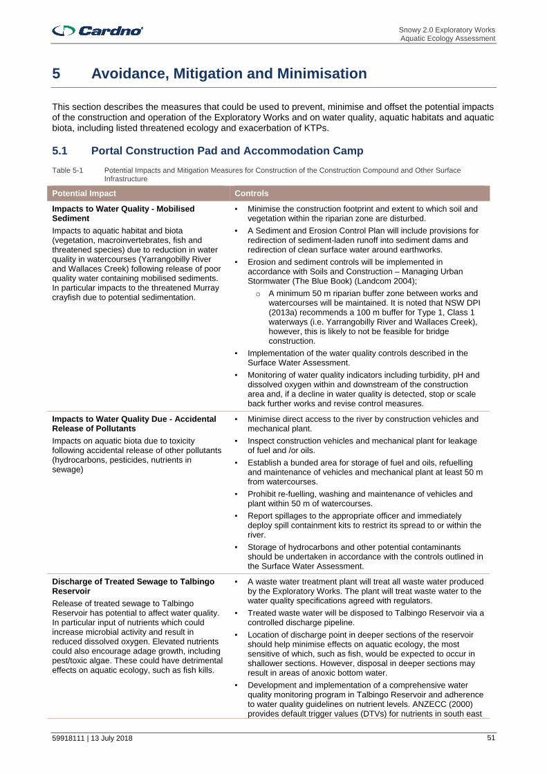
Snowy 2.0 Exploratory Works Aquatic Ecology Assessment
59918111 | 13 July 2018 51
5 Avoidance, Mitigation and Minimisation
This section describes the measures that could be used to prevent, minimise and offset the potential impacts of the construction and operation of the Exploratory Works and on water quality, aquatic habitats and aquatic biota, including listed threatened ecology and exacerbation of KTPs.
5.1 Portal Construction Pad and Accommodation Camp
Table 5-1 Potential Impacts and Mitigation Measures for Construction of the Construction Compound and Other Surface Infrastructure
Potential Impact Controls
Impacts to Water Quality - Mobilised Sediment
Impacts to aquatic habitat and biota (vegetation, macroinvertebrates, fish and threatened species) due to reduction in water quality in watercourses (Yarrangobilly River and Wallaces Creek) following release of poor quality water containing mobilised sediments. In particular impacts to the threatened Murray crayfish due to potential sedimentation.
▪ Minimise the construction footprint and extent to which soil and vegetation within the riparian zone are disturbed.
▪ A Sediment and Erosion Control Plan will include provisions for redirection of sediment-laden runoff into sediment dams and redirection of clean surface water around earthworks.
▪ Erosion and sediment controls will be implemented in accordance with Soils and Construction – Managing Urban Stormwater (The Blue Book) (Landcom 2004);
o A minimum 50 m riparian buffer zone between works and watercourses will be maintained. It is noted that NSW DPI (2013a) recommends a 100 m buffer for Type 1, Class 1 waterways (i.e. Yarrangobilly River and Wallaces Creek), however, this is likely to not be feasible for bridge construction.
▪ Implementation of the water quality controls described in the Surface Water Assessment.
▪ Monitoring of water quality indicators including turbidity, pH and dissolved oxygen within and downstream of the construction area and, if a decline in water quality is detected, stop or scale back further works and revise control measures.
Impacts to Water Quality Due - Accidental Release of Pollutants
Impacts on aquatic biota due to toxicity following accidental release of other pollutants (hydrocarbons, pesticides, nutrients in sewage)
▪ Minimise direct access to the river by construction vehicles and mechanical plant.
▪ Inspect construction vehicles and mechanical plant for leakage of fuel and /or oils.
▪ Establish a bunded area for storage of fuel and oils, refuelling and maintenance of vehicles and mechanical plant at least 50 m from watercourses.
▪ Prohibit re-fuelling, washing and maintenance of vehicles and plant within 50 m of watercourses.
▪ Report spillages to the appropriate officer and immediately deploy spill containment kits to restrict its spread to or within the river.
▪ Storage of hydrocarbons and other potential contaminants should be undertaken in accordance with the controls outlined in the Surface Water Assessment.
Discharge of Treated Sewage to Talbingo Reservoir
Release of treated sewage to Talbingo Reservoir has potential to affect water quality. In particular input of nutrients which could increase microbial activity and result in reduced dissolved oxygen. Elevated nutrients could also encourage adage growth, including pest/toxic algae. These could have detrimental effects on aquatic ecology, such as fish kills.
▪ A waste water treatment plant will treat all waste water produced by the Exploratory Works. The plant will treat waste water to the water quality specifications agreed with regulators.
▪ Treated waste water will be disposed to Talbingo Reservoir via a controlled discharge pipeline.
▪ Location of discharge point in deeper sections of the reservoir should help minimise effects on aquatic ecology, the most sensitive of which, such as fish, would be expected to occur in shallower sections. However, disposal in deeper sections may result in areas of anoxic bottom water.
▪ Development and implementation of a comprehensive water quality monitoring program in Talbingo Reservoir and adherence to water quality guidelines on nutrient levels. ANZECC (2000) provides default trigger values (DTVs) for nutrients in south east

Snowy 2.0 Exploratory Works Aquatic Ecology Assessment
59918111 | 13 July 2018 52
Potential Impact Controls
Australian freshwater lakes and reservoirs, though development of site-specific trigger values should be considered. Monitoring of biological indicators of elevated nutrients, such as chlorophyll a should also be considered.
Entrainment / Impingement of Fish Eggs and Larvae Due to Extraction of Potable and Construction Water from Talbingo Reservoir
▪ Location of pump in deeper sections of reservoir away from fish habitat such as woody debris and aquatic plants where fish and their eggs and larvae as less likely to occur.
▪ Starting the pump up slowly and then ramping up its velocity to a level that reduces the likelihood of aquatic biota in the vicinity of the intake being drawn into the pump.
▪ Incorporation of an enclosed, dark and long passage approach to the pump would also likely deter fish of all ages and size classes from entering this structure (NSW DPI 2016).
▪ If feasible, screening of the intake with at least 5 mm screen would prevent entrainment of all adult and most, if not all, juvenile fish. It would also likely be effective in minimising entrainment of larger sized larvae (e.g. those of trout cod and Murray cod). The use of a 3 mm screen would be expected to further minimise entrainment of larger larvae, and would be more effective in minimising entrainment of smaller larvae.
▪ If feasible, installation of a coarse mesh (e.g. cm aperture) screen / cage a few metres around the intake should also prevent / discourage adult fish from approaching the intake and utilising associated hard structures and the nearby area as a breading / egg deposition area, thereby further minimising the number of eggs and larvae in the vicinity of the intake. Removal and control of any aquatic vegetation within and immediately adjacent to the intake location would reduce the habitat value around this area and discourage its utilisation by fish.
▪ If feasible, limiting the approach water velocity at the headwall during normal operation ideally to 0.1 m/s would likely allow all adult and juvenile fish avoid entrainment and impingement. This is considered to be effective in reducing entrainment of Murray-Darling Basin fish (Boys et al. 2012).
Removal of riparian vegetation
Impacts to aquatic biota due to reduction in the amount of habitat (i.e. wood debris) and food provided by riparian vegetation.
▪ Minimise the construction footprint and extent to which vegetation within the riparian zone is disturbed.
5.2 Exploratory Tunnel Excavation
Table 5-2 Potential Impacts and Mitigation Measures for Excavation of Exploratory Tunnel
Potential Impact Controls
Reduced Baseflow to Water Courses Due to Interception of Groundwater Flows
▪ Concreting / grouting of tunnel walls to prevent inflows of intercepted groundwater.
▪ If groundwater is intercepted and reductions to groundwater inflows to watercourses predicted, then groundwater should be discharged to waterways. This would occur following appropriate treatment so that water quality of discharged water was comparable to baseline water quality of waterways.
5.3 Excavated Rock Management
Table 5-3 Potential Impacts and Mitigation Measures for Excavated Rock Management – Land Placement
Potential Impact Controls
Displacement of Aquatic Habitat Within the Third Order Lick Hole Creek
Minimisation of placement footprint where possible.
Impacts to Water Quality
Impacts to aquatic habitat and biota
▪ Minimise the construction footprint and extent to which soil and vegetation within the riparian zone are disturbed.

Snowy 2.0 Exploratory Works Aquatic Ecology Assessment
59918111 | 13 July 2018 53
Potential Impact Controls
(vegetation, macroinvertebrates, fish and threatened species) due to reduction in water quality in watercourses following reductions in water quality following disturbance of soils and potential leaching of any sediment-bound contaminants n
▪ As per controls for Portal Construction Pad and Accommodation Camp.
Table 5-4 Potential Impacts and Mitigation Measures for Excavated Rock Management – Subaqueous Placement
Potential Impact Controls
Displacement of Aquatic Habitat and Biota
Loss of soft sediment, wood debris, aquatic macrophytes and associated biota within the placement area
▪ Extent of the placement area will be minimised as far as practicable.
▪ Placement no shallower than 3 m below MOL (i.e. where aquatic habitat, such as aquatic plants and macrophytes are unlikely to occur).
▪ Mapping of aquatic habitats within and adjacent to the placement area would allow confirmation of the presence/absence of the aquatic habitats and vegetation within and adjacent to the placement area and the placement extent updated accordingly.
▪ Placement of large rocks within the placement area is expected to enhance the value of this habitat for fish and mobile invertebrates by providing hard surface and refuges.
▪ Mapping of aquatic habitats would include searches for crayfish burrows along the shoreline, as these could indicate the presence of Murray crayfish and would inform the final placement area extent. Deployment of crayfish traps along the shorelines adjacent to the placement area and within the placement area could be used to re-locate any large mobile invertebrates (including any Murray crayfish) from these areas to nearby sections of the reservoir that would not be affected by placement.
Impairment of Water Quality During Emplacement
Impacts to aquatic habitat and biota due to elevated suspended sediments, sedimentation and elevated turbidity within and outside the placement footprint. Also potential impacts to water quality due to release of any potential contaminants in the placement material.
▪ Suspended sediment and turbidity controls will be implemented throughout placement, including: o Deployment of silt curtains to enclose the placement area
and disposal barge and minimise transport of mobilised sediments into nearby sections of reservoir. These should be inspected for integrity at least daily. Particular attention should be given to inspection and maintenance following heavy rainfall and high winds.
o Material deposited via a fall pipe located below the water surface.
o No more than 10 % fines in the placement material. Fines would be wetted before placement to assist settling.
Characterisation of the potential contaminant content and acid forming content of the placement material. Only suitable material would be selected for placement within the reservoir.
▪ Well disposal equipment and barges will be used to minimise sediment loss/turbidity generation (e.g. leaking hopper seals).
▪ Water quality monitoring will be undertaken in accordance with a monitoring plan developed in consultation with regulators.
Care should be taken when loading barges to reduce the potential for sediment spills and uncontrolled discharges. Overflowing/overloading of barges should be avoided.
Temporary Disturbance Due to Noise
Disturbance to fish and other aquatic life during dredging and vessel use
▪ Un-necessary noise and vibration disturbances should be kept to a minimum to avoid impacts to fish and other aquatic species.
Increased Risk of Spills of Fuels and Oils ▪ Fuels and chemicals should be stored in bunded areas to prevent chemical spills or leakages entering the water.

Snowy 2.0 Exploratory Works Aquatic Ecology Assessment
59918111 | 13 July 2018 54
Potential Impact Controls
▪ Vehicles, vessels and plant would be properly maintained and regularly inspected for fluid leaks.
▪ An emergency spill kit should be kept onsite and on all vessels at all times during the Exploratory Works. The spill kit must be appropriately sized for the volume of substances on the vessel. All staff would be made aware of the location of the spill kit and trained in its use.
▪ An emergency plan should be developed for implementation in the event of a spill.
Spread of Pest Aquatic Plant Species
In particular, spread of aquatic plant and fish to other waterbodies
▪ All equipment and vessel components, such as propellers, hulls, anchors and any other equipment used should be inspected for pest aquatic plants and fish. All personnel working within the waters should be instructed how to identify potential pests.
▪ Vessels and vehicles should be washed down and cleaned prior to arriving at the boat ramp to be launched onto the reservoir and before travelling off-site from the reservoir.
5.4 Roads and Access
Table 5-5 Potential Impacts and Mitigation Measures for Road Access works and Watercourse Crossings
Potential Impact Controls (Applicable to Crossings Only, Unless Specified Otherwise)
Impacts to Water Quality - Mobilised Sediment
Bankside and any in-stream works have the potential to cause the mobilisation and release of sediments into watercourses.
▪ Restriction of vegetation clearing and construction works to no rainfall periods to reduce the risk of sediment runoff.
▪ Deployment of erosion control matting in the riparian zone and silt curtains along the river bank to prevent sediment entering the river channel and provision of protection against scouring and erosion of the river bed.
▪ Regular inspection of these control measures during the course of construction to ensure they are functioning properly;
▪ Stabilisation and rehabilitation of disturbed / eroded areas of the river bed and bank, riparian zone and in-stream aquatic habitat.
▪ Adjacent access roads should be constructed with reference to the requirements of Managing Urban Stormwater – Volume 2C Unsealed Roads (DECC 2008) to prevent surface run-off entering waterways.
Degradation of Riparian Vegetation ▪ Revegetation of disturbed banks and areas cleared of vegetation with appropriate native species.
▪ Native species selected for planting beneath the bridge structures should be tolerant of shade.
▪ Re-instatement of any wood debris and boulders removed during construction.
▪ Re-planting and rehabilitation of riparian vegetation along other sections of first and second order watercourses should be undertaken.
Disturbance and Displacement of In-Stream Aquatic Habitat
Any temporary structures may displace in-stream aquatic habitat and affect aquatic biota
▪ Minimise construction footprints and use of temporary structures where possible.
▪ Minimise access to watercourses by construction plant; ▪ Do not stockpile and construction material within or where it
may enter watercourses.
Barriers to Fish Passage and Changes in Natural Flow Regimes
Any temporary bridges and other structures that may hinder or prevent fish passage and change flow conditions in Yarrangobilly River and Wallaces Creek.
▪ As for controls for minimisation of disturbance and displacement of in-stream aquatic habitat.
▪ Avoidance or minimisation of works including temporary bridge deployment in Yarrangobilly River during the spawning time (October to January) of Macquarie perch if possible.
▪ Engineering the temporary Yarrangobilly River crossing so that some unmodified channel remains and a weir effect or flow

Snowy 2.0 Exploratory Works Aquatic Ecology Assessment
59918111 | 13 July 2018 55
Potential Impact Controls (Applicable to Crossings Only, Unless Specified Otherwise)
through rock interstices only is not created. For example, this could be created by installing artificial structures (such as square concrete blocks) with channel spaces small enough for vehicles to cross and large enough for some unobstructed flow between them. Alternatively, culverts could be installed within the fill material or along the side so as to maintain flow and fish passage while the structure was deployed.
▪ Ongoing maintenance to ensure any instream structures do not become filled with / collect debris thereby obstructing fish passage.
▪ Any temporary structure should be removed and the river channel rehabilitated following construction of the permanent bridge.
▪ Adherence to guidelines for temporary structures in NSW DPI (Fisheries) (2013a) and recommendations crossing design considerations in Fairfull and Witheridge (2003), which include: o Temporary in-stream structures should avoid spanning the
full width of the waterway channel to ensure base flow conditions are maintained down the waterway.
o Guidelines on the type of suitable fill material. o Temporary in-stream structures should be inserted during
low-flow periods, with management plans being submitted to NSW DPI detailing how high flow events will be managed to limit erosion of the structures and associated sedimentation of downstream waterways.
▪ Any large build-ups of debris potentially resulting in obstruction to fish passage should also be removed from the permanent piers within Yarrangobilly River.
5.5 Barge Access and Other Works in Talbingo Reservoir
Table 5-6 Potential Impacts and Mitigation Measures for Barge Access Structures and Other Works in Talbingo Reservoir
Potential Impact Controls
Displacement of Aquatic Habitat and Vegetation
Loss of soft sediment, wood debris and aquatic macrophytes in the dredge footprint and under the dredge spoil
▪ The extent of the dredge footprint should be minimised as far as possible.
▪ Return any wood debris removed from the dredge footprint to adjacent sections of the reservoir.
Mapping of aquatic habitats together with visual searches for burrows and deployment of crayfish traps in areas of potential habitat (as per Excavated Rock Management – Subaqueous Placement).
Impact to Water Quality Due to Sediment Mobilised During Dredging and Disposal
Impacts to aquatic habitat and biota due to sediments mobilised during dredging and disposal
▪ Silt and sediment controls should be established for the dredging footprint prior to commencement of dredging. Silt curtains and floating booms would be placed around any work areas where sediments may be disturbed to protect adjacent vegetation and habitat. These should be inspected for integrity regularly and maintained throughout the dredging operation to ensure effectiveness. Particular attention should be given to inspection and maintenance following rainfall and high winds.
▪ Well maintained dredging equipment and barges will be used to minimise sediment loss/turbidity generation (e.g. leaking hopper seals).
▪ Water quality monitoring will be undertaken in accordance with a monitoring plan developed in consultation with regulators.
▪ Containment measures (e.g. booms) would be installed around water based works for spill containment. Care should be taken when loading barges to reduce the potential for sediment spills and uncontrolled discharges. Overflowing/overloading of barges should be avoided.
▪ Sediment and erosion control measures must be in place for the
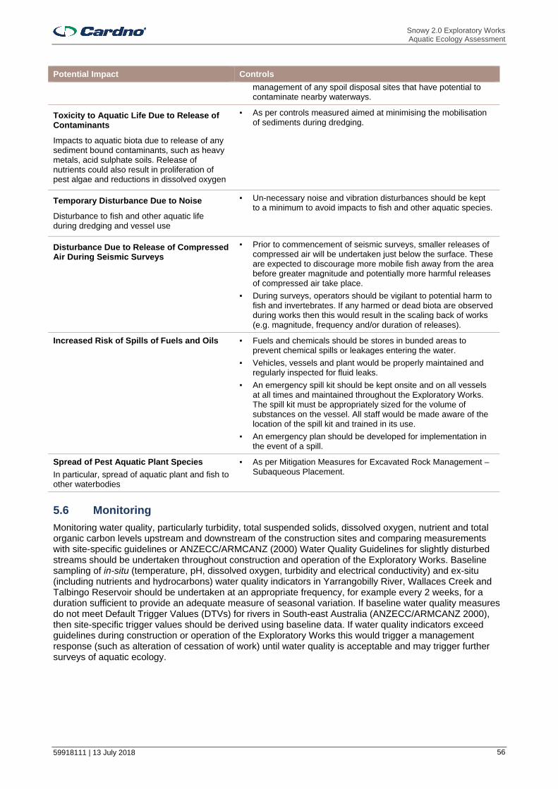
Snowy 2.0 Exploratory Works Aquatic Ecology Assessment
59918111 | 13 July 2018 56
Potential Impact Controls
management of any spoil disposal sites that have potential to contaminate nearby waterways.
Toxicity to Aquatic Life Due to Release of Contaminants
Impacts to aquatic biota due to release of any sediment bound contaminants, such as heavy metals, acid sulphate soils. Release of nutrients could also result in proliferation of pest algae and reductions in dissolved oxygen
▪ As per controls measured aimed at minimising the mobilisation of sediments during dredging.
Temporary Disturbance Due to Noise
Disturbance to fish and other aquatic life during dredging and vessel use
▪ Un-necessary noise and vibration disturbances should be kept to a minimum to avoid impacts to fish and other aquatic species.
Disturbance Due to Release of Compressed Air During Seismic Surveys
▪ Prior to commencement of seismic surveys, smaller releases of compressed air will be undertaken just below the surface. These are expected to discourage more mobile fish away from the area before greater magnitude and potentially more harmful releases of compressed air take place.
▪ During surveys, operators should be vigilant to potential harm to fish and invertebrates. If any harmed or dead biota are observed during works then this would result in the scaling back of works (e.g. magnitude, frequency and/or duration of releases).
Increased Risk of Spills of Fuels and Oils ▪ Fuels and chemicals should be stores in bunded areas to prevent chemical spills or leakages entering the water.
▪ Vehicles, vessels and plant would be properly maintained and regularly inspected for fluid leaks.
▪ An emergency spill kit should be kept onsite and on all vessels at all times and maintained throughout the Exploratory Works. The spill kit must be appropriately sized for the volume of substances on the vessel. All staff would be made aware of the location of the spill kit and trained in its use.
▪ An emergency plan should be developed for implementation in the event of a spill.
Spread of Pest Aquatic Plant Species
In particular, spread of aquatic plant and fish to other waterbodies
▪ As per Mitigation Measures for Excavated Rock Management – Subaqueous Placement.
5.6 Monitoring
Monitoring water quality, particularly turbidity, total suspended solids, dissolved oxygen, nutrient and total organic carbon levels upstream and downstream of the construction sites and comparing measurements with site-specific guidelines or ANZECC/ARMCANZ (2000) Water Quality Guidelines for slightly disturbed streams should be undertaken throughout construction and operation of the Exploratory Works. Baseline sampling of in-situ (temperature, pH, dissolved oxygen, turbidity and electrical conductivity) and ex-situ (including nutrients and hydrocarbons) water quality indicators in Yarrangobilly River, Wallaces Creek and Talbingo Reservoir should be undertaken at an appropriate frequency, for example every 2 weeks, for a duration sufficient to provide an adequate measure of seasonal variation. If baseline water quality measures do not meet Default Trigger Values (DTVs) for rivers in South-east Australia (ANZECC/ARMCANZ 2000), then site-specific trigger values should be derived using baseline data. If water quality indicators exceed guidelines during construction or operation of the Exploratory Works this would trigger a management response (such as alteration of cessation of work) until water quality is acceptable and may trigger further surveys of aquatic ecology.
Snowy 2.0 Exploratory Works Aquatic Ecology Assessment
59918111 | 13 July 2018 57
6 Conclusion
The Snowy 2.0 Exploratory Works have the potential to impact the aquatic ecology of Talbingo Reservoir, Yarrangobilly River, Wallaces Creek and some of their minor tributaries. Yarrangobilly River and Wallaces Creek, in particular, support relatively undisturbed aquatic habitat and the vulnerable Murray crayfish.
The primary potential impact to these watercourses is associated with reductions in water quality due to unplanned release of sediment laden water during Exploratory Works. The presence of other chemical pollutants and nutrients in any discharge may also affect aquatic biota. Such impacts could be adequately controlled by successful implementation of standard erosion and sediment controls and strict water quality controls. Waste water would only be released to Talbingo Reservoir and only following suitable treatment. There would only be minimal removal of riparian vegetation and no permanent obstruction of fish passage or alteration of flow regimes.
In Talbingo Reservoir, the greatest potential risk to aquatic ecology is associated with dredging works for barge access infrastructure and subaqueous spoil placement. These works could result in displacement of a small amount of aquatic habitat within the dredge footprint and disposal area and indirect impacts to nearby aquatic habitat and biota following elevated suspended sediment, turbidity and sedimentation associated with the dredge and disposal plumes. Although such impacts represent a substantial impact to aquatic ecology at the local scale, they represent a very low to negligible impact to the overall aquatic ecology of the reservoir due to the size of the reservoir and the abundance of comparable aquatic habitat throughout. Habitat mapping will be undertaken to confirm the occurrence of aquatic habitat within these areas and the extent of these areas and/or control measures updated, if required, to help ensure minimal impact to aquatic habitat and associated biota. There is a risk of some harm to and potential mortality of fish and invertebrates due to release of compressed air during seismic surveys within Middle Arm. However, seismic surveys would be localised to the proposed dredge area and would be only temporary.
Only a relatively small amount of KFH (primarily wood debris) within Talbingo Reservoir would be disturbed as part of barge ramp construction and associated dredging. Displaced wood debris would also be replaced within the reservoir, resulting in no net loss. A very small amount of KFH within Yarrangobilly River would be displaced due to construction of the temporary and permanent crossings. Indirect impacts to KFH due to potential smothering following any unplanned release of sediment laden water stored on-site or from the stockpiled excavated rock are unlikely given the best practice water quality controls that would be implemented. Thus, there would be very low to negligible impacts to the availability of KFH due to Exploratory Works and there would be no significant impact on any threatened species, population, endangered ecological community (including those which are MNES) or key threatening process triggered.
On the basis of the assessment of the existing aquatic environment and the description of the Exploratory Works this aquatic ecology assessment concludes that impacts would not significantly compromise the functionality, long-term connectivity or viability of habitats, or ecological processes within assemblages of biota beyond the small affected areas. The majority of impacts would be temporary. It is, however, important that the mitigation measures described here and in the assessments undertaken by other specialists aimed at minimising potential impacts on aquatic habitats and associated aquatic biota, are developed and implemented. Given successful implementation of these, residual impacts to aquatic ecology would be acceptable
Snowy 2.0 Exploratory Works Aquatic Ecology Assessment
59918111 | 13 July 2018 58
7 References
ABC News (2013). http://www.abc.net.au/news/2013-01-31/canberra-reef-balls-to-attract-native-fish/4492968
ACT Government (2017). Home Open Government Inform ACT Government Media Releases ACT Territory and Municipal Services Directorate Media Releases Artificial habitats installed for Murray cod in Molonglo River. http://www.cmd.act.gov.au/open_government/inform/act_government_media_releases/tamsd/2012/07/artificial_habitat_installed_for_murray_cod_in_molonglo_river
ANZECC (2000). Australian guidelines for water quality monitoring and reporting. National water quality management strategy, No. 7. Prepared for: Australian & New Zealand Governments. ANZECC//ARMCANZ, Australia.
Australian Soil Resource Information System (ASRIS) (2018). http://www.asris.csiro.au/index.html
Boys, C., Baumgartner, Rampano, B., Robinson, W., Alexander, T., Reilly, G, Roswell, M., Fowler, T., and Lowry, M. (2012). Development of fish screening criteria for water diversions in the Murray Darling Basin. Industry and Investment NSW.
Bureau of Meteorology, 2018. Groundwater Dependent Ecosystem Atlas. [Online] Available at: http://www.bom.gov.au/water/groundwater/gde/map.shtml [Accessed 2018].
Clarke, R.B. (1997). Marine Pollution, Fourth Edition. Oxford University Press. Oxford, UK.
Department of Environment and Energy (DEE) (2017). Draft National Recovery Plan for the Macquarie Perch (Macquaria australasica)
Department of the Environment (DoE) (2013). Significant impact guidelines 1.1 – Matters of National Environmental Significance, s.l.: s.n.
Department of Environment and Climate Change (DECC 2008). Managing Urban Stormwater – Volume 2C Unsealed Roads. http://www.environment.nsw.gov.au/resources/stormwater/0802soilsconststorm2c.pdf
Department of Sustainability and Environment (DSE) (2008a) National Recovery Plan for the Trout Cod (Maccullochella macquariensis). Trout Cod Recovery Team. https://www.environment.sa.gov.au/managing-natural-resources/Plants_Animals/Threatened_species_ecological_communities/Recovery_planning/Plans_for_threatened_animals_in_SA/Freshwater_fishes
Department of Sustainability and Environment (DSE) (2008b). National Recovery Plan for the Murray Cod (Maccullochella peelii peelii). https://www.environment.gov.au/system/files/resources/bcc0fbf6-279b-4c52-88c5-42ce4d44b864/files/murray-cod.pdf
Department of Sustainability, Environment, Water Population and Communities (DSEWPC 2011). Survey guidliens for Australia’s threatened fish. Guidelines for detecting fish listed as threatened under the Environment Protection and Biodiversity Conservation Act 1999.
Ebner, B.C.,Lintermans,M.,Jekabsons, M.and Dunford, M. (2010). Convoluted shorelines confound diel-range estimates of radio-tracked fish. Marine and Freshwater Research 61(12):1360-1365
EMM Consulting (EMM) (2018a). Snowy 2.0 Exploratory Works. Technical Report - Surface Water Assessment. June 2018.
EMM Consulting (EMM) (2018b). Snowy 2.0 Exploratory Works. Technical Report - Groundwater Assessment. June 2018.
EMM Consulting (EMM) (2018c). Snowy 2.0 Exploratory Works. Technical Report – Terrestrial Ecology Assessment. June 2018.
EnviroDNA (2018). Fish and decapod environmental DNA biodiversity surveys in the Snowy 2.0 project area. Draft. 14 June 2018.
Fairfull, S. and Witheridge, G. (2003) Why do Fish Need to Cross the Road? Fish Passage Requirements for Waterway Crossings. NSW Fisheries, Cronulla, 16 pp.
Snowy 2.0 Exploratory Works Aquatic Ecology Assessment
59918111 | 13 July 2018 59
https://www.dpi.nsw.gov.au/__data/assets/pdf_file/0004/633505/Why-do-fish-need-to-cross-the-road_booklet.pdf
Fisheries Scientific Committee (FSC) (2013). Final Determination. The Murray crayfish – Euastacus armatus as a Vulnerable Species. https://www.dpi.nsw.gov.au/__data/assets/pdf_file/0003/636492/Murray-Crayfish-final-determination.pdf
Honeysett, J., 2015. The response of riparian and aquatic vegetation to environmental water allocations to the Snow River: A spatial analysis of the Dalgety Uplands, s.l.: University of Wollongong.
Independent Scientific Committee, 2004. An assessment of the values of Koscuiszko National Park, s.l.: NSW National Parks and Wildlife Service.
Joy, J. & Jones, L., 1973. Observations on the inflammatory response within the dermis of a white bass, Morone chrysops (Rafinesque), infected with Lernaea cruciata (Copepoda: Caligidea). Journal of Fish Biology, Volume 5, pp. 21-23.
Khalifa, K. & Post, G., 1976. Histopathological Effect of Lernaea cyprinacea (a Copepod Parasite) on Fish. The Progressive Fish-culturist, Volume 38, pp. 110-113.
Kupferberg, S., Catenazzi, A., Lunde, K., Lind, A., & Palen, W. (2009). Parasitic Copepod (Lernaea cyprinacea) Outbreaks in Foothill Yellow-legged Frogs (Rana boylii) Linked to Unusually Warm Summers and Amphibian Malformations in Northern California. Copeia, 529-537.
Landcom (2004). Soils and Construction. Volume 1. Managing Urban Stormwater. http://www.environment.nsw.gov.au/resources/water/BlueBookVol1.pdf
Linterman, M. (2002). Fish in the upper Murrumbidgee Catchment.Lintermans, M. (2007). Fishes of the Murray-Darling Basin. An Introductory Guide.
McCauley, J. Fewtrell, A.J. Duncan, C. Jenner, N. Jenner, J.D. Penrose, R.I.T. Prince, A. Adhitya, J. Murdoch, K. McCabe. (2000). Marine Seismic Surveys – A Study of Environmental Implications.
Murray-Darling Basin Authority (MDBA) (2011a). Native Fish Strategy, Fish Factsheet: Murray Cod. Australian Government, Murray-Darling Basin Authority, Canberra, ACT.
Murray-Darling Basin Authority (MDBA) (2011b). Native Fish Strategy, Fish Factsheet: Trout Cod. Australian Government, Murray-Darling Basin Authority, Canberra, ACT.
Murray-Darling Basin Authority (MDBA) (2011d). Native Fish Strategy, Fish Factsheet: Silver Perch. Australian Government, Murray-Darling Basin Authority, Canberra, ACT.
Murray-Darling Basin Authority (MDBA) (2011e). Native Fish Strategy, Fish Factsheet: Flathead Galaxais Australian Government, Murray-Darling Basin Authority, Canberra, ACT.
Murray-Darling Basin Authority (MDBA) (2011f). Native Fish Strategy, Fish Factsheet: Eel Tailed Catfish. Australian Government, Murray-Darling Basin Authority, Canberra, ACT.
Murray-Darling Basin Commission (MDBC) (2007a). Native Species. Climbing galaxias (Broad-finned galaxias). https://www.mdba.gov.au/sites/default/files/archived/mdbc-NFS-reports/2202_factsheet_native_climbing_galaxias.pdf
Murray-Darling Basin Commission (MDBC) (2007b). Native Species. Northern river blackfish. https://www.mdba.gov.au/sites/default/files/archived/mdbc-NFS-reports/2203_factsheet_native_northern_river_blackfish.pdf
Murray-Darling Basin Commission (MDBC) (2007c). Native Species. Murray hardyhead (Craterocephalus fluviatilis) https://www.mdba.gov.au/sites/default/files/archived/mdbc-NFS-reports/2203_factsheet_native_murray_hardyhead.pdf
Murray-Darling Basin Commission (MDBC) (2007d). Native Species. Freshwater catfish (Tandanus tandanus). https://www.mdba.gov.au/sites/default/files/archived/mdbc-NFS-reports/2202_factsheet_native_freshwater_catfish.pdf
Murray-Darling Basin Commission (MDBC) (2007e). Alien Species. Goldfish. (Carassius auratus). https://www.mdba.gov.au/sites/default/files/archived/mdbc-NFS-reports/2201_factsheet_alien_goldfish.pdf
National Murray Cod Recovery Team (2010a). Background and Implementation Information for the National Recovery Plan for the Murray Cod Maccullochella peelii peelii. (Department of Sustainability and Environment, Melbourne.
Snowy 2.0 Exploratory Works Aquatic Ecology Assessment
59918111 | 13 July 2018 60
NSW Department of Planning and Environment (DPE) (2015). Critical State Significant Infrastructure Standard Secretary’s Environmental Assessment Requirements (SEARs). http://www.planning.nsw.gov.au/Assess-and-Regulate/Development-Assessment/Systems/~/media/129372A5B29A4BCDA30CF1AADA8D7E1A.ashx
NSW DPI (2005a). NSW DPI Primefact 10. Key Threatening Processes in NSW. Instream Structures and Other Mechanisms that Alter Natural Flows. http://www.dpi.nsw.gov.au/__data/assets/pdf_file/0016/34252/Primefact_Instream_structures.pdf
NSW DPI (2005b). NSW DPI Primefact 12. Key Threatening Processes in NSW. Degradation of Native Riparian Vegetation along NSW Water Courses. http://www.dpi.nsw.gov.au/__data/assets/pdf_file/0015/34251/Primefact_Degradation_of_Native_Riparian_Vegetation.pdf
NSW DPI (2005c). NSW DPI Primefact 11. Key Threatening Processes in NSW. Removal of large woody debris from NSW rivers and streams. https://www.dpi.nsw.gov.au/__data/assets/pdf_file/0011/634529/Primefact_Removal_of_large_woody_debris.pdf
NSW DPI (2005a). Primefacts. Threatened species in NSW. Silver perch. http://www.dpi.nsw.gov.au/__data/assets/pdf_file/0014/5081/Primefact_Silver_perch.pdf
NSW DPI (2006a), Silver Perch. NSW Recovery Plan. https://www.dpi.nsw.gov.au/__data/assets/pdf_file/0007/636388/NSW-Silver-Perch-Recovery-Plan.pdf
NSW DPI (2006b). Trout cod (Maccullochella macquariensis) recovery plan. http://www.dpi.nsw.gov.au/__data/assets/pdf_file/0006/228498/trout-cod-recovery-plan.pdf
NSW DPI (Fisheries) (2013a). Policy and Guidelines for Fish Habitat Conservation and Management (2013 update). http://www.dpi.nsw.gov.au/__data/assets/pdf_file/0009/468927/Policy-and-guidelines-for-fish-habitat.pdf
NSW DPI (2013b). Primefact. Fishing for Murray Crayfish in NSW. https://www.dpi.nsw.gov.au/__data/assets/pdf_file/0009/463653/fishing_for_murray_crayfish_in_nsw_v2.pdf
NSW DPI (2013c). NSW impoundment stockings 2005/06 – 2012/13 (all programs). http://www.dpi.nsw.gov.au/__data/assets/pdf_file/0007/511963/NSW-fish-stocking-record-200506-201213.pdf
NSW DPI (2014). Primefact. Flathead Galaxias (Galaxias rostratus). https://www.dpi.nsw.gov.au/__data/assets/pdf_file/0020/635123/primefact-880-flathead-galaxias.pdf
NSW DPI (2016a). Fish communities and threatened species distributions of NSW.
NSW DPI (2016b). Primefact. Macquarie Perch - Macquaria australasica. April 2016, Primefact 9, Third Edition. Threatened Species Unit, Port Stephens Fisheries Institute. http://www.dpi.nsw.gov.au/__data/assets/pdf_file/0010/635257/primefact-9-macquarie-perch-macquaria-australasica-2.pdf
NSW DPI (2013c). Primefact. Southern Pygmy Perch. (Nannoperca australis). https://www.dpi.nsw.gov.au/__data/assets/pdf_file/0009/635364/primefact-190-southern-pygmy-perch.pdf
NSW DPI (2017a). Draft National Recovery Plan for the Macquarie perch (Macquaria australasica). http://www.environment.gov.au/system/files/resources/8e9c5e38-7b7f-4b91-9f8d-66fd90eca1c2/files/draft-recovery-plan-macquarie-perch.pdf
NSW DPI (2017b). Priorities Action Statement - Actions for Macquarie Perch. http://www.dpi.nsw.gov.au/fishing/species-protection/conservation/what-current/endangered-species/macquarie-perch/priorities-action-statement-actions-for-macquarie-perch
NSW DPI (2017c) Protecting Macquarie Perch – a guide for fishers and land managers. https://www.dpi.nsw.gov.au/__data/assets/pdf_file/0010/747379/protecting-macquarie-perch-a-guide-for-fishers-and-land-managers.pdf
NSW DPI (2017d). Primefact. Trout Cod - Maccullochella macquariensis. February 2017, Primefact 185, Third Edition. Threatened Species Unit, Port Stephens Fisheries Institute. https://www.dpi.nsw.gov.au/__data/assets/pdf_file/0004/635512/Trout-cod.pdf

Snowy 2.0 Exploratory Works Aquatic Ecology Assessment
59918111 | 13 July 2018 61
NSW DPI (2018a). Home. Fishing. Threatened species. Species List. Listed threatened species, populations, ecological communities and key threatening processes. https://www.dpi.nsw.gov.au/fishing/species-protection/conservation/what-current/endangered-species/macquarie-perch
NSW DPI (2018b). Home. Fishing Recreational. fishing Resources for fishers. Fish Stocking. https://www.dpi.nsw.gov.au/fishing/recreational/resources/stocking
NSW DPI (2018c). Protecting Trout Cod - a guide for fishers and land managers. https://www.dpi.nsw.gov.au/fishing/species-protection/conservation/what-current/endangered-species/trout-cod/protecting-trout-cod
NSW DPI (2018d). Sliver Perch. https://www.dpi.nsw.gov.au/fishing/species-protection/conservation/what-current/vulnerable-species/silver-perch
NSW DPI (2018e). Flathead galaxias. https://www.dpi.nsw.gov.au/fishing/species-protection/conservation/what-current/critically/flathead-galaxias
NSW DPI (2018f). Fishing. Key Fish Habitat Maps. Tumut. https://www.dpi.nsw.gov.au/__data/assets/pdf_file/0004/634360/Tumut.pdfTimms, B., 1980. The benthos of Australia Lakes. In: W. Williams, ed. A Biological Basis for Water Resource Management in Australia. s.l.:ANU Press.
NSW DPI (2018g). Fishing. Fish Species. Murray Crayfish. https://www.dpi.nsw.gov.au/fishing/fish-species/species-list/murray-crayfish
RHDHV (2018a). Snowy 2.0 Exploratory Works. Technical Report – Subaqueous excavated rock placement assessment
RHDHV (2018b). Snowy 2.0 Exploratory Works. Technical Report - Barge access infrastructure
RHDHV (2018c). Snowy 2.0 Exploratory Works. Technical Report - Dredging and dredging impact assessment
SGMW (2018). Snowy 2.0 Exploratory Works. Technical Report - Excavated rock emplacement areas assessment
Talbingo Fishing Club (2017). The Fish Are Bitting At Talbingo. Posted on August 17, 2017 by Kari. http://www.talbingofishingclub.com.au/the-fish-are-bitting-at-talbingo/
Trout Cod Recovery Team (2008). Background and Implementation Information for the Trout Cod Maccullochella macquariensis National Recovery Plan. Department of Sustainability and Environment, Melbourne.
Webster, F.J., Wise, B.S., Fletcher, W.J., and Kemps, H 2018. Risk Assessment of the potential impacts of seismic air gun surveys on marine finfish and invertebrates in Western Australia. Fisheries Research Report No. 288 Department of Primary Industries and Regional Development, Western Australia. 42pp.
Whittington. R., Joy Becker, Alison Tweedie, Dean Gilligan and Martin Asmus, (2011), Susceptibility of previously untested basin fish species to Epizootic Haematopoietic Necrosis Virus (EHNV) and its epidemiology in the wild. Final Report. The University of Sydney. Project No. MD743

Snowy 2.0 Exploratory Works Aquatic Ecology Assessment
59918111 | 13 July 2018 62
Aquatic Ecology Assessment
APPENDIX
A RCE INVENTORY CRITERIA AND RESULTS
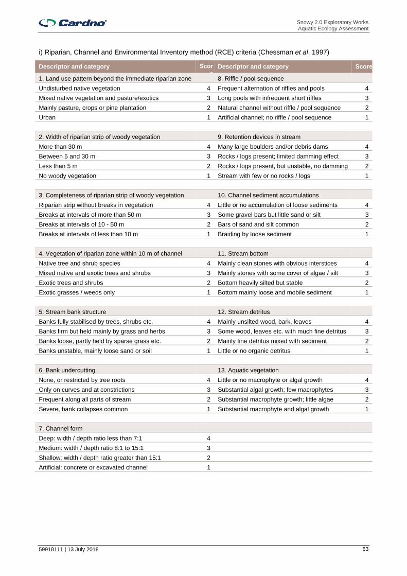
Snowy 2.0 Exploratory Works Aquatic Ecology Assessment
59918111 | 13 July 2018 63
i) Riparian, Channel and Environmental Inventory method (RCE) criteria (Chessman et al. 1997)
Descriptor and category Score
Descriptor and category Score
1. Land use pattern beyond the immediate riparian zone 8. Riffle / pool sequence
Undisturbed native vegetation 4 Frequent alternation of riffles and pools 4
Mixed native vegetation and pasture/exotics 3 Long pools with infrequent short riffles 3
Mainly pasture, crops or pine plantation 2 Natural channel without riffle / pool sequence 2
Urban 1 Artificial channel; no riffle / pool sequence 1
2. Width of riparian strip of woody vegetation 9. Retention devices in stream
More than 30 m 4 Many large boulders and/or debris dams 4
Between 5 and 30 m 3 Rocks / logs present; limited damming effect 3
Less than 5 m 2 Rocks / logs present, but unstable, no damming 2
No woody vegetation 1 Stream with few or no rocks / logs 1
3. Completeness of riparian strip of woody vegetation 10. Channel sediment accumulations
Riparian strip without breaks in vegetation 4 Little or no accumulation of loose sediments 4
Breaks at intervals of more than 50 m 3 Some gravel bars but little sand or silt 3
Breaks at intervals of 10 - 50 m 2 Bars of sand and silt common 2
Breaks at intervals of less than 10 m 1 Braiding by loose sediment 1
4. Vegetation of riparian zone within 10 m of channel 11. Stream bottom
Native tree and shrub species 4 Mainly clean stones with obvious interstices 4
Mixed native and exotic trees and shrubs 3 Mainly stones with some cover of algae / silt 3
Exotic trees and shrubs 2 Bottom heavily silted but stable 2
Exotic grasses / weeds only 1 Bottom mainly loose and mobile sediment 1
5. Stream bank structure 12. Stream detritus
Banks fully stabilised by trees, shrubs etc. 4 Mainly unsilted wood, bark, leaves 4
Banks firm but held mainly by grass and herbs 3 Some wood, leaves etc. with much fine detritus 3
Banks loose, partly held by sparse grass etc. 2 Mainly fine detritus mixed with sediment 2
Banks unstable, mainly loose sand or soil 1 Little or no organic detritus 1
6. Bank undercutting 13. Aquatic vegetation
None, or restricted by tree roots 4 Little or no macrophyte or algal growth 4
Only on curves and at constrictions 3 Substantial algal growth; few macrophytes 3
Frequent along all parts of stream 2 Substantial macrophyte growth; little algae 2
Severe, bank collapses common 1 Substantial macrophyte and algal growth 1
7. Channel form
Deep: width / depth ratio less than 7:1 4
Medium: width / depth ratio 8:1 to 15:1 3
Shallow: width / depth ratio greater than 15:1 2
Artificial: concrete or excavated channel 1

Snowy 2.0 Exploratory Works Aquatic Ecology Assessment
59918111 | 13 July 2018 64
ii) Results of RCE assessment
RCE Category 1a 2a 4 10
Land use pattern beyond the immediate riparian zone 3 4 3 3
Width of riparian strip of woody vegetation 3 4 4 4
Completeness of riparian strip of woody vegetation 3 4 3 4
Vegetation of riparian zone within 10 m of channel 3 4 3 3
Stream bank structure 4 4 4 4
Bank undercutting 4 4 4 4
Channel form 3 4 4 4
Riffle/pool sequence 4 4 2 n/a
Retention devices in stream 3 4 3 3
Channel sediment accumulations 4 4 1 4
Stream bottom 4 4 2 4
Stream detritus 4 4 3 4
Aquatic vegetation 4 4 4 n/a
Total 46 52 40 37

Snowy 2.0 Exploratory Works Aquatic Ecology Assessment
59918111 | 13 July 2018 65
Aquatic Ecology Assessment
APPENDIX
B ASSESSMENTS OF SIGNIFICANCE

Snowy 2.0 Exploratory Works Aquatic Ecology Assessment
59918111 | 13 July 2018 66
i) Macquarie Perch (Macquaria australasica) – Assessment of Significance Based on Significant Impact Criteria for Critically Endangered and Endangered Species under the EPBC Act
An action is likely to have a significant impact on an endangered species if there is a real chance or possibility that it will:
a. Lead to a long-term decrease in the size of a population
Macquarie perch is listed as endangered under the EPBC Act and the FM Act. They are found in the Murray-Darling Basin, particularly the upstream reaches of the Lachlan, Murrumbidgee and Murray rivers, and parts of southeastern coastal NSW, including the Hawkesbury and Shoalhaven catchments (NSW DPI 2018). The draft National Recovery Plan for Macquarie perch (NSW DPI 2017a) identifies four self-sustaining populations as occurring in NSW. One of these is the upper Murrumbidgee River below Tantangara Dam upstream of Gigerline Gorge. Another is Adjungbilly Creek in the Tumut River catchment, downstream of Blowering Talbingo reservoirs. The other two are in the upper Lachlan River and Hawkesbury-Nepean River system. None of these are within Talbingo Reservoir or Yarrangobilly River (which flows into it).
A stocked population of Macquarie perch was reported to occur in Talbingo Reservoir (NSW DPI 2017), although it does not appear to have been stocked here in the last 10 years and it is unclear if this species still occurs there. NSW DPI (2016a) predicts that suitable habitat for this species occurs in the lower Yarrangobilly River. While there is potential for a self-sustaining population in the Study Area, its potential to contribute substantially to the integrity (e.g. population numbers and genetic diversity) of the wider Murray-Darling Basin population is likely to be minimal due to the presence of several existing barriers to fish passage. These include Talbingo and Blowering dam walls.
Macquarie perch prefer clear water and deep, rocky holes with extensive cover in the form of aquatic vegetation, large boulders, woody debris and overhanging banks (NSW DPI 2016b), which are all present in Talbingo Reservoir and Yarrangobilly River. They spawn in spring or summer and lay eggs over stones and gravel in shallow, fast-flowing upland streams or flowing parts of rivers. Macquarie perch inhabiting impoundments such as Talbingo Reservoir would likely undertake upstream spawning migration in October to mid-January after which adults usually move from the streams to the lake.
Based on the above information, Macquarie perch are considered to have a moderate potential of occurrence in Talbingo Reservoir and in the lower Yarrangobilly River (Cardno 2018). Components of the Exploratory Works of Snowy 2.0 with potential to affect Macquarie perch and/or its habitat include:
> Displacement of some fish habitat including woody debris and aquatic macrophytes under the footprint of two barge ramp structures (Talbingo barge ramp and Middle Bay barge ramp) and under the footprint of associated dredging works (construction footprint and navigation channel);
> Displacement of aquatic habitat and impacts to water quality associated with potential shoreline disposal of dredge material from construction of the Talbingo barge ramp and subaqueous placement of dredge material and excavated material;
> Impacts on water quality in Talbingo Reservoir due to discharge of treated sewage;
> Impacts to water quality in Yarrangobilly River and Wallace’s Creek due to run-off of sediment-laden water;
> Potential entrainment due to extraction of water from Talbingo Reservoir to supply potable and construction water requirements;
> Obstruction of migration associated with reproduction due to construction of a temporary (causeway type) and permanent (bridge) crossing on the Yarrangobilly River at the current ford crossing; and
> Disturbance and harm due to noise from release of compressed air as part of seismic surveys within Middle Bay.
The total area of aquatic habitat that would be displaced by barge access infrastructure and associated dredging is very small compared with the total area of the reservoir. Wood debris and aquatic macrophytes are also abundant throughout the reservoir. Thus, the loss / alteration of habitat due to dredging is expected to have a negligible effect on the amount of potential Macquarie perch habitat in the reservoir.
Indirect effects on water quality due to barge access infrastructure and associated dredging, specifically elevated turbidity and sedimentation would likely be very small, localised and short term.
Discharge of treated wastewater containing nutrients has potential to exacerbate the risk of algal blooms or indirectly reduce dissolved oxygen levels in Talbingo Reservoir due to increased biological oxygen demand following nutrient input. Input of sediment-laden water from surface run-off in Yarrangobilly River and its
Snowy 2.0 Exploratory Works Aquatic Ecology Assessment
59918111 | 13 July 2018 67
tributary, Wallace’s Creek could temporarily affect the ecology of Macquarie perch in the creeks as well as downstream. A waste water treatment plant will treat all waste water produced by the Exploratory Works. The plant will treat waste water to the water quality criteria specified by an EPL. Standard sediment and erosion controls would be put in place during any construction works near water. Water quality would also be regularly monitored to ensure that measures to manage water quality are effective and targets are met. Given these measures are taken, the proposed Exploratory Works are not expected to impact on water quality such that a Macquarie perch population (if present) would be impacted.
The risk of entrainment of Macquarie perch eggs is very low given their reproductive characteristics. Macquarie perch lay adhesive eggs in shallow riffle sections of flowing streams (NSW DPI 2017). Newly hatched yolk sac larvae shelter amongst pebbles. This would suggest they would be unlikely to be suspended in the water column and susceptible to entrainment. Larvae (if present) may be more susceptible to entrainment, though their relatively large size (7 mm) may allow them to actively avoid entraining. Adoption of appropriate approach velocities and mesh screen aperture sizes and deployment of the pump away from woody debris and macrophytes would help minimise the potential for entrainment. Macquarie perch juveniles and adults would be able to actively avoid entrainment.
The temporary crossing over Yarrangobilly River may obstruct passage of Macquarie perch undertaking upstream migrations from Talbingo Reservoir in search of spawning habitat in Yarrangobilly River. The temporary crossing would be designed and installed to provide fish passage hence minimising potential obstruction of passage to Macquarie perch. Deployment of the temporary crossing would also be avoided during the spawning time of October to January. The permanent bridge crossing is not expected to result in any substantial barrier to fish passage.
Displacement of a small amount aquatic habitat at subaqueous placement locations would result in a minor loss of key fish habitat. Subaqueous placement would be undertaken in deep sections of the reservoir and would be selected to avoid key fish habitat. No aquatic plants are expected to occur in deeper sections due to reduced light. Any woody debris present would also be relatively deep and unlikely to be used by Macquarie perch. Placement along shallow sections of the reservoir as part of construction of the Talbingo barge ramp may displace a very small amount of shallower aquatic plants and wood debris. In any case, these habitats and soft sediment habitat are abundant throughout the reservoir and loss of a small amount under the placement footprint is likely to have negligible effect on its availability to Macquarie perch. Placement would result in short-term, localised disturbance to the reservoir bed resulting in elevated suspended sediments, sedimentation and turbidity. Standard controls, including the use silt curtains and ongoing monitoring of water quality would be undertaken as part of an environmental monitoring program to ensure water quality targets are met and turbidity levels minimised. Laboratory assessment of the physical and chemical characteristics of the excavated rock will be undertaken prior to placement to ensure material meets specified criteria.
The risk of disturbance and/or harm due to release of compressed air during seismic surveys would depend on the level of noise generated and the duration of works. There is potential for harm and potential mortality of individuals in the immediate vicinity of the release of compressed air. The potential risk to this species would be minimised to an extent by the temporary nature of the surveys (approximately 100 firings over a few days) and the relatively localised position within an arm of the reservoir. Prior to commencement of seismic surveys, smaller releases of compressed air would also be undertaken just below the surface. These are expected to discourage fish away from the area before greater magnitude and potentially more harmful releases of compressed air take place. It is noted that harm or mortality of aquatic biota has not been observed during several previous comparable surveys undertaken by the operators (SMEC, Pers. Comm. 10 July 2018).
The minor reduction in baseflow associated with groundwater seepage into the Exploratory Tunnel is not expected to change the flow regimes in either the Yarrangobilly River or Wallaces Creek during normal and drought conditions. Thus, there would not be any reduction in the availability or connectivity of aquatic habitat and no associated impacts to this species are expected.
In general, potential impacts to Macquarie perch due to the Exploratory Works are likely to be small-scale and temporary and unlikely to result in any long term decrease in population size should they be present within the Study Area.
b. Reduce the area of occupancy of the species
Macquarie perch habitat (submerged woody debris, rocks and boulders) is abundant throughout the reservoir and downstream reaches of Yarrangobilly River, however, there would be negligible reduction to this habitat due to Exploratory Works. The temporary or permanent crossings of Yarrangobilly River would not represent a complete or permanent obstruction to fish passage. As described above, potential impacts to

Snowy 2.0 Exploratory Works Aquatic Ecology Assessment
59918111 | 13 July 2018 68
Macquarie perch due to the exploratory works are likely to be small-scale and temporary and would not result in a reduction of the area of occupancy of the species should they occur within the Study Area.
c. Fragment an existing population into two or more populations
As described in (a), potential impacts to Macquarie perch due to the exploratory works are likely to be small-scale and temporary. Given the temporary crossing of Yarrangobilly River would be designed and installed to provide fish passage and would avoid the Macquarie perch spawning period of October to January, there would be little potential to fragment a population of Macquarie perch potentially occurring in Talbingo Reservoir and/or the Yarrangobilly River.
d. Adversely affect habitat critical to the survival of a species
As described in (a), potential impacts to Macquarie perch due to the exploratory works are likely to be small-scale and temporary and would not affect habitat critical to the survival of a species.
e. Disrupt the breeding cycle of a population
Macquarie perch undertake upstream migrations as part of reproduction in October to January. Although works within Talbingo Reservoir and Yarrangobilly River during this time may disturb nearby fish e.g. via temporary noise or minor habitat alteration these works would not occur during times of spawning migrations. The temporary crossing at Yarrangobilly River would be designed to ensure it does not represent a complete or permanent obstruction to fish passage.
f. Modify, destroy, remove or isolate or decrease the availability or quality of habitat to the extent that the species is likely to decline
As described in (a) – (d) potential impacts to Macquarie perch due to the exploratory works are likely to be small-scale and temporary and would not significant affect its forage, resting or spawning habitat to the extent that the species is likely to decline should it occur within the Study Area.
g. Result in invasive species that are harmful to an endangered species becoming established in the endangered species’ habitat
Invasive species that may predate on Macquarie perch eggs or young fish and/or potentially compete with Macquarie perch for food and habitat include redfin perch (Perca fluviatilis), rainbow trout (Oncorhynchus mykiss), brown trout (Salmo trutta), wild goldfish (Carassius auratus), eastern gambusia (Gambusia holbrooki) and carp (Cyprinus carpio). Redfin perch, wild goldfish and eastern gambusia were caught in Talbingo Reservoir during the aquatic ecology investigation and trout are stocked here by NSW DPI (Fisheries). Construction and barge transport vessels have potential to act as vectors for introduced species, however, appropriate hygiene protocols will be followed so that the further spread or introduction of these species by these vectors is unlikely and would not be expected to result in any further additional associated impact to Macquarie perch.
h. Introduce disease that may cause the species to decline
The invasive species listed in g) may carry disease, such as EHNV or parasites that could infect Macquarie perch. However, exploratory works represents little risk of introduction of these.
i. Interfere substantially with the recovery of the species
The major current threats to Macquarie perch are:
> Habitat degradation;
> Invasive fish;
> Barriers to fish movement;
> Altered flow and thermal regimes;
> Disease;
> Illegal and incidental capture;
> Chemical water pollution;
> Climate change.
The objectives of the draft Macquarie perch recovery plan (DEE 2017) are to:
> Conserve existing Macquarie perch populations;
> Protect and restore Macquarie perch habitat;

Snowy 2.0 Exploratory Works Aquatic Ecology Assessment
59918111 | 13 July 2018 69
> Investigate threats to Macquarie perch populations and habitats;
> Establish additional Macquarie perch populations;
> Improve understanding of the biology and ecology of the Macquarie perch and its distribution and abundance; and
> Increase participation by community groups in Macquarie perch conservation.
The following Priority Action Statements for Macquarie perch (NSW DPI 2017) exist:
> Advice to consent and determining authorities;
> Collate and review existing information;
> Community and stakeholder liaison, awareness and education;
> Compliance / enforcement;
> Enhance, modify or implement Natural Resource Management planning processes to minimize adverse impacts on threatened species;
> Habitat rehabilitation;
> Pest eradication and control;
> Research / monitoring;
> Stocking / translocation; and
> Survey / mapping.
As potential impacts associated with Exploratory Works are likely to be small-scale and temporary and unlikely to result in any long-term effect on Macquarie perch or its habitat, the proposed works are not expected to interfere with these objectives and the recovery of the species.
Conclusion
Barge ramp construction and dredging would result in a very small reduction in potential Macquarie perch habitat in Talbingo Reservoir and temporary disturbance to areas nearby the works. These impacts are likely to be negligible considering the abundance of this habitat in the reservoir. Given its reproductive characteristics, the species would be at low risk of potential entrainment due to water extraction. There would be no permanent or complete barrier to fish barrier installed in Yarrangobilly River that could affect passage of this species and the proposed temporary crossing would be fish-friendly and would not be deployed when this species is undertaking upstream migration as part of reproduction. The quality of waste water at discharges in Yarrangobilly River would be managed to meet EPL conditions and there would be standard sediment control during works near water as well as monitoring to verify standards were met.
Subaqueous placement of dredged and excavated material in the reservoir is not expected to result in any loss of key fish habitat and associated reductions in water quality will be managed and minimised. Further assessment of the physical and chemical characteristics of the material will be undertaken to confirm the type and appropriateness of control measures required.
Disturbances due to elevated noise during seismic surveys, if they occur, are expected to be localised within Middle Arm and temporary with soft start measures in place to disburse any fish present prior to survey level noise. Thus, it is considered that if Macquarie perch do occur within the Study Area, it is unlikely that the Exploratory Works will have a significant impact to this species.
References
Cardno (2018). Exploratory Works EIS. Aquatic Ecology. July 2018.
NSW DPI (2016b). Primefact. Macquarie Perch - Macquaria australasica. April 2016, Primefact 9, Third Edition. Threatened Species Unit, Port Stephens Fisheries Institute. http://www.dpi.nsw.gov.au/__data/assets/pdf_file/0010/635257/primefact-9-macquarie-perch-macquaria-australasica-2.pdf
NSW DPI (2017a). Draft National Recovery Plan for the Macquarie Perch (Macquaria australasica)
NSW DPI (2018a). Home. Fishing. Threatened species. Species List. Listed threatened species, populations, ecological communities and key threatening processes. https://www.dpi.nsw.gov.au/fishing/species-protection/conservation/what-current/endangered-species/macquarie-perch

Snowy 2.0 Exploratory Works Aquatic Ecology Assessment
59918111 | 13 July 2018 70
ii) Macquarie Perch (Macquaria australasica) – listed as endangered under the FM Act
In the case of a threatened species, whether the action proposed is likely to have an adverse effect on the life cycle of the species such that a viable local population of the species is likely to be placed at risk of extinction
Macquarie perch are found in the Murray-Darling Basin, particularly the upstream reaches of the Lachlan, Murrumbidgee and Murray rivers, and parts of southeastern coastal NSW, including the Hawkesbury and Shoalhaven catchments (NSW DPI, 2018). The remaining populations of Macquarie perch have high levels of genetic diversity across populations and it is thought that populations in the Murray, Murrumbidgee, Lachlan and Hawkesbury and Shoalhaven river systems are genetically different (Gehrke, Gilligan, & Barwick, 2001; Lintermans, 2006; Faulks, Gilligan, & Beheregaray, 2009). The draft National Recovery Plan for Macquarie perch (DEE, 2017) identifies four self-sustaining populations as occurring in NSW. One of these is the upper Murrumbidgee River below Tantangara Dam upstream of Gigerline Gorge. Another is Adjungbilly Creek in the Tumut River catchment, downstream of Blowering Talbingo reservoirs. The other two are in the upper Lachlan River and Hawkesbury-Nepean River system. None of these are within Talbingo Reservoir or Yarrangobilly River (which flows into it).
A stocked population was reported to occur in Talbingo Reservoir (NSW DPI 2017), though it is unclear if this species still occurs here. It does not appear to have been stocked here in the last 10 years. NSW DPI (2018a) predicts that suitable habitat for this species occurs in the lower Yarrangobilly River. While there is potential for a self-sustaining population in the Study Area, its potential to contribute substantially to the integrity (e.g. population numbers and genetic diversity) of the wider Murray-Darling Basin population is likely to be minimal due to the presence of several substantial barriers to fish passage. These include Talbingo and Blowering dam walls.
Any stocked population of Macquarie perch in Talbingo Dam would usually undertake upstream migrations as part of reproduction in October to January. Although works within Talbingo Reservoir and Yarrangobilly River during this time may disturb nearby fish, these would be expected to avoid any disturbances, such as elevated turbidity or noise, and move to nearby unaffected areas. Aquatic habitat within the reservoir is extensive, and disturbance to a very small proportion of this is unlikely to have more than minimal impact on this species. The temporary crossing over Yarrangobilly River would not represent a complete or permanent obstruction to fish passage and would not be deployed during October to January when this species is known to migrate upstream to breed. Thus, the project is unlikely to have an adverse effect on the life cycle of the species (if present within the Study Area), such that self-sustaining populations of Macquarie perch would be placed at risk of extinction.
In the case of an endangered population, whether the action proposed is likely to have an adverse effect on the life cycle of the species that constitutes the endangered population such that a viable local population of the species is likely to be placed at risk of extinction
Not applicable.
In the case of an endangered ecological community or critically endangered ecological community, whether the action proposed:
i. Is likely to have an adverse effect on the extent of the ecological community such that its local occurrence is likely to be placed at risk of extinction; or
ii. Is likely to substantially and adversely modify the composition of the ecological community such that its local occurrence is likely to be placed at risk of extinction.
Not applicable.
In relation to the habitat of a threatened species, population or ecological community:
i. The extent to which habitat is likely to be removed or modified as a result of the action proposed; and
ii. Whether an area of habitat is likely to become fragmented or isolated from other areas of habitat as a result of the proposed action; and
iii. The importance of the habitat to be removed, modified, fragmented or isolated to the long-term survival of the species, population or ecological community in the locality.
Macquarie perch prefer clear water and deep, rocky holes with extensive cover in the form of aquatic vegetation, large boulders, woody debris and overhanging banks (NSW DPI 2016b). These habitat features are all present within Talbingo Reservoir and the Yarrangobilly River. They spawn in spring or summer and lay eggs over stones and gravel in shallow, fast-flowing upland streams or flowing parts of rivers. Macquarie

Snowy 2.0 Exploratory Works Aquatic Ecology Assessment
59918111 | 13 July 2018 71
perch inhabiting impoundments such as Talbingo Reservoir would likely undertake upstream spawning migration in October to mid-January after which adults would usually move from the streams to the lake.
Based on the above, Macquarie perch are considered to have a moderate potential of occurrence in Talbingo Reservoir and in the lower Yarrangobilly River (Cardno, 2018). Components of the Exploratory Works of Snowy 2.0 with potential to affect Macquarie perch habitat include:
> Displacement of some fish habitat including woody debris and aquatic macrophytes under the footprint of two barge ramp structures (Talbingo barge ramp and Middle Bay barge ramp) and under the footprint of associated dredging works (construction footprint and navigation channel);
> Displacement of aquatic habitat and impacts to water quality associated with potential shoreline disposal of dredge material from construction of the Talbingo barge ramp and subaqueous placement of dredge material and excavated material;
> Impacts on water quality in Talbingo Reservoir due to discharge of treated sewage;
> Impacts to water quality in Yarrangobilly River and Wallace’s Creek due to run-off of sediment-laden water;
> Potential entrainment due to extraction of water from Talbingo Reservoir to supply potable and construction water requirements;
> Obstruction of migration associated with reproduction due to construction of a temporary (causeway type) and permanent (bridge) crossing on the Yarrangobilly River at the current ford crossing; and
> Disturbance and harm due to noise from release of compressed air as part of seismic surveys within Middle Bay.
The total area of aquatic habitat that would be displaced by barge access infrastructure and associated dredging is small compared with the total area of reservoir. Wood debris and aquatic macrophytes are also abundant throughout the reservoir. Thus, the loss / alteration of the small amount of habitat due to dredging is expected to have very low to negligible effect on the amount of potential Macquarie perch habitat in the reservoir. Indirect effects due to barge access infrastructure and dredging, primarily elevated turbidity and sedimentation and other associated reductions in water quality, would likely also be very small, localised and short term and unlikely to represent a significant risk to this species following implementation of standard control measures.
Release of water with elevated nutrients has potential to result in changes in water quality that could lead to algal blooms or a reduction in dissolved oxygen in the Yarrangobilly River and downstream in Talbingo Reservoir due to increased biological oxygen demand following nutrient input. Accidental release of poor quality water, particularly sediment-laden water, during Exploratory Works in Yarrangobilly River and its tributary, Wallace’s Creek could temporarily affect the ecology of Macquarie perch in the creeks as well as downstream. A waste water treatment plant will treat all waste water produced by the Exploratory Works. The plant will treat waste water to the water quality criteria specified by an EPL. Standard sediment control during works near water and that daily monitoring would be done to verify standards are met there would be small potential for impacts associated with reductions in water quality.
The temporary crossing over Yarrangobilly River may obstruct passage of Macquarie perch undertaking upstream migrations from Talbingo Reservoir in search of spawning habitat in Yarrangobilly River. The temporary crossing would be designed and installed to provide fish passage hence minimising potential obstruction of passage to Macquarie perch. Deployment of the temporary crossing would also be avoided during the spawning time of October to January. The permanent bridge crossing is not expected to result in any substantial barrier to fish passage.
Displacement of a small amount aquatic habitat at subaqueous placement locations is unlikely to result in any more than a minor loss of key fish habitat. Subaqueous placement would be undertaken in deep sections of the reservoir and would be selected to avoid key fish habitat. No aquatic plants are expected to occur in deeper sections due to reduced light. Any woody debris present would also be relatively deep and unlikely to be used by Macquarie perch. Placement along shallow sections of the reservoir as part of construction of the Talbingo barge ramp may displace a very small amount of shallower aquatic plants and wood debris. In any case, these habitats and soft sediment habitat are abundant throughout the reservoir and loss of a small amount under the placement footprint is likely to have negligible effect on its availability to Macquarie perch. Placement would result in localised reductions in water quality associated with elevated suspended sediments, sedimentation and turbidity. Standard controls, including the use silt curtains and ongoing monitoring of water quality would be undertaken as part of an environmental monitoring program to help ensure changes in water quality were localised, minimised as far as practicable and would not exceed

Snowy 2.0 Exploratory Works Aquatic Ecology Assessment
59918111 | 13 July 2018 72
water quality guidelines. Laboratory assessment of the physical and chemical characteristics of the excavated rock will be undertaken to ensure material meets specified criteria..
The risk of disturbance and/or harm due to release of compressed air during seismic surveys would depend on the level of noise generated and the duration of works. There is potential for harm and potential mortality of individuals in the immediate vicinity of the release of compressed air. The potential risk to this species would be minimised to an extent by the temporary nature of the surveys (approximately 100 firings over a few days) and the relatively localised position within an arm of the reservoir. Prior to commencement of seismic surveys, smaller releases of compressed air would also be undertaken just below the surface. These are expected to discourage fish away from the area before greater magnitude and potentially more harmful releases of compressed air take place. It is noted that harm or mortality of aquatic biota has not been observed during several previous comparable surveys undertaken by the operators (SMEC, Pers. Comm. 10 July 2018).
With the above considered, the extent to which habitat is likely to be removed or modified as a result of the exploratory works would be minimal relative to the total area of potentially suitable habitat. The design considerations for fish passage and measures to minimise disturbance during seismic testing would not have any long term effects and would not result in barriers to fish movement or fragmentation/isolation of a population (if it occurred within the Study Area). With the design and control measures outlined above the Exploratory Works are not expected to impact on the long-term survival of the population in the locality, should they occur there.
Whether the action proposed is likely to have an adverse effect on critical habitat (either directly or indirectly)
Critical habitat refers to the register of critical habitat kept by the NSW DPI. No critical habitat is listed for Macquarie perch.
Whether the action proposed is consistent with the objective or actions of a recovery plan or threat abatement plan
The objectives of the Draft National Recovery Plan for the Macquarie perch (Macquaria australasica) (NSW DPI 2017a) are to:
> Conserve existing Macquarie perch populations;
> Protect and restore Macquarie perch habitat;
> Investigate threats to Macquarie perch populations and habitats;
> Establish additional Macquarie perch populations;
> Improve understanding of the biology and ecology of the Macquarie perch and its distribution and abundance; and
> Increase participation by community groups in Macquarie perch conservation.
The following Priority Action Statements for Macquarie perch (NSW DPI 2017b) exist:
> Advice to consent and determining authorities;
> Collate and review existing information;
> Community and stakeholder liaison, awareness and education;
> Compliance / enforcement;
> Enhance, modify or implement Natural Resource Management planning processes to minimize adverse impacts on threatened species;
> Habitat rehabilitation;
> Pest eradication and control;
> Research / monitoring;
> Stocking / translocation; and
> Survey / mapping.
These recovery objectives and actions mostly surround conservation works, research and monitoring, agency consultation and community engagement. The proposed Exploratory Works are unlikely to interfere with these objectives.

Snowy 2.0 Exploratory Works Aquatic Ecology Assessment
59918111 | 13 July 2018 73
Whether the action proposed constitutes or is part of a key threatening process or is likely to result in the operation of, or increase the impact of, a key threatening process.
Key threatening processes are threatening processes that, in the opinion of the Fisheries Scientific Committee, adversely affect threatened species populations or ecological communities, or could cause species, populations or ecological communities that are not threatened to become threatened. There are currently eight key threatening processes listed under the FM Act of which three are applicable to the Exploratory Works:
i) Degradation or native riparian vegetation along New South Wales water courses;
ii) Installation and operation of instream structure and other mechanisms that alter flow regimes of rivers and streams; and
iii) Removal of woody debris from New South Wales rivers and streams.
The Exploratory Works would involve the disturbance / clearing of some riparian vegetation along natural watercourses. This has potential to degrade native riparian vegetation and aquatic habitat by:
> Introducing exotic vegetation;
> Reduction in leaf fall and alterations to organic detritus regimes instream; and
> Alterations to flow regime via installation of instream structures and placement of excavated rock material.
Although the Exploratory Works would involve disturbance / clearing of riparian vegetation, proposed areas of disturbance are a small proportion of that present in adjacent areas. Controls would be implemented during and following disturbance / clearing to avoid the spread or introduction of exotic vegetation and reinstate native vegetation. As such, the Exploratory Works are unlikely to trigger or further exacerbate this KTP.
The Exploratory Works would involve the installation of some temporary structures and a permanent instream structure (bridge pier in Yarrangobilly River). Instream structures have potential to alter flow regime and obstruct fish passage resulting in:
> Disruption to natural environmental cues for species life cycles;
> Impair spawning, growth, recruitment, feeding and other activities;
> Hinder or prevent fish migration and movement;
> Reduce available habitat;
> Destruction of benthic habitats;
> Alter sedimentation and erosion processes; and
> Alter aquatic assemblages.
The areas these structures would impact are small in comparison to similar areas in associated watercourses and designs of instream structures would consider the Fairfull and Witheridge (2003) requirements. As such, the installation of the proposed instream structures would not alter flow regimes (except for some potential minor and temporary alteration associated with the temporary bridge) or become a barrier to fish passage. The identified threat abatement actions for this KTP include advice to consent authorities, community and stakeholder engagement, research and monitoring and habitat rehabilitation and protection. The minor reduction in baseflow associated with groundwater seepage into the Exploratory Tunnel is not expected to change the flow regimes in either the Yarrangobilly River or Wallaces Creek during normal and drought conditions. Thus, there would not be any reduction in the availability or connectivity of aquatic habitat and no associated impacts to this species are expected. The Exploratory Works are not expected to trigger or exacerbate this KTP.
The Exploratory Works have potential to remove large wood debris from watercourses to facilitate bridge construction and from Talbingo Reservoir as part of dredging works. If any wood is removed as part of bridge construction activities, it will be re-located within the River at another location and wood debris displaced during dredging works would be re-placed in other sections of the reservoir. There will be no net loss of large woody debris in the Study Area. Aquatic habitat provided by large woody debris are likely to return to previous conditions post-construction. Thus, the Exploratory Works are unlikely to trigger or exacerbate this KTP.
Conclusion
Snowy 2.0 Exploratory Works Aquatic Ecology Assessment
59918111 | 13 July 2018 74
Barge access infrastructure and dredging would result in a very small reduction in potential Macquarie perch habitat in Talbingo Reservoir and temporary disturbance to areas nearby the works. These impacts are likely to be negligible considering the abundance of this habitat in the reservoir. Given its reproductive characteristics, the species would be at low risk of entrainment due to water extraction. There would be no permanent or complete barrier to fish barrier installed in Yarrangobilly River that could affect passage of this species and the proposed temporary crossing would be fish-friendly and would not be deployed when this species is undertaking upstream migration as part of reproduction. The quality of water at discharges in Yarrangobilly River would be managed to meet EPL conditions and there would be standard sediment control during works near water as well as daily monitoring to verify standards were met.
Subaqueous placement of dredged and excavated material in the reservoir is not expected to result in any loss of key fish habitat and associated reductions in water quality will be managed and minimised. Further assessment of the physical and chemical characteristics of the material will be undertaken to confirm the type and appropriateness of control measures required.
Disturbances due to elevated noise during seismic surveys, are expected to be localised within Middle Arm and temporary with soft start measures in place to disburse any fish present prior to survey level noise. Thus, it is considered unlikely that the Exploratory Works will have a significant impact to this species and further assessment in a species impact statement is not recommended.
References
Cardno (2018). Exploratory Works EIS. Aquatic Ecology. July 2018.
Department of Environment and Energy (NSW DPI) (2017a). Draft National Recovery Plan for the Macquarie Perch (Macquaria australasica)
Fairfull, S. and Witheridge, G. (2003) Why do Fish Need to Cross the Road? Fish Passage Requirements for Waterway Crossings. NSW Fisheries, Cronulla, 16 pp.
Faulks, L., Gilligan, D. & Beheregaray, L., 2009. Evolution and maintenance of divergent lineages in an endangered freshwater fish, Macquaria australasica, s.l.: s.n.
Gehrke, P., Gilligan, D. & Barwick, M., 2001. Fish communities and migration in the Shoalhaven River- before construction of a fishway, s.l.: Port Stephens: NSW Fisheries Office of Conservation.
Lintermans, M., 2006. Threatened fish in mountain streams: out of sight, out of mind. Proceedings of the NPA ACT Symposium: Caring for Namadgi: Science and People: Canberra, 5-7 May 2006.
NSW DPI (2017b) Protecting Macquarie Perch – a guide for fishers and land managers. https://www.dpi.nsw.gov.au/__data/assets/pdf_file/0010/747379/protecting-macquarie-perch-a-guide-for-fishers-and-land-managers.pdf
NSW DPI (2018a). Home. Fishing. Threatened species. Species List. Listed threatened species, populations, ecological communities and key threatening processes. https://www.dpi.nsw.gov.au/fishing/species-protection/conservation/what-current/endangered-species/macquarie-perch
Snowy 2.0 Exploratory Works Aquatic Ecology Assessment
59918111 | 13 July 2018 75
iii) Trout Cod (Maccullochella macquariensis) – Assessment of Significance Based on Significant Impact Criteria for Critically Endangered and Endangered Species under the EPBC Act
An action is likely to have a significant impact on an endangered species if there is a real chance or possibility that it will:
a. Lead to a long-term decrease in the size of a population
Trout cod is endemic to the southern Murray-Darling river system, including the Murrumbidgee and Murray rivers, and the Macquarie River in central NSW. It was once widespread and abundant in these areas but has undergone dramatic declines in its distribution and abundance over the past century. Reasons for the decline of trout cod include habitat loss and degradation, impacts from introduced species and historical illegal fishing. There is now only one self-sustaining population of trout cod remaining in the wild, in the Murray River between Yarrawonga and Barmah (NSW DPI 2018a). Several other breeding populations have been re-established in NSW and Victoria by stocking of captive bred fingerlings or through translocation (NSW DPI 2006). These are a translocated population in Seven Creeks (a tributary of the Goulburn River) below Polly McQuinns Weir in Victoria, a stocked population in Loombah Weir in Victoria and a translocated population in Cataract Dam in coastal NSW (outside the species range). The species has been reintroduced to several rivers in the Murray-Darling Basin as part of a long term stocking program that began in the late 1980s.
In NSW, stocked populations occur in the upper Murray River above the Hume Dam, upper Murrumbidgee River between Adaminaby and Murrells Crossing, near Cooma, middle sections of the Murrumbidgee River from Burrinjuck to Yanco Weir, the Macquarie River near Dubbo and Talbingo Reservoir. During 2014 to 2016 approximately 14,000 were stocked into Talbingo Reservoir (NSW DPI 2018b). By 2006 recruitment of stocked populations had not been confirmed, however, there was strong evidence to suggest that natural recruitment may have occurred in the Murrumbidgee River downstream of Burrinjuck Dam (NSW DPI 2006). The current status of any population in Talbingo Reservoir is unknown, though there are no known reports that it is self-sustaining and it is most likely maintained by stocking. Together with the presence of several artificial barriers that would likely isolate and prevent or severely hinder any genetic exchange between fish in Talbingo Reservoir and those further downstream, the population in Talbingo Reservoir is unlikely to contribute substantially to the integrity (e.g. population numbers and genetic diversity) of the wider Murray-Darling Basin population. The historic distribution of trout cod included the Tumut River Catchment within the Study Area.
Talbingo Reservoir and downstream sections of Yarrangobilly River, which flows into Talbingo Reservoir, provide suitable, and potentially breeding, habitat. Trout cod may utilise a variety of habitats, including large (60 m to 100 m wide), flowing and deep (> 3 m) rivers with sand, silt and clay substratum, containing abundant snags. In other creeks, they have been found to utilise relatively narrow (5 to 7 m wide) streams with bedrock, gravel and sand substratum and pools (generally < 2m deep) interspersed with rapids and cascades up to about 4m in height. However, this may not reflect all the natural habitat requirements of the species. Formal investigation into critical habitat requirements indicated trout cod occupied sites with large woody debris and that debris located away from the bank may be preferred. Up to 95% of trout cod caught in habitat surveys have been associated with the presence of woody habitat (NSW DPI 2006 and references therein). Trout cod are believed to form pairs and spawn annually during late October to early November when water temperatures reach about 16 C. Spawning occurs under a wide range of flow conditions and is not flow dependant. The eggs are large (2.5 to 4 mm), adhesive and opaque, and are probably deposited on hard surfaces on or near the water bottom. Newly hatched larvae are around 6 to 9 mm long.
Based on the above, trout cod are considered to have a moderate potential of occurrence in Talbingo Reservoir (Cardno 2018). Components of the Exploratory Works of Snowy 2.0 with potential to affect trout cod and/or its habitat include:
> Displacement of some fish habitat including woody debris and aquatic macrophytes under the footprint of two barge ramp structures (Talbingo barge ramp and Middle Bay barge ramp) and under the footprint of associated dredging works (construction footprint and navigation channel);
> Displacement of aquatic habitat and impacts to water quality associated with potential shoreline disposal of dredge material from construction of the Talbingo barge ramp and subaqueous placement of dredge material and excavated material;
> Impacts on water quality in Talbingo Reservoir due to discharge of treated sewage;
> Impacts to water quality in Yarrangobilly River and Wallace’s Creek due to run-off of sediment-laden water;

Snowy 2.0 Exploratory Works Aquatic Ecology Assessment
59918111 | 13 July 2018 76
> Potential entrainment due to extraction of water from Talbingo Reservoir to supply potable and construction water requirements;
> Obstruction of migration associated with reproduction due to construction of a temporary (causeway type) and permanent (bridge) crossing on the Yarrangobilly River at the current ford crossing; and
> Disturbance and harm due to noise from release of compressed air as part of seismic surveys within Middle Bay.
The total area of aquatic habitat that would be displaced by barge access infrastructure and associated dredging is very small compared with the total area of the reservoir. Wood debris and aquatic macrophytes are also abundant throughout the reservoir. Thus, the loss / alteration of habitat due to dredging is expected to have very low to negligible effect on the amount of potential trout cod habitat in the reservoir.
Indirect effects on water quality due to barge access infrastructure and associated dredging, specifically elevated turbidity and sedimentation would likely be very small, localised and short term.
Discharge of treated wastewater containing nutrients has potential to exacerbate the risk of algal blooms or indirectly reduce dissolved oxygen levels in Talbingo Reservoir due to increased biological oxygen demand following nutrient input. Input of sediment-laden water from surface run-off in Yarrangobilly River and its tributary, Wallace’s Creek could temporarily affect the ecology of Macquarie perch in the creeks as well as downstream. A waste water treatment plant will treat all waste water produced by the Exploratory Works. The plant will treat waste water to the water quality criteria specified by an EPL.. Standard sediment and erosion controls would be put in place during any construction works near water. Water quality would also be regularly monitored to ensure that measures to manage water quality are effective and targets are met. Given these measures are taken, the proposed Exploratory Works are not expected to impact on water quality such that a trout cod population (if present) would be impacted.
The risk of entrainment of trout cod eggs is very low given their reproductive characteristics (i.e. adhesive eggs attached to cleared surfaces such as woody debris and rocks) which suggests they would be unlikely to be suspended in the water column and susceptible to entrainment. Larvae may be more susceptible to entrainment, though their relatively large size may allow them to actively avoid entraining. Adoption of appropriate approach velocities and mesh screen aperture sizes and deployment of the pump away from woody debris and macrophytes would help minimise the potential for entrainment. In any case, it appears unlikely that trout cod eggs and larvae would be present in Talbingo Reservoir. Trout cod juveniles and adults would be able to actively avoid entrainment.
The temporary crossing over Yarrangobilly River may obstruct passage to trout cod undertaking migrations in search of food and habitat, however, it is unlikely to affect reproduction as this species is not known to undertaken any substantial associated migration. Designing and installation the temporary crossing to provide fish passage would likely represent minimal impact to trout cod due to potential obstruction of passage. The permanent bridge crossing is not expected to result in any substantial barrier to fish passage.
Displacement of a small amount aquatic habitat at subaqueous placement locations would result in a minor loss of key fish habitat. Subaqueous placement would be undertaken in deep sections of the reservoir and would be selected to avoid key fish habitat. No aquatic plants are expected to occur in deeper sections due to reduced light. Any woody debris present would also be relatively deep and unlikely to be used by trout cod. Placement along shallow sections of the reservoir as part of construction of the Talbingo barge ramp may displace a very small amount of shallower aquatic plants and wood debris. In any case, these habitats and soft sediment habitat are abundant throughout the reservoir and loss of a small amount under the placement footprint is likely to have negligible effect on its availability to trout cod. Placement would result in short-term, localised disturbance of the reservoir bed with a temporary increase in suspended sediments, sedimentation and turbidity. Standard controls, including the use silt curtains and ongoing monitoring of water quality would be undertaken as part of an environmental monitoring program to help ensure changes in water quality were localised, minimised as far as practicable and would not exceed water quality guidelines. Laboratory assessment of the physical and chemical characteristics of the excavated rock will be undertaken to confirm the planned controls are adequate and if any further controls are required to ensure material meets specified criteria.
The risk of disturbance and/or harm due to release of compressed air during seismic surveys would depend on the level noise generated and the duration of works. There is potential for harm and potential mortality of individuals in the immediate vicinity of the release of compressed air. The potential risk to this species would be minimised to an extent by the temporary nature of the surveys (approximately 100 firings over a few days) and the relatively localised position within an arm of the reservoir. Prior to commencement of seismic surveys, smaller releases of compressed air would also be undertaken just below the surface. These are expected to discourage fish away from the area before greater magnitude and potentially more harmful

Snowy 2.0 Exploratory Works Aquatic Ecology Assessment
59918111 | 13 July 2018 77
releases of compressed air take place. It is noted that harm or mortality of aquatic biota has not been observed during several previous comparable surveys undertaken by the operators (SMEC, Pers. Comm. 10 July 2018).
The minor reduction in baseflow associated with groundwater seepage into the Exploratory Tunnel is not expected to change the flow regimes in either the Yarrangobilly River or Wallaces Creek during normal and drought conditions. Thus, there would not be any reduction in the availability or connectivity of aquatic habitat and no associated impacts to this species are expected.
In general, potential impacts to trout cod due to the Exploratory Works are likely to be small scale and temporary and unlikely to result in any long term decrease in population size.
b. Reduce the area of occupancy of the species
Important habitat (woody debris, rocks and boulders) is abundant throughout the reservoir and downstream reaches of Yarrangobilly River, however, there would be negligible reduction in this habitat due to Exploratory Works. The temporary and permanent crossings of Yarrangobilly River would not represent a complete or permanent obstruction to fish passage, nor does trout cod undertake migration as part of reproduction. As described above, potential impacts to trout cod due to the exploratory works are likely to be small scale and temporary and would not result in reduction the area of occupancy of this species.
c. Fragment an existing population into two or more populations
As described in (a), potential impacts to trout cod due to the exploratory works are likely to be small-scale and temporary. Given the temporary crossing would be designed and installed to provide fish passage and would avoid the spawning time of October to early November, there would be little potential to fragment a population of trout cod potentially occurring in Talbingo Reservoir and/or the Yarrangobilly River.
d. Adversely affect habitat critical to the survival of a species
As described in (a), potential impacts to trout cod due to the exploratory works are likely to be small-scale and temporary and would not affect habitat critical to the survival of a species.
e. Disrupt the breeding cycle of a population
Trout cod spawn annually during late October to early November. Although works within Talbingo Reservoir and Yarrangobilly River during October to November may disturb nearby fish, these would be expected to avoid any disturbances, such as elevated turbidity or noise, and move to nearby unaffected areas. Aquatic habitat within the reservoir is extensive, and disturbance to a very small proportion of this is unlikely to have a minimal impact on this species. Trout cod are not known to undertake migration as part of reproduction and any partial and/or temporary obstruction of fish passage due to the temporary bridge is unlikely to have any long-term impact on this species.
f. Modify, destroy, remove or isolate or decrease the availability or quality of habitat to the extent that the species is likely to decline
As described in (a) – (d) potential impacts to trout cod due to the exploratory works are likely to be small-scale and temporary and would not significant affect its forage, resting or spawning habitat to the extent that the species is likely to decline should it occur within the Study Area.
g. Result in invasive species that are harmful to an endangered species becoming established in the endangered species’ habitat
Invasive species that may predate on trout cod eggs or young fish and/or potentially compete with trout cod for food and habitat include redfin perch (Perca fluviatilis), rainbow trout (Oncorhynchus mykiss), brown trout (Salmo trutta), wild goldfish (Carassius auratus), eastern gambusia (Gambusia holbrooki) and carp (Cyprinus carpio). Redfin perch, wild goldfish and eastern gambusia were caught in Talbingo Reservoir during the aquatic ecology investigation and trout are stocked here by NSW DPI (Fisheries). Construction and barge transport vessels have potential to act as vectors for introduced species, however, appropriate hygiene protocols will be followed so that potential further introduction of these species by these vectors is unlikely and would not be expected to result in any further additional associated impact to trout cod.
h. Introduce disease that may cause the species to decline
The invasive species listed in g) may carry disease such as EHNV or parasites that could infect trout cod. However, exploratory works represents little risk of introduction of these.
i. Interfere substantially with the recovery of the species
The major current and suspected threats to trout cod are:
Snowy 2.0 Exploratory Works Aquatic Ecology Assessment
59918111 | 13 July 2018 78
> Removal of large woody debris;
> River regulation;
> Barriers to movements;
> Water loss to irrigation;
> Poor water quality;
> Siltation;
> Thermal pollution;
> Predation and competition;
> Recreational Fishing;
> Hybridisation;
> Disease;
> Low Genetic Diversity.
A NSW recovery plan and a National recovery plan have been published for the trout cod.
The objectives of the trout cod recovery plan (NSW DPI 2006) are to:
> Ensure the security of the existing trout cod population in the Murray River by maintaining and improving, where necessary, the aquatic habitat values in that locality, and through habitat protection mechanisms;
> Establish and protect additional stocked populations of trout cod at selected locations throughout the species former range;
> Reduce fishing related mortality of trout cod by setting appropriate regulatory controls and maximise angler compliance;
> Improve our understanding of the population size, distribution, ecological requirements, and historical and existing genetic status of trout cod;
> Improve our understanding of the threats to the survival of trout cod, and contribute to management actions to ameliorate identified threats;
> Coordinate and initiate new community awareness and education programs relating to trout cod;
> Coordinate and support appropriate actions by the community and government to provide a strategic, regional approach to trout cod survival and effective threat management;
> Increase awareness of the status of and threats to trout cod, and enhance community support for recovery actions;
> Assess the outcomes of past and current recovery actions and the species’ conservation status.
> The objectives of the National recovery plan for the trout cod (DSE 2008) are to:
> Investigate key aspects of biology and ecology.
> Determine the growth rates and viability of populations.
> Identify and map habitat critical to survival.
> Investigate and control threatening processes.
> Manage Murray River population to ensure its continued sustainability natural and reintroduced populations to achieve self-sustainability.
> Manage Seven Creeks (Vic) population to ensure its continued sustainability (N/A for this project).
> Manage Ovens River population to ensure its continued sustainability (N/A for this project).
> Manage the Murrumbidgee River and Cotter River populations (ACT) to ensure their continued sustainability.
> Breed Trout Cod for reintroduction.
> Undertake reintroductions to establish new populations.
> Encourage community awareness and support.
Snowy 2.0 Exploratory Works Aquatic Ecology Assessment
59918111 | 13 July 2018 79
> Trial a stocked recreational fishery for Trout Cod in Victoria (N/A for this project).
> Manage Recovery Plan implementation.
As potential impacts associated with Exploratory Works are likely to be small scale and temporary and unlikely to result in any long-term effect on trout cod or its habitat, the proposed works are not expected to interfere with these objectives and the recovery of the species.
Conclusion
Barge ramp construction and dredging would result in a very small reduction in potential trout cod habitat in Talbingo Reservoir and temporary disturbance to areas nearby the works. These impacts are likely to be negligible considering the abundance of this habitat in the reservoir. Given its reproductive characteristics, the species would be at low risk of potential entrainment due to water extraction. There would be no permanent or complete barrier to fish barrier installed in Yarrangobilly River that could affect passage of this species and the proposed temporary crossing would be fish-friendly. The quality of waste water at discharges in Yarrangobilly River would be managed to meet EPL conditions and there would be standard sediment control during works near water as well as monitoring to verify standards were met.
Subaqueous placement of dredged and excavated material in the reservoir is not expected to result in any loss of key fish habitat and associated reductions in water quality will be managed and minimised. Further assessment of the physical and chemical characteristics of the material will be undertaken to confirm the type and appropriateness of control measures required.
Thus, it is considered that it is unlikely that the Exploratory Works will have a significant impact to this species.
References
Cardno (2018). Exploratory Works EIS. Aquatic Ecology. May 2018.
NSW DPI (2018a). Protecting Trout Cod - a guide for fishers and land managers. https://www.dpi.nsw.gov.au/fishing/species-protection/conservation/what-current/endangered-species/trout-cod/protecting-trout-cod
NSW DPI (2018b). Home. Fishing Recreational. fishing Resources for fishers. Fish Stocking. https://www.dpi.nsw.gov.au/fishing/recreational/resources/stocking
NSW DPI (2006). Trout cod (Maccullochella macquariensis) recovery plan. Threatened Species Unit.
Trout Cod Recovery Team (2008). National Recovery Plan for the Trout Cod Maccullochella macquariensis. DSE, Melbourne.

Snowy 2.0 Exploratory Works Aquatic Ecology Assessment
59918111 | 13 July 2018 80
iv) Trout Cod (Maccullochella macquariensis) – listed as endangered under the FM Act
In the case of a threatened species, whether the action proposed is likely to have an adverse effect on the life cycle of the species such that a viable local population of the species is likely to be placed at risk of extinction.
Trout cod is endemic to the southern Murray-Darling river system, including the Murrumbidgee and Murray rivers, and the Macquarie River in central NSW. It was once widespread and abundant in these areas but has undergone dramatic declines in its distribution and abundance over the past century. Reasons for the decline of trout cod include habitat loss and degradation, impacts from introduced species and historical illegal fishing. There is now only one self-sustaining population of trout cod remaining in the wild, in the Murray River between Yarrawonga and Barmah (NSW DPI, 2018a). Several other breeding populations have been re-established in NSW and Victoria by stocking of captive bred fingerlings or through translocation (NSW DPI, 2006). These include a translocated population in Seven Creeks (a tributary of the Goulburn River) below Polly McQuinns Weir in Victoria, a stocked population in Loombah Weir in Victoria and a translocated population in Cataract Dam in coastal NSW (outside the species range). The species has been reintroduced to several rivers in the Murray-Darling Basin as part of a long term stocking program that began in the late 1980s. In NSW, stocked populations occur in the upper Murray River above the Hume Dam, upper Murrumbidgee River between Adaminaby and Murrells Crossing, near Cooma, middle sections of the Murrumbidgee River from Burrinjuck to Yanco Weir, the Macquarie River near Dubbo and Talbingo Reservoir. By 2006 recruitment of stocked populations had not been confirmed, however, there was strong evidence to suggest that natural recruitment may have occurred in the Murrumbidgee River downstream of Burrinjuck Dam (NSW DPI, 2006). During 2014 to 2016 approximately 14,000 were stocked into Talbingo Reservoir (NSW DPI, 2018b). The current status of any population in Talbingo Reservoir is unknown, though there are no known reports that it is self-sustaining and it is most likely maintained by stocking. Together with the presence of several artificial barriers that would likely isolate and prevent or severely hinder any genetic exchange between fish in Talbingo Reservoir and those further downstream, the population in Talbingo Reservoir is unlikely to contribute substantially to the integrity (e.g. population numbers and genetic diversity) of the wider Murray-Darling Basin population.
Trout cod spawn annually during late October to early November. Although works within Talbingo Reservoir and Yarrangobilly River during October to November may disturb nearby fish, these would be expected to avoid any disturbances, such as elevated turbidity or noise, and move to nearby unaffected areas. Aquatic habitat within the reservoir is extensive, and disturbance to a very small proportion of this would have minimal impact on this species. Trout cod are not known to undertake migration as part of reproduction and any partial and/or temporary obstruction of fish passage due to the temporary bridge over Yarrangobilly River is unlikely to have any long-term impact on this species.
The risk of entrainment of trout cod eggs, due to the extraction of water from Talbingo Reservoir to supply potable and construction water requirements during works associated with tunnel excavation at Lobs Hole Ravine, is considered very low. This is due to their reproductive characteristics (i.e. adhesive eggs attached to cleared surfaces such as woody debris and rocks) which suggests they would be unlikely to be suspended in the water column and susceptible to entrainment. Larvae may be more susceptible to entrainment, though their relatively large size may allow them to actively avoid entraining. Adoption of appropriate approach velocities and mesh screen aperture sizes and deployment of the pump away from woody debris and macrophytes would help minimise the potential for entrainment. In any case, it appears unlikely that trout cod eggs and larvae would be present in Talbingo Reservoir. Trout cod juveniles and adults would be able to actively avoid entrainment.
Thus, the project is unlikely to have an adverse effect on the life cycle of the species such that self-sustaining populations of trout cod (if present within the Study Area), would be placed at risk of extinction.
In the case of an endangered population, whether the action proposed is likely to have an adverse effect on the life cycle of the species that constitutes the endangered population such that a viable local population of the species is likely to be placed at risk of extinction
Not applicable.
In the case of an endangered ecological community or critically endangered ecological community, whether the action proposed:
i. Is likely to have an adverse effect on the extent of the ecological community such that its local occurrence is likely to be placed at risk of extinction; or
iv. Is likely to substantially and adversely modify the composition of the ecological community such that its local occurrence is likely to be placed at risk of extinction.
Snowy 2.0 Exploratory Works Aquatic Ecology Assessment
59918111 | 13 July 2018 81
Not applicable.
In relation to the habitat of a threatened species, population or ecological community:
i. The extent to which habitat is likely to be removed or modified as a result of the action proposed; and
ii. Whether an area of habitat is likely to become fragmented or isolated from other areas of habitat as a result of the proposed action; and
iii. The importance of the habitat to be removed, modified, fragmented or isolated to the long-term survival of the species, population or ecological community in the locality.
Talbingo Reservoir and downstream sections of Yarrangobilly River, which flows into Talbingo Reservoir, provide suitable, and potentially breeding, habitat. Trout cod may utilise a variety of habitats, including large (60 m to 100 m wide), flowing and deep (> 3 m) rivers with sand, silt and clay substratum, containing abundant snags. In other creeks, they have been found to utilise relatively narrow (5 to 7 m wide) streams with bedrock, gravel and sand substratum and pools (generally < 2m deep) interspersed with rapids and cascades up to about 4m in height. However, this may not reflect all the natural habitat requirements of the species. Formal investigation into critical habitat requirements indicated trout cod occupied sites with large woody debris and that debris located away from the bank may be preferred. Up to 95% of trout cod caught in habitat surveys have been associated with the presence of woody habitat (NSW DPI 2006 and references therein). Trout cod are believed to form pairs and spawn annually during late October to early November when water temperatures reach about 16 C. Spawning occurs under a wide range of flow conditions and is not flow dependant. The eggs are large (2.5 to 4 mm), adhesive and opaque, and are probably deposited on hard surfaces on or near the water bottom. Newly hatched larvae are around 6 to 9 mm long.
Based on the above, trout cod are considered to have a moderate potential of occurrence in Talbingo Reservoir (Cardno 2018). Components of the Exploratory Works of Snowy 2.0 with potential to affect trout cod and/or its habitat include:
> Displacement of some fish habitat including woody debris and aquatic macrophytes under the footprint of two barge ramp structures (Talbingo barge ramp and Middle Bay barge ramp) and under the footprint of associated dredging works (construction footprint and navigation channel);
> Displacement of aquatic habitat and impacts to water quality associated with potential shoreline disposal of dredge material from construction of the Talbingo barge ramp and subaqueous placement of dredge material and excavated material;
> Impacts on water quality in Talbingo Reservoir due to discharge of treated sewage;
> Impacts to water quality in Yarrangobilly River and Wallace’s Creek due to run-off of sediment-laden water;
> Potential entrainment due to extraction of water from Talbingo Reservoir to supply potable and construction water requirements;
> Obstruction of migration associated with reproduction due to construction of a temporary (causeway type) and permanent (bridge) crossing on the Yarrangobilly River at the current ford crossing; and
> Disturbance and harm due to noise from release of compressed air as part of seismic surveys within Middle Bay.
The total area of aquatic habitat that would be displaced by barge access infrastructure and associated dredging is small compared with the total area of reservoir. Wood debris and aquatic macrophytes are also abundant throughout the reservoir. Thus, the loss / alteration of the small amount of habitat due to dredging is expected to have very low to negligible effect on the amount of potential Macquarie perch habitat in the reservoir. Indirect effects due to barge access infrastructure and dredging, primarily elevated turbidity and sedimentation and other associated reductions in water quality, would likely also be very small, localised and short term and unlikely to represent a significant risk to this species following implementation of standard control measures.
Release of water with elevated nutrients has potential to result in changes in water quality that could lead to algal blooms or a reduction in dissolved oxygen due to increased biological oxygen demand following nutrient input, in Yarrangobilly River and downstream in Talbingo Reservoir. Accidental release of poor quality water, particularly sediment-laden water, during Exploratory Works in Yarrangobilly River and its tributary, Wallace’s Creek could temporarily affect the ecology of trout cod in the creeks as well as downstream. A waste water treatment plant will treat all waste water produced by the Exploratory Works. The plant will treat waste water to the water quality criteria specified by an EPL. Standard sediment control
Snowy 2.0 Exploratory Works Aquatic Ecology Assessment
59918111 | 13 July 2018 82
during works near water and that daily monitoring would be done to verify standards are met there would be small potential for impacts associated with reductions in water quality.
The temporary crossing over Yarrangobilly River may obstruct passage to trout cod undertaking migrations in search of food and habitat, however, it is unlikely to affect reproduction as this species is not known to undertaken any substantial associated migration. Designing and installation the temporary crossing to provide fish passage would likely represent minimal impact to trout cod due to potential obstruction of passage. The permanent bridge crossing is not expected to result in any substantial barrier to fish passage.
Displacement of key fish habitat at subaqueous placement locations would be very minor. Subaqueous placement would be undertaken in deep sections of the reservoir and would be selected to avoid key fish habitat. No aquatic plants are expected to occur in deeper sections due to reduced light. Any woody debris present would also be relatively deep and unlikely to be used by trout cod. Placement along shallow sections of the reservoir as part of construction of the Talbingo barge ramp may displace a very small amount of shallower aquatic plants and wood debris. In any case, these habitats and soft sediment habitat are abundant throughout the reservoir and loss of a small amount under the placement footprint is likely to have negligible effect on its availability to trout cod Placement would result in localised reductions in water quality associated with elevated suspended sediments, sedimentation and turbidity. Standard controls, including the use silt curtains and ongoing monitoring of water quality would be undertaken as part of an environmental monitoring program to help ensure changes in water quality were localised, minimised as far as practicable and would meet water quality guidelines. Laboratory assessment of the physical and chemical characteristics of the excavated rock will be undertaken to ensure material meets specified criteria..
The risk of disturbance and/or harm due to release of compressed air during seismic surveys would depend on the level of noise generated and the duration of works. There is potential for harm and potential mortality of individuals in the immediate vicinity of the release of compressed air. The potential risk to this species would be minimised to an extent by the temporary nature of the surveys (approximately 100 firings over a few days) and the relatively localised position within an arm of the reservoir. Prior to commencement of seismic surveys, smaller releases of compressed air would also be undertaken just below the surface. These are expected to discourage fish away from the area before greater magnitude and potentially more harmful releases of compressed air take place. It is noted that harm or mortality of aquatic biota has not been observed during several previous comparable surveys undertaken by the operators (SMEC, Pers. Comm. 10 July 2018).
With the above considered, the extent to which habitat is likely to be removed or modified as a result of the exploratory works would be minimal relative to the total area of potentially suitable habitat. The design considerations for fish passage and measures to minimise disturbance during seismic testing would not have any long term effects and would not result in barriers to fish movement or fragmentation/isolation of a population (if it occurred within the Study Area). With the design and control measures outlined above, the Exploratory Works are not expected to impact on the long-term survival of the population in the locality, should they occur there.
Whether the action proposed is likely to have an adverse effect on critical habitat (either directly or indirectly).
Critical habitat refers to the register of critical habitat kept by the NSW DPI. No critical habitat is listed for trout cod.
Whether the action proposed is consistent with the objective or actions of a recovery plan or threat abatement plan
A NSW recovery plan and a National recovery plan have been published for the trout cod. The objectives of the trout cod recovery plan (NSW DPI 2006) are to:
> Ensure the security of the existing trout cod population in the Murray River by maintaining and improving, where necessary, the aquatic habitat values in that locality, and through habitat protection mechanisms;
> Establish and protect additional stocked populations of trout cod at selected locations throughout the species former range;
> Reduce fishing related mortality of trout cod by setting appropriate regulatory controls and maximise angler compliance;
> Improve our understanding of the population size, distribution, ecological requirements, and historical and existing genetic status of trout cod;
> Improve our understanding of the threats to the survival of trout cod, and contribute to management actions to ameliorate identified threats;

Snowy 2.0 Exploratory Works Aquatic Ecology Assessment
59918111 | 13 July 2018 83
> Coordinate and initiate new community awareness and education programs relating to trout cod;
> Coordinate and support appropriate actions by the community and government to provide a strategic, regional approach to trout cod survival and effective threat management;
> Increase awareness of the status of and threats to trout cod, and enhance community support for recovery actions; and
> Assess the outcomes of past and current recovery actions and the species’ conservation status.
The objectives of the National recovery plan for the trout cod (DSE 2008) are to:
> Investigate key aspects of biology and ecology.
> Determine the growth rates and viability of populations.
> Identify and map habitat critical to survival.
> Investigate and control threatening processes.
> Manage Murray River population to ensure its continued sustainability natural and reintroduced populations to achieve self-sustainability.
> Manage Seven Creeks (Vic) population to ensure its continued sustainability (N/A for this project).
> Manage Ovens River population to ensure its continued sustainability (N/A for this project).
> Manage the Murrumbidgee River and Cotter River populations (ACT) to ensure their continued sustainability.
> Breed trout cod for reintroduction.
> Undertake reintroductions to establish new populations.
> Encourage community awareness and support.
> Trial a stocked recreational fishery for trout cod in Victoria (N/A for this project).
> Manage Recovery Plan implementation.
These recovery objectives and actions mostly surround conservation works, research and monitoring, managing recreational activities, agency consultation and community engagement. The proposed Exploratory Works are unlikely to interfere with these objectives.
Whether the action proposed constitutes or is part of a key threatening process or is likely to result in the operation of, or increase the impact of, a key threatening process.
Key threatening processes are threatening processes that, in the opinion of the Fisheries Scientific Committee, adversely affect threatened species populations or ecological communities, or could cause species, populations or ecological communities that are not threatened to become threatened. There are currently eight key threatening processes listed under the FM Act of which three are applicable to the Exploratory Works:
i. Degradation or native riparian vegetation along New South Wales water courses;
ii. Installation and operation of instream structure and other mechanisms that alter flow regimes of rivers and streams; and
iii. Removal of woody debris from New South Wales rivers and streams.
The Exploratory Works would involve the disturbance / clearing of some riparian vegetation along natural watercourses. This has potential to degrade native riparian vegetation and aquatic habitat by:
i. Introducing exotic vegetation;
ii. Reduction in leaf fall and alterations to organic detritus regimes instream; and
iii. Alterations to geomorphology.
Although the Exploratory Works would involve disturbance / clearing of riparian vegetation, proposed areas of disturbance are a small proportion of that present in adjacent areas. Controls would be implemented during and following disturbance / clearing to avoid the spread or introduction of exotic vegetation and reinstate native vegetation. As such, the Exploratory Works are unlikely to trigger or further exacerbate this KTP.

Snowy 2.0 Exploratory Works Aquatic Ecology Assessment
59918111 | 13 July 2018 84
The Exploratory Works would involve the installation of some temporary structures and a permanent instream structure (bridge pier in Yarrangobilly River). Instream structures have potential to alter flow regime and obstruct fish passage resulting in:
> Disruption to natural environmental cues for species life cycles;
> Impair spawning, growth, recruitment, feeding and other activities;
> Hinder or prevent fish migration and movement;
> Reduce available habitat;
> Destruction of benthic habitats;
> Alter sedimentation and erosion processes; and
> Alter aquatic assemblages.
The areas these structures would impact are small in comparison to similar areas in associated watercourses and designs of instream structures would consider the Fairfull and Witheridge (2003) requirements. As such, the installation of the proposed instream structures would not alter flow regimes or become a barrier to fish passage. The identified threat abatement actions for this KTP include advice to consent authorities, community and stakeholder engagement, research and monitoring and habitat rehabilitation and protection. The minor reduction in baseflow associated with groundwater seepage into the Exploratory Tunnel is not expected to change the flow regimes in either the Yarrangobilly River or Wallaces Creek during normal and drought conditions. Thus, there would not be any reduction in the availability or connectivity of aquatic habitat and no associated impacts to this species are expected. The Exploratory Works are not expected to trigger or exacerbate this KTP.
The Exploratory Works have potential to remove large wood debris from watercourses to facilitate bridge construction and from Talbingo Reservoir as part of dredging works. If any wood is removed as part of bridge construction activities, it will be re-located within the River at another location and wood debris displaced during dredging works would be re-placed in other sections of the reservoir. There will be no net loss of large woody debris in the Study Area. Aquatic habitat provided by large woody debris are likely to return to previous conditions post-construction. Thus, the Exploratory Works are unlikely to trigger or exacerbate this KTP.
Conclusion
Barge access infrastructure and dredging would result in a very small reduction in trout cod habitat in Talbingo Reservoir and temporary disturbance to areas nearby the works. These impacts are likely to be negligible considering the abundance of this habitat in the reservoir. Given its reproductive characteristics, the species would be at low risk of potential entrainment due to water extraction. There would be no permanent or complete barrier to fish passage installed in Yarrangobilly River that could affect movement of this species and the proposed temporary crossing would be fish-friendly. The quality of water at discharges in Yarrangobilly River would be managed to meet EPL conditions and there would be standard sediment and erosion control during works near water as well as daily monitoring to verify standards were met.
Subaqueous placement of dredged and excavated material in the reservoir is not expected to result in any loss of key fish habitat and associated reductions in water quality will be managed and minimised. Further assessment of the physical and chemical characteristics of the material will be undertaken to confirm the type and appropriateness of control measures required.
Disturbances due to elevated noise during seismic surveys, are expected to be localised within Middle Arm and temporary with soft start measures in place to disburse any fish present prior to survey level noise. Thus, it is considered unlikely that the Exploratory Works will have a significant impact to this species and further assessment in a species impact statement is not recommended.
References
Cardno (2018). Exploratory Works EIS. Aquatic Ecology. May 2018.
Fairfull, S. and Witheridge, G. (2003) Why do Fish Need to Cross the Road? Fish Passage Requirements for Waterway Crossings. NSW Fisheries, Cronulla, 16 pp.
NSW DPI (2018a). Protecting Trout Cod - a guide for fishers and land managers. https://www.dpi.nsw.gov.au/fishing/species-protection/conservation/what-current/endangered-species/trout-cod/protecting-trout-cod
Snowy 2.0 Exploratory Works Aquatic Ecology Assessment
59918111 | 13 July 2018 85
NSW DPI (2018b). Home. Fishing Recreational. fishing Resources for fishers. Fish Stocking. https://www.dpi.nsw.gov.au/fishing/recreational/resources/stocking
NSW DPI (2006). Trout cod (Maccullochella macquariensis) recovery plan. Threatened Species Unit.
Trout Cod Recovery Team (2008a). National Recovery Plan for the Trout Cod Maccullochella macquariensis. DSE, Melbourne.
Snowy 2.0 Exploratory Works Aquatic Ecology Assessment
59918111 | 13 July 2018 86
Murray Crayfish (Euastacus armatus) – listed as vulnerable under the FM Act
In the case of a threatened species, whether the action proposed is likely to have an adverse effect on the life cycle of the species such that a viable local population of the species is likely to be placed at risk of extinction
Murray crayfish are endemic to the southern tributaries of the Murray-Darling Basin (NSW DPI, 2018a). Prior to the 1950s the species was found in the Murray River for most of its length in New South Wales with the exception of the Darling River (Morgan, 1986). However, they have suffered considerable declines in range and distribution since the 1950s. NSW DPI conducted surveys to determine Murray crayfish stocks in 2012 and 2013. 53 sites were sampled each year throughout the species former range in the Murrumbidgee and Murray River systems (NSW DPI, 2014). Anecdotally, the species was historically abundant throughout this entire range. Murray crayfish was not detected in 42% of the sites with majority of these sites along downstream sections of the Murrumbidgee and Murray Rivers. Murray crayfish were caught in the Yarrangobilly River and Wallace’s Creek in the current study and are likely to utilise the reaches of these watercourses within the Study Area. Their apparent preference for flowing stream habitat suggests they have a low likelihood of occurrence within the reservoir.
Murray crayfish are the second largest freshwater crayfish in the world and are a slow-growing and long-lived species (NSW DPI, 2014). Growth occurs through a series of moults with moulting frequency dependent on size but commonly occurs annually following the first year where an individual may enter up to 10 moulting cycles. Females become sexually mature between eight to 10 years’ of age while males mature faster at around four years. Mating begins in May each year after moulting is complete and is thought to be triggered by a rapid decline in water temperature (O'Connor, 1986). Eggs are laid once a year and brood size can range between 150, at sexual maturity, to 2,000, at maximum size. The eggs are held under the mother’s tail for up to six months and once hatched the offspring would remain within the mother’s protection for another four weeks, allowing for two moults, before independence. Offspring survival is usually low (Clarke & Ascroft, 2003).
Temporary and permanent crossings in Yarrangobilly River and Wallace’s Creek would be constructed as part of the Exploratory Works. Although this species is not known to migrate for breeding purposes, isolation of genetic material may occur if barriers are erected in watercourses such as the Yarrangobilly River. However, the temporary crossing would be designed and installed to provide fish passage hence would not obstruct movement of Murray crayfish. The permanent crossings in Yarrangobilly River and Wallace’s Creek would also be designed to allow free movement.
During construction of the portal construction pad and accommodation camp and during the operation of the accommodation camp, there is potential for soil disturbance which may exacerbate the risk of sediment erosion and mobilisation into Yarrangobilly River and Wallace’s Creek if exposed to heavy rainfall. This is of particular importance as the occurrence of Murray crayfish in the Yarrangobilly River and Wallaces Creek are likely to form a viable local population and is known to have experienced a reduction in distribution due to habitat modifications and poor water quality throughout their former range. Input of sediment-laden water into Murray crayfish habitat has also been recognised as one of the threats to the survival of this species. Sediment and erosion controls will be implemented to minimise potential risks to water quality. These will aim to contain and prevent sediment laden water reaching waterways. As a result, sedimentation in waterways is not expected to occur.
Thus, the project is unlikely to have an adverse effect on the life cycle of Murray crayfish such that self-sustaining populations of the species (which are known to occur within the Study Area), would be placed at risk of extinction.
In the case of an endangered population, whether the action proposed is likely to have an adverse effect on the life cycle of the species that constitutes the endangered population such that a viable local population of the species is likely to be placed at risk of extinction.
Not applicable.
In the case of an endangered ecological community or critically endangered ecological community, whether the action proposed:
i. Is likely to have an adverse effect on the extent of the ecological community such that its local occurrence is likely to be placed at risk of extinction; or
ii. Is likely to substantially and adversely modify the composition of the ecological community such that its local occurrence is likely to be placed at risk of extinction.
Not applicable.
Snowy 2.0 Exploratory Works Aquatic Ecology Assessment
59918111 | 13 July 2018 87
In relation to the habitat of a threatened species, population or ecological community:
i. The extent to which habitat is likely to be removed or modified as a result of the action proposed; and
ii. Whether an area of habitat is likely to become fragmented or isolated from other areas of habitat as a result of the proposed action; and
iii. The importance of the habitat to be removed, modified, fragmented or isolated to the long-term survival of the species, population or ecological community in the locality.
Murray crayfish prefer environments with high flow velocity and cool to cold water temperatures(NSW DPI, 2014). This species is more active during the cooler months when cold, flowing water maximises the dissolved oxygen in the water column allowing the species to capitalise energy expenditure. Murray crayfish require clay banks for burrowing. Burrows are usually less than one metre long with up to six entrances. They appear to spend most of the warmer months in their burrows, emerging occasionally to feed, and become more active during the cooler months. Burrows can occur on the banks of small creeks as well as large rivers below altitudes of 700 m. Murray crayfish will shelter in rock crevices, snags and other banks structures when the geomorphology of river banks is not favourable for burrowing. Habitat alteration is one of the main causes of the species decline. Project activities with potential to alter Murray crayfish habitat include:
> Impacts to water quality in Yarrangobilly River and its tributary, Wallace’s Creek, due to accidental release of poor quality water, particularly any sedimentation following any release of sediment-laden water, during Exploratory Works;
> Obstruction of movement due to construction of crossings on the Yarrangobilly River and Wallaces Creek;
> Displacement of a small amount of potential habitat beneath the temporary and permanent bridge structures in Yarrangobilly River; and
> Noise disturbance during seismic survey.
Release of water with elevated nutrients has potential to result in changes in water quality that could lead to algal blooms or a reduction in dissolved oxygen in the Yarrangobilly River and downstream in Talbingo Reservoir due to increased biological oxygen demand following nutrient input. Accidental release of poor quality water, particular sediment-laden water, during Exploratory Works in Yarrangobilly River and its tributary, Wallace’s Creek could temporarily affect the ecology of Murray crayfish in the watercourses. Given no waste water or treated sewage would be discharged to Yarrangobilly River or Wallaces Creek and that standard sediment control during works would prevent any sedimentation in waterways there would be small potential for impacts associated with reductions in water quality. Ongoing monitoring of water quality would also be undertaken to confirm the effectiveness of these control measures.
The temporary crossings would be designed and installed to provide fish passage hence minimising potential obstruction of passage to Murray crayfish. The permanent bridge crossings are not expected to result in a barrier to passage.
The risk of disturbance and/or harm due to release of compressed air during seismic surveys would depend on the level of noise generated and the duration of works. There is potential for harm and potential mortality of individuals in the immediate vicinity of the release of compressed air. The potential risk to this species would be minimised to an extent by the temporary nature of the surveys (approximately 100 shots over a few days) and the relatively localised position within an arm of the reservoir. Prior to commencement of seismic surveys, smaller releases of compressed air would also be undertaken just below the surface. These are expected to discourage fish away from the area before greater magnitude and potentially more harmful releases of compressed air take place. It is noted that harm or mortality of aquatic biota has not been observed during several previous comparable surveys undertaken by the operators (SMEC, Pers. Comm. 10 July 2018).
With the above considered, the extent to which habitat is likely to be removed or modified as a result of the exploratory works would be minimal. The design considerations for fish passage would not result in barriers to fish movement or fragmentation/isolation of a population. With the design and control measures outlined above, the Exploratory Works are not expected to impact on the long-term survival of the population.
Whether the action proposed is likely to have an adverse effect on critical habitat (either directly or indirectly)

Snowy 2.0 Exploratory Works Aquatic Ecology Assessment
59918111 | 13 July 2018 88
Critical habitat refers to the register of critical habitat kept by the NSW DPI. No critical habitat is listed for Murray crayfish.
Whether the action proposed is consistent with the objective or actions of a recovery plan or threat abatement plan.
No recovery plans have been developed for the Murray crayfish. However, the following Priority Action Statements for Murray crayfish (NSW DPI, 2018b) exist:
> Advice to consent and determining authorities;
> Collate and review existing information;
> Community and stakeholder liaison, awareness and education;
> Compliance / enforcement;
> Enhance, modify or implement Natural Resource Management planning processes to minimize adverse impacts on threatened species;
> Habitat rehabilitation;
> Pest eradication and control;
> Research / monitoring;
> Stocking / translocation; and
> Survey / mapping.
These recovery objectives and actions mostly surround conservation works, research and monitoring, agency consultation and community engagement. The proposed Exploratory Works are unlikely to interfere with these objectives.
Whether the action proposed constitutes or is part of a key threatening process or is likely to result in the operation of, or increase the impact of, a key threatening process.
Key threatening processes are threatening processes that, in the opinion of the Fisheries Scientific Committee, adversely affect threatened species populations or ecological communities, or could cause species, populations or ecological communities that are not threatened to become threatened. There are currently eight key threatening processes listed under the FM Act of which three are applicable to the Exploratory Works:
i. Installation and operation of instream structure and other mechanisms that alter flow regimes of rivers and streams; and
ii. Removal of woody debris from New South Wales rivers and streams.
The Exploratory Works would involve the installation of some temporary structures and permanent instream structures). Instream structures have potential to alter flow regime and obstruct fish passage resulting in:
> Disruption to natural environmental cues for species life cycles;
> Impair spawning, growth, recruitment, feeding and other activities;
> Hinder or prevent fish migration and movement;
> Reduce available habitat;
> Destruction of benthic habitats;
> Alter sedimentation and erosion processes; and
> Alter aquatic assemblages.
The areas these structures would impact are small in comparison to similar areas in associated watercourses and designs of instream structures would consider the Fairfull and Witheridge (2003) requirements. As such, the installation of the proposed instream structures would not alter flow regimes (except for some potential minor and temporary alteration associated with the temporary bridge) or become a barrier to passage. The identified threat abatement actions for this KTP include advice to consent authorities, community and stakeholder engagement, research and monitoring and habitat rehabilitation and protection. The minor reduction in baseflow associated with groundwater seepage into the Exploratory Tunnel is not expected to change the flow regimes in either the Yarrangobilly River or Wallaces Creek during normal and drought conditions. Thus, there would not be any reduction in the availability or connectivity of
Snowy 2.0 Exploratory Works Aquatic Ecology Assessment
59918111 | 13 July 2018 89
aquatic habitat and no associated impacts to this species are expected. The Exploratory Works are not expected to trigger or exacerbate this KTP.
The Exploratory Works have potential to remove large wood debris from watercourses to facilitate bridge construction and from Talbingo Reservoir as part of dredging works. If any wood is removed as part of bridge construction activities, it will be re-located within the River at another location and wood debris displaced during dredging works would be placed in other sections of the reservoir. There will be no net loss of large woody debris in the Study Area. Thus, the Exploratory Works are unlikely to trigger or exacerbate this KTP.
Conclusion
There would be no permanent or complete barrier installed in Yarrangobilly River or Wallaces Creek that could affect movement of this species. Standard sediment control during works would prevent sedimentation occurring in waterways during construction and operation and monitoring of water quality would be undertaken to ensure the control measures were effective.
Thus, it is considered unlikely that the Exploratory Works will have a significant impact to this species and further assessment in a species impact statement is not recommended.
References
Bureau of Meteorology. (2018). Groundwater Dependent Ecosystem Atlas. Retrieved 2018, from http://www.bom.gov.au/water/groundwater/gde/map.shtml
Clarke, G., & Ascroft, F. (2003). A Review of the Conservation Status of Selected Australian Non-marine Invertebrates.
Creese, R., Glasby, T., West, G., & Callen, C. (2009). Mapping the habitats of NSW estuaries. NSW DPI.
Department of the Environment (DoE). (2013). Significant impact guidelines 1.1 – Matters of National Environmental Significance.
Faulks, L., Gilligan, D., & Beheregaray, L. (2009). Evolution and maintenance of divergent lineages in an endangered freshwater fish, Macquaria australasica.
Gehrke, P., Gilligan, D., & Barwick, M. (2001). Fish communities and migration in the Shoalhaven River- before construction of a fishway. Port Stephens: NSW Fisheries Office of Conservation.
Honeysett, J. (2015). The response of riparian and aquatic vegetation to environmental water allocations to the Snow River: A spatial analysis of the Dalgety Uplands. University of Wollongong.
Independent Scientific Committee. (2004). An assessment of the values of Koscuiszko National Park. NSW National Parks and Wildlife Service.
Joy, J., & Jones, L. (1973). Observations on the inflammatory response within the dermis of a white bass, Morone chrysops (Rafinesque), infected with Lernaea cruciata (Copepoda: Caligidea). Journal of Fish Biology , 5, 21-23.
Khalifa, K., & Post, G. (1976). Histopathological Effect of Lernaea cyprinacea (a Copepod Parasite) on Fish. The Progressive Fish-culturist , 38, 110-113.
Lintermans, M. (2006). hreatened fish in mountain streams: out of sight, out of mind. Proceedings of the NPA ACT Symposium: Caring for Namadgi: Science and People: Canberra, 5-7 May 2006 .
Morgan, G. (1986). Freshwater crayfish of the genus Euastacus Clark (Decapoda: Parastacidae) from Victoria. Memoirs of the Museum Victoria , 47, 1-57.
NSW DPI. (2016). Fish communities and threatened species distributions of NSW. NSW DPI.
NSW DPI. (2016a). Fish communities and threatened species distributions of NSW. NSW DPI.
NSW DPI. (2018a). Murray Crayfish. Retrieved 2018, from https://www.dpi.nsw.gov.au/fishing/threatened-species/conservation/what-current/vulnerable-species/murray-crayfish
NSW DPI. (2018). Pests and Diseases. Retrieved 2018, from https://www.dpi.nsw.gov.au/fishing/pests-diseases
NSW DPI. (2013). Policy and Guidelines for Fish Conservation and Management. Wollongbar, NSW: NSW DPI.
NSW DPI. (2018b). Priorities Action Statement - Actions for Murray Crayfish. Retrieved 2018, from https://www.dpi.nsw.gov.au/fishing/threatened-species/conservation/what-current/vulnerable-species/murray-crayfish/priorities-action-statement-actions-for-murray-crayfish

Snowy 2.0 Exploratory Works Aquatic Ecology Assessment
59918111 | 13 July 2018 90
NSW DPI. (2014). Recreational fishing for Murray Crayfish (Euastacus armatus). NSW DPI.
O'Connor, P. (1986). The biology of the Murray crayfish, Euastacus armatus (Decapoda: Parastacidae) and recommendations for the future management of the Fishery.
Timms, B. (1980). The benthos of Australia Lakes. In W. Williams (Ed.), A Biological Basis for Water Resource Management in Australia. ANU Press.

OFFICE LOCATIONS
SYDNEYGround Floor, Suite 01, 20 Chandos StreetSt Leonards NSW 2065T 02 9493 9500F 02 9493 9599
NEWCASTLELevel 1, Suite 6, 146 Hunter StreetNewcastle NSW 2300T 02 4907 4800F 02 4907 4899
BRISBANELevel 10, Suite 01, 87 Wickham TerraceSpring Hill QLD 4000T 07 3839 1800F 07 3839 1866
ADELAIDELevel 1, 70 Pirie StreetAdelaide SA 5000T 08 8232 2253