Application of true‐azimuth 3D SRME to an onshore … of True-Azimuth 3D SRME to an Onshore...
5
Application of True-Azimuth 3D SRME to an Onshore Mexican Data Set Simon Barnes* 1 , Roald van Borselen 1 , Humberto Salazar 2 , Alfredo Vàzquez 2 , Israel Ronzón 2 , Ruben Martinez 1 1 PGS; 2 Pemex Exploration and Production Summary A processing strategy for the 3D prediction and subsequent elimination of long period surface-related multiples (SRME) contaminating a 3D sparse non-orthogonal land seismic data is presented. A comparison is made between 1D and 3D multiple prediction using the Surface-related Multiple Elimination (SRME) method, showing that significant improvements can be obtained by taking into account the full 3D complexity of the subsurface. Multi- dimensional Fourier regularization has been proven to be a critical component of the pre-conditioning of the data applied prior to the multiple prediction and subtraction. Introduction Multiple elimination remains one of the key challenges in seismic data processing. Data-driven multiple prediction schemes, such as Surface-related Multiple Elimination (SRME), do not make use of any a priori information about the subsurface geology. In principle, SRME is applicable for both land and marine data. However, unlike marine surveys, land data sets are characterized by variable near surface conditions. In the surface multiple removal process, the data itself is used as the multiple prediction operator. Consequently, any contribution to the data that does not represent upgoing body waves from the subsurface will hamper the multiple prediction process. For land data, such disturbing effects are the presence of direct waves and surface waves such as ground roll. Other near surface consistent filtering effects also have to be corrected for appropriately. Furthermore, the intrinsic irregular sparse spatial sampling of source and receivers commonly found in onshore data acquisition needs to be accounted in order to generate the densely populated data set that is required for accurate 3D multiple prediction. True-azimuth 3D multiple prediction For 3D land data sets, much of the published work on SRME has been restricted to utilization of 1D multiple prediction schemes, applied in the common midpoint domain (CMP) domain (Alá’i and Verschuur, 2006; al Nahhas et al., 2008). To meet the appropriate spatial Nyquist criteria for surface-related multiple prediction, super CMP gathers are formed. If the lateral homogeneity assumption of the multiple-generating overburden can be relaxed, such one-dimensional approach may lead to satisfactory results. However, similarly to marine applications, even if the three dimensional nature of the subsurface geology is modest, the best demultiple results are obtained using a 3D prediction scheme that honours the true multi-dimensional character of the data, and the true azimuth of the original input data. In 3D SRME, for each source and receiver pair in the data, multiples at the free-surface are predicted through a recursive convolution process of 3D common shot gathers with 3D common receiver gathers (Verschuur and Berkhout, 1997): where f indicates frequency, and indicate the receiver and source locations respectively, is the best available estimate of the upgoing multiple-free data, and equals the multiple-contaminated upgoing pressure wavefield, as obtained from the recorded field data. For land surveys, constitutes the data after the removal of for the disturbing effects caused at the near surface and after the reduction of acquisition-related noise. For successful computation of the 3D multiples, the sampling of these shot and receiver gathers must obey the well-known Nyquist criteria. As data acquired on land are typically under-sampled and irregular, a data regularization and reconstruction approach is required to generate densely sampled regularized 3D common shot and receiver gathers. After the final data reconstruction step, an aperture around each original input trace is defined, within which the source- and receiver side traces are convolved (Figure 1). The most appropriate traces to be used are found by minimizing the differences in offset, midpoint position and azimuth between the regularized traces and the desired trace. After the “best fitting” traces are found, a correction for the final reconstruction is applied to account for either the differences in offset alone (van Dedem and Verschuur, 1998), or the differences in offset, midpoint and azimuth, through the utilization of dip-dependent corrections (Aaron et al., 2010). Multi-dimensional Data Regularization Using 2D and 3D regularization schemes, it is often difficult to find suitable data domains to regularize the data. For example, if data regularization is done in common offset classes, than a large range of offsets may be needed to obtain a sufficient dense sampling. The large variation in offsets will lead to significant time shifts of events with moveout. Although NMO correction can be used to reduce the moveout, this will not work for both primaries and multiples. Higher dimensional regularization uses all ), , , , , , ( * ) , , , , , ( ) , , , , , ( 0 0 0 max min max min 0 f z y x y x P f z y x y x P f z y x y x M s s k k k k r r x x x y y y s s r r k k ) , ( r r y x ) , ( s s y x M 0 z 0 P P P © 2011 SEG SEG San Antonio 2011 Annual Meeting 3515 3515 Downloaded 01/19/16 to 217.144.243.100. Redistribution subject to SEG license or copyright; see Terms of Use at http://library.seg.org/
-
Upload
duongxuyen -
Category
Documents
-
view
223 -
download
0
Transcript of Application of true‐azimuth 3D SRME to an onshore … of True-Azimuth 3D SRME to an Onshore...

Application of True-Azimuth 3D SRME to an Onshore Mexican Data Set Simon Barnes*1, Roald van Borselen1, Humberto Salazar2, Alfredo Vàzquez2, Israel Ronzón2, Ruben Martinez1 1PGS; 2 Pemex Exploration and Production
Summary
A processing strategy for the 3D prediction and subsequent
elimination of long period surface-related multiples
(SRME) contaminating a 3D sparse non-orthogonal land
seismic data is presented. A comparison is made between
1D and 3D multiple prediction using the Surface-related
Multiple Elimination (SRME) method, showing that
significant improvements can be obtained by taking into
account the full 3D complexity of the subsurface. Multi-
dimensional Fourier regularization has been proven to be a
critical component of the pre-conditioning of the data
applied prior to the multiple prediction and subtraction.
Introduction
Multiple elimination remains one of the key challenges in
seismic data processing. Data-driven multiple prediction
schemes, such as Surface-related Multiple Elimination
(SRME), do not make use of any a priori information about
the subsurface geology. In principle, SRME is applicable
for both land and marine data. However, unlike marine
surveys, land data sets are characterized by variable near
surface conditions. In the surface multiple removal process,
the data itself is used as the multiple prediction operator.
Consequently, any contribution to the data that does not
represent upgoing body waves from the subsurface will
hamper the multiple prediction process. For land data, such
disturbing effects are the presence of direct waves and
surface waves such as ground roll. Other near surface
consistent filtering effects also have to be corrected for
appropriately. Furthermore, the intrinsic irregular sparse
spatial sampling of source and receivers commonly found
in onshore data acquisition needs to be accounted in order
to generate the densely populated data set that is required
for accurate 3D multiple prediction.
True-azimuth 3D multiple prediction
For 3D land data sets, much of the published work on
SRME has been restricted to utilization of 1D multiple
prediction schemes, applied in the common midpoint
domain (CMP) domain (Alá’i and Verschuur, 2006; al
Nahhas et al., 2008). To meet the appropriate spatial
Nyquist criteria for surface-related multiple prediction,
super CMP gathers are formed. If the lateral homogeneity
assumption of the multiple-generating overburden can be
relaxed, such one-dimensional approach may lead to
satisfactory results. However, similarly to marine
applications, even if the three dimensional nature of the
subsurface geology is modest, the best demultiple results
are obtained using a 3D prediction scheme that honours the
true multi-dimensional character of the data, and the true
azimuth of the original input data.
In 3D SRME, for each source and receiver pair in the data,
multiples at the free-surface are predicted through a
recursive convolution process of 3D common shot gathers
with 3D common receiver gathers (Verschuur and
Berkhout, 1997):
where f indicates frequency, and indicate
the receiver and source locations respectively, is the
best available estimate of the upgoing multiple-free
data, and equals the multiple-contaminated upgoing
pressure wavefield, as obtained from the recorded field
data. For land surveys, constitutes the data after the
removal of for the disturbing effects caused at the near
surface and after the reduction of acquisition-related noise.
For successful computation of the 3D multiples, the
sampling of these shot and receiver gathers must obey the
well-known Nyquist criteria. As data acquired on land are
typically under-sampled and irregular, a data regularization
and reconstruction approach is required to generate densely
sampled regularized 3D common shot and receiver gathers.
After the final data reconstruction step, an aperture around
each original input trace is defined, within which the
source- and receiver side traces are convolved (Figure 1).
The most appropriate traces to be used are found by
minimizing the differences in offset, midpoint position and
azimuth between the regularized traces and the desired
trace. After the “best fitting” traces are found, a correction
for the final reconstruction is applied to account for either
the differences in offset alone (van Dedem and Verschuur,
1998), or the differences in offset, midpoint and azimuth,
through the utilization of dip-dependent corrections (Aaron
et al., 2010).
Multi-dimensional Data Regularization
Using 2D and 3D regularization schemes, it is often
difficult to find suitable data domains to regularize the data.
For example, if data regularization is done in common
offset classes, than a large range of offsets may be needed
to obtain a sufficient dense sampling. The large variation in
offsets will lead to significant time shifts of events with
moveout. Although NMO correction can be used to reduce
the moveout, this will not work for both primaries and
multiples. Higher dimensional regularization uses all
),,,,,,(*),,,,,(),,,,,( 000
max
min
max
min
0 fzyxyxPfzyxyxPfzyxyxM sskkkkrr
x
xx
y
yy
ssrr
kk
),( rr yx ),( ss yx
M 0z
0P
P
P
© 2011 SEGSEG San Antonio 2011 Annual Meeting 35153515
Dow
nloa
ded
01/1
9/16
to 2
17.1
44.2
43.1
00. R
edis
trib
utio
n su
bjec
t to
SEG
lice
nse
or c
opyr
ight
; see
Ter
ms
of U
se a
t http
://lib
rary
.seg
.org
/
3D SRME to an Onshore Mexican Data Set
available data in one step, takes variations with offset into
account, and also benefits from a sparser transform domain.
The method used in this paper is based on the anti-leakage
Fourier transform (ALFT), as proposed by Xu et al. (2004
and 2005). The ALFT is a regularization method using an
iterative procedure for computing the spectrum of
irregularly sampled data. For each iteration, a discrete
Fourier transform is performed, the maximum Fourier
component selected followed by a transform back to the
irregular grid. Each time the component is subtracted from
the input data and the result used in the next iteration. As
discussed in Schonewille et al. (2009), for irregularly
sampled data, the ALFT can cope with very steep dips.
However, for regularly sampled data that are just as sparse,
the aliased Fourier components of a steeply dipping event
can have the same amplitude as the true component leading
to that event not being properly reconstructed. In practice
results from regularization can also be degraded for
situations where the sampling is (locally) close to regular.
To improve on the standard ALFT, an anti-aliasing method
is used where un-aliased lower frequencies provide spectral
weights for the higher frequencies. This helps avoiding
selecting the aliased component. In Schonewille et al.
(2009) it was shown on 2D synthetic and 3D field data that
the method can give a significant improvement for data
with steeply dipping events. This anti-aliasing ALFT has
been extended to 4D and 5D, and the 4D approach is the
technique that was used for the field data example shown in
this paper.
Like the 3D interpolation, the higher dimensional anti-
aliasing ALFT uses the exact locations of the input data.
While binning the locations to a regular grid could improve
efficiency (as it will be possible to use the FFT), it would
lead to errors as the traces are assumed to be at different
locations than their true locations. The method deployed
here can use all data (redundant offset rejection does not
have to be carried out) and preserves amplitudes.
Field data case study
For this paper, a 3D non-orthogonal land survey from
Mexico was selected, where the presence of thick
carbonates in the overburden produced significant long
period surface-related multiple contamination.
Arrivals that did not contribute to the multiples of body
waves were removed as well as applying appropriate
surface consistent scaling and deconvolution. Residual
statics and datum statics were also applied before the
regularization step. The latter were removed prior to the 3D
multiple prediction computation as the multiple prediction
operator assumes that both source, receiver and multiple
contribution stations are at their respective down hole (for
dynamite) or surface locations (Kelamis and Verschuur,
2000). As the survey had been sparsely acquired, the
Fourier regularization step generated (a) midpoint sampling
that was four times denser, from 30m x 30m bins to 15m x
15m bins; and, (b) a regularized offset spacing four times
smaller than the nominal input, from an offset plane
spacing of 300m to regularized offsets every 75m (see
Figure 2).
Only the nominally fully populated offset planes (13 in
total up to a maximum offset of around 4000m) were used
for the input to the regularization but the quality of the
result (Figure 3) was more than adequate for subsequent
multiple prediction step and the aperture required. In this
case the regularized data has a far higher signal-to-noise
ratio than the original input. As described earlier, the ALFT
is an iterative technique, and using more iterations would
reconstruct more of the noise/less coherent data, but in this
case a limited number of iterations and a cleaner result
were preferred.
The long period multiples for this case study are difficult to
suppress in the common image gather domain and need to
be removed prior to migration (Figure 4). Assuming the
multiple generating overburden does not locally vary
laterally, a 1D CMP-orientated SRME approach can be
applied (Figure 5) leading to modest multiple attenuation.
Through the utilization of a full 3D prediction scheme, the
true azimuth of the original input , as well as the modest 3D
characteristics of the sub-surface geology are taken into
account, leading to a superior demultiple result compared
to using 1D prediction scheme. Note the similarity
between the computed 3D Surface-related Multiple
Prediction (SRMP) model and the difference between the
original input and after adaptive subtraction (Figures 6b
and 6c). This demonstrates the accuracy of the multiple
prediction model as only very mild adaptive subtraction
filtering was needed to match the predicted multiples with
the recorded multiples. Note also that the 3D predicted
multiples (Figure 6b) contains less noise than the 1D-based
computed multiple model (Figure 5b). For consistency, the
adaptive subtraction for both approaches was performed in
the CMP domain.
Conclusions
The successful application of 3D surface-related multiple
prediction and subtraction has been demonstrated to a 3D
onshore Mexican data set. Even though the geological
complexity of the subsurface was relatively modest, the 3D
multiple prediction flow clearly outperformed a 1D
application, because the azimuth of the original input data
is honored and subtle 3D geological features were
accounted for properly. Multi-dimensional Fourier
regularization, as well as the removal of surface waves, and
accounting for statics have all been important prerequisites
© 2011 SEGSEG San Antonio 2011 Annual Meeting 35163516
Dow
nloa
ded
01/1
9/16
to 2
17.1
44.2
43.1
00. R
edis
trib
utio
n su
bjec
t to
SEG
lice
nse
or c
opyr
ight
; see
Ter
ms
of U
se a
t http
://lib
rary
.seg
.org
/

3D SRME to an Onshore Mexican Data Set
to the successful application of 3D SRME to this onshore
3D data set.
Acknowledgments
The authors would like to thank Pemex Exploration and
Production for allowing us to show the land data example.
Figure 1: Simplified SRME flow for land outlining the
regularization, reconstruction and computation of the multiple
model.
Figure 2: Fold of coverage of an input near offset plane of a land
survey before (top: mid offset 600m, offset planes spaced every
300m) and after Fourier regularization (bottom: regularized offset
600m, offsets now spaced every 75m). The input has been
regridded for display from 30m x 30m bins to the regularized
output grid of 15m x 15m bins. Blue denotes a fold of one. Note
that the extent of regularization is constrained to the vicinity of the
original survey input.
Figure 3: NMO stacks before (top) and after (middle) Fourier
regularization of midpoint and offset. The original bin spacing
after regularization is retained for display. The profiles in yellow
show the variation in CMP fold (up to 60). Respective FK analysis
corresponding to the blue squares (bottom) show a slightly
spatially band limited but stable result suitable for computing the
multiple model with the steep diffraction event clearly preserved.
Sections are displayed in two-way time over 2s. Total length of
line: 11km.
© 2011 SEGSEG San Antonio 2011 Annual Meeting 35173517
Dow
nloa
ded
01/1
9/16
to 2
17.1
44.2
43.1
00. R
edis
trib
utio
n su
bjec
t to
SEG
lice
nse
or c
opyr
ight
; see
Ter
ms
of U
se a
t http
://lib
rary
.seg
.org
/
3D SRME to an Onshore Mexican Data Set
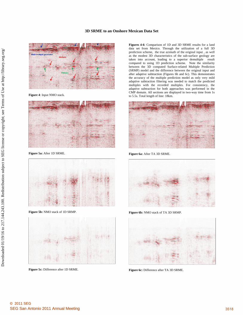
Figure 4: Input NMO stack.
Figure 5a: After 1D SRME.
Figure 5b: NMO stack of 1D SRMP.
Figure 5c: Difference after 1D SRME.
Figures 4-6: Comparison of 1D and 3D SRME results for a land
data set from Mexico. Through the utilization of a full 3D
prediction scheme, the true azimuth of the original input , as well
as the modest 3D characteristics of the sub-surface geology are
taken into account, leading to a superior demultiple result
compared to using 1D prediction scheme. Note the similarity
between the 3D computed Surface-related Multiple Prediction
(SRMP) model and the difference between the original input and
after adaptive subtraction (Figures 6b and 6c). This demonstrates
the accuracy of the multiple prediction model as only very mild
adaptive subtraction filtering was needed to match the predicted
multiples with the recorded multiples. For consistency, the
adaptive subtraction for both approaches was performed in the
CMP domain. All sections are displayed in two-way time from 1s
to 5.5s. Total length of line: 18km.
Figure 6a: After TA 3D SRME.
Figure 6b: NMO stack of TA 3D SRMP.
Figure 6c: Difference after TA 3D SRME.
© 2011 SEGSEG San Antonio 2011 Annual Meeting 35183518
Dow
nloa
ded
01/1
9/16
to 2
17.1
44.2
43.1
00. R
edis
trib
utio
n su
bjec
t to
SEG
lice
nse
or c
opyr
ight
; see
Ter
ms
of U
se a
t http
://lib
rary
.seg
.org
/

EDITED REFERENCES
Note: This reference list is a copy-edited version of the reference list submitted by the author. Reference lists for the 2011
SEG Technical Program Expanded Abstracts have been copy edited so that references provided with the online metadata for
each paper will achieve a high degree of linking to cited sources that appear on the Web.
REFERENCES
Aaron, P., S. Barnes, R. van Borselen, and R. Hegge, 2011, Enhanced data reconstruction for true-
azimuth 3D SRME: First Break, 29, 91–97.
Alá’i, R., and E. Verschuur, 2006, Case study of surface-related and internal multiple elimination on land
data. 76th Annual International Meeting, SEG, Expanded Abstracts, 2727–2731.
al Nahhas, M. S., D. Barwick, and M. Raafat, 2008, Application of cascaded multiple attenuation, on a
land 3D data set, south east Abu Dhabi: 78th Annual International Meeting, SEG, Expanded
Abstracts, 2527–2530.
Kelamis, P. G., and D. J. Verschuur, 2000, Surface-related multiple elimination on land seismic data —
Strategies via case studies: Geophysics, 65, 719–734, doi:10.1190/1.1444771.
Schonewille, M., A. Klaedtke, and A. Vigner, 2009, Anti-alias antileakage Fourier transform: 79th
Annual International Meeting, SEG, Expanded Abstracts, 3249–3253.
Schonewille, M., A. Klaedtke, A. Vigner, J. Brittan, and A. Martin, 2009, Seismic data regularization
with the antialias antileakage Fourier transform: First Break, 27, 85–92.
van Dedem, E. J., and D. J. Verschuur, 1998, 3D Surface-related multiple elimination and interpolation:
68th Annual International Meeting, SEG, Expanded Abstracts, 1321–1324.
Xu, S., Y. Zhang, D. L. Pham, and G. Lambaré, 2004, On the orthogonality of antileakage Fourier
transform-based seismic trace interpolation: 74th Annual International Meeting, SEG, Expanded
Abstracts, 2013–2016.
———, 2005, Antileakage Fourier transform for seismic data regularization: Geophysics, 70, no. 4, V87–
V95, doi:10.1190/1.1993713.
© 2011 SEGSEG San Antonio 2011 Annual Meeting 35193519
Dow
nloa
ded
01/1
9/16
to 2
17.1
44.2
43.1
00. R
edis
trib
utio
n su
bjec
t to
SEG
lice
nse
or c
opyr
ight
; see
Ter
ms
of U
se a
t http
://lib
rary
.seg
.org
/