
Assessment of Temporal Hydrological Variations Due to Land Use Changes Using Remote Sensing/GIS
Upload
phungtuongCategory
view
213download
0
Application of Remote Monitoring to Overcome the
Temporal and Spatial Limitations of Beach Litter Survey
Seon Woong Jang1 , Seong Kyu Lee2, Dae Hyun Kim
3, Yong Hyun Chung4,
Hong Joo Yoon1
1 Department of Spatial Information Engineering, Pukyong National University, (608-737)
599-1, Daeyeon 3-Dong, Nam-Gu, Busan, South Korea, [email protected](Seon Woong Jang),
[email protected](Hong Joo Yoon) 2 APEC Climate Center, (612-020) 12, Centum 7-ro, Haeundae-Gu, Busan, South Korea,
[email protected] 3 OCEANTECH CO., (412-240) 262-29, Haengjuoe-Dong, Deokyang-Gu, Goyang-Si,
Gyeonggi-Do, South Korea, [email protected] 4 Department of Ecological Engineering, Pukyong National University, (608-737) 599-1,
Daeyeon 3-Dong, Nam-Gu, Busan, South Korea, [email protected]
Abstract. This study used a remote sensing technique as an environmental
monitoring tool to assess beach litter. To determine both the time at which
beach litter was deposited and the area affected, we undertook real-time
monitoring with a network camera. When the cameras confirmed generation of
a large amount of litter, an unmanned aerial vehicle was used to monitor the
contamination status of the beach. If the monitoring technique used in this study
is adopted as part of a beach litter management policy by central or local
government, practical assistance could be provided to future beach litter
collection and maintenance programs.
Keywords: Beach litter, Remote Monitoring, Network Camera, Unmanned
Aerial Vehicle.
1 Introduction
To solve the marine debris problem and efficiently collect beach litter, an accurate
assessment of the current situation is a prerequisite. The most commonly used method
is monitoring through beach surveys [1]. Both in Korea and abroad, many studies
have been undertaken to determine levels of beach litter, its spatial distribution,
composition, and morphology using monitoring methods [2-4]. In Korea, to quantify
and classify beach litter, the Korean National Marine Debris Monitoring Program ran
from 2008 to 2012. A total of 20 beaches were targeted, with a 100-m section selected
to monitor beach litter every 2 months [5]. The monitoring method was based on
beach litter collection and analysis, and enabled identification of the source, type of
material, and area affected [6]. Through the results of the survey and statistics based
on long-term monitoring, the actual status of beach litter was determined. The results
were also used to improve the effectiveness of management policies [7]. However,
Advanced Science and Technology Letters Vol.95 (CIA 2015), pp.67-72
http://dx.doi.org/10.14257/astl.2015.95.13
ISSN: 2287-1233 ASTL Copyright © 2015 SERSC

studies to date have been limited to research on general features of beach litter, such
as the type of material, source, and the period of generation. Beach surveys require
large amounts of time, labor, and funding. A study with a non-continuous survey
cycle time of more than 1 month cannot determine specific changes in beach litter
over time [8]. The aim of this study was to utilize remote-sensing techniques for
beach litter monitoring and to enhance the effectiveness of beach surveys.
2 Materials and Methods
2.1 Monitoring Site
Remote monitoring of beach litter was undertaken at a site on Geoje Island, in the
south of Korea (Fig. 1). Heungnam Beach is located in the northeast of Geoje Island,
and has a length of 350 m and a width of 30 m. Its slope is gentle and it has a
monotonous sandy surface. Every year, this island is affected by fishery-based litter
caused by Styrofoam buoys and trash deposited illegally by tourists. In addition, it is
adjacent to the mouth of the Nakdong River, which is the largest river inflowing to
the southern sea, with an estimated 2,000 tons of litter flowing to the coast each year
[9].
Fig. 1. The location and shape of Heungnam Beach on the southern coast of Korea (red circles
indicate the locations and areas photographed by the network camera system).
Advanced Science and Technology Letters Vol.95 (CIA 2015)
68 Copyright © 2015 SERSC

2.2 Configuration and Operation of the Monitoring Equipment
Heungnam Beach is located on the southeast coastline, and the left side of the beach
is wider than the right side. In this study, to monitor a wide area, we established
network cameras on top of the left side of a building (Fig. 1). We also erected a 4-m
pole and set up two cameras facing left and right to maximize the photography area
and angle (Fig. 2a). We also established a control box including a server, which was
capable of real-time monitoring and controlling a high-definition video surveillance
network, terabyte (TB) storage, a power supply, and Internet router (Fig. 2b). This
server not only acted as a digital video recorder but could also assess storage, the
Internet environment, and the operational state of the cameras. Beach litter monitoring
took place from 1 January to 31 December 2013 using the network cameras. The
cameras observed through the Internet connection a remote PC (in the laboratory)
could monitor the beach status in real time. Each network camera was allocated a
private IP address, which facilitated access to the monitoring videos using a web
browser (Fig. 2c).
Fig. 2. The structure of the network camera system: (a) a network camera setting on a 4-m-high
pole (SNO-7080R), (b) the structure of the control box, and (c) the web browser for real-time
monitoring.
The area covered by the network cameras was limited by constraints such as
camera angle, height, and location of installation. Therefore, it was difficult to
Advanced Science and Technology Letters Vol.95 (CIA 2015)
Copyright © 2015 SERSC 69

monitor the whole beach. To compensate for this, we combined the use of an
unmanned aerial vehicle with camera monitoring. The unmanned aerial vehicle used
in this study was a mini quadcopter (GAUI 500X: TSH GAUI, Fig. 3), which can be
equipped with a camera. For beach photography, a GPS, on-screen display module,
and autopilot system were combined, so that the current location above the ground
could be recorded while maintaining flight parameters such as positioning and auto
balance (Fig. 3b). On the ground, the video and flight information (e.g., height,
distance, and location) could be viewed through a color monitor installed in the
receiver, and the position of the flight could be adjusted (Fig. 3c). We installed a
gimbal mount at the bottom of the engine, so that the vertical angle of the receiver
could be adjusted and a digital camera for aerial photography could be attached (Fig.
3d). Unmanned aerial vehicle monitoring enabled the identification of locations on
the beach with high pollution levels. Photographs were taken from the left to right
side of the beach; i.e. from the narrow to broad sections of beach. Through the color
monitor installed in the receiver, we could confirm the range of photography and the
size of beach litter. During the monitoring, the photography height was controlled to
be ~15 m.
Fig. 3. Micro-UAV equipped with a digital camera on a gimbal mount: (a) the quadcopter, (b)
GPS and main controller, (c) transmitter and color monitor and (d) gimbal mount and camera.
Advanced Science and Technology Letters Vol.95 (CIA 2015)
70 Copyright © 2015 SERSC
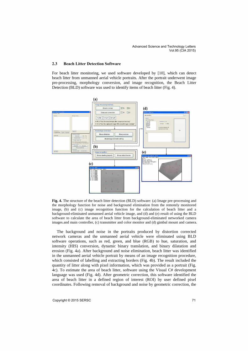
2.3 Beach Litter Detection Software
For beach litter monitoring, we used software developed by [10], which can detect
beach litter from unmanned aerial vehicle portraits. After the portrait underwent image
pre-processing, morphology conversion, and image recognition, the Beach Litter
Detection (BLD) software was used to identify items of beach litter (Fig. 4).
Fig. 4. The structure of the beach litter detection (BLD) software: (a) Image pre-processing and
the morphology function for noise and background elimination from the remotely monitored
image, (b) and (c) image recognition function for the calculation of beach litter and a
background-eliminated unmanned aerial vehicle image, and (d) and (e) result of using the BLD
software to calculate the area of beach litter from background-eliminated networked camera
images.and main controller, (c) transmitter and color monitor and (d) gimbal mount and camera.
The background and noise in the portraits produced by distortion corrected
network cameras and the unmanned aerial vehicle were eliminated using BLD
software operations, such as red, green, and blue (RGB) to hue, saturation, and
intensity (HIS) conversion, dynamic binary translation, and binary dilatation and
erosion (Fig. 4a). After background and noise elimination, beach litter was identified
in the unmanned aerial vehicle portrait by means of an image recognition procedure,
which consisted of labelling and extracting borders (Fig. 4b). The result included the
quantity of litter along with pixel information, which was provided as a portrait (Fig.
4c). To estimate the area of beach litter, software using the Visual C# development
language was used (Fig. 4d). After geometric correction, this software identified the
area of beach litter in a defined region of interest (ROI) by user defined pixel
coordinates. Following removal of background and noise by geometric correction, the
Advanced Science and Technology Letters Vol.95 (CIA 2015)
Copyright © 2015 SERSC 71

network camera portraits were used to identify the area of pollution. The portraits
could be used to show the area of beach litter pollution, the time at which pollution
occurred, and pixel information (Fig. 4e).
References
1. Madzena, A., Lasiak, T.: Spatial and temporal variations in beach litter on the Transkei
coast of South Africa. Mar. Pollut. Bull. 34, 900--907 (1997)
2. Rees, G., Pond, K.: Marine litter monitoring programmes-a review of methods with special
reference to national surveys. Mar. Pollut. Bull. 30, 103--108 (1995)
3. Kusui, T., Noda, M.: International survey on the distribution of stranded and buried litter on
beaches along the Sea of Japan. Mar. Pollut. Bull. 47, 175--179 (2003)
4. Jang, S. W., Park, J. M., Chung, Y. H., Kim, D. H., Yoon, H. J.: A study on the inflow and
seasonal characteristics of foreign marine debris in the coastal area of the West Sea (in
Korea). J. Korean Soc. Mar. Environ. Energy. 15, 89—100 (2012)
5. Ministry of Oceans and Fisheries, Korea Marine Environment Management Corporation:
Korea marine debris monitoring result report (in Korea) (2012)
6. Zhou, P., Huang, C., Fang, H., Cai, W., Li, D., Li, X., Yu, H.: The abundance, composition
and sources of marine debris in coastal seawaters or beaches around the northern South
China Sea (China). Mar. Pollut. Bull. 62, 199--2007 (2011)
7. Ministry of Land, Transport and Maritime Affairs: Achievements and challenges of marine
litter management in Korea (in Korea) (2009)
8. Kataoka, T., Hinata, H., Kako, S.: A new technique for detecting colored macro plastic
debris on beaches using webcam images and CLEUV. Mar. Pollut. Bull. 64, 1829--1836
(2012)
9. Kim, Y. K., Strategic measures preventing debris from entering the Nak-dong River (in
Korea). Gyeongnam Development Institute (2003)
10. Jang, S. W., Kim, D. H., Chung, Y. H., Seong, K. T., Yoon, H. J.: Development and
application of the technique for detecting beach litter using a Micro-Unmanned Aerial
Vehicle (in Korea). Korean J. Remote Sens. 30, 351--366 (2014)
Advanced Science and Technology Letters Vol.95 (CIA 2015)
72 Copyright © 2015 SERSC