Application of Criteria for a Project of Air Quality
10
Application of Criteria for a Project of Air Quality Concern Project Title: Interstate 80/San Pablo Dam Road Interchange Project Project Summary for Air Quality Conformity Task Force Meeting: November 30, 2011 Description Project will replace the existing four-lane San Pablo Dam Road Overcrossing in the City of San Pablo in Contra Costa County with a new six-lane structure. The nonstandard El Portal Drive on-ramp to westbound I-80 will be relocated approximately 2,000 feet north of the existing isolated on-ramp, creating a full diamond interchange at El Portal Drive and addressing the insufficient weaving distance on westbound I-80 between El Portal Drive and San Pablo Dam Road. The existing McBryde Avenue off-ramp from westbound I-80 will be closed and replaced by access via a new one-way connector road from the San Pablo Dam Road off-ramp from westbound I-80. The project will improve pedestrian and bicycle access in the project area by including Class II bicycle lanes on local streets affected by the project, ADA-compliant curb ramps, and an improved new pedestrian overcrossing structure at Riverside Avenue. Background Project is currently in detailed design phase (PS&E Phase) FHWA has issued conformity determination on November 18, 2009 NEPA process for Initial Study/Environmental Assessment (IS/EA) was completed in February 2010 No comments received on air quality Seeking air quality conformity determination on or before December 30, 2011 Not a Project of Air Quality Concern (40 CFR 93.123(b)(1)) (i) New or expanded highway projects with significant number/increase in diesel vehicles? Not a new or expanded highway project Interchange replacement—no additional through lanes on I-80 No increase in truck percentages on I-80 (ii) Affects intersections at LOS D, E, or F with a significant number of diesel vehicles? Diesel vehicles represent a maximum of 5% of traffic volume on I-80, which does not constitute a significant portion of total traffic No project changes to land use that would affect diesel traffic percentage Existing ramp intersections within the project that currently operate at LOS E or F will be improved to operate at LOS D or better. (iii) New bus and rail terminals and transfer points?—Not Applicable (iv) Expanded bus and rail terminals and transfer points?—Not Applicable (v) Affects areas identified in PM 10 or PM 2.5 implementation plan as site of violation? No state implementation plan for PM 2.5 (due by December 2012) Therefore, not identified in plan as an area of potential violation
Transcript of Application of Criteria for a Project of Air Quality

Application of Criteria for a Project of Air Quality Concern
Project Title: Interstate 80/San Pablo Dam Road Interchange Project
Project Summary for Air Quality Conformity Task Force Meeting: November 30, 2011
Description
Project will replace the existing four-lane San Pablo Dam Road Overcrossing in the City of San Pablo in Contra Costa County with a new six-lane structure.
The nonstandard El Portal Drive on-ramp to westbound I-80 will be relocated approximately 2,000 feet north of the existing isolated on-ramp, creating a full diamond interchange at El Portal Drive and addressing the insufficient weaving distance on westbound I-80 between El Portal Drive and San Pablo Dam Road.
The existing McBryde Avenue off-ramp from westbound I-80 will be closed and replaced by access via a new one-way connector road from the San Pablo Dam Road off-ramp from westbound I-80.
The project will improve pedestrian and bicycle access in the project area by including Class II bicycle lanes on local streets affected by the project, ADA-compliant curb ramps, and an improved new pedestrian overcrossing structure at Riverside Avenue.
Background
Project is currently in detailed design phase (PS&E Phase)
FHWA has issued conformity determination on November 18, 2009
NEPA process for Initial Study/Environmental Assessment (IS/EA) was completed in February 2010
No comments received on air quality
Seeking air quality conformity determination on or before December 30, 2011
Not a Project of Air Quality Concern (40 CFR 93.123(b)(1))
(i) New or expanded highway projects with significant number/increase in diesel vehicles?
Not a new or expanded highway project
Interchange replacement—no additional through lanes on I-80
No increase in truck percentages on I-80 (ii) Affects intersections at LOS D, E, or F with a significant number of diesel vehicles?
Diesel vehicles represent a maximum of 5% of traffic volume on I-80, which does not constitute a significant portion of total traffic
No project changes to land use that would affect diesel traffic percentage
Existing ramp intersections within the project that currently operate at LOS E or F will be improved to operate at LOS D or better.
(iii) New bus and rail terminals and transfer points?—Not Applicable (iv) Expanded bus and rail terminals and transfer points?—Not Applicable (v) Affects areas identified in PM10 or PM2.5 implementation plan as site of violation?
No state implementation plan for PM2.5 (due by December 2012)
Therefore, not identified in plan as an area of potential violation

Project Assessment Form for PM2.5 Interagency Consultation
RTIP ID# (required) 22360
TIP ID# (required) CC-070035
Air Quality Conformity Task Force Consideration Date November 24, 2011 Project Description (clearly describe project)
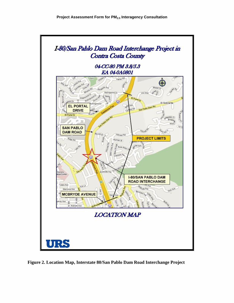
The Contra Costa Transportation Authority (CCTA), in cooperation with the California Department of Transportation (Caltrans), proposes to reconstruct the Interstate 80 (I-80)/San Pablo Dam Road (SPDR) Interchange, which is in the City of San Pablo and unincorporated Contra Costa County (County) and borders the City of Richmond, California (Figures 1 and 2). The interchange lacks sufficient capacity to accommodate future growth, and existing conditions between the I-80/San Pablo Dam Road Interchange and the interchanges immediately to the east and west affect the flow of traffic and contribute to congestion on westbound I-80 in the immediate vicinity of San Pablo Dam Road. The area of the proposed I-80/San Pablo Dam Road Interchange Project extends between McBryde Avenue (PM 3.8) and El Portal Drive Underpass (PM 5.3) to include these adjacent interchanges (Figure 3). The total length of the project is 1.47 miles.
The purpose of the Project is also to improve overall traffic operations and bicycle/pedestrian access at the interchange. The Project would reduce traffic congestion, optimize traffic flows at interchange ramps, improve pedestrian and bicycle access and safety, and standardize the vertical clearance of the existing overcrossing.
The project includes:
Replacing the existing four-lane San Pablo Dam Road overcrossing with a new six-lane bridge over I-80 that would be curved (re-aligned) to allow relocation of the Amador Street/San Pablo Dam Road intersection; lining up the eastbound I-80 off-ramp with the eastbound I-80 on-ramp to create a typical tight diamond interchange; adding a left-turn lane from the eastbound San Pablo Dam Road to the eastbound I-80 on-ramp; and adding a left-turn lane from westbound San Pablo Dam Road to Amador Street.
Relocating the existing westbound on-ramp from El Portal Drive from its current location to line up with the westbound off-ramp to create a typical tight diamond interchange.
Removing the McBryde Avenue westbound off-ramp, constructing a new Connector Road between San Pablo Dam Road and McBryde Avenue.
Improving pedestrian access on San Pablo Dam Road and across the I-80 ramps. The pedestrian overcrossing on I-80 between San Pablo Dam Road and McBryde Avenue would be relocated and extended to allow elementary school students to avoid crossing busy Amador Street.
Providing Class II bicycle lanes in the shoulders of the San Pablo Dam Road Overcrossing, which would increase safety on the designated bicycle route on San Pablo Dam Road between San Pablo Avenue and El Portal Drive.
Type of Project: Reconfigure existing interchange
County Contra Costa
Narrative Location/Route & Postmiles: On I-80 from 0.1 mile East of McBryde Avenue OC to El Portal Drive UC (Post Miles 3.8 to 5.3)
Caltrans Projects – EA# 04-0A0801
Lead Agency: Contra Costa Transportation Authority
Contact Person Hisham Noeimi
Phone# (925) 256-4731
Fax# (925) 256-4701
Email: [email protected] Federal Action for which Project-Level PM Conformity is Needed (check appropriate box)
Categorical Exclusion
EA or Draft EIS
FONSI or Final EIS
X PS&E or Construction
Other

PM2.5 Project Assessment Form for Interagency Consultation
(NEPA)
Scheduled Date of Federal Action: March 2014
NEPA Delegation – Project Type (check appropriate box)
Exempt
Section 6004 –Categorical Exemption
Section 6005 – Non-Categorical Exemption
Current Programming Dates (as appropriate)
PE/Environmental ENG ROW CON
Start October 2006 May 2011 Jan 2012 March 2014
End May 2010 May 2013 February 2013 September 2016
Project Purpose and Need (Summary): (please be brief) The purpose of the proposed project is to: • Reduce traffic congestion at the I 80/San Pablo Dam Road Interchange and on local streets in
the vicinity of the interchange without increasing congestion on I-80; • Reduce weaving conflicts between vehicles entering and exiting the freeway at the I-80/San
Pablo Dam Road Interchange; and • Provide efficient and safe bicycle and pedestrian access across I-80. The I-80/San Pablo Dam Road Interchange lacks sufficient capacity to accommodate existing and projected future traffic volumes. Inefficient traffic flows at the I-80/San Pablo Dam Road Interchange ramps result in long queues entering and exiting I-80. Projected future traffic volumes will exacerbate congestion on I-80 and the San Pablo Dam Road ramps and hinder traffic operations on local roads approaching the interchange. The four-lane San Pablo Dam Road Overcrossing lacks the capacity to accommodate projected future traffic volumes. On the east side of this overcrossing is a five-legged intersection of San Pablo Dam Road, Amador Street, and the freeway ramps that does not permit left turns from westbound San Pablo Dam Road onto Amador Street. This restriction prevents westbound San Pablo Dam Road traffic from directly accessing Amador Street and Riverside Elementary School. In addition, existing pedestrian and bicycle facilities are not adequate to provide efficient access through the interchange.
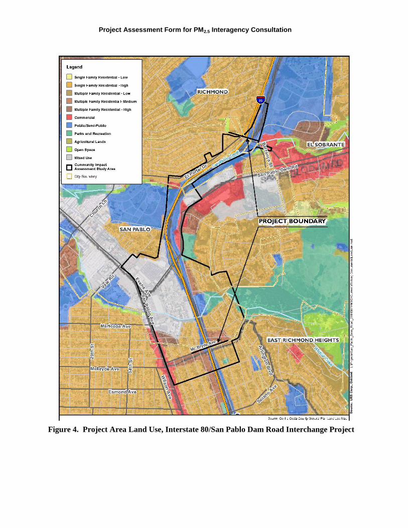
Surrounding Land Use/Traffic Generators (especially effect on diesel traffic) Figure 4 shows land uses in the project vicinity. The I-80 right-of-way and St. Joseph Cemetery to the west of I-80 near the San Pablo Dam Road Interchange are designated for public/quasi-public (County) and institutional (San Pablo) uses. Single-family and multi-family residential uses are present in unincorporated Contra Costa County at the north end of the study area, in San Pablo in the vicinity of the I-80/San Pablo Dam Road Interchange and McBryde Avenue, and in Richmond around McBryde Avenue. Commercial land uses are concentrated around the I-80/San Pablo Dam Road Interchange and San Pablo Avenue in the study area, although commercial uses are also present along El Portal Drive west of the I-80 westbound on-ramp. Institutional uses include Riverside Elementary School on Amador Street.

Project Assessment Form for PM2.5 Interagency Consultation
Brief summary of assumptions and methodology used for conducting analysis (please keep this concise – specifics may include date of when traffic counts were conducted, studies where truck percentages were derived)
The traffic operations analysis report was approved in October 2008. Caltrans provided 24-hour traffic volumes for the freeway mainline and at the ramps along the study corridor. Traffic volumes for the peak period along the freeway mainline and ramps were derived based on 24-hour traffic volumes. URS collected peak hour turning movement data at the study intersections in November 2006 and April 2007, and queue length observations in 2007.
The I-80/San Pablo Dam Road Interchange has the highest traffic volumes of the three I-80 interchanges within the project limits. It is considered the worst-case study interchange; therefore, only data for the I-80/San Pablo Dam Road Interchange is presented in this evaluation.
The traffic operations analysis assumed that trucks comprise 5% of total traffic on I-80, in accordance with Caltrans truck counts for the study area. The most recent Caltrans truck counts (2009; http://traffic-counts.dot.ca.gov/2009all/docs/2009truckpublication.pdf) were consulted to determine if truck volumes have changed since the traffic analysis was conducted. Truck counts were not collected in 2009 for the portion of I-80 in the 1.47-mile study limits; however, the closest interchanges to the east and west (San Pablo Avenue at PM 2.961 and Hilltop Drive at PM 5.983) had truck percentages of 3.55% and 4%, respectively. Consequently, the use of 5% trucks in the analysis is within an acceptable range of current conditions and will not understate the potential for PM2.5 impacts.
The analysis of opening year and horizon year annual average daily traffic (AADT) used 2007 as the baseline for existing conditions. The baseline AADT for I-80 at the San Pablo Dam Road Interchange was 213,000. The most recent Caltrans traffic counts (2009; http://traffic-counts.dot.ca.gov/2009all/Route71-80i.htm) were consulted to determine if AADT in the study area has changed since the analysis was conducted. The 2009 traffic counts show that peak month AADT just west of the I-80/San Pablo Dam Road interchange (PM 4.341) was 207,000. The baseline AADT is within a reasonable, conservative range of the 2009 AADT and will not understate the potential for PM2.5 impacts.
Opening Year: If facility is a highway or street, Build and No Build LOS, AADT, % and # trucks, truck AADT of proposed facility
Not applicable; see below for Interchange facility
RTP Horizon Year / Design Year: If facility is a highway or street, Build and No Build LOS, AADT, % and # trucks, truck AADT of proposed facility
Not applicable; see below for Interchange facility

PM2.5 Project Assessment Form for Interagency Consultation
Opening Year: If facility is an interchange(s) or intersection(s), Build and No Build cross-street AADT, % and # trucks, truck AADT
Opening year (2016)
Scenario Location AADT % and # trucks Truck AADT
No Build I-80 at San Pablo Dam Road interchange
228,060 5% 11,403
San Pablo Dam Road at I-80 interchange
35,500 2%* 710
Build I-80 at San Pablo Dam Road interchange
227,280 5% 11,364
San Pablo Dam Road at I-80 interchange
33,500 2%* 670
RTP Horizon Year / Design Year: If facility is an interchange (s) or intersection(s), Build and No Build cross-street AADT, % and # trucks, truck AADT
Horizon year (2035)
Scenario Location AADT % and # trucks Truck AADT
No Build I-80 at San Pablo Dam Road interchange
251,500 5% 12,575
San Pablo Dam Road at I-80 interchange
44,500 2%* 890
Build I-80 at San Pablo Dam Road interchange
249,500 5% 12,475
San Pablo Dam Road at I-80 interchange
39,400 2%* 788
* The assumption of 2% trucks for San Pablo Dam Road is based on the Contra Costa Transportation Authority Travel Demand Model.
Opening Year: If facility is a bus, rail or intermodal facility/terminal/transfer point, # of bus arrivals for Build and No Build, % and # of bus arrivals will be diesel buses
Not applicable; see above for Interchange facility
RTP Horizon Year / Design Year: If facility is a bus, rail or intermodal facility/terminal/transfer point, # of bus arrivals for Build and No Build, % and # of bus arrivals will be diesel buses
Not applicable; see above for Interchange facility

Project Assessment Form for PM2.5 Interagency Consultation
Describe potential traffic redistribution effects of congestion relief (impact on other facilities) The traffic operations analysis (URS 2008) determined that the Build Alternative will reduce the cut-through traffic using city streets to avoid congestion on I-80 by approximately 250 vehicles compared to the No Build Alternative. The proposed improvements are projected to reduce the travel time by approximately 19%, total network delay is projected to be reduced by approximately 64%, and the average speed is projected to increase by 54 percent. Also, the Build Alternative will improve the level of service at the ramp intersections to LOS D or better, compared to LOS E and F in the No Build Condition.
Comments/Explanation/Details (please be brief) The project is not considered a POAQC, as defined in 40 CFR 93.123(b), for the following reasons:
• The project is not a new or expanded highway project with a significant number of or increase in diesel vehicles.
Interchange replacement—no additional through lanes on I-80
No increase in truck percentage on I-80 • The project does not include intersections that are or will be at LOS D, E, or F with a significant
number of diesel vehicles.
Diesel vehicles represent a maximum of 5% of traffic volume on I-80, which does not constitute a significant portion of total traffic
No project changes to land use that would affect diesel traffic percentage
• The project does not include the construction of a new bus or rail terminal with a significant number of diesel vehicles congregating at a single location.
Not applicable
• The project does not expand an existing bus or rail terminal with significant increases in the number of diesel vehicles congregating at a single location.
Not applicable • The project is not in or affecting locations, areas, or categories of sites that are identified in the
PM2.5 applicable implementation plan or implementation plan submission, as appropriate, as sites of violation or possible violation.
No state implementation plan for PM2.5 (due by December 2012)
Therefore, not identified in plan as an area of potential violation Therefore, the project meets the Clean Air Act requirements and 40 CFR 93.116 without any explicit Hot-spot analysis. The project will not create a new or worsen an existing PM2.5 violation.

PM2.5 Project Assessment Form for Interagency Consultation
Figure 1. Vicinity Map, Interstate 80/San Pablo Dam Road Interchange Project
Project Assessment Form for PM2.5 Interagency Consultation
Figure 2. Location Map, Interstate 80/San Pablo Dam Road Interchange Project

PM2.5 Project Assessment Form for Interagency Consultation
Figure 3. Project Features, Interstate 80/San Pablo Dam Road Interchange Project
Project Assessment Form for PM2.5 Interagency Consultation
Figure 4. Project Area Land Use, Interstate 80/San Pablo Dam Road Interchange Project