Appendix K€¦ · A written declaration by a person executing an instrument given ... Bargain And...
20
MONTANA RIGHT-OF-WAY DESIGN MANUAL Appendix K R/W TERMINOLOGY
Transcript of Appendix K€¦ · A written declaration by a person executing an instrument given ... Bargain And...

MONTANA RIGHT-OF-WAY DESIGN MANUAL
Appendix K
R/W TERMINOLOGY

u3822
Typewritten Text
u3822
Typewritten Text
Spaceholder page for double-sided printing.
u3822
Typewritten Text
u3822
Typewritten Text
u3822
Typewritten Text
u3822
Typewritten Text
u3822
Typewritten Text

March 2005 APPENDIX K K-i
Appendix K R/W TERMINOLOGY
Table of Contents
Page
APPENDIX K R/W TERMINOLOGY ........................................................................ K-1
R/W Terminology ............................................................................... K-1
u3822
Typewritten Text

u3822
Typewritten Text
u3822
Typewritten Text
Spaceholder page for double-sided printing.
u3822
Typewritten Text
u3822
Typewritten Text
u3822
Typewritten Text
u3822
Typewritten Text
u3822
Typewritten Text
March 2005 APPENDIX K K-1
R/W TERMINOLOGY 4-F. Preservation of the natural beauty of public parks, recreation lands and wildlife or waterfowl refuges. Also covered under this section is protection for historic sites that are on or are eligible for inclusion on the National Register of Historic Places. 6-F. Provides money for improving certain lands and conserving water.
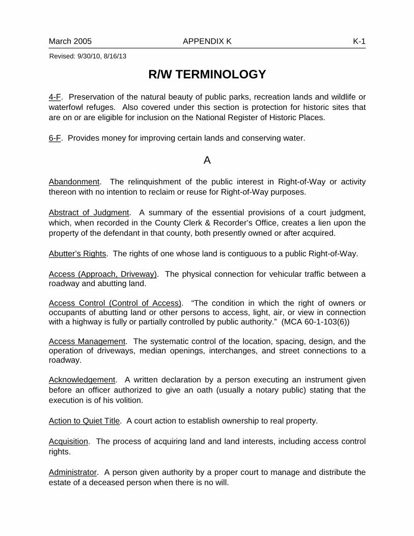
A Abandonment. The relinquishment of the public interest in Right-of-Way or activity thereon with no intention to reclaim or reuse for Right-of-Way purposes. Abstract of Judgment. A summary of the essential provisions of a court judgment, which, when recorded in the County Clerk & Recorder’s Office, creates a lien upon the property of the defendant in that county, both presently owned or after acquired. Abutter’s Rights. The rights of one whose land is contiguous to a public Right-of-Way. Access (Approach, Driveway). The physical connection for vehicular traffic between a roadway and abutting land. Access Control (Control of Access). “The condition in which the right of owners or occupants of abutting land or other persons to access, light, air, or view in connection with a highway is fully or partially controlled by public authority.” (MCA 60-1-103(6)) Access Management. The systematic control of the location, spacing, design, and the operation of driveways, median openings, interchanges, and street connections to a roadway. Acknowledgement. A written declaration by a person executing an instrument given before an officer authorized to give an oath (usually a notary public) stating that the execution is of his volition. Action to Quiet Title. A court action to establish ownership to real property. Acquisition. The process of acquiring land and land interests, including access control rights. Administrator. A person given authority by a proper court to manage and distribute the estate of a deceased person when there is no will.
Revised: 9/30/10, 8/16/13
u3822
Typewritten Text
u3822
Typewritten Text

March 2005 APPENDIX K K-2 Administratrix. A female Administrator. Advanced Acquisition. Acquiring land and/or land interests prior to full development and authorization of Right-of-Way plans.
Agreement. A common view of two or more people regarding the rights and obligations of each with regard to a specific subject. Not necessarily a contract, although all contracts are agreements. Agreement Number. Three-digit sequential number relating to the number of projects performed on the route/county section and used for funding. Appurtenance. Something belonging to something else, either attached or not, such as a barn to a house, or an easement to land. The appurtenance is part of the property and passes with it upon sale or other transfer. Assignee. One who receives an assignment. Assignment. A transfer to another of any property, real or personal, or of any rights or estates in said property. Common assignments are of leases, mortgages, Deeds of Trust, etc. Assignor. One who makes the assignment. Associated Projects. Projects that are associated with different phases of the project at hand. Usually identified on the Right-of-Way plans with the PE Project ID number. Attachment. An act of seizing persons or property by judicial order to bring them within the custody of the court. Most commonly the seizure of property to furnish security for a debt in connection with a pending action.
B Backslope. That portion of the roadway between the side drainage ditch and the top of the cut, usually measured as a ratio of horizontal distance versus each foot of increase in elevation. Bankruptcy. Proceedings under Federal Bankruptcy Statutes to relieve a debtor from insurmountable debt. The bankrupt’s property is distributed by the court to the creditors as full satisfaction of the debts in accordance with certain priorities and exemptions. Voluntary bankruptcy is petitioned by the debtors; involuntary by the creditors.
Revised: 9/30/10, 8/16/13
u3822
Typewritten Text

March 2005 APPENDIX K K-3 Bargain And Sale Deed. A deed, which is a hybrid between a quitclaim and a warranty deed. It usually conveys property, but contains no guarantees or warranties of title. Bearing. A very precise way in which a direction is determined. Beneficiary. (1) One for whose benefit a trust is created; (2) in states in which Deeds of Trust are commonly used instead of mortgages, the lender (mortgagee) is called the beneficiary. Bequeath. To give to a person; personal property (i.e., money, books, jewelry, furniture) by Will. Bequest. Personal property left by a Will. Berm. (1) The earthen or paved extension of the roadway, sometimes a shoulder; (2) longitudinal mound of earth used to deflect water or a dike-like structure formed by materials excavated from a shallow ditch that parallels and adjoins it – used to control surface drainage. Borrow Site. A parcel of ground used for storing sand and/or gravel for use by the DOT.
C Cadastral Map. A map showing the boundaries of subdivisions of land, usually with the bearing and lengths thereof and the areas of individual tracts, for purposes of describing and recording ownership. Chord. A straight line connecting two points on a curve. Centerline. The longitudinal center of a Right-of-Way project. Certificate of Redemption. Evidence of redeeming (buying back) a property by the owner after losing it through a judicial sale. The time limit for redemption is set by statute. Certificate of Sale. Certificate issued to the buyer at a judicial sale (such as a tax sale), which will entitle the buyer to a deed upon confirmation of a sale by the court if the land is not redeemed within a specified time. Chain of Title. Chronological order of conveyance of a parcel of land from the original owner (usually the government) to the present owner.
Revised: 9/30/10, 8/16/13

March 2005 APPENDIX K K-4 Closed. When a street or alley is closed by the governing body, it’s only closed for use and the governing body retains ownership. Cloud on Title. An invalid encumbrance on real property, which affects the rights of the owner.
Example: Owner “A” sells to owner “B” Lot 1 of Tract 1. The deed is mistakenly written to read Lot 2 of Tract 1. A cloud is created on Lot 2 by recording the erroneous deed. The cloud may be removed by a quitclaim deed or by a court action.
Color of Title. That which gives the appearance of good title, but actually contains some defect.
Example: A conveyance given without the grantor having good title, like an undisputed interest.
Condemnation. Power to condemn property for public use arises from the State’s right of eminent domain, a basis right of sovereignty limited by the constitution. Conservator. A court appointed guardian to manage the affairs of a minor or incompetent. Consideration. Anything that is legally of value and induces one to enter into a contract. Construction Limits. Lines drawn along each side of roadway showing the outer edges of the cuts and fills. Construction Permit. Where land is needed solely for construction purposes, a construction permit is purchased from the adjacent landholders that allows the contractor to build the project. This permit is for a limited period of time. Contract. An agreement between two or more parties or entities in which create or modify a legal relationship. Contract Plans Book (CPB). An electronic MicroStation plan sheet record containing sequential page information. Each CPB page is a record of the CADD server, the MicroStation design file, and specific fence coordinates for the plan sheet.
Revised: 9/30/10, 8/16/13

March 2005 APPENDIX K K-5 Control Survey. A survey that provides positions (horizontal or vertical) of points to which supplementary surveys are adjusted. Coordinates. Linear or angular quantities, or both, which designate the position of a point in relation to a given reference frame. Corner Record. A written record of the corner establishment or restoration to be filed with the county clerk and recorder of the county where the corner is situated. Cut Slope. Slopes extending upward and outward from the ditch bottom to intersect the natural ground line.
D Debt. Money owing from one person to another. Debtor. One who owes the debt. Declaration of Homestead. Statutory exemption protecting homestead property (the dwelling, out buildings and any contiguous property) of the head of the family against the rights of creditors (usually a set amount). Deed. One of many conveyance or financing instruments. Generally, a conveying instrument given to pass fee title to property upon sale. Deed of Reconveyance. An instrument used to transfer title from a Trustee to the equitable owner of real estate when title is held as collateral security for a debt. Most commonly used upon payment in full of a Trust Deed. Deed of Trust. An instrument used in place of a mortgage. Property is transferred to a trustee by the borrower. Devisee. One to whom real estate is given by a Will. Document Management System (DMS). An MDT program that gives users quick access to project-related files. DocuPlot. DocuPlot is a plotting solution meeting the needs of MDT CADD designers, the MDT Contract Plans Section, and the MDT Print Unit.
Revised: 9/30/10, 8/16/13
March 2005 APPENDIX K K-6
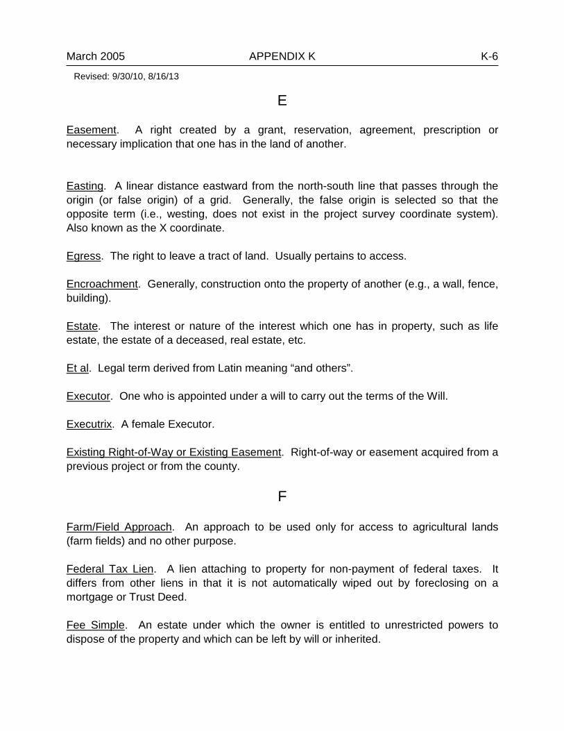
E Easement. A right created by a grant, reservation, agreement, prescription or necessary implication that one has in the land of another. Easting. A linear distance eastward from the north-south line that passes through the origin (or false origin) of a grid. Generally, the false origin is selected so that the opposite term (i.e., westing, does not exist in the project survey coordinate system). Also known as the X coordinate. Egress. The right to leave a tract of land. Usually pertains to access. Encroachment. Generally, construction onto the property of another (e.g., a wall, fence, building). Estate. The interest or nature of the interest which one has in property, such as life estate, the estate of a deceased, real estate, etc. Et al. Legal term derived from Latin meaning “and others”. Executor. One who is appointed under a will to carry out the terms of the Will. Executrix. A female Executor. Existing Right-of-Way or Existing Easement. Right-of-way or easement acquired from a previous project or from the county.
F Farm/Field Approach. An approach to be used only for access to agricultural lands (farm fields) and no other purpose. Federal Tax Lien. A lien attaching to property for non-payment of federal taxes. It differs from other liens in that it is not automatically wiped out by foreclosing on a mortgage or Trust Deed. Fee Simple. An estate under which the owner is entitled to unrestricted powers to dispose of the property and which can be left by will or inherited.
Revised: 9/30/10, 8/16/13

March 2005 APPENDIX K K-7 Fill Slope. Slopes extending outward and downward from the hinge point to intersect the natural ground line. Foreclosure. A proceeding in or out of court to extinguish all rights, title, and interest of the owner of property in order to sell the property to satisfy a lien against it. Found. The survey data per the project survey. Sometimes noted as “measured”. Four-F. See 4-F. Full Access Control. All rights of ingress and egress are controlled by MDT. Access allowed only at specific interchanges or at specified public approaches. It is intended to give high priority to the uninterrupted movement of through traffic. At-grade access is inconsistent with full access control.
G Government Lots. Irregularly shaped parcels of land, usually fronting on water, which could not practically be divided into sections under government survey. Also provides for the placement of deficiency or surplus in the north and west sections of a township. (Affects sections 1, 2, 3, 4, 5, 6, 7, 18, 19, 30 and 31.) Grade. The slope of a surface, such as a lot or road, with a vertical rise or fall expressed as a percentage of the horizontal distance. (3% grade means a rise of 3 feet (meters) per 100 feet (meters) of horizontal distance.) Grant. To transfer an interest in real property. Grantee. One to whom a grant is made. (Generally, this is the buyer.) Grantor. One who grants property or property rights. Grid Coordinates. The X and Y that designates a point on a grid. Grid Factor. A scale factor used to convert from sea level distance to grid distance, or vice versa, in the state coordinate systems. Guardian. One who is court appointed to manage the affairs of a minor or incompetent.
H
Revised: 9/30/10, 8/16/13

March 2005 APPENDIX K K-8 Heir. One who, by law rather than by will, receives the estate of a deceased person. Heirs and Assigns. The right to assign property or have it descend upon a person’s death. This would be considered a fee interest. Hereditaments. Anything that could be considered real property. Anything that may be inherited.
I Ingress. The right to enter a tract of land. Usually pertains to access. Inslope. The side slope in a cut section created by connecting the subgrade shoulder to the ditch bottom downward and outward. Interest. A share or right in some property (real or personal). Intestate. Without leaving a will.
J Joint Tenancy. An undivided interest in property (most commonly taken by two). Upon death of a joint tenant, the interest passes to the surviving joint tenant rather than to the heirs of the deceased. Joint-Use Approach. A single approach connecting two or more contiguous sites to a public roadway that serves more than one property, development, including those in different ownership. Judgment. Decision of the court of law. Money judgments, when recorded, become a lien on real property of the defendant.
L Landlocked Parcel. A parcel of land surrounded entirely by privately owned land, with no access to a public Right-of-Way. Lease. An agreement by which an owner of real property (lessor) gives the right of possession to another (lessee) for a specified period of time (term) and for a specified consideration (rent).
Revised: 9/30/10, 8/16/13

March 2005 APPENDIX K K-9 Lessee. Party to whom a lease is given in return for rent. Lessor. Party who gives the lease. Lien. An encumbrance against property for money, either voluntary or involuntary. Life Estate. An estate in real property for the life of a person. Upon death, the estate reverts to the grantor or to a third party. Limited Access Control. Landowner has a right to “reasonable access”; reasonable is not to be interpreted as direct access. Access allowed at specified public roads or at private driveways as specified in legal agreements and/or deeds. The established street system is given first priority in access to the highway. When it is determined that reasonable private access cannot be provided using the public access, direct private access may be allowed at specific points. Limited Access Highway (or Facility). A portion of roadway with limited access control imposed by the governing public authority. Local Coordinate System. Coordinate datum that does not take into account the shape of the earth.
M Material Site. Parcel of land where road maintenance materials are stored. Meander Corner. A corner established at the intersection of standard, township or section lines with the banks of navigable streams or any meanderable body of water. Meander Line. Lines run in surveying lands that border rivers to determine the winding and movements of the river. Mechanic’s Lien. A lien created by statute for the purpose of securing priority of payment for the price of work performed and materials furnished. Metes and Bounds. Description of land by boundary lines with their terminal points and angles. Originally metes referred to distance and bounds to direction. Monument (USPLS). A physical structure that marks the location of a corner or other survey point.
Revised: 9/30/10, 8/16/13

March 2005 APPENDIX K K-10 Mortgage. The instrument by which real estate is hypothecated as security for repayment of a loan. Mortgagee. The party lending the money and receiving the mortgage. Mortgagor. The party who borrows the money and gives the mortgage.
N Navigable Rivers. Capable of carrying commercial shipping or boats for travel. If the river is classified navigable and if the adjacent landowner’s property description encompasses all or a portion of the riverbed, the riverbed is to be included as a part of the parcel. In addition, a separate parcel number is to be shown within the boundaries of the river along with a notation “Riverbed Only” and is to be acquired from State Lands. Northing. A linear distance northward from the east-west line that passes through the origin (or false origin) of a grid. Generally the false origin is selected so that all northings remain positive. Also known as the Y coordinate. Notary Public. One who is authorized by the State or Federal government to administer oaths and to attest to the authenticity of signatures. Notice of Purchaser’s Interest. A document making notice to the public of a Contract for Deed showing seller, buyer, and legal description, but not divulging all the contract details.
O Ownership. Rights to the use, enjoyment and alienation of property to the exclusion of others.
P Partial Reconveyance. Release of portion of property covered by trust indenture. Partial Release. Release of a portion of property covered by a mortgage. Partnership. An association of two or more persons to carry on as co-owners, a business for profit.
Revised: 9/30/10, 8/16/13

March 2005 APPENDIX K K-11 Patent. Instrument of conveyance of title to public (government) land. Plan-in-Hand Review. An in-depth office and on-site review of all project elements to ensure that all details have been satisfactorily incorporated into the construction plans and that the project is ready to advance to construction. Plan-in-Hand Report. A report that provides written documentation of all decisions made during the plan-in-hand office and field review meetings. Preliminary Field Review. An initial field review meeting held after a project has been nominated to determine the major design features, and to discuss other project-related issues and any potential problems. Preliminary Field Review Report. A report that provides written documentation of all major determinations made during the preliminary field review meeting. Prescriptive Easement. An easement declared after a period of open and continuous use of land. Private Approach. An approach that allows access to and/or from a commercial, industrial or residential property. Probate. An action over which probate court has jurisdiction in checking, ordering, and decreeing all stipulations in a will. Project ID. Alphanumeric project identifier usually containing funding, route, and milepost information. Project Number. Uniform Project Number + Agreement Number + Unit Number separated by a dash Property Controlling Corners. Section corners, quarter corners, meander corners, and the like. They monument the rectangular survey system. Property Corners. Monument individual tracts of land, both private and public. Protraction. The extension or prolongation; also the making of a plot, as on paper; the subdivision of a section without a complete survey. Public Approach. A connection to and/or from a dedicated street, road, alley or other dedicated public roadway to a highway facility.
Revised: 9/30/10, 8/16/13

March 2005 APPENDIX K K-12 Public Domain. Lands belonging to the federal government. Public Land Survey Corner. Any corner actually established and monumented in an original survey or resurvey used as a basis of legal description for issuing a patent for the land to a private person from the United State government.
Q Quitclaim Deed. A deed operating as a release; intended to pass any title, interest, or claim which the grantor may have on the property, but not containing any warranty of a valid interest or title in the grantor.
R Ready Date. The target date for completion of Right-of-Way activities and a project is ready for letting. Real Estate. Land and anything permanently affixed to the land, such a buildings, fences and those things attached to the building, such as light fixtures, plumbing and heating fixtures, etc. Record. The survey data per the original GLO/BLM Survey; survey data per a subsequent survey, often a certificate of survey. Record Data. That information that can be retrieved from formal filing systems. Recorded Plat. A map recorded in a county recorder’s office (e.g., subdivision, C.O.S.). Reference Monument. A special monument that does not occupy the same geographical position as the corner itself but whose spatial relationship to the corner is recorded and which serves to witness the corner. Regulated Access. Access managed through the granting of revocable permits to private parties to construct and maintain an approach. This level is intended to strike a balance between the through mobility on the highway and accessibility to adjacent land use. Related Projects. Projects that occurred previously within the limits and prior to the project at hand. Identified on the R/W plans with the R/W Project ID numbers of existing plans.
Revised: 9/30/10, 8/16/13

March 2005 APPENDIX K K-13 Regulated Access. Access managed through the granting of revocable permits to private parties to construct and maintain an approach. This level is intended to strike a balance between the through mobility on the highway and accessibility to adjacent land use. Relocation. The displacement and re-establishment of individuals, businesses, farms, and non-profit organizations for which special financial assistance and/or advisory assistance is available. Remise. To give up or remit. Reservation. A right retained by a grantor in conveying property. Retracement. A term applied to a survey that is made for the purpose of verifying the direction and length of lines, and identifying the monuments and other marks of an established prior survey. Revocable Permit (Driveway Approach Application and Permit). A revocable permit issued by MDT for the construction, maintenance, and use of a driveway or public street that connects to a highway. Form link: www.mdt.mt.gov/publications/docs/forms/ contracting/approach_permit.pdf Reversion. The right to possession of the residue of an estate in a grantor or successor of a grantor, commencing upon termination of a particular estate, granted or devised. Right-of-Way. The right to pass over the land of another; may be easement or fee. Rip Rap. A loosely composed wall of rocks and stones used to hinder the flow of water, thereby, preventing erosion. Rural Area. Relating to the country, as versus an urban area. (Refer to city plats for city limits and urban boundaries.)
S Satisfaction. Discharge of an obligation by payment of the amount due, as on a mortgage, trust deed or, contract. Also, the recorded instrument stating said payment has been made. Section. A division or parcel of land on a government survey comprising one square mile (640 acres). Thirty-six sections comprise a township.
Revised: 9/30/10, 8/16/13

March 2005 APPENDIX K K-14 Sequential Conveyances. Are transfer of land generally independent of a plat, typically described as metes and bounds. Sequential conveyances address senior rights that dictate that a junior deed cannot take away from the senior deed. Simultaneous Conveyances. Are transfer of land generally made in reference to a recorded plat, such as a subdivision or GLO/BLM plat (lot/block of subdivision). Simultaneous conveyances will share the excess and deficiencies that exist. Single Proportionate Measurement. A method of proportioning measurement in the restoration of a lost corner whose position is determined with reference to alignment in one direction. Six-F. See 6-F. Slope. The angle of a grade as measured from a level surface. Snow Fence. A barrier placed along the side of a road to prevent snow from drifting onto the road. State Plane Coordinate System. Coordinate datum that takes into account the shape of the earth. Subdivision. Commonly, a division of a single parcel of land into smaller parcels by filing a map describing the division and obtaining approval by a governmental commission (city or county). Survey. The measurement of the boundaries of a parcel of land, its area and sometimes its topography. Survey Ties. Accurate ties between the highway centerline and the documented land lines. As a general rule, it is preferred to locate a found monument within 1 mile of the land to be acquired. Survivorship. Gaining an interest in property by outliving (surviving) another who had the interest.
T Tangent. Also called semi-tangent. (1) A straight line that touches a given curve at one and only one point and does not intersect it. (2) In route alignment, that part of alignment from one P.I. to the next P.I.; the distance from the P.T. of one curve to the P.C. of the next curve; or the distances from the P.C. to P.I. and P.I. to P.T. of a curve.
Revised: 9/30/10, 8/16/13

March 2005 APPENDIX K K-15 Tax Deed. (1) Deed from tax collector to a governmental body after a period of non-payment of taxes according to statute. (2) Deed to a purchaser at a public sale of land taken for delinquent taxes. The purchaser receives only such title as the former owners had. Tenancy in Common. An undivided ownership in real estate by two or more persons. The interests need not be equal. In the event of the death of one of the owners, no right of survivorship in the other owners exists. Testate. Having written a last will and testament. Title. The evidence one has of the right to possession of land. Topography. The position of natural and man made features depicted on maps (plan sheets). Township. A territorial division of land established by federal survey, being 6 miles square and containing 36 sections, each being one-mile square. Township Lines. Survey lines that divide townships at their northern and southern boundaries. The east and west boundaries are called Range lines. Trust. A fiduciary relationship under which one holds property (real or personal) for the benefit of another. Trustee. (1) One who is appointed or required by law to execute a trust; (2) One who holds title to real property under the terms of a deed of trust. Trustee’s Deed. A deed by a Trustee under a Deed of Trust (trust indenture) issued to a purchaser at auction, pursuant to foreclosure. Trustee’s Sale. A sale at auction by a Trustee under a Deed of Trust (trust indenture) pursuant to foreclosure proceedings.
U Uneconomic Remnant or Remainder. A remainder of land so small or irregular that it usually has little or no economic value. Uniform Project Number. Five characters (formerly four characters), used to identify the project as a whole.
Revised: 9/30/10, 8/16/13
u3822
Typewritten Text

March 2005 APPENDIX K K-16 Unit Number. Three-digit number used to identify project splits. Urban. Pertaining to city or town.
V Vacated. When the street or alley is vacated, the governing body relinquishes ownership and another party obtains ownership. Vendee. Purchaser or buyer, especially on a land contract. Vendor. Another word for seller. Commonly used in land contract sales. Vested. Present ownership rights. Absolute and fixed.
W Warrant. To legally assure that title conveyed is good and possession will be undisturbed. Warranty. A legal binding promise given at the time of sale, whereby the seller gives the buyer certain assurances as to the condition of the property being sold. Warranty Deed. A deed containing a covenant by the grantor to the grantee to warrant and defend the title of the estate conveyed.
X X, Y, and Z Coordinates. Three separate coordinate values that are referenced to a known or adopted datum. The “X” value is an east-west or longitudinal coordinate. The “Y” value is a north-south or latitudinal coordinate value. The “Z” value is an elevation value.
Revised: 8/16/13