Appendix E Easements, Rights-of-Way, and Withdrawals
14
Appendix E Easements, Rights-of-Way, and Withdrawals
Transcript of Appendix E Easements, Rights-of-Way, and Withdrawals

Appendix E
Easements, Rights-of-Way, and Withdrawals


Appendix E: Easements, Rights-of-Way, and Withdrawals
Arctic National Wildlife Refuge Revised Comprehensive Conservation Plan E-1
E. Easements, Rights-of-Way, and Withdrawals
E.1 Easements E.1.1 Alaska Native Claims Settlement Section 17(b) Easements
Section 17(b) of Alaska Native Claims Settlement (ANCSA) requires the Federal government to reserve easements for access to public lands or waters whenever land is conveyed to Native corporations. The U.S. Fish and Wildlife Service (Service) is responsible for administering these public easements, both inside and outside refuge boundaries, which provide access to refuge lands and other public lands and waters. Service authority for administering 17(b) easements is restricted to the lands in the easement. Maps filed with conveyance documents identify the size, route, and general location of 17(b) easements. Conveyance documents also specify the terms and conditions of use, including the acceptable periods and methods of public access. Any use not specified in the conveyance documents is not an allowable use. Currently, there are 9 campsites, 2 landing areas, 1 streamside, and 11 trail easements in Arctic National Wildlife Refuge (Arctic Refuge, Refuge). If necessary to protect access to public lands and waters, additional easements may be reserved whenever lands are conveyed to Native corporations.
Management of easements that access public lands in a conservation system unit, but which are located outside a conservation system unit boundary, lies with the agency that manages the unit. There are two ANCSA 17(b) easements located on Venetie tribal land in Arctic Village. Although these easements are outside the Refuge boundary, their purpose is to provide access across Native land to public land in the Refuge. Therefore, these two easements are managed by the Service.
ANCSA 17(b) easements are listed by easement identification number (EIN) below, and are depicted in Map E-1. Easements are reserved on and across the following Native village corporation and Native regional corporation land:
Kaktovik Iñupiat Corporation
SITES
EIN 1a C5 C6 ............. A 1-acre site on the western shore of Barter Island in Section 26, Township 9 North, Range 33 East, Umiat Meridian. Reference: BLM Interim Conveyance 2296.
EIN 2a C5 C6 ............. A site easement 25 feet wide and 1,700 feet long upland of and parallel to the mean high tide line in Sections 33 and 34, Township 9 North, Range 32 East, Umiat Meridian. Reference: BLM Decision Document, July 14, 2009.
EIN 2b C5 C6 ............. A site easement 25 feet wide and 1,700 feet long upland of and parallel to the mean high tide line in Section 35, Township 9 North, Range 33 East, Umiat Meridian. Reference: BLM Decision Document, July 14, 2009.
EIN 2d C5 C6 ............. A 1-acre site easement upland of the ordinary high water mark in Section 21, Township 9 North, Range 33 East, Umiat Meridian. Reference: BLM Interim Conveyance 2296.

Appendix E: Easements, Rights-of-Way, and Withdrawals
E-2 Arctic National Wildlife Refuge Revised Comprehensive Conservation Plan
EIN 8 C6 ...................... A 1-acre site easement upland of the mean high tide line on the northwest point of Manning Point in Section 21, Township 9 North, Range 34 East, Umiat Meridian. Reference: BLM Patent 50-77-0046.
EIN 10 C6 .................... A 1-acre site on the left bank of the Jago River in Section 29, Township 9 North, Range 35 East, Umiat Meridian. Reference: BLM Patent 50-77-0046.
EIN 11 C6 .................... A 1-acre site on the right bank of the Hulahula River in Section 13, Township 8 North, Range 32 East, Umiat Meridian. Reference: BLM Patent 50-77-0046.
EIN 18 K ..................... An 8.26-acre airspace easement, 400 feet wide and 900 feet long, located in Section 18, Township 9 North, Range 34 East, Umiat Meridian. Reference: BLM Interim Conveyance 1250.
TRAILS
EIN 1 C3 C5 D1 .......... A 25-foot-wide trail easement from the western boundary of Public Land Order (PLO) 715 in Section 24, Township 9 North, Range 33 East, Umiat Meridian, to public land in Section 30, Township 8 North, Range 34 East, Umiat Meridian. Reference: BLM Interim Conveyance 52.
EIN 1a C5 C6 .............. A 25-foot-wide trail easement from site easement 1a C5 C6 in Section 26, Township 9 North, Range 33 East, Umiat Meridian, easterly to trail easement 1 C3 C5 D1. Reference: BLM Interim Conveyance 2296.
EIN 2c C5 C6 .............. A 25-foot-wide trail easement from site easement 2d C5 C6 in Section 21, Township 9 North, Range 33 East, Umiat Meridian, easterly to the western boundary of PLO 715 in Section 13, Township 9 North, Range 33 East, Umiat Meridian. Reference: BLM Interim Conveyance 2296.
EIN 5 C3 C5 C6 D1 .... A 25-foot-wide trail easement along the right (east) bank of the Jago River from Section 11, Township 7 North, Range 35 East, Umiat Meridian, northerly to the mouth of the Jago River in Section 21, Township 9 North, Range 35 East, Umiat Meridian. Reference: BLM Patent 50-77-0046.
EIN 6 C3 C5 D1 .......... A 25-foot-wide trail easement along the right (east) bank of the Okpilak River from Section 5, Township 7 North, Range 33 East, Umiat Meridian, northerly to the mouth of the Okpilak River in Section 6, Township 8 North, Range 33 East, Umiat Meridian. An additional 25-foot-wide trail easement spur begins at site easement 11 C6 on the right bank of the Hulahula River in Section 13, Township 8 North, Range 32 East, Umiat Meridian, and continues easterly to the left (west) bank of the Okpilak River in Section 18, Township 8 North, Range 33 East, Umiat Meridian. Reference: BLM Patent 50-77-0046.
EIN 8 C6 ...................... A 25-foot-wide trail easement from Section 24, Township 8 North, Range 34 East, Umiat Meridian, northerly to site easement 8 C6 on the northwest point of Manning Point in Section 21, Township 9 North, Range 34 East, Umiat Meridian. Reference: BLM Patent 50-77-0046.


Appendix E: Easements, Rights-of-Way, and Withdrawals
Arctic National Wildlife Refuge Revised Comprehensive Conservation Plan E-5
EIN 9 C6 ..................... A 25-foot-wide trail easement from the mean high tide line in Section 35, Township 9 North, Range 34 East, Umiat Meridian, southeasterly to trail easement 5 C3 C5 C6 D1 in Section 12, Township 8 North, Range 35 East, Umiat Meridian. Reference: BLM Patent 50-77-0046.
EIN 14a C3 C5 D1 ..... A 25-foot-wide trail easement on the bed of the Hulahula River from public land in Section 12, Township 7 North, Range 32 East, Umiat Meridian, to the mouth of the river in Township 8 North, Range 32 East, Umiat Meridian. Reference: BLM Decision Document, April 3, 2008.
EIN 14b C3 C5 D1 .......A 25-foot-wide trail easement on the right (east) bank of the Hulahula River from the mouth of the Hulahula River in Section 11, Township 8 North, Range 32 East, Umiat Meridian, to site easement 11 C6 in Section 13, Township 8 North, Range 32 East, Umiat Meridian, thence southerly to public land in Section 12, Township 7 North, Range 32 East, Umiat Meridian. Reference: BLM Decision Document, April 3, 2008.
Arctic Slope Regional Corporation
SITE
EIN 1a C6 ................... An airstrip easement 200 feet wide and 1,000 feet long on the eastern shore of Elusive Lake in Sections 18 and 19, Township 9 South, Range 16 East, Umiat Meridian. Reference: BLM Interim Conveyance 1472.
TRAILS
EIN 2a C6 ................... A 25-foot-wide trail easement on the left (west) bank of the Ribdon River from Section 28, Township 9 South, Range 16 East, Umiat Meridian, northwesterly to Section 6, Township 9 South, Range 16 East, Umiat Meridian. Reference: BLM Interim Conveyance 1472.
EIN 4 C6 D1 ............... A 25-foot-wide trail easement from site easement 1a C6 in Sections 18 and 19, Township 9 South, Range 16 East, Umiat Meridian, easterly to trail easement 2a C6 in Section 17, Township 9 South, Range 16 East, Umiat Meridian. Reference: BLM Interim Conveyance 1472.
EIN 5 C6 D1 ............... A 25-foot-wide trail easement on the right (east) bank of the Ribdon River from Section 15, Township 9 South, Range 16 East, Umiat Meridian, northwesterly to Section 5, Township 9 South, Range 16 East, Umiat Meridian. Reference: BLM Interim Conveyance 1472.
Venetie Tribal Corporation and Neets’ai Corporation
SITE
EIN 3 C5 L ................. A 1-acre site easement on the left (south) bank of the East Fork Chandalar River in Section 24, Township 15 South, Range 28 East, Umiat Meridian. Reference: BLM Patent 50-80-0027.

Appendix E: Easements, Rights-of-Way, and Withdrawals
E-6 Arctic National Wildlife Refuge Revised Comprehensive Conservation Plan
TRAIL
EIN 4 C5 ...................... A 25-foot-wide trail easement from site easement 3 C5 L in Section 24, Township 15 South, Range 28 East, Umiat Meridian, easterly to the Refuge boundary and public land in Section 19, Township 15 South, Range 29 East, Umiat Meridian. Reference: BLM Patent 50-80-0027.
E.2 Rights-of-Way E.2.1 Revised Statute 2477 Right-of-Way Claims
The State of Alaska identifies numerous claims to roads, trails, and paths across Federal lands under Revised Statute 2477 (RS 2477), a section of the Mining Act of 1866 that states, “The rights-of-way for construction of highways over public lands, not reserved for public uses, is hereby granted.” RS 2477 was repealed by Section 706(a) of the Federal Land Policy and Management Act of 1976, subject to valid existing claims.
Assertion and identification of RS 2477 rights-of-way neither establishes the validity of these claims nor the public’s right to use them. The validity of all RS 2477 rights-of-way may be determined either via demonstration that these rights were perfected prior to the enactment of the Federal Land Policy and Management Act of 1976, or through appropriate judicial proceedings. In Alaska Statute 19.30.400, the State of Alaska identifies the following six routes on Arctic Refuge (Table E-1). The State’s claims may be asserted as RS 2477 rights-of-way (Map E-1).
Table E-1. RS 2477 rights-of-way on Arctic Refuge
Trail Number Name 476 Circle-Chalkyitsik-Yukon Border
560 Rampart House-Demarcation Point
1648 Gordon-US Border (coastal)
1649 Simpson Cove-Tamayariak
466 Nation River-Rampart House Trail
85 Christian-Arctic Village Trail
E.2.2 Alaska National Interest Lands Conservation Act Title XI, Sections 1110(a) and (b) Access Requirements
Under Sections 1110(a) and 1110(b) of the Alaska National Interest Lands Conservation Act (ANILCA), the Service must provide certain types of access across Refuge lands, subject to reasonable regulations. Section 1110(a) permits transportation access across Refuge lands for traditional activities and for travel to and from villages and home sites. Under Section 1110(b), when the State or a private party owns surface or subsurface land interests that are effectively surrounded by Refuge lands, the Service must provide “adequate and feasible access for economic and other purposes” to the property but may impose reasonable regulations to protect Refuge resources.

Appendix E: Easements, Rights-of-Way, and Withdrawals
Arctic National Wildlife Refuge Revised Comprehensive Conservation Plan E-7
E.3 Withdrawals There are several Federal withdrawals in Arctic Refuge boundaries, including the following. Chapter 4, Section 4.1 discusses additional withdrawals.
E.3.1 Public Land Order 399 – Hot and Medicinal Springs
In 1947, PLO 399 made up to 160 acres of public land surrounding hot or medicinal springs open to settlement and other forms of appropriation. In 1947, the opportunity to file an application under the Homestead Act and other public land laws opened for limited time periods to accommodate World War II veterans, and from January 1–January 21, 1948, opened for the general public. Then in 1977, PLO 5563 made these lands available for certain types of selections under ANCSA. Although the application period for these appropriations and selections has long closed, the withdrawals themselves were never formally relinquished. In Arctic Refuge, there are 20 hot springs withdrawals totaling nearly 3,000 acres.
E.3.2 Public Land Order 715 – Barter Island Distance Early Warning Line Station
In 1951, PLO 715 reserved about 4,500 acres of public land in the Barter Island area for the use of the U.S. Air Force. During the Cold War, the Air Force operated the Barter Island Distant Early Warning Line Station, part of a system of radar stations designed to detect incoming Soviet bombers. All but about 620 acres of the original withdrawal have been relinquished (Map E-21).
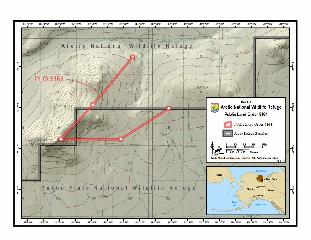
E.3.3 Public Land Order 5164 – Burnt Mountain Research Site
In 1972, PLO 5164 withdrew approximately 100 acres in the Burnt Mountain area on the boundary between the Arctic and Yukon Flats refuges for the U.S. Air Force Burnt Mountain Research Site or Seismic Observatory. Approximately 56 acres of the PLO withdrawal are on Arctic Refuge, and 44 acres are in the adjacent Yukon Flats National Wildlife Refuge (Map E-3).
The withdrawal consists of five seismic monitoring sites situated on 500-foot square parcels, spaced one to four miles apart, and interconnected with ground-laid cable in the center of 100-foot-wide interconnecting access ways. Each monitoring site contains a seismic sensor (geophone) located in a bore hole and a small frame building containing electronics, which are enclosed in a chain link fenced area. Each site utilizes a solar-diesel power source and batteries to power the seismic sensors and electronics. One of the monitoring sites also contains a central radio facility, an antenna, a cabin (for personnel use when servicing the site), and an equipment shed. The site is operated remotely and is manned only for periodic servicing.
1 As can be seen on Map E-2, Kaktovik is not part of Arctic Refuge even though the town site is physically inside the boundaries of the Refuge. The Refuge boundary surrounds the town site, creating a “doughnut-hole” in the Refuge.

Appendix E: Easements, Rights-of-Way, and Withdrawals
E-8 Arctic National Wildlife Refuge Revised Comprehensive Conservation Plan
This page intentionally left blank.