Appendix C Phase I Environmental Site Assessment · San Francisco Bay Area Water Emergency...
39
Appendix C Phase I Environmental Site Assessment
Transcript of Appendix C Phase I Environmental Site Assessment · San Francisco Bay Area Water Emergency...
Appendix C Phase I Environmental Site Assessment

PHASE I ENVIRONMENTAL
SITE ASSESSMENT
JANUARY 2010
The Southeast Corner of W. Hornet Avenue and Ferry Point Road
Alameda, California
For: San Francisco Bay Area
Water Emergency Transportation Authority Planning and Development
San Francisco, California
Y9374-00.01405
5900 Hollis Street, Suite D • Emeryville, California 94608 • (510) 420-8686
Y9374-00 01415 WETA Phase_I_ESA_012110.doc-1/22/10
22 January 2009 Y9374-00.01405v.1 Ms. Laurie Karlinsky ICF Jones & Stokes 620 Folsom Street, 2nd Floor San Francisco, CA 94107 Subject: Phase I Environmental Site Assessment: the Southeast Corner of W. Hornet
Avenue and Ferry Point Road, Alameda, California Dear Ms. Karlinsky: Please find enclosed our report documenting the activities and findings of a Phase I Environmental Site Assessment performed at the southeast corner of W. Hornet Avenue and Ferry Point Road, Alameda, California. If you have any questions or comments, please contact us at your convenience. Sincerely,
Yane Nordhav Ralph Russell Principal Environmental Analyst Professional Geologist No. 4009 YN:RER:km Enclosure
PHASE I ENVIRONMENTAL SITE ASSESSMENT
JANUARY 2010
The Southeast Corner of W. Hornet Avenue and Ferry Point Road Alameda, California
For: San Francisco Bay Area Water Emergency Transportation Authority
Planning and Development San Francisco, California
Y9374-00.01405
BASELINE Environmental Consulting 5900 Hollis Street, Suite D, Emeryville, California 94608
(510) 420-8686

Y9374-00 01415 WETA Phase_I_ESA_012110.doc-1/22/10 -iii-
TABLE OF CONTENTS
page
EXECUTIVE SUMMARY ........................................................................................................... iv
1. INTRODUCTION .....................................................................................................................1
2. SITE DESCRIPTION ................................................................................................................2
3. HISTORICAL LAND USES.....................................................................................................3
4. ENVIRONMENTAL DATABASE REVIEW..........................................................................8
5. CURRENT LAND USES AND SITE RECONNAISSANCE..................................................9
6. INTERVIEW WITH FUTURE USER OF THE PROJECT SITE..........................................10
7. DATA GAPS ...........................................................................................................................11
8. ASTM E1527-05 DEVIATIONS ............................................................................................11
9. CONCLUSIONS AND RECOMMENDATIONS ..................................................................12
10. ENVIRONMENTAL PROFESSIONAL STATEMENT........................................................13
11. LIMITATIONS........................................................................................................................13
12. REFERENCES ........................................................................................................................14
APPENDICES
A: Historical Land Use Resources (Portable Document Format on CD ROM) B: Environmental Database Report (Portable Document Format on CD ROM) C: Phase I User Questionnaire D: Qualifications of Preparers
FIGURES
1: Regional Location 2: Project Site and Adjacent Lands 3: Sites with Known Hazardous Materials Use and/or Release within One-Quarter
Mile of the Project Site 4: Photographs from Site Reconnaissance, 10 November 2009 5: Photographs from Site Reconnaissance, 10 November 2009

Y9374-00 01415 WETA Phase_I_ESA_012110.doc-1/22/10 -iv-
EXECUTIVE SUMMARY PHASE I ENVIRONMENTAL SITE ASSESSMENT
The Southeast Corner of W. Hornet Avenue and Ferry Point Road
Alameda, California
BASELINE Environmental Consulting performed a Phase I Environmental Site Assessment (ESA) near the southeast corner of W. Hornet Avenue and Ferry Point Road in Alameda, California (project site). The San Francisco Bay Area Emergency Water Transportation Agency (WETA) is considering a long-term lease of the project site for a proposed maintenance and operations facility in support of ferry operations. The purpose of this investigation was to determine whether recognized environmental conditions (RECs) are present at the project site or adjoining properties as defined in the American Society of Testing and Materials (ASTM) Method E1527-05, “Standard Practice for Environmental Site Assessments: Phase I Environmental Assessment Process.”
The scope of work for the Phase I ESA included: a review of historical land use information, including historical topographic maps and aerial photographs; a reconnaissance of the project site; and a review of environmental records from federal, state, and local sources. All work was conducted in accordance with ASTM Method E1527-05.
CONCLUSIONS AND RECOMMENDATIONS
• Prior to filling of San Francisco Bay, the project site was open water approximately 2,400 feet offshore from Alameda Island. The landside portion of the project site was created between 1942 and 1946 by filling (reportedly with mostly dredge spoils), and by 1946, the rail line crossing the site and W. Hornet Avenue had been constructed. By 1959, a building housing a snack-shop and a boat house had been constructed. In 1966 a replacement structure, Navy Building No. 385, was constructed and served as a restaurant and maintenance building for the recreational marina located on the adjacent parcel to the east. Reportedly, a hazardous materials storage locker was located in the eastern portion of the landside portion of the project site. The project site was cleared of aboveground structures, and subsurface utilities, such as sanitary sewer connections, were sealed, sometime during 2006 and/or early 2007. Fuel lines associated with the basewide fuel distribution systems have been removed from the project site by the Navy.
• The project site is entirely within a larger area variously designated Terminal 1, or Term-1. This irregularly shaped area is mapped as Salt March & Tide Lands (submerged lands) in the County of Alameda’s Assessors/County Clerks maps, and as property of the City of Alameda. The City of Alameda leased these submerged lands to the Navy prior to their development as part of NAS. The NAS was closed in 1997, and the Navy’s lease of the property expired, returning control of the property to the City of Alameda.
• The adjoining land uses to the north and east of the project site were identified as primarily paved open space uses, consisting of parking areas for aircraft during the 1940s to the

Y9374-00 01415 WETA Phase_I_ESA_012110.doc-1/22/10 -v-
1960s, and for vehicle parking from the 1960s until Navy base closure proceedings in the 1990s. Since the Navy base closure, the adjacent areas have been primarily vacant except for vehicle parking. Pier 3, northwest of the site, has been converted to a permanent base for the USS Hornet, which now serves as a museum. To the east, the land adjoining Breakwater Beach has been become a park, and is managed by the East Bay Regional Parks system.
• Land uses associated with hazardous materials use were identified by the Navy as part of the base closure activities. These included railroad tracks, a former hazardous materials storage locker, and a building housing marina maintenance activities (including storage of pesticides). The project site was determined by the Navy to not warrant remedial actions to protect human health or the environment.
• Observations made during reconnaissance of the project site identified no current use of the project site, or land uses on adjoining properties that indicated current use of hazardous materials. No evidence of hazardous materials release was observed at the project site and adjoining properties.
• Historical use of the landside portion project site as a rail corridor and landscaped area are considered RECs due to the potential for releases of pesticides, herbicides, metals, and fuels. It is recommended that the rail corridor and landscaped areas be investigated to determine possible presence of organic (including total petroleum hydrocarbons [TPH], semivolatile organic compounds [SVOCs], polychlorinated biphenyls [PCBs], pesticides, and herbicides) and inorganic compounds in the subsurface. It is recommended that a licensed professional develop a soil sampling program to assess potential effects to human health (including future users and construction workers) and the environment; in addition, the sampling approach should consider analytical requirements for soil management/disposal purposes, should the area be excavated as part of future development. Depending on the results of the investigation, additional sampling may be necessary to determine potential effects to underlying groundwater.
• The past on-site operation of a restaurant and marina maintenance facility, and the former presence of a locker for storage of hazardous materials, could have resulted in releases to the subsurface of organic (TPH, pesticides, PCBs, SVOCs, and volatile organic compounds [VOCs]) and inorganic compounds, (including locations of drains or along utility lines); this is considered an REC. It is recommended that either during demolition of the existing foundation slab and other paved areas of the project site, or prior to removal, a licensed professional develop and implement a soil sampling program to determine potential effects to human health (including future users and construction workers) and the environment; in addition, the sampling should consider analytical requirements for soil management/disposal purposes, should the area be excavated as part of future development. Depending on the results of the investigation, additional sampling may be necessary to determine potential effects to underlying groundwater.
• Any dredging or removal of piers required for the waterside development could result in requirements for special handling of generated wastes. Sediment sampling was performed by the Navy within the waterside portion of the project site near Outfall N as part of the
Y9374-00 01415 WETA Phase_I_ESA_012110.doc-1/22/10 -vi-
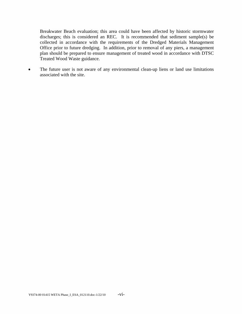
Breakwater Beach evaluation; this area could have been affected by historic stormwater discharges; this is considered an REC. It is recommended that sediment sample(s) be collected in accordance with the requirements of the Dredged Materials Management Office prior to future dredging. In addition, prior to removal of any piers, a management plan should be prepared to ensure management of treated wood in accordance with DTSC Treated Wood Waste guidance.
• The future user is not aware of any environmental clean-up liens or land use limitations associated with the site.

Y9374-00 01415 WETA Phase_I_ESA_012110.doc-1/22/10 -1-
PHASE I ENVIRONMENTAL SITE ASSESSMENT
The Southeast Corner of W. Hornet Avenue and Ferry Point Road Alameda, California
1. INTRODUCTION
This report presents the activities and findings of a Phase I Environmental Site Assessment (ESA) performed by BASELINE Environmental Consulting (BASELINE). The project site is approximately one-half acre of land (landside) and three acres of San Francisco Bay (waterside) located near the western end of W. Hornet Avenue at Alameda Point in the City of Alameda, California (Figure 1).
The San Francisco Bay Area Emergency Water Transportation Agency (WETA) is considering a long-term lease of the project site for a proposed maintenance and operations facility in support of ferry operations. The proposed landside facility would include a three-story building with an approximately 5,600 square feet footprint with drilled or driven pier foundation supports, and four 10,000-gallon below-grade fuel/urea1 storage tanks. Waterside improvements would include dredging to a depth of ten feet below mean lower low water (MLLW), and installation of piers and a floating dock structure with berthing space for a maximum of ten ferries. Up to ten berths would be equipped for fueling, maintaining, and resupplying the ferries.
This Phase I ESA was performed for WETA in accordance with Standard Practice for Environmental Site Assessments: Phase I Environmental Site Assessment Process adopted by ASTM International in Method E1527-05. ASTM Method E1527-05 includes provisions designed to meet the requirements of U.S. Environmental Protection Agency’s All Appropriate Inquiry contained in Title 40 of the Code of Federal Regulations Part 312 (40 CFR). The purpose of this assessment was to determine whether recognized environmental conditions (RECs)2 were present at the project site, including the waterside area of proposed dock facilities, and/or adjoining properties3 based on current and/or previous land uses. The scope of work for the Phase I ESA included: a review of historical land use information, including historical
1 A mix of urea (chemical formula (NH2)2CO) and water is used as the catalytic reduction agent for reducing
the oxides of nitrogen (NOx) and other emissions from diesel engines. 2 RECs are defined in ASTM E1527-05 as “the presence or likely presence of any hazardous substances or
petroleum products on a property under conditions that indicate an existing release, a past release, or a material threat of a release of any hazardous substances or petroleum products into structures on the property or into the ground, ground water, or surface water of the property.” According to ASTM E1527-05, the term “REC” is not intended to include de minimis conditions that generally do not present a material risk of harm to public health or the environment and that generally would not be the subject of an enforcement action if brought to the attention of appropriate governmental authorities.
3 Adjoining properties are defined in ASTM E1527-05 as “any real property or properties the border of which is contiguous or partially contiguous with that of the [subject] property, or that would be contiguous or partially contiguous with that of the [subject] property but for a street, road, or other public thoroughfare separating them.” This report uses this definition of adjoining property throughout this document.
Y9374-00 01415 WETA Phase_I_ESA_012110.doc-1/22/10 -2-
topographic maps and aerial photographs; a reconnaissance of the project site; and a review of environmental records from federal, state, and local sources.
2. SITE DESCRIPTION
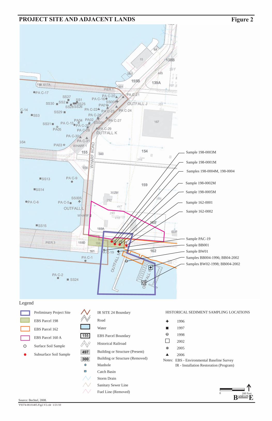
2.1. Physical Description The landside of the project site is a roughly rectangular area starting approximately 130 feet east of the current intersection of W. Hornet Avenue and Ferry Point Road (also mapped as 5th Street or Wharf Road) and continuing eastward to approximately the historic Marina entrance. The landside includes the roadbed of W. Hornet Avenue, and the area south to the shore of San Francisco Bay. (Figure 2). The waterside area is an irregularly shaped approximately three-acre portion of San Francisco Bay fronting the landside area and continuing offshore approximately 200 to 400 feet south. The landside portion of the project site is nearly flat and has an elevation of approximately six to eight feet above mean sea level (EDR, 2009a).
The landside portion of the site is bordered to the north by paved open area with a small utility building and fenced storage yard, a park to the east, Pier 3 and the USS Hornet to the west, and San Francisco Bay (partially fronted with a rip-rap breakwater, and partially with beach) to the south.
2.2. Geology and Hydrology The landside portion of the project and vicinity is underlain by five units of Quaternary sediments overlying Franciscan bedrock. The five units are, from top to bottom: artificial fill, Bay Mud, Posey/Merritt Sand Formation, upper San Antonio Formation, and lower San Antonio Formation.
The artificial fill at the project site was placed between 1942 and 19464. A generalized geologic cross section was prepared for an area about 1,000 feet northeast of the landside portion of the project site. The materials underlying that area include artificial fill, estimated to be approximately 10 to 12 feet thick, overlying Bay Mud, which is approximately 8 feet thick. The Bay Mud is underlain by Posey/Merritt/San Antonio Formation in excess of 20 feet thick. The materials underlying the landside portion of the project site may be similar. Groundwater was generally about 6 feet below ground surface (bgs) (Tetra Tech, 2009).
No surface water traverses the landside portion of the project site. Most surface runoff is captured by drop inlets set in the pavement leading to a storm drain culvert under the site. The storm drain discharges directly into the Bay (Figure 2). In the eastern portion of the project site, runoff, as sheet flow, moves to a landscaped area at the adjacent park or to the Bay. Based on the topography and proximity to the Bay, groundwater would be expected to flow to the south-southwest toward the Bay.
4 The project site is not mapped as underlain by Marsh Crust, a term referring to a relatively thin layer of
deposits that would have formed during the early part of the 20th century consisting of sludge and hydrocarbon by-products released by early industries along the Oakland Inner Harbor and Alameda Island (Tetra Tech, 2003a).

Y9374-00 01415 WETA Phase_I_ESA_012110.doc-1/22/10 -3-
3. HISTORICAL LAND USES
Historical land uses at the project site and adjoining properties were identified to assess potential sources of hazardous materials that could have affected soil and groundwater quality at the project site. Portions of an Environmental Baseline Survey (EBS), prepared as part of the closure proceedings for the Alameda Naval Air Station (NAS) by the Navy, were reviewed (IT, 2001a). In addition, historical land uses in the vicinity of the project site were determined through review of topographic maps from 1915 through 1980, and aerial photographs from 1939 through 2005 (EDR, 2009d). Historical Sanborn Maps or Tax Map files were not available for the area (EDR, 2009c, 2009f). The EDR historical land use resources reviewed for this Phase I ESA are included in Appendix A.
3.1. Project Vicinity History The project site is within the NAS Base Realignment and Closure (BRAC) area, now known as Alameda Point. The former NAS occupied approximately 1,700 acres of land and about 1,000 acres of water. A BRAC Cleanup Plan (Cleanup Plan) was prepared by Tetra Tech EM Inc. (Tetra Tech) for the Navy (Tetra Tech, 2003).
The 2001 EBS divided the NAS into smaller parcels; these parcels are referred to as “EBS Parcels.” Based on the EBS parcelization, NAS was subsequently divided into 38 Installation Restoration (IR) sites within the Alameda Point project area. These 38 IR sites were organized into a total of 10 Operable Units (OU) based on geographic proximity and environmental characterization. The landside portion of the project site includes small portions of EBS Parcels 160A, 162, and the majority of 198. The waterside area was not included within an EBS parcel (Figure 2). The project site is partly within IR Site 24 (Figure 2), which includes portions of landside and waterside project site.
The entire project site is also located within the larger Terminal 1 (Term-1) area, which was historically salt marsh and tide lands. Unlike the majority of the former NAS, the Term-1 property is owned by the City of Alameda, and was leased by the Navy until the base closure in 1997, when control of the property reverted to the City of Alameda (Thomas, 2009).
3.2. Project Site
The project site is located near the west end of W. Hornet Avenue (Figure 2). Aerial photographs show the area was open Bay in 1939. By 1946 the area had been filled to its present extent and W. Hornet Avenue, and rail tracks (traversing the landside portion of the project site) had been constructed (EDR, 2009d).
In 1953 a dock was constructed for a small craft marina on the waterside portion of the project site. By 1958 a boathouse and snack shop had been constructed on the landside portion of the project site (IT, 2001a).
Between 1965 and 1998, the docks were reconfigured several times. Portions of abandoned docks are still present within a portion of the waterside of the project site (Figure 5B) (EDR, 2009d). In 1966 Navy building No. 385 was constructed on the landside of the project site where the snack shop and boathouse had been located previously. Building No 385 was used as a
Y9374-00 01415 WETA Phase_I_ESA_012110.doc-1/22/10 -4-
restaurant and maintenance area for the marina (Tetra Tech, 2003a). Building 385 is still shown in the 2005 aerial photograph for the site (EDR, 2009d). The building has subsequently been removed, but the foundations are still present on the landside of the project site. Navy documents (IT, 2001a) also report the past presence of a hazardous materials locker in the eastern portion of the project site.
3.2.1 Past Environmental Investigations and Observations
Environmental investigations have been conducted at the project site as part of Navy assessments of the environmental conditions of the NAS. The investigations by the Navy have been both parcel-specific and also part of basewide investigations, as described below.
Fuel Pipelines – Basewide. Starting in approximately 1997 and currently in the final implementation stages, there was as basewide removal of pipelines and tanks used for transporting and storing fuels as part of the Basewide Petroleum Cleanup Project (Battelle, 2009). The basewide removal action included the removal of fuel pipelines that traversed the project site (Tetra Tech, 2003b). Based on site plans, the pipelines were located just above the riprap on the outboard side of the retaining wall facing the Bay (Battelle, 2009). In addition, a basewide sewer investigation, addressing the industrial, storm, and sanitary sewers, was conducted by the Navy. Sewer corridor samples were not collected from the project site (IT, 1997, 2001a).
Radiological Issues – Basewide. A basewide Historical Radiological Assessment (HRA) was prepared by the Navy in 2000; the HRA concludes that, based on the environmental radioactivity data collected by the Navy since 1966, no cobalt-60 or other radioactivity attributable to the Naval Nuclear Propulsion Program (NNPP) at the NAS has ever been detected, and that no significant radioactivity has accumulated in the marine environment based on water, sediment, and biota sampling (HRA, 2000).
EBS Parcel 198. As part of the EBS, Parcel 198 was subject to a Parcel Evaluation Plan (PEP). The landside portion of the project site is partially within parcel 198 (Figure 2). The objective of the PEP parcel-specific sampling effort was to investigate and document the existing environmental conditions at EBS Parcel 198. The PEP noted that pesticides had been used inside Building 385 during 1992 and 1993, and that petroleum products had been stored in the boat maintenance portion of the building continuously since its construction; however, there were no documented spills. No lead-based paint issues were identified for Building 385. No polychlorinated biphenyls (PCBs) issues were identified for Parcel 198. Asbestos containing-materials were identified as insulation on pipes and fitting in Building 385 (IT, 2001b).
One soil sample (198-0003M on Figure 2) was collected by IT Corporation for the Navy on EBS Parcel 198 in 1995. The sample was collected adjacent to the rail junction at 2.5 bgs. This sampling was part of a larger sampling effort related to railroad tracks at NAS. The sample was analyzed for lead, total petroleum hydrocarbons (TPH) as gasoline, diesel, and motor oil, semivolatile organic compounds (SVOCs), and PCBs.
• Lead was detected at 2.2 milligrams per kilogram (mg/kg).
• TPH as diesel (2.4 mg/kg) and TPH as motor oil (150 mg/kg) were detected.
Y9374-00 01415 WETA Phase_I_ESA_012110.doc-1/22/10 -5-
• SVOCs and PCBs were not detected above laboratory reporting limits.
Five additional soil samples were also collected in 1995 on the landside portion of the project site in the eastern portion of EBS Parcel 198 as part of a NAS parcel-specific investigation. The samples consisted of two surface samples (198-0001M, 198-0002M on Figure 2) collected at 0.5 to 1.0 feet bgs, and three subsurface samples (198-0004M, 198-0004, 198-0005M) collected at 4.0 to 4.5 feet bgs. Surface soil samples were analyzed for TPH as diesel and motor oil. The subsurface soil samples were analyzed for TPH as diesel, and motor oil, and VOCs.
• TPH as motor oil was detected in surface sample 198-0001M at 1,100 mg/kg.
• TPH as motor oil was detected in subsurface samples 198-0004M (1,000 mg/kg), and 198-0004 (30 mg/kg).
• TPH as diesel was detected in subsurface sample 198-0005M (2.2 mg/kg).
• VOCs were not detected in the samples above laboratory reporting limits.
EBS Parcel 162. The eastern portion of the landside portion of the project site was part of EBS Parcel 162 (Figure 2). The PEP for EBS Parcel 162 noted that chemicals were reportedly stored in a hazardous materials locker located on asphalt near the western border of EBS Parcel 162 (within the eastern portion of the project site).
The stored chemicals in the hazardous materials locker were reported to be marina supplies including non-halogenated solvents, paints, and petroleum products. The total volume of materials stored was estimated to be less than 75 gallons. The PEP noted a stained area in front of the locker that covered approximately 25 square feet. Based on the visual evidence of ground staining, two soil samples were collected in 1995 by IT Corporation from that portion of EBS Parcel 162 that is located within the landside portion of the project site (Figure 2). One soil sample (162-0001) was collected at 1.0 to 1.5 feet bgs, and one subsurface soil sample (162-0002) was collected at 4.0 to 4.5 feet bgs, and analyzed for TPH as diesel and motor oil. In addition, the subsurface sample was analyzed for volatile organic compounds (VOCs) and TPH as gasoline.
• Analytical results of soil samples for 162-0001 and 162-0002 indicated 38 mg/kg and 900 mg/kg TPH as motor oil, respectively.
• TPH as diesel was not detected above laboratory reporting limits.
• VOCs were not detected above laboratory reporting limits.
• TPH as gasoline was not detected above laboratory reporting limits.
No conclusions or recommendations regarding remediation were made; however, the report concluded that no additional sampling was recommended for EBS Parcel 162 (IT, 1997).
EBS Parcel 160A. The northern edge of the landside of the project site falls within EBS Parcel 160A. EBS Parcel 160A was originally a portion of EBS Parcel 160; however, the border of EBS

Y9374-00 01415 WETA Phase_I_ESA_012110.doc-1/22/10 -6-
160 intersected land in the Term-1 area, and 160A was set aside to facilitate transfer to the Alameda Reuse and Redevelopment Authority. Historical use of EBS 160 was characterized as aircraft parking and no chemical storage, spills, or staining were noted at EBS 160 during preparation of the original 1994 EBS; potential impact to soil or groundwater was characterized as ‘unlikely,’ and the Navy recommended that no further evaluation was warranted for EBS Parcel 160 (Bechtel, 2007).
IR Site 24. The Navy has conducted investigations to develop and implement remediation strategies for all the IR sites. Originally, the landside portion of the project site was determined to not be within any IR site, and as a result the landside portion of the project site was not included within an OU (IT, 2001a). The area defined as IR Site 24 was subsequently expanded to include part of EBS Parcel 198 (the landside portion of the project site), and a portion of the waterside of the project site in a Final Feasibility Study Report (FFSR) (Bechtel, 2008).
Results of investigations of IR Site 24 by the Navy indicated that the highest concentrations of contaminants were in the northeastern corner of IR Site 24 (approximately 1,000 feet north of the project site) (DTSC, 2009). The Navy prepared a Proposed Plan for implementation of a remedial action for IR Site 24. This Proposed Plan evaluated remedial alternatives for the contaminated sediment portion of IR Site 24. For the remainder of IR Site 24 (including the landside and waterside portions of the project site), no further action was recommended, and no land-use restrictions, environmental monitoring, or other cleanup actions were recommended (Navy, 2009).
Storm drain Outfall M, underlying the site, discharges stormwater directly into the Bay on the waterside portion of the project site. As part of the preparation of the FFSR for IR Site 24, discussed above, sediment cores were collected during 2005 or 2006 from the waterside potion of IR Site 24 to characterize potential sediment contaminants from storm drain outfalls. One of these samples was collected at the project site. In 2005, sample PAC-19 (Figure 2) was collected approximately 50 feet offshore in the waterside portion of the project site about 100 feet west of storm drain Outfall M. Sample PAC-19 was analyzed for polycyclic aromatic hydrocarbons (PAH), PCBs, pesticides, and metals.
• Total PAH, pesticides, total PCB, and metal concentrations at PAC-19 did not exceed the effects range-median5 (ER-M) values established as threshold for ecological impact for the former base (Bechtel, 2008).
Risk Evaluation – Breakwater Beach Area. An ecological and human health risk evaluation was conducted by Battelle for the Breakwater Beach area, which includes the waterside portion of the project site in the vicinity of storm drain Outfall N. Storm drain Outfall N, underlying the site, discharges stormwater directly into the Bay on the waterside portion of the project site. This areas could have been affected by historic stormwater discharges. A total of six samples were collected from four sampling locations (BB001, BB004, BW01, and BW02) for the Breakwater Beach evaluation within the waterside of the project site (Figure 2).
5 EPA definition: The concentration of a contaminant above which harmful effects always or almost always
occur.
Y9374-00 01415 WETA Phase_I_ESA_012110.doc-1/22/10 -7-
• No ER-M values were exceeded in surface sediment for any inorganic constituents or organic chemicals, except for nickel, during any sampling event for Breakwater Beach. Nickel was the only analyte at Breakwater Beach that exceeded its ER-M in surface sediment, but nickel concentrations at Breakwater Beach were not different from San Francisco Bay ambient nickel concentrations (Battelle, 2007).
• In the subsurface sediment, no ER-Ms were exceeded for inorganic constituents except for nickel (which was less than ambient), and the only organic chemical that exceeded the ER-M was Total PCBs at BB004 in the 1996 sample (PCBs at a sediment depth of 75 to 180 cm were 210 μg/kg compared to an ER-M value of 180 μg/kg) (Battelle, 2007).
The study concluded that no unacceptable risks were identified for any of the ecological receptors, and human health risks were all determined to be consistent with ambient conditions. Based on this information, no remedial action was recommended by Battelle for the Breakwater Beach area (Battelle, 2007).
3.3. Adjoining Properties
Alameda Point is reported to be predominantly built on land created by placing fill (mostly dredge fill) in the Bay and over tidal areas (HRA, 2001). The Bay was filled to create the project site and surrounding land between 1942 and 1946, and the layout and structures of the adjoining properties have remained relatively stable since then.
In the 1946 aerial photograph, a small structure had been constructed about 200 feet north of the project site, and a large triangular-shaped field to the east served as parking for aircraft. By 1959 two large above-ground tanks had been constructed about 700 feet east of the project site beyond the marina (EDR, 2009d). These tanks were cleaned, demolished, and removed in 2008 by the Navy (RAB, 2008). In 1959, aircraft and vehicles were also parked in large numbers to the east and north of the project site, and an additional building had been constructed about 300 feet north of the site. In 1965, the landscaping had been reconfigured and a new dock had been installed at the marina immediately southeast of the project site. Since 1965 until present, no significant additions are apparent from the historical aerials for the adjacent area (EDR, 2009d).
3.4. Historical Land Uses Associated with Hazardous Materials
Prior to 1936, the western end of the original Alameda Island (approximately 2,400 feet northeast of the project site) was occupied by a borax processing plant, an oil refinery, and an airport for the City of Alameda. Initially the areas were acquired by the Army in 1930. Since 1936, when the Navy acquired title to the area, the air station’s primary mission was to provide facilities and support for fleet aviation activities. The Navy expanded the NAS by filling the Bay in phases through 1975. Wastes generated at NAS included industrial solvents, acids, paint strippers, degreasers, caustic cleaners, pesticides, chromium and cyanide wastes, waste oils containing PCBs, radium associated with dial painting and stripping, medical debris, and inert and unexploded ordnance. Solid wastes generated at the NAS were disposed into two on-base landfills at the western end of the NAS, approximately 1.8 miles northwest of the project site. All liquid industrial wastewaters generated at the site prior to 1974 were discharged untreated into the Seaplane Lagoon located 0.5 mile to the north of the project site, and the Oakland Inner
Y9374-00 01415 WETA Phase_I_ESA_012110.doc-1/22/10 -8-
Harbor located 1.3 miles to the north (U.S. EPA, 2009). Some of these historic off-site land uses, including aircraft parking north of the project site, could have affected stormwater quality discharging through the outfalls under the site and into the waterside portion of the project site.
At the landside portion of the project site, railroad tracks traversed the center of the site. Common contaminants associated with railroad tracks are pesticides and herbicides, metals (depending on the type of ballast used), SVOCs, and petroleum hydrocarbons. Operation of a restaurant and marina maintenance facility (Navy Building No. 385) at the site may have resulted in the discharge of various oils and greases from food preparation or discharges of fuels/solvents from maintenance activities onto the ground or into sewers or sumps; reportedly pesticides were used at this building in the 1990s. Maintenance of a landscaped area may have involved the use of fertilizers and/or pesticides. The operation of a hazardous materials locker, on the eastern portion of the project site, could also have resulted in the discharge of hazardous materials onto the ground.
At the waterside portion of the project site hazardous materials may have been contained in the stormwater discharging from the storm drain outfalls located at the project site; the discharges may have included urban/industrial-type pollutants such as organic and inorganic contaminants that may have affected the quality of sediments in the area.
4. ENVIRONMENTAL DATABASE REVIEW
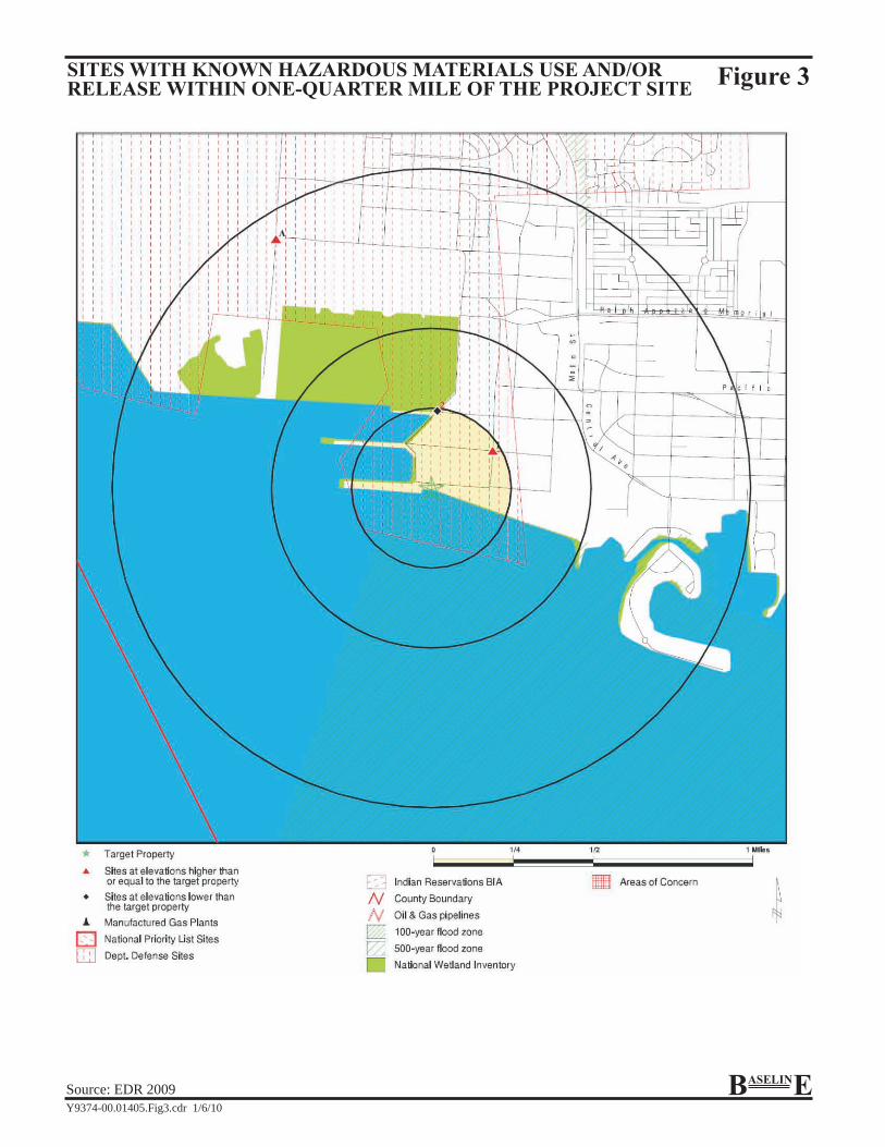
BASELINE contacted Environmental Data Resources, Inc. (EDR), an environmental resource service, to conduct a search of environmental records from federal, state, and local databases pertaining to past and present hazardous materials uses and releases on properties at or near the project site (EDR, 2009a) (Appendix B). For the purposes of this report, sites with known hazardous materials use and/or release within one-quarter mile of the project site identified by EDR were evaluated to determine whether they could potentially affect conditions at the project site.
4.1. Sites Associated With Use, Storage, Generation, or Disposal of Hazardous Materials
Two sites of current facilities associated with hazardous materials use were identified within one-quarter mile of the project site (Figure 3). The first site was Delta Sandblasting Company, Inc., at 1501 Viking St, Alameda; this company is a Small Quantity Generator of Hazardous Waste (primarily uses solvents and acids) located approximately one-quarter mile northeast of the landside portion of the project site. No hazardous materials violations by this firm at this location were noted in the database (EDR, 2009a). This site is therefore unlikely to affect the project site.
The second site was for National Response Corporation Environmental Services (NRC) activities related to cleanup of NAS facilities. NRC is listed as a “handler” of hazardous waste and a conditionally exempt small quantity generator. No violations were noted related to their activities. This site is therefore unlikely to affect the project site.
Y9374-00 01415 WETA Phase_I_ESA_012110.doc-1/22/10 -9-
A supplemental inquiry of the EDR databases indicated approximately 200 entries from various sources related to historic NAS activities (EDR, 2009b). The project site was not specifically identified in any of the databases searched by EDR as associated with the storage, generation, or disposal of hazardous materials; however, the project site is within the larger defined area for the NAS cleanup program. The environmental database report is included in Appendix B.
4.2. Sites Associated with a Hazardous Materials Release
EDR identified the NAS in the Department of Defense facilities database, noting that the NAS is to be closed (EDR, 2009a). The project site is located with the boundaries of the NAS. A supplemental inquiry of the EDR database materials indicated the National Priorities List (NPL) (Superfund) entry for the NAS, and inclusion of the NAS in the CERCLIS6 database (EDR, 2009b). The EDR database search report indicated approximately 200 entries related to historic base activities including both use and release of hazardous materials; the project site was not specifically identified as associated with any release records.
4.3. Orphan Sites
The EDR report included an orphan summary, which contained sites with known hazardous materials use and release, but with poor or inadequate address information; these sites may be within the search distance established by the ASTM Standard Method E1527-05. The orphan sites were evaluated to determine whether they could be proximate to the project site and potentially affect conditions at the project site.
The orphan summary listed 20 sites with corresponding address and database information (Appendix B). Of the 20 sites, 13 sites were identified in federal and state databases associated with hazardous materials use, but not releases. These sites are considered unlikely to affect conditions at the project site since no releases of hazardous materials have been reported. The other seven orphan sites were identified in federal and state databases associated with hazardous materials releases. These seven sites were reviewed and were determined to be more than one-quarter of a mile from the project site. One record in particular is noted for referring to a spill at the ‘Alameda Marina,’ however, the location description places the spill in the Oakland Estuary, on the north edge of Alameda Island. An EDR Site Report for each of the 20 orphan sites is included in the environmental database report included in Appendix B.
5. CURRENT LAND USES AND SITE RECONNAISSANCE
A BASELINE environmental analyst conducted a visual reconnaissance of the project site on 10 November 2009. BASELINE staff was accompanied during the reconnaissance of the project site by a representative of WETA, the future project site user. The reconnaissance was conducted to document current land uses and evidence of storage, generation, release, and disposal of hazardous materials at the project site and adjoining properties. Observations on adjoining properties were made from public rights-of-way. Photographs taken during the reconnaissance of the project site are shown on Figures 4 and 5. Observations made during the site reconnaissance are included in the descriptions below.
6 The US EPA Comprehensive Environmental Response, Compensation, and Liability Information System.

Y9374-00 01415 WETA Phase_I_ESA_012110.doc-1/22/10 -10-
5.1. Properties Adjacent to the Project Site
The adjoining properties to the south, north and east of the project site (Figure 2), consist primarily of open areas and were observed to be vacant during the reconnaissance. No signs of distressed vegetation, stained soil, odors, or other evidence that would suggest a hazardous materials release, were observed at adjoining properties. Sumps, drums, transformers, tanks, standpipes, ponds, basins, or containment structure of hazardous materials or associated structures were not identified on properties adjoining the project site. The USS Hornet is currently berthed at Pier 3, west of the project site, and is used as a museum. Immediately west of the landside portion of the project site is an approximately 30- by 30-foot fenced enclosure around a high-voltage transformer. The enclosed transformer area is not part of the project site (Gougherty, 2009).
5.2. Project Site
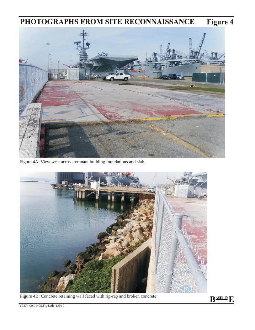
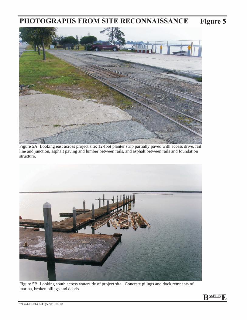
Landside. The site is vacant and currently unused. No evidence of current hazardous materials use or storage was noted during the BASELINE site reconnaissance. The landside area contains the remnant foundations of an approximately 4,500 square-foot building and associated sewer pipes and drains within the building foundation; the pipes and drains were observed to be sealed with plates or grout at ground level (Figure 4A). The landside also contains a partially paved and partially vegetated 12-foot planter-strip adjacent to W. Hornet Avenue; the project site is crossed by a standard gauge railroad track with siding junction (Figure 5A). The remainder of the landside portion of the project site is paved with either concrete or asphalt. A vertical concrete wall, topped by a chain link fence, fronts the Bay with large rip-rap and broken concrete at the base on the waterside (Figure 4B).
Waterside. The waterside of the project site includes a portion of what was formerly a recreational marina dock area. A site map prepared for IR Site 24 indicates that storm drains Outfall M and N are located just offshore (Bechtel, 2008) (Figure 2); however, outfall M was not apparent during the site reconnaissance and Outfall N was not identified as the landside of the project does not extend as far east as Outfall N. Concrete pilings, docks, ramps and floating debris, consisting primarily of timbers and broken wooden pilings (possibly treated wood), occupy a portion of the waterside project site (Figure 5B).
6. INTERVIEW WITH FUTURE USER OF THE PROJECT SITE
A Phase I user questionnaire was prepared by the future user The Phase I user questionnaire, based on ASTM Standard Method E1527-05, discloses information and/or specialized knowledge of the user that may be helpful in identifying RECs in connection with the project site. A copy of the interview questionnaire is included in Appendix C.
WETA representative John Sindzinski indicated on the interview questionnaire (Appendix C) that he is not aware of any environmental liens against the property, land use limitations associated with the project site, or the presence of contamination at the project site.

Y9374-00 01415 WETA Phase_I_ESA_012110.doc-1/22/10 -11-
7. DATA GAPS
The ASTM Standard Method E1527-05 requires the identification of data gaps, along with actions taken to address these gaps, and an opinion as to whether these gaps are significant. Information sources at intervals greater than five years between sources from the present to 1940 or the first developed land use, whichever is earlier, can be considered a data gap. In addition, a lack of or the inability to obtain information required by the ASTM Standard (i.e., site reconnaissance or interview with the owner/key site manager) may constitute a data gap.
No Sanborn Maps, Tax Maps, or City Directories were available for the project site; however, either an aerial photograph or topographic map was available for the years 1915, 1939, 1946, 1948, 1949, 1959, 1965, 1968, 1973, 1975, 1980, 1982, 1993, 1998, and 2005. Prior to about 1942 the area of the project site was open water and part of San Francisco Bay. For the 13-year period between the aerial photos of 1946 and 1959 there was no change in the shoreline or roads adjoining the property, but a building had been constructed on the project site. This is consistent with the site history provided in the EBS for the NAS indicating that in 1958 a boathouse and ‘snack-shop’ were constructed. The topographic map of 1948 appears to be in error, at it does not show the changed shoreline evident in the 1946 aerial photograph. Based on the 1982 and 1993 aerial photographs, there appear to be no changes on the landside of the project site; however, the Marina docks had been reconfigured. Neither of these gaps in the historical record would be expected to indicate a significant limitation in our understanding of the project site and activities. Continuous land control by the Navy, consistent use purposes, and minimal structural changes to the site indicate consistent use. In addition, the existing conditions of the project site, as determined during reconnaissance of the project site, match the anticipated conditions from the aerial photographs.
A good faith effort was made to discover any and all Environmental Cleanup Liens (Liens), and Activity and Land Use Limitations (AULs) that may affect the project site. The project site does not have an address and has not been platted by the County. The good faith effort was based both on online research with the Alameda County Clerk’s office, DTSC, Region 9 U.S. EPA, and the EDR database service, as well as phone and email inquiries made to the Dot Lofstrom, DTSC Project Manager for the NAS closure, and to Andrew Thomas, Supervising Planner for the City of Alameda. Liens and AULs affecting the project site were not discovered.
The project site and surrounding area were leased from City of Alameda by the Navy starting in approximately 1942. Prior to that time, the area was open water of San Francisco Bay, and County records do not contain address or title records; as a result, interviews with prior owners were not possible.
8. ASTM E1527-05 DEVIATIONS
The City of Alameda is the current and past owner of the project site. The Supervising Planner for the City of Alameda for the Alameda Point project was contacted via email and voicemail in an effort to conduct an interview regarding the current and past conditions of the project site; an interview with the current owner, or owners representative, was not obtained. This is a deviation from the ASTM E1527-05 standard.
Y9374-00 01415 WETA Phase_I_ESA_012110.doc-1/22/10 -12-
9. CONCLUSIONS AND RECOMMENDATIONS
• Prior to filling of San Francisco Bay, the project site was open water approximately 2,400 feet offshore from Alameda Island. The landside portion of the project site was created between 1942 and 1946 by filling (reportedly with mostly dredge spoils), and by 1946, the rail line crossing the site and W. Hornet Avenue had been constructed. By 1959, a building housing a snack-shop and a boat house had been constructed. In 1966 a replacement structure, Navy Building No. 385, was constructed and served as a restaurant and maintenance building for the recreational marina located on the adjacent parcel to the east. Reportedly, a hazardous materials storage locker was located in the eastern portion of the landside portion of the project site. The project site was cleared of aboveground structures, and subsurface utilities, such as sanitary sewer connections, were sealed, sometime during 2006 and/or early 2007. Fuel lines associated with the basewide fuel distribution systems have been removed from the project site by the Navy.
• The project site is entirely within a larger area variously designated Terminal 1, or Term-1. This irregularly shaped area is mapped as Salt March & Tide Lands (submerged lands) in the County of Alameda’s Assessors/County Clerks maps, and as property of the City of Alameda. The City of Alameda leased these submerged lands to the Navy prior to their development as part of NAS. The NAS was closed in 1997, and the Navy’s lease of the property expired, returning control of the property to the City of Alameda.
• The adjoining land uses to the north and east of the project site were identified as primarily paved open space uses, consisting of parking areas for aircraft during the 1940s to the 1960s, and for vehicle parking from the 1960s until Navy base closure proceedings in the 1990s. Since the Navy base closure, the adjacent areas have been primarily vacant except for vehicle parking. Pier 3, northwest of the site, has been converted to a permanent base for the USS Hornet, which now serves as a museum. To the east, the land adjoining Breakwater Beach has been become a park, and is managed by the East Bay Regional Parks system.
• Land uses associated with hazardous materials use were identified by the Navy as part of the base closure activities. These included railroad tracks, a former hazardous materials storage locker, and a building housing marina maintenance activities (including storage of pesticides). The project site was determined by the Navy to not warrant remedial actions to protect human health or the environment.
• Observations made during reconnaissance of the project site identified no current use of the project site, or land uses on adjoining properties that indicated current use of hazardous materials. No evidence of hazardous materials release was observed at the project site and adjoining properties.
• Historical use of the landside portion project site as a rail corridor and landscaped area are considered RECs due to the potential for releases of pesticides, herbicides, metals, and fuels. It is recommended that the rail corridor and landscaped areas be investigated to determine possible presence of organic (including TPH, SVOCs, PCBs, pesticides, and herbicides) and inorganic compounds in the subsurface. It is recommended that a licensed
Y9374-00 01415 WETA Phase_I_ESA_012110.doc-1/22/10 -13-
professional develop a soil sampling program to assess potential effects to human health (including future users and construction workers) and the environment; in addition, the sampling approach should consider analytical requirements for soil management/disposal purposes, should the area be excavated as part of future development. Depending on the results of the investigation, additional sampling may be necessary to determine potential effects to underlying groundwater.
• The past on-site operation of a restaurant and marina maintenance facility, and the former presence of a locker for storage of hazardous materials, could have resulted in releases to the subsurface of organic (including TPH, pesticides, PCBs, SVOCs, and VOCs) and inorganic compounds, (including locations of drains or along utility lines); this is considered an REC. It is recommended that either during demolition of the existing foundation slab and other paved areas of the project site, or prior to removal, a licensed professional develop and implement a soil sampling program to determine potential effects to human health (including future users and construction workers) and the environment; in addition, the sampling should consider analytical requirements for soil management/disposal purposes, should the area be excavated as part of future development. Depending on the results of the investigation, additional sampling may be necessary to determine potential effects to underlying groundwater.
• Any dredging or removal of piers required for the waterside development could result in requirements for special handling of generated wastes. Sediment sampling was performed by the Navy within the waterside portion of the project site near Outfall N as part of the Breakwater Beach evaluation; this area could have been affected by historic stormwater discharges; this is considered an REC. It is recommended that sediment sample(s) be collected in accordance with the requirements of the Dredged Materials Management Office prior to future dredging. In addition, prior to removal of any piers, a management plan should be prepared to ensure management of treated wood in accordance with DTSC Treated Wood Waste guidance.
• The future user is not aware of any environmental clean-up liens or land use limitations associated with the site.
10. ENVIRONMENTAL PROFESSIONAL STATEMENT
We declare that, to the best of our professional knowledge and belief, we meet the definition of Environmental Professional as defined in 40 CFR Part 312 and we have the specific qualifications based on education, training, and experience to assess a property of the nature, history, and setting of the subject property. We have developed and performed all appropriate inquiries in conformance with the standards and practices set forth in 40 CFR Part 312. The qualifications of the document preparers are provided in Appendix D.
11. LIMITATIONS
This Phase I ESA was performed to provide an understanding of the current environmental conditions at the project site. BASELINE’s interpretations and conclusions regarding this

Y9374-00 01415 WETA Phase_I_ESA_012110.doc-1/22/10 -14-
information and presented in this report are based on the expertise and experience of BASELINE in conducting similar assessments and current local, state, and federal regulations and standards.
BASELINE’s objective is to perform our work with care, exercising the customary thoroughness and competence of earth science, environmental, and engineering consulting professionals, in accordance with the standard for professional services for a consulting firm at the time these services were provided. It is important to recognize that even the most comprehensive scope of services may fail to detect environmental conditions and potential liability at a particular site. Therefore, BASELINE cannot act as insurers and cannot “certify or underwrite” that a site is free of environmental contamination, and no expressed or implied representation or warranty is included or intended in this report except that the work was performed within the limits prescribed with the customary thoroughness and competence of our profession.
The passage of time, manifestation of latent conditions, or occurrence of future events may require further exploration at the project site, analysis of the data, and re-evaluation of the findings, observations, conclusions, and recommendations expressed in the report.
The findings, observations, conclusions, and recommendations expressed by BASELINE in this report are limited by the scope of services and should not be considered an opinion concerning the compliance of any past or current owner or operator of the site with any federal, state, or local law or regulation. No warranty or guarantee, whether express or implied, is made with respect to the data reported or findings, observations, conclusions, and recommendations expressed in this report.
12. REFERENCES
ASTM International, 2005, Standard Practice for Environmental Site Assessments: Phase I Site Assessment Process.
Battelle, 2009, Final No Further Action Evaluation and Data Gaps Sampling Work Plan for Various Petroleum Sites, Alameda Point, Alameda, CA. Contract No. N68711-01-D-6009. June.
Battelle, 2007, Final Site Inspection Report Western Bayside and Breakwater Beach, Alameda Point, California. Contract No. N47408-01-D-8207, October.
Bechtel, 2008, Final Feasibility Study Report, IR Site 24, Alameda Point, Alameda, CA. Contract No. N68711-85D-7526, Submitted to Dept. of the Navy BRAC Program, September.
Bechtel, 2007, Final Site Inspection Report, Transfer Parcel EDC-12, Alameda Point, Alameda, CA. Contract No. Submitted to Dept. of the Navy BRAC Program, October.
County of Alameda (County), 1999, Assessor’s Map No. 0741025.
Department of Toxic Substances Control (DTSC), 2009. IR 24, Sub-area OU-4B: Pier Area. Project Activities Comments. Accessed 12-23-09 at: www.envirostor.dtsc.ca.gov.
Department of the Navy (Navy), 2009. Proposed Plan for Installation Restoration Site 24, Former NAS Alameda, May.

Y9374-00 01415 WETA Phase_I_ESA_012110.doc-1/22/10 -15-
Environmental Database Resources (EDR), 2009a, The EDR Radius Map Report™ with Geocheck®, W. Hornet Avenue, Alameda, California, 94501. Inquiry Number: 2642749, 20 November.
EDR, 2009b, The EDR Radius Map Report™ with Geocheck®, W. Hornet Avenue, Alameda, California, 94501. Inquiry Number: 2642749, Document 2642749_7s, 23 December.
EDR, 2009c, Certified Sanborn Map Report, W. Hornet Avenue, Alameda, California, 94501. Inquiry Number: 2642749, Document 2642749.6, 20 November
EDR, 2009d, The EDR Aerial Photo Decade Package, W. Hornet Avenue, Alameda, California, 94501. Inquiry Number: 2642749, Document 2642749.11, 20 November
EDR, 2009e, The EDR Historical Topographic Map Report, W. Hornet Avenue, Alameda, California, 94501. Inquiry Number: 2642749, Document 2642749.8, 20 November
EDR, 2009f, The EDR Property Tax Map Report, W. Hornet Avenue, Alameda, California, 94501. Inquiry Number: 2642749, Document 2642749.10, 20 November
Gougherty, Michael, 2009, Planner/Analyst, San Francisco Bay Water Emergency Transportation Authority. Personal communication with BASELINE Environmental Consulting, 10 November.
Historical Radiological Assessment (HRA) 2000, Naval Air Station Alameda, Volume I, Naval Nuclear Propulsion Program, Radiological Control Office, April.
IT Corporation (IT), 2001a, Environmental Baseline Survey, Data Evaluation Summaries – Final, Alameda Point, Alameda California, Prepared for the Department of the Navy, January.
IT Corporation (IT), 2001b, Parcel Evaluation Data Summary, Phase 2A Sampling, Zone 23: The Southeastern Recreational Zone Parcel 198, Alameda Point, Alameda, CA. Contract No. N62474-93-D-2151, Delivery Order No. 0034. Submitted to: Southwest Division, Naval Facilities Engineering Command, January.
IT Corporation (IT), 1997, Parcel Evaluation Data Summary, Phase 2A Sampling, Zone 23: Southeastern Recreational Zone Parcel 162, NAS Alameda, Alameda, CA. Contract No. N62474-93-D-2151. Prepared for West Naval Facilities Engineering Command, August.
Restoration Advisory Board (RAB), 2008, Final Naval Air Station Alameda Restoration Advisory Board Meeting Summary, 2 October.
Tetra Tech EM, Inc. 2009. Final Technical Memorandum for Data Gap Sampling at Operable Units 2A and 2B, Alameda Point, California, 17 July.
Tetra Tech EM, Inc., 2003a. Draft Base Realignment and Closure (BRAC) Cleanup Plan, Alameda Point. Prepared for the Department of the Navy, Southwest Division, 7 April.
Y9374-00 01415 WETA Phase_I_ESA_012110.doc-1/22/10 -16-
Tetra Tech EM, Inc., 2003b. Supplemental EBS, Figure 5-4. Status of Underground Fuel Lines, Alameda Point, Alameda Ca, 7 March.
Thomas, 2009, Andrew, Supervising Planner, Alameda Point. Personal communication with BASELINE Environmental Consulting.
United States Environmental Protection Agency (U.S. EPA), 2009, Alameda Naval Air Station, EPA No. CA2170023236, Description and History, accessed 12-12-09 at: yosemite.epa.gov/r9/sfund/r9sfdocw.nsf/ViewByEPAID/ca2170023236?OpenDocument

FIGURES

REGIONAL LOCATION Figure 1
Project Site
Y9374-00.01405.Fig1.cdr 1/6/10
0 3000 Feet
BASELINE
M
PROJECT SITE AND ADJACENT LANDS Figure 2
Y9374-00.01405.Fig2.V2.cdr 1/21/10
Source: Bechtel, 2008.
2
Preliminary Project Site
EBS Parcel 198
EBS Parcel 162
EBS Parcel 160 A
Surface Soil Sample
Subsurface Soil Sample
Legend
0 200 Feet
BASELINE
HISTORICAL SEDIMENT SAMPLING LOCATIONS
1996
1997
1998
2002
2005
2006
Notes: EBS - Environmental Baseline Survey
IR - Installation Restoration (Program)
Building or Structure (Present)
Building or Structure (Removed)
Manhole
Catch Basin
Storm Drain
Sanitary Sewer Line
Fuel Line (Removed)
155
497
300
IR SITE 24 Boundary
Road
Water
EBS Parcel Boundary
Historical Railroad
Sample 198-0001M
Samples 198-0004M, 198-0004
Sample 198-0002M
Sample 198-0005M
Sample 162-0001
Sample 162-0002
Sample 198-0003M
Sample PAC-19
Sample BB001
Sample BW01
Samples BB004-1996; BB04-2002
Samples BW02-1998; BB004-2002
SITES WITH KNOWN HAZARDOUS MATERIALS USE AND/OR RELEASE WITHIN ONE-QUARTER MILE OF THE PROJECT SITE
Figure 3
Source: EDR 2009Y9374-00.01405.Fig3.cdr 1/6/10
BASELINE
PHOTOGRAPHS FROM SITE RECONNAISSANCE Figure 4
Y9374-00.01405.Fig4.cdr 1/6/10
BASELINEFigure 4B: Concrete retaining wall faced with rip-rap and broken concrete.
Figure 4A: View west across remnant building foundations and slab.
PHOTOGRAPHS FROM SITE RECONNAISSANCE Figure 5
Y9374-00.01405.Fig5.cdr 1/6/10
BASELINE
Figure 5A: Looking east across project site; 12-foot planter strip partially paved with access drive, rail line and junction, asphalt paving and lumber between rails, and asphalt between rails and foundation structure.
Figure 5B: Looking south across waterside of project site. Concrete pilings and dock remnants of marina, broken pilings and debris.

APPENDICES
APPENDIX A
HISTORICAL LAND USE RESOURCES (Portable Document Format on CD-ROM)
APPENDIX B
ENVIRONMENTAL DATABASE REPORT (Portable Document Format on CD-ROM)
APPENDIX C
PHASE I USER QUESTIONNAIRE


APPENDIX D
QUALIFICATIONS OF PREPARER

YANE NORDHAV BASELINE
ynordhav_09.doc-5/7/09
ane Nordhav is the principal of BASELINE. She is the principal-in-charge for BASELINE projects related to hazardous materials management, development of remedial actions, site characterizations, and CEQA/NEPA documentation. She performs QA/QC functions for all projects at BASELINE. As principal investigator, she has managed and conducted groundwater investigations and remediation on major Superfund sites and local brownfields sites in California.
Through her work, she has developed an extensive working knowledge of regulatory requirements and established working relationships with regulatory agency staff on the state and local levels. She routinely works with Regional Water Quality Control Board, Department of Toxic Substances Control, and local agency staff to arrive at appropriate goals for risk-based cleanup of soil and groundwater resources.
She has managed major environmental audits and developed environmental programs for cities, ports, and industrial clients; her work has included development of strategies for waste management and minimization, and UST compliance programs. She also routinely provides litigation support and expert witness services to clients on sites that have been affected by historic land uses and require cleanup prior to future productive uses. In addition, Ms. Nordhav has been the project manager for the preparation of major environmental documents in California, including EIRs for controversial projects, ranging from open pit mines, hazardous waste disposal facilities, and new towns.
Recent Projects
• Sacramento Trapshoot Club, investigation, remediation, agency negotiations, Project Manager, 2004-2006
• Stockton Waterfront Brownfields Pilot Project, Project Manager, 2000-2006
• Bayview Transportation Improvements Project EIR/EIS, Hazardous Materials and Water Quality Technical Studies, Project Manager, 2004-2006
• Port of Oakland, Berths 25 and 26, investigation, remediation, agency negotiations, 2002-present
Y M.S., Geology, Cal State Hayward B.A., Geology, U.C. Berkeley 40-hour OSHA training PG No. 4009 25 years of experience
Presentations and Publications Nordhav, Yane, 1998, Are Geologic and Seismic Impacts Significant, Unavoidable, or Mitigatable, in AEP Environmental Monitor, Summer. Nordhav, Yane, 1997, Identification of Geologic Impacts - UC Berkeley, guest lecturer for Conservation of Natural Resources Department. Nordhav, Yane, 1997, Moderator - Panel on Changes in Hazardous Waste Management, Association of Environmental Professionals Annual Meeting, San Francisco. Schoenholz, Dan and Yane Nordhav, 1995, Construction of a Movie Theater at Lot 12: A Case Study in Reuse of a Former Manufactured Gas Plant Site; in Land Contamination and Reclamation 3(4). Phase I and II Investigations and Land Use Decisions, presented at the Annual Meeting of the National Association of Housing and Redevelopment Officials, San Francisco, September 1992. Closure and Clean-up of Underground Storage Tanks; a one-day training course presented at HAZMACON 1987 for Association of Bay Area Governments and to local implementing agencies throughout California for the State Water Resources Control Board. The Long Journey from Discovery to Clean-Up of Superfund Sites, presented at the Annual Meeting of Association of Engineering Geologists, Boston, MA, 1984; published in the Bulletin of the Association of Engineering Geologists, Vol. 12:2, May 1986.

RALPH E. RUSSELL BASELINE
rrussell_09.doc-01/19/10
alph Russell is an Environmental Analyst with over 11 years of experience in environmental permitting and planning. He has extensive experience in planning and permitting of residential and commercial development. He also has experience conducting CEQA analyses of a variety of projects including proposed residential, commercial, industrial, and infill projects and timber harvest plans.
As the Director of Housing Development for a non-profit dedicated to providing affordable multi-unit housing for low-income seniors and disabled persons, he supervised the processes of site selection, negotiation and land acquisition as well as project design, governmental approvals and permitting. He worked with the Department of Housing and Urban Development (HUD) and the City of Petaluma Housing Office to secure Community Development Block Grants (CDBG) and additional local financing. He supervised the process of site development and assessment with the attendant issues related to environmental concerns, zoning and general plan amendments. Mr. Russell acted on behalf of the Board of Directors as point person for interaction with City and County Planning and Community Development Departments and ensured construction program compliance with General and Specific Plan requirements.
While working with the California North Coast Regional Water Quality Control Board, Mr. Russell participated in the ‘first review’ of dozens of Timber Harvest Plans submitted for logging projects in Sonoma and Mendocino counties. In addition, Mr. Russell worked with NCRWQCB senior staff conducting pre-harvest inspection field reviews of Timber Harvest Plans, hazardous materials and soil contamination investigations, water quality sampling and active timber harvest operations reviews.
Mr. Russell has extensive experience conducting CEQA review for a variety of projects in the Bay Area. He specializes in geology, hydrology, and hazardous materials impact analyses. He is thoroughly familiar with the geological environment and geologic hazards facing
developments in a seismically active region and the regulatory requirements addressing geologic hazards through state regulations and local ordinances. Mr. Russell is also experienced in performing hydrologic assessments of developments and evaluating compliance with stormwater regulations for construction and post-construction conditions. Mr. Russell has conducted numerous Phase I investigations and assesses public health impacts associated with developments in Brownfields areas.
Recent Projects
MacArthur BART Transit Village, Oakland, Technical Lead on Geology and Hydrology EIR Sections, 2007 – 2008.
San Francisco General Hospital Seismic Rebuild, Technical Lead on Geology and Hydrology EIR Sections, 2007 – 2008.
First Street Project, Petaluma, Phase I Environmental Site Assessment, Author, 2005.
R
B.A., Environmental Studies: Environmental Conservation and Regional Planning, Geology Minor, Sonoma State University AICP 40-Hour OSHA training 11 years of experience
Presentations and Publications 2002 Solar Sebastopol Initiative, Co-author. A field study and proposal to supply up to 25 percent of the electricity consumed in Sebastopol from photovoltaic sources. Sonoma State University and the City of Sebastopol, CA.