APPENDIX B FIRE BEHAVIOR FUEL MODELS
155
APPENDIX B FIRE BEHAVIOR FUEL MODELS version 1.0 (September 2005) The following pages detail the FBFMs observed in the ECFPD, their unique characteristics and expected fire behavior (Scott and Burgan 2005). These pages can be used as a pull-out section for field reference. Adjective class definitions for expected/predicted fire behavior Adjective class Rate of Spread (ch/hr) Flame Length (ft) Very Low 0 - 2 0 - 1 Low 2 - 5 1 - 4 Moderate 5 - 20 4 - 8 High 20 - 50 8 - 12 Very High 50 - 150 12 - 25 Extreme > 150 > 25 Non-burnable fuel type models (NB) Description: These non-burnable "fuel models" are included to provide consistency in how the non-burnable portions of the landscape are displayed on a fuel model map. In all NB fuel models there is no fuel load -- wildland fire will not spread. The gap in the NB numbering sequence is to retain fuel model numbers 98 as open water and 99 as "rock", as has been convention in the FARSITE system. Expected fire behavior: no fire spread NB1 (91) NB2 (92) NB8 (98) urban/developed snow/ice open water
Transcript of APPENDIX B FIRE BEHAVIOR FUEL MODELS

APPENDIX B
FIRE BEHAVIOR FUEL MODELS version 1.0 (September 2005)
The following pages detail the FBFMs observed in the ECFPD, their unique
characteristics and expected fire behavior (Scott and Burgan 2005). These pages can be
used as a pull-out section for field reference.
Adjective class definitions for expected/predicted fire behavior Adjective class Rate of Spread (ch/hr) Flame Length (ft)
Very Low 0 - 2 0 - 1
Low 2 - 5 1 - 4
Moderate 5 - 20 4 - 8
High 20 - 50 8 - 12
Very High 50 - 150 12 - 25
Extreme > 150 > 25
Non-burnable fuel type models (NB) Description:
These non-burnable "fuel models" are included to provide consistency in how the non-burnable
portions of the landscape are displayed on a fuel model map. In all NB fuel models there is no
fuel load -- wildland fire will not spread. The gap in the NB numbering sequence is to retain
fuel model numbers 98 as open water and 99 as "rock", as has been convention in the
FARSITE system.
Expected fire behavior:
no fire spread NB1 (91) NB2 (92) NB8 (98) urban/developed snow/ice open water

GR1 (101) Short, sparse dry climate grass (dynamic)
Description:
The primary carrier of fire in GR1 is sparse grass, though small amounts of fine dead fuel may
be present. The grass in GR1 is generally short, either naturally or by heavy grazing, and may
be sparse or discontinuous. The moisture of extinction of GR1 is indicative of a dry climate
fuelbed, but GR1 may also be applied in high-extinction moisture fuelbeds because in both
cases predicted spread rate and flame length are very low (compared to other GR fuel
models).
Fine fuel load (t/ac): 0.40
Characteristic SAV (1/ft): 2054
Packing ratio (dimensionless): 0.00143
Extinction moisture content (percent): 15
Expected fire behavior:
Very low to low
GR2 (102) Low load, dry climate grass (dynamic)
Description:
The primary carrier of fire in GR2 is grass, though small amounts of fine dead fuel may be
present. Load is greater than GR1, and fuelbed may be more continuous. Shrubs, if present,
do not affect fire behavior.
Fine fuel load (t/ac): 1.10
Characteristic SAV (1/ft): 1820
Packing ratio (dimensionless): 0.00158
Extinction moisture content (percent): 15
Expected fire behavior:
Low to moderate
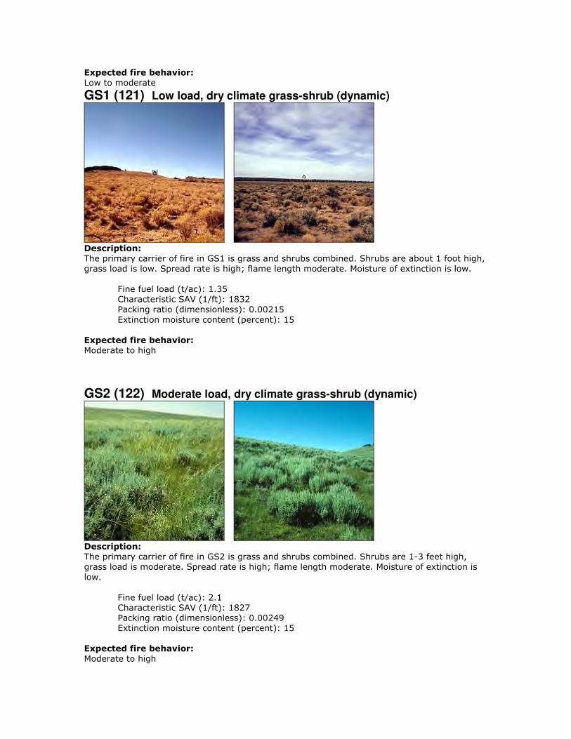
GS1 (121) Low load, dry climate grass-shrub (dynamic)
Description:
The primary carrier of fire in GS1 is grass and shrubs combined. Shrubs are about 1 foot high,
grass load is low. Spread rate is high; flame length moderate. Moisture of extinction is low.
Fine fuel load (t/ac): 1.35
Characteristic SAV (1/ft): 1832
Packing ratio (dimensionless): 0.00215
Extinction moisture content (percent): 15
Expected fire behavior:
Moderate to high
GS2 (122) Moderate load, dry climate grass-shrub (dynamic)
Description:
The primary carrier of fire in GS2 is grass and shrubs combined. Shrubs are 1-3 feet high,
grass load is moderate. Spread rate is high; flame length moderate. Moisture of extinction is
low.
Fine fuel load (t/ac): 2.1
Characteristic SAV (1/ft): 1827
Packing ratio (dimensionless): 0.00249
Extinction moisture content (percent): 15
Expected fire behavior:
Moderate to high

SH1 (141) Low load dry climate shrub (dynamic)
Description:
The primary carrier of fire in SH1 is woody shrubs and shrub litter. Low shrub fuel load,
fuelbed depth about 1 foot; some grass may be present. Spread rate is high; flame length
moderate.
Fine fuel load (t/ac): 1.7
Characteristic SAV (1/ft): 1674
Packing ratio (dimensionless): 0.00280
Extinction moisture content (percent): 15
Expected fire behavior:
Moderate to high
SH7 (147) Very high load dry climate shrub
Description:
The primary carrier of fire in SH7 is woody shrubs and shrub litter. Very heavy shrub load,
depth 4-6 feet. Spread rate lower than SH5, but flame length similar. Spread rate is very
high; flame length very high.
Fine fuel load (t/ac): 6.9
Characteristic SAV (1/ft): 1233
Packing ratio (dimensionless): 0.00344
Extinction moisture content (percent): 15
Expected fire behavior:
Very high
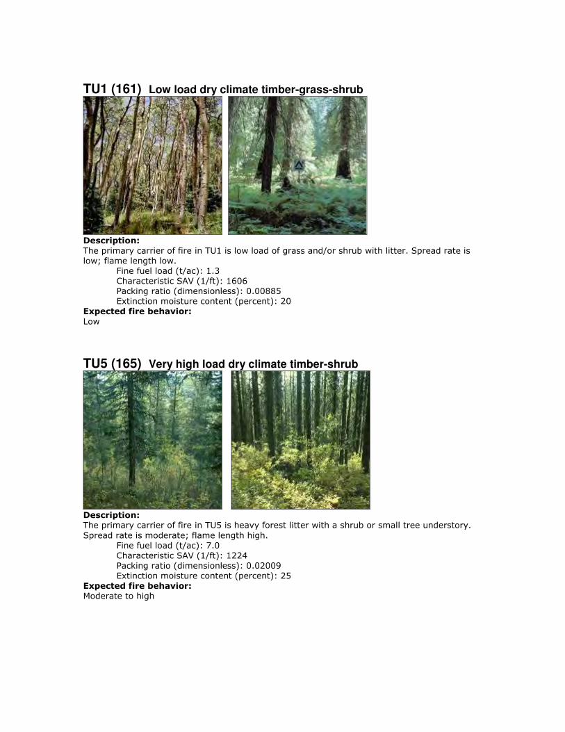
TU1 (161) Low load dry climate timber-grass-shrub
Description:
The primary carrier of fire in TU1 is low load of grass and/or shrub with litter. Spread rate is
low; flame length low.
Fine fuel load (t/ac): 1.3
Characteristic SAV (1/ft): 1606
Packing ratio (dimensionless): 0.00885
Extinction moisture content (percent): 20
Expected fire behavior:
Low
TU5 (165) Very high load dry climate timber-shrub
Description:
The primary carrier of fire in TU5 is heavy forest litter with a shrub or small tree understory.
Spread rate is moderate; flame length high.
Fine fuel load (t/ac): 7.0
Characteristic SAV (1/ft): 1224
Packing ratio (dimensionless): 0.02009
Extinction moisture content (percent): 25
Expected fire behavior:
Moderate to high

TL1 (181) Low load compact conifer litter
Description:
The primary carrier of fire in TL1 is compact forest litter. Light to moderate load, fuels 1-2
inches deep. Spread rate is very low; flame length very low. May be used to represent a
recently burned forest.
Fine fuel load (t/ac): 1.0
Characteristic SAV (1/ft): 1716
Packing ratio (dimensionless): 0.04878
Extinction moisture content (percent): 30
Expected fire behavior:
Very low
TL3 (183) Moderate load conifer litter
Description:
The primary carrier of fire in TL3 is moderate load conifer litter, light load of coarse fuels.
Spread rate is very low; flame length very low.
Fine fuel load (t/ac): 0.50
Characteristic SAV (1/ft): 1532
Packing ratio (dimensionless): 0.02630
Extinction moisture content (percent): 20
Expected fire behavior:
Very low

TL8 (188) Long-needle litter
Description:
The primary carrier of fire in TL8 is moderate load long-needle pine litter, may include small
amount of herbaceous load. Spread rate is moderate; flame length low.
Fine fuel load (t/ac): 5.8
Characteristic SAV (1/ft): 1770
Packing ratio (dimensionless): 0.03969
Extinction moisture content (percent): 35
Expected fire behavior:
Low to moderate

APPENDIX C
NFPA WILDLAND FIRE RISK AND HAZARD SEVERITY ASSESSMENT FORM 1144
AND
WILDLAND-URBAN INTERFACE AND INTERMIX ZONE
HAZARD ASSESSMENTS
The purpose of this appendix is to examine, in greater detail, the communities in the
study area. Of the 17 communities in Golden Gate Fire Protection District, 9 are rated as
high hazard, and 8 as moderate hazard. No communities are currently rated as extreme or
low hazard.

1144 Field Form Example (left blank):
Wildfire Risk and Hazard Severity Form NFPA 1144 Community Name: Overall Rating:
A. Means of Access Value Points Assigned
1. Ingress and Egress 2 or more roads in & out 0
One road in & out 7
2. Road Width > 24 ft 0
≥ 20 - 24 ft 2
< 20 ft 4
3. All-Season Road Condition
Surfaced Road, grade <5% 0
Surfaced Road, grade >5% 2
Non-Surfaced Road, grade <5% 2
Non-Surfaced Road, grade >5% 5
Other than all-season 7
4. Fire Service Access
≤ 300 ft with turnaround 0
> 300 ft with turnaround 2
≤ 300 ft with no turnaround 4
> 300 ft with no turnaround 5
5. Street signs
Present (at least 4" and reflective) 0
Present (small or non-reflective) 3
Not Present 5 B. Vegetation (Fuel Models) 1. Characteristics of predominant vegetation within 300 ft Light; 1,2,3 5
Medium; 5,6,7,8,9 10
Heavy; 4, 10 20
Slash; 11, 12, 13 25
2. Defensible Space (vegetation treatment from the structure) > 100 ft 1
71 - 100 ft 3
31 - 70 ft 10
≤ 30 ft 25 C. Topography within 300 ft of Structures 1. Slope < 9% 1
10 - 20% 4
21 - 30% 7
31 - 40% 8
> 41% 10 D. Additional Rating Factors (rate all that apply) 1. Additional factors Topographic features adversely affect fire behavior 0 - 5
Areas with a history of high fire occurrence (high ignition potential) 0 - 5
Severe fire weather potential 0 - 5
Separation of adjacent structures contributing to fire spread 0 - 5
Page 1 of 2
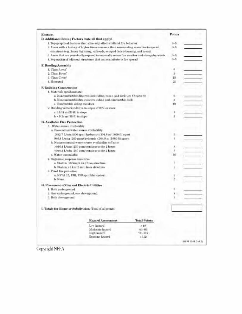
E. Roofing Assembly Value Points Assigned
Roofing Materials
Class A (asphalt, clay, concrete, slate, metal) 0
Class B (Fire-resistance rating that indicates roofing materials are able to withstand moderate exposure to fire originating from sources outside the building.) 3
Class C (Fire-resistance rating that indicates roofing materials are able to withstand light exposure to fire originating from sources outside the building.) 15
Nonrated 25
F. Building Construction
1. Materials
Noncombustible/fire-resistant siding, eaves, and deck 0
Noncombustible/fire-resistant siding only 5
Combustible siding and deck 10
2. Building setback from slope of ≥30%
≥ 30 ft to slope 1
< 30 ft to slope 5
G. Available Fire Protection
1. Water Source Availability
Pressurized hydrants
500 gpm hydrants ≤1000 ft apart 0
250 gpm hydrants ≤1000 ft apart 1
Nonpressurized water sources (off site)
≥ 250 gpm continuous for 2 hours 3
≤ 250 gpm continuous for 2 hours 5
Water Unavailable 10
2. Organized Response Resources
Station 5 miles or less from structure 1
Station >5 miles from structure 3
3. Fixed Fire Protection
NFPA 13, 13R, 13D sprinkler system 0
None 5
H. Placement of Gas and Electric Utilities 1. aboveground/underground
Both underground 0
One underground, one aboveground 3
Both aboveground 5
I. Point total for home or subdivision
<40 = LOW >40 = MODERATE >70 = HIGH >112 = EXTREME
Notes:
Page 2 of 2

WUI Score Hazard Rating
Bear Paw 93 High Douglas Mountain North 63 Moderate
Douglas Mountain South 76 High
Drew Hill 70 Moderate
Geneva Glen 100 High
Guy Hill 54 Moderate
Horseradish Gulch 69 Moderate
Lower Canyon 79 High
Middle Crawford Gulch 93 High
North Ranch 72 High
Red School Ranch 52 Moderate
Robinson Hill East 51 Moderate
Robinson Hill West 67 Moderate
Rye Gulch 71 High
The Grange 81 High
Thea Gulch 71 High
Window Rock 67 Moderate

Bear Paw
Hazard Rating: 93, High
Does the community have dual access/egress roads? No
Water supply: Cistern at Mouse Ear Lane
Description: This is a relatively isolated community with primarily newer homes.
Construction is a mixture of wood siding and fire-resistant siding, and asphalt and metal
roofs. Structure density is low, and most homes are located on large lots at the end of
long driveways. Access roads and driveways are narrow in spots, steep, rough, and
rocky. Access and egress would be difficult in fire conditions, particularly on Seldom
Seen Road. Homes are built mid-slope, some in saddles and above chimneys on slopes of
up to 60%. The newer homes have completed required defensible space, but considering
the heavy fuels loads and steep topography, expanded defensible space is needed on most
properties. Most homes have inadequate or missing address numbers, making properties
difficult to find in low-visibility conditions. There is one cistern on Mouse Ear Lane, but
the WUI has no other verified water sources for fire suppression.
Vegetation: The area is mostly covered by dense, decadent lodgepole pine forests.
Closed-canopy mixed conifer is also present in some areas. Active forest management
projects are ongoing in this area. In several stands throughout the community, additional
cutting would release suppressed or declining aspen groves.

Bear Paw
Recommendations:
● For all homes, make improvements within the home ignition zone to reduce
structure ignitability.
● Reduce percentage of combustible siding and decking on homes.
● Improve or expand defensible space by limbing and/or thinning trees, mowing
seasonally, and disposing of slash.
● Enclose open areas below decks and structures to prevent embers from collecting
in ignitable areas.
● Maintain private roads in passable condition
● Thin vegetation along access roads.
● Add reflective address markers to driveways and homes.
● On smaller parcels, create small patch cut openings where Aspen saplings are
growing, to encourage the reestablishment of Aspen groves.
● Complete shaded fuelbreak along Bear Paw Road, south to Mouse Ear Lane.
● Complete patch cuts on the west side of Bear Paw Road.
● Clear encroaching vegetation away from power lines (should be completed by
power company)

Wildfire Risk and Hazard Severity Form NFPA 1144
Community Name: Bear Paw Overall Rating: 93 High
A. Means of Access Value Points Assigned
1. Ingress and Egress
2 or more roads in & out 0
One road in & out 7 7
2. Road Width
> 24 ft 0
≥ 20 - 24 ft 2 2
< 20 ft 4
3. All-Season Road Condition
Surfaced Road, grade <5% 0
Surfaced Road, grade >5% 2
Non-Surfaced Road, grade <5% 2
Non-Surfaced Road, grade >5% 5 6
Other than all-season 7
4. Fire Service Access
≤ 300 ft with turnaround 0
> 300 ft with turnaround 2 2
≤ 300 ft with no turnaround 4
> 300 ft with no turnaround 5
5. Street signs
Present (at least 4" and reflective) 0
Present (small or non-reflective) 3 3
Not Present 5
B. Vegetation (Fuel Models)
1. Characteristics of predominant vegetation within 300 ft
Light; 1,2,3 5
Medium; 5,6,7,8,9 10
Heavy; 4, 10 20 20
Slash; 11, 12, 13 25
2. Defensible Space (vegetation treatment from the structure)
> 100 ft 1
71 - 100 ft 3
31 - 70 ft 10 9
≤ 30 ft 25
C. Topography within 300 ft of Structures
1. Slope
< 9% 1
10 - 20% 4
21 - 30% 7
31 - 40% 8 8
> 41% 10
D. Additional Rating Factors (rate all that apply)
1. Additional factors
Topographic features adversely affect fire behavior 0 - 5 4
Areas with a history of high fire occurrence (high ignition potential) 0 - 5 2
Severe fire weather potential 0 - 5 2
Separation of adjacent structures contributing to fire spread 0 - 5 0

E. Roofing Assembly Value Points Assigned
Roofing Materials
Class A (asphalt, clay, concrete, slate, metal) 0 0
Class B (Fire-resistance rating that indicates roofing materials are able to withstand moderate exposure to fire originating from sources outside the building.) 3
Class C (Fire-resistance rating that indicates roofing materials are able to withstand light exposure to fire originating from sources outside the building.) 15
Nonrated 25
F. Building Construction
1. Materials
Noncombustible/fire-resistant siding, eaves, and deck 0
Noncombustible/fire-resistant siding only 5
Combustible siding and deck 10 8
2. Building setback from slope of ≥30%
≥ 30 ft to slope 1
< 30 ft to slope 5 4
G. Available Fire Protection
1. Water Source Availability
Pressurized hydrants
500 gpm hydrants ≤1000 ft apart 0
250 gpm hydrants ≤1000 ft apart 1
Nonpressurized water sources (off site)
≥ 250 gpm continuous for 2 hours 3
≤ 250 gpm continuous for 2 hours 5 5
Water Unavailable 10
2. Organized Response Resources
Station 5 miles or less from structure 1 1
Station >5 miles from structure 3
3. Fixed Fire Protection
NFPA 13, 13R, 13D sprinkler system 0
None 5 5
H. Placement of Gas and Electric Utilities
1. aboveground/underground
Both underground 0
One underground, one aboveground 3
Both aboveground 5 5
I. Point total for home or subdivision 93
<40 = LOW >40 = MODERATE >70 = HIGH >112 = EXTREME

Douglas Mountain North
Hazard Rating: 63, Moderate
Does the community have dual access/egress roads? Yes
Water supply: Numerous cisterns on
Douglas Mountain Rd. and
Douglas Mountain Dr., draft
ponds/dip sites
Description: Homes in this area are built on both sides of the wide canyon bottom that
runs southwest from the intersection of Robinson Hill Road and Douglas Mountain Road.
Centennial Cone Open Space Park borders this community south of Harkwood Run.
Development throughout this community consists of widely scattered clusters of homes
on large lots, varying from older ranch houses to recent construction with ignition
resistant roofs. Most homes have wood siding and asphalt roofs. The majority of homes
in this community are ranches located in open meadows and irrigated lawns. Slopes
average 15-25%. The area west of Douglas Mountain Road has a few homes located in
dense mixed conifer stands on steeper slopes that need defensible space improvements.
However, most homes have large defensible space areas due to light fuels.
Vegetation: This WUI is characterized by open meadows and open ponderosa
woodlands with grass and shrub understory. Most of the homes are located in short grass
meadows, and some properties have irrigated lawns. There are isolated stands of closed-
canopy ponderosa pine and mixed conifer, especially on north aspects and areas in the
northwest portion of the area.

Douglas Mountain North
Recommendations:
● For all homes, make improvements within the home ignition zone to reduce
structure ignitability. This applies to homes in open meadows as well as homes
surrounded by forest.
● Reduce percentage of combustible siding and decking on homes.
● Improve or expand defensible space by limbing and/or thinning trees, mowing
seasonally, and disposing of slash.
● Enclose open areas below decks and structures to prevent embers from collecting
in ignitable areas.
● Maintain private roads in passable condition
● Thin vegetation along access roads, especially in the northwest portion of this
community.
● Add reflective address markers to driveways and homes.
● Complete shaded fuelbreak on the west side of Douglas Mountain Drive.

Wildfire Risk and Hazard Severity Form NFPA 1144
Community Name: Douglas Mountain North Overall Rating: 63 Moderate
A. Means of Access Value Points Assigned
1. Ingress and Egress
2 or more roads in & out 0 0
One road in & out 7
2. Road Width
> 24 ft 0
≥ 20 - 24 ft 2 2
< 20 ft 4
3. All-Season Road Condition
Surfaced Road, grade <5% 0
Surfaced Road, grade >5% 2
Non-Surfaced Road, grade <5% 2 3
Non-Surfaced Road, grade >5% 5
Other than all-season 7
4. Fire Service Access
≤ 300 ft with turnaround 0
> 300 ft with turnaround 2 2
≤ 300 ft with no turnaround 4
> 300 ft with no turnaround 5
5. Street signs
Present (at least 4" and reflective) 0 1
Present (small or non-reflective) 3
Not Present 5
B. Vegetation (Fuel Models)
1. Characteristics of predominant vegetation within 300 ft
Light; 1,2,3 5
Medium; 5,6,7,8,9 10 7
Heavy; 4, 10 20
Slash; 11, 12, 13 25
2. Defensible Space (vegetation treatment from the structure)
> 100 ft 1
71 - 100 ft 3 5
31 - 70 ft 10
≤ 30 ft 25
C. Topography within 300 ft of Structures
1. Slope
< 9% 1
10 - 20% 4
21 - 30% 7 7
31 - 40% 8
> 41% 10
D. Additional Rating Factors (rate all that apply)
1. Additional factors
Topographic features adversely affect fire behavior 0 - 5 3
Areas with a history of high fire occurrence (high ignition potential) 0 - 5 3
Severe fire weather potential 0 - 5 3
Separation of adjacent structures contributing to fire spread 0 - 5 0

E. Roofing Assembly Value Points Assigned
Roofing Materials
Class A (asphalt, clay, concrete, slate, metal) 0 0
Class B (Fire-resistance rating that indicates roofing materials are able to withstand moderate exposure to fire originating from sources outside the building.) 3
Class C (Fire-resistance rating that indicates roofing materials are able to withstand light exposure to fire originating from sources outside the building.) 15
Nonrated 25
F. Building Construction
1. Materials
Noncombustible/fire-resistant siding, eaves, and deck 0
Noncombustible/fire-resistant siding only 5
Combustible siding and deck 10 10
2. Building setback from slope of ≥30%
≥ 30 ft to slope 1 3
< 30 ft to slope 5
G. Available Fire Protection
1. Water Source Availability
Pressurized hydrants
500 gpm hydrants ≤1000 ft apart 0
250 gpm hydrants ≤1000 ft apart 1
Nonpressurized water sources (off site)
≥ 250 gpm continuous for 2 hours 3 3
≤ 250 gpm continuous for 2 hours 5
Water Unavailable 10
2. Organized Response Resources
Station 5 miles or less from structure 1 1
Station >5 miles from structure 3
3. Fixed Fire Protection
NFPA 13, 13R, 13D sprinkler system 0
None 5 5
H. Placement of Gas and Electric Utilities
1. aboveground/underground
Both underground 0
One underground, one aboveground 3
Both aboveground 5 5
I. Point total for home or subdivision 63
<40 = LOW >40 = MODERATE >70 = HIGH >112 = EXTREME

Douglas Mountain South
Hazard Rating: 76, High
Does the community have dual access/egress roads? Yes
Water supply: Cistern at Centennial Cone
Jefferson County Open Space
Description: This community is built along both sides of a predominately north/south
side canyon that connects Robinson Hill with Clear Creek Canyon. Homes are mostly
modern construction on small to moderate sized lots. About half of the homes have fire-
resistant siding, and roofs are metal or asphalt. Fuel loads are predominately light to
moderate for most of the WUI; therefore, most homes have adequate defensible space.
The north and west facing slopes of this steep canyon have some stands of high fuel
loads, and most homes are built at the top and middle of steep slopes, many at the top of
natural chimneys and other hazardous terrain features. Secondary roads and driveways
are steep and many homes have inadequate turnarounds for emergency vehicles.
Vegetation: Vegetation is primarily grasses and shrubs, with isolated large, mature
Rocky Mountain juniper (a highly flammable native species) near many homes. There
are some stands of closed canopy mixed conifer forest on north and west aspects, but they
are isolated to steep north and west aspects. Approximately 6 acres of fuels reduction
work has been completed in this area since 2006.

Douglas Mountain South
Recommendations:
● For all homes, make improvements within the home ignition zone to reduce
structure ignitability. This applies to homes in open meadows as well as homes
surrounded by forest.
● Reduce percentage of combustible siding and decking on homes.
● Improve or expand defensible space by limbing and/or thinning trees, mowing
seasonally, and disposing of slash, particularly along Coyote Spur.
● Enclose open areas below decks and structures to prevent embers from collecting
in ignitable areas.
● Maintain private roads in passable condition
● Thin vegetation along access roads.
● Add reflective address markers to driveways and homes where they are lacking.
● Improved turnarounds should be considered at residences and on secondary roads.
● Thin in gullies below Douglas Mountain Drive to protect access.
● Maintain previously mitigated areas by removing tree regeneration and woody
shrubs.

Wildfire Risk and Hazard Severity Form NFPA 1144
Community Name: Douglas Mountain South Overall Rating: 76 High
A. Means of Access Value Points Assigned
1. Ingress and Egress
2 or more roads in & out 0 0
One road in & out 7
2. Road Width
> 24 ft 0
≥ 20 - 24 ft 2 2
< 20 ft 4
3. All-Season Road Condition
Surfaced Road, grade <5% 0
Surfaced Road, grade >5% 2
Non-Surfaced Road, grade <5% 2 3
Non-Surfaced Road, grade >5% 5
Other than all-season 7
4. Fire Service Access
≤ 300 ft with turnaround 0
> 300 ft with turnaround 2
≤ 300 ft with no turnaround 4 3
> 300 ft with no turnaround 5
5. Street signs
Present (at least 4" and reflective) 0 2
Present (small or non-reflective) 3
Not Present 5
B. Vegetation (Fuel Models)
1. Characteristics of predominant vegetation within 300 ft
Light; 1,2,3 5
Medium; 5,6,7,8,9 10 8
Heavy; 4, 10 20
Slash; 11, 12, 13 25
2. Defensible Space (vegetation treatment from the structure)
> 100 ft 1
71 - 100 ft 3
31 - 70 ft 10 10
≤ 30 ft 25
C. Topography within 300 ft of Structures
1. Slope
< 9% 1
10 - 20% 4
21 - 30% 7
31 - 40% 8 8
> 41% 10
D. Additional Rating Factors (rate all that apply)
1. Additional factors
Topographic features adversely affect fire behavior 0 - 5 5
Areas with a history of high fire occurrence (high ignition potential) 0 - 5 4
Severe fire weather potential 0 - 5 3
Separation of adjacent structures contributing to fire spread 0 - 5 2

E. Roofing Assembly Value Points Assigned
Roofing Materials
Class A (asphalt, clay, concrete, slate, metal) 0 0
Class B (Fire-resistance rating that indicates roofing materials are able to withstand moderate exposure to fire originating from sources outside the building.) 3
Class C (Fire-resistance rating that indicates roofing materials are able to withstand light exposure to fire originating from sources outside the building.) 15
Nonrated 25
F. Building Construction
1. Materials
Noncombustible/fire-resistant siding, eaves, and deck 0
Noncombustible/fire-resistant siding only 5
Combustible siding and deck 10 7
2. Building setback from slope of ≥30%
≥ 30 ft to slope 1
< 30 ft to slope 5 5
G. Available Fire Protection
1. Water Source Availability
Pressurized hydrants
500 gpm hydrants ≤1000 ft apart 0
250 gpm hydrants ≤1000 ft apart 1
Nonpressurized water sources (off site)
≥ 250 gpm continuous for 2 hours 3 3
≤ 250 gpm continuous for 2 hours 5
Water Unavailable 10
2. Organized Response Resources
Station 5 miles or less from structure 1 1
Station >5 miles from structure 3
3. Fixed Fire Protection
NFPA 13, 13R, 13D sprinkler system 0
None 5 5
H. Placement of Gas and Electric Utilities
1. aboveground/underground
Both underground 0
One underground, one aboveground 3
Both aboveground 5 5
I. Point total for home or subdivision 76
<40 = LOW >40 = MODERATE >70 = HIGH >112 = EXTREME
Drew Hill
Hazard Rating: 70, Moderate
Does the community have dual access/egress roads? Yes
Water supply: Cistern at Spirit Ranch Rd.,
draft ponds at Ralston Creek
Description: This area is sparsely populated with scattered homes on large lots. Many
are located far from Drew Hill Road, the primary access, on long narrow driveways.
Homes are a mixture of old and new construction of predominately wood siding and
asphalt roofs. Address numbers are inconsistent or missing. Most homes need extended
defensible space because of heavy fuels and steep slopes. The topography in this area is
moderate, with slopes less than 30% near most homes. The 477-acre Spirit Mountain
Ranch at the south end of this area could become a major development in the future, but
there is currently no new construction in progress. There is one confirmed water source
within this WUI on a private property, and a consistent water supply from Ralston Creek
at the west end of the community.
Vegetation: The area is mostly covered by dense “dog-hair” lodgepole pine and mixed
conifer forests. Closed-canopy ponderosa pine stands are also present in a few areas.
Some small meadows with grasses and woody shrubs break up the continuous forest fuels
on south and east aspects and on ridge tops.
Drew Hill
Recommendations:
● For all homes, make improvements within the home ignition zone to reduce
structure ignitability. This applies to homes in open meadows as well as homes
surrounded by forest.
● Reduce percentage of combustible siding and decking on homes.
● Improve or expand defensible space by limbing and/or thinning trees, mowing
seasonally, and disposing of slash.
● Enclose open areas below decks and structures to prevent embers from collecting
in ignitable areas.
● Maintain private roads in passable condition
● Thin vegetation along access roads.
● Add reflective address markers to driveways and homes where they are lacking.
● Complete shaded fuelbreaks on the ridge south of Drew Hill Road.
● Complete shaded fuelbreak north of Spirit Ranch Road, parallel to the large
meadow, and tie to private access road off of Drew Hill Road.
● Individual cisterns may be the best choice for water supply needs in this area

Wildfire Risk and Hazard Severity Form NFPA 1144
Community Name: Drew Hill Overall Rating: 70 Moderate
A. Means of Access Value Points Assigned
1. Ingress and Egress
2 or more roads in & out 0 0
One road in & out 7
2. Road Width
> 24 ft 0
≥ 20 - 24 ft 2 2
< 20 ft 4
3. All-Season Road Condition
Surfaced Road, grade <5% 0
Surfaced Road, grade >5% 2
Non-Surfaced Road, grade <5% 2
Non-Surfaced Road, grade >5% 5 4
Other than all-season 7
4. Fire Service Access
≤ 300 ft with turnaround 0
> 300 ft with turnaround 2 3
≤ 300 ft with no turnaround 4
> 300 ft with no turnaround 5
5. Street signs
Present (at least 4" and reflective) 0
Present (small or non-reflective) 3 3
Not Present 5
B. Vegetation (Fuel Models)
1. Characteristics of predominant vegetation within 300 ft
Light; 1,2,3 5
Medium; 5,6,7,8,9 10
Heavy; 4, 10 20 15
Slash; 11, 12, 13 25
2. Defensible Space (vegetation treatment from the structure)
> 100 ft 1
71 - 100 ft 3 5
31 - 70 ft 10
≤ 30 ft 25
C. Topography within 300 ft of Structures
1. Slope
< 9% 1
10 - 20% 4
21 - 30% 7 7
31 - 40% 8
> 41% 10
D. Additional Rating Factors (rate all that apply)
1. Additional factors
Topographic features adversely affect fire behavior 0 - 5 3
Areas with a history of high fire occurrence (high ignition potential) 0 - 5 3
Severe fire weather potential 0 - 5 3
Separation of adjacent structures contributing to fire spread 0 - 5 0

E. Roofing Assembly Value Points Assigned
Roofing Materials
Class A (asphalt, clay, concrete, slate, metal) 0 0
Class B (Fire-resistance rating that indicates roofing materials are able to withstand moderate exposure to fire originating from sources outside the building.) 3
Class C (Fire-resistance rating that indicates roofing materials are able to withstand light exposure to fire originating from sources outside the building.) 15
Nonrated 25
F. Building Construction
1. Materials
Noncombustible/fire-resistant siding, eaves, and deck 0
Noncombustible/fire-resistant siding only 5 5
Combustible siding and deck 10
2. Building setback from slope of ≥30%
≥ 30 ft to slope 1
< 30 ft to slope 5 3
G. Available Fire Protection
1. Water Source Availability
Pressurized hydrants
500 gpm hydrants ≤1000 ft apart 0
250 gpm hydrants ≤1000 ft apart 1
Nonpressurized water sources (off site)
≥ 250 gpm continuous for 2 hours 3
≤ 250 gpm continuous for 2 hours 5 5
Water Unavailable 10
2. Organized Response Resources
Station 5 miles or less from structure 1 1
Station >5 miles from structure 3
3. Fixed Fire Protection
NFPA 13, 13R, 13D sprinkler system 0
None 5 5
H. Placement of Gas and Electric Utilities
1. aboveground/underground
Both underground 0
One underground, one aboveground 3 3
Both aboveground 5
I. Point total for home or subdivision 70
<40 = LOW >40 = MODERATE >70 = HIGH >112 = EXTREME

Geneva Glen
Hazard Rating: 100, High
Does the community have dual access/egress roads? Yes
Water supply: Draft ponds off Ralston
Creek
Description: This is a relatively isolated community surrounded by Golden Gate State
Park. The majority of the homes in this WUI are clustered close together off Geneva
Road. Several structures are older cabins, with wood siding and older asphalt or tar paper
roofs. The homes are largely modern log or wood siding construction with fire-resistant
asphalt or metal roofs. Firewood stacks and other manmade fuel jackpots are common
near structures. Access along Drew Hill and Ralston Creek Roads are good, the unpaved
side roads are rough, steep, and narrow in spots. Many properties lack adequate
turnarounds. There are missing or inadequate street signs and addressing throughout the
area. Topography is moderate to steep, with some slopes up to 40%. The nearest water
supply is draft water from draft ponds off Ralston Creek in Golden Gate State Park, on
Drew Hill Road.
Vegetation: The area is primarily covered by dense “dog-hair” lodgepole pine and
closed canopy mixed conifer forests. There are extensive areas where small patch cuts
and forest thinning are ongoing. Riparian trees and shrubs occur in stringers and patches
near Ralston Creek and ponds, however they are unlikely to make a significant
contribution to the overall fire behavior of this area.

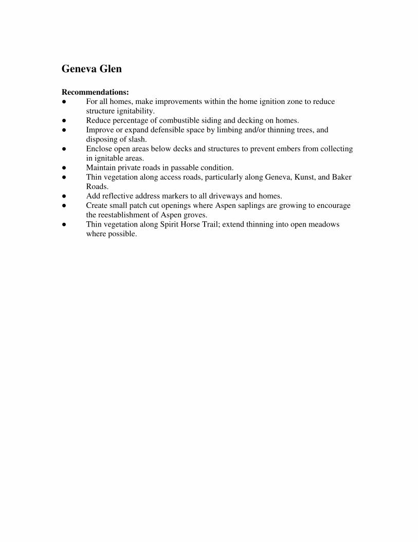
Geneva Glen
Recommendations:
● For all homes, make improvements within the home ignition zone to reduce
structure ignitability.
● Reduce percentage of combustible siding and decking on homes.
● Improve or expand defensible space by limbing and/or thinning trees, and
disposing of slash.
● Enclose open areas below decks and structures to prevent embers from collecting
in ignitable areas.
● Maintain private roads in passable condition.
● Thin vegetation along access roads, particularly along Geneva, Kunst, and Baker
Roads.
● Add reflective address markers to all driveways and homes.
● Create small patch cut openings where Aspen saplings are growing to encourage
the reestablishment of Aspen groves.
● Thin vegetation along Spirit Horse Trail; extend thinning into open meadows
where possible.

Wildfire Risk and Hazard Severity Form NFPA 1144
Community Name: Geneva Glen Overall Rating: 100 High
A. Means of Access Value Points Assigned
1. Ingress and Egress
2 or more roads in & out 0 0
One road in & out 7
2. Road Width
> 24 ft 0
≥ 20 - 24 ft 2 3
< 20 ft 4
3. All-Season Road Condition
Surfaced Road, grade <5% 0
Surfaced Road, grade >5% 2
Non-Surfaced Road, grade <5% 2
Non-Surfaced Road, grade >5% 5 5
Other than all-season 7
4. Fire Service Access
≤ 300 ft with turnaround 0
> 300 ft with turnaround 2
≤ 300 ft with no turnaround 4 4
> 300 ft with no turnaround 5
5. Street signs
Present (at least 4" and reflective) 0
Present (small or non-reflective) 3 3
Not Present 5
B. Vegetation (Fuel Models)
1. Characteristics of predominant vegetation within 300 ft
Light; 1,2,3 5
Medium; 5,6,7,8,9 10
Heavy; 4, 10 20 20
Slash; 11, 12, 13 25
2. Defensible Space (vegetation treatment from the structure)
> 100 ft 1
71 - 100 ft 3
31 - 70 ft 10 17
≤ 30 ft 25
C. Topography within 300 ft of Structures
1. Slope
< 9% 1
10 - 20% 4
21 - 30% 7 7
31 - 40% 8
> 41% 10
D. Additional Rating Factors (rate all that apply)
1. Additional factors
Topographic features adversely affect fire behavior 0 - 5 4
Areas with a history of high fire occurrence (high ignition potential) 0 - 5 2
Severe fire weather potential 0 - 5 2
Separation of adjacent structures contributing to fire spread 0 - 5 3

E. Roofing Assembly Value Points Assigned
Roofing Materials
Class A (asphalt, clay, concrete, slate, metal) 0
Class B (Fire-resistance rating that indicates roofing materials are able to withstand moderate exposure to fire originating from sources outside the building.) 3 3
Class C (Fire-resistance rating that indicates roofing materials are able to withstand light exposure to fire originating from sources outside the building.) 15
Nonrated 25
F. Building Construction
1. Materials
Noncombustible/fire-resistant siding, eaves, and deck 0
Noncombustible/fire-resistant siding only 5
Combustible siding and deck 10 10
2. Building setback from slope of ≥30%
≥ 30 ft to slope 1
< 30 ft to slope 5 3
G. Available Fire Protection
1. Water Source Availability
Pressurized hydrants
500 gpm hydrants ≤1000 ft apart 0
250 gpm hydrants ≤1000 ft apart 1
Nonpressurized water sources (off site)
≥ 250 gpm continuous for 2 hours 3 3
≤ 250 gpm continuous for 2 hours 5
Water Unavailable 10
2. Organized Response Resources
Station 5 miles or less from structure 1 1
Station >5 miles from structure 3
3. Fixed Fire Protection
NFPA 13, 13R, 13D sprinkler system 0
None 5 5
H. Placement of Gas and Electric Utilities
1. aboveground/underground
Both underground 0
One underground, one aboveground 3
Both aboveground 5 5
I. Point total for home or subdivision 100
<40 = LOW >40 = MODERATE >70 = HIGH >112 = EXTREME

Guy Hill
Hazard Rating: 54, Moderate
Does the community have dual access/egress roads? Yes
Water supply: Cistern at Rye Gulch and
Guy Hill Roads
Description: This sparsely populated WUI community consists primarily of new homes
on large lots. Construction is a mixture of wood or fire-resistant siding, and asphalt or
metal roofs. Fuel loads are predominately light to moderate in this WUI; therefore, most
homes have adequate defensible space. Structures are located on flat or gently rolling
terrain on the tops of broad ridges. On the north side of Golden Gate Road, Guy Hill
Road becomes narrow and passes through some heaver fuels, but this area appears only
has a few homes.
Vegetation: This WUI is characterized by open meadows and open ponderosa
woodlands with grass and shrub understory. Most of the homes are located in short grass
meadows, and some properties have irrigated lawns. There are isolated stands of closed-
canopy ponderosa pine and mixed conifer, especially on north aspects and areas in the
northwest portion of the area.
Guy Hill
Recommendations:
● For all homes, make improvements within the home ignition zone to reduce
structure ignitability. This applies to homes in open meadows as well as homes
surrounded by forest.
● Reduce percentage of combustible siding and decking on homes.
● Improve or expand defensible space by limbing and/or thinning trees, mowing
seasonally, and disposing of slash.
● Enclose open areas below decks and structures to prevent embers from collecting
in ignitable areas.
● Maintain private roads in passable condition
● Thin vegetation along access roads.
● Add reflective address markers to driveways and homes.
● Fuels should be thinned on both sides of the narrow portion of Guy Hill Road to
make it a more viable access/egress route.
Wildfire Risk and Hazard Severity Form NFPA 1144
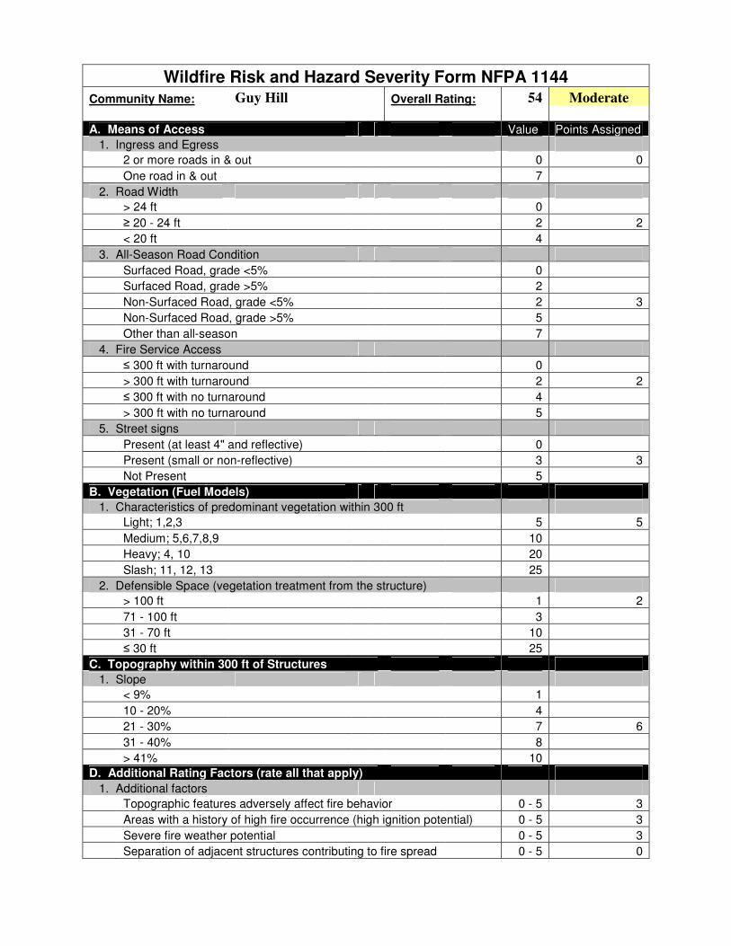
Community Name: Guy Hill Overall Rating: 54 Moderate
A. Means of Access Value Points Assigned
1. Ingress and Egress
2 or more roads in & out 0 0
One road in & out 7
2. Road Width
> 24 ft 0
≥ 20 - 24 ft 2 2
< 20 ft 4
3. All-Season Road Condition
Surfaced Road, grade <5% 0
Surfaced Road, grade >5% 2
Non-Surfaced Road, grade <5% 2 3
Non-Surfaced Road, grade >5% 5
Other than all-season 7
4. Fire Service Access
≤ 300 ft with turnaround 0
> 300 ft with turnaround 2 2
≤ 300 ft with no turnaround 4
> 300 ft with no turnaround 5
5. Street signs
Present (at least 4" and reflective) 0
Present (small or non-reflective) 3 3
Not Present 5
B. Vegetation (Fuel Models)
1. Characteristics of predominant vegetation within 300 ft
Light; 1,2,3 5 5
Medium; 5,6,7,8,9 10
Heavy; 4, 10 20
Slash; 11, 12, 13 25
2. Defensible Space (vegetation treatment from the structure)
> 100 ft 1 2
71 - 100 ft 3
31 - 70 ft 10
≤ 30 ft 25
C. Topography within 300 ft of Structures
1. Slope
< 9% 1
10 - 20% 4
21 - 30% 7 6
31 - 40% 8
> 41% 10
D. Additional Rating Factors (rate all that apply)
1. Additional factors
Topographic features adversely affect fire behavior 0 - 5 3
Areas with a history of high fire occurrence (high ignition potential) 0 - 5 3
Severe fire weather potential 0 - 5 3
Separation of adjacent structures contributing to fire spread 0 - 5 0

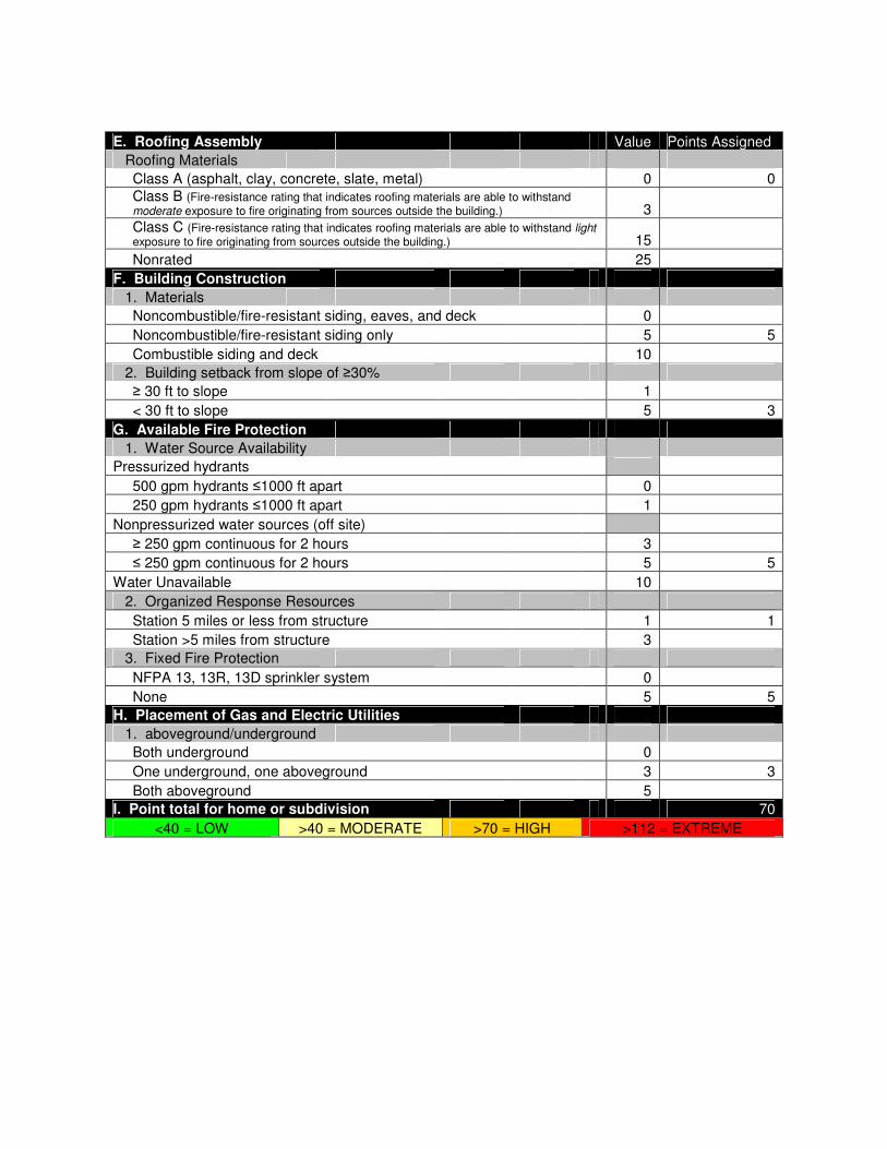
E. Roofing Assembly Value Points Assigned
Roofing Materials
Class A (asphalt, clay, concrete, slate, metal) 0 0
Class B (Fire-resistance rating that indicates roofing materials are able to withstand moderate exposure to fire originating from sources outside the building.) 3
Class C (Fire-resistance rating that indicates roofing materials are able to withstand light exposure to fire originating from sources outside the building.) 15
Nonrated 25
F. Building Construction
1. Materials
Noncombustible/fire-resistant siding, eaves, and deck 0
Noncombustible/fire-resistant siding only 5 6
Combustible siding and deck 10
2. Building setback from slope of ≥30%
≥ 30 ft to slope 1 2
< 30 ft to slope 5
G. Available Fire Protection
1. Water Source Availability
Pressurized hydrants
500 gpm hydrants ≤1000 ft apart 0
250 gpm hydrants ≤1000 ft apart 1
Nonpressurized water sources (off site)
≥ 250 gpm continuous for 2 hours 3 3
≤ 250 gpm continuous for 2 hours 5
Water Unavailable 10
2. Organized Response Resources
Station 5 miles or less from structure 1 1
Station >5 miles from structure 3
3. Fixed Fire Protection
NFPA 13, 13R, 13D sprinkler system 0
None 5 5
H. Placement of Gas and Electric Utilities
1. aboveground/underground
Both underground 0
One underground, one aboveground 3
Both aboveground 5 5
I. Point total for home or subdivision 54
<40 = LOW >40 = MODERATE >70 = HIGH >112 = EXTREME

Bear Paw
Hazard Rating: 93, High
Does the community have dual access/egress roads? No
Water supply: Cistern at Mouse Ear Lane
Description: This is a relatively isolated community with primarily newer homes.
Construction is a mixture of wood siding and fire-resistant siding, and asphalt and metal
roofs. Structure density is low, and most homes are located on large lots at the end of
long driveways. Access roads and driveways are narrow in spots, steep, rough, and
rocky. Access and egress would be difficult in fire conditions, particularly on Seldom
Seen Road. Homes are built mid-slope, some in saddles and above chimneys on slopes of
up to 60%. The newer homes have completed required defensible space, but considering
the heavy fuels loads and steep topography, expanded defensible space is needed on most
properties. Most homes have inadequate or missing address numbers, making properties
difficult to find in low-visibility conditions. There is one cistern on Mouse Ear Lane, but
the WUI has no other verified water sources for fire suppression.
Vegetation: The area is mostly covered by dense, decadent lodgepole pine forests.
Closed-canopy mixed conifer is also present in some areas. Active forest management
projects are ongoing in this area. In several stands throughout the community, additional
cutting would release suppressed or declining aspen groves.

Bear Paw
Recommendations:
● For all homes, make improvements within the home ignition zone to reduce
structure ignitability.
● Reduce percentage of combustible siding and decking on homes.
● Improve or expand defensible space by limbing and/or thinning trees, mowing
seasonally, and disposing of slash.
● Enclose open areas below decks and structures to prevent embers from collecting
in ignitable areas.
● Maintain private roads in passable condition
● Thin vegetation along access roads.
● Add reflective address markers to driveways and homes.
● On smaller parcels, create small patch cut openings where Aspen saplings are
growing, to encourage the reestablishment of Aspen groves.
● Complete shaded fuelbreak along Bear Paw Road, south to Mouse Ear Lane.
● Complete patch cuts on the west side of Bear Paw Road.
● Clear encroaching vegetation away from power lines (should be completed by
power company)

Wildfire Risk and Hazard Severity Form NFPA 1144
Community Name: Bear Paw Overall Rating: 93 High
A. Means of Access Value Points Assigned
1. Ingress and Egress
2 or more roads in & out 0
One road in & out 7 7
2. Road Width
> 24 ft 0
≥ 20 - 24 ft 2 2
< 20 ft 4
3. All-Season Road Condition
Surfaced Road, grade <5% 0
Surfaced Road, grade >5% 2
Non-Surfaced Road, grade <5% 2
Non-Surfaced Road, grade >5% 5 6
Other than all-season 7
4. Fire Service Access
≤ 300 ft with turnaround 0
> 300 ft with turnaround 2 2
≤ 300 ft with no turnaround 4
> 300 ft with no turnaround 5
5. Street signs
Present (at least 4" and reflective) 0
Present (small or non-reflective) 3 3
Not Present 5
B. Vegetation (Fuel Models)
1. Characteristics of predominant vegetation within 300 ft
Light; 1,2,3 5
Medium; 5,6,7,8,9 10
Heavy; 4, 10 20 20
Slash; 11, 12, 13 25
2. Defensible Space (vegetation treatment from the structure)
> 100 ft 1
71 - 100 ft 3
31 - 70 ft 10 9
≤ 30 ft 25
C. Topography within 300 ft of Structures
1. Slope
< 9% 1
10 - 20% 4
21 - 30% 7
31 - 40% 8 8
> 41% 10
D. Additional Rating Factors (rate all that apply)
1. Additional factors
Topographic features adversely affect fire behavior 0 - 5 4
Areas with a history of high fire occurrence (high ignition potential) 0 - 5 2
Severe fire weather potential 0 - 5 2
Separation of adjacent structures contributing to fire spread 0 - 5 0

E. Roofing Assembly Value Points Assigned
Roofing Materials
Class A (asphalt, clay, concrete, slate, metal) 0 0
Class B (Fire-resistance rating that indicates roofing materials are able to withstand moderate exposure to fire originating from sources outside the building.) 3
Class C (Fire-resistance rating that indicates roofing materials are able to withstand light exposure to fire originating from sources outside the building.) 15
Nonrated 25
F. Building Construction
1. Materials
Noncombustible/fire-resistant siding, eaves, and deck 0
Noncombustible/fire-resistant siding only 5
Combustible siding and deck 10 8
2. Building setback from slope of ≥30%
≥ 30 ft to slope 1
< 30 ft to slope 5 4
G. Available Fire Protection
1. Water Source Availability
Pressurized hydrants
500 gpm hydrants ≤1000 ft apart 0
250 gpm hydrants ≤1000 ft apart 1
Nonpressurized water sources (off site)
≥ 250 gpm continuous for 2 hours 3
≤ 250 gpm continuous for 2 hours 5 5
Water Unavailable 10
2. Organized Response Resources
Station 5 miles or less from structure 1 1
Station >5 miles from structure 3
3. Fixed Fire Protection
NFPA 13, 13R, 13D sprinkler system 0
None 5 5
H. Placement of Gas and Electric Utilities
1. aboveground/underground
Both underground 0
One underground, one aboveground 3
Both aboveground 5 5
I. Point total for home or subdivision 93
<40 = LOW >40 = MODERATE >70 = HIGH >112 = EXTREME

Douglas Mountain North
Hazard Rating: 63, Moderate
Does the community have dual access/egress roads? Yes
Water supply: Numerous cisterns on
Douglas Mountain Rd. and
Douglas Mountain Dr., draft
ponds/dip sites
Description: Homes in this area are built on both sides of the wide canyon bottom that
runs southwest from the intersection of Robinson Hill Road and Douglas Mountain Road.
Centennial Cone Open Space Park borders this community south of Harkwood Run.
Development throughout this community consists of widely scattered clusters of homes
on large lots, varying from older ranch houses to recent construction with ignition
resistant roofs. Most homes have wood siding and asphalt roofs. The majority of homes
in this community are ranches located in open meadows and irrigated lawns. Slopes
average 15-25%. The area west of Douglas Mountain Road has a few homes located in
dense mixed conifer stands on steeper slopes that need defensible space improvements.
However, most homes have large defensible space areas due to light fuels.
Vegetation: This WUI is characterized by open meadows and open ponderosa
woodlands with grass and shrub understory. Most of the homes are located in short grass
meadows, and some properties have irrigated lawns. There are isolated stands of closed-
canopy ponderosa pine and mixed conifer, especially on north aspects and areas in the
northwest portion of the area.

Douglas Mountain North
Recommendations:
● For all homes, make improvements within the home ignition zone to reduce
structure ignitability. This applies to homes in open meadows as well as homes
surrounded by forest.
● Reduce percentage of combustible siding and decking on homes.
● Improve or expand defensible space by limbing and/or thinning trees, mowing
seasonally, and disposing of slash.
● Enclose open areas below decks and structures to prevent embers from collecting
in ignitable areas.
● Maintain private roads in passable condition
● Thin vegetation along access roads, especially in the northwest portion of this
community.
● Add reflective address markers to driveways and homes.
● Complete shaded fuelbreak on the west side of Douglas Mountain Drive.

Wildfire Risk and Hazard Severity Form NFPA 1144
Community Name: Douglas Mountain North Overall Rating: 63 Moderate
A. Means of Access Value Points Assigned
1. Ingress and Egress
2 or more roads in & out 0 0
One road in & out 7
2. Road Width
> 24 ft 0
≥ 20 - 24 ft 2 2
< 20 ft 4
3. All-Season Road Condition
Surfaced Road, grade <5% 0
Surfaced Road, grade >5% 2
Non-Surfaced Road, grade <5% 2 3
Non-Surfaced Road, grade >5% 5
Other than all-season 7
4. Fire Service Access
≤ 300 ft with turnaround 0
> 300 ft with turnaround 2 2
≤ 300 ft with no turnaround 4
> 300 ft with no turnaround 5
5. Street signs
Present (at least 4" and reflective) 0 1
Present (small or non-reflective) 3
Not Present 5
B. Vegetation (Fuel Models)
1. Characteristics of predominant vegetation within 300 ft
Light; 1,2,3 5
Medium; 5,6,7,8,9 10 7
Heavy; 4, 10 20
Slash; 11, 12, 13 25
2. Defensible Space (vegetation treatment from the structure)
> 100 ft 1
71 - 100 ft 3 5
31 - 70 ft 10
≤ 30 ft 25
C. Topography within 300 ft of Structures
1. Slope
< 9% 1
10 - 20% 4
21 - 30% 7 7
31 - 40% 8
> 41% 10
D. Additional Rating Factors (rate all that apply)
1. Additional factors
Topographic features adversely affect fire behavior 0 - 5 3
Areas with a history of high fire occurrence (high ignition potential) 0 - 5 3
Severe fire weather potential 0 - 5 3
Separation of adjacent structures contributing to fire spread 0 - 5 0

E. Roofing Assembly Value Points Assigned
Roofing Materials
Class A (asphalt, clay, concrete, slate, metal) 0 0
Class B (Fire-resistance rating that indicates roofing materials are able to withstand moderate exposure to fire originating from sources outside the building.) 3
Class C (Fire-resistance rating that indicates roofing materials are able to withstand light exposure to fire originating from sources outside the building.) 15
Nonrated 25
F. Building Construction
1. Materials
Noncombustible/fire-resistant siding, eaves, and deck 0
Noncombustible/fire-resistant siding only 5
Combustible siding and deck 10 10
2. Building setback from slope of ≥30%
≥ 30 ft to slope 1 3
< 30 ft to slope 5
G. Available Fire Protection
1. Water Source Availability
Pressurized hydrants
500 gpm hydrants ≤1000 ft apart 0
250 gpm hydrants ≤1000 ft apart 1
Nonpressurized water sources (off site)
≥ 250 gpm continuous for 2 hours 3 3
≤ 250 gpm continuous for 2 hours 5
Water Unavailable 10
2. Organized Response Resources
Station 5 miles or less from structure 1 1
Station >5 miles from structure 3
3. Fixed Fire Protection
NFPA 13, 13R, 13D sprinkler system 0
None 5 5
H. Placement of Gas and Electric Utilities
1. aboveground/underground
Both underground 0
One underground, one aboveground 3
Both aboveground 5 5
I. Point total for home or subdivision 63
<40 = LOW >40 = MODERATE >70 = HIGH >112 = EXTREME

Douglas Mountain South
Hazard Rating: 76, High
Does the community have dual access/egress roads? Yes
Water supply: Cistern at Centennial Cone
Jefferson County Open Space
Description: This community is built along both sides of a predominately north/south
side canyon that connects Robinson Hill with Clear Creek Canyon. Homes are mostly
modern construction on small to moderate sized lots. About half of the homes have fire-
resistant siding, and roofs are metal or asphalt. Fuel loads are predominately light to
moderate for most of the WUI; therefore, most homes have adequate defensible space.
The north and west facing slopes of this steep canyon have some stands of high fuel
loads, and most homes are built at the top and middle of steep slopes, many at the top of
natural chimneys and other hazardous terrain features. Secondary roads and driveways
are steep and many homes have inadequate turnarounds for emergency vehicles.
Vegetation: Vegetation is primarily grasses and shrubs, with isolated large, mature
Rocky Mountain juniper (a highly flammable native species) near many homes. There
are some stands of closed canopy mixed conifer forest on north and west aspects, but they
are isolated to steep north and west aspects. Approximately 6 acres of fuels reduction
work has been completed in this area since 2006.

Douglas Mountain South
Recommendations:
● For all homes, make improvements within the home ignition zone to reduce
structure ignitability. This applies to homes in open meadows as well as homes
surrounded by forest.
● Reduce percentage of combustible siding and decking on homes.
● Improve or expand defensible space by limbing and/or thinning trees, mowing
seasonally, and disposing of slash, particularly along Coyote Spur.
● Enclose open areas below decks and structures to prevent embers from collecting
in ignitable areas.
● Maintain private roads in passable condition
● Thin vegetation along access roads.
● Add reflective address markers to driveways and homes where they are lacking.
● Improved turnarounds should be considered at residences and on secondary roads.
● Thin in gullies below Douglas Mountain Drive to protect access.
● Maintain previously mitigated areas by removing tree regeneration and woody
shrubs.

Wildfire Risk and Hazard Severity Form NFPA 1144
Community Name: Douglas Mountain South Overall Rating: 76 High
A. Means of Access Value Points Assigned
1. Ingress and Egress
2 or more roads in & out 0 0
One road in & out 7
2. Road Width
> 24 ft 0
≥ 20 - 24 ft 2 2
< 20 ft 4
3. All-Season Road Condition
Surfaced Road, grade <5% 0
Surfaced Road, grade >5% 2
Non-Surfaced Road, grade <5% 2 3
Non-Surfaced Road, grade >5% 5
Other than all-season 7
4. Fire Service Access
≤ 300 ft with turnaround 0
> 300 ft with turnaround 2
≤ 300 ft with no turnaround 4 3
> 300 ft with no turnaround 5
5. Street signs
Present (at least 4" and reflective) 0 2
Present (small or non-reflective) 3
Not Present 5
B. Vegetation (Fuel Models)
1. Characteristics of predominant vegetation within 300 ft
Light; 1,2,3 5
Medium; 5,6,7,8,9 10 8
Heavy; 4, 10 20
Slash; 11, 12, 13 25
2. Defensible Space (vegetation treatment from the structure)
> 100 ft 1
71 - 100 ft 3
31 - 70 ft 10 10
≤ 30 ft 25
C. Topography within 300 ft of Structures
1. Slope
< 9% 1
10 - 20% 4
21 - 30% 7
31 - 40% 8 8
> 41% 10
D. Additional Rating Factors (rate all that apply)
1. Additional factors
Topographic features adversely affect fire behavior 0 - 5 5
Areas with a history of high fire occurrence (high ignition potential) 0 - 5 4
Severe fire weather potential 0 - 5 3
Separation of adjacent structures contributing to fire spread 0 - 5 2

E. Roofing Assembly Value Points Assigned
Roofing Materials
Class A (asphalt, clay, concrete, slate, metal) 0 0
Class B (Fire-resistance rating that indicates roofing materials are able to withstand moderate exposure to fire originating from sources outside the building.) 3
Class C (Fire-resistance rating that indicates roofing materials are able to withstand light exposure to fire originating from sources outside the building.) 15
Nonrated 25
F. Building Construction
1. Materials
Noncombustible/fire-resistant siding, eaves, and deck 0
Noncombustible/fire-resistant siding only 5
Combustible siding and deck 10 7
2. Building setback from slope of ≥30%
≥ 30 ft to slope 1
< 30 ft to slope 5 5
G. Available Fire Protection
1. Water Source Availability
Pressurized hydrants
500 gpm hydrants ≤1000 ft apart 0
250 gpm hydrants ≤1000 ft apart 1
Nonpressurized water sources (off site)
≥ 250 gpm continuous for 2 hours 3 3
≤ 250 gpm continuous for 2 hours 5
Water Unavailable 10
2. Organized Response Resources
Station 5 miles or less from structure 1 1
Station >5 miles from structure 3
3. Fixed Fire Protection
NFPA 13, 13R, 13D sprinkler system 0
None 5 5
H. Placement of Gas and Electric Utilities
1. aboveground/underground
Both underground 0
One underground, one aboveground 3
Both aboveground 5 5
I. Point total for home or subdivision 76
<40 = LOW >40 = MODERATE >70 = HIGH >112 = EXTREME

Drew Hill
Hazard Rating: 70, Moderate
Does the community have dual access/egress roads? Yes
Water supply: Cistern at Spirit Ranch Rd.,
draft ponds at Ralston Creek
Description: This area is sparsely populated with scattered homes on large lots. Many
are located far from Drew Hill Road, the primary access, on long narrow driveways.
Homes are a mixture of old and new construction of predominately wood siding and
asphalt roofs. Address numbers are inconsistent or missing. Most homes need extended
defensible space because of heavy fuels and steep slopes. The topography in this area is
moderate, with slopes less than 30% near most homes. The 477-acre Spirit Mountain
Ranch at the south end of this area could become a major development in the future, but
there is currently no new construction in progress. There is one confirmed water source
within this WUI on a private property, and a consistent water supply from Ralston Creek
at the west end of the community.
Vegetation: The area is mostly covered by dense “dog-hair” lodgepole pine and mixed
conifer forests. Closed-canopy ponderosa pine stands are also present in a few areas.
Some small meadows with grasses and woody shrubs break up the continuous forest fuels
on south and east aspects and on ridge tops.

Drew Hill
Recommendations:
● For all homes, make improvements within the home ignition zone to reduce
structure ignitability. This applies to homes in open meadows as well as homes
surrounded by forest.
● Reduce percentage of combustible siding and decking on homes.
● Improve or expand defensible space by limbing and/or thinning trees, mowing
seasonally, and disposing of slash.
● Enclose open areas below decks and structures to prevent embers from collecting
in ignitable areas.
● Maintain private roads in passable condition
● Thin vegetation along access roads.
● Add reflective address markers to driveways and homes where they are lacking.
● Complete shaded fuelbreaks on the ridge south of Drew Hill Road.
● Complete shaded fuelbreak north of Spirit Ranch Road, parallel to the large
meadow, and tie to private access road off of Drew Hill Road.
● Individual cisterns may be the best choice for water supply needs in this area

Wildfire Risk and Hazard Severity Form NFPA 1144
Community Name: Drew Hill Overall Rating: 70 Moderate
A. Means of Access Value Points Assigned
1. Ingress and Egress
2 or more roads in & out 0 0
One road in & out 7
2. Road Width
> 24 ft 0
≥ 20 - 24 ft 2 2
< 20 ft 4
3. All-Season Road Condition
Surfaced Road, grade <5% 0
Surfaced Road, grade >5% 2
Non-Surfaced Road, grade <5% 2
Non-Surfaced Road, grade >5% 5 4
Other than all-season 7
4. Fire Service Access
≤ 300 ft with turnaround 0
> 300 ft with turnaround 2 3
≤ 300 ft with no turnaround 4
> 300 ft with no turnaround 5
5. Street signs
Present (at least 4" and reflective) 0
Present (small or non-reflective) 3 3
Not Present 5
B. Vegetation (Fuel Models)
1. Characteristics of predominant vegetation within 300 ft
Light; 1,2,3 5
Medium; 5,6,7,8,9 10
Heavy; 4, 10 20 15
Slash; 11, 12, 13 25
2. Defensible Space (vegetation treatment from the structure)
> 100 ft 1
71 - 100 ft 3 5
31 - 70 ft 10
≤ 30 ft 25
C. Topography within 300 ft of Structures
1. Slope
< 9% 1
10 - 20% 4
21 - 30% 7 7
31 - 40% 8
> 41% 10
D. Additional Rating Factors (rate all that apply)
1. Additional factors
Topographic features adversely affect fire behavior 0 - 5 3
Areas with a history of high fire occurrence (high ignition potential) 0 - 5 3
Severe fire weather potential 0 - 5 3
Separation of adjacent structures contributing to fire spread 0 - 5 0
E. Roofing Assembly Value Points Assigned
Roofing Materials
Class A (asphalt, clay, concrete, slate, metal) 0 0
Class B (Fire-resistance rating that indicates roofing materials are able to withstand moderate exposure to fire originating from sources outside the building.) 3
Class C (Fire-resistance rating that indicates roofing materials are able to withstand light exposure to fire originating from sources outside the building.) 15
Nonrated 25
F. Building Construction
1. Materials
Noncombustible/fire-resistant siding, eaves, and deck 0
Noncombustible/fire-resistant siding only 5 5
Combustible siding and deck 10
2. Building setback from slope of ≥30%
≥ 30 ft to slope 1
< 30 ft to slope 5 3
G. Available Fire Protection
1. Water Source Availability
Pressurized hydrants
500 gpm hydrants ≤1000 ft apart 0
250 gpm hydrants ≤1000 ft apart 1
Nonpressurized water sources (off site)
≥ 250 gpm continuous for 2 hours 3
≤ 250 gpm continuous for 2 hours 5 5
Water Unavailable 10
2. Organized Response Resources
Station 5 miles or less from structure 1 1
Station >5 miles from structure 3
3. Fixed Fire Protection
NFPA 13, 13R, 13D sprinkler system 0
None 5 5
H. Placement of Gas and Electric Utilities
1. aboveground/underground
Both underground 0
One underground, one aboveground 3 3
Both aboveground 5
I. Point total for home or subdivision 70
<40 = LOW >40 = MODERATE >70 = HIGH >112 = EXTREME

Geneva Glen
Hazard Rating: 100, High
Does the community have dual access/egress roads? Yes
Water supply: Draft ponds off Ralston
Creek
Description: This is a relatively isolated community surrounded by Golden Gate State
Park. The majority of the homes in this WUI are clustered close together off Geneva
Road. Several structures are older cabins, with wood siding and older asphalt or tar paper
roofs. The homes are largely modern log or wood siding construction with fire-resistant
asphalt or metal roofs. Firewood stacks and other manmade fuel jackpots are common
near structures. Access along Drew Hill and Ralston Creek Roads are good, the unpaved
side roads are rough, steep, and narrow in spots. Many properties lack adequate
turnarounds. There are missing or inadequate street signs and addressing throughout the
area. Topography is moderate to steep, with some slopes up to 40%. The nearest water
supply is draft water from draft ponds off Ralston Creek in Golden Gate State Park, on
Drew Hill Road.
Vegetation: The area is primarily covered by dense “dog-hair” lodgepole pine and
closed canopy mixed conifer forests. There are extensive areas where small patch cuts
and forest thinning are ongoing. Riparian trees and shrubs occur in stringers and patches
near Ralston Creek and ponds, however they are unlikely to make a significant
contribution to the overall fire behavior of this area.
Geneva Glen
Recommendations:
● For all homes, make improvements within the home ignition zone to reduce
structure ignitability.
● Reduce percentage of combustible siding and decking on homes.
● Improve or expand defensible space by limbing and/or thinning trees, and
disposing of slash.
● Enclose open areas below decks and structures to prevent embers from collecting
in ignitable areas.
● Maintain private roads in passable condition.
● Thin vegetation along access roads, particularly along Geneva, Kunst, and Baker
Roads.
● Add reflective address markers to all driveways and homes.
● Create small patch cut openings where Aspen saplings are growing to encourage
the reestablishment of Aspen groves.
● Thin vegetation along Spirit Horse Trail; extend thinning into open meadows
where possible.

Wildfire Risk and Hazard Severity Form NFPA 1144
Community Name: Geneva Glen Overall Rating: 100 High
A. Means of Access Value Points Assigned
1. Ingress and Egress
2 or more roads in & out 0 0
One road in & out 7
2. Road Width
> 24 ft 0
≥ 20 - 24 ft 2 3
< 20 ft 4
3. All-Season Road Condition
Surfaced Road, grade <5% 0
Surfaced Road, grade >5% 2
Non-Surfaced Road, grade <5% 2
Non-Surfaced Road, grade >5% 5 5
Other than all-season 7
4. Fire Service Access
≤ 300 ft with turnaround 0
> 300 ft with turnaround 2
≤ 300 ft with no turnaround 4 4
> 300 ft with no turnaround 5
5. Street signs
Present (at least 4" and reflective) 0
Present (small or non-reflective) 3 3
Not Present 5
B. Vegetation (Fuel Models)
1. Characteristics of predominant vegetation within 300 ft
Light; 1,2,3 5
Medium; 5,6,7,8,9 10
Heavy; 4, 10 20 20
Slash; 11, 12, 13 25
2. Defensible Space (vegetation treatment from the structure)
> 100 ft 1
71 - 100 ft 3
31 - 70 ft 10 17
≤ 30 ft 25
C. Topography within 300 ft of Structures
1. Slope
< 9% 1
10 - 20% 4
21 - 30% 7 7
31 - 40% 8
> 41% 10
D. Additional Rating Factors (rate all that apply)
1. Additional factors
Topographic features adversely affect fire behavior 0 - 5 4
Areas with a history of high fire occurrence (high ignition potential) 0 - 5 2
Severe fire weather potential 0 - 5 2
Separation of adjacent structures contributing to fire spread 0 - 5 3

E. Roofing Assembly Value Points Assigned
Roofing Materials
Class A (asphalt, clay, concrete, slate, metal) 0
Class B (Fire-resistance rating that indicates roofing materials are able to withstand moderate exposure to fire originating from sources outside the building.) 3 3
Class C (Fire-resistance rating that indicates roofing materials are able to withstand light exposure to fire originating from sources outside the building.) 15
Nonrated 25
F. Building Construction
1. Materials
Noncombustible/fire-resistant siding, eaves, and deck 0
Noncombustible/fire-resistant siding only 5
Combustible siding and deck 10 10
2. Building setback from slope of ≥30%
≥ 30 ft to slope 1
< 30 ft to slope 5 3
G. Available Fire Protection
1. Water Source Availability
Pressurized hydrants
500 gpm hydrants ≤1000 ft apart 0
250 gpm hydrants ≤1000 ft apart 1
Nonpressurized water sources (off site)
≥ 250 gpm continuous for 2 hours 3 3
≤ 250 gpm continuous for 2 hours 5
Water Unavailable 10
2. Organized Response Resources
Station 5 miles or less from structure 1 1
Station >5 miles from structure 3
3. Fixed Fire Protection
NFPA 13, 13R, 13D sprinkler system 0
None 5 5
H. Placement of Gas and Electric Utilities
1. aboveground/underground
Both underground 0
One underground, one aboveground 3
Both aboveground 5 5
I. Point total for home or subdivision 100
<40 = LOW >40 = MODERATE >70 = HIGH >112 = EXTREME

Guy Hill
Hazard Rating: 54, Moderate
Does the community have dual access/egress roads? Yes
Water supply: Cistern at Rye Gulch and
Guy Hill Roads
Description: This sparsely populated WUI community consists primarily of new homes
on large lots. Construction is a mixture of wood or fire-resistant siding, and asphalt or
metal roofs. Fuel loads are predominately light to moderate in this WUI; therefore, most
homes have adequate defensible space. Structures are located on flat or gently rolling
terrain on the tops of broad ridges. On the north side of Golden Gate Road, Guy Hill
Road becomes narrow and passes through some heaver fuels, but this area appears only
has a few homes.
Vegetation: This WUI is characterized by open meadows and open ponderosa
woodlands with grass and shrub understory. Most of the homes are located in short grass
meadows, and some properties have irrigated lawns. There are isolated stands of closed-
canopy ponderosa pine and mixed conifer, especially on north aspects and areas in the
northwest portion of the area.

Guy Hill
Recommendations:
● For all homes, make improvements within the home ignition zone to reduce
structure ignitability. This applies to homes in open meadows as well as homes
surrounded by forest.
● Reduce percentage of combustible siding and decking on homes.
● Improve or expand defensible space by limbing and/or thinning trees, mowing
seasonally, and disposing of slash.
● Enclose open areas below decks and structures to prevent embers from collecting
in ignitable areas.
● Maintain private roads in passable condition
● Thin vegetation along access roads.
● Add reflective address markers to driveways and homes.
● Fuels should be thinned on both sides of the narrow portion of Guy Hill Road to
make it a more viable access/egress route.

Wildfire Risk and Hazard Severity Form NFPA 1144
Community Name: Guy Hill Overall Rating: 54 Moderate
A. Means of Access Value Points Assigned
1. Ingress and Egress
2 or more roads in & out 0 0
One road in & out 7
2. Road Width
> 24 ft 0
≥ 20 - 24 ft 2 2
< 20 ft 4
3. All-Season Road Condition
Surfaced Road, grade <5% 0
Surfaced Road, grade >5% 2
Non-Surfaced Road, grade <5% 2 3
Non-Surfaced Road, grade >5% 5
Other than all-season 7
4. Fire Service Access
≤ 300 ft with turnaround 0
> 300 ft with turnaround 2 2
≤ 300 ft with no turnaround 4
> 300 ft with no turnaround 5
5. Street signs
Present (at least 4" and reflective) 0
Present (small or non-reflective) 3 3
Not Present 5
B. Vegetation (Fuel Models)
1. Characteristics of predominant vegetation within 300 ft
Light; 1,2,3 5 5
Medium; 5,6,7,8,9 10
Heavy; 4, 10 20
Slash; 11, 12, 13 25
2. Defensible Space (vegetation treatment from the structure)
> 100 ft 1 2
71 - 100 ft 3
31 - 70 ft 10
≤ 30 ft 25
C. Topography within 300 ft of Structures
1. Slope
< 9% 1
10 - 20% 4
21 - 30% 7 6
31 - 40% 8
> 41% 10
D. Additional Rating Factors (rate all that apply)
1. Additional factors
Topographic features adversely affect fire behavior 0 - 5 3
Areas with a history of high fire occurrence (high ignition potential) 0 - 5 3
Severe fire weather potential 0 - 5 3
Separation of adjacent structures contributing to fire spread 0 - 5 0

E. Roofing Assembly Value Points Assigned
Roofing Materials
Class A (asphalt, clay, concrete, slate, metal) 0 0
Class B (Fire-resistance rating that indicates roofing materials are able to withstand moderate exposure to fire originating from sources outside the building.) 3
Class C (Fire-resistance rating that indicates roofing materials are able to withstand light exposure to fire originating from sources outside the building.) 15
Nonrated 25
F. Building Construction
1. Materials
Noncombustible/fire-resistant siding, eaves, and deck 0
Noncombustible/fire-resistant siding only 5 6
Combustible siding and deck 10
2. Building setback from slope of ≥30%
≥ 30 ft to slope 1 2
< 30 ft to slope 5
G. Available Fire Protection
1. Water Source Availability
Pressurized hydrants
500 gpm hydrants ≤1000 ft apart 0
250 gpm hydrants ≤1000 ft apart 1
Nonpressurized water sources (off site)
≥ 250 gpm continuous for 2 hours 3 3
≤ 250 gpm continuous for 2 hours 5
Water Unavailable 10
2. Organized Response Resources
Station 5 miles or less from structure 1 1
Station >5 miles from structure 3
3. Fixed Fire Protection
NFPA 13, 13R, 13D sprinkler system 0
None 5 5
H. Placement of Gas and Electric Utilities
1. aboveground/underground
Both underground 0
One underground, one aboveground 3
Both aboveground 5 5
I. Point total for home or subdivision 54
<40 = LOW >40 = MODERATE >70 = HIGH >112 = EXTREME

Bear Paw
Hazard Rating: 93, High
Does the community have dual access/egress roads? No
Water supply: Cistern at Mouse Ear Lane
Description: This is a relatively isolated community with primarily newer homes.
Construction is a mixture of wood siding and fire-resistant siding, and asphalt and metal
roofs. Structure density is low, and most homes are located on large lots at the end of
long driveways. Access roads and driveways are narrow in spots, steep, rough, and
rocky. Access and egress would be difficult in fire conditions, particularly on Seldom
Seen Road. Homes are built mid-slope, some in saddles and above chimneys on slopes of
up to 60%. The newer homes have completed required defensible space, but considering
the heavy fuels loads and steep topography, expanded defensible space is needed on most
properties. Most homes have inadequate or missing address numbers, making properties
difficult to find in low-visibility conditions. There is one cistern on Mouse Ear Lane, but
the WUI has no other verified water sources for fire suppression.
Vegetation: The area is mostly covered by dense, decadent lodgepole pine forests.
Closed-canopy mixed conifer is also present in some areas. Active forest management
projects are ongoing in this area. In several stands throughout the community, additional
cutting would release suppressed or declining aspen groves.

Bear Paw
Recommendations:
● For all homes, make improvements within the home ignition zone to reduce
structure ignitability.
● Reduce percentage of combustible siding and decking on homes.
● Improve or expand defensible space by limbing and/or thinning trees, mowing
seasonally, and disposing of slash.
● Enclose open areas below decks and structures to prevent embers from collecting
in ignitable areas.
● Maintain private roads in passable condition
● Thin vegetation along access roads.
● Add reflective address markers to driveways and homes.
● On smaller parcels, create small patch cut openings where Aspen saplings are
growing, to encourage the reestablishment of Aspen groves.
● Complete shaded fuelbreak along Bear Paw Road, south to Mouse Ear Lane.
● Complete patch cuts on the west side of Bear Paw Road.
● Clear encroaching vegetation away from power lines (should be completed by
power company)
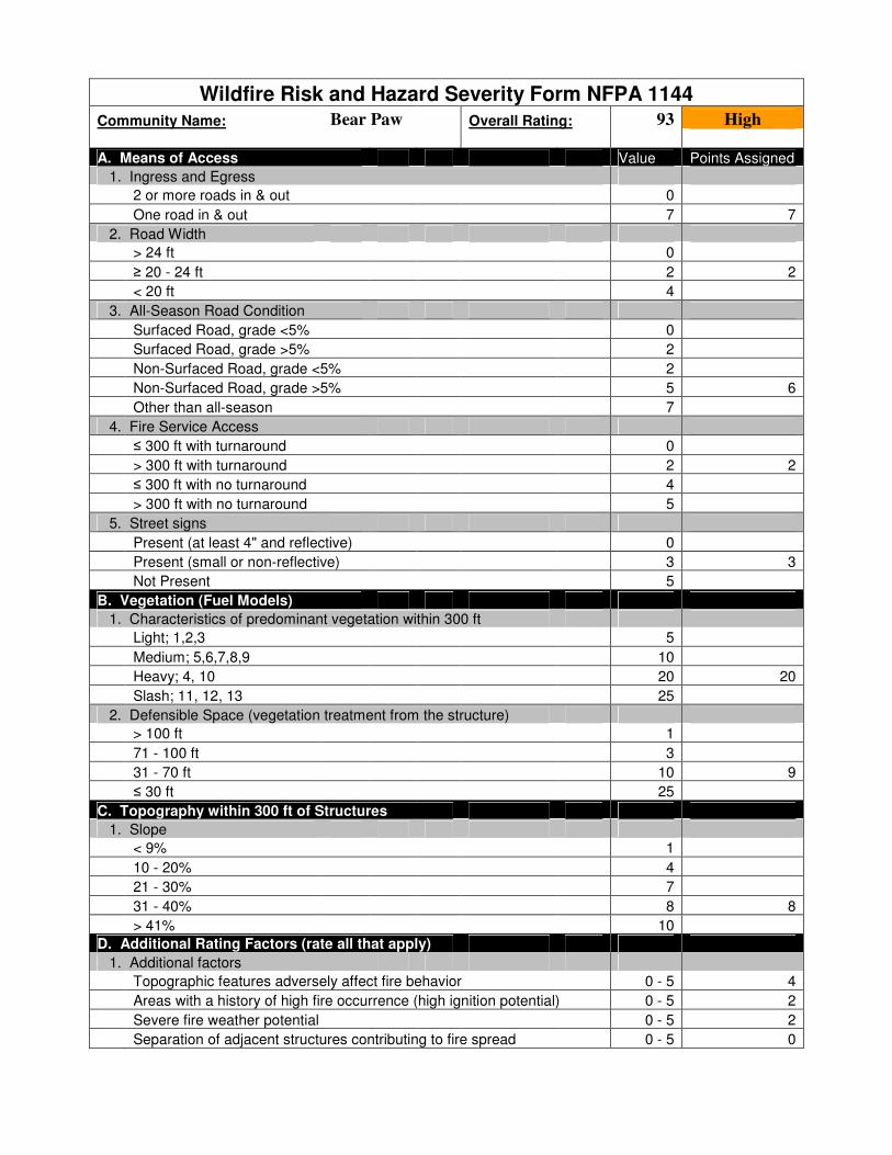
Wildfire Risk and Hazard Severity Form NFPA 1144
Community Name: Bear Paw Overall Rating: 93 High
A. Means of Access Value Points Assigned
1. Ingress and Egress
2 or more roads in & out 0
One road in & out 7 7
2. Road Width
> 24 ft 0
≥ 20 - 24 ft 2 2
< 20 ft 4
3. All-Season Road Condition
Surfaced Road, grade <5% 0
Surfaced Road, grade >5% 2
Non-Surfaced Road, grade <5% 2
Non-Surfaced Road, grade >5% 5 6
Other than all-season 7
4. Fire Service Access
≤ 300 ft with turnaround 0
> 300 ft with turnaround 2 2
≤ 300 ft with no turnaround 4
> 300 ft with no turnaround 5
5. Street signs
Present (at least 4" and reflective) 0
Present (small or non-reflective) 3 3
Not Present 5
B. Vegetation (Fuel Models)
1. Characteristics of predominant vegetation within 300 ft
Light; 1,2,3 5
Medium; 5,6,7,8,9 10
Heavy; 4, 10 20 20
Slash; 11, 12, 13 25
2. Defensible Space (vegetation treatment from the structure)
> 100 ft 1
71 - 100 ft 3
31 - 70 ft 10 9
≤ 30 ft 25
C. Topography within 300 ft of Structures
1. Slope
< 9% 1
10 - 20% 4
21 - 30% 7
31 - 40% 8 8
> 41% 10
D. Additional Rating Factors (rate all that apply)
1. Additional factors
Topographic features adversely affect fire behavior 0 - 5 4
Areas with a history of high fire occurrence (high ignition potential) 0 - 5 2
Severe fire weather potential 0 - 5 2
Separation of adjacent structures contributing to fire spread 0 - 5 0
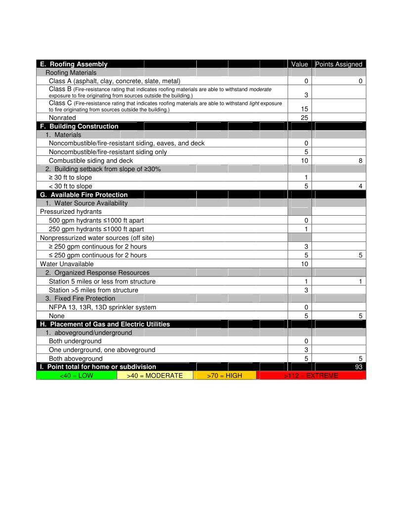
E. Roofing Assembly Value Points Assigned
Roofing Materials
Class A (asphalt, clay, concrete, slate, metal) 0 0
Class B (Fire-resistance rating that indicates roofing materials are able to withstand moderate exposure to fire originating from sources outside the building.) 3
Class C (Fire-resistance rating that indicates roofing materials are able to withstand light exposure to fire originating from sources outside the building.) 15
Nonrated 25
F. Building Construction
1. Materials
Noncombustible/fire-resistant siding, eaves, and deck 0
Noncombustible/fire-resistant siding only 5
Combustible siding and deck 10 8
2. Building setback from slope of ≥30%
≥ 30 ft to slope 1
< 30 ft to slope 5 4
G. Available Fire Protection
1. Water Source Availability
Pressurized hydrants
500 gpm hydrants ≤1000 ft apart 0
250 gpm hydrants ≤1000 ft apart 1
Nonpressurized water sources (off site)
≥ 250 gpm continuous for 2 hours 3
≤ 250 gpm continuous for 2 hours 5 5
Water Unavailable 10
2. Organized Response Resources
Station 5 miles or less from structure 1 1
Station >5 miles from structure 3
3. Fixed Fire Protection
NFPA 13, 13R, 13D sprinkler system 0
None 5 5
H. Placement of Gas and Electric Utilities
1. aboveground/underground
Both underground 0
One underground, one aboveground 3
Both aboveground 5 5
I. Point total for home or subdivision 93
<40 = LOW >40 = MODERATE >70 = HIGH >112 = EXTREME

Douglas Mountain North
Hazard Rating: 63, Moderate
Does the community have dual access/egress roads? Yes
Water supply: Numerous cisterns on
Douglas Mountain Rd. and
Douglas Mountain Dr., draft
ponds/dip sites
Description: Homes in this area are built on both sides of the wide canyon bottom that
runs southwest from the intersection of Robinson Hill Road and Douglas Mountain Road.
Centennial Cone Open Space Park borders this community south of Harkwood Run.
Development throughout this community consists of widely scattered clusters of homes
on large lots, varying from older ranch houses to recent construction with ignition
resistant roofs. Most homes have wood siding and asphalt roofs. The majority of homes
in this community are ranches located in open meadows and irrigated lawns. Slopes
average 15-25%. The area west of Douglas Mountain Road has a few homes located in
dense mixed conifer stands on steeper slopes that need defensible space improvements.
However, most homes have large defensible space areas due to light fuels.
Vegetation: This WUI is characterized by open meadows and open ponderosa
woodlands with grass and shrub understory. Most of the homes are located in short grass
meadows, and some properties have irrigated lawns. There are isolated stands of closed-
canopy ponderosa pine and mixed conifer, especially on north aspects and areas in the
northwest portion of the area.
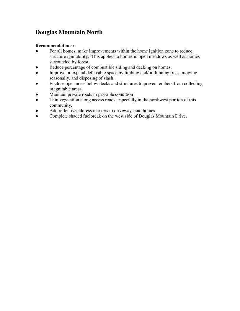
Douglas Mountain North
Recommendations:
● For all homes, make improvements within the home ignition zone to reduce
structure ignitability. This applies to homes in open meadows as well as homes
surrounded by forest.
● Reduce percentage of combustible siding and decking on homes.
● Improve or expand defensible space by limbing and/or thinning trees, mowing
seasonally, and disposing of slash.
● Enclose open areas below decks and structures to prevent embers from collecting
in ignitable areas.
● Maintain private roads in passable condition
● Thin vegetation along access roads, especially in the northwest portion of this
community.
● Add reflective address markers to driveways and homes.
● Complete shaded fuelbreak on the west side of Douglas Mountain Drive.

Wildfire Risk and Hazard Severity Form NFPA 1144
Community Name: Douglas Mountain North Overall Rating: 63 Moderate
A. Means of Access Value Points Assigned
1. Ingress and Egress
2 or more roads in & out 0 0
One road in & out 7
2. Road Width
> 24 ft 0
≥ 20 - 24 ft 2 2
< 20 ft 4
3. All-Season Road Condition
Surfaced Road, grade <5% 0
Surfaced Road, grade >5% 2
Non-Surfaced Road, grade <5% 2 3
Non-Surfaced Road, grade >5% 5
Other than all-season 7
4. Fire Service Access
≤ 300 ft with turnaround 0
> 300 ft with turnaround 2 2
≤ 300 ft with no turnaround 4
> 300 ft with no turnaround 5
5. Street signs
Present (at least 4" and reflective) 0 1
Present (small or non-reflective) 3
Not Present 5
B. Vegetation (Fuel Models)
1. Characteristics of predominant vegetation within 300 ft
Light; 1,2,3 5
Medium; 5,6,7,8,9 10 7
Heavy; 4, 10 20
Slash; 11, 12, 13 25
2. Defensible Space (vegetation treatment from the structure)
> 100 ft 1
71 - 100 ft 3 5
31 - 70 ft 10
≤ 30 ft 25
C. Topography within 300 ft of Structures
1. Slope
< 9% 1
10 - 20% 4
21 - 30% 7 7
31 - 40% 8
> 41% 10
D. Additional Rating Factors (rate all that apply)
1. Additional factors
Topographic features adversely affect fire behavior 0 - 5 3
Areas with a history of high fire occurrence (high ignition potential) 0 - 5 3
Severe fire weather potential 0 - 5 3
Separation of adjacent structures contributing to fire spread 0 - 5 0

E. Roofing Assembly Value Points Assigned
Roofing Materials
Class A (asphalt, clay, concrete, slate, metal) 0 0
Class B (Fire-resistance rating that indicates roofing materials are able to withstand moderate exposure to fire originating from sources outside the building.) 3
Class C (Fire-resistance rating that indicates roofing materials are able to withstand light exposure to fire originating from sources outside the building.) 15
Nonrated 25
F. Building Construction
1. Materials
Noncombustible/fire-resistant siding, eaves, and deck 0
Noncombustible/fire-resistant siding only 5
Combustible siding and deck 10 10
2. Building setback from slope of ≥30%
≥ 30 ft to slope 1 3
< 30 ft to slope 5
G. Available Fire Protection
1. Water Source Availability
Pressurized hydrants
500 gpm hydrants ≤1000 ft apart 0
250 gpm hydrants ≤1000 ft apart 1
Nonpressurized water sources (off site)
≥ 250 gpm continuous for 2 hours 3 3
≤ 250 gpm continuous for 2 hours 5
Water Unavailable 10
2. Organized Response Resources
Station 5 miles or less from structure 1 1
Station >5 miles from structure 3
3. Fixed Fire Protection
NFPA 13, 13R, 13D sprinkler system 0
None 5 5
H. Placement of Gas and Electric Utilities
1. aboveground/underground
Both underground 0
One underground, one aboveground 3
Both aboveground 5 5
I. Point total for home or subdivision 63
<40 = LOW >40 = MODERATE >70 = HIGH >112 = EXTREME

Douglas Mountain South
Hazard Rating: 76, High
Does the community have dual access/egress roads? Yes
Water supply: Cistern at Centennial Cone
Jefferson County Open Space
Description: This community is built along both sides of a predominately north/south
side canyon that connects Robinson Hill with Clear Creek Canyon. Homes are mostly
modern construction on small to moderate sized lots. About half of the homes have fire-
resistant siding, and roofs are metal or asphalt. Fuel loads are predominately light to
moderate for most of the WUI; therefore, most homes have adequate defensible space.
The north and west facing slopes of this steep canyon have some stands of high fuel
loads, and most homes are built at the top and middle of steep slopes, many at the top of
natural chimneys and other hazardous terrain features. Secondary roads and driveways
are steep and many homes have inadequate turnarounds for emergency vehicles.
Vegetation: Vegetation is primarily grasses and shrubs, with isolated large, mature
Rocky Mountain juniper (a highly flammable native species) near many homes. There
are some stands of closed canopy mixed conifer forest on north and west aspects, but they
are isolated to steep north and west aspects. Approximately 6 acres of fuels reduction
work has been completed in this area since 2006.

Douglas Mountain South
Recommendations:
● For all homes, make improvements within the home ignition zone to reduce
structure ignitability. This applies to homes in open meadows as well as homes
surrounded by forest.
● Reduce percentage of combustible siding and decking on homes.
● Improve or expand defensible space by limbing and/or thinning trees, mowing
seasonally, and disposing of slash, particularly along Coyote Spur.
● Enclose open areas below decks and structures to prevent embers from collecting
in ignitable areas.
● Maintain private roads in passable condition
● Thin vegetation along access roads.
● Add reflective address markers to driveways and homes where they are lacking.
● Improved turnarounds should be considered at residences and on secondary roads.
● Thin in gullies below Douglas Mountain Drive to protect access.
● Maintain previously mitigated areas by removing tree regeneration and woody
shrubs.

Wildfire Risk and Hazard Severity Form NFPA 1144
Community Name: Douglas Mountain South Overall Rating: 76 High
A. Means of Access Value Points Assigned
1. Ingress and Egress
2 or more roads in & out 0 0
One road in & out 7
2. Road Width
> 24 ft 0
≥ 20 - 24 ft 2 2
< 20 ft 4
3. All-Season Road Condition
Surfaced Road, grade <5% 0
Surfaced Road, grade >5% 2
Non-Surfaced Road, grade <5% 2 3
Non-Surfaced Road, grade >5% 5
Other than all-season 7
4. Fire Service Access
≤ 300 ft with turnaround 0
> 300 ft with turnaround 2
≤ 300 ft with no turnaround 4 3
> 300 ft with no turnaround 5
5. Street signs
Present (at least 4" and reflective) 0 2
Present (small or non-reflective) 3
Not Present 5
B. Vegetation (Fuel Models)
1. Characteristics of predominant vegetation within 300 ft
Light; 1,2,3 5
Medium; 5,6,7,8,9 10 8
Heavy; 4, 10 20
Slash; 11, 12, 13 25
2. Defensible Space (vegetation treatment from the structure)
> 100 ft 1
71 - 100 ft 3
31 - 70 ft 10 10
≤ 30 ft 25
C. Topography within 300 ft of Structures
1. Slope
< 9% 1
10 - 20% 4
21 - 30% 7
31 - 40% 8 8
> 41% 10
D. Additional Rating Factors (rate all that apply)
1. Additional factors
Topographic features adversely affect fire behavior 0 - 5 5
Areas with a history of high fire occurrence (high ignition potential) 0 - 5 4
Severe fire weather potential 0 - 5 3
Separation of adjacent structures contributing to fire spread 0 - 5 2

E. Roofing Assembly Value Points Assigned
Roofing Materials
Class A (asphalt, clay, concrete, slate, metal) 0 0
Class B (Fire-resistance rating that indicates roofing materials are able to withstand moderate exposure to fire originating from sources outside the building.) 3
Class C (Fire-resistance rating that indicates roofing materials are able to withstand light exposure to fire originating from sources outside the building.) 15
Nonrated 25
F. Building Construction
1. Materials
Noncombustible/fire-resistant siding, eaves, and deck 0
Noncombustible/fire-resistant siding only 5
Combustible siding and deck 10 7
2. Building setback from slope of ≥30%
≥ 30 ft to slope 1
< 30 ft to slope 5 5
G. Available Fire Protection
1. Water Source Availability
Pressurized hydrants
500 gpm hydrants ≤1000 ft apart 0
250 gpm hydrants ≤1000 ft apart 1
Nonpressurized water sources (off site)
≥ 250 gpm continuous for 2 hours 3 3
≤ 250 gpm continuous for 2 hours 5
Water Unavailable 10
2. Organized Response Resources
Station 5 miles or less from structure 1 1
Station >5 miles from structure 3
3. Fixed Fire Protection
NFPA 13, 13R, 13D sprinkler system 0
None 5 5
H. Placement of Gas and Electric Utilities
1. aboveground/underground
Both underground 0
One underground, one aboveground 3
Both aboveground 5 5
I. Point total for home or subdivision 76
<40 = LOW >40 = MODERATE >70 = HIGH >112 = EXTREME

Drew Hill
Hazard Rating: 70, Moderate
Does the community have dual access/egress roads? Yes
Water supply: Cistern at Spirit Ranch Rd.,
draft ponds at Ralston Creek
Description: This area is sparsely populated with scattered homes on large lots. Many
are located far from Drew Hill Road, the primary access, on long narrow driveways.
Homes are a mixture of old and new construction of predominately wood siding and
asphalt roofs. Address numbers are inconsistent or missing. Most homes need extended
defensible space because of heavy fuels and steep slopes. The topography in this area is
moderate, with slopes less than 30% near most homes. The 477-acre Spirit Mountain
Ranch at the south end of this area could become a major development in the future, but
there is currently no new construction in progress. There is one confirmed water source
within this WUI on a private property, and a consistent water supply from Ralston Creek
at the west end of the community.
Vegetation: The area is mostly covered by dense “dog-hair” lodgepole pine and mixed
conifer forests. Closed-canopy ponderosa pine stands are also present in a few areas.
Some small meadows with grasses and woody shrubs break up the continuous forest fuels
on south and east aspects and on ridge tops.

Drew Hill
Recommendations:
● For all homes, make improvements within the home ignition zone to reduce
structure ignitability. This applies to homes in open meadows as well as homes
surrounded by forest.
● Reduce percentage of combustible siding and decking on homes.
● Improve or expand defensible space by limbing and/or thinning trees, mowing
seasonally, and disposing of slash.
● Enclose open areas below decks and structures to prevent embers from collecting
in ignitable areas.
● Maintain private roads in passable condition
● Thin vegetation along access roads.
● Add reflective address markers to driveways and homes where they are lacking.
● Complete shaded fuelbreaks on the ridge south of Drew Hill Road.
● Complete shaded fuelbreak north of Spirit Ranch Road, parallel to the large
meadow, and tie to private access road off of Drew Hill Road.
● Individual cisterns may be the best choice for water supply needs in this area

Wildfire Risk and Hazard Severity Form NFPA 1144
Community Name: Drew Hill Overall Rating: 70 Moderate
A. Means of Access Value Points Assigned
1. Ingress and Egress
2 or more roads in & out 0 0
One road in & out 7
2. Road Width
> 24 ft 0
≥ 20 - 24 ft 2 2
< 20 ft 4
3. All-Season Road Condition
Surfaced Road, grade <5% 0
Surfaced Road, grade >5% 2
Non-Surfaced Road, grade <5% 2
Non-Surfaced Road, grade >5% 5 4
Other than all-season 7
4. Fire Service Access
≤ 300 ft with turnaround 0
> 300 ft with turnaround 2 3
≤ 300 ft with no turnaround 4
> 300 ft with no turnaround 5
5. Street signs
Present (at least 4" and reflective) 0
Present (small or non-reflective) 3 3
Not Present 5
B. Vegetation (Fuel Models)
1. Characteristics of predominant vegetation within 300 ft
Light; 1,2,3 5
Medium; 5,6,7,8,9 10
Heavy; 4, 10 20 15
Slash; 11, 12, 13 25
2. Defensible Space (vegetation treatment from the structure)
> 100 ft 1
71 - 100 ft 3 5
31 - 70 ft 10
≤ 30 ft 25
C. Topography within 300 ft of Structures
1. Slope
< 9% 1
10 - 20% 4
21 - 30% 7 7
31 - 40% 8
> 41% 10
D. Additional Rating Factors (rate all that apply)
1. Additional factors
Topographic features adversely affect fire behavior 0 - 5 3
Areas with a history of high fire occurrence (high ignition potential) 0 - 5 3
Severe fire weather potential 0 - 5 3
Separation of adjacent structures contributing to fire spread 0 - 5 0

E. Roofing Assembly Value Points Assigned
Roofing Materials
Class A (asphalt, clay, concrete, slate, metal) 0 0
Class B (Fire-resistance rating that indicates roofing materials are able to withstand moderate exposure to fire originating from sources outside the building.) 3
Class C (Fire-resistance rating that indicates roofing materials are able to withstand light exposure to fire originating from sources outside the building.) 15
Nonrated 25
F. Building Construction
1. Materials
Noncombustible/fire-resistant siding, eaves, and deck 0
Noncombustible/fire-resistant siding only 5 5
Combustible siding and deck 10
2. Building setback from slope of ≥30%
≥ 30 ft to slope 1
< 30 ft to slope 5 3
G. Available Fire Protection
1. Water Source Availability
Pressurized hydrants
500 gpm hydrants ≤1000 ft apart 0
250 gpm hydrants ≤1000 ft apart 1
Nonpressurized water sources (off site)
≥ 250 gpm continuous for 2 hours 3
≤ 250 gpm continuous for 2 hours 5 5
Water Unavailable 10
2. Organized Response Resources
Station 5 miles or less from structure 1 1
Station >5 miles from structure 3
3. Fixed Fire Protection
NFPA 13, 13R, 13D sprinkler system 0
None 5 5
H. Placement of Gas and Electric Utilities
1. aboveground/underground
Both underground 0
One underground, one aboveground 3 3
Both aboveground 5
I. Point total for home or subdivision 70
<40 = LOW >40 = MODERATE >70 = HIGH >112 = EXTREME

Geneva Glen
Hazard Rating: 100, High
Does the community have dual access/egress roads? Yes
Water supply: Draft ponds off Ralston
Creek
Description: This is a relatively isolated community surrounded by Golden Gate State
Park. The majority of the homes in this WUI are clustered close together off Geneva
Road. Several structures are older cabins, with wood siding and older asphalt or tar paper
roofs. The homes are largely modern log or wood siding construction with fire-resistant
asphalt or metal roofs. Firewood stacks and other manmade fuel jackpots are common
near structures. Access along Drew Hill and Ralston Creek Roads are good, the unpaved
side roads are rough, steep, and narrow in spots. Many properties lack adequate
turnarounds. There are missing or inadequate street signs and addressing throughout the
area. Topography is moderate to steep, with some slopes up to 40%. The nearest water
supply is draft water from draft ponds off Ralston Creek in Golden Gate State Park, on
Drew Hill Road.
Vegetation: The area is primarily covered by dense “dog-hair” lodgepole pine and
closed canopy mixed conifer forests. There are extensive areas where small patch cuts
and forest thinning are ongoing. Riparian trees and shrubs occur in stringers and patches
near Ralston Creek and ponds, however they are unlikely to make a significant
contribution to the overall fire behavior of this area.

Geneva Glen
Recommendations:
● For all homes, make improvements within the home ignition zone to reduce
structure ignitability.
● Reduce percentage of combustible siding and decking on homes.
● Improve or expand defensible space by limbing and/or thinning trees, and
disposing of slash.
● Enclose open areas below decks and structures to prevent embers from collecting
in ignitable areas.
● Maintain private roads in passable condition.
● Thin vegetation along access roads, particularly along Geneva, Kunst, and Baker
Roads.
● Add reflective address markers to all driveways and homes.
● Create small patch cut openings where Aspen saplings are growing to encourage
the reestablishment of Aspen groves.
● Thin vegetation along Spirit Horse Trail; extend thinning into open meadows
where possible.

Wildfire Risk and Hazard Severity Form NFPA 1144
Community Name: Geneva Glen Overall Rating: 100 High
A. Means of Access Value Points Assigned
1. Ingress and Egress
2 or more roads in & out 0 0
One road in & out 7
2. Road Width
> 24 ft 0
≥ 20 - 24 ft 2 3
< 20 ft 4
3. All-Season Road Condition
Surfaced Road, grade <5% 0
Surfaced Road, grade >5% 2
Non-Surfaced Road, grade <5% 2
Non-Surfaced Road, grade >5% 5 5
Other than all-season 7
4. Fire Service Access
≤ 300 ft with turnaround 0
> 300 ft with turnaround 2
≤ 300 ft with no turnaround 4 4
> 300 ft with no turnaround 5
5. Street signs
Present (at least 4" and reflective) 0
Present (small or non-reflective) 3 3
Not Present 5
B. Vegetation (Fuel Models)
1. Characteristics of predominant vegetation within 300 ft
Light; 1,2,3 5
Medium; 5,6,7,8,9 10
Heavy; 4, 10 20 20
Slash; 11, 12, 13 25
2. Defensible Space (vegetation treatment from the structure)
> 100 ft 1
71 - 100 ft 3
31 - 70 ft 10 17
≤ 30 ft 25
C. Topography within 300 ft of Structures
1. Slope
< 9% 1
10 - 20% 4
21 - 30% 7 7
31 - 40% 8
> 41% 10
D. Additional Rating Factors (rate all that apply)
1. Additional factors
Topographic features adversely affect fire behavior 0 - 5 4
Areas with a history of high fire occurrence (high ignition potential) 0 - 5 2
Severe fire weather potential 0 - 5 2
Separation of adjacent structures contributing to fire spread 0 - 5 3

E. Roofing Assembly Value Points Assigned
Roofing Materials
Class A (asphalt, clay, concrete, slate, metal) 0
Class B (Fire-resistance rating that indicates roofing materials are able to withstand moderate exposure to fire originating from sources outside the building.) 3 3
Class C (Fire-resistance rating that indicates roofing materials are able to withstand light exposure to fire originating from sources outside the building.) 15
Nonrated 25
F. Building Construction
1. Materials
Noncombustible/fire-resistant siding, eaves, and deck 0
Noncombustible/fire-resistant siding only 5
Combustible siding and deck 10 10
2. Building setback from slope of ≥30%
≥ 30 ft to slope 1
< 30 ft to slope 5 3
G. Available Fire Protection
1. Water Source Availability
Pressurized hydrants
500 gpm hydrants ≤1000 ft apart 0
250 gpm hydrants ≤1000 ft apart 1
Nonpressurized water sources (off site)
≥ 250 gpm continuous for 2 hours 3 3
≤ 250 gpm continuous for 2 hours 5
Water Unavailable 10
2. Organized Response Resources
Station 5 miles or less from structure 1 1
Station >5 miles from structure 3
3. Fixed Fire Protection
NFPA 13, 13R, 13D sprinkler system 0
None 5 5
H. Placement of Gas and Electric Utilities
1. aboveground/underground
Both underground 0
One underground, one aboveground 3
Both aboveground 5 5
I. Point total for home or subdivision 100
<40 = LOW >40 = MODERATE >70 = HIGH >112 = EXTREME
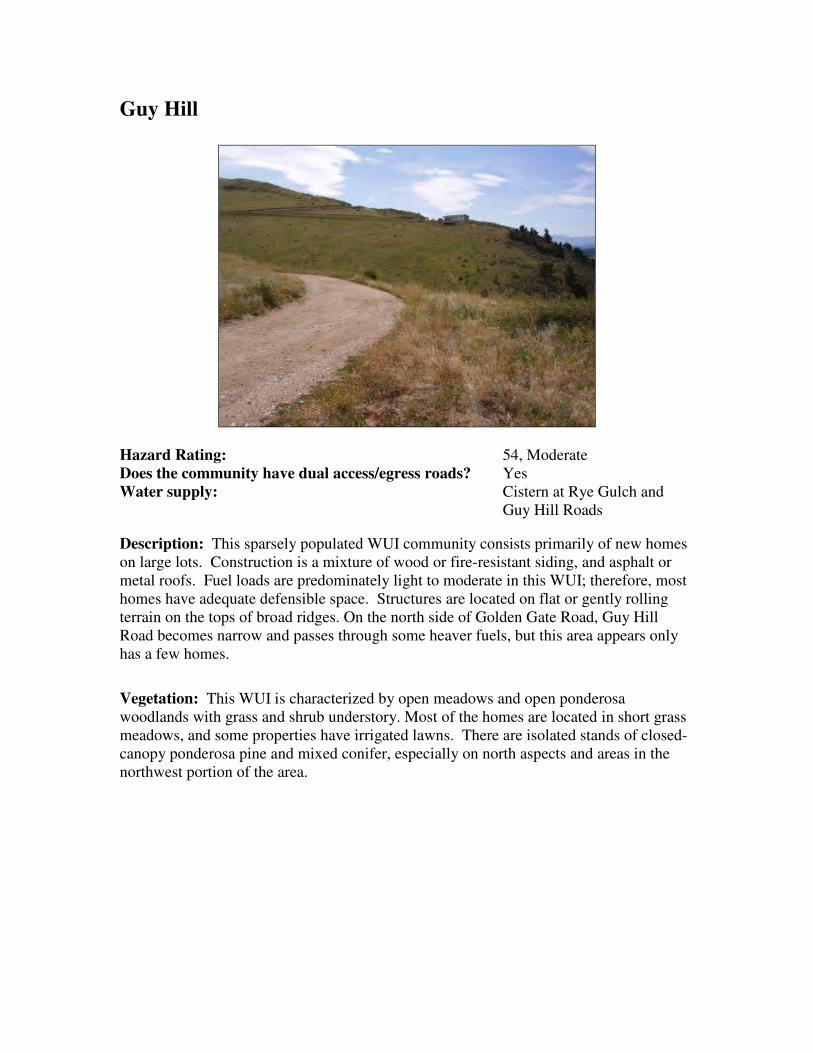
Guy Hill
Hazard Rating: 54, Moderate
Does the community have dual access/egress roads? Yes
Water supply: Cistern at Rye Gulch and
Guy Hill Roads
Description: This sparsely populated WUI community consists primarily of new homes
on large lots. Construction is a mixture of wood or fire-resistant siding, and asphalt or
metal roofs. Fuel loads are predominately light to moderate in this WUI; therefore, most
homes have adequate defensible space. Structures are located on flat or gently rolling
terrain on the tops of broad ridges. On the north side of Golden Gate Road, Guy Hill
Road becomes narrow and passes through some heaver fuels, but this area appears only
has a few homes.
Vegetation: This WUI is characterized by open meadows and open ponderosa
woodlands with grass and shrub understory. Most of the homes are located in short grass
meadows, and some properties have irrigated lawns. There are isolated stands of closed-
canopy ponderosa pine and mixed conifer, especially on north aspects and areas in the
northwest portion of the area.

Guy Hill
Recommendations:
● For all homes, make improvements within the home ignition zone to reduce
structure ignitability. This applies to homes in open meadows as well as homes
surrounded by forest.
● Reduce percentage of combustible siding and decking on homes.
● Improve or expand defensible space by limbing and/or thinning trees, mowing
seasonally, and disposing of slash.
● Enclose open areas below decks and structures to prevent embers from collecting
in ignitable areas.
● Maintain private roads in passable condition
● Thin vegetation along access roads.
● Add reflective address markers to driveways and homes.
● Fuels should be thinned on both sides of the narrow portion of Guy Hill Road to
make it a more viable access/egress route.

Wildfire Risk and Hazard Severity Form NFPA 1144
Community Name: Guy Hill Overall Rating: 54 Moderate
A. Means of Access Value Points Assigned
1. Ingress and Egress
2 or more roads in & out 0 0
One road in & out 7
2. Road Width
> 24 ft 0
≥ 20 - 24 ft 2 2
< 20 ft 4
3. All-Season Road Condition
Surfaced Road, grade <5% 0
Surfaced Road, grade >5% 2
Non-Surfaced Road, grade <5% 2 3
Non-Surfaced Road, grade >5% 5
Other than all-season 7
4. Fire Service Access
≤ 300 ft with turnaround 0
> 300 ft with turnaround 2 2
≤ 300 ft with no turnaround 4
> 300 ft with no turnaround 5
5. Street signs
Present (at least 4" and reflective) 0
Present (small or non-reflective) 3 3
Not Present 5
B. Vegetation (Fuel Models)
1. Characteristics of predominant vegetation within 300 ft
Light; 1,2,3 5 5
Medium; 5,6,7,8,9 10
Heavy; 4, 10 20
Slash; 11, 12, 13 25
2. Defensible Space (vegetation treatment from the structure)
> 100 ft 1 2
71 - 100 ft 3
31 - 70 ft 10
≤ 30 ft 25
C. Topography within 300 ft of Structures
1. Slope
< 9% 1
10 - 20% 4
21 - 30% 7 6
31 - 40% 8
> 41% 10
D. Additional Rating Factors (rate all that apply)
1. Additional factors
Topographic features adversely affect fire behavior 0 - 5 3
Areas with a history of high fire occurrence (high ignition potential) 0 - 5 3
Severe fire weather potential 0 - 5 3
Separation of adjacent structures contributing to fire spread 0 - 5 0

E. Roofing Assembly Value Points Assigned
Roofing Materials
Class A (asphalt, clay, concrete, slate, metal) 0 0
Class B (Fire-resistance rating that indicates roofing materials are able to withstand moderate exposure to fire originating from sources outside the building.) 3
Class C (Fire-resistance rating that indicates roofing materials are able to withstand light exposure to fire originating from sources outside the building.) 15
Nonrated 25
F. Building Construction
1. Materials
Noncombustible/fire-resistant siding, eaves, and deck 0
Noncombustible/fire-resistant siding only 5 6
Combustible siding and deck 10
2. Building setback from slope of ≥30%
≥ 30 ft to slope 1 2
< 30 ft to slope 5
G. Available Fire Protection
1. Water Source Availability
Pressurized hydrants
500 gpm hydrants ≤1000 ft apart 0
250 gpm hydrants ≤1000 ft apart 1
Nonpressurized water sources (off site)
≥ 250 gpm continuous for 2 hours 3 3
≤ 250 gpm continuous for 2 hours 5
Water Unavailable 10
2. Organized Response Resources
Station 5 miles or less from structure 1 1
Station >5 miles from structure 3
3. Fixed Fire Protection
NFPA 13, 13R, 13D sprinkler system 0
None 5 5
H. Placement of Gas and Electric Utilities
1. aboveground/underground
Both underground 0
One underground, one aboveground 3
Both aboveground 5 5
I. Point total for home or subdivision 54
<40 = LOW >40 = MODERATE >70 = HIGH >112 = EXTREME

Horseradish Gulch
Hazard Rating: 69, Moderate
Does the community have dual access/egress roads? Yes
Water supply: Cisterns on Horseradish
Gulch Rd, on private
properties
Description: Residences are mostly older ranch houses on large, widely spaced lots.
Homes are located at the end of long private driveways, many with locked gates.
Construction is primarily wood siding with asphalt roofs. Some homes have combustible
materials near structures and propane tanks. Most roads are of adequate width, but are
rough in spots. Some driveways and private roads are very steep and narrow, and some
have tight switchbacks. Some mitigation has been completed, and there is adequate
defensible space near most homes.
Vegetation: Vegetation is a mixture of open canopy ponderosa pine and dense, closed
canopy mixed conifer (on north and west aspects), broken by large grassy meadows.
Overall, vegetation cover is light to moderate. Approximately 7.5 acres in this
community have had fire mitigation completed. On Mica Mountain Road, there are old
slash piles left at the side of the road, which adds to the hazardous fuel loads in this area.

Horseradish Gulch
Recommendations:
● For all homes, make improvements within the home ignition zone to reduce
structure ignitability. This applies to homes in open meadows as well as homes
surrounded by forest.
● Reduce percentage of combustible siding and decking on homes.
● Improve or expand defensible space by limbing and/or thinning trees, mowing
seasonally, and disposing of slash.
● Enclose open areas below decks and structures to prevent embers from collecting
in ignitable areas.
● Maintain private roads in passable condition
● Thin vegetation along access roads, particularly Mica Mountain Road.
● Clear or burn old slash piles along Mica Mountain Road
● Add reflective address markers to driveways and homes.
● Clear grasses and combustible materials away from propane tanks.
● At least one large (10,000 gallon or larger) community cistern is recommended.
● Complete shaded fuelbreak from Golden Gate Canyon Road north along
Horseradish Gulch Road, on the north side of the draw.
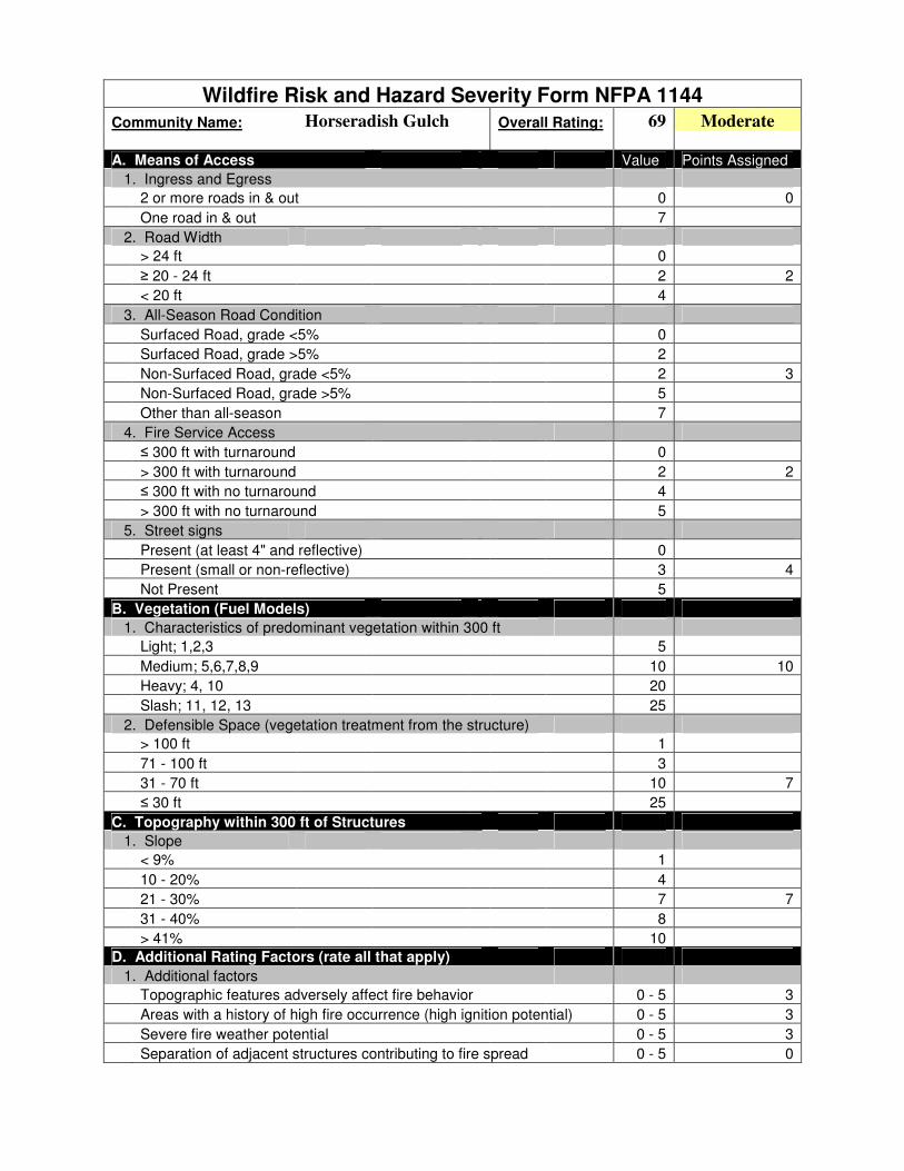
Wildfire Risk and Hazard Severity Form NFPA 1144
Community Name: Horseradish Gulch Overall Rating: 69 Moderate
A. Means of Access Value Points Assigned
1. Ingress and Egress
2 or more roads in & out 0 0
One road in & out 7
2. Road Width
> 24 ft 0
≥ 20 - 24 ft 2 2
< 20 ft 4
3. All-Season Road Condition
Surfaced Road, grade <5% 0
Surfaced Road, grade >5% 2
Non-Surfaced Road, grade <5% 2 3
Non-Surfaced Road, grade >5% 5
Other than all-season 7
4. Fire Service Access
≤ 300 ft with turnaround 0
> 300 ft with turnaround 2 2
≤ 300 ft with no turnaround 4
> 300 ft with no turnaround 5
5. Street signs
Present (at least 4" and reflective) 0
Present (small or non-reflective) 3 4
Not Present 5
B. Vegetation (Fuel Models)
1. Characteristics of predominant vegetation within 300 ft
Light; 1,2,3 5
Medium; 5,6,7,8,9 10 10
Heavy; 4, 10 20
Slash; 11, 12, 13 25
2. Defensible Space (vegetation treatment from the structure)
> 100 ft 1
71 - 100 ft 3
31 - 70 ft 10 7
≤ 30 ft 25
C. Topography within 300 ft of Structures
1. Slope
< 9% 1
10 - 20% 4
21 - 30% 7 7
31 - 40% 8
> 41% 10
D. Additional Rating Factors (rate all that apply)
1. Additional factors
Topographic features adversely affect fire behavior 0 - 5 3
Areas with a history of high fire occurrence (high ignition potential) 0 - 5 3
Severe fire weather potential 0 - 5 3
Separation of adjacent structures contributing to fire spread 0 - 5 0

E. Roofing Assembly Value Points Assigned
Roofing Materials
Class A (asphalt, clay, concrete, slate, metal) 0 0
Class B (Fire-resistance rating that indicates roofing materials are able to withstand moderate exposure to fire originating from sources outside the building.) 3
Class C (Fire-resistance rating that indicates roofing materials are able to withstand light exposure to fire originating from sources outside the building.) 15
Nonrated 25
F. Building Construction
1. Materials
Noncombustible/fire-resistant siding, eaves, and deck 0
Noncombustible/fire-resistant siding only 5 7
Combustible siding and deck 10
2. Building setback from slope of ≥30%
≥ 30 ft to slope 1 2
< 30 ft to slope 5
G. Available Fire Protection
1. Water Source Availability
Pressurized hydrants
500 gpm hydrants ≤1000 ft apart 0
250 gpm hydrants ≤1000 ft apart 1
Nonpressurized water sources (off site)
≥ 250 gpm continuous for 2 hours 3
≤ 250 gpm continuous for 2 hours 5 5
Water Unavailable 10
2. Organized Response Resources
Station 5 miles or less from structure 1 1
Station >5 miles from structure 3
3. Fixed Fire Protection
NFPA 13, 13R, 13D sprinkler system 0
None 5 5
H. Placement of Gas and Electric Utilities
1. aboveground/underground
Both underground 0
One underground, one aboveground 3
Both aboveground 5 5
I. Point total for home or subdivision 69
<40 = LOW >40 = MODERATE >70 = HIGH >112 = EXTREME
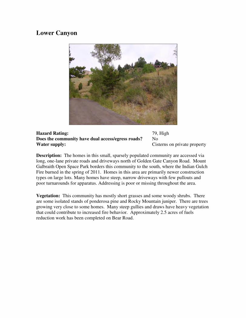
Lower Canyon
Hazard Rating: 79, High
Does the community have dual access/egress roads? No
Water supply: Cisterns on private property
Description: The homes in this small, sparsely populated community are accessed via
long, one-lane private roads and driveways north of Golden Gate Canyon Road. Mount
Galbraith Open Space Park borders this community to the south, where the Indian Gulch
Fire burned in the spring of 2011. Homes in this area are primarily newer construction
types on large lots. Many homes have steep, narrow driveways with few pullouts and
poor turnarounds for apparatus. Addressing is poor or missing throughout the area.
Vegetation: This community has mostly short grasses and some woody shrubs. There
are some isolated stands of ponderosa pine and Rocky Mountain juniper. There are trees
growing very close to some homes. Many steep gullies and draws have heavy vegetation
that could contribute to increased fire behavior. Approximately 2.5 acres of fuels
reduction work has been completed on Bear Road.

Lower Canyon
Recommendations:
● For all homes, make improvements within the home ignition zone to reduce
structure ignitability. This applies to homes in open meadows as well as homes
surrounded by forest.
● Reduce percentage of combustible siding and decking on homes.
● Improve or expand defensible space by limbing and/or thinning trees, mowing
seasonally, and disposing of slash.
● Enclose open areas below decks and structures to prevent embers from collecting
in ignitable areas.
● Maintain private roads and driveways in passable condition
● Thin vegetation along access roads.
● Add reflective address markers to driveways and homes.
● Individual cisterns, in addition to one large (10,000 to 30,000 gallon) community
cistern is recommended.

Wildfire Risk and Hazard Severity Form NFPA 1144
Community Name: Lower Canyon Overall Rating: 79 High
A. Means of Access Value Points Assigned
1. Ingress and Egress
2 or more roads in & out 0
One road in & out 7 7
2. Road Width
> 24 ft 0
≥ 20 - 24 ft 2
< 20 ft 4 4
3. All-Season Road Condition
Surfaced Road, grade <5% 0
Surfaced Road, grade >5% 2
Non-Surfaced Road, grade <5% 2
Non-Surfaced Road, grade >5% 5 4
Other than all-season 7
4. Fire Service Access
≤ 300 ft with turnaround 0
> 300 ft with turnaround 2 2
≤ 300 ft with no turnaround 4
> 300 ft with no turnaround 5
5. Street signs
Present (at least 4" and reflective) 0
Present (small or non-reflective) 3 3
Not Present 5
B. Vegetation (Fuel Models)
1. Characteristics of predominant vegetation within 300 ft
Light; 1,2,3 5 8
Medium; 5,6,7,8,9 10
Heavy; 4, 10 20
Slash; 11, 12, 13 25
2. Defensible Space (vegetation treatment from the structure)
> 100 ft 1
71 - 100 ft 3
31 - 70 ft 10 10
≤ 30 ft 25
C. Topography within 300 ft of Structures
1. Slope
< 9% 1
10 - 20% 4
21 - 30% 7 7
31 - 40% 8
> 41% 10
D. Additional Rating Factors (rate all that apply)
1. Additional factors
Topographic features adversely affect fire behavior 0 - 5 3
Areas with a history of high fire occurrence (high ignition potential) 0 - 5 3
Severe fire weather potential 0 - 5 3
Separation of adjacent structures contributing to fire spread 0 - 5 0

E. Roofing Assembly Value Points Assigned
Roofing Materials
Class A (asphalt, clay, concrete, slate, metal) 0 0
Class B (Fire-resistance rating that indicates roofing materials are able to withstand moderate exposure to fire originating from sources outside the building.) 3
Class C (Fire-resistance rating that indicates roofing materials are able to withstand light exposure to fire originating from sources outside the building.) 15
Nonrated 25
F. Building Construction
1. Materials
Noncombustible/fire-resistant siding, eaves, and deck 0
Noncombustible/fire-resistant siding only 5
Combustible siding and deck 10 9
2. Building setback from slope of ≥30%
≥ 30 ft to slope 1 2
< 30 ft to slope 5
G. Available Fire Protection
1. Water Source Availability
Pressurized hydrants
500 gpm hydrants ≤1000 ft apart 0
250 gpm hydrants ≤1000 ft apart 1
Nonpressurized water sources (off site)
≥ 250 gpm continuous for 2 hours 3 3
≤ 250 gpm continuous for 2 hours 5
Water Unavailable 10
2. Organized Response Resources
Station 5 miles or less from structure 1 1
Station >5 miles from structure 3
3. Fixed Fire Protection
NFPA 13, 13R, 13D sprinkler system 0
None 5 5
H. Placement of Gas and Electric Utilities
1. aboveground/underground
Both underground 0
One underground, one aboveground 3
Both aboveground 5 5
I. Point total for home or subdivision 79
<40 = LOW >40 = MODERATE >70 = HIGH >112 = EXTREME

Middle Crawford Gulch
Hazard Rating: 93, High
Does the community have dual access/egress roads? No
Water supply: Cistern at Pleasant Park
Road, and small draft ponds
Description: This is a newly delineated WUI community in this CWPP. Middle
Crawford Gulch is a small cluster of homes on a ridge top above a very steep slope above
Crawford Gulch Road. Construction is primarily wood siding with asphalt roofs.
Defensible space is variable from one property to the next, and most homes need
additional defensible space. There is only one way in and out of this community.
Properties lack clear addressing. Slopes in this area range from 15-30% on average, with
draws and gullies below most homes.
Vegetation: Forests are dominated by closed-canopy ponderosa pine stands. Some areas
have dense regeneration in the understory, with Douglas-fir saplings below the main tree
canopy. Forests are generally more open on the ridge tops, near homes, and along
roadsides, with fewer ladder fuels.

Middle Crawford Gulch
Recommendations:
● For all homes, make improvements within the home ignition zone to reduce
structure ignitability. This applies to homes in open meadows as well as homes
surrounded by forest.
● Reduce percentage of combustible siding and decking on homes.
● Improve or expand defensible space by limbing and/or thinning trees, mowing
seasonally, and disposing of slash.
● Enclose open areas below decks and structures to prevent embers from collecting
in ignitable areas.
● Maintain private roads in passable condition
● Thin vegetation along access roads.
● Add reflective address markers to driveways and homes.
● Complete secondary access/egress from private drive at the northern end of the
WUI to the end of Summer Star Lane in the Window Rock WUI.

Wildfire Risk and Hazard Severity Form NFPA 1144
Community Name: Middle Crawford Gulch Overall Rating: 93 High
A. Means of Access Value Points Assigned
1. Ingress and Egress
2 or more roads in & out 0
One road in & out 7 7
2. Road Width
> 24 ft 0
≥ 20 - 24 ft 2
< 20 ft 4 4
3. All-Season Road Condition
Surfaced Road, grade <5% 0
Surfaced Road, grade >5% 2
Non-Surfaced Road, grade <5% 2
Non-Surfaced Road, grade >5% 5
Other than all-season 7 6
4. Fire Service Access
≤ 300 ft with turnaround 0
> 300 ft with turnaround 2
≤ 300 ft with no turnaround 4
> 300 ft with no turnaround 5 5
5. Street signs
Present (at least 4" and reflective) 0
Present (small or non-reflective) 3 3
Not Present 5
B. Vegetation (Fuel Models)
1. Characteristics of predominant vegetation within 300 ft
Light; 1,2,3 5
Medium; 5,6,7,8,9 10
Heavy; 4, 10 20 10
Slash; 11, 12, 13 25
2. Defensible Space (vegetation treatment from the structure)
> 100 ft 1
71 - 100 ft 3
31 - 70 ft 10 10
≤ 30 ft 25
C. Topography within 300 ft of Structures
1. Slope
< 9% 1
10 - 20% 4
21 - 30% 7
31 - 40% 8 8
> 41% 10
D. Additional Rating Factors (rate all that apply)
1. Additional factors
Topographic features adversely affect fire behavior 0 - 5 4
Areas with a history of high fire occurrence (high ignition potential) 0 - 5 3
Severe fire weather potential 0 - 5 3
Separation of adjacent structures contributing to fire spread 0 - 5 0

E. Roofing Assembly Value Points Assigned
Roofing Materials
Class A (asphalt, clay, concrete, slate, metal) 0 0
Class B (Fire-resistance rating that indicates roofing materials are able to withstand moderate exposure to fire originating from sources outside the building.) 3
Class C (Fire-resistance rating that indicates roofing materials are able to withstand light exposure to fire originating from sources outside the building.) 15
Nonrated 25
F. Building Construction
1. Materials
Noncombustible/fire-resistant siding, eaves, and deck 0
Noncombustible/fire-resistant siding only 5
Combustible siding and deck 10 10
2. Building setback from slope of ≥30%
≥ 30 ft to slope 1
< 30 ft to slope 5 4
G. Available Fire Protection
1. Water Source Availability
Pressurized hydrants
500 gpm hydrants ≤1000 ft apart 0
250 gpm hydrants ≤1000 ft apart 1
Nonpressurized water sources (off site)
≥ 250 gpm continuous for 2 hours 3
≤ 250 gpm continuous for 2 hours 5 5
Water Unavailable 10
2. Organized Response Resources
Station 5 miles or less from structure 1 1
Station >5 miles from structure 3
3. Fixed Fire Protection
NFPA 13, 13R, 13D sprinkler system 0
None 5 5
H. Placement of Gas and Electric Utilities
1. aboveground/underground
Both underground 0
One underground, one aboveground 3
Both aboveground 5 5
I. Point total for home or subdivision 93
<40 = LOW >40 = MODERATE >70 = HIGH >112 = EXTREME

North Ranch
Hazard Rating: 72, High
Does the community have dual access/egress roads? No
Water supply: Community cistern and
private property cisterns.
Description: This exclusive neighborhood consists of large recently constructed homes
on large lots. Most homes have ignition resistant roofs and some have ignition resistant
external walls. There are many homes built at the top of steep ravines, some over 40%
slope, with Misty and Homestead Roads, which are the primary access, are steep but of
adequate width. Turnarounds are few and many driveways have tight switchbacks, are
steep, narrow and overgrown with fuels.
Vegetation: The area has dense mixed conifer forests broken by open-canopy ponderosa
pine forests and grassy meadows. There are dense “dog-hair” lodgepole pine and
Douglas-fir stands on the north end of Homestead Road. Meadows break up the
continuous forest fuels, especially in the southern portion of the community. An
extensive shaded fuel break was completed in 2004-2005, which reduced hazardous fuel
loads along Homestead Road. In addition, several properties have completed additional
fuels mitigation and defensible space work since 2006. This work comprises more than
50 acres.
North Ranch
Recommendations:
● For all homes, make improvements within the home ignition zone to reduce
structure ignitability. This applies to homes in open meadows as well as homes
surrounded by forest.
● Improve or expand defensible space by limbing and/or thinning trees, mowing
seasonally, and disposing of slash.
● Enclose open areas below decks and structures to prevent embers from collecting
in ignitable areas.
● Maintain private roads and driveways in passable condition
● Misty and Homestead Roads need thinning to at least a 300' width to protect
access and egress.
● Add reflective address markers to driveways and homes.
● Construct pullouts along the narrow portions of Homestead and Misty Roads ● Maintain areas that have been previously mitigated to control tree regeneration,
especially along roadsides and within defensible space of structures.
● Complete shaded fuelbreak on the north side of Misty Road; tie thinned areas to
meadows and previously completed mitigation work areas.
● Complete access road improvement on private road that connects Misty Road
with Homestead Road, to create a passable loop.
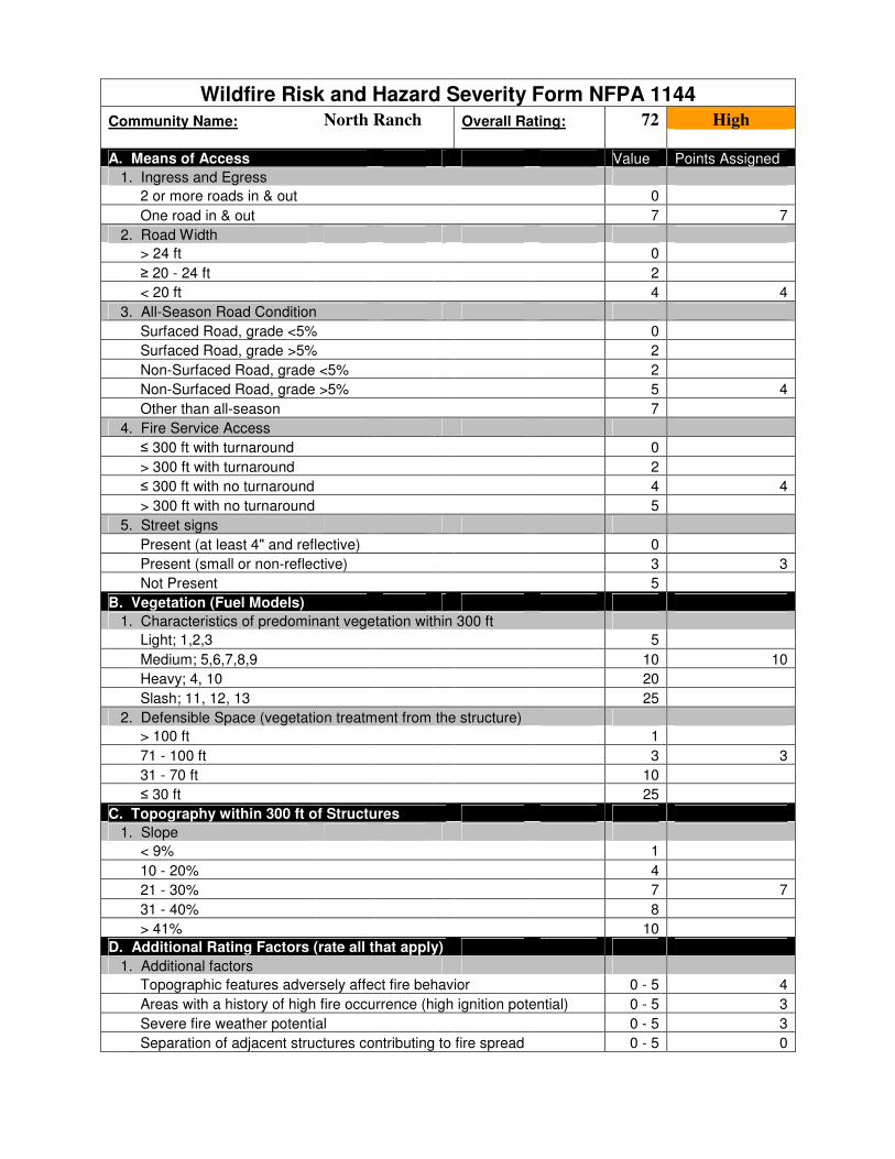
Wildfire Risk and Hazard Severity Form NFPA 1144
Community Name: North Ranch Overall Rating: 72 High
A. Means of Access Value Points Assigned
1. Ingress and Egress
2 or more roads in & out 0
One road in & out 7 7
2. Road Width
> 24 ft 0
≥ 20 - 24 ft 2
< 20 ft 4 4
3. All-Season Road Condition
Surfaced Road, grade <5% 0
Surfaced Road, grade >5% 2
Non-Surfaced Road, grade <5% 2
Non-Surfaced Road, grade >5% 5 4
Other than all-season 7
4. Fire Service Access
≤ 300 ft with turnaround 0
> 300 ft with turnaround 2
≤ 300 ft with no turnaround 4 4
> 300 ft with no turnaround 5
5. Street signs
Present (at least 4" and reflective) 0
Present (small or non-reflective) 3 3
Not Present 5
B. Vegetation (Fuel Models)
1. Characteristics of predominant vegetation within 300 ft
Light; 1,2,3 5
Medium; 5,6,7,8,9 10 10
Heavy; 4, 10 20
Slash; 11, 12, 13 25
2. Defensible Space (vegetation treatment from the structure)
> 100 ft 1
71 - 100 ft 3 3
31 - 70 ft 10
≤ 30 ft 25
C. Topography within 300 ft of Structures
1. Slope
< 9% 1
10 - 20% 4
21 - 30% 7 7
31 - 40% 8
> 41% 10
D. Additional Rating Factors (rate all that apply)
1. Additional factors
Topographic features adversely affect fire behavior 0 - 5 4
Areas with a history of high fire occurrence (high ignition potential) 0 - 5 3
Severe fire weather potential 0 - 5 3
Separation of adjacent structures contributing to fire spread 0 - 5 0

E. Roofing Assembly Value Points Assigned
Roofing Materials
Class A (asphalt, clay, concrete, slate, metal) 0 0
Class B (Fire-resistance rating that indicates roofing materials are able to withstand moderate exposure to fire originating from sources outside the building.) 3
Class C (Fire-resistance rating that indicates roofing materials are able to withstand light exposure to fire originating from sources outside the building.) 15
Nonrated 25
F. Building Construction
1. Materials
Noncombustible/fire-resistant siding, eaves, and deck 0
Noncombustible/fire-resistant siding only 5 3
Combustible siding and deck 10
2. Building setback from slope of ≥30%
≥ 30 ft to slope 1
< 30 ft to slope 5 3
G. Available Fire Protection
1. Water Source Availability
Pressurized hydrants
500 gpm hydrants ≤1000 ft apart 0
250 gpm hydrants ≤1000 ft apart 1
Nonpressurized water sources (off site)
≥ 250 gpm continuous for 2 hours 3
≤ 250 gpm continuous for 2 hours 5 5
Water Unavailable 10
2. Organized Response Resources
Station 5 miles or less from structure 1 1
Station >5 miles from structure 3
3. Fixed Fire Protection
NFPA 13, 13R, 13D sprinkler system 0
None 5 5
H. Placement of Gas and Electric Utilities
1. aboveground/underground
Both underground 0
One underground, one aboveground 3 3
Both aboveground 5
I. Point total for home or subdivision 72
<40 = LOW >40 = MODERATE >70 = HIGH >112 = EXTREME
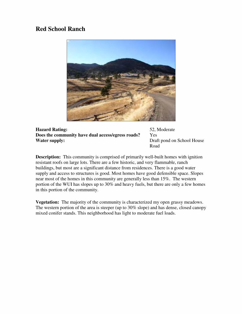
Red School Ranch
Hazard Rating: 52, Moderate
Does the community have dual access/egress roads? Yes
Water supply: Draft pond on School House
Road
Description: This community is comprised of primarily well-built homes with ignition
resistant roofs on large lots. There are a few historic, and very flammable, ranch
buildings, but most are a significant distance from residences. There is a good water
supply and access to structures is good. Most homes have good defensible space. Slopes
near most of the homes in this community are generally less than 15%. The western
portion of the WUI has slopes up to 30% and heavy fuels, but there are only a few homes
in this portion of the community.
Vegetation: The majority of the community is characterized my open grassy meadows.
The western portion of the area is steeper (up to 30% slope) and has dense, closed canopy
mixed conifer stands. This neighborhood has light to moderate fuel loads.

Red School Ranch
Recommendations:
● For all homes, make improvements within the home ignition zone to reduce
structure ignitability. This applies to homes in open meadows as well as homes
surrounded by forest.
● Reduce percentage of combustible siding and decking on homes.
● Improve or expand defensible space by limbing and/or thinning trees, mowing
seasonally, and disposing of slash.
● Enclose open areas below decks and structures to prevent embers from collecting
in ignitable areas.
● Maintain private roads in passable condition
● Thin vegetation along access roads.
● Add reflective address markers to driveways and homes.
● Complete shaded fuelbreak along Risky Road, west from School House Road.

Wildfire Risk and Hazard Severity Form NFPA 1144
Community Name: Red School Ranch Overall Rating: 52 Moderate
A. Means of Access Value Points Assigned
1. Ingress and Egress
2 or more roads in & out 0 0
One road in & out 7
2. Road Width
> 24 ft 0
≥ 20 - 24 ft 2 3
< 20 ft 4
3. All-Season Road Condition
Surfaced Road, grade <5% 0
Surfaced Road, grade >5% 2
Non-Surfaced Road, grade <5% 2 3
Non-Surfaced Road, grade >5% 5
Other than all-season 7
4. Fire Service Access
≤ 300 ft with turnaround 0
> 300 ft with turnaround 2
≤ 300 ft with no turnaround 4 3
> 300 ft with no turnaround 5
5. Street signs
Present (at least 4" and reflective) 0
Present (small or non-reflective) 3 3
Not Present 5
B. Vegetation (Fuel Models)
1. Characteristics of predominant vegetation within 300 ft
Light; 1,2,3 5 5
Medium; 5,6,7,8,9 10
Heavy; 4, 10 20
Slash; 11, 12, 13 25
2. Defensible Space (vegetation treatment from the structure)
> 100 ft 1
71 - 100 ft 3 3
31 - 70 ft 10
≤ 30 ft 25
C. Topography within 300 ft of Structures
1. Slope
< 9% 1
10 - 20% 4 5
21 - 30% 7
31 - 40% 8
> 41% 10
D. Additional Rating Factors (rate all that apply)
1. Additional factors
Topographic features adversely affect fire behavior 0 - 5 3
Areas with a history of high fire occurrence (high ignition potential) 0 - 5 3
Severe fire weather potential 0 - 5 3
Separation of adjacent structures contributing to fire spread 0 - 5 0

E. Roofing Assembly Value Points Assigned
Roofing Materials
Class A (asphalt, clay, concrete, slate, metal) 0 0
Class B (Fire-resistance rating that indicates roofing materials are able to withstand moderate exposure to fire originating from sources outside the building.) 3
Class C (Fire-resistance rating that indicates roofing materials are able to withstand light exposure to fire originating from sources outside the building.) 15
Nonrated 25
F. Building Construction
1. Materials
Noncombustible/fire-resistant siding, eaves, and deck 0 1
Noncombustible/fire-resistant siding only 5
Combustible siding and deck 10
2. Building setback from slope of ≥30%
≥ 30 ft to slope 1
< 30 ft to slope 5 3
G. Available Fire Protection
1. Water Source Availability
Pressurized hydrants
500 gpm hydrants ≤1000 ft apart 0
250 gpm hydrants ≤1000 ft apart 1
Nonpressurized water sources (off site)
≥ 250 gpm continuous for 2 hours 3 3
≤ 250 gpm continuous for 2 hours 5
Water Unavailable 10
2. Organized Response Resources
Station 5 miles or less from structure 1 1
Station >5 miles from structure 3
3. Fixed Fire Protection
NFPA 13, 13R, 13D sprinkler system 0
None 5 5
H. Placement of Gas and Electric Utilities
1. aboveground/underground
Both underground 0
One underground, one aboveground 3
Both aboveground 5 5
I. Point total for home or subdivision 52
<40 = LOW >40 = MODERATE >70 = HIGH >112 = EXTREME

Robinson Hill East
Hazard Rating: 51, Moderate
Does the community have dual access/egress roads? Yes
Water supply: Cistern at Station 1. Small
private property cisterns on
Robinson Hill Road, Camino
Perdido, and Calle Louisa.
Draft pond in meadow, south
of the end of Calle Louisa.
Description: GGFPD Station 1 is in this community. Homes are primarily newer
construction, with wood siding and ignition resistant roofs. Most homes have good
defensible spaces and visible addressing. Some homes have irrigated lawns. There are a
few homes located above steep slopes in heavier fuels off Robinson Hill Road and Calle
Louisa, but the majority of homes are on flat or gently rolling terrain. There are
numerous water sources in this community, and response time from Station 1 is short.
Vegetation: The dominant vegetation is short grass. This is a combination of short
native and agricultural grasses interspersed with irrigated lawns around homes. On north
and west facing slopes, there are isolated stands of closed-canopy mixed conifers. Fuels
reduction work has been completed on 13 acres in this community since 2006.

Robinson Hill East
Recommendations:
● For all homes, make improvements within the home ignition zone to reduce
structure ignitability. This applies to homes in open meadows as well as homes
surrounded by forest.
● Reduce percentage of combustible siding and decking on homes.
● Improve or expand defensible space by limbing and/or thinning trees, mowing
seasonally, and disposing of slash.
● Enclose open areas below decks and structures to prevent embers from collecting
in ignitable areas.
● Maintain private roads and driveways in passable condition
● Thin slopes below homes on Calle Louisa and along the steep driveways off the
eastern portion of Robinson Hill Road.
● Thin vegetation along access roads.
● Add reflective address markers to driveways and homes.
● Complete shaded fuelbreak in the northeast corner of the WUI, on the north
aspect of the drainage, south of Golden Gate Canyon Road.

Wildfire Risk and Hazard Severity Form NFPA 1144
Community Name: Robinson Hill East Overall Rating: 51 Moderate
A. Means of Access Value Points Assigned
1. Ingress and Egress
2 or more roads in & out 0 0
One road in & out 7
2. Road Width
> 24 ft 0
≥ 20 - 24 ft 2 2
< 20 ft 4
3. All-Season Road Condition
Surfaced Road, grade <5% 0
Surfaced Road, grade >5% 2
Non-Surfaced Road, grade <5% 2 3
Non-Surfaced Road, grade >5% 5
Other than all-season 7
4. Fire Service Access
≤ 300 ft with turnaround 0
> 300 ft with turnaround 2 2
≤ 300 ft with no turnaround 4
> 300 ft with no turnaround 5
5. Street signs
Present (at least 4" and reflective) 0 2
Present (small or non-reflective) 3
Not Present 5
B. Vegetation (Fuel Models)
1. Characteristics of predominant vegetation within 300 ft
Light; 1,2,3 5 5
Medium; 5,6,7,8,9 10
Heavy; 4, 10 20
Slash; 11, 12, 13 25
2. Defensible Space (vegetation treatment from the structure)
> 100 ft 1 2
71 - 100 ft 3
31 - 70 ft 10
≤ 30 ft 25
C. Topography within 300 ft of Structures
1. Slope
< 9% 1
10 - 20% 4 3
21 - 30% 7
31 - 40% 8
> 41% 10
D. Additional Rating Factors (rate all that apply)
1. Additional factors
Topographic features adversely affect fire behavior 0 - 5 2
Areas with a history of high fire occurrence (high ignition potential) 0 - 5 3
Severe fire weather potential 0 - 5 3
Separation of adjacent structures contributing to fire spread 0 - 5 0

E. Roofing Assembly Value Points Assigned
Roofing Materials
Class A (asphalt, clay, concrete, slate, metal) 0 0
Class B (Fire-resistance rating that indicates roofing materials are able to withstand moderate exposure to fire originating from sources outside the building.) 3
Class C (Fire-resistance rating that indicates roofing materials are able to withstand light exposure to fire originating from sources outside the building.) 15
Nonrated 25
F. Building Construction
1. Materials
Noncombustible/fire-resistant siding, eaves, and deck 0
Noncombustible/fire-resistant siding only 5
Combustible siding and deck 10 9
2. Building setback from slope of ≥30%
≥ 30 ft to slope 1 1
< 30 ft to slope 5
G. Available Fire Protection
1. Water Source Availability
Pressurized hydrants
500 gpm hydrants ≤1000 ft apart 0
250 gpm hydrants ≤1000 ft apart 1
Nonpressurized water sources (off site)
≥ 250 gpm continuous for 2 hours 3 3
≤ 250 gpm continuous for 2 hours 5
Water Unavailable 10
2. Organized Response Resources
Station 5 miles or less from structure 1 1
Station >5 miles from structure 3
3. Fixed Fire Protection
NFPA 13, 13R, 13D sprinkler system 0
None 5 5
H. Placement of Gas and Electric Utilities
1. aboveground/underground
Both underground 0
One underground, one aboveground 3
Both aboveground 5 5
I. Point total for home or subdivision 51
<40 = LOW >40 = MODERATE >70 = HIGH >112 = EXTREME

Robinson Hill West
Hazard Rating: 67, Moderate
Does the community have dual access/egress roads? Yes
Water supply: Cisterns on private property
Description: Homes here are built along a mainly east/west running canyon bottom with
slopes of 20% to 40% above homes. Most homes are located mid-slope. Many have long,
narrow, steep driveways with tight switchbacks. Many of the buildings in this area are
older wood siding construction, with asphalt roofs. There are historic ranch buildings in
this community. Most homes in this area have reflective addressing and street signage is
good. At Raptor Point, Robinson Hill Road becomes Road 8, which provides an escape
route into Gilpin County. This road is narrow and winding with very few turnarounds.
Vegetation: Vegetation is primarily open canopy ponderosa pine woodlands with grassy
understory, broken by grassy meadows and some isolated patches of closed-canopy
mixed conifer forest in north facing drainages. There is more insect mortality in this area
than in other GGFPD communities, which provides good opportunities for fuels
reduction.

Robinson Hill West
Recommendations:
● For all homes, make improvements within the home ignition zone to reduce
structure ignitability. This applies to homes in open meadows as well as homes
surrounded by forest.
● Reduce percentage of combustible siding and decking on homes.
● Improve or expand defensible space by limbing and/or thinning trees, mowing
seasonally, and disposing of slash.
● Enclose open areas below decks and structures to prevent embers from collecting
in ignitable areas.
● Maintain private roads in passable condition
● Thin vegetation along access roads.
● Add reflective address markers to driveways and homes.
● Widen and improve access road surfaces where possible to make all condition
access at least 20 feet wide for passenger cars, and add pullouts for emergency
apparatus.

Wildfire Risk and Hazard Severity Form NFPA 1144
Community Name: Robinson Hill West Overall Rating: 67 Moderate
A. Means of Access Value Points Assigned
1. Ingress and Egress
2 or more roads in & out 0 0
One road in & out 7
2. Road Width
> 24 ft 0
≥ 20 - 24 ft 2 3
< 20 ft 4
3. All-Season Road Condition
Surfaced Road, grade <5% 0
Surfaced Road, grade >5% 2
Non-Surfaced Road, grade <5% 2
Non-Surfaced Road, grade >5% 5 4
Other than all-season 7
4. Fire Service Access
≤ 300 ft with turnaround 0
> 300 ft with turnaround 2 3
≤ 300 ft with no turnaround 4
> 300 ft with no turnaround 5
5. Street signs
Present (at least 4" and reflective) 0
Present (small or non-reflective) 3 3
Not Present 5
B. Vegetation (Fuel Models)
1. Characteristics of predominant vegetation within 300 ft
Light; 1,2,3 5 7
Medium; 5,6,7,8,9 10
Heavy; 4, 10 20
Slash; 11, 12, 13 25
2. Defensible Space (vegetation treatment from the structure)
> 100 ft 1
71 - 100 ft 3
31 - 70 ft 10 6
≤ 30 ft 25
C. Topography within 300 ft of Structures
1. Slope
< 9% 1
10 - 20% 4
21 - 30% 7 7
31 - 40% 8
> 41% 10
D. Additional Rating Factors (rate all that apply)
1. Additional factors
Topographic features adversely affect fire behavior 0 - 5 3
Areas with a history of high fire occurrence (high ignition potential) 0 - 5 3
Severe fire weather potential 0 - 5 3
Separation of adjacent structures contributing to fire spread 0 - 5 0

E. Roofing Assembly Value Points Assigned
Roofing Materials
Class A (asphalt, clay, concrete, slate, metal) 0 0
Class B (Fire-resistance rating that indicates roofing materials are able to withstand moderate exposure to fire originating from sources outside the building.) 3
Class C (Fire-resistance rating that indicates roofing materials are able to withstand light exposure to fire originating from sources outside the building.) 15
Nonrated 25
F. Building Construction
1. Materials
Noncombustible/fire-resistant siding, eaves, and deck 0
Noncombustible/fire-resistant siding only 5
Combustible siding and deck 10 10
2. Building setback from slope of ≥30%
≥ 30 ft to slope 1 1
< 30 ft to slope 5
G. Available Fire Protection
1. Water Source Availability
Pressurized hydrants
500 gpm hydrants ≤1000 ft apart 0
250 gpm hydrants ≤1000 ft apart 1
Nonpressurized water sources (off site)
≥ 250 gpm continuous for 2 hours 3 3
≤ 250 gpm continuous for 2 hours 5
Water Unavailable 10
2. Organized Response Resources
Station 5 miles or less from structure 1 1
Station >5 miles from structure 3
3. Fixed Fire Protection
NFPA 13, 13R, 13D sprinkler system 0
None 5 5
H. Placement of Gas and Electric Utilities
1. aboveground/underground
Both underground 0
One underground, one aboveground 3
Both aboveground 5 5
I. Point total for home or subdivision 67
<40 = LOW >40 = MODERATE >70 = HIGH >112 = EXTREME

Rye Gulch
Hazard Rating: 71, High
Does the community have dual access/egress roads? No
Water supply: Cistern at Rye Gulch and
Guy Hill Roads
Description: This is a sparsely populated WUI community that lies between Horseradish
Gulch and Guy Hill. Homes are a mixture of old and new construction; some have
ignition resistant siding and some have older wood siding. Homes have ignition resistant
asphalt roofs. Roads and driveways are steep in some areas, but most are of adequate
width and in good condition. There are gasoline tanks on one property. There are
communication towers, located at 5318 Rye Gulch Road, built on the top of the ridge. A
secondary access connects Rye Gulch Road with Guy Hill Road but this is rough and
may require 4WD.
Vegetation: Vegetation is a mixture of open canopy ponderosa pine and dense, closed
canopy mixed conifer (on north and west aspects), broken by large grassy meadows.
Overall, vegetation cover is light to moderate. The terrain becomes steeper at the upper
end of the canyon and there is a greater density of woody shrubs. Five acres of
mitigation work has been completed in this community since 2006.

Rye Gulch
Recommendations:
● For all homes, make improvements within the home ignition zone to reduce
structure ignitability. This applies to homes in open meadows as well as homes
surrounded by forest.
● Reduce percentage of combustible siding and decking on homes.
● Improve or expand defensible space by limbing and/or thinning trees, mowing
seasonally, and disposing of slash.
● Enclose open areas below decks and structures to prevent embers from collecting
in ignitable areas.
● Maintain private roads in passable condition
● Thin vegetation along access roads.
● Add reflective address markers to driveways and homes.
● Move equipment from driveways and locate gasoline tanks away from structures.
● Add reflective addressing at entrance to properties and on homes.
● Improve the secondary access to Guy Hill Road.
● Complete shaded fuelbreak at the intersection of Golden Gate Canyon Road and
Rye Gulch Road; tie into open meadows.
● Maintain and expand previously completed fuels reduction work.

Wildfire Risk and Hazard Severity Form NFPA 1144
Community Name: Rye Gulch Overall Rating: 71 High
A. Means of Access Value Points Assigned
1. Ingress and Egress
2 or more roads in & out 0
One road in & out 7 7
2. Road Width
> 24 ft 0
≥ 20 - 24 ft 2 2
< 20 ft 4
3. All-Season Road Condition
Surfaced Road, grade <5% 0
Surfaced Road, grade >5% 2
Non-Surfaced Road, grade <5% 2
Non-Surfaced Road, grade >5% 5 5
Other than all-season 7
4. Fire Service Access
≤ 300 ft with turnaround 0
> 300 ft with turnaround 2 2
≤ 300 ft with no turnaround 4
> 300 ft with no turnaround 5
5. Street signs
Present (at least 4" and reflective) 0
Present (small or non-reflective) 3 4
Not Present 5
B. Vegetation (Fuel Models)
1. Characteristics of predominant vegetation within 300 ft
Light; 1,2,3 5
Medium; 5,6,7,8,9 10 6
Heavy; 4, 10 20
Slash; 11, 12, 13 25
2. Defensible Space (vegetation treatment from the structure)
> 100 ft 1
71 - 100 ft 3 3
31 - 70 ft 10
≤ 30 ft 25
C. Topography within 300 ft of Structures
1. Slope
< 9% 1
10 - 20% 4
21 - 30% 7 6
31 - 40% 8
> 41% 10
D. Additional Rating Factors (rate all that apply)
1. Additional factors
Topographic features adversely affect fire behavior 0 - 5 3
Areas with a history of high fire occurrence (high ignition potential) 0 - 5 3
Severe fire weather potential 0 - 5 3
Separation of adjacent structures contributing to fire spread 0 - 5 0
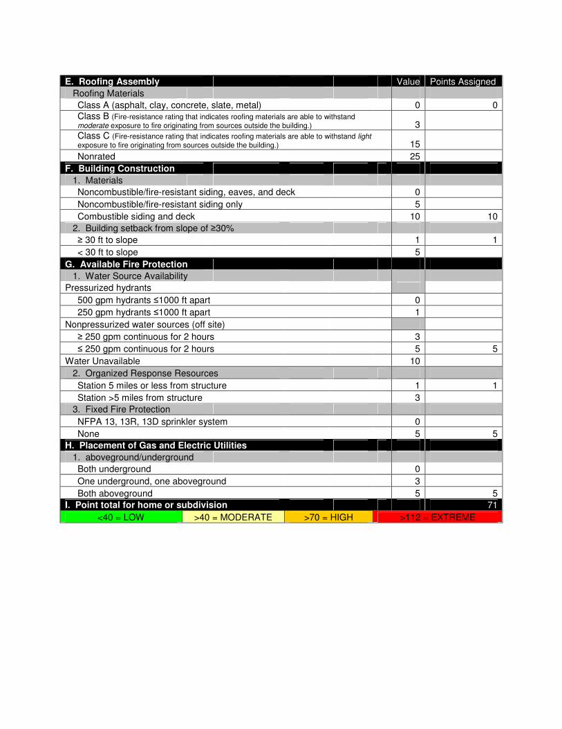
E. Roofing Assembly Value Points Assigned
Roofing Materials
Class A (asphalt, clay, concrete, slate, metal) 0 0
Class B (Fire-resistance rating that indicates roofing materials are able to withstand moderate exposure to fire originating from sources outside the building.) 3
Class C (Fire-resistance rating that indicates roofing materials are able to withstand light exposure to fire originating from sources outside the building.) 15
Nonrated 25
F. Building Construction
1. Materials
Noncombustible/fire-resistant siding, eaves, and deck 0
Noncombustible/fire-resistant siding only 5
Combustible siding and deck 10 10
2. Building setback from slope of ≥30%
≥ 30 ft to slope 1 1
< 30 ft to slope 5
G. Available Fire Protection
1. Water Source Availability
Pressurized hydrants
500 gpm hydrants ≤1000 ft apart 0
250 gpm hydrants ≤1000 ft apart 1
Nonpressurized water sources (off site)
≥ 250 gpm continuous for 2 hours 3
≤ 250 gpm continuous for 2 hours 5 5
Water Unavailable 10
2. Organized Response Resources
Station 5 miles or less from structure 1 1
Station >5 miles from structure 3
3. Fixed Fire Protection
NFPA 13, 13R, 13D sprinkler system 0
None 5 5
H. Placement of Gas and Electric Utilities
1. aboveground/underground
Both underground 0
One underground, one aboveground 3
Both aboveground 5 5
I. Point total for home or subdivision 71
<40 = LOW >40 = MODERATE >70 = HIGH >112 = EXTREME

The Grange
Hazard Rating: 81, High
Does the community have dual access/egress roads? No
Water supply: Cisterns on private property,
off Golden Gate Canyon
Road
Description: This neighborhood has steep roads with few turnarounds. The primary
access road has a 15% grade and there are driveways in this area that go up 25% slopes.
The primary access is of sufficient width but there are no turnarounds until the road
reaches the plateau. Address markers are missing or inadequate for most homes. The
Grange building has served as the community center for the entire district for several
decades, and should be considered a value at risk. Most homes need extended defensible
spaces, especially considering the steep slopes in this community.
Vegetation: Vegetation is a mixture of open canopy ponderosa pine and dense, closed
canopy mixed conifer (on north and west aspects), broken by large grassy meadows.
Overall, vegetation cover is moderate to heavy. Three acres of mitigation work has been
completed in this community since 2006.

The Grange
Recommendations:
● For all homes, make improvements within the home ignition zone to reduce
structure ignitability. This applies to homes in open meadows as well as homes
surrounded by forest.
● Reduce percentage of combustible siding and decking on homes.
● Improve or expand defensible space by limbing and/or thinning trees, mowing
seasonally, and disposing of slash.
● Enclose open areas below decks and structures to prevent embers from collecting
in ignitable areas.
● Maintain private roads in passable condition
● Thin vegetation along access roads and private driveways. Extend roadside
thinning to open meadows in the eastern portion of the WUI.
● Add reflective address markers to driveways and homes.

Wildfire Risk and Hazard Severity Form NFPA 1144
Community Name: The Grange Overall Rating: 81 High
A. Means of Access Value Points Assigned
1. Ingress and Egress
2 or more roads in & out 0
One road in & out 7 7
2. Road Width
> 24 ft 0
≥ 20 - 24 ft 2
< 20 ft 4 4
3. All-Season Road Condition
Surfaced Road, grade <5% 0
Surfaced Road, grade >5% 2
Non-Surfaced Road, grade <5% 2
Non-Surfaced Road, grade >5% 5 5
Other than all-season 7
4. Fire Service Access
≤ 300 ft with turnaround 0
> 300 ft with turnaround 2 2
≤ 300 ft with no turnaround 4
> 300 ft with no turnaround 5
5. Street signs
Present (at least 4" and reflective) 0
Present (small or non-reflective) 3 3
Not Present 5
B. Vegetation (Fuel Models)
1. Characteristics of predominant vegetation within 300 ft
Light; 1,2,3 5
Medium; 5,6,7,8,9 10 7
Heavy; 4, 10 20
Slash; 11, 12, 13 25
2. Defensible Space (vegetation treatment from the structure)
> 100 ft 1
71 - 100 ft 3
31 - 70 ft 10 10
≤ 30 ft 25
C. Topography within 300 ft of Structures
1. Slope
< 9% 1
10 - 20% 4
21 - 30% 7
31 - 40% 8 8
> 41% 10
D. Additional Rating Factors (rate all that apply)
1. Additional factors
Topographic features adversely affect fire behavior 0 - 5 4
Areas with a history of high fire occurrence (high ignition potential) 0 - 5 3
Severe fire weather potential 0 - 5 3
Separation of adjacent structures contributing to fire spread 0 - 5 0

E. Roofing Assembly Value Points Assigned
Roofing Materials
Class A (asphalt, clay, concrete, slate, metal) 0 0
Class B (Fire-resistance rating that indicates roofing materials are able to withstand moderate exposure to fire originating from sources outside the building.) 3
Class C (Fire-resistance rating that indicates roofing materials are able to withstand light exposure to fire originating from sources outside the building.) 15
Nonrated 25
F. Building Construction
1. Materials
Noncombustible/fire-resistant siding, eaves, and deck 0
Noncombustible/fire-resistant siding only 5
Combustible siding and deck 10 10
2. Building setback from slope of ≥30%
≥ 30 ft to slope 1 1
< 30 ft to slope 5
G. Available Fire Protection
1. Water Source Availability
Pressurized hydrants
500 gpm hydrants ≤1000 ft apart 0
250 gpm hydrants ≤1000 ft apart 1
Nonpressurized water sources (off site)
≥ 250 gpm continuous for 2 hours 3 3
≤ 250 gpm continuous for 2 hours 5
Water Unavailable 10
2. Organized Response Resources
Station 5 miles or less from structure 1 1
Station >5 miles from structure 3
3. Fixed Fire Protection
NFPA 13, 13R, 13D sprinkler system 0
None 5 5
H. Placement of Gas and Electric Utilities
1. aboveground/underground
Both underground 0
One underground, one aboveground 3
Both aboveground 5 5
I. Point total for home or subdivision 81
<40 = LOW >40 = MODERATE >70 = HIGH >112 = EXTREME

Thea Gulch
Hazard Rating: 71, High
Does the community have dual access/egress roads? Yes
Water supply: Draft pond in drainage
between Thea Gulch Road
and Crawford Gulch Road
spur.
Description: Homes in this community are widely spaced on large lots, mostly at the
end of long private driveways with locked gates. Construction materials are a mixture of
new, fire-resistant siding and roofing, and older, conventional wood siding. Most homes
in this community are built on ridge tops or on the upper 1/3 of the slopes above both
sides of the bottom of the gulch. In the western part of the community homes become
more spread out along very long driveways with few turnouts. This area can be escaped
to the west by using private ranch roads. Overall, topography is gently rolling to
moderate, with slopes less than 25% on average. There is only one confirmed water
source, which is a stock pond in the large meadow between the two main access roads.
Homes need defensible space and mowing. Extended defensible spaces, especially for
homes on the north side of the canyon, are recommended.
Vegetation: Vegetation is a mixture of open canopy ponderosa pine and large grassy
meadows. On north and west aspects, there are some isolated patches of dense mixed
conifer. Riparian trees and shrubs occur in stringers and patches along the Thea Gulch
drainage, however they are unlikely to make a significant contribution to the overall fire
behavior of this area. Overall, vegetation cover is light to moderate.
Thea Gulch
Recommendations:
● For all homes, make improvements within the home ignition zone to reduce
structure ignitability. This applies to homes in open meadows as well as homes
surrounded by forest.
● Reduce percentage of combustible siding and decking on homes.
● Improve or expand defensible space by limbing and/or thinning trees, mowing
seasonally, and disposing of slash.
● Enclose open areas below decks and structures to prevent embers from collecting
in ignitable areas.
● Maintain private roads and driveways in passable condition.
● Thin vegetation along access roads.
● Add reflective address markers to driveways and homes.
● Install dry hydrant in draft pond.
● Clear and maintain private road loop at the end of The Gulch Road to provide
additional emergency egress route to spur of Crawford Gulch Road.

Wildfire Risk and Hazard Severity Form NFPA 1144
Community Name: Thea Gulch Overall Rating: 71 High
A. Means of Access Value Points Assigned
1. Ingress and Egress
2 or more roads in & out 0
One road in & out 7 4
2. Road Width
> 24 ft 0
≥ 20 - 24 ft 2
< 20 ft 4 4
3. All-Season Road Condition
Surfaced Road, grade <5% 0
Surfaced Road, grade >5% 2
Non-Surfaced Road, grade <5% 2
Non-Surfaced Road, grade >5% 5 5
Other than all-season 7
4. Fire Service Access
≤ 300 ft with turnaround 0
> 300 ft with turnaround 2
≤ 300 ft with no turnaround 4
> 300 ft with no turnaround 5 5
5. Street signs
Present (at least 4" and reflective) 0 0
Present (small or non-reflective) 3
Not Present 5
B. Vegetation (Fuel Models)
1. Characteristics of predominant vegetation within 300 ft
Light; 1,2,3 5 7
Medium; 5,6,7,8,9 10
Heavy; 4, 10 20
Slash; 11, 12, 13 25
2. Defensible Space (vegetation treatment from the structure)
> 100 ft 1
71 - 100 ft 3
31 - 70 ft 10 7
≤ 30 ft 25
C. Topography within 300 ft of Structures
1. Slope
< 9% 1
10 - 20% 4
21 - 30% 7 7
31 - 40% 8
> 41% 10
D. Additional Rating Factors (rate all that apply)
1. Additional factors
Topographic features adversely affect fire behavior 0 - 5 3
Areas with a history of high fire occurrence (high ignition potential) 0 - 5 3
Severe fire weather potential 0 - 5 3
Separation of adjacent structures contributing to fire spread 0 - 5 0

E. Roofing Assembly Value Points Assigned
Roofing Materials
Class A (asphalt, clay, concrete, slate, metal) 0 1
Class B (Fire-resistance rating that indicates roofing materials are able to withstand moderate exposure to fire originating from sources outside the building.) 3
Class C (Fire-resistance rating that indicates roofing materials are able to withstand light exposure to fire originating from sources outside the building.) 15
Nonrated 25
F. Building Construction
1. Materials
Noncombustible/fire-resistant siding, eaves, and deck 0
Noncombustible/fire-resistant siding only 5
Combustible siding and deck 10 7
2. Building setback from slope of ≥30%
≥ 30 ft to slope 1 1
< 30 ft to slope 5
G. Available Fire Protection
1. Water Source Availability
Pressurized hydrants
500 gpm hydrants ≤1000 ft apart 0
250 gpm hydrants ≤1000 ft apart 1
Nonpressurized water sources (off site)
≥ 250 gpm continuous for 2 hours 3 3
≤ 250 gpm continuous for 2 hours 5
Water Unavailable 10
2. Organized Response Resources
Station 5 miles or less from structure 1 1
Station >5 miles from structure 3
3. Fixed Fire Protection
NFPA 13, 13R, 13D sprinkler system 0
None 5 5
H. Placement of Gas and Electric Utilities
1. aboveground/underground
Both underground 0
One underground, one aboveground 3
Both aboveground 5 5
I. Point total for home or subdivision 71
<40 = LOW >40 = MODERATE >70 = HIGH >112 = EXTREME

Window Rock
Hazard Rating: 67, Moderate
Does the community have dual access/egress roads? No
Water supply: 30,000 gallon cistern at
Belcher Hill Rd and
Abundance Way
Description: This is a small community of luxury homes located at the top of a ridge.
There is no reflective address signage in this community. Homes are new construction,
with fire resistant siding and roofing materials. Roads are paved and in good condition,
but turnarounds that are adequate for fire apparatus are scarce. There is only one way in
and out of this gated community. There is a 30,000 gallon cistern at the entrance to this
community. Most properties have address numbers, but most would be difficult to spot
in dark or smoky conditions. Slopes below properties, and in the southern portion of the
community slopes are steep, which could contribute to increased fire behavior, but the
majority of homes are built along Abundance Way, which follows a relatively flat ridge
top.
Vegetation: Vegetation is primarily open-canopy ponderosa pine and Rocky Mountain
juniper with grass and shrub understory. On north-facing slopes and in steep draws,
vegetation is denser, and has a higher percentage of Douglas-fir. This area has had some
mitigation, which has opened the understory and forest canopy, and significantly reduced
ladder fuels.
Window Rock
Recommendations:
● For all homes, make improvements within the home ignition zone to reduce
structure ignitability. This applies to homes in open meadows as well as homes
surrounded by forest.
● Reduce percentage of combustible siding and decking on homes.
● Improve or expand defensible space by limbing and/or thinning trees, mowing
seasonally, and disposing of slash.
● Enclose open areas below decks and structures to prevent embers from collecting
in ignitable areas.
● Maintain private roads in passable condition
● Thin vegetation along access roads.
● Add reflective address markers to driveways and homes.
● Maintain areas that have been previously mitigated to control tree regeneration,
especially along roadsides and within defensible space of structures.
● Connect end of Summer Star Lane with private road in Middle Crawford Gulch
WUI to create secondary egress route for both communities.

Wildfire Risk and Hazard Severity Form NFPA 1144
Community Name: Window Rock Overall Rating: 67 Moderate
A. Means of Access Value Points Assigned
1. Ingress and Egress
2 or more roads in & out 0
One road in & out 7 7
2. Road Width
> 24 ft 0
≥ 20 - 24 ft 2 3
< 20 ft 4
3. All-Season Road Condition
Surfaced Road, grade <5% 0
Surfaced Road, grade >5% 2
Non-Surfaced Road, grade <5% 2
Non-Surfaced Road, grade >5% 5 4
Other than all-season 7
4. Fire Service Access
≤ 300 ft with turnaround 0
> 300 ft with turnaround 2
≤ 300 ft with no turnaround 4 3
> 300 ft with no turnaround 5
5. Street signs
Present (at least 4" and reflective) 0
Present (small or non-reflective) 3 3
Not Present 5
B. Vegetation (Fuel Models)
1. Characteristics of predominant vegetation within 300 ft
Light; 1,2,3 5 5
Medium; 5,6,7,8,9 10
Heavy; 4, 10 20
Slash; 11, 12, 13 25
2. Defensible Space (vegetation treatment from the structure)
> 100 ft 1
71 - 100 ft 3 3
31 - 70 ft 10
≤ 30 ft 25
C. Topography within 300 ft of Structures
1. Slope
< 9% 1
10 - 20% 4
21 - 30% 7 7
31 - 40% 8
> 41% 10
D. Additional Rating Factors (rate all that apply)
1. Additional factors
Topographic features adversely affect fire behavior 0 - 5 3
Areas with a history of high fire occurrence (high ignition potential) 0 - 5 3
Severe fire weather potential 0 - 5 3
Separation of adjacent structures contributing to fire spread 0 - 5 0

E. Roofing Assembly Value Points Assigned
Roofing Materials
Class A (asphalt, clay, concrete, slate, metal) 0 0
Class B (Fire-resistance rating that indicates roofing materials are able to withstand moderate exposure to fire originating from sources outside the building.) 3
Class C (Fire-resistance rating that indicates roofing materials are able to withstand light exposure to fire originating from sources outside the building.) 15
Nonrated 25
F. Building Construction
1. Materials
Noncombustible/fire-resistant siding, eaves, and deck 0
Noncombustible/fire-resistant siding only 5
Combustible siding and deck 10 8
2. Building setback from slope of ≥30%
≥ 30 ft to slope 1 1
< 30 ft to slope 5
G. Available Fire Protection
1. Water Source Availability
Pressurized hydrants
500 gpm hydrants ≤1000 ft apart 0
250 gpm hydrants ≤1000 ft apart 1
Nonpressurized water sources (off site)
≥ 250 gpm continuous for 2 hours 3 3
≤ 250 gpm continuous for 2 hours 5
Water Unavailable 10
2. Organized Response Resources
Station 5 miles or less from structure 1 1
Station >5 miles from structure 3
3. Fixed Fire Protection
NFPA 13, 13R, 13D sprinkler system 0
None 5 5
H. Placement of Gas and Electric Utilities
1. aboveground/underground
Both underground 0
One underground, one aboveground 3
Both aboveground 5 5
I. Point total for home or subdivision 67
<40 = LOW >40 = MODERATE >70 = HIGH >112 = EXTREME

APPENDIX D
Jefferson County Community Wildfire Protection Plan Survey 2011
In accordance with Colorado Senate Bill 09-001, Jefferson County Division of Emergency Management, in partnership with Jefferson Conservation District, is preparing a County-Wide Community Wildfire Protection Plan. This includes assessing the risk of wildfire in your community and identifying actions to reduce the risk. Your input on this very important topic is needed to create an effective plan. You can help by providing the following information by June 30, 2011:
1. What community/town do you live in or closest to? __________________________________________________ 2. Is your community currently part of an existing CWPP?
� No � I don’t know � Yes _____________________________________________
3. How great of a risk do you think wildfire poses to your community? �Extreme Risk �High Risk �Moderate Risk �Low Risk �No Risk
4. Do you think any areas in Jefferson County are an extreme fire hazard? � No. � Yes, this (these) area(s): ________________________________________________________ 5. How likely are you to leave your home if it is imminently threatened by fire? �Will not leave �More likely to stay �More likely to evacuate �Will evacuate
6. Do you think your community is currently prepared for a wildfire? � No � Yes � I don’t know 7. What types of areas in your community do you think pose a fire risk to homes or property? �Forests �Meadows and Grasses �Shrubs and Bushes
8. What do you think are the best ways to mitigate or reduce wildfire risks? (Choose all that apply.)
� Reduce vegetation (grasses, trees, etc.) on public land by controlled burns. � Reduce vegetation (grasses, trees, etc.) on public land by mechanical treatments � Develop shaded fuel breaks along roads and strategic locations. � Increase firefighting equipment (more trucks, water tenders, etc.) � Increase number of fire department volunteers. � Increase water availability. � Encourage private landowners to develop defensible spaces around structures.
� Conduct community outreach and education programs. � Other______________________________________________________________________________

9. Have actions been taken to reduce the risk of wildfire in your community? (Choose all that apply)
� Not that I am aware of. � Individual homeowners working on defensible space � Community work days to reduce hazardous fuels � Community slash collection days
� Shaded fuelbreaks created on private property in the community � Shaded fuelbreaks created on public lands adjacent to the community
� Other______________________________________________________________________________
10. Have fire education programs occurred in your community? (Choose all that apply) � Not that I am aware of. � Firewise Community outreach � Colorado State Forest Service programs � Local Fire Department programs � Other______________________________________________________________________________
11. How supportive are you of fuel mitigation projects taking place in your community? � Strongly supportive � Somewhat supportive � Neither supportive nor opposed � Somewhat opposed � Strongly opposed
12. Use this space to provide any additional comments or feedback (optional):
Please contact the Jefferson County Emergency Management Community Wildfire Protection Forester if you wish to
receive more information about this CWPP and/or fuels mitigation projects:
Robin Keith, Community Wildfire Protection Forester
303-271-4926

Responses to the Jefferson County CWPP Survey by Golden Gate FPD Residents
0
1
2
3
4
5
6
Yes No I don't know
Is your community currently part of an existing CWPP?
0
1
2
3
4
5
6
Extreme
risk
High Risk Moderate
Risk
Low Risk No Risk
How great a risk do you think wildfire poses to your community?

0
2
4
6
8
10
12
Yes No
Do you think any areas in your fire protection district are an
extreme fire hazard?
0
1
2
3
4
5
6
Will not leave More likely to
stay
More likely to
evacuate
Will evacuate
How likely are you to leave your home if it is imminently
threatened by f ire?
0
1
2
3
4
5
6
Yes No I don't know
Do you think your community is prepared for a w ildfire?

What types of landscapes in your community do you think pose a fire risk
to homes or property?
Forests
Meadows and grasses
Shrubs and bushes
What do you think are the best ways to mitigate or reduce wildfire risks?
Choose all that apply.
0
2
4
6
8
10
12
14
Cont
rolle
d bu
rns on
pub
lic la
nd
Mec
hanica
l tre
atment
s on
pub
lic la
nd
Thin
fore
st alo
ng ro
ads
Incr
ease
fire
fightin
g equ
ipm
ent
Incr
ease
fire
fightin
g volun
teers
Incr
ease
wat
er a
vaila
bility
Cle
aring
defensi
ble
spac
es o
n pr
ivat
e land
Com
muni
ty o
utre
ach
and
educ
ation
Oth
er

What actions have been taken to reduce the risk of wildfire in your community?
Choose all that apply.
0
1
2
3
4
5
6
7
8
9
10In
dividua
l hom
eow
ners
cre
atin
g de
fens
ible
spa
ce
Com
muni
ty w
ork
days
Com
muni
ty s
lash
col
lect
ion d
ays
Sha
ded
fuelb
reaks
on
priv
ate
pro
perty
Sha
ded
fuelb
reaks
on
pub
lic la
nds
None
that
I am
aw
are
of
Oth
er
What fire education programs have occurred in your community? Choose all that apply.
0
1
2
3
4
5
6
7
8
9
10
"Fire
wis
e" c
omm
unity
out
reac
h
Col
orad
o Sta
te F
ores
t Ser
vice
pro
gram
s
Loca
l fire
dep
artm
ent p
rogr
ams
Non
e th
at I
am a
war
e of
.
Oth
er
How supportive are you of fuel mitigation projects taking place in your community?
0
1
2
3
4
5
6
7
8
9
Strongly
supportive
Somewhat
supportive
Neither
support nor
oppose
Somewhat
opposed
Strongly
opposed

Fuelbreak Guidelines for Forested Subdivisions & Communities
By
Frank C. Dennis
Knowledge to Go Places

This publication was developed for use by foresters, planners, developers, homeowners’ associations and others. Implementation of these measures cannot guarantee safety from all wildfires, but will greatly increase the probability of containing them at more manageable levels.
Colorado’s forested lands are experiencing severe impacts from continuing population increases and peoples’ desire to escape urban pressures. Subdivisions and developments are opening new areas for homesite construction at an alarming rate, especially along the Front Range and around recreational areas such as Dillon, Vail, and Steamboat Springs.
But with development inevitably comes a higher risk of wildfire as well as an ever-increasing potential for loss of life and property. Methods of fire suppression, pre-suppression needs, and homeowner and fire crew safety must all be considered in the planning and review of new developments as well as for the “retrofi�ing” of existing, older subdivisions.
Fuelbreaks should be considered in fire management planning for subdivisions and developments; however, the following are guidelines only. They should be customized to local areas by professional foresters experienced in Rocky Mountain wildfire behavior and suppression tactics.
Fuelbreak vs FirebreakAlthough the term fuelbreak is widely used in Colorado, it is o�en confused with firebreak. The two are entirely separate, and aesthetically different, forms of forest fuel modification and treatment.
• A firebreak is strip of land, 20 to 30 feet wide (or more), in which all vegetation is removed down to bare, mineral soil each year prior to fire season.
• A fuelbreak (or shaded fuelbreak) is an easily accessible strip of land of varying width (depending on fuel and terrain), in which fuel density is reduced, thus improving fire control opportunities. The stand is thinned, and remaining trees are pruned to remove ladder fuels. Brush, heavy ground fuels, snags, and dead trees are disposed of and an open, park-like appearance is established.
The following is a discussion of the uses, limitations, and specifications of fuelbreaks in wildfire control and fuels management.
Fuelbreak LimitationsFuelbreaks provide quick access for wildfire suppression. Control activities can be conducted more safely due to low fuel volumes. Strategically located, they break up large, continuous tracts of dense timber, thus limiting uncontrolled spread of wildfire.
Fuelbreaks can aid firefighters greatly by slowing fire spread under normal burning conditions. However, under extreme conditions, even the best fuelbreaks stand li�le chance of arresting a large
Inadequate fire planning can result in loss of life or property and costly suppression activities.
Above, cross section of mixed conifer stand before fuelbreak modification. Below, a�er modification.
2

fire, regardless of firefighting efforts. Such fires, in a phenomenon called “spo�ing,” can drop firebrands 1/8-mile or more ahead of the main fire, causing very rapid fire spread. These types of large fires may continue until there is a major change in weather conditions, topography, or fuel type.
It is critical to understand: A fuelbreak is the line of defense. The area (including any homes and developments) between it and the fire may remain vulnerable.
In spite of these somewhat gloomy limitations, fuelbreaks have proven themselves effective in Colorado. During the 1980 Crystal Lakes Subdivision Fire near Fort Collins, crown fires were stopped in areas with fuelbreak thinnings, while other areas of dense lodgepole pine burned completely. A fire at O’Fallon Park in Jefferson County was successfully stopped and controlled at a fuelbreak. The Buffalo Creek Fire in Jefferson County (1996) and the High Meadow Fire in Park and Jefferson Counties (2000) slowed dramatically wherever intense forest thinnings had been completed. During the 2002 Hayman Fire, Denver Water’s entire complex of offices, shops and caretakers’ homes at Cheesman Reservoir were saved by a fuelbreak with no firefighting intervention by a fuelbreak.
The Need For A FuelbreakSeveral factors determine the need for fuelbreaks in forested subdivisions, including: (1) potential problem indicators; (2) wildfire hazard areas; (3) slope; (4) topography; (5) crowning potential; and (6) ignition sources.
Potential Problem IndicatorThe table below explains potential problem indicators for various hazards and characteristics common to Colorado’s forest types. All major forest types, except aspen, indicate a high potential for wildfire hazard.
Before and a�er photos of a forest stand thinned to reduce fuel loads.
Burned area near Cheesman Reservoir as a result of the Hayman Fire. Note the unburned green trees in the middle right of the photo, a treated fuelbreak.
3
Fuel Type Characteristics Hazards
Aspen 2 3 3 2 4 3 2Douglas-fir 2 2 3 5 2 2 3Greasewood-Saltbrush 4 2 2 2 1 3 3Limber-Bristlecone Pine 3 2 4 3 4 2 5Lodgepole Pine 2 2 3 5 4 2 4Meadow 5 4 4 2 3 4 3Mixed Conifer 2 1 1 5 3 1 3Mountain Grassland 5 3 4 3 3 2 4Mountain Shrub 3 5 4 4 2 2 3Piñon-Juniper 2 3 4 4 2 3 2Ponderosa Pine 2 3 1 5 2 2 3Sagebrush 4 4 3 3 3 2 3Spruce-Fir 2 3 3 4 5 3 4
Legend: 5 – Problem may be crucial; 4 – Problem very likely; 3 – Exercise caution; 2 – Problem usually limited; 1 – No rating possible
Aesthe
tics
Wildlife
Soil Wild
fire
Avalan
che
Flood
Climate

Fire effects, flat vs steep terrain. Note preheating of fuels on steep ground from passage of smoke column.
Chimney.
Saddle.
Flashover in V-shaped valley.4
Wildfire Hazard MapsThe Colorado State Forest Service (CSFS), numerous counties and some National Forests have completed wildfire hazard mapping for many areas within Colorado, particularly along the Front Range. These maps typically consider areas with 30 percent or greater slope; hazardous fuel types; and hazardous topographic features such as fire chimneys. Wildfire Hazard Ratings may be depicted in several ways. Whatever system is used, areas rated moderate or higher should be considered for fuel modification work.
SlopeRate of fire spread increases as the slope of the land increases. Fuels are preheated by the rising smoke column or they may even come into contact with the flames themselves.
At 30 percent slope, rate of fire spread doubles compared to rates at level ground, drastically reducing firefighting effectiveness. Areas near 30 percent or greater slopes are critical and must be reviewed carefully.
TopographyCertain topographic features influence fire spread and should be evaluated. Included are fire chimneys, saddles, and V-shaped canyons. They are usually recognized by reviewing standard U.S.G.S. quad maps.
• Chimneys are densely vegetated drainages on slopes greater than 30 percent. Wind, as well as air pre-heated by a fire, tends to funnel up these drainages, rapidly spreading fire upslope.
• Saddles are low points along a main ridge or between two high points. Like chimneys, they also funnel winds to create a natural fire path during a fire’s uphill run. Saddles act as corridors to spread fire into adjacent valleys or drainages.
• Narrow, V-shaped valleys or canyons can ignite easily due to heat radiating from one side to the other. For example, a fire burning on one side of a narrow valley dries and preheats fuels on the opposite side until the fire “flashes over.” The natural effect of slope on fire then takes over and fire spreads rapidly up drainage and uphill along both sides of the valley.
5
Crowning PotentialAn on-site visit is required to accurately assess crowning potential. A key, below, helps determine this rating. Fuel modification is usually unnecessary if an area has a rating of 3 or less.
Crowning Potential Key RatingA. Foliage present, trees living or dead — B B. Foliage living — C C. Leaves deciduous or, if evergreen, usually so�, pliant, and moist; never oily, waxy, or resinous. 0 CC. Leaves evergreen, not as above — D D. Foliage resinous, waxy, or oily — E E. Foliage dense — F F. Ladder fuels plentiful — G G. Crown closure > 75 percent 9 GG. Crown closure < 75 percent 7 FF. Ladder fuels sparse or absent — H H. Crown closure > 75 percent 7 HH. Crown closure < 75 percent 5 EE. Foliage open — I I. Ladder fuel plentiful 4 II. Ladder fuel sparse or absent 2 DD. Foliage not resinous, waxy, or oily — J J. Foliage dense — K K. Ladder fuels plentiful — L L. Crown closure > 75 percent 7 LL. Crown closure < 75 percent 4 KK. Ladder fuels sparse or absent — M M. Crown closure > 75 percent 5 MM. Crown closure < 75 percent 3 JJ. Foliage open — N N. Ladder fuels plentiful 3 NN. Ladder fuels sparse or absent 1 BB. Foliage dead 0
The majority of dead trees within the fuelbreak should be removed. Occasionally, large, dead trees (14 inches or larger in diameter at 4 1/2 feet above ground level) may be retained as wildlife trees. If retained, all ladder fuels must be cleared from around the tree’s trunk.
Ignition SourcesPossible ignition sources, which may threaten planned or existing developments, must be investigated thoroughly. Included are other developments and homes, major roads, recreation sites, railroads, and other possible sources. These might be distant from the proposed development,
yet still able to channel fire into the area due to slope, continuous fuels, or other topographic features.
Fuelbreak LocationsIn fire suppression, an effective fire line is connected, or “anchored,” to natural or artificial fire barriers. Such anchor points might be rivers, creeks, large rock outcrops, wet meadows, or a less flammable timber type such as aspen. Similarly, properly designed and constructed fuelbreaks take advantage of these same barriers to eliminate “fuel bridges.” (Fire o�en escapes control because of fuel bridges that carry the fire across control lines.)
Since fuelbreaks should normally provide quick, safer access to defensive positions, they are necessarily linked with road systems. Connected with county-specified roads within subdivisions, they provide good access and defensive positions for firefighting equipment and support vehicles. Cut-and fill slopes of roads are an integral part of a fuelbreak as they add to the effective width of modified fuels.
Fuelbreaks without an associated road system, such as those located along strategic ridge lines, are still useful in fire suppression. Here, they are o�en strengthened and held using aerial retardant drops until fire crews can walk in or be ferried in by helicopter.
Preferably, fuelbreaks are located along ridge tops to help arrest fires at the end of their runs. However, due to homesite locations and resource values, they can also be effective when established at the base of slopes. Mid-slope fuelbreaks are least desirable, but under certain circumstances and with modifications, these too, may be valuable.
Fuelbreaks are located so that the area under management is broken into small, manageable units. Thus, when a wildfire reaches modified fuels, defensive action is more easily taken, helping to keep the fire small. For example, a plan for a subdivision might recommend that fuelbreaks break up continuous forest fuels into units of 10 acres or less. This is an excellent plan, especially if defensible space thinnings are completed around homes and structures, and thinning for forest management and forest health are combined with the fuelbreak.
When located along ridge tops, continuous length as well as width are critical elements. Extensive long-range planning is essential in positioning these types of fuelbreaks.

AestheticsImproperly planned fuelbreaks can adversely impact an area’s aesthetic qualities. Careful construction is necessary when combining mid-slope fuelbreaks with roads involving excessive cut-and-fill.
Care must also be taken in areas that are not thinned throughout for fuel hazard reduction. In such cases the fuelbreak visually sticks out like a “sore thumb” due to contrasting thinned and unthinned portions of the forest. (Especially noticeable are those portions of the fuelbreak above road cuts).
These guidelines are designed to minimize aesthetic impacts. However, some situations may require extensive thinning and, thus, result in a major visual change to an area. Additional thinning beyond the fuelbreak may be necessary to create an irregular edge and to “feather,” or blend, the fuelbreak thinning into the unthinned portions of the forest. Any thinning beyond the fuelbreak improves its effectiveness and is highly recommended.
Constructing the FuelbreakFuelbreak Width and Slope AdjustmentsNote: Since road systems are so important to fuelbreak construction, the following measurements are from the toe of the fill for downslope distances, and above the edge of the cut for uphill distances.
The minimum recommended fuelbreak width is approximately 300 feet for level ground. Since fire activity intensifies as slope increases, the overall fuelbreak width must also increase. However, to minimize aesthetic impacts and to maximize fire crew safety, the majority of the increases should be made at the bo�om of the fuelbreak, below the road cut.
Widths are also increased when severe topographic conditions are encountered. Guidelines for fuelbreak widths on slopes are given below:
Fuelbreak Width/SlopePercent Minimum Minimum Total Width of Slope Uphill Downhill Modified fuels (%) Distance (�) Distance (�) (�)*
0 150 150 300 10 140 165 303 20 130 180 310 30 120 195 315 40 110 210 320 50 100 225 325 60 100 240 340*As slope increases, total distance for cut-and-fill for road construction rapidly increases, improving fuelbreak effective width.
These photos, far- and near- views of the same site, illustrate that forest can be thinned without impacting aesthetics.
road
fuelbreak
6
Cross-section of a typical fuelbreak built in conjunction with a road.
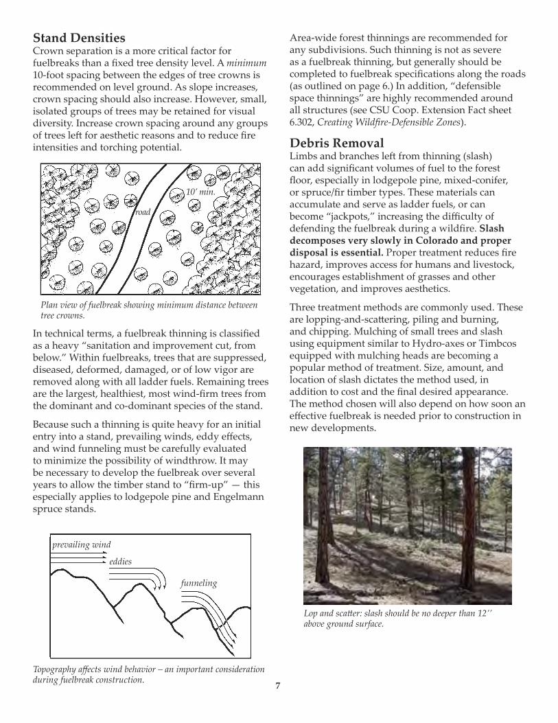
Stand Densities Crown separation is a more critical factor for fuelbreaks than a fixed tree density level. A minimum 10-foot spacing between the edges of tree crowns is recommended on level ground. As slope increases, crown spacing should also increase. However, small, isolated groups of trees may be retained for visual diversity. Increase crown spacing around any groups of trees le� for aesthetic reasons and to reduce fire intensities and torching potential.
In technical terms, a fuelbreak thinning is classified as a heavy “sanitation and improvement cut, from below.” Within fuelbreaks, trees that are suppressed, diseased, deformed, damaged, or of low vigor are removed along with all ladder fuels. Remaining trees are the largest, healthiest, most wind-firm trees from the dominant and co-dominant species of the stand.
Because such a thinning is quite heavy for an initial entry into a stand, prevailing winds, eddy effects, and wind funneling must be carefully evaluated to minimize the possibility of windthrow. It may be necessary to develop the fuelbreak over several years to allow the timber stand to “firm-up” — this especially applies to lodgepole pine and Engelmann spruce stands.
Area-wide forest thinnings are recommended for any subdivisions. Such thinning is not as severe as a fuelbreak thinning, but generally should be completed to fuelbreak specifications along the roads (as outlined on page 6.) In addition, “defensible space thinnings” are highly recommended around all structures (see CSU Coop. Extension Fact sheet 6.302, Creating Wildfire-Defensible Zones).
Debris RemovalLimbs and branches le� from thinning (slash) can add significant volumes of fuel to the forest floor, especially in lodgepole pine, mixed-conifer, or spruce/fir timber types. These materials can accumulate and serve as ladder fuels, or can become “jackpots,” increasing the difficulty of defending the fuelbreak during a wildfire. Slash decomposes very slowly in Colorado and proper disposal is essential. Proper treatment reduces fire hazard, improves access for humans and livestock, encourages establishment of grasses and other vegetation, and improves aesthetics.
Three treatment methods are commonly used. These are lopping-and-sca�ering, piling and burning, and chipping. Mulching of small trees and slash using equipment similar to Hydro-axes or Timbcos equipped with mulching heads are becoming a popular method of treatment. Size, amount, and location of slash dictates the method used, in addition to cost and the final desired appearance. The method chosen will also depend on how soon an effective fuelbreak is needed prior to construction in new developments.
Plan view of fuelbreak showing minimum distance between tree crowns.
road
10’ min.
prevailing wind
eddies
funneling
Lop and sca�er: slash should be no deeper than 12’’ above ground surface.
7
Topography affects wind behavior – an important consideration during fuelbreak construction.

Fuelbreak MaintenanceFollowing initial thinning, trees continue to grow (usually at a faster rate). The increased light on the forest floor encourages heavy grass and brush growth where, in many cases, where li�le grew before. The site disturbance and exposed mineral soil created during fuelbreak development is a perfect seed bed for new trees that, in turn, create new ladder fuels. Thus, in the absence of maintenance, fuelbreak effectiveness will decrease over time.
Fuelbreak maintenance problems are most o�en the result of time and neglect. Misplaced records, lack of follow-up and funding, and apathy caused by a lack of fire events are some of the major obstacles. In addition, the responsibility for fuelbreak maintenance projects is o�en unclear. For example, control of a fuelbreak completed by a developer passes to a homeowner’s association, usually with limited funds and authority to maintain fuelbreaks.
If fuelbreak maintenance is not planned and completed as scheduled, consider carefully whether the fuelbreak should be constructed. An un-maintained fuelbreak may lead to a false sense of security among residents and fire suppression personnel.
Conclusion An image of well-designed communities for Colorado includes:
• Forested subdivisions where the total forest cover is well-managed through carefully planned, designed, and maintained thinnings. This contributes to reduced wildfire hazards and a much healthier forest — one that is more resistant to insects and disease.
• A system of roads and driveways with their associated fuelbreaks that break up the continuity of the forest cover and fuels. These help keep fires small, while also providing safer locations from which to mount fire suppression activities. In addition to allowing fire personnel in, they will allow residents to evacuate if necessary.
• Individual homes that all have defensible space around them, making them much easier to defend and protect from wildfire, while also protecting the surrounding forest from structure fires.
Creation of such communities is entirely feasible if recognition of the fire risks, a spirit of cooperation, an a�itude of shared responsibility, and the political will exists.
Colorado’s mountains comprise diverse slopes, fuel types, aspects, and topographic features. This variety makes it impossible to develop general fuelbreak prescriptions for all locations. The previous recommendations are guidelines only. A professional forester with fire suppression expertise should be consulted to “customize” fuelbreaks for particular areas.
Chipping is the most desirable, but also the most expensive method of slash disposal.
Fuelbreak maintenance is essential. Ingrowth, shown above, will minimize the effectiveness of this fuelbreak within a few years.
Piled slash can be burned but only during certain conditions, such as a�er a snowfall.

© Colorado State University Cooperative Extension. 5/03.
Reviewed 1/06.www.ext.colostate.edu
FORESTRYN A T U R A L R E S O U R C E S S E R I E S
Fire is capricious. It can find the weak link in your home’s fire protection scheme and gain the upper hand because of a small, overlooked or seemingly inconsequential factor. While you may not be able to accomplish all measures below (and there are no guarantees), each will increase your home’s, and possibly your family’s, safety and survival during a wildfire.
Start with the easiest and least expensive actions. Begin your work closest to your house and move outward. Keep working on the more difficult items until you have completed your entire project.
Defensible SpaceTwo factors have emerged as the primary determinants of a home’s
ability to survive wildfire. These are the home’s roofing material and the quality of the “defensible space” surrounding it.
Use fire-resistive materials (Class C or better rating), not wood or shake shingles, to roof homes in or near forests and grasslands. When your roof needs significant repairs or replacement, do so with a fire-resistant roofing material. Check with your county building department. Some counties now restrict wood roofs or require specific classifications of roofing material.
Defensible space is an area around a structure where fuels and vegetation are treated, cleared or reduced to slow the spread of wildfire towards the structure. It also reduces the chance of a structure fire moving from the building to the surrounding forest. Defensible space provides room for firefighters to do their jobs. Your house is more likely to withstand a wildfire if grasses, brush, trees and other common forest fuels are managed to reduce a fire’s intensity.
The measure of fuel hazard refers to its continuity, both horizontal (across the ground) and vertical (from the ground up into the vegetation crown). Fuels with a high degree of both vertical and horizontal continuity are the most hazardous, particularly when they occur on slopes. Heavier fuels (brush and trees) are more hazardous (i.e. produce a more intense fire) than light fuels such as grass.
Mitigation of wildfire hazards focuses on breaking up the continuity of horizontal and vertical fuels. Additional distance between fuels is required on slopes.
Creating an effective defensible space involves developing a series of management zones in which different treatment techniques are used. See Figure 1 for a general view of the relationships among these management zones. Develop defensible space around each building on your property. Include detached garages, storage buildings, barns and other structures in your plan.
The actual design and development of your defensible space depends on several factors: size and shape of buildings, materials used in their construction, the slope of the ground on which the structures are built, surrounding topography,
Creating Wildfire-Defensible Zones no. 6.302by F.C. Dennis 1
Quick Facts...
Wildfire will find the weakest links in the defense measures you have taken on your property.
The primary determinants of a home’s ability to survive wildfire are its roofing material and the quality of the “defensible space” surrounding it.
Even small steps to protect your home and property will make them more able to withstand fire.
Consider these measures for all areas of your property, not just the immediate vicinity of the house.

and sizes and types of vegetation on your property. These factors all affect your design. You may want to request additional guidance from your local Colorado State Forest Service (CSFS) forester or fire department. (See the Special Recommendations section of this fact sheet for shrubs, lodgepole pine, Engelmann spruce, and aspen.)
Defensible Space Management ZonesZone 1 is the area of maximum modification and treatment.
It consists of an area of 15 feet around the structure in which all flammable vegetation is removed. This 15 feet is measured from the outside edge of the home’s eaves and any attached structures, such as decks.
Zone 2 is an area of fuel reduction. It is a transitional area between Zones 1 and 3. The size of Zone 2 depends on the slope of the ground where the structure is built. Typically, the defensible space should extend at least 75 to 125 feet from the structure. See Figure 2 for the appropriate distance for your home’s defensible space. Within this zone, the continuity and arrangement of vegetation is modified. Remove stressed, diseased, dead or dying trees and shrubs. Thin and prune the remaining larger trees and shrubs. Be sure to extend thinning along either side of your driveway all the way to your main access road. These actions help eliminate the continuous fuel surrounding a structure while enhancing homesite safety and the aesthetics of the property.
Zone 3 is an area of traditional forest management and is of no particular size. It extends from the edge of your defensible space to
your property boundaries.
PrescriptionsZone 1
The size of Zone 1 is 15 feet, measured from the edges of the structure. Within this zone, several specific treatments are recommended. Plant nothing within 3 to 5 feet of the structure, particularly if the building is sided with wood, logs or other flammable materials. Decorative rock, for example, creates an attractive, easily maintained, nonflammable ground cover. If the house has noncombustible siding, widely spaced foundation plantings of low growing shrubs or other “fire wise” plants are acceptable. Do not plant directly beneath windows or next to foundation vents. Be sure there are no areas of continuous grass adjacent to plantings in this area. Frequently prune and maintain plants in this zone to ensure vigorous growth and a low growth habit. Remove dead branches, stems and leaves. Do not store firewood or other combustible materials in this area. Enclose or screen decks with metal screening. Extend the gravel coverage under the decks. Do not use areas under decks for storage. Ideally, remove all trees from Zone 1 to reduce fire hazards. If you do keep a tree, consider it part of the structure and extend the distance of the entire defensible space accordingly. Isolate the tree from any other surrounding trees. Prune it to at least 10 feet above the ground. Remove any branches that interfere with the roof or are within 10 feet of the chimney. Remove all “ladder fuels” from beneath the tree. Ladder fuels are vegetation with vertical continuity that allows fire to burn from ground level up into the branches and crowns of trees. Ladder fuels are potentially very hazardous but are easy to mitigate. No ladder fuels can be allowed under tree canopies. In all other areas, prune all branches of shrubs or trees up to a height of 10 feet above ground (or 1/2 the height, whichever is the least).
Figure 1: Forested property showing the three fire-defensible zones around a home or other structure.
Figure 2: This chart indicates the minimum recommended dimensions for defensible space from the home to the outer edge of Zone 2. For example, if your home is situated on a 20 percent slope, the minimum defensible space dimensions would be 90 feet uphill and to the sides of the home and 104 feet downhill from the home.
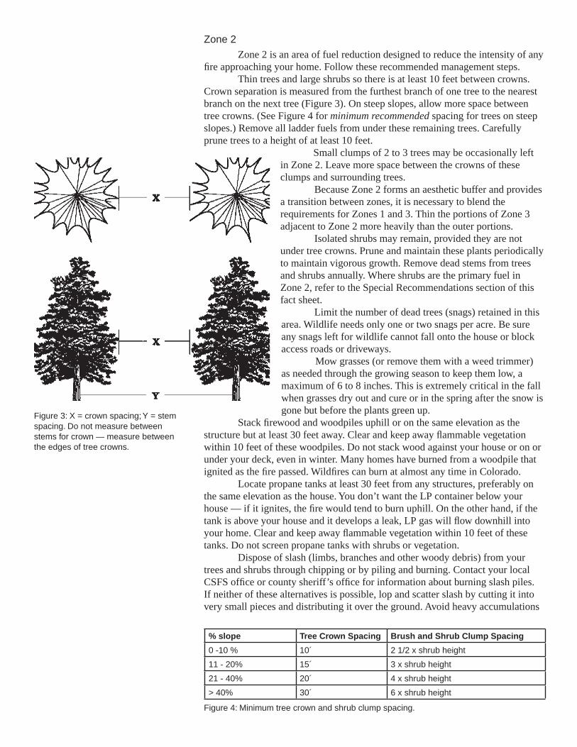
Figure 3: X = crown spacing; Y = stem spacing. Do not measure between stems for crown — measure between the edges of tree crowns.
Zone 2
Zone 2 is an area of fuel reduction designed to reduce the intensity of any fire approaching your home. Follow these recommended management steps.
Thin trees and large shrubs so there is at least 10 feet between crowns. Crown separation is measured from the furthest branch of one tree to the nearest branch on the next tree (Figure 3). On steep slopes, allow more space between tree crowns. (See Figure 4 for minimum recommended spacing for trees on steep slopes.) Remove all ladder fuels from under these remaining trees. Carefully prune trees to a height of at least 10 feet.
Small clumps of 2 to 3 trees may be occasionally left in Zone 2. Leave more space between the crowns of these clumps and surrounding trees.
Because Zone 2 forms an aesthetic buffer and provides a transition between zones, it is necessary to blend the requirements for Zones 1 and 3. Thin the portions of Zone 3 adjacent to Zone 2 more heavily than the outer portions.
Isolated shrubs may remain, provided they are not under tree crowns. Prune and maintain these plants periodically to maintain vigorous growth. Remove dead stems from trees and shrubs annually. Where shrubs are the primary fuel in Zone 2, refer to the Special Recommendations section of this fact sheet.
Limit the number of dead trees (snags) retained in this area. Wildlife needs only one or two snags per acre. Be sure any snags left for wildlife cannot fall onto the house or block access roads or driveways.
Mow grasses (or remove them with a weed trimmer) as needed through the growing season to keep them low, a maximum of 6 to 8 inches. This is extremely critical in the fall when grasses dry out and cure or in the spring after the snow is gone but before the plants green up.
Stack firewood and woodpiles uphill or on the same elevation as the structure but at least 30 feet away. Clear and keep away flammable vegetation within 10 feet of these woodpiles. Do not stack wood against your house or on or under your deck, even in winter. Many homes have burned from a woodpile that ignited as the fire passed. Wildfires can burn at almost any time in Colorado.
Locate propane tanks at least 30 feet from any structures, preferably on the same elevation as the house. You don’t want the LP container below your house — if it ignites, the fire would tend to burn uphill. On the other hand, if the tank is above your house and it develops a leak, LP gas will flow downhill into your home. Clear and keep away flammable vegetation within 10 feet of these tanks. Do not screen propane tanks with shrubs or vegetation.
Dispose of slash (limbs, branches and other woody debris) from your trees and shrubs through chipping or by piling and burning. Contact your local CSFS office or county sheriff’s office for information about burning slash piles. If neither of these alternatives is possible, lop and scatter slash by cutting it into very small pieces and distributing it over the ground. Avoid heavy accumulations
Figure 4: Minimum tree crown and shrub clump spacing.
% slope Tree Crown Spacing Brush and Shrub Clump Spacing
0 -10 % 10´ 2 1/2 x shrub height
11 - 20% 15´ 3 x shrub height
21 - 40% 20´ 4 x shrub height
> 40% 30´ 6 x shrub height

of slash. Lay it close to the ground to speed decomposition. If desired, no more than two or three small, widely spaced brush piles may be left for wildlife purposes. Locate these towards the outer portions of your defensible space.
Zone 3
This zone is of no specified size. It extends from the edge of your defensible space to your property lines. A gradual transition into this zone from defensible space standards to other management objectives you may have is suggested. Typical management objectives for areas surrounding homesites or subdivisions are: provide optimum recreational opportunities; enhance aesthetics; maintain tree health and vigor; provide barriers for wind, noise, dust and visual intrusions; support limited production of firewood, fence posts and other forest commodities; or grow Christmas trees or trees for transplanting.
Specific requirements will be dictated by your objectives for your land and the kinds of trees present. See Figure 5 for the minimum suggested spacing between “leave” trees. Forest management in Zone 3 is an opportunity for you to increase the health and growth rate of the forest in this zone. Keep in mind that root competition for available moisture limits tree growth and ultimately the health of the forest.
A high canopy forest reduces the chance of a surface fire climbing into the tops of the trees and might be a priority for you if this zone slopes steeply. The healthiest forest is one that has multiple ages, sizes, and species of trees where adequate growing room is maintained over time. Remember to consider the hazards of ladder fuels. Multiple sizes and ages of trees might increase the fire hazard from Zone 3 into Zone 2, particularly on steep slopes.
A greater number of wildlife trees can remain in Zone 3. Make sure that dead trees pose no threat to power lines or fire access roads.
While pruning generally is not necessary in Zone 3, it may be a good idea from the standpoint of personal safety to prune trees along trails and fire access roads. Or, if you prefer the aesthetics of a well-manicured forest, you might prune the entire area. In any case, pruning helps reduce ladder fuels within the tree stand, thus enhancing wildfire safety.
Mowing is not necessary in Zone 3.Any approved method of slash treatment is acceptable for this zone,
including piling and burning, chipping or lop-and-scatter.
Special RecommendationsTree spacing guidelines do not apply to mature stands of aspen trees
where the recommendations for ladder fuels have been complied with. In areas of aspen regeneration and young trees, the spacing guidelines should be followed.
Brush and shrubs
Brush and shrubs are woody plants, smaller than trees, often formed by a number of vertical or semi-upright branches arising close to the ground. Brush is smaller than shrubs and can be either woody or herbaceous vegetation.
On nearly level ground, minimum spacing recommendations between clumps of brush and/or shrubs is 2 1/2 times the height of the vegetation. Maximum diameter of clumps should be 2 times the height of the vegetation. As with tree crown spacing, all measurements are made from the edges of vegetation crowns (Figure 3).
For example: For shrubs 6 feet high, spacing between shrub clumps should be 15 feet or more apart (measured from the edges of the crowns of vegetation clumps). The diameter of shrub clumps should not exceed 12 feet (measured from the edges of the crowns). Branches should be pruned to a height of 3 feet.
Figure 5: Minimum tree spacing for Zone 3.
Tree Diameter
(in inches)
Average Stem Spacing Between Trees
(in feet)
3 10
4 11
5 12
6 13
7 14
8 15
9 16
10 17
11 19
12 21
13 23
14 24
15 26
16 28
17 29
18 31
19 33
20 35
21 36
22 38
23 40
24 42

Grasses
Keep dead, dry or curing grasses mowed to less than 6 inches. Defensible space size where grass is the predominant fuel can be reduced (Figure 5) when applying this practice.
Windthrow
In Colorado, certain locations and tree species, including lodgepole pine and Engelmann spruce, are especially susceptible to damage and uprooting by high winds (windthrow). If you see evidence of this problem in or near your forest, or have these tree species, consider the following adjustments to the defensible space guidelines. It is highly recommended that you contact a professional forester to help design your defensible space.
Adjustments: If your trees or homesite are susceptible to windthrow and the trees have never been thinned, use a stem spacing of diameter plus five instead of the guides listed in the Zone 3 section. Over time (every 3 to 5 years) gradually remove additional trees. The time between cutting cycles allows trees to “firm up” by expanding their root systems. Continue this periodic thinning until the desired spacing is reached.
Also consider leaving small clumps of trees and creating small openings on their lee side (opposite of the predominant wind direction). Again, a professional forester can help you design the best situation for your specific homesite and tree species. Remember, with species such as lodgepole pine and Engelmann spruce, the likelihood of a wildfire running through the tree tops or crowns (crowning) is closely related to the overabundance of fuels on the forest floor. Be sure to remove downed logs, branches and excess brush and needle buildup.
Maintaining Your Defensible SpaceYour home is located in a forest that is dynamic, always changing. Trees
and shrubs continue to grow, plants die or are damaged, new plants begin to grow, and plants drop their leaves and needles. Like other parts of your home, defensible space requires maintenance. Use the following checklist each year to determine if additional work or maintenance is necessary.
Defensible Space and FireWise Annual Checklist
Trees and shrubs are properly thinned and pruned within the defensible space. Slash from the thinning is disposed of.
Roof and gutters are clear of debris. Branches overhanging the roof and chimney are removed. Chimney screens are in place and in good condition. Grass and weeds are mowed to a low height. An outdoor water supply is available, complete with a hose and
nozzle that can reach all parts of the house. Fire extinguishers are checked and in working condition. The driveway is wide enough. The clearance of trees and branches
is adequate for fire and emergency equipment. (Check with your local fire department.)
Road signs and your name and house number are posted and easily visible.
There is an easily accessible tool storage area with rakes, hoes, axes and shovels for use in case of fire.
You have practiced family fire drills and your fire evacuation plan. Your escape routes, meeting points and other details are known and
understood by all family members. Attic, roof, eaves and foundation vents are screened and in good condition.
Figure 6: Minimum defensible space size for grass fuels.
% slope
D-space size (uphill, downhill, sidehill)
0 - 20 % 30’
21 - 40% 50’
> 40% 70’

FIREWISE is a multi-agency program that encourages the development of defensible space and the prevention of catastrophic wildfire.
Colorado State University, U.S. Department of Agriculture, and Colorado counties cooperating. Cooperative Extension programs are available to all without discrimination. No endorsement of products mentioned is intended nor is criticism implied of products not mentioned.
This fact sheet was produced in cooperation with the Colorado State Forest Service.
1Wildfire Hazard Mitigation Coordinator, Colorado State Forest Service.
Stilt foundations and decks are enclosed, screened or walled up. Trash and debris accumulations are removed from the defensible space. A checklist for fire safety needs inside the home also has been completed.
This is available from your local fire department.
ReferencesColorado State Forest Service, Colorado State University, Fort Collins,
CO 80523-5060; (970) 491-6303:• FireWise Construction — Design and Materials• Home Fire Protection in the Wildland Urban Interface• Wildfire Protection in the Wildland Urban Interface• Landowner Guide to ThinningColorado State University Cooperative Extension, 115 General Services
Bldg., Fort Collins, CO 80523-4061; (970) 491-6198; E-mail: [email protected]:
• 6.303, Fire-Resistant Landscaping• 6.304, Forest Home Fire Safety• 6.305, FireWise Plant Materials• 6.306, Grass Seed Mixes to Reduce Wildfire Hazard• 7.205, Pruning Evergreens• 7.206, Pruning Shrubs• 7.207, Pruning Deciduous Trees

APPENDIX G PRESCRIBED FIRE PILE BURNING GUIDLINES
GOLDEN DISTRICT
PRESCRIBED FIRE-PILE BURNING GUIDELINES This handout is designed to be used by forest landowners, land managers, and fire
department personnel in planning and conducting safe and effective burning of piled
forest debris (“slash”) - called “pile burns”. These guidelines cannot guarantee safety
against accidents, unforeseen circumstances, changing burning conditions, or negligent
actions of the individuals conducting the prescribed fire. By following the intent of these
guidelines and using common sense, the landowner or forest manager can reduce slash
accumulations, improve the appearance of their forest land, and reduce wildfire risk on
their property. The reader should contact a local office of the Colorado State Forest
Service (CSFS) or their local fire authority for updated versions of this publication and
current requirements about the use of open fires.
DEFINITIONS:
Slash: The accumulation of vegetative materials such as tops, limbs,
branches, brush, and miscellaneous residue resulting from forest
management activities such as thinning, pruning, timber harvesting, and
wildfire hazard mitigation.
Pile Burning: The treatment of slash by arranging limbs and tops into manageable piles.
Piles are burned during safe burning conditions, generally during the
winter following cutting.
Chunking-In: The process of moving unburned materials from the outside perimeter into
the center of the still burning piles. This is done after the pile has initially
burned down and is safe to approach, but before the hot coals in the center
have cooled. Chunking-in allows greater consumption of the piled slash.
Mop-up: The final check of the fire to identify and extinguish any still-burning
embers or materials. This is accomplished by mixing snow, water, or soil
with the burning materials.
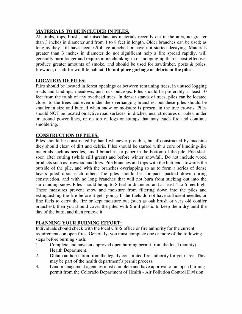
MATERIALS TO BE INCLUDED IN PILES:
All limbs, tops, brush, and miscellaneous materials recently cut in the area, no greater
than 3 inches in diameter and from 1 to 8 feet in length. Older branches can be used; as
long as they still have needles/foliage attached or have not started decaying. Materials
greater than 3 inches in diameter do not significant help a fire spread rapidly, will
generally burn longer and require more chunking-in or mopping-up than is cost-effective,
produce greater amounts of smoke, and should be used for sawtimber, posts & poles,
firewood, or left for wildlife habitat. Do not place garbage or debris in the piles.
LOCATION OF PILES:
Piles should be located in forest openings or between remaining trees, in unused logging
roads and landings, meadows, and rock outcrops. Piles should be preferably at least 10
feet from the trunk of any overhead trees. In denser stands of trees, piles can be located
closer to the trees and even under the overhanging branches, but these piles should be
smaller in size and burned when snow or moisture is present in the tree crowns. Piles
should NOT be located on active road surfaces, in ditches, near structures or poles, under
or around power lines, or on top of logs or stumps that may catch fire and continue
smoldering.
CONSTRUCTION OF PILES:
Piles should be constructed by hand whenever possible, but if constructed by machine
they should clean of dirt and debris. Piles should be started with a core of kindling-like
materials such as needles, small branches, or paper in the bottom of the pile. Pile slash
soon after cutting (while still green) and before winter snowfall. Do not include wood
products such as firewood and logs. Pile branches and tops with the butt ends towards the
outside of the pile, and with the branches overlapping so as to form a series of dense
layers piled upon each other. The piles should be compact, packed down during
construction, and with no long branches that will not burn from sticking out into the
surrounding snow. Piles should be up to 8 feet in diameter, and at least 4 to 6 feet high.
These measures prevent snow and moisture from filtering down into the piles and
extinguishing the fire before it gets going. If the fuels do not have sufficient needles or
fine fuels to carry the fire or kept moisture out (such as oak brush or very old conifer
branches), then you should cover the piles with 6 mil plastic to keep them dry until the
day of the burn, and then remove it.
PLANNING YOUR BURNING EFFORT:
Individuals should check with the local CSFS office or fire authority for the current
requirements on open fires. Generally, you must complete one or more of the following
steps before burning slash:
1. Complete and have an approved open burning permit from the local (county)
Health Department.
2. Obtain authorization from the legally constituted fire authority for your area. This
may be part of the health department’s permit process.
3. Land management agencies must complete and have approval of an open burning
permit from the Colorado Department of Health - Air Pollution Control Division.

Copies of all permits should be available on-site during the burning operation. Burning
activities should also include plans for safety, supplemental water sources, and extra
assistance from the local fire authority or the landowner. The individual(s) planning the
burning operation should notify the following entities on the day of a burn: the local fire
authority; county sheriff’s department; and adjacent landowners who may be affected by
smoke. Notification should include the date, times, and exact location of the burn. Pile
burning must be conducted under suitable weather conditions. Periods of snow or light
rain, with steady, light winds (for smoke dispersal), and sufficiently snow cover (6-12
inch depths) are ideal. Do not burn during periods of high winds, low humidity or drying
conditions, temperature inversions (especially “Red Air Quality” days in metropolitan
areas), with a lack of snow cover or these conditions are expected to develop after
starting the burn. Persons burning slash piles should have the following: leather gloves;
shovels; suitable footwear; masks for covering the mouth and nose; and proper eye
protection.
BURNING SLASH PILES:
Piles may be ignited by several means. If the needles and fine fuels within the pile have
dried though the summer, ignition can be easily started with matches and a large ball of
newspaper placed within the bottom of the pile. If fuels are still partially green, or the pile
is wet from rain or melting snow, then a hotter and longer burning source may be
necessary. Drip torches (a specially designed gas can used by foresters for igniting fires)
or sawdust soaked with diesel fuel can be used to ignite the pile. Flares used for highway
emergencies can also be utilized to ignite the piles. Do not use gasoline for this
purpose.
One test pile should be ignited to see if it burns and at what rate, prior to igniting other
piles. If suitable burning conditions exist, then additional piles may be started. Ignite only
those piles that can be controlled by the available manpower and resources until they
have burned down. You can slow the rate of burning (and possible scorching of adjacent
trees) by shoveling snow or spraying water into the pile and cooling the fire down.
Depending upon weather conditions, pile size, and moisture content of the fuels, piles
should burn down in 30-60 minutes. As a general rule, one person can manage 3-6
closely situated piles.
After the piles have burned down, chunk-in any unburned slash and wood into the hot
coals in the center of the pile. As much as 95% of the original slash can be consumed by
aggressive chunking-in. Do not start any new piles on fire after 2:00 pm, as they may
continue burning into the evening and will not burn as completely due to lower
temperatures and higher relative humidity. Smoke inversions may be a problem for piles
still burning after sunset. At all times, piles may need to be actively mopped-up if the
weather conditions will not extinguish the fire, or if the fires could escape. If high winds
or melting snow increases this risk, then all burning materials must be mopped-up.

ADDITIONAL ASSISTANCE:
If landowners have questions about burning slash, they should contact a local CSFS
office (http://csfs.colostate.edu/). CSFS can assist landowners with planning or
conducting prescribed fire activities such as pile burning or broadcast (area) burning.
Local, state, and fire department authorities may require a burn plan, smoke management
plan, and weather monitoring for complex burning operations.
APPENDIX H Jefferson County Structure Triage Form. The structure is tagged with the completed form so that
emergency personnel know which structures have priority for defense in an advancing wildfire.
Jefferson County Structure Triage Form Subdivision: Address: Unit ID: Date: Time:
Roof
1/4 Involved in Fire YES NO
If YES consider structure lost and move on
Safety Static Attack
FF
Safe
ty
Civ
ilian
S
afe
ty
Hazm
at
Fu
els
To
po
gra
ph
y
Cle
ara
nce
Co
nstru
cti
on
Access
Wate
r
Rad
io
Co
vera
ge C
olu
mn
To
tals
No S
afe
ty Z
ones
Mandato
ry
Evacuatio
n
Bulk
LP
G, F
uels
, C
hem
icals
Heavy o
r Dead T
rees
/ Bru
sh
Ste
ep S
lopes o
r Box
Canyons >
40%
30 F
eet o
r less
Com
bustib
le S
hake
Roofs
/ Exte
rior
Long N
arro
w
Driv
ew
ay, S
teep,
Heavy F
uel L
oad
No W
ate
r Sourc
es
Overa
ll Poor R
adio
or
Cell C
overa
ge
4 2
2
2
2
4
4
2
4
26
Marg
inal S
afe
ty
Zone
Evacuate
If Tim
e
Perm
its
Hazard
s In
Barn
s &
S
tora
ge S
heds
Modera
te b
rush
Mediu
m S
lopes 2
0-
40%
30 T
o 7
0 F
eet
Asphalt R
oofs
/ S
om
e C
om
bustib
le
Exte
riors
Adequate
wid
th/T
urn
A
rounds/M
odera
te
gra
de
Ponds, P
ools
,Low
F
low
Hydra
nts
Radio
Covera
ge O
K,
Som
e W
eak S
pots
2 1
1
1
1
2
2
1
2
13
Adequate
Safe
ty
Zone
Shelte
r In P
lace
None
Lig
ht F
lashy
Fla
t 0-2
0%
More
Than 7
0
Feet
Non C
om
bustib
le
Roof / E
xte
riors
Short W
ide
Driv
ew
ay, F
lat,
Lig
ht F
uel L
oad
Good H
ydra
nts
Good R
adio
and
Cell C
overa
ge
0 0
0
0
0
0
0
0
0
Comments:
Sco
re
14 - 2
6
Last Priority
Sco
re
7 - 1
3 Threatened
Sco
re
0 -6
Not Threatened