Appendix A4 Marine Mammal Management Plan - BHP€¦ · Appendix A4 Marine Mammal Management Plan....
27
Appendix A4 Marine Mammal Management Plan
Transcript of Appendix A4 Marine Mammal Management Plan - BHP€¦ · Appendix A4 Marine Mammal Management Plan....

Appendix A4 Marine Mammal Management Plan


MARINE MAMMAL MANAGEMENT PLAN
FEBRUARY 2011 Page i
Table of Contents
1 INTRODUCTION ....................................................................................................................... 1
1.1 PURPOSE OF THIS PLAN ....................................................................................................... 1
1.2 PROJECT OVERVIEW ............................................................................................................. 1
1.3 PROJECT DESCRIPTION ........................................................................................................ 1
1.4 MARINE MAMMAL SPECIES ................................................................................................... 4
1.5 RELEVANT LEGISLATION ...................................................................................................... 4
1.6 STRUCTURE OF THIS REPORT ............................................................................................. 4
2 BACKGROUND ........................................................................................................................ 6
2.1 OVERVIEW OF MARINE MAMMAL BIOLOGY AND SIGNIFICANT HABITATS WITHIN THE STUDY AREA ........................................................................................................................... 6
2.2 SUMMARY OF MARINE MAMMAL HABITAT USAGE ............................................................ 8
2.3 PROPOSED MARINE MEGA FAUNA SURVEY ....................................................................11
2.4 OTHER RELEVANT STUDIES ...............................................................................................11 2.4.1 Benthic Marine Habitat ............................................................................................11 2.4.2 Megafauna Surveys .................................................................................................12 2.4.3 Noise Assessment ...................................................................................................12
3 MANAGEMENT ISSUES ........................................................................................................13
3.1 POTENTIAL IMPACTS ...........................................................................................................13 3.1.1 Noise and Vibration .................................................................................................13 3.1.2 Boat Strikes .............................................................................................................14 3.1.3 Habitat Loss .............................................................................................................14 3.1.4 Oil Spill .....................................................................................................................15
4 MANAGEMENT ......................................................................................................................16
4.1 DREDGING AND SPOIL DISPSOAL .....................................................................................16
4.2 NOISE .....................................................................................................................................17
4.3 BOAT STRIKES ......................................................................................................................17
4.4 WATER QUALITY AND TURBIDITY ......................................................................................18
4.5 HYDROCARBON LEAKS AND SPILLS .................................................................................18
4.6 LIQUID AND SOLID WASTE DISPOSAL ...............................................................................18
5 REPORTING FRAMEWORK .................................................................................................20
5.1 ROUTINE INTERNAL REPORTING.......................................................................................20 5.1.1 Construction .............................................................................................................20
5.2 INCIDENT REPORTING .........................................................................................................20
6 REFERENCES ........................................................................................................................21
MARINE MAMMAL MANAGEMENT PLAN
FEBRUARY 2011 Page ii
Tables
Table 1.1 –The Conservation Status of Marine Mammal Species known or likely to occur in the Project Area ...................................................................................................................................... 5
Table 2.1 – Summary of Marine Mammal Habitat usage within and adjacent to the Proposed Port Hedland Outer Harbour Development ................................................................................. 8
Figures
Figure 1-1 – Proposed Outer Harbour Development Marine Infrastructure............................................. 3 Figure 2-1 – Humpback Whale Migration Routes and Aggregation Areas ............................................10 Figure 4-1 – Marine Mammal Monitoring and Exclusion Zones in Relation to Piling Activities .............19
Appendices
A.1 MARINE MAMMAL SIGHTING REPORT FORM

MARINE MAMMAL MANAGEMENT PLAN
FEBRUARY 2011 Page 1
1 INTRODUCTION
1.1 PURPOSE OF THIS PLAN
This Marine Mammal Management Plan (MMMP) focuses on managing potential impacts to marine mammals associated with the Port Hedland Outer Harbour Development. Specifically, this MMMP:
• focuses on management actions and strategies associated with construction activities; and
• outlines management strategies and monitoring programs that will be adopted to mitigate potential impacts associated with the construction phase.
For consistency, this MMMP follows the structure and, where appropriate, mitigation strategies proposed in the Outer Harbour Development Marine Turtle Management Plan (Pendoley Environmental 2010). Some management recommendations to mitigate impacts to marine turtles, such as the designated Marine Fauna Observers, will benefit marine mammals. Where appropriate, the same management approach is proposed in the Marine Turtle Management Plan.
1.2 PROJECT OVERVIEW
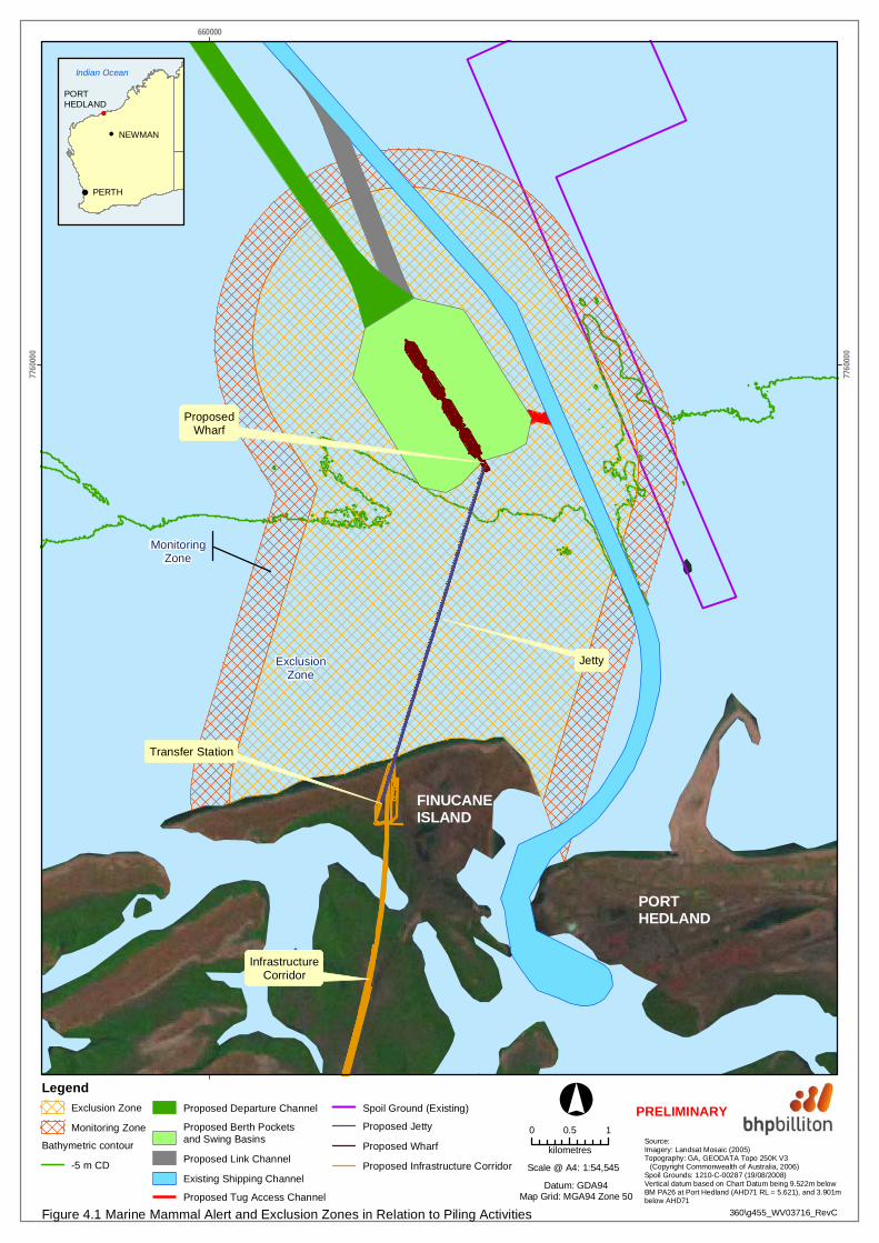
BHP Billiton Iron Ore currently exports iron ore from port facilities in Port Hedland, Western Australia. The current port operations consist of processing, stockpiling and shiploading facilities at Nelson Point and Finucane Island (referred to as the Inner Harbour), located on opposite sides of the Port Hedland Harbour.
The Outer Harbour Development will be a new port facility near Port Hedland, linked to Finucane Island (Figure 1-1).
Key marine structures and activities will include:
• a marine jetty extending from Finucane island to a wharf with eight berths;
• associated transfer stations, ore conveyors and ship loaders; and
• dredging for berth pockets, basins and departure channels.
1.3 PROJECT DESCRIPTION
The Outer Harbour Development will be established in four stages, with incremental expansions brought online over a five year period to reach the maximum capacity. The combined offshore and onshore construction period will last approximately eight years if each stage is built sequentially.
The marine infrastructure for the new offshore loading facility will be constructed on Finucane Island. The new jetty and wharf will extend nominally 4 km offshore in a northerly direction, adjacent to the existing inner harbour shipping channel (Figure 1-1). The new iron ore loading facility will be capable of berthing and loading vessels up to 320,000 deadweight tonnes (DWT) in size.
The key components of the offshore maritime infrastructure will comprise the following:
• access jetty structure, including abutment works;
• transfer station at the tail end of the wharf deck;
• wharf structure;
• berthing and mooring dolphins;
• ship access gangways and conveyor cross-overs and cross-unders;
• aids to navigation;
MARINE MAMMAL MANAGEMENT PLAN
FEBRUARY 2011 Page 2
• future provision of a ship arrestor barrier structure; and
• dredging works (24 hours per day, 7 days per week) for berth pockets and access and departure of the design vessels.
The marine components of the Outer Harbour Development will traverse both Western Australian State Waters and Commonwealth Waters (Figure 1-1). Detailed bathymetry within a subtidal study boundary considered relevant to the Outer Harbour Development was obtained during airborne Light Detection and Ranging (LiDAR) surveys (SKM 2009a). The area covers in excess of 3,600 km2, covering waters approximately 50 km to the east and west of Port Hedland, and extending 40 km seaward.

I N D I A N O C E A N
PORT HEDLAND
Transfer Deck
Tug Access Channel
Berth Pockets and Swing Basins
Crossover Channel
Wharf and Berths
Link Channel
Departure Channel
Transfer Station
Abutment
Jetty
Existing Shipping Channel
Infrastructure Corridor FINUCANEISLAND
656000 658000 660000 662000 664000 666000775
2000
775200
0
775400
0
775400
0
775600
0
775600
0
775800
0
775800
0
776000
0
776000
0
776200
0
776200
0
776400
0
776400
0
776600
0
776600
0
LegendStage 1 BerthsStage 2 BerthsStage 3 BerthsStage 4 Berths
Proposed Infrastructure CorridorProposed JettyExisting RailwayDisturbance Envelope
Proposed Departure ChannelProposed Berth Pockets and Swing BasinsProposed Link ChannelProposed Crossover ChannelExisting Shipping Channel
Proposed Tug Access ChannelState/CommonwealthJurisdiction Boundary AMBIS (2001) Source:
Orthorectified Aerial Photograph:06/06/2010 (BHPBIO)Australian Maritime Boundaries (AMB)© Commonwealth of Australia (GA), 2006Topography: GEODATA Topo 250K V3© Commonwealth of Australia (GA), 2006
003\g007_WV05024_RevA
!(
!(
!(
Indian Ocean
PERTH
NEWMAN
PORT HEDLAND
Figure 1.1 Proposed Marine Infrastructure Layout
West Creek
Salm
on C
reek
0 0.5 1kilometres
°
Datum: GDA94Map Grid: MGA94 Zone 50
1:65,000Scale = at A4
Limit of aerial photography data
PRELIMINARY

MARINE MAMMAL MANAGEMENT PLAN
FEBRUARY 2011 Page 4
1.4 MARINE MAMMAL SPECIES
There are 11 species of marine mammals known or likely to occur in the Project area. All are listed in the Environment Protection and Biodiversity Conservation Act 1999 (EPBC Act) as threatened, migratory or marine species (DEWHA 2008). These are:
• Humpback Whale (Megaptera novaeangliae);
• Blue Whale (Balaenoptera musculus);
• Antarctic Minke Whale (Balaenoptera bonaerensis);
• Bryde’s Whale (Balaenoptera edeni);
• Fin Whale (Balaenoptera physalus);
• Sperm Whale (Physeter macrocephalus);
• Indo-Pacific Humpback Dolphin (Sousa chinensis);
• Spotted or Indo-Pacific Bottlenose Dolphin; Arafura/Timor Sea populations (Tursiops aduncus);
• Killer Whale (Orcinus orca);
• Australian Snubfin Dolphin (Orcaella heinsohni); and
• Dugong (Dugong dugon).
The species considered in this MMMP are the Humpback Whale, Indo-Pacific Humpback Dolphin (hereafter Humpback Dolphin), spotted or Indo-Pacific Bottlenose Dolphin (hereafter Bottlenose Dolphin) and the Dugong because these are known to occur in waters off Port Hedland (Prince et al. 2001). It is likely that during the project construction, individuals of these species will pass close to where pile driving and dredging will occur. The Australian Snubfin Dolphin (hereafter Snubfin Dolphin) has been reported in the Port Hedland regions as unconfirmed incidental sightings (Salgado-Kent et al. 2009) and off Dampier (Paton 2008), and therefore is also considered in this Plan.
In contrast, the other listed species are expected to rarely venture into shallow water sections of the study area and thus are unlikely to be affected by construction (including pile driving or dredging) activities. These species are not considered further in this MMMP. Nevertheless, the management actions proposed in this plan will be effective for all marine mammal species that venture into the project area during construction and operational phases.
1.5 RELEVANT LEGISLATION
In Western Australia, marine mammals are protected under the Wildlife Conservation Act 1950. Only two of the five species under consideration have sufficient data available to be assigned a protection status (Table 1.1). The marine mammals under consideration are also protected by Commonwealth legislation (EPBC Act) and international conventions (CMS, CITES, IUCN) (Table 1.1).
1.6 STRUCTURE OF THIS REPORT
This Plan provides the following information:
• an overview of mammal species and ecology within the project area;
• an overview of marine mammal habitat usage within and adjacent to the proposed Outer Harbour Development;
• an overview of other relevant studies conducted as part of the proposed Outer Harbour Development;
• identification of the key stressors, potential impacts and environmental risk assessment;

MARINE MAMMAL MANAGEMENT PLAN
FEBRUARY 2011 Page 5
• identification of management strategies to minimise the impact associated with construction and operational activities; and
• a framework for reporting.
This Management Plan has been prepared based on information and recommendations presented in the following studies:
• Public Environmental Review /Environmental Impact Statement for Port Hedland Outer Harbour Development
• Salgado-Kent, C., McCauley, R.D. and Duncan, A.J. (2009). Environmental Impacts of Underwater Noise Associated With Harbour Works, Port Hedland;
• Pendoley Environmental (2009a). Port Hedland Outer Harbour (Quantum) Development: Marine Turtle Management Plan;
• Sinclair Knight Merz (2009a). Port Hedland Outer Harbour Development Marine Benthic Habitat Survey; and
• Sinclair Knight Merz (2009b). RGP6 Port Facilities Definition Phase: Benthic Primary Producer Reference Area Subtidal Habitat Mapping. The relevance of this document relates to the description of habitat (e.g. seagrass) in the Project area that may be of importance to marine mammals.
Table 1.1 –The Conservation Status of Marine Mammal Species known or likely to occur in the Project Area
Species Wildlife Conservation Act 1950
Environment Protection and Biodiversity Conservation (EPBC) Act 1999
Convention on Migratory Species (CMS) Appendix (as at May 2009)
Convention on International Trade in Endangered Species (CITES) Appendix (as at August 2009)
International Union for Conservation of Nature (IUCN) (as at August 2009)
Humpback Whale Schedule 11 Vulnerable,
Migratory Appendix I2 Appendix I3 Least Concern4
Humpback Dolphin N/A Migratory Appendix II5 Appendix I Near
Threatened6 Bottlenose Dolphin N/A Migratory Appendix II Appendix II7 Data deficient
Snubfin Dolphin N/A Migratory Appendix II Appendix I8 Near Threatened
Dugong Schedule 49 Migratory Marine
Appendix II Appendix I Vulnerable10
1 Fauna that is rare or likely to become extinct 2 CMS Appendix I lists migratory species that have been categorized as being in danger of extinction throughout all or a significant proportion of their range 3 CITES Appendix I includes all species threatened with extinction which are or may be affected by trade. 4 A taxon is Least Concern when it has been evaluated against the criteria and does not qualify for Critically Endangered, Endangered, Vulnerable or Near Threatened. Widespread and abundant taxa are included in this category 5 CMS Appendix II lists Migratory species that have an unfavourable conservation status or would benefit significantly from international co‐operation 6 A taxon is Near Threatened when it has been evaluated against the criteria but does not qualify for Critically Endangered, Endangered or Vulnerable now, but is close to qualifying for or is likely to qualify for a threatened category in the near future 7 CITES Appendix II includes all species which although not necessarily now threatened with extinction may become so unless trade in specimens of these species is subject to strict regulation in order to avoid utilization incompatible with their survival 8 Status in the CITES database is for Orcaella breviostris 9 Fauna in need of special protection, but not covered by Schedules 1 – 3 of the Wildlife Conservation Act 1950 10 A taxon is Vulnerable when the best available evidence indicates that it meets any of the criteria A to E for Vulnerable and it is therefore considered to be facing a high risk of extinction in the wild.

MARINE MAMMAL MANAGEMENT PLAN
FEBRUARY 2011 Page 6
2 BACKGROUND
2.1 OVERVIEW OF MARINE MAMMAL BIOLOGY AND SIGNIFICANT HABITATS WITHIN THE STUDY AREA
The following section summarises the information known on marine mammal habitat usage within and adjacent to the project that has been determined from a literature review by Salgado-Kent et al. (2009) in a report commissioned by BHP Billiton Iron Ore. It also draws on additional supporting references.
Humpback Whale (Megaptera novaeangliae)
During winter months, Humpback Whales migrate from their Antarctic summer feeding grounds to their sub-tropical winter calving grounds. The major calving area in Western Australia is off the Kimberley coast (DEH 2005) and thus each year large numbers migrate along the Western Australia coastline. The Group IV population of humpback whales that migrates along the Western Australian coast was estimated during the northward migration in 2008 to be approximately 21,750 animals (Hedley, Bannister & Dunlop 2009). Habitat considered important (or critical) for supporting Humpback Whale populations are those areas utilised for feeding, calving, resting and migratory routes (DEH 2005). According to the Humpback Whale Recovery Plan 2005-2010 (DEH 2005), the Port Hedland area is not a known feeding, aggregation or major calving area. However, Humpback Whales migrate past Port Hedland on their way to and from calving areas off the Kimberley (Jenner et al. 2001). Portions of the migratory route that Humpback Whales follow contain narrow corridors due to physical and other barriers. In these areas, the majority of the population passes within 30 km of the coastline. These areas are considered important habitat during the migration period. The Port Headland area is not considered to be one of these areas (DEWHA, 2009).
The exact timing of the migration period can vary on a yearly basis and is dependent on a number of factors including sea temperature, predation risk and prey abundance. Humpback Whales are generally seen in southern waters in May, and migrate to north along the east and west coasts to the calving and breeding grounds. The southern migration commences in August, with most individuals having started their migration by October (DEWHA, 2009).
Off Port Hedland, the northbound peak period is late June to early August, while the southbound period is late August to mid October (DEWHA 2005; Jenner et al. 2001).
According to Jenner et al. (2001) and Prince et al. (2001), migrating whales remain well offshore, typically in waters equal to or exceeding 20 m. Nevertheless, individual animals or pods do venture closer to shore, and during boat-based field work off Port Hedland in mid August 2009, SKM personnel documented a mother and calf Humpback Whale in water depth of approximately 15 m (G Paccani, SKM pers comm.); and in early September 2009 three adults were documented in similar water depths (C Wilson, SKM pers comm.).
Key points relevant to management:
• off Port Hedland only from July to October (Jenner et al. 2001);
• most animals migrating off Port Hedland are in waters 20 m or deeper (Jenner et al. 2001; Prince et al. 2001); this depth contour is approximately 30-35 km from the proposed wharf and 3-5 km from the end of the outer most section of the proposed departure channel;
• individual animals or small pods are sometimes observed in waters <20 m (SKM personnel, pers. obs.);
• animals found shallower than 20 m are likely to include adult females and calves on their southbound migration in August to early September; and
• Port Hedland is not a known feeding, aggregation or calving area for this species (DEH 2005).
Humpback Dolphin (Sousa chinensis)
Indo-Pacific Humpback Dolphins have not been studied in the Pilbara region, and therefore their abundance and biology in the Port Hedland area remains unclear. Prince et al. (2001) reported small
MARINE MAMMAL MANAGEMENT PLAN
FEBRUARY 2011 Page 7
numbers of dolphins including Sousa chinensis during a one-off aerial survey in the Pilbara. According to Jefferson (2000), this species usually occurs close to the coast, generally in depths of less than 20 m. They have been reported from both clear and turbid water environments, and in a variety of coastal habitats, from coastal lagoons and enclosed bays with mangrove stands and seagrass beds through to open coastal waters with coral reefs (Corkeron et al. 1997). Humpback Dolphins are known to move seasonally, but resident populations have been described in some areas (Ross et al. 1994). This species is known to feed on fish, cephalopods and crustaceans.
Key points relevant to management:
• Pilbara waters appear not to support large populations of humpback or other species of dolphin (Prince et al. 2001);
• the Humpback Dolphin is a coastal species and is widespread through northern and eastern Australia, and other areas of the world; and
• very little is known of its ecology in the Pilbara, but there is no evidence that Port Hedland supports critical habitat for large numbers of this species.
Bottlenose Dolphin (Tursiops aduncus)
Bottlenose Dolphins have not been studied in the Pilbara region; however studies to reduce by-catch of this species in the Pilbara Trawl Fishery have been undertaken (Stephenson et al. 2006). Prince et al. (2001) reported that the Pilbara supports small numbers of dolphins, with Tursiops being the most abundant. The taxonomic status of this species in the Pilbara remains unclear (Hammond et al. 2008). Stephenson et al. (2006) reported specimens of Tursiops truncatus being caught by trawlers in the Pilbara. However, the Pilbara specimens may be Tursiops aduncus (Hammond et al. 2008). T. aduncus feeds on a wide variety of schooling, demersal and reef fish, as well as cephalopods (Hammond et al. 2008).
Key points relevant to management:
• Pilbara waters appear not to support large populations of this or other species of dolphin (Prince et al. 2001);
• this is probably the most common dolphin species found in Pilbara waters (Prince et al. 2001);
• Tursiops spp. is widespread throughout the Pilbara and northern Australia; and
• very little is known of its ecology in the Pilbara, but there is no evidence that Port Hedland supports critical habitat for large numbers of this species.
Snubfin Dolphin (Orcaella heinsohni)
Previously reported in Australia as the Irrawaddy Dolphin (Orcaella breviostris), the Australian population was re-named the Snub-fin Dolphin (Orcaella heinsohni) by Beasley et al. (2005). Until recently, it was unclear if this species was found in the Pilbara region (Prince et al. 2001; Parra et al. 2002; Beasley et al. 2005; DEWHA). However, Paton (2008) reported this species from waters off Dampier. Based on research in Queensland, this species is primarily found in shallow waters (<20 m deep), close to the coast, close to river and creek mouths and in the proximity of seagrass beds (Parra et al. 2002). Fish appear to be the primary food. According to Parra (2006) this species may be transient, with large home ranges.
Key points relevant to management:
• Pilbara waters appear not to support large populations of this or other species of dolphin (Prince et al. 2001);
• it is unclear if this species is found off the Pilbara (Prince et al. 2001; Parra et al. 2002; Beasley et al. 2005); and
• this species is found through northern and eastern Australia (Parra 2006).

MARINE MAMMAL MANAGEMENT PLAN
FEBRUARY 2011 Page 8
Dugong (Dugong dugon)
Dugongs are usually found in large numbers only in shallow waters supporting extensive seagrass meadows. In Australia, they are found from the Queensland/New South Wales border in the east to Shark Bay on the Western Australian coast. Based on an aerial survey in 2000, Prince et al. (2001) estimated a population of 2,046 (±376 SE) in Pilbara waters, with an average density of 0.1 Dugong per km². This compares with a density of 0.71 (±0.12SE) dugong per km² in Shark Bay, Western Australia (Marsh et al. 1994). A recent aerial survey by Pendoley (2009b), focusing on turtles but also recording mammals, reported six to eight dugongs near Little Turtle Island. The observers could not determine if the animals were feeding, resting or travelling; but confirmed that no feeding scars (tracks) were observed anywhere in, or adjacent to, the study area.
There are no extensive seagrass meadows in the study area (SKM 2009a), so it is not considered to be a critical feeding ground for this species. Low-density beds of seagrass, predominantly Halophila ovalis, were reported in an embayment on the landward side of Weerdee Island (see Section 2.4.1) with a single dugong spotted there in August 2008 during related field investigations (Peter Morrison, SKM pers. comm.). Dugong feeding scars were not recorded in these seagrass beds during dives conducted in August 2009 (Kurt Wiegle, SKM pers. comm.).
Key points relevant to management:
• Pilbara waters support low densities of this species (Prince et al. 2001).
• This species has been observed in and immediately adjacent to the study area.
• Port Hedland does not support large meadows of seagrass, the primary food source of this species (SKM 2009a, b). Also, the marine environment off Port Hedland is highly exposed to extreme ocean conditions. For these reasons, the marine environment off Port Hedland is not predicted to be critical habitat for this species or support large populations.
2.2 SUMMARY OF MARINE MAMMAL HABITAT USAGE
Table 2.1 presents a summary of information relating to the types of habitats utilised by these marine mammals in the study area and the timing of their occurrence. Figure 2-1 illustrates the timing of humpback whale southern and northern migrations past the Port Hedland area.
Table 2.1 – Summary of Marine Mammal Habitat usage within and adjacent to the Proposed Port Hedland Outer Harbour Development
Species Habitat Type Known and Predicted Activity
Occurrence in Project Area
Reference relevant to study area
Humpback whale Shelf waters off Western Australia, but mainly in water > 20 m in depth. Individuals (adults with calves) will come close to shore
Migration July to October. Northbound peak period: Late June–Early Aug. Southbound peak period: Late August–Mid October
Jenner et al. (2001); Prince at al. 2001; DEH (2005)
Humpback dolphin Coastal lagoons and enclosed bays with mangrove stands and seagrass beds through to open coastal waters
Transient and feeding
All year Jenner et al. (2001); Prince at al. (2001); Jenner & Thiele 2008
Bottlenose Dolphin Inshore and offshore marine environments
Transient and feeding
All year Jenner et al. (2001); Prince at al. (2001); Jenner & Thiele 2008

MARINE MAMMAL MANAGEMENT PLAN
FEBRUARY 2011 Page 9
Species Habitat Type Known and Predicted Activity
Occurrence in Project Area
Reference relevant to study area
Snubfin Dolphin Coastal, shallow waters and brackish estuaries <10 m in depth
Transient and feeding
All year IUCN website1 Jenner & Thiele 2008
Dugong Shelf waters – presumably shallow waters (<10 m deep) where seagrasses are abundant (seagrass may occur in waters deeper than 10 m if water is clear enough to allow light penetration, however this is not the case in the Port Hedland area)
Transient and feeding
All year
Jenner et al. (2001); Prince at al. (2001)
.
1 http://www.iucnredlist.org/details/136315/0

!
!
!
!
PORT HEDLAND
BROOME
ONSLOW
EXMOUTH
KARRATHA
250000 350000 450000 550000 650000 750000 850000 950000 105000075
0000
076
0000
077
0000
078
0000
079
0000
080
0000
081
0000
082
0000
0
Figure 2.1 Humpback Whale Migration Route and Aggregation Areas
Scale = 1:3,000,000
350\g401_WV03716_RevE
Legend
[ Noise Monitor
Humpback Whale Migration
Humpback Whale Presence
Aggregation Area
Species known to be present
Spoil Ground (Existing)
Spoil Ground (Proposed)
Proposed Jetty
Proposed Wharf
Proposed Infrastructure Corridor
Proposed Stockyards
Source:Channel: 112-SK-00500 (FAST JV 01/11/2008)Channel: Navy Hydrographer, AUS00740Topography: GEODATA Topo 1M © Commonwealth of Australia (GA), 2006Whales: Department of Water, Environment and Heritage © Commonwealth of Australia, 2006
Datum: GDA94Projection: MGA94 Zone 50
0 50 100
kilometres
°PRELIMINARY
Humpback Whale Migraton:North: Late June - Early August
South: Late August - Mid OctoberCow and calf numbers peaking Late September - Mid October
Outer HarbourInfrastructure
Study AreaBoundary
!(
!(
!(
PORT HEDLAND
NEWMAN
PERTH
Indian Ocean
[
at A3

MARINE MAMMAL MANAGEMENT PLAN
FEBRUARY 2011 Page 11
2.3 PROPOSED MARINE MEGA FAUNA SURVEY
Pre impact aerial marine mega fauna surveys will be undertaken to:
• determine the seasonal distribution and relative abundance and densities of marine mammals within the study area during a 12 month seasonal cycle; and
• analyse the relative importance of the modelled sub-tidal habitats within the Project area for conservation significant marine mammals.
The study area for the surveys will be defined as the State and Commonwealth waters within and adjacent to the Project area, extending approximately 35 km west of Finucane Island, 35km east/north-east of Finucane Island and seaward approximately 50 km.
A systematic and comprehensive aerial transect sampling method will be utilised to estimate the abundance and distribution of marine mammals in the study area. Transects will be designed to be consistent and comparable with other marine mega-fauna surveys undertaken in the region. Transects will include the main Humpback Whale migratory pathway.
Surveys will be undertaken over a 12 month period. Analysis of the survey data will include:
• temporal and spatial analysis to determine relative densities of marine mammal species in the study area over the 12 month period;
• determination of the distribution of Humpback Whales during the northern and southern migration periods;
• analysis of the spatial patters of milling/resting whales and cow/calf pods;
• analysis of the abundance and distribution of other marine mammals; and
• correlation of marine mammal distribution and modelled sub tidal habitat, to determine if sub-tidal habitat is present to support conservation significant species
A key output of the survey will be marine mega fauna (include humpback whales, dugongs and marine turtles) density maps.
The surveys and analysis will be completed prior to the commencement of marine construction activities that may affect marine mega fauna. This Plan will be updated based on the results of the surveys prior to the commencement of marine construction activities that may affect marine mammals.
The survey will be repeated post construction for monitoring purposes.
2.4 OTHER RELEVANT STUDIES
2.4.1 Benthic Marine Habitat
Benthic seabed habitat surveys were undertaken between December 2007 and February 2009 by SKM for BHP Billiton Iron Ore (SKM 2009a). Whilst ground truthing and habitat modelling indicated that the majority of benthos within the study boundary (85%) was bare sand, four patches of Halophila ovalis seagrass have been identified in an embayment on the landward side of Weerdee Island. This area is located outside of the subtidal study boundary but is considered of relevance due to its proximity to the proposed development activities (approximately 10 km from the proposed wharf head). The seagrass patches covered a total of 85 hectares, of density described as sparse to dense (SKM 2009b).

MARINE MAMMAL MANAGEMENT PLAN
FEBRUARY 2011 Page 12
2.4.2 Megafauna Surveys
An aerial turtle survey in December 2008 identified a group of six to eight dugongs at Little Turtle Island, approximately 35 km north-east of the proposed wharf head (Pendoley Environmental 2009b). In addition, three other individuals were spotted in the study area during this survey. A winter survey conducted in April 2009 observed three individuals within the study area. The observers were unable to determine if the dugongs were feeding or resting. However, they were able to confirm that no scars in seagrass beds, indicating dugong feeding, were observed within or adjacent to the study area (Kellie Pendoley, Pendoley Environmental pers comm. 2009).
It should be noted that extensive seagrass meadows such as those characteristic of Shark Bay were absent from the study area (SKM 2009a). This lends support to the low density of dugongs previously reported in the Port Hedland region, of 0.1 per km2 (Prince et al. 2001).
2.4.3 Noise Assessment
A background study and noise impact assessment related to the Outer Harbour Development was conducted by the Centre for Marine Science and Technology at Curtin University (Salgado-Kent et al. 2009). The report measured existing ambient noise at a location midway along the proposed shipping channel (Figure 2-1), and modelled potential noise levels resulting from the proposed construction and operational activities.
The sources of noise considered to have the greatest potential impacts on marine mammals were identified as pile drivers, increased shipping and vessel traffic and dredging activities. The following points summarise the main potential physiological and behavioural impacts on marine mammals in the study area and are specific to noise inputs for the proposed Outer Harbour Development (Salgado-Kent et al. 2009):
• Organ damage: physiological damage which may lead to death. Estimated to occur within several to tens of metres from the source.
• Permanent Threshold Shift (PTS): a permanent loss of hearing sensitivity. Estimated to occur within tens to hundreds of metres from the source.
• Temporary Threshold Shift (TTS): a temporary effect upon hearing which is recoverable. Estimated to occur within 200 m from the source.
• Behavioural responses which may cause a startle response, long term avoidance of certain areas, or changes to movement and migratory pathways. These may occur at ranges of 2 km to tens of kilometres, depending upon the species and severity of behavioural response considered.

MARINE MAMMAL MANAGEMENT PLAN
FEBRUARY 2011 Page 13
3 MANAGEMENT ISSUES
This section examines the potential threats to marine mammals within the Port Hedland region that may arise from construction and operation activities of the proposed Outer Harbour Development. Based on previous studies, the marine mammals that may be impacted from the proposed development are:
• Humpback Whales during their northern (late June to early August) and southern migration (late August to mid October) off the coast of Port Hedland;
• Dolphins that feed, rest or pass through the area; and
• Dugongs that feed, rest or pass through the area.
With respect to the potential impacts, the following should be noted::
• Humpback whale mother and calf pairs are known to travel closer to the coastline during their southbound migration, therefore they are potentially more susceptible to impacts than adult males travelling further offshore.
• The species of concern listed in Section 2.1 vary in their sensitivity to underwater noise and therefore in terms of assessing risk and developing management strategies, accordingly, and as a precaution, this plan focuses on humpbacks, which are more sensitive to low frequency noise than dolphins (Salgado-Kent et al. 2009).
• The risk of boat strikes was considered in the context of large and slow moving construction vessels (dredgers, support vessels, bulk carriers) compared with faster recreational vessels that are a known source of dugong injury and mortality (Preen 1999) but are more manoeuvrable.
3.1 POTENTIAL IMPACTS
Most potential impacts on marine mammals from the proposed Outer Harbour development are considered to be low-risk. The higher risk level impacts are considered to be:
• noise impacts to marine mammals from pile driving during construction of the permanent marine facilities;
• mortalities or injuries to marine mammals from ship strike; and
• loss of feeding grounds due to habitat loss.
3.1.1 Noise and Vibration
Detailed analysis of proposed marine noise and potential impacts on marine mammals has been conducted by Salgado Kent et al. (2009) for the Outer Harbour Development. The noise sources related to the proposed development in order of predicted severity of underwater noise impacts are: pile drivers; increased shipping and vessel traffic associated with harbour works; and the dredges, typically the trailing suction hopper dredgers (TSHDs) (Salgado Kent et al. 2009). Noise modelling was based on three pile hammers operating concurrently over the first twelve-month period of construction. Dredging is expected to occur for approximately 50 months.
Key findings from Salgado Kent et al. (2009) that are relevant to management of marine mammals during the proposed Outer Harbour Development are:
• Impulsive noise (associated with piling) is predicted to be the main potential agent of disturbance to marine mammals during the construction phase.
• Behavioural responses as a result of piling can potentially occur at distances up to several km or more.

MARINE MAMMAL MANAGEMENT PLAN
FEBRUARY 2011 Page 14
• The main concern with pile driving start-up is that animals nearby have no warning, and if sufficiently close to the source may experience auditory injury.
• For non-pulsed noise sources, such as dredging and shipping, Humpback Whales are unlikely to experience TTS unless the animals are within 50 m or less of the vessel.
• Humpback Whales are unlikely to receive injuries caused by noise from dredging or shipping.
• For dolphins, TTS and PTS should be similar to Humpback Whales. However, dolphins maybe at greater risk because they are known to habituate to noise sources and receive a greater cumulative sound loading than if they were exposed on a transitory basis.
• Dugongs migrating through the area are likely to experience behavioural disturbance from all development operations at the lowest exposure levels, although individuals exposed over multiple events may habituate to the noise if not associated with negative events.
• For Dugongs, PTS and TTS are predicted to be similar to levels proposed for dolphins.
3.1.2 Boat Strikes
Vessel collisions can contribute to the mortality or injury of several marine taxa including cetaceans and dugongs (Laist et al. 2001; Kraus et al. 2005; Preen 1999). Laist et al. (2001) reported that most vessel strikes between whales and large vessels (80 m or larger) occurred when vessels were travelling at 14 knots or more. Laist et al (2001) noted that larger cetaceans and those that display extended surface milling time are more vulnerable to vessel collision. Szabo and Duffus (2007) noted that calves and juveniles were also more susceptible to vessel strike. Vanderlaan & Taggart (2007) showed that the probability of a lethal collision increased significantly with vessel speed.
During the construction stage there will be an increase in marine traffic associated with dredges and support vessels. The potential for collisions between whales and vessels is considered low as:
• cetaceans have strong auditory sense allowing them to detect and avoid vessels, especially where the vessels are travelling at lower speeds;
• Humpback Whales are only in the area for up to three months a year;
• During the migration season the greatest proportion of the population will be in deep waters (≥20 m), which is approximately 30 to 35 km from the proposed wharf site and areas where the majority of construction vessel activity occurs;
• there is a low density of dugongs in the area; and
• The larger, less manoeuvrable construction vessels will be moving at low speeds (less than 15 knots).
Fast moving, smaller vessels have the potential to impact dugongs via vessel strike. However, given their low population density in the area, the risk of boat strike on dugongs is considered low.
3.1.3 Habitat Loss
During construction of the Outer Harbour Development, the habitat that will be impacted most, in terms of spatial extent, is unvegetated subtidal sand, in an open and exposed marine environment (SKM 2009a). This habitat is widespread in the Pilbara and is not a known critical habitat for marine mammals.
Habitat, such as seagrass meadows, which is important to dugongs, is not predicted to be temporarily or permanently impacted during the proposed Outer Harbour Development (SKM 2009c) because there are no major seagrass meadows in the Project area. The closest occurrence of low density seagrass is near Weerdee Island, over 10 km south-west of the proposed wharf site, and this is not considered critical feeding ground for dugong (see Section 2.1). Further, Port Hedland is not considered a key aggregation, feeding or calving area for Humpback whales (DEH 2005) or any of the other species of concern in this Management Plan (DEWHA 2008).

MARINE MAMMAL MANAGEMENT PLAN
FEBRUARY 2011 Page 15
3.1.4 Oil Spill
In the unlikely event of an oil spill, there is a risk of marine mammals being exposed to surface oil or ingesting small quantities. It is difficult to quantify the risk of marine animals to this type of disturbance because there is no literature demonstrating the impact on whales, dolphins or dugongs after swimming through an oil slick. However, given the low risk of a major spill and the level of planning for managing spilt oil in the Port Hedland area the risk to marine mammals from this threat is considered extremely low.
MARINE MAMMAL MANAGEMENT PLAN
FEBRUARY 2011 Page 16
4 MANAGEMENT
The following management measures will be applied to minimise the potential impacts identified in Section 3.
4.1 DREDGING AND SPOIL DISPSOAL
Note: the following management measures do not apply to dolphins
The following management measures will be implemented to manage risk of impacts to marine mammals from the dredging operations:
General Management Measures
• Prior to commencement of construction, designated crew (one per vessel) will be trained as Marine Fauna Observers, and trained to observe for marine turtles and marine mammals, record sightings and the actions to be taken in event of sightings, injury or mortality.
• Site inductions for all vessel crew and awareness programmes covering procedures to be undertaken to minimise disturbance to marine fauna.
• If marine mammals are sighted in the area, relevant project vessels operating in the area will be notified.
• Operators of specified vessels will be required to maintain a watch for marine mammals, and if they are spotted, vessels will avoid impacting the fauna (within safe operational constraints of the vessel).
• Any injuries or mortalities of marine mammals will be documented and reported to DEC/ DSEWPaC.
CSD
• Within the operating constraints of the CSD, the dredge pumps will only be turned on when the cutter head is close to the sea bed.
• Within the operating constraints of the CSD, the dredge pumps will be turned off as soon as possible after the cutter head clears the sea bed (generally after the discharge pipe is clear).
TSHD Dredging Operations
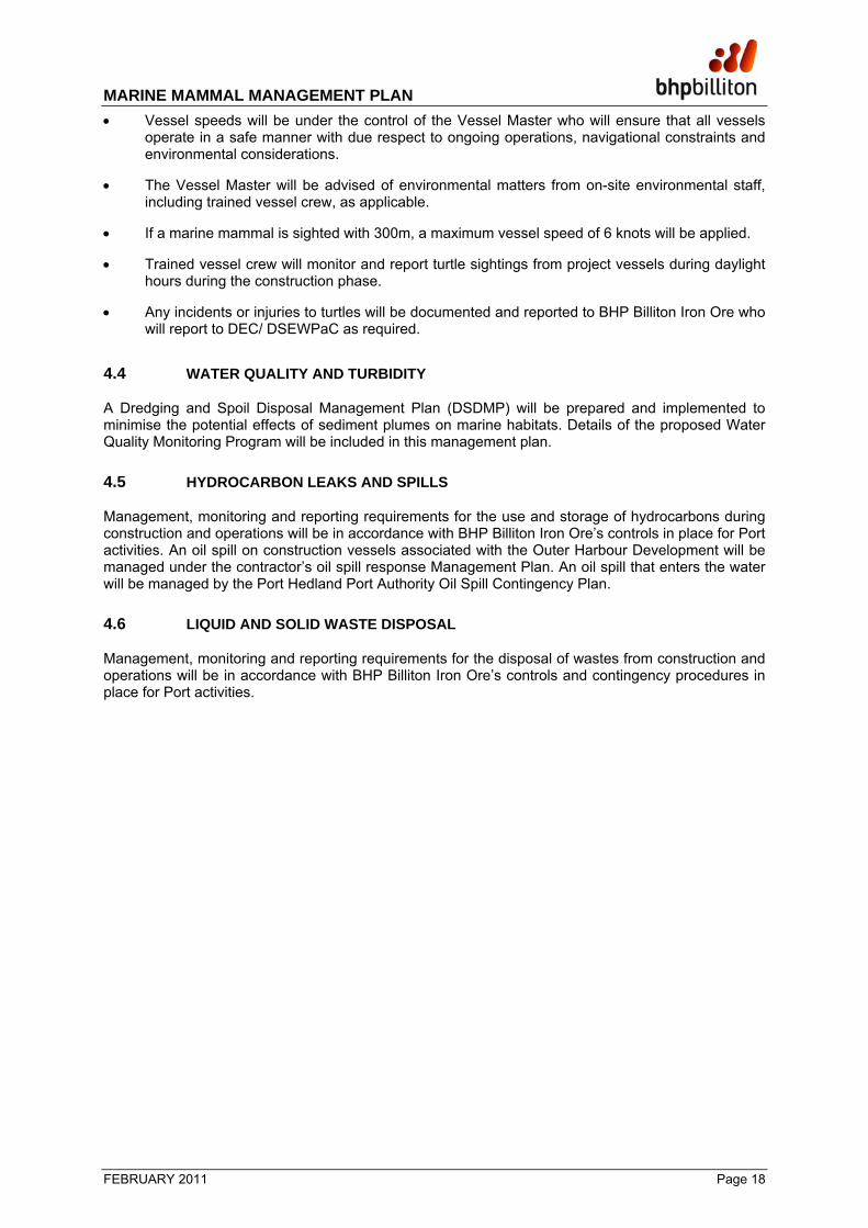
• Upon arrival at the dredging location (each cycle) and prior to the commencement of dredging, the area within 300m of the dredge (exclusion zone) will be visually inspected. If any marine mammals are sighted within the exclusion zone, dredging will not commence until the marine mammal has moved out of the exclusion zone or has not been sighted for 10 minute (note : the dredge may move location to ensure the mammal is out of the exclusion zone).
• The vessels MFO will maintain a watch for the marine mammals (during daylight hours) during the dredging operations. In the event that a marine mammal enters the exclusion zone during the dredging works, dredging operations will cease until the marine mammal is outside of the exclusion zone or has not been seen for 10 minutes.
• During transit avoidance action will be taken where necessary to attempt to maintain distance of 1000 m or more between vessel and whales.
• During transit, if a marine mammal is sighted with 300m, a maximum vessel speed of 6 knots will be applied.
MARINE MAMMAL MANAGEMENT PLAN
FEBRUARY 2011 Page 17
TSHD Spoil Disposal Operations
• Upon arrival at the spoil ground (each cycle) and prior to the commencement of disposal operations the area within 300m of the dredge (exclusion zone) will be visually inspected. If any marine mammals are sighted within the exclusion zone, disposal will not commence until the marine mammal has moved out of the exclusion zone or has not been sighted for 10 minutes (note : the dredge may move location to ensure the marine mammal is out of the exclusion zone).
4.2 NOISE
Marine noise and vibrations during construction and operations will be managed by the following measures:
• A trained MFO will be responsible for observing marine mammals during active piling at the piling site (e.g. on a jack up barge or adjacent support vessel).
• Vessel crew will undergo site inductions and clear briefings covering procedures to be undertaken to minimise disturbance to marine fauna provided by appropriately qualified personnel
• Existing acoustic controls on noise-generating equipment (including vessel engines, drill and piling equipment) will be implemented to reduce noise at source.
• Noise-generating equipment (including vessel engines, drill and piling equipment) will be routinely maintained and inspected to reduce unnecessary increases in noise levels from the equipment. All vessels shall operate in accordance with appropriate industry equipment noise standards.
• Regular monitoring will be conducted to assess compliance with noise and vibration levels
• Where practical the practice of leaving engines, thrusters and auxiliary plant on standby or running mode will be avoided.
• Before commencing piling, carry-out ‘soft-start’ for pile driving, slowly increasing intensity of the driving hammer power.
• If marine mammals are sighted in the monitoring area, project vessels operating in the area will be notified.
• Trained vessel crew will monitor and report observations of marine mammals within a designated monitoring zone (2500m radius of piling barge) around the pile driving operations. Observations are to be recorded on the Observation Record Form. In the event that a marine mammal is sighted within a designated exclusion zone (2000m radius of the piling barge), piling activities will cease until the marine mammal moves outside of the exclusion zone or is not sighted for 20 minutes (Figure 4.1). Note: for reference, a 500m exclusion zone applies for Marine Turtles.
• BHP Billiton Iron Ore will report all incidents of injury or mortality to the DEC and DSEWPaC
within 48 hours
4.3 BOAT STRIKES
Management measures for minimising the interaction of marine turtles with vessels during construction and operations include:
• Vessel crew will undertake site induction by appropriately trained project personnel.
MARINE MAMMAL MANAGEMENT PLAN
FEBRUARY 2011 Page 18
• Vessel speeds will be under the control of the Vessel Master who will ensure that all vessels operate in a safe manner with due respect to ongoing operations, navigational constraints and environmental considerations.
• The Vessel Master will be advised of environmental matters from on-site environmental staff, including trained vessel crew, as applicable.
• If a marine mammal is sighted with 300m, a maximum vessel speed of 6 knots will be applied.
• Trained vessel crew will monitor and report turtle sightings from project vessels during daylight hours during the construction phase.
• Any incidents or injuries to turtles will be documented and reported to BHP Billiton Iron Ore who will report to DEC/ DSEWPaC as required.
4.4 WATER QUALITY AND TURBIDITY
A Dredging and Spoil Disposal Management Plan (DSDMP) will be prepared and implemented to minimise the potential effects of sediment plumes on marine habitats. Details of the proposed Water Quality Monitoring Program will be included in this management plan.
4.5 HYDROCARBON LEAKS AND SPILLS
Management, monitoring and reporting requirements for the use and storage of hydrocarbons during construction and operations will be in accordance with BHP Billiton Iron Ore’s controls in place for Port activities. An oil spill on construction vessels associated with the Outer Harbour Development will be managed under the contractor’s oil spill response Management Plan. An oil spill that enters the water will be managed by the Port Hedland Port Authority Oil Spill Contingency Plan.
4.6 LIQUID AND SOLID WASTE DISPOSAL
Management, monitoring and reporting requirements for the disposal of wastes from construction and operations will be in accordance with BHP Billiton Iron Ore’s controls and contingency procedures in place for Port activities.
ProposedWharf
JettyExclusionZone
MonitoringZone
66000077
6000
0
7760
000
LegendExclusion Zone
Monitoring Zone
Bathymetric contour
-5 m CD
Proposed Departure Channel
Proposed Berth Pockets and Swing Basins
Proposed Link Channel
Existing Shipping Channel
Proposed Tug Access Channel
Spoil Ground (Existing)
Proposed Jetty
Proposed Wharf
Proposed Infrastructure Corridor
Source:Imagery: Landsat Mosaic (2005)Topography: GA, GEODATA Topo 250K V3 (Copyright Commonwealth of Australia, 2006)Spoil Grounds: 1210-C-00287 (19/08/2008)Vertical datum based on Chart Datum being 9.522m below BM PA26 at Port Hedland (AHD71 RL = 5.621), and 3.901m below AHD71
360\g455_WV03716_RevC
!(
!(
!(
PORT HEDLAND
NEWMAN
PERTH
Indian Ocean
PORTHEDLAND
FINUCANEISLAND
InfrastructureCorridor
Transfer Station
Figure 4.1 Marine Mammal Alert and Exclusion Zones in Relation to Piling Activities
PRELIMINARY0 0.5 1
kilometres
°
Datum: GDA94Map Grid: MGA94 Zone 50
1:54,545Scale @ A4:
MARINE MAMMAL MANAGEMENT PLAN
FEBRUARY 2011 Page 20
5 REPORTING FRAMEWORK
5.1 ROUTINE INTERNAL REPORTING
5.1.1 Construction
Monitoring of this Plan will be achieved through the compilation of annual reports. Annual reports will detail all methods, findings and mammal observation data. These reports will form the basis for assessment and consideration of performance and are required to provide clear and concise indication of compliance with these measures. Annual reports will also be used to help evaluate the risk of dredging, piling and related activities to marine mammals. Early findings (year one and year two) will be used to modify management practices as required. Annual reports and proposed management recommendations, if required, will be submitted to the DEC and DSEWPaC.
5.2 INCIDENT REPORTING
As per DEC and DSEWPaC requirements, any incident that involves the injury or mortality of a mammal will be reported to BHP Billiton Iron Ore, who will notify DEC and DSEWPaC within 48-hours of its occurrence. The incident will be reported to the on-site BHP Billiton Iron Ore Environmental Supervisor who is then responsible for contacting DEC and DSEWPaC A. Details of the incident including time and date of incident, cause of injury/ mortality and the species (if known) will be recorded and reported. Reports will be in electronic and hard copy form.
Any recoverable remains will be made available to a mammal biologist for species identification. Any incident that results in marine mammal injury or fatality will be documented using a Marine Mammal Sighting Report Form (Appendix A.1).
MARINE MAMMAL MANAGEMENT PLAN
FEBRUARY 2011 Page 21
6 REFERENCES
Bannister J.L. and Hedley, S.L 2001. Southern Hemisphere Group IV humpback whales: their status from recent aerial survey. Memoirs of the Queensland Museum 47, 587-598.
Beasley, I., K. M. Robertson and P. Arnold. 2005. Description of a new dolphin, the Australian snubfin dolphin Orcaella heinsohni sp. n. (Cetacea, Delphinidae). Marine Mammal Science 21:365—400.
Corkeron, P.J. , Morisette,N.M., Porter, L. & Marsh, H. 1997. Distribution and status of Humpback Dolphins, Sousa chinensis, in Australian waters. Asian Marine Biology. 14:49-59.
DEH 2005. Australian National Guidelines for Whale and Dolphin Watching 2005
Department of the Environment, Water, Heritage and the Arts 2008. Marine Bioregional Planning in the North-west. Available online: http://www.environment.gov.au/coasts/mbp/north-west/index.html. Accessed 12 August 2009.
Department of the Environment, Water, Heritage and the Arts (2009b) Species Profile and Threats Database. Available online:
http://www.environment.gov.au/cgi-bin/sprat/public/publicspecies.pl?taxon_id=28 .Accessed January 18 2009.
Hammond P.S., Bearzi G., Bjørge A., Forney K., Karczmarski L., Kasuya T., Perrin W.F., Scott M.D., Wang J.Y., Wells R.S., Wilson B. (Assessors) 2008. Tursiops truncatus (Common Bottlenose Dolphin). 2008 IUCN Red List of Threatened Species. http://www.iucnredlist.org/details/22563/0
Hedley, S.L., Bannister, J.L. and Dunlop, R. (2009). Group IV humpback whales: abundance estimates from aerial and land-based surveys off Shark Bay, Western Australia, 2008. Paper SC/61/SH23 presented to the Scientific Committee of the International Whaling Commission, June 2009. (unpublished): 17 pp.
IUCN Red List of Threatened Species. Version 2009. Available online: http://www.iucnredlist.org.
Jefferson, T.A. 2000. Population biology of the Indo-Pacific hump-backed dolphin in Hong Kong waters. Wildlife Monographs. 144:65.
Jenner, K.C.S., Jenner, M.N., and McCabe K.A. 2001. Geographical and temporal movements of humpback whales in Western Australian waters. APPEA Journal 38 (1):692-707.
Jenner, A and Thiele, D (2008) Review of cetacean and dugong literature. Assessment of likely impacts and identification of risks for species in the Port Hedland region of Northwestern Australia. Report prepared for BHP Billiton’s Iron Ore Outer Harbour Development.
Laist, D.W., Knowlton, A.R., Mead, J.G, Collet, A.S., and Podesta, M. 2001. Collisions between Ships and Whales. Marine Mammal Science 17(1):35-75.
Marsh, H., Prince, R.I.T., Saalfeld, W.K., and Shepherd, R. 1994. The distribution and abundance of the dugong in Shark Bay, Western Australia. Wildlife Research21: 149-161.
Parra, G.J., Preen, A.R., Corkeron, P.J., Azuma, C. and Marsh, H. 2002. Distribution of Irrawaddy dolphins, Orcaella brevirostris, in Australian waters. Raffles Bulletin of Zoology. 10:141-154.
Parra, G.J. 2006. Resource partitioning in sympatric delphinids: Space use and habitat preferences of Australian snubfin and Indo-Pacific humpback dolphins. Journal of Animal Ecology. 75:862-874.
Paton, D.A 2008. Independent Fauna Observers Report for the Pluto LNG Development Project. A report prepared by Blue Planet Marine for Woodside Energy Limited.
Pendoley Environmental 2010. Port Hedland Outer Harbour (Quantum) Development: Marine Turtle Management Plan. Report prepared for SKM/BHP Billiton Iron Ore
Pendoley Environmental 2009b. Marine Turtle Surveys December 2008 and April 2009. Report prepared for SKM/BHP Billiton Iron Ore.

MARINE MAMMAL MANAGEMENT PLAN
FEBRUARY 2011 Page 22
Preen, T. 1999. Dugongs, Boats, Dolphins and Turtles in the Townsville-Cardwell Region and Recommendations for a Boat Traffic Management Plan for the Hinchinbrook Dugong Protection Area. Cooperative Research Centre for the Ecologically Sustainable Development of the Great Barrier Reef and Department of Tropical Environment Studies and Geography, James Cook University. http://www.gbrmpa.gov.au/corp_site/info_services/publications/research_publications/rp067/research_publication_no._67
Prince, R. I. T., Lawler, I. R. & Marsh, R. 2001. The distribution and abundance of dugong and other mega vertebrates in WA coastal waters extending seaward of the 20m isobath between NW Cape and the De Grey River mouth. April 2000. Report prepared for Environment Australia.
Ross, G.J.B., Heinsohn, G.E. and Cockcroft, V.G 1994. Humpback Dolphins. In: Ridgway, S.H. & R. Harrison, eds. Handbook of Marine Mammals Vol. 5: The First Book of Dolphins. Page(s) 23-42. Academic Press, London.
Salgado-Kent, C., McCauley, R.D. and Duncan, A.J. 2009. Environmental Impacts of Underwater Noise Associated With Harbour Works, Port Hedland. Centre for Marine Science and Technology, Curtin University. Report prepared for BHP Billiton Iron Ore.
Sinclair Knight Merz 2009a. Port Hedland Outer Harbour Development Marine Benthic Habitat Survey. Report prepared for BHP Billiton Iron Ore.
Sinclair Knight Merz 2009b. RGP6 Port Facilities Definition Phase: Benthic Primary Producer Reference Area Subtidal Habitat Mapping. Report prepared for BHP Billiton Iron Ore.
Sinclair Knight Merz 2009c. Port Hedland Outer Harbour Development Marine Subtidal Benthic Primary Producer Habitat Impact Assessment. Report prepared for BHP Billiton Iron Ore.
Sinclair Knight Merz 2009d. Port Hedland Outer Harbour Development: Dredge and Spoil Disposal Management Plan. Report prepared for BHP Billiton Iron Ore.
Stephenson, P. C., Wells, S. & King, J.A. 2006. Evaluation of exclusion grids to reduce the catch of dolphins, turtles, sharks and rays in Pilbara trawl fishery. DBIF Funded Project. Fisheries Research Report No. 171, Department of Fisheries Western Australia, 24 pp.
Szabo A.R. and Duffus D. 2007. Mother-offspring Association in the Humpback Whale (Megaptera novaeangliae): Following behaviour in an aquatic mammal. Animal Behaviour 75,1085-1092.

MARINE MAMMAL MANAGEMENT PLAN
FEBRUARY 2011 Appendices
A.1 Marine Mammal Sighting Report Form
Date Time (24 hr)
Vessel Position
Vessel Activity
Estimated Distance
& Bearing from vessel
(m & deg)
Estimated Animal Position
Species (if known)*
Total Number of Animals
Action Taken (if any)
Sea State (Beaufort)
Overall Visibility
Easting Northing Easting Northing