Appendix A: Johnson Creek Vegetation Management EA Forest...
7
# * # * # * # * # * # * # * # * # * # * # * # * # * " "" " " " " " " " " " " " " " " " " " " " " " " " " " " " " S3 S2 S4 S3 S1 BURGESS DUMP STAT ION SIBLEY LAKE DAM P.G. SIBLEY LAKE DOCK P.G. SIBLEY LAKE (BOAT RAMP) SIBLEY LAKE C.G. PRUNE CREEK C.G. PINE ISLAND P.G. ARROWHEAD LODGE BURGESS I.S. SUMMER CAMP BETHEL SIBLEY SKI PARKING/HUT SHUTTS FLATS T.H. CUTLER T.H. 8.0 9.0 10.0 5.0 6.0 15.0 11.0 13.0 4.0 7.0 3.0 2.0 1.0 14.0 12.0 5.1 24.0 23.0 20.0 18.0 19.0 21.0 26.0 25.0 29.0 27.0 F10 F11 F13 F14 R2 F7 F8 F9 F4 F5 F3 F1 F2 R3 F12 F6 R1 " Recreation Residences # * Recreation Sites Proposed Ski Trails Existing Ski Trails Snowmobile Trail Trails Temporary Roads Road Hwy 14 Highway 14 Reroute Non-FS Lands Project Area Boundary T:\FS\NFS\Bighorn\Project\2410JohnsonCreek\GIS\Projects\JohnsonCreekAlt2.mxd O:\NFS\Bighorn\Project\2410JohnsonCreek\GIS\Maps\JohnsonCreekAlt2_20110307.pdf NAD83 utm13 07Mar2011 amo Appendix A: Johnson Creek Vegetation Management EA Forest Vegetation Treatments Tongue Ranger District Bighorn National Forest Skull Ridge quad. T 55 & 56N R 88W Project Area Bighorn National Forest £ ¤ 14 £ ¤ 14A £ ¤ 16 Dayton Sheridan Ranchester Shell Buffalo Cloud Peak Wilderness 0 1 2 0.5 Miles 1:28,000 ¹ Disclaimer: The Forest Service uses the most current and complete data it has available GIS data and product accuracy may vary. They may be developed from sources of differing accuracy, accurate only at certain scales, based on modeling or interpretation, incomplete while being created or revised, have represented features not in accurate geographic locations, etc. The Forest Service makes no expressed or implied warranty, including warranty of merchantability and fitness, with respect to the character, function, or capabilities of the data or their appropriateness for any user’s purposes. The Forest Service reserves the right to correct, update, modify, or replace this geospatial information without notification. For more information, contact the Bighorn National Forest Supervisor’s Office (2013 Eastside Second Street, Sheridan, WY 82801, 307-674-2600). Treatment Commercial Thin Overstory Removal Uneven Age Clearcut WUI Recreation
Transcript of Appendix A: Johnson Creek Vegetation Management EA Forest...

#*
#*
#*
#*
#*#*#*
#*
#*
#*
#*
#*
#*
#*
#*
#*
#*
#*
#*
#*
#*
#*
#*""
" "" "
"""
"
"
"
""
""
"
"
"
"
"
"
"
"
"
" "
"
"
""
"
""
"
"
"
"
"
"
"
"
"
"
"
"
"
"
S3
S2
S4
S3
S1
BURGESSDUMP
STATION
SIBLEY LAKE DAM P.G.
SIBLEYLAKE DOCK
P.G.
SIBLEY LAKE(BOAT RAMP)
SIBLEY LAKE C.G.
PRUNECREEKC.G.
PINE ISLAND P.G.
ARROWHEAD LODGE
BURGESSI.S.
SUMMER
CAMPBETHEL
SIBLEY SKIPARKING/HUT
SHUTTSFLATS
T.H.
CUTLERT.H.8.0
9.0 10.0
5.06.0
15.011.0
13.0
4.0
7.0
3.0
2.0
1.0
14.012.05.1
24.023.0
20.018.019.0
21.0
26.0
25.0 29.027.0
F10 F11F13F14R2
F7
F8 F9
F4
F5
F3F1F2
R3
F12
F6
R1
" Recreation Residences#* Recreation Sites
Proposed Ski TrailsExisting Ski TrailsSnowmobile TrailTrailsTemporary RoadsRoadHwy 14Highway 14 RerouteNon-FS LandsProject Area Boundary
T:\FS\NFS\Bighorn\Project\2410JohnsonCreek\GIS\Projects\JohnsonCreekAlt2.mxdO:\NFS\Bighorn\Project\2410JohnsonCreek\GIS\Maps\JohnsonCreekAlt2_20110307.pdf
NAD83 utm13 07Mar2011 amo
Appendix A: Johnson CreekVegetation Management EA
Forest Vegetation TreatmentsTongue Ranger District
Bighorn National ForestSkull Ridge quad.
T 55 & 56N R 88W
ProjectArea
Bighorn National Forest
£¤14
£¤14A
£¤16
DaytonSheridan
Ranchester
Shell
BuffaloCloud PeakWilderness
0 1 20.5Miles
1:28,000¹
Disclaimer:The Forest Service uses the most current and complete data it has availableGIS data and product accuracy may vary. They may be developed fromsources of differing accuracy, accurate only at certain scales , based onmodeling or interpretation, incomplete while being created or rev ised,have represented features not in accurate geographic locations , etc. TheForest Serv ice makes no expressed or implied warranty, including warrantyof merchantability and f itness, with respect to the character, func tion, orcapabilities of the data or their appropriateness for any user’s purposes. TheForest Serv ice reserves the right to correc t, update, modify, or replace thisgeospatial information without not ificat ion. For more information, contactthe Bighorn National Fores t Superv isor’s Off ice (2013 Eas tside SecondStreet, Sheridan, WY 82801, 307-674-2600).
TreatmentCommercial ThinOverstory RemovalUneven AgeClearcutWUIRecreation


Environmental Assessment for the B-1 Johnson Creek Vegetation Management Project
Appendix B – Road Maintenance and Management under the Proposed Action
Appendix B: Road Maintenance and Management under the Proposed Action
The roads listed are those where road maintenance or management activities related to the Johnson Creek project are proposed. It is not a complete list of roads in the project area.
Road Number
Approx. Length (miles)
Location, Access, Unit Number(s)
Description of Road Maintenance Before Treatment and Travel Management Changes After Treatment
Specified Roads
#188 0.6 Sibley Lake, Unit R3 Currently open and will remain open after its use for this project.
No preuse maintenance will be done but surface blading will be required after completion of the project.
#190 0.4 Sibley Lake C.G., Unit R3
#191 0.2 Sibley Lake Dam P.G., Unit R3
#193 1.6 S. Fork Shutts Flats, Unit F10
#194 1.8 Johnson Creek, Unit 4
Converted to a nonmotorized trail
Prior to treatment: The roadbed will be useable after drainage structures have been maintained and it has been surface bladed.
After treatment: The first 0.9 miles of this road will be left useable as a multi use trail (hiking, biking and cross-country skiing).
The remaining 0.9 miles will decommissioned by ripping to a depth of 8 inches.
A new road closure device will be installed at the beginning of the road along with a 3-foot-wide person pass gate.
A parking lot to accommodate 10 vehicles will be constructed near the beginning of this road and proper recreation site signing installed.
#195 0.7 Lower South Tongue, Unit F9
Currently open and will remain open after its use for this project.
No preuse maintenance will be done but surface blading will be required after completion of the project.
#196 0.5 Nickle Creek Loop, Unit F4
#928 0.3 Nickle Loop Cabins, Unit F2
#970 0.4 Arrowhead Lodge, Unit F6
#984 0.2 Masters Summer Home, Unit F5
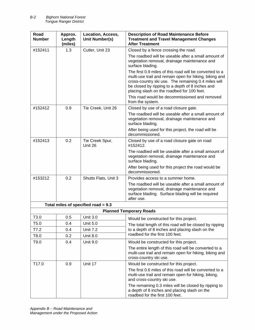
B-2 Bighorn National Forest Tongue Ranger District
Appendix B – Road Maintenance and Management under the Proposed Action
Road Number
Approx. Length (miles)
Location, Access, Unit Number(s)
Description of Road Maintenance Before Treatment and Travel Management Changes After Treatment
#152411 1.3 Cutler, Unit 23 Closed by a fence crossing the road.
The roadbed will be useable after a small amount of vegetation removal, drainage maintenance and surface blading.
The first 0.9 miles of this road will be converted to a multi-use trail and remain open for hiking, biking and cross-country ski use. The remaining 0.4 miles will be closed by ripping to a depth of 8 inches and placing slash on the roadbed for 100 feet.
This road would be decommissioned and removed from the system.
#152412 0.9 Tie Creek, Unit 26 Closed by use of a road closure gate.
The roadbed will be useable after a small amount of vegetation removal, drainage maintenance and surface blading.
After being used for this project, the road will be decommissioned.
#152413 0.2 Tie Creek Spur, Unit 26
Closed by use of a road closure gate on road #152412.
The roadbed will be useable after a small amount of vegetation removal, drainage maintenance and surface blading.
After being used for this project the road would be decommissioned.
#153212 0.2 Shutts Flats, Unit 3 Provides access to a summer home.
The roadbed will be useable after a small amount of vegetation removal, drainage maintenance and surface blading. Surface blading will be required after use.
Total miles of specified road = 9.3
Planned Temporary Roads
T3.0 0.5 Unit 3.0 Would be constructed for this project.
The total length of this road will be closed by ripping to a depth of 8 inches and placing slash on the roadbed for the first 100 feet.
T5.0 0.4 Unit 5.0
T7.2 0.4 Unit 7.2
T8.0 0.2 Unit 8.0
T9.0 0.4 Unit 9.0 Would be constructed for this project.
The entire length of this road will be converted to a multi-use trail and remain open for hiking, biking and cross-country ski use.
T17.0 0.9 Unit 17 Would be constructed for this project.
The first 0.6 miles of this road will be converted to a multi-use trail and remain open for hiking, biking, and cross-country ski use.
The remaining 0.3 miles will be closed by ripping to a depth of 8 inches and placing slash on the roadbed for the first 100 feet.

Environmental Assessment for the B-3 Johnson Creek Vegetation Management Project
Appendix B – Road Maintenance and Management under the Proposed Action
Road Number
Approx. Length (miles)
Location, Access, Unit Number(s)
Description of Road Maintenance Before Treatment and Travel Management Changes After Treatment
T19.1 0.8 Unit 19.1 Would be constructed for this project.
The first 0.6 miles of this road will be converted to a multi-use trail and remain open for hiking, biking and cross-country ski use.
The remaining 0.2 miles will be closed by ripping to a depth of 8 inches and placing slash on the roadbed for the first 100 feet.
T25 0.5 Unit 25 Would be constructed for this project.
The total length of this road will be closed by ripping to a depth of 8 inches and placing slash on the roadbed for the first 100 feet.
T29 0.2 Unit 29
TS3 0.2 Unit S3 Would be constructed for this project.
The total length of this road will be converted to a multi-use trail and remain open for hiking, biking and cross-country ski use.
Total miles of temporary road = 4.5
Definitions Closed Road – An intermittent service road in Maintenance Level 1 that is closed to all vehicular traffic for more than 1 year. The closure may be ordered [by administrative action] under 36 CFR 261(forest plan EIS appendix G, page G-7).
Decommission – Removal of a road from the forest transportation road system. This may include ripping and seeding of the roadbed, recontouring of cut and fill slopes to return the road to original ground contours, or restoration of original drainage patterns. This action eliminates the deferred maintenance needs for the asset. Decommissioning is done to travelways that are no longer needed for resource management. Portions of an asset or component may remain if they do not cause resource problems or require maintenance. Decommissioning includes meeting the following objective s as a minimum:
Motorized access is signed closed and/or access is physically blocked.
The road is hydrologically self-maintaining.
The road prism is revegetated.
Slopes are stabilized (forest plan EIS appendix G, page G-12).
In addition to the minimum requirements for decommissioning above, see Chapter 2 design criteria 8 for details on decommissioning in this project.

#*
#*
#*
#*
#*#*#*
#*
#*
#*
#*
#*
#*
#*
#*
#*
#*
#*
#*
#*
#*
#*
#*""
" "" "
"""
"
"
"
""
""
"
"
"
"
"
"
"
"
"
" "
"
"
""
"
""
"
"
"
"
"
"
"
"
"
"
"
"
"
"
S3
£¤14£¤14
FR 194
FR 193
FR 189
FR 188
FR 190FR 191
F R 195
FR 1 9
6FR 928
FR 970
FR 984
FR 152411
FR 152412
FR 152413
FR 153212
T 3.0
T 5.0T 9.0
T 17.0
T 19.1 T 25.0
FR 153313
FR 192
Trail C
T 29.0
T 7.2
T 8.0
T S3
CUTLERT.H.
SHUTTSFLATS
T.H.
Trail C
Trail P
Trail F
Trail C
Travel Management Areas - S5Closed to motorized vehicles,including snowmobiles, from
Dec. 1 - May 1
S2
S4
S3
S1Treatment Units
" Recreation Residences#* Recreation Sites
Proposed Ski TrailsExisting Ski TrailsSnowmobile TrailTrailsTemporary RoadsRoadHwy 14Highway 14 RerouteTravel ManagementArea – S5Non-FS LandsProject Area Boundary
T:\FS\NFS\Bighorn\Project\2410JohnsonCreek\GIS\Projects\JohnsonCreekTravelmanagement.mxdO:\NFS\Bighorn\Project\2410JohnsonCreek\GIS\Maps\JohnsonCreekTravelManagement20110106.pdf
NAD83 utm13 06Jan2011 amo
Appendix C: Johnson CreekVegetation Management EA
Roads & Trails MapTongue Ranger District
Bighorn National ForestSkull Ridge quad.
T 55 & 56N R 88W
ProjectArea
Bighorn National Forest
£¤14
£¤14A
£¤16
DaytonSheridan
Ranchester
Shell
BuffaloCloud PeakWilderness
0 1 20.5 Miles1:28,000
¹Disclaimer:The Forest Service uses the most current and complete data it has availableGIS data and product accuracy may vary. They may be developed fromsources of differing accuracy, accurate only at certain scales , based onmodeling or interpretation, incomplete while being created or revised,have represented features not in accurate geographic locations , etc. TheForest Serv ice makes no expressed or implied warranty, including warrantyof merchantability and f itness, with respect to the character, func tion, orcapabilities of the data or their appropriateness for any user’s purposes. TheForest Serv ice reserves the right to correc t, update, modify, or replace thisgeospatial information without not ificat ion. For more information, contactthe Bighorn National Fores t Superv isor’s Off ice (2013 Eas tside SecondStreet, Sheridan, WY 82801, 307-674-2600).
Sibley Ski Trail System
Cutler Ski Trail System

Environmental Assessment for the D-1 Johnson Creek Vegetation Management Project
Appendix D – Soil Types in the Project Area
Appendix D: Soil Types in the Project Area Map of soil types in the project area, identifying sensitive soils (16, 29, and 43) in relation to proposed ski
trails, temporary roads, and vegetation management treatment units.