Appendix 2 - Coastal Natural Character Schedule of Values
104
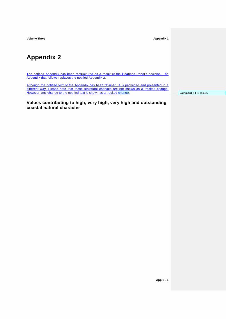
Volume Three Appendix 2 App 2 - 1 Appendix 2 The notified Appendix has been restructured as a result of the Hearings Panel’s decision. The Appendix that follows replaces the notified Appendix 2. Although the notified text of the Appendix has been retained, it is packaged and presented in a different way. Please note that these structural changes are not shown as a tracked change. However, any change to the notified text is shown as a tracked change. Values contributing to high, very high, very high and outstanding coastal natural character Comment [ 1]: Topic 5
Transcript of Appendix 2 - Coastal Natural Character Schedule of Values
Volume Three Appendix 2
App 2 - 1
Appendix 2
The notified Appendix has been restructured as a result of the Hearings Panel’s decision. The Appendix that follows replaces the notified Appendix 2.
Although the notified text of the Appendix has been retained, it is packaged and presented in a different way. Please note that these structural changes are not shown as a tracked change. However, any change to the notified text is shown as a tracked change.
Values contributing to high, very high, very high and outstanding coastal natural character
Comment [ 1]: Topic 5
Appendix 2 Volume Three
App 2 - 2
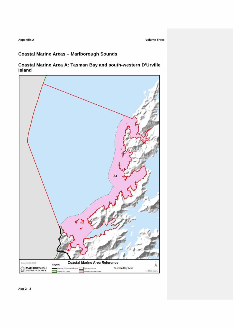
Coastal Marine Areas – Marlborough Sounds
Coastal Marine Area A: Tasman Bay and south-western D’Urville Island
Volume Three Appendix 2
App 2 - 3
Map Reference
Sub Area Key ValuesCharacteristics1 Additional Comments and noted modifications
A1 Outer Croisilles Harbour – south western D’Urville Island
Largely unmodified near-shore coastal marine environment ranging from semi-sheltered to very sheltered shores. Very High levels of natural character throughout this area.
− Whangarae Estuary. − Subtidal sand flat and boulder bank
habitats/ communities at the mouth of Croisilles Harbour. High flow habitats associated with Current Basin and Te Aumiti/French Pass.
− Greville Harbour/Wharariki and associated communities.
− D’Urville Island Scenic Reserve. − Offshore islands (Croisilles Harbour and
rocky outcrops (e.g. Paddock Rocks). − Adjoins Coastal Marine Area B.
Outstanding Natural Character overlays apply to this sub-area. Refer to Table ONC1, ONC2 and ONC6, and accompanying Maps for further information.
Excludes Squally Cove, which has numerous marine farms.
Includes a small number of marine farms in two small bays in Current Basin.
Certain offshore areas in Tasman Bay are commercially trawled
1 High natural character attributes characteristics will exist in all areas, but some areas will also contain very high natural character attributes characteristics as described in this column.
Appendix 2 Volume Three
App 2 - 4
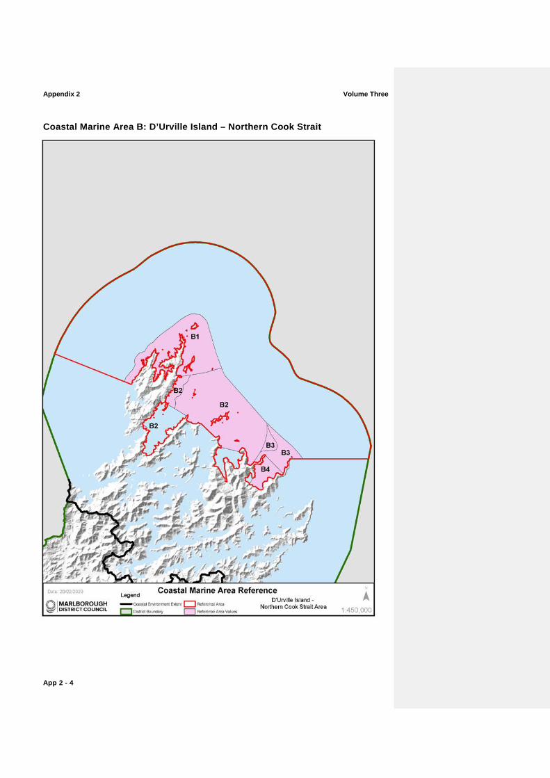
Coastal Marine Area B: D’Urville Island – Northern Cook Strait

Volume Three Appendix 2
App 2 - 5
Map Reference
Sub Area Key CharacteristicsValues Additional Comments and noted modifications
B1 Western D’Urville Island – Rangitoto Islands
Largely unmodified and highly diverse near-shore coastal marine environment ranging from very exposed to very sheltered shores. Very High levels of natural character.
− Diverse rocky reef communities. − High current habitats including areas
dominated by bryozoan corals. − Port Hardy and associated sheltered
Sounds communities. − D’Urville Island Scenic Reserve. − Several offshore islands and rock
stacks including Stephen’s Island, the Rangitoto Islands and Jag Rocks.
− Adjoins Coastal Marine Area A.
Outstanding Natural Character overlays apply to this sub-area. Refer to Table ONC1 and ONC3 and accompanying Maps for further information.
One small marine farm in Port Hardy, which expires in 2024.
Certain offshore areas in Tasman Bay and Cook Strait are commercially trawled.
B2 Eastern D’Urville Island – Waitui Bay
Near-shore areas, including around the Trio Islands, Chetwode Islands and Titi Island, retain high natural characteristicsvalues.
− Variable exposure. − Numerous ecologically significant
marine sites. − D’Urville Island Scenic Reserve;
Chetwode Island Nature Reserve; Titi Island Nature Reserve.
− High flow habitats associated with Current Basin and Te Aumiti/French Pass retain very high levels of natural character.
Outstanding Natural Character overlays apply to this sub-area. Refer to Table ONC3 and ONC4 and accompanying Maps for further information.
Offshore banks between the island groups are commercially trawled, in places relatively intensively.
Some commercial scallop dredging in Waitui Bay and northwest of Nukuwaiata Island.
B3 Cape Lambert – Cape Jackson
Largely unmodified section of coast with exposed rocky bluffs, headlands and reefs. Very High levels of natural character.
− Cape Lambert Scenic Reserve. − Adjoins Coastal Marine Area G at
Cape Jackson.
An Outstanding Natural Character overlay applies to this sub-area. Refer to Table ONC9 and accompanying Maps for further information.
Some commercial trawling offshore.
Offshore areas in Waitui Bay are commercially dredged for scallops.
Appendix 2 Volume Three
App 2 - 6
Map Reference
Sub Area Key CharacteristicsValues Additional Comments and noted modifications
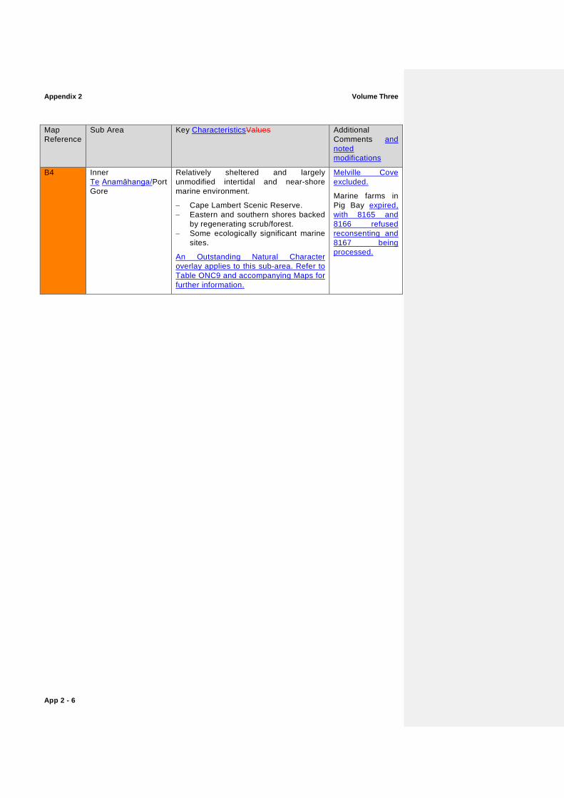
B4 Inner Te Anamāhanga/Port Gore
Relatively sheltered and largely unmodified intertidal and near-shore marine environment.
− Cape Lambert Scenic Reserve. − Eastern and southern shores backed
by regenerating scrub/forest. − Some ecologically significant marine
sites.
An Outstanding Natural Character overlay applies to this sub-area. Refer to Table ONC9 and accompanying Maps for further information.
Melville Cove excluded.
Marine farms in Pig Bay expired, with 8165 and 8166 refused reconsenting and 8167 being processed.

Volume Three Appendix 2
App 2 - 7
Appendix 2 Volume Three
App 2 - 8
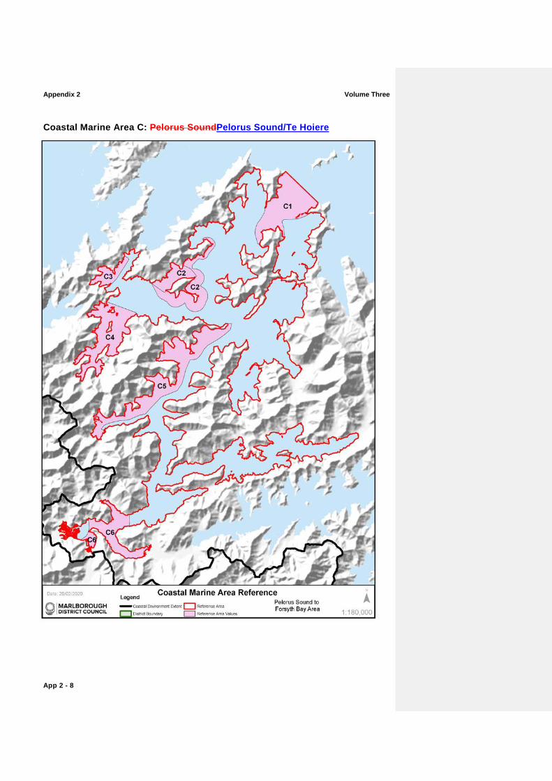
Coastal Marine Area C: Pelorus SoundPelorus Sound/Te Hoiere
Volume Three Appendix 2
App 2 - 9
Map Reference
Sub Area Key CharacteristicsValues Additional Comments and noted modifications
C1 Pelorus Heads Largely unmodified section of coast extending into the entrance of Pelorus SoundPelorus Sound/Te Hoiere to Kaitira and Te Akaroa.
− High current communities flanking the main channels.
− Includes the offshore main channel entering Pelorus SoundPelorus Sound/Te Hoiere.
− Duffers Reef including its associated king shag nesting sites.
− Adjoins Coastal Marine Area B.
Some marine farming north of Te Akaroa.
C2 Maud Island to Yellow Cliffs, including Apuau Channel
Near-shore areas and much of Apuau Channel, including Waiona Bay, retain high natural valuescharacteristics.
Sheltered indented coastline with multiple aspects.
Apuau Channel, with its deep channel habitats and moderate currents, separates Maud Island from the mainland.
− Tom Shand Scientific Reserve (Maud Island) and Deep Bay Scenic Reserve on the opposite mainland. separated by Apuau Channel.
An Outstanding Natural Character overlay applies to this sub-area. Refer to Table ONC7 and accompanying Maps for further information.
Commercial scallop dredging in Tawhitinui Reach and Waitata Reach, but mostly absent between Maud Island and the mainland.
Three marine farms near Treble Tree approved refused for the culture of sponges and seaweeds with limited effect on seabed valuescharacteristics
C3 Fitzroy Bay and western Hallam Cove
Near-shore and offshore waters mostly unmodified.
− Backed by Garne and Savill Bay Scenic Reserve.
− Elephant fish spawning grounds close to shore.
Two mussel-spat marine farms.
C4 Tennyson Inlet The largest marine area in Marlborough surrounded by protected native forest, holding very high levels of natural character.
- Largely unmodified, very sheltered inner-Sounds marine environment.
- Low natural diversity. - Convoluted shoreline with three small
offshore islands. - Three small estuaries. − Several scenic reserves.
An Outstanding Natural Character overlay applies to this sub-area. Refer to Table ONC8 and accompanying Maps for further information.
Moorings and a small port area are located in Elaine Bay. A number of moorings are also present in Penzance Bay.
Appendix 2 Volume Three
App 2 - 10
Map Reference
Sub Area Key CharacteristicsValues Additional Comments and noted modifications
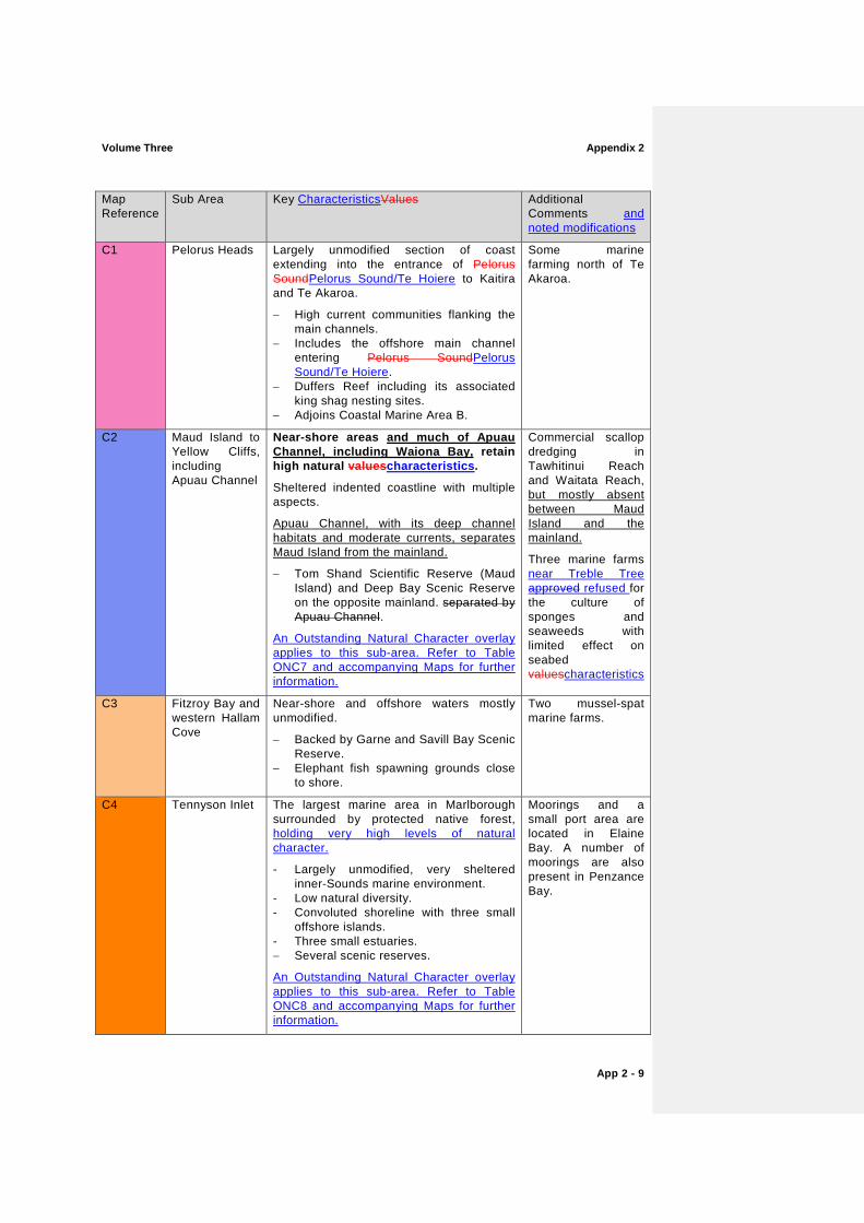
C5 Nydia Bay – Tawero Point
Largely unmodified section of coast extending over many kilometres from the head of Nydia Bay along the western side of Pelorus SoundPelorus Sound/Te Hoiere to Tawero Point holding very high levels of natural character.
- Several small bays. - Mostly sheltered but exposed to a wide
range of tidal flow conditions including high flow communities.
- Large sections of this coast are backed by scenic reserves.
An Outstanding Natural Character overlay applies to this sub-area. Refer to Table ONC8 and accompanying Maps for further information.
Two small areas of mussel farms (Fairy Bay and west of Tawero Point).
A number of moorings, jetties, boatsheds and private residences located within Fairy Bay and North West Bay.
C6 Pelorus/Kaituna Estuary – Mahakipawa Arm – Kaiuma Bay
The largest estuarine area in the Marlborough Sounds. Natural processes within the estuary are largely intact.
- Extensive saltmarsh beds, intertidal mud flats and other estuarine communities.
- Diverse avifauna. - Despite modifications around parts of
its perimeter, this large estuarine complex retains many of its natural qualities.
An Outstanding Natural Character overlay applies to this sub-area. Refer to Table ONC13 and accompanying Maps for further information.
Excludes Port Havelock.
Water quality modified by discharges, port activities and river inputs.
Partly modified margins due to the port, an oyster farm, roading and agriculture.

Volume Three Appendix 2
App 2 - 11
Appendix 2 Volume Three
App 2 - 12
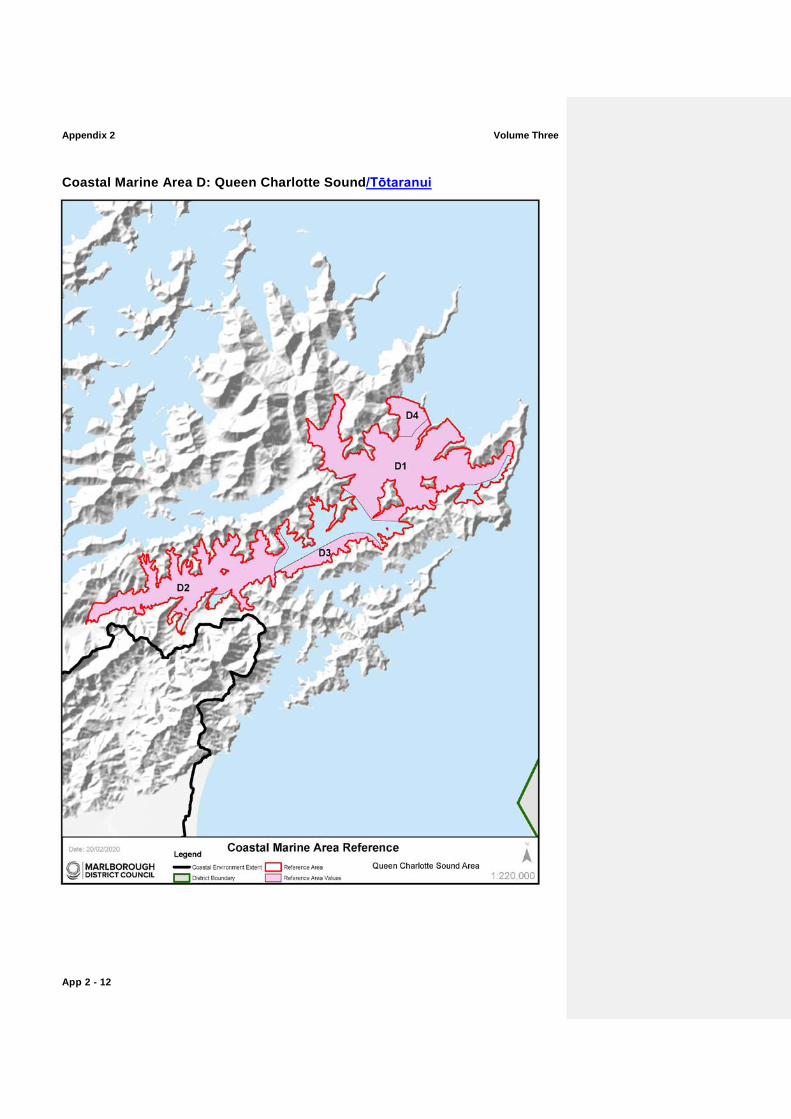
Coastal Marine Area D: Queen Charlotte Sound/Tōtaranui
Volume Three Appendix 2
App 2 - 13
Map Reference
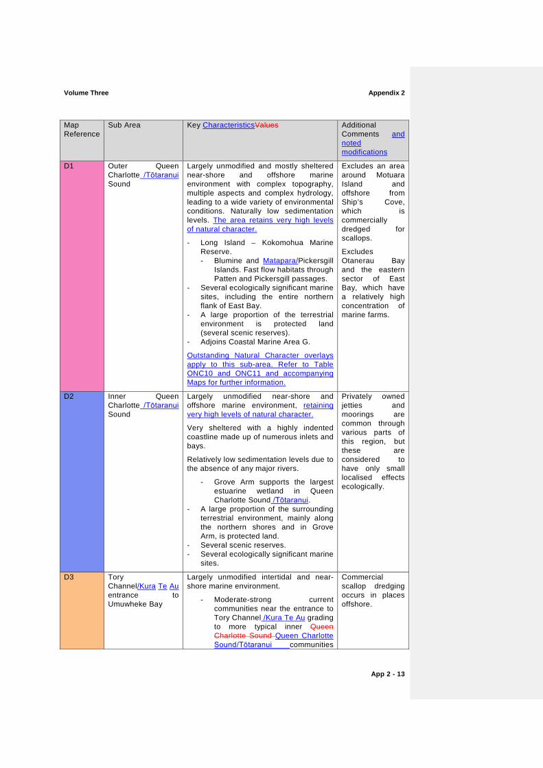
Sub Area Key CharacteristicsValues Additional Comments and noted modifications
D1 Outer Queen Charlotte /Tōtaranui Sound
Largely unmodified and mostly sheltered near-shore and offshore marine environment with complex topography, multiple aspects and complex hydrology, leading to a wide variety of environmental conditions. Naturally low sedimentation levels. The area retains very high levels of natural character.
- Long Island – Kokomohua Marine Reserve. - Blumine and Matapara/Pickersgill
Islands. Fast flow habitats through Patten and Pickersgill passages.
- Several ecologically significant marine sites, including the entire northern flank of East Bay.
- A large proportion of the terrestrial environment is protected land (several scenic reserves).
- Adjoins Coastal Marine Area G.
Outstanding Natural Character overlays apply to this sub-area. Refer to Table ONC10 and ONC11 and accompanying Maps for further information.
Excludes an area around Motuara Island and offshore from Ship’s Cove, which is commercially dredged for scallops.
Excludes Otanerau Bay and the eastern sector of East Bay, which have a relatively high concentration of marine farms.
D2 Inner Queen Charlotte /Tōtaranui Sound
Largely unmodified near-shore and offshore marine environment, retaining very high levels of natural character.
Very sheltered with a highly indented coastline made up of numerous inlets and bays.
Relatively low sedimentation levels due to the absence of any major rivers.
- Grove Arm supports the largest estuarine wetland in Queen Charlotte Sound /Tōtaranui.
- A large proportion of the surrounding terrestrial environment, mainly along the northern shores and in Grove Arm, is protected land.
- Several scenic reserves. - Several ecologically significant marine
sites.
Privately owned jetties and moorings are common through various parts of this region, but these are considered to have only small localised effects ecologically.
D3 Tory Channel/Kura Te Au entrance to Umuwheke Bay
Largely unmodified intertidal and near-shore marine environment.
- Moderate-strong current communities near the entrance to Tory Channel /Kura Te Au grading to more typical inner Queen Charlotte Sound Queen Charlotte Sound/Tōtaranui communities
Commercial scallop dredging occurs in places offshore.
Appendix 2 Volume Three
App 2 - 14
Map Reference
Sub Area Key CharacteristicsValues Additional Comments and noted modifications
with distance away from Tory Channel/Kura Te Au.
- Backed by regenerating scrub/forest and scenic reserve in places.
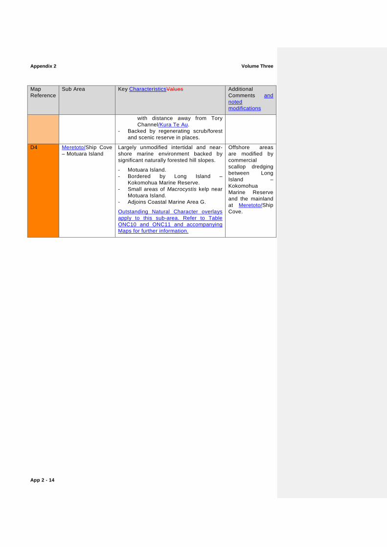
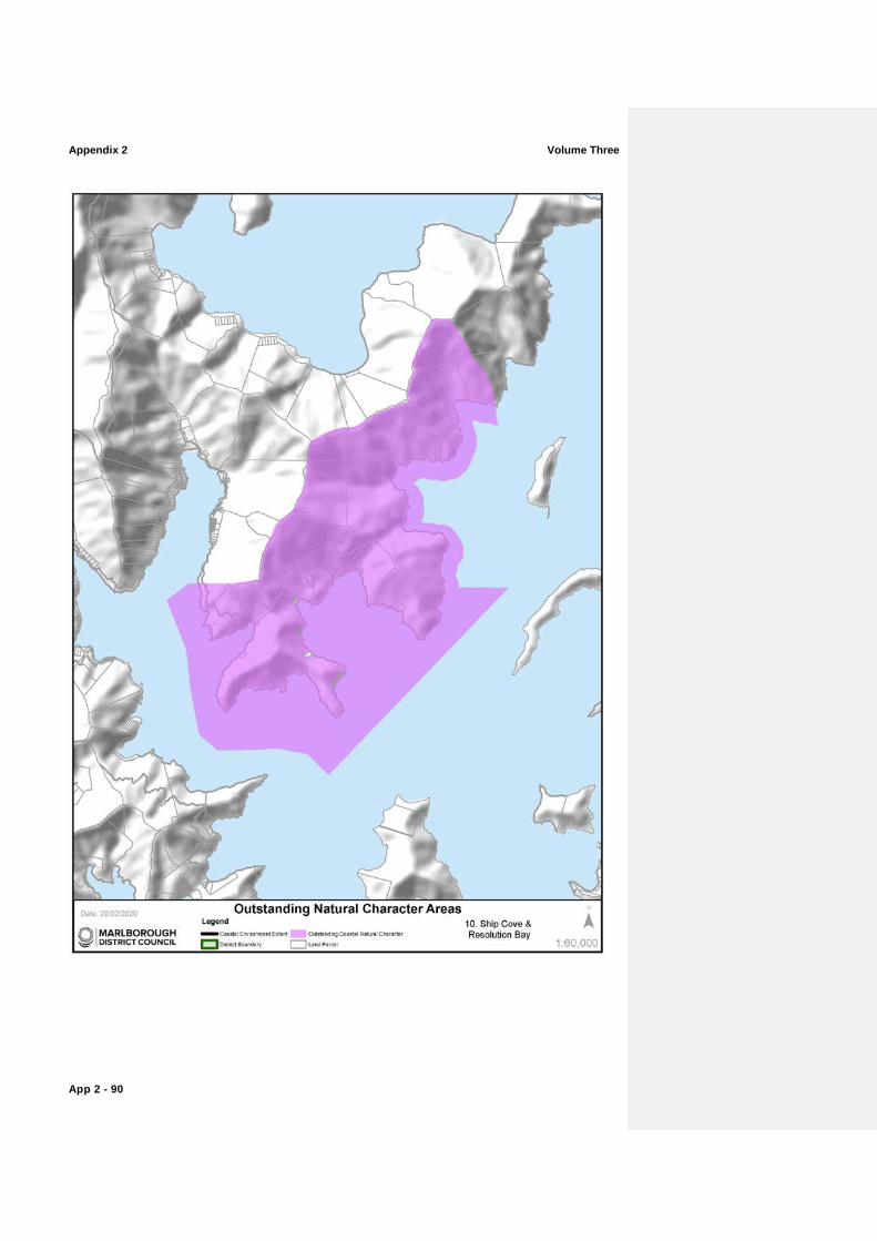
D4 Meretoto/Ship Cove – Motuara Island
Largely unmodified intertidal and near-shore marine environment backed by significant naturally forested hill slopes.
- Motuara Island. - Bordered by Long Island –
Kokomohua Marine Reserve. - Small areas of Macrocystis kelp near
Motuara Island. - Adjoins Coastal Marine Area G.
Outstanding Natural Character overlays apply to this sub-area. Refer to Table ONC10 and ONC11 and accompanying Maps for further information.
Offshore areas are modified by commercial scallop dredging between Long Island – Kokomohua Marine Reserve and the mainland at Meretoto/Ship Cove.

Volume Three Appendix 2
App 2 - 15
Appendix 2 Volume Three
App 2 - 16
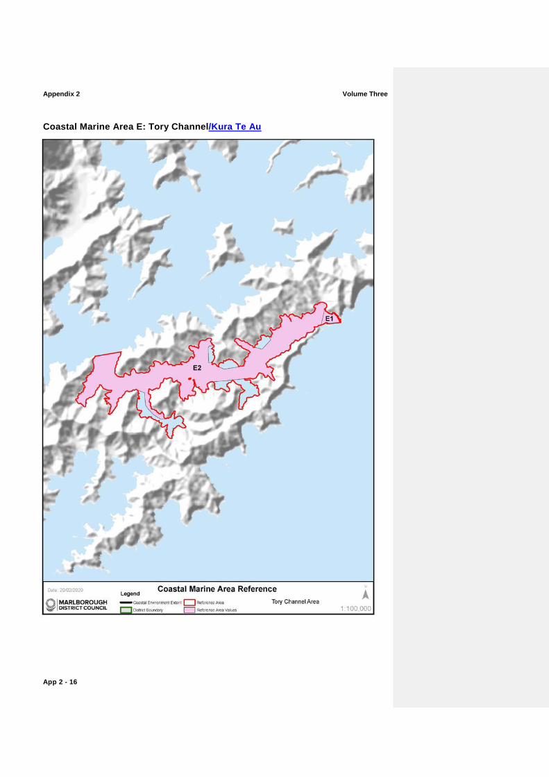
Coastal Marine Area E: Tory Channel/Kura Te Au
Volume Three Appendix 2
App 2 - 17
Map Reference
Sub Area Key CharacteristicsValues Additional Comments and noted modifications
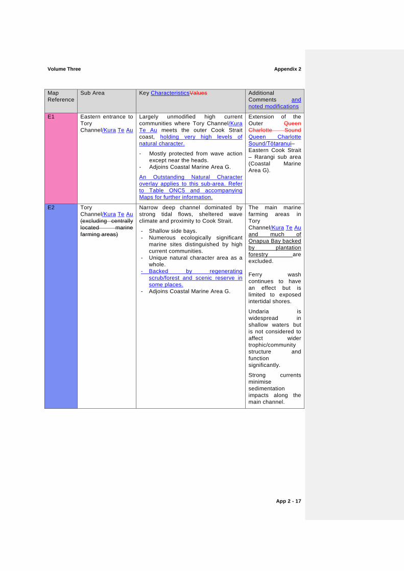
E1 Eastern entrance to Tory Channel/Kura Te Au
Largely unmodified high current communities where Tory Channel/Kura Te Au meets the outer Cook Strait coast, holding very high levels of natural character.
- Mostly protected from wave action except near the heads.
- Adjoins Coastal Marine Area G.
An Outstanding Natural Character overlay applies to this sub-area. Refer to Table ONC5 and accompanying Maps for further information.
Extension of the Outer Queen Charlotte Sound Queen Charlotte Sound/Tōtaranui– Eastern Cook Strait – Rarangi sub area (Coastal Marine Area G).
E2 Tory Channel/Kura Te Au (excluding centrally located marine farming areas)
Narrow deep channel dominated by strong tidal flows, sheltered wave climate and proximity to Cook Strait.
- Shallow side bays. - Numerous ecologically significant
marine sites distinguished by high current communities.
- Unique natural character area as a whole.
- Backed by regenerating scrub/forest and scenic reserve in some places.
- Adjoins Coastal Marine Area G.
The main marine farming areas in Tory Channel/Kura Te Au and much of Onapua Bay backed by plantation forestry are excluded.
Ferry wash continues to have an effect but is limited to exposed intertidal shores.
Undaria is widespread in shallow waters but is not considered to affect wider trophic/community structure and function significantly.
Strong currents minimise sedimentation impacts along the main channel.
Appendix 2 Volume Three
App 2 - 18
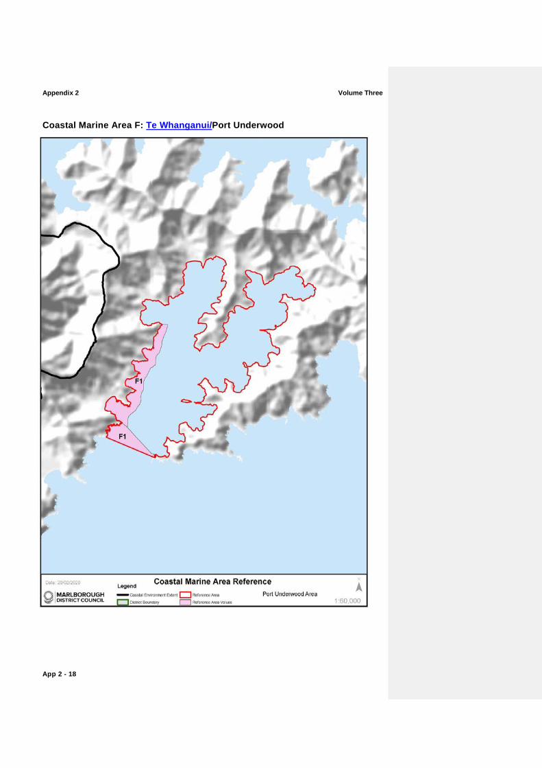
Coastal Marine Area F: Te Whanganui/Port Underwood

Volume Three Appendix 2
App 2 - 19
Map Reference
Sub Area Key CharacteristicsValues Additional Comments and noted modifications
F1 Ocean Bay to Willawa Point
Largely undeveloped semi-exposed rocky coast.
Influenced by southerly swells and periods of relatively high sedimentation, especially when the Wairau River floods.
Reef communities, including a range of macroalgae, fringe the shoreline.
This area is one of the least modified areas of Te Whanganui/Port Underwood. Aquaculture is absent.
The adjacent terrestrial environment retains a mosaic of land use activities, ranging from forestry and pasture to areas of regenerating scrub and bush. Much of the coastal fringe seawards of the Te Whanganui/Port Underwood Road is regenerating scrub.
This section of coast is continuous with a similar but more exposed rocky coast from Ocean Bay to Rarangi.
Adjoins Coastal Marine Area G.
Trawling offshore through parts of Te Whanganui/Port Underwood.
Despite episodic high levels of sedimentation, moderate-strong wave action will mitigate adverse effects close to shore through resuspension and dispersal of sediments.
Appendix 2 Volume Three
App 2 - 20
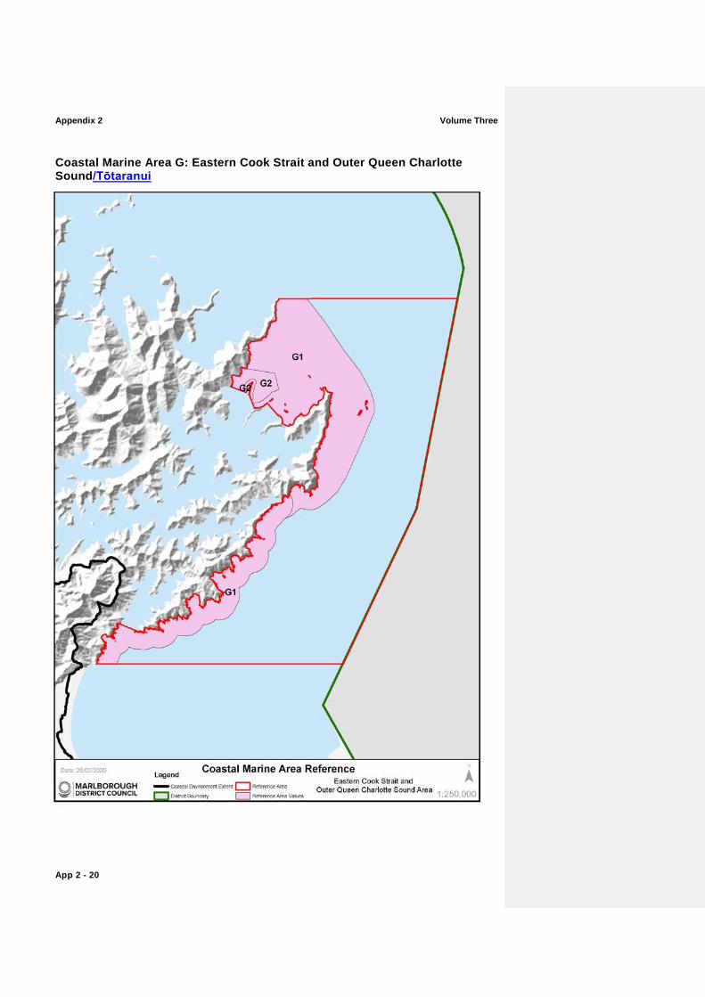
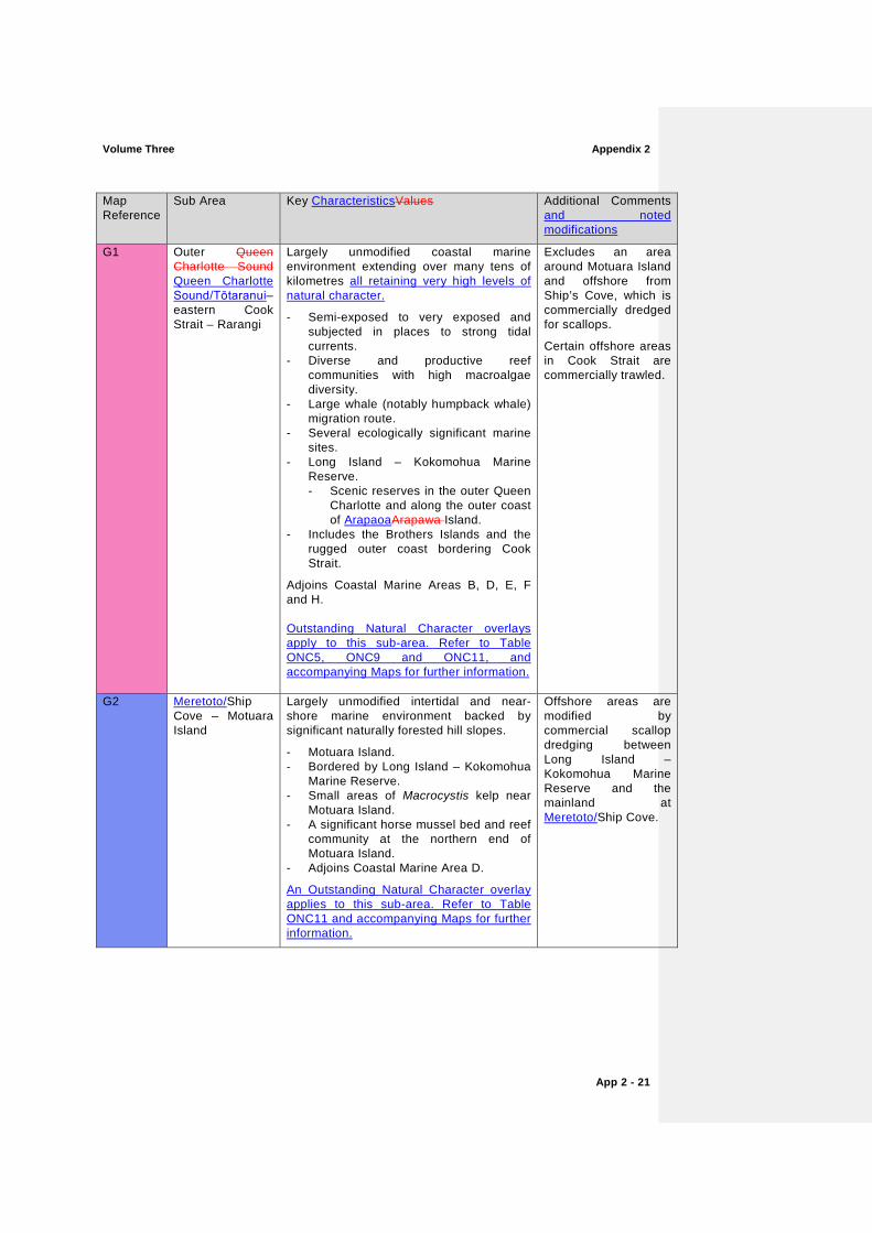
Coastal Marine Area G: Eastern Cook Strait and Outer Queen Charlotte Sound/Tōtaranui
Volume Three Appendix 2
App 2 - 21
Map Reference
Sub Area Key CharacteristicsValues Additional Comments and noted modifications
G1 Outer Queen Charlotte Sound Queen Charlotte Sound/Tōtaranui– eastern Cook Strait – Rarangi
Largely unmodified coastal marine environment extending over many tens of kilometres all retaining very high levels of natural character.
- Semi-exposed to very exposed and subjected in places to strong tidal currents.
- Diverse and productive reef communities with high macroalgae diversity.
- Large whale (notably humpback whale) migration route.
- Several ecologically significant marine sites.
- Long Island – Kokomohua Marine Reserve. - Scenic reserves in the outer Queen
Charlotte and along the outer coast of ArapaoaArapawa Island.
- Includes the Brothers Islands and the rugged outer coast bordering Cook Strait.
Adjoins Coastal Marine Areas B, D, E, F and H.
Outstanding Natural Character overlays apply to this sub-area. Refer to Table ONC5, ONC9 and ONC11, and accompanying Maps for further information.
Excludes an area around Motuara Island and offshore from Ship’s Cove, which is commercially dredged for scallops.
Certain offshore areas in Cook Strait are commercially trawled.
G2 Meretoto/Ship Cove – Motuara Island
Largely unmodified intertidal and near-shore marine environment backed by significant naturally forested hill slopes.
- Motuara Island. - Bordered by Long Island – Kokomohua
Marine Reserve. - Small areas of Macrocystis kelp near
Motuara Island. - A significant horse mussel bed and reef
community at the northern end of Motuara Island.
- Adjoins Coastal Marine Area D.
An Outstanding Natural Character overlay applies to this sub-area. Refer to Table ONC11 and accompanying Maps for further information.
Offshore areas are modified by commercial scallop dredging between Long Island – Kokomohua Marine Reserve and the mainland at Meretoto/Ship Cove.
Appendix 2 Volume Three
App 2 - 22
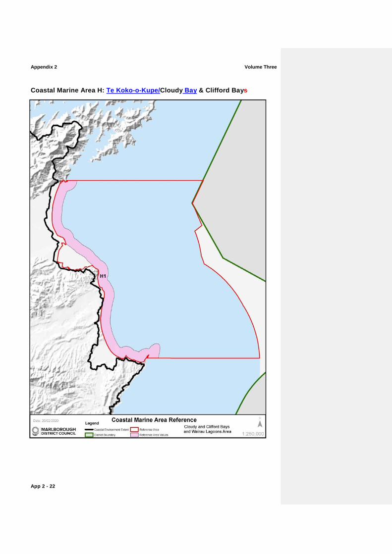
Coastal Marine Area H: Te Koko-o-Kupe/Cloudy Bay & Clifford Bays
Volume Three Appendix 2
App 2 - 23
Map Reference
Sub Area Key CharacteristicsValues Additional Comments and noted modifications
H1 Cloudy and Clifford Bays and (inexcluding Wairau Lagoons and Lake Grassmere/ Kapara Te Hau).
Largely unmodified and mostly exposed east coast South Island coastal environment extending over tens of kilometres from Rarangi to Cape Campbell. Very High levels of natural character.
Extensive sand/gravel shores.
Cape Campbell reef systems and patchy offshore Macrocystis beds.
Adjoins Coastal Marine Areas G and I.
High Remote values attributes.
Outstanding Natural Character overlays apply to this sub-area. Refer to Table ONC14 and ONC15 and accompanying Maps for further information.
Certain offshore areas are commercially trawled; those grounds closer to shore are expected to be reasonably resilient to the effects of trawling.
Effects of the Blenheim sewage discharge on the outer coast are considered minor.
A large marine farm approved granted south of the Awatere River mouth, which will alter seabed values at the site once it becomes operational, is excluded.
H2 Wairau Lagoons
Large tidal lagoons and extensive salt marsh beds.
- Diverse avifauna.
- An ecologically significant marine site.
- Despite modifications, this large estuarine complex retains many of its natural qualities. –
High remote valuesattributes.
.An Outstanding Natural Character overlay applies to this sub-area. Refer to Table ONC14 and accompanying Maps for further information
The estuary has been modified through historic stop-banking and alterations to river flows.
The Blenheim sewage outfall discharges into the mouth of the Wairau River on the outgoing tide.
Appendix 2 Volume Three
App 2 - 24
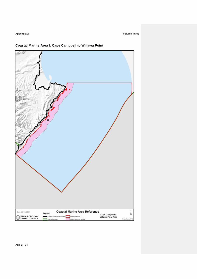
Coastal Marine Area I: Cape Campbell to Willawa Point
Volume Three Appendix 2
App 2 - 25
Map Reference
Sub Area Key CharacteristicsValues Additional Comments and noted modifications
I1 Cape Campbell to Willawa Point
Largely unmodified and very exposed east coast South Island coastal environment extending south from Cape Campbell. Very High levels of natural character.
- Prominent reef areas in the north (including Cape Campbell) giving way to extensive sand/gravel shores in the south.
- Large offshore Macrocystis beds.
- Adjoins Coastal Marine Area H at Cape Campbell.
- High remote valuesattributes.
Outstanding Natural Character overlays apply to this sub-area. Refer to Table ONC15 and ONC16 and accompanying Maps for further information.
Certain offshore areas are commercially trawled; inshore areas are expected to be reasonably resilient to the effects of trawling.
Appendix 2 Volume Three
App 2 - 26
Terrestrial Areas – Marlborough Sounds
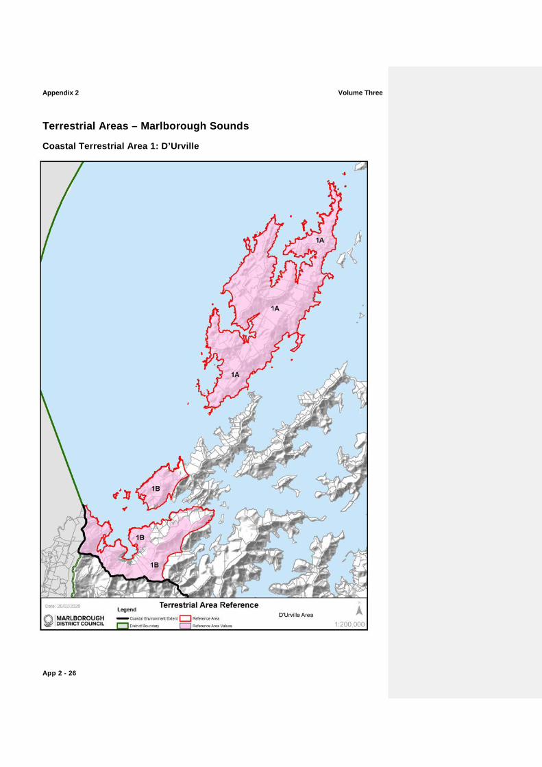
Coastal Terrestrial Area 1: D’Urville
Volume Three Appendix 2
App 2 - 27
Map Reference
Sub Area Key CharacteristicsValues Additional Comments and noted modifications
1A D’Urville Island
This area is characterised by a unique combination of ultramafic dominated basement rock types. The sheltered coastal lagoons are regionally rare.
Upland vegetation is largely intact holding very high biotic valuescharacteristics.
Nationally important geological and landform features including Greville Harbour/Wharariki boulder spit; and serpentinitic breccias along parts of western coast. It contains regionally important landforms including: the Greville Harbour/Wharariki barrier dune system, and associated lagoon and swamp; Te Aumiti/French Pass partly submerged ridgeline and reef; and the D’Urville Island limestone outcrops.
Island communities here are nationally important with distinctive biota, communities and habitats. Some communities, especially tussocklands, rocklands, shrublands and stunted forests are endemic to the ultramafic “mineral belt” and nationally important, with the coastal ultramafic communities, being unique in New Zealand. Also present are dune, spit, beach, lagoon, freshwater wetland, estuarine and alluvial communities, which are all very distinctive and rare in the Sounds. Overall, natural biodiversity of communities and species is exceptional, holding very high biotic and abiotic valuescharacteristics.
D’Urville Island is a refuge for nationally threatened fauna and flora. It is one of the largest areas that is free of possums and feral goats in New Zealand.
The entire island holds very high levels of natural character, apart from three areas which rate as high natural character. These three areas are associated with the northern peninsula (north of Massacre Bay and Deserter Bay), the slopes close to Catherine Cove, and parts of the southern island (including Mitikarukaru, Owhata and Ohana) where tracks, regenerating scrub, groups of buildings, grazing and commercial forestry lots reduce natural character to high.
D’Urville Island and its smaller islands hold extremely very high experiential valuesattributes, partially due to its semi-remoteness and dark, night-time skies, but equally due to its perceived lack of modification.
Areas of pasture, regenerating scrub, tracks, groups of buildings and commercial forestry lots included within 'High' rating. These three areas are associated with the northern peninsula (north of Massacre Bay and Deserter Bay), the slopes close to Catherine Cove, and parts of the southern island (including Mitikarukaru, Owhata and Ohana).
Appendix 2 Volume Three
App 2 - 28
Map Reference
Sub Area Key CharacteristicsValues Additional Comments and noted modifications
Outstanding Natural Character overlays apply to this sub-area. Refer to Table ONC1, ONC2 and ONC3 and accompanying Maps for further information.
1B Croisilles Harbour Area(including the slopes from Cape Soucis eastwards to Elliott Peak/ Editor Hill, Matapehe and Mt McLaren and the northern headland and slopes around Askews Hill). This area also includes the islands of Motuanauru, Otuhaereroa and Moukirikiri.
This area is characterised by a unique combination of ultramafic dominated basement rock types. The sheltered coastal lagoons are regionally rare.
Upland vegetation is largely intact holding very high abiotic and biotic valuescharacteristics, extending from Cape Soucis to Mt. McLaren and around Askews Hill.
Nationally important geological and landform features including Matarau Point beach ridge gravel foreland.
Regionally important landforms including: Pakiaka Point barrier island and lagoon; Taipare and Whangarae limestone outcrops.
Island communities here are nationally important with distinctive biota, communities and habitats. Some mainland communities, especially tussocklands, rocklands, shrublands and stunted forests are endemic to the ultramafic “mineral belt” and nationally important, with the coastal ultramafic communities, being unique in New Zealand. Also present are dune, spit, beach, lagoon, freshwater wetland, estuarine and alluvial communities, which are all very distinctive and rare in the Sounds. Overall, natural biodiversity of communities and species is exceptional holding very high abiotic and biotic valuescharacteristics.
The entire mapped area holds very high levels of natural character, apart from three broad areas which rate as holding high levels of natural character. These includes the north-eastern and south-eastern lower slopes of Askews Hill (around Tunnel Bay and Oyster Bay), small sections of mid and upper slopes of Mt. McLaren (Oparapara – Samson Bay and McLaren Bay) and Symonds Hill where tracks, regenerating scrub and commercial forestry lots reduce natural character to high.
High experiential values attributes throughout these areas due to lack of modification.
Outstanding Natural Character overlays apply to this sub-area. Refer to Table ONC6 and ONC8 and accompanying Maps for further information.
Areas of regenerating scrub, tracks and commercial forestry lots included within 'High' rating. These three areas are associated with the north-eastern and south-eastern lower slopes of Askews Hill (around Tunnel Bay and Oyster Bay), small sections of mid and upper slopes of Mt. McLaren (Oparapara – Samson Bay and McLaren Bay) and Symonds Hill.

Volume Three Appendix 2
App 2 - 29
Appendix 2 Volume Three
App 2 - 30
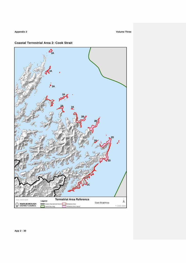
Coastal Terrestrial Area 2: Cook Strait
Volume Three Appendix 2
App 2 - 31
Map Reference
Sub Area Key CharacteristicsValues Additional Comm and noted modificatio
2A Islands of Cook Strait (including Stephens Island; Rangitoto Islands; Nga Kiore (Jag Rocks); Trio Islands (Kuru Pongi); Chetwode Islands; Forsyth Island, Sentinel Rock; Titi Island; White Rocks; Long Island; Kokomohua Islands; The Twins; Motungarara Island; The Brothers)
Island communities are nationally important, with distinct and rare biotic assemblages, which are vulnerable to disturbance and loss and difficult to recover. These are vital habitats for threatened species due to their lack of introduced predators and holds very high abiotic and biotic valuescharacteristics.
Shrublands, herbfields and tussockland communities are nationally important habitats as they are highly distinctive and endemic to Cook Strait.
The Area also supports a nationally high concentration of rare, relictual and endemic fauna, which is vulnerable to predation and/or collection.
The islands and outer peninsulas hold very high experiential values attributes due to the remote, rugged and expansive seascape vistas. The weathered sea-cliffs and hardy vegetation tilted from the wind are characteristic of their exposed maritime position.
Remoteness values amplified through natural darkness of the night sky.
Outstanding Natural Character overlays apply to this sub-area. Refer to Table ONC3, ONC4, ONC 11 and ONC5 and accompanying Maps for further information.
A lighthouse is located on The Brothers northernmost island. A lighthouse, a small cluster of buildings and a track are located on the northern part of Stephens Island.
2B Cape Lambert and Cape Jackson
Exceptional biodiversity at Cape Lambert. Threatened plants, remnant forest and regenerating native vegetation at Cape Jackson with both Capes holding very high levels of abiotic and biotic valuescharacteristics.
Shrublands, herbfields and tussockland communities are nationally important habitats as they are highly distinctive and endemic to Cook Strait.
The islands and outer peninsulas hold very high experiential values attributes due to the remote, rugged and expansive seascape vistas. The weathered sea-cliffs and hardy vegetation tilted from the wind are characteristic of their exposed maritime position.
Remoteness
values amplified through natural darkness of the night sky.
An Outstanding Natural Character overlay
A lighthouse is located off Cape Jackson. A small track (an extension to the Queen Charlotte Track) extends along the Cape Jackson peninsula. A small group of buildings and a powerline are located within Anakakata Bay.
Appendix 2 Volume Three
App 2 - 32
Map Reference
Sub Area Key CharacteristicsValues Additional Comm and noted modificatio
applies to this sub-area. Refer to Table ONC9 and accompanying Maps for further information.
2C Western Cook Strait, Te Whanganui/Port Underwood to Tory Channel/Kura Te Au cliffs (Robertson Point to West Head)
Intricate bluff system between Robertson Point (Te Whanganui/Port Underwood) and Tory Channel/Kura Te Au hold very high levels of natural character.
Regionally important geological features including the Oraumoa/Fighting Bay schist sea cliffs.
The weathered sea-cliffs and hardy vegetation tilted from the wind are characteristic of their exposed maritime position and hold very high levels of natural character.
Remoteness values amplified through natural darkness of the night sky.
Much of the upper slopes beyond the bluffs are commercial forestry.
2D Western Cook Strait, Arapawa Arapaoa Island (East Head to Cape Koamaru and onto Cooper Point)
Towering cliffs and native vegetation sequences of the Cook Strait narrows. Exceptional natural biodiversity holding very high abiotic and biotic valuescharacteristics.
The eastern flanks of Arapawa Arapaoa Island support some of the best remaining examples of Cook Strait mixed broadleaved forests and are nationally important, especially as possum-free environments holding very high biotic and abiotic valuescharacteristics.
High levels of natural character are located where there are greater levels of modification to the biotic aspects of natural character, notably at East Head and the slopes from Cape Koamaru to Cooper Point.
The weathered sea-cliffs and hardy vegetation tilted from the wind are characteristic of their exposed maritime position.
Remoteness values amplified through natural darkness of the night sky.
An Outstanding Natural Character overlay applies to this sub-area. Refer to Table ONC5 and accompanying Maps for further information.
Areas of pasture close to East Head and regenerating slopes from Cape Koamaru to Cooper Point are included within the high natural character rating.

Volume Three Appendix 2
App 2 - 33
Appendix 2 Volume Three
App 2 - 34
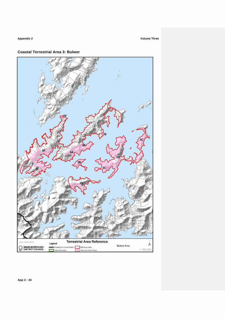
Coastal Terrestrial Area 3: Bulwer
Volume Three Appendix 2
App 2 - 35
Map Reference
Sub Area Key CharacteristicsValues Additional Comments and noted modifications
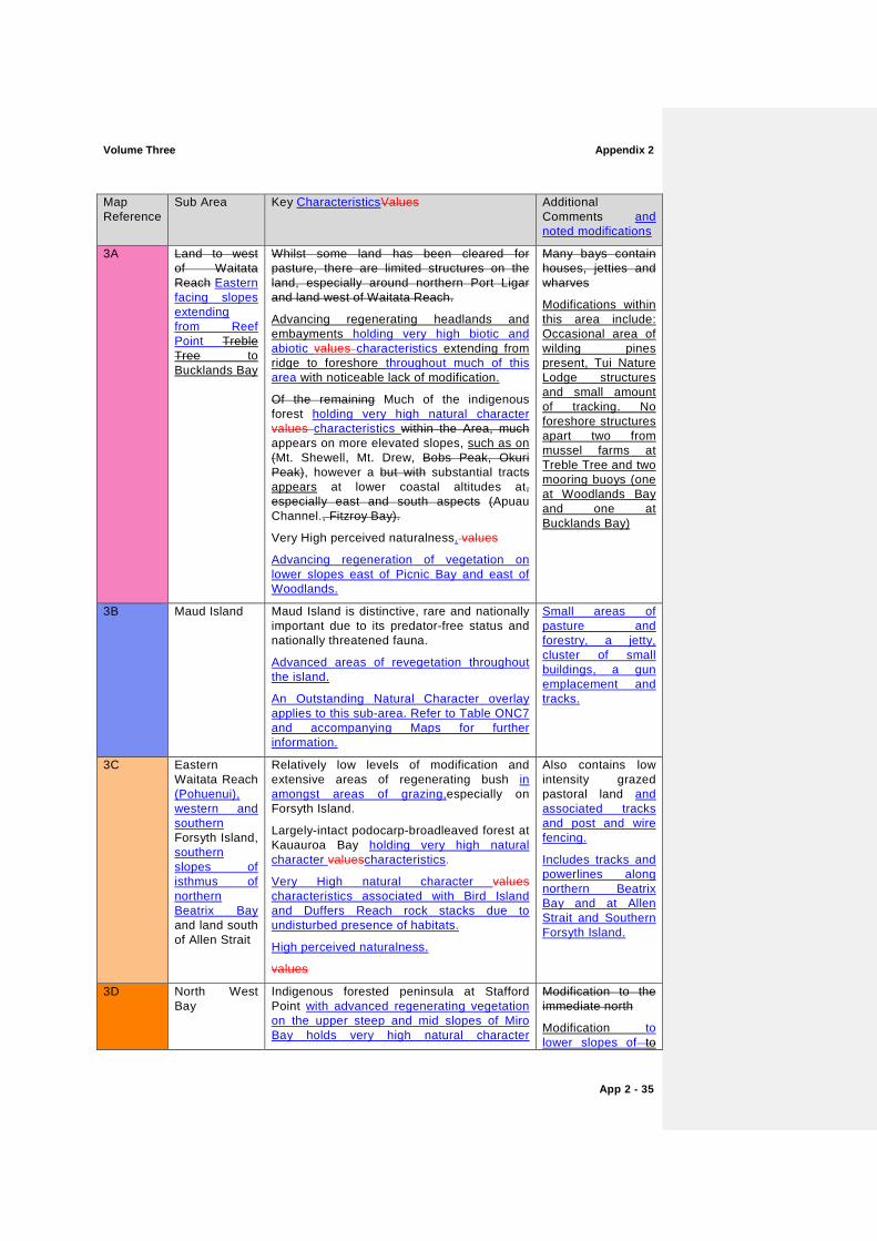
3A Land to west of Waitata Reach Eastern facing slopes extending from Reef Point Treble Tree to Bucklands Bay
Whilst some land has been cleared for pasture, there are limited structures on the land, especially around northern Port Ligar and land west of Waitata Reach.
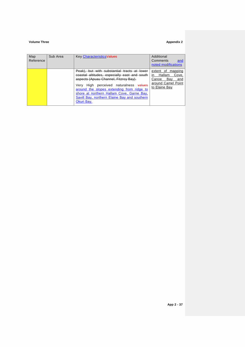
Advancing regenerating headlands and embayments holding very high biotic and abiotic values characteristics extending from ridge to foreshore throughout much of this area with noticeable lack of modification.
Of the remaining Much of the indigenous forest holding very high natural character values characteristics within the Area, much appears on more elevated slopes, such as on (Mt. Shewell, Mt. Drew, Bobs Peak, Okuri Peak), however a but with substantial tracts appears at lower coastal altitudes at, especially east and south aspects (Apuau Channel., Fitzroy Bay).
Very High perceived naturalness. values
Advancing regeneration of vegetation on lower slopes east of Picnic Bay and east of Woodlands.
Many bays contain houses, jetties and wharves
Modifications within this area include: Occasional area of wilding pines present, Tui Nature Lodge structures and small amount of tracking. No foreshore structures apart two from mussel farms at Treble Tree and two mooring buoys (one at Woodlands Bay and one at Bucklands Bay)
3B Maud Island Maud Island is distinctive, rare and nationally important due to its predator-free status and nationally threatened fauna.
Advanced areas of revegetation throughout the island.
An Outstanding Natural Character overlay applies to this sub-area. Refer to Table ONC7 and accompanying Maps for further information.
Small areas of pasture and forestry, a jetty, cluster of small buildings, a gun emplacement and tracks.
3C Eastern Waitata Reach (Pohuenui), western and southern Forsyth Island, southern slopes of isthmus of northern Beatrix Bay and land south of Allen Strait
Relatively low levels of modification and extensive areas of regenerating bush in amongst areas of grazing,especially on Forsyth Island.
Largely-intact podocarp-broadleaved forest at Kauauroa Bay holding very high natural character valuescharacteristics.
Very High natural character values characteristics associated with Bird Island and Duffers Reach rock stacks due to undisturbed presence of habitats.
High perceived naturalness.
values
Also contains low intensity grazed pastoral land and associated tracks and post and wire fencing.
Includes tracks and powerlines along northern Beatrix Bay and at Allen Strait and Southern Forsyth Island.
3D North West Bay
Indigenous forested peninsula at Stafford Point with advanced regenerating vegetation on the upper steep and mid slopes of Miro Bay holds very high natural character
Modification to the immediate north
Modification to lower slopes of to
Appendix 2 Volume Three
App 2 - 36
Map Reference
Sub Area Key CharacteristicsValues Additional Comments and noted modifications
valuescharacteristics.
High perceived naturalness values characteristics due to lack of structures and regenerating vegetation evident around mid and upper slopes of Miro Bay, within northern North West Bay.
Miro Bay and Wilson Bay include: numerous jetties, boatsheds, private residences, powerlines and tracks
3E Land to west of Waitata Reach White Horse Rock, Hamilton Cove, Yellow Cliffs
Whilst some land has been cleared for pasture, there are limited structures on the land, especially around northern Port Ligar and land west of Waitata Reach, including White Horse Rock, Yellow Cliffs and Hamilton Cove.
Advancing regenerating headlands and embayments extending from ridge to foreshore around Hamilton Cove and White Horse Rock.
Very high abiotic and biotic natural character
values characteristics at Yellow Cliffs due to lack of modification.
Of the remaining indigenous forests within the Area, much appears on more elevated slopes (Mt. Shewell, Mt. Drew, Bobs Peak, Okuri Peak), but with substantial tracts at lower coastal altitudes, especially east and south aspects (Apuau Channel, Fitzroy Bay).
Very High perceived naturalness values experienced throughout.
Many bays contain houses, jetties and wharves
Modifications within Waihinau Bay and Waitata Bay limit extent of mapping to those identified. Modifications within these mapped areas are restricted to several jetties, a small number of private residences, powerlines and tracks. Where aquaculture is present, this has limited the extent of mapping to the terrestrial area only.
3F Land to west of Waitata Reach Fitzroy Bay Area, Te Aumiti/French Pass, Okuri Bay, and land at the head of Squally Cove
Whilst some land has been cleared for pasture, there are limited structures on within the mapped area. land, especially around northern Port Ligar and land west of Waitata Reach.
Advancing regenerating headlands, slopes and embayments extending from ridge to foreshore and holding very high levels of natural character, noticeably from Bobs Peak and Okuri Peak with substantial tracts at lower coastal altitudes around northern Hallam Cove, Garne Bay, Savill Bay, northern Elaine Bay and southern Okuri Bay.
Smaller ‘pockets’ of coastal vegetation retaining high levels of natural character are also present around the Te Aumiti/French Pass settlement, parts of the western slopes of Wairangi Bay and the eastern slopes of Whakakitenga Bay.
Of the remaining indigenous forests within the Area, much appears on more elevated slopes (Mt. Shewell, Mt. Drew, Bobs Peak, Okuri
Many bays contain houses, jetties and wharves
Modifications within these mapped areas are restricted to one jetty in Savill Bay, several private residences in Canoe Bay, Garne Bay, small tracks extending from the Te Aumiti/French Pass Rd into Canoe Bay, Savill Bay and Garne Bay. Agriculture and forestry have restricted mapping to parts of Hallam Cove and Savill Bay. Aquaculture has limited the
Volume Three Appendix 2
App 2 - 37
Map Reference
Sub Area Key CharacteristicsValues Additional Comments and noted modifications
Peak), but with substantial tracts at lower coastal altitudes, especially east and south aspects (Apuau Channel, Fitzroy Bay).
Very High perceived naturalness values around the slopes extending from ridge to shore at northern Hallam Cove, Garne Bay, Savill Bay, northern Elaine Bay and southern Okuri Bay.
extent of mapping in Hallam Cove, Canoe Bay and around Camel Point to Elaine Bay
Appendix 2 Volume Three
App 2 - 38
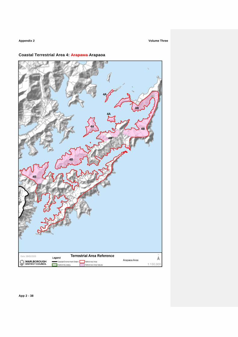
Coastal Terrestrial Area 4: Arapawa Arapaoa
Volume Three Appendix 2
App 2 - 39
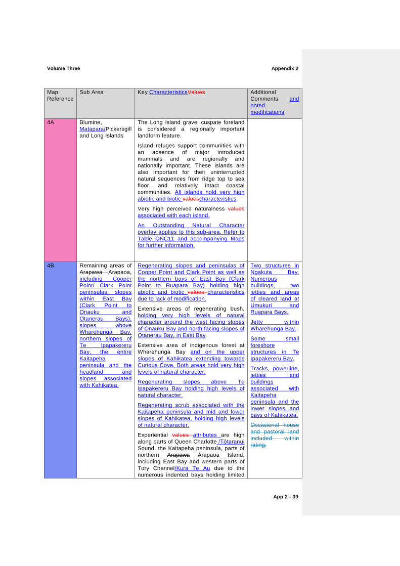
Map Reference
Sub Area Key CharacteristicsValues Additional Comments and noted modifications
4A Blumine, Matapara/Pickersgill and Long Islands
The Long Island gravel cuspate foreland is considered a regionally important landform feature.
Island refuges support communities with an absence of major introduced mammals and are regionally and nationally important. These islands are also important for their uninterrupted natural sequences from ridge top to sea floor, and relatively intact coastal communities. All islands hold very high abiotic and biotic valuescharacteristics.
Very high perceived naturalness values associated with each island.
An Outstanding Natural Character overlay applies to this sub-area. Refer to Table ONC11 and accompanying Maps for further information.
4B Remaining areas of Arapawa Arapaoa, including Cooper Point/ Clark Point peninsulas, slopes within East Bay (Clark Point to Onauku and Otanerau Bays), slopes above Wharehunga Bay, northern slopes of Te Ipapakereru Bay, the entire Kaitapeha peninsula and the headland and slopes associated with Kahikatea.
Regenerating slopes and peninsulas of Cooper Point and Clark Point as well as the northern bays of East Bay (Clark Point to Ruapara Bay) holding high abiotic and biotic values characteristics due to lack of modification.
Extensive areas of regenerating bush, holding very high levels of natural character around the west facing slopes of Onauku Bay and north facing slopes of Otanerau Bay, in East Bay.
Extensive area of indigenous forest at Wharehunga Bay and on the upper slopes of Kahikatea extending towards Curious Cove. Both areas hold very high levels of natural character.
Regenerating slopes above Te Ipapakereru Bay holding high levels of natural character.
Regenerating scrub associated with the Kaitapeha peninsula and mid and lower slopes of Kahikatea, holding high levels of natural character.
Experiential values attributes are high along parts of Queen Charlotte /Tōtaranui Sound, the Kaitapeha peninsula, parts of northern Arapawa Arapaoa Island, including East Bay and western parts of Tory Channel/Kura Te Au due to the numerous indented bays holding limited
Two structures in Ngakuta Bay. Numerous buildings, two jetties and areas of cleared land at Umukuri and Ruapara Bays.
Jetty within Wharehunga Bay.
Some small foreshore structures in Te Ipapakereru Bay.
Tracks, powerline, jetties and buildings associated with Kaitapeha peninsula and the lower slopes and bays of Kahikatea.
Occasional house and pastoral land included within rating.
Appendix 2 Volume Three
App 2 - 40
Map Reference
Sub Area Key CharacteristicsValues Additional Comments and noted modifications
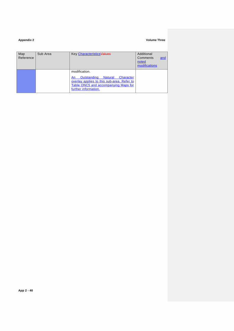
modification.
An Outstanding Natural Character overlay applies to this sub-area. Refer to Table ONC5 and accompanying Maps for further information.

Volume Three Appendix 2
App 2 - 41
Appendix 2 Volume Three
App 2 - 42
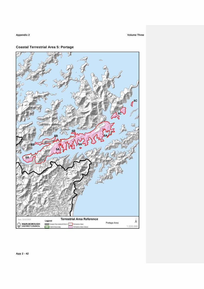
Coastal Terrestrial Area 5: Portage
Volume Three Appendix 2
App 2 - 43
Map Reference
Sub Area Key CharacteristicsValues Additional Comments and noted modifications
5A Southern faces of Mt. Cawte and Onahau and slopes surrounding the following bays: Onahau Bay; Lochmara Bay; Torea Bay (Torea Moua); Kaipakirikiri Bay; Kumutoto Bay; Blackwood Bay (or Tahuahua Bay); Ruakaka Bay and Bay of Many Coves (Miritu Bay – excluding Snake Point peninsula). Also includes Allports Island.Southern Queen Charlotte Sound
Tracts of primary coastal forest from ridge to foreshore (e.g., Kumutoto Bay and south slopes of Mt. Cawte and Onahau) found in this area are regionally important and hold very high abiotic and biotic valuescharacteristics. Most of the remainder of the upper and mid slopes land is clad in regenerating native forests, with limited modification holding high levels of natural character.
South-facing biotic communities are generally more intact (greater cover, less vulnerable to past and ongoing disturbance) than north-facing communities.
Areas of high experiential values attributes along both the intended bays of northern Queen Charlotte Sound Queen Charlotte Sound/Tōtaranuiand Kenepuru Sound
Areas of residential land and clusters of other foreshore structures (jetties, wharves etc)adjacent to shoreline excluded from rating.
5B Kenepuru Sound, including parts of the Putanui Point peninsula and Kaiaho Point peninsula
Regenerating slopes of Putanui Point peninsula, around Schnapper Point and on the Kaiaho Point peninsula hold high levels of natural character due to lack of modification.
Areas of high experiential valuesattributes.
Small tracks evident at Putanui Point peninsula and south of Schnapper Point.
Several buildings located along the lower slopes of Kaiaho Point.
5C Northern Queen Charlotte Sound Queen Charlotte Sound/TōtaranuiEastern Tawa Bay, Marine Head to Scott Point, Resolution Bay, southern Meretoto/Ship Cove and Motuara Island
There is good primary forest at the eastern end of the Coastal Terrestrial Area. Remaining areas of coastal forest are well-represented on headlands in Queen Charlotte Sound /Tōtaranui.
Motuara Island is nationally important as an island refuge for “marooning” nationally threatened species.
Primary podocarp-broadleaf forest between Meretoto/Ship Cove and Resolution Bay is distinctive and regionally outstanding, displaying intact natural sequences from ridge top to sea floor.
Very high experiential values attributes around Resolution Bay.
Outstanding Natural Character overlays apply to this sub-area. Refer to Table ONC10 and ONC11 and accompanying Maps for further information.
Occasional building and jetty located on southern foreshore of Resolution Bay.
Jetty and track on Motuana Island.
Refer to Coastal Terrestrial Area 8: Stokes for more on northern Queen Charlotte Sound /Tōtaranui.

Appendix 2 Volume Three
App 2 - 44
Coastal Terrestrial Area 6: Nydia
Volume Three Appendix 2
App 2 - 45
Map Reference
Sub Area Key CharacteristicsValues Additional Comments and noted modifications
6A Tennyson Inlet and northern slopes of Nydia Bay area (to Opouri Saddle), including Tarakaipa Island, Tawhitinui Island and surrounding small islands and rocks;
Original forests on lower altitude hillslopes and toeslopes, and coastal forests are largely intact in Tennyson Inlet, and Nydia Bay to Fairy Bay all holding very high abiotic and biotic valuescharacteristics.
Small areas of alluvial forests and beach communities are still intact in Tennyson Inlet and Nydia Bay and contribute significantly to the biodiversity and very high levels of natural character of to the area.
Tennyson Inlet and Nydia Bay supports some of the largest tracts of lowland and coastal forests in Marlborough. These are largely intact altitudinal sequences of primary forest, extending from ridgetops to seafloor and are therefore nationally important.
There are nationally threatened plants on the Tennyson Inlet islands.
Tennyson Inlet and parts of Nydia Bay retain extremely very high experiential valuesattributes, due mainly to its unmodified indigenous vegetation cover that extends from the shore line to the ridges and peaks that contain the inlet.
Some areas of high natural character are located within the very high levels of natural character. Those areas of high natural character are due to concentrations modifications associated with roads, tracks, buildings, powerlines, plantation forestry and grazed land. These are restricted to the western and northern slopes of Tuna Bay and Penzance Bay and the mid and upper slopes of North West Bay.
An Outstanding Natural Character overlay applies to this sub-area. Refer to Table ONC8 and accompanying Maps for further information.
Some modification around Tuna Bay, Penzance Bay and North West Bay restricts those areas to High Natural Character.
Modification to Fairy Bay is limited and restricted to several jetties and a small number of houses. Modifications to North West Bay include: numerous jetties, boatsheds, private residences, powerlines and tracks.
Greater levels of modification at Tuna Bay, Harvey Bay and Duncan Bay are not included within the mapping.
6B Southern and eastern parts
Opouri Saddle southwards to Kaiuma Point and Hikapu Reach; and the land associated with eastern Pelorus SoundPelorus Sound/Te
Continuation of the upland coastal forests from northern Nydia Bay from Opouri Saddle to Kaiuma Bay holding very high abiotic and biotic valuescharacteristics.
Extensive upland forest holding very high levels of natural character from the shores of northern Yncyca Bay to the upper slopes of the ridges and peaks extending south., although
Ssome regenerating of indigenous vegetation to lower slopes around Kaiuma Bay and Hikapu Reach.
More modified parts of the lower slopes and foreshore excluded from mapping. Those areas included within the high natural character areas include Kaiuma Bay Road, power lines, tracks, occasional buildings and occasional foreshore structures
Appendix 2 Volume Three
App 2 - 46
Map Reference
Sub Area Key CharacteristicsValues Additional Comments and noted modifications
Hoiere (extending from Marys Bay to the slopes above Double Bay)
High experiential valuesattributes. (i.e. jetties).

Volume Three Appendix 2
App 2 - 47
Appendix 2 Volume Three
App 2 - 48
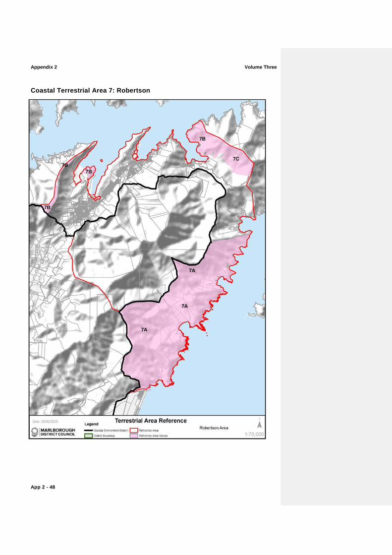
Coastal Terrestrial Area 7: Robertson
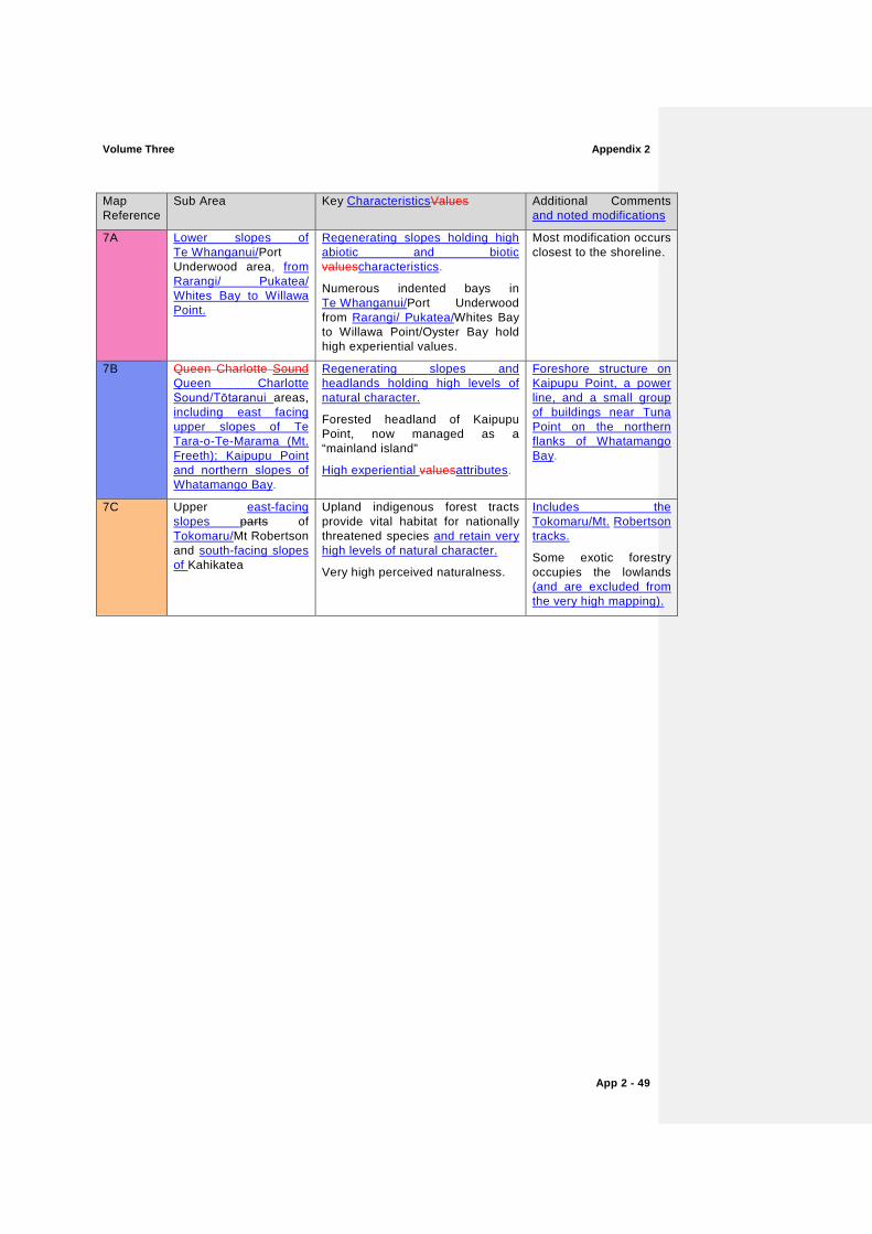
Volume Three Appendix 2
App 2 - 49
Map Reference
Sub Area Key CharacteristicsValues Additional Comments and noted modifications
7A Lower slopes of Te Whanganui/Port Underwood area, from Rarangi/ Pukatea/ Whites Bay to Willawa Point.
Regenerating slopes holding high abiotic and biotic valuescharacteristics.
Numerous indented bays in Te Whanganui/Port Underwood from Rarangi/ Pukatea/Whites Bay to Willawa Point/Oyster Bay hold high experiential values.
Most modification occurs closest to the shoreline.
7B Queen Charlotte Sound Queen Charlotte Sound/Tōtaranui areas, including east facing upper slopes of Te Tara-o-Te-Marama (Mt. Freeth); Kaipupu Point and northern slopes of Whatamango Bay.
Regenerating slopes and headlands holding high levels of natural character.
Forested headland of Kaipupu Point, now managed as a “mainland island”
High experiential valuesattributes.
Foreshore structure on Kaipupu Point, a power line, and a small group of buildings near Tuna Point on the northern flanks of Whatamango Bay.
7C Upper east-facing slopes parts of Tokomaru/Mt Robertson and south-facing slopes of Kahikatea
Upland indigenous forest tracts provide vital habitat for nationally threatened species and retain very high levels of natural character.
Very high perceived naturalness.
Includes the Tokomaru/Mt. Robertson tracks.
Some exotic forestry occupies the lowlands (and are excluded from the very high mapping).

Appendix 2 Volume Three
App 2 - 50
Coastal Terrestrial Area 8: Stokes
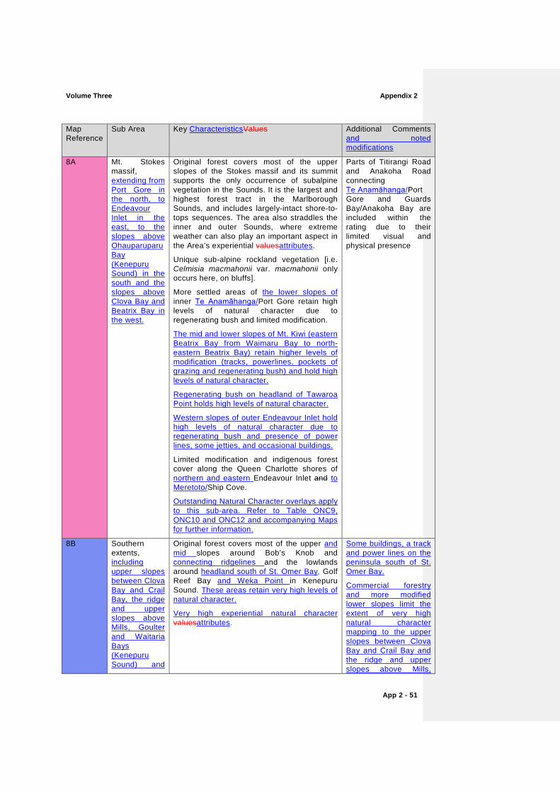
Volume Three Appendix 2
App 2 - 51
Map Reference
Sub Area Key CharacteristicsValues Additional Comments and noted modifications
8A Mt. Stokes massif, extending from Port Gore in the north, to Endeavour Inlet in the east, to the slopes above Ohauparuparu Bay (Kenepuru Sound) in the south and the slopes above Clova Bay and Beatrix Bay in the west.
Original forest covers most of the upper slopes of the Stokes massif and its summit supports the only occurrence of subalpine vegetation in the Sounds. It is the largest and highest forest tract in the Marlborough Sounds, and includes largely-intact shore-to-tops sequences. The area also straddles the inner and outer Sounds, where extreme weather can also play an important aspect in the Area’s experiential valuesattributes.
Unique sub-alpine rockland vegetation [i.e. Celmisia macmahonii var. macmahonii only occurs here, on bluffs].
More settled areas of the lower slopes of inner Te Anamāhanga/Port Gore retain high levels of natural character due to regenerating bush and limited modification.
The mid and lower slopes of Mt. Kiwi (eastern Beatrix Bay from Waimaru Bay to north-eastern Beatrix Bay) retain higher levels of modification (tracks, powerlines, pockets of grazing and regenerating bush) and hold high levels of natural character.
Regenerating bush on headland of Tawaroa Point holds high levels of natural character.
Western slopes of outer Endeavour Inlet hold high levels of natural character due to regenerating bush and presence of power lines, some jetties, and occasional buildings.
Limited modification and indigenous forest cover along the Queen Charlotte shores of northern and eastern Endeavour Inlet and to Meretoto/Ship Cove.
Outstanding Natural Character overlays apply to this sub-area. Refer to Table ONC9, ONC10 and ONC12 and accompanying Maps for further information.
Parts of Titirangi Road and Anakoha Road connecting Te Anamāhanga/Port Gore and Guards Bay/Anakoha Bay are included within the rating due to their limited visual and physical presence
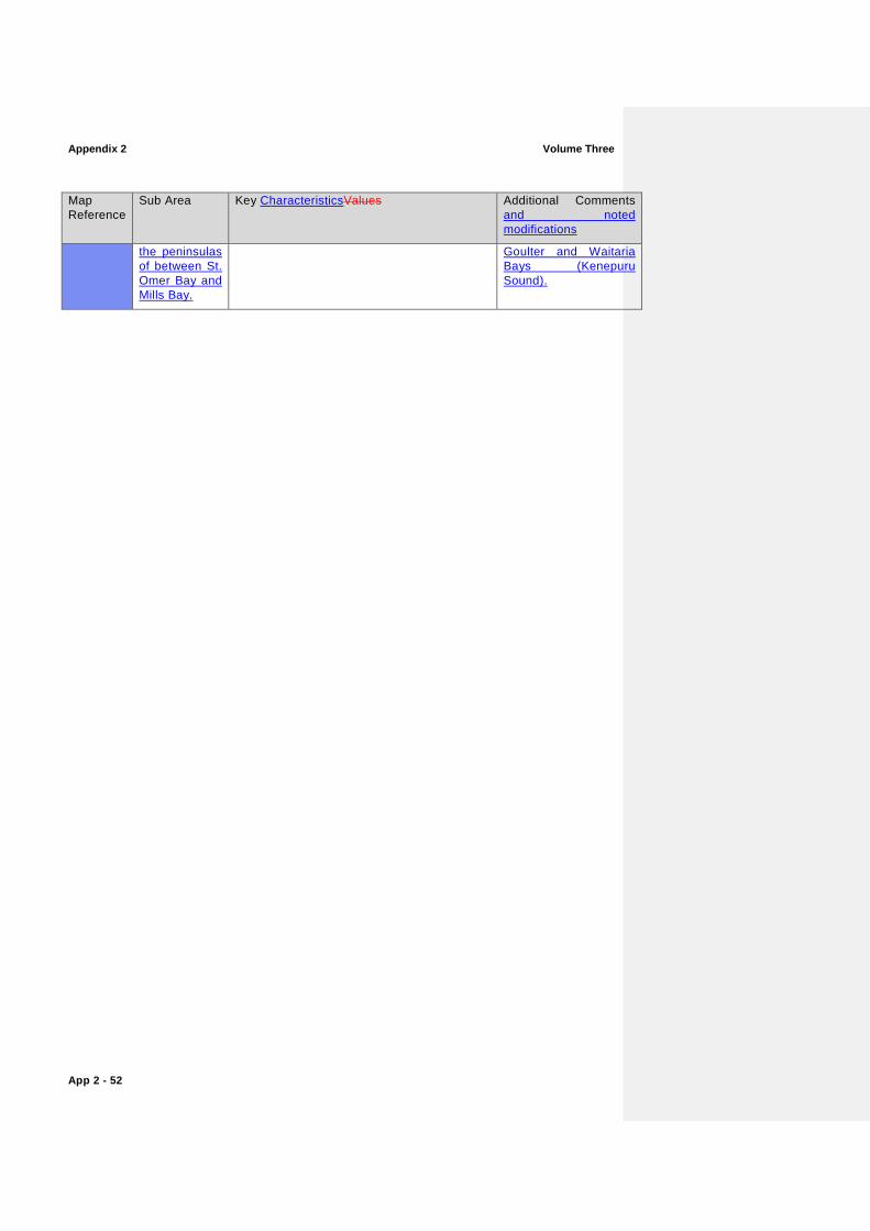
8B Southern extents, including upper slopes between Clova Bay and Crail Bay, the ridge and upper slopes above Mills, Goulter and Waitaria Bays (Kenepuru Sound) and
Original forest covers most of the upper and mid slopes around Bob’s Knob and connecting ridgelines and the lowlands around headland south of St. Omer Bay, Golf Reef Bay and Weka Point in Kenepuru Sound. These areas retain very high levels of natural character.
Very high experiential natural character valuesattributes.
Some buildings, a track and power lines on the peninsula south of St. Omer Bay.
Commercial forestry and more modified lower slopes limit the extent of very high natural character mapping to the upper slopes between Clova Bay and Crail Bay and the ridge and upper slopes above Mills,
Appendix 2 Volume Three
App 2 - 52
Map Reference
Sub Area Key CharacteristicsValues Additional Comments and noted modifications
the peninsulas of between St. Omer Bay and Mills Bay.
Goulter and Waitaria Bays (Kenepuru Sound).

Volume Three Appendix 2
App 2 - 53
Appendix 2 Volume Three
App 2 - 54
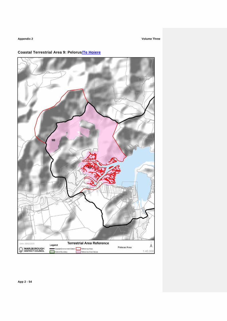
Coastal Terrestrial Area 9: Pelorus/Te Hoiere
Volume Three Appendix 2
App 2 - 55
Map Reference
Sub Area Key CharacteristicsValues Additional Comments and noted modifications
9A Pelorus/Kaituna Estuary
Distinctive remnant alluvial communities, although now reduced to scattered treelands, are regionally important and include fertile podocarp and mixed broadleaf treeland, and semi-deciduous kowhai-ribbonwood-lacebark treelands hold very high abiotic and biotic values characteristics.
Estuarine and adjoining freshwater wetland communities are extensive, very distinctive, regionally outstanding, and provide important habitats.
The estuarine system also has biotic patterns and sequences, dynamics and processes that are largely intact.
The intertidal river delta, with its network of small waterways holds very high perceived naturalness values.
An Outstanding Natural Character overlay applies to this sub-area. Refer to Table ONC13 and accompanying Maps for further information.
Extent delimited by the more modified paddocks to the west and by alignment of SH6. Small pocket of estuary included between SH6 and Forestry Road.
9B Upper vegetated slopes
The forested mid and upper slopes of Mt. Rutland assist in framing this intimate part of the Sounds, holding high levels of natural character.
Biotic patterns and sequences, dynamics and process functioning are largely intact at higher altitudes on the hillslopes.
Lower slopes retain commercial forestry. Area delineated by vegetation cover.
Appendix 2 Volume Three
App 2 - 56
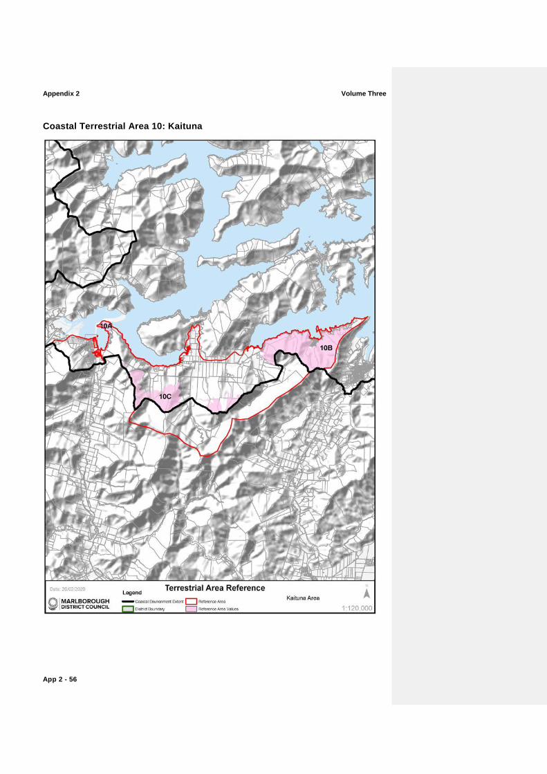
Coastal Terrestrial Area 10: Kaituna
Volume Three Appendix 2
App 2 - 57
Map Reference
Sub Area Key CharacteristicsValues Additional Comments and noted modifications
10A Cullen Point headland
Cullen Point is a noted vegetated headland, holding high levels of natural character where views are obtained towards Havelock.
High levels of perceived naturalness from the walking track on Cullen Point.
Navigational aids and track around the lower slopes of the Cullen Point headland.
10B South of Grove Arm
Biotic patterns and sequences on the southern slopes of Grove Arm are strong and hold high levels of natural character.
Ridge of Te Tara-o-Te-Marama (Mt. Freeth) holds very high levels of natural character due to mature indigenous bush cover.
High levels of perceived naturalness from Queen Charlotte Drive.
Many houses and other modification reduce naturalness character close to the shore.
10C Elevated parts of Mt Duncan, Mt. Cullen and Wheadon Creek catchment
Upland indigenous forest tracts provide vital habitat for nationally threatened species, holding very high levels of natural character.
Very high perceived naturalness.
Pasture, commercial forestry and scrub dominate lower slopes delimiting the mapped extent.
Appendix 2 Volume Three
App 2 - 58
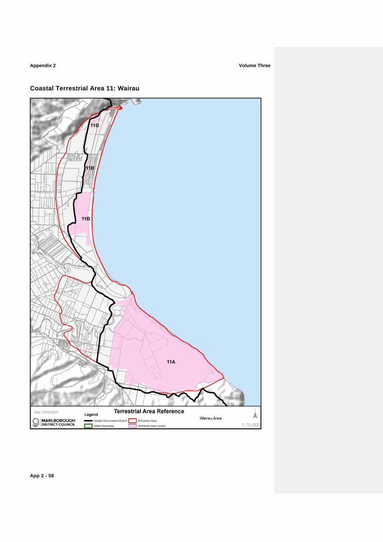
Coastal Terrestrial Area 11: Wairau
Volume Three Appendix 2
App 2 - 59
Map Reference
Sub Area Key CharacteristicsValues Additional Comments and noted modifications
11A Wairau Lagoons and boulder bank
The river mouth lagoon–estuary, bird’s foot delta, and fringing wetlands and islands are some of the country’s best examples and provide extensive wildlife habitat.
The whole wetland ecosystem is of national importance for wading birds (including migratory species), waterfowl and other wetland birds and is equally outstanding for freshwater and estuarine fauna.
Te Pokohiwi/Boulder Bank/Wairau Bar is a nationally important landform.
Open and expansive nature of the lagoons retains high levels of perceived naturalness.
An Outstanding Natural Character overlay applies to this sub-area. Refer to Table ONC14 and accompanying Maps for further information.
The estuary has been modified through historical stop-banking and alterations to river flows.
The Blenheim sewage outfall discharges into the mouth of the Wairau River on the outgoing tide.
11B Rarangi-Wairau Bar beach ridge system
Nationally important landform: a sequence of beach ridges and swales created by tectonic uplift events.
Remnant native vegetation: forest, treeland, dry shrubland and wetland.
Recognised as a significant wetland in the Marlborough District.
Areas of housing and land use modifications have eroded the legibility of some of these ridge systems.
Appendix 2 Volume Three
App 2 - 60
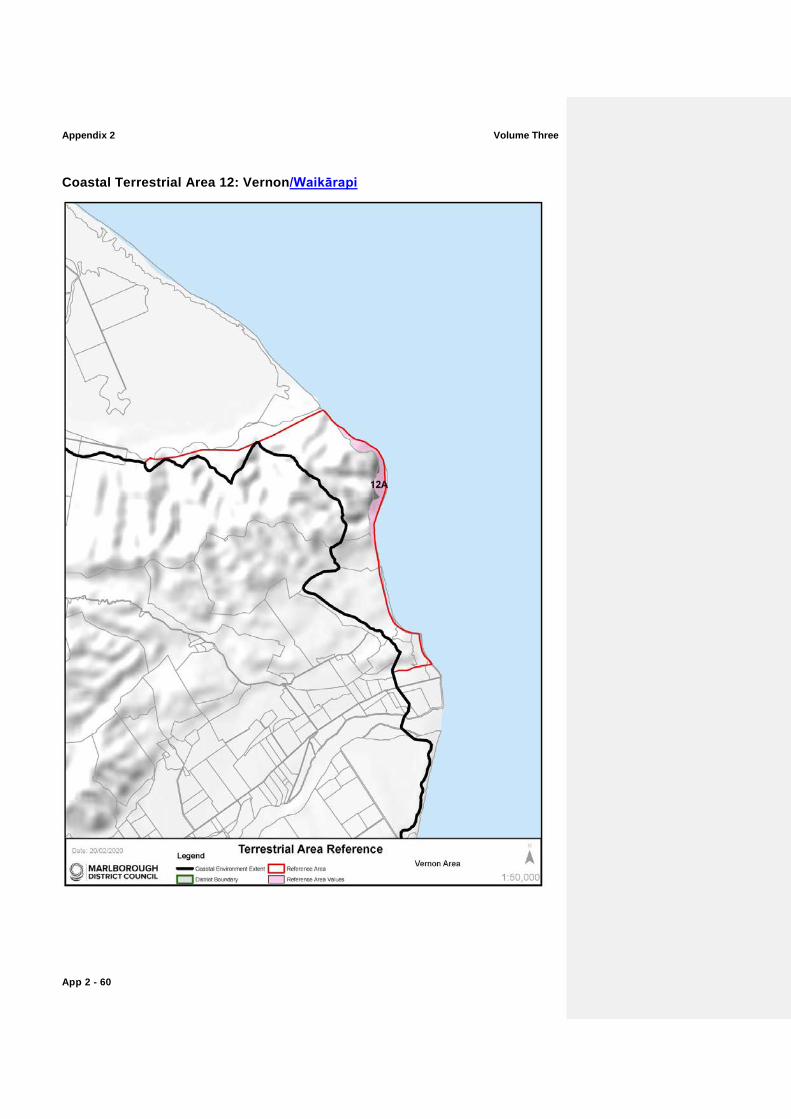
Coastal Terrestrial Area 12: Vernon/Waikārapi
Volume Three Appendix 2
App 2 - 61
Map Reference
Sub Area Key ValuesCharacteristics Additional Comments and noted modifications
12A White BluffsBluffs/Te Parinui o Whiti
The dissected hill country terminates in the regionally significant White Bluff sea cliff overlooking Te Koko-o-Kupe/Cloudy Bay.
With the constant erosion on these cliffs, vegetation is scarce, but it proliferates within the slot gorges where reclusive forests of ngaio, mahoe, mapou, akiraho, akeake, kohuhu, five-finger and lancewood are found.
The White BluffsBluffs/Te Parinui o Whiti form a visually strategic and striking point along the Marlborough coast, acting as the headland that divides Te Koko-o-Kupe/Cloudy Bay to the north from Clifford Bay to the south. Based on this they are extremely memorable.
Area delimited by cliff faces only.
Appendix 2 Volume Three
App 2 - 62
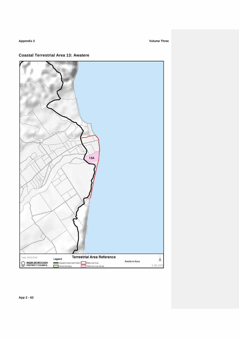
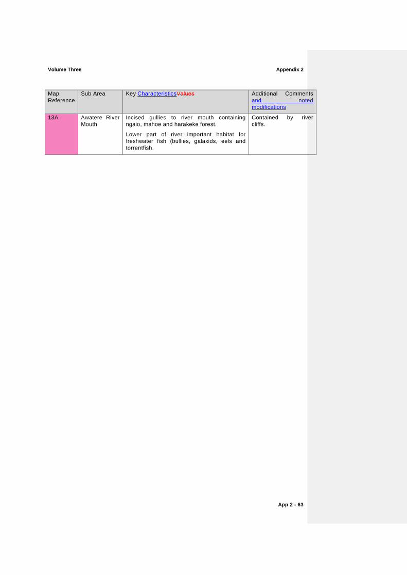
Coastal Terrestrial Area 13: Awatere
Volume Three Appendix 2
App 2 - 63
Map Reference
Sub Area Key CharacteristicsValues Additional Comments and noted modifications
13A Awatere River Mouth
Incised gullies to river mouth containing ngaio, mahoe and harakeke forest.
Lower part of river important habitat for freshwater fish (bullies, galaxids, eels and torrentfish.
Contained by river cliffs.
Appendix 2 Volume Three
App 2 - 64
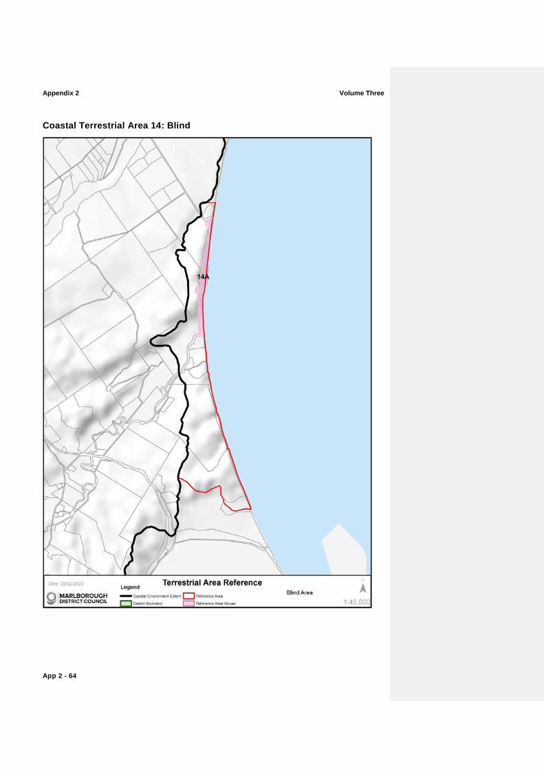
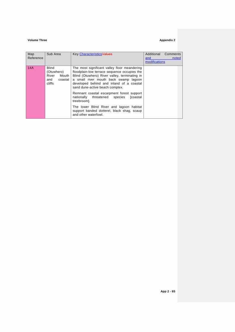
Coastal Terrestrial Area 14: Blind
Volume Three Appendix 2
App 2 - 65
Map Reference
Sub Area Key CharacteristicsValues Additional Comments and noted modifications
14A Blind (Otuwhero) River Mouth and coastal cliffs
The most significant valley floor meandering floodplain-low terrace sequence occupies the Blind (Otuwhero) River valley, terminating in a small river mouth back swamp lagoon developed behind and inland of a coastal sand dune-active beach complex.
Remnant coastal escarpment forest support nationally threatened species [coastal treebroom].
The lower Blind River and lagoon habitat support banded dotterel, black shag, scaup and other waterfowl.
Appendix 2 Volume Three
App 2 - 66
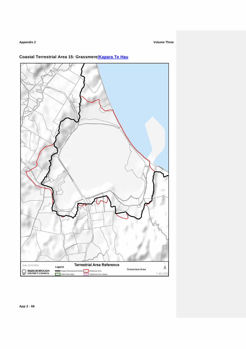
Coastal Terrestrial Area 15: Grassmere/Kapara Te Hau
Volume Three Appendix 2
App 2 - 67
Map Reference
Sub Area Key CharacteristicsValues Additional Comments and noted modifications
There are no specific areas within Coastal Terrestrial Area 15 with Outstanding, High or Very High Coastal Natural Character CharacteristicsValues.
Appendix 2 Volume Three
App 2 - 68
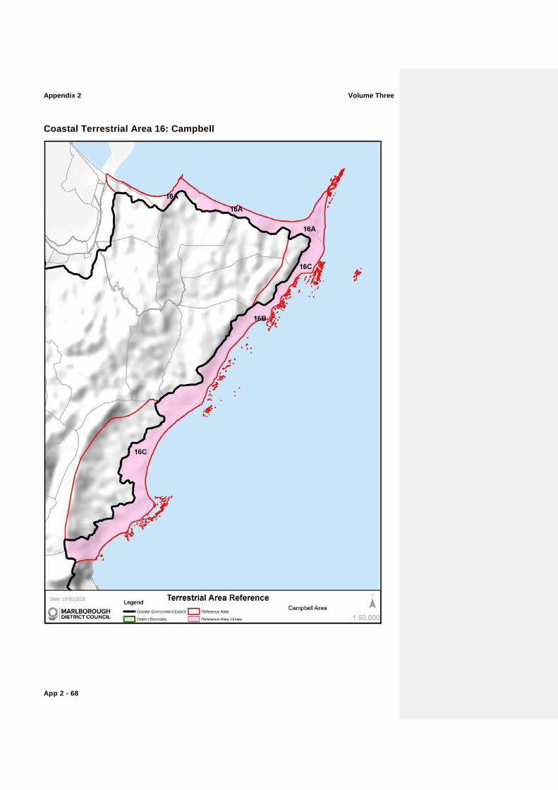
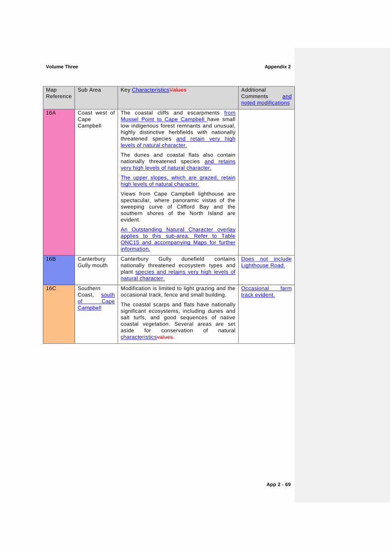
Coastal Terrestrial Area 16: Campbell
Volume Three Appendix 2
App 2 - 69
Map Reference
Sub Area Key CharacteristicsValues Additional Comments and noted modifications
16A Coast west of Cape Campbell
The coastal cliffs and escarpments from Mussel Point to Cape Campbell have small low indigenous forest remnants and unusual, highly distinctive herbfields with nationally threatened species and retain very high levels of natural character.
The dunes and coastal flats also contain nationally threatened species and retains very high levels of natural character.
The upper slopes, which are grazed, retain high levels of natural character.
Views from Cape Campbell lighthouse are spectacular, where panoramic vistas of the sweeping curve of Clifford Bay and the southern shores of the North Island are evident.
An Outstanding Natural Character overlay applies to this sub-area. Refer to Table ONC15 and accompanying Maps for further information.
16B Canterbury Gully mouth
Canterbury Gully dunefield contains nationally threatened ecosystem types and plant species and retains very high levels of natural character.
Does not include Lighthouse Road.
16C Southern Coast, south of Cape Campbell
Modification is limited to light grazing and the occasional track, fence and small building.
The coastal scarps and flats have nationally significant ecosystems, including dunes and salt turfs, and good sequences of native coastal vegetation. Several areas are set aside for conservation of natural characteristicsvalues.
Occasional farm track evident.
Appendix 2 Volume Three
App 2 - 70
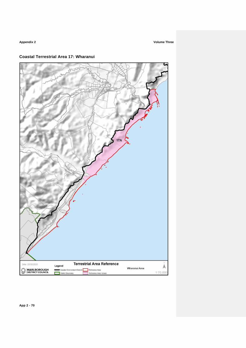
Coastal Terrestrial Area 17: Wharanui

Volume Three Appendix 2
App 2 - 71
Map Reference
Sub Area Key CharacteristicsValues Additional Comments and noted modifications
17A Chancet Rocks to Waima/ Ure River Mouth
The coastal zone contains localised endemic plants, nationally threatened plants and naturally rare ecosystems (calcareous bluffs, stacks and screes; dunes, gravel beaches, small wetlands and marine mammal haulouts). There are two NZ fur seal colonies (Chancet Rocks and Needles Point). There is also a ventifact field.
The coastline from the Chancet Rocks to the Waima River holds high experiential valuesattributes. The dramatic coast-sculpted limestone features of Weld Cone, the numerous coastal stacks as well as the wave cut platforms and reefs of Chancet Rock and the Needles are prominent features displaying limited modification, despite the agricultural land use.
An Outstanding Natural Character overlay applies to this sub-area. Refer to Table ONC16 and accompanying Maps for further information.
Light grazing dominates the land use.
Appendix 2 Volume Three
App 2 - 72
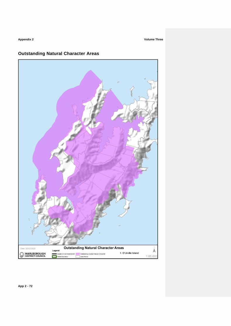
Outstanding Natural Character Areas
Volume Three Appendix 2
App 2 - 73
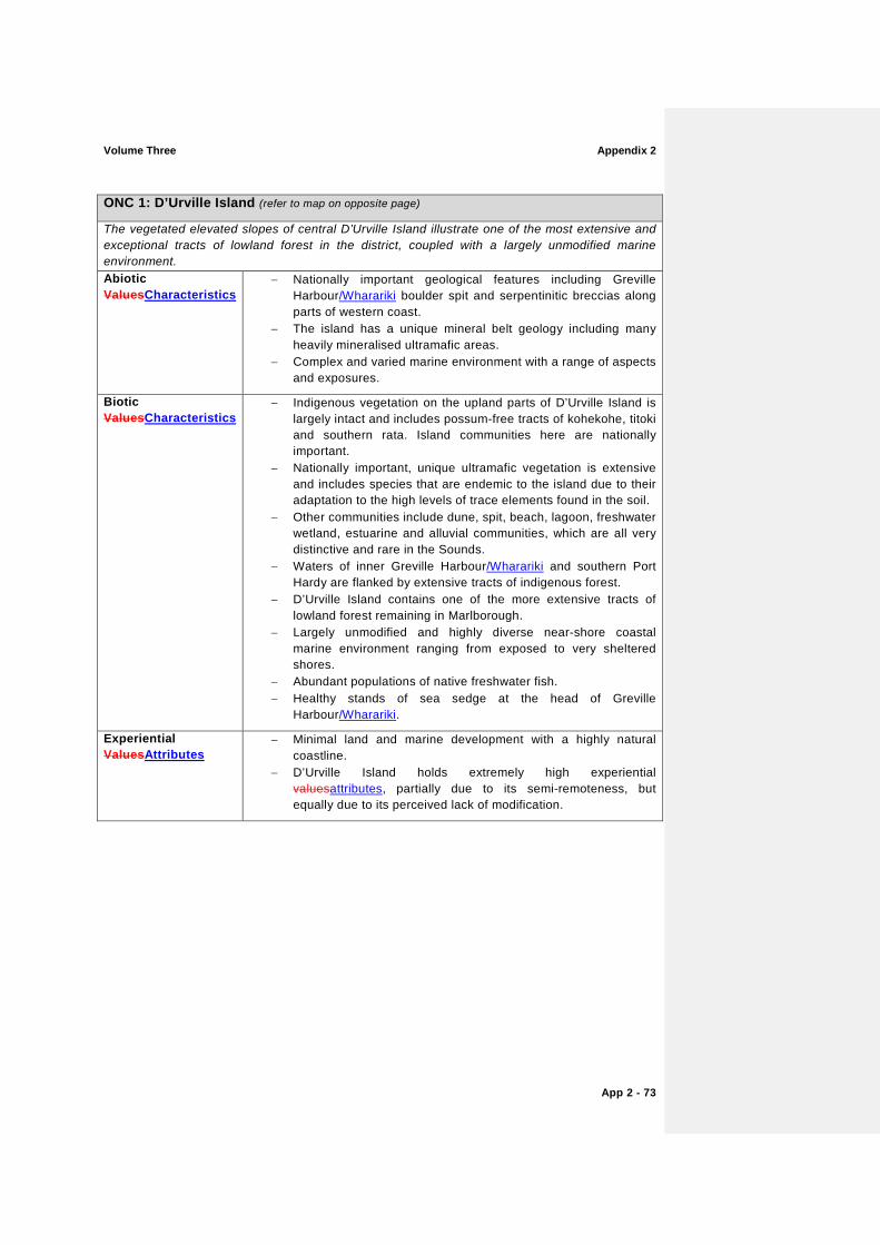
ONC 1: D’Urville Island (refer to map on opposite page)
The vegetated elevated slopes of central D’Urville Island illustrate one of the most extensive and exceptional tracts of lowland forest in the district, coupled with a largely unmodified marine environment. Abiotic ValuesCharacteristics
− Nationally important geological features including Greville Harbour/Wharariki boulder spit and serpentinitic breccias along parts of western coast.
− The island has a unique mineral belt geology including many heavily mineralised ultramafic areas.
− Complex and varied marine environment with a range of aspects and exposures.
Biotic ValuesCharacteristics
− Indigenous vegetation on the upland parts of D’Urville Island is largely intact and includes possum-free tracts of kohekohe, titoki and southern rata. Island communities here are nationally important.
− Nationally important, unique ultramafic vegetation is extensive and includes species that are endemic to the island due to their adaptation to the high levels of trace elements found in the soil.
− Other communities include dune, spit, beach, lagoon, freshwater wetland, estuarine and alluvial communities, which are all very distinctive and rare in the Sounds.
− Waters of inner Greville Harbour/Wharariki and southern Port Hardy are flanked by extensive tracts of indigenous forest.
− D’Urville Island contains one of the more extensive tracts of lowland forest remaining in Marlborough.
− Largely unmodified and highly diverse near-shore coastal marine environment ranging from exposed to very sheltered shores.
− Abundant populations of native freshwater fish. − Healthy stands of sea sedge at the head of Greville
Harbour/Wharariki.
Experiential ValuesAttributes
− Minimal land and marine development with a highly natural coastline.
− D’Urville Island holds extremely high experiential valuesattributes, partially due to its semi-remoteness, but equally due to its perceived lack of modification.
Appendix 2 Volume Three
App 2 - 74
Volume Three Appendix 2
App 2 - 75
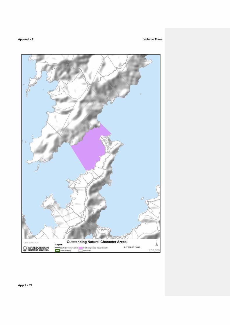
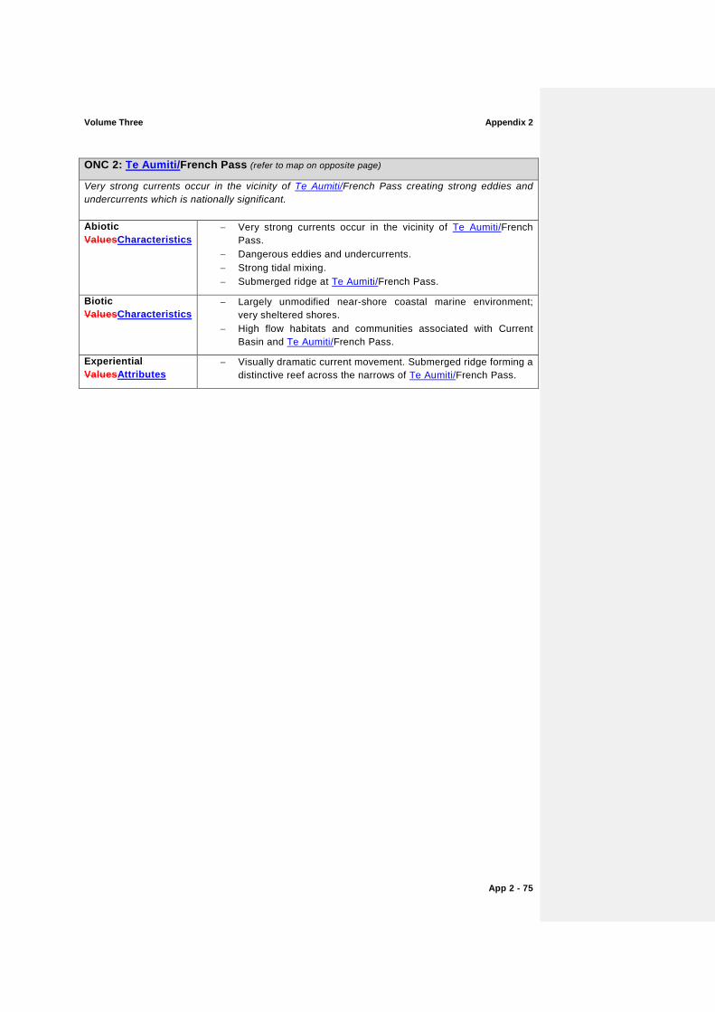
ONC 2: Te Aumiti/French Pass (refer to map on opposite page)
Very strong currents occur in the vicinity of Te Aumiti/French Pass creating strong eddies and undercurrents which is nationally significant.
Abiotic ValuesCharacteristics
− Very strong currents occur in the vicinity of Te Aumiti/French Pass.
− Dangerous eddies and undercurrents. − Strong tidal mixing. − Submerged ridge at Te Aumiti/French Pass.
Biotic ValuesCharacteristics
− Largely unmodified near-shore coastal marine environment; very sheltered shores.
− High flow habitats and communities associated with Current Basin and Te Aumiti/French Pass.
Experiential ValuesAttributes
− Visually dramatic current movement. Submerged ridge forming a distinctive reef across the narrows of Te Aumiti/French Pass.
Appendix 2 Volume Three
App 2 - 76
Volume Three Appendix 2
App 2 - 77
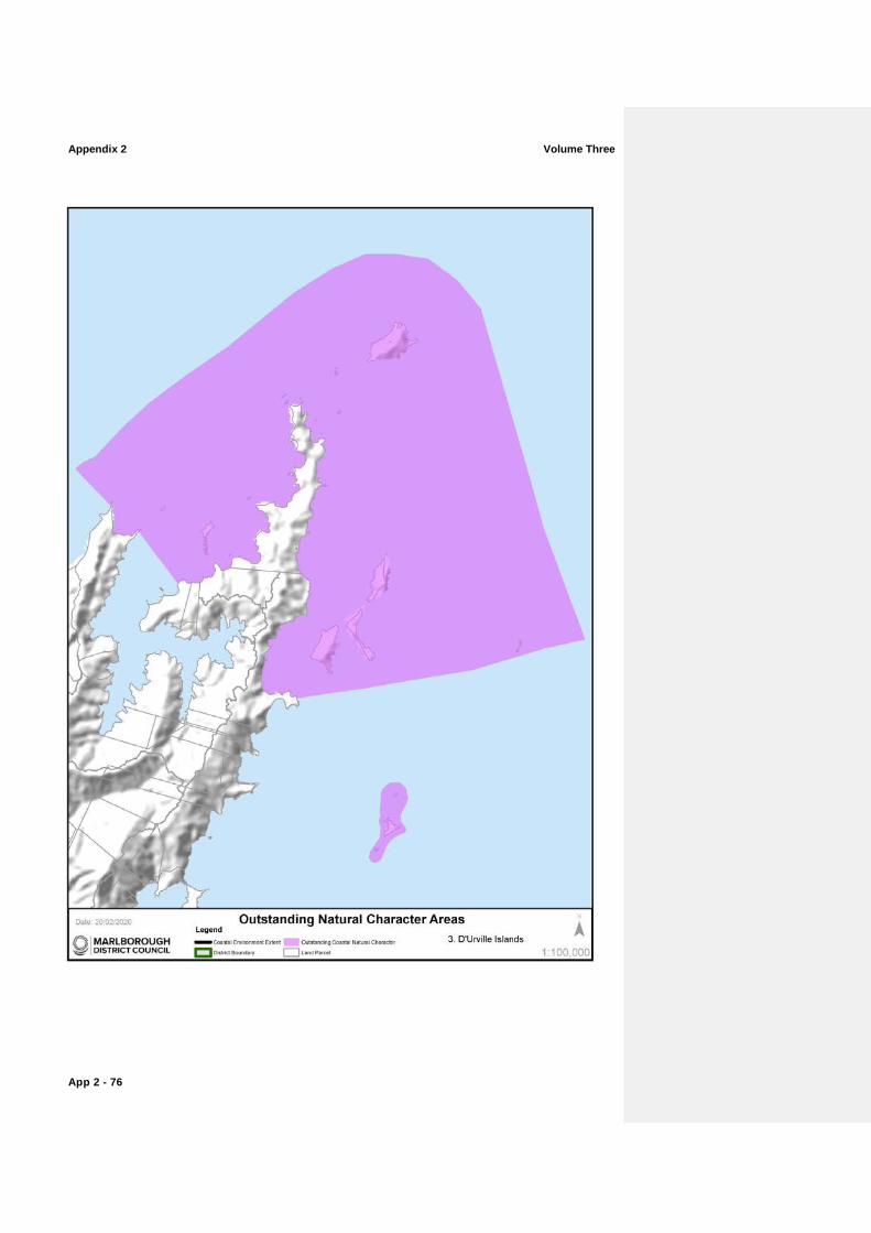
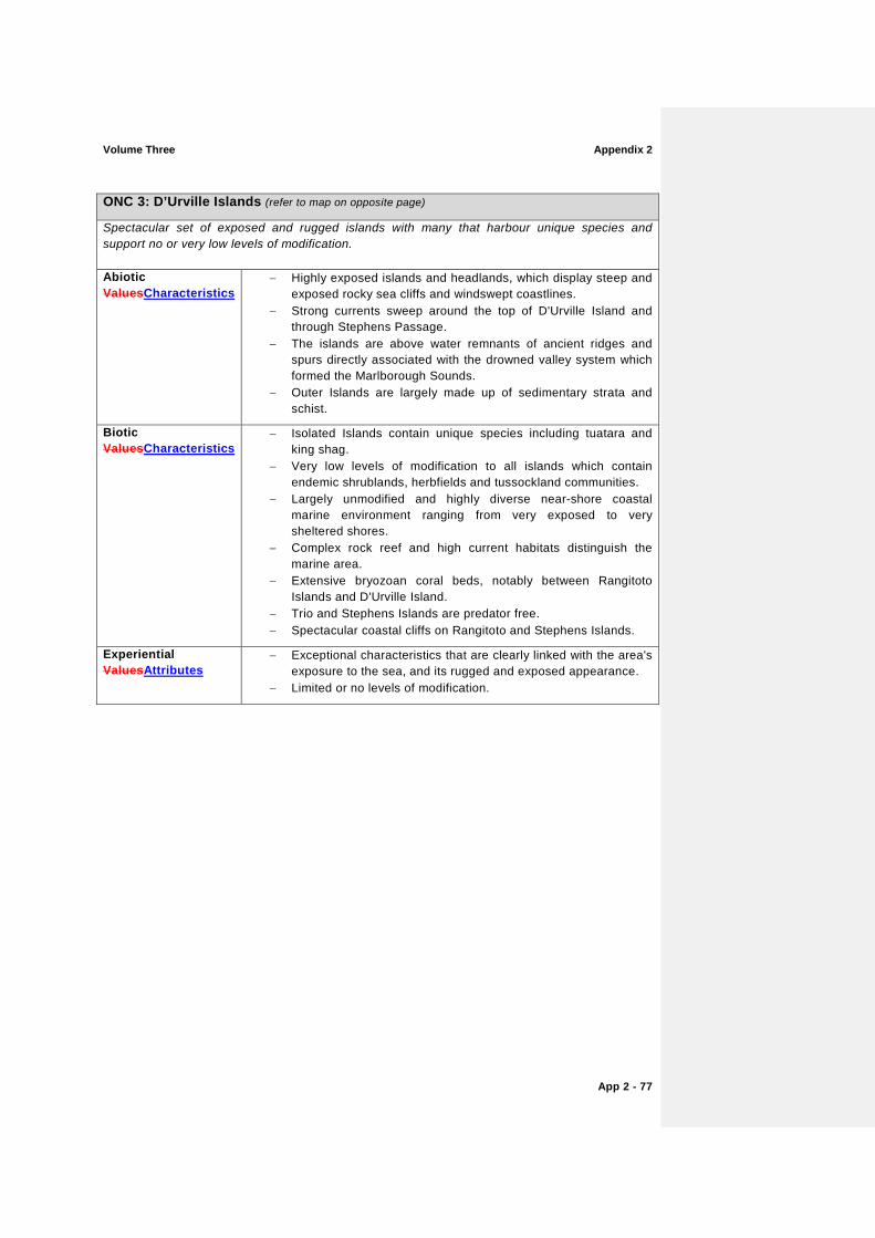
ONC 3: D’Urville Islands (refer to map on opposite page)
Spectacular set of exposed and rugged islands with many that harbour unique species and support no or very low levels of modification.
Abiotic ValuesCharacteristics
− Highly exposed islands and headlands, which display steep and exposed rocky sea cliffs and windswept coastlines.
− Strong currents sweep around the top of D'Urville Island and through Stephens Passage.
− The islands are above water remnants of ancient ridges and spurs directly associated with the drowned valley system which formed the Marlborough Sounds.
− Outer Islands are largely made up of sedimentary strata and schist.
Biotic ValuesCharacteristics
− Isolated Islands contain unique species including tuatara and king shag.
− Very low levels of modification to all islands which contain endemic shrublands, herbfields and tussockland communities.
− Largely unmodified and highly diverse near-shore coastal marine environment ranging from very exposed to very sheltered shores.
− Complex rock reef and high current habitats distinguish the marine area.
− Extensive bryozoan coral beds, notably between Rangitoto Islands and D'Urville Island.
− Trio and Stephens Islands are predator free. − Spectacular coastal cliffs on Rangitoto and Stephens Islands.
Experiential ValuesAttributes
− Exceptional characteristics that are clearly linked with the area's exposure to the sea, and its rugged and exposed appearance.
− Limited or no levels of modification.
Appendix 2 Volume Three
App 2 - 78
Volume Three Appendix 2
App 2 - 79
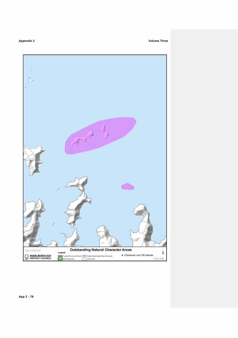
ONC 4: Chetwode and Titi Islands (refer to map on opposite page)
Exposed predator free islands harbouring no or very low levels of modification. The Chetwodes are the most ecologically significant islands in the Marlborough Sounds.
Abiotic ValuesCharacteristics
− The Chetwode and Titi Islands are generally characterised by steep rock scarps and exposed cliffs.
− Many spectacular rock stacks are present at the southern end of the Chetwode Islands.
Biotic CharacteristicsValues
− Titi and Chetwode Islands are predator free. − Very low levels of modification to all islands, which contain
endemic shrublands, herbfields and tussockland communities. Steep rock scarps contain tough native shrubs and species endemic to the region such as the Cook Strait Kowhai.
− The Chetwodes are the most ecologically significant islands in the Marlborough Sounds harbouring the yellow crowned parakeet, mohua, robin, kaka and rare indigenous vegetation and plant species.
− Near-shore areas retain high marine natural valuescharacteristics, including high current habitats supporting bryozoan corals, sponges, hydroids, ascidians, horse mussels and associated species (e.g. fish).
Experiential ValuesAttributes
− Characteristics clearly linked with the area's exposure to the sea, rugged and exposed in appearance.
Appendix 2 Volume Three
App 2 - 80
Volume Three Appendix 2
App 2 - 81
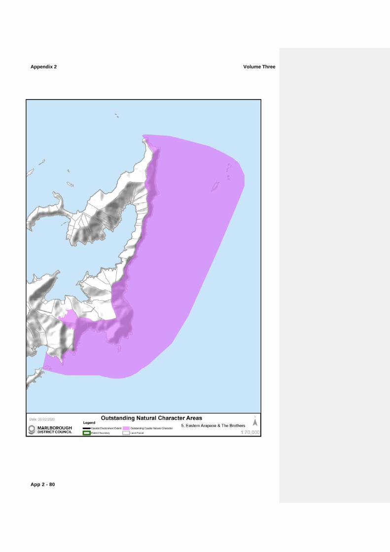
ONC 5: Eastern Arapawa Island and The Brothers (refer to map on opposite page)
The visually dramatic, highly legible steep coastal cliffs support some of the best remaining Cook Strait mixed broadleaved forests with The Brothers holding some of the strongest tidal currents in the Region. Abiotic CharacteristicsValues
− Dynamic features and processes are largely driven by southerly winds and swells which impact upon the exposed eastern shores, creating a very high energy coastline.
− Strong tidal currents are a feature especially around The Brothers Islands, near Tory Channel/Kura Te Au and off major headlands.
Biotic CharacteristicsValues
− The eastern flanks of ArapaoaArapawa Island support some of the best remaining examples of Cook Strait mixed broad-leaved forests and are nationally important, especially as possum-free environments.
− The Brothers Islands harbour nationally important reptiles (tuatara, duvaucels gecko).
− South Brothers Island is one of the most pristine seabird islands in New Zealand.
− Largely unmodified exposed rocky coastal marine environment extending over many tens of kilometres.
− Diverse and productive reef communities with high macroalgae diversity.
Experiential ValuesAttributes
− Dramatic coastal processes are highly legible along the length of these steep coastal cliffs and rocky reefs, with minimal modification.
− The Brothers Islands are a clearly legible group of islands representing some of the most exposed islands in the Region.
− The eastern entrance to Tory Channel/Kura Te Au is the gateway to the Marlborough Sounds for passengers on the Cook Strait ferries.
Appendix 2 Volume Three
App 2 - 82
Volume Three Appendix 2
App 2 - 83
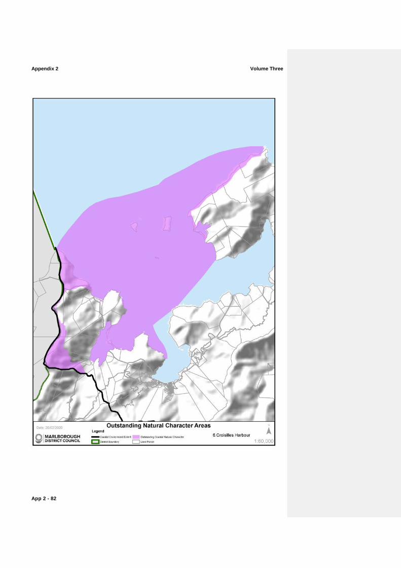
ONC 6: Croisilles Harbour (refer to map on opposite page)
The high levels of naturalness of this marine environment coupled with the exceptional Whangarae Estuary are outstanding in this regional context.
Abiotic CharacteristicsValues
− Whangarae Estuary is the only spit-formed estuary in the Marlborough Sounds.
− Pakiaka Point barrier island and lagoon are regionally significant features.
− Exposed, prominent rugged headland of Cape Soucis forms the regions western extent.
− Islands to north of harbour.
Biotic CharacteristicsValues
− Croisilles Harbour marine environment supports a unique shallow sand community notable for the presence of the New Zealand lancelet (the southernmost population of this patchily distributed species).
− Largely unmodified near-shore coastal marine environment ranging from semi sheltered to very sheltered shores.
− Whangarae Estuary is an excellent example of a relatively unmodified estuary in Marlborough.
− Subtidal sand flat and boulder bank habitats/communities at the mouth of Croisilles Harbour.
− Island communities here are nationally important (Motuanauru Island and Otuhaereroa Island). They are distinct and rare biotic assemblages, which are highly productive.
− Upland altitudinal forest tracks.
Experiential ValuesAttributes
− High levels of naturalness due to limited modification to the waterbody.
− Islands to north of harbour and Cape Soucis headland create a visual entrance and are unmodified.
Appendix 2 Volume Three
App 2 - 84
Volume Three Appendix 2
App 2 - 85
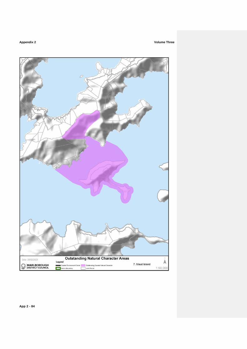
ONC 7: Maud Island (refer to map on opposite page)
A visually striking internationally significant, predator free island sanctuary.
Abiotic CharacteristicsValues
− The Island landform of steep to moderately steep coastal hills with inlets and bays retains a high maritime influence.
− The Island forms a distinct pyramidal form with a slender landform connecting Maud Island to Harter Point.
− Sheltered indented coastline with multiple aspects because of Maud Island
− Apuau Channel, with its deep channel habitats and moderate currents separates Maud Island from the mainland.
Biotic CharacteristicsValues
− Internationally significant, predator free Island sanctuary. − Harbours nationally threatened species of invertebrates, birdlife
and the entire population of the Maud Island Frog. − Home Bay contains 15 hectares of remnant bush including
kohekohe, tawa, nikau, pukatea and mahoe. − Most of the Island is cloaked in regenerating shrubland and
forest. − Several species of plants uncommon in Marlborough Sounds
occur on Maud Island including the large-leaved milk tree, Sonchus kirkii and renga renga lily.
− Sheltered coastline with multiple aspects. − Near-shore marine areas and much of Apuau Channel retain
high natural valuescharacteristics.
Experiential ValuesAttributes
− Distinct island landform, pyramidal skyline and slender neck of Harter Point is very evident.
− Vegetation predominates views of the island which straddles the inner and outer Marlborough Sounds.
− Apuau Channel provides a sense of enclosure, but with expanding vistas northwards to Waitata Reach and southwards to Tawhitinui Reach.
Appendix 2 Volume Three
App 2 - 86
Volume Three Appendix 2
App 2 - 87
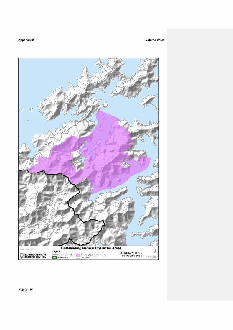
ONC 8: Tennyson Inlet and Inner Pelorus SoundPelorus Sound/Te Hoiere (refer to map on opposite page) This exceptional tract of inland indigenous forest, displaying a sequence of vegetation types from mountain top to shore is rare nationally.
Abiotic CharacteristicsValues
− The coastline is moderately dissected with numerous large, deeply indented inlets and smaller bays.
− Very sheltered with limited wave fetch. − Three islands are strategically located at the entrance of
Tennyson Inlet.
Biotic CharacteristicsValues
− Much of the area is backed by native forest clad hillslopes. − Intact coastal forest extends to the water’s edge, some of the
largest tracts of lowland forest in Marlborough. − Largely intact and nationally significant altitudinal sequences of
primary forest, extending from ridgetops to seafloor. − Vegetation comprises coastal podocarp/broadleaved forest at
lower altitudes and mature beech forest that stretches to the summits of the hills. These sequences extend north into Tennyson Inlet and south into Nydia Bay.
− Some plant communities are possum free. − Tennyson Inlet is the largest marine area in Marlborough
surrounded by protected native forest. Much of the coast extending from the head of Nydia Bay along the western side of Pelorus SoundPelorus Sound/Te Hoiere to Jacobs Bay is also clad in native bush.
− Marine habitats and communities are mostly unmodified and retain high natural valuescharacteristics.
Experiential ValuesAttributes
− This area retains an overwhelming sense of naturalness, from shore to ridge.
− Access is limited to this area by one road: Tennyson Inlet Road. − The Nydia Track connects Tennyson Inlet and Nydia Bay with
Kaiuma Bay, north of Havelock through mainly forested slopes. − The area includes rare examples of sheltered inland inlets with
limited modification to the water and the shores.

Appendix 2 Volume Three
App 2 - 88
Volume Three Appendix 2
App 2 - 89
ONC 9: The Capes (refer to map on opposite page)
Dramatic examples of a sunken landscape with stretches of nationally significant broadleaved forest and exceptional visual qualities.
Abiotic CharacteristicsValues
− Cape Jackson is a superb example of a drowned ridge crest. − Cliffs and very steep slopes flank the sea and are being
continually eroded by high energy waves. − Strong tidal currents off headlands. − Reefs fringe the shore and extend into deeper water, especially
off the headlands.
Biotic CharacteristicsValues
− Brutal exposure to the elements has shaped unique Cook Strait vegetation on the headlands of Capes Lambert and Jackson.
− Largely unmodified section of coast with exposed rocky bluffs and headlands and reef communities extending into deep water.
− Cape Lambert Scenic Reserve. − High current communities in the vicinity of The Capes.
Experiential ValuesAttributes
− The Capes and the waters they enclose are remote and retain a wild and exposed nature due to their narrow and rugged form.
− They act as the outer ‘arms’ of Te Anamāhanga/Port Gore, where rocky outcrops and partially submerged platforms extend into the sea and offer opportunities for fishing.
− Cape Jackson forms the western entrance to Queen Charlotte Sound Queen Charlotte Sound/Tōtaranui where biotic patterns extend from Mt. Stokes and Mt. Furneaux further inland.
Appendix 2 Volume Three
App 2 - 90
Volume Three Appendix 2
App 2 - 91
ONC 10: Meretoto/Ship Cove and Resolution Bay (refer to map on opposite page)
This stretch of primary coastal and lowland indigenous bush is exceptional in its intactness.
Abiotic CharacteristicsValues
− Very steep sided faces clothed in indigenous vegetation. − Highly indented coastline comprising several sheltered small
bays.
Biotic CharacteristicsValues
− Mt Furneaux features nationally significant podocarp/broadleaved forest. Forest between Meretoto/Ship Cove and Resolution Bay is distinctive and regionally outstanding, displaying intact natural sequences from sea to ridge top.
− Largely unmodified sheltered near-shore and in places offshore marine environment backed by bush clad hills.
Experiential ValuesAttributes
− This mostly sheltered coastline with its clear waters and forested backdrop is particularly memorable.
− Meretoto/Ship Cove is generally the start of the Queen Charlotte Track.
− The area retains a reasonably high level of remoteness, due to its location between the inner and outer Sounds.
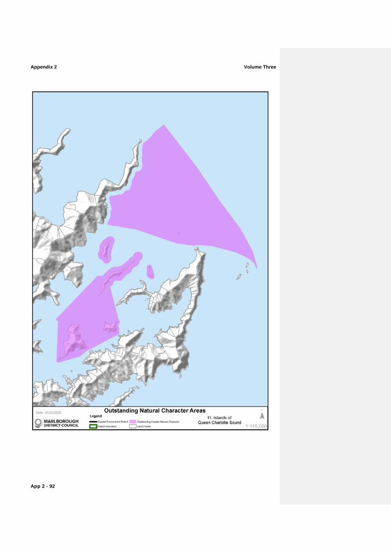
Appendix 2 Volume Three
App 2 - 92
Volume Three Appendix 2
App 2 - 93
ONC 11: Islands of Queen Charlotte Sound Queen Charlotte Sound/Tōtaranui and White Rocks (refer to map on opposite page) These islands at the entrance to Queen Charlotte Sound Queen Charlotte Sound/Tōtaranui are exceptional in their strategic positions harbouring many endangered bird species.
Abiotic CharacteristicsValues
− Marine submergence has created Blumine, Matapara/Pickersgill, Long, The Twins, Motungarara and Motuara Islands, which are separated from the mainland and the larger ArapaoaArapawa Island by narrow passages.
− Long Island cuspate foreland is a regionally important geological feature.
− The islands have an exposed, steep and rocky character to the north and more sheltered southern tips.
− White Rocks are a good example of a very small, exposed, sparsely-soiled rock stack system.
Biotic CharacteristicsValues
− All Islands within this outstanding natural character area are predator free.
− Long Island harbours the endangered little spotted kiwi. − Matapara/Pickersgill Island is regionally significant for its flora
and fauna. − Motuara Island features regenerating bush and many species of
native bird endangered on mainland New Zealand. − Blumine Island is home to the world’s most endangered Kiwi,
the rowi and other endangered New Zealand birds. Features regenerating bush.
− A marine reserve of national significance surrounds Long Island and Kokomohua Island.
− Largely unmodified near-shore and in places off-shore marine environment.
− Unmodified White Rocks holds a unique ecosystem with limited flora and is a breeding colony for the nationally endangered king shag.
Experiential ValuesAttributes
− The steep and often rugged bush clad slopes are highly natural. − This network of islands and rocks combine to create a
memorable experience for visitors to the outer Queen Charlotte Sound /Tōtaranui.
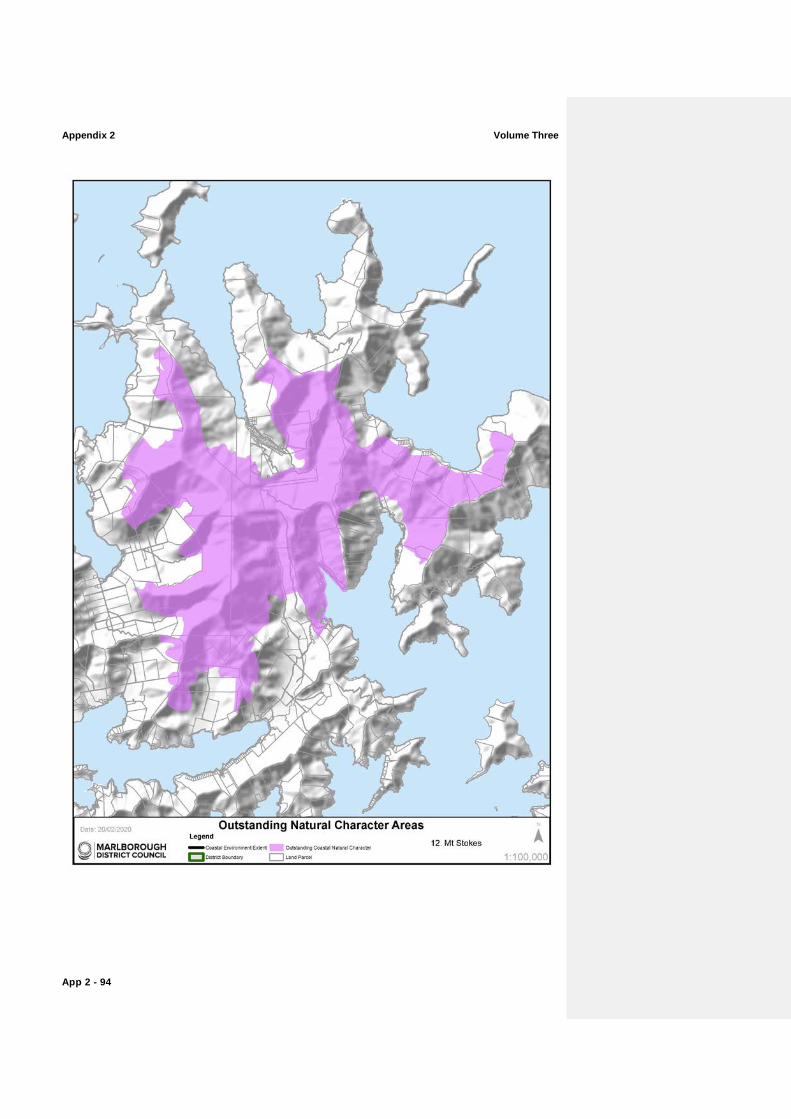
Appendix 2 Volume Three
App 2 - 94
Volume Three Appendix 2
App 2 - 95
ONC 12: Mt Stokes (refer to map on opposite page)
The green corridor of bush that connects Mt Stokes to the sea at Endeavour Inlet, is part of the larger Mt Stokes area managed by Department of Conservation and is identified as having internationally significant ecological valuescharacteristics.
Abiotic CharacteristicsValues
− Mt. Stokes is one of the most dominant landforms in the Marlborough Sounds, with its upland ridge crests and summits reaching 1,203m above sea level.
− A number of watercourses extend from this central massif, and have long, high gradients with the water quality being amongst the highest in the Sounds.
Biotic CharacteristicsValues
− Original forest covers most of the upper slopes of Stokes massif and its summit supports the only occurrence of subalpine vegetation in the Sounds.
− Natural biodiversity is high due to the range of altitude, landform and habitat types; especially enhanced by subalpine communities.
Experiential ValuesAttributes
− The area straddles the inner and outer Sounds, where extreme weather can also play an important aspect in the areas experiential valuesattributes.
− The mountain top and associated ridges define and frame the associated bays and due to their lack of modification, retain very high remote and experiential valuesattributes.
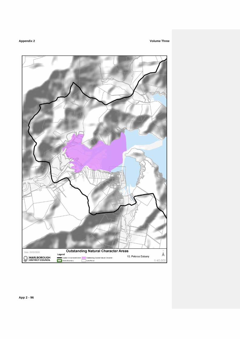
Appendix 2 Volume Three
App 2 - 96
Volume Three Appendix 2
App 2 - 97
ONC 13: Pelorus Estuary (refer to map on opposite page)
The mouth of the Pelorus River holds distinctive remnant alluvial communities that are impressive in their extent and lack of modification.
Abiotic CharacteristicsValues
− Extensive and uniform intertidal flats at the mouth of the Te Hoiere/Pelorus River.
− Largely intact estuarine hydrological processes.
Biotic CharacteristicsValues
− Biotic patterns and sequences, dynamics and process functioning are largely intact.
− Distinctive remnant alluvial communities are largely intact in the estuary and also for the upper hillslopes, although now reduced to scattered treelands, and include fertile podocarp and mixed broadleaved treeland, and semi-deciduous kowhai ribbonwood-lacebark treelands.
− Estuarine and adjoining freshwater wetland communities are extensive, very distinctive, regionally outstanding, and provide important habitats.
Experiential ValuesAttributes
− The intertidal river delta, with its network of small waterways and extensive saltmarsh beds is extremely memorable.
− Despite modifications around parts of its perimeter, this large estuary holds high levels of perceived naturalness.
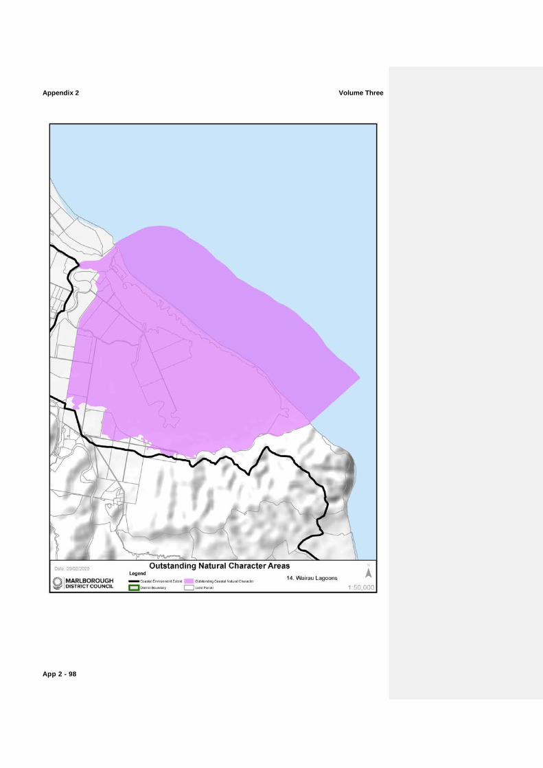
Appendix 2 Volume Three
App 2 - 98
Volume Three Appendix 2
App 2 - 99
ONC 14: Wairau Lagoons (refer to map on opposite page)
The Wairau Lagoons represent an exceptional system of interlinked channels and lagoons harbouring a diverse avifauna community.
Abiotic CharacteristicsValues
− The Wairau Lagoons estuary is a distinctive feature of this coastline – a 2,300ha system of interlinked channels, broad shallow lagoons, small islands and expansive intertidal flats, forming a unique and nationally significant coastal lagoon-estuarine system.
− The Wairau Lagoons and Bar have been identified as nationally significant intact landforms.
− Geopreservation site includes: Wairau boulder barrier; lagoon; and delta.
Biotic CharacteristicsValues
− Extensive glasswort herbfields are a distinctive feature. Other species such as rushes, sedges, estuarine herbs and grasses feature around the fringes.
− Nationally significant for wading birds (including migratory species), waterfowl and other wetland birds with almost 90 recorded species – the majority being native and more than a quarter endangered, vulnerable or rare.
Experiential ValuesAttributes
− Aesthetically interesting and broadly unmodified landforms of the estuarine landscape and boulder bank.
− Expansive sea views out to Te Koko-o-Kupe/Cloudy Bay, backdropped by the White Bluffs/Te Parinui o Whiti, which are visually impressive.
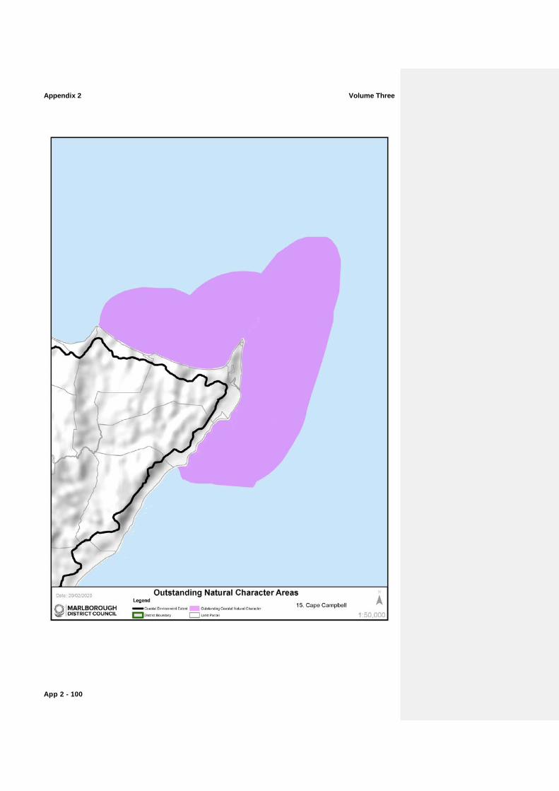
Appendix 2 Volume Three
App 2 - 100
Volume Three Appendix 2
App 2 - 101
ONC 15: Cape Campbell (refer to map on opposite page)
Impressive Cape retaining a number of offshore reefs, platforms and rocks that harbour a variety of species.
Abiotic CharacteristicsValues
− This area is influenced by the cold Southland Current, and is frequently exposed to high energy swells and storms from the south and east.
− Broad and deeply incised shore platforms and offshore reefs characterise the marine environment in the vicinity of Cape Campbell.
− Mussel Point forms another prominent reef structure marking the western boundary of this area.
− High limestone cliffs extend between Mussel Point and Cape Campbell.
Biotic CharacteristicsValues
− The reefs support moderate numbers and diversity of plants and animals with the greatest diversity located subtidally within channels, pools and partially sheltered areas of the reefs.
− Large offshore beds of giant kelp (Macrocystis pyrifera). − Largely unmodified coastal marine environment.
Experiential ValuesAttributes
− Access to this remote and rugged coastline is limited. − The coast is largely unmodified with no aquaculture or
jetties/wharves. The area, once visited, is extremely memorable.
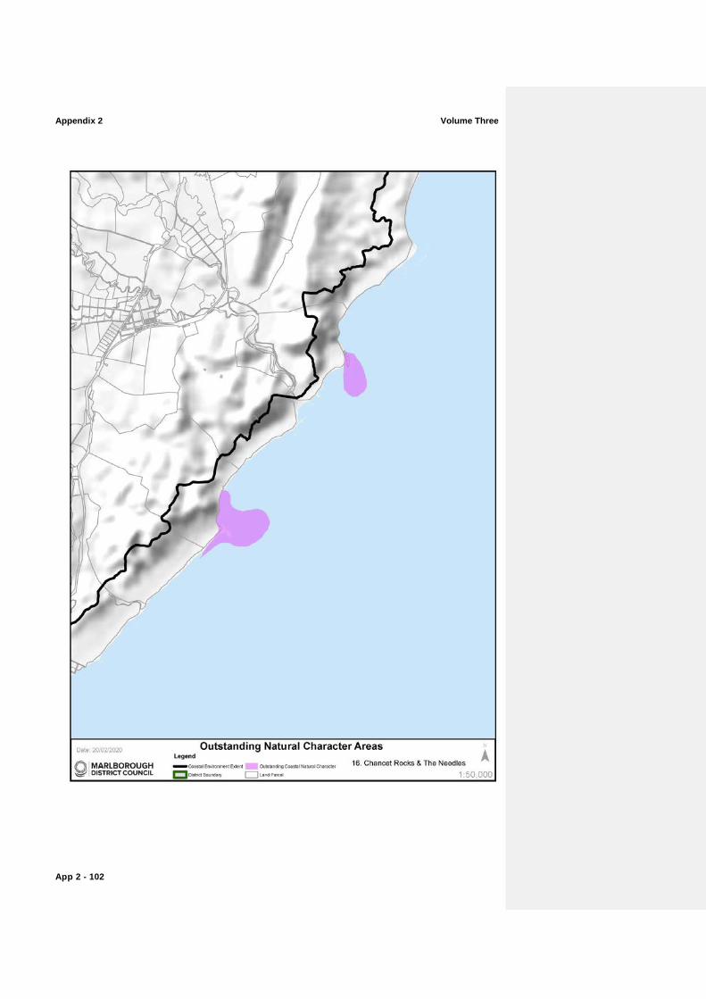
Appendix 2 Volume Three
App 2 - 102

Volume Three Appendix 2
App 2 - 103
ONC 16: Chancet Rocks and The Needles (refer to map on opposite page)
Impressive coastal erosional features of The Needles and Chancet Rocks hold outstanding abiotic, and biotic characteristics and experiential values attributes due to their location on this high energy coastline.
Abiotic CharacteristicsValues
− This area is influenced by the cold Southland Current, and is frequently exposed to high energy swells and storms from the south and east. Inshore coastal waters are cloudy due to sedimentation from the Flaxbourne, Waiau-toa/Clarence and Waima (Ure) Rivers and erosion of the soft cretaceous rocks of this coast by wave action.
− The limestone features and wave cut platforms of the Needles and Chancet Rocks are unique to this coastline and have been identified as individual geopreservation sites due to their unique geological makeup.
Biotic CharacteristicsValues
− There are colonies of NZ fur seals at Chancet Rocks and The Needles.
− Limestone reef communities.
Experiential ValuesAttributes
− The wave cut platforms and reefs of Chancet Rock and the Needles are prominent features displaying limited modification.
− This coast is characterised by rocky reefs and stacks interspersed with sand or gravel beaches. Access is limited to only a few locations.
Comment [ 2]: Topic 4

Appendix 2 Volume Three
App 2 - 104