APPENDIX 2: Application Form for Environmental Authorisation · E-mail: [email protected] Name of...
47
DBAR: R335 Upgrade, Motherwell to Addo 41643 APPENDIX 2: Application Form for Environmental Authorisation
Transcript of APPENDIX 2: Application Form for Environmental Authorisation · E-mail: [email protected] Name of...

DBAR: R335 Upgrade, Motherwell to Addo 41643
APPENDIX 2: Application Form for Environmental Authorisation

PROPOSED UPGRADING OF NATIONAL ROUTE R335 BETWEEN
MOTHERWELL (KM 5.600) AND ADDO (KM 37.600), WITHIN THE NELSON
MANDELA BAY MUNICIPALITY AND SUNDAYS RIVER VALLEY LOCAL
MUNICIPALITY, EASTERN CAPE PROVINCE
APPLICATION FORM FOR ENVIRONMENTAL AUTHORISATION
April 2019
Prepared by:
Terratest (Pty) Ltd
PO Box 27308
Greenacres
Port Elizabeth
6057

Application for Environmental Authorisation Form
Page 1 of 17
APPLICATION FORM FOR ENVIRONMENTAL AUTHORISATION
(For official use only)
File Reference Number:
NEAS Reference Number: DEA/EIA/
Date Received:
Application for authorisation in terms of the National Environmental Management Act, Act No. 107 of 1998, as amended and the Environmental Impact Assessment (EIA) Regulations, 2014, as amended (the Regulations)
PROJECT TITLE
PROPOSED UPGRADING OF NATIONAL ROUTE R335 BETWEEN MOTHERWELL (KM 5.600) AND ADDO (KM 37.600), WITHIN THE NELSON MANDELA BAY MUNICIPALITY AND SUNDAYS RIVER VALLEY LOCAL MUNICIPALITY, EASTERN CAPE PROVINCE
Indicate if the DRAFT report accompanies the application Yes No ✓ PRE-APPLICATION CONSULTATION
Was a pre-application meeting held Yes ✓ No
Date of the pre-application meeting 03 October 2018
Reference number of pre-application meeting held None provided to EAP
Was minutes compiled and submitted to the Department for approval Yes ✓ No
A copy of the pre-application meeting minutes must be appended to this application as APPENDIX 1. Kindly note the following: 1. This form must always be used for applications that must be subjected to Basic Assessment or Scoping &
Environmental Impact Reporting where this Department is the Competent Authority.
2. This application form is current as of 01 September 2018. It is the responsibility of the Applicant / Environmental
Assessment Practitioner (EAP) to ascertain whether subsequent versions of the form have been published or
produced by the Competent Authority. The latest available Departmental templates are available at
https://www.environment.gov.za/documents/forms.
3. The onus on Applicant/EAP to determine all applicable listed activities that would require Environmental
Authorisation prior to the commencement of the construction activities. Should any revision of your development
comprise any other activities that constitute a listed activity/ies as defined in GN R983, R984 and R98 of 04
December 2014, as amended, it must also form part of the Application for Environmental Authorisation.
4. An application fee is applicable (refer to Section 2). Proof of payment must accompany this application. The
application will not be processed without proof of payment unless one of the exclusions provided for in the Fee
Regulations is applicable AND such information in the exclusion section of this application form has been confirmed
by this Department.
5. A cover letter on your company letterhead indicating the nature of this application must be appended to this form i.e.
new application for Environmental Authorisation, updated application for Environmental Authorisation.
6. An electronic copy (in the form of a USB) of the signed application form must be submitted together with two
hardcopies (one of which must contain the original signatures of both the Applicant and EAP).
7. This form must be marked “for Attention: Chief Director: Integrated Environmental Authorisations” and
submitted to the Department at the postal or physical addresses contained in this form.

Application for Environmental Authorisation Form
Page 2 of 17
8. All documentation delivered to the physical address contained in this form must be delivered during the official
Departmental Officer Hours which is visible on the Departmental gate.
9. All EIA related documents (includes application forms, reports or any EIA related submissions) that are faxed;
emailed; delivered to Security or placed in the Departmental Tender Box will not be accepted, only hardcopy
submissions are accepted.
10. The required information must be typed within the spaces provided in the form. The sizes of the spaces provided
are not necessarily indicative of the amount of information to be provided. Spaces are provided in tabular format
and will extend automatically when each space is filled with typing. A legible font type and size must be used when
completing the form. The font size should not be smaller than 10pt (e.g. Arial 10).
11. Where applicable black out the boxes that are not applicable in the form.
12. The use of the phrase “not applicable” in the form must be done with circumspection. Where it is used in respect of
material information that is required by the Competent Authority for assessing the application, this may result in the
rejection of the application as provided for in the Regulations.
13. Unless protected by law, all information contained in and attached to this application, will become public information
on receipt by the Competent Authority. Upon request during any stage of the application process, the Applicant /
EAP must provide any registered interested and affected party with the information contained in and attached to this
application.
14. Should a specialist report or report on a specialised process be submitted at any stage for any part of this
application, the terms of reference for such report and declaration of interest of the specialist must also be
submitted.
15. Please note that this form must be copied to the relevant Provincial Environmental Department(s)
16. An application for Environmental Authorisation/Amendment lapses if the applicant fails to meet any of the
timeframes prescribed in terms of the EIA Regulations, 2014, as amended.
Departmental Details
Postal address: Department of Environmental Affairs Attention: Chief Director: Integrated Environmental Authorisations Private Bag X447 Pretoria 0001 Physical address: Department of Environmental Affairs Attention: Chief Director: Integrated Environmental Authorisations Environment House 473 Steve Biko Road Arcadia Queries must be directed to the Directorate: Coordination, Strategic Planning and Support at: Email: [email protected]

Application for Environmental Authorisation Form
Page 3 of 17
1. COMPETENT AUTHORITY
Identified Competent Authority to consider the application:
Department of Environmental Affairs
Reason(s) in terms of S24C of NEMA:
The Applicant, the South African National Roads Agency SOC Ltd (SANRAL) is a parastatal, and as such the Competent Authority in terms of review and decision making for this application is the Department of Environmental Affairs.
2. FEES Applicants are required to tick the appropriate box below to indicate that either proof of payment is attached or that, in the applicant’s view, an exclusion applies. Proof of payment or a motivation for exclusions must be attached as APPENDIX 2 of this application form.
Proof of payment x
Exclusion applies ✓
An applicant is excluded from paying fees if:
• The activity is a community based project funded by a government grant; or
• The applicant is an organ of state.
TYPE OF EXCLUSION Tick where applicable. Proper motivation must be attached to the application
The activity is a community based project funded by a government grant
The applicant is an organ of state ✓
FEE AMOUNT Fee
Application for an environmental authorisation for which basic assessment is required in terms of the Environmental Impact Assessment Regulations
R2 000
Application for an environmental authorisation, for which S&EIR is required in terms of the Environmental Impact Assessment Regulations
R10 000
Department of Environmental Affairs’ banking details for the payment of application fees:
Payment Enquiries: Email: [email protected] Banking details: ABSA Bank Branch code: 632005 Account number: 1044 2400 72 Current account Reference number : Reference number to be provided in the specific format indicating centre point coordinates of site in decimal degrees to 5 or 6 decimal places: latitude/longitude eg. -33.918861/18.423300 Status: Tax exempted

Application for Environmental Authorisation Form
Page 4 of 17
3. GENERAL INFORMATION
Name of the Applicant: South African National Roads Agency SOC Limited (SANRAL)
RSA Identity/ Passport Number:
-
Name of contact person for applicant (if other):
Mbulelo Simon Peterson
RSA Identity/ Passport Number:
610804 5613 085
Responsible position, e.g. Director, CEO, etc.:
Regional Manager - Southern Region
Company/ Trading name (if any):
N/A
Company Registration Number:
1998/009584/30
BBBEE status: Compliant
Physical address: Baywest Boulevard, Hunters Retreat, Port Elizabeth
Postal address: PO Box 24210, Baywest Boulevard, Hunters Retreat, Port Elizabeth
Postal code: 6025 Cell: 083 283 6119
Telephone: 041 398 3200 Fax: 041 492 0200
E-mail: [email protected]
Name of the landowner: Please see Appendix 3 for landowner details
Name of contact person for landowner (if other):
Postal address:
Postal code: Cell:
Telephone: Fax:
E-mail:
Name of Person in control of the land:
Please see Appendix 3 for landowner details
Name of contact person for person in control of the land:
Postal address:
Postal code: Cell:
Telephone: Fax:
E-mail:
In instances where there is more than one landowner, please attach a list of those landowners with their contact details as APPENDIX 3. Unless the application is in respect of linear activities or Strategic Infrastructure Projects as contemplated in the Infrastructure Development Act (Act No. 23 of 2014), written consent of landowner/s must be submitted in APPENDIX 3. The declaration undertaking by the applicant must be submitted as APPENDIX 9.

Application for Environmental Authorisation Form
Page 5 of 17
Provincial Environmental Authority:
Eastern Cape Department of Economic Development, Environmental Affairs and Tourism (DEDEAT): Cacadu Region
Name of contact person: Ms Charmaine Struwig
Postal address: Private Bag X5001, Greenacres
Postal code: 6057 Cell: -
Telephone: 041 508 5800/39 Fax: 041 508 5865
E-mail: [email protected]
Local Municipality: Nelson Mandela Bay Municipality (NMBM)
Name of contact person in (Environmental Section)
Ms Jill Miller (Environmental Management Sub-directorate, NMBM)
Postal address: PO Box 7, Port Elizabeth
Postal code: 6000 Cell: -
Telephone: 041 506 5447 Fax: 041 585 7261
E-mail: [email protected]
Local Municipality: Sundays River Valley Local Municipality (SRVLM)
Name of contact person in (Environmental Section)
Mr Mpumelelo Nzuzo (Acting Director of Infrastructure Development)
Postal address: PO Box 47, Kirkwood
Postal code: 6120 Cell: 063 505 5185
Telephone: 042 230 7700 Fax: -
E-mail: [email protected]
In instances where there is more than one Local/Provincial Authority involved, please attach a list of those Local/ Provincial Authorities with their contact details as APPENDIX 4. 4. ENVIRONMENTAL ASSESSMENT PRACTITIONER (EAP) INFORMATION
Company of Environmental Assessment Practitioner:
Terratest (Pty) Ltd
B-BBEE Contribution level (indicate 1 to 8 or non-compliant)
2 Percentage Procurement recognition
125%
EAP name: Cherize Coetzee
EAP Qualifications: MSc (Zoology), BSc (Hons) (Zoology), BSc
Professional affiliation/registration:
IAIAsa Eastern Cape Branch (Registration number 3551) Institute of Waste Management of Southern Africa (Registration number 40213120)
Physical address: Southern Life Gardens, Block D – Ground Floor, 70 – 2nd Avenue, Newton Park, Port Elizabeth, 6045, Eastern Cape, South Africa
Postal address: PO Box 27308, Greenacres, Port Elizabeth, South Africa
Postal code: 6057 Cell: 082 299 8782
Telephone: 041 390 8730 Fax: 041 363 1922
E-mail: [email protected]
The appointed EAP must meet the requirements of Regulation 13 of GN R982 of 04 December 2014, as amended. The declaration of independence of the EAP and undertaking under oath or affirmation that all the information submitted or to be submitted for the purposes of the application is true and correct must be submitted as APPENDIX 10.

Application for Environmental Authorisation Form
Page 6 of 17
5. PROJECT DESCRIPTION Please provide a detailed description of the project.
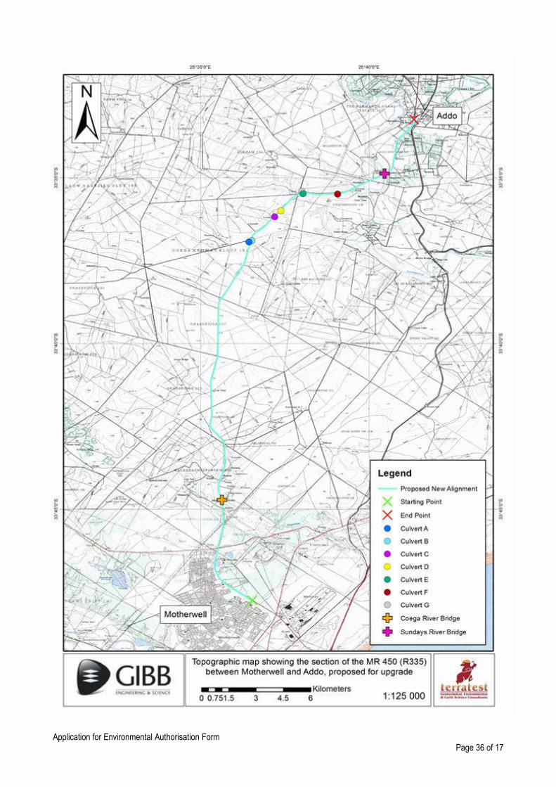
The South African National Roads Agency SOC Limited (SANRAL) has appointed Terratest (Pty) Ltd as the Environmental Assessment Practitioner for the ‘Upgrading of National Route R335 between Motherwell (km 5.600) and Addo (km 37.600)’ within the Nelson Mandela Bay Municipality (NMBM) and Sundays River Valley Local Municipality (SRVLM). The improvement works will include road drainage upgrades, widening and/or replacement of bridges and culverts and all associated road furniture. The R335 between Motherwell and Addo is a major link in the road network of the Coega hinterland. It serves as a major link for traffic to the industrial production areas (manufacture of cement and clay bricks), agricultural areas (citrus farm areas) around Addo and Kirkwood, as well as to tourism areas such as the Addo Elephant National Park. The total length of the road to be upgraded will be 32 km and crosses the Coega River and Sundays River. The work to be executed will comprise the following: Route realignment The proposed upgrading will start at the WM Maku Street intersection in Motherwell (km 5.600) and will end at the southern boundary of the Addo CBD (km 37.600). A dual carriageway is proposed for the urban section within Motherwell starting at WM Maku Street (km 5.600) and continue up to the intersection with the R334 (km 9.300) where it transitions over 150 m to the start of the single carriageway. The new road alignment will be generally offset to either the left or the right of the existing road. Where possible the offset will be 7m, (left or right) in order to assist with maintaining two-way traffic accommodation while at the same time reducing the requirement for temporary deviations and stop-and-goes. It is anticipated that the only long term stop-and-go will be at the Sundays Rive Bridge in order to facilitate widening of the deck. The vertical alignment will be smoothed out along portions of the alignment to prevent sudden dips
and rises in the road surface. As a result, substantial mass earthworks (cut and fill) on the existing road will be required.
Road Drainage Drainage on the road will be achieved by a combination of the longitudinal grade and the cross fall of the road. The cross fall of the road will be increased to 2.5 % where the longitudinal grade falls below 1% and increased to 3% where the longitudinal grade falls below 0.5%. The stormwater will be collected in side drains, kerb and channel, concrete v drains or it will be allowed to run down embankments in the areas of low fill. Drainage away from the road prism will include the construction of cut-off drains at the tops of high cuts in order to avoid water spilling down the embankment. Subsoil drains will be installed to deal with groundwater in order to protect the lower road layers. Bridges and Structures 1. The following hydraulic structures will be affected by the upgrade:
a) The construction of a new bridge over the Coega River and the decommissioning of the ‘old’ Coega River Bridge.
b) The reconstruction and widening of the existing bridge on the Sundays River at km 34.80. The existing bridge is a three-span, reinforced concrete fixed arch structure with spandrel walls. As it will be necessary to widen the deck the existing balustrades and sidewalks shall be demolished, maintaining a similar, arched profile in order to accommodate a wider road profile. The new deck will accommodate a road width of 13.4 m.
c) The construction / expansion of in situ box culverts complete with inlet and outlet structures of which 2 major culverts are located on intersecting roads a short distance from the R335:
o Culvert A (new culvert) – 2 cell x 2.4m wide x 2.4m high on the DR01958 at km 0.120 o Culvert B (upgrading and expanding existing culvert) – 3 cell x 3.4m wide x 3.2m high on the R335 at
km 27.120 o Culvert C (upgrading and expanding existing culvert) – 3 cell x 3.4m wide x 3.2m high on the R335 at
km 28.825 o Culvert D (upgrading and expanding existing culvert) – 3 cell x 3.4m wide x 3.2m high on the R335 at
km 29.305 o Culvert E (upgrading and expanding existing culvert) – 3 cell x 3.4m wide x 3.2m high on the R335 at
km 30.730

Application for Environmental Authorisation Form
Page 7 of 17
o Culvert F (upgrading and expanding existing culvert) – 3 cell x 3.4m wide x 3.2m high on the R335 at km 32.310
o Culvert G (new culvert) - 2 cell x 1.8m wide x 2 m high on the MN50267 at km 0.08 d) The construction of minor precast box culverts complete with inlet and outlet structures.
2. The construction of retaining structures (concrete and/or reinforced earth). 3. The construction of three precast culvert type underpasses to facilitate the safe movement of wildlife to either side of the road:
a) Underpass #01 crosses the R335 at km 33.240. Configuration is 1-cell x 3000mm width x 3000mm height. b) Underpass #02 crosses the R335 at km 33.270. Configuration is 1-cell x 3000mm width x 3000mm height. c) Underpass #03 crosses the R335 at km 28.050. Configuration is 1-cell x 3000mm width x 3000mm height.
Roadworks
a) Clearing and grubbing; b) Removal of topsoil for widening of the road. c) Roadbed preparation for widening of the road. d) Bulk Earthworks (Cut to fill or spoil). e) Removal of existing road layer works to stockpile. f) The construction of in-situ and imported layers; g) The construction of a C3 stabilised sub-base layer; h) The construction of a crushed stone base bitumen stabilised and unstabilised; and, i) Surfacing the road with a Cape Seal.
Ancillary Roadworks
a) Construction of bus/taxi stops with shelters; b) Fencing of the road reserve; c) The provision of road markings; d) The installation of road studs; e) The installation of new road signs; f) The erection of guardrails; g) Pedestrian facilities, including sidewalks where appropriate; h) Top-soiling and grassing of cut and fill slopes; and i) Finishing off the road reserve, spoil areas and borrow pits.
Please note that an Application for a Mining Permit for material sources for seven borrow pits is to be applied for. However, as the Competent Authority related to mining right and permit applications is the Department of Mineral Resources, a separate application is being undertaken and will not be dealt with further under this Application.
Does the project form part of any of the Strategic Infrastructure Projects (SIPs) as described in the National Development Plan, 2011?
NO
If YES, please indicate which SIPs are applicable in APPENDIX 5. You are also required to provide confirmation of SIP applications from the relevant sector representative which must be attached in APPENDIX 5.
Is the project subject to the Integrated Resource Plan 2010 – 2030 (IRP) bidding process? NO
Please indicate which sector the project falls under by crossing out the relevant block in the table below: Table 1
Infrastructure /Transport Services/Roads - Public ✓ Services/Waste Management Services/Disposal facilities - Hazardous
Infrastructure /Transport Services/Roads - Private Services/Waste Management Services/Disposal facilities - Nuclear
Infrastructure /Transport Services/Rail - Public Services/Waste Management Services/Disposal
Application for Environmental Authorisation Form
Page 8 of 17
facilities - General
Infrastructure /Transport Services/Rail - Private Services/Waste Management Services/Treatment facilities - Hazardous
Infrastructure /Transport Services/Airport/Runways/Landing Strip/Helipad - Commercial
Services/Waste Management Services/Treatment facilities - General
Infrastructure /Transport Services/Airport/Runways/Landing Strip/Helipad - Private
Services/Waste Management Services/Storage Facilities - General
Infrastructure /Transport Services/Airport/Runways/Landing Strip/Helipad - Public Services
Services/Waste Management Services/Storage Facilities - Hazardous
Infrastructure /Transport Services - Ports Services/Waste Management Services/Storage Facilities - Nuclear
Infrastructure /Transport Services - Inland Waterways
Services/Burial and cemeteries - Cemeteries
Infrastructure /Transport Services - Marina Services/Burial and cemeteries - Cremators
Infrastructure /Transport Services - Canal Services/Water services/Storage - Dams
Infrastructure /Localised infrastructure - Infrastructure in the Sea/Estuary/Littoral Active Zone/Development Setback/100M Inland/or coastal public property.
Services/Water services/Storage - Reservoirs
Infrastructure /Localised infrastructure - Zip Lines & Foefie Slides
Services/Water services - Desalination
Infrastructure /Localised infrastructure - Cableway or Funiculars
Services/Water services - Treatment & Waste Water
Infrastructure /Localised infrastructure - Billboards Services - Hospitality
Infrastructure /Localised infrastructure - Depot for dangerous goods
Mining - Prospecting rights
Infrastructure /Localised infrastructure - Filling station or Tanks for dangerous goods
Mining - Mining Permit
Utilities Infrastructure/Pipelines - Fresh/Storm Water Urban
Mining - Mining Right
Utilities Infrastructure/Pipelines - Fresh/ Storm Water Rural
Mining/Exploration Right - Gas or Oil Marine
Utilities Infrastructure/Pipelines - Waste Water Mining/Exploration Right - Gas or Oil Terrestrial
Utilities Infrastructure/Pipelines - Dangerous Goods Urban
Mining/Production Right - Gas or Oil Marine
Utilities Infrastructure/Pipelines - Dangerous Goods Rural
Mining/Production Right - Gas or Oil Terrestrial
Utilities Infrastructure/Telecommunications/ Radio Broadcasting - Tower
Mining/Underground gasification of coal - Oil
Utilities Infrastructure/Telecommunications/ Radio Broadcasting - Mast
Mining/Beneficiation - Hydrocarbon
Utilities Infrastructure/Telecommunications/ Radio Broadcasting - Receivers
Mining/Beneficiation - Mineral
Utilities Infrastructure - Marine Cables Agriculture/Forestry/ Fisheries - Crop Production
Utilities Infrastructure/Electricity /Generation/Non Renewable/Hydrocarbon - Petroleum
Agriculture/Forestry/ Fisheries - Animal Production
Utilities Infrastructure/Electricity /Generation/Non Renewable/Hydrocarbon - Coal
Agriculture/Forestry/ Fisheries - Afforestation
Utilities Infrastructure/Electricity /Generation/Non Renewable - Nuclear
Agriculture/Forestry/ Fisheries - Aquaculture
Utilities Infrastructure/Electricity /Generation/Renewable - Hydro
Agriculture/Forestry/ Fisheries - Agro-Processing
Utilities Infrastructure/Electricity Transformation of land - Indigenous vegetation

Application for Environmental Authorisation Form
Page 9 of 17
/Generation/Renewable/Solar - PV
Utilities Infrastructure/Electricity /Generation/Renewable/Solar - CSP
Transformation of land - From open space or Conservation
Utilities Infrastructure/Electricity /Generation/Renewable - Wind
Transformation of land - From agriculture or afforestation
Utilities Infrastructure/Electricity /Generation/Renewable - Biomass/ biofuels
Transformation of land - From mining or heavy industrial areas
Utilities Infrastructure/Electricity /Generation/Renewable - Wave
Any activities within or close to a watercourse
Utilities Infrastructure/Electricity /Distribution and Transmission - Power line
Any activity in an estuary, on the seashore, in the littoral active zone, or in the sea.
Utilities Infrastructure/Electricity /Distribution and Transmission/Substation -
Activity requiring permit or licence in terms of National or Provincial legislation governing the release or generation of emissions - Emissions
Release of Genetically Modified Organisms Activity requiring permit or licence - Marine Effluent
Activity requiring permit or licence - Fresh Water Effluent
Table 2
Does the listed activity/ies applied for form part of a larger project which is not a listed activity itself e.g. a road that is a listed activity that is needed to access a drilling site where the drilling does not constitute a listed activity.
NO
If indicated yes above, please provide a brief description on how the activity/ies relate to the larger project that forms part there of:
N/A

Application for Environmental Authorisation Form
Page 10 of 17
6. SITE DESCRIPTION Provide a detailed description of the site involved in the application.
Province/s Eastern Cape
District Municipality/ies Nelson Mandela Bay Municipality (NMBM) Sarah Baartman District Municipality
Local Municipality/ies Nelson Mandela Bay Municipality Sundays River Valley Local Municipality
Ward number/s NMBM: Wards 23, 53, 54, 55 and 56 SRVLM: Wards 3 and 6
Nearest town/s Port Elizabeth, Motherwell, Addo
Farm name/s and number/s Please see Appendix 3
Portion number/s Please see Appendix 3
Surveyor General 21digit code: (If there are more than 4, please attach a list with the rest of the codes as APPENDIX 6. Where the 21digit SGID and farm name are not available, the coordinates of the boundary of the property or properties must be provided in APPENDIX 6.
Please see Appendix 3 for details
1 2 3 4 5
Locality map:
A locality map must be attached to the application form, as APPENDIX 7. The scale of the locality map must be at least 1:50 000. For linear activities of more than 25 kilometres, a smaller scale e.g. 1:250 000 can be used. The scale must be indicated on the map. The map must include the following:
• an accurate indication of the project site position as well as the positions of the alternative sites, if any;
• road names or numbers of all the major roads as well as the roads that provide access to the site(s)
• a north arrow;
• a legend;
• the prevailing wind direction;
• site sensitivities, including but not limited to vegetation, wetlands, watercourses, heritage sites, critical biodiversity area/s, World Heritage Site, etc. and it must be overlaid by the study area; and
• GPS co-ordinates (Indicate the position of the proposed activity with the latitude and longitude at the centre point for each alternative site. The co-ordinates should be in degrees and decimal minutes. The minutes should be to at least three decimal places. The projection that must be used in all cases is the WGS-84 spheroid in a national or local projection)
Project Plan (e.g. Gantt chart)
A project schedule must be submitted as APPENDIX 8, and must include milestones for:
• public participation (dates for advertisements, workshops and other meetings, obtaining comment from organs of state including state departments);
• the commencement of parallel application processes required in terms of other statutes and where relevant, the alignment of these application processes with the EIA process;
• the submission of the key documents (e.g. Basic Assessment Report, Scoping Reports, EIA Reports and Environmental Management Programmes).
Note: All the above dates must take into account the statutory timeframes for authority responses that are stipulated in the 2014 NEMA EIA Regulations. Possible appeals may impact on project timeframes/milestones. Regulation 45 states that “An application in terms of these Regulations lapses, and a competent authority will deem the application as having lapsed, if the applicant fails to meet any of the time-frames prescribed in terms of these Regulations, unless extension has been granted in

Application for Environmental Authorisation Form
Page 11 of 17
terms of regulation 3(7).” It is recommended that the Department be approached for guidance on the process to be followed, prior to submitting an application.

Application for Environmental Authorisation Form
Page 12 of 17
7. ACTIVITIES APPLIED FOR For an application for authorisation that involves more than one listed activity that, together, make up one development proposal, all the listed activities pertaining to this application must be provided below.
Activity No(s): Provide the relevant Basic Assessment Activity(ies) as set out in Listing Notice 1 (GN R983)
Describe the portion of the proposed project to which the applicable listed activity relates.
GNR 983
(Listing Notice
1), as
amended:
Activity 19
“The infilling or depositing of any material of more than 10 cubic meters into, or the dredging, excavation,
removal or moving of soil, sand, shells, shell grit,
pebbles or rock of more than 10 cubic meters from –
(a) A watercourse;”
Construction of the new Coega River Bridge
and new culverts as well as the expansion of
the existing Sundays River Bridge and existing
culverts will require the excavation and
removal of material from the various
watercourses. As the cumulative volume of
material to be excavated from the
watercourses is anticipated to be 3000 m³, this
Listed Activity is triggered.
GNR 983
(Listing Notice
1), as
amended:
Activity 27
“The clearance of an area of 1 hectares or more, but less than 20 hectares of indigenous vegetation,
except where such clearance of indigenous vegetation
is required for-
(i) the undertaking of a linear activity…”
It is to be noted that whilst this exclusion
applies to the upgrading of the R335 road, it
does not apply to the proposed bridge and
culvert structures, site camps and stockpile
areas. As such, it is anticipated that
cumulatively, in excess of 1ha of indigenous
vegetation will be cleared during the
construction process and as such this Listed
Activity is triggered.
GNR 983
(Listing Notice
1), as
amended:
Activity 31
“The decommissioning of existing facilities, structures
or infrastructure for –
(i) any development and related operation activity or
activities listed in this Notice, Listing Notice 2 of 2014
or Listing Notice 3 of 2014…”
The new Coega River Bridge will be
constructed adjacent to the existing bridge
structure. Once construction is completed, the
‘old’ bridge will be decommissioned and demolished and would trigger Activity 19 (of
LN1) and Activities 12 and 14 (of LN3) if it was
to be constructed. As such, this Listed Activity
for the decommissioning of this structure is
triggered.
GNR 983
(Listing Notice
1), as
amended:
Activity 48
“The expansion of –
(i) infrastructure or structures where the physical
footprint is expanded by 100 square metres or more;
Where such expansion occurs-
(a) within a watercourse;
(c) if no development setback exists, within 32 metres
of a watercourse, measured from the edge of a
watercourse…”
The cumulative expansion of the Sundays
River Bridge and culvert structures will exceed
100m² and will occur within watercourses, as
well as within 32m of watercourses. As such,
this Listed Activity is triggered.
GNR 983
(Listing Notice
1), as
amended:
Activity 56
“The widening of a road by more than 6 metres, or the lengthening of a road by more than 1 kilometre-
(i) where the existing reserve is wider than 13.5
metres…”
The proposed upgrading of the R335 road will
exceed a road widening width of 6 metres and
has a reserve of 30 metres (a maximum total
road width of 13.4m applies) and as such this
Listed Activity is triggered.

Application for Environmental Authorisation Form
Page 13 of 17
Activity No(s): Provide the relevant Basic Assessment Activity(ies) as set out in Listing Notice 3 (GN R985)
Describe the portion of the proposed project to which the applicable listed activity relates.
GNR 985
(Listing Notice
3), as
amended:
Activity 12
“The clearance of an area of 300 square metres or more of indigenous vegetation except where such
clearance of indigenous vegetation is required for
maintenance purposes undertaken in accordance with
a maintenance plan.
a. Eastern Cape
i. Within any critically endangered or endangered
ecosystem listed in terms of section 52 of NEMBA or
prior to publication of such a list, within an area that
has been identified as critically endangered in the
National Spatial Biodiversity Assessment 2004…”
The alignment of the R335 at the Coega River
Bridge passes directly through what is
characterised as Albany Alluvial Vegetation,
which has an endangered status as per
SANBI status. The construction of the new
Coega River Bridge is anticipated to require
the clearing of in excess of 300m², and as
such this Listed Activity is triggered.
GNR 985
(Listing Notice
3), as
amended:
Activity 14
“The development of –
(ii) infrastructure or structures with a physical footprint
of 10 square metres or more;
where such development occurs –
(a) within a watercourse;
(c) …within 32 meters of a watercourse, measured from the edge of the watercourse;
excluding the development of infrastructure or
structures within existing ports or harbours that will not
increase the development footprint of the port or
harbour.
(a) In Eastern Cape:
i. Outside urban areas, in:
(aa) A protected area identified in terms of NEMPAA,
excluding conservancies;
(hh) Areas within 10 kilometres from national parks or
world heritage sites or 5 kilometres from any other
protected area identified in terms of NEMPAA or from
the core area of a biosphere reserve.”
The footprint of the Coega River Bridge, within
the Coega River, proposed to be demolished
and reconstructed, will exceed the 100m²
footprint. In addition, new drainage culverts
will be established along the upgraded
alignment. The majority of the proposed
development will occur outside an urban area
(see Appendix 7).
A section of the R335 bisects the Tregathlyn
Game Farm, listed on the DEA Screening Tool
as a Protected Area. Within this portion of the
alignment, one new culvert (Culvert A) is to be
constructed with a footprint of 23.04m² (4.8m x
4.8m). The construction of Culvert G, a new
culvert, falls within 7.6km of the Addo
Elephant National Park and has a footprint of
12.96m² (3.6m x 3.6m). Based on these
factors this Listed Activity is triggered.
GNR 985
(Listing Notice
3), as
amended:
Activity 18
“The widening of a road by more than 4 metres, or the lengthening of a road by more than 1 kilometre.
(a) Eastern Cape:
i. Outside urban areas:
(aa) A protected area identified in terms of NEMPAA,
excluding conservancies;
(gg) Areas within 10 kilometres from national parks or
world heritage sites or 5 kilometres from any other
protected area identified in terms of NEMPAA or from
the core area of a biosphere reserve;
(kk) A watercourse…”
The proposed upgrading of the R335 will
involve the widening of the road by more than
4m and the majority of the proposed site falls
outside the urban area. The proposed site
falls within 10 km from the Addo Elephant
National Park. In addition, the road traverses
the Sundays and Coega Rivers as well as
unnamed watercourses at which the culverts
will be constructed. This Listed Activity is
therefore triggered.
GNR 985
(Listing Notice
3), as
amended:
Activity 23
“The expansion of –
(ii) infrastructure or structures where the physical
footprint is expanded by 10 square metres or more;
where such expansion occurs –
(a) within a watercourse;
(c) if no development setback has been adopted,
The bridge crossing the Sundays River will be
expanded by more than 910m² (130m x 7m).
In addition Culverts C, D, E and F will all be
expanded (each having a footprint of 34.68m²
(10.2m x 3.4m). The proposed sites fall within
10 km from the Addo Elephant National Park.

Application for Environmental Authorisation Form
Page 14 of 17
within 32 meters of a watercourse, measured from the
edge of the watercourse;
…
(a) In Eastern Cape:
i. Outside urban areas:
(gg) Areas within 10 kilometres from national parks or
world heritage sites or 5 kilometres from any other
protected area identified in terms of NEMPAA or from
the core area of a biosphere reserve.”
In addition, the road traverses the Sundays
and Coega Rivers as well as unnamed
watercourses at which the culverts will be
constructed. This Listed Activity IS therefore
triggered.
Activity No(s): Provide the relevant Scoping and EIR Activity(ies) as set out in Listing Notice 2 (GN R984)
Describe the portion of the proposed project to which the applicable listed activity relates.
N/A
Please note that any authorisation that may result from this application will only cover activities specifically applied for. Only those activities listed above shall be considered for authorisation. The onus is on the applicant to ensure that all applicable listed activities are included in the application. Environmental Authorisation must be obtained prior to commencement with each applicable listed activity. Coordinate points indicating the location of each listed activity must be provided as part of APPENDIX 6 as well part of the reports to be submitted. Coordinates must be provided in degrees, minutes and seconds using the Hartebeesthoek94 WGS84 co-ordinate system. 8. PUBLIC PARTICIPATION Provide details of the public participation process proposed for the application as required by Regulation 41(2) of GN R982 of 04 December 2014, as amended.
Prior to submitting an Application to the Department of Environmental Affairs, Terratest advertised the application in one (1) local newspaper. Site notices were erected along the upgrade alignment. A Background Information Document (BID) was disseminated via letter drop, email and postage, to all landowners and IAP’s situated along the R335. These circulations notified members of the public of the proposed activity and provided details on how Interested and Affected Parties could participate in the process. Terratest also submitted the BID to key stakeholders, Government Departments and members of the public who had requested to be registered. Following the commencement of the Public Participation Process period, Terratest will submit an Application Form to the Department of Environmental Affairs (DEA). Concurrently, the Draft Basic Assessment Report (DBAR) will be circulated to key stakeholders, Government Departments and copies will be made available for public review at the local municipal office and public library, as well as for download off the Terratest (Pty) Ltd website. As prescribed within GN R.982 of the 2014 EIA regulations (as amended), the DBAR will be made available for review and comment for a period of 30 days. Once the aforementioned commenting timeframes have expired, the EAP will consolidate all comments received on the application, address any concerns or queries raised and finalise the BAR and Environmental Management Programme (EMPr). The BAR and EMPr will then be submitted to the DEA for review and decision making. All of the PPP to be undertaken will be in accordance with GN R.982 of NEMA (Act 107 of 1998), as amended.
Application for Environmental Authorisation Form
Page 15 of 17
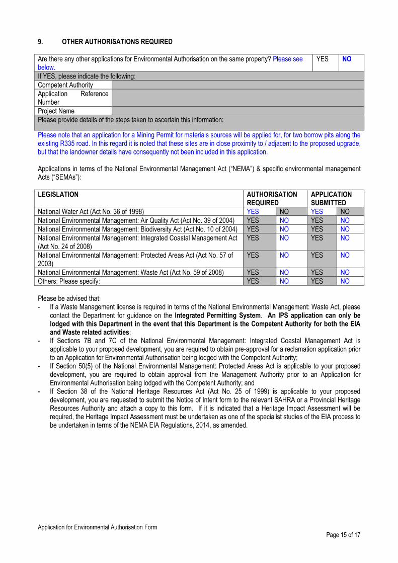
9. OTHER AUTHORISATIONS REQUIRED
Are there any other applications for Environmental Authorisation on the same property? Please see below.
YES NO
If YES, please indicate the following:
Competent Authority
Application Reference Number
Project Name
Please provide details of the steps taken to ascertain this information:
Please note that an application for a Mining Permit for materials sources will be applied for, for two borrow pits along the existing R335 road. In this regard it is noted that these sites are in close proximity to / adjacent to the proposed upgrade, but that the landowner details have consequently not been included in this application. Applications in terms of the National Environmental Management Act (“NEMA”) & specific environmental management Acts (“SEMAs”):
LEGISLATION AUTHORISATION REQUIRED
APPLICATION SUBMITTED
National Water Act (Act No. 36 of 1998) YES NO YES NO
National Environmental Management: Air Quality Act (Act No. 39 of 2004) YES NO YES NO
National Environmental Management: Biodiversity Act (Act No. 10 of 2004) YES NO YES NO
National Environmental Management: Integrated Coastal Management Act (Act No. 24 of 2008)
YES NO YES NO
National Environmental Management: Protected Areas Act (Act No. 57 of 2003)
YES NO YES NO
National Environmental Management: Waste Act (Act No. 59 of 2008) YES NO YES NO
Others: Please specify: YES NO YES NO
Please be advised that: - If a Waste Management license is required in terms of the National Environmental Management: Waste Act, please
contact the Department for guidance on the Integrated Permitting System. An IPS application can only be lodged with this Department in the event that this Department is the Competent Authority for both the EIA and Waste related activities;
- If Sections 7B and 7C of the National Environmental Management: Integrated Coastal Management Act is applicable to your proposed development, you are required to obtain pre-approval for a reclamation application prior to an Application for Environmental Authorisation being lodged with the Competent Authority;
- If Section 50(5) of the National Environmental Management: Protected Areas Act is applicable to your proposed development, you are required to obtain approval from the Management Authority prior to an Application for Environmental Authorisation being lodged with the Competent Authority; and
- If Section 38 of the National Heritage Resources Act (Act No. 25 of 1999) is applicable to your proposed development, you are requested to submit the Notice of Intent form to the relevant SAHRA or a Provincial Heritage Resources Authority and attach a copy to this form. If it is indicated that a Heritage Impact Assessment will be required, the Heritage Impact Assessment must be undertaken as one of the specialist studies of the EIA process to be undertaken in terms of the NEMA EIA Regulations, 2014, as amended.

Application for Environmental Authorisation Form
Page 16 of 17
10. LIST OF APPENDICES
SUBMITTED
APPENDIX 1 Copy of the pre-application meeting minutes YES NO
APPENDIX 2 Proof of Payment / Motivation for exclusion YES NO
APPENDIX 3 List of land owners (with contact details) and written consent of land owners.
YES NO
APPENDIX 4 List of Local/Provincial Authority involved (with contact details) YES NO
APPENDIX 5 Strategic Infrastructure Projects YES N/A
APPENDIX 6 List of SGIDs and coordinates YES NO
APPENDIX 7 Locality map YES NO
APPENDIX 8 Project schedule YES NO
APPENDIX 9 Declaration of Applicant YES NO
APPENDIX 10 Declaration of EAP and undertaking under oath or affirmation YES NO

Application for Environmental Authorisation Form
Page 17 of 17
APPENDIX 1 COPY OF THE PRE-APPLICATION MEETING MINUTES

Application for Environmental Authorisation Form
Page 18 of 17
APPENDIX 2 PROOF OF PAYMENT/ MOTIVATION FOR EXCLUSION
The Applicant is the South African National Roads Agency SOC Limited (SANRAL). As SANRAL is an Organ of
State, the application fees are not payable by them and therefore no proof of payment is enclosed.

Application for Environmental Authorisation Form
Page 19 of 17
APPENDIX 3 LIST OF LAND OWNERS
WRITTEN CONSENT OF LAND OWNERS
Please note that as the proposal is for a linear development, landowner consent is not required as per Section 39(2)(a) of GNR 982 of NEMA (Act 107 of 1998), as amended 2014. However, it is to be noted that all landowners have been contacted and registered as stakeholders and IAP’s. In addition, all land
acquisitions are being dealt specifically by SANRAL designated representatives. Nevertheless, bridges and culverts will also be constructed and/or upgraded as part of this project. It is understood that bridges and culverts are not considered linear developments, and thus, written consent from the affected landowners (properties affected by the proposed construction and/or upgrading of bridges and culverts) have been requested. All written consents have been obtained from the seven 7 respective property owners (see table below).
NEW / UPGRADED
STRUCTURE
AFFECTED FARM
NAME AND NO.
OWNER’S DETAILS (as per title deed)
CONTACT PERSON Consent Form
included
Coega River Bridge Welbedachtfontein
300, Portion 4 Scarlet Ibis 251 (Pty) Ltd Dr Kas Kasongo ✓
Culvert A
Coega Kammas Kloof
191, Remaining
Extent
Agriculture (Crown
Chickens) Cliffort Baartman ✓
Culvert B
Coega Kammas Kloof
191, Remaining
Extent
Agriculture (Crown
Chickens) Cliffort Baartman ✓
Culvert C
Farm 716 Private (Longhill Game
Reserve) Gavin Biggs ✓
Culvert D
Farm 716 Private (Longhill Game
Reserve) Gavin Biggs ✓
Culvert E
Farm 192, Portion 44 Private Game Reserve
(Kudu Ridge) Brian Bowren ✓
Culvert F
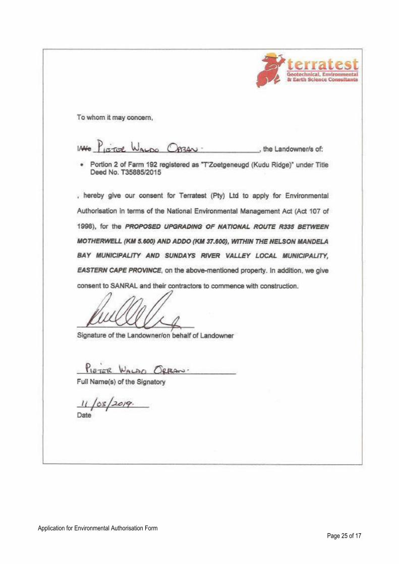
Zoetgeneugd North
192, Portion 2 Agriculture Waldo Pieter Orban ✓
Culvert G
Farm 192, Portion 44 Private Game Reserve
(Kudu Ridge) Brian Bowren ✓
Sundays River Bridge Addo Drift East 124,
Portion 29 Agriculture Trust Ricardo Stefana ✓
Sundays River Bridge Wolverton 130,
Portion 2 Agriculture Cyril Rowe ✓

Application for Environmental Authorisation Form
Page 20 of 17

Application for Environmental Authorisation Form
Page 21 of 17

Application for Environmental Authorisation Form
Page 22 of 17

Application for Environmental Authorisation Form
Page 23 of 17

Application for Environmental Authorisation Form
Page 24 of 17
Application for Environmental Authorisation Form
Page 25 of 17

Application for Environmental Authorisation Form
Page 26 of 17

Application for Environmental Authorisation Form
Page 27 of 17
Farm Name/Description
Portion / Farm No / Erf No
SG Diagram No (EC):
Owner/s details (as per title deed)
Contact Person Contact details SG ID
Motherwell Erf 20572 10405/1995 Nelson Mandela Municipality Yussuf Gaffore 041 506 2109 C07600170002057200000
Motherwell Erf 17528 8636/1991 Nelson Mandela Municipality Yussuf Gaffore 041 506 2109 C07600170001752800000
Motherwell Erf 24532 8411/1992 Nelson Mandela Municipality Yussuf Gaffore 041 506 2109 C07600170002453200000
Motherwell Erf 16616 L274/1986 Nelson Mandela Municipality Yussuf Gaffore 041 506 2109 C07600120001661600000
Coegaskop 316 Portion 5 1082/1949 Nelson Mandela Municipality Yussuf Gaffore 041 506 2109 C07600000000031600005
Motherwell Rem Erf 16781 8410/1992 Nelson Mandela Municipality Yussuf Gaffore 041 506 2109 C07600170001678100000
Motherwell Erf 17682 3130/1991 Nelson Mandela Municipality Yussuf Gaffore 041 506 2109 C07600170001768200000
Coegaskop 316 Portion 8 (a ptn of Ptn 5)
6401/1952 Nelson Mandela Municipality Yussuf Gaffore 041 506 2109 C07600000000031600008
Coegaskop 316 Remainder 316 B191/1913 Nelson Mandela Municipality Yussuf Gaffore 041 506 2109 C07600000000031600000
Coegaskop 316 Portion 2, 316 1312/1914 Nelson Mandela Municipality Yussuf Gaffore 041 506 2109 C07600000000031600002
Coega 313 Portion 9 (a ptn of Ptn 5)
8437/1951 Nelson Mandela Municipality Yussuf Gaffore 041 506 2109 C07600000000031300009
Coega 313 Remainder B400/1815 Nelson Mandela Municipality Yussuf Gaffore 041 506 2109 C07600000000031300000
Coega 313 Portion 10 (a ptn of Ptn 5)
361/1955 Nelson Mandela Municipality Yussuf Gaffore 041 506 2109 C07600000000031300010
Coega 313 Portion 4 (a ptn of Ptn 3)
4467/1939 Nelson Mandela Municipality Yussuf Gaffore 041 506 2109 C07600000000031300004
Coega 313 Portion 3 A3447/1926 Nelson Mandela Municipality Yussuf Gaffore 041 506 2109 C07600000000031300003
Welbedachtfontein 300 Portion 2 2590/1920 Nu Way Housing Group Michael Cullen 083 267 9336 C07600000000030000002
Welbedachtfontein 300 Portion 12 1925/1955 Private Immanuel Stephanus Wilken 072 355 9123 / 072 783 7248
C07600000000030000012

Application for Environmental Authorisation Form
Page 28 of 17
Farm Name/Description
Portion / Farm No / Erf No
SG Diagram No (EC):
Owner/s details (as per title deed)
Contact Person Contact details SG ID
Welbedachtfontein 300 Portion 4, Hillside, (a ptn of Ptn 2)
A623/1926 Scarlet Ibis 251 (Pty) Ltd Dr Kas Kasongo 082 461 1189 C07600000000030000004
Welbedachtfontein 300 RE/ Portion 4, Hillside, (a ptn of Ptn 2)
A623/1926 Scarlet Ibis 251 (Pty) Ltd Dr Kas Kasongo 082 461 1189 C07600000000030000004
Welbedachtfontein 300 Portion 16, (a Ptn of ptn 1, Airedale)
1219/1967 D.W. Steenmakery Lukas Johannes Jakobus Du Piesanie
082 489 3899 C07600000000030000016
Welbedachtfontein 300 Portion 1, Airedale 2591/1920 Scarlet Ibis 251 (Pty) Ltd Dr Kas Kasongo 082 461 1189 C07600000000030000001
Welbedachtfontein 300 Portion 9, Airedale 9830/1952 Lloyds Brickworks Property Trust (Coega Bricks)
L. L. Kastelyn, Pieter du Plessis
041-461 1408 C07600000000030000009
Welbedachtfontein 300 Portion 10, Airedale
11231/1952 African Brick Pty Ltd (Addo Bricks) Demon Britz, [email protected]
083 391 9249 C07600000000030000010
Welbedachtsfontein 300 Portion 6 (a ptn of Ptn 1)
A247/1941 Master Brick Works Marcel Venter 084 696 9700 C07600000000030000006
Welbedachtsfontein 300 Portion 3 A1318/1925 Nu Way Housing Group Jordan Mann 011 789 3334 C07600000000030000003
Welbedachtsfontein 300 Portion 19 2524/2007 Suppliers of Coal Martin Cloete 071 554 7385 C07600000000030000019
Grassridge 226 Portion 3 10652/1970 - Johan Snyman 082 471 6293 C07600000000022600003
Grassridge 228 Remainder B83/1869 PPC Cement Johannes Coetzee 041-461 8001 C07600000000022800000
Grassridge 227 Remainder B84/1869 PPC Cement Johannes Coetzee 041-461 8001 C07600000000022700000
Coega Kammas Kloof 191
Portion 6 (a ptn of Portion 1)
9147/1957 C.J. Partners Transportation Theo Strydom 083 533 3150 C07600000000019100006
Coega Kammas Kloof 191
RE 2466/1885 Agriculture Cliffort Bartman 082 417 8128 C07600000000019100000
Farm 717 - 207/2010 Agriculture Rudi Orban 082 417 5500 C07600000000071700000
Farm 716 - 208/2010 Private (Longhill Game Reserve) Gavin Biggs 082 612 1661 C07600000000071600000
Farm 192 Portion 44 1841/2001 Private Game Reserve (Kudu Ridge)
Brian Bowren 082 466 6464 C07600000000019200044

Application for Environmental Authorisation Form
Page 29 of 17
Farm Name/Description
Portion / Farm No / Erf No
SG Diagram No (EC):
Owner/s details (as per title deed)
Contact Person Contact details SG ID
Zoetgeneugd North 192 Portion 2 B1206/1911 Agriculture Waldo Pieter Orban 082 441 2458 C07600000000019200002
Zoetgeneugd North 192 Portion 33 5248/1952 Agriculture Josua Josef van Deventer 083 604 8472 C07600000000019200033
Zoetgeneugd North 192 Ptn 32(a ptn of Ptn 4)
9226/1951 Private (Estate Maria Isabella Sampson)
Eric Sampson 060 348 8993 C07600000000019200032
Wolverton,130 Portion 2 B1244/1909 Agriculture Cyril Rowe 082 898 2142 C07600000000013000002
Addo Drift East 124 Portion 29 9805/1955 Agriculture Trust Ricardo Stefana 076 998 6852 C07600000000012400029
Addo Drift East 122 Portion 3 460/1889 Private / Business Neels Diedericks 082 786 6780 / 082 307 4288
C07600000000012200003
Addo Drift East 124 Portion 31 7501/1960 Agriculture Trust Ricardo Stefana 076 998 6852 C07600000000012400031
Addo Drift East 124 Portion 28 12768/1954 Zoetgeneugd Feedlot (Pty) Ltd Allan Hartslief 082 905 4734 C07600000000012200028
Addo Drift East 122 Portion 6 994/1915 Railway Reserve Transnet 041-507 1300 C07600000000012200033
Addo Drift East 122 Portion 33 - Agriculture Trust Ricardo Stefana 076 998 6852 C07600000000012200033
Addo Drift East 122 Portion 30 - Agriculture Trust Ricardo Stefana 076 998 6852 C07600000000012200030
Addo Drift East 122 Portion 13 T7191/2009 Agriculture Trust Ricardo Stefana 076 998 6852 C07600000000012200013
Addo Drift East 122 Portion 16 T7192/2009 Agriculture Trust Ricardo Stefana 076 998 6852 C07600000000012200016
Addo Drift East 122 Portion 11 T7145/2009 Agriculture Trust Ricardo Stefana 076 998 6852 C07600000000012200011
Addo Drift East 122 Portion 32 - Agriculture Trust Ricardo Stefana 076 998 6852 C07600000000012200032
Welbedachtsfontein 300 Portion 13 T83315/2000 Agriculture, Tractor Repairs Emmanuel Marais 078 969 0109 C07600000000030000013

Application for Environmental Authorisation Form
Page 30 of 17
APPENDIX 4 LIST OF LOCAL/PROVINCIAL AUTHORITY INVOLVED
Provincial Environmental Authority:
Eastern Cape Department of Economic Development, Environmental Affairs and Tourism (DEDEAT): Cacadu Region
Name of contact person: Ms Charmaine Struwig
Postal address: Private Bag X5001, Greenacres
Postal code: 6057 Cell: -
Telephone: 041 508 5800/39 Fax: 041 508 5865
E-mail: [email protected]

Application for Environmental Authorisation Form
Page 31 of 17
APPENDIX 5 STRATEGIC INFRASTRUCTURE PROJECTS
SIP 1: Unlocking the northern mineral belt with Waterberg as the catalyst
• Unlock mineral resources
• Rail, water pipelines, energy generation and transmission infrastructure
• Thousands of direct jobs across the areas unlocked
• Urban development in Waterberg - first major post-apartheid new urban centre will be a “green” development project
• Rail capacity to Mpumalanga and Richards Bay
• Shift from road to rail in Mpumalanga
• Logistics corridor to connect Mpumalanga and Gauteng.
SIP 2: Durban-Free State-Gauteng logistics and industrial corridor
• Strengthen the logistics and transport corridor between SA’s main industrial hubs
• Improve access to Durban’s export and import facilities
• Integrate Free State Industrial Strategy activities into the corridor
• New port in Durban
• Aerotropolis around OR Tambo International Airport.
SIP 3: South-Eastern node & corridor development
• New dam at Mzimvubu with irrigation systems
• N2-Wild Coast Highway which improves access into KwaZulu-Natal and national supply chains
• Strengthen economic development in Port Elizabeth through a manganese rail capacity from Northern Cape
• A manganese sinter (Northern Cape) and smelter (Eastern Cape)
• Possible Mthombo refinery (Coega) and transshipment hub at Ngqura and port and rail upgrades to improve industrial capacity and performance of the automotive sector.
SIP 4: Unlocking the economic opportunities in North West Province
• Acceleration of investments in road, rail, bulk water, water treatment and transmission infrastructure
• Enabling reliable supply and basic service delivery
• Facilitate development of mining, agricultural activities and tourism opportunities
• Open up beneficiation opportunities in North West Province.
SIP 5: Saldanha-Northern Cape development corridor
• Integrated rail and port expansion
• Back-of-port industrial capacity (including an IDZ)
• Strengthening maritime support capacity for oil and gas along African West Coast
• Expansion of iron ore mining production and beneficiation.
SIP 6: Integrated municipal infrastructure project Develop national capacity to assist the 23 least resourced districts (19 million people) to address all the maintenance backlogs and upgrades required in water, electricity and sanitation bulk infrastructure. The road maintenance programme will enhance service delivery capacity thereby impacting positively on the population.
SIP 7: Integrated urban space and public transport programme Coordinate planning and implementation of public transport, human settlement, economic and social infrastructure and location decisions into sustainable urban settlements connected by densified transport corridors. This will focus on the 12 largest urban centres of the country, including all the metros in South Africa. Significant work is underway on urban transport integration.
SIP 8: Green energy in support of the South African economy Support sustainable green energy initiatives on a national scale through a diverse range of clean energy options as envisaged in the Integrated Resource Plan (IRP2010) and support bio-fuel production facilities.

Application for Environmental Authorisation Form
Page 32 of 17
Indicate capacity in MW:
SIP 9: Electricity generation to support socioeconomic development Accelerate the construction of new electricity generation capacity in accordance with the IRP2010 to meet the needs of the economy and address historical imbalances. Monitor implementation of major projects such as new power stations: Medupi, Kusile and Ingula. Indicate capacity in MW:
SIP 10: Electricity transmission and distribution for all Expand the transmission and distribution network to address historical imbalances, provide access to electricity for all and support economic development. Align the 10-year transmission plan, the services backlog, the national broadband roll-out and the freight rail line development to leverage off regulatory approvals, supply chain and project development capacity.
SIP 11: Agri-logistics and rural infrastructure Improve investment in agricultural and rural infrastructure that supports expansion of production and employment, small-scale farming and rural development, including facilities for storage (silos, fresh-produce facilities, packing houses); transport links to main networks (rural roads, branch train-line, ports), fencing of farms, irrigation schemes to poor areas, improved R&D on rural issues (including expansion of agricultural colleges), processing facilities (abattoirs, dairy infrastructure), aquaculture incubation schemes and rural tourism infrastructure.
SIP 12: Revitalisation of public hospitals and other health facilities Build and refurbish hospitals, other public health facilities and revamp 122 nursing colleges. Extensive capital expenditure to prepare the public healthcare system to meet the requirements of the National Health Insurance (NHI) system. The SIP contains major builds for 6 hospitals.
SIP 13: National school build programme A national school build programme driven by uniformity in planning, procurement, contract management and provision of basic services. Replace inappropriate school structures and address basic service backlog and provision of basic services under the Accelerated School Infrastructure Delivery Initiative (ASIDI). In addition, address national backlogs in classrooms, libraries, computer labs and admin buildings. Improving the learning environment will strengthen outcomes especially in rural schools, as well as reduce overcrowding.
SIP 14: Higher education infrastructure Infrastructure development for higher education, focusing on lecture rooms, student accommodation, libraries and laboratories, as well as ICT connectivity. Development of university towns with a combination of facilities from residence, retail to recreation and transport. Potential to ensure shared infrastructure such as libraries by universities, FETs and other educational institutions. Two new universities will be built - in Northern Cape and Mpumalanga.
SIP 15: Expanding access to communication technology Provide for broadband coverage to all households by 2020 by establishing core Points of Presence (POPs) in district municipalities, extend new Infraco fibre networks across provinces linking districts, establish POPs and fibre connectivity at local level, and further penetrate the network into deep rural areas. While the private sector will invest in ICT infrastructure for urban and corporate networks, government will co-invest for township and rural access, as well as for e-government, school and health connectivity. The school roll-out focus is initially on the 125 Dinaledi (science and maths-focussed) schools and 1525 district schools. Part of digital access to all South Africans includes TV migration nationally from analogue to digital broadcasting.
SIP 16: SKA & Meerkat SKA is a global mega-science project, building an advanced radio-telescope facility linked to research infrastructure and high-speed ICT capacity and provides an opportunity for Africa and South Africa to contribute towards global advanced science projects.
SIP 17: Regional integration for African cooperation and development Participate in mutually beneficial infrastructure projects to unlock long-term socio-economic benefits by partnering with fast growing African economies with projected growth ranging between 3% and 10%.

Application for Environmental Authorisation Form
Page 33 of 17
The projects involving transport, water and energy also provide competitively-priced, diversified, short and medium to long-term options for the South African economy where, for example, electricity transmission in Mozambique (Cesul) could assist in providing cheap, clean power in the short-term whilst Grand Inga in the DRC is long-term. All these projects complement the Free Trade Area (FTA) discussions to create a market of 600 million people in South, Central and East Africa.
SIP 18: Water and sanitation infrastructure A 10-year plan to address the estimated backlog of adequate water to supply 1.4m households and 2.1m households to basic sanitation. The project will involve provision of sustainable supply of water to meet social needs and support economic growth. Projects will provide for new infrastructure, rehabilitation and upgrading of existing infrastructure, as well as improve management of water infrastructure.

Application for Environmental Authorisation Form
Page 34 of 17
APPENDIX 6 LIST OF SGIDS / COORDINATES OF THE BOUNDARY OF THE PROPERTY OR PROPERTIES / COORDINATES
OF LISTED ACTIVITIES
SEE APPENDIX 3

Application for Environmental Authorisation Form
Page 35 of 17
APPENDIX 7 LOCALITY MAP
Application for Environmental Authorisation Form
Page 36 of 17

Application for Environmental Authorisation Form
Page 37 of 17

Application for Environmental Authorisation Form
Page 38 of 17

Application for Environmental Authorisation Form
Page 39 of 17

Application for Environmental Authorisation Form
Page 40 of 17

Application for Environmental Authorisation Form
Page 41 of 17
APPENDIX 8
PROJECT SCHEDULE

Application for Environmental Authorisation Form
Page 42 of 17
Task
Working weeks
1 2 3 4 5 - 20 21
AUG ‘19 SEP '19 SEP '19 SEP '19 OCT – DEC '19 DEC '19
1 Initial PPP (advert, poster, BID) Completed
2 Submission of Application Form to DEA
3 Circulation of DBAR and EMPr for comment (30 days)
4 Collate and respond to comments and compile FBAR and EMPr
5 Submission of FBAR and EMPr to DEA for decision-making
6 Decision-making by DEA (up to 107 days)
7 On-site inspection with DEA
8 Issue decision on EA
9 Notify IAPs of decision