Appendix 1 Site catalogue - Antikmuseet€¦ · Double-pen Hillsides DSP07-H02-02 BA, LC-EH...
114
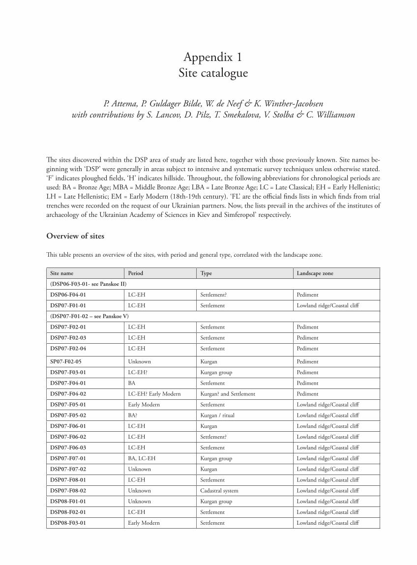
Appendix 1 Site catalogue P. Attema, P. Guldager Bilde, W. de Neef & K. Winther-Jacobsen with contributions by S. Lancov, D. Pilz, T. Smekalova, V. Stolba & C. Williamson e sites discovered within the DSP area of study are listed here, together with those previously known. Site names be- ginning with ‘DSP’ were generally in areas subject to intensive and systematic survey techniques unless otherwise stated. ‘F’ indicates ploughed fields, ‘H’ indicates hillside. roughout, the following abbreviations for chronological periods are used: BA = Bronze Age; MBA = Middle Bronze Age; LBA = Late Bronze Age; LC = Late Classical; EH = Early Hellenistic; LH = Late Hellenistic; EM = Early Modern (18th-19th century). ‘FL’ are the official finds lists in which finds from trial trenches were recorded on the request of our Ukrainian partners. Now, the lists prevail in the archives of the institutes of archaeology of the Ukrainian Academy of Sciences in Kiev and Simferopol’ respectively. Overview of sites is table presents an overview of the sites, with period and general type, correlated with the landscape zone. Site name Period Type Landscape zone (DSP06-F03-01- see Panskoe II) DSP06-F04-01 LC-EH Settlement? Pediment DSP07-F01-01 LC-EH Settlement Lowland ridge/Coastal cliff (DSP07-F01-02 – see Panskoe V) DSP07-F02-01 LC-EH Settlement Pediment DSP07-F02-03 LC-EH Settlement Pediment DSP07-F02-04 LC-EH Settlement Pediment SP07-F02-05 Unknown Kurgan Pediment DSP07-F03-01 LC-EH? Kurgan group Pediment DSP07-F04-01 BA Settlement Pediment DSP07-F04-02 LC-EH? Early Modern Kurgan? and Settlement Pediment DSP07-F05-01 Early Modern Settlement Lowland ridge/Coastal cliff DSP07-F05-02 BA? Kurgan / ritual Lowland ridge/Coastal cliff DSP07-F06-01 LC-EH Kurgan Lowland ridge/Coastal cliff DSP07-F06-02 LC-EH Settlement? Lowland ridge/Coastal cliff DSP07-F06-03 LC-EH Settlement Lowland ridge/Coastal cliff DSP07-F07-01 BA, LC-EH Kurgan group Lowland ridge/Coastal cliff DSP07-F07-02 Unknown Kurgan Lowland ridge/Coastal cliff DSP07-F08-01 LC-EH Settlement Lowland ridge/Coastal cliff DSP07-F08-02 Unknown Cadastral system Lowland ridge/Coastal cliff DSP08-F01-01 Unknown Kurgan group Lowland ridge/Coastal cliff DSP08-F02-01 LC-EH Settlement Lowland ridge/Coastal cliff DSP08-F03-01 Early Modern Settlement Lowland ridge/Coastal cliff
Transcript of Appendix 1 Site catalogue - Antikmuseet€¦ · Double-pen Hillsides DSP07-H02-02 BA, LC-EH...
Appendix 1 Site catalogue
P. Attema, P. Guldager Bilde, W. de Neef & K. Winther-Jacobsen with contributions by S. Lancov, D. Pilz, T. Smekalova, V. Stolba & C. Williamson
The sites discovered within the DSP area of study are listed here, together with those previously known. Site names be-ginning with ‘DSP’ were generally in areas subject to intensive and systematic survey tech niques unless otherwise stated. ‘F’ indicates ploughed fields, ‘H’ indicates hillside. Throughout, the following abbreviations for chronological periods are used: BA = Bronze Age; MBA = Middle Bronze Age; LBA = Late Bronze Age; LC = Late Classical; EH = Early Hellenistic; LH = Late Hellenistic; EM = Early Modern (18th-19th century). ‘FL’ are the official finds lists in which finds from trial trenches were recorded on the request of our Ukrainian partners. Now, the lists prevail in the archives of the institutes of archaeology of the Ukrainian Academy of Sciences in Kiev and Simferopol’ respectively.
Overview of sites
This table presents an overview of the sites, with period and general type, correlated with the landscape zone.
Site name Period Type Landscape zone
(DSP06-F03-01- see Panskoe II)
DSP06-F04-01 LC-EH Settlement? Pediment
DSP07-F01-01 LC-EH Settlement Lowland ridge/Coastal cliff
(DSP07-F01-02 – see Panskoe V)
DSP07-F02-01 LC-EH Settlement Pediment
DSP07-F02-03 LC-EH Settlement Pediment
DSP07-F02-04 LC-EH Settlement Pediment
SP07-F02-05 Unknown Kurgan Pediment
DSP07-F03-01 LC-EH? Kurgan group Pediment
DSP07-F04-01 BA Settlement Pediment
DSP07-F04-02 LC-EH? Early Modern Kurgan? and Settlement Pediment
DSP07-F05-01 Early Modern Settlement Lowland ridge/Coastal cliff
DSP07-F05-02 BA? Kurgan / ritual Lowland ridge/Coastal cliff
DSP07-F06-01 LC-EH Kurgan Lowland ridge/Coastal cliff
DSP07-F06-02 LC-EH Settlement? Lowland ridge/Coastal cliff
DSP07-F06-03 LC-EH Settlement Lowland ridge/Coastal cliff
DSP07-F07-01 BA, LC-EH Kurgan group Lowland ridge/Coastal cliff
DSP07-F07-02 Unknown Kurgan Lowland ridge/Coastal cliff
DSP07-F08-01 LC-EH Settlement Lowland ridge/Coastal cliff
DSP07-F08-02 Unknown Cadastral system Lowland ridge/Coastal cliff
DSP08-F01-01 Unknown Kurgan group Lowland ridge/Coastal cliff
DSP08-F02-01 LC-EH Settlement Lowland ridge/Coastal cliff
DSP08-F03-01 Early Modern Settlement Lowland ridge/Coastal cliff
87620_dzarylgac.indb 165 23-04-2012 20:35:29
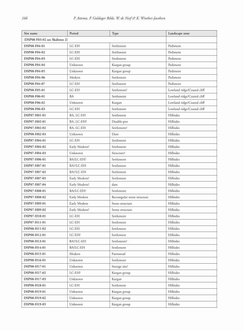
166 P. Attema, P. Guldager Bilde, W. de Neef & K. Winther-Jacobsen
Site name Period Type Landscape zone
(DSP08-F03-02 see Skalistoe 2)
DSP08-F04-01 LC-EH Settlement Pediment
DSP08-F04-02 LC-EH Settlement Pediment
DSP08-F04-03 LC-EH Settlement Pediment
DSP08-F04-04 Unknown Kurgan group Pediment
DSP08-F04-05 Unknown Kurgan group Pediment
DSP08-F04-06 Modern Settlement Pediment
DSP08-F04-07 LC-EH Settlement Pediment
DSP08-F05-01 LC-EH Settlement? Lowland ridge/Coastal cliff
DSP08-F06-01 BA Settlement Lowland ridge/Coastal cliff
DSP08-F06-02 Unknown Kurgan Lowland ridge/Coastal cliff
DSP08-F06-03 LC-EH Settlement Lowland ridge/Coastal cliff
DSP07-H01-01 BA, LC-EH Settlement Hillsides
DSP07-H02-01 BA, LC-EH? Double-pen Hillsides
DSP07-H02-02 BA, LC-EH Settlement? Hillsides
DSP08-H02-03 Unknown Dam Hillsides
DSP07-H04-01 LC-EH Settlement Hillsides
DSP07-H04-02 Early Modern? Settlement Hillsides
DSP07-H04-03 Unknown Structure? Hillsides
DSP07-H06-01 BA/LC-EH? Settlement Hillsides
DSP07-H07-01 BA?/LC-EH Settlement Hillsides
DSP07-H07-02 BA?/LC-EH Settlement Hillsides
DSP07-H07-03 Early Modern? Settlement Hillsides
DSP07-H07-04 Early Modern? dam Hillsides
DSP07-H08-01 BA/LC-EH? Settlement Hillsides
DSP07-H08-02 Early Modern Rectangular stone structure Hillsides
DSP07-H09-01 Early Modern Stone structure Hillsides
DSP07-H09-02 Early Modern? Stone structure Hillsides
DSP07-H10-01 LC-EH Settlement Hillsides
DSP07-H11-01 LC-EH Settlement Hillsides
DSP08-H11-02 LC-EH Settlement Hillsides
DSP08-H12-01 LC-EH? Settlement Hillsides
DSP08-H13-01 BA?/LC-EH Settlement? Hillsides
DSP08-H14-01 BA/LC-EH Settlement Hillsides
DSP08-H15-01 Modern Farmstead Hillsides
DSP08-H16-01 Unknown Settlement Hillsides
DSP08-H17-01 Unknown Storage site? Hillsides
DSP08-H17-02 LC-EH? Kurgan group Hillsides
DSP08-H17-03 Unknown Kurgan Hillsides
DSP08-H18-01 LC-EH Settlement Hillsides
DSP08-H19-01 Unknown Kurgan group Hillsides
DSP08-H19-02 Unknown Kurgan group Hillsides
DSP08-H19-03 Unknown Kurgan group Hillsides
87620_dzarylgac.indb 166 23-04-2012 20:35:29
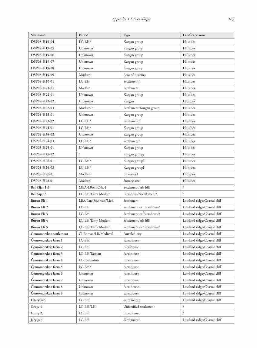
Appendix 1 Site catalogue 167
Site name Period Type Landscape zone
DSP08-H19-04 LC-EH? Kurgan group Hillsides
DSP08-H19-05 Unknown Kurgan group Hillsides
DSP08-H19-06 Unknown Kurgan group Hillsides
DSP08-H19-07 Unknown Kurgan group Hillsides
DSP08-H19-08 Unknown Kurgan group Hillsides
DSP08-H19-09 Modern? Area of quarries Hillsides
DSP08-H20-01 LC-EH Settlement? Hillsides
DSP08-H21-01 Modern Settlement Hillsides
DSP08-H22-01 Unknown Kurgan group Hillsides
DSP08-H22-02 Unknown Kurgan Hillsides
DSP08-H22-03 Modern/? Settlement/Kurgan group Hillsides
DSP08-H23-01 Unknown Kurgan group Hillsides
DSP08-H23-02 LC-EH? Settlement? Hillsides
DSP08-H24-01 LC-EH? Kurgan group Hillsides
DSP08-H24-02 Unknown Kurgan group Hillsides
DSP08-H24-03 LC-EH? Settlement? Hillsides
DSP08-H25-01 Unknown Kurgan group Hillsides
DSP08-H25-02 ? Kurgan group? Hillsides
DSP08-H26-01 LC-EH? Kurgan group? Hillsides
DSP08-H26-02 LC-EH? Kurgan group? Hillsides
DSP08-H27-01 Modern? Farmstead Hillsides
DSP08-H28-01 Modern? Storage site? Hillsides
Baj Kijat 1-2 MBA-LBA/LC-EH Settlement/ash hill ?
Baj Kijat 3 LC-EH/Early Modern Farmhouse?/settlement? ?
Burun Eli 1 LBA/Late Scythian/Med Settlement Lowland ridge/Coastal cliff
Burun Eli 2 LC-EH Settlement or Farmhouse? Lowland ridge/Coastal cliff
Burun Eli 3 LC-EH Settlement or Farmhouse? Lowland ridge/Coastal cliff
Burun Eli 4 LC-EH/Early Modern Settlement/ash hill Lowland ridge/Coastal cliff
Burun Eli 5 LC-EH/Early Modern Settlement or Farmhouse? Lowland ridge/Coastal cliff
Černomorskoe settlement Cl-Roman/LR/Medieval Fortified city Lowland ridge/Coastal cliff
Černomorskoe farm 1 LC-EH Farmhouse Lowland ridge/Coastal cliff
Černomorskoe farm 2 LC-EH Farmhouse Lowland ridge/Coastal cliff
Černomorskoe farm 3 LC-EH/Roman Farmhouse Lowland ridge/Coastal cliff
Černomorskoe farm 4 LC-Hellenistic Farmhouse Lowland ridge/Coastal cliff
Černomorskoe farm 5 LC-EH? Farmhouse Lowland ridge/Coastal cliff
Černomorskoe farm 6 Unknown Farmhouse Lowland ridge/Coastal cliff
Černomorskoe farm 7 Unknown Farmhouse Lowland ridge/Coastal cliff
Černomorskoe farm 8 Unknown Farmhouse Lowland ridge/Coastal cliff
Černomorskoe farm 9 Unknown Farmhouse Lowland ridge/Coastal cliff
Džarylgač LC-EH Settlement? Lowland ridge/Coastal cliff
Groty 1 LC-EH/LH Unfortified settlement ?
Groty 2 LC-EH Farmhouse ?
Jarylgač LC-EH Settlement? Lowland ridge/Coastal cliff
87620_dzarylgac.indb 167 23-04-2012 20:35:29
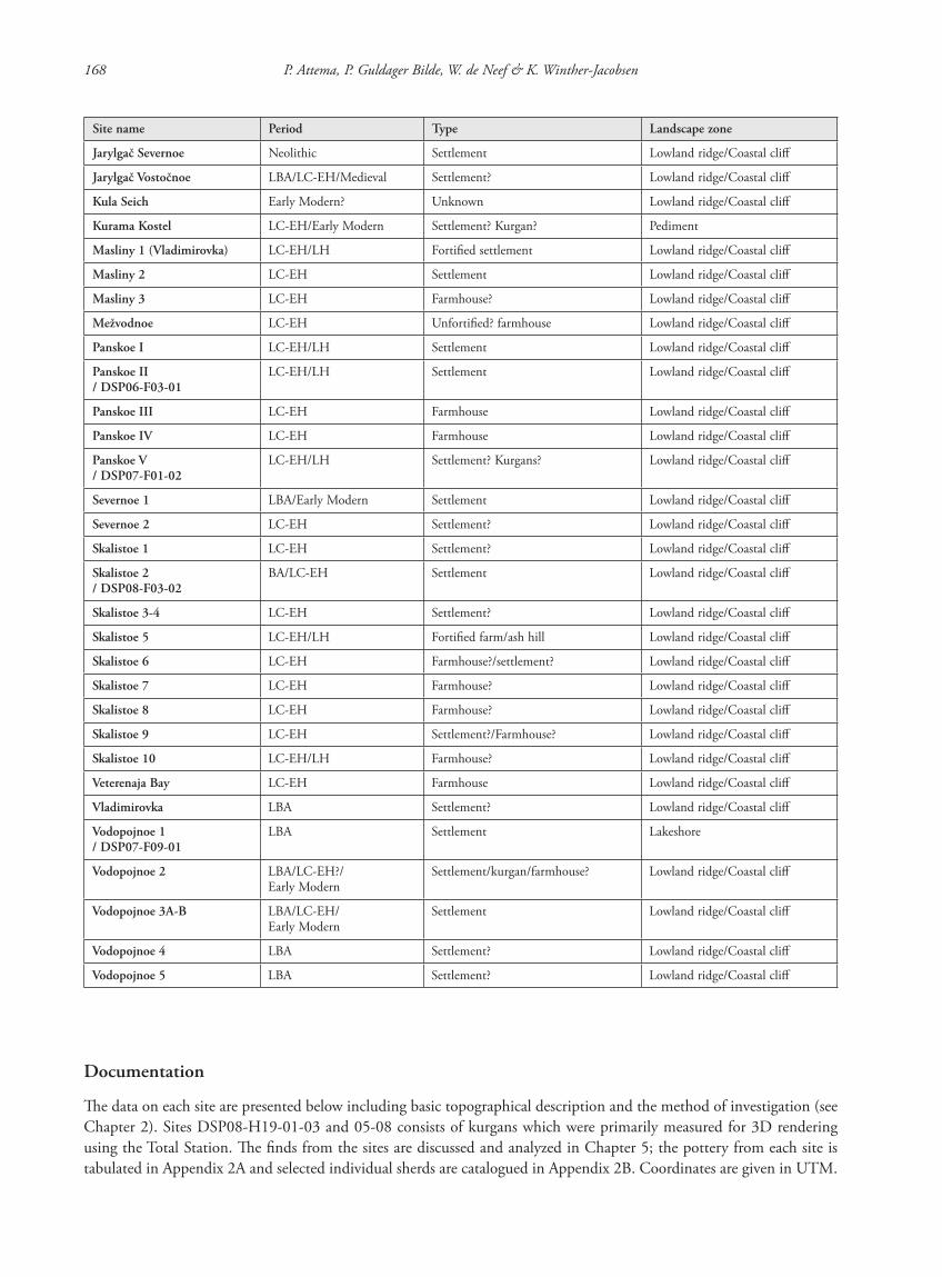
168 P. Attema, P. Guldager Bilde, W. de Neef & K. Winther-Jacobsen
Site name Period Type Landscape zone
Jarylgač Severnoe Neolithic Settlement Lowland ridge/Coastal cliff
Jarylgač Vostočnoe LBA/LC-EH/Medieval Settlement? Lowland ridge/Coastal cliff
Kula Seich Early Modern? Unknown Lowland ridge/Coastal cliff
Kurama Kostel LC-EH/Early Modern Settlement? Kurgan? Pediment
Masliny 1 (Vladimirovka) LC-EH/LH Fortified settlement Lowland ridge/Coastal cliff
Masliny 2 LC-EH Settlement Lowland ridge/Coastal cliff
Masliny 3 LC-EH Farmhouse? Lowland ridge/Coastal cliff
Mežvodnoe LC-EH Unfortified? farmhouse Lowland ridge/Coastal cliff
Panskoe I LC-EH/LH Settlement Lowland ridge/Coastal cliff
Panskoe II / DSP06-F03-01
LC-EH/LH Settlement Lowland ridge/Coastal cliff
Panskoe III LC-EH Farmhouse Lowland ridge/Coastal cliff
Panskoe IV LC-EH Farmhouse Lowland ridge/Coastal cliff
Panskoe V / DSP07-F01-02
LC-EH/LH Settlement? Kurgans? Lowland ridge/Coastal cliff
Severnoe 1 LBA/Early Modern Settlement Lowland ridge/Coastal cliff
Severnoe 2 LC-EH Settlement? Lowland ridge/Coastal cliff
Skalistoe 1 LC-EH Settlement? Lowland ridge/Coastal cliff
Skalistoe 2 / DSP08-F03-02
BA/LC-EH Settlement Lowland ridge/Coastal cliff
Skalistoe 3-4 LC-EH Settlement? Lowland ridge/Coastal cliff
Skalistoe 5 LC-EH/LH Fortified farm/ash hill Lowland ridge/Coastal cliff
Skalistoe 6 LC-EH Farmhouse?/settlement? Lowland ridge/Coastal cliff
Skalistoe 7 LC-EH Farmhouse? Lowland ridge/Coastal cliff
Skalistoe 8 LC-EH Farmhouse? Lowland ridge/Coastal cliff
Skalistoe 9 LC-EH Settlement?/Farmhouse? Lowland ridge/Coastal cliff
Skalistoe 10 LC-EH/LH Farmhouse? Lowland ridge/Coastal cliff
Veterenaja Bay LC-EH Farmhouse Lowland ridge/Coastal cliff
Vladimirovka LBA Settlement? Lowland ridge/Coastal cliff
Vodopojnoe 1 / DSP07-F09-01
LBA Settlement Lakeshore
Vodopojnoe 2 LBA/LC-EH?/Early Modern
Settlement/kurgan/farmhouse? Lowland ridge/Coastal cliff
Vodopojnoe 3A-B LBA/LC-EH/Early Modern
Settlement Lowland ridge/Coastal cliff
Vodopojnoe 4 LBA Settlement? Lowland ridge/Coastal cliff
Vodopojnoe 5 LBA Settlement? Lowland ridge/Coastal cliff
Documentation
The data on each site are presented below including basic topographical description and the method of investigation (see Chapter 2). Sites DSP08-H19-01-03 and 05-08 consists of kurgans which were primarily measured for 3D rendering using the Total Station. The finds from the sites are discussed and analyzed in Chapter 5; the pottery from each site is tabulated in Appendix 2A and selected individual sherds are catalogued in Appendix 2B. Coordinates are given in UTM.
87620_dzarylgac.indb 168 23-04-2012 20:35:29
Appendix 1 Site catalogue 169
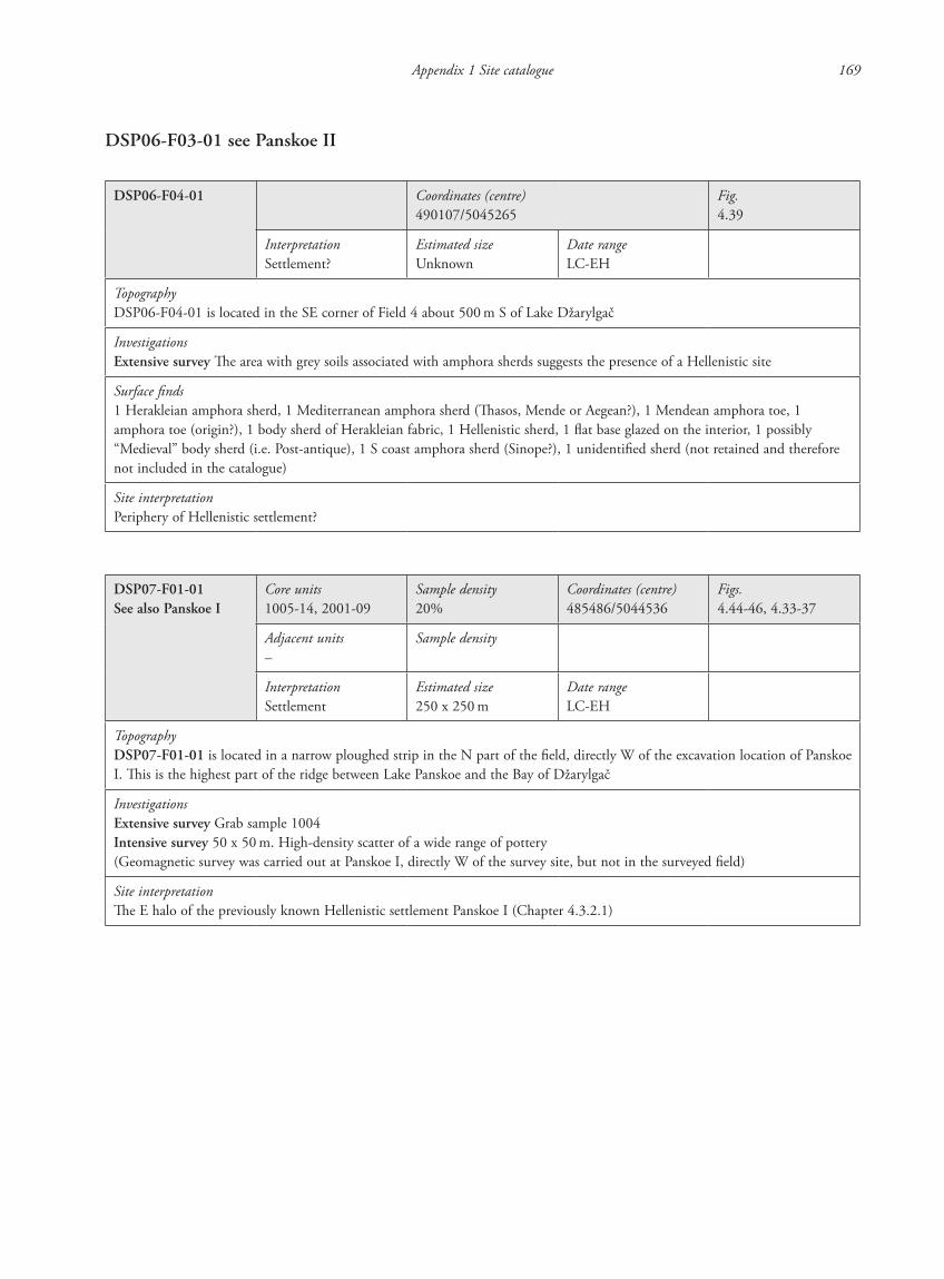
DSP06-F03-01 see Panskoe II
DSP06-F04-01 Coordinates (centre)490107/5045265
Fig.4.39
InterpretationSettlement?
Estimated sizeUnknown
Date rangeLC-EH
TopographyDSP06-F04-01 is located in the SE corner of Field 4 about 500 m S of Lake Džarylgač
InvestigationsExtensive survey The area with grey soils associated with amphora sherds suggests the presence of a Hellenistic site
Surface finds1 Herakleian amphora sherd, 1 Mediterranean amphora sherd (Thasos, Mende or Aegean?), 1 Mendean amphora toe, 1 amphora toe (origin?), 1 body sherd of Herakleian fabric, 1 Hellenistic sherd, 1 flat base glazed on the interior, 1 possibly “Medieval” body sherd (i.e. Post-antique), 1 S coast amphora sherd (Sinope?), 1 unidentified sherd (not retained and therefore not included in the catalogue)
Site interpretationPeriphery of Hellenistic settlement?
DSP07-F01-01See also Panskoe I
Core units1005-14, 2001-09
Sample density20%
Coordinates (centre)485486/5044536
Figs.4.44-46, 4.33-37
Adjacent units–
Sample density
InterpretationSettlement
Estimated size250 x 250 m
Date rangeLC-EH
TopographyDSP07-F01-01 is located in a narrow ploughed strip in the N part of the field, directly W of the excavation location of Panskoe I. This is the highest part of the ridge between Lake Panskoe and the Bay of Džarylgač
InvestigationsExtensive survey Grab sample 1004Intensive survey 50 x 50 m. High-density scatter of a wide range of pottery(Geomagnetic survey was carried out at Panskoe I, directly W of the survey site, but not in the surveyed field)
Site interpretationThe E halo of the previously known Hellenistic settlement Panskoe I (Chapter 4.3.2.1)
87620_dzarylgac.indb 169 23-04-2012 20:35:29
170 P. Attema, P. Guldager Bilde, W. de Neef & K. Winther-Jacobsen
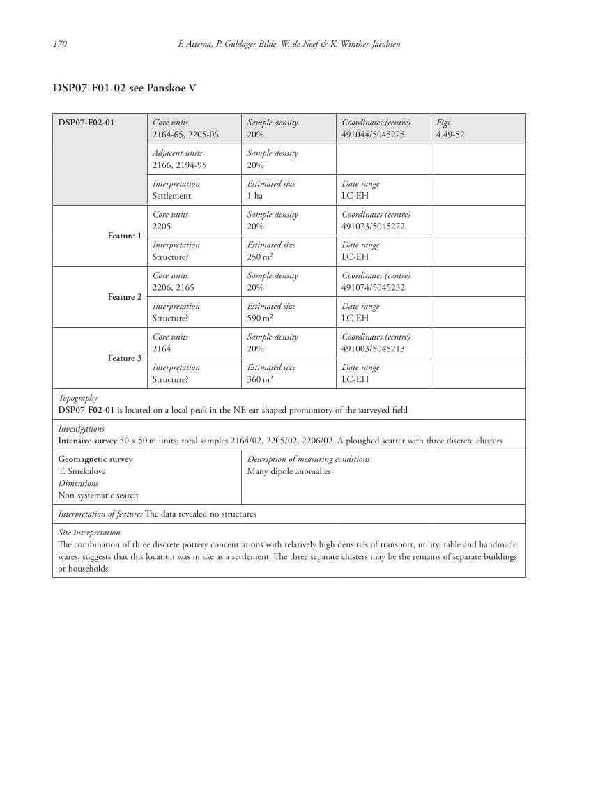
DSP07-F01-02 see Panskoe V
DSP07-F02-01 Core units2164-65, 2205-06
Sample density20%
Coordinates (centre)491044/5045225
Figs.4.49-52
Adjacent units2166, 2194-95
Sample density20%
InterpretationSettlement
Estimated size1 ha
Date rangeLC-EH
Feature 1
Core units2205
Sample density20%
Coordinates (centre)491073/5045272
InterpretationStructure?
Estimated size250 m2
Date rangeLC-EH
Feature 2
Core units2206, 2165
Sample density20%
Coordinates (centre)491074/5045232
InterpretationStructure?
Estimated size590 m2
Date rangeLC-EH
Feature 3
Core units2164
Sample density20%
Coordinates (centre)491003/5045213
InterpretationStructure?
Estimated size360 m2
Date rangeLC-EH
TopographyDSP07-F02-01 is located on a local peak in the NE ear-shaped promontory of the surveyed field
InvestigationsIntensive survey 50 x 50 m units; total samples 2164/02, 2205/02, 2206/02. A ploughed scatter with three discrete clusters
Geomagnetic surveyT. SmekalovaDimensionsNon-systematic search
Description of measuring conditionsMany dipole anomalies
Interpretation of features The data revealed no structures
Site interpretationThe combination of three discrete pottery concentrations with relatively high densities of transport, utility, table and handmade wares, suggests that this location was in use as a settlement. The three separate clusters may be the remains of separate buildings or households
87620_dzarylgac.indb 170 23-04-2012 20:35:29

Appendix 1 Site catalogue 171
DSP07-F02-02 Core units2100-02, 2117-19, 2146-47
Sample density20%
Coordinates (centre)490199/5044946
Figs.4.49-50, 4.53-54
Adjacent units2104
Sample density20%
InterpretationSettlement
Estimated sizeUnknown
Date rangeLC-EH
TopographyDSP07-F02-02 is located in the NW part of the field on a slight elevation overlooking a ravine, which runs towards Lake Džarylgač
InvestigationsIntensive survey 50 x 50 m units. TS 2101/02 (13 x 13 m in W part of Unit 2102). A discrete, relatively high-dentity scatter of pottery in five corner units yielding pottery from different functional groups including tablewares, amphorai and handmade material. The pottery frs. may be part of the halo or perimeter of a larger site located outside the field border. Therefore, the extent of the site remains unknown
Site interpretationThe combination of several functional pottery groups in this scatter suggests the presence of a settlement
DSP07-F02-03 Core units1233-34
Sample density20%
Coordinates (centre)490839/5044023
Figs.4.49-50, 4.55
Adjacent units1228, 1230, 1259, 1261
Sample density20%
InterpretationSettlement
Estimated size330 m2
Date rangeLC-EH
TopographyDSP07-F02-03 is located approximately 1.4 km S of Lake Džarylgač. The site is located uphill, but seems a bit sheltered between undulating parts of the field
InvestigationsIntensive survey 50 x 50 m units; TS 1233/02 and 1234/02. A small, discrete scatter of handmade pottery, amphorai, tableware and stone tools (whetting stones, grinding stones) was found
Site interpretationThe presence of several types of pottery in combination with stone tools suggests that this is a small settlement site
87620_dzarylgac.indb 171 23-04-2012 20:35:29
172 P. Attema, P. Guldager Bilde, W. de Neef & K. Winther-Jacobsen
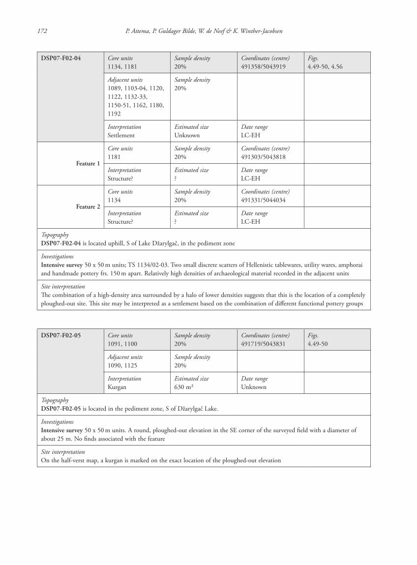
DSP07-F02-04 Core units1134, 1181
Sample density20%
Coordinates (centre)491358/5043919
Figs.4.49-50, 4.56
Adjacent units1089, 1103-04, 1120, 1122, 1132-33, 1150-51, 1162, 1180, 1192
Sample density20%
InterpretationSettlement
Estimated sizeUnknown
Date rangeLC-EH
Feature 1
Core units1181
Sample density20%
Coordinates (centre)491303/5043818
InterpretationStructure?
Estimated size?
Date rangeLC-EH
Feature 2
Core units1134
Sample density20%
Coordinates (centre)491331/5044034
InterpretationStructure?
Estimated size?
Date rangeLC-EH
TopographyDSP07-F02-04 is located uphill, S of Lake Džarylgač, in the pediment zone
InvestigationsIntensive survey 50 x 50 m units; TS 1134/02-03. Two small discrete scatters of Hellenistic tablewares, utility wares, amphorai and handmade pottery frs. 150 m apart. Relatively high densities of archaeological material recorded in the adjacent units
Site interpretationThe combination of a high-density area surrounded by a halo of lower densities suggests that this is the location of a completely ploughed-out site. This site may be interpreted as a settlement based on the combination of different functional pottery groups
DSP07-F02-05 Core units1091, 1100
Sample density20%
Coordinates (centre)491719/5043831
Figs.4.49-50
Adjacent units1090, 1125
Sample density20%
InterpretationKurgan
Estimated size630 m2
Date rangeUnknown
TopographyDSP07-F02-05 is located in the pediment zone, S of Džarylgač Lake.
InvestigationsIntensive survey 50 x 50 m units. A round, ploughed-out elevation in the SE corner of the surveyed field with a diameter of about 25 m. No finds associated with the feature
Site interpretationOn the half-verst map, a kurgan is marked on the exact location of the ploughed-out elevation
87620_dzarylgac.indb 172 23-04-2012 20:35:29
Appendix 1 Site catalogue 173
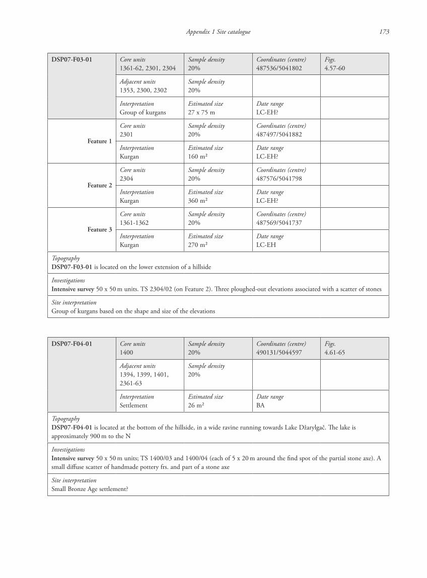
DSP07-F03-01 Core units1361-62, 2301, 2304
Sample density20%
Coordinates (centre)487536/5041802
Figs.4.57-60
Adjacent units1353, 2300, 2302
Sample density20%
InterpretationGroup of kurgans
Estimated size27 x 75 m
Date rangeLC-EH?
Feature 1
Core units2301
Sample density20%
Coordinates (centre)487497/5041882
InterpretationKurgan
Estimated size160 m2
Date rangeLC-EH?
Feature 2
Core units2304
Sample density20%
Coordinates (centre)487576/5041798
InterpretationKurgan
Estimated size360 m2
Date rangeLC-EH?
Feature 3
Core units1361-1362
Sample density20%
Coordinates (centre)487569/5041737
InterpretationKurgan
Estimated size270 m2
Date rangeLC-EH
TopographyDSP07-F03-01 is located on the lower extension of a hillside
InvestigationsIntensive survey 50 x 50 m units. TS 2304/02 (on Feature 2). Three ploughed-out elevations associated with a scatter of stones
Site interpretationGroup of kurgans based on the shape and size of the elevations
DSP07-F04-01 Core units1400
Sample density20%
Coordinates (centre)490131/5044597
Figs.4.61-65
Adjacent units1394, 1399, 1401, 2361-63
Sample density20%
InterpretationSettlement
Estimated size26 m2
Date rangeBA
TopographyDSP07-F04-01 is located at the bottom of the hillside, in a wide ravine running towards Lake Džarylgač. The lake is approximately 900 m to the N
InvestigationsIntensive survey 50 x 50 m units; TS 1400/03 and 1400/04 (each of 5 x 20 m around the find spot of the partial stone axe). A small diffuse scatter of handmade pottery frs. and part of a stone axe
Site interpretationSmall Bronze Age settlement?
87620_dzarylgac.indb 173 23-04-2012 20:35:30
174 P. Attema, P. Guldager Bilde, W. de Neef & K. Winther-Jacobsen
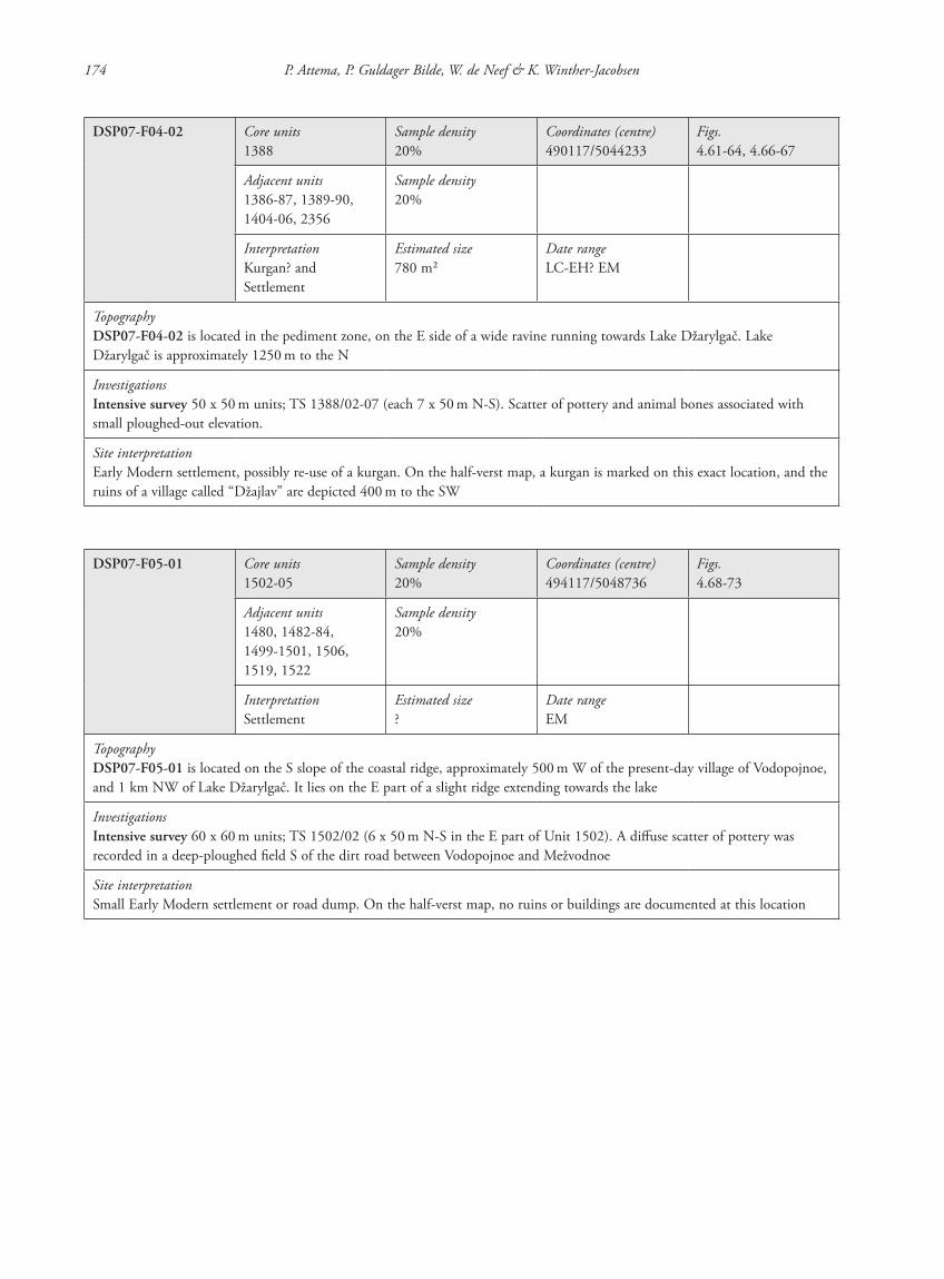
DSP07-F04-02 Core units1388
Sample density20%
Coordinates (centre)490117/5044233
Figs.4.61-64, 4.66-67
Adjacent units1386-87, 1389-90, 1404-06, 2356
Sample density20%
InterpretationKurgan? and Settlement
Estimated size780 m2
Date rangeLC-EH? EM
TopographyDSP07-F04-02 is located in the pediment zone, on the E side of a wide ravine running towards Lake Džarylgač. Lake Džarylgač is approximately 1250 m to the N
InvestigationsIntensive survey 50 x 50 m units; TS 1388/02-07 (each 7 x 50 m N-S). Scatter of pottery and animal bones associated with small ploughed-out elevation.
Site interpretationEarly Modern settlement, possibly re-use of a kurgan. On the half-verst map, a kurgan is marked on this exact location, and the ruins of a village called “Džajlav” are depicted 400 m to the SW
DSP07-F05-01 Core units1502-05
Sample density20%
Coordinates (centre)494117/5048736
Figs.4.68-73
Adjacent units1480, 1482-84, 1499-1501, 1506, 1519, 1522
Sample density20%
InterpretationSettlement
Estimated size?
Date rangeEM
TopographyDSP07-F05-01 is located on the S slope of the coastal ridge, approximately 500 m W of the present-day village of Vodopojnoe, and 1 km NW of Lake Džarylgač. It lies on the E part of a slight ridge extending towards the lake
InvestigationsIntensive survey 60 x 60 m units; TS 1502/02 (6 x 50 m N-S in the E part of Unit 1502). A diffuse scatter of pottery was recorded in a deep-ploughed field S of the dirt road between Vodopojnoe and Mežvodnoe
Site interpretationSmall Early Modern settlement or road dump. On the half-verst map, no ruins or buildings are documented at this location
87620_dzarylgac.indb 174 23-04-2012 20:35:30
Appendix 1 Site catalogue 175
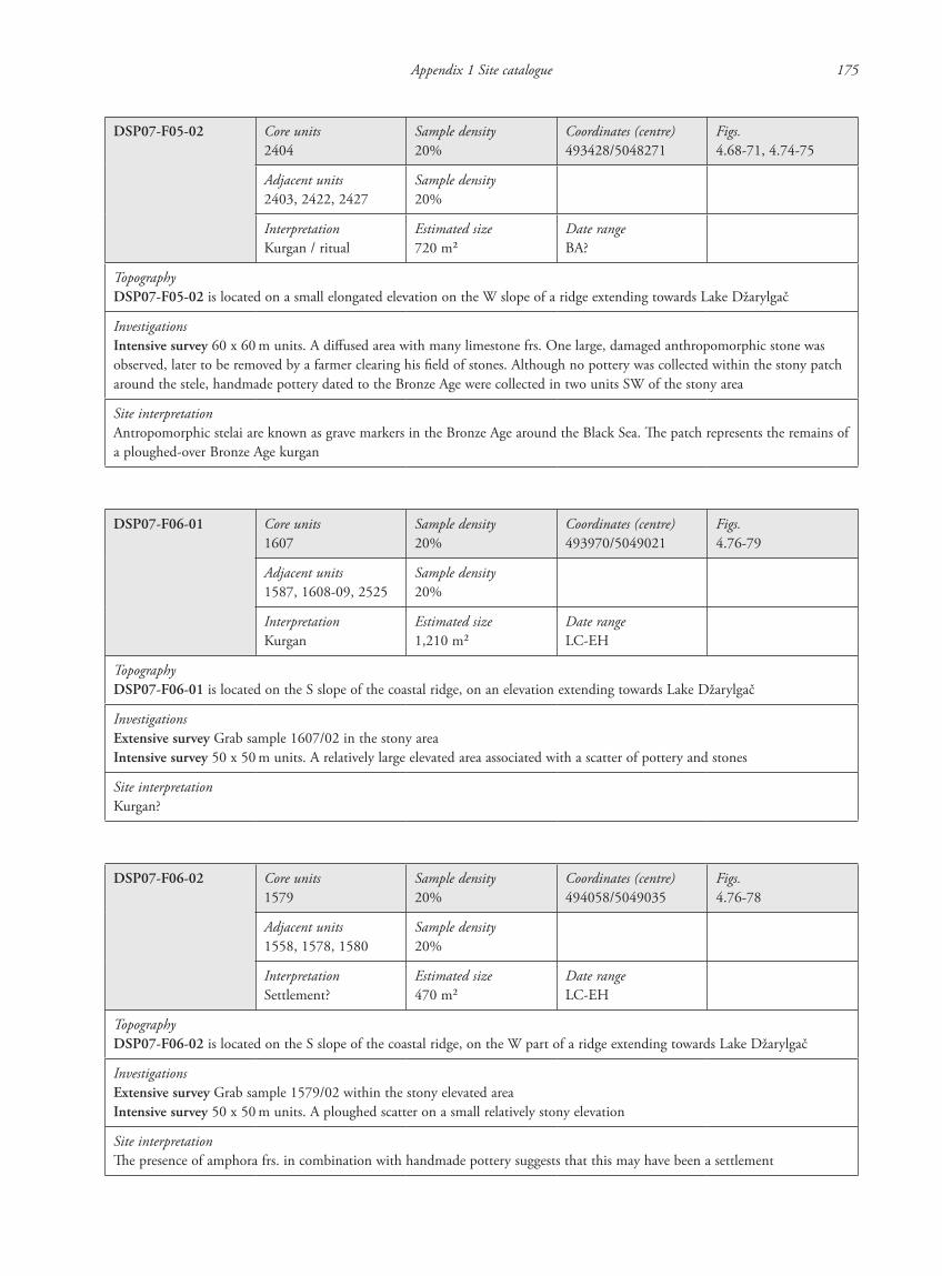
DSP07-F05-02 Core units2404
Sample density20%
Coordinates (centre)493428/5048271
Figs.4.68-71, 4.74-75
Adjacent units2403, 2422, 2427
Sample density20%
InterpretationKurgan / ritual
Estimated size720 m2
Date rangeBA?
TopographyDSP07-F05-02 is located on a small elongated elevation on the W slope of a ridge extending towards Lake Džarylgač
InvestigationsIntensive survey 60 x 60 m units. A diffused area with many limestone frs. One large, damaged anthropomorphic stone was observed, later to be removed by a farmer clearing his field of stones. Although no pottery was collected within the stony patch around the stele, handmade pottery dated to the Bronze Age were collected in two units SW of the stony area
Site interpretationAntropomorphic stelai are known as grave markers in the Bronze Age around the Black Sea. The patch represents the remains of a ploughed-over Bronze Age kurgan
DSP07-F06-01 Core units1607
Sample density20%
Coordinates (centre)493970/5049021
Figs.4.76-79
Adjacent units1587, 1608-09, 2525
Sample density20%
InterpretationKurgan
Estimated size1,210 m2
Date rangeLC-EH
TopographyDSP07-F06-01 is located on the S slope of the coastal ridge, on an elevation extending towards Lake Džarylgač
InvestigationsExtensive survey Grab sample 1607/02 in the stony areaIntensive survey 50 x 50 m units. A relatively large elevated area associated with a scatter of pottery and stones
Site interpretationKurgan?
DSP07-F06-02 Core units1579
Sample density20%
Coordinates (centre)494058/5049035
Figs.4.76-78
Adjacent units1558, 1578, 1580
Sample density20%
InterpretationSettlement?
Estimated size470 m2
Date rangeLC-EH
TopographyDSP07-F06-02 is located on the S slope of the coastal ridge, on the W part of a ridge extending towards Lake Džarylgač
InvestigationsExtensive survey Grab sample 1579/02 within the stony elevated areaIntensive survey 50 x 50 m units. A ploughed scatter on a small relatively stony elevation
Site interpretationThe presence of amphora frs. in combination with handmade pottery suggests that this may have been a settlement
87620_dzarylgac.indb 175 23-04-2012 20:35:30
176 P. Attema, P. Guldager Bilde, W. de Neef & K. Winther-Jacobsen
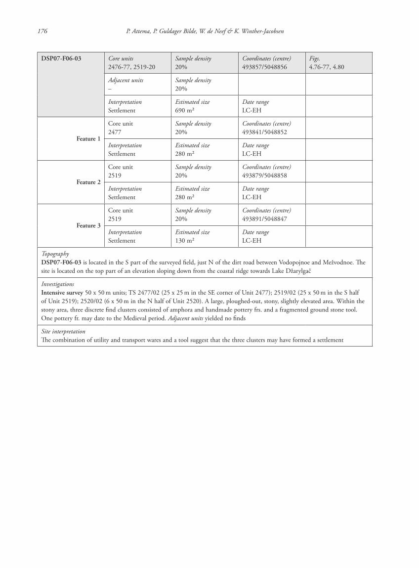
DSP07-F06-03 Core units2476-77, 2519-20
Sample density20%
Coordinates (centre)493857/5048856
Figs.4.76-77, 4.80
Adjacent units–
Sample density20%
InterpretationSettlement
Estimated size690 m2
Date rangeLC-EH
Feature 1
Core unit2477
Sample density20%
Coordinates (centre)493841/5048852
InterpretationSettlement
Estimated size280 m2
Date rangeLC-EH
Feature 2
Core unit2519
Sample density20%
Coordinates (centre)493879/5048858
InterpretationSettlement
Estimated size280 m2
Date rangeLC-EH
Feature 3
Core unit2519
Sample density20%
Coordinates (centre)493891/5048847
InterpretationSettlement
Estimated size130 m2
Date rangeLC-EH
TopographyDSP07-F06-03 is located in the S part of the surveyed field, just N of the dirt road between Vodopojnoe and Mežvodnoe. The site is located on the top part of an elevation sloping down from the coastal ridge towards Lake Džarylgač
InvestigationsIntensive survey 50 x 50 m units; TS 2477/02 (25 x 25 m in the SE corner of Unit 2477); 2519/02 (25 x 50 m in the S half of Unit 2519); 2520/02 (6 x 50 m in the N half of Unit 2520). A large, ploughed-out, stony, slightly elevated area. Within the stony area, three discrete find clusters consisted of amphora and handmade pottery frs. and a fragmented ground stone tool. One pottery fr. may date to the Medieval period. Adjacent units yielded no finds
Site interpretationThe combination of utility and transport wares and a tool suggest that the three clusters may have formed a settlement
87620_dzarylgac.indb 176 23-04-2012 20:35:30
Appendix 1 Site catalogue 177
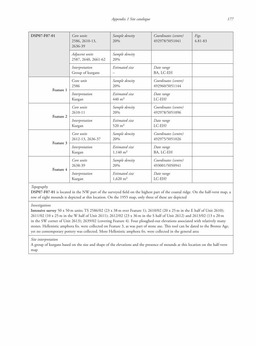
DSP07-F07-01 Core units2586, 2610-13, 2636-39
Sample density20%
Coordinates (centre)492978/5051041
Figs.4.81-83
Adjacent units2587, 2640, 2661-62
Sample density20%
InterpretationGroup of kurgans
Estimated size–
Date rangeBA, LC-EH
Feature 1
Core unit2586
Sample density20%
Coordinates (centre)492960/5051144
InterpretationKurgan
Estimated size440 m2
Date rangeLC-EH?
Feature 2
Core units2610-11
Sample density20%
Coordinates (centre)492978/5051096
InterpretationKurgan
Estimated size520 m2
Date rangeLC-EH?
Feature 3
Core units2612-13, 2636-37
Sample density20%
Coordinates (centre)492975/5051026
InterpretationKurgan
Estimated size1,140 m2
Date rangeBA, LC-EH
Feature 4
Core units2638-39
Sample density20%
Coordinates (centre)493001/5050941
InterpretationKurgan
Estimated size1,620 m2
Date rangeLC-EH?
TopographyDSP07-F07-01 is located in the NW part of the surveyed field on the highest part of the coastal ridge. On the half-verst map, a row of eight mounds is depicted at this location. On the 1955 map, only three of these are depicted
InvestigationsIntensive survey 50 x 50 m units; TS 2586/02 (23 x 38 m over Feature 1); 2610/02 (20 x 25 m in the E half of Unit 2610); 2611/02 (10 x 25 m in the W half of Unit 2611); 2612/02 (23 x 36 m in the S half of Unit 2612) and 2613/02 (13 x 20 m in the SW corner of Unit 2613); 2639/02 (covering Feature 4). Four ploughed-out elevations associated with relatively many stones. Hellenistic amphora frs. were collected on Feature 3, as was part of stone axe. This tool can be dated to the Bronze Age, yet no contemporary pottery was collected. More Hellenistic amphora frs. were collected in the general area
Site interpretationA group of kurgans based on the size and shape of the elevations and the presence of mounds at this location on the half-verst map
87620_dzarylgac.indb 177 23-04-2012 20:35:30
178 P. Attema, P. Guldager Bilde, W. de Neef & K. Winther-Jacobsen
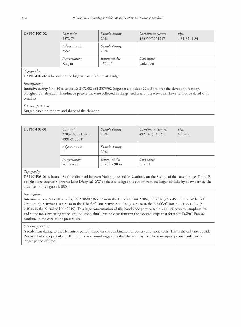
DSP07-F07-02 Core units2572-73
Sample density20%
Coordinates (centre)493550/5051217
Figs.4.81-82, 4.84
Adjacent units2552
Sample density20%
InterpretationKurgan
Estimated size470 m2
Date rangeUnknown
TopographyDSP07-F07-02 is located on the highest part of the coastal ridge
InvestigationsIntensive survey 50 x 50 m units; TS 2572/02 and 2573/02 (together a block of 22 x 35 m over the elevation). A stony, ploughed-out elevation. Handmade pottery frs. were collected in the general area of the elevation. These cannot be dated with certainty
Site interpretationKurgan based on the size and shape of the elevation
DSP07-F08-01 Core units2705-10, 2715-20, 8991-92, 9019
Sample density20%
Coordinates (centre)492102/5048591
Figs.4.85-88
Adjacent units–
Sample density20%
InterpretationSettlement
Estimated sizeca.250 x 90 m
Date rangeLC-EH
TopographyDSP07-F08-01 is located S of the dirt road between Vodopojnoe and Mežvodnoe, on the S slope of the coastal ridge. To the E, a slight ridge extends S towards Lake Džarylgač. SW of the site, a lagoon is cut off from the larger salt lake by a low barrier. The distance to this lagoon is 880 m
InvestigationsIntensive survey 50 x 50 m units; TS 2706/02 (6 x 35 m in the E end of Unit 2706); 2707/02 (25 x 45 m in the W half of Unit 2707); 2709/02 (10 x 50 m in the E half of Unit 2709); 2710/02 (7 x 30 m in the E half of Unit 2710); 2719/02 (50 x 10 m in the N end of Unit 2719). This large concentration of tile, handmade pottery, table- and utility wares, amphora frs. and stone tools (whetting stone, ground stone, flint), but no clear features; the elevated strips that form site DSP07-F08-02 continue in the core of the present site
Site interpretationA settlement dating to the Hellenistic period, based on the combination of pottery and stone tools. This is the only site outside Panskoe I where a part of a Hellenistic tile was found suggesting that the site may have been occupied permanently over a longer period of time
87620_dzarylgac.indb 178 23-04-2012 20:35:30
Appendix 1 Site catalogue 179
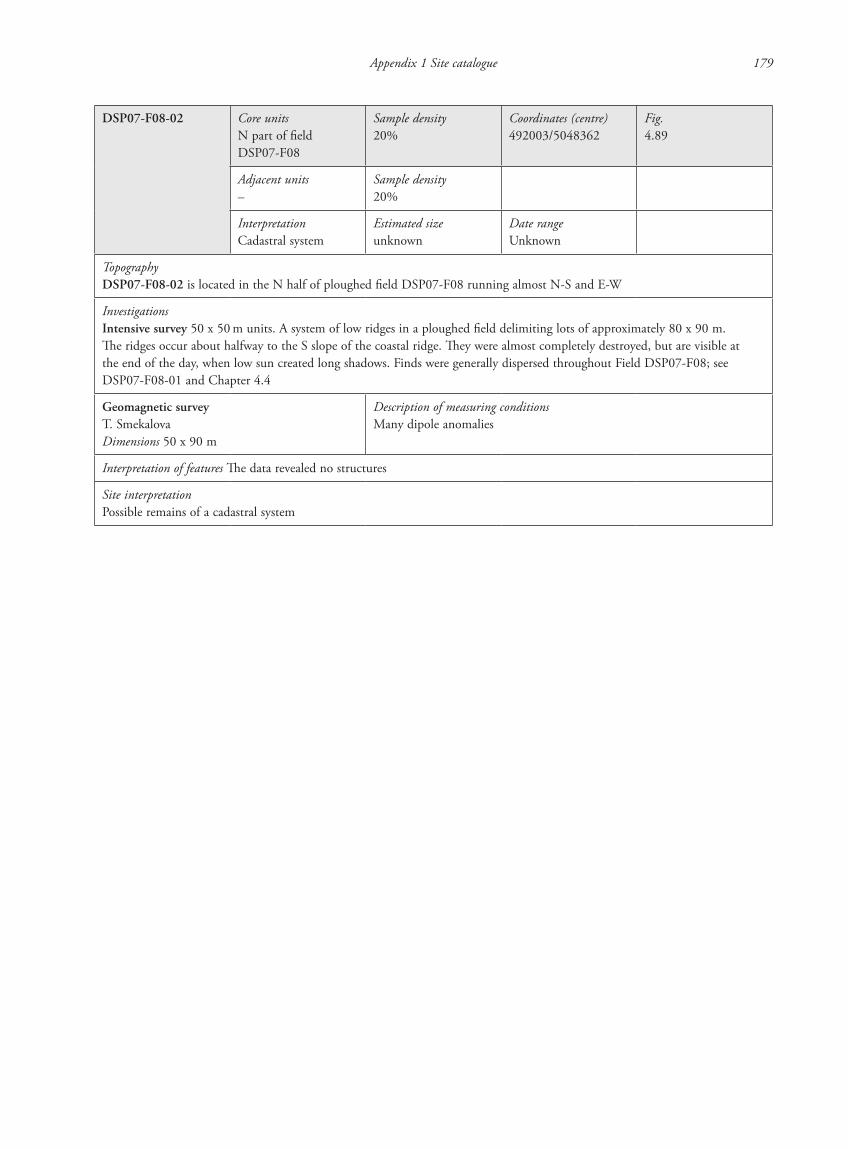
DSP07-F08-02 Core unitsN part of field DSP07-F08
Sample density20%
Coordinates (centre)492003/5048362
Fig.4.89
Adjacent units–
Sample density20%
InterpretationCadastral system
Estimated sizeunknown
Date rangeUnknown
TopographyDSP07-F08-02 is located in the N half of ploughed field DSP07-F08 running almost N-S and E-W
InvestigationsIntensive survey 50 x 50 m units. A system of low ridges in a ploughed field delimiting lots of approximately 80 x 90 m. The ridges occur about halfway to the S slope of the coastal ridge. They were almost completely destroyed, but are visible at the end of the day, when low sun created long shadows. Finds were generally dispersed throughout Field DSP07-F08; see DSP07-F08-01 and Chapter 4.4
Geomagnetic surveyT. SmekalovaDimensions 50 x 90 m
Description of measuring conditionsMany dipole anomalies
Interpretation of features The data revealed no structures
Site interpretationPossible remains of a cadastral system
87620_dzarylgac.indb 179 23-04-2012 20:35:30
180 P. Attema, P. Guldager Bilde, W. de Neef & K. Winther-Jacobsen
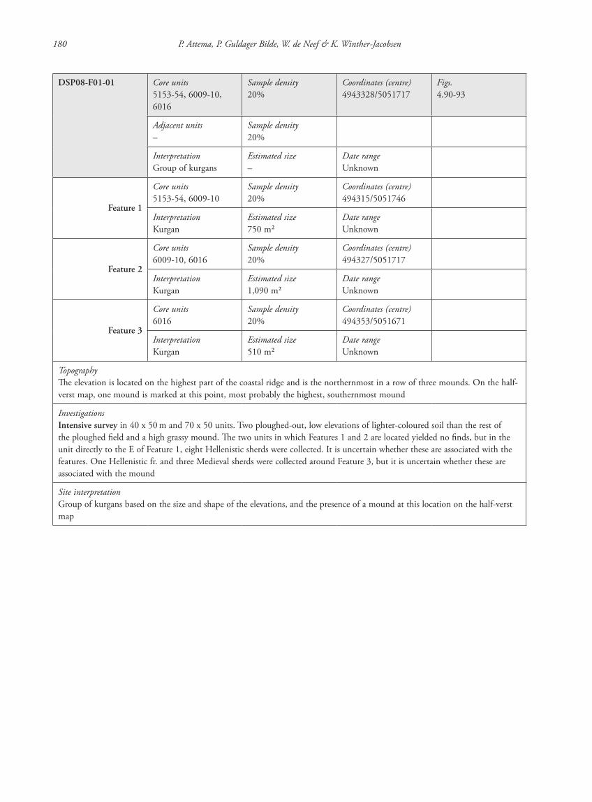
DSP08-F01-01 Core units5153-54, 6009-10, 6016
Sample density20%
Coordinates (centre)4943328/5051717
Figs.4.90-93
Adjacent units–
Sample density20%
InterpretationGroup of kurgans
Estimated size–
Date rangeUnknown
Feature 1
Core units5153-54, 6009-10
Sample density20%
Coordinates (centre)494315/5051746
InterpretationKurgan
Estimated size750 m2
Date rangeUnknown
Feature 2
Core units6009-10, 6016
Sample density20%
Coordinates (centre)494327/5051717
InterpretationKurgan
Estimated size1,090 m2
Date rangeUnknown
Feature 3
Core units6016
Sample density20%
Coordinates (centre)494353/5051671
InterpretationKurgan
Estimated size510 m2
Date rangeUnknown
TopographyThe elevation is located on the highest part of the coastal ridge and is the northernmost in a row of three mounds. On the half-verst map, one mound is marked at this point, most probably the highest, southernmost mound
InvestigationsIntensive survey in 40 x 50 m and 70 x 50 units. Two ploughed-out, low elevations of lighter-coloured soil than the rest of the ploughed field and a high grassy mound. The two units in which Features 1 and 2 are located yielded no finds, but in the unit directly to the E of Feature 1, eight Hellenistic sherds were collected. It is uncertain whether these are associated with the features. One Hellenistic fr. and three Medieval sherds were collected around Feature 3, but it is uncertain whether these are associated with the mound
Site interpretationGroup of kurgans based on the size and shape of the elevations, and the presence of a mound at this location on the half-verst map
87620_dzarylgac.indb 180 23-04-2012 20:35:30
Appendix 1 Site catalogue 181
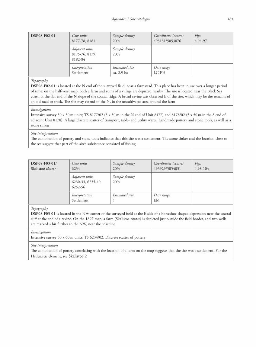
DSP08-F02-01 Core units8177-78, 8181
Sample density20%
Coordinates (centre)493131/5053076
Figs.4.94-97
Adjacent units8175-76, 8179, 8182-84
Sample density20%
InterpretationSettlement
Estimated sizeca. 2.9 ha
Date rangeLC-EH
TopographyDSP08-F02-01 is located at the N end of the surveyed field, near a farmstead. This place has been in use over a longer period of time: on the half-verst map, both a farm and ruins of a village are depicted nearby. The site is located near the Black Sea coast, at the flat end of the N slope of the coastal ridge. A broad ravine was observed E of the site, which may be the remains of an old road or track. The site may extend to the N, in the uncultivated area around the farm
InvestigationsIntensive survey 50 x 50 m units; TS 8177/02 (5 x 50 m in the N end of Unit 8177) and 8178/02 (5 x 50 m in the S end of adjacent Unit 8178). A large discrete scatter of transport, table- and utility wares, handmade pottery and stone tools, as well as a stone sinker
Site interpretationThe combination of pottery and stone tools indicates that this site was a settlement. The stone sinker and the location close to the sea suggest that part of the site’s subsistence consisted of fishing
DSP08-F03-01/Skalistoe chutor
Core units6234
Sample density20%
Coordinates (centre)493929/5054031
Figs.4.98-104
Adjacent units6230-33, 6235-40, 6252-56
Sample density20%
InterpretationSettlement
Estimated size?
Date rangeEM
TopographyDSP08-F03-01 is located in the NW corner of the surveyed field at the E side of a horseshoe-shaped depression near the coastal cliff at the end of a ravine. On the 1897 map, a farm (Skalistoe chutor) is depicted just outside the field border, and two wells are marked a bit further to the NW, near the coastline
InvestigationsIntensive survey 50 x 60 m units; TS 6234/02. Discrete scatter of pottery
Site interpretationThe combination of pottery correlating with the location of a farm on the map suggests that the site was a settlement. For the Hellenistic element, see Skalistoe 2
87620_dzarylgac.indb 181 23-04-2012 20:35:30
182 P. Attema, P. Guldager Bilde, W. de Neef & K. Winther-Jacobsen
DSP08-F03-02, see Skalistoe 2
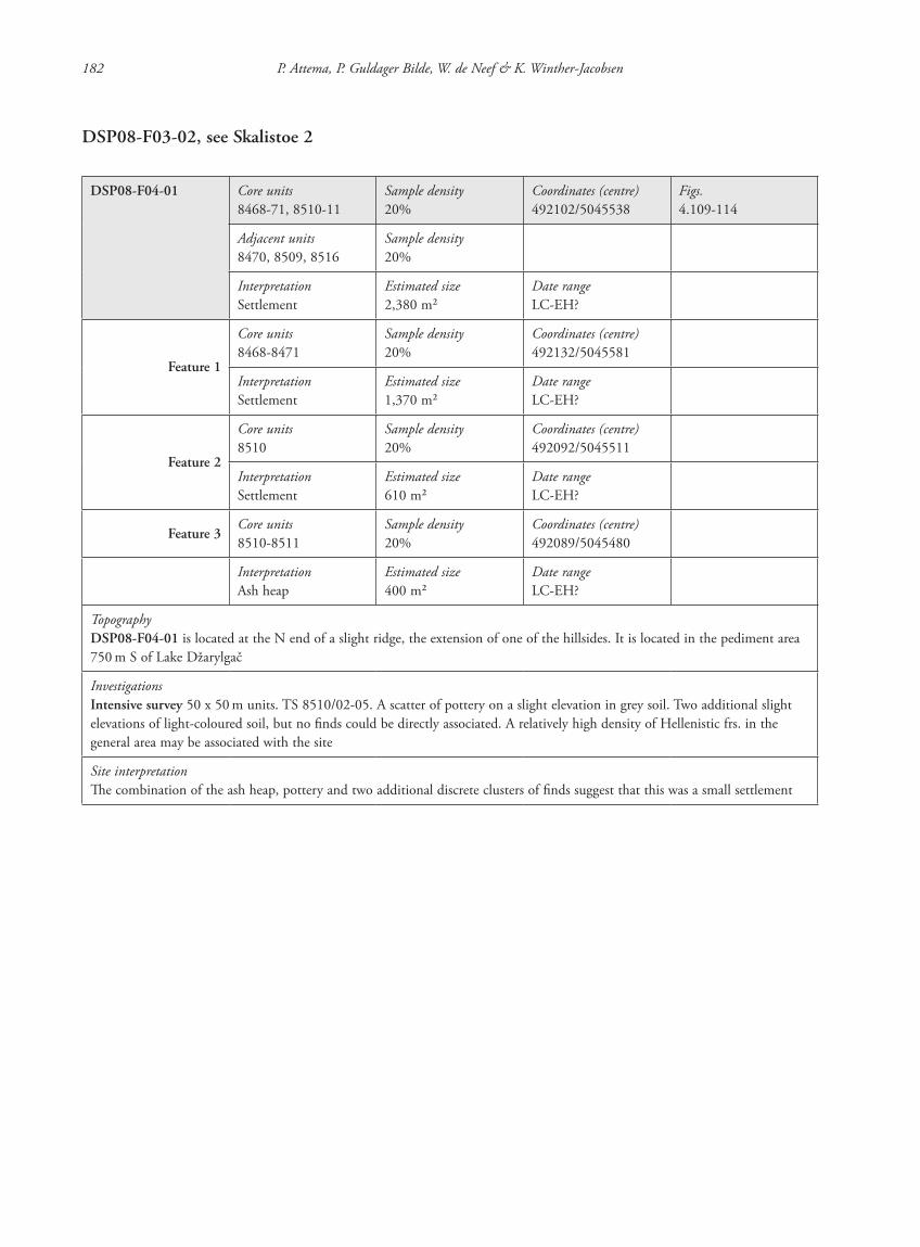
DSP08-F04-01 Core units8468-71, 8510-11
Sample density20%
Coordinates (centre)492102/5045538
Figs.4.109-114
Adjacent units8470, 8509, 8516
Sample density20%
InterpretationSettlement
Estimated size2,380 m2
Date rangeLC-EH?
Feature 1
Core units8468-8471
Sample density20%
Coordinates (centre)492132/5045581
InterpretationSettlement
Estimated size1,370 m2
Date rangeLC-EH?
Feature 2
Core units8510
Sample density20%
Coordinates (centre)492092/5045511
InterpretationSettlement
Estimated size610 m2
Date rangeLC-EH?
Feature 3Core units8510-8511
Sample density20%
Coordinates (centre)492089/5045480
InterpretationAsh heap
Estimated size400 m2
Date rangeLC-EH?
TopographyDSP08-F04-01 is located at the N end of a slight ridge, the extension of one of the hillsides. It is located in the pediment area 750 m S of Lake Džarylgač
InvestigationsIntensive survey 50 x 50 m units. TS 8510/02-05. A scatter of pottery on a slight elevation in grey soil. Two additional slight elevations of light-coloured soil, but no finds could be directly associated. A relatively high density of Hellenistic frs. in the general area may be associated with the site
Site interpretationThe combination of the ash heap, pottery and two additional discrete clusters of finds suggest that this was a small settlement
87620_dzarylgac.indb 182 23-04-2012 20:35:31

Appendix 1 Site catalogue 183
DSP08-F04-02 Core units8499-8500, 8520-21
Sample density20%
Coordinates (centre)491823/5045461
Figs.4.109-112, 4.115-116
Adjacent units8480, 8498, 8501, 8519
Sample density20%
InterpretationSettlement
Estimated size2,460 m2
Date rangeLC-EH
Feature 1
Core units8499-8500
Sample density20%
Coordinates (centre)491823/5045461
InterpretationSettlement
Estimated size1,270 m2
Date rangeLC-EH
Feature 2
Core units8520-21
Sample density20%
Coordinates (centre)491811/5045423
InterpretationSettlement
Estimated size1,190 m2
Date rangeLC-EH
TopographyDSP08-F04-02 is located on a local ridge top. Lake Džarylgač is approximately 580 m to the NW
InvestigationsIntensive survey 50 x 50 m units; TS 8500/02-06 and 8521/01-02. A ploughed scatter around two discrete, relatively high-density clusters of transport, utility and handmade wares and flint on slight elevations in lighter-coloured soil
Site interpretationThe combination of two discrete pottery concentrations with relatively high densities of pottery and flint suggests that this location was a settlement. The two separate clusters may be the remains of two buildings or households, although more research is needed to assess this assumption
87620_dzarylgac.indb 183 23-04-2012 20:35:31
184 P. Attema, P. Guldager Bilde, W. de Neef & K. Winther-Jacobsen
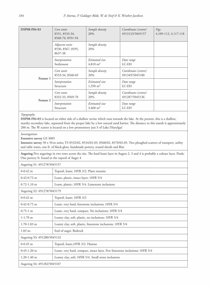
DSP08-F04-03 Core units8531, 8533-34, 8568-70, 8591-94
Sample density20%
Coordinates (centre)4913123/5045157
Figs.4.109-112, 4.117-118
Adjacent units8530, 8567, 8595, 8637-38
Sample density20%
InterpretationSettlement
Estimated size4,810 m2
Date rangeLC-EH
Feature 1
Core units8533-34, 8568-69
Sample density20%
Coordinates (centre)491349/5045180
InterpretationStructure
Estimated size1,350 m2
Date rangeLC-EH
Feature 2
Core units8332-33, 8569-70
Sample density20%
Coordinates (centre)491287/5045136
InterpretationStructure
Estimated size3,460 m2
Date rangeLC-EH
TopographyDSP08-F04-03 is located on either side of a shallow ravine which runs towards the lake. At the present, this is a shallow, marshy secondary lake, separated from the proper lake by a low natural sand barrier. The distance to this marsh is approximately 200 m. The W scatter is located on a low promontory just S of Lake Džarylgač
InvestigationsExtensive survey GS 3005Intensive survey 50 x 50 m units; TS 8532/02, 8534/02-03, 8568/02, 8570/02-05. Two ploughed scatters of transport, utility and table wares, one fr. of black-gloss, handmade pottery, reused sherds and flint
Augering Five augerings in two rows across the site. The hard loam layer in Augers 2, 3 and 4 is probably a culture layer. Finds: One pottery fr. found in the topsoil of Auger 4
Augering S1: 491278/5045157
0-0.42 m Topsoil, loam; 10YR 3/2. Plant remains
0.42-0.72 m Loam, plastic, intact layer; 10YR 5/4
0.72-1.10 m Loam, plastic; 10YR 5/4. Limestone inclusions
Augering S2: 491278/5045179
0-0.42 m Topsoil, loam; 10YR 3/2
0.42-0.75 m Loam, very hard, limestone inclusions; 10YR 5/4
0.75-1 m Loam, very hard, compact. No inclusions; 10YR 5/4
1-1.70 m Loamy clay, soft, plastic, no inclusions; 10YR 5/4
1.70-1.83 m Loamy clay, soft, plastic, limestone inclusions; 10YR 5/4
1.83 m- End of auger. Bedrock
Augering S3: 491280/5045132
0-0.45 m Topsoil, loam,10YR 3/2. Humus
0.45-1.20 m Loam, very hard, compact, intact layer. Few limestone inclusions; 10YR 5/4
1.20-1.40 m Loamy clay, soft; 10YR 5/4. Small stone inclusions
Augering S4: 491282/5045107
87620_dzarylgac.indb 184 23-04-2012 20:35:31
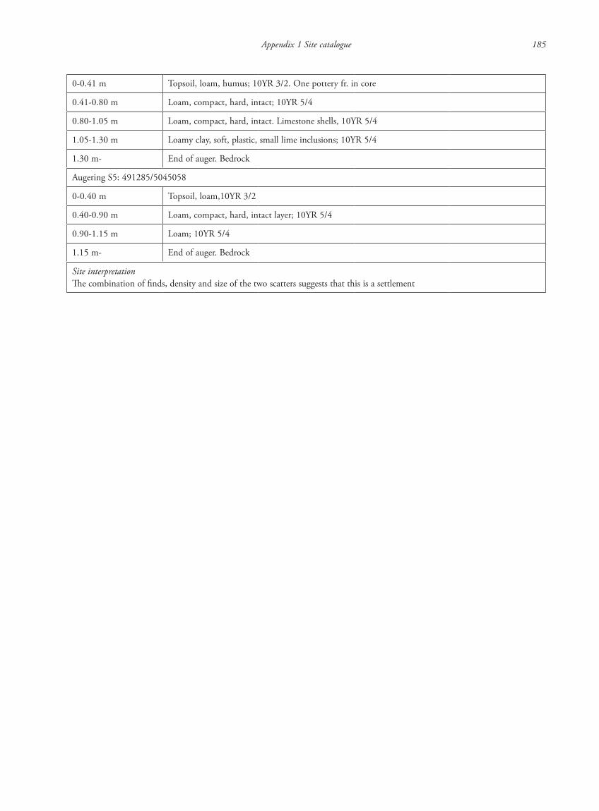
Appendix 1 Site catalogue 185
0-0.41 m Topsoil, loam, humus; 10YR 3/2. One pottery fr. in core
0.41-0.80 m Loam, compact, hard, intact; 10YR 5/4
0.80-1.05 m Loam, compact, hard, intact. Limestone shells, 10YR 5/4
1.05-1.30 m Loamy clay, soft, plastic, small lime inclusions; 10YR 5/4
1.30 m- End of auger. Bedrock
Augering S5: 491285/5045058
0-0.40 m Topsoil, loam,10YR 3/2
0.40-0.90 m Loam, compact, hard, intact layer; 10YR 5/4
0.90-1.15 m Loam; 10YR 5/4
1.15 m- End of auger. Bedrock
Site interpretationThe combination of finds, density and size of the two scatters suggests that this is a settlement
87620_dzarylgac.indb 185 23-04-2012 20:35:31
186 P. Attema, P. Guldager Bilde, W. de Neef & K. Winther-Jacobsen
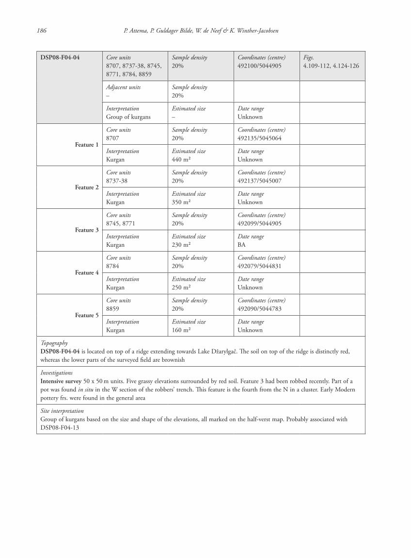
DSP08-F04-04 Core units8707, 8737-38, 8745, 8771, 8784, 8859
Sample density20%
Coordinates (centre)492100/5044905
Figs.4.109-112, 4.124-126
Adjacent units–
Sample density20%
InterpretationGroup of kurgans
Estimated size–
Date rangeUnknown
Feature 1
Core units8707
Sample density20%
Coordinates (centre)492135/5045064
InterpretationKurgan
Estimated size440 m2
Date rangeUnknown
Feature 2
Core units8737-38
Sample density20%
Coordinates (centre)492137/5045007
InterpretationKurgan
Estimated size350 m2
Date rangeUnknown
Feature 3
Core units8745, 8771
Sample density20%
Coordinates (centre)492099/5044905
InterpretationKurgan
Estimated size230 m2
Date rangeBA
Feature 4
Core units8784
Sample density20%
Coordinates (centre)492079/5044831
InterpretationKurgan
Estimated size250 m2
Date rangeUnknown
Feature 5
Core units8859
Sample density20%
Coordinates (centre)492090/5044783
InterpretationKurgan
Estimated size160 m2
Date rangeUnknown
TopographyDSP08-F04-04 is located on top of a ridge extending towards Lake Džarylgač. The soil on top of the ridge is distinctly red, whereas the lower parts of the surveyed field are brownish
InvestigationsIntensive survey 50 x 50 m units. Five grassy elevations surrounded by red soil. Feature 3 had been robbed recently. Part of a pot was found in situ in the W section of the robbers’ trench. This feature is the fourth from the N in a cluster. Early Modern pottery frs. were found in the general area
Site interpretationGroup of kurgans based on the size and shape of the elevations, all marked on the half-verst map. Probably associated with DSP08-F04-13
87620_dzarylgac.indb 186 23-04-2012 20:35:31
Appendix 1 Site catalogue 187
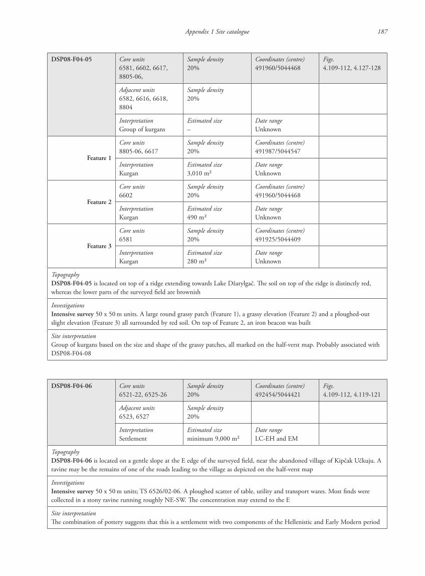
DSP08-F04-05 Core units6581, 6602, 6617, 8805-06,
Sample density20%
Coordinates (centre)491960/5044468
Figs.4.109-112, 4.127-128
Adjacent units6582, 6616, 6618, 8804
Sample density20%
InterpretationGroup of kurgans
Estimated size–
Date rangeUnknown
Feature 1
Core units8805-06, 6617
Sample density20%
Coordinates (centre)491987/5044547
InterpretationKurgan
Estimated size3,010 m2
Date rangeUnknown
Feature 2
Core units6602
Sample density20%
Coordinates (centre)491960/5044468
InterpretationKurgan
Estimated size490 m2
Date rangeUnknown
Feature 3
Core units6581
Sample density20%
Coordinates (centre)491925/5044409
InterpretationKurgan
Estimated size280 m2
Date rangeUnknown
TopographyDSP08-F04-05 is located on top of a ridge extending towards Lake Džarylgač. The soil on top of the ridge is distinctly red, whereas the lower parts of the surveyed field are brownish
InvestigationsIntensive survey 50 x 50 m units. A large round grassy patch (Feature 1), a grassy elevation (Feature 2) and a ploughed-out slight elevation (Feature 3) all surrounded by red soil. On top of Feature 2, an iron beacon was built
Site interpretationGroup of kurgans based on the size and shape of the grassy patches, all marked on the half-verst map. Probably associated with DSP08-F04-08
DSP08-F04-06 Core units6521-22, 6525-26
Sample density20%
Coordinates (centre)492454/5044421
Figs.4.109-112, 4.119-121
Adjacent units6523, 6527
Sample density20%
InterpretationSettlement
Estimated sizeminimum 9,000 m2
Date rangeLC-EH and EM
TopographyDSP08-F04-06 is located on a gentle slope at the E edge of the surveyed field, near the abandoned village of Kipčak Učkuju. A ravine may be the remains of one of the roads leading to the village as depicted on the half-verst map
InvestigationsIntensive survey 50 x 50 m units; TS 6526/02-06. A ploughed scatter of table, utility and transport wares. Most finds were collected in a stony ravine running roughly NE-SW. The concentration may extend to the E
Site interpretationThe combination of pottery suggests that this is a settlement with two components of the Hellenistic and Early Modern period
87620_dzarylgac.indb 187 23-04-2012 20:35:31
188 P. Attema, P. Guldager Bilde, W. de Neef & K. Winther-Jacobsen
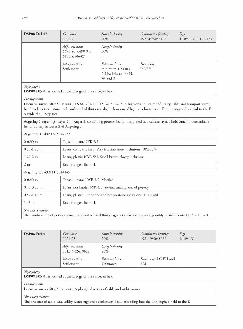
DSP08-F04-07 Core units6492-94
Sample density20%
Coordinates (centre)492104/5044144
Figs.4.109-112, 4.122-123
Adjacent units6475-80, 6490-91, 6495, 6506-07
Sample density20%
InterpretationSettlement
Estimated sizeminimum 1 ha in a 2.5 ha halo to the N, W, and S
Date rangeLC-EH
TopographyDSP08-F05-01 is located at the E edge of the surveyed field
InvestigationsIntensive survey 50 x 50 m units; TS 6492/02-06, TS 6493/02-03. A high-density scatter of utility, table and transport wares, handmade pottery, stone tools and worked flint on a slight elevation of lighter-coloured soil. The site may well extend to the E outside the survey area
Augering 2 augerings. Layer 2 in Auger 2, containing pottery frs., is interpreted as a culture layer. Finds: Small indeterminate frs. of pottery in Layer 2 of Augering 2
Augering S6: 492094/5044232
0-0.30 m Topsoil, loam,10YR 3/2
0.30-1.20 m Loam, compact, hard. Very few limestone inclusions; 10YR 5/4
1.20-2 m Loam, plastic,10YR 5/4. Small brown clayey inclusions
2 m- End of auger. Bedrock
Augering S7: 492111/5044145
0-0.40 m Topsoil, loam; 10YR 3/2. Mottled
0.40-0.52 m Loam, not hard; 10YR 4/3. Several small pieces of pottery
0.52-1.48 m Loam, plastic. Limestone and brown stone inclusions; 10YR 4/4
1.48 m- End of auger. Bedrock
Site interpretationThe combination of pottery, stone tools and worked flint suggests that is a settlement, possibly related to site DSP07-F08-01
DSP08-F05-01 Core units9024-25
Sample density20%
Coordinates (centre)492119/5048936
Figs.4.129-131
Adjacent units9013, 9026, 9028
Sample density20%
InterpretationSettlement
Estimated sizeUnknown
Date range LC-EH and EM
TopographyDSP08-F05-01 is located at the E edge of the surveyed field
InvestigationsIntensive survey 50 x 50 m units. A ploughed scatter of table and utility wares
Site interpretationThe presence of table- and utility wares suggests a settlement likely extending into the unploughed field to the E
87620_dzarylgac.indb 188 23-04-2012 20:35:31
Appendix 1 Site catalogue 189
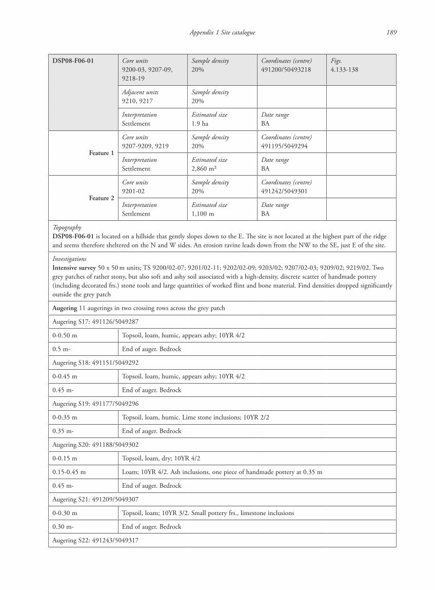
DSP08-F06-01 Core units9200-03, 9207-09, 9218-19
Sample density20%
Coordinates (centre)491200/50493218
Figs.4.133-138
Adjacent units9210, 9217
Sample density20%
InterpretationSettlement
Estimated size1.9 ha
Date rangeBA
Feature 1
Core units9207-9209, 9219
Sample density20%
Coordinates (centre)491195/5049294
InterpretationSettlement
Estimated size2,860 m2
Date rangeBA
Feature 2
Core units9201-02
Sample density20%
Coordinates (centre)491242/5049301
InterpretationSettlement
Estimated size1,100 m
Date rangeBA
TopographyDSP08-F06-01 is located on a hillside that gently slopes down to the E. The site is not located at the highest part of the ridge and seems therefore sheltered on the N and W sides. An erosion ravine leads down from the NW to the SE, just E of the site.
InvestigationsIntensive survey 50 x 50 m units; TS 9200/02-07; 9201/02-11; 9202/02-09; 9203/02; 9207/02-03; 9209/02; 9219/02. Two grey patches of rather stony, but also soft and ashy soil associated with a high-density, discrete scatter of handmade pottery (including decorated frs.) stone tools and large quantities of worked flint and bone material. Find densities dropped significantly outside the grey patch
Augering 11 augerings in two crossing rows across the grey patch
Augering S17: 491126/5049287
0-0.50 m Topsoil, loam, humic, appears ashy; 10YR 4/2
0.5 m- End of auger. Bedrock
Augering S18: 491151/5049292
0-0.45 m Topsoil, loam, humic, appears ashy; 10YR 4/2
0.45 m- End of auger. Bedrock
Augering S19: 491177/5049296
0-0.35 m Topsoil, loam, humic. Lime stone inclusions; 10YR 2/2
0.35 m- End of auger. Bedrock
Augering S20: 491188/5049302
0-0.15 m Topsoil, loam, dry; 10YR 4/2
0.15-0.45 m Loam; 10YR 4/2. Ash inclusions, one piece of handmade pottery at 0.35 m
0.45 m- End of auger. Bedrock
Augering S21: 491209/5049307
0-0.30 m Topsoil, loam; 10YR 3/2. Small pottery frs., limestone inclusions
0.30 m- End of auger. Bedrock
Augering S22: 491243/5049317
87620_dzarylgac.indb 189 23-04-2012 20:35:31
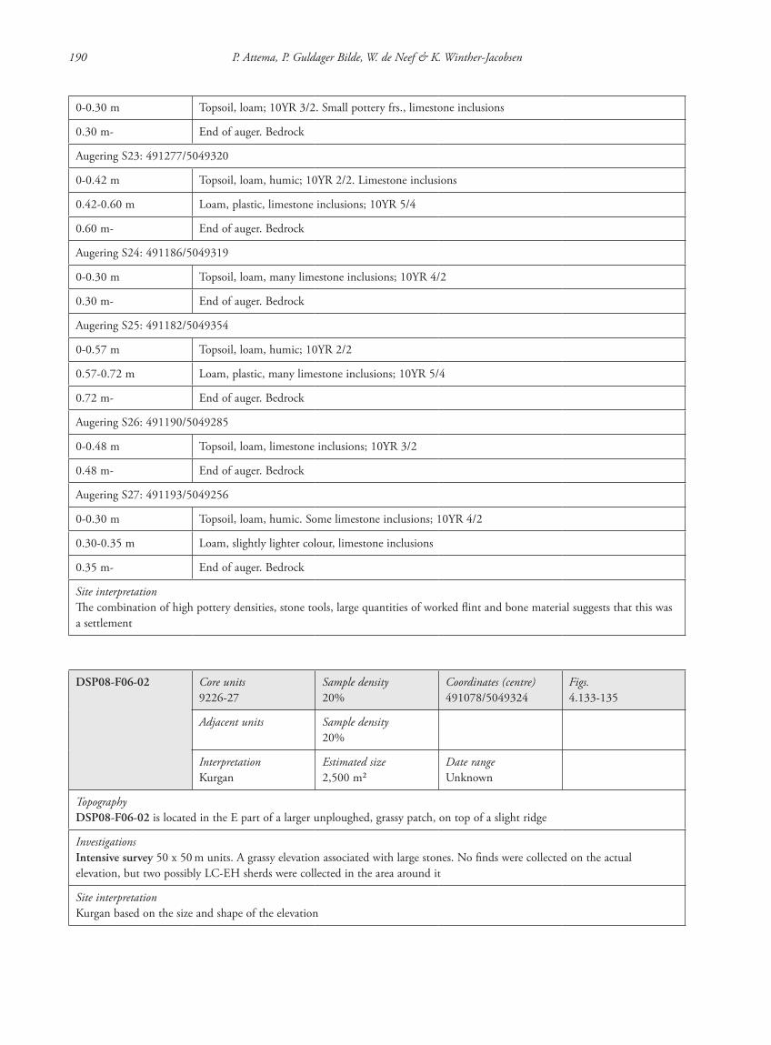
190 P. Attema, P. Guldager Bilde, W. de Neef & K. Winther-Jacobsen
0-0.30 m Topsoil, loam; 10YR 3/2. Small pottery frs., limestone inclusions
0.30 m- End of auger. Bedrock
Augering S23: 491277/5049320
0-0.42 m Topsoil, loam, humic; 10YR 2/2. Limestone inclusions
0.42-0.60 m Loam, plastic, limestone inclusions; 10YR 5/4
0.60 m- End of auger. Bedrock
Augering S24: 491186/5049319
0-0.30 m Topsoil, loam, many limestone inclusions; 10YR 4/2
0.30 m- End of auger. Bedrock
Augering S25: 491182/5049354
0-0.57 m Topsoil, loam, humic; 10YR 2/2
0.57-0.72 m Loam, plastic, many limestone inclusions; 10YR 5/4
0.72 m- End of auger. Bedrock
Augering S26: 491190/5049285
0-0.48 m Topsoil, loam, limestone inclusions; 10YR 3/2
0.48 m- End of auger. Bedrock
Augering S27: 491193/5049256
0-0.30 m Topsoil, loam, humic. Some limestone inclusions; 10YR 4/2
0.30-0.35 m Loam, slightly lighter colour, limestone inclusions
0.35 m- End of auger. Bedrock
Site interpretationThe combination of high pottery densities, stone tools, large quantities of worked flint and bone material suggests that this was a settlement
DSP08-F06-02 Core units9226-27
Sample density20%
Coordinates (centre)491078/5049324
Figs.4.133-135
Adjacent units Sample density20%
InterpretationKurgan
Estimated size2,500 m2
Date rangeUnknown
TopographyDSP08-F06-02 is located in the E part of a larger unploughed, grassy patch, on top of a slight ridge
InvestigationsIntensive survey 50 x 50 m units. A grassy elevation associated with large stones. No finds were collected on the actual elevation, but two possibly LC-EH sherds were collected in the area around it
Site interpretationKurgan based on the size and shape of the elevation
87620_dzarylgac.indb 190 23-04-2012 20:35:31
Appendix 1 Site catalogue 191
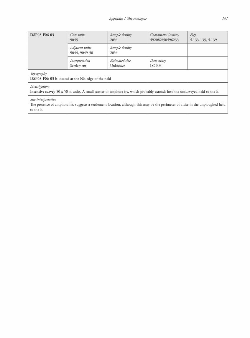
DSP08-F06-03 Core units9045
Sample density20%
Coordinates (centre)492082/50496233
Figs.4.133-135, 4.139
Adjacent units9044, 9049-50
Sample density20%
InterpretationSettlement
Estimated sizeUnknown
Date rangeLC-EH
TopographyDSP08-F06-03 is located at the NE edge of the field
InvestigationsIntensive survey 50 x 50 m units. A small scatter of amphora frs. which probably extends into the unsurveyed field to the E
Site interpretationThe presence of amphora frs. suggests a settlement location, although this may be the perimeter of a site in the unploughed field to the E
87620_dzarylgac.indb 191 23-04-2012 20:35:32
192 P. Attema, P. Guldager Bilde, W. de Neef & K. Winther-Jacobsen
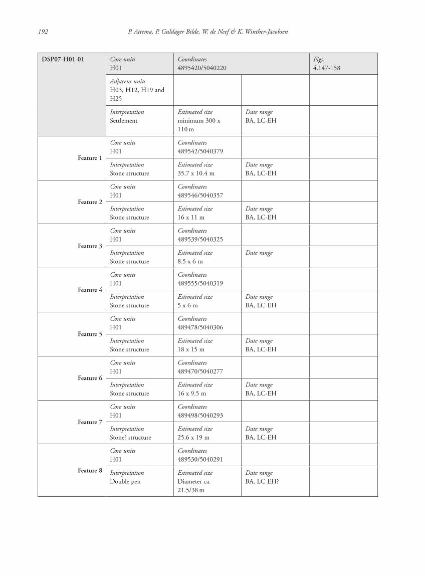
DSP07-H01-01 Core unitsH01
Coordinates4895420/5040220
Figs.4.147-158
Adjacent unitsH03, H12, H19 and H25
InterpretationSettlement
Estimated sizeminimum 300 x 110 m
Date rangeBA, LC-EH
Feature 1
Core unitsH01
Coordinates489542/5040379
InterpretationStone structure
Estimated size35.7 x 10.4 m
Date rangeBA, LC-EH
Feature 2
Core unitsH01
Coordinates489546/5040357
InterpretationStone structure
Estimated size16 x 11 m
Date rangeBA, LC-EH
Feature 3
Core unitsH01
Coordinates489539/5040325
InterpretationStone structure
Estimated size8.5 x 6 m
Date range
Feature 4
Core unitsH01
Coordinates489555/5040319
InterpretationStone structure
Estimated size5 x 6 m
Date rangeBA, LC-EH
Feature 5
Core unitsH01
Coordinates489478/5040306
InterpretationStone structure
Estimated size18 x 15 m
Date rangeBA, LC-EH
Feature 6
Core unitsH01
Coordinates489470/5040277
InterpretationStone structure
Estimated size16 x 9.5 m
Date rangeBA, LC-EH
Feature 7
Core unitsH01
Coordinates489498/5040293
InterpretationStone? structure
Estimated size25.6 x 19 m
Date rangeBA, LC-EH
Feature 8
Core unitsH01
Coordinates489530/5040291
InterpretationDouble pen
Estimated sizeDiameter ca. 21.5/38 m
Date rangeBA, LC-EH?
87620_dzarylgac.indb 192 23-04-2012 20:35:32
Appendix 1 Site catalogue 193
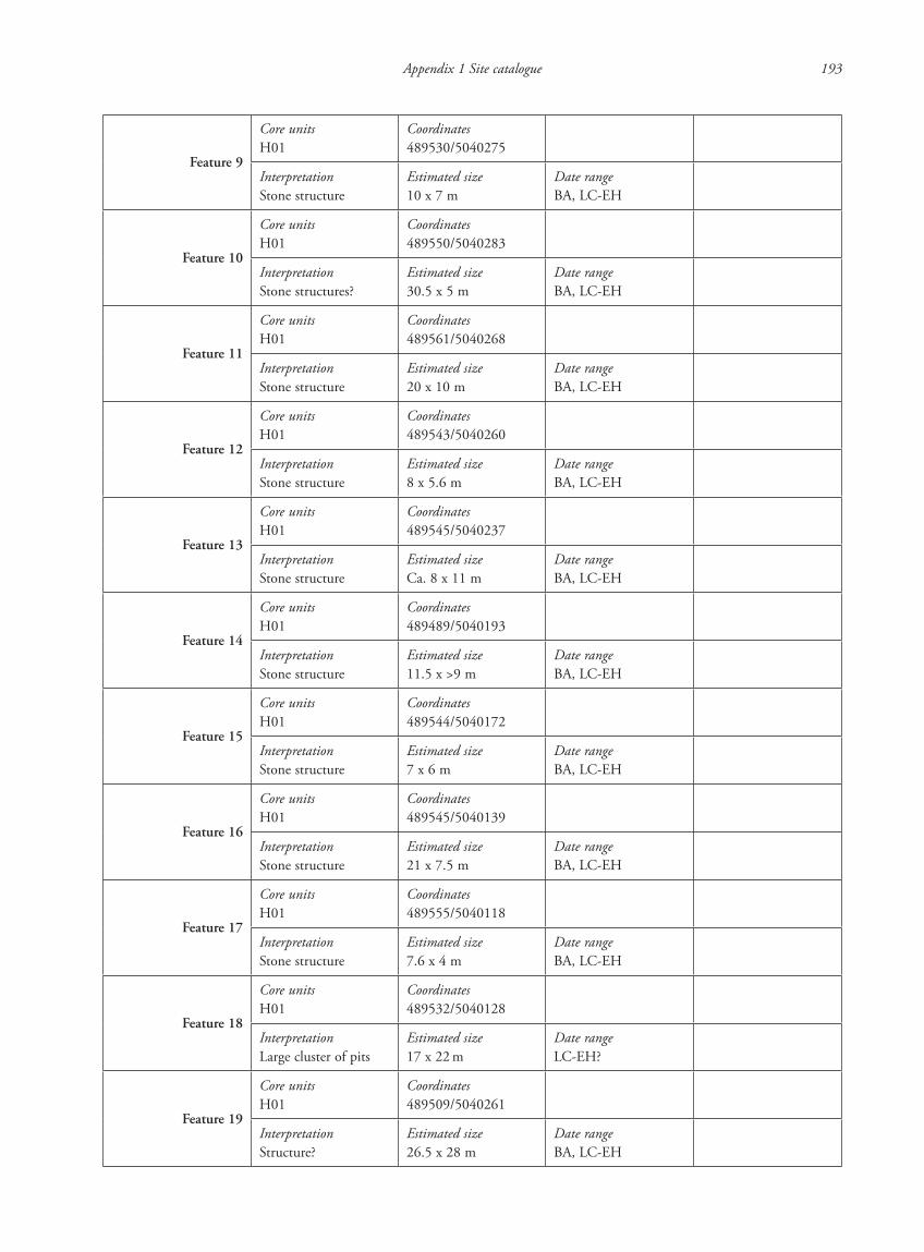
Feature 9
Core unitsH01
Coordinates489530/5040275
InterpretationStone structure
Estimated size10 x 7 m
Date rangeBA, LC-EH
Feature 10
Core unitsH01
Coordinates489550/5040283
InterpretationStone structures?
Estimated size30.5 x 5 m
Date rangeBA, LC-EH
Feature 11
Core unitsH01
Coordinates489561/5040268
InterpretationStone structure
Estimated size20 x 10 m
Date rangeBA, LC-EH
Feature 12
Core unitsH01
Coordinates489543/5040260
InterpretationStone structure
Estimated size8 x 5.6 m
Date rangeBA, LC-EH
Feature 13
Core unitsH01
Coordinates489545/5040237
InterpretationStone structure
Estimated sizeCa. 8 x 11 m
Date rangeBA, LC-EH
Feature 14
Core unitsH01
Coordinates489489/5040193
InterpretationStone structure
Estimated size11.5 x >9 m
Date rangeBA, LC-EH
Feature 15
Core unitsH01
Coordinates489544/5040172
InterpretationStone structure
Estimated size7 x 6 m
Date rangeBA, LC-EH
Feature 16
Core unitsH01
Coordinates489545/5040139
InterpretationStone structure
Estimated size21 x 7.5 m
Date rangeBA, LC-EH
Feature 17
Core unitsH01
Coordinates489555/5040118
InterpretationStone structure
Estimated size7.6 x 4 m
Date rangeBA, LC-EH
Feature 18
Core unitsH01
Coordinates489532/5040128
InterpretationLarge cluster of pits
Estimated size17 x 22 m
Date rangeLC-EH?
Feature 19
Core unitsH01
Coordinates489509/5040261
InterpretationStructure?
Estimated size26.5 x 28 m
Date rangeBA, LC-EH
87620_dzarylgac.indb 193 23-04-2012 20:35:32
194 P. Attema, P. Guldager Bilde, W. de Neef & K. Winther-Jacobsen
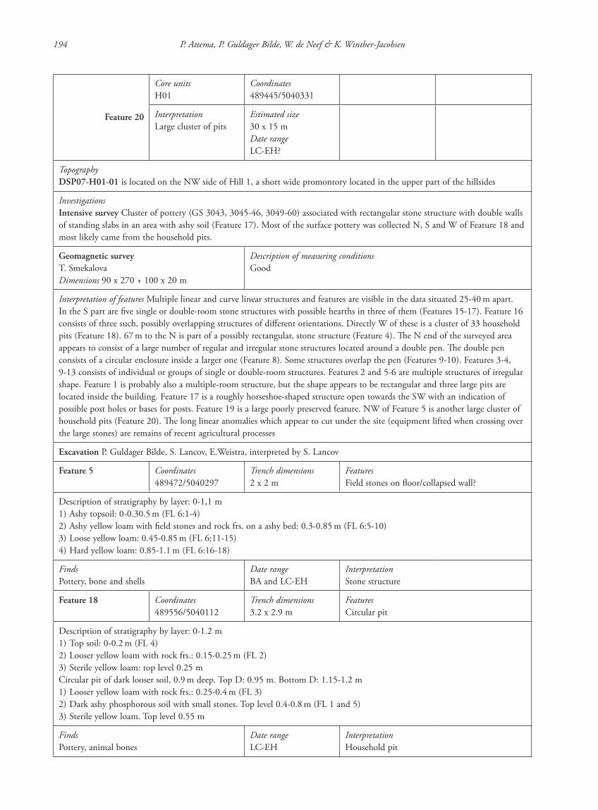
Feature 20
Core unitsH01
Coordinates489445/5040331
InterpretationLarge cluster of pits
Estimated size30 x 15 mDate rangeLC-EH?
TopographyDSP07-H01-01 is located on the NW side of Hill 1, a short wide promontory located in the upper part of the hillsides
InvestigationsIntensive survey Cluster of pottery (GS 3043, 3045-46, 3049-60) associated with rectangular stone structure with double walls of standing slabs in an area with ashy soil (Feature 17). Most of the surface pottery was collected N, S and W of Feature 18 and most likely came from the household pits.
Geomagnetic surveyT. SmekalovaDimensions 90 x 270 + 100 x 20 m
Description of measuring conditionsGood
Interpretation of features Multiple linear and curve linear structures and features are visible in the data situated 25-40 m apart. In the S part are five single or double-room stone structures with possible hearths in three of them (Features 15-17). Feature 16 consists of three such, possibly overlapping structures of different orientations. Directly W of these is a cluster of 33 household pits (Feature 18). 67 m to the N is part of a possibly rectangular, stone structure (Feature 4). The N end of the surveyed area appears to consist of a large number of regular and irregular stone structures located around a double pen. The double pen consists of a circular enclosure inside a larger one (Feature 8). Some structures overlap the pen (Features 9-10). Features 3-4, 9-13 consists of individual or groups of single or double-room structures. Features 2 and 5-6 are multiple structures of irregular shape. Feature 1 is probably also a multiple-room structure, but the shape appears to be rectangular and three large pits are located inside the building. Feature 17 is a roughly horseshoe-shaped structure open towards the SW with an indication of possible post holes or bases for posts. Feature 19 is a large poorly preserved feature. NW of Feature 5 is another large cluster of household pits (Feature 20). The long linear anomalies which appear to cut under the site (equipment lifted when crossing over the large stones) are remains of recent agricultural processes
Excavation P. Guldager Bilde, S. Lancov, E.Weistra, interpreted by S. Lancov
Feature 5 Coordinates489472/5040297
Trench dimensions2 x 2 m
FeaturesField stones on floor/collapsed wall?
Description of stratigraphy by layer: 0-1,1 m1) Ashy topsoil: 0-0.30.5 m (FL 6:1-4)2) Ashy yellow loam with field stones and rock frs. on a ashy bed: 0.3-0.85 m (FL 6:5-10)3) Loose yellow loam: 0.45-0.85 m (FL 6:11-15)4) Hard yellow loam: 0.85-1.1 m (FL 6:16-18)
FindsPottery, bone and shells
Date rangeBA and LC-EH
InterpretationStone structure
Feature 18 Coordinates489556/5040112
Trench dimensions3.2 x 2.9 m
FeaturesCircular pit
Description of stratigraphy by layer: 0-1.2 m1) Top soil: 0-0.2 m (FL 4)2) Looser yellow loam with rock frs.: 0.15-0.25 m (FL 2)3) Sterile yellow loam: top level 0.25 mCircular pit of dark looser soil, 0.9 m deep. Top D: 0.95 m. Bottom D: 1.15-1.2 m1) Looser yellow loam with rock frs.: 0.25-0.4 m (FL 3)2) Dark ashy phosphorous soil with small stones. Top level 0.4-0.8 m (FL 1 and 5)3) Sterile yellow loam. Top level 0.55 m
FindsPottery, animal bones
Date rangeLC-EH
InterpretationHousehold pit
87620_dzarylgac.indb 194 23-04-2012 20:35:32
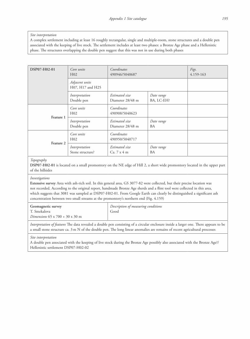
Appendix 1 Site catalogue 195
Site interpretationA complex settlement including at least 16 roughly rectangular, single and multiple-room, stone structures and a double pen associated with the keeping of live stock. The settlement includes at least two phases: a Bronze Age phase and a Hellenistic phase. The structures overlapping the double pen suggest that this was not in use during both phases
DSP07-H02-01 Core unitsH02
Coordinates490946/5040687
Figs.4.159-163
Adjacent unitsH07, H17 and H25
InterpretationDouble pen
Estimated sizeDiameter 28/48 m
Date rangeBA, LC-EH?
Feature 1
Core unitsH02
Coordinates490908/5040623
InterpretationDouble pen
Estimated sizeDiameter 28/48 m
Date rangeBA
Feature 2
Core unitsH02
Coordinates490950/5040717
InterpretationStone structure?
Estimated sizeCa. 7 x 4 m
Date rangeBA
TopographyDSP07-H02-01 is located on a small promontory on the NE edge of Hill 2, a short wide promontory located in the upper part of the hillsides
InvestigationsExtensive survey Area with ash-rich soil. In this general area, GS 3077-82 were collected, but their precise location was not recorded. According to the original report, handmade Bronze Age sherds and a flint tool were collected in this area, which suggests that 3081 was sampled at DSP07-H02-01. From Google Earth can clearly be distinguished a significant ash concentration between two small streams at the promontory’s northern end (Fig. 4.159)
Geomagnetic surveyT. SmekalovaDimensions 65 x 700 + 30 x 30 m
Description of measuring conditionsGood
Interpretation of features The data revealed a double pen consisting of a circular enclosure inside a larger one. There appears to be a small stone structure ca. 3 m N of the double pen. The long linear anomalies are remains of recent agricultural processes
Site interpretationA double pen associated with the keeping of live stock during the Bronze Age possibly also associated with the Bronze Age?/Hellenistic settlement DSP07-H02-02
87620_dzarylgac.indb 195 23-04-2012 20:35:32
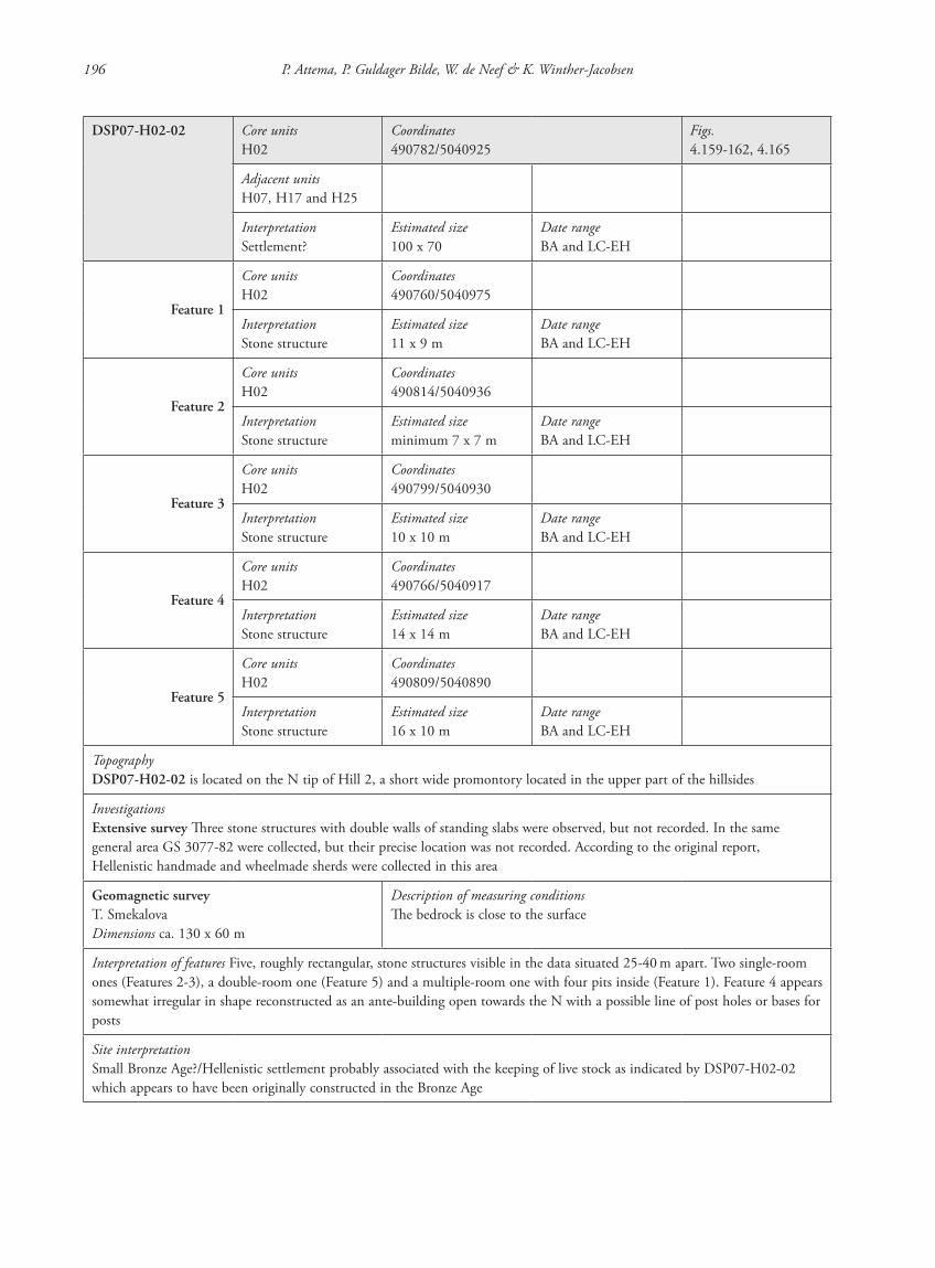
196 P. Attema, P. Guldager Bilde, W. de Neef & K. Winther-Jacobsen
DSP07-H02-02 Core unitsH02
Coordinates490782/5040925
Figs.4.159-162, 4.165
Adjacent unitsH07, H17 and H25
InterpretationSettlement?
Estimated size100 x 70
Date rangeBA and LC-EH
Feature 1
Core unitsH02
Coordinates490760/5040975
InterpretationStone structure
Estimated size11 x 9 m
Date rangeBA and LC-EH
Feature 2
Core unitsH02
Coordinates490814/5040936
InterpretationStone structure
Estimated sizeminimum 7 x 7 m
Date rangeBA and LC-EH
Feature 3
Core unitsH02
Coordinates490799/5040930
InterpretationStone structure
Estimated size10 x 10 m
Date rangeBA and LC-EH
Feature 4
Core unitsH02
Coordinates490766/5040917
InterpretationStone structure
Estimated size14 x 14 m
Date rangeBA and LC-EH
Feature 5
Core unitsH02
Coordinates490809/5040890
InterpretationStone structure
Estimated size16 x 10 m
Date rangeBA and LC-EH
TopographyDSP07-H02-02 is located on the N tip of Hill 2, a short wide promontory located in the upper part of the hillsides
InvestigationsExtensive survey Three stone structures with double walls of standing slabs were observed, but not recorded. In the same general area GS 3077-82 were collected, but their precise location was not recorded. According to the original report, Hellenistic handmade and wheelmade sherds were collected in this area
Geomagnetic surveyT. SmekalovaDimensions ca. 130 x 60 m
Description of measuring conditionsThe bedrock is close to the surface
Interpretation of features Five, roughly rectangular, stone structures visible in the data situated 25-40 m apart. Two single-room ones (Features 2-3), a double-room one (Feature 5) and a multiple-room one with four pits inside (Feature 1). Feature 4 appears somewhat irregular in shape reconstructed as an ante-building open towards the N with a possible line of post holes or bases for posts
Site interpretationSmall Bronze Age?/Hellenistic settlement probably associated with the keeping of live stock as indicated by DSP07-H02-02 which appears to have been originally constructed in the Bronze Age
87620_dzarylgac.indb 196 23-04-2012 20:35:32
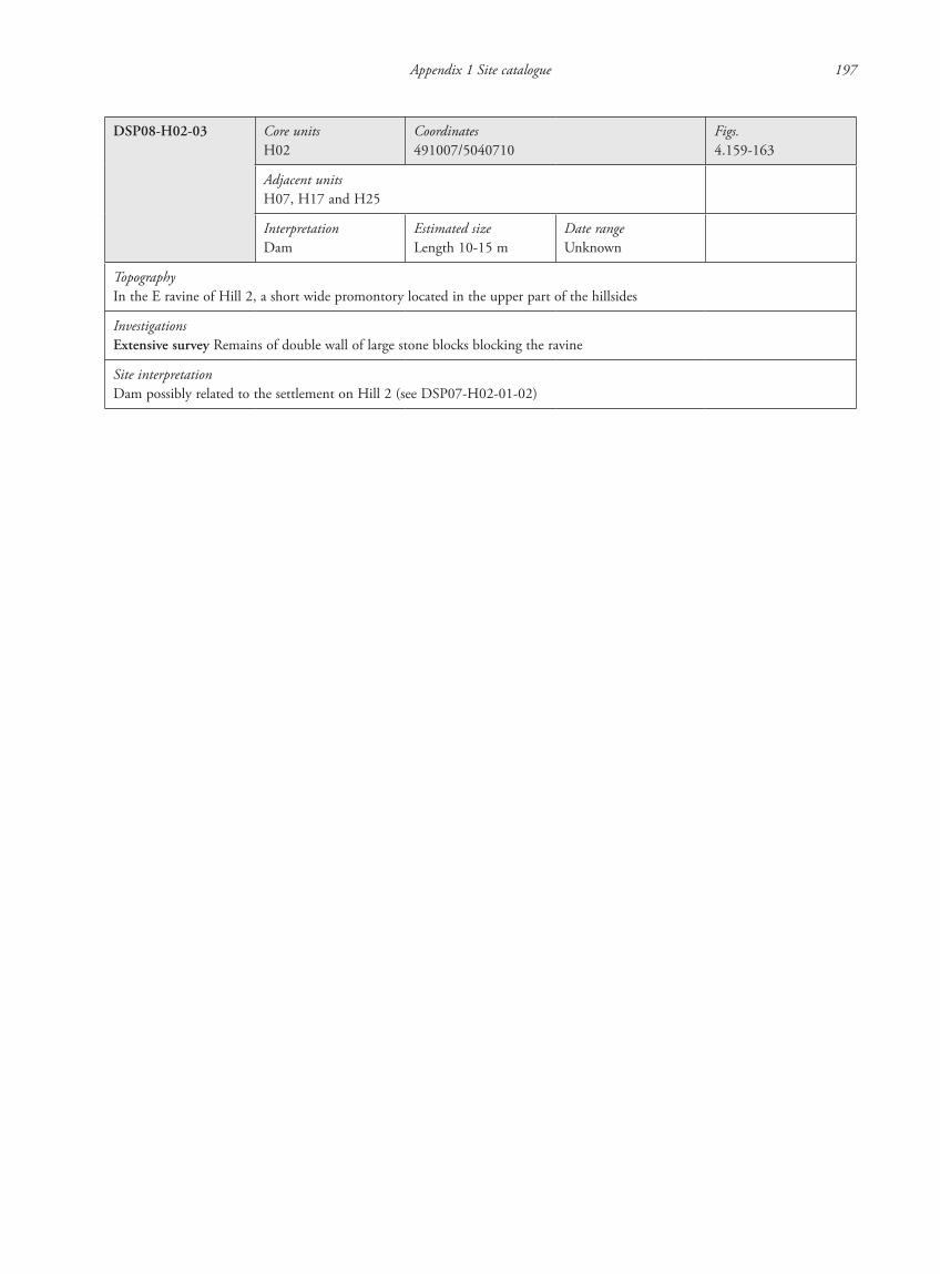
Appendix 1 Site catalogue 197
DSP08-H02-03 Core unitsH02
Coordinates491007/5040710
Figs.4.159-163
Adjacent unitsH07, H17 and H25
InterpretationDam
Estimated sizeLength 10-15 m
Date rangeUnknown
TopographyIn the E ravine of Hill 2, a short wide promontory located in the upper part of the hillsides
InvestigationsExtensive survey Remains of double wall of large stone blocks blocking the ravine
Site interpretationDam possibly related to the settlement on Hill 2 (see DSP07-H02-01-02)
87620_dzarylgac.indb 197 23-04-2012 20:35:32
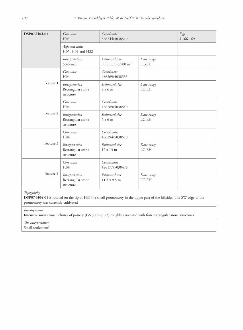
198 P. Attema, P. Guldager Bilde, W. de Neef & K. Winther-Jacobsen
DSP07-H04-01 Core unitsH04
Coordinates486244/5038519
Figs.4.166-169
Adjacent unitsH05, H09 and H22
InterpretationSettlement
Estimated sizeminimum 6,900 m2
Date rangeLC-EH
Feature 1
Core unitsH04
Coordinates486269/5038555
InterpretationRectangular stone structure
Estimated size8 x 6 m
Date rangeLC-EH
Feature 2
Core unitsH04
Coordinates486289/5038549
InterpretationRectangular stone structure
Estimated size6 x 6 m
Date rangeLC-EH
Feature 3
Core unitsH04
Coordinates486194/5038518
InterpretationRectangular stone structure
Estimated size17 x 13 m
Date rangeLC-EH
Feature 4
Core unitsH04
Coordinates486177/5038478
InterpretationRectangular stone structure
Estimated size11.5 x 9.5 m
Date rangeLC-EH
TopographyDSP07-H04-01 is located on the tip of Hill 4, a small promontory in the upper part of the hillsides. The SW edge of the promontory was currently cultivated
InvestigationsIntensive survey Small cluster of pottery (GS 3068-3072) roughly associated with four rectangular stone structures
Site interpretationSmall settlement?
87620_dzarylgac.indb 198 23-04-2012 20:35:32
Appendix 1 Site catalogue 199
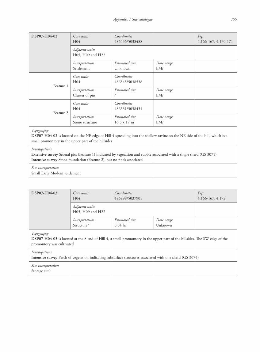
DSP07-H04-02 Core unitsH04
Coordinates486536/5038488
Figs.4.166-167, 4.170-171
Adjacent unitsH05, H09 and H22
InterpretationSettlement
Estimated sizeUnknown
Date rangeEM?
Feature 1
Core unitsH04
Coordinates486545/5038538
InterpretationCluster of pits
Estimated size?
Date rangeEM?
Feature 2
Core unitsH04
Coordinates486531/5038431
InterpretationStone structure
Estimated size16.5 x 17 m
Date rangeEM?
TopographyDSP07-H04-02 is located on the NE edge of Hill 4 spreading into the shallow ravine on the NE side of the hill, which is a small promontory in the upper part of the hillsides
InvestigationsExtensive survey Several pits (Feature 1) indicated by vegetation and rubble associated with a single sherd (GS 3075)Intensive survey Stone foundation (Feature 2), but no finds associated
Site interpretationSmall Early Modern settlement
DSP07-H04-03 Core unitsH04
Coordinates486899/5037905
Figs.4.166-167, 4.172
Adjacent unitsH05, H09 and H22
InterpretationStructure?
Estimated size0.04 ha
Date rangeUnknown
TopographyDSP07-H04-03 is located at the S end of Hill 4, a small promontory in the upper part of the hillsides. The SW edge of the promontory was cultivated
InvestigationsIntensive survey Patch of vegetation indicating subsurface structures associated with one sherd (GS 3074)
Site interpretationStorage site?
87620_dzarylgac.indb 199 23-04-2012 20:35:33
200 P. Attema, P. Guldager Bilde, W. de Neef & K. Winther-Jacobsen
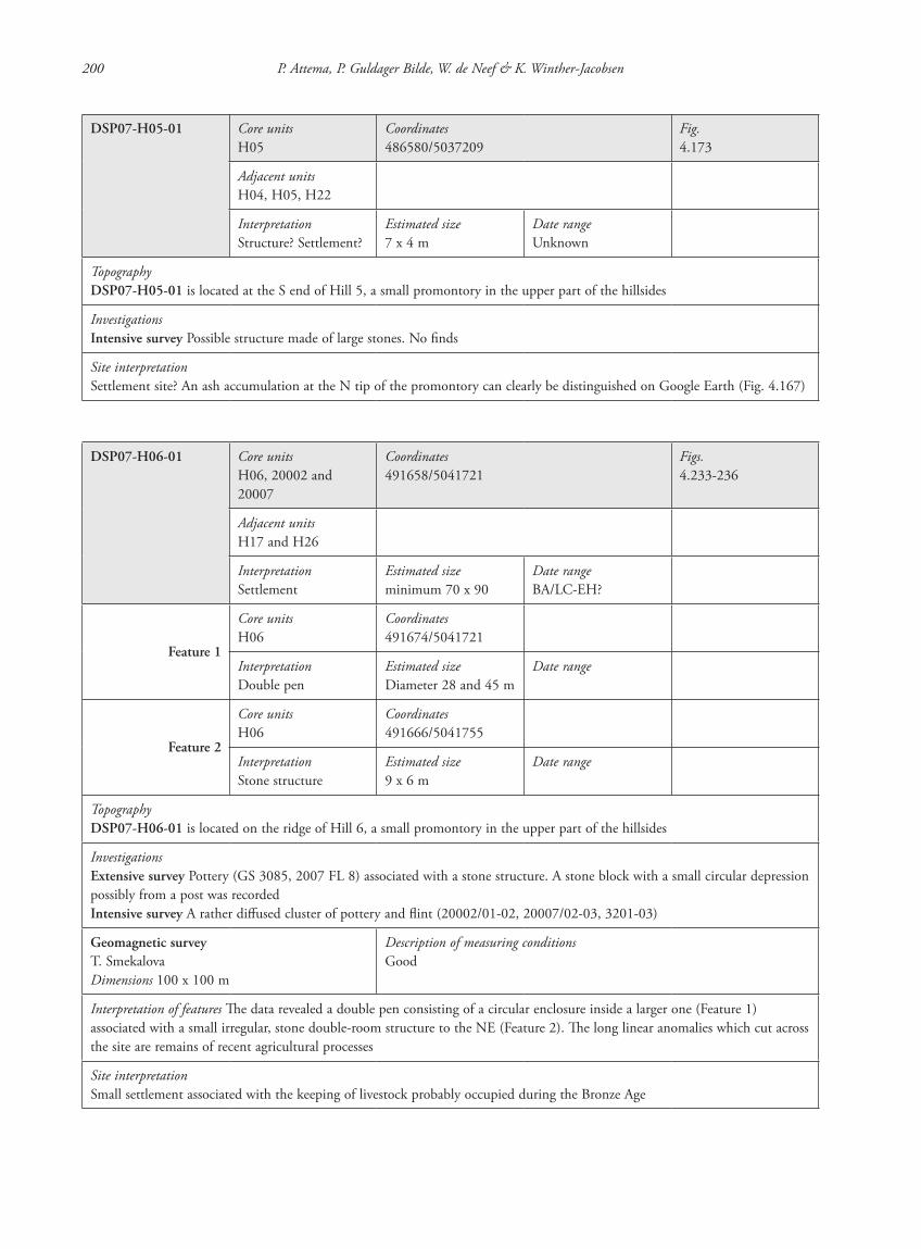
DSP07-H05-01 Core unitsH05
Coordinates486580/5037209
Fig.4.173
Adjacent unitsH04, H05, H22
InterpretationStructure? Settlement?
Estimated size7 x 4 m
Date rangeUnknown
TopographyDSP07-H05-01 is located at the S end of Hill 5, a small promontory in the upper part of the hillsides
InvestigationsIntensive survey Possible structure made of large stones. No finds
Site interpretationSettlement site? An ash accumulation at the N tip of the promontory can clearly be distinguished on Google Earth (Fig. 4.167)
DSP07-H06-01 Core unitsH06, 20002 and 20007
Coordinates491658/5041721
Figs.4.233-236
Adjacent unitsH17 and H26
InterpretationSettlement
Estimated sizeminimum 70 x 90
Date rangeBA/LC-EH?
Feature 1
Core unitsH06
Coordinates491674/5041721
InterpretationDouble pen
Estimated sizeDiameter 28 and 45 m
Date range
Feature 2
Core unitsH06
Coordinates491666/5041755
InterpretationStone structure
Estimated size9 x 6 m
Date range
TopographyDSP07-H06-01 is located on the ridge of Hill 6, a small promontory in the upper part of the hillsides
InvestigationsExtensive survey Pottery (GS 3085, 2007 FL 8) associated with a stone structure. A stone block with a small circular depression possibly from a post was recordedIntensive survey A rather diffused cluster of pottery and flint (20002/01-02, 20007/02-03, 3201-03)
Geomagnetic surveyT. SmekalovaDimensions 100 x 100 m
Description of measuring conditionsGood
Interpretation of features The data revealed a double pen consisting of a circular enclosure inside a larger one (Feature 1) associated with a small irregular, stone double-room structure to the NE (Feature 2). The long linear anomalies which cut across the site are remains of recent agricultural processes
Site interpretationSmall settlement associated with the keeping of livestock probably occupied during the Bronze Age
87620_dzarylgac.indb 200 23-04-2012 20:35:33
Appendix 1 Site catalogue 201
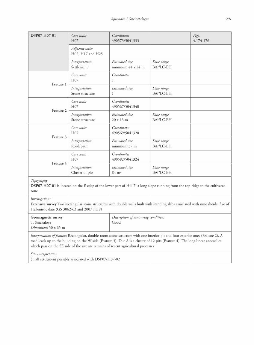
DSP07-H07-01 Core unitsH07
Coordinates490573/5041333
Figs.4.174-176
Adjacent unitsH02, H17 and H25
InterpretationSettlement
Estimated sizeminimum 44 x 24 m
Date rangeBA?/LC-EH
Feature 1
Core unitsH07
Coordinates?
InterpretationStone structure
Estimated size?
Date rangeBA?/LC-EH
Feature 2
Core unitsH07
Coordinates490567/5041340
InterpretationStone structure
Estimated size20 x 13 m
Date rangeBA?/LC-EH
Feature 3
Core unitsH07
Coordinates490569/5041320
InterpretationRoad/path
Estimated sizeminimum 37 m
Date rangeBA?/LC-EH
Feature 4
Core unitsH07
Coordinates490582/5041324
InterpretationCluster of pits
Estimated size84 m2
Date rangeBA?/LC-EH
TopographyDSP07-H07-01 is located on the E edge of the lower part of Hill 7, a long slope running from the top ridge to the cultivated zone
InvestigationsExtensive survey Two rectangular stone structures with double walls built with standing slabs associated with nine sherds, five of Hellenistic date (GS 3062-63 and 2007 FL 9)
Geomagnetic surveyT. SmekalovaDimensions 50 x 65 m
Description of measuring conditionsGood
Interpretation of features Rectangular, double-room stone structure with one interior pit and four exterior ones (Feature 2). A road leads up to the building on the W side (Feature 3). Due S is a cluster of 12 pits (Feature 4). The long linear anomalies which pass on the SE side of the site are remains of recent agricultural processes
Site interpretationSmall settlement possibly associated with DSP07-H07-02
87620_dzarylgac.indb 201 23-04-2012 20:35:33

202 P. Attema, P. Guldager Bilde, W. de Neef & K. Winther-Jacobsen
DSP07-H07-02 Core unitsH07
Coordinates490168/5041704
Figs.4.174, 4.177
Adjacent unitsH02, H17 and H25
InterpretationSettlement
Estimated sizeminimum 140 x 30 m
Date rangeBA?/LC-EH
Feature 1
Core unitsH07
Coordinates490108/5041684
InterpretationStone structure
Estimated size10 x 15 m
Date rangeBA?/LC-EH
Feature 2
Core unitsH07
Coordinates490215/5041750
InterpretationJurt?
Estimated sizeDiameter 18 m
Date rangeBA?/LC-EH
Feature 3
Core unitsH07
Coordinates490217/5041714
InterpretationFence
Estimated sizeminimum 35 m
Date rangeBA?/LC-EH
TopographyDSP07-H07-02 is located N of DSP07-H07-01 on the E edge of the lower part of Hill 7, a long slope running from the top ridge to the cultivated zone
InvestigationsExtensive survey Intense vegetation and multiple-room, stone structure built with standing slabs associated with eight sherds of amphorai and jugs (2007 FL 10)
Geomagnetic surveyT. SmekalovaDimensions 30 x 60 and 50 x 50 m
Description of measuring conditionsSome dipole anomalies
Interpretation of features Rectangular, multiple-room, stone structure associated with metal debris (Feature 1). 50 m NE is a round structure made up of 17 to 20 post-holes or bases for posts with four pits inside, possibly a jurt (Feature 2). To the S is a long linear anomaly possibly a fence (Feature 3)
Site interpretationSmall settlement possibly associated with DSP07-H07-01
87620_dzarylgac.indb 202 23-04-2012 20:35:33
Appendix 1 Site catalogue 203
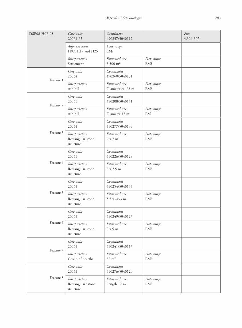
DSP08-H07-03 Core units20064-65
Coordinates490257/5040112
Figs.4.304-307
Adjacent unitsH02, H17 and H25
Date rangeEM?
InterpretationSettlement
Estimated size5,500 m2
Date rangeEM?
Feature 1
Core units20064
Coordinates490260/5040151
InterpretationAsh hill
Estimated sizeDiameter ca. 23 m
Date rangeEM?
Feature 2
Core units20065
Coordinates490208/5040141
InterpretationAsh hill
Estimated sizeDiameter 17 m
Date rangeEM
Feature 3
Core units20064
Coordinates490277/5040139
InterpretationRectangular stone structure
Estimated size9 x 7 m
Date rangeEM?
Feature 4
Core units20065
Coordinates490226/5040128
InterpretationRectangular stone structure
Estimated size8 x 2.5 m
Date rangeEM?
Feature 5
Core units20064
Coordinates490254/5040134
InterpretationRectangular stone structure
Estimated size5.5 x =/>3 m
Date rangeEM?
Feature 6
Core units20064
Coordinates490249/5040127
InterpretationRectangular stone structure
Estimated size8 x 5 m
Date rangeEM?
Feature 7
Core units20064
Coordinates490241/5040117
InterpretationGroup of hearths
Estimated size38 m2
Date rangeEM?
Feature 8
Core units20064
Coordinates490276/5040120
InterpretationRectangular? stone structure
Estimated sizeLength 17 m
Date rangeEM?
87620_dzarylgac.indb 203 23-04-2012 20:35:33
204 P. Attema, P. Guldager Bilde, W. de Neef & K. Winther-Jacobsen
Feature 9
Core units20064-20065
Coordinates490263/5040098
InterpretationRectangular earth bank
Estimated sizeLength >105 m
Date rangeEM?
TopographyDSP08-H07-03 is located in the central part of Hill 7 on the top of the ridge
InvestigationsExtensive survey Ash hill associated with a single tiny sherd and several stone structures. A later visit yielded a small cluster of pottery on and around the ash hill (GS 3221)Intensive survey Two ash hills (Features 1-2) and three possible rectangular stone structures of double walls (Features 3-4 and 8) were recorded associated with a few tiny sherds (20064-65)
Geomagnetic surveyEastern AtlasDimensions 100 x 78 m
Description of measuring conditionsSome dipole anomalies
Interpretation of features Archaeological features are noticeable in the NW corner, SW of the ash hill. Three rectangular buildings with one or two rooms show up as weak, white (negative) anomalies (Features 4-6). Three strong possible anomalies with a white “halo” are most likely former fireplaces (Feature 7). Several pits most likely of archaeological origin are located in and around the structures, but also random pattern of small pits. To the S, the data are less disturbed, probably due to a thicker soil horizon. The whole site is pervaded by linear features that either belong to roads/paths or agricultural patterns (Feature 9). A circular feature in the centre is of modern origin
Site interpretationEarly Modern settlement probably associated with DSP08-H07-04 located 110 m to the SW. The geomagnetic survey did not cover the entire site which consists of a total of five possible stone structure and two ash hills
DSP07-H07-04 Core unitsH07
Coordinates490105/5040058
Figs.4.304, 4.308
Adjacent unitsH02, H17 and H25
InterpretationDam
Estimated size48 x 30.5 m
Date rangeEM?
TopographyDSP07-H07-04 is located in a shallow ravine at the W side of Hill 7, on the top of the ridge, 110 m SW of DSP07-H07-03
InvestigationsExtensive survey Two interlocking L-shaped earth banks, but no artefacts associated
Site interpretationA dam which is probably associated with DSP08-H07-03
87620_dzarylgac.indb 204 23-04-2012 20:35:33
Appendix 1 Site catalogue 205
DSP07-H08-01 Core units20008-9, 20013-16
Coordinates493206/5042276
Figs.4.248-256
Adjacent unitsH16 and H20
InterpretationSettlement
Estimated size2.8 ha
Date rangeBA, LC-EH?
Feature 1
Core units20013
Coordinates493290/ 5042399
InterpretationStone structure
Estimated size10.5 x =/>13 m
Date rangeBA
Feature 2
Core units20013-14
Coordinates493252/5042355
InterpretationDouble pen
Estimated sizeDiameter 22 and 30 m
Date rangeBA
Feature 3
Core units20013
Coordinates493289/5042342
InterpretationStone structure
Estimated size6 x 10 m
Date rangeBA
Feature 4
Core units20014
Coordinates493231/5042368
InterpretationStone structure
Estimated size10.5 x 4 m
Date rangeBA, LC-EH?
Feature 5
Core units20014-15
Coordinates493251/5042375
InterpretationCluster of pits?
Estimated size560 m2
Date rangeBA, LC-EH?
Feature 6
Core units20015
Coordinates493176/5042225
InterpretationStone structure
Estimated size12.5 x =/> 7 m
Date rangeBA, LC-EH?
Feature 7
Core units20016
Coordinates493132/5042237
InterpretationStone structure
Estimated size11.5 x 10 m
Date rangeBA, LC-EH?
Feature 8
Core units20015-16
Coordinates493151/5042205
InterpretationComplex stone structure/structures
Estimated size60 x 22 m
Date rangeBA, LC-EH?
Feature 9
Core units20016
Coordinates493126/5042211
InterpretationStone structure
Estimated size11 x 15 m
Date rangeBA, LC-EH?
87620_dzarylgac.indb 205 23-04-2012 20:35:34
206 P. Attema, P. Guldager Bilde, W. de Neef & K. Winther-Jacobsen
Feature 10
Core units20016
Coordinates493114/5042179
InterpretationStone structure
Estimated size7 x 7 m
Date rangeBA, LC-EH?
Feature 11
Core units20015-16
Coordinates493101/5042128
InterpretationComplex stone structure
Estimated size16 x 9 and 22 x 29 m
Date rangeBA, LC-EH?
Feature 12
Core units20015
Coordinates493128/5042104
InterpretationStone structure
Estimated size5 x 4.5 m
Date rangeBA, LC-EH?
TopographyDSP07-H08-01 is located along the W edge of Hill 8, a short shallow promontory between two high promontories on the lower part of the hillsides
InvestigationsExtensive survey A cluster of Bronze Age pottery (GS 3095, 2007 FL 11-12) associated with stone structures in an area of ashy soil with intense vegetationIntensive survey One discrete cluster of pottery (20013/01-02, 20014/01-02 and 20015/01-03) associated with two stone structures (Features 2 and 4) and six possible pits indicated by intense vegetation (Feature 5) all within a larger area of diffused intense vegetation of 0.87 ha. Another less discrete cluster of pottery and flint is located approximately 100 m to the SW (20015/04-10 and 20016/04). Further 100 m to the SW are the remains a stone structure (Feature 11) associated with a small cluster of finds (20016/01-03) in a larger area of greener, grassier vegetation
Geomagnetic surveyT. SmekalovaDimensions 1.25 ha
Description of measuring conditionsSome dipole anomalies
Interpretation of features The data revealed a complex site with several types of stone structures. In the N end is a large double pen consisting of a circular enclosure inside a larger one (Feature 2) associated with two irregular structures (Features 1 and 3). Feature 4 to the E of the double pen is obscured by dipole anomalies. 120 m to the S is a complex cluster of rectangular (Features 6-7 and 9) and irregular structures mostly of different orientation, although one long wall links a cluster of walls (Feature 8). The long linear anomalies which cross the site are remains of recent agricultural processes
Geomagnetic surveyEastern AtlasDimensions 210 x 48 m
Description of measuring conditionsRare dipole anomalies
Interpretation of features Rectangular structure with pits inside and around it 80 m SW of Feature 8 (Feature 10). Small cluster of small pits 15 m S of this. Another complex further S consisting of a rectangular multi-room structure associated with curved walls to the SW and NW (Feature 11). Large irregular pits inside and around the northernmost room and the small curved structure NE of this. A small square structure 9 m to the SW (Feature 12)
Excavation V. Stolba, S. Lancov and P. Gecko.
Feature 2 Coordinates493248/5042340
Trench dimensions2 x 3 m
FeaturesBroad/collapsed stone wall
87620_dzarylgac.indb 206 23-04-2012 20:35:34
Appendix 1 Site catalogue 207
Description of stratigraphy by layer: 0-0.75 m1) Topsoil: 0-0.2 m (FL bag 18)2) Loose dark soil: 0.2-0.3 m (FL bags 19-20)3) Layer of ashy soil with a broad, double stone wall constructed from large blocks and filled with rubble: top level 0.1 m.
Bottom level: 0.4 m. Thickness: 1.6 m. Preserved H: 0.35 m4) Yellowish loam with concentration of small stones in the W corner: 0.3-0.65 m. Concentration of animal bones (FL bags
21-26 and 32)5) Sterile loam: top level 0.45-0.65 m
FindsHandmade pottery, animal bones
Date rangeBA
InterpretationDouble pen
Feature 7 Coordinates493134/5042240
Trench dimensions2 x 2 m
FeaturesCollapsed stone wall
Description of stratigraphy by layer: 0-0.3 m1) Topsoil: 0-0.2/0.25 m (FL bag 27)2) Layer of ashy soil with collapsed stone wall: top level: 0.1 m. Bottom level: 0.3 m. Numerous animal bones, handmade
pottery frs. and a flint blade (FL bags 28-31)3) Sterile loam, top level: 0.3 m below surface
FindsHandmade pottery, micro-lithic, stone axe, animal bones
Date rangeBA
InterpretationSettlement
Site interpretationComplex Bronze Age settlement associated with the keeping of livestock although the structures may not all be contemporary
DSP08-H08-02 Core units20018
Coordinates493372/5042379
Figs.4.248, 4.257-258
Adjacent units20013-17, H16 and H20
InterpretationRectangular stone structure
Estimated size4 x 4 m
Date rangeEM
TopographyDSP07-H08-02 is located along the E edge of Hill 8, a short shallow promontory between two high promontories on the lower part of the hillsides
InvestigationsIntensive survey Possible stone structure associated with two Early Modern sherds (20018/1-2)
Site interpretationEarly Modern storage site?
87620_dzarylgac.indb 207 23-04-2012 20:35:34
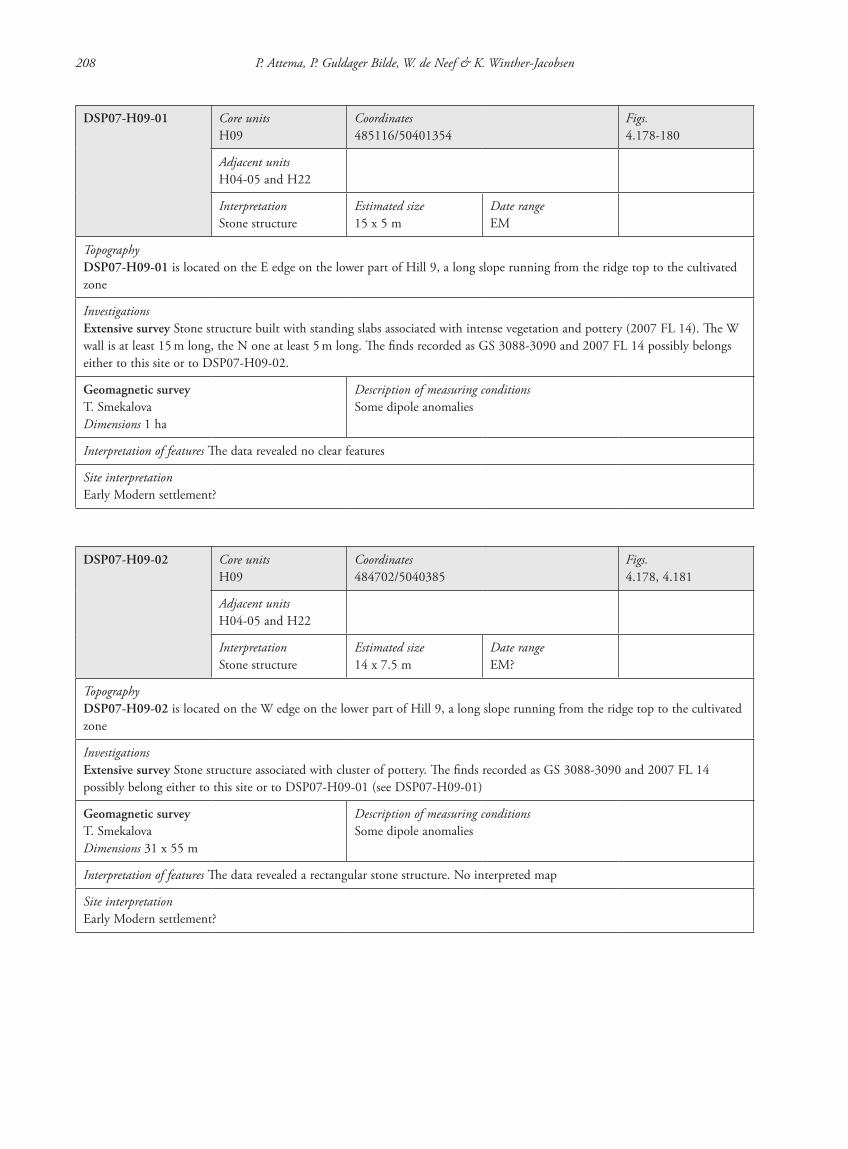
208 P. Attema, P. Guldager Bilde, W. de Neef & K. Winther-Jacobsen
DSP07-H09-01 Core unitsH09
Coordinates485116/50401354
Figs.4.178-180
Adjacent unitsH04-05 and H22
InterpretationStone structure
Estimated size15 x 5 m
Date rangeEM
TopographyDSP07-H09-01 is located on the E edge on the lower part of Hill 9, a long slope running from the ridge top to the cultivated zone
InvestigationsExtensive survey Stone structure built with standing slabs associated with intense vegetation and pottery (2007 FL 14). The W wall is at least 15 m long, the N one at least 5 m long. The finds recorded as GS 3088-3090 and 2007 FL 14 possibly belongs either to this site or to DSP07-H09-02.
Geomagnetic surveyT. SmekalovaDimensions 1 ha
Description of measuring conditionsSome dipole anomalies
Interpretation of features The data revealed no clear features
Site interpretationEarly Modern settlement?
DSP07-H09-02 Core unitsH09
Coordinates484702/5040385
Figs.4.178, 4.181
Adjacent unitsH04-05 and H22
InterpretationStone structure
Estimated size14 x 7.5 m
Date rangeEM?
TopographyDSP07-H09-02 is located on the W edge on the lower part of Hill 9, a long slope running from the ridge top to the cultivated zone
InvestigationsExtensive survey Stone structure associated with cluster of pottery. The finds recorded as GS 3088-3090 and 2007 FL 14 possibly belong either to this site or to DSP07-H09-01 (see DSP07-H09-01)
Geomagnetic surveyT. SmekalovaDimensions 31 x 55 m
Description of measuring conditionsSome dipole anomalies
Interpretation of features The data revealed a rectangular stone structure. No interpreted map
Site interpretationEarly Modern settlement?
87620_dzarylgac.indb 208 23-04-2012 20:35:34
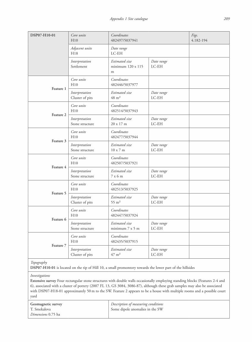
Appendix 1 Site catalogue 209
DSP07-H10-01 Core unitsH10
Coordinates482497/5037941
Figs.4.182-194
Adjacent unitsH18
Date rangeLC-EH
InterpretationSettlement
Estimated sizeminimum 120 x 115 m
Date rangeLC-EH
Feature 1
Core unitsH10
Coordinates482446/5037977
InterpretationCluster of pits
Estimated size48 m2
Date rangeLC-EH
Feature 2
Core unitsH10
Coordinates482514/5037943
InterpretationStone structure
Estimated size20 x 17 m
Date rangeLC-EH
Feature 3
Core unitsH10
Coordinates482477/5037944
InterpretationStone structure
Estimated size10 x 7 m
Date rangeLC-EH
Feature 4
Core unitsH10
Coordinates482507/5037921
InterpretationStone structure
Estimated size7 x 6 m
Date rangeLC-EH
Feature 5
Core unitsH10
Coordinates482513/5037925
InterpretationCluster of pits
Estimated size55 m2
Date rangeLC-EH
Feature 6
Core unitsH10
Coordinates482447/5037924
InterpretationStone structure
Estimated sizeminimum 7 x 5 m
Date rangeLC-EH
Feature 7
Core unitsH10
Coordinates482435/5037915
InterpretationCluster of pits
Estimated size47 m2
Date rangeLC-EH
TopographyDSP07-H10-01 is located on the tip of Hill 10, a small promontory towards the lower part of the hillsides
InvestigationsExtensive survey Four rectangular stone structures with double walls occasionally employing standing blocks (Features 2-4 and 6), associated with a cluster of pottery (2007 FL 13, GS 3084, 3086-87), although these grab samples may also be associated with DSP07-H18-01 approximately 50 m to the SW. Feature 2 appears to be a house with multiple rooms and a possible court yard
Geomagnetic surveyT. SmekalovaDimensions 0.75 ha
Description of measuring conditionsSome dipole anomalies in the SW
87620_dzarylgac.indb 209 23-04-2012 20:35:34
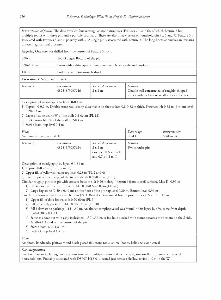
210 P. Attema, P. Guldager Bilde, W. de Neef & K. Winther-Jacobsen
Interpretation of features The data revealed four rectangular stone structures (Features 2-4 and 6), of which Feature 2 has multiple rooms with three pits and a possible courtyard. There are also three clusters of household pits (1, 5 and 7). Feature 5 is associated with Features 4 and 6 possibly with 7. A single pit is associated with Feature 3. The long linear anomalies are remains of recent agricultural processes
Augering One core was drilled from the bottom of Feature 5, Pit 1
0.96 m Top of auger. Bottom of the pit
0.96-1.81 m Loam with a thin layer of limestone crumble above the rock surface
1.81 m End of auger. Limestone bedrock
Excavation V. Stolba and P. Gecko
Feature 2 Coordinates482518/5037946
Trench dimensions2 x 2 m
FeaturesDouble wall constructed of roughly chipped stones with packing of small stones in between
Description of stratigraphy by layer: 0-0.4 m1) Topsoil: 0-0.2 m. Double stone wall clearly discernable on the surface. 0.8-0.82 m thick. Preserved H: 0.32 m. Bottom level:
0.28-0.3 m2) Layer of stone debris W of the wall: 0.2-0.4 m (FL 12)3) Dark brown fill SW of the wall: 0.2-0.4 m4) Sterile loam: top level 0.4 m
FindsAmphora frs. and helix shell
Date rangeLC-EH
InterpretationSettlement
Feature 5 Coordinates482511/5037924
Trench dimensions2 x 2 mextended 0.6 x 1 m E and 0.7 x 1.1 m N
FeaturesTwo circular pits
Description of stratigraphy by layer: 0-1.81 m1) Topsoil: 0-0.28 m (FL 1, 3 and 8)2) Upper fill of yellowish loam: top level 0.28 m (FL 2 and 4)3) Control pit on the S edge of the trench: depth 0.60-0.70 m (FL 7)Circular roughly piriform pit with concave bottom (1): 0.96 m deep (measured from topsoil surface). Max D: 0.96 m 1) Darker soil with admixture of rubble: 0.50/0.60-0.80 m (FL 5-6) 2) Large flag stone (0.50 x 0.40 m) on the floor of the pit: top level 0.80 m. Bottom level 0.96 mCircular piriform pit with concave bottom (2): 1.36 m deep (measured from topsoil surface). Max D: 1.47 m 1) Upper fill of dark brown soil: 0.20-60 m (FL 9) 2) Fill of densely packed rubble: 0.60-1.15 m (FL 10) 3) Fill below stone packing: 1.15-1.30 m. An almost complete vessel was found in this layer, but frs. came from depth
0.40-1.30 m (FL 11) 4) Same as above but with ashy inclusions: 1.30-1.36 m. A fox hole blocked with stones towards the bottom on the S side.
Mudbrick found on the bottom of the pit 5) Sterile loam 1.36-1.81 m 6) Bedrock: top level 1.81 m
FindsAmphora, handmade, plainware and black-glazed frs., stone tools, animal bones, helix shells and cereal
Site interpretationSmall settlement including one large structure with multiple rooms and a courtyard, two smaller structures and several household pits. Probably associated with DSP07-H18-01, located just across a shallow ravine 140 m to the W
87620_dzarylgac.indb 210 23-04-2012 20:35:34
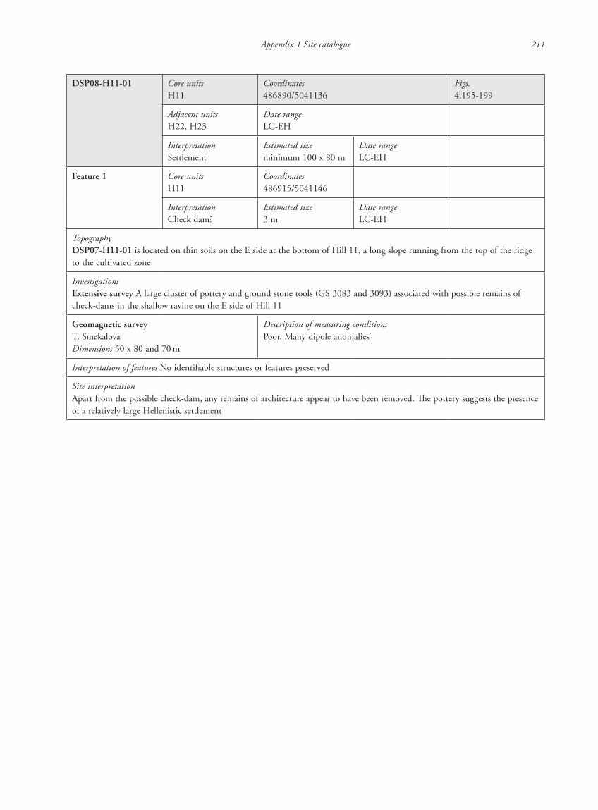
Appendix 1 Site catalogue 211
DSP08-H11-01 Core unitsH11
Coordinates486890/5041136
Figs.4.195-199
Adjacent unitsH22, H23
Date rangeLC-EH
InterpretationSettlement
Estimated sizeminimum 100 x 80 m
Date rangeLC-EH
Feature 1 Core unitsH11
Coordinates486915/5041146
InterpretationCheck dam?
Estimated size3 m
Date rangeLC-EH
TopographyDSP07-H11-01 is located on thin soils on the E side at the bottom of Hill 11, a long slope running from the top of the ridge to the cultivated zone
InvestigationsExtensive survey A large cluster of pottery and ground stone tools (GS 3083 and 3093) associated with possible remains of check-dams in the shallow ravine on the E side of Hill 11
Geomagnetic surveyT. SmekalovaDimensions 50 x 80 and 70 m
Description of measuring conditionsPoor. Many dipole anomalies
Interpretation of features No identifiable structures or features preserved
Site interpretationApart from the possible check-dam, any remains of architecture appear to have been removed. The pottery suggests the presence of a relatively large Hellenistic settlement
87620_dzarylgac.indb 211 23-04-2012 20:35:34
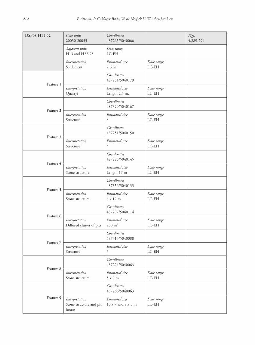
212 P. Attema, P. Guldager Bilde, W. de Neef & K. Winther-Jacobsen
DSP08-H11-02 Core units20050-20055
Coordinates487265/5040066
Figs.4.289-294
Adjacent unitsH13 and H22-23
Date rangeLC-EH
InterpretationSettlement
Estimated size2.6 ha
Date rangeLC-EH
Feature 1
Coordinates487254/5040179
InterpretationQuarry?
Estimated sizeLength 2.5 m.
Date rangeLC-EH
Feature 2
Coordinates487320/5040167
InterpretationStructure
Estimated size?
Date rangeLC-EH
Feature 3
Coordinates487251/5040150
InterpretationStructure
Estimated size?
Date rangeLC-EH
Feature 4
Coordinates487285/5040145
InterpretationStone structure
Estimated sizeLength 17 m
Date rangeLC-EH
Feature 5
Coordinates487356/5040133
InterpretationStone structure
Estimated size4 x 12 m
Date rangeLC-EH
Feature 6
Coordinates487297/5040114
InterpretationDiffused cluster of pits
Estimated size200 m2
Date rangeLC-EH
Feature 7
Coordinates487313/5040088
InterpretationStructure
Estimated size?
Date rangeLC-EH
Feature 8
Coordinates487224/5040063
InterpretationStone structure
Estimated size5 x 9 m
Date rangeLC-EH
Feature 9
Coordinates487266/5040063
InterpretationStone structure and pit house
Estimated size10 x 7 and 8 x 5 m
Date rangeLC-EH
87620_dzarylgac.indb 212 23-04-2012 20:35:35
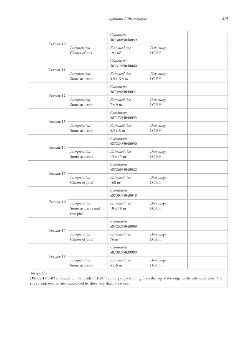
Appendix 1 Site catalogue 213
Feature 10
Coordinates487300/5040059
InterpretationCluster of pits
Estimated size197 m2
Date rangeLC-EH
Feature 11
Coordinates487314/5040060
InterpretationStone structure
Estimated size5.5 x 6.5 m
Date rangeLC-EH
Feature 12
Coordinates487396/5040041
InterpretationStone structure
Estimated size7 x 9 m
Date rangeLC-EH
Feature 13
Coordinates487172/5040033
InterpretationStone structure
Estimated size4.5 x 8 m
Date rangeLC-EH
Feature 14
Coordinates487224/5040030
InterpretationStone structure
Estimated size15 x 15 m
Date rangeLC-EH
Feature 15
Coordinates487260/5040022
InterpretationCluster of pits?
Estimated size168 m2
Date rangeLC-EH
Feature 16
Coordinates487301/5040018
InterpretationStone structure and two pits?
Estimated size10 x 18 m
Date rangeLC-EH
Feature 17
Coordinates487232/5040009
InterpretationCluster of pits?
Estimated size76 m2
Date rangeLC-EH
Feature 18
Coordinates487387/5039980
InterpretationStone structure
Estimated size5 x 6 m
Date rangeLC-EH
TopographyDSP08-H11-02 is located on the E side of Hill 11, a long slope running from the top of the ridge to the cultivated zone. The site spreads over an area subdivided by three very shallow ravines
87620_dzarylgac.indb 213 23-04-2012 20:35:35

214 P. Attema, P. Guldager Bilde, W. de Neef & K. Winther-Jacobsen
InvestigationsExtensive survey A scatter of pottery (GS 3094 and 3218) associated with area of concentrated intense vegetation (see below)Intensive survey A diffused scatter of pottery (20050-55) associated with 10 stone structures in an area of diffused intense vegetation. There is an area of more concentrated intense vegetation to the N on the tip of the promontory (Feature 2). A possible quarry is located to the NW (Feature 15). Traces of three possible stone structures were found on another promontory approximately 80 m to the NW along the E edge of the ravine
Geomagnetic surveyT. SmekalovaDimensions 3.5 ha
Description of measuring conditionsFew dipole anomalies
Interpretation of features The data revealed 11 poorly defined anomalies on either side of a shallow ravine. A strong anomaly was chosen for excavation. The long linear anomalies which cut cross the site are remains of recent agricultural processes
Excavation S. Lancov and P. Gecko
Feature 9 Coordinates487276/5040055
Dimensions5.7 x 4.1 m
FeaturesConcentric pits
Description of stratigraphy by layer: 0-1.47 m 1) Topsoil: 0-0.2 m 2) Grey ashy layer with many frs. of bones and pottery: 0.2-0.45 m 3) Irregular pit of loamy sand with several floors. Top level: 0.4 m. 1st floor: top level 0.73-0.78 m. 2nd floor top level
0.98-1.17 m. Bottom level: 1.4-1.47 m 4) Sterile loam: top level 0.45-1.47 m
FindsPottery, animal bone
Date rangeLC-EH
InterpretationPit house
Site interpretationThe investigations suggest that the settlement consisted of at least 14 structures dispersed around two shallow ravines. Some of the structures are visible as possible stone structures on the surface (Features 4-5, 8-14, 16 and 18), but at least Feature 9 is associated with a pit house and this may be the case at several features e.g. Features 5, 11 and 16. There appear to be four, possible, large clusters of pits (Features 6, 10, 15 and 17), two of which are relatively closely associated with individual structures (Features 10-11 and Features 14 and 17). The stone structures are poorly preserved, but appear to be less complex than the contemporary stone structures from DSP08-H12-01 and DSP07-H10-01/18-01
87620_dzarylgac.indb 214 23-04-2012 20:35:35
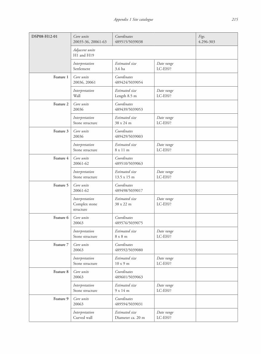
Appendix 1 Site catalogue 215
DSP08-H12-01 Core units20035-36, 20061-63
Coordinates489515/5039038
Figs.4.296-303
Adjacent unitsH1 and H19
InterpretationSettlement
Estimated size3.6 ha
Date rangeLC-EH/?
Feature 1 Core units20036, 20061
Coordinates489424/5039054
InterpretationWall
Estimated sizeLength 8.5 m
Date rangeLC-EH/?
Feature 2 Core units20036
Coordinates489439/5039053
InterpretationStone structure
Estimated size38 x 24 m
Date rangeLC-EH/?
Feature 3 Core units20036
Coordinates489429/5039003
InterpretationStone structure
Estimated size8 x 11 m
Date rangeLC-EH/?
Feature 4 Core units20061-62
Coordinates489510/5039063
InterpretationStone structure
Estimated size13.5 x 15 m
Date rangeLC-EH/?
Feature 5 Core units20061-62
Coordinates489498/5039017
InterpretationComplex stone structure
Estimated size38 x 22 m
Date rangeLC-EH/?
Feature 6 Core units20063
Coordinates489576/5039075
InterpretationStone structure
Estimated size8 x 8 m
Date rangeLC-EH/?
Feature 7 Core units20063
Coordinates489592/5039080
InterpretationStone structure
Estimated size10 x 9 m
Date rangeLC-EH/?
Feature 8 Core units20063
Coordinates489601/5039063
InterpretationStone structure
Estimated size9 x 14 m
Date rangeLC-EH/?
Feature 9 Core units20063
Coordinates489594/5039031
InterpretationCurved wall
Estimated sizeDiameter ca. 20 m
Date rangeLC-EH/?
87620_dzarylgac.indb 215 23-04-2012 20:35:35
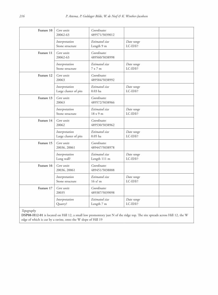
216 P. Attema, P. Guldager Bilde, W. de Neef & K. Winther-Jacobsen
Feature 10 Core units20062-63
Coordinates489571/5039012
InterpretationStone structure
Estimated sizeLength 9 m
Date rangeLC-EH/?
Feature 11 Core units20062-63
Coordinates489560/5038998
InterpretationStone structure
Estimated size7 x 7 m
Date rangeLC-EH/?
Feature 12 Core units20063
Coordinates489584/5038992
InterpretationLarge cluster of pits
Estimated size0.03 ha
Date rangeLC-EH/?
Feature 13 Core units20063
Coordinates489572/5038966
InterpretationStone structure
Estimated size18 x 9 m
Date rangeLC-EH/?
Feature 14 Core units20062
Coordinates489530/5038962
InterpretationLarge cluster of pits
Estimated size0.05 ha
Date rangeLC-EH/?
Feature 15 Core units20036, 20061
Coordinates489447/5038978
InterpretationLong wall?
Estimated sizeLength 111 m
Date rangeLC-EH/?
Feature 16 Core units20036, 20061
Coordinates489451/5038888
InterpretationStone structure
Estimated size16 x? m
Date rangeLC-EH/?
Feature 17 Core units20035
Coordinates489387/5039098
InterpretationQuarry?
Estimated sizeLength 7 m
Date rangeLC-EH/?
TopographyDSP08-H12-01 is located on Hill 12, a small low promontory just N of the ridge top. The site spreads across Hill 12, the W edge of which is cut by a ravine, onto the W slope of Hill 19
87620_dzarylgac.indb 216 23-04-2012 20:35:36
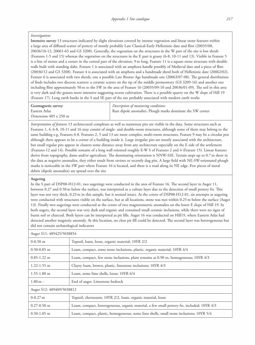
Appendix 1 Site catalogue 217
InvestigationsIntensive survey 13 structures indicated by slight elevations covered by intense vegetation and linear stone features within a large area of diffused scatter of pottery of mostly probably Late Classical-Early Hellenistic date and flint (20035/08, 20036/10-12, 20061-63 and GS 3208). Generally, the vegetation on the structures in the W part of the site is low shrub (Features 1-5 and 15) whereas the vegetation on the structures in the E part is grassy (6-8, 10-11 and 13). Visible in Feature 5 is a line of stones and a corner in the central part of the elevation, 9 m long. Feature 11 is a square stone structure with double walls built with standing slabs. Feature 1 is associated with an amphora handle possibly of Medieval date and a piece of flint (20036/12 and GS 3208). Feature 4 is associated with an amphora and a handmade sherd both of Hellenistic date (20062/02). Feature 6 is associated with two sherds, one a possible Late Bronze Age handmade one (20063/07-08). The general distribution of finds includes two discrete scatters: a ceramic scatter on the tip of the middle promontory (GS 3209-16) and another one including flint approximately 50 m to the SW in the area of Feature 16 (20035/09-10 and 20036/01-09). The soil in this area is very dark and the grasses more intensive suggesting recent cultivation. There is a possible quarry on the W slope of Hill 19 (Feature 17). Long earth banks in the S and SE part of the site probably associated with modern earth works
Geomagnetic surveyEastern AtlasDimensions 405 x 250 m
Description of measuring conditionsRare dipole anomalies. Plough marks dominate the SW corner
Interpretation of features 13 architectural complexes as well as numerous pits are visible in the data. Some structures such as Features 1, 4, 6-8, 10-11 and 16 may consist of single- and double-room structures, although some of them may belong to the same building e.g. Features 6-8. Features 2, 5 and 13 are more complex, multi-room structures. Feature 9 may be a circular pen although there appears to be a corner of a building inside it. Large irregular pits are mostly associated with the architecture, but small regular pits appear in clusters some distance away from any architecture especially on the E side of the settlement (Features 12 and 14). Possible remains of a long wall oriented roughly E-W S of Features 2 and 4 (Feature 15). Linear features derive from topography, dams and/or agriculture. The dominating orientation is NNW-SSE. Terrain steps up to 0.7 m show in the data as negative anomalies, they either result from ravines or recently dug pits. A large field with NE-SW-orientated plough marks is noticeable in the SW part where Feature 16 is located, and there is a road along its NE edge. Few pieces of metal debris (dipole anomalies) are spread over the site
AugeringIn the S part of DSP08-H12-01, two augerings were conducted in the area of Feature 16. The second layer in Auger 11, between 0.27 and 0.50 m below the surface, was interpreted as a culture layer due to the detection of small pottery frs. This layer was not very thick, 0.23 m in this sample, but it seemed intact. At the centre of DSP08-H12-01, six attempts at augering were conducted with structures visible on the surface, but at all locations, stone was met within 0.25 m below the surface (Auger 13). Finally two augerings were conducted at the centre of two magnetometric anomalies on the lower E slope of Hill 19. In both augers, the second layer was very dark and organic and contained small ceramic inclusions, while there were no signs of burnt soil or charcoal. Both layers can be interpreted as pit fills. Auger 16 was conducted on Hill19, where Eastern Atlas had detected another magnetic anomaly. At this location, no clear pit fill could be detected. The second layer was heterogeneous but did not contain archaeological indicators
Auger S11: 489425/5038854
0-0.50 m Topsoil, loam, loose, organic material; 10YR 2/2
0.50-0.85 m Loam, compact, some stone inclusions, plastic, organic material; 10YR 4/4
0.85-1.22 m Loam, compact, few stone inclusions, plant remains at 0.90 m, homogeneous; 10YR 4/3
1.22-1.55 m Clayey loam, brown, plastic, limestone inclusions; 10YR 4/3
1.55-1.80 m Loam, some lime shells, loose; 10YR 6/4
1.80 m - End of auger. Limestone bedrock
Auger S12: 489409/5038812
0-0.27 m Topsoil, chernozem; 10YR 2/2, loam, organic material, loose
0.27-0.50 m Loam, compact, heterogeneous, organic material, a few small pottery frs. included; 10YR 4/3
0.50-1.05 m Loam, compact, plastic, homogeneous, some lime shells, small stone inclusions; 10YR 5/4
87620_dzarylgac.indb 217 23-04-2012 20:35:36
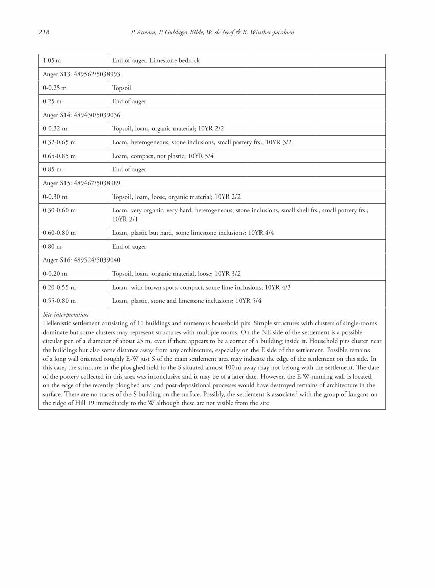
218 P. Attema, P. Guldager Bilde, W. de Neef & K. Winther-Jacobsen
1.05 m - End of auger. Limestone bedrock
Auger S13: 489562/5038993
0-0.25 m Topsoil
0.25 m- End of auger
Auger S14: 489430/5039036
0-0.32 m Topsoil, loam, organic material; 10YR 2/2
0.32-0.65 m Loam, heterogeneous, stone inclusions, small pottery frs.; 10YR 3/2
0.65-0.85 m Loam, compact, not plastic; 10YR 5/4
0.85 m- End of auger
Auger S15: 489467/5038989
0-0.30 m Topsoil, loam, loose, organic material; 10YR 2/2
0.30-0.60 m Loam, very organic, very hard, heterogeneous, stone inclusions, small shell frs., small pottery frs.; 10YR 2/1
0.60-0.80 m Loam, plastic but hard, some limestone inclusions; 10YR 4/4
0.80 m- End of auger
Auger S16: 489524/5039040
0-0.20 m Topsoil, loam, organic material, loose; 10YR 3/2
0.20-0.55 m Loam, with brown spots, compact, some lime inclusions; 10YR 4/3
0.55-0.80 m Loam, plastic, stone and limestone inclusions; 10YR 5/4
Site interpretationHellenistic settlement consisting of 11 buildings and numerous household pits. Simple structures with clusters of single-rooms dominate but some clusters may represent structures with multiple rooms. On the NE side of the settlement is a possible circular pen of a diameter of about 25 m, even if there appears to be a corner of a building inside it. Household pits cluster near the buildings but also some distance away from any architecture, especially on the E side of the settlement. Possible remains of a long wall oriented roughly E-W just S of the main settlement area may indicate the edge of the settlement on this side. In this case, the structure in the ploughed field to the S situated almost 100 m away may not belong with the settlement. The date of the pottery collected in this area was inconclusive and it may be of a later date. However, the E-W-running wall is located on the edge of the recently ploughed area and post-depositional processes would have destroyed remains of architecture in the surface. There are no traces of the S building on the surface. Possibly, the settlement is associated with the group of kurgans on the ridge of Hill 19 immediately to the W although these are not visible from the site
87620_dzarylgac.indb 218 23-04-2012 20:35:36
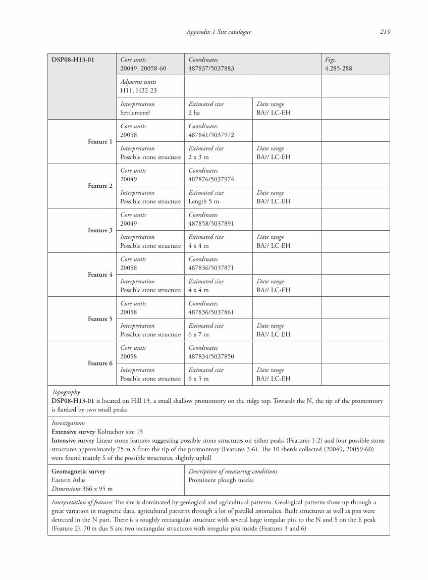
Appendix 1 Site catalogue 219
DSP08-H13-01 Core units20049, 20058-60
Coordinates487837/5037883
Figs.4.285-288
Adjacent unitsH11, H22-23
InterpretationSettlement?
Estimated size2 ha
Date rangeBA?/ LC-EH
Feature 1
Core units20058
Coordinates487841/5037972
InterpretationPossible stone structure
Estimated size2 x 3 m
Date rangeBA?/ LC-EH
Feature 2
Core units20049
Coordinates487876/5037974
InterpretationPossible stone structure
Estimated sizeLength 5 m
Date rangeBA?/ LC-EH
Feature 3
Core units20049
Coordinates487858/5037891
InterpretationPossible stone structure
Estimated size4 x 4 m
Date rangeBA?/ LC-EH
Feature 4
Core units20058
Coordinates487836/5037871
InterpretationPossible stone structure
Estimated size4 x 4 m
Date rangeBA?/ LC-EH
Feature 5
Core units20058
Coordinates487836/5037861
InterpretationPossible stone structure
Estimated size6 x 7 m
Date rangeBA?/ LC-EH
Feature 6
Core units20058
Coordinates487834/5037850
InterpretationPossible stone structure
Estimated size6 x 5 m
Date rangeBA?/ LC-EH
TopographyDSP08-H13-01 is located on Hill 13, a small shallow promontory on the ridge top. Towards the N, the tip of the promontory is flanked by two small peaks
InvestigationsExtensive survey Koltuchov site 15Intensive survey Linear stone features suggesting possible stone structures on either peaks (Features 1-2) and four possible stone structures approximately 75 m S from the tip of the promontory (Features 3-6). The 10 sherds collected (20049, 20059-60) were found mainly S of the possible structures, slightly uphill
Geomagnetic surveyEastern AtlasDimensions 366 x 95 m
Description of measuring conditionsProminent plough marks
Interpretation of features The site is dominated by geological and agricultural patterns. Geological patterns show up through a great variation in magnetic data, agricultural patterns through a lot of parallel anomalies. Built structures as well as pits were detected in the N part. There is a roughly rectangular structure with several large irregular pits to the N and S on the E peak (Feature 2). 70 m due S are two rectangular structures with irregular pits inside (Features 3 and 6)
87620_dzarylgac.indb 219 23-04-2012 20:35:36
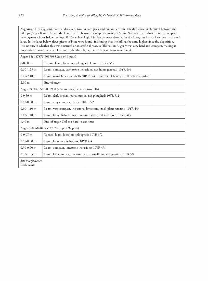
220 P. Attema, P. Guldager Bilde, W. de Neef & K. Winther-Jacobsen
Augering Three augurings were undertaken, two on each peak and one in between. The difference in elevation between the hilltops (Auger 8 and 10) and the lower part in between was approximately 2.50 m. Noteworthy in Auger 8 is the compact heterogeneous layer below the topsoil. No archaeological indicators were detected in this layer, but it may have been a cultural layer. In the layer below, three pieces of bone were found, indicating that the hill has become higher since the deposition. It is uncertain whether this was a natural or an artificial process. The soil in Auger 9 was very hard and compact, making it impossible to continue after 1.40 m. In the third layer, intact plant remains were found.
Auger S8: 487873/5037985 (top of E peak)
0-0.60 m Topsoil, loam, loose, not ploughed. Humus; 10YR 5/3
0.60-1.25 m Loam, compact, dark stone inclusions, not homogeneous; 10YR 4/4
1.25-2.10 m Loam, many limestone shells; 10YR 5/4. Three frs. of bone at 1.50 m below surface
2.10 m- End of auger
Auger S9: 487858/5037980 (next to track, between two hills)
0-0.50 m Loam, dark brown, loose, humus, not ploughed; 10YR 3/2
0.50-0.90 m Loam, very compact, plastic; 10YR 3/2
0.90-1.10 m Loam, very compact, inclusions, limestone, small plant remains; 10YR 4/3
1.10-1.40 m Loam, loose, light brown, limestone shells and inclusions; 10YR 4/3
1.40 m- End of auger. Soil too hard to continue
Auger S10: 487842/5037972 (top of W peak)
0-0.07 m Topsoil, loam, loose, not ploughed; 10YR 3/2
0.07-0.50 m Loam, loose, no inclusions; 10YR 4/4
0.50-0.90 m Loam, compact, limestone inclusions; 10YR 4/4
0.90-1.05 m Loam, less compact, limestone shells, small pieces of granite? 10YR 5/4
Site interpretationSettlement?
87620_dzarylgac.indb 220 23-04-2012 20:35:37
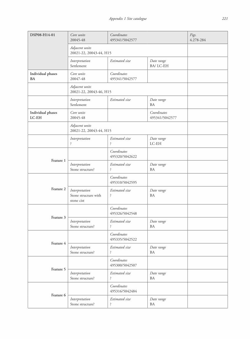
Appendix 1 Site catalogue 221
DSP08-H14-01 Core units20045-48
Coordinates495341/5042577
Figs.4.278-284
Adjacent units20021-22, 20043-44, H15
InterpretationSettlement
Estimated size Date rangeBA/ LC-EH
Individual phasesBA
Core units20047-48
Coordinates495341/5042577
Adjacent units20021-22, 20043-46, H15
InterpretationSettlement
Estimated size Date rangeBA
Individual phasesLC-EH
Core units20045-48
Coordinates495341/5042577
Adjacent units20021-22, 20043-44, H15
Interpretation?
Estimated size?
Date rangeLC-EH
Feature 1
Coordinates495320/5042622
InterpretationStone structure?
Estimated size?
Date rangeBA
Feature 2
Coordinates495310/5042595
InterpretationStone structure with stone cist
Estimated size?
Date rangeBA
Feature 3
Coordinates495326/5042548
InterpretationStone structure?
Estimated size?
Date rangeBA
Feature 4
Coordinates495335/5042522
InterpretationStone structure?
Estimated size?
Date rangeBA
Feature 5
Coordinates495300/5042507
InterpretationStone structure?
Estimated size?
Date rangeBA
Feature 6
Coordinates495316/5042484
InterpretationStone structure?
Estimated size?
Date rangeBA
87620_dzarylgac.indb 221 23-04-2012 20:35:37
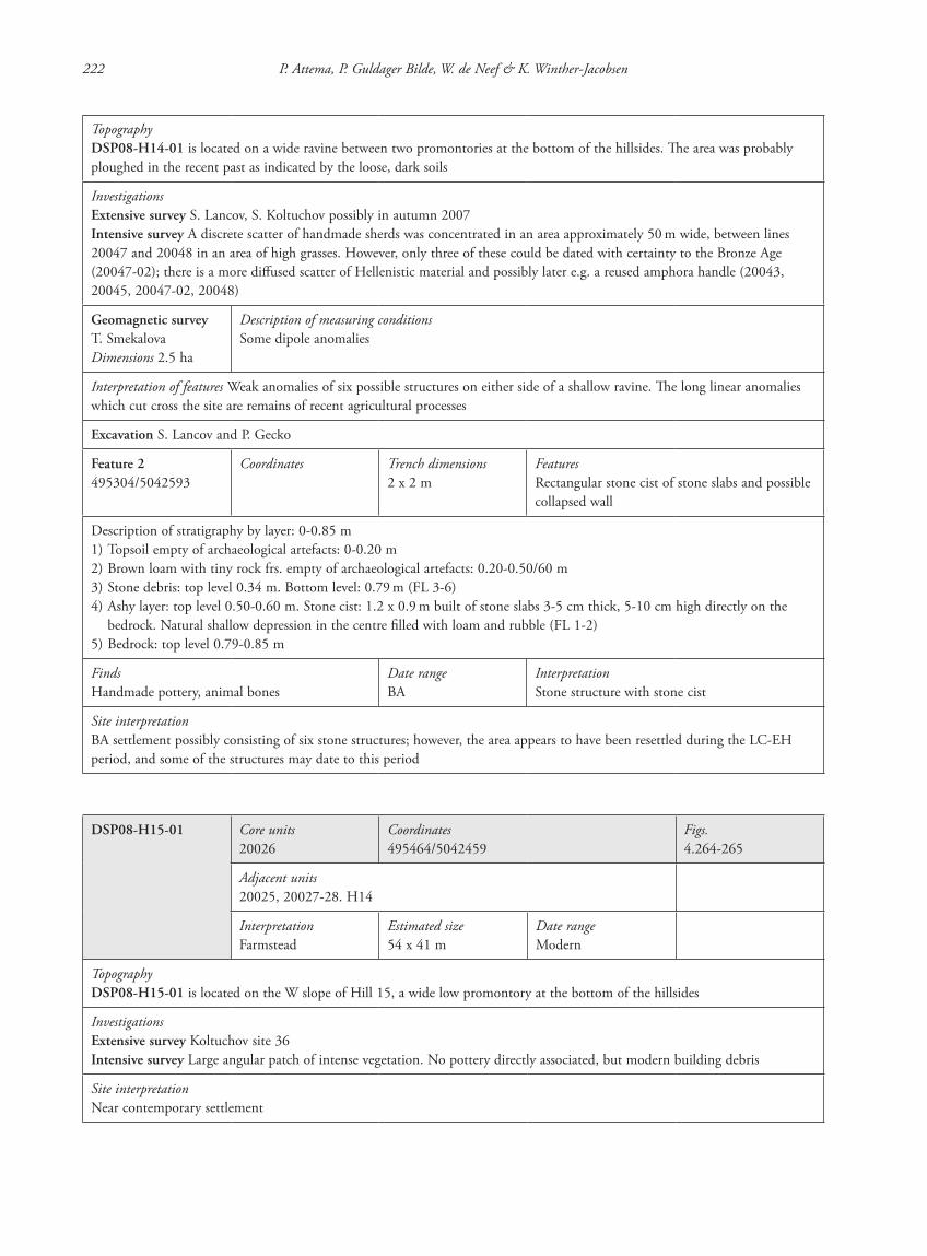
222 P. Attema, P. Guldager Bilde, W. de Neef & K. Winther-Jacobsen
TopographyDSP08-H14-01 is located on a wide ravine between two promontories at the bottom of the hillsides. The area was probably ploughed in the recent past as indicated by the loose, dark soils
InvestigationsExtensive survey S. Lancov, S. Koltuchov possibly in autumn 2007Intensive survey A discrete scatter of handmade sherds was concentrated in an area approximately 50 m wide, between lines 20047 and 20048 in an area of high grasses. However, only three of these could be dated with certainty to the Bronze Age (20047-02); there is a more diffused scatter of Hellenistic material and possibly later e.g. a reused amphora handle (20043, 20045, 20047-02, 20048)
Geomagnetic surveyT. SmekalovaDimensions 2.5 ha
Description of measuring conditionsSome dipole anomalies
Interpretation of features Weak anomalies of six possible structures on either side of a shallow ravine. The long linear anomalies which cut cross the site are remains of recent agricultural processes
Excavation S. Lancov and P. Gecko
Feature 2495304/5042593
Coordinates Trench dimensions2 x 2 m
FeaturesRectangular stone cist of stone slabs and possible collapsed wall
Description of stratigraphy by layer: 0-0.85 m1) Topsoil empty of archaeological artefacts: 0-0.20 m2) Brown loam with tiny rock frs. empty of archaeological artefacts: 0.20-0.50/60 m3) Stone debris: top level 0.34 m. Bottom level: 0.79 m (FL 3-6)4) Ashy layer: top level 0.50-0.60 m. Stone cist: 1.2 x 0.9 m built of stone slabs 3-5 cm thick, 5-10 cm high directly on the
bedrock. Natural shallow depression in the centre filled with loam and rubble (FL 1-2)5) Bedrock: top level 0.79-0.85 m
FindsHandmade pottery, animal bones
Date rangeBA
InterpretationStone structure with stone cist
Site interpretationBA settlement possibly consisting of six stone structures; however, the area appears to have been resettled during the LC-EH period, and some of the structures may date to this period
DSP08-H15-01 Core units20026
Coordinates495464/5042459
Figs.4.264-265
Adjacent units20025, 20027-28. H14
InterpretationFarmstead
Estimated size54 x 41 m
Date rangeModern
TopographyDSP08-H15-01 is located on the W slope of Hill 15, a wide low promontory at the bottom of the hillsides
InvestigationsExtensive survey Koltuchov site 36Intensive survey Large angular patch of intense vegetation. No pottery directly associated, but modern building debris
Site interpretationNear contemporary settlement
87620_dzarylgac.indb 222 23-04-2012 20:35:37

Appendix 1 Site catalogue 223
DSP08-H16-01 Core units20008-9
Coordinates493049/5042275
Figs.4.243, 4.245
Adjacent unitsH08
InterpretationSettlement
Estimated size0.4 ha
Date rangeUnknown
Feature 1
Core units20009
Coordinates493069/5042257
InterpretationDitches?
Estimated sizeDiameter ca. 11 m
Date rangeUnknown
Feature 2
Core units20008
Coordinates493037/5042247
InterpretationStone structure
Estimated size24 x 30 m
Date rangeUnknown
Feature 3
Core units20008
Coordinates493021/5042232
InterpretationStone structure
Estimated size7.5 x 7 m
Date rangeUnknown
Feature 4
Core units20008-9
Coordinates493053/5042247
InterpretationEnclosure
Estimated size100 x =/>100 m
Date rangeUnknown
TopographyDSP08-H16-01 is located on the SE slope of Hill 16, a high short promontory near the bottom of the hillsides
InvestigationsIntensive survey Three long shallow elevations running E-W at irregular intervals. No finds
Geomagnetic surveyEastern AtlasDimensions 630 x 53 m
Description of measuring conditionsMetal debris is randomly spread over the site
Interpretation of features Square structure with multiple internal walls surrounded on three sides by large irregular pits (Feature 2). SW of this is a rectangular structure with small pits inside and large irregular pit outside the S wall (Feature 3). NE of Feature 1 are two concentric U-shaped ditches. This entire complex is surrounded by shallow banks on three sides. Open towards the W (Feature 4). Additional E-W running bank on the E side. Linear anomalies close to the archaeological findings could be due to farming
Site interpretationAgricultural settlement? Date unknown
87620_dzarylgac.indb 223 23-04-2012 20:35:37
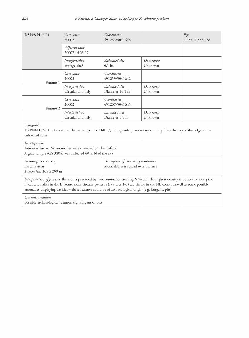
224 P. Attema, P. Guldager Bilde, W. de Neef & K. Winther-Jacobsen
DSP08-H17-01 Core units20002
Coordinates491253/5041648
Fig.4.233, 4.237-238
Adjacent units20007, H06-07
InterpretationStorage site?
Estimated size0.1 ha
Date rangeUnknown
Feature 1
Core units20002
Coordinates491259/5041642
InterpretationCircular anomaly
Estimated sizeDiameter 16.5 m
Date rangeUnknown
Feature 2
Core units20002
Coordinates491207/5041645
InterpretationCircular anomaly
Estimated sizeDiameter 6.5 m
Date rangeUnknown
TopographyDSP08-H17-01 is located on the central part of Hill 17, a long wide promontory running from the top of the ridge to the cultivated zone
InvestigationsIntensive survey No anomalies were observed on the surfaceA grab sample (GS 3204) was collected 60 m N of the site
Geomagnetic surveyEastern AtlasDimensions 205 x 200 m
Description of measuring conditionsMetal debris is spread over the area
Interpretation of features The area is pervaded by road anomalies crossing NW-SE. The highest density is noticeable along the linear anomalies in the E. Some weak circular patterns (Features 1-2) are visible in the NE corner as well as some possible anomalies displaying cavities – these features could be of archaeological origin (e.g. kurgans, pits)
Site interpretationPossible archaeological features, e.g. kurgans or pits
87620_dzarylgac.indb 224 23-04-2012 20:35:38

Appendix 1 Site catalogue 225
DSP08-H17-02 Core units20003, 20006, H17
Coordinates491131/5041648
Figs.4.239-240
Adjacent unitsH06-07
InterpretationGroup of kurgans
Estimated size–
Date rangeLC-EH?
Feature 1
Core unitsH17
Coordinates491034/5041477
InterpretationKurgan
Estimated sizeDiameter 21 m
Date rangeLC-EH?
Feature 2
Core unitsH17
Coordinates491082/5041433
InterpretationKurgan
Estimated sizeDiameter 17 m
Date rangeLC-EH?
Feature 3
Core units20003
Coordinates491132/5041398
InterpretationKurgan
Estimated sizeDiameter 34 m
Date rangeLC-EH?
Feature 4
Core units20003
Coordinates491152/5041372
InterpretationKurgan
Estimated sizeDiameter 19 m
Date rangeLC-EH?
Feature 5
Core units20003, 20006
Coordinates491216/5041318
InterpretationKurgan
Estimated sizeDiameter 15 m
Date rangeLC-EH?
TopographyDSP08-H17-02 is located on the central part of Hill 17, a long wide promontory running from the top of the ridge to the cultivated zone
InvestigationsIntensive survey Five grassy elevations associated with five sherds of which one is a Thasian amphora and one is probably Early Modern and a piece of flint (20003/01-04 and GS 3205-6)
Site interpretationGroup of kurgans
87620_dzarylgac.indb 225 23-04-2012 20:35:38
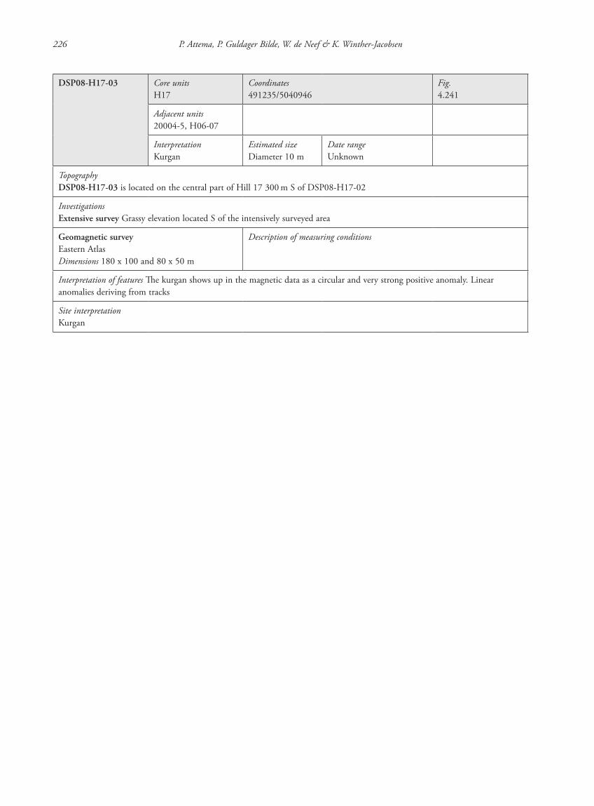
226 P. Attema, P. Guldager Bilde, W. de Neef & K. Winther-Jacobsen
DSP08-H17-03 Core unitsH17
Coordinates491235/5040946
Fig.4.241
Adjacent units20004-5, H06-07
InterpretationKurgan
Estimated sizeDiameter 10 m
Date rangeUnknown
TopographyDSP08-H17-03 is located on the central part of Hill 17 300 m S of DSP08-H17-02
InvestigationsExtensive survey Grassy elevation located S of the intensively surveyed area
Geomagnetic surveyEastern AtlasDimensions 180 x 100 and 80 x 50 m
Description of measuring conditions
Interpretation of features The kurgan shows up in the magnetic data as a circular and very strong positive anomaly. Linear anomalies deriving from tracks
Site interpretationKurgan
87620_dzarylgac.indb 226 23-04-2012 20:35:38
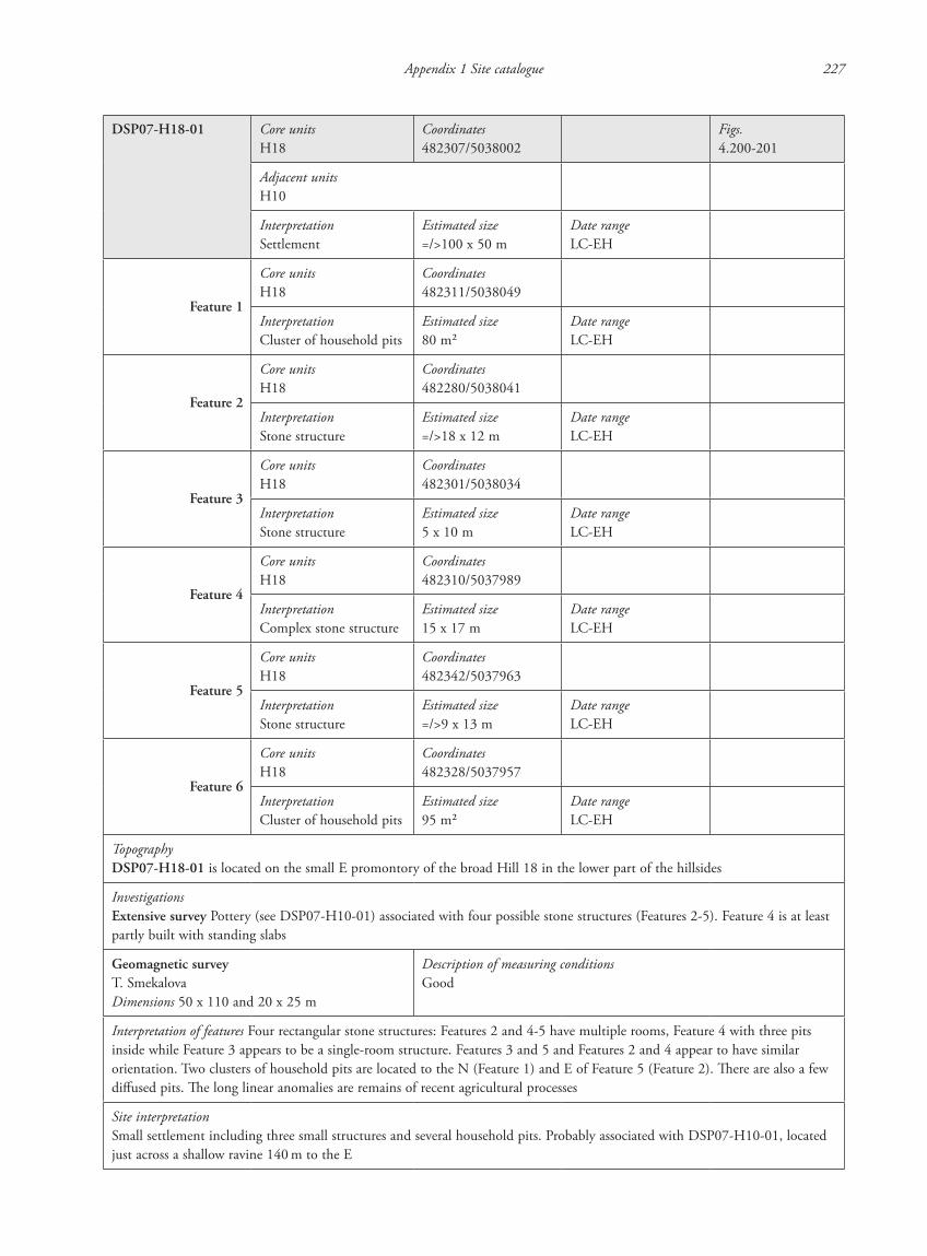
Appendix 1 Site catalogue 227
DSP07-H18-01 Core unitsH18
Coordinates482307/5038002
Figs.4.200-201
Adjacent unitsH10
InterpretationSettlement
Estimated size=/>100 x 50 m
Date rangeLC-EH
Feature 1
Core unitsH18
Coordinates482311/5038049
InterpretationCluster of household pits
Estimated size80 m2
Date rangeLC-EH
Feature 2
Core unitsH18
Coordinates482280/5038041
InterpretationStone structure
Estimated size=/>18 x 12 m
Date rangeLC-EH
Feature 3
Core unitsH18
Coordinates482301/5038034
InterpretationStone structure
Estimated size5 x 10 m
Date rangeLC-EH
Feature 4
Core unitsH18
Coordinates482310/5037989
InterpretationComplex stone structure
Estimated size15 x 17 m
Date rangeLC-EH
Feature 5
Core unitsH18
Coordinates482342/5037963
InterpretationStone structure
Estimated size=/>9 x 13 m
Date rangeLC-EH
Feature 6
Core unitsH18
Coordinates482328/5037957
InterpretationCluster of household pits
Estimated size95 m2
Date rangeLC-EH
TopographyDSP07-H18-01 is located on the small E promontory of the broad Hill 18 in the lower part of the hillsides
InvestigationsExtensive survey Pottery (see DSP07-H10-01) associated with four possible stone structures (Features 2-5). Feature 4 is at least partly built with standing slabs
Geomagnetic surveyT. SmekalovaDimensions 50 x 110 and 20 x 25 m
Description of measuring conditionsGood
Interpretation of features Four rectangular stone structures: Features 2 and 4-5 have multiple rooms, Feature 4 with three pits inside while Feature 3 appears to be a single-room structure. Features 3 and 5 and Features 2 and 4 appear to have similar orientation. Two clusters of household pits are located to the N (Feature 1) and E of Feature 5 (Feature 2). There are also a few diffused pits. The long linear anomalies are remains of recent agricultural processes
Site interpretationSmall settlement including three small structures and several household pits. Probably associated with DSP07-H10-01, located just across a shallow ravine 140 m to the E
87620_dzarylgac.indb 227 23-04-2012 20:35:38
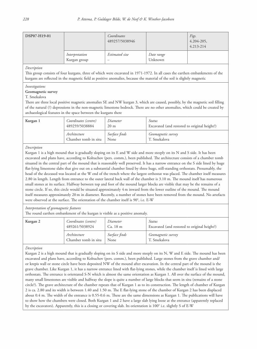
228 P. Attema, P. Guldager Bilde, W. de Neef & K. Winther-Jacobsen
DSP07-H19-01 Coordinates489257/5038946
Figs.4.204-205,4.213-214
InterpretationKurgan group
Estimated size–
Date rangeUnknown
DescriptionThis group consists of four kurgans, three of which were excavated in 1971-1972. In all cases the earthen embankments of the kurgans are reflected in the magnetic field as positive anomalies, because the material of the soil is slightly magnetic
InvestigationsGeomagnetic surveyT. SmekalovaThere are three local positive magnetic anomalies SE and NW kurgan 3, which are caused, possibly, by the magnetic soil filling of the natural (?) depressions in the non-magnetic limestone bedrock. There are no other anomalies, which could be created by archaeological features in the space between the kurgans there
Kurgan 1 Coordinates (centre)489259/5038884
Diameter20 m
StatusExcavated (and restored to original height?)
ArchitectureChamber tomb in situ
Surface findsNone
Geomagnetic surveyT. Smekalova
DescriptionKurgan 1 is a high mound that is gradually sloping on its E and W side and more steeply on its N and S side. It has been excavated and plans have, according to Koltuchov (pers. comm.), been published. The architecture consists of a chamber tomb situated in the central part of the mound that is reasonably well preserved. It has a narrow entrance on the S side lined by huge flat-lying limestone slabs that give out on a substantial chamber lined by three huge, still-standing orthostats. Presumably, the head of the deceased was located at the W end of the trench where the largest orthostat was placed. The chamber itself measures 2.80 in length. Length from entrance to the outer lateral back wall of the chamber is 3.10 m. The mound itself has numerous small stones at its surface. Halfway between top and foot of the mound larger blocks are visible that may be the remains of a stone circle. If so, this circle would be situated approximately 4 m inward from the lower outline of the mound. The mound itself measures approximately 20 m in diameter. Recently, a number of stones have been removed from the mound. No artefacts were observed at the surface. The orientation of the chamber itself is 90°, i.e. E-W
Interpretation of geomagnetic featuresThe round earthen embankment of the kurgan is visible as a positive anomaly.
Kurgan 2 Coordinates (centre)489261/5038924
DiameterCa. 18 m
StatusExcavated (and restored to original height?)
ArchitectureChamber tomb in situ
Surface findsNone
Geomagnetic surveyT. Smekalova
DescriptionKurgan 2 is a high mound that is gradually sloping on its S side and more steeply on its N, W and E side. The mound has been excavated and plans have, according to Koltuchov (pers. comm.), been published. Large stones from the grave chamber and/or krepis wall or stone circle have been deposited NW of the mound after excavation. In the central part of the mound is the grave chamber. Like Kurgan 1, it has a narrow entrance lined with flat-lying stones, while the chamber itself is lined with large orthostats. The entrance is orientated S-N which is almost the same orientation as Kurgan 1. All over the surface of the mound, many small limestones are visible and halfway the slope is quite a number of large blocks that seem in situ (remains of a stone circle?). The grave architecture of the chamber repeats that of Kurgan 1 as to its construction. The length of chamber of Kurgan 2 is ca. 2.80 and its width is between 1.40 and 1.50 m. The E flat-lying stone of the chamber of Kurgan 2 has been displaced about 0.4 m. The width of the entrance is 0.55-0.6 m. These are the same dimensions as Kurgan 1. The publications will have to show how the chambers were closed. Both Kurgan 1 and 2 have a large slab lying loose at the entrance (apparently replaced by the excavators). Apparently, this is a closing or covering slab. Its orientation is 100° i.e. slightly S of E-W
87620_dzarylgac.indb 228 23-04-2012 20:35:38
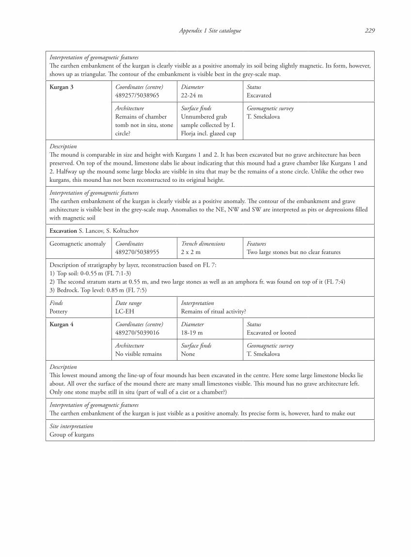
Appendix 1 Site catalogue 229
Interpretation of geomagnetic featuresThe earthen embankment of the kurgan is clearly visible as a positive anomaly its soil being slightly magnetic. Its form, however, shows up as triangular. The contour of the embankment is visible best in the grey-scale map.
Kurgan 3 Coordinates (centre)489257/5038965
Diameter22-24 m
StatusExcavated
ArchitectureRemains of chamber tomb not in situ, stone circle?
Surface findsUnnumbered grab sample collected by I. Florja incl. glazed cup
Geomagnetic surveyT. Smekalova
DescriptionThe mound is comparable in size and height with Kurgans 1 and 2. It has been excavated but no grave architecture has been preserved. On top of the mound, limestone slabs lie about indicating that this mound had a grave chamber like Kurgans 1 and 2. Halfway up the mound some large blocks are visible in situ that may be the remains of a stone circle. Unlike the other two kurgans, this mound has not been reconstructed to its original height.
Interpretation of geomagnetic featuresThe earthen embankment of the kurgan is clearly visible as a positive anomaly. The contour of the embankment and grave architecture is visible best in the grey-scale map. Anomalies to the NE, NW and SW are interpreted as pits or depressions filled with magnetic soil
Excavation S. Lancov, S. Koltuchov
Geomagnetic anomaly Coordinates489270/5038955
Trench dimensions2 x 2 m
FeaturesTwo large stones but no clear features
Description of stratigraphy by layer, reconstruction based on FL 7:1) Top soil: 0-0.55 m (FL 7:1-3)2) The second stratum starts at 0.55 m, and two large stones as well as an amphora fr. was found on top of it (FL 7:4)3) Bedrock. Top level: 0.85 m (FL 7:5)
FindsPottery
Date rangeLC-EH
InterpretationRemains of ritual activity?
Kurgan 4 Coordinates (centre)489270/5039016
Diameter18-19 m
StatusExcavated or looted
ArchitectureNo visible remains
Surface findsNone
Geomagnetic surveyT. Smekalova
DescriptionThis lowest mound among the line-up of four mounds has been excavated in the centre. Here some large limestone blocks lie about. All over the surface of the mound there are many small limestones visible. This mound has no grave architecture left. Only one stone maybe still in situ (part of wall of a cist or a chamber?)
Interpretation of geomagnetic featuresThe earthen embankment of the kurgan is just visible as a positive anomaly. Its precise form is, however, hard to make out
Site interpretationGroup of kurgans
87620_dzarylgac.indb 229 23-04-2012 20:35:38
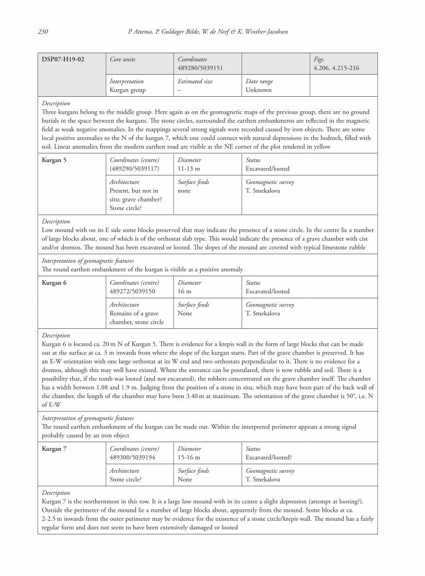
230 P. Attema, P. Guldager Bilde, W. de Neef & K. Winther-Jacobsen
DSP07-H19-02 Core units Coordinates489280/5039151
Figs.4.206, 4.215-216
InterpretationKurgan group
Estimated size–
Date rangeUnknown
DescriptionThree kurgans belong to the middle group. Here again as on the geomagnetic maps of the previous group, there are no ground burials in the space between the kurgans. The stone circles, surrounded the earthen embankments are reflected in the magnetic field as weak negative anomalies. In the mappings several strong signals were recorded caused by iron objects. There are some local positive anomalies to the N of the kurgan 7, which one could connect with natural depressions in the bedrock, filled with soil. Linear anomalies from the modern earthen road are visible at the NE corner of the plot rendered in yellow
Kurgan 5 Coordinates (centre)(489290/5039117)
Diameter11-13 m
StatusExcavated/looted
ArchitecturePresent, but not in situ; grave chamber? Stone circle?
Surface findsnone
Geomagnetic surveyT. Smekalova
DescriptionLow mound with on its E side some blocks preserved that may indicate the presence of a stone circle. In the centre lie a number of large blocks about, one of which is of the orthostat slab type. This would indicate the presence of a grave chamber with cist and/or dromos. The mound has been excavated or looted. The slopes of the mound are covered with typical limestone rubble
Interpretation of geomagnetic featuresThe round earthen embankment of the kurgan is visible as a positive anomaly
Kurgan 6 Coordinates (centre)489272/5039150
Diameter16 m
StatusExcavated/looted
ArchitectureRemains of a grave chamber, stone circle
Surface findsNone
Geomagnetic surveyT. Smekalova
DescriptionKurgan 6 is located ca. 20 m N of Kurgan 5. There is evidence for a krepis wall in the form of large blocks that can be made out at the surface at ca. 3 m inwards from where the slope of the kurgan starts. Part of the grave chamber is preserved. It has an E-W orientation with one large orthostat at its W end and two orthostats perpendicular to it. There is no evidence for a dromos, although this may well have existed. Where the entrance can be postulated, there is now rubble and soil. There is a possibility that, if the tomb was looted (and not excavated), the robbers concentrated on the grave chamber itself. The chamber has a width between 1.08 and 1.9 m. Judging from the position of a stone in situ, which may have been part of the back wall of the chamber, the length of the chamber may have been 3.40 m at maximum. The orientation of the grave chamber is 50°, i.e. N of E-W
Interpretation of geomagnetic featuresThe round earthen embankment of the kurgan can be made out. Within the interpreted perimeter appears a strong signal probably caused by an iron object
Kurgan 7 Coordinates (centre)489300/5039194
Diameter15-16 m
StatusExcavated/looted?
ArchitectureStone circle?
Surface findsNone
Geomagnetic surveyT. Smekalova
DescriptionKurgan 7 is the northernmost in this row. It is a large low mound with in its centre a slight depression (attempt at looting?). Outside the perimeter of the mound lie a number of large blocks about, apparently from the mound. Some blocks at ca. 2-2.5 m inwards from the outer perimeter may be evidence for the existence of a stone circle/krepis wall. The mound has a fairly regular form and does not seem to have been extensively damaged or looted
87620_dzarylgac.indb 230 23-04-2012 20:35:39

Appendix 1 Site catalogue 231
Interpretation of geomagnetic featuresThe round earthen embankment of the kurgan can be made out. To the W, N and NE, three anomalies occur interpreted as pits or depressions filled with magnetic soil
Site interpretationGroup of kurgans
DSP07-H19-03 Core units20035
Coordinates489267/5039496
Figs.4.207, 4.217-218
Adjacent units20036, H01, H03, H12 and H24
InterpretationGroup of kurgans
Estimated size Date rangeLC-EH?
TopographyDSP07-H19-03 is located on Hill 19, a long slope running from the top of the ridge to the cultivated zone
InvestigationIntensive survey Line of four grassy elevations just N of Hill 12 (for detailed descriptions, see kurgan catalogue). 12 sherds collected in the area including three Hellenistic transport amphora frs. (20035/05-06 and 20036/14-18)Topographical survey The N group of barrows consists of three kurgans. The northernmost kurgan has been excavated, which is reflected in the magnetic field as a circular positive anomaly. The two remaining kurgans give us only weak circular negative anomalies, most probably, from the stone walls surrounding the embankments. Again, there are no anomalies, which could be caused by ground burials in the space between the barrows. There are linear anomalies from the modern earth road at the NW part of the plot
Kurgan 8 Coordinates (centre)489294/5039404
Diameter18 m
StatusLooted
ArchitectureGrave chamber
Surface findsNone
Geomagnetic surveyT. Smekalova
DescriptionLarge mound with on its slopes the characteristic limestone rubble exposed in a very dense packing. Its top is flat and it appears that the grave chamber has been plundered and damaged. A probable head stone, however, still protrudes from the mound and seems to be in situ. The orthostat slabs lining the chamber have, however, been removed and lie tilted and out of place. On the N slope, a few exposed blocks lie in situ and may indicate the position of a stone circle. These blocks are situated ca. 3.50 m inwards from the outer boundary of the mound. For this mound it is not possible to give dimensions of the grave chamber and there is no sign of an entrance of the dromos-type. Where it can be postulated, no digging has been taken place. This grave may have been of the grave chamber and lateral dromos type. The orientation of the grave chamber is 70°, i.e. slightly N of E-W
Interpretation of geomagnetic featuresOf this kurgan only a very weak circular anomaly could be made out. To the S, various strong signals indicate the presence of (recent) iron objects
Kurgan 9 Coordinates (centre)489284/5039477
Diameter16 m
StatusExcavated/looted
ArchitecturePossibly a grave chamber?
Surface findsNone
Geomagnetic surveyT. Smekalova
87620_dzarylgac.indb 231 23-04-2012 20:35:39
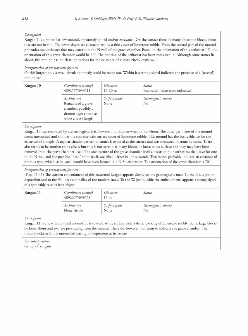
232 P. Attema, P. Guldager Bilde, W. de Neef & K. Winther-Jacobsen
DescriptionKurgan 9 is a rather flat low mound, apparently looted and/or excavated. On the surface there lie many limestone blocks about that are not in situ. The lower slopes are characterized by a thin cover of limestone rubble. From the central part of the mound protrudes one orthostat that may constitute the N wall of the grave chamber. Based on the orientation of this orthostat (if ), the orientation of this grave chamber would be 60°. The position of the orthostat has been measured in. Although some stones lie about, this mound has no clear indications for the existence of a stone circle/krepis wall
Interpretation of geomagnetic featuresOf this kurgan only a weak circular anomaly could be made out. Within it a strong signal indicates the presence of a (recent?) iron object
Kurgan 10 Coordinates (centre)489257/5039511
Diameter16-20 m
StatusExcavated (excavators unknown)
ArchitectureRemains of a grave chamber, possibly a dromos type entrance, stone circle / krepis
Surface findsNone
Geomagnetic surveyNo
DescriptionKurgan 10 was excavated by archaeologists: it is, however, not known when or by whom. The outer perimeter of the mound seems untouched and still has the characteristic surface cover of limestone rubble. This mound has the best evidence for the existence of a krepis. A regular circular pattern of stones is exposed at the surface and was measured in stone by stone. There also seems to be another stone circle, but this is not certain as many blocks lie loose at the surface and they may have been removed from the grave chamber itself. The architecture of the grave chamber itself consists of four orthostats that, save for one in the N wall and the possible “head” stone itself, are tilted, either in- or outwards. Two stones probably indicate an entrance of dromos type, which, as is usual, would have been located in a N-S orientation. The orientation of the grave chamber is 70°
Interpretation of geomagnetic features(Figs. 45-47) The earthen embankment of this excavated kurgan appears clearly on the geomagnetic map. To the NE, a pit or depression and to the W linear anomalies of the modern track. To the W, just outside the embankment, appears a strong signal of a (probably recent) iron object
Kurgan 11 Coordinates (centre)489260/5039558
Diameter13 m
Status
ArchitectureNone visible
Surface findsNone
Geomagnetic surveyNo
DescriptionKurgan 11 is a low, fairly small mound. It is covered at the surface with a dense packing of limestone rubble. Some large blocks lie loose about and two are protruding from the mound. These do, however, not seem to indicate the grave chamber. The mound looks as if it is untouched having no depression at its centre
Site interpretationGroup of kurgans
87620_dzarylgac.indb 232 23-04-2012 20:35:39
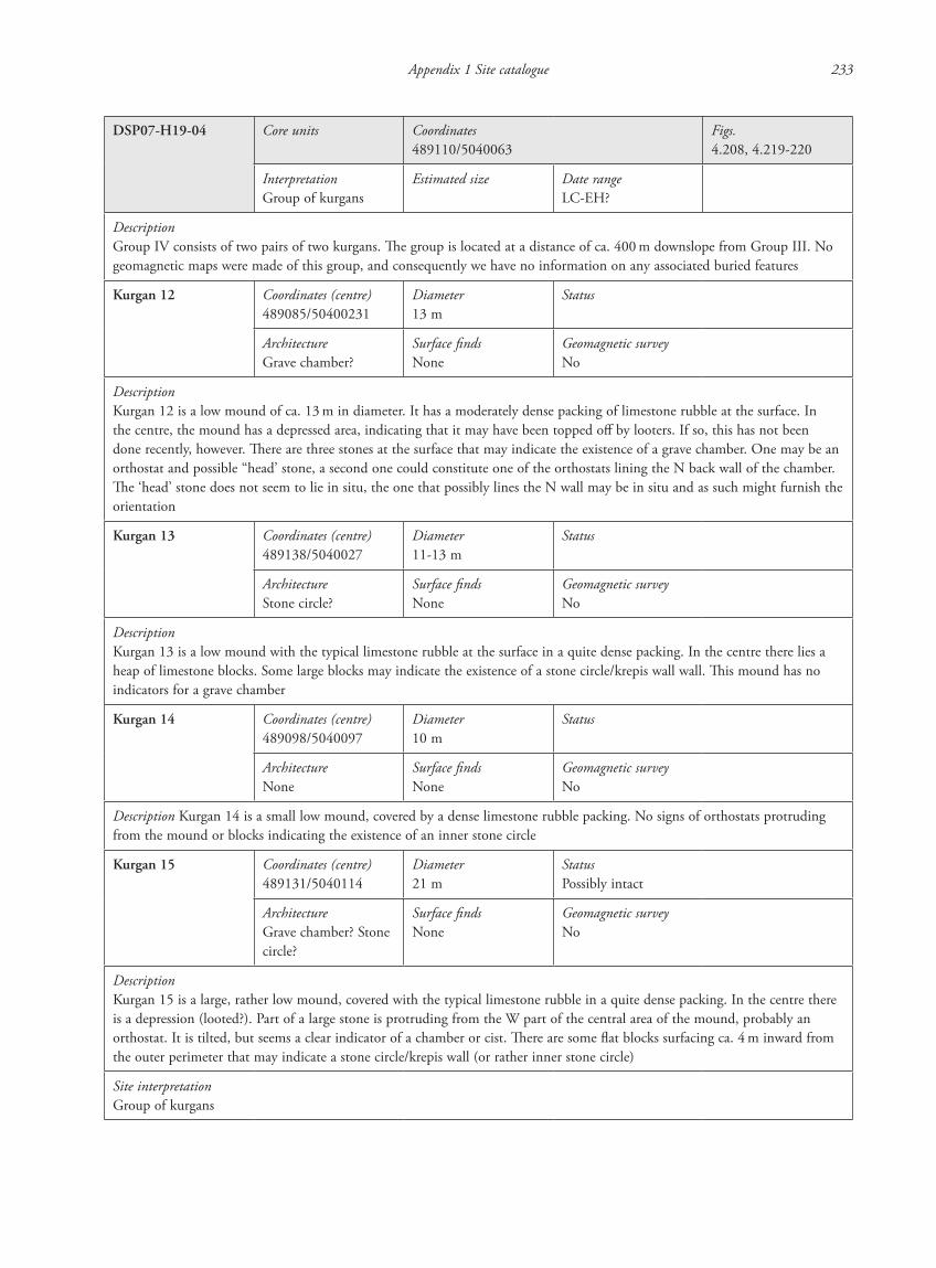
Appendix 1 Site catalogue 233
DSP07-H19-04 Core units Coordinates489110/5040063
Figs.4.208, 4.219-220
InterpretationGroup of kurgans
Estimated size Date rangeLC-EH?
DescriptionGroup IV consists of two pairs of two kurgans. The group is located at a distance of ca. 400 m downslope from Group III. No geomagnetic maps were made of this group, and consequently we have no information on any associated buried features
Kurgan 12 Coordinates (centre)489085/50400231
Diameter13 m
Status
ArchitectureGrave chamber?
Surface findsNone
Geomagnetic surveyNo
DescriptionKurgan 12 is a low mound of ca. 13 m in diameter. It has a moderately dense packing of limestone rubble at the surface. In the centre, the mound has a depressed area, indicating that it may have been topped off by looters. If so, this has not been done recently, however. There are three stones at the surface that may indicate the existence of a grave chamber. One may be an orthostat and possible “head’ stone, a second one could constitute one of the orthostats lining the N back wall of the chamber. The ‘head’ stone does not seem to lie in situ, the one that possibly lines the N wall may be in situ and as such might furnish the orientation
Kurgan 13 Coordinates (centre)489138/5040027
Diameter11-13 m
Status
ArchitectureStone circle?
Surface findsNone
Geomagnetic surveyNo
DescriptionKurgan 13 is a low mound with the typical limestone rubble at the surface in a quite dense packing. In the centre there lies a heap of limestone blocks. Some large blocks may indicate the existence of a stone circle/krepis wall wall. This mound has no indicators for a grave chamber
Kurgan 14 Coordinates (centre)489098/5040097
Diameter10 m
Status
ArchitectureNone
Surface findsNone
Geomagnetic surveyNo
Description Kurgan 14 is a small low mound, covered by a dense limestone rubble packing. No signs of orthostats protruding from the mound or blocks indicating the existence of an inner stone circle
Kurgan 15 Coordinates (centre)489131/5040114
Diameter21 m
StatusPossibly intact
ArchitectureGrave chamber? Stone circle?
Surface findsNone
Geomagnetic surveyNo
DescriptionKurgan 15 is a large, rather low mound, covered with the typical limestone rubble in a quite dense packing. In the centre there is a depression (looted?). Part of a large stone is protruding from the W part of the central area of the mound, probably an orthostat. It is tilted, but seems a clear indicator of a chamber or cist. There are some flat blocks surfacing ca. 4 m inward from the outer perimeter that may indicate a stone circle/krepis wall (or rather inner stone circle)
Site interpretationGroup of kurgans
87620_dzarylgac.indb 233 23-04-2012 20:35:39
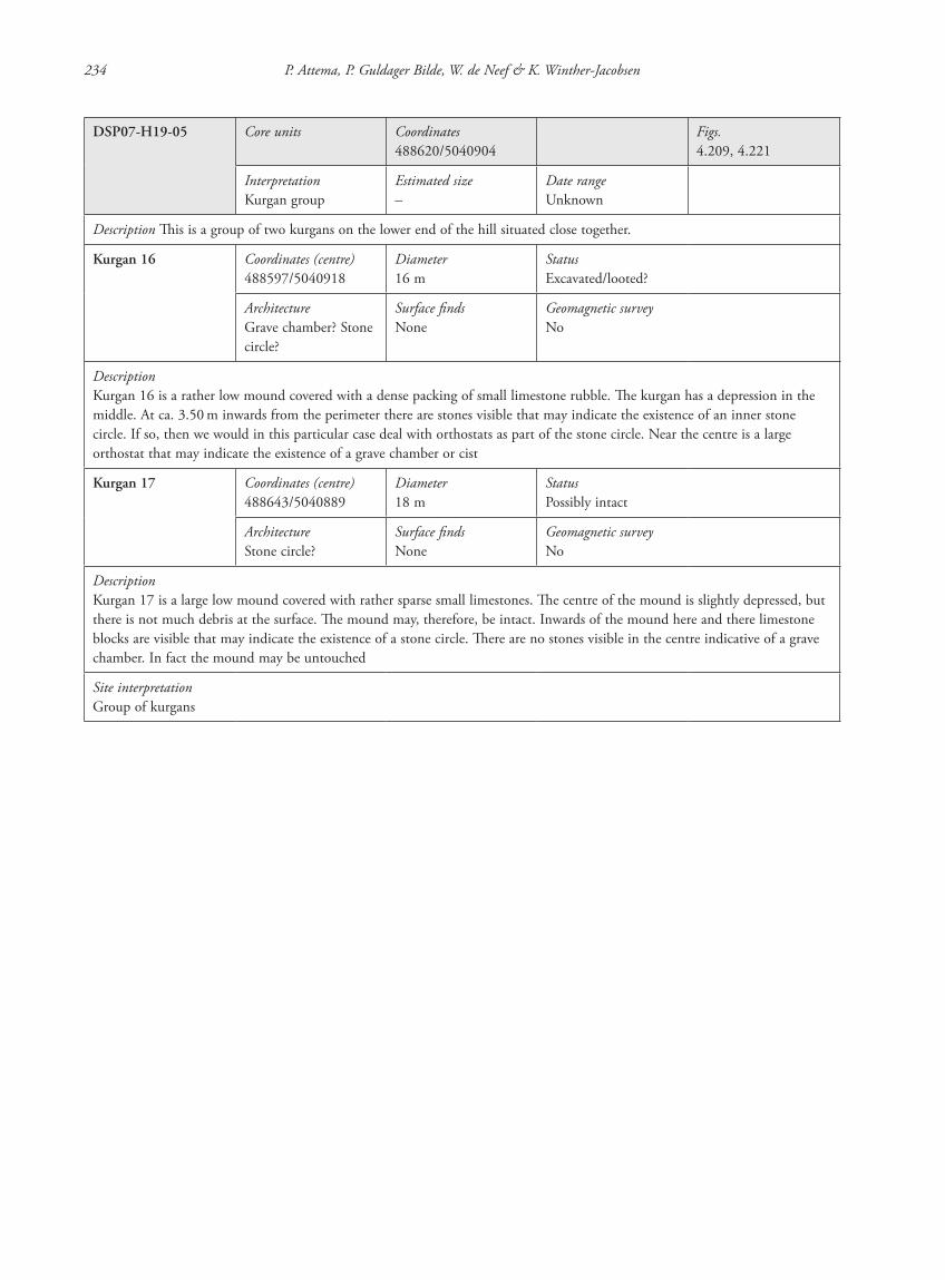
234 P. Attema, P. Guldager Bilde, W. de Neef & K. Winther-Jacobsen
DSP07-H19-05 Core units Coordinates488620/5040904
Figs.4.209, 4.221
InterpretationKurgan group
Estimated size–
Date rangeUnknown
Description This is a group of two kurgans on the lower end of the hill situated close together.
Kurgan 16 Coordinates (centre)488597/5040918
Diameter16 m
StatusExcavated/looted?
ArchitectureGrave chamber? Stone circle?
Surface findsNone
Geomagnetic surveyNo
DescriptionKurgan 16 is a rather low mound covered with a dense packing of small limestone rubble. The kurgan has a depression in the middle. At ca. 3.50 m inwards from the perimeter there are stones visible that may indicate the existence of an inner stone circle. If so, then we would in this particular case deal with orthostats as part of the stone circle. Near the centre is a large orthostat that may indicate the existence of a grave chamber or cist
Kurgan 17 Coordinates (centre)488643/5040889
Diameter18 m
StatusPossibly intact
ArchitectureStone circle?
Surface findsNone
Geomagnetic surveyNo
DescriptionKurgan 17 is a large low mound covered with rather sparse small limestones. The centre of the mound is slightly depressed, but there is not much debris at the surface. The mound may, therefore, be intact. Inwards of the mound here and there limestone blocks are visible that may indicate the existence of a stone circle. There are no stones visible in the centre indicative of a grave chamber. In fact the mound may be untouched
Site interpretationGroup of kurgans
87620_dzarylgac.indb 234 23-04-2012 20:35:40
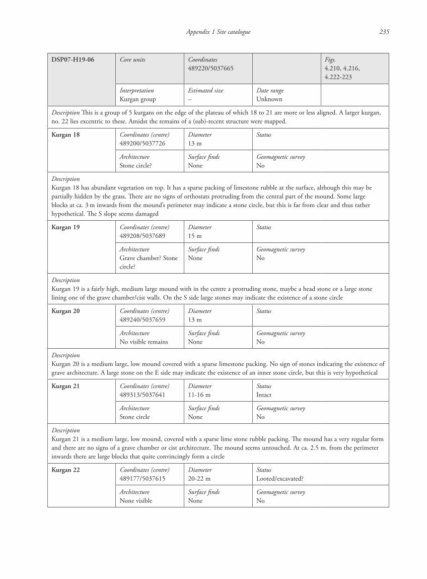
Appendix 1 Site catalogue 235
DSP07-H19-06 Core units Coordinates489220/5037665
Figs.4.210, 4.216, 4.222-223
InterpretationKurgan group
Estimated size–
Date rangeUnknown
Description This is a group of 5 kurgans on the edge of the plateau of which 18 to 21 are more or less aligned. A larger kurgan, no. 22 lies excentric to these. Amidst the remains of a (sub)-recent structure were mapped.
Kurgan 18 Coordinates (centre)489200/5037726
Diameter13 m
Status
ArchitectureStone circle?
Surface findsNone
Geomagnetic surveyNo
DescriptionKurgan 18 has abundant vegetation on top. It has a sparse packing of limestone rubble at the surface, although this may be partially hidden by the grass. There are no signs of orthostats protruding from the central part of the mound. Some large blocks at ca. 3 m inwards from the mound’s perimeter may indicate a stone circle, but this is far from clear and thus rather hypothetical. The S slope seems damaged
Kurgan 19 Coordinates (centre)489208/5037689
Diameter15 m
Status
ArchitectureGrave chamber? Stone circle?
Surface findsNone
Geomagnetic surveyNo
DescriptionKurgan 19 is a fairly high, medium large mound with in the centre a protruding stone, maybe a head stone or a large stone lining one of the grave chamber/cist walls. On the S side large stones may indicate the existence of a stone circle
Kurgan 20 Coordinates (centre)489240/5037659
Diameter13 m
Status
ArchitectureNo visible remains
Surface findsNone
Geomagnetic surveyNo
DescriptionKurgan 20 is a medium large, low mound covered with a sparse limestone packing. No sign of stones indicating the existence of grave architecture. A large stone on the E side may indicate the existence of an inner stone circle, but this is very hypothetical
Kurgan 21 Coordinates (centre)489313/5037641
Diameter11-16 m
StatusIntact
ArchitectureStone circle
Surface findsNone
Geomagnetic surveyNo
DescriptionKurgan 21 is a medium large, low mound, covered with a sparse lime stone rubble packing. The mound has a very regular form and there are no signs of a grave chamber or cist architecture. The mound seems untouched. At ca. 2.5 m. from the perimeter inwards there are large blocks that quite convincingly form a circle
Kurgan 22 Coordinates (centre)489177/5037615
Diameter20-22 m
StatusLooted/excavated?
ArchitectureNone visible
Surface findsNone
Geomagnetic surveyNo
87620_dzarylgac.indb 235 23-04-2012 20:35:40

236 P. Attema, P. Guldager Bilde, W. de Neef & K. Winther-Jacobsen
DescriptionKurgan 22 is a large, high mound, with a depression in the central part (excavated? looted? or just an attempt at?). No clear remains of grave architecture are visible at the surface, although there are some large blocks lying about. There is quite some vegetation on the mound through which one can discern the limestone rubble covering the surface of the mound. No signs at the surface of the existence of an inner stone circle
Site interpretationGroup of kurgans
87620_dzarylgac.indb 236 23-04-2012 20:35:40
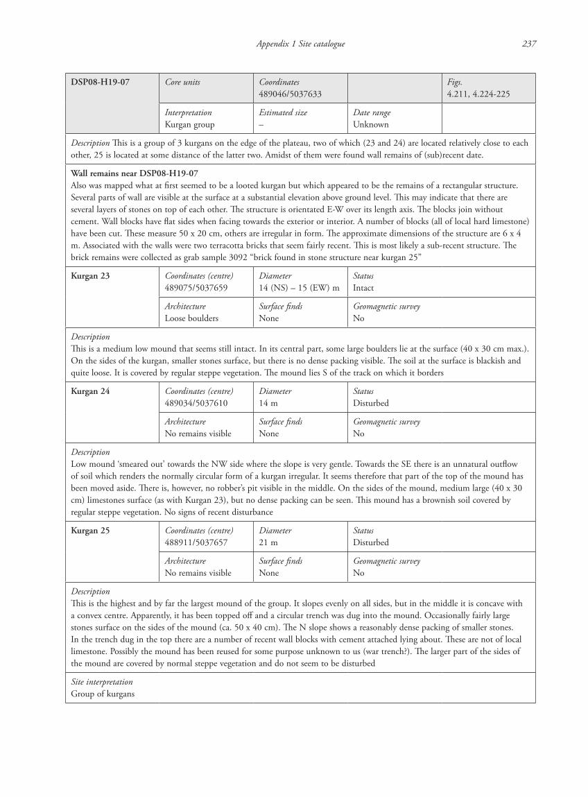
Appendix 1 Site catalogue 237
DSP08-H19-07 Core units Coordinates489046/5037633
Figs.4.211, 4.224-225
InterpretationKurgan group
Estimated size–
Date rangeUnknown
Description This is a group of 3 kurgans on the edge of the plateau, two of which (23 and 24) are located relatively close to each other, 25 is located at some distance of the latter two. Amidst of them were found wall remains of (sub)recent date.
Wall remains near DSP08-H19-07Also was mapped what at first seemed to be a looted kurgan but which appeared to be the remains of a rectangular structure. Several parts of wall are visible at the surface at a substantial elevation above ground level. This may indicate that there are several layers of stones on top of each other. The structure is orientated E-W over its length axis. The blocks join without cement. Wall blocks have flat sides when facing towards the exterior or interior. A number of blocks (all of local hard limestone) have been cut. These measure 50 x 20 cm, others are irregular in form. The approximate dimensions of the structure are 6 x 4 m. Associated with the walls were two terracotta bricks that seem fairly recent. This is most likely a sub-recent structure. The brick remains were collected as grab sample 3092 “brick found in stone structure near kurgan 25”
Kurgan 23 Coordinates (centre)489075/5037659
Diameter14 (NS) – 15 (EW) m
StatusIntact
ArchitectureLoose boulders
Surface findsNone
Geomagnetic surveyNo
DescriptionThis is a medium low mound that seems still intact. In its central part, some large boulders lie at the surface (40 x 30 cm max.). On the sides of the kurgan, smaller stones surface, but there is no dense packing visible. The soil at the surface is blackish and quite loose. It is covered by regular steppe vegetation. The mound lies S of the track on which it borders
Kurgan 24 Coordinates (centre)489034/5037610
Diameter14 m
StatusDisturbed
ArchitectureNo remains visible
Surface findsNone
Geomagnetic surveyNo
DescriptionLow mound ‘smeared out’ towards the NW side where the slope is very gentle. Towards the SE there is an unnatural outflow of soil which renders the normally circular form of a kurgan irregular. It seems therefore that part of the top of the mound has been moved aside. There is, however, no robber’s pit visible in the middle. On the sides of the mound, medium large (40 x 30 cm) limestones surface (as with Kurgan 23), but no dense packing can be seen. This mound has a brownish soil covered by regular steppe vegetation. No signs of recent disturbance
Kurgan 25 Coordinates (centre)488911/5037657
Diameter21 m
StatusDisturbed
ArchitectureNo remains visible
Surface findsNone
Geomagnetic surveyNo
DescriptionThis is the highest and by far the largest mound of the group. It slopes evenly on all sides, but in the middle it is concave with a convex centre. Apparently, it has been topped off and a circular trench was dug into the mound. Occasionally fairly large stones surface on the sides of the mound (ca. 50 x 40 cm). The N slope shows a reasonably dense packing of smaller stones. In the trench dug in the top there are a number of recent wall blocks with cement attached lying about. These are not of local limestone. Possibly the mound has been reused for some purpose unknown to us (war trench?). The larger part of the sides of the mound are covered by normal steppe vegetation and do not seem to be disturbed
Site interpretationGroup of kurgans
87620_dzarylgac.indb 237 23-04-2012 20:35:40
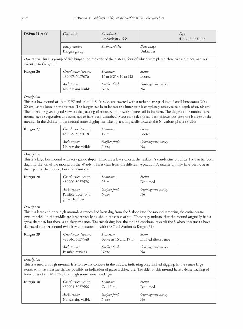
238 P. Attema, P. Guldager Bilde, W. de Neef & K. Winther-Jacobsen
DSP08-H19-08 Core units Coordinates489984/5037665
Figs.4.212, 4.225-227
InterpretationKurgan group
Estimated size–
Date rangeUnknown
Description This is a group of five kurgans on the edge of the plateau, four of which were placed close to each other, one lies excentric to the group
Kurgan 26 Coordinates (centre)490047/5037676
Diameter13 m EW x 14 m NS
StatusLooted
ArchitectureNo remains visible
Surface findsNone
Geomagnetic surveyNo
DescriptionThis is a low mound of 13 m E-W and 14 m N-S. Its sides are covered with a rather dense packing of small limestones (20 x 20 cm), some loose on the surface. The kurgan has been looted: the inner part is completely removed to a depth of ca. 60 cm. The inner side gives a good view on the packing of stones with brownish loose soil in between. The slopes of the mound have normal steppe vegetation and seem not to have been disturbed. Most stone debris has been thrown out onto the E slope of the mound. In the vicinity of the mound more digging has taken place. Especially towards the N, various pits are visible
Kurgan 27 Coordinates (centre)489979/5037618
Diameter17 m
StatusLooted
ArchitectureNo remains visible
Surface findsNone
Geomagnetic surveyNo
DescriptionThis is a large low mound with very gentle slopes. There are a few stones at the surface. A clandestine pit of ca. 1 x 1 m has been dug into the top of the mound on the W side. This is clear from the different vegetation. A smaller pit may have been dug in the E part of the mound, but this is not clear
Kurgan 28 Coordinates (centre)489960/5037576
Diameter23 m
StatusDisturbed
ArchitecturePossible traces of a grave chamber
Surface findsNone
Geomagnetic surveyNo
DescriptionThis is a large and once high mound. A trench had been dug from the S slope into the mound removing the entire centre (war trench?). In the middle are large stones lying about, most out of situ. These may indicate that the mound originally had a grave chamber, but there is no clear evidence. The trench dug into the mound continues towards the S where it seems to have destroyed another mound (which was measured in with the Total Station as Kurgan 31)
Kurgan 29 Coordinates (centre)489946/5037548
DiameterBetween 16 and 17 m
StatusLimited disturbance
ArchitecturePossible remains
Surface findsNone
Geomagnetic surveyNo
DescriptionThis is a medium high mound. It is somewhat concave in the middle, indicating only limited digging. In the centre large stones with flat sides are visible, possibly an indication of grave architecture. The sides of this mound have a dense packing of limestones of ca. 20 x 20 cm, though some stones are larger
Kurgan 30 Coordinates (centre)489904/5037556
DiameterCa. 13 m
StatusDisturbed
ArchitectureNo remains visible
Surface findsNone
Geomagnetic surveyNo
87620_dzarylgac.indb 238 23-04-2012 20:35:40
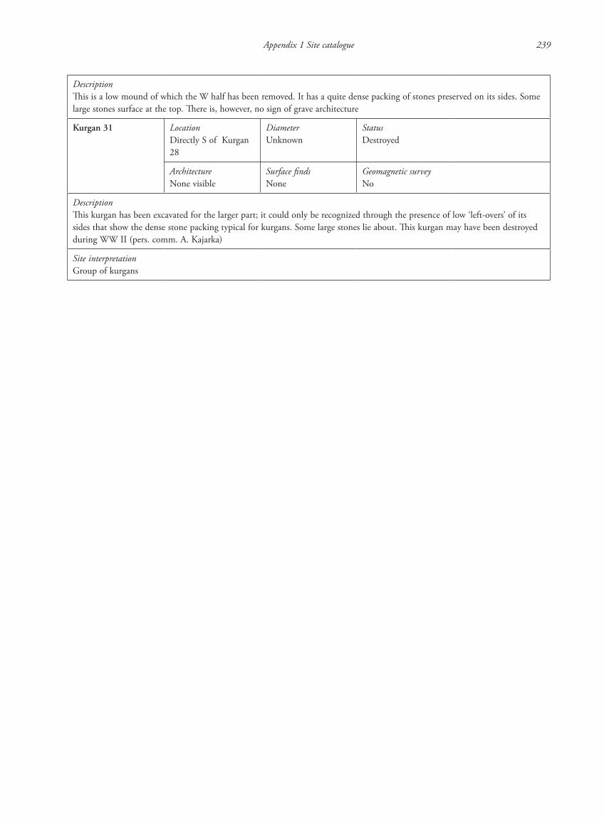
Appendix 1 Site catalogue 239
DescriptionThis is a low mound of which the W half has been removed. It has a quite dense packing of stones preserved on its sides. Some large stones surface at the top. There is, however, no sign of grave architecture
Kurgan 31 LocationDirectly S of Kurgan 28
DiameterUnknown
StatusDestroyed
ArchitectureNone visible
Surface findsNone
Geomagnetic surveyNo
DescriptionThis kurgan has been excavated for the larger part; it could only be recognized through the presence of low ‘left-overs’ of its sides that show the dense stone packing typical for kurgans. Some large stones lie about. This kurgan may have been destroyed during WW II (pers. comm. A. Kajarka)
Site interpretationGroup of kurgans
87620_dzarylgac.indb 239 23-04-2012 20:35:40
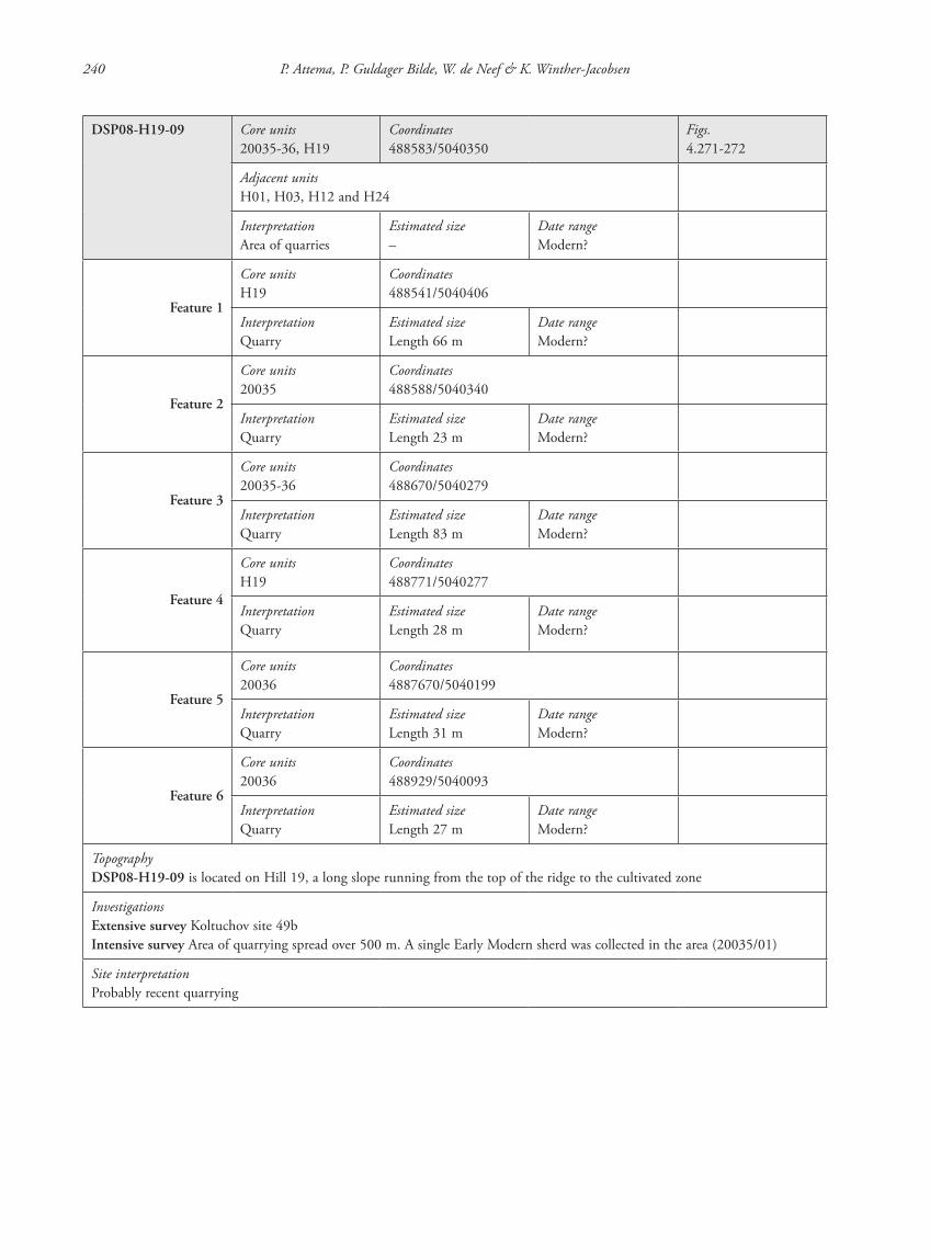
240 P. Attema, P. Guldager Bilde, W. de Neef & K. Winther-Jacobsen
DSP08-H19-09 Core units20035-36, H19
Coordinates488583/5040350
Figs.4.271-272
Adjacent unitsH01, H03, H12 and H24
InterpretationArea of quarries
Estimated size–
Date rangeModern?
Feature 1
Core unitsH19
Coordinates488541/5040406
InterpretationQuarry
Estimated sizeLength 66 m
Date rangeModern?
Feature 2
Core units20035
Coordinates488588/5040340
InterpretationQuarry
Estimated sizeLength 23 m
Date rangeModern?
Feature 3
Core units20035-36
Coordinates488670/5040279
InterpretationQuarry
Estimated sizeLength 83 m
Date rangeModern?
Feature 4
Core unitsH19
Coordinates488771/5040277
InterpretationQuarry
Estimated sizeLength 28 m
Date rangeModern?
Feature 5
Core units20036
Coordinates4887670/5040199
InterpretationQuarry
Estimated sizeLength 31 m
Date rangeModern?
Feature 6
Core units20036
Coordinates488929/5040093
InterpretationQuarry
Estimated sizeLength 27 m
Date rangeModern?
TopographyDSP08-H19-09 is located on Hill 19, a long slope running from the top of the ridge to the cultivated zone
InvestigationsExtensive survey Koltuchov site 49bIntensive survey Area of quarrying spread over 500 m. A single Early Modern sherd was collected in the area (20035/01)
Site interpretationProbably recent quarrying
87620_dzarylgac.indb 240 23-04-2012 20:35:41
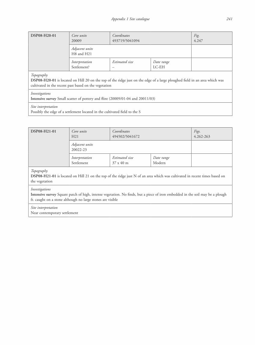
Appendix 1 Site catalogue 241
DSP08-H20-01 Core units20009
Coordinates493719/5041094
Fig.4.247
Adjacent unitsH8 and H21
InterpretationSettlement?
Estimated size–
Date rangeLC-EH
TopographyDSP08-H20-01 is located on Hill 20 on the top of the ridge just on the edge of a large ploughed field in an area which was cultivated in the recent past based on the vegetation
InvestigationsIntensive survey Small scatter of pottery and flint (20009/01-04 and 20011/03)
Site interpretationPossibly the edge of a settlement located in the cultivated field to the S
DSP08-H21-01 Core unitsH21
Coordinates494502/5041672
Figs.4.262-263
Adjacent units20022-23
InterpretationSettlement
Estimated size37 x 40 m
Date range Modern
TopographyDSP08-H21-01 is located on Hill 21 on the top of the ridge just N of an area which was cultivated in recent times based on the vegetation
InvestigationsIntensive survey Square patch of high, intense vegetation. No finds, but a piece of iron embedded in the soil may be a plough fr. caught on a stone although no large stones are visible
Site interpretationNear contemporary settlement
87620_dzarylgac.indb 241 23-04-2012 20:35:41
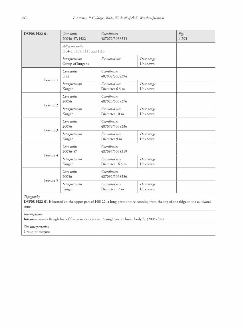
242 P. Attema, P. Guldager Bilde, W. de Neef & K. Winther-Jacobsen
DSP08-H22-01 Core units20056-57, H22
Coordinates487072/5038333
Fig.4.295
Adjacent unitsH04-5, H09, H11 and H13
InterpretationGroup of kurgans
Estimated size Date rangeUnknown
Feature 1
Core unitsH22
Coordinates487008/5038394
InterpretationKurgan
Estimated sizeDiameter 6.5 m
Date rangeUnknown
Feature 2
Core units20056
Coordinates487023/5038376
InterpretationKurgan
Estimated sizeDiameter 10 m
Date rangeUnknown
Feature 3
Core units20056
Coordinates487079/5038336
InterpretationKurgan
Estimated sizeDiameter 9 m
Date rangeUnknown
Feature 4
Core units20056-57
Coordinates487097/5038319
InterpretationKurgan
Estimated sizeDiameter 16.5 m
Date rangeUnknown
Feature 5
Core units20056
Coordinates487092/5038286
InterpretationKurgan
Estimated sizeDiameter 17 m
Date rangeUnknown
TopographyDSP08-H22-01 is located on the upper part of Hill 22, a long promontory running from the top of the ridge to the cultivated zone
InvestigationsIntensive survey Rough line of five grassy elevations. A single inconclusive body fr. (20057/02)
Site interpretationGroup of kurgans
87620_dzarylgac.indb 242 23-04-2012 20:35:41
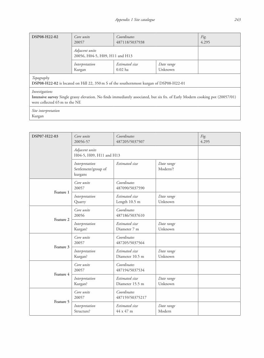
Appendix 1 Site catalogue 243
DSP08-H22-02 Core units20057
Coordinates487118/5037938
Fig.4.295
Adjacent units20056, H04-5, H09, H11 and H13
InterpretationKurgan
Estimated size0.02 ha
Date rangeUnknown
TopographyDSP08-H22-02 is located on Hill 22, 350 m S of the southernmost kurgan of DSP08-H22-01
InvestigationsIntensive survey Single grassy elevation. No finds immediately associated, but six frs. of Early Modern cooking pot (20057/01) were collected 65 m to the NE
Site interpretationKurgan
DSP07-H22-03 Core units20056-57
Coordinates487205/5037507
Fig.4.295
Adjacent unitsH04-5, H09, H11 and H13
InterpretationSettlement/group of kurgans
Estimated size Date rangeModern/?
Feature 1
Core units20057
Coordinates487090/5037590
InterpretationQuarry
Estimated sizeLength 10.5 m
Date rangeUnknown
Feature 2
Core units20056
Coordinates487186/5037610
InterpretationKurgan?
Estimated sizeDiameter 7 m
Date rangeUnknown
Feature 3
Core units20057
Coordinates487205/5037564
InterpretationKurgan?
Estimated sizeDiameter 10.5 m
Date rangeUnknown
Feature 4
Core units20057
Coordinates487194/5037534
InterpretationKurgan?
Estimated sizeDiameter 15.5 m
Date rangeUnknown
Feature 5
Core units20057
Coordinates487159/50375217
InterpretationStructure?
Estimated size44 x 47 m
Date rangeModern
87620_dzarylgac.indb 243 23-04-2012 20:35:42

244 P. Attema, P. Guldager Bilde, W. de Neef & K. Winther-Jacobsen
Feature 6
Core units20056-57
Coordinates487165/5037490
InterpretationKurgan?
Estimated sizeDiameter 7 m
Date rangeUnknown
Feature 7
Core units20056
Coordinates487222/5037529
InterpretationKurgan?
Estimated sizeDiameter 26.5 m
Date rangeUnknown
Feature 8
Core units20056-57
Coordinates4872120/5037494
InterpretationStructure
Estimated size10.5 x 6.5 m
Date rangeModern
Feature 9
Core units20057
Coordinates487198/5037477
InterpretationKurgan?
Estimated sizeDiameter 19 m
Date rangeUnknown
Feature 10
Core units20057
Coordinates487213/5037447
InterpretationStructure?
Estimated sizeDiameter 7.5 m
Date rangeModern
Feature 11
Core units20056-57
Coordinates487219/5037424
InterpretationStructure?
Estimated size29 x 24.5 m
Date rangeModern
Feature 12
Core units20057
Coordinates487232/5037407
InterpretationKurgan?
Estimated sizeDiameter 14 m
Date rangeUnknown
TopographyDSP07-H22-03 is located on the top of the ridge of Hill 22, a long promontory running from the top of the ridge to the cultivated zone
InvestigationsIntensive survey Three square patches of high, intense vegetation (Feature 5, 10-11) and a stone foundation (Feature 8) among six grassy elevations. No finds associated.
Geomagnetic surveyEastern AtlasDimensions 53 x 740 + 101 x 100 m
Description of measuring conditionsMany dipole anomalies
Interpretation of features The surveyed area crosses only part of the site and none of the features are clearly visible due to the many dipole anomalies caused by metal or other debris. At the southern edge of the site several pits were recorded as well as possible ditches
Site interpretationNear contemporary settlement associated with a group of kurgans
87620_dzarylgac.indb 244 23-04-2012 20:35:42
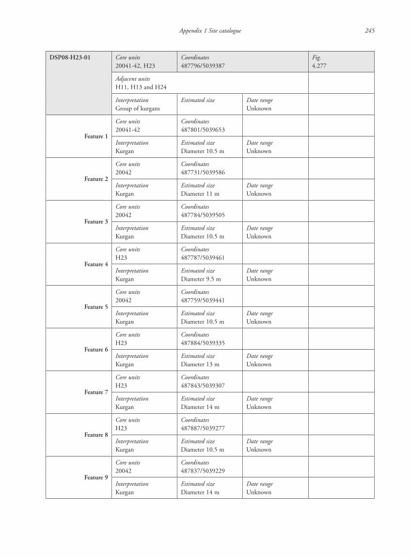
Appendix 1 Site catalogue 245
DSP08-H23-01 Core units20041-42, H23
Coordinates487796/5039387
Fig.4.277
Adjacent unitsH11, H13 and H24
InterpretationGroup of kurgans
Estimated size Date rangeUnknown
Feature 1
Core units20041-42
Coordinates487801/5039653
InterpretationKurgan
Estimated sizeDiameter 10.5 m
Date rangeUnknown
Feature 2
Core units20042
Coordinates487731/5039586
InterpretationKurgan
Estimated sizeDiameter 11 m
Date rangeUnknown
Feature 3
Core units20042
Coordinates487784/5039505
InterpretationKurgan
Estimated sizeDiameter 10.5 m
Date rangeUnknown
Feature 4
Core unitsH23
Coordinates487787/5039461
InterpretationKurgan
Estimated sizeDiameter 9.5 m
Date rangeUnknown
Feature 5
Core units20042
Coordinates487759/5039441
InterpretationKurgan
Estimated sizeDiameter 10.5 m
Date rangeUnknown
Feature 6
Core unitsH23
Coordinates487884/5039335
InterpretationKurgan
Estimated sizeDiameter 13 m
Date rangeUnknown
Feature 7
Core unitsH23
Coordinates487843/5039307
InterpretationKurgan
Estimated sizeDiameter 14 m
Date rangeUnknown
Feature 8
Core unitsH23
Coordinates487887/5039277
InterpretationKurgan
Estimated sizeDiameter 10.5 m
Date rangeUnknown
Feature 9
Core units20042
Coordinates487837/5039229
InterpretationKurgan
Estimated sizeDiameter 14 m
Date rangeUnknown
87620_dzarylgac.indb 245 23-04-2012 20:35:42
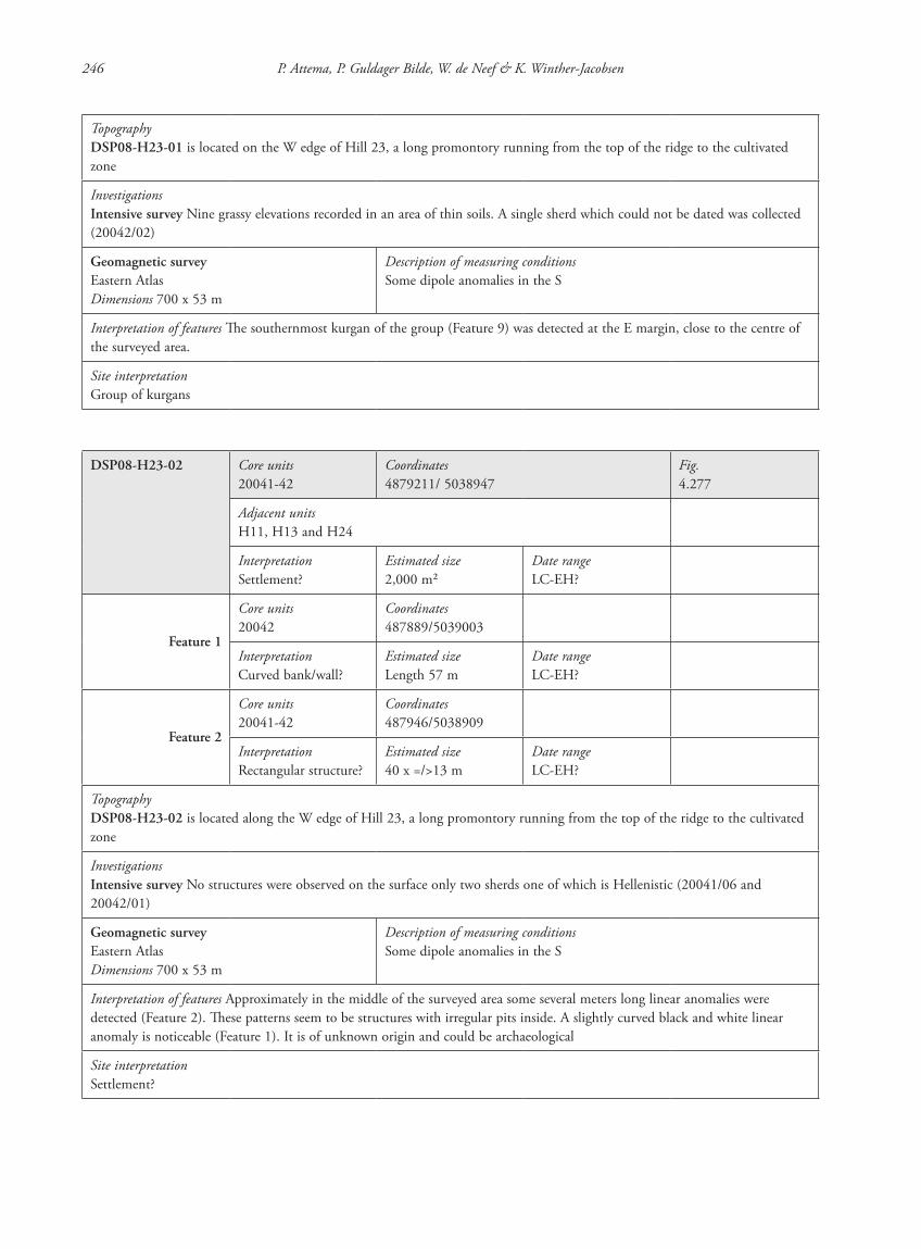
246 P. Attema, P. Guldager Bilde, W. de Neef & K. Winther-Jacobsen
TopographyDSP08-H23-01 is located on the W edge of Hill 23, a long promontory running from the top of the ridge to the cultivated zone
InvestigationsIntensive survey Nine grassy elevations recorded in an area of thin soils. A single sherd which could not be dated was collected (20042/02)
Geomagnetic surveyEastern AtlasDimensions 700 x 53 m
Description of measuring conditionsSome dipole anomalies in the S
Interpretation of features The southernmost kurgan of the group (Feature 9) was detected at the E margin, close to the centre of the surveyed area.
Site interpretationGroup of kurgans
DSP08-H23-02 Core units20041-42
Coordinates4879211/ 5038947
Fig.4.277
Adjacent unitsH11, H13 and H24
InterpretationSettlement?
Estimated size2,000 m2
Date rangeLC-EH?
Feature 1
Core units20042
Coordinates487889/5039003
InterpretationCurved bank/wall?
Estimated sizeLength 57 m
Date rangeLC-EH?
Feature 2
Core units20041-42
Coordinates487946/5038909
InterpretationRectangular structure?
Estimated size40 x =/>13 m
Date rangeLC-EH?
TopographyDSP08-H23-02 is located along the W edge of Hill 23, a long promontory running from the top of the ridge to the cultivated zone
InvestigationsIntensive survey No structures were observed on the surface only two sherds one of which is Hellenistic (20041/06 and 20042/01)
Geomagnetic surveyEastern AtlasDimensions 700 x 53 m
Description of measuring conditionsSome dipole anomalies in the S
Interpretation of features Approximately in the middle of the surveyed area some several meters long linear anomalies were detected (Feature 2). These patterns seem to be structures with irregular pits inside. A slightly curved black and white linear anomaly is noticeable (Feature 1). It is of unknown origin and could be archaeological
Site interpretationSettlement?
87620_dzarylgac.indb 246 23-04-2012 20:35:42
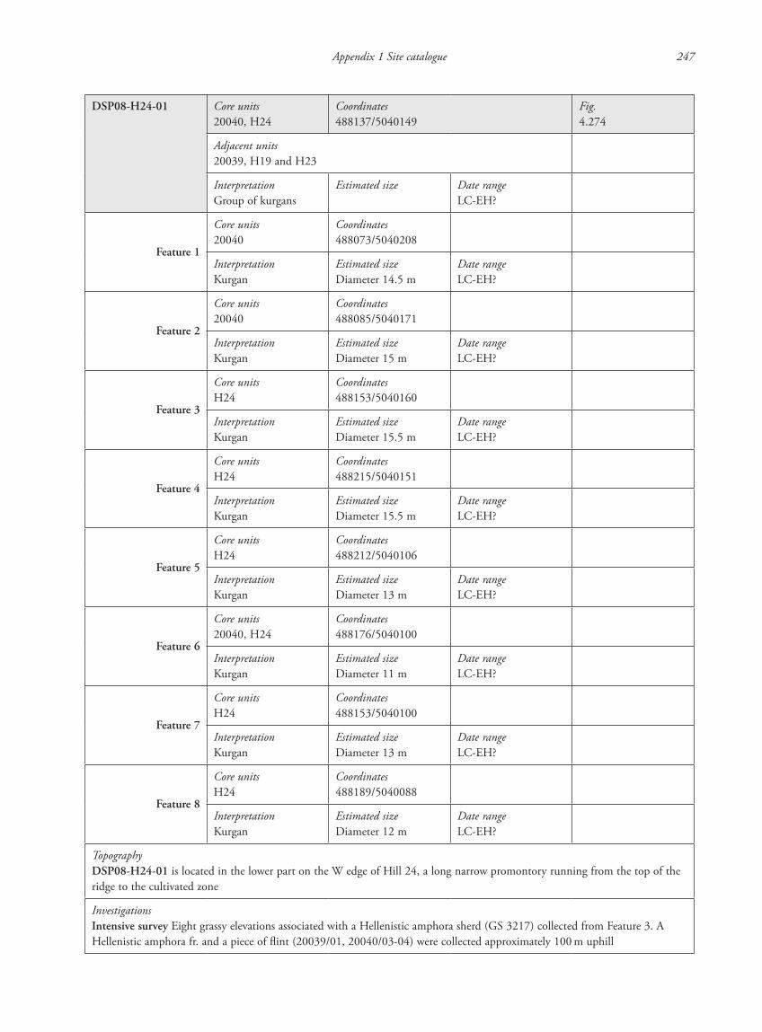
Appendix 1 Site catalogue 247
DSP08-H24-01 Core units20040, H24
Coordinates488137/5040149
Fig.4.274
Adjacent units20039, H19 and H23
InterpretationGroup of kurgans
Estimated size Date rangeLC-EH?
Feature 1
Core units20040
Coordinates488073/5040208
InterpretationKurgan
Estimated sizeDiameter 14.5 m
Date rangeLC-EH?
Feature 2
Core units20040
Coordinates488085/5040171
InterpretationKurgan
Estimated sizeDiameter 15 m
Date rangeLC-EH?
Feature 3
Core unitsH24
Coordinates488153/5040160
InterpretationKurgan
Estimated sizeDiameter 15.5 m
Date rangeLC-EH?
Feature 4
Core unitsH24
Coordinates488215/5040151
InterpretationKurgan
Estimated sizeDiameter 15.5 m
Date rangeLC-EH?
Feature 5
Core unitsH24
Coordinates488212/5040106
InterpretationKurgan
Estimated sizeDiameter 13 m
Date rangeLC-EH?
Feature 6
Core units20040, H24
Coordinates488176/5040100
InterpretationKurgan
Estimated sizeDiameter 11 m
Date rangeLC-EH?
Feature 7
Core unitsH24
Coordinates488153/5040100
InterpretationKurgan
Estimated sizeDiameter 13 m
Date rangeLC-EH?
Feature 8
Core unitsH24
Coordinates488189/5040088
InterpretationKurgan
Estimated sizeDiameter 12 m
Date rangeLC-EH?
TopographyDSP08-H24-01 is located in the lower part on the W edge of Hill 24, a long narrow promontory running from the top of the ridge to the cultivated zone
InvestigationsIntensive survey Eight grassy elevations associated with a Hellenistic amphora sherd (GS 3217) collected from Feature 3. A Hellenistic amphora fr. and a piece of flint (20039/01, 20040/03-04) were collected approximately 100 m uphill
87620_dzarylgac.indb 247 23-04-2012 20:35:43
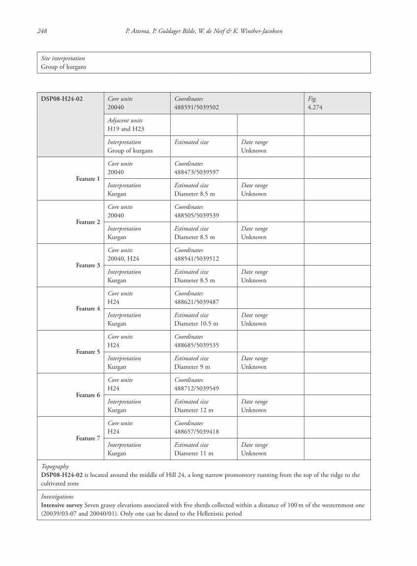
248 P. Attema, P. Guldager Bilde, W. de Neef & K. Winther-Jacobsen
Site interpretationGroup of kurgans
DSP08-H24-02 Core units20040
Coordinates488591/5039502
Fig.4.274
Adjacent unitsH19 and H23
InterpretationGroup of kurgans
Estimated size Date rangeUnknown
Feature 1
Core units20040
Coordinates488473/5039597
InterpretationKurgan
Estimated sizeDiameter 8.5 m
Date rangeUnknown
Feature 2
Core units20040
Coordinates488505/5039539
InterpretationKurgan
Estimated sizeDiameter 8.5 m
Date rangeUnknown
Feature 3
Core units20040, H24
Coordinates488541/5039512
InterpretationKurgan
Estimated sizeDiameter 8.5 m
Date rangeUnknown
Feature 4
Core unitsH24
Coordinates488621/5039487
InterpretationKurgan
Estimated sizeDiameter 10.5 m
Date rangeUnknown
Feature 5
Core unitsH24
Coordinates488685/5039535
InterpretationKurgan
Estimated sizeDiameter 9 m
Date rangeUnknown
Feature 6
Core unitsH24
Coordinates488712/5039549
InterpretationKurgan
Estimated sizeDiameter 12 m
Date rangeUnknown
Feature 7
Core unitsH24
Coordinates488657/5039418
InterpretationKurgan
Estimated sizeDiameter 11 m
Date rangeUnknown
TopographyDSP08-H24-02 is located around the middle of Hill 24, a long narrow promontory running from the top of the ridge to the cultivated zone
InvestigationsIntensive survey Seven grassy elevations associated with five sherds collected within a distance of 100 m of the westernmost one (20039/03-07 and 20040/01). Only one can be dated to the Hellenistic period
87620_dzarylgac.indb 248 23-04-2012 20:35:43
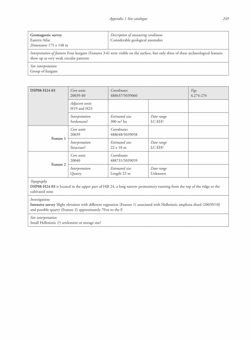
Appendix 1 Site catalogue 249
Geomagnetic surveyEastern AtlasDimensions 175 x 148 m
Description of measuring conditionsConsiderable geological anomalies
Interpretation of features Four kurgans (Features 3-6) were visible on the surface, but only three of these archaeological features show up as very weak circular patterns
Site interpretationGroup of kurgans
DSP08-H24-03 Core units20039-40
Coordinates488637/5039060
Figs.4.274-276
Adjacent unitsH19 and H23
InterpretationSettlement?
Estimated size300 m2 ha
Date rangeLC-EH?
Feature 1
Core units20039
Coordinates488648/5039058
InterpretationStructure?
Estimated size22 x 18 m
Date rangeLC-EH?
Feature 2
Core units20040
Coordinates488731/5039059
InterpretationQuarry
Estimated sizeLength 22 m
Date rangeUnknown
TopographyDSP08-H24-03 is located in the upper part of Hill 24, a long narrow promontory running from the top of the ridge to the cultivated zone
InvestigationsIntensive survey Slight elevation with different vegetation (Feature 1) associated with Hellenistic amphora sherd (20039/10) and possible quarry (Feature 2) approximately 70 m to the E
Site interpretationSmall Hellenistic (?) settlement or storage site?
87620_dzarylgac.indb 249 23-04-2012 20:35:43
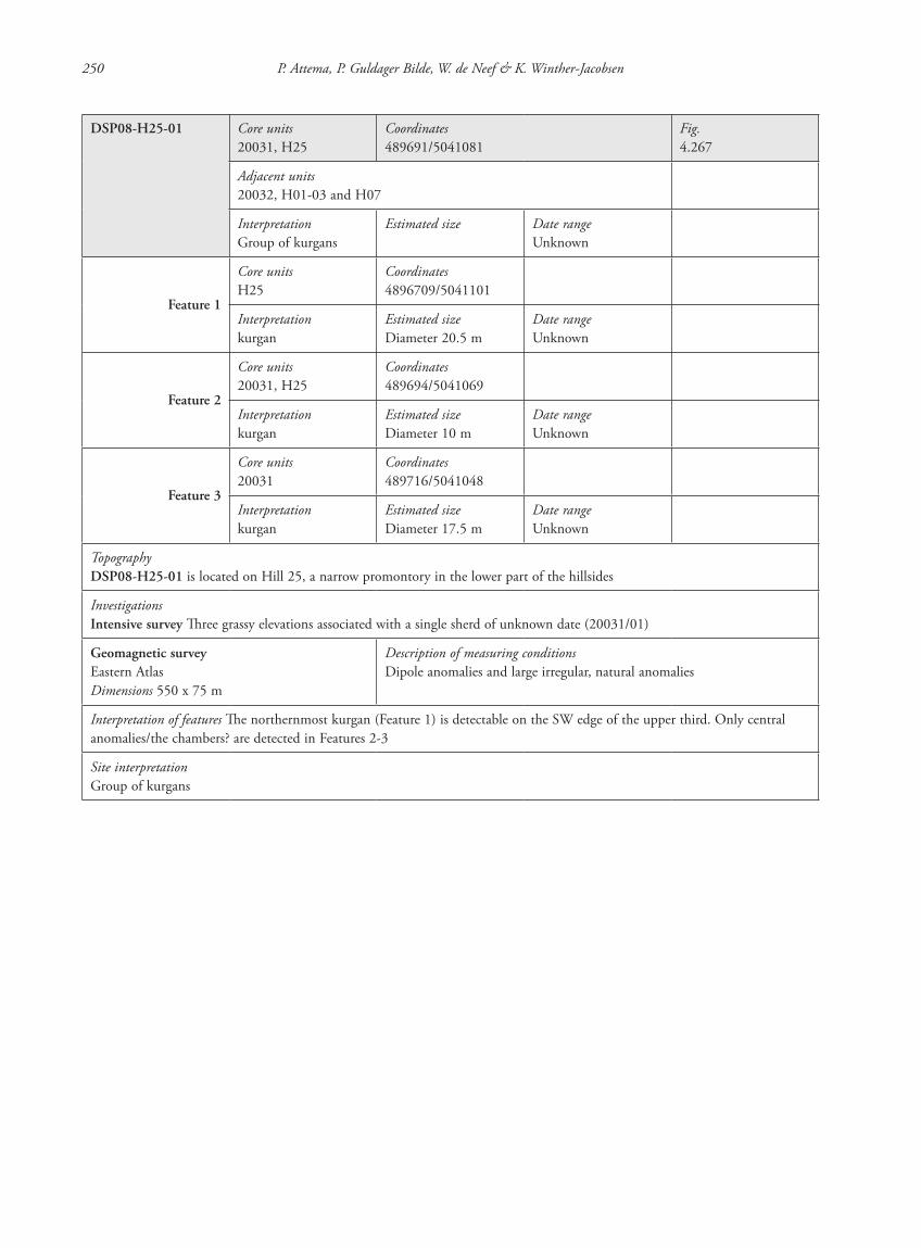
250 P. Attema, P. Guldager Bilde, W. de Neef & K. Winther-Jacobsen
DSP08-H25-01 Core units20031, H25
Coordinates489691/5041081
Fig.4.267
Adjacent units20032, H01-03 and H07
InterpretationGroup of kurgans
Estimated size Date rangeUnknown
Feature 1
Core unitsH25
Coordinates4896709/5041101
Interpretationkurgan
Estimated sizeDiameter 20.5 m
Date rangeUnknown
Feature 2
Core units20031, H25
Coordinates489694/5041069
Interpretationkurgan
Estimated sizeDiameter 10 m
Date rangeUnknown
Feature 3
Core units20031
Coordinates489716/5041048
Interpretationkurgan
Estimated sizeDiameter 17.5 m
Date rangeUnknown
TopographyDSP08-H25-01 is located on Hill 25, a narrow promontory in the lower part of the hillsides
InvestigationsIntensive survey Three grassy elevations associated with a single sherd of unknown date (20031/01)
Geomagnetic surveyEastern AtlasDimensions 550 x 75 m
Description of measuring conditions Dipole anomalies and large irregular, natural anomalies
Interpretation of features The northernmost kurgan (Feature 1) is detectable on the SW edge of the upper third. Only central anomalies/the chambers? are detected in Features 2-3
Site interpretationGroup of kurgans
87620_dzarylgac.indb 250 23-04-2012 20:35:43

Appendix 1 Site catalogue 251
DSP08-H25-02 Core units20031
Coordinates489850/5040589
Figs.4.267-268
Adjacent unitsH01-03 and H07
InterpretationGroup? of Kurgans
Estimated size–
Date rangeUnknown
Feature 1
Core units20031
Coordinates489836/5040591
InterpretationKurgan
Estimated sizeDiameter 7 m
Date rangeUnknown
Feature 2
Core units20031
Coordinates489864/5040586
InterpretationKurgan
Estimated sizeDiameter 6.5 m
Date rangeUnknown
TopographyDSP08-H25-02 is located on Hill 25, a narrow promontory in the lower part of the hillsides
InvestigationsIntensive survey Small grassy elevation, but no finds associated
Geomagnetic surveyEastern AtlasDimensions 75 x 550 m
Description of measuring conditionsDipole anomalies and large irregular, natural anomalies
Interpretation of features Kurgan (Feature 1) clearly detectable on the SW edge. Strong positive anomalies S of it
Site interpretationKurgans
87620_dzarylgac.indb 251 23-04-2012 20:35:44
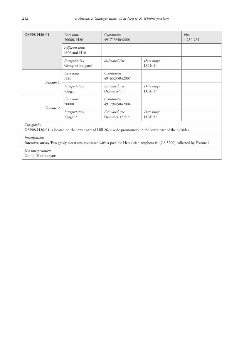
252 P. Attema, P. Guldager Bilde, W. de Neef & K. Winther-Jacobsen
DSP08-H26-01 Core units20000, H26
Coordinates491715/5042001
Figs.4.230-231
Adjacent unitsH06 and H16
InterpretationGroup of kurgans?
Estimated size–
Date rangeLC-EH?
Feature 1
Core unitsH26
Coordinates491652/5042007
InterpretationKurgan
Estimated sizeDiameter 9 m
Date rangeLC-EH?
Feature 2
Core units20000
Coordinates491794/5042004
InterpretationKurgan?
Estimated sizeDiameter 13.5 m
Date rangeLC-EH?
TopographyDSP08-H26-01 is located on the lower part of Hill 26, a wide promontory in the lower part of the hillsides
InvestigationsIntensive survey Two grassy elevations associated with a possible Herakleian amphora fr. (GS 3200) collected by Feature 1
Site interpretationGroup (?) of kurgans
87620_dzarylgac.indb 252 23-04-2012 20:35:44

Appendix 1 Site catalogue 253
DSP08-H26-02 Core units20001, 20030, H26
Coordinates491930/5041989
Figs.4.230, 4.232
Adjacent units20000, 200029, H06 and H16
InterpretationGroup of kurgans
Estimated size Date rangeLC-EH?
Feature 1
Core units20001
Coordinates491901/5042028
InterpretationKurgan
Estimated sizeDiameter 12.5 m
Date rangeLC-EH?
Feature 2
Core unitsH26
Coordinates491929/5042027
InterpretationSpoil heap?
Estimated sizeDiameter 8.5 m
Date rangeLC-EH?
Feature 3
Core units20001
Coordinates491924/5042006
InterpretationSpoil heap?
Estimated sizeDiameter 8.5 m
Date rangeLC-EH?
Feature 4
Core units20001
Coordinates491919/5041993
InterpretationSpoil heap?
Estimated sizeDiameter 10.5 m
Date rangeLC-EH?
Feature 5
Core units20001
Coordinates491929/5041974
InterpretationKurgan
Estimated sizeDiameter 15.5 m
Date rangeLC-EH?
Feature 6
Core units20001, 20030
Coordinates491970/50419769
InterpretationKurgan
Estimated sizeDiameter 20 m
Date rangeLC-EH?
TopographyDSP08-H26-02 is located on the lower part of Hill 26, a wide promontory in the lower part of the hillsides
InvestigationsIntensive survey Three grassy elevations associated with heaps of rock frs. Five Hellenistic sherds associated with the area (20001/01, 20029/01 and 20030/01), three of which came from just N of Feature 6
Site interpretationGroup of kurgans
87620_dzarylgac.indb 253 23-04-2012 20:35:44
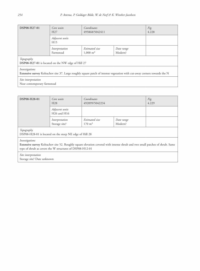
254 P. Attema, P. Guldager Bilde, W. de Neef & K. Winther-Jacobsen
DSP08-H27-01 Core unitsH27
Coordinates495868/5042411
Fig.4.228
Adjacent unitsH15
InterpretationFarmstead
Estimated size1,000 m2
Date rangeModern?
TopographyDSP08-H27-01 is located on the NW edge of Hill 27
InvestigationsExtensive survey Koltuchov site 37. Large roughly square patch of intense vegetation with cut-away corners towards the N
Site interpretationNear contemporary farmstead
DSP08-H28-01 Core unitsH28
Coordinates492099/5042234
Fig.4.229
Adjacent unitsH26 and H16
InterpretationStorage site?
Estimated size170 m2
Date rangeModern?
TopographyDSP08-H28-01 is located on the steep NE edge of Hill 28
InvestigationsExtensive survey Koltuchov site 52. Roughly square elevation covered with intense shrub and two small patches of shrub. Same type of shrub as covers the W structures of DSP08-H12-01
Site interpretationStorage site? Date unknown
87620_dzarylgac.indb 254 23-04-2012 20:35:44
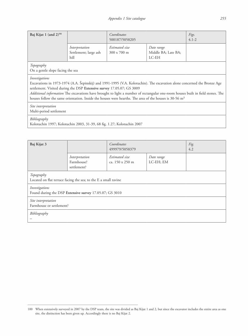
Appendix 1 Site catalogue 255
Baj Kijat 1 (and 2)98 Coordinates500187/5058205
Figs.4.1-2
InterpretationSettlement; large ash hill
Estimated size300 x 700 m
Date rangeMiddle BA; Late BA; LC-EH
TopographyOn a gentle slope facing the sea
InvestigationsExcavations in 1973-1974 (A.A. Šepinskij) and 1991-1995 (V.A. Kolotuchin). The excavation alone concerned the Bronze Age settlement. Visited during the DSP Extensive survey 17.05.07; GS 3009Additional information The excavations have brought to light a number of rectangular one-room houses built in field stones. The houses follow the same orientation. Inside the houses were hearths. The area of the houses is 30-56 m2
Site interpretationMulti-period settlement
BibliographyKolotuchin 1997; Kolotuchin 2003, 31-39, 68 fig. 1.27; Kolotuchin 2007
Baj Kijat 3 Coordinates499979/5058379
Fig.4.2
InterpretationFarmhouse? settlement?
Estimated sizeca. 150 x 250 m
Date rangeLC-EH; EM
TopographyLocated on flat terrace facing the sea; to the E a small ravine
InvestigationsFound during the DSP Extensive survey 17.05.07; GS 3010
Site interpretationFarmhouse or settlement?
Bibliography–
100 When extensively surveyed in 2007 by the DSP team, the site was divided as Baj Kijat 1 and 2, but since the excavator includes the entire area as one site, the distinction has been given up. Accordingly there is no Baj Kijat 2.
87620_dzarylgac.indb 255 23-04-2012 20:35:45
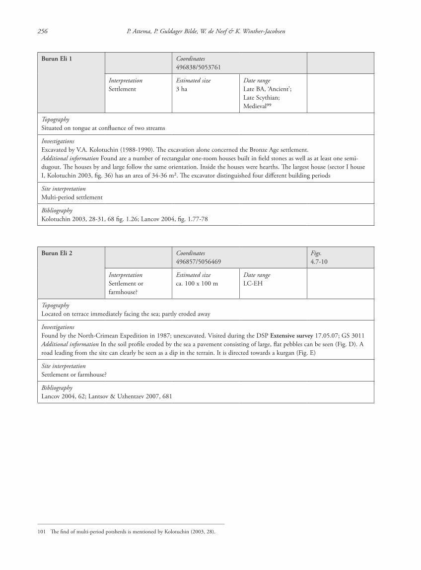
256 P. Attema, P. Guldager Bilde, W. de Neef & K. Winther-Jacobsen
Burun Eli 1 Coordinates496838/5053761
InterpretationSettlement
Estimated size3 ha
Date rangeLate BA, ‘Ancient’; Late Scythian; Medieval99
TopographySituated on tongue at confluence of two streams
InvestigationsExcavated by V.A. Kolotuchin (1988-1990). The excavation alone concerned the Bronze Age settlement.Additional information Found are a number of rectangular one-room houses built in field stones as well as at least one semi-dugout. The houses by and large follow the same orientation. Inside the houses were hearths. The largest house (sector I house I, Kolotuchin 2003, fig. 36) has an area of 34-36 m2. The excavator distinguished four different building periods
Site interpretationMulti-period settlement
BibliographyKolotuchin 2003, 28-31, 68 fig. 1.26; Lancov 2004, fig. 1.77-78
Burun Eli 2 Coordinates496857/5056469
Figs.4.7-10
InterpretationSettlement or farmhouse?
Estimated sizeca. 100 x 100 m
Date rangeLC-EH
TopographyLocated on terrace immediately facing the sea; partly eroded away
InvestigationsFound by the North-Crimean Expedition in 1987; unexcavated. Visited during the DSP Extensive survey 17.05.07; GS 3011Additional information In the soil profile eroded by the sea a pavement consisting of large, flat pebbles can be seen (Fig. D). A road leading from the site can clearly be seen as a dip in the terrain. It is directed towards a kurgan (Fig. E)
Site interpretationSettlement or farmhouse?
BibliographyLancov 2004, 62; Lantsov & Uzhentzev 2007, 681
101 The find of multi-period potsherds is mentioned by Kolotuchin (2003, 28).
87620_dzarylgac.indb 256 23-04-2012 20:35:45
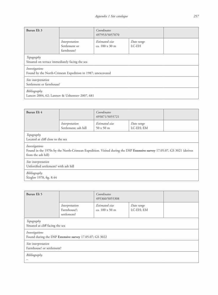
Appendix 1 Site catalogue 257
Burun Eli 3 Coordinates497953/5057070
InterpretationSettlement or farmhouse?
Estimated sizeca. 100 x 30 m
Date rangeLC-EH
TopographySituated on terrace immediately facing the sea
InvestigationsFound by the North-Crimean Expedition in 1987; unexcavated
Site interpretationSettlement or farmhouse?
BibliographyLancov 2004, 62; Lantsov & Uzhentzev 2007, 681
Burun Eli 4 Coordinates495871/5055721
InterpretationSettlement; ash hill
Estimated size50 x 50 m
Date rangeLC-EH; EM
TopographyLocated at cliff close to the sea
InvestigationsFound in the 1970s by the North-Crimean Expedition. Visited during the DSP Extensive survey 17.05.07, GS 3021 (derives from the ash hill)
Site interpretationUnfortified settlement? with ash hill
BibliographyŠčeglov 1978, fig. 8.44
Burun Eli 5 Coordinates495360/5055308
InterpretationFarmhouse?; settlement?
Estimated sizeca. 100 x 50 m
Date rangeLC-EH; EM
TopographySituated at cliff facing the sea
InvestigationsFound during the DSP Extensive survey 17.05.07; GS 3022
Site interpretationFarmhouse? or settlement?
Bibliography–
87620_dzarylgac.indb 257 23-04-2012 20:35:45

258 P. Attema, P. Guldager Bilde, W. de Neef & K. Winther-Jacobsen
Černomorskoe Settlement (traditionally identified as Kalos Limen)
Coordinates477655/5040468
Figs.4.23-27
InterpretationFortified city
Estimated size200 x 140 m
Date rangeEarly 4th c. BC-early 2nd c. AD; late 3rd-early 4th c. AD; 8th-10th c. AD
TopographyAt the NE outskirts of the modern district town of Černomorskoe by the Uzkaja (‘Narrow’) Bay is located a small fortified harbour city. Its location, which is drawn back and thus sheltered from the sea, is at the E side of the outer part of the Kel’šejch Ravine. The topography of the site is somewhat altered since antiquity. In early antiquity the city was probably surrounded by water to the W (as today) as well as to the S. At some point, the stream of the Kel’šejch Ravine has been cut off from the sea by a narrow sand barrier thus creating a small brackish lagoon. Today, part of the ancient town is under water
InvestigationsScientific excavation has taken place in the ancient settlement since 1929 (L.A. Moiseev; for a summary of the excavation history with references, see Užencev 2006, 10-15; Lantsov & Uzhentzev 2006, 699-705). P.N. Schulz worked here in 1933 and in 1948 as did K.E. Grinevič in 1946. The Tauro-Scythian Expedition excavated at the site in 1948 and 1950 (M.A. Nalivkina, G.D. Smirnov) and in 1959 a joint Soviet-Polish expedition worked here (V.F. Gajdukevič, K. Michalowski; M.L. Bernhard). In 1962-1963 the Tarchankut Expedition excavated in the site (A.N. Ščeglov). After a hiatus in the investigations, in 1988 the site became the study object of the West-Crimean Expedition under the direction of V.A. Kutajsov. Recently, the first monograph of the site was published (Užencev 2006)
Site interpretationMulti-period fortified city
BibliographyŠčeglov 1978, fig. 8.35; Ajbabin 2003, fig. 4.105; Lancov 2004, fig. 1.66; Užencev 2004; Lantsov & Uzhentzev 2006, 699-705; Užencev 2006; Kutajsov & Pridnev 2007
Černomorskoefarm 1
Coordinates (approx.)477816/5040932
InterpretationFarmhouse
Estimated size?
Date rangeLC-EH
TopographyBy Uzkaja Bay, NE of the Černomorskoe Settlement
InvestigationsExcavated by P.N. Schulz in 1933Additional information Ščeglov mentions the presence of walls and pits
Site interpretationFarmhouse?
BibliographyŠčeglov 1967, fig. 2.8
87620_dzarylgac.indb 258 23-04-2012 20:35:45
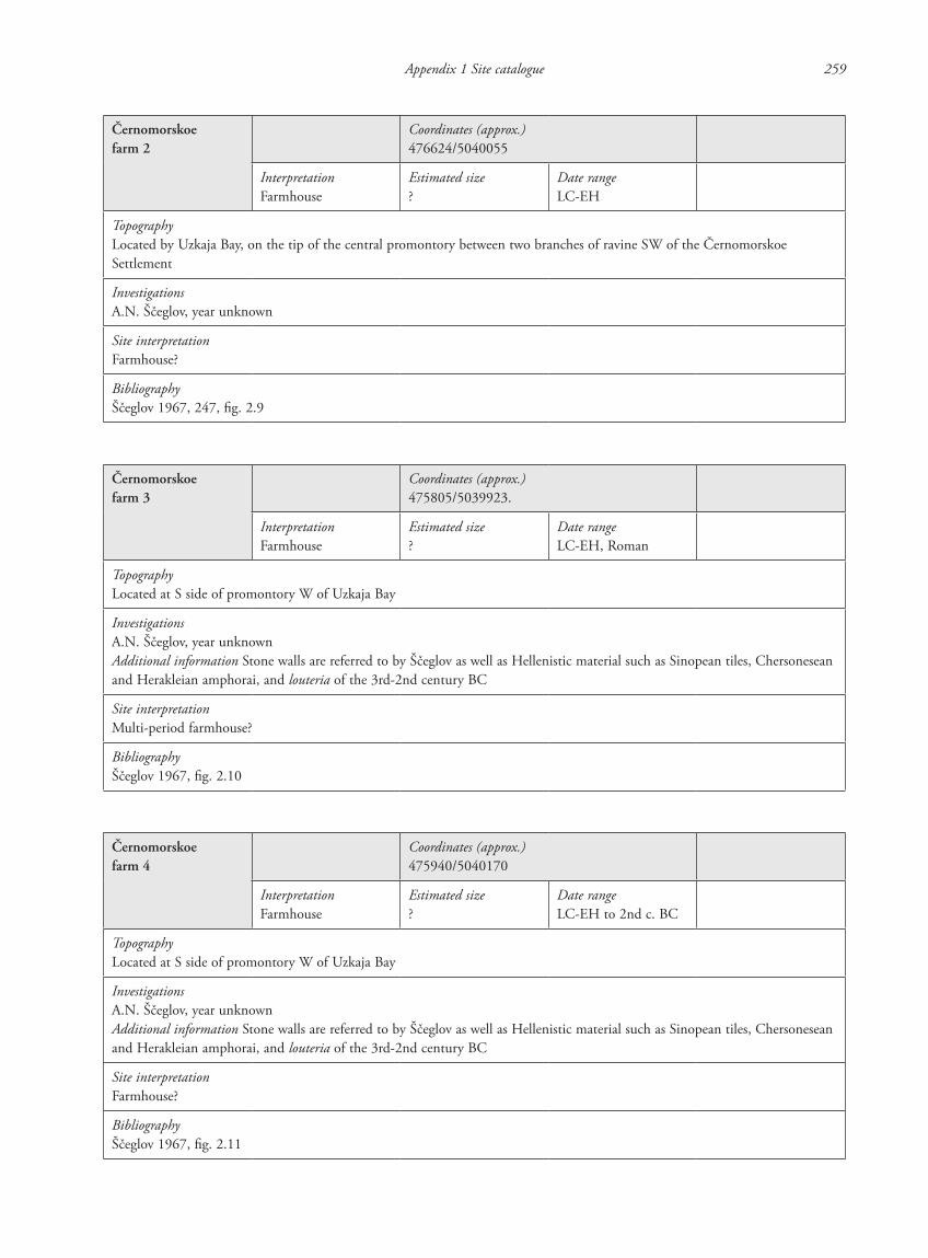
Appendix 1 Site catalogue 259
Černomorskoefarm 2
Coordinates (approx.)476624/5040055
InterpretationFarmhouse
Estimated size?
Date rangeLC-EH
TopographyLocated by Uzkaja Bay, on the tip of the central promontory between two branches of ravine SW of the Černomorskoe Settlement
InvestigationsA.N. Ščeglov, year unknown
Site interpretationFarmhouse?
BibliographyŠčeglov 1967, 247, fig. 2.9
Černomorskoefarm 3
Coordinates (approx.)475805/5039923.
InterpretationFarmhouse
Estimated size?
Date rangeLC-EH, Roman
TopographyLocated at S side of promontory W of Uzkaja Bay
InvestigationsA.N. Ščeglov, year unknownAdditional information Stone walls are referred to by Ščeglov as well as Hellenistic material such as Sinopean tiles, Chersonesean and Herakleian amphorai, and louteria of the 3rd-2nd century BC
Site interpretationMulti-period farmhouse?
BibliographyŠčeglov 1967, fig. 2.10
Černomorskoefarm 4
Coordinates (approx.)475940/5040170
InterpretationFarmhouse
Estimated size?
Date rangeLC-EH to 2nd c. BC
TopographyLocated at S side of promontory W of Uzkaja Bay
InvestigationsA.N. Ščeglov, year unknownAdditional information Stone walls are referred to by Ščeglov as well as Hellenistic material such as Sinopean tiles, Chersonesean and Herakleian amphorai, and louteria of the 3rd-2nd century BC
Site interpretationFarmhouse?
BibliographyŠčeglov 1967, fig. 2.11
87620_dzarylgac.indb 259 23-04-2012 20:35:46
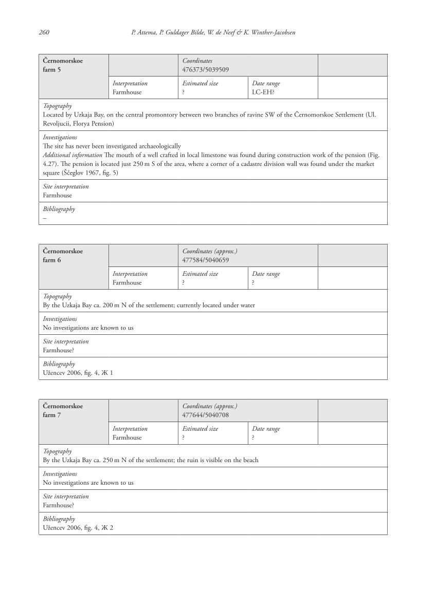
260 P. Attema, P. Guldager Bilde, W. de Neef & K. Winther-Jacobsen
Černomorskoefarm 5
Coordinates476373/5039509
InterpretationFarmhouse
Estimated size?
Date rangeLC-EH?
TopographyLocated by Uzkaja Bay, on the central promontory between two branches of ravine SW of the Černomorskoe Settlement (Ul. Revoljucii, Florya Pension)
InvestigationsThe site has never been investigated archaeologicallyAdditional information The mouth of a well crafted in local limestone was found during construction work of the pension (Fig. 4.27). The pension is located just 250 m S of the area, where a corner of a cadastre division wall was found under the market square (Ščeglov 1967, fig. 5)
Site interpretationFarmhouse
Bibliography–
Černomorskoefarm 6
Coordinates (approx.)477584/5040659
InterpretationFarmhouse
Estimated size?
Date range?
TopographyBy the Uzkaja Bay ca. 200 m N of the settlement; currently located under water
InvestigationsNo investigations are known to us
Site interpretationFarmhouse?
BibliographyUžencev 2006, fig. 4, Ж 1
Černomorskoefarm 7
Coordinates (approx.)477644/5040708
InterpretationFarmhouse
Estimated size?
Date range?
TopographyBy the Uzkaja Bay ca. 250 m N of the settlement; the ruin is visible on the beach
InvestigationsNo investigations are known to us
Site interpretationFarmhouse?
BibliographyUžencev 2006, fig. 4, Ж 2
87620_dzarylgac.indb 260 23-04-2012 20:35:46
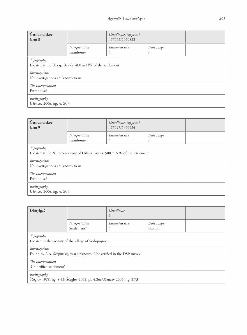
Appendix 1 Site catalogue 261
Černomorskoefarm 8
Coordinates (approx.)477443/5040832
InterpretationFarmhouse
Estimated size?
Date range?
TopographyLocated at the Uzkaja Bay ca. 400 m NW of the settlement
InvestigationsNo investigations are known to us
Site interpretationFarmhouse?
BibliographyUžencev 2006, fig. 4, Ж 3
Černomorskoefarm 9
Coordinates (approx.)477497/5040934
InterpretationFarmhouse
Estimated size?
Date range?
TopographyLocated at the NE promontory of Uzkaja Bay ca. 500 m NW of the settlement
InvestigationsNo investigations are known to us
Site interpretationFarmhouse?
BibliographyUžencev 2006, fig. 4, Ж 4
Džarylgač Coordinates?
InterpretationSettlement?
Estimated size?
Date rangeLC-EH
TopographyLocated in the vicinity of the village of Vodopojnoe
InvestigationsFound by A.A. Ščepinskij, year unknown. Not verified in the DSP survey
Site interpretation‘Unfortified settlement’
BibliographyŠčeglov 1978, fig. 8.42; Ščeglov 2002, pl. 4.26; Užencev 2006, fig. 2.73
87620_dzarylgac.indb 261 23-04-2012 20:35:46
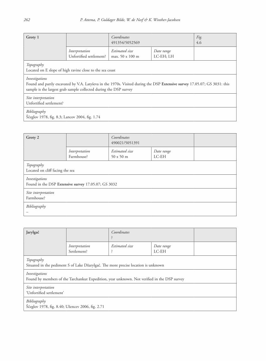
262 P. Attema, P. Guldager Bilde, W. de Neef & K. Winther-Jacobsen
Groty 1 Coordinates491354/5052569
Fig.4.6
InterpretationUnfortified settlement?
Estimated sizemax. 50 x 100 m
Date rangeLC-EH; LH
TopographyLocated on E slope of high ravine close to the sea coast
InvestigationsFound and partly excavated by V.A. Latyševa in the 1970s. Visited during the DSP Extensive survey 17.05.07; GS 3031: this sample is the largest grab sample collected during the DSP survey
Site interpretationUnfortified settlement?
BibliographyŠčeglov 1978, fig. 8.3; Lancov 2004, fig. 1.74
Groty 2 Coordinates490021/5051391
InterpretationFarmhouse?
Estimated size50 x 50 m
Date rangeLC-EH
TopographyLocated on cliff facing the sea
InvestigationsFound in the DSP Extensive survey 17.05.07; GS 3032
Site interpretationFarmhouse?
Bibliography–
Jarylgač Coordinates?
InterpretationSettlement?
Estimated size?
Date rangeLC-EH
TopographySituated in the pediment S of Lake Džarylgač. The more precise location is unknown
InvestigationsFound by members of the Tarchankut Expedition, year unknown. Not verified in the DSP survey
Site interpretation‘Unfortified settlement’
BibliographyŠčeglov 1978, fig. 8.40; Užencev 2006, fig. 2.71
87620_dzarylgac.indb 262 23-04-2012 20:35:47
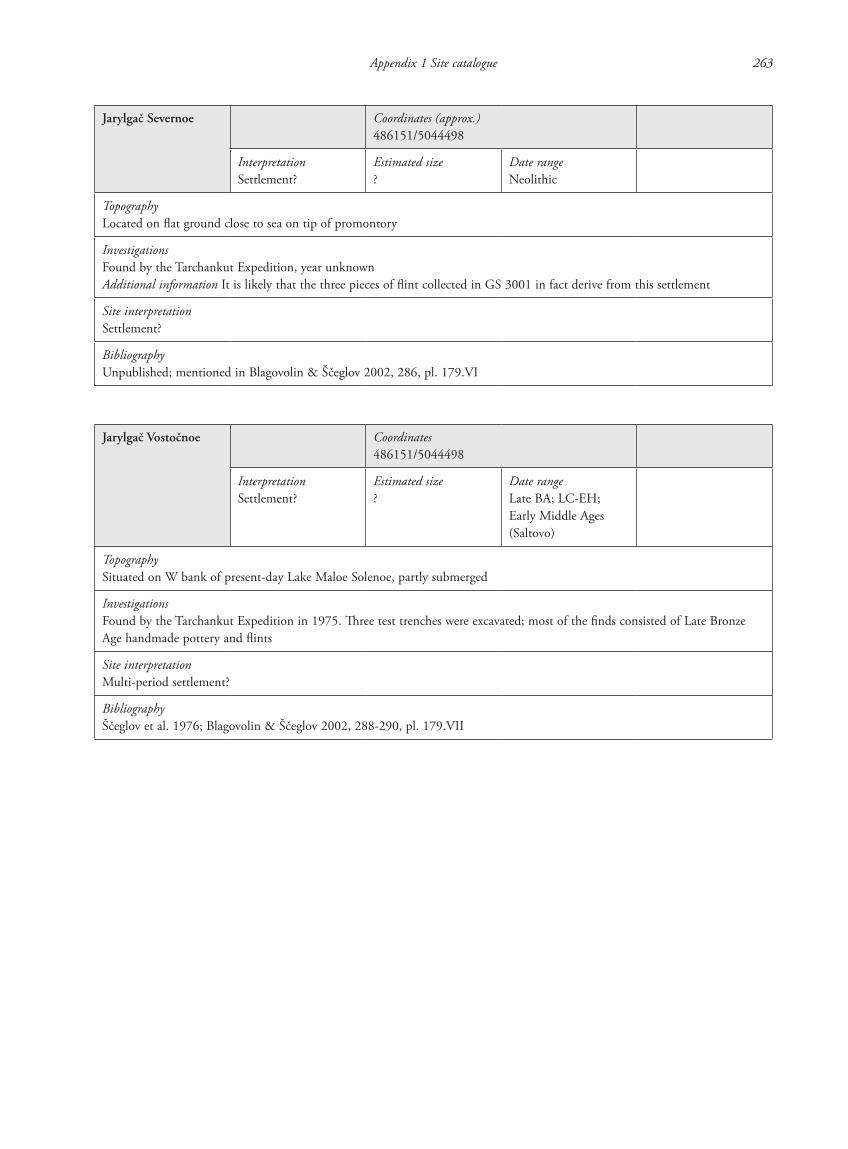
Appendix 1 Site catalogue 263
Jarylgač Severnoe Coordinates (approx.)486151/5044498
InterpretationSettlement?
Estimated size?
Date rangeNeolithic
TopographyLocated on flat ground close to sea on tip of promontory
InvestigationsFound by the Tarchankut Expedition, year unknownAdditional information It is likely that the three pieces of flint collected in GS 3001 in fact derive from this settlement
Site interpretationSettlement?
BibliographyUnpublished; mentioned in Blagovolin & Ščeglov 2002, 286, pl. 179.VI
Jarylgač Vostočnoe Coordinates486151/5044498
InterpretationSettlement?
Estimated size?
Date rangeLate BA; LC-EH; Early Middle Ages (Saltovo)
TopographySituated on W bank of present-day Lake Maloe Solenoe, partly submerged
InvestigationsFound by the Tarchankut Expedition in 1975. Three test trenches were excavated; most of the finds consisted of Late Bronze Age handmade pottery and flints
Site interpretationMulti-period settlement?
BibliographyŠčeglov et al. 1976; Blagovolin & Ščeglov 2002, 288-290, pl. 179.VII
87620_dzarylgac.indb 263 23-04-2012 20:35:47
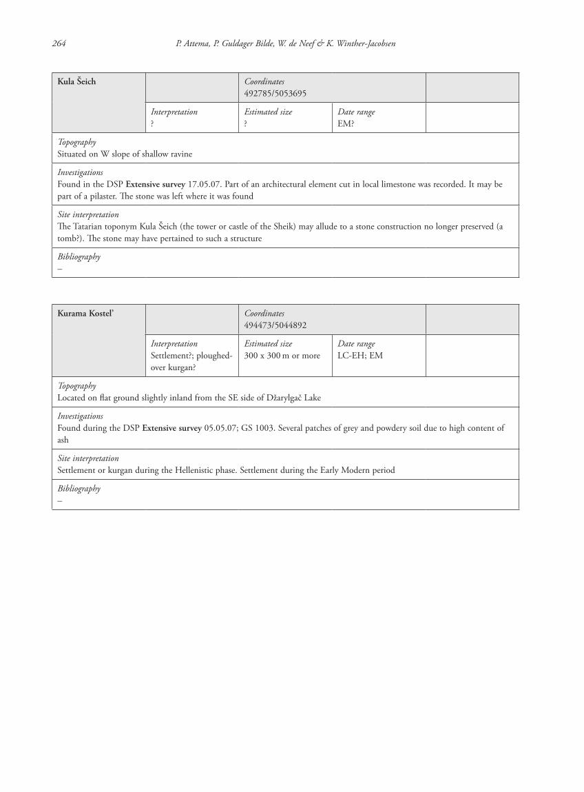
264 P. Attema, P. Guldager Bilde, W. de Neef & K. Winther-Jacobsen
Kula Šeich Coordinates492785/5053695
Interpretation?
Estimated size?
Date rangeEM?
TopographySituated on W slope of shallow ravine
InvestigationsFound in the DSP Extensive survey 17.05.07. Part of an architectural element cut in local limestone was recorded. It may be part of a pilaster. The stone was left where it was found
Site interpretationThe Tatarian toponym Kula Šeich (the tower or castle of the Sheik) may allude to a stone construction no longer preserved (a tomb?). The stone may have pertained to such a structure
Bibliography–
Kurama Kostel’ Coordinates494473/5044892
InterpretationSettlement?; ploughed-over kurgan?
Estimated size300 x 300 m or more
Date rangeLC-EH; EM
TopographyLocated on flat ground slightly inland from the SE side of Džarylgač Lake
InvestigationsFound during the DSP Extensive survey 05.05.07; GS 1003. Several patches of grey and powdery soil due to high content of ash
Site interpretationSettlement or kurgan during the Hellenistic phase. Settlement during the Early Modern period
Bibliography–
87620_dzarylgac.indb 264 23-04-2012 20:35:47
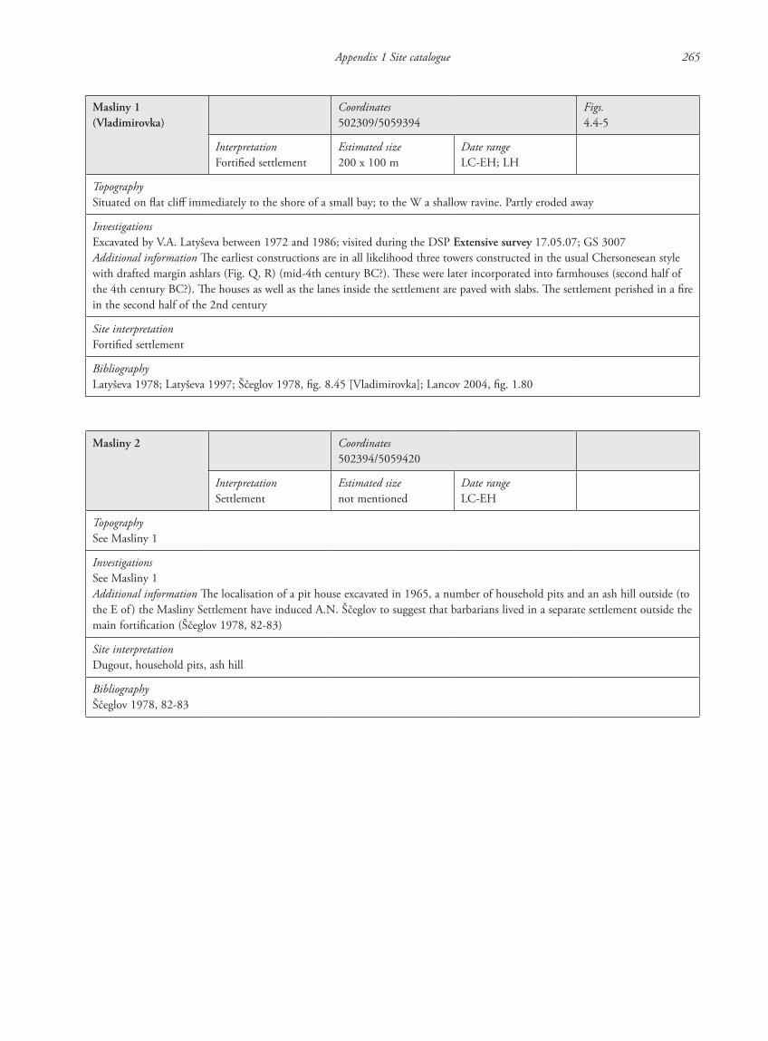
Appendix 1 Site catalogue 265
Masliny 1 (Vladimirovka)
Coordinates502309/5059394
Figs.4.4-5
InterpretationFortified settlement
Estimated size200 x 100 m
Date rangeLC-EH; LH
TopographySituated on flat cliff immediately to the shore of a small bay; to the W a shallow ravine. Partly eroded away
InvestigationsExcavated by V.A. Latyševa between 1972 and 1986; visited during the DSP Extensive survey 17.05.07; GS 3007Additional information The earliest constructions are in all likelihood three towers constructed in the usual Chersonesean style with drafted margin ashlars (Fig. Q, R) (mid-4th century BC?). These were later incorporated into farmhouses (second half of the 4th century BC?). The houses as well as the lanes inside the settlement are paved with slabs. The settlement perished in a fire in the second half of the 2nd century
Site interpretationFortified settlement
BibliographyLatyševa 1978; Latyševa 1997; Ščeglov 1978, fig. 8.45 [Vladimirovka]; Lancov 2004, fig. 1.80
Masliny 2 Coordinates502394/5059420
InterpretationSettlement
Estimated sizenot mentioned
Date rangeLC-EH
TopographySee Masliny 1
InvestigationsSee Masliny 1Additional information The localisation of a pit house excavated in 1965, a number of household pits and an ash hill outside (to the E of ) the Masliny Settlement have induced A.N. Ščeglov to suggest that barbarians lived in a separate settlement outside the main fortification (Ščeglov 1978, 82-83)
Site interpretationDugout, household pits, ash hill
BibliographyŠčeglov 1978, 82-83
87620_dzarylgac.indb 265 23-04-2012 20:35:48
266 P. Attema, P. Guldager Bilde, W. de Neef & K. Winther-Jacobsen
Masliny 3 Coordinates501413/5059108
InterpretationFarmhouse?
Estimated sizeca. 150 x 50 m
Date rangeLC-EH
TopographyLocated on cliff facing the sea
InvestigationsFound during the DSP Extensive survey 12.05.07; GS 3008
Site interpretationFarmhouse?
Bibliography–
Mežvodnoe Coordinates?
InterpretationUnfortified(?) farmhouse
Estimated size?
Date rangeLC-EH
TopographyLocated at the Jarylgač Bay; the more precise location is unknown
InvestigationsExcavated by T.N. Vysotskaja in 1967. A test trench was occasioned by the occasional find of a limestone relief with a reclining Herakles. Of the farmhouse was only excavated a single room and a courtyard
Site interpretationUnfortified(?) farmhouse
BibliographyVysotskaja 1968; 1969; Ščeglov 1978, fig. 8.41; Lancov 2004, fig. 1.72
87620_dzarylgac.indb 266 23-04-2012 20:35:48
Appendix 1 Site catalogue 267
Panskoe ISee also DSP07-F01-01
Coordinates485536/5044250
Figs.4.31, 4.33-37
InterpretationSettlement
Estimated sizeca. 4 ha + ca. 2 ha submerged100
Date rangeLC-EH; LH
Geomagnetic surveyT. Smekalova
TopographySituated on extended promontory between Lake Sasyk (now Panskoe) and Jarylgač Bay immediately at the coast of the lake
InvestigationsExcavated by the Tarchankut Expedition (1969-1994); GS 1004. In 2007 and 2008 the settlement of Panskoe I was surveyed with magnetometer by T.N. Smekalova assisted by A. Čudin. The purpose was to supplement the existing sketch plan, which has been published in several versions in order to determine the extension and composition of its layout (e.g. Ščeglov 2002, pl. 6). In 2007 were measured two large tracts S and W of U6 as well as a large tract E of U7 and a smaller one at the E outskirts of the settlement (Figs. 4.33, 35-36). In 2008 was measured a tract of land 35 m x 85 m E of U6. The results of these measurements allow us to complement the known picture of the settlement history of the site (Chapter 4.3.2.1)Interpretation Unlike the majority of the other rural settlements of the region, which are represented by isolated fortified and unfortified farmhouses, the layout of Panskoe is rather unique, as it represents an agglomeration of both well constructed, rectilinear farmhouses and other larger building structures
Site interpretationSettlement
BibliographyŠčeglov 1978, fig. 6.5, 8.36; Panskoe I 2002; Lancov 2004, fig. 1.67; comprehensive bibliography available at http://www.pontos.dk/research/ra_3/publications-devoted-to-panskoye
Panskoe II/DSP06-F03-01
Coordinates (centre)485810/5042440
Fig.4.31
InterpretationSettlement
Estimated sizeca. 40 m across (EM)
Date rangeLC-EH; LH; EM
TopographyLocated close to the present S shore of the Sasyk Lake at junction between E-W road and the Panskoe promontory in an unploughed area in the NE corner of Field 3
InvestigationsUnexcavated; soundings at the settlement were made by T.N. Vysotskaja in the late 1960sExtensive survey A scatter of ca. 40 m across in a patch of greyish soil containing many stones and Early Modern pottery among which pottery with a brown glaze. The halo of finds related to this site continue for only 60 to 80 m and at places much less. This means that there seems hardly any archaeological effect of the site on the surrounding terrain. Grab sample (GS 3002) collected in 2007Additional information Scattered in the terrain are a number of ashlar blocks that, provided they have not been transported from elsewhere, indicate that the building was intended as a permanent one. A square tower 10 x 10 m is mentioned by A.N. Ščeglov (Chtcheglov 1992, 151). An isolated farm is marked on the half-verst map of the 1890s in a location corresponding to this site. It may be the material remains thereof we have located
Site interpretationMulti-period site. Hellenistic fort or fortified farmhouse; Early Modern scatter of pottery, stones and ash, probably a farmhouse
BibliographyŠčeglov 1978, fig. 6.2, 8.37; Chtcheglov 1992, 151; Lancov 2004, fig. 1.68
102 Ščeglov 1987, 241.
87620_dzarylgac.indb 267 23-04-2012 20:35:48
268 P. Attema, P. Guldager Bilde, W. de Neef & K. Winther-Jacobsen
Panskoe III Coordinates (approx.)482117/5042790
Figs.4.31-32
InterpretationFarmhouse
Estimated size?
Date rangeLC-EH
TopographyLocated on gentle slope W of the Sasyk Ravine
InvestigationsLocated in 1972 (ŠČeglov et al. 1973, 354) and excavated by Ju.A. Vinogradov, E.Ja. Rogov, D. Naman in 1978. The building, which lacks its SE side, because it has been eroded away by the lake, may have been square in plan. It consists of a number of rooms grouped around a central courtyard
Site interpretationUnfortified, isolated farmstead
BibliographyŠčeglov 1978, fig. 6.3, 8.38; Ščeglov 1985, 5; plan in Ščeglov 1987, 259, fig. 2; Lancov 2004, fig. 1.69
Panskoe IV Coordinates (approx.)484337/5043652
Fig.4.31
InterpretationFarmhouse
Estimated sizeUnknown
Date rangeLC-EH
TopographyOriginally located at side of ravine; today submerged
InvestigationsNon-systematically investigated
Site interpretationIsolated farmhouse
BibliographyŠčeglov 1978, fig. 6.4, 8.39; Ščeglov 1987, 240; Lancov 2004, fig. 1.70
87620_dzarylgac.indb 268 23-04-2012 20:35:49
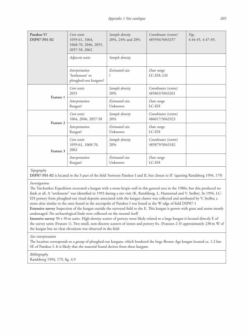
Appendix 1 Site catalogue 269
Panskoe V/ DSP07-F01-02
Core units1059-61, 1064, 1068-70, 2046, 2055, 2057-58, 2062
Sample density20%, 24% and 28%
Coordinates (centre)485956/5043257
Figs.4.44-45, 4.47-49,
Adjacent units Sample density
Interpretation‘Settlement’ or ploughed-out kurgans?
Estimated size?
Date rangeLC-EH; LH
Feature 1
Core units2055
Sample density20%
Coordinates (centre)485863/5043261
InterpretationKurgan?
Estimated sizeUnknown
Date rangeLC-EH
Feature 2
Core units1064, 2046, 2057-58
Sample density20%
Coordinates (centre)486017/5043323
InterpretationKurgan?
Estimated sizeUnknown
Date rangeLC-EH
Feature 3
Core units1059-61, 1068-70, 2062
Sample density20%
Coordinates (centre)485879/5043182
InterpretationKurgan?
Estimated sizeUnknown
Date rangeLC-EH
TopographyDSP07-F01-02 is located in the S part of the field ‘between Panskoe I and II, but closest to II’ (quoting Randsborg 1994, 179)
InvestigationsThe Tarchankut Expedition excavated a kurgan with a stone krepis wall in this general area in the 1980s, but this produced no finds at all. A “settlement” was identified in 1993 during a site visit (K. Randsborg, L. Hannestad and V. Stolba). In 1994, LC-EH pottery from ploughed-out ritual deposits associated with the kurgan cluster was collected and attributed by V. Stolba; a stone altar similar to the ones found in the necropolis of Panskoe I was found at the W edge of field DSP07-1Extensive survey Inspection of the kurgan outside the surveyed field to the E. This kurgan is grown with grass and seems mostly undamaged. No archaeological finds were collected on the mound itselfIntensive survey 50 x 50 m units. High-density scatter of pottery most likely related to a large kurgan is located directly E of the survey units (Feature 1). Two small, non-discrete scatters of stones and pottery frs. (Features 2-3) approximately 230 m W of the kurgan but no clear elevations was observed in the field
Site interpretationThe location corresponds to a group of ploughed-out kurgans, which bordered the large Bronze Age kurgan located ca. 1.2 km SE of Panskoe I. It is likely that the material found derives from these kurgans
BibliographyRandsborg 1994, 179, fig. 4.9
87620_dzarylgac.indb 269 23-04-2012 20:35:49
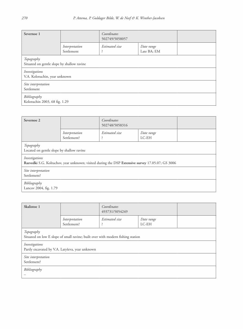
270 P. Attema, P. Guldager Bilde, W. de Neef & K. Winther-Jacobsen
Severnoe 1 Coordinates502749/5058057
InterpretationSettlement
Estimated size?
Date rangeLate BA; EM
TopographySituated on gentle slope by shallow ravine
InvestigationsV.A. Kolotuchin, year unknown
Site interpretationSettlement
BibliographyKolotuchin 2003, 68 fig. 1.29
Severnoe 2 Coordinates502748/5058316
InterpretationSettlement?
Estimated size?
Date rangeLC-EH
TopographyLocated on gentle slope by shallow ravine
InvestigationsRazvedki S.G. Koltuchov, year unknown; visited during the DSP Extensive survey 17.05.07; GS 3006
Site interpretationSettlement?
BibliographyLancov 2004, fig. 1.79
Skalistoe 1 Coordinates493731/5054249
InterpretationSettlement?
Estimated size?
Date rangeLC-EH
TopographySituated on low E slope of small ravine; built over with modern fishing station
InvestigationsPartly excavated by V.A. Latyševa, year unknown
Site interpretationSettlement?
Bibliography–
87620_dzarylgac.indb 270 23-04-2012 20:35:49

Appendix 1 Site catalogue 271
Skalistoe 2/ DSP08-F03-02
Core units6226, 6244-45, 6247
Sample density20%, 23%
Coordinates (centre)493952/5053607
Figs.4.98-101, 4.105-108
Adjacent units6227, 6243, 6246, 6248, 6265-67
Sample density20%
InterpretationSettlement
Estimated size3,000 m2, halo of ca. 12,500 m2
Date rangeBA, LC-EH
Phase 1 Core units6244
Sample density20%
Coordinates (centre)493983/5053614
InterpretationSettlement
Estimated size110 x 130 m
Date rangeBA
Phase 2 Core units6245, 6247
Sample density20%
Coordinates (centre)494052/5053588
InterpretationSettlement
Estimated size?
Date rangeLC-EH
TopographyDSP08-F03-02 is located in the SW corner of the surveyed field. The site is located shallow depression next to a ravine 650 m from the current coastline. Outside the field, on the other side of the ravine, an elevated plateau was visible which may be an extension of the site
InvestigationsA small scale excavation by V.A. Kolotuchin (1973; 1987) revealed house foundations of field stonesIntensive survey 50 x 60 m units; TS 6243/02-06; 6246/02; 6247/02. A high-density scatter with two components: a strong Bronze Age presence, especially in Unit 6244, and a larger Hellenistic part. The Hellenistic finds include amphorai, table- and utility wares
Geomagnetic surveyT. SmekalovaDimensions 3,500 m2
Description of measuring conditionsGood
Interpretation of features Six or seven weak positive anomalies, possibly pit houses
Augering Four augerings were conducted in a cross section over the site. The sediment seems very thin, except in auger 31 which has a 1,16 m layer of loam sediment. This core was taken at the eastern end of the site. No clear archaeological culture layer was detected.
Auger S28: 493983/5053527
0-0.20 m Loam, some grit, 10YR 3/2
0.20-0.30 m Loam, some small limestone inclusions, 10YR 3/2
0.30 m End of augering: soil too hard
Auger S29: 494016/5053558
0-0.20 m Loam, topsoil, 10YR 3/2
0.20-0.40 m Loam, 10YR 3/2
0.70 m End of augering, bedrock
Auger S30: 494034/5053574
0-0.10 m Loam, 10YR 3/2
0.10-0.30 m Loam, some limestone inclusions, 10YR4/2
87620_dzarylgac.indb 271 23-04-2012 20:35:50
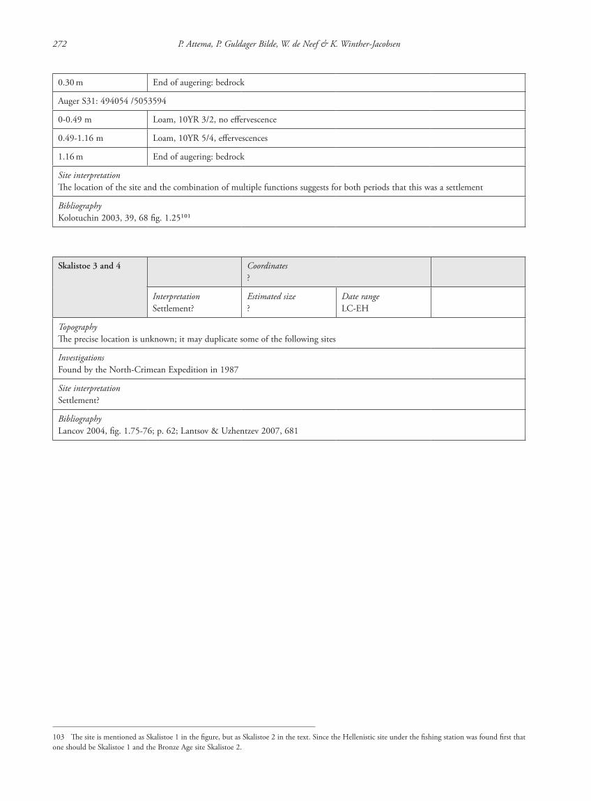
272 P. Attema, P. Guldager Bilde, W. de Neef & K. Winther-Jacobsen
0.30 m End of augering: bedrock
Auger S31: 494054 /5053594
0-0.49 m Loam, 10YR 3/2, no effervescence
0.49-1.16 m Loam, 10YR 5/4, effervescences
1.16 m End of augering: bedrock
Site interpretationThe location of the site and the combination of multiple functions suggests for both periods that this was a settlement
BibliographyKolotuchin 2003, 39, 68 fig. 1.25101
Skalistoe 3 and 4 Coordinates?
InterpretationSettlement?
Estimated size?
Date rangeLC-EH
TopographyThe precise location is unknown; it may duplicate some of the following sites
InvestigationsFound by the North-Crimean Expedition in 1987
Site interpretationSettlement?
BibliographyLancov 2004, fig. 1.75-76; p. 62; Lantsov & Uzhentzev 2007, 681
103 The site is mentioned as Skalistoe 1 in the figure, but as Skalistoe 2 in the text. Since the Hellenistic site under the fishing station was found first that one should be Skalistoe 1 and the Bronze Age site Skalistoe 2.
87620_dzarylgac.indb 272 23-04-2012 20:35:50
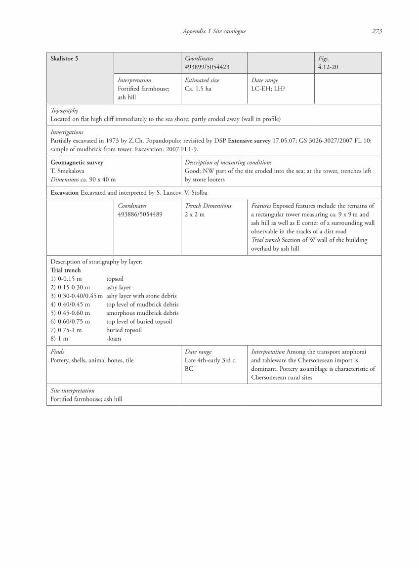
Appendix 1 Site catalogue 273
Skalistoe 5 Coordinates493899/5054423
Figs.4.12-20
InterpretationFortified farmhouse; ash hill
Estimated sizeCa. 1.5 ha
Date rangeLC-EH; LH?
TopographyLocated on flat high cliff immediately to the sea shore; partly eroded away (wall in profile)
InvestigationsPartially excavated in 1973 by Z.Ch. Popandopulo; revisited by DSP Extensive survey 17.05.07; GS 3026-3027/2007 FL 10; sample of mudbrick from tower. Excavation: 2007 FL1-9.
Geomagnetic surveyT. SmekalovaDimensions ca. 90 x 40 m
Description of measuring conditionsGood; NW part of the site eroded into the sea; at the tower, trenches left by stone looters
Excavation Excavated and interpreted by S. Lancov, V. Stolba
Coordinates493886/5054489
Trench Dimensions2 x 2 m
Features Exposed features include the remains of a rectangular tower measuring ca. 9 x 9 m and ash hill as well as E corner of a surrounding wall observable in the tracks of a dirt roadTrial trench Section of W wall of the building overlaid by ash hill
Description of stratigraphy by layer:Trial trench1) 0-0.15 m topsoil2) 0.15-0.30 m ashy layer3) 0.30-0.40/0.45 m ashy layer with stone debris4) 0.40/0.45 m top level of mudbrick debris5) 0.45-0.60 m amorphous mudbrick debris6) 0.60/0.75 m top level of buried topsoil7) 0.75-1 m buried topsoil8) 1 m -loam
FindsPottery, shells, animal bones, tile
Date rangeLate 4th-early 3rd c. BC
Interpretation Among the transport amphorai and tableware the Chersonesean import is dominant. Pottery assamblage is characteristic of Chersonesean rural sites
Site interpretationFortified farmhouse; ash hill
87620_dzarylgac.indb 273 23-04-2012 20:35:50
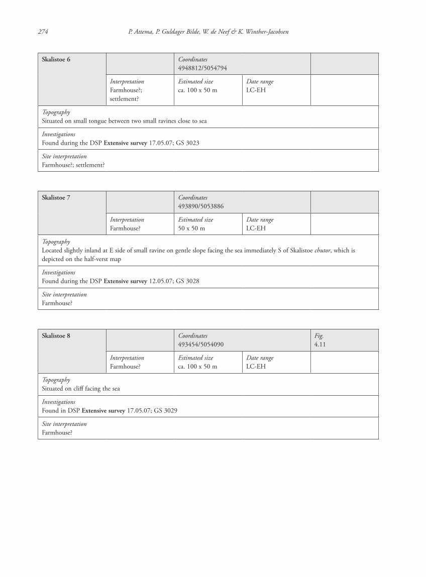
274 P. Attema, P. Guldager Bilde, W. de Neef & K. Winther-Jacobsen
Skalistoe 6 Coordinates4948812/5054794
InterpretationFarmhouse?; settlement?
Estimated sizeca. 100 x 50 m
Date rangeLC-EH
TopographySituated on small tongue between two small ravines close to sea
InvestigationsFound during the DSP Extensive survey 17.05.07; GS 3023
Site interpretationFarmhouse?; settlement?
Skalistoe 7 Coordinates493890/5053886
InterpretationFarmhouse?
Estimated size50 x 50 m
Date rangeLC-EH
TopographyLocated slightly inland at E side of small ravine on gentle slope facing the sea immediately S of Skalistoe chutor, which is depicted on the half-verst map
InvestigationsFound during the DSP Extensive survey 12.05.07; GS 3028
Site interpretationFarmhouse?
Skalistoe 8 Coordinates493454/5054090
Fig.4.11
InterpretationFarmhouse?
Estimated sizeca. 100 x 50 m
Date rangeLC-EH
TopographySituated on cliff facing the sea
InvestigationsFound in DSP Extensive survey 17.05.07; GS 3029
Site interpretationFarmhouse?
87620_dzarylgac.indb 274 23-04-2012 20:35:51
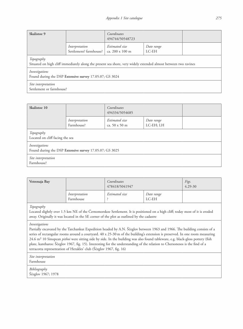
Appendix 1 Site catalogue 275
Skalistoe 9 Coordinates494744/50548723
InterpretationSettlement? farmhouse?
Estimated sizeca. 200 x 100 m
Date rangeLC-EH
TopographySituated on high cliff immediately along the present sea shore, very widely extended almost between two ravines
InvestigationsFound during the DSP Extensive survey 17.05.07; GS 3024
Site interpretationSettlement or farmhouse?
Skalistoe 10 Coordinates494334/5054685
InterpretationFarmhouse?
Estimated sizeca. 50 x 50 m
Date rangeLC-EH; LH
TopographyLocated on cliff facing the sea
InvestigationsFound during the DSP Extensive survey 17.05.07; GS 3025
Site interpretationFarmhouse?
Vetrenaja Bay Coordinates478418/5041947
Figs.4.29-30
InterpretationFarmhouse
Estimated size?
Date rangeLC-EH
TopographyLocated slightly over 1.5 km NE of the Černomorskoe Settlement. It is positioned on a high cliff; today most of it is eroded away. Originally it was located in the SE corner of the plot as outlined by the cadastre
InvestigationsPartially excavated by the Tarchankut Expedition headed by A.N. Ščeglov between 1963 and 1966. The building consists of a series of rectangular rooms around a courtyard. 40 x 25-30 m of the building’s extension is preserved. In one room measuring 24.6 m2 10 Sinopean pithoi were sitting side by side. In the building was also found tableware, e.g. black-gloss pottery (fish plate, kantharos: Ščeglov 1967, fig. 15). Interesting for the understanding of the relation to Chersonesos is the find of a terracotta representation of Herakles’ club (Ščeglov 1967, fig. 16)
Site interpretationFarmhouse
BibliographyŠčeglov 1967; 1978
87620_dzarylgac.indb 275 23-04-2012 20:35:51

276 P. Attema, P. Guldager Bilde, W. de Neef & K. Winther-Jacobsen
Vladimirovka Coordinates?
InterpretationSettlement?
Estimated size?
Date rangeLate BA
TopographyLocated inland; the more precise location is unknown
InvestigationsExcavated by V.A. Kolotuchin; year unknown; the site could not be verified in the DSP survey
Site interpretationSettlement?
BibliographyKolotuchin 2003, 68 fig. 1.28
Vodopojnoe 1(see chapter 4.3.3)
Coordinates493242/5047343
Fig.4.38
InterpretationSettlement
Estimated size?
Date rangeLate BA
TopographyLocated on W side of small ravine where it meets the Džarylgač Lake
InvestigationsFound by V.A. Kolotuchin; year unknownSystematic Extensive survey by DPS in 2007
Site interpretationSettlement
BibliographyKolotuchin 2003, 40, 68 fig. 1.22
Vodopojnoe 2 Coordinates497552/5049033
InterpretationSettlement, kurgan and farmhouse?
Estimated size50 x 50 m
Date rangeLate BA; LC-EH?; EM
TopographySituated in valley bottom on low elevation connected with soil bank to Bronze Age(?) kurgan
InvestigationsRazvedki S.G. Koltuchov; year unknown; visited during the DSP Extensive survey 27.05.07
Site interpretationMulti-period settlement, kurgan and farmhouse?
BibliographyKolotuchin 2003, 68 fig. 1.23
87620_dzarylgac.indb 276 23-04-2012 20:35:51
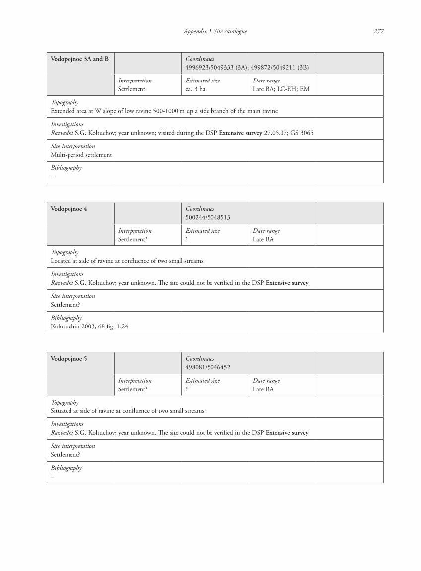
Appendix 1 Site catalogue 277
Vodopojnoe 3A and B Coordinates4996923/5049333 (3A); 499872/5049211 (3B)
InterpretationSettlement
Estimated sizeca. 3 ha
Date rangeLate BA; LC-EH; EM
TopographyExtended area at W slope of low ravine 500-1000 m up a side branch of the main ravine
InvestigationsRazvedki S.G. Koltuchov; year unknown; visited during the DSP Extensive survey 27.05.07; GS 3065
Site interpretationMulti-period settlement
Bibliography–
Vodopojnoe 4 Coordinates500244/5048513
InterpretationSettlement?
Estimated size?
Date rangeLate BA
TopographyLocated at side of ravine at confluence of two small streams
InvestigationsRazvedki S.G. Koltuchov; year unknown. The site could not be verified in the DSP Extensive survey
Site interpretationSettlement?
BibliographyKolotuchin 2003, 68 fig. 1.24
Vodopojnoe 5 Coordinates498081/5046452
InterpretationSettlement?
Estimated size?
Date rangeLate BA
TopographySituated at side of ravine at confluence of two small streams
InvestigationsRazvedki S.G. Koltuchov; year unknown. The site could not be verified in the DSP Extensive survey
Site interpretationSettlement?
Bibliography–
87620_dzarylgac.indb 277 23-04-2012 20:35:52

87620_dzarylgac.indb 278 23-04-2012 20:35:52