APPENDIX 1 – Protected Plant Survey Report, Coolum Ridges ...
19
Impact Management Plan – Coolum Ridges Southern Interchange Job No: Q01058/RW2 JWA Pty Ltd 26 APPENDIX 1 – Protected Plant Survey Report, Coolum Ridges Southern Interchange
Transcript of APPENDIX 1 – Protected Plant Survey Report, Coolum Ridges ...

Impact Management Plan – Coolum Ridges Southern Interchange
Job No: Q01058/RW2 JWA Pty Ltd 26
APPENDIX 1 – Protected Plant Survey Report, Coolum Ridges Southern Interchange

PROTECTED PLANT SURVEY REPORT Coolum Ridges Southern Interchange
A Report Prepared for Aveo Group Limited
AUGUST 2015

Protected Plant Survey Report – Coolum Ridges Southern Interchange
© 2015 JWA Pty Ltd All Rights Reserved. Copyright in the whole and every part of this document belongs to JWA Pty Ltd and may not be used, sold, transferred, copied or reproduced in whole or in part in any manner or form or in or on any media to any person without the prior written consent of JWA Pty Ltd.
DOCUMENT CONTROL Document
Title Protected Plant Survey Report
Job Number Q01058
File Reference \\SERVER\data\QLD CLIENT FILES\01058_Coolum Ridges\2015 Coolum interchange\Reports\Protected Plant Survey
Version and Date RW3 06/08/15
Client Aveo Group Limited
Revision History (office use only)
Issue Version Draft/ Final
Date Distributed To No. Copies
Media Delivery Method
1 RW1 DRAFT 04/06/15 JWA 1 Word Email 2 RW2 DRAFT 23/07/15 Aveo Group 1 PDF Email 3 RW3 FINAL 06/08/15 Aveo Group 1 PDF Email 4 5
Client Issue
Version Date Sent
Author Approved by
Name Initials Name Initials
RW2 23/07/15 Kirsty Macpherson /Adam McArthur KM/AM Adam McArthur AM
RW3 06/08/15 Kirsty Macpherson /Adam McArthur KM/AM Adam McArthur AM

Protected Plant Survey Report – Coolum Ridges Southern Interchange
Job No: Q01058/RW3 JWA Pty Ltd 3
TABLE OF CONTENTS
1 Introduction ....................................................................................... 41.1 Background ................................................................................... 41.2 The Subject Site ............................................................................. 41.3 The Proposed Development ................................................................ 4
2 Desktop Assessment .............................................................................. 52.1 Introduction .................................................................................. 52.2 Methods ....................................................................................... 5
2.2.1 Database Searches ...................................................................... 52.2.2 DEHP Environmental Mapping ......................................................... 62.2.3 Habitat Suitability Assessment ........................................................ 6
2.3 Results......................................................................................... 72.3.1 Database Searches ...................................................................... 72.3.2 DEHP Environmental Mapping ......................................................... 82.3.3 Habitat Suitability Assessment for Threatened Flora Species .................... 9
3 Site Assessment .................................................................................. 103.1 Introduction ................................................................................. 103.2 Methods ...................................................................................... 10
3.2.1 Introduction ............................................................................. 103.2.2 Surveyors ................................................................................ 103.2.3 Timed Random Meander Searches ................................................... 103.2.4 Survey Restrictions ..................................................................... 113.2.5 Specimen Identification ............................................................... 113.2.6 Nomenclature ........................................................................... 11
3.3 Results........................................................................................ 113.3.1 Introduction ............................................................................. 113.3.2 Protected Plants on the Site .......................................................... 113.3.3 Vegetation Community Descriptions ................................................ 123.3.4 Declared Weed Species ................................................................ 14
4 Impacts and Amelioration ...................................................................... 164.1 Introduction ................................................................................. 164.2 Potential Impacts of the Proposed Development ..................................... 16
4.2.1 Protected Plants ........................................................................ 164.2.2 Habitat Loss ............................................................................. 16
4.3 Amelioration Strategies ................................................................... 174.3.1 Protected Plants ........................................................................ 174.3.2 Habitat Loss ............................................................................. 174.3.3 General Direct/Indirect Impacts ..................................................... 17
5 Summary and Conclusions ...................................................................... 196 References ........................................................................................ 20APPENDIX 1 - Habitat Suitability Assessment for Threatened Flora Species ................. 23APPENDIX 2 – Curricula Vitae ........................................................................ 29APPENDIX 3 – Flora Species List ..................................................................... 35

Protected Plant Survey Report – Coolum Ridges Southern Interchange
Job No: Q01058/RW3 JWA Pty Ltd 4
1 Introduction
1.1 Background JWA Pty Ltd has been engaged by Aveo Group Limited to complete a Protected Plant Survey for the site of the proposed Coolum Ridges Estate southern interchange to the Sunshine Motorway. This report is required to satisfy Queensland’s Department of Transport and Main Roads requirements for a clearing permit (protected plants). The purpose of this document is to outline how the flora survey was conducted and its results, in order to meet the requirements of the protected plants legislative framework for clearing protected plants under the Nature Conservation (Wildlife Management) Regulation 2006.
1.2 The Subject Site The location of the interchange is in the south east corner of the Coolum Ridges Estate and includes easements allotted to the sunshine motorway. The area is formally described as including part of Lot 1 on RP855786, Lot 2 on RP855785, Lots 2 and 3 on CP855787, Lot 18 on CP902705, and Lot 1 on SP264901 (FIGURE 1). The survey area (henceforth referred to as the subject site) includes the proposed southern interchange and all associated earthworks and a 100m buffer to all proposed vegetation clearing. The subject site is approximately 37.5ha in area. An aerial photograph of the subject site is shown in FIGURE 2. The subject site includes part of the existing Sunshine Motorway and its associated cleared road reserve, as well as adjacent vegetated areas. Vegetation within the subject site includes scribbly gum woodland, paperbark forest and wallum heathland. The site ranges from 2m ASL to 11m ASL on gently undulating ground. The majority of vegetated areas that were surveyed are remnant vegetation, some of which occurs within Noosa National Park. Partly cleared areas are located within private land and the road reserve.
1.3 The Proposed Development The proposed development is for an entry and exit interchange onto the Sunshine Motorway (FIGURE 3). The interchange will service the Coolum Ridges Estate. Clearing is expected to commence mid-August and to take an estimated seven (7) days to complete.

DEPT OFSTATE DEVELOPMENT
DA
VID
L
OW
W
AY
POSSIBLE FUTUREINDUSTRIAL ESTATE
HAVANA RD EAST
YANDINA
CO
OLU
M
COOLUMHIGH
SCHOOL
MAROOCHYSHIRE
SPORT &RECREATION
PEREGIANSPRINGSESTATE
COOLUMRIDGESESTATE
COOLUMBEACH
Stumers
Cre
ek
MO
TO
RW
AY
SU
NS
HIN
E
INSET NOT TO SCALE
LOCALITYPLAN
SCALE: 1 : 30 000 @ A4
SOURCE: Google Maps;JFP (Ref: overpass-base 11.03.04.dwg)
TITLE
FIGURE 1
PREPARED: BW
FILE: Q01058_Locality.cdr
DATE: 06 August 2015
Aveo Group LimitedCLIENT
PROJECTProtected Plants Survey ReportCoolum Ridges Southern InterchangeCoolum Ridges Estates, QLDSunshine Coast Regional Council LGA
N
JWA PTY LTDEcological Consultants
SUBJECT SITE
750m0
LegendSouthern Interchange Extent of WorksSurvey Area (100m Buffer)

LegendSouthern Interchange Extent of WorksSurvey Area (100m Buffer)
AERIALPHOTOGRAPH
Aveo Group Limited
SCALE: 1 : 3500 @ A3
SOURCE: Calibre Consulting (Ref: X-N07071-BASE.dwg); Google Earth Aug 2014 Aerial
CLIENT
PROJECT
TITLE
FIGURE 2
PREPARED: BW
FILE: Q01058_Aerial v2.cdr
DATE: 06 August 2015
Protected Plants Survey ReportCoolum Ridges Southern InterchangeCoolum Ridges Estates, QLDSunshine Coast Regional Council LGA
N
JWA PTY LTDEcological Consultants
0 100m50m
1 : 3500


Protected Plant Survey Report – Coolum Ridges Southern Interchange
Job No: Q01058/RW3 JWA Pty Ltd 5
2 Desktop Assessment
2.1 Introduction A desktop assessment was completed to highlight any potential conservation significant vegetation communities or threatened plants and any potential habitat for threatened flora. The desktop assessment included a review of State and Commonwealth databases and State environmental mapping. A habitat suitability assessment was also completed prior to conducting the site inspection to determine target species (i.e. considered possible or likely to occur).
2.2 Methods
2.2.1 Database Searches
2.2.1.1 Background The following databases were reviewed as part of the desktop assessment:
the Commonwealth Environment Protection Biodiversity and Conservation (EPBC) Act (1999) Protected Matters Search Tool (PMST) (Dept. Environment 2013); and
the Queensland Department of Environment and Heritage Protection (DEHP) Wildlife Online database (DEHP 2014).
2.2.1.2 EPBC Act PMST The Commonwealth PMST generates a list of protected matters under the Commonwealth EPBC Act that may occur in or near the subject area. Threatened ecological communities and threatened species lists were reviewed for an area within a 5km radius of the subject site. The database incorporates information from a range of sources including government, research and community organisations. It should be noted that there are limitations on the accuracy of some matters reported by the PMST. In particular, database records of threatened species are based on their current known distribution and do not necessarily correlate to an actual observation. Database records are an indicator of potential presence only and do not take into account if suitable vegetation, geology, soil, climate or habitat types are actually present to support the occurrence of a significant species or community.
2.2.1.3 DEHP Wildlife Online The DEHP Wildlife Online database contains recorded wildlife sightings and listings of plants, fungi, protists, mammals, birds, reptiles, amphibians, freshwater fish, marine cartilaginous fish and butterflies in Queensland. The database is based on collated species lists and wildlife records acquired by the Queensland government through a range of sources including specimen collections, research and monitoring programs and community wildlife recording programs. The DEHP Wildlife Online database was consulted to determine the variety of threatened flora species known to occur within a 5km radius of the subject site.

Protected Plant Survey Report – Coolum Ridges Southern Interchange
Job No: Q01058/RW3 JWA Pty Ltd 6
2.2.2 DEHP Environmental Mapping
2.2.2.1 Background The following DEHP environmental mapping was reviewed as part of the desktop assessment:
Regional Ecosystem (RE) Mapping (version 8) (DNRM 2014); and Essential Habitat Mapping (version 4) (DNRM 2014);
DEHP environmental mapping was obtained from the DEHP website using the Lot and Plan numbers of the subject site.
2.2.2.2 Regional Ecosystems Regional ecosystems (REs) are vegetation communities that are consistently associated with a particular combination of geology, land form and soil in a bioregion. Certain REs are known to contain habitat suitable for threatened species. The Queensland Herbarium has mapped the extent of RE’s and Essential Habitat across Queensland, however it should be noted that mapping was completed at a scale of 1:100,000 and as such there are inaccuracies at a property scale. As a result, RE maps should be considered to indicative only and should not be relied upon as an inherently correct source of vegetation mapping. Site ground truthing is required to confirm the presence of RE types and their extent, verify floristics and structure and confirm conservation status.
2.2.2.3 Essential Habitat Mapping Essential Habitat are areas identified by DEHP as essential habitat for a species listed as endangered, vulnerable, near threatened or rare under the Nature Conservation Act (NCA, 1992). These areas are shown on RE maps and Essential Habitat maps.
2.2.3 Habitat Suitability Assessment
The suitability of the habitats on the site for listed threatened flora species identified in database searches was assessed to determine which of those species could potentially occur on the site. Assessments were based on the following:
desktop research of scientific journal articles and botanical literature; consultations with specialist academic staff; and results of previous targeted field surveys in areas surrounding the site.
The impacts associated with current land use, vegetation clearing, land and waterway erosion/degradation, weed and feral invasion and previous fire regimes were all considered when completing habitat suitability assessments. Potential occurrences of threatened flora species were discussed as unlikely, possible or likely to occur in habitats on the site. Possible occurrences were species which may occur sporadically or are provided with small areas of potentially suitable habitat. Likely occurrences were provided with habitat of high quality on the subject site. The flora surveys particularly targeted habitat for species considered a possible or likely occurrence.

Protected Plant Survey Report – Coolum Ridges Southern Interchange
Job No: Q01058/RW3 JWA Pty Ltd 7
2.3 Results
2.3.1 Database Searches
2.3.1.1 Threatened Flora Species Database searches using the Commonwealth PMST identified sixteen (16) threatened flora species that may occur within 5km of the subject site based on the availability of suitable habitat in the locality. The DEHP Wildlife Online database indicated that eleven (11) threatened flora species have been recorded from within 5km of the subject site. Threatened flora species identified in the database searches are listed in TABLE 1. The conservation status of each species listed in TABLE 1 is shown in accordance with the Commonwealth EPBC Act (1999) and Queensland Nature Conservation (Wildlife) Regulation (NCWR, 2006).
TABLE 1 DATABASE RECORDS OF LISTED THREATENED FLORA SPECIES
WITHIN 5KM OF THE SITE Scientific Name Common Name EPBC# NCWR*
Acacia attenuata - CV (QV) Acacia baueri subsp. baueri Tiny Wattle - QV Allocasuarina defungens Dwarf Heath Casuarina CE - Allocasuarina emuina Emu Mountain Sheoak CE QE Allocasuarina thalassoscopica - CE (QE) Arthraxon hispidus Hairy-joint Grass CV (QV) Baloghia marmorata Marbled Balogia CV (QV) Blandfordia grandiflora Christmas bells - QE Bosistoa selwynii Heart-leaved Bosistoa CV - Bosistoa transversa Three-leaved Bosistoa CV - Cryptocarya foetida Stinking Cryptocarya CV QV Cryptostylis hunteriana Leafless Tongue-orchid CV - Durringtonia paludosa Durringtonia - QNT Eucalyptus conglomerata Swamp Stringybark CE QE Lenwebbia sp. (Blackall Range P.R.Sharpe 5387) Blackall Lenwebbia - QE
Lobelia membranacea - - QNT Pararistolochia praevenosa - - QNT Phaius australis Lesser Swamp-orchid CE QE Phebalium distans Mt Berryman Phebalium CCE (QE) Prasophyllum wallum Wallum Leek-orchid CV (QV) Streblus pendulinus Siah's Backbone CE - Symplocos harroldii hairy hazelwood - QNT Triunia robusta - CE (QE)
# CCE - Critically Endangered, CE – Endangered and CV - Vulnerable as listed within schedules of the Commonwealth EPBC Act (1999); * QE - Endangered, QV - Vulnerable and QNT – Near Threatened as listed within schedules of the Queensland NCWR (2006); () listed but not found in site database search.

Protected Plant Survey Report – Coolum Ridges Southern Interchange
Job No: Q01058/RW3 JWA Pty Ltd 8
2.3.1.2 Threatened Ecological Communities Database searches using the Commonwealth PMST also revealed that one (1) threatened Ecological Community is known to occur within 5km of the subject site:
Lowland Rainforest of Subtropical Australia – Critically Endangered.
2.3.2 DEHP Environmental Mapping
2.3.2.1 Regulated Vegetation Management and RE Mapping The current regulated vegetation management map of the subject site includes both Category B (remnant vegetation) and Category X (vegetation not regulated under the VMA) areas (FIGURE 4). The Regional Ecosystem (RE) mapping identifies the remnant vegetation as the following REs (FIGURE 5):
RE 12.9-10.4 - Eucalyptus racemosa subsp. racemosa woodland on sedimentary rocks, conservation status ‘Least Concern’ under the VMA.
RE 12.2.12 - Closed heath on seasonally waterlogged sand plains (Wallum), conservation status ‘Least Concern’ under the VMA.
RE 12.2.7 - Melaleuca quinquenervia or rarely M. dealbata open forest on sand plains, conservation status ‘Least Concern’ under the VMA.
RE 12.2.15 - Gahnia sieberiana, Empodisma minus, Gleichenia spp. closed sedgeland in coastal swamps and associated water bodies, conservation status ‘Least Concern’ under the VMA.
RE 12.9-10.4 is a Eucalyptus racemosa open woodland and is found on the higher areas of the site. Other canopy species can include Angophora leiocarpa, Eucalyptus seeana, E. siderophloia, Corymbia intermedia, E. tindaliae with Lophostemon suaveolens, Melaleuca quinquenervia, and E. tereticornis on the lower slopes. This RE is located within the extent of development works. RE 12.2.12 is a wet heathland with characteristic shrubs including Banksia spp. (especially B. robur) Boronia falcifolia, Epacris spp., Baeckea frutescens, Schoenus brevifolius, Leptospermum spp., Hakea actites, Melaleuca thymifolia, M. nodosa, Xanthorrhoea fulva with Baloskion spp. and Sporadanthus spp. in ground layer. This RE occurs on poorly drained quaternary coastal dunes and sandplains. This RE is located within the extent of development works. RE 12.2.7 is an open forest of Melaleuca quinquenervia or rarely M. dealbata. Other species include Eucalyptus tereticornis, Corymbia intermedia, E. bancroftii, E. latisinensis, E. robusta, Lophostemon suaveolens and Livistona decora. A shrub layer may occur with frequent species including Melastoma malabathricum subsp. malabathricum or Banksia robur. The ground layer is sparse to dense and comprised of species including the ferns Pteridium esculentum and Blechnum indicum the sedges Schoenus brevifolius, Baloskion tetraphyllum subsp. meiostachyum, Baumea rubiginosa and Gahnia sieberiana and the grass Imperata cylindrica. This RE is located northeast and west of the development within Noosa National Park and is located adjacent to the development works. RE 12.2.15 is a closed sedgeland in coastal swamps and associated water bodies. Characteristic species include Gahnia sieberiana, Empodisma minus, Gleichenia spp., Blechnum indicum, Lepironia articulata, Baumea spp., Juncus spp., and Eleocharis spp. It
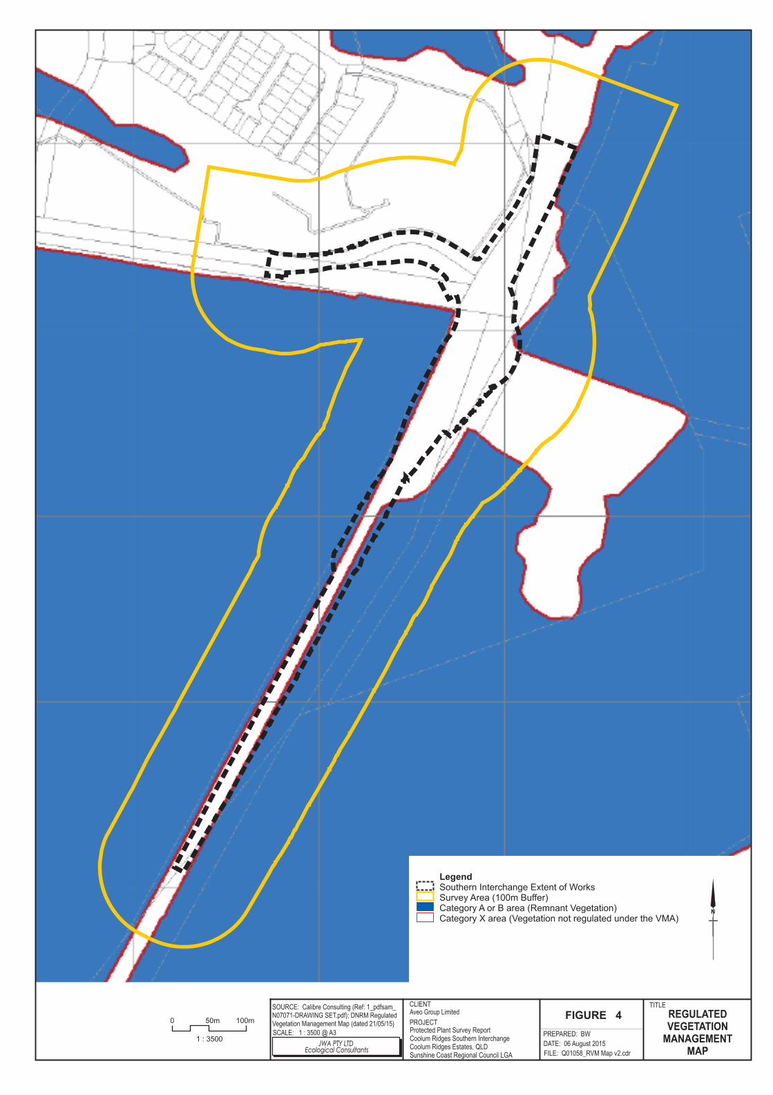
LegendSouthern Interchange Extent of WorksSurvey Area (100m Buffer)Category A or B area (Remnant Vegetation)Category X area (Vegetation not regulated under the VMA)
REGULATEDVEGETATION
MANAGEMENTMAP
Aveo Group Limited
SCALE: 1 : 3500 @ A3
SOURCE: Calibre Consulting (Ref: 1_pdfsam_N07071-DRAWING SET.pdf); DNRM RegulatedVegetation Management Map (dated 21/05/15)
CLIENT
PROJECT
TITLE
FIGURE 4
PREPARED: BW
FILE: Q01058_RVM Map v2.cdr
DATE: 06 August 2015
Protected Plant Survey ReportCoolum Ridges Southern InterchangeCoolum Ridges Estates, QLDSunshine Coast Regional Council LGA
N
JWA PTY LTDEcological Consultants
0 100m50m
1 : 3500

LegendSouthern Interchange Extent of WorksSurvey Area (100m Buffer)Category A or B area that is a least concern regional ecosystemNon remnantWetland on the vegetation management wetlands mapEssential habitat on the essential habitat mapWatercourse on the vegetation management watercourse mapNational Parks, State Forest and other reserves
REGIONALECOSYSTEMS
Aveo Group Limited
SCALE: 1 : 3500 @ A3
SOURCE: Calibre Consulting (Ref: 1_pdfsam_N07071-DRAWING SET.pdf); DNRM VegetationManagement Supporting Map (dated 21/05/15)
CLIENT
PROJECT
TITLE
FIGURE 5
PREPARED: BW
FILE: Q01058_RE Map v2.cdr
DATE: 06 August 2015
Protected Plant Survey ReportCoolum Ridges Southern InterchangeCoolum Ridges Estates, QLDSunshine Coast Regional Council LGA
N
JWA PTY LTDEcological Consultants
0 100m50m
1 : 3500

Protected Plant Survey Report – Coolum Ridges Southern Interchange
Job No: Q01058/RW3 JWA Pty Ltd 9
occurs on Quaternary coastal dunes and beaches. RE 12.2.15 also includes several types of vegetated swamps and lakes. This RE is located in a small area north of the development within Noosa National Park and is unlikely to be directly impacted by the development works.
2.3.2.2 Essential Habitat Mapping Essential Habitat for threatened flora species Eucalyptus conglomerata (Swamp Stringybark), Acacia baueri subsp. baueri (Tiny Wattle), Allocasuarina emuina (Emu Mountain Sheoak) is mapped on site concurrent with RE 12.2.7 and RE 12.2.12 (FIGURE 5).
2.3.3 Habitat Suitability Assessment for Threatened Flora Species
Habitat suitability assessments of the twenty-three (23) threatened flora species listed in the database searches (TABLE 1), determined that ten (10) of these species had the potential to be present within the subject site given the habitat available. These species are:
Acacia attenuata – Possible; Acacia baueri subsp. baueri (Tiny Wattle) - Possible; Allocasuarina defungens (Dwarf Heath Casuarina) - Possible; Allocasuarina emuina (Emu Mountain Sheoak) – Known; Blandfordia grandiflora (Christmas bells) - Likely; Cryptostylis hunteriana (Leafless Tongue-orchid) - Possible; Durringtonia paludosa (Durringtonia) - Possible; Eucalyptus conglomerata (Swamp Stringybark) - Possible; Phaius australis (Lesser Swamp-orchid) - Possible; and Prasophyllum wallum (Wallum Leek-orchid) – Possible.
These species and their habitats were targeted during the site inspections. APPENDIX 1 contains the results of the habitat suitability assessment. It lists the threatened flora species that are known or considered to possibly occur in the locality and notes the likelihood of occurrence of each species within the subject area.

Protected Plant Survey Report – Coolum Ridges Southern Interchange
Job No: Q01058/RW3 JWA Pty Ltd 10
3 Site Assessment
3.1 Introduction This section discusses the methods used in the site assessment and presents the results of the assessment.
3.2 Methods
3.2.1 Introduction
A site inspection including a survey of existing flora communities was completed by two (2) JWA scientist on the 26th and 27th of May 2015. A total of approximately thirty-one (31) person hours were spent on this survey. A second site inspection was completed by one (1) JWA scientist on the 15th of July 2015. A total of approximately ten (10) person hours were spent on this survey. Field surveys involved a botanical assessment within a number of representative areas within remnant and non-remnant vegetation communities. The surveys used the methodology described in the Nature Conservation Act’s (1992) Flora Survey Guidelines - Protected Plants (DEHP 2014) as timed random meander searches.
3.2.2 Surveyors
The following JWA scientists completed the site inspection:
Adam McArthur, Principal Scientist for JWA - Bachelor Applied Science (Environmental Resource Management), 11 years’ experience in ecological impact assessment and flora identification; and
Kirsty Macpherson, Senior Scientist for JWA - Masters of Environmental Science, 5 years’ experience in ecological impact assessment and flora identification.
Curricula vitaes are provided in APPENDIX 2.
3.2.3 Timed Random Meander Searches
The random meander technique original described by Cropper (1993) and adapted by the Flora Survey Guidelines was used to search for threatened flora species. The meander technique was used to discover and record all the vascular flora observed on the site. A total of sixteen (16) meander searches were undertaken within vegetated areas for approximately 1-3 hours each. If after 30 minutes the meander had not discovered any new plants the meander was concluded (FIGURE 6). Vegetation communities were mapped and described using the technique contained in Walker and Hopkins (1998). Vegetation structural formation classes were assessed according to Neldner et al. (2005). RE classification of vegetation communities were determined as per Sattler and Williams (1999), and in accordance with the Regional Ecosystems Description Database (REDD) (Queensland Herbarium 2014).

M11
M10
M9
M8
M7
M6
M5
M4
M3
M2
M1
M15
M14
M16
M13
M12
LegendSouthern Interchange Extent of WorksSurvey Area (100m Buffer)
Meander LocationsMeander 1Meander 2Meander 3Meander 4Meander 5Meander 6Meander 7Meander 8Meander 9Meander 10Meander 11Meander 12Meander 13Meander 14Meander 15Meander 16
MEANDERLOCATIONS
Aveo Group Limited
SCALE: 1 : 3500 @ A3
SOURCE: JWA Site Investigations; CalibreConsulting (Ref: X-N07071-BASE.dwg); GoogleEarth Aug 2014 Aerial
CLIENT
PROJECT
TITLE
FIGURE 6
PREPARED: BW
FILE: Q01058_Survey.cdr
DATE: 06 August 2015
Protected Plants Survey ReportCoolum Ridges Southern InterchangeCoolum Ridges Estates, QLDSunshine Coast Regional Council LGA
N
JWA PTY LTDEcological Consultants
0 100m50m
1 : 3500

Protected Plant Survey Report – Coolum Ridges Southern Interchange
Job No: Q01058/RW3 JWA Pty Ltd 11
3.2.4 Survey Restrictions
The timing of the survey was determined by the likelihood of finding flowering and fruiting bodies on the threatened species likely to occur within the search area given the habitat available. There is a population of Allocasuarina emuina within the adjacent Coolum ridges estate. The timing of the survey was conducted when these known plants were fruiting and flowering. The timing was also restricted by the nature of the terrain. Some of the areas being surveyed are periodically inundated. The survey was timed to coincide with the dry season. The flora survey was hampered at meander sites 5 and 10 by deep water. This influenced the ability to detect groundcover and low shrub species in these areas. However, it was noted that the vegetation within these area was consistent with the surrounding vegetation in shallower water. It was expected that all species present in the shallower areas would be found in the deep water areas and that no novel species would be located.
3.2.5 Specimen Identification
For those species not identified in the field, samples were pressed and dried and positive identifications of plant specimens were subsequently made under laboratory conditions or forwarded to the Queensland Herbarium for identification. Where available, fruiting and/or flowering specimens were taken to assist with identification. All identifications were made by qualified botanists with experience identifying flora taxa of Queensland vegetation communities.
3.2.6 Nomenclature
Taxonomic nomenclature used for the description of floral species is according to Henderson (2002). Introduced species are signified in all text by an asterix (*). Any additional changes in taxonomic nomenclature have been incorporated as described in Jessup (2002, 2003 and 2005). Field references utilised for the identification and description of floral species include: Stanley and Ross (1989); Brooker and Kleinig (1994a and 1994b); Leiper et al. (2008); Haslam (2004) and Queensland Museum (2003).
3.3 Results
3.3.1 Introduction
One-hundred and forty-eight (148) native and sixteen (16) exotic species were recorded on site. A full species list is provided in APPENDIX 3.
3.3.2 Protected Plants on the Site
One (1) threatened species was recorded on the site, Allocasuarina emuina. This species was identified in the field by JWA scientists and confirmed by sample at the Queensland Herbarium. All stems of this species occurring within the survey area were located by a suitably qualified surveyor during the second site inspection. This species was located in the south eastern portion of the subject site, to the east of the Sunshine Motorway. This species occurs as part of a small population containing seventy-one (71) individuals. These individuals generally occur in two separate clumps, covering a total area of approximately 282m2, with several individual outliers also

Protected Plant Survey Report – Coolum Ridges Southern Interchange
Job No: Q01058/RW3 JWA Pty Ltd 12
present to the east of the main population. The locations of these plants within the subject site are shown in FIGURE 7. The population of Allocasuarina emuina on the subject site was located within an area of heathland (RE 12.2.12). The species prefers loamy-clayey sands which lack strong texture contrast between the A and B horizons. The soil is periodically inundated but is free draining during other times. It is likely that a shallow depth to ground water is a major contributing factor to the location of these plants. Under the Nature Conservation Act (1992) this species is listed as Endangered. Any clearing of this species, or within 100m of this species, will require approval under the Qld protected plants legislative framework. An application for a Clearing permit (Protected Plants) in accordance with Section 15 of the Nature Conservation (Administration) Regulation 2006 will need to be lodged with DEHP for assessment and approval. Areas of the subject site not within 100m of these plants can be cleared under exemptions. An Exempt clearing notification (Protected plants) will be lodged to notify DEHP of this clearing which is exempt from the requirement of a permit under Section 261ZA of the Nature Conservation (Wildlife Management) Regulation 2006. FIGURE 8 indicates areas subject to the Exempt clearing notification (Protected plants) and the Clearing permit (Protected Plants). This species is also listed under the Commonwealth EPBC Act (1999) as Endangered. Clearing of these species will need to be referred to the Commonwealth fort assessment under the Environment Protection and Biodiversity Conservation Act 1999.
3.3.3 Vegetation Community Descriptions
3.3.3.1 Background Five (5) broad vegetation communities were identified on the subject site (FIGURE 9). This section provides a description of each of these vegetation communities and a discussion of the condition and conservation status of each. The conservation status of vegetation communities is discussed with reference to the Regional Ecosystem Description Database (Queensland Herbarium 2014) and the Queensland VMA (1999) where appropriate.
3.3.3.2 Community 1: Eucalyptus racemosa woodland Location and area This community is located on either side of the Sunshine Motorway on the higher ground (FIGURE 9). Meander 3, 9, 11 and 16 were located within this community. Description This vegetation community is open woodland with dominant canopy species Eucalyptus racemosa, Angophora leiocarpa and Corymbia intermedia. Lower trees include Melaleuca quinquenervia, Banksia integrifolia, Glochidion ferdinandi, and Lophostemon sauveolens. The shrub layer contains Banksia robur, Acacia suaveolens, Hakea actites, Xanthorrhoea johnsonii, Hovea acutifolia, Epacris spp., and Melastoma malabathricum. The ground layer is dominated by leaf litter and Hibbertia scandens, Caustis blakei, Imperata cylindrica, Xanthorrhoea fulva, Lomandra longifolia, and Pteridium esculentum. Condition This community is remnant vegetation in good condition with very few weeds present and minimal edge effects.