
ANNUAL/FINAL TECHNICAL RELINQUISHMENT REPORT EL25228 · Annual/Final Technical Report EL25228 4 1...
15
Annual/Final Technical Report EL25228 1 ANNUAL/FINAL TECHNICAL RELINQUISHMENT REPORT EL25228 Rare Earth Metal, Uranium, Gold, Base Metals, Diamonds FOR PERIOD ENDING 22 ND NOVEMBER 2012 NORTHERN TERRITORY Pine Creek SD5208 1:250,000 Batchelor 5171 1:100,000 Titleholder: TUC Resources Ltd Report No. 2012-016 Prepared for TUC Resources E A Lamb/T Page Exploration Manager/Project Geologist
Transcript of ANNUAL/FINAL TECHNICAL RELINQUISHMENT REPORT EL25228 · Annual/Final Technical Report EL25228 4 1...
Annual/Final Technical Report EL25228 1
ANNUAL/FINAL TECHNICAL RELINQUISHMENT REPORT
EL25228
Rare Earth Metal, Uranium, Gold, Base Metals, Diamonds
FOR PERIOD ENDING 22ND NOVEMBER 2012
NORTHERN TERRITORY
Pine Creek SD5208 1:250,000
Batchelor 5171 1:100,000
Titleholder: TUC Resources Ltd
Report No. 2012-016
Prepared for TUC Resources
E A Lamb/T Page
Exploration Manager/Project Geologist

Annual/Final Technical Report EL25228 2
Contents
1 Abstract ......................................................................................................................... 4
2 Copyright ....................................................................................................................... 5
3 Location and Access ...................................................................................................... 6
4 Tenement Status and Ownership ................................................................................... 7
5 Geology ......................................................................................................................... 8
5.1 Stratigraphy ............................................................................................................ 8
5.2 Structure ................................................................................................................. 8
6 Previous Exploration .................................................................................................... 10
6.1 Exploration by Other Companies .......................................................................... 10
7 Exploration by TUC ...................................................................................................... 10
7.1 Year 1 ................................................................................................................... 10
7.2 Year 2 ................................................................................................................... 10
7.3 Year 3 ................................................................................................................... 11
7.4 Year 4 ................................................................................................................... 13
7.5 Year 5 ................................................................................................................... 13
7.6 Year 6 ................................................................................................................... 13
8 References .................................................................................................................. 14
9 Appendices .................................................................................................................. 15
9.1 Appendix 1 ............................................................................................................ 15
9.2 Appendix 2 ............................................................................................................ 15

Annual/Final Technical Report EL25228 3
Figure 1 – Map showing extents of EL25228 and areas previously relinquished. .................. 6
Figure 2 – Regional stratigraphy around EL25228. ............................................................... 9
Figure 3 – Brumby Recent Drilling, showing intersections on two new reefs ....................... 11
Figure 4: New survey area (green polygon) in relation to nearby uranium mines/deposits
(green dots) on historic low resolution radiometric data and topography. ............................ 12
Figure 5 – Anomalies identified by 2009 radiometrics ......................................................... 13
Table 1 – Tenement Status and Landowner information ....................................................... 7

Annual/Final Technical Report EL25228 4
1 Abstract
TUC Resources have held EL25228 since 22nd November 2006, and are relinquishing the
tenement at the end of the sixth year of tenure, 21st November 2012.
Since gaining access to the licence TUC Resources have completed a historical review of
the tenement examining existing prospects. TUC completed an initial 14 hole drill program
on the Brumby prospect, the 606m program was tested a mineralised quartz reef system
within folded gold prospective sediments. The extensional drilling on the main reef system
was disappointing but exploration holes 500m to the north intersected oxide mineralisation
on two separate reefs.
In the third year of tenure TUC Resources flew a low level detailed (100m line spaced)
airborne magnetic and radiometric survey. The 4,030.3 line km survey covered parts of
EL25223, EL25224 and EL25228. The survey revealed a number of discrete radiometric
anomalies for follow up work. Subtle anomalies are located on major fault zones and in
association with the uranium prospective unconformity line. Reconnaissance investigation
was commenced but due to access restrictions no samples were located on EL25228.
Due to other priorities and budget restraints TUC Resources was unable to further explore
the tenement in the fourth, fifth or sixth year of the tenement.

Annual/Final Technical Report EL25228 5
2 Copyright
Under Regulation 126 of the Mineral Titles Act 2010 E Lamb and T Page are identified as
authors of this report with ownership of copyright unless otherwise stated being held by TUC
Resources Ltd.
In accordance with Regulation 126 of the Mineral Titles Act 2010 TUC Resources Ltd gives
authorisation for the Minister and/or Department permission to publish the report and its
associated data where copyright is held by TUC Resources Ltd.

Annual/Final Technical Report EL25228 6
3 Location and Access
EL25228 is situated approximately 12km east of Adelaide River, NT, and 120km SSE of
Darwin (CrossRef). The Stuart Highway crosses the southern portion of the Licence near Mt
Darwent and is near the western boundary of the Licence near Mt Tymn. Access to EL
25228 is via the Stuart Highway (in the southern area) and along the Ringwood Station road
in the northern part. Different tracks traverse the Licence, but most of the tenement is
inaccessible during the wet season. Topography for most of the tenement is low relief, with
some floodplains and black soil plains. The Adelaide River borders the NW part of the
Licence, while the Howley Creek transects the eastern portion. The southern border of the
Licence has higher relief and areas around Mt Foelsche, Mt Tym and Mt Darwent are also
notable ridges rising out of black soil plains. The tenement has numerous creeks (many
feeding into Howley Creek) which can flood in heavy rains during the wet season.
Figure 1 – Map showing extents of EL25228 and areas previously relinquished.
Annual/Final Technical Report EL25228 7
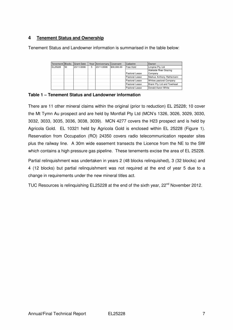
4 Tenement Status and Ownership
Tenement Status and Landowner information is summarised in the table below:
Table 1 – Tenement Status and Landowner information
There are 11 other mineral claims within the original (prior to reduction) EL 25228; 10 cover
the Mt Tymn Au prospect and are held by Montfall Pty Ltd (MCN’s 1326, 3026, 3029, 3030,
3032, 3033, 3035, 3036, 3038, 3039). MCN 4277 covers the H23 prospect and is held by
Agricola Gold. EL 10321 held by Agricola Gold is enclosed within EL 25228 (Figure 1).
Reservation from Occupation (RO) 24350 covers radio telecommunication repeater sites
plus the railway line. A 30m wide easement transects the Licence from the NE to the SW
which contains a high pressure gas pipeline. These tenements excise the area of EL 25228.
Partial relinquishment was undertaken in years 2 (48 blocks relinquished), 3 (32 blocks) and
4 (12 blocks) but partial relinquishment was not required at the end of year 5 due to a
change in requirements under the new mineral titles act.
TUC Resources is relinquishing EL25228 at the end of the sixth year, 22nd November 2012.
Tenement Blocks Grant Date Year Anniversary Covenant Cadastre Owner
EL25228 50 23/11/2006 5 23/11/2008 $30,000.00 Free Hold Limpine Pty Ltd
Pastoral Lease
Adelaide River Grazing
Company
Pastoral Lease Markus Anthony Rathsmann
Pastoral Lease Whites pastoral Company
Pastoral Lease Branir Pty Ltd and Tovehead
Pastoral Lease Donald Aaron White

Annual/Final Technical Report EL25228 8
5 Geology
The project is situated within the Pine Creek Geosyncline, a tightly folded sequence
of Lower Proterozoic rocks. A full description of the geology and stratigraphy of the
Pine Creek Geosyncline can be found in several texts, including Ahmad et al., (1993;
Ahmad, 1998). The 1:100,000 Batchelor – Hayes Creek Region Geological Special
map covers the tenement areas (Crick, 1980).
5.1 Stratigraphy
The area covers the Finniss River Group (Burrell Creek Formation) which is
dominantly feldspathic greywacke with interbedded siltstones. A very small section
(<1 block) in the SE part of EL25228 is underlain by Gerowie Tuff and Mt Bonnie
Formation from the Mt Partridge Group (Figure 2).
5.2 Structure
The Mount Shoobridge fault transects the central part of the tenement and regional
maps show some NNW-trending (north plunging) symmetrical folds throughout the
tenement. Quartz veins parallel to these folds and within fold noses are common.

Annual/Final Technical Report EL25228 9
Figure 2 – Regional stratigraphy around EL25228.

Annual/Final Technical Report EL25228 10
6 Previous Exploration
6.1 Exploration by Other Companies
Previous exploration from the 1970’s to the present has been reviewed and summarised in
previous annual reports for these tenements. Exploration ranged from airborne geophysics
to drilling exploring for uranium, gold and base-metals, geochemical exploration was also
undertaken. Historical exploration is summarised in Appendix 1.
On EL25228 exploration was undertaken by Central Pacific Minerals, Aquitaine, Pan Dor
mining, WMC, Ringwood and others. Exploration involved drilling, geophysics and
geochemistry primarily for gold and uranium.
7 Exploration by TUC
7.1 Year 1
Work done during Year 1 of tenure consisted of a historic compilation, which included a
review of targets and prospects. Also the available geophysics (from both regional NTGS
airborne surveys) and Open File Company Surveys were reviewed by a Consultant
Geophysicist.
7.2 Year 2
A total of 14 RC holes for 606m were drilled at the Brumby prospect, a mineralised quartz
reef system within folded gold prospective sediments, 25km south of Adelaide River town.
Extensional drilling on the main reef system was disappointing but exploration holes
targeting soil anomalies 500m to the north intersected oxide mineralisation on two separate
reefs (Figure 3). Results on the two newly identified reefs are promising as neither of the
reefs had been drilled previously and scope remains for improvements in grade and
thickness.
Field reconnaissance and ground scintillometer work was also undertaken at a number of
radiometric anomalies and 7 rock chip samples were taken. No significant results were
returned but further investigation is warranted.

Annual/Final Technical Report EL25228 11
Figure 3 – Brumby Recent Drilling, showing intersections on two new reefs
7.3 Year 3
In June and July, a low level detailed (100m line spaced) airborne magnetic and radiometric
survey was completed by Fugro Airborne Surveys Pty. Ltd. to reveal any previously hidden
opportunities in this uranium-rich province. The survey area is along strike of the Adelaide
River uranium mine (historical production of ~3,500t @ 0.5% U3O8*) and North West of the
Fleur De Lys uranium mine (historical production of ~122t @ 0.22% U3O8*) (Figure 7).
There were two areas, flown in 8 flights for a total of 4030.3 line kms. The survey covered
parts of EL25223, EL25224, and EL25228. The area covered by the survey is shown in
Figure 3.
Annual/Final Technical Report EL25228 12
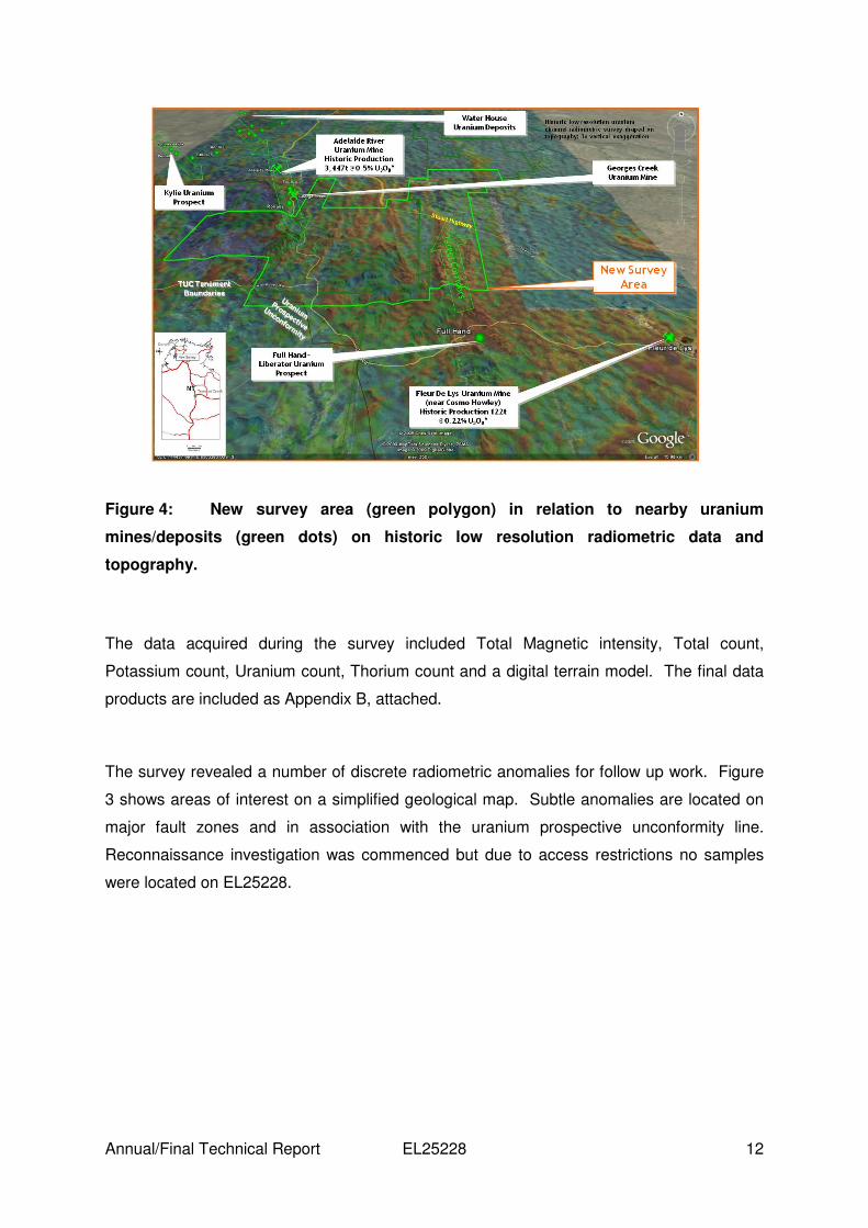
Figure 4: New survey area (green polygon) in relation to nearby uranium
mines/deposits (green dots) on historic low resolution radiometric data and
topography.
The data acquired during the survey included Total Magnetic intensity, Total count,
Potassium count, Uranium count, Thorium count and a digital terrain model. The final data
products are included as Appendix B, attached.
The survey revealed a number of discrete radiometric anomalies for follow up work. Figure
3 shows areas of interest on a simplified geological map. Subtle anomalies are located on
major fault zones and in association with the uranium prospective unconformity line.
Reconnaissance investigation was commenced but due to access restrictions no samples
were located on EL25228.

Annual/Final Technical Report EL25228 13
Figure 5 – Anomalies identified by 2009 radiometrics
7.4 Year 4
TUC Resources intended to follow up on a number of discrete radiometric anomalies
identified in the radiometric survey. Unfortunately due to other exploration programs,
Quantum (EL25229) and Stromberg (EL25222), and budget restraints TUC Resources was
unable to perform any work on the anomalies.
7.5 Year 5
No work was carried out during the fifth year of tenure.
7.6 Year 6
No work was carried out during the sixth year of tenure, and due to other priorities TUC
Resources decided to not extend the exploration leaves.

Annual/Final Technical Report EL25228 14
8 References
Ahmad, M., 1998. Geology and mineral deposits of the Pine Creek Inlier and McArthur
Basin, Northern Territory. AGSO Journal of Australian Geology and Geophysics, 17(3), pp1-
17.
Ahmad, M., Wygralak, A.S., Ferenczi, P.A., and Bajwah, Z.U. 1993. Explanatory Notes and
Mineral Deposit Data Sheets. 1:250,000 Metallogenic Map Series, Department of Mines and
Energy, Northern Territory Geological Survey
Dundas, D.L., Edgoose, C.J., Fahey, G.M., and Fahey, J.E., 1987. Daly River 5070
Explanatory Notes 1:100,000 Geological Map Series; Northern Territory Geological Survey.
Edgoose, C.J., Fahey, G.M., and Fahey, J.E., 1989. Wingate Mountains 5069 Explanatory
Notes 1:100,000 Geological Map Series; Northern Territory Geological Survey.
Crick, I., 1980. Geology of the Batchelor-Hayes Creek Region. BMR 1:100,000 Geological
Special.
Rade, J., 1956. Shearing along anticlines as an important structural feature in uranium
mineralisation in the northern part of the Northern Territory of Australia. Journal of Economic
Geology.
Khan, M., Ferenczi, PA., Ahmad, M., and Kruse, P.D., 2007. Phosphate testing of
waterbores and diamond drillcore in the Georgina, Wiso and Daly basins, Northern Territory.
Northern Territory Department of Primary Industry, Fisheries and Mines Geological Survey
Record 2007-003.
Pontifex, I.R., and Mendum, J.R., 1972. Fergusson River 1:250,000 Geological Series –
Explanatory Notes. BMR 250,000 Geological Series.

Annual/Final Technical Report EL25228 15
9 Appendices
9.1 Appendix 1
• Previous Tenure on EL25228.xls
9.2 Appendix 2
• ConsultantGeophys_Images.zip
• Fugro_Flight_June09.zip


