ANNUAL REPORT of LOGAN RIVER DISTRIBUTION …waterrights.utah.gov/docSys/v907/s907/s90703yd.pdf ·...
61
ANNUAL REPORT of LOGAN RIVER DISTRIBUTION SYSTEM prepared for STATE OF UTAH OFFICE OF STATE ENGINEER LOGAN, UTAH by Terry L. Gnehm Water Commissioner Water Year 2003
Transcript of ANNUAL REPORT of LOGAN RIVER DISTRIBUTION …waterrights.utah.gov/docSys/v907/s907/s90703yd.pdf ·...

ANNUAL REPORTof
LOGAN RIVER DISTRIBUTION SYSTEM
prepared for
STATE OF UTAHOFFICE OF STATE ENGINEER
LOGAN, UTAH
by
Terry L. GnehmWater Commissioner
Water Year2003

ANNUAL REPORTof
LOGAN RIVER DISTRIBUTION SYSTEM
prepared for
STATE OF UTAHOFFICE OF STATE ENGINEER
LOGAN, UTAH
by
Terry L. GnehmWater Commissioner
Water Year2003

LOGAN RIVER 2003 ANNUAL REPORTi
TABLE OF CONTENTS
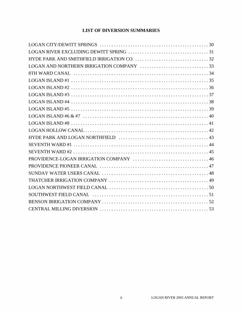
LIST OF DIVERSION SUMMARIES . . . . . . . . . . . . . . . . . . . . . . . . . . . . . . . . . . . . . . . . . . ii
ACKNOWLEDGMENT . . . . . . . . . . . . . . . . . . . . . . . . . . . . . . . . . . . . . . . . . . . . . . . . . . . . . . . 1
MINUTES . . . . . . . . . . . . . . . . . . . . . . . . . . . . . . . . . . . . . . . . . . . . . . . . . . . . . . . . . . . . . . . . . . . 3
2003 FINANCIAL STATEMENT . . . . . . . . . . . . . . . . . . . . . . . . . . . . . . . . . . . . . . . . . . . . . . . 5
2003 BUDGET EXPENDITURES . . . . . . . . . . . . . . . . . . . . . . . . . . . . . . . . . . . . . . . . . . . . . . . 6
2003 DELINQUENT WATER ASSESSMENTS . . . . . . . . . . . . . . . . . . . . . . . . . . . . . . . . . . . 7
DIRECTORY OF OFFICERS . . . . . . . . . . . . . . . . . . . . . . . . . . . . . . . . . . . . . . . . . . . . . . . . . . 8
2003 DAILY RECORD . . . . . . . . . . . . . . . . . . . . . . . . . . . . . . . . . . . . . . . . . . . . . . . . . . . . . . . 11
LIST OF ALL RIGHTS OF RECORD WITH PRIORITIES AND FLOW RIGHT . . . . . 13
EXCHANGE STATEMENT FOR 2003 . . . . . . . . . . . . . . . . . . . . . . . . . . . . . . . . . . . . . . . . . 15
EXCHANGE RIGHTS - LOGAN RIVER WATER USERS/LOGAN CITY . . . . . . . . . . . 16
EXCHANGE BETWEEN LOGAN CITY AND LOGAN RIVER WATER USERS . . . . . 16
DEWITT SPRINGS/IRRIGATION SEASON . . . . . . . . . . . . . . . . . . . . . . . . . . . . . . . . . . . . 17
LOGAN CITY WATER RIGHTS . . . . . . . . . . . . . . . . . . . . . . . . . . . . . . . . . . . . . . . . . . . . . . 17
2003 MONTHLY WATER USE TABLE . . . . . . . . . . . . . . . . . . . . . . . . . . . . . . . . . . . . . . . . 18
WATER DISTRIBUTION SCHEDULE . . . . . . . . . . . . . . . . . . . . . . . . . . . . . . . . . . . . . . . . . 25
2003 WATER USE . . . . . . . . . . . . . . . . . . . . . . . . . . . . . . . . . . . . . . . . . . . . . . . . . . . . . . . . . . . 25
MONTHLY SUMMARY OF WATER DIVERTED FROMLOGAN RIVER IN AC-FT . . . . . . . . . . . . . . . . . . . . . . . . . . . . . . . . . . . . . . . . . . . . . 26
MEASURING DEVICES INSTALLED BY APPROPRIATORS FROMLOGAN RIVER . . . . . . . . . . . . . . . . . . . . . . . . . . . . . . . . . . . . . . . . . . . . . . . . . . . . . . . 27
APPENDIX A - LOGAN RIVER DIVERSIONS . . . . . . . . . . . . . . . . . . . . . . . . . . . . . . . . . . 28
APPENDIX B - REVISED KIMBALL DECREE . . . . . . . . . . . . . . . . . . . . . . . . . . . . . . . . . 54
LOGAN RIVER 2003 ANNUAL REPORTii
LIST OF DIVERSION SUMMARIES
LOGAN CITY/DEWITT SPRINGS . . . . . . . . . . . . . . . . . . . . . . . . . . . . . . . . . . . . . . . . . . . . . . 30LOGAN RIVER EXCLUDING DEWITT SPRING . . . . . . . . . . . . . . . . . . . . . . . . . . . . . . . . . . 31HYDE PARK AND SMITHFIELD IRRIGATION CO. . . . . . . . . . . . . . . . . . . . . . . . . . . . . . . . 32LOGAN AND NORTHERN IRRIGATION COMPANY . . . . . . . . . . . . . . . . . . . . . . . . . . . . . 338TH WARD CANAL . . . . . . . . . . . . . . . . . . . . . . . . . . . . . . . . . . . . . . . . . . . . . . . . . . . . . . . . . 34LOGAN ISLAND #1 . . . . . . . . . . . . . . . . . . . . . . . . . . . . . . . . . . . . . . . . . . . . . . . . . . . . . . . . . . 35LOGAN ISLAND #2 . . . . . . . . . . . . . . . . . . . . . . . . . . . . . . . . . . . . . . . . . . . . . . . . . . . . . . . . . . 36LOGAN ISLAND #3 . . . . . . . . . . . . . . . . . . . . . . . . . . . . . . . . . . . . . . . . . . . . . . . . . . . . . . . . . . 37LOGAN ISLAND #4 . . . . . . . . . . . . . . . . . . . . . . . . . . . . . . . . . . . . . . . . . . . . . . . . . . . . . . . . . . 38LOGAN ISLAND #5 . . . . . . . . . . . . . . . . . . . . . . . . . . . . . . . . . . . . . . . . . . . . . . . . . . . . . . . . . . 39LOGAN ISLAND #6 & #7 . . . . . . . . . . . . . . . . . . . . . . . . . . . . . . . . . . . . . . . . . . . . . . . . . . . . . 40LOGAN ISLAND #8 . . . . . . . . . . . . . . . . . . . . . . . . . . . . . . . . . . . . . . . . . . . . . . . . . . . . . . . . . . 41LOGAN HOLLOW CANAL . . . . . . . . . . . . . . . . . . . . . . . . . . . . . . . . . . . . . . . . . . . . . . . . . . . . 42HYDE PARK AND LOGAN NORTHFIELD . . . . . . . . . . . . . . . . . . . . . . . . . . . . . . . . . . . . . . 43SEVENTH WARD #1 . . . . . . . . . . . . . . . . . . . . . . . . . . . . . . . . . . . . . . . . . . . . . . . . . . . . . . . . . 44SEVENTH WARD #2 . . . . . . . . . . . . . . . . . . . . . . . . . . . . . . . . . . . . . . . . . . . . . . . . . . . . . . . . . 45PROVIDENCE-LOGAN IRRIGATION COMPANY . . . . . . . . . . . . . . . . . . . . . . . . . . . . . . . . 46PROVIDENCE PIONEER CANAL . . . . . . . . . . . . . . . . . . . . . . . . . . . . . . . . . . . . . . . . . . . . . . 47SUNDAY WATER USERS CANAL . . . . . . . . . . . . . . . . . . . . . . . . . . . . . . . . . . . . . . . . . . . . . 48THATCHER IRRIGATION COMPANY . . . . . . . . . . . . . . . . . . . . . . . . . . . . . . . . . . . . . . . . . . 49LOGAN NORTHWEST FIELD CANAL . . . . . . . . . . . . . . . . . . . . . . . . . . . . . . . . . . . . . . . . . . 50SOUTHWEST FIELD CANAL . . . . . . . . . . . . . . . . . . . . . . . . . . . . . . . . . . . . . . . . . . . . . . . . . 51BENSON IRRIGATION COMPANY . . . . . . . . . . . . . . . . . . . . . . . . . . . . . . . . . . . . . . . . . . . . . 52CENTRAL MILLING DIVERSION . . . . . . . . . . . . . . . . . . . . . . . . . . . . . . . . . . . . . . . . . . . . . . 53

LOGAN RIVER 2003 ANNUAL REPORT1
ACKNOWLEDGMENT
I would like to thank everyone for the position of Water Commissioner for the 2003irrigationseason. It was another long, hot and dry summer. The river flow went from the 300 - 400 cfs range,and peaked the last of May with a flow of 750 cfs and quickly returned to the 400 cfs by June 8th.
Regulation of the canals began in July and continued through October when the flow ofLogan River dropped. Plastic was also put in the 8th Ward diversion on July 21st, enabling the usersto utilize all the water in the river. All the water in the river was used until October 31st when a 5inch snow storm suddenly hit Logan. At that time, the plank and plastic put in the river at the 8th
Ward diversion were removed.
During the irrigation season when the flows were low, USU Water Lab cooperated with thewater users. They worked at using the water for their experiments, so there was little disruption tothe water users below. Despite the correspondence sent to USU Hydro-plant, we had another yearwith problems. Operation practices at State Dam caused numerous problems downstream with thecontinuous and drastic fluctuations. These fluctuations make it very difficult to get accurate gaugereadings and causes problems for all the irrigators downstream. The following is taken from theFINAL Kimball Decree on page 38;
“. . .the Trustees be and they are hereby allowed to operate the power planthereinbefore referred to and to main the water in the reservoir at an elevation of105.63 feet at all times of year, except during the irrigation season when the flow ofLogan River measured at D D D, viz: D the river station below the Logan andNorthern Canal and D the station on the Logan and Northern Canal is less than205.56 cubic feet per second; that during this season the surface of the water in saidreservoir shall be lowered to an elevation of 102.95 feet. The Trustees agree to lowerthe water when this stage is reached upon notification from the Logan Riverdistribution agent.”
It has proved to be a difficult and impossible task of finding the right individual(s) to contact. Since the operating guidelines have clearly been spelled out in the Kimball Decree, we are goingto need assistance from the state, before the new irrigation season begins, in trying to get this matterresolved with USU Hydro-plant.
Terry L. GnehmWater Commissioner

LOGAN RIVER 2003 ANNUAL REPORT2

LOGAN RIVER 2003 ANNUAL REPORT3
MINUTESAnnual Meeting of Logan River Water User’s Association and
Representatives of the State Engineer’s Office
February 12, 2003
President Don Hansen chaired the meeting and asked that the minutes of the 2002meeting be read by secretary/treasurer Peter Küng. A motion to accept the minutes was made byArt Marshall and was seconded by Lynn James. The motion passed.
Don then asked Lee Sim to review the financial statement prepared by the State Engineer,which he did. All but one of the regular yearly assessments had been collected. There continuedto be a problem contacting the owner of record of this account, but in light of some newlyprovided information, efforts would continue to contact the family. With interest and delinquentpenalties, there was a balance of $5475.45 in the State account as of Dec. 31, 2002. ArnoldTaylor made the motion to accept the statement and Lynn James seconded. The motion passed.
Terry Gnehm began the Water Commissioner’s report by saying that there would again bean exchange of funds for the 2002 water year. The difference shown in the exchange statementfor 2002 was a sum of $69.60 to be paid to Logan City by the canal companies. Terry reportedthat once again there was an overall lack of water in the Logan River during the entire irrigationseason, with barely enough to provide all member companies. Pumps were again used during thelatter part of the season to supplement available Logan River irrigation water. Terry also statedthat hydroelectric operations at State Dam, caused problems for downstream users several timeswith drastic fluctuations in water release levels. Peter Küng was asked as Sec/Treas of LRWUAto write a letter to the facilities manager to ask that these occurrences stop, especially when thelow river flows are under Kimball Decree. Terry included copies of several flow recorder tapesin the annual report showing how these large fluctuations affected member companies. Afterconferring with the Utah Division of Water Rights it was determined that USU’s non-consumptive subordinate water rights cannot interfere with mandated water deliveries to ourmember shareholders. The proposed letter would also request reimbursement for clean up of lastyear’s debris flow caused by construction activities at the dam, which affected many downstreamusers. Lynn James made the motion to accept the proposed letter and the Commissioner’s report,Donna Spillet seconded, and the motion passed.
Don Hansen then conducted a line-by-line review of 2002 annual expenditures to helpprepare next year’s proposed budget. Current Water Commissioner Terry Gnehm’sresponsibilities and compensation were discussed and cost of living, State assessment andinsurance adjustments were made. After thorough review of all budgeted items, a motion wasmade by Art Marshall and seconded by Lynn James that set the 2003 proposed budget a $11,289. Art Marshall made the motion to accept this proposed budget and it was seconded by LynnJames. State officials however recommended maintaining only approximately a 35% balance offunds in reserve, so in light of the budget surplus carried forward from previous years, it wasproposed that the 2003 assessment be set at $ 9,200. Donna Spillet made the motion to acceptthis proposed assessment, Lynn James seconded, and the motion passed.
In other business, Don Hansen opened the meeting for nominations to fill any of thepositions on the current LRWUA Board of Directors. Art Marshall made the motion to retain thecurrent board by acclimation, it was seconded by Arnold Taylor, and it passed unanimously.

LOGAN RIVER 2003 ANNUAL REPORT4
Don Hansen then discussed the implications of a continuing 5 year drought andrecommended that member companies be conscious of their water rights and do everything toexercise and protect them. This included maximizing use of irrigation water and utilizing theentire irrigation season, typically April 1 to October 31. Ongoing efforts to establish a regionalCanal consortium, to address storm-water and irrigation related issues affecting all membercanal companies and municipalities, was also discussed at length. The growing potential for saleor conversion of irrigation water to domestic and culinary use was also debated among themembers.
The annual meeting of the Crockett Avenue Irrigation and Distribution System wasannounced to immediately follow this meeting. There was no other business brought before thegroup, and Art Marshall moved to adjourn. Peter E. Küng seconded and the motion carried. Themeeting was adjourned.
Those in attendance:
Terry L. Gnehm Water Commissioner / Logan North Field IrrigationDon Hansen Logan River Waters Users / Logan & Northern Co.Peter E. Küng Logan River Water Users / Crockett Ave Irrigation Lee Sim Utah Division of Water Rights, SLCRick Reese Logan River Water Users/ Crockett Ave/ Benson Arthur Marshall Logan Hollow Canal Arnold Taylor Logan Hollow CanalVirginia Parker Seventh Ward IrrigationBob Fotheringham Utah Division of Water Rights, LoganWill Atkin Utah Division of Water Rights, LoganDonna Spillet Logan Island IrrigationLynn James Hyde Park IrrigationColleen Gnehm Crockett Ave / Logan North Field Irrigation Dean Bernston Thatcher Irrigation CompanyJeff Kunzler Benson Irrigation

LOGAN RIVER 2003 ANNUAL REPORT5
2003 FINANCIAL STATEMENT

LOGAN RIVER 2003 ANNUAL REPORT6
2003 BUDGET EXPENDITURES

LOGAN RIVER 2003 ANNUAL REPORT7
2003 DELINQUENT WATER ASSESSMENTS

LOGAN RIVER 2003 ANNUAL REPORT8
DIRECTORY OF OFFICERS
LOGAN RIVER WATER USERS ASSOCIATION
President . . . . . . . . . Don Hansen . . . . . . . . . . . . . 563-69936231 North 400 West Smithfield, UT 84335
Director . . . . . . . . . . Rick Reese . . . . . . . . . . . . . . 753-21844043 North 2400 West Benson, UT 84335
Secretary . . . . . . . . . Peter Küng . . . . . . . . . . . . . . 752-6025346 North 400 West Logan, UT 84321
LOGAN, HYDE PARK & SMITHFIELD
President . . . . . . . . . John Fred Krusi . . . . . . . . . . 563-5590338 North 400 East Hyde Park, UT 84318
Secretary . . . . . . . . . Mariana P. Larsen . . . . . . . . 755-8070Logan, UT 84341
Water Master . . . . . . Russell Austin . . . . . . . . . . . . 755-0919
LOGAN & NORTHERN IRRIGATION COMPANY
President . . . . . . . . . Lewis Wilhelm . . . . . . . . . . . 753-53092183 North 1600 East Logan, UT 84341
Sec/Treas . . . . . . . . . Lyle Thornley . . . . . . . . . . . . 753-51501010 East Ridge Drive Logan, UT 84321
Water Master . . . . . . Mike Jones . . . . . . . . . . . . . . 752-1746
LOGAN HOLLOW IRRIGATION COMPANY
President . . . . . . . . . Arthur Marshall . . . . . . . . . . 752-4818756 East 200 North . . . . . . . Logan, UT 84321
Sec/Treas . . . . . . . . . Arnold Taylor . . . . . . . . . . . . 752-669681 Crockett Avenue . . . . . . . Logan, UT 84321
PROVIDENCE LOGAN IRRIGATION COMPANY
President . . . . . . . . . Ted Wilson . . . . . . . . . . . . . . 752-39941730 South 470 East Logan, UT 84321
Secretary . . . . . . . . . Jane Davis . . . . . . . . . . . . . . 752-5250PO Box 566 Logan, UT 84321
Water Master . . . . . . Ted Wilson . . . . . . . . . . . . . . 752-3994

LOGAN RIVER 2003 ANNUAL REPORT9
LOGAN ISLAND IRRIGATION COMPANY
President . . . . . . . . . Donna Spillet . . . . . . . . . . . . 753-0562138 West 300 South Logan, UT 84321
Sec/Treas . . . . . . . . . Desmond Anderson . . . . . . . 752-1041107 South 300 East Logan, UT 84321
Water Master . . . . . . Glen Marcusen . . . . . . . . . . . 752-2734
SUNDAY WATER USERS DITCH
Robert Allen . . . . . . . . . . . . . 752-5852600 East 100 North Logan, UT 84321Don MurrayBlaine Morris
SEVENTH WARD IRRIGATION COMPANY
President . . . . . . . . . John T. Ellerbeck . . . . . . . . . 752-049250 North 500 East Logan, UT 84321
Sec/Treas . . . . . . . . . Virginia Parker . . . . . . . . . . . 752-105541 South 400 East Logan, UT 84321
HYDE PARK IRRIGATION COMPANY
President . . . . . . . . . Lynn James . . . . . . . . . . . . . 563-5979493 East 200 South Hyde Park, UT 84318
Sec/Treas . . . . . . . . . Mrs. Pat Ashcroft . . . . . . . . . 563-307050 West 100 North Hyde Park, UT 84318
Water Master . . . . . . Ron Jenson . . . . . . . . . . . . . . 755-9601
LOGAN NORTH FIELD IRRIGATION COMPANY
President . . . . . . . . . Ray Wilhelm . . . . . . . . . . . . 752-03091516 East 2300 North Logan, UT 84341
Sec/Treas . . . . . . . . . LuAnn Wilhelm 753-28751510 East 2300 North . . . . . N. Logan, UT 84341
Water Master . . . . . . Garth Gnehm . . . . . . . . . . . . 770-0508
CENTRAL MILL
Central Mill . . . . . . . . . . . . . 752-6625122 East Center Logan, UT 84321Jack Kidd . . . . . . . . . . . . . . . 752-1598Milt Carlisle . . . . . . . . . . . . . 752-0596

LOGAN RIVER 2003 ANNUAL REPORT10
THATCHER IRRIGATION COMPANY
President . . . . . . . . . Brett Butler . . . . . . . . . . . . . . 752-5966131 South 300 West Logan, UT 84321
Sec/Treas . . . . . . . . . Dan Merck . . . . . . . . . . . . . . 752-8708120 South 300 West Logan, UT 84321
Water Master . . . . . . John Wheldon . . . . . . . . . . . . 752-4734
LOGAN SOUTHWEST FIELD IRRIGATION COMPANY
President . . . . . . . . . Alan Alder . . . . . . . . . . . . . . 752-8703407 South 1900 West Logan, UT 84321
Sec/Treas . . . . . . . . . Grant Potter . . . . . . . . . . . . . 753-3221500 South 1900 West Young Ward, UT 84339
Water Master . . . . . . Scott Jensen . . . . . . . . . . . . . 753-4324
LOGAN COW PASTURE WATER CO.
President . . . . . . . . . Darrell Kunzler . . . . . . . . . . 752-51943215 West 3000 North Benson, UT 84335
Sec/Treas . . . . . . . . . Leigh Cowley . . . . . . . . . . . . 753-76153555 West 2600 North Benson, UT 84335
LOGAN NORTHWEST FIELD IRRIGATION COMPANY
President . . . . . . . . . Peter Küng . . . . . . . . . . . . . . 752-6025346 North 400 West Logan, UT 84321
Sec/Treas . . . . . . . . . Heber Hardman . . . . . . . . . . 752-1943157 North 500 West Logan, UT 84321
Water Master . . . . . . Ryan Webber . . . . . . . . . . . . 757-6694
BENSON WARD IRRIGATION COMPANY
President . . . . . . . . . Rick Reese . . . . . . . . . . . . . . 753-21844043 North 2400 North Benson, UT 84335
Sec/Treas . . . . . . . . . Leigh Cowley . . . . . . . . . . . . 753-76153555 West 2600 North Benson, UT 84335
Water Master . . . . . . Rick Reese . . . . . . . . . . . . . . 753-2184Water Master . . . . . . Tracy Reese . . . . . . . . . . . . . 753-4363
PROVIDENCE PIONEER IRRIGATION COMPANY
President . . . . . . . . . Boyd Humpherys . . . . . . . . . 752-4868328 Riverdale Avenue Logan, UT 84321
Sec/Treas . . . . . . . . . Ed Hibbard . . . . . . . . . . . . . . 752-90551135 South Main Logan, UT 84321

LOGAN RIVER 2003 ANNUAL REPORT11
2003 DAILY RECORD
DATEWEATHERCONDITIONS
April 1 went to Water Rights, discussed flumes
April 2 - - - - - - - - - - - - - - - .07" rain
April 4 - - - - - - - - - - - - - - - .13" rain
April 6 - - - - - - - - - - - - - - - .16" wet snow
April 8 recorders were put out in preparation for irrigation season windy
April 10 checks Logan River and all canals warm
April 15 went with Louis Wilhelm and fixed LN flume .08" rain
April 17 checked Logan River and all canals and LN flume cold - cloudy
April 20 checked Logan River and all canals cool
April 21 cleaned mud from stilling well at 8 th Ward Diversion cool
April 22 repaired gauge house at Benson warm
April 23 - - - - - - - - - - - - - - - .16" rain
April 25 cleaned Twin canal stilling well .15" rain
April 28 met with Jack and Dennis at Logan City Hydro warm
May 3 check SWF to Jenson’s cool
May 4 check all the small canals .50" rain
May 5 checked Logan River and main canals
May 6 cleaned the still well at Providence Logan cool
May 7 - - - - - - - - - - - - - - - .14' rain
May 8 - - - - - - - - - - - - - - - .40" rain
May 10 - - - - - - - - - - - - - - - .23" rain
May 12 checked all the small canals warm
May 14 - - - - - - - - - - - - - - - .10" rain
May 18 checked Logan River and all canals cool
May 22 checked LN and went to Logan City Service Center
May 26 checked Logan River and all main canals hot
June 1 checked Logan River and all canals hot
June 8 checked Logan River and main canals warm
June 15 checked Logan River and all canals hot
June 21 - - - - - - - - - - - - - - - .64" rain
June 29 installed railing on LNWF flumechecked Logan River and all canals
hot
July 3 Logan City well turned on for LHPS2 trips to adjust canals
hot
July 6 checked Logan River and all canals, started regulation hot
July 13 checked Logan River and all canals hot - 100°

DATEWEATHERCONDITIONS
LOGAN RIVER 2003 ANNUAL REPORT12
July 17 Logan City well off for 12 hrs for de-mossing hot
July 18 checked Logan River and all canalsLogan city well off for 24 hrs
hot
July 21 plastic was put in at the 8th Ward Diversion at noon hot
July 23 4.5 cfs Logan City well water diverted to Benson4.5 cfs Logan city well water still going to LHPS
.20" rain
July 27 checked Logan River and all canals hot
July 29 looked for water, checked USU Water Lab and physical plant hot
July 30 checked all canals twice, met Jack at Logan City Hydro hot
July 31 spent day looking for water from Crockett and LNWF hot
August 2 - - - - - - - - - - - - - - - .06" rain
August 3 Logan City well off for 32 hours for de-mossing .44" rain
August 10 checked Logan River and all canals hot
August 15 checked all canals hot - windy
August 17 regulated LN and adjusted headgated warm
August 21 - - - - - - - - - - - - - - - .14" rain
August 22 - - - - - - - - - - - - - - - .22" rain
August 24 checked all canals warm
August 27 checked LNWF, Benson, and LI#5 warm
August 30 - - - - - - - - - - - - - - - .80" rain
August 31 checked all canals warm
September 7 checked all canals warm
September 9 regulated LHPS and adjusted headgate, visited w/Jack .40" rain
September 14 checked all canals warm
September 15 Logan City well shut off in morning warm
September 17 - - - - - - - - - - - - - - - .35" rain
September 21 checked all canals hot
September 28 checked all canals .10" rain
October 2 - - - - - - - - - - - - - - -
October 5 checked all canals hot
October 12 checked Logan River and LHPS, removed PL recorder cool
October 13 worked with Logan City to cut LHPS from 28 to 23 cfs cool
October 19 checked Logan River and all canals warm
October 26 checked all the smaller canals cool
October 30 checked Logan River and main canals .66" rain
October 31 removed recorders and shut down LHPS cool - 6" snow

LOGAN RIVER 2003 ANNUAL REPORT13
LIST OF ALL RIGHTS OF RECORD WITH PRIORITIES AND FLOW RIGHT (Revised January 2000)
Acct. Water User Water Right No. Priority
Period ofUse
Flow(cfs)
1 Logan City Corp. 3506 1860 1/1 - 12/31 10.08258 1981 9/30 - 4/1 20.0
2 Logan, Hyde Park & Smithfield Canal 6145 1860 4/1 - 10/31 58.06146 1860 4/1 - 7/31 16.06147 1860 4/1 - 7/17 27.26148 1860 10/1 - 10/10 20.0
22 3055 1928 4/1 - 10/31 21.0
3 Logan & Northern 6110 1860 4/1 - 10/31 68.16111 1860 4/1 - 7/31 7.96112 1860 4/1 - 7/14 27.26113 1860 10/1 - 10/31 20.0
23 3056 1928 4/1 - 10/31 10.0
4 Logan Hollow 5090 1860 4/1 - 10/31 1.75091 1860 4/1 - 7/31 0.25092 1860 4/1 - 7/14 0.6
5 Providence-Logan 5137 1860 4/1 - 10/31 9.65138 1860 4/1 - 7/31 1.25139 1860 4/1 - 7/15 3.95140 1860 10/1 - 10/10 3.0
5a Sunday Water Users 5476-5482 1860 4/1 - 10/31 2.5
6 Logan Island 5023 1860 4/1 - 10/31 5.95024 1860 4/1 - 10/31 0.75133 1860 4/1 - 10/31 2.35134 1860 4/1 - 10/31 9.05135 1860 4/1 - 10/31 1.25136 1860 4/1 - 10/31 2.0
7 Seventh Ward Irrigation 5121 1860 4/1 - 10/31 1.75122 1860 4/1 - 7/14 0.3
8,9 Hyde Park (51%) & Logan Northfield (49%) 6137-6138 1860 4/1 - 10/31 38.56139-6140 1860 4/1 - 7/31 2.16141-6142 1860 4/1 - 7/15 4.86143-6144 1860 10/1 - 10/10 12.0
10 Thatcher (even numbers) 5114, 5494, 5572 1860 4/1 - 10/31 0.6(Odd numbers) 5115, 5495, 5573 1860 4/1 - 7/14 0.2
11 Logan Northwest Field 5243 1860 4/1 - 10/31 32.0

LIST OF ALL RIGHTS OF RECORD WITH PRIORITIES AND FLOW RIGHT (continued)
Acct. Water User Water Right No. Priority
Period ofUse
Flow(cfs)
LOGAN RIVER 2003 ANNUAL REPORT14
12 Benson Ward Irrigation Co. 5938 1860 4/1 - 10/31 16.0
13 Southwest Field 5141 1860 4/1 - 10/31 11.015 5142 1865 4/1 - 10/31 1.0
14 Providence Pioneer 5007 1860 4/1 - 10/31 3.95008 1860 4/1 - 8/1 0.55009 1860 4/1 - 7/15 1.65010 1860 10/1 - 10/10 2.0
17 Logan Cow Pasture 5402 1888 4/1 - 10/31 9.0
18 Ezra J. Nixon 5205 1895 4/1 - 10/31 1.0
19 Logan City 5492 1900 4/1 - 10/31 4.0
24 U.S. Forest Service 3074 1937 4/15 - 9/30 5.04648 1937 4/15 - 9/30 5.0
25 Dean Parker 2178 1953 4/1 - 10/31 1.75
Logan River Non-Consumptive Use Rights
27 Central Milling Co. 5700 1860 1/1 - 12/31 22.65701 1860 1/1 - 12/31 9.12702 1860 9/16 - 6/30 3.05703 1860 1/1 - 12/31 39.8
28 Utah Power & Light (Logan City) 5241 1893 1/1 - 12/31 100.05653 1900 1/1 - 12/31 100.0
29 Utah State University 3511 1908 1/1 - 12/31 150.03512 1919 1/1 - 12/31 84.0

LOGAN RIVER 2003 ANNUAL REPORT15
EXCHANGE STATEMENT FOR 2003
1. Total Logan City Rights 6106.1 ac-ft
2. Dewitt Spring
A. Logan City Rights used (all rights combined; see following 2 pages) Rights used are not to exceed the amount diverted from Dewitt Spring for each day. 5,890.2 ac-ft
B. Excess water used by Logan City during periods of limited use by canals. Dates April 1 - July 21 1,110.1 ac-ft
C. Excess water used by Logan City during full use period by the canals. Dates July 22 - October 31 1,211.6 ac-ft
3. Total from Dewitt Spring 8,009 ac-ft
4. Water pumped to the canals by Logan City 1,176 ac-ft
5. Total amount owed at $4.00/ac-ft
A. Logan City to canal companies $ 4,846.40
B. Canal companies* to Logan City $ 4,704.00
C. Difference paid to canal companies $ 142.60
*LHPS 8 cfs - July 3
16 cfs - July 4 - July 22
8 cfs - July 23 - September 14 = $2,976.00
*Benson 8 cfs - July 23 - September 14 = $1,728.00

LOGAN RIVER 2003 ANNUAL REPORT16
EXCHANGE RIGHTS - LOGAN RIVER WATER USERS/LOGAN CITY
Dewitt Springs Use (flow Measurement)
Irrigation Season Rights*
Kimball Decree #243 10 cfs 3630 ac-ft
(Gibbons) #11353 4 cfs whenriver above 280 varies
Exchange #1844 9.9 cfs max.varies w/river varies
Exchange #133 20 cfs over canal use
Logan is pay for excess water used above its rights during low flows.
Logan is not be charged during those months that irrigation water available to users is not fullyused, i.e. usually April, May, September.
During an unusually dry year, however, all available water may be used during these months, inwhich case Logan will pay for water used above its rights.
The attached chart included all applicable rights of the city versus total Logan River flow. Canalusage during low water months must also be checked to determine if charges for excess watershould be made.
* See following chart to determine
EXCHANGE BETWEEN LOGAN CITY AND LOGAN RIVER WATER USERS
An agreement between Logan City and the Logan River Water Users Association signed on June26, 1963, permits Logan City to divert water from Dewitt Springs in excess of its decreed rights. For this privilege, Logan City agrees to pay the Association $4.00 for each acre-foot so diverted. Logan City also agrees to sell to the Association water diverted from underground storagethrough, each, any, or all of its producing wells. The rate per acre-foot for this water is also$4.00, so that an actual exchange of funds occurs only when the amount of water diverted fromone source is greater than the amount diverted from the other source. Part of the excess Citydiversion occurs during high water stages in Logan River and is delivered to Logan City withoutcharge. The $4.00 rate applies only when the river stage is at 426 cfs, or below. A statementitemizing the excess use is shown on the preceding page. The daily accumulative flows forexchange are shown in TABLE #4.

LOGAN RIVER 2003 ANNUAL REPORT17
DEWITT SPRINGS/IRRIGATION SEASON
TotalLogan River
(cfs)
TotalLHP&S
(cfs)
#243Logan City
Kimball Decree(cfs)
#11353Hyrum
Gibbons(cfs)
#1844 LHP&SShares
(202.17 1/82)Total
Logan City(cfs)
100 20.2 10 0 1.4 11.4110 22.4 10 0 1.6 11.6120 24.6 10 0 1.7 11.7130 26.9 10 0 1.9 11.9140 29.1 10 0 2.0 12.0150 31.4 10 0 2.2 12.2160 33.6 10 0 2.3 12.3170 35.8 10 0 2.5 12.5180 38.1 10 0 2.6 12.6190 40.3 10 0 2.8 12.8200 42.6 10 0 2.9 12.9210 44.8 10 0 3.1 13.1220 47.0 10 0 3.3 13.3230 49.4 10 0 3.4 13.4240 51.5 10 0 3.6 13.6250 53.7 10 0 3.7 13.7260 56.0 10 0 3.9 13.9270 57.3 10 0 4.0 14.0280 59.5 10 4 4.1 18.1290 59.5 10 4 4.1 18.1300 70.8 10 4 5.2 19.2310 75.3 10 4 5.7 19.7320 79.8 10 4 6.2 20.2330 84.3 10 4 6.6 20.6340 88.8 10 4 7.1 21.1350 93.3 10 4 7.6 21.6360 97.8 10 4 8.0 22.0370 102.3 10 4 8.5 22.5380 103.2 10 4 8.6 22.6390 109.3 10 4 9.2 23.2400 116.0 10 4 9.9 23.9
LOGAN CITY WATER RIGHTS
Kimball Decree #234 10 cfs 1963A-11353 (Gibbons) 4 cfs 1980 (above 270 cfs)EX #1844 1.4-9.9 cfs 1982 (varies) LHP&S sharesEX #133 (excess over canal use) 20 cfs 1963 Dewitt#55967 (winter/non-irr. use) 20 cfs 1981

APRIL 2003
DayDewitt
Spring FlowComb.
River FlowUSGS
Total RiverFlow
Total LoganCity Rights
Logan CityRights Used
Excess FlowAbove All
Accum.Excess
Above 426cfs
Accum.Excess
Below 426cfs
Flow of Logan City Wellsto Canals
cfs cfs cfs cfs cfs cfs ac-ft ac-ft ac-ft ac-ft accum. ac-ft
1 17.2 122 138 11.9 11.9 5.3 11.9 11.92 17.2 126 143 12.0 12.0 5.2 12.0 23.93 17.2 129 145 12.0 12.0 5.2 12.0 35.94 17.2 122 138 11.9 11.9 5.3 11.9 47.85 17.2 118 134 11.9 11.9 5.3 11.9 59.76 17.2 114 130 11.9 11.9 5.3 11.9 71.67 17.2 108 124 11.7 11.7 5.5 11.7 83.38 17.2 106 122 11.7 11.7 5.5 11.7 95.09 17.2 108 124 11.7 11.7 5.5 11.7 106.710 17.2 120 136 11.9 11.9 5.3 11.9 118.611 17.2 151 167 12.3 12.3 4.9 12.3 130.912 17.2 161 177 12.5 12.5 4.7 12.5 143.413 17.2 187 203 12.9 12.9 4.3 12.9 156.314 17.2 201 217 13.1 13.1 4.1 13.1 169.415 17.2 239 256 13.4 13.4 3.8 13.4 182.816 17.2 233 249 13.6 13.6 3.6 13.6 196.417 17.2 212 228 13.3 13.3 3.9 13.3 209.718 17.2 221 237 13.4 13.4 3.8 13.4 223.119 17.2 206 223 13.3 13.3 3.9 13.3 236.420 17.2 206 223 13.3 13.3 3.9 13.3 249.721 17.2 227 243 13.6 13.6 3.6 13.6 263.322 17.2 233 249 13.6 13.6 3.6 13.6 276.923 17.2 227 243 13.3 13.3 3.9 13.3 290.224 17.2 206 223 13.3 13.3 3.9 13.3 303.525 17.2 227 243 13.6 13.6 3.6 13.6 317.126 17.2 252 268 13.9 13.9 3.3 13.9 331.027 17.2 239 255 13.7 13.7 3.5 13.7 344.728 17.2 227 243 13.6 13.6 3.6 13.6 358.329 17.2 243 259 13.7 13.7 3.5 13.7 372.030 17.2 252 268 13.9 13.9 3.3 13.9 385.9
April Total ac-ft 1,023 10,952 11,916 765.2 765.2 385.9 5,795.4

MAY 2003
DayDewitt
Spring FlowComb.
River FlowUSGS
Total RiverFlow
Total LoganCity Rights
Logan CityRights Used
Excess FlowAbove All
Accum.Excess
Above 426cfs
Accum.Excess
Below 426cfs
Flow of Logan City Wellsto Canals
cfs cfs cfs cfs cfs cfs ac-ft ac-ft ac-ft ac-ft accum. ac-ft
1 19.6 233 252 13.7 13.7 5.9 13.7 13.7
2 19.6 237 255 13.7 13.7 5.9 13.7 27.4
3 19.6 248 267 13.9 13.9 5.7 13.9 41.3
4 19.6 244 263 13.9 13.9 5.7 13.9 55.2
5 19.6 244 263 13.9 13.9 5.7 13.9 69.1
6 19.6 225 244 13.6 13.6 6.0 13.6 82.7
7 19.6 218 236 13.4 13.4 6.2 13.4 96.1
8 19.6 207 226 13.3 13.3 6.3 13.3 109.4
9 19.6 215 234 13.4 13.4 6.2 13.4 122.8
10 19.6 215 234 13.4 13.4 6.2 13.4 136.2
11 19.6 206 225 13.3 13.3 6.3 13.3 149.5
12 19.6 204 223 13.3 13.3 6.3 13.3 162.8
13 19.6 209 228 13.3 13.3 6.3 13.3 176.1
14 19.6 253 272 14.0 14.0 5.6 14.0 190.1
15 19.6 329 348 21.1 19.6 0.0 0.0 190.1
16 19.6 416 435 23.9 19.6 0.0 0.0 190.1
17 19.6 561 580 23.9 19.6 0.0 0.0 190.1
18 19.6 436 455 23.9 19.6 0.0 0.0 190.1
19 19.6 428 446 23.9 19.6 0.0 0.0 190.1
20 19.6 415 433 23.9 19.6 0.0 0.0 190.1
21 19.6 439 458 23.9 19.6 0.0 0.0 190.1
22 19.6 463 482 23.9 19.6 0.0 0.0 190.1
23 19.6 521 539 23.9 19.6 0.0 0.0 190.1
24 19.6 612 631 23.9 19.6 0.0 0.0 190.1
25 19.6 644 662 23.9 19.6 0.0 0.0 190.1
26 19.6 723 741 23.9 19.6 0.0 0.0 190.1
27 19.6 719 737 23.9 19.6 0.0 0.0 190.1
28 19.6 730 749 23.9 19.6 0.0 0.0 190.1
29 19.6 754 772 23.9 19.6 0.0 0.0 190.1
30 19.6 767 786 23.9 19.6 0.0 0.0 190.1
31 19.6 780 798 23.9 19.6 0.0 0.0 190.1
May Totalac-ft 1,205 25,572 26,715 1,177.1 1,037.7 190.1 4,664.1

JUNE 2003
DayDewitt
Spring FlowComb.
River FlowUSGS
Total RiverFlow
Total LoganCity Rights
Logan CityRights Used
Excess FlowAbove All
Accum.Excess
Above 426cfs
Accum.Excess
Below 426cfs
Flow of Logan City Wellsto Canals
cfs cfs cfs cfs cfs cfs ac-ft ac-ft ac-ft ac-ft accum. ac-ft
1 21.0 744 764 23.9 21.0 0.0 0.0 0.0
2 21.0 637 657 23.9 21.0 0.0 0.0 0.0
3 21.0 644 664 23.9 21.0 0.0 0.0 0.0
4 21.0 592 612 23.9 21.0 0.0 0.0 0.0
5 21.0 546 566 23.9 21.0 0.0 0.0 0.0
6 21.0 507 527 23.9 21.0 0.0 0.0 0.0
7 21.0 479 499 23.9 21.0 0.0 0.0 0.0
8 21.0 454 474 23.9 21.0 0.0 0.0 0.0
9 21.0 436 456 23.9 21.0 0.0 0.0 0.0
10 21.0 426 446 23.9 21.0 0.0 0.0 0.0
11 21.0 416 436 23.9 21.0 0.0 0.0 0.0
12 21.0 386 406 23.9 21.0 0.0 0.0 0.0
13 21.0 376 396 23.2 21.0 0.0 0.0 0.0
14 21.0 339 359 21.6 21.0 0.0 0.0 0.0
15 21.0 348 368 22.0 21.0 0.0 0.0 0.0
16 21.0 328 348 20.2 20.2 0.8 20.2 20.2
17 21.0 319 339 19.7 19.7 1.3 19.7 39.9
18 21.0 310 330 20.6 20.6 0.4 20.6 60.5
19 21.0 303 323 20.2 20.2 0.8 20.2 80.7
20 21.0 290 310 19.7 19.7 1.3 19.7 100.4
21 21.0 293 313 19.7 19.7 1.3 19.7 120.1
22 21.0 286 306 19.2 19.2 1.8 19.2 139.3
23 21.0 273 293 18.1 18.1 2.9 18.1 157.4
24 21.0 265 285 18.1 18.1 2.9 18.1 175.5
25 21.0 262 282 18.1 18.1 2.9 18.1 193.6
26 21.0 246 266 13.9 13.9 7.1 13.9 207.5
27 21.0 235 255 13.7 13.7 7.3 13.7 221.2
28 21.0 232 252 13.7 13.7 7.3 13.7 234.9
29 21.0 228 248 13.6 13.6 7.4 13.6 248.5
30 21.0 225 245 13.6 13.6 7.4 13.6 262.1
June Totalac-ft 1,249 22,656 23,846 1,220.9 1,144.4 262.1 2,261.8

JULY 2003
DayDewitt
Spring FlowComb.
River FlowUSGS
Total RiverFlow
Total LoganCity Rights
Logan CityRights Used
Excess FlowAbove All
Accum.Excess
Above 426cfs
Accum.Excess
Below 426cfs
Flow of Logan City Wellsto Canals
cfs cfs cfs cfs cfs cfs ac-ft ac-ft ac-ft ac-ft accum. ac-ft
1 21.0 219 239 13.4 13.4 7.6 13.4 13.4
2 21.0 214 234 13.4 13.4 7.6 13.4 26.8
3 21.0 210 230 13.4 13.4 7.6 13.4 40.2 8.00 8.00
4 21.0 204 224 13.3 13.3 7.7 13.3 53.5 16.00 24.00
5 21.0 203 223 13.3 13.3 7.7 13.3 66.8 16.00 40.00
6 21.0 200 220 13.3 13.3 7.7 13.3 80.1 16.00 56.00
7 21.0 196 216 13.1 13.1 7.9 13.1 93.2 16.00 72.00
8 21.0 192 212 13.1 13.1 7.9 13.1 106.3 16.00 88.00
9 21.0 187 207 12.9 12.9 8.1 12.9 119.2 16.00 104.00
10 21.0 187 207 12.9 12.9 8.1 12.9 132.1 16.00 120.00
11 21.0 182 202 12.9 12.9 8.1 12.9 145.0 16.00 136.00
12 21.0 180 200 12.9 12.9 8.1 12.9 157.9 16.00 152.00
13 21.0 179 199 12.8 12.8 8.2 12.8 170.7 16.00 168.00
14 21.0 179 199 12.8 12.8 8.2 12.8 183.5 16.00 184.00
15 21.0 171 191 12.8 12.8 8.2 12.8 196.3 16.00 200.00
16 21.0 172 192 12.8 12.8 8.2 12.8 209.1 16.00 216.00
17 21.0 168 188 12.6 12.6 8.4 12.6 221.7 16.00 232.00
18 21.0 168 188 12.6 12.6 8.4 12.6 234.3 16.00 248.00
19 21.0 167 187 12.6 12.6 8.4 12.6 246.9 16.00 264.00
20 21.0 166 186 12.6 12.6 8.4 12.6 259.5 16.00 280.00
21 21.0 160 180 12.6 12.6 8.4 12.6 272.1 16.00 296.00
22 21.0 160 180 12.6 12.6 8.4 12.6 284.7 16.00 312.00
23 21.0 159 179 12.5 12.5 8.5 12.5 297.2 16.00 328.00
24 21.0 158 178 12.5 12.5 8.5 12.5 309.7 16.00 344.00
25 21.0 160 180 12.6 12.6 8.4 12.6 322.3 16.00 360.00
26 21.0 162 182 12.6 12.6 8.4 12.6 334.9 16.00 376.00
27 21.0 160 180 12.6 12.6 8.4 12.6 347.5 16.00 392.00
28 21.0 156 176 12.5 12.5 8.5 12.5 360.0 16.00 408.00
29 21.0 156 176 12.5 12.5 8.5 12.5 372.5 16.00 424.00
30 21.0 152 172 12.5 12.5 8.5 12.5 385.0 16.00 440.00
31 21.0 150 170 12.5 12.5 8.5 12.5 397.5 16.00 456.00
July Totalac-ft 1,291 10,860 12,089 788.2 788.2 397.5 6,439.9 456.00 456.00

AUGUST 2003
DayDewitt
Spring FlowComb.
River FlowUSGS
Total RiverFlow
Total LoganCity Rights
Logan CityRights Used
Excess FlowAbove All
Accum.Excess
Above 426cfs
Accum.Excess
Below 426cfs
Flow of Logan City Wellsto Canals
cfs cfs cfs cfs cfs cfs ac-ft ac-ft ac-ft ac-ft accum. ac-ft
1 20.9 149 169 12.3 12.3 8.6 12.3 12.3 16.00 472.00
2 20.9 147 167 12.3 12.3 8.6 12.3 24.6 16.00 488.00
3 20.9 147 167 12.3 12.3 8.6 12.3 36.9 16.00 504.00
4 20.9 146 166 12.3 12.3 8.6 12.3 49.2 16.00 520.00
5 20.9 144 164 12.3 12.3 8.6 12.3 61.5 16.00 536.00
6 20.9 143 163 12.3 12.3 8.6 12.3 73.8 16.00 552.00
7 20.9 141 160 12.3 12.3 8.6 12.3 86.1 16.00 568.00
8 20.9 135 155 12.2 12.2 8.7 12.2 98.3 16.00 584.00
9 20.9 142 162 12.3 12.3 8.6 12.3 110.6 16.00 600.00
10 20.9 138 158 12.2 12.2 8.7 12.2 122.8 16.00 616.00
11 20.9 136 156 12.2 12.2 8.7 12.2 135.0 16.00 632.00
12 20.9 135 155 12.2 12.2 8.7 12.2 147.2 16.00 648.00
13 20.9 135 155 12.2 12.2 8.7 12.2 159.4 16.00 664.00
14 20.9 133 152 12.2 12.2 8.7 12.2 171.6 16.00 680.00
15 20.9 133 153 12.2 12.2 8.7 12.2 183.8 16.00 696.00
16 20.9 133 152 12.2 12.2 8.7 12.2 196.0 16.00 712.00
17 20.9 131 151 12.2 12.2 8.7 12.2 208.2 16.00 728.00
18 20.9 129 149 12.0 12.0 8.9 12.0 220.2 16.00 744.00
19 20.9 129 149 12.0 12.0 8.9 12.0 232.2 16.00 760.00
20 20.9 127 147 12.0 12.0 8.9 12.0 244.2 16.00 776.00
21 20.9 127 147 12.0 12.0 8.9 12.0 256.2 16.00 792.00
22 20.9 133 152 12.2 12.2 8.7 12.2 268.4 16.00 808.00
23 20.9 129 149 12.0 12.0 8.9 12.0 280.4 16.00 824.00
24 20.9 127 147 12.0 12.0 8.9 12.0 292.4 16.00 840.00
25 20.9 125 145 12.0 12.0 8.9 12.0 304.4 16.00 856.00
26 20.9 123 142 12.0 12.0 8.9 12.0 316.4 16.00 872.00
27 20.9 121 141 12.0 12.0 8.9 12.0 328.4 16.00 888.00
28 20.9 120 140 12.0 12.0 8.9 12.0 340.4 16.00 904.00
29 20.9 117 137 11.9 11.9 9.0 11.9 352.3 16.00 920.00
30 20.9 120 140 12.0 12.0 8.9 12.0 364.3 16.00 936.00
31 20.9 118 138 11.9 11.9 9.0 11.9 376.2 16.00 952.00
Aug Totalac-ft 1,285 8,154 9,377 746.0 746.0 376.2 6,053.7 496.00 952.00

SEPTEMBER 2003
DayDewitt
Spring FlowComb.
River FlowUSGS
Total RiverFlow
Total LoganCity Rights
Logan CityRights Used
Excess FlowAbove All
Accum.Excess
Above 426cfs
Accum.Excess
Below 426cfs
Flow of Logan City Wellsto Canals
cfs cfs cfs cfs cfs cfs ac-ft ac-ft ac-ft ac-ft accum. ac-ft
1 17.9 117 133 11.9 11.9 6.0 11.9 11.9 16.00 968.00
2 17.9 115 132 11.9 11.9 6.0 11.9 23.8 16.00 984.00
3 17.9 115 132 11.9 11.9 6.0 11.9 35.7 16.00 1,000.00
4 17.9 114 131 11.9 11.9 6.0 11.9 47.6 16.00 1,016.00
5 17.9 114 131 11.9 11.9 6.0 11.9 59.5 16.00 1,032.00
6 17.9 115 132 11.9 11.9 6.0 11.9 71.4 16.00 1,048.00
7 17.9 117 133 11.9 11.9 6.0 11.9 83.3 16.00 1,064.00
8 17.9 114 131 11.9 11.9 6.0 11.9 95.2 16.00 1,080.00
9 17.9 111 127 11.7 11.7 6.2 11.7 106.9 16.00 1,096.00
10 17.9 116 133 11.9 11.9 6.0 11.9 118.8 16.00 1,112.00
11 17.9 113 130 11.9 11.9 6.0 11.9 130.7 16.00 1,128.00
12 17.9 111 127 11.7 11.7 6.2 11.7 142.4 16.00 1,144.00
13 17.9 110 127 11.7 11.7 6.2 11.7 154.1 16.00 1,160.00
14 17.9 110 127 11.7 11.7 6.2 11.7 165.8 16.00 1,176.00
15 17.9 110 127 11.7 11.7 6.2 11.7 177.5
16 17.9 108 125 11.7 11.7 6.2 11.7 189.2
17 17.9 108 125 11.7 11.7 6.2 11.7 200.9
18 17.9 110 127 11.7 11.7 6.2 11.7 212.6
19 17.9 108 125 11.7 11.7 6.2 11.7 224.3
20 17.9 106 123 11.7 11.7 6.2 11.7 236.0
21 17.9 106 123 11.7 11.7 6.2 11.7 247.7
22 17.9 106 123 11.7 11.7 6.2 11.7 259.4
23 17.9 105 122 11.7 11.7 6.2 11.7 271.1
24 17.9 105 122 11.7 11.7 6.2 11.7 282.8
25 17.9 105 122 11.7 11.7 6.2 11.7 294.5
26 17.9 105 122 11.7 11.7 6.2 11.7 306.2
27 17.9 105 122 11.7 11.7 6.2 11.7 317.9
28 17.9 103 120 11.7 11.7 6.2 11.7 329.6
29 17.9 106 123 11.7 11.7 6.2 11.7 341.3
30 17.9 103 120 11.7 11.7 6.2 11.7 353.0
Sept Totalac-ft 1,065 6,523 7,529 700.0 700.0 353.0 5,491.1 224.00 1,176.00

OCTOBER 2003
DayDewitt
Spring FlowComb.
River FlowUSGS
Total RiverFlow
Total LoganCity Rights
Logan CityRights Used
Excess FlowAbove All
Accum.Excess
Above 426cfs
Accum.Excess
Below 426cfs
Flow of Logan City Wellsto Canals
cfs cfs cfs cfs cfs cfs ac-ft ac-ft ac-ft ac-ft accum. ac-ft
1 14.5 102 115 11.6 11.6 2.9 11.6 11.6
2 14.5 102 115 11.6 11.6 2.9 11.6 23.2
3 14.5 102 115 11.6 11.6 2.9 11.6 34.8
4 14.5 102 115 11.6 11.6 2.9 11.6 46.4
5 14.5 99 113 11.6 11.6 2.9 11.6 58.0
6 14.5 100 114 11.6 11.6 2.9 11.6 69.6
7 14.5 99 113 11.6 11.6 2.9 11.6 81.2
8 14.5 100 114 11.6 11.6 2.9 11.6 92.8
9 14.5 98 111 11.6 11.6 2.9 11.6 104.4
10 14.5 100 113 11.6 11.6 2.9 11.6 116.0
11 14.5 96 110 11.6 11.6 2.9 11.6 127.6
12 14.5 99 113 11.6 11.6 2.9 11.6 139.2
13 14.5 98 111 11.6 11.6 2.9 11.6 150.8
14 14.5 97 110 11.6 11.6 2.9 11.6 162.4
15 14.5 97 110 11.6 11.6 2.9 11.6 174.0
16 14.5 97 110 11.6 11.6 2.9 11.6 185.6
17 14.5 97 110 11.6 11.6 2.9 11.6 197.2
18 14.5 97 110 11.6 11.6 2.9 11.6 208.8
19 14.5 95 109 11.4 11.4 3.1 11.4 220.2
20 14.5 95 109 11.4 11.4 3.1 11.4 231.6
21 14.5 93 107 11.4 11.4 3.1 11.4 243.0
22 14.5 93 107 11.4 11.4 3.1 11.4 254.4
23 14.5 93 107 11.4 11.4 3.1 11.4 265.8
24 14.5 93 107 11.4 11.4 3.1 11.4 277.2
25 14.5 93 107 11.4 11.4 3.1 11.4 288.6
26 14.5 93 107 11.4 11.4 3.1 11.4 300.0
27 14.5 93 107 11.4 11.4 3.1 11.4 311.4
28 14.5 95 108 11.4 11.4 3.1 11.4 322.8
29 14.5 98 111 11.6 11.6 2.9 11.6 334.4
30 14.5 98 111 11.6 11.6 2.9 11.6 346.0
31 14.5 96 109 11.4 11.4 3.1 11.4 357.4
Oct Totalac-ft 891 5,969 6,799 708.7 708.7 357.4 5,736.4 0.00 0.00
AccumTotalac-ft
8,009 90,686 98,695 6,106.1 5,890.2 2,312.2 36,441.4 1,176.00 1,176.00

LOGAN RIVER 2003 ANNUAL REPORT25
WATER DISTRIBUTION SCHEDULE
Water is distributed to all owners of perfected rights in accordance with the schedule
approved with by the First Judicial District Court, February 22, 1922, before the
Honorable James N. Kimball, District Judge. Amendments to the original decree
were made in 1926 and again in 1963. The latest approved schedule appears at the
end of the report. A complete list of all rights of record with their respective
priorities and amounts is shown in Table #1.
WATER USE
A summary of the monthly water use for the Logan River Distribution is shown in
Table #3. The total irrigation and municipal use during 2003 was 61,363
acre-feet.
The total flow of the Logan River, including Dewitt Spring for the period of April
through October 2003 was 98,695 acre-feet.

MONTHLY SUMMARY OF WATER DIVERTED FROM LOGAN RIVER IN AC-FT
No. Appropriator April May June July August September October Total
1 Logan City 1,024 1,205 1,249 1,291 1,285 1,065 891 8,0102,22 Logan, Hyde Park & Smithfield 0 2,013 3,495 3,071 2,005 1,784 1,510 13,8783,23 Logan Northern Canal 133 1,284 2,419 1,950 1,946 1,552 1,330 10,6134 Logan Hollow 0 49 90 162 93 78 20 4935 Providence - Logan Canal 13 207 304 367 258 236 8 1,3926 Logan Island Irr. Co. 0 75 517 507 453 435 275 2,262
Sunday Water Users Canal 0 0 5 4 4 0 0 137 Seventh Ward Irr. Co. 0 0 76 95 76 72 36 3558,9 Hyde Park & Logan Northfield 261 492 1,278 832 586 580 693 4,722
Diversion from Central Mill Penstock4 0 12 18 18 18 18 9 9410 Thatcher Irrigation Association 0 22 43 43 43 36 29 21511 Logan Northwest Field3 514 1,498 2,238 1,607 1,381 837 932 9,00712 Benson Irr. Co. 396 641 1,183 931 721 496 535 4,90313,15 Logan Southwest Field 0 115 292 397 360 268 195 1,62617 Logan Cow Pasture Water Co.2
14 Providence Pioneer Canal 0 59 160 135 175 113 29 67018 Ezra J. Nixon1
24 U.S. Forest Service1
25 Dean Parker1
Total Irrigation and Municipal 1,945 7,030 12,185 10,479 8,684 7,072 5,956 53,3501 Diverted Water, but no measurements or estimates available.2 Diverted water at the Southwest Field Co. Diversion and through the same measuring device.3 Combined flow - Logan Northwest Field, and Benson Ward.4 This diversion is part of North Field Irr. Co. water rights.
Note: Benson Ward total is not added in for irrigation and municipal total. This table shows that monthly tables are added together from diversions for the yearly total

LOGAN RIVER 2003 ANNUAL REPORT27
MEASURING DEVICES INSTALLED BY APPROPRIATORS FROM LOGAN RIVER
Appropriator Max. Cap under
all rights, cfs
Measuring Devices
Logan City Corp 24.0 36x22 Venturi Meter with recorder
Logan, Hyde Park & Smithfield 124.2 8-ft Parshall Flume with recorder
Logan & Northern Irr. Co. 113.2 8-ft Parshall Flume with recorder
Logan Hollow Canal Co. 2.5 9 inch Parshall Flume
Providence - Logan Canal 14.7 3-ft Parshall Flume with recorder
Eighth Ward Diversion 140.8 10-ft Parshall Flume with recorder
Logan Island Irr. Co. 21.1 6 @ 9 inch, 1 @ 18 inch Parshall Flume
Sunday Water Users 2.5 1-ft Parshall Flume
Seventh Ward Irr. Co. 2.0 2 @ 6 inch Parshall Flume
Hyde Park Irr. Co. 45.4 7-ft Parshall Flume with recorder
Logan North Field Irr. Co.
Diversion from Central Mill Penstock none
Thatcher Irr. Co. .8 9 inch Parshall Flume
Logan Northwest Field Irr. Co. 48.0 12-ft Ramp Flume with recorder - combined flow
Benson Irr. Co. 6-ft Parshall Flume with recorder
Southwest Field Irr. Co. 12.0 3-ft Parshall Flume with recorder - combined flow
Logan Cow Pasture Water Co. 9.0
Providence - Pioneer Canal 6.0 18 inch Parshal Flume with recorder
Ezra J. Nixon 1.0 none
U.S. Forest Service 10.0 none
Dean Parker 2.0 none
Power
Central Milling Co. 72.0 none
Utah Power & Light 325.0 Rated Section-USGS
Utah State University 150.0 none
Crowther Brothers 59.0 none
Logan City Corporation 240.0 none
The measuring devices installed by appropriators from Logan River are listed in the above table. These include uses byirrigation and power.

LOGAN RIVER 2003 ANNUAL REPORT28
� � �This page intentionally left blank
� � �

LOGAN RIVER 2003 ANNUAL REPORT29
APPENDIX A
LOGAN RIVER DIVERSIONS

LOGAN RIVER 2003 ANNUAL REPORT30
� � �This page intentionally left blank
� � �

LOGAN RIVER 2003 ANNUAL REPORT31
UTAH DIVISION OF WATER RIGHTSLOGAN RIVER
LOGAN CITY/DEWITT SPRINGS
THE MEASURING STATION IS LOCATED AND FEET FROM THE CORNER OF SECTION 22 TOWNSHIP 12N RANGE 2E, SL B&M. COMMON DESCRIPTION: DeWitt Spring/Logan Canyon DIVERTING WORKS: Spring box and collection system MEASURING DEVICE: 36x22 Venturi Meter with recorder RECORDS RATING: E (E,G,F,P) WATER RIGHT NUMBER: 25- 3506
CALENDAR YEAR 2003MONTHLY SUMMARY IN (AC-FT)
YEAR JAN FEB MAR APR MAY JUN JUL AUG SEP OCT NOV DEC ANN
2003 69 102 788 1023 1205 1249 1291 1285 1065 891 757 747 10474

LOGAN RIVER 2003 ANNUAL REPORT32
Utah Division of Water RightsLOGAN RIVER
Distribution System Daily Records
LOGAN RIVER EXCLUDING DEWITT SPRING
COMMON DESCRIPTION: DIVERTING WORKS: MEASURING DEVICE: RECORDS RATING: Good
CALENDAR YEAR 2003 Mean daily discharge in CFS
DAY JAN FEB MAR APR MAY JUN JUL AUG SEP OCT NOV DEC
01 122.1 233.1 743.8 219.1 149.4 116.5 101.5 02 126.3 236.5 636.7 214.0 147.4 115.4 101.5 03 128.5 248.2 644.2 209.7 147.4 115.4 101.5 04 122.1 244.4 592.3 204.4 145.6 113.7 99.5 05 117.9 244.4 546.0 202.6 144.1 113.7 100.0
06 113.8 225.2 506.7 200.3 143.1 114.9 99.5 07 107.9 217.5 478.6 196.4 140.5 116.5 100.0 08 105.9 207.0 454.4 192.4 135.3 113.7 98.0 09 107.9 215.1 436.4 186.6 141.6 110.6 99.5 10 120.0 215.1 426.4 186.6 138.2 115.6 96.5
11 151.2 206.4 415.6 182.3 135.8 113.4 96.5 12 160.9 203.9 385.5 180.1 135.0 110.6 99.5 13 186.8 209.3 375.5 179.3 135.0 110.0 98.0 14 200.6 253.4 339.2 179.3 132.5 110.0 97.0 15 239.3 329.1 347.7 171.1 133.1 110.0 96.8
16 233.1 416.1 328.0 171.9 132.5 108.4 96.8 17 212.1 560.9 319.3 167.7 130.7 108.4 96.8 18 221.0 436.4 309.9 167.8 128.8 110.0 96.8 19 206.3 427.8 303.1 167.2 128.8 107.9 95.2 20 206.3 414.7 289.8 165.7 127.0 106.3 95.2
21 227.0 439.0 293.0 159.7 127.0 106.3 93.2 22 233.1 463.4 286.1 159.7 132.5 106.3 93.2 23 227.0 520.5 272.5 159.1 128.8 104.7 93.2 24 206.3 612.0 265.3 158.1 127.0 104.7 93.2 25 227.0 643.6 261.8 160.1 125.2 104.7 93.2
26 252.0 722.6 246.5 161.6 122.6 104.7 93.2 27 239.3 718.8 235.3 159.5 121.0 104.7 93.2 28 227.0 730.3 232.5 156.1 120.5 103.1 94.8 29 242.5 753.6 228.1 155.5 117.1 106.3 97.9 30 252.0 767.5 225.5 152.2 120.0 103.1 97.9
31 779.5 150.0 118.2 95.8
Mean 184.1 416.0 380.8 176.7 132.6 109.7 96.9 Min 105.9 203.9 225.5 150.0 117.1 103.1 93.2 Max 252.0 779.5 743.8 219.1 149.4 116.5 101.5 Acft 10955.1 25577.8 22662.1 10862.3 8155.9 6525.0 5960.0

LOGAN RIVER 2003 ANNUAL REPORT33
Utah Division of Water RightsLOGAN RIVER
Distribution System Daily Records
HYDE PARK AND SMITHFIELD IRRIGATION CO.
COMMON DESCRIPTION: Logan Canyon LAT/LON: 41 44 34 N / 111 45 42 W DIVERTING WORKS: MEASURING DEVICE: 8 foot Parshall with recorder RECORDS RATING: Excellent
CALENDAR YEAR 2003 Mean daily discharge in CFS
DAY JAN FEB MAR APR MAY JUN JUL AUG SEP OCT NOV DEC 01 0.00 49.94 50.57 35.61 32.33 28.67 02 30.22 61.91 50.57 35.61 32.87 28.67 03 30.22 91.91 51.22 35.61 32.87 28.67 04 32.33 56.46 53.16 31.80 32.87 28.67 05 32.33 59.16 53.81 32.33 32.87 28.16
06 32.87 57.13 53.81 31.27 32.33 28.67 07 33.41 55.79 54.47 30.74 32.33 28.16 08 33.41 53.16 55.13 31.27 32.87 28.67 09 0.08 51.86 53.81 31.80 29.70 26.67 10 0.08 78.20 53.81 32.33 29.70 26.67
11 0.08 67.40 53.81 31.80 29.18 28.16 12 0.44 64.00 53.81 32.87 29.70 28.16 13 0.08 72.30 55.13 32.87 29.18 28.16 14 38.43 67.40 55.13 32.33 29.18 20.97 15 22.34 69.50 53.16 32.87 29.18 22.34
16 48.04 69.50 51.86 32.33 29.18 22.34 17 15.04 76.82 51.86 32.33 29.18 22.34 18 22.34 76.82 49.94 32.33 29.18 22.34 19 22.34 76.14 49.30 32.33 29.18 22.34 20 21.88 74.78 49.94 32.33 28.67 22.34
21 70.90 0.54 49.94 32.33 28.67 21.88 22 49.30 49.94 49.94 32.33 28.67 21.88 23 52.51 63.30 49.30 32.33 28.67 21.88 24 50.57 53.16 44.34 32.33 28.67 21.88 25 50.57 40.76 44.34 32.33 28.67 21.88
26 51.86 40.17 43.73 33.22 28.67 21.88 27 53.81 40.17 43.73 33.41 28.67 21.88 28 53.81 40.17 44.34 32.87 28.67 21.88 29 53.81 51.86 43.73 32.87 28.67 21.88 30 55.80 51.86 44.34 32.33 28.67 21.88
31 55.80 36.17 32.33 21.42
Mean 32.73 58.74 49.94 32.63 29.97 24.56 Min 0.00 0.54 36.17 30.74 28.67 20.97 Max 70.90 91.91 55.13 35.61 32.87 28.67 Acft 2012.63 3495.09 3070.81 2006.16 1783.64 1510.19
Water purchased from Logan City Well:8 cfs - July 3; 16 cfs - July 4 - July 22; 8 cfs - July 23 - September 14 = $2,976.00

LOGAN RIVER 2003 ANNUAL REPORT34
Utah Division of Water RightsLOGAN RIVER
Distribution System Daily Records
LOGAN AND NORTHERN IRRIGATION COMPANY
COMMON DESCRIPTION: Canyon Road by U.S.U. Water Lab DIVERTING WORKS: 3 headgates out of Logan River MEASURING DEVICE: 8 foot parshall flume with recorder RECORDS RATING: Good
CALENDAR YEAR 2003 Mean daily discharge in CFS
DAY JAN FEB MAR APR MAY JUN JUL AUG SEP OCT NOV DEC 01 7.6 47.6 36.8 36.8 26.5 24.6 02 7.6 47.6 38.8 36.8 27.0 19.7 03 7.3 48.2 36.8 36.8 27.0 24.2 04 7.3 47.6 36.2 36.2 27.0 24.6 05 7.0 47.0 36.2 36.2 27.5 23.3
06 6.5 46.4 33.6 33.6 27.5 24.2 07 6.5 45.2 34.1 34.1 26.1 22.8 08 6.2 43.5 35.7 35.7 26.5 20.1 09 5.9 41.2 35.1 35.1 26.5 24.2 10 6.5 40.1 35.1 35.1 27.0 24.2
11 6.5 38.9 34.1 34.1 26.5 24.2 12 6.5 39.5 31.0 31.0 27.0 24.2 13 6.5 40.6 31.5 31.5 26.1 24.2 14 6.5 39.5 31.5 31.5 25.6 26.5 15 6.5 37.8 28.0 28.0 25.6 26.5
16 7.0 37.8 34.1 34.1 27.0 24.6 17 7.6 37.8 34.1 34.1 27.0 24.6 18 4.6 8.6 38.4 30.5 30.5 26.5 24.2 19 4.6 12.6 38.9 29.5 29.5 26.5 24.2 20 4.6 23.3 38.4 27.0 27.0 26.1 24.2
21 4.6 23.3 38.4 28.0 28.0 25.6 24.2 22 4.6 23.7 38.4 29.5 29.5 25.1 23.7 23 3.5 32.0 38.9 29.0 29.0 24.2 23.7 24 0.0 53.7 38.9 29.0 29.0 24.2 24.2 25 0.0 54.3 38.4 29.0 29.0 25.1 23.7
26 8.6 54.3 38.4 28.5 28.5 25.1 23.7 27 8.6 48.8 37.3 28.5 28.5 25.6 24.2 28 7.9 48.8 36.2 28.5 28.5 25.1 23.7 29 7.9 49.4 35.7 28.5 28.5 25.1 0.0 30 7.6 49.4 36.8 28.0 28.0 24.6 0.0
31 49.4 27.0 27.0 0.0
Mean 5.2 20.9 40.6 31.7 31.7 26.1 21.6 Min 0.0 5.9 35.7 27.0 27.0 24.2 0.0 Max 8.6 54.3 48.2 38.8 36.8 27.5 26.5 Acft 133.2 1283.7 2418.6 1950.1 1946.2 1551.5 1329.7

LOGAN RIVER 2003 ANNUAL REPORT35
Utah Division of Water RightsLOGAN RIVER
Distribution System Daily Records
8TH WARD CANAL
COMMON DESCRIPTION: Crockett Avenue LAT/LON: 41 44 02 N/ 111 48 44 W DIVERTING WORKS: concrete dam and flash boards MEASURING DEVICE: 10 ft. Parshall Flume with recorder RECORDS RATING: Good
CALENDAR YEAR 2003 Mean daily discharge in CFS
DAY JAN FEB MAR APR MAY JUN JUL AUG SEP OCT NOV DEC 01 18.00 82.90 93.40 62.70 44.60 40.70 02 19.90 82.10 89.00 62.70 44.00 40.70 03 20.40 82.10 87.20 64.20 44.00 40.00 04 22.00 77.90 82.90 63.40 44.00 48.00 05 22.00 72.90 81.20 63.40 44.00 42.00
06 21.50 72.10 80.40 64.20 44.00 38.70 07 21.50 70.50 78.70 64.20 43.30 42.60 08 19.00 71.30 11.00 64.20 43.30 42.60 09 19.00 73.70 76.20 60.40 43.30 42.60 10 21.50 0.00 76.20 75.40 58.90 43.30 42.60
11 21.50 0.00 97.90 72.10 58.90 43.30 42.60 12 21.50 27.90 91.60 66.50 58.10 42.60 44.00 13 22.00 27.90 88.10 65.00 57.40 41.30 46.00 14 23.00 28.50 86.40 64.20 56.60 40.00 46.00 15 0.00 33.10 85.50 65.00 53.70 40.00 46.00
16 0.00 35.00 85.50 64.20 53.70 40.00 46.00 17 0.00 37.50 89.00 63.40 53.70 40.00 45.30 18 13.10 13.10 89.00 61.10 54.40 40.00 45.30 19 13.10 13.10 91.60 59.60 55.20 40.00 43.30 20 27.90 27.90 91.60 55.90 55.20 40.00 44.60
21 27.90 27.90 65.00 59.60 52.30 40.70 44.60 22 28.50 28.50 80.40 59.60 52.30 40.70 44.60 23 33.70 33.70 78.70 61.10 50.80 40.70 44.60 24 0.00 33.70 77.00 61.10 46.00 40.70 44.60 25 0.00 33.70 74.60 61.10 46.00 40.00 45.30
26 18.50 82.90 71.30 59.60 44.60 40.00 45.30 27 18.00 83.80 69.70 57.40 44.60 38.70 46.00 28 18.00 83.80 68.10 55.90 44.00 40.00 46.70 29 18.00 85.50 65.70 40.70 44.00 40.70 53.70 30 18.00 86.40 69.70 33.70 42.60 40.70 17.50
31 83.80 60.40 42.60 0.00
Mean 16.39 35.19 79.27 64.60 54.68 41.60 42.02 Min 0.00 0.00 65.00 11.00 42.60 38.70 0.00 Max 33.70 86.40 97.90 93.40 64.20 44.60 53.70 Acft 682.71 2163.97 4716.89 3972.10 3361.98 2475.17 2583.47
LOGAN RIVER 2003 ANNUAL REPORT36
Utah Division of Water RightsLOGAN RIVER
Distribution System Daily Records
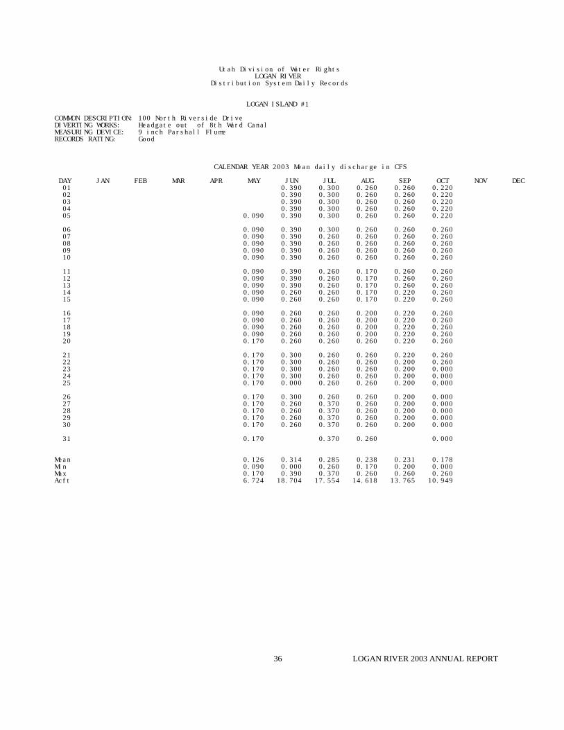
LOGAN ISLAND #1
COMMON DESCRIPTION: 100 North Riverside Drive DIVERTING WORKS: Headgate out of 8th Ward Canal MEASURING DEVICE: 9 inch Parshall Flume RECORDS RATING: Good
CALENDAR YEAR 2003 Mean daily discharge in CFS
DAY JAN FEB MAR APR MAY JUN JUL AUG SEP OCT NOV DEC 01 0.390 0.300 0.260 0.260 0.220 02 0.390 0.300 0.260 0.260 0.220 03 0.390 0.300 0.260 0.260 0.220 04 0.390 0.300 0.260 0.260 0.220 05 0.090 0.390 0.300 0.260 0.260 0.220
06 0.090 0.390 0.300 0.260 0.260 0.260 07 0.090 0.390 0.260 0.260 0.260 0.260 08 0.090 0.390 0.260 0.260 0.260 0.260 09 0.090 0.390 0.260 0.260 0.260 0.260 10 0.090 0.390 0.260 0.260 0.260 0.260
11 0.090 0.390 0.260 0.170 0.260 0.260 12 0.090 0.390 0.260 0.170 0.260 0.260 13 0.090 0.390 0.260 0.170 0.260 0.260 14 0.090 0.260 0.260 0.170 0.220 0.260 15 0.090 0.260 0.260 0.170 0.220 0.260
16 0.090 0.260 0.260 0.200 0.220 0.260 17 0.090 0.260 0.260 0.200 0.220 0.260 18 0.090 0.260 0.260 0.200 0.220 0.260 19 0.090 0.260 0.260 0.200 0.220 0.260 20 0.170 0.260 0.260 0.260 0.220 0.260
21 0.170 0.300 0.260 0.260 0.220 0.260 22 0.170 0.300 0.260 0.260 0.200 0.260 23 0.170 0.300 0.260 0.260 0.200 0.000 24 0.170 0.300 0.260 0.260 0.200 0.000 25 0.170 0.000 0.260 0.260 0.200 0.000
26 0.170 0.300 0.260 0.260 0.200 0.000 27 0.170 0.260 0.370 0.260 0.200 0.000 28 0.170 0.260 0.370 0.260 0.200 0.000 29 0.170 0.260 0.370 0.260 0.200 0.000 30 0.170 0.260 0.370 0.260 0.200 0.000
31 0.170 0.370 0.260 0.000
Mean 0.126 0.314 0.285 0.238 0.231 0.178 Min 0.090 0.000 0.260 0.170 0.200 0.000 Max 0.170 0.390 0.370 0.260 0.260 0.260 Acft 6.724 18.704 17.554 14.618 13.765 10.949
LOGAN RIVER 2003 ANNUAL REPORT37
Utah Division of Water RightsLOGAN RIVER
Distribution System Daily Records
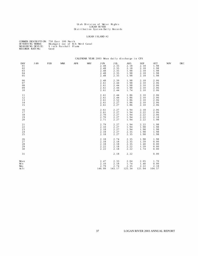
LOGAN ISLAND #2
COMMON DESCRIPTION: 750 East 100 North DIVERTING WORKS: Headgate out of 8th Ward Canal MEASURING DEVICE: 9 inch Parshall Flume RECORDS RATING: Good
CALENDAR YEAR 2003 Mean daily discharge in CFS
DAY JAN FEB MAR APR MAY JUN JUL AUG SEP OCT NOV DEC 01 2.48 2.35 2.18 2.18 1.98 02 2.48 2.35 2.18 2.18 1.98 03 2.48 2.35 1.98 2.18 1.98 04 2.48 2.35 1.98 2.18 1.98 05 2.48 2.35 1.98 2.18 1.98
06 2.48 2.39 1.98 2.18 2.06 07 2.61 2.44 1.98 2.10 2.06 08 2.61 2.44 1.98 2.10 2.06 09 2.61 2.44 1.98 2.10 2.06 10 2.61 2.44 1.74 2.10 2.06
11 2.61 2.44 1.86 2.10 2.06 12 2.61 2.44 1.86 2.10 2.06 13 2.61 2.52 1.86 2.10 2.06 14 2.61 2.27 1.86 2.10 2.06 15 2.61 2.27 1.86 2.10 2.06
16 2.61 2.27 1.94 2.18 2.06 17 2.61 2.27 1.94 2.22 2.06 18 2.70 2.27 1.94 2.22 2.06 19 2.70 2.27 1.94 2.22 2.18 20 2.71 2.27 1.94 2.22 1.98
21 2.79 2.27 1.94 2.22 1.98 22 2.10 2.27 1.94 1.98 1.98 23 2.18 2.27 1.94 1.98 1.98 24 2.18 2.27 2.35 1.98 1.98 25 2.18 2.27 2.35 1.98 1.98
26 2.18 2.74 2.35 1.98 1.98 27 2.18 2.18 2.35 1.59 0.00 28 2.18 2.18 2.35 1.40 0.00 29 2.22 2.18 2.22 1.59 0.00 30 2.22 2.18 2.22 1.74 0.00
31 2.18 2.22 0.00
Mean 2.47 2.33 2.04 2.05 1.70 Min 2.10 2.18 1.74 1.40 0.00 Max 2.79 2.74 2.35 2.22 2.18 Acft 146.99 143.17 125.34 121.94 104.57

LOGAN RIVER 2003 ANNUAL REPORT38
Utah Division of Water RightsLOGAN RIVER
Distribution System Daily Records
LOGAN ISLAND #3
COMMON DESCRIPTION: 581 East Center Street DIVERTING WORKS: Headgate out of 8th Ward Canal MEASURING DEVICE: 9 inch Parshall Flume RECORDS RATING: Good
CALENDAR YEAR 2003 Mean daily discharge in CFS
DAY JAN FEB MAR APR MAY JUN JUL AUG SEP OCT NOV DEC 01 0.590 0.590 0.590 0.590 0.590 02 0.590 0.590 0.590 0.590 0.590 03 0.590 0.590 0.590 0.590 0.590 04 0.590 0.590 0.590 0.590 0.590 05 0.590 0.590 0.590 0.590 0.590
06 0.590 0.590 0.590 0.590 0.590 07 0.590 0.590 0.590 0.590 0.590 08 0.590 0.590 0.590 0.590 0.590 09 0.590 0.590 0.590 0.590 0.590 10 0.590 0.590 0.590 0.590 0.590
11 0.590 0.590 0.590 0.590 0.590 12 0.590 0.590 0.590 0.590 0.590 13 0.590 0.590 0.590 0.590 0.590 14 0.590 0.590 0.590 0.590 0.590 15 0.590 0.590 0.590 0.590 0.590
16 0.760 0.590 0.590 0.590 0.590 17 0.760 0.590 0.590 0.590 0.590 18 0.760 0.590 0.590 0.590 0.590 19 0.760 0.590 0.590 0.590 0.590 20 0.760 0.590 0.590 0.590 0.590
21 0.760 0.590 0.590 0.590 0.590 22 0.760 0.590 0.590 0.590 0.590 23 0.760 0.590 0.590 0.590 0.590 24 0.760 0.590 0.590 0.590 0.590 25 0.760 0.590 0.590 0.590 0.590
26 0.760 0.590 0.590 0.590 0.590 27 0.760 0.590 0.590 0.590 0.590 28 0.760 0.590 0.590 0.590 0.590 29 0.760 0.590 0.590 0.590 0.590 30 0.760 0.590 0.590 0.590 0.590
31 0.590 0.590 0.000
Mean 0.675 0.590 0.590 0.590 0.571 Min 0.590 0.590 0.590 0.590 0.000 Max 0.760 0.590 0.590 0.590 0.590 Acft 40.165 36.278 36.278 35.107 35.107

LOGAN RIVER 2003 ANNUAL REPORT39
Utah Division of Water RightsLOGAN RIVER
Distribution System Daily Records
LOGAN ISLAND #4
COMMON DESCRIPTION: 400 East Center Street DIVERTING WORKS: Headgate out of 8th Ward Canal MEASURING DEVICE: 9 inch Parshall Flume RECORDS RATING: Good
CALENDAR YEAR 2003 Mean daily discharge in CFS
DAY JAN FEB MAR APR MAY JUN JUL AUG SEP OCT NOV DEC 01 1.70 1.70 1.40 1.70 1.63 02 1.70 1.70 1.40 1.70 1.63 03 1.70 1.70 1.40 1.70 1.63 04 1.74 1.70 1.40 1.70 1.63 05 1.74 1.70 1.40 1.70 1.63
06 1.74 1.70 1.40 1.70 1.63 07 1.74 1.70 1.40 1.70 1.63 08 1.74 1.70 1.40 1.63 1.63 09 1.74 1.70 0.90 1.63 1.63 10 1.74 1.70 0.56 1.63 1.63
11 1.66 1.74 1.70 0.90 1.63 1.63 12 1.66 1.74 1.70 1.06 1.63 1.70 13 1.66 1.74 1.66 1.13 1.63 1.82 14 1.66 1.74 1.55 1.13 1.63 1.82 15 1.66 1.90 1.55 1.20 1.66 1.82
16 1.66 1.90 1.55 1.59 1.66 1.82 17 1.66 1.90 1.55 1.59 1.66 1.82 18 1.66 1.90 1.55 1.59 1.66 1.82 19 1.66 1.90 1.55 1.59 1.66 1.82 20 1.66 1.90 1.55 1.59 1.66 1.74
21 1.66 1.90 1.55 1.59 1.66 1.74 22 1.66 1.90 1.55 1.74 1.63 1.74 23 1.66 1.82 1.55 1.74 1.63 1.74 24 1.66 1.82 1.55 1.74 1.63 1.74 25 1.66 1.82 1.55 1.70 1.63 1.74
26 1.66 1.82 1.48 1.70 1.63 1.74 27 1.66 1.82 1.44 1.70 1.63 1.74 28 1.66 1.82 1.48 1.70 1.63 1.74 29 1.66 1.70 1.48 1.70 1.63 0.00 30 1.66 1.70 1.48 1.70 1.63 0.00
31 1.66 1.48 1.70 0.00
Mean 1.66 1.79 1.60 1.44 1.65 1.55 Min 1.66 1.70 1.44 0.56 1.63 0.00 Max 1.66 1.90 1.70 1.74 1.70 1.82 Acft 69.14 106.63 98.18 88.74 98.38 95.27

LOGAN RIVER 2003 ANNUAL REPORT40
Utah Division of Water RightsLOGAN RIVER
Distribution System Daily Records
LOGAN ISLAND #5
COMMON DESCRIPTION: 75 South 200 East DIVERTING WORKS: Headgate out of 8th Ward Canal MEASURING DEVICE: 9 inch Parshall Flume RECORDS RATING: Good
CALENDAR YEAR 2003 Mean daily discharge in CFS
DAY JAN FEB MAR APR MAY JUN JUL AUG SEP OCT NOV DEC 01 0.590 0.590 0.590 0.590 0.150 02 0.590 0.590 0.590 0.590 0.150 03 0.590 0.590 0.590 0.590 0.150 04 0.590 0.590 0.590 0.590 0.150 05 0.590 0.590 0.590 0.590 0.150
06 0.590 0.590 0.590 0.590 0.150 07 0.590 0.490 0.590 0.670 0.150 08 0.590 0.490 0.590 0.670 0.150 09 0.590 0.490 0.590 0.670 0.150 10 0.590 0.490 0.590 0.170 0.150
11 0.590 0.490 0.640 0.170 0.150 12 0.590 0.490 0.640 0.170 0.150 13 0.590 0.440 0.640 0.170 0.150 14 0.590 0.440 0.640 0.170 0.150 15 0.590 0.440 0.670 0.190 0.150
16 0.590 0.440 0.670 0.190 0.150 17 0.590 0.440 0.670 0.190 0.000 18 0.590 0.440 0.670 0.190 0.000 19 0.590 0.440 0.000 0.190 0.000 20 0.590 0.440 0.000 0.190 0.000
21 0.590 0.440 0.000 0.190 0.000 22 0.590 0.440 0.000 0.150 0.000 23 0.590 0.540 0.000 0.150 0.000 24 0.590 0.540 0.000 0.150 0.000 25 0.590 0.540 0.000 0.150 0.000
26 0.590 0.540 0.000 0.150 0.000 27 0.590 0.540 0.280 0.150 0.000 28 0.590 0.540 0.280 0.150 0.000 29 0.590 0.540 0.280 0.150 0.000 30 0.590 0.540 0.150 0.000
31 0.540 0.280 0.000
Mean 0.590 0.508 0.409 0.303 0.077 Min 0.590 0.440 0.000 0.150 0.000 Max 0.590 0.590 0.670 0.670 0.150 Acft 35.107 31.220 24.317 18.010 4.760

LOGAN RIVER 2003 ANNUAL REPORT41
Utah Division of Water RightsLOGAN RIVER
Distribution System Daily Records
LOGAN ISLAND #6 & #7
COMMON DESCRIPTION: 150 East 100 South DIVERTING WORKS: Headgate out of 8th Ward Canal MEASURING DEVICE: 18 inch Parshall Flume RECORDS RATING: Good
CALENDAR YEAR 2003 Mean daily discharge in CFS
DAY JAN FEB MAR APR MAY JUN JUL AUG SEP OCT NOV DEC 01 1.19 1.19 1.19 0.94 0.71 02 1.19 1.19 1.19 0.94 0.71 03 1.19 1.19 1.19 0.94 0.71 04 1.19 1.19 1.19 0.94 0.71 05 1.19 1.19 1.19 0.94 0.71
06 1.19 1.19 1.19 0.94 0.71 07 1.19 1.19 1.19 0.94 0.71 08 1.19 1.19 1.19 0.94 0.71 09 1.19 1.19 1.19 0.94 0.71 10 1.19 1.19 1.19 0.94 0.71
11 1.19 1.19 1.19 0.94 0.71 12 1.19 1.19 1.19 0.94 0.71 13 1.19 1.19 1.19 0.94 0.71 14 1.19 1.19 1.19 0.94 0.71 15 1.19 1.19 1.19 0.94 0.71
16 1.19 1.19 1.19 0.94 0.71 17 1.19 1.19 0.94 0.94 0.71 18 1.19 1.19 0.94 0.94 0.00 19 1.19 1.19 0.94 0.94 0.00 20 1.19 1.19 0.94 0.94 0.00
21 1.19 1.19 0.94 0.94 0.00 22 1.19 1.19 0.94 0.94 0.00 23 1.19 1.19 0.94 0.94 0.00 24 1.19 1.19 0.94 0.94 0.00 25 1.19 1.19 0.94 0.94 0.00
26 1.19 1.19 0.94 0.71 0.00 27 1.19 1.19 0.94 0.71 0.00 28 1.19 1.19 0.94 0.71 0.00 29 1.19 1.19 0.94 0.71 0.00 30 1.19 1.19 0.94 0.71 0.00
31 1.19 0.94 0.00
Mean 1.19 1.19 1.07 0.90 0.39 Min 1.19 1.19 0.94 0.71 0.00 Max 1.19 1.19 1.19 0.94 0.71 Acft 70.81 73.17 65.73 53.65 23.94

LOGAN RIVER 2003 ANNUAL REPORT42
Utah Division of Water RightsLOGAN RIVER
Distribution System Daily Records
LOGAN ISLAND #8
COMMON DESCRIPTION: 165 South 100 West DIVERTING WORKS: Headgate out of 8th Ward Canal MEASURING DEVICE: 9 inch Parshall Flume RECORDS RATING: Good
CALENDAR YEAR 2003 Mean daily discharge in CFS
DAY JAN FEB MAR APR MAY JUN JUL AUG SEP OCT NOV DEC 01 1.74 1.74 1.59 1.59 0.00 02 1.74 1.74 1.59 1.59 0.00 03 1.74 1.74 1.59 1.59 0.00 04 1.74 1.74 1.59 1.59 0.00 05 1.74 1.74 1.59 1.59 0.00
06 1.74 1.74 1.59 1.59 0.00 07 1.74 1.74 1.59 1.59 0.00 08 1.74 1.74 1.59 1.59 0.00 09 1.74 1.74 1.59 1.59 0.00 10 1.74 1.74 1.59 1.59 0.00
11 1.74 1.74 1.59 1.59 0.00 12 1.74 1.74 1.59 1.59 0.00 13 1.74 1.74 1.59 1.59 0.00 14 1.74 1.74 1.59 1.59 0.00 15 1.74 1.74 1.59 1.59 0.00
16 1.70 1.74 1.59 1.59 0.00 17 1.70 1.74 1.59 1.59 0.00 18 1.70 1.74 1.59 1.59 0.00 19 1.70 1.74 1.59 1.59 0.00 20 1.70 1.74 1.59 1.59 0.00
21 1.70 1.74 1.59 1.59 0.00 22 1.59 1.74 1.59 1.59 0.00 23 1.59 1.74 1.59 1.59 0.00 24 1.59 1.74 1.59 1.59 0.00 25 1.59 1.74 1.59 1.59 0.00
26 1.59 1.74 1.59 1.59 0.00 27 1.59 1.74 1.59 1.59 0.00 28 1.59 1.74 1.59 1.59 0.00 29 1.59 1.74 1.59 1.59 0.00 30 1.59 1.74 1.59 1.59 0.00
31 1.74 1.59 0.00
Mean 1.69 1.74 1.59 1.59 0.00 Min 1.59 1.74 1.59 1.59 0.00 Max 1.74 1.74 1.59 1.59 0.00 Acft 100.38 106.99 97.77 94.61 0.00

LOGAN RIVER 2003 ANNUAL REPORT43
Utah Division of Water RightsLOGAN RIVER
Distribution System Daily Records
LOGAN HOLLOW CANAL
COMMON DESCRIPTION: 1344 Canyon road DIVERTING WORKS: Cement structure out of Logan River MEASURING DEVICE: 9 inch parshall flume RECORDS RATING: Good
CALENDAR YEAR 2003 Mean daily discharge in CFS
DAY JAN FEB MAR APR MAY JUN JUL AUG SEP OCT NOV DEC 01 1.37 2.06 1.59 1.74 0.76 02 1.37 2.18 1.59 1.48 0.76 03 1.23 2.18 1.59 1.48 0.76 04 1.23 2.18 1.59 1.48 0.14 05 1.23 2.18 1.59 1.48 0.14
06 1.23 2.18 1.59 1.48 0.14 07 1.23 1.98 1.59 1.48 0.49 08 1.23 1.98 1.59 1.48 0.00 09 1.23 1.98 1.59 1.48 0.59 10 1.23 1.70 1.48 1.48 0.59
11 1.06 1.70 1.48 1.48 0.59 12 1.06 1.70 1.48 1.48 0.59 13 1.06 1.70 1.48 1.48 0.59 14 1.06 2.06 1.48 1.48 0.59 15 1.06 2.06 1.33 1.20 0.59
16 1.23 2.06 1.26 1.20 0.59 17 1.74 1.23 2.06 1.23 1.20 0.59 18 1.74 1.23 2.06 1.23 1.20 0.59 19 1.74 1.23 2.06 1.23 1.20 0.59 20 1.74 1.23 20.60 1.23 1.20 0.59
21 1.74 2.18 2.06 1.23 1.10 0.00 22 1.74 2.18 2.06 1.23 1.10 0.00 23 1.74 2.18 2.06 1.23 1.10 0.00 24 1.74 2.18 2.06 1.82 1.10 0.00 25 1.74 2.18 2.06 1.74 1.10 0.00
26 1.74 2.18 2.06 1.74 1.10 0.00 27 1.74 2.18 2.18 1.74 1.10 0.00 28 1.37 2.18 2.18 1.74 1.10 0.00 29 1.37 2.06 2.18 1.74 1.10 0.00 30 1.37 2.06 2.18 1.74 1.10 0.00
31 1.37 2.18 1.74 0.00
Mean 1.64 1.52 2.64 1.51 1.31 0.33 Min 1.37 1.06 1.70 1.23 1.10 0.00 Max 1.74 2.18 20.60 1.82 1.74 0.76 Acft 48.83 90.43 162.49 93.04 77.71 20.37

LOGAN RIVER 2003 ANNUAL REPORT44
Utah Division of Water RightsLOGAN RIVER
Distribution System Daily Records
HYDE PARK AND LOGAN NORTHFIELD
COMMON DESCRIPTION: 150 East Center DIVERTING WORKS: MEASURING DEVICE: 7 foot Parshall Flume with recorder RECORDS RATING: Good
CALENDAR YEAR 2003 Mean daily discharge in CFS
DAY JAN FEB MAR APR MAY JUN JUL AUG SEP OCT NOV DEC 01 5.70 21.60 21.60 10.80 8.65 10.50 02 4.52 21.60 21.60 10.10 8.94 11.10 03 4.52 21.60 20.40 10.50 8.94 11.70 04 4.52 21.60 14.10 10.80 8.36 11.70 05 5.95 21.60 14.10 10.80 8.36 11.70
06 5.95 21.60 14.10 10.50 8.94 11.70 07 5.95 21.20 13.70 10.10 9.23 12.00 08 6.46 20.80 13.70 10.10 9.53 12.40 09 6.46 20.40 13.40 9.53 9.53 12.40 10 8.65 6.46 21.20 13.40 11.10 10.10 12.40
11 8.65 6.46 21.20 13.40 10.80 10.10 12.40 12 8.65 5.95 22.40 13.40 10.80 10.10 12.00 13 8.65 5.95 22.40 13.00 10.80 10.10 11.70 14 6.98 0.00 22.40 12.70 10.80 10.10 12.00 15 5.70 0.00 22.80 12.70 10.80 10.10 12.00
16 5.70 0.00 22.80 12.40 9.53 10.10 12.00 17 5.70 0.00 22.80 9.53 8.94 10.10 11.70 18 5.70 3.44 23.20 9.23 8.65 9.83 11.70 19 5.70 7.25 23.20 9.23 8.65 10.80 11.40 20 5.70 7.80 23.20 9.23 8.65 11.40 11.40
21 5.70 7.52 18.40 8.94 8.65 11.10 11.40 22 5.46 8.08 22.00 13.70 8.65 7.52 11.40 23 5.46 9.23 24.90 13.70 8.36 7.52 11.10 24 5.70 7.80 20.40 13.70 8.36 7.80 11.10 25 5.22 9.23 20.00 13.70 8.36 9.53 11.40
26 5.46 6.72 19.60 13.70 8.08 11.70 11.70 27 5.70 19.60 20.00 13.70 8.08 11.40 12.00 28 5.70 21.60 20.00 14.10 8.36 11.10 11.40 29 5.70 21.60 19.60 13.70 8.36 11.10 13.00 30 5.70 21.60 20.00 12.00 8.65 10.50 9.23
31 21.60 13.40 8.65 0.00
Mean 6.27 8.00 21.48 13.52 9.53 9.75 11.28 Min 5.22 0.00 18.40 8.94 8.08 7.52 0.00 Max 8.65 21.60 24.90 21.60 11.10 11.70 13.00 Acft 260.99 491.74 1278.35 831.59 585.74 580.32 693.48
During the irritation season, 2 cfs also goes to Logan City Golf Course, and is not includedin the above totals.
Logan City well was turned on July 3 - September 15. During this time, an additional 8 cfs isadded to the above numbers.The well was off for 24 hours July 18th and again for 32 hours August 2-3.

LOGAN RIVER 2003 ANNUAL REPORT45
Utah Division of Water RightsLOGAN RIVER
Distribution System Daily Records
SEVENTH WARD #1
COMMON DESCRIPTION: Preston Avenue DIVERTING WORKS: Headgate out of 8th Ward Canal MEASURING DEVICE: 6 inch Parshall Flume RECORDS RATING: Good
CALENDAR YEAR 2003 Mean daily discharge in CFS
DAY JAN FEB MAR APR MAY JUN JUL AUG SEP OCT NOV DEC 01 0.310 0.310 0.310 0.310 0.160 02 0.310 0.310 0.310 0.310 0.160 03 0.310 0.310 0.310 0.310 0.160 04 0.310 0.310 0.310 0.310 0.160 05 0.310 0.310 0.310 0.310 0.160
06 0.310 1.040 0.310 0.310 0.160 07 0.310 1.040 0.310 0.310 0.160 08 0.310 1.040 0.310 0.310 0.160 09 0.310 1.040 0.310 0.310 0.160 10 0.310 1.040 0.310 0.310 0.160
11 0.310 1.040 0.310 0.310 0.160 12 0.310 1.040 0.310 0.310 0.160 13 0.310 1.040 0.310 0.310 0.160 14 0.310 0.310 0.310 0.310 0.160 15 0.310 0.310 0.310 0.310 0.160
16 0.310 0.310 0.310 0.310 0.160 17 0.310 0.310 0.310 0.310 0.000 18 0.310 0.310 0.310 0.310 0.000 19 0.310 0.310 0.310 0.310 0.000 20 0.310 0.310 0.310 0.310 0.000
21 0.310 0.310 0.310 0.310 0.000 22 0.310 0.310 0.310 0.310 0.000 23 0.310 0.310 0.310 0.310 0.000 24 0.310 0.310 0.310 0.310 0.000 25 0.310 0.310 0.310 0.310 0.000
26 0.310 0.310 0.310 0.310 0.000 27 0.310 0.310 0.310 0.160 0.000 28 0.310 0.310 0.310 0.160 0.000 29 0.310 0.310 0.310 0.160 0.000 30 0.310 0.310 0.310 0.160 0.000
31 0.310 0.310 0.000
Mean 0.310 0.498 0.310 0.290 0.083 Min 0.310 0.310 0.310 0.160 0.000 Max 0.310 1.040 0.310 0.310 0.160 Acft 18.446 30.645 19.061 17.256 5.078

LOGAN RIVER 2003 ANNUAL REPORT46
Utah Division of Water RightsLOGAN RIVER
Distribution System Daily Records
SEVENTH WARD #2
COMMON DESCRIPTION: 500 East Canyon Road DIVERTING WORKS: Headgate out of 8th Ward Canal MEASURING DEVICE: 6 inch Parshall Flume RECORDS RATING: Good
CALENDAR YEAR 2003 Mean daily discharge in CFS
DAY JAN FEB MAR APR MAY JUN JUL AUG SEP OCT NOV DEC 01 1.150 1.040 0.920 0.920 0.920 02 1.155 1.040 0.920 0.920 0.920 03 1.150 1.040 0.920 0.920 0.920 04 1.150 1.040 0.920 0.920 0.920 05 1.150 1.040 0.920 0.920 0.920
06 1.150 1.040 0.920 0.920 0.920 07 1.150 1.040 0.920 0.920 0.920 08 1.150 1.040 0.920 0.920 0.920 09 1.150 1.040 0.920 0.920 0.920 10 1.150 1.040 0.920 0.920 0.920
11 1.150 1.040 0.920 0.920 0.920 12 1.150 1.040 0.920 0.920 0.920 13 1.150 1.040 0.920 0.920 0.920 14 1.150 1.040 0.920 0.920 0.920 15 1.150 1.040 0.920 0.920 0.920
16 1.150 1.040 0.920 0.920 0.920 17 1.150 1.040 0.920 0.920 0.920 18 1.150 1.040 0.920 0.920 0.000 19 1.150 1.040 0.920 0.920 0.000 20 1.150 1.040 0.920 0.920 0.000
21 1.150 1.040 0.920 0.920 0.000 22 1.150 1.040 0.920 0.920 0.000 23 0.480 1.040 0.920 0.920 0.000 24 0.480 1.040 0.920 0.920 0.000 25 0.480 1.040 0.920 0.920 0.000
26 0.480 1.040 0.920 0.920 0.000 27 0.480 1.040 0.920 0.920 0.000 28 0.480 1.040 0.920 0.920 0.000 29 0.480 1.040 0.920 0.920 0.000 30 0.480 1.040 0.920 0.920 0.000
31 1.040 0.920 0.000
Mean 0.971 1.040 0.920 0.920 0.505 Min 0.480 1.040 0.920 0.920 0.000 Max 1.155 1.040 0.920 0.920 0.920 Acft 57.808 63.947 56.569 54.744 31.021

LOGAN RIVER 2003 ANNUAL REPORT47
Utah Division of Water RightsLOGAN RIVER
Distribution System Daily Records
PROVIDENCE-LOGAN IRRIGATION COMPANY
COMMON DESCRIPTION: 1500 Sumac Drive DIVERTING WORKS: Headgate out of Logan River MEASURING DEVICE: 3 foot parshall flume with recorder RECORDS RATING: Good
CALENDAR YEAR 2003 Mean daily discharge in CFS
DAY JAN FEB MAR APR MAY JUN JUL AUG SEP OCT NOV DEC 01 1.37 5.25 5.25 5.53 3.92 3.80 02 1.37 5.11 5.25 5.53 3.80 0.00 03 1.20 4.98 5.11 4.44 3.80 0.00 04 0.00 4.98 5.11 3.20 3.80 0.00 05 0.00 4.84 5.82 3.56 3.80 0.00
06 0.00 4.84 6.71 4.05 3.80 0.00 07 0.61 4.57 6.56 4.05 3.80 0.00 08 3.56 4.44 6.56 4.18 3.80 0.00 09 3.68 4.31 6.26 4.31 3.80 0.00 10 2.97 4.31 6.41 4.57 3.80 0.00
11 2.97 5.11 6.41 4.44 3.80 0.00 12 2.86 5.11 6.41 4.44 3.80 0.00 13 2.86 5.11 6.26 4.31 3.80 0.00 14 2.75 4.98 6.12 4.31 3.80 0.00 15 2.86 4.98 6.12 4.31 3.80 0.00
16 4.70 5.39 6.26 4.18 3.92 0.00 17 5.11 5.39 6.26 4.05 4.05 0.00 18 4.31 5.39 6.12 4.05 4.05 0.00 19 4.31 5.39 6.12 4.05 4.18 0.00 20 4.31 5.39 6.12 4.05 4.18 0.00
21 4.31 5.82 6.12 4.05 4.18 0.00 22 4.18 5.82 6.12 4.18 4.18 0.00 23 4.44 5.68 5.97 4.05 4.18 0.00 24 4.84 5.68 5.97 4.05 4.18 0.00 25 4.84 5.39 5.97 4.05 4.05 0.00
26 0.97 4.84 5.25 5.82 4.05 4.05 0.00 27 1.37 4.84 5.11 5.68 4.05 4.18 0.00 28 1.37 4.84 4.98 5.68 4.05 4.18 0.00 29 1.37 4.84 4.84 5.53 4.05 4.05 0.00 30 1.37 5.11 4.98 5.53 4.05 4.05 0.00
31 5.25 5.53 3.92 0.00
Mean 1.29 3.36 5.11 5.97 4.20 3.96 0.12 Min 0.97 0.00 4.31 5.11 3.20 3.80 0.00 Max 1.37 5.25 5.82 6.71 5.53 4.18 3.80 Acft 12.79 206.54 304.30 367.26 258.17 235.60 7.54

LOGAN RIVER 2003 ANNUAL REPORT48
Utah Division of Water RightsLOGAN RIVER
Distribution System Daily Records
PROVIDENCE PIONEER CANAL
COMMON DESCRIPTION: below River Heights Bridge DIVERTING WORKS: diverted from Logan River MEASURING DEVICE: 18 inch Parshall Flume with recorder RECORDS RATING: Good
CALENDAR YEAR 2003 Mean daily discharge in CFS
DAY JAN FEB MAR APR MAY JUN JUL AUG SEP OCT NOV DEC 01 2.73 1.25 3.02 2.66 1.41 02 2.66 1.30 3.02 2.66 1.36 03 2.52 1.70 2.95 2.66 1.14 04 2.39 1.76 2.95 2.66 0.67 05 2.25 1.88 2.73 0.00 0.55
06 2.59 1.58 2.25 3.31 0.55 07 3.31 1.58 2.25 3.31 0.55 08 3.09 1.64 2.25 3.17 0.55 09 3.46 1.94 2.32 1.76 0.55 10 3.77 1.94 2.32 1.64 0.55
11 3.62 1.94 2.32 1.64 0.55 12 3.54 1.94 2.32 1.64 0.55 13 0.15 3.54 1.88 2.32 1.64 0.55 14 0.71 3.46 1.82 2.39 2.25 0.55 15 0.94 3.31 1.70 2.39 2.39 0.55
16 0.94 3.17 1.53 2.39 2.39 0.55 17 0.94 3.17 1.47 2.39 1.64 0.55 18 0.94 2.95 1.47 2.39 1.58 0.55 19 0.51 2.95 1.94 2.59 1.53 0.55 20 0.51 3.02 1.94 3.39 1.53 0.55
21 0.51 3.02 1.94 3.39 1.53 0.55 22 0.51 2.45 1.64 3.46 1.53 0.59 23 0.94 2.06 1.64 3.46 1.53 0.00 24 2.25 1.88 3.69 3.46 1.53 0.00 25 2.52 1.88 3.85 3.46 1.53 0.00
26 2.80 1.76 3.85 3.46 1.53 0.00 27 2.73 1.53 3.77 3.54 1.53 0.00 28 2.95 1.53 3.69 3.54 1.47 0.00 29 3.02 1.53 3.39 3.54 1.41 0.00 30 2.95 1.53 3.31 3.09 1.47 0.00
31 2.73 3.02 2.66 0.00
Mean 1.56 2.69 2.19 2.84 1.90 0.47 Min 0.15 1.53 1.25 2.25 0.00 0.00 Max 3.02 3.77 3.85 3.54 3.31 1.41 Acft 58.61 160.01 134.86 174.57 113.30 28.80

LOGAN RIVER 2003 ANNUAL REPORT49
Utah Division of Water RightsLOGAN RIVER
Distribution System Daily Records
SUNDAY WATER USERS CANAL
COMMON DESCRIPTION: Preston Avenue DIVERTING WORKS: Headgate out of 8th Ward Canal MEASURING DEVICE: 1 foot parshall flume RECORDS RATING: Good
CALENDAR YEAR 2003 Mean daily discharge in CFS
DAY JAN FEB MAR APR MAY JUN JUL AUG SEP OCT NOV DEC 01 0.640 02 03 04 05
06 0.640 07 0.640 08 0.640 09 10
11 12 13 0.640 14 0.640 15 0.640
16 17 18 19 20
21 0.640 22 23 24 25
26 27 0.640 28 29 0.640 30
31
Mean 0.640 0.640 0.640 Min 0.640 0.640 0.640 Max 0.640 0.640 0.640 Acft 5.078 3.808 3.808

LOGAN RIVER 2003 ANNUAL REPORT50
Utah Division of Water RightsLOGAN RIVER
Distribution System Daily Records
THATCHER IRRIGATION COMPANY
COMMON DESCRIPTION: 100 South 100 West, DIVERTING WORKS: Headgate out of Thatcher Mill MEASURING DEVICE: RECORDS RATING: Poor
CALENDAR YEAR 2003 Mean daily discharge in CFS
DAY JAN FEB MAR APR MAY JUN JUL AUG SEP OCT NOV DEC 01 0.00 0.80 0.70 0.70 0.60 0.60 02 0.00 0.80 0.70 0.70 0.60 0.60 03 0.00 0.80 0.70 0.70 0.60 0.60 04 0.00 0.80 0.70 0.70 0.60 0.60 05 0.00 0.80 0.70 0.70 0.60 0.60
06 0.00 0.80 0.70 0.70 0.60 0.60 07 0.00 0.80 0.70 0.70 0.60 0.60 08 0.00 0.80 0.70 0.70 0.60 0.60 09 0.00 0.80 0.70 0.70 0.60 0.60 10 0.00 0.80 0.70 0.70 0.60 0.60
11 0.00 0.80 0.70 0.70 0.60 0.60 12 0.00 0.80 0.70 0.70 0.60 0.60 13 0.00 0.80 0.70 0.70 0.60 0.60 14 0.00 0.80 0.70 0.70 0.60 0.60 15 0.00 0.80 0.70 0.70 0.60 0.60
16 0.00 0.80 0.70 0.70 0.60 0.60 17 0.00 0.80 0.70 0.70 0.60 0.60 18 0.80 0.80 0.70 0.70 0.60 0.60 19 0.80 0.80 0.70 0.70 0.60 0.60 20 0.80 0.80 0.70 0.70 0.60 0.60
21 0.80 0.00 0.70 0.70 0.60 0.60 22 0.80 0.00 0.70 0.70 0.60 0.60 23 0.80 0.00 0.70 0.70 0.60 0.60 24 0.80 0.80 0.70 0.70 0.60 0.60 25 0.80 0.80 0.70 0.70 0.60 0.00
26 0.80 0.80 0.70 0.70 0.60 0.00 27 0.80 0.80 0.70 0.70 0.60 0.00 28 0.80 0.80 0.70 0.70 0.60 0.00 29 0.80 0.80 0.70 0.70 0.60 0.00 30 0.80 0.80 0.70 0.70 0.60 0.00
31 0.80 0.70 0.70 0.00
Mean 0.36 0.72 0.70 0.70 0.60 0.46 Min 0.00 0.00 0.70 0.70 0.60 0.00 Max 0.80 0.80 0.70 0.70 0.60 0.60 Acft 22.21 42.84 43.04 43.04 35.70 28.56

LOGAN RIVER 2003 ANNUAL REPORT51
Utah Division of Water RightsLOGAN RIVER
Distribution System Daily Records
LOGAN NORTHWEST FIELD CANAL
COMMON DESCRIPTION: behind Logan High School DIVERTING WORKS: water from 8th Ward Canal MEASURING DEVICE: 12 foot ramp flume with recorder RECORDS RATING: Good
CALENDAR YEAR 2003 Mean daily discharge in CFS
DAY JAN FEB MAR APR MAY JUN JUL AUG SEP OCT NOV DEC 01 12.00 41.40 32.20 12.40 16.40 13.10 02 14.30 40.80 31.10 22.80 16.00 13.50 03 13.90 40.20 31.60 23.30 14.70 13.50 04 12.70 40.20 32.70 25.80 14.30 12.50 05 12.50 38.50 34.40 25.80 13.90 12.00
06 12.50 37.30 33.90 25.80 13.90 12.50 07 14.30 36.70 32.70 25.80 13.50 12.60 08 14.30 36.70 30.50 25.30 13.90 12.70 09 14.70 38.50 30.50 25.80 14.70 12.50 10 10.00 10.00 40.20 30.00 22.30 16.00 12.40
11 10.00 10.00 42.10 30.00 22.80 15.60 12.50 12 10.00 21.90 42.10 30.00 23.30 14.70 12.70 13 13.90 21.90 42.70 30.00 22.80 14.30 13.10 14 13.90 22.30 42.70 25.80 22.30 14.30 13.10 15 13.90 23.30 42.70 27.40 23.80 14.30 13.10
16 13.90 25.80 42.70 27.40 23.80 13.90 14.70 17 13.90 25.80 43.90 24.80 22.80 14.30 17.30 18 13.90 24.80 43.90 24.30 23.30 13.90 17.70 19 13.50 25.80 43.90 25.30 23.30 13.10 18.20 20 12.00 26.80 43.90 23.80 23.30 12.70 18.20
21 12.00 26.80 42.70 21.40 24.30 12.00 18.20 22 12.00 24.80 38.50 22.30 24.80 14.30 18.20 23 12.00 25.80 36.10 22.30 23.80 14.70 18.20 24 12.00 29.50 36.70 22.30 21.90 14.50 18.60 25 12.00 32.20 27.40 21.90 20.90 13.10 19.10
26 12.00 45.80 26.30 21.90 20.00 12.50 19.10 27 12.00 43.90 26.80 20.40 20.00 13.50 18.60 28 12.00 41.40 24.80 20.90 19.50 13.10 19.10 29 12.00 42.10 23.80 20.00 19.10 13.10 19.10 30 12.00 42.10 24.30 12.70 18.20 12.70 23.80
31 41.40 15.60 17.30 0.00
Mean 12.33 24.37 37.62 26.13 22.46 14.06 15.16 Min 10.00 10.00 23.80 12.70 12.40 12.00 0.00 Max 13.90 45.80 43.90 34.40 25.80 16.40 23.80 Acft 513.52 1498.31 2238.35 1606.81 1381.29 836.83 932.03

LOGAN RIVER 2003 ANNUAL REPORT52
Utah Division of Water RightsLOGAN RIVER
Distribution System Daily Records
SOUTHWEST FIELD CANAL
COMMON DESCRIPTION: Cache County Fair Grounds DIVERTING WORKS: Headgate out of Anderson Mill MEASURING DEVICE: 3 foot Parshall Flume RECORDS RATING: Good
CALENDAR YEAR 2003 Mean daily discharge in CFS
DAY JAN FEB MAR APR MAY JUN JUL AUG SEP OCT NOV DEC 01 5.39 6.41 12.00 4.70 1.04 02 5.39 6.41 12.00 4.70 0.97 03 5.39 6.26 8.46 4.70 0.82 04 5.39 6.26 5.97 4.70 0.82 05 5.39 5.97 5.97 4.70 3.80
06 5.39 5.97 6.12 4.70 3.80 07 0.00 6.12 6.12 5.53 3.56 08 5.39 6.26 5.97 5.53 3.44 09 4.05 6.56 5.82 5.53 3.08 10 4.05 6.41 5.11 5.53 2.86
11 4.05 6.86 4.98 5.53 3.20 12 4.05 6.71 5.39 5.39 3.08 13 4.05 6.56 5.53 5.25 2.97 14 4.05 6.26 5.53 4.98 2.86 15 4.05 5.68 5.39 5.11 2.42
16 5.39 4.98 2.22 4.84 2.12 17 5.39 4.31 3.80 4.84 2.02 18 5.39 7.49 6.12 4.70 1.92 19 5.39 7.17 6.12 4.70 1.92 20 5.39 6.12 6.26 4.70 1.82
21 5.39 5.11 6.26 4.70 1.82 22 5.39 5.39 5.39 5.53 4.98 1.82 23 4.57 5.39 4.05 5.11 4.44 1.82 24 4.44 5.39 2.97 4.98 5.68 6.86 25 4.44 5.39 6.56 4.98 5.39 7.65
26 3.92 5.39 6.56 4.98 4.05 7.17 27 7.17 5.39 8.13 4.98 1.46 6.56 28 7.02 5.39 6.26 4.98 1.37 5.97 29 7.02 5.39 6.12 4.98 1.28 5.82 30 7.02 5.68 12.00 4.98 1.20 4.05
31 7.02 12.00 4.99 0.00
Mean 5.80 4.91 6.45 5.86 4.50 3.16 Min 3.92 0.00 2.97 2.22 1.20 0.00 Max 7.17 5.68 12.00 12.00 5.68 7.65 Acft 115.06 292.01 396.54 360.26 267.59 194.50

LOGAN RIVER 2003 ANNUAL REPORT53
Utah Division of Water RightsLOGAN RIVER
Distribution System Daily Records
BENSON IRRIGATION COMPANY
COMMON DESCRIPTION: 600 west 2300 north DIVERTING WORKS: MEASURING DEVICE: 6 foot parshall flume with recorder RECORDS RATING: Good
CALENDAR YEAR 2003 Mean daily discharge in CFS
DAY JAN FEB MAR APR MAY JUN JUL AUG SEP OCT NOV DEC 01 5.57 24.00 18.50 12.40 8.72 6.96 02 6.48 23.20 19.60 13.00 8.20 6.96 03 9.79 22.10 20.30 13.60 8.98 7.69 04 9.52 21.80 19.60 12.10 8.46 7.44 05 8.72 19.60 19.60 12.70 6.72 4.50
06 8.46 20.70 19.60 11.50 8.46 4.71 07 9.25 19.90 19.60 10.10 8.46 4.92 08 10.40 19.90 19.60 10.90 7.69 4.92 09 11.50 19.90 19.90 11.50 9.25 4.92 10 13.60 6.48 18.90 19.90 7.69 11.50 4.92
11 13.60 6.02 22.50 17.20 10.10 11.20 4.50 12 13.60 9.52 22.50 15.20 10.10 10.90 4.50 13 13.60 9.52 22.10 15.20 13.60 11.20 6.72 14 13.60 9.25 19.60 12.10 8.72 11.50 12.40 15 7.20 8.98 19.20 12.40 13.90 9.52 12.70
16 7.20 8.72 18.50 13.90 12.70 7.69 11.80 17 7.20 8.20 19.60 13.90 13.90 8.98 11.20 18 7.20 6.96 19.20 15.20 13.30 9.25 11.20 19 7.20 6.72 19.90 15.20 13.00 8.72 11.20 20 10.10 9.52 19.00 14.50 13.00 8.46 11.50
21 8.72 8.98 20.30 10.60 13.90 8.20 11.50 22 8.46 6.96 21.40 11.50 13.60 8.98 11.80 23 8.46 7.94 21.40 11.50 13.60 6.96 12.10 24 10.10 10.60 20.70 13.00 12.40 6.72 11.20 25 8.72 11.50 20.30 12.40 10.90 6.25 11.50
26 8.72 12.70 20.70 13.00 10.90 4.92 11.50 27 8.72 12.40 19.60 13.00 10.90 4.92 12.70 28 8.46 19.20 17.20 13.00 10.90 4.92 14.50 29 7.69 19.60 9.25 10.60 10.60 6.96 17.50 30 7.44 21.40 13.60 7.94 9.25 7.20 0.00
31 22.10 11.80 8.98 0.00
Mean 9.50 10.42 19.89 15.14 11.73 8.33 8.71 Min 7.20 5.57 9.25 7.94 7.69 4.92 0.00 Max 13.60 22.10 24.00 20.30 13.90 11.50 17.50 Acft 395.88 640.58 1183.24 930.92 721.47 495.65 535.46
Water Purchased from Logan City Well: 8 cfs - July 23 - September 14 = $1,728.00

LOGAN RIVER 2003 ANNUAL REPORT54
Utah Division of Water RightsLOGAN RIVER
Distribution System Daily Records
CENTRAL MILLING DIVERSION
COMMON DESCRIPTION: 150 East Center Street DIVERTING WORKS: Mill Race MEASURING DEVICE: Metered Mill Race RECORDS RATING: Good
CALENDAR YEAR 2003 Mean daily discharge in CFS
DAY JAN FEB MAR APR MAY JUN JUL AUG SEP OCT NOV DEC 01 0.000 0.300 0.300 0.300 0.300 0.300 02 0.000 0.300 0.300 0.300 0.300 0.300 03 0.000 0.300 0.300 0.300 0.300 0.300 04 0.000 0.300 0.300 0.300 0.300 0.300 05 0.000 0.300 0.300 0.300 0.300 0.300
06 0.000 0.300 0.300 0.300 0.300 0.300 07 0.000 0.300 0.300 0.300 0.300 0.300 08 0.000 0.300 0.300 0.300 0.300 0.300 09 0.000 0.300 0.300 0.300 0.300 0.300 10 0.000 0.300 0.300 0.300 0.300 0.300
11 0.300 0.300 0.300 0.300 0.300 0.300 12 0.300 0.300 0.300 0.300 0.300 0.300 13 0.300 0.300 0.300 0.300 0.300 0.300 14 0.300 0.300 0.300 0.300 0.300 0.300 15 0.300 0.300 0.300 0.300 0.300 0.300
16 0.300 0.300 0.300 0.300 0.300 0.000 17 0.300 0.300 0.300 0.300 0.300 0.000 18 0.300 0.300 0.300 0.300 0.300 0.000 19 0.300 0.300 0.300 0.300 0.300 0.000 20 0.300 0.300 0.300 0.300 0.300 0.000
21 0.300 0.300 0.300 0.300 0.300 0.000 22 0.300 0.300 0.300 0.300 0.300 0.000 23 0.300 0.300 0.300 0.300 0.300 0.000 24 0.300 0.300 0.300 0.300 0.300 0.000 25 0.300 0.300 0.300 0.300 0.300 0.000
26 0.300 0.300 0.300 0.300 0.300 0.000 27 0.300 0.300 0.300 0.300 0.300 0.000 28 0.300 0.300 0.300 0.300 0.300 0.000 29 0.300 0.300 0.300 0.300 0.300 0.000 30 0.300 0.300 0.300 0.300 0.300 0.000
31 0.300 0.300 0.300 0.000
Mean 0.203 0.300 0.300 0.300 0.300 0.145 Min 0.000 0.300 0.300 0.300 0.300 0.000 Max 0.300 0.300 0.300 0.300 0.300 0.300 Acft 12.496 17.851 18.446 18.446 17.851 8.926

LOGAN RIVER 2003 ANNUAL REPORT55
APPENDIX B
REVISED KIMBALL DECREE

LOGAN RIVER 2003 ANNUAL REPORT56
� � �This page intentionally left blank
� � �

REVISED SCHEDULE "A" KIMBALL DECREE October 21, 1965
Award No. Appropriations 100 110 120 130 140 150 160 170 180 190 200 210 220 230 240 250217 & 234 Logan City 10.0 10.0 10.0 10.0 10.0 10.0 10.0 10.0 10.0 10.0 10.0 10.0 10.0 10.0 10.0 10.0216 Logan, Hyde Park,
& Smithfield 20.2 22.4 24.6 26.9 29.1 31.4 33.6 35.8 38.1 40.3 42.6 44.8 47.0 49.4 51.5 53.7219 Logan Northern 22.9 25.4 27.9 30.5 33.0 35.5 38.1 40.6 43.2 45.7 48.2 50.8 53.3 56.0 58.4 61.0224 Logan Hollow 0.6 0.6 0.7 0.7 0.9 0.9 0.9 1.0 1.1 1.1 1.2 1.2 1.3 1.3 1.4 1.4220 Providence - Logan 3.2 3.6 3.9 4.3 4.6 5.0 5.3 5.7 6.0 6.4 6.8 7.1 7.5 7.5 8.2 8.6
8th Ward Diversions 41.7 46.5 51.2 55.8 60.5 65.1 69.8 74.4 79.0 83.7 88.3 93.0 97.7 102.4 107.0 111.6225 Logan Island 6.9 7.7 8.4 9.2 10.0 10.7 11.5 12.3 13.0 13.8 14.6 15.3 16.1 16.9 17.7 18.4226 7th Ward 0.7 0.8 0.9 0.9 1.0 1.1 1.2 1.2 1.3 1.4 1.5 1.6 1.6 1.7 1.8 1.9222 Hyde Park &
Logan Northfield 14.8 16.5 18.1 19.8 21.4 23.0 24.7 26.3 28.0 29.6 31.3 32.9 34.6 36.2 37.9 39.5227 Thatcher Irr. Co. 0.3 0.3 0.3 0.4 0.4 0.4 0.4 0.5 0.5 0.6 0.6 0.6 0.7 0.7 0.7 0.8223 Logan Northwest
Field & Benson 15.5 17.3 19.0 20.7 22.4 24.2 25.9 27.6 29.3 31.1 32.8 34.5 36.2 38.0 39.7 41.4Southwest Field 3.6 4.0 4.4 4.8 5.2 5.6 6.0 6.4 6.8 7.2 7.6 8.0 8.4 8.8 9.2 9.6Logan Cow Pasture - - - - - - - - - - - - - - - -
221 Providence Pioneer 1.4 1.5 1.5 1.8 2.0 2.1 2.3 2.5 2.6 2.8 2.9 3.1 3.2 3.4 3.5 3.7Power Rights
Utah Power & Light 69.8 77.6 85.4 93.1 100.9 108.6 116.4 124.2 131.9 139.7 147.4 155.2 163.0 170.6 178.5 186.3Central Milling 22.7 25.1 28.0 30.5 33.0 35.0 38.1 40.5 43.1 45.7 48.1 50.8 53.3 56.2 58.3 60.9Crowther Bros. 19.1 21.3 23.5 25.6 27.6 29.9 32.0 34.1 36.3 38.3 40.4 42.7 44.7 47.1 49.0 51.1
Award No. Appropriations 260 270 280 290 300 310 320 330 340 350 360 370 380 390 400217 & 234 Logan City 10.0 10.0 14.0 14.0 14.0 14.0 14.0 14.0 14.0 14.0 14.0 14.0 14.0 14.0 14.0216 Logan, Hyde Park,
& Smithfield 56.0 57.3 59.5 59.5 70.8 75.3 79.8 84.3 88.8 93.3 97.8 102.3 103.2 109.3 116.0219 Logan Northern 63.3 65.0 67.5 67.5 70.8 75.3 79.8 84.8 88.8 93.3 97.8 102.3 103.2 106.1 109.4224 Logan Hollow 1.6 1.6 1.7 1.7 1.8 1.9 2.0 2.1 2.2 2.3 2.4 2.5 2.5 2.5 2.5220 Providence - Logan 9.0 9.2 9.5 9.5 10.1 10.7 11.4 12.0 12.6 13.3 13.9 14.6 14.7 14.7 14.7
8th Ward Diversions116.3 119.0 123.8 123.8 128.4 128.4 128.4 128.4 128.4 128.4 128.4 128.4 136.4 137.4 137.4225 Logan Island 19.2 19.6 29.4 21.2 21.2 21.2 21.2 21.2 21.2 21.2 21.2 21.2 20.9 21.4 21.4226 7th Ward 1.9 2.0 2.1 2.1 2.2 2.2 2.2 2.2 2.2 2.2 2.2 2.2 2.0 2.0 2.0222 Hyde Park &
Logan Northfield 41.2 42.1 43.8 43.8 45.5 45.5 45.5 45.5 45.5 45.5 45.5 45.5 44.7 45.0 45.0227 Thatcher 0.8 0.8 0.8 0.8 0.9 0.9 0.9 0.9 0.9 0.9 0.9 0.9 0.8 0.8 0.8223 Logan Northwest
Field &Benson
43.1 44.1 46.0 46.0 47.6 47.6 47.6 47.6 47.6 47.6 47.6 47.6 47.3 47.7 47.7
Southwest Field 10.0 10.3 10.7 10.7 11.0 11.0 11.0 11.0 11.0 11.0 11.0 11.0 10.8 10.9 10.9Logan Cow Pasture - - - - - - - - - - - - 8.7 8.9 8.9
221 Providence Pioneer 3.8 3.9 4.0 4.1 4.1 4.4 4.6 4.9 5.2 5.4 5.7 5.9 6.0 6.0 6.0Power Rights
Utah Power & Light 194.0 200.0 200.0 200.0 200.0 200.0 200.0 200.0 200.0 200.0 200.0 200.0 200.0 200.0 200.0Central Milling 63.3 63.9 66.2 68.5 70.4 70.4 70.4 70.4 70.4 70.4 70.4 70.4 70.4 70.4 70.4Crowther Bros. 53.1 53.6 55.5 57.3 59.0 59.0 59.0 59.0 59.0 59.0 59.0 59.0 59.0 59.0 59.0