ANNUAL REPORT 2020 Year 2 Report for Horse Creek Stream ...
30
ANNUAL REPORT 2020 Year 2 Report for Horse Creek Stream Relocation Monitoring Plan TIP Project No. I-4729A – Interchange Improvements at I-26 and US 74 USACE Action ID No. SAW-2017-01737 NCDWR Project No. 2017-01737 Polk County, NC Prepared By: Vaughn & Melton Consulting Engineers, Inc. 40 Colonial Square Sylva, NC 28779 (828) 477-4993 Date: April 2020 Prepared for: North Carolina Department of Transportation Division of Highways – Division 14 253 Webster Road Sylva, NC 28779
Transcript of ANNUAL REPORT 2020 Year 2 Report for Horse Creek Stream ...
ANNUAL REPORT 2020
Year 2 Report for Horse Creek Stream Relocation Monitoring Plan
TIP Project No. I-4729A – Interchange Improvements at I-26 and US 74 USACE Action ID No. SAW-2017-01737
NCDWR Project No. 2017-01737 Polk County, NC
Prepared By:
Vaughn & Melton Consulting Engineers, Inc. 40 Colonial Square Sylva, NC 28779 (828) 477-4993
Date: April 2020
Prepared for:
North Carolina Department of Transportation Division of Highways – Division 14
253 Webster Road Sylva, NC 28779
TABLE OF CONTENTS
SUMMARY .................................................................................................................................... 1 1.0 INTRODUCTION ................................................................................................................... 2 1.1 Project Description ........................................................................................................... 2 1.2 Purpose ............................................................................................................................. 2 1.3 Project History .................................................................................................................. 2 1.4 Debit Ledger ..................................................................................................................... 2 2.0 STREAM ASSESSMENT ....................................................................................................... 4 2.1 Success Criteria ................................................................................................................ 4 2.2 Stream Description ........................................................................................................... 4 2.2.1 Post Construction Conditions ................................................................................ 4 2.2.2 Monitoring Conditions ........................................................................................... 5 2.3 Results of Stream Assessment .......................................................................................... 5 2.3.1 Site Data ................................................................................................................. 5 3.0 VEGETATION ......................................................................................................................... 6 3.1 Success Criteria ................................................................................................................ 6 3.2 Description of Species ...................................................................................................... 6 3.3 Results of Vegetation Monitoring .................................................................................... 7 3.4 Live Stake Evaluation....................................................................................................... 7 3.5 Conclusions....................................................................................................................... 7 4.0 OVERALL CONCLUSIONS/RECOMMENDATIONS ......................................................... 8 5.0 REFERENCES ......................................................................................................................... 9 6.0 QUALIFICATIONS………………………………………………………………………….. 9

LIST OF FIGURES
Figure 1. Site Location Map .......................................................................................................... 3
LIST OF TABLES
Table 1. Monitoring Schedule…………………………………………………………………….2 Table 2. Abbreviated Morphological Summary ............................................................................ 5 Table 3. Average Density of Tree Species………………………………………………………..7
APPENDICES
APPENDIX A CROSS SECTION, VEGETATION PLOT & PHOTO POINT LOCATIONS APPENDIX B CROSS SECTION COMPARISION & LONGITUDINAL PROFILE APPENDIX C SITE PHOTOGRAPHS
1
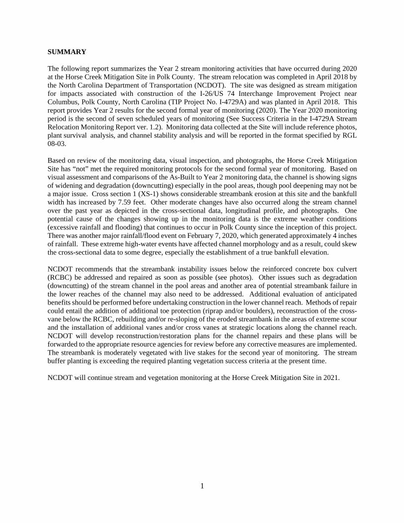
SUMMARY The following report summarizes the Year 2 stream monitoring activities that have occurred during 2020 at the Horse Creek Mitigation Site in Polk County. The stream relocation was completed in April 2018 by the North Carolina Department of Transportation (NCDOT). The site was designed as stream mitigation for impacts associated with construction of the I-26/US 74 Interchange Improvement Project near Columbus, Polk County, North Carolina (TIP Project No. I-4729A) and was planted in April 2018. This report provides Year 2 results for the second formal year of monitoring (2020). The Year 2020 monitoring period is the second of seven scheduled years of monitoring (See Success Criteria in the I-4729A Stream Relocation Monitoring Report ver. 1.2). Monitoring data collected at the Site will include reference photos, plant survival analysis, and channel stability analysis and will be reported in the format specified by RGL 08-03. Based on review of the monitoring data, visual inspection, and photographs, the Horse Creek Mitigation Site has “not” met the required monitoring protocols for the second formal year of monitoring. Based on visual assessment and comparisons of the As-Built to Year 2 monitoring data, the channel is showing signs of widening and degradation (downcutting) especially in the pool areas, though pool deepening may not be a major issue. Cross section 1 (XS-1) shows considerable streambank erosion at this site and the bankfull width has increased by 7.59 feet. Other moderate changes have also occurred along the stream channel over the past year as depicted in the cross-sectional data, longitudinal profile, and photographs. One potential cause of the changes showing up in the monitoring data is the extreme weather conditions (excessive rainfall and flooding) that continues to occur in Polk County since the inception of this project. There was another major rainfall/flood event on February 7, 2020, which generated approximately 4 inches of rainfall. These extreme high-water events have affected channel morphology and as a result, could skew the cross-sectional data to some degree, especially the establishment of a true bankfull elevation. NCDOT recommends that the streambank instability issues below the reinforced concrete box culvert (RCBC) be addressed and repaired as soon as possible (see photos). Other issues such as degradation (downcutting) of the stream channel in the pool areas and another area of potential streambank failure in the lower reaches of the channel may also need to be addressed. Additional evaluation of anticipated benefits should be performed before undertaking construction in the lower channel reach. Methods of repair could entail the addition of additional toe protection (riprap and/or boulders), reconstruction of the cross-vane below the RCBC, rebuilding and/or re-sloping of the eroded streambank in the areas of extreme scour and the installation of additional vanes and/or cross vanes at strategic locations along the channel reach. NCDOT will develop reconstruction/restoration plans for the channel repairs and these plans will be forwarded to the appropriate resource agencies for review before any corrective measures are implemented. The streambank is moderately vegetated with live stakes for the second year of monitoring. The stream buffer planting is exceeding the required planting vegetation success criteria at the present time. NCDOT will continue stream and vegetation monitoring at the Horse Creek Mitigation Site in 2021.
2
1.0 INTRODUCTION
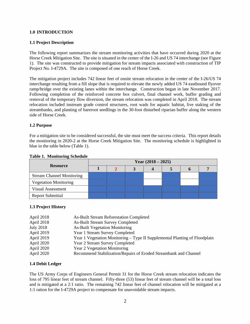
1.1 Project Description The following report summarizes the stream monitoring activities that have occurred during 2020 at the Horse Creek Mitigation Site. The site is situated in the center of the I-26 and US 74 interchange (see Figure 1). The site was constructed to provide mitigation for stream impacts associated with construction of TIP Project No. I-4729A. The site is composed of one reach of Horse Creek. The mitigation project includes 742 linear feet of onsite stream relocation in the center of the I-26/US 74 interchange resulting from a fill slope that is required to elevate the newly added US 74 eastbound flyover ramp/bridge over the existing lanes within the interchange. Construction began in late November 2017. Following completion of the reinforced concrete box culvert, final channel work, buffer grading and removal of the temporary flow diversion, the stream relocation was completed in April 2018. The stream relocation included instream grade control structures, root wads for aquatic habitat, live staking of the streambanks, and planting of bareroot seedlings in the 30-foot disturbed riparian buffer along the western side of Horse Creek. 1.2 Purpose For a mitigation site to be considered successful, the site must meet the success criteria. This report details the monitoring in 2020-2 at the Horse Creek Mitigation Site. The monitoring schedule is highlighted in blue in the table below (Table 1). Table 1. Monitoring Schedule
Resource Year (2018 – 2025)
1 2 3 4 5 6 7 Stream Channel Monitoring Vegetation Monitoring Visual Assessment Report Submittal
1.3 Project History April 2018 As-Built Stream Reforestation Completed April 2018 As-Built Stream Survey Completed July 2018 As-Built Vegetation Monitoring April 2019 Year 1 Stream Survey Completed April 2019 Year 1 Vegetation Monitoring – Type II Supplemental Planting of Floodplain April 2020 Year 2 Stream Survey Completed April 2020 Year 2 Vegetation Monitoring April 2020 Recommend Stabilization/Repairs of Eroded Streambank and Channel 1.4 Debit Ledger The US Army Corps of Engineers General Permit 31 for the Horse Creek stream relocation indicates the loss of 795 linear feet of stream channel. Fifty-three (53) linear feet of stream channel will be a total loss and is mitigated at a 2:1 ratio. The remaining 742 linear feet of channel relocation will be mitigated at a 1:1 ration for the I-4729A project to compensate for unavoidable stream impacts.

3
Figure 1. Project Vicinity Map
4
2.0 STREAM ASSESSMENT 2.1 Success Criteria
The stream mitigation site shall be monitored for seven years or until success criteria are satisfied. Monitoring protocols shall follow the Monitoring Level I outlined in the Stream Mitigation Guidelines, April 2003. NCDOT will evaluate the success of the stream relocation project based on guidance provided by the Stream Mitigation Guidelines disseminated by the United States Army Corps of Engineers-Wilmington District. The survey of channel dimension will consist of three permanent cross sections (two riffles and one pool) and a longitudinal profile. Annual photographs showing both banks and upstream and downstream views will be taken from permanent, mapped photo points. The entire length of the stream relocation will be investigated for channel stability. Any evidence of channel instability will be identified, mapped and photographed. Pebble counts shall not be conducted. The monitoring shall be conducted annually for a minimum of seven (7) years after final planting with measurements completed in years 1-3, year 5, and year 7. The results of visual monitoring will be reported in all monitoring reports as well as the specified measurements of performance measures (vegetative success, etc.) Monitoring reports for years 4 and 6 will include photo documentation of stream stability. If monitoring demonstrates the Site is successful by year 5 and no concerns have been identified, NCDOT may propose in writing to terminate monitoring (Year 6 & 7) at the site. The US Army Corps of Engineers (USACE) will provide written approval to NCDOT if monitoring criteria is acceptable following Year 5 reporting and the final site visit and “close out” by the various resource agencies. The monitoring results shall be submitted to the USACE and NCDWR in a final report within sixty (60) days after completing monitoring. Vegetation Success The success of vegetation and plantings will be measured through stem counts. Two permanent plots will be used to sample vegetation success in the riparian buffer. Survival of the live stakes will be determined by visual observation throughout the seven-year monitoring period. Bare root vegetation will be evaluated using two staked survival plots, which will be 30-feet by 30-feet (0.02 Acres) in size. All flagged stems will be counted in those plots. Success will be defined as 320 planted stems per acre after Year 3, 260 planted stems per acre in year 5, and 210 planted stems per acre in Year 7. Since the site is in the mountains, planted vegetation must reach an average height of 8-feet in each plot at Year 7. Volunteer stems of “native plants” will be considered in determining overall vegetation success; however, (1) volunteer stems will be counted separately from planted stems and (2) volunteer stems must be species from the approved planting list included in the monitoring plan. All vegetation monitoring will be conducted during the growing season (July 1 through leaf drop) to characterize species composition and density. Visual observations of the percent cover of shrub and herbaceous species will also be documented by photograph. 2.2 Stream Description 2.2.1 Post-Construction Conditions The mitigation project covers approximately 742 linear feet of stream relocation in the center of the I-26/US 74 interchange. A portion of Horse Creek was relocated in March/April 2018 by NCDOT. Stream relocation involved the installation of grade control structures (cross vanes, log vanes) meanders, riffle/pool complexes, root wads for aquatic habitat, live staking of streambanks, and planting of bareroot seedlings in the disturbed 30-foot buffer zone along the western side of Horse Creek. The riparian zone along the eastern side of Horse Creek is forested and was basically undisturbed during construction.

5
2.2.2 Monitoring Conditions The objective of the I-4729A stream relocation was to offset stream impacts associated with the interchange improvement project. The relocation of Horse Creek should improve channel stability, sediment transport, water quality, as well as, terrestrial and aquatic habitats along this stream reach, which was previously disturbed during the construction of the existing interchange in the 1970’s. For this report, three cross sections were used in the comparison of channel morphology (Table 2). Table 2. Abbreviated Morphological Summary – Horse Creek – Cross Sections #1, #2, and #3
Variable As-Built - 2018 Monitoring Year 1 - 2019 Monitoring Year 2 - 2020
XS 1 XS 2 XS 3 XS 1 XS 2 XS 3 XS 1 XS 2 XS 3 Drainage Area (mi²) 1.2 1.2 1.2 1.2 1.2 1.2 1.2 1.2 1.2 Bankfull width (ft) 10.87 10.35 11.83 11.61 10.49 11.75 19.20 11.43 12.79 Bankfull Mean Depth (ft) 0.62 1.16 0.71 0.86 0.66 0.91 0.47 1.60 1.04 Bank Height (ft) 7.70 8.21 7.94 7.41 7.74 7.98 7.64 9.39 7.80 Width/Depth Ratio 17.53 8.92 16.66 13.50 15.89 12.91 14.44 18.29 12.30 Bankfull Cross Sectional Area (ft²) 6.71 12.07 8.41 8.45 8.04 10.70 9.01 8.04 13.36 Maximum Bankfull Depth (ft) 0.95 1.79 1.12 1.27 1.37 1.40 1.33 2.96 1.52 Floodprone Area (ft²) 19.62 42.43 24.09 27.78 26.87 31.28 36.99 73.74 37.65 Entrenchment Ratio 2.92 3.51 1.37 1.61 1.63 1.51 1.21 2.21 1.50 Bank Height Ratio (ft/ft) 8.11 4.59 7.09 5.83 5.65 5.70 5.74 3.17 5.13
*Floodprone Width and Slope are average values only. *Riffle values are used for classification purposes. 2.3 Results of the Stream Assessment 2.3.1 Site Data The site assessment included the survey of 3 cross sections along the 742-linear foot Horse Creek stream relocation following construction. The three cross sections were established during the 2018 as-built survey/monitoring evaluation. Cross sections were established at locations where they would represent the various channel dimensions that exist along the new alignment so that they could be monitored for stability. The locations of the cross sections are presented below and shown in Appendix C.
• Cross Section 1 (XS 1): Horse Creek (most upstream below RCBC), midpoint of riffle • Cross Section 2 (XS 2): Horse Creek, middle of pool • Cross Section 3 (XS 3): Horse Creek, (most downstream), midpoint of riffle
Based on visual assessment and comparisons of the As-Built to Year 2 monitoring data, the channel is showing some stability issues in the form of excessive streambank erosion, especially in the vicinity of XS- 1 (riffle), in the upper reaches of the channel below the reinforced concrete box culvert. The channel is also showing signs of degradation (downcutting) in the pool areas. XS-1 shows an increase in bankfull width of approximately 7.5 feet (see photos) and a decrease in mean bankfull depth of 0.40 feet due to aggradation associated with the streambank erosion and widening of the stream channel. XS-2 (pool) shows an increase in bankfull width of approximately 1-foot and mean bankfull depth of 1-foot. The channel shows signs of widening and degradation (downcutting) of the pool at this site. XS-3 (riffle) shows an increase in bankfull width of approximately 1-foot. All other parameters at this site appear to be stable.
6
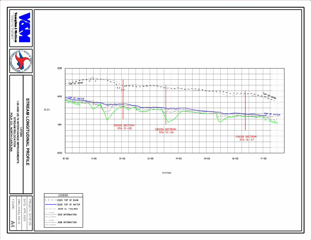
The longitudinal profile appears to be relatively stable, except in the pool areas. The pool areas have degraded (downcut) approximately 3-4 feet and have also extended longitudinally from the 2019 profile. Moderate changes have occurred along the stream channel over the past year as depicted in the cross-sectional data, longitudinal profile, and photographs. One potential cause of the changes showing up in the monitoring data is the extreme weather conditions (excessive rainfall and flooding) that continues to occur in Polk County since the inception of this project. There was another major rainfall event on February 7, 2020, which generated approximately 4 inches of rainfall. These extreme high-water events have affected channel morphology and as a result, has skewed the cross-sectional data to some degree. The establishment of a true bankfull width elevation has been difficult to determine in this newly constructed stream channel. NCDOT recommends that the streambank instability issues below the reinforced concrete box culvert (RCBC) be addressed and repaired as soon as possible (see photos). Other issues such as degradation (downcutting) of the stream channel in the pool areas and another area of potential streambank failure in the lower reaches of the channel may also need to be addressed. Methods of repair could entail the addition of additional toe protection (riprap and/or boulders), rebuilding and/or re-sloping of the eroded streambanks in the areas of extreme scour and the installation of additional vanes and/or cross vanes at strategic locations along the channel reach. NCDOT will develop reconstruction/restoration plans for the channel repairs and these plans will be forwarded to the resource agencies for review before any corrective measures are implemented. Graphs of the cross sections and longitudinal profile are presented in Appendix B. Site photographs are presented in Appendix C. Pebble counts were not required per the permit conditions or the monitoring plan; therefore, were not completed. All other monitoring activities will continue to be completed by NCDOT-Division 14 throughout the seven-year monitoring period. 3.0 VEGETATION: HORSE CREEK MITIGATION SITE (YEAR 2 MONITORING) 3.1 Success Criteria Mitigation Plan: Success for vegetation monitoring within the riparian buffer is based on the survival of at least 320 planted stems per acre in Years 1-3; 290 planted stems per acre in Year 4; and 260 planted stems per acre in Year 5. Vegetation monitoring will consist of counts of planted stems within the two 30-foot x 30-foot plots (0.02 acres) established within the disturbed riparian buffer along the western side of Horse Creek. 3.2 Description of Species The following live stake species were planted in the Streambank Enhancement Area (Type I): (Cornus amomum), Silky Dogwood (Salix nigra), Black Willow The following tree species were planted in the Buffer Enhancement Area (Type II):
(Platanus occidentalis), American Sycamore (Liriodendron tulipifera), Yellow Poplar (Fraxinus pennsylvanica), Green Ash (Betula nigra), River Birch
7
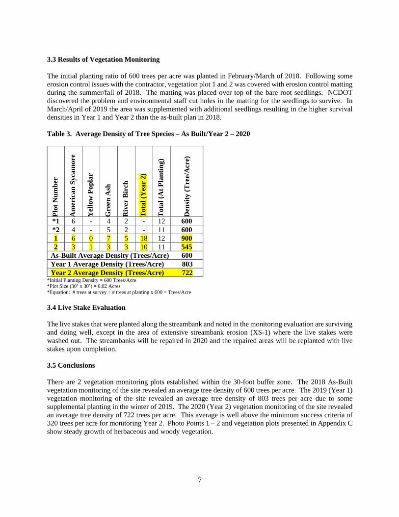
3.3 Results of Vegetation Monitoring The initial planting ratio of 600 trees per acre was planted in February/March of 2018. Following some erosion control issues with the contractor, vegetation plot 1 and 2 was covered with erosion control matting during the summer/fall of 2018. The matting was placed over top of the bare root seedlings. NCDOT discovered the problem and environmental staff cut holes in the matting for the seedlings to survive. In March/April of 2019 the area was supplemented with additional seedlings resulting in the higher survival densities in Year 1 and Year 2 than the as-built plan in 2018. Table 3. Average Density of Tree Species – As Built/Year 2 – 2020
Plot
Num
ber
Am
eric
an S
ycam
ore
Yel
low
Pop
lar
Gre
en A
sh
Riv
er B
irch
Tot
al (Y
ear
2)
Tot
al (A
t Pla
ntin
g)
Den
sity
(Tre
e/A
cre)
*1 6 - 4 2 - 12 600 *2 4 - 5 2 - 11 600 1 6 0 7 5 18 12 900 2 3 1 3 3 10 11 545
As-Built Average Density (Trees/Acre) 600 Year 1 Average Density (Trees/Acre) 803 Year 2 Average Density (Trees/Acre) 722
*Initial Planting Density = 600 Trees/Acre *Plot Size (30’ x 30’) = 0.02 Acres *Equation: # trees at survey ÷ # trees at planting x 600 = Trees/Acre 3.4 Live Stake Evaluation The live stakes that were planted along the streambank and noted in the monitoring evaluation are surviving and doing well, except in the area of extensive streambank erosion (XS-1) where the live stakes were washed out. The streambanks will be repaired in 2020 and the repaired areas will be replanted with live stakes upon completion. 3.5 Conclusions There are 2 vegetation monitoring plots established within the 30-foot buffer zone. The 2018 As-Built vegetation monitoring of the site revealed an average tree density of 600 trees per acre. The 2019 (Year 1) vegetation monitoring of the site revealed an average tree density of 803 trees per acre due to some supplemental planting in the winter of 2019. The 2020 (Year 2) vegetation monitoring of the site revealed an average tree density of 722 trees per acre. This average is well above the minimum success criteria of 320 trees per acre for monitoring Year 2. Photo Points 1 – 2 and vegetation plots presented in Appendix C show steady growth of herbaceous and woody vegetation.

8
4.0 OVERALL CONCLUSIONS AND RECOMMENDATIONS The Horse Creek Mitigation Site has “not” met the required monitoring protocols for the second formal year of monitoring. Based on visual assessment and comparisons of the As-Built to Year 2 monitoring data, the channel is showing signs of widening and degradation (downcutting) especially in the pool areas, though pool deepening may not be a major issue. XS-1 shows considerable streambank erosion and the bankfull width has increased by 7.59 feet at this site. Other moderate changes have also occurred along the stream channel over the past year as depicted in the cross-sectional data, longitudinal profile, and photographs. One potential cause of the changes showing up in the monitoring data is the extreme weather conditions (excessive rainfall and flooding) that continues to occur in Polk County since the inception of this project. There was another major rainfall/flood event on February 7, 2020, which generated approximately 4 inches of rainfall. These extreme high-water events have affected channel morphology and as a result, has skewed the cross-sectional data to some degree, especially the establishment of a true bankfull elevation. NCDOT recommends that the streambank instability issues below the reinforced concrete box culvert (RCBC) be addressed/repaired as soon as possible (see photos). Other issues such as degradation (downcutting) of the stream channel in the pool areas and another area of potential streambank failure in the lower reaches of the channel may also need to be addressed. Additional evaluation of anticipated benefits should be performed before undertaking construction in the lower channel reach. Methods of repair could entail the addition of additional toe protection (riprap and/or boulders), reconstruction of the cross-vane below the RCBC, rebuilding and/or re-sloping of the eroded streambanks in the areas of extreme scour and the installation of additional vanes and/or cross vanes at strategic locations along the channel reach. NCDOT will develop reconstruction/restoration plans for the channel repairs and these plans will be forwarded to the resource agencies for review before any corrective measures are implemented. The streambank is moderately vegetated with live stakes for the second year of monitoring. The stream buffer planting is exceeding the required planting vegetation success criteria at present. NCDOT will continue stream and vegetation monitoring at the Horse Creek Mitigation Site in 2020.

9
5.0 REFERENCES I-4729A Stream Relocation Monitoring Plan, Horse Creek, Polk County. Version 1.2, NCDOT Division 14, August 17, 2017. On-Site Stream Mitigation Plan, Interchange at I-26 and US 74 near Columbus; Polk County, NC, T.I.P. Number I-4729A, WBS No: 34243.1.3, August 17, 2017. Rosgen, D. L., 1996. Applied River Morphology. Wildland Hydrology, Pagosa Springs, Colorado. US Army Corps of Engineers (USACE), 2003. Stream Mitigation Guidelines. Prepared with cooperation from the US Environmental Protection Agency, NC Wildlife Resources Commission, and the NC Division of Water Quality. 6.0 QUALIFICATIONS The field surveys and preparation of the Stream Monitoring Report was conducted by Mark S. Davis, Environmental Specialist, Jan Gay, LSS, Ecologist, and Mark Parris, PLS, of Vaughn and Melton Consulting Engineers, Inc. Investigator: Mark S. Davis, Environmental Specialist, Vaughn & Melton Consulting Engineers Education: BS Fishery Science, North Carolina State University, 1978 Experience: Environmental Specialist, Vaughn & Melton Consulting Engineers, 2016-Present Environmental Supervisor, NCDOT Division 14, 2000-2016 Mountain Region Hab/Con Coordinator, NC Wildlife Resources Commission, 1996-2000 Fishery Biologist/Technician, NC Wildlife Resources Commission, 1987-1996 Research Technician, US Forest Service, Coweeta Hydrologic Laboratory, 1980-1985 Biological Technician, US Fish & Wildlife Service, 1978-1979 Responsibilities: Wetland and stream delineations, habitat assessments, T&E species assessments and surveys, SHPO requests, 404/401 and TVA 26a Permit Applications, NEPA/SEPA document preparation. Investigator: Jan Gay, Ecologist, Vaughn and Melton Consulting Engineers Education: MS Landscape Classification and Ecosystem Modeling, Clemson University, 1992 Experience: Environmental Specialist, Vaughn & Melton Consulting Engineers, 2011-Present Forensic Ecologist, Cardno-Entrix, Deep Water Horizon, Houma Louisiana, 2010 Office Manager, Environmental Services, Inc., Asheville, NC, 1995-2010 Research Scientist, US Forest Service, Savannah River Site, Aiken, SC, 1992-1995 Responsibilities: Jurisdictional wetland/stream delineation, Terrestrial habitat assessment, T&E species
assessments and surveys, stream channel and vegetation assessments. Surveyor: Mark Parris, PLS, Survey Manager, Vaughn and Melton Consulting Engineers Education: AS, Surveying Technology, Asheville-Buncombe Community College, 2003 Experience: He has extensive experience in boundary surveys, topographical surveys and construction
staking surveys since 1999. V&M Survey Manager, 2015 to Present Responsibilities: In charge of QA/QC, technical review, staffing, scheduling, and project budgets for
V&M in the Carolinas.

10
APPENDIX A
CROSS SECTION, VEGETATION PLOT & PHOTO POINT LOCATIONS
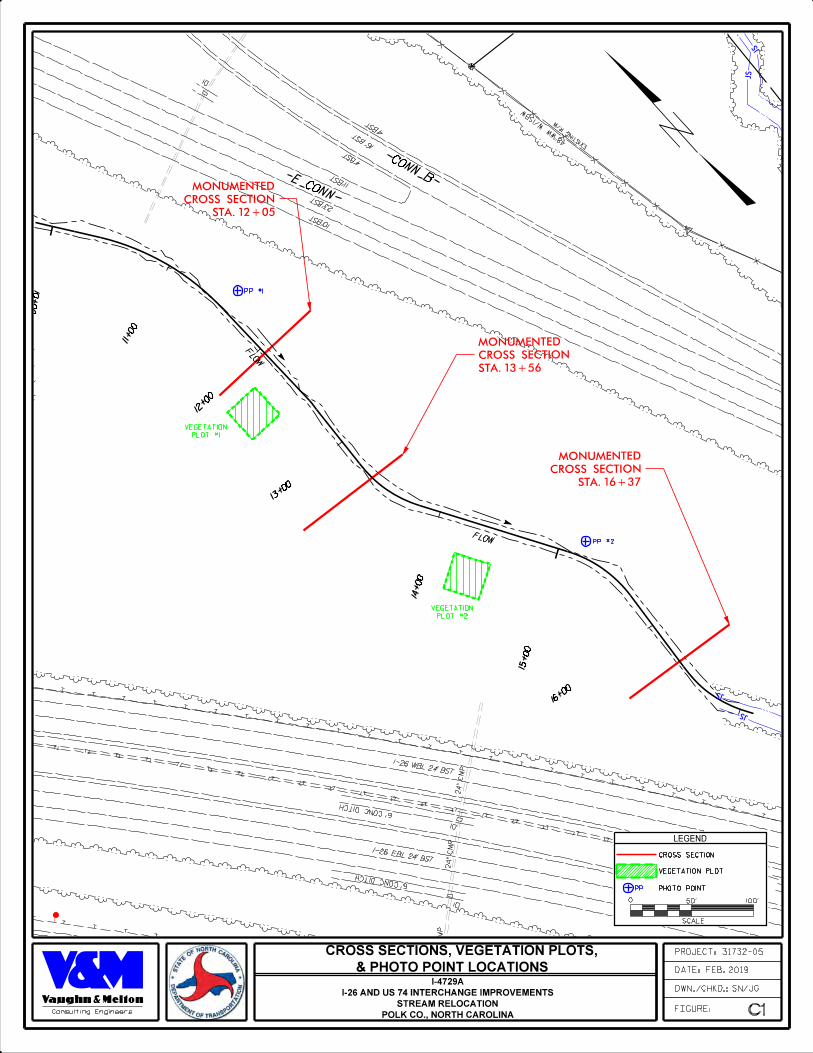
PROJECT: 31732-05
FIGURE:
DWN./CHKD.: SN/JG
DATE: FEB. 2019
C1
Consulting Engineers
LEGEND
POLK CO., NORTH CAROLINA
STREAM RELOCATION
I-26 AND US 74 INTERCHANGE IMPROVEMENTS
I-4729A
0
SCALE
50' 100'
& PHOTO POINT LOCATIONS
CROSS SECTIONS, VEGETATION PLOTS,
CROSS SECTION
VEGETATION PLOT
PHOTO POINT
STA. 12+05
CROSS SECTION
MONUMENTED
STA. 13+56
CROSS SECTION
MONUMENTED
PP
PLOT #1
VEGETATION
PLOT #2
VEGETATION
PP #1
PP #2
STA. 16+37
CROSS SECTION
MONUMENTED
15+00
14+00
13+00
12+00
11+00
16+00
FLO
W
FLOW
10+00
I-26 WBL 24' BST
I-26 EBL 24' BST
-E_CONN-
-CONN_B-
48"W
W
W/1S
BW
16' B
ST4'
BST
4'BST
10'BST
11'BST
23'B
ST
10'BST
24"
CM
P
24"
CM
P
DI
24"
CM
P
DI
DI
6' CONC DITCH
6' CONC DITCH
6' CONC D
ITCH
HORSE CREEK
EXIS
TIN
G R/
W

11
APPENDIX B
CROSS SECTION COMPARISONS &
LONGTITUDINAL PROFILE

PROJECT: 31732-05
FIGURE:
DWN./CHKD.: SN/JG
DATE: APR. 2020
A1
Consulting Engineers POLK CO., NORTH CAROLINA
STREAM RELOCATION
I-26 AND US 74 INTERCHANGE IMPROVEMENTS
I-4729A
LEGEND
LBF (LEFT BANK FULL) / RBF (RIGHT BANK FULL)
LEW (LEFT EDGE WATER) / REW (RIGHT EDGE WATER)
RBFLBF
REWLEW
10.87
0.62
7.70
1010
1020
1030
ELEV.
0+00 0+20 0+40 0+60 0+80 1+00
STATION
1+20
1000
1+40
RIFFLE CROSS-SECTION - STA. 12+05
CROSS SECTION #1 - STA. 12+05
17.53
6.71
0.95
19.62
2.92
BANKFULL MEAN DEPTH (FT.)
BANK HEIGHT (FT.)
WIDTH/DEPTH RATIO
ENTRENCHMENT RATIO
BANK HEIGHT RATIO (FT./FT.)
BANKFULL WIDTH (FT.)
AS BUILT 2019 2020 2021
BANKFULL CROSS SECTIONAL AREA (SQ. FT.)
MAXIMUM BANKFULL DEPTH (FT.)
LEGEND
2018 INFORMATION2018
2019 CROSS SECTION
2018
2018
2018
2018
2018 RBF
2019 LBF
2019 REW2019 LEW
11.61
0.86
7.41
13.50
8.45
1.27
27.78
1.61
FLOODPRONE AREA (SQ FT.)
5.838.11
19.20
0.47
7.64
14.44
9.01
1.33
36.99
1.21
5.74
2020 CROSS SECTION
2019
2019
2019

PROJECT: 31732-05
FIGURE:
DWN./CHKD.: SN/JG
DATE: APR. 2020
A2
Consulting Engineers POLK CO., NORTH CAROLINA
STREAM RELOCATION
I-26 AND US 74 INTERCHANGE IMPROVEMENTS
I-4729A
LEGEND
LBF (LEFT BANK FULL) / RBF (RIGHT BANK FULL)
LEW (LEFT EDGE WATER) / REW (RIGHT EDGE WATER)
0+00 0+20 0+40 0+60 0+80 1+00
ELEV.
STATION
1000
1010
1020
1030
1+20 1+37
RBF
REWLEW
LBF
BANKFULL WIDTH (FT.)
AS BUILT 2019 2020 2021
10.35
1.16
8.21
CROSS SECTION #2 - STA. 13+56
BANKFULL CROSS SECTIONAL AREA (SQ. FT.)
MAXIMUM BANKFULL DEPTH (FT.) 1.79
42.43
3.51
BANKFULL MEAN DEPTH (FT.)
BANK HEIGHT (FT.)
WIDTH/DEPTH RATIO
ENTRENCHMENT RATIO
BANK HEIGHT RATIO (FT./FT.)
8.92
12.07
4.59
2019 RBF
2019 REW
FLOODPRONE AREA (SQ. FT.)
10.49
0.66
7.74
15.89
8.04
1.37
26.87
1.63
5.65
2019 LEW
2019 LBF
2018
2018
POOL CROSS-SECTION - STA. 13+56
LEGEND
2018 INFORMATION2018
2019 CROSS SECTION
2020 CROSS SECTION
2019
11.43
1.60
9.39
18.29
8.04
2.96
73.24
2.21
3.17
2019
2019

PROJECT: 31732-05
FIGURE:
DWN./CHKD.: SN/JG
DATE: APR. 2020
A3
Consulting Engineers POLK CO., NORTH CAROLINA
STREAM RELOCATION
I-26 AND US 74 INTERCHANGE IMPROVEMENTS
I-4729A
1000
ELEV.
STATION
0+00 0+20 0+40 0+60 0+80 1+00 1+13
1010
1020
1030
RBFLBF
REWLEW
LEGEND
LBF (LEFT BANK FULL) / RBF (RIGHT BANK FULL)
LEW (LEFT EDGE WATER) / REW (RIGHT EDGE WATER)
RIFFLE CROSS-SECTION - STA. 16+37
BANKFULL WIDTH (FT.)
AS BUILT 2019 2020 2021
11.83
0.71
7.94
CROSS SECTION #3 - STA. 16+37
BANKFULL CROSS SECTIONAL AREA (SQ. FT.)
MAXIMUM BANKFULL DEPTH (FT.)
16.66
8.41
1.12
24.09
1.37
BANKFULL MEAN DEPTH (FT.)
BANK HEIGHT (FT.)
WIDTH/DEPTH RATIO
ENTRENCHMENT RATIO
BANK HEIGHT RATIO (FT./FT.)
2019 RBF
2019 REW
11.75
0.91
7.98
12.91
1.40
31.28
1.51
FLOODPRONE AREA (SQ. FT.)
10.70
5.70
2018
2018
2019 LEW
2019 LBF
7.09
LEGEND
2018 INFORMATION2018
2019 CROSS SECTION
2020 CROSS SECTION
2019
12.79
1.04
7.80
12.30
1.52
37.65
1.50
13.36
5.13
2019
2019
PR
OJE
CT
: 31732-05
FIG
UR
E:
DW
N./C
HK
D.: S
N/J
G
DA
TE
: AP
R. 2
020A
4
Co
nsu
ltin
g E
ng
in
eers
P
OL
K C
O., N
OR
TH
CA
RO
LIN
A
ST
RE
AM
RE
LO
CA
TIO
N
I-26
AN
D U
S 7
4 IN
TE
RC
HA
NG
E IM
PR
OV
EM
EN
TS
I-4729A
1000
1010
1020
1030
ELEV.
STATION
ST
RE
AM
LO
NG
ITU
DIN
AL
PR
OF
ILE
10+00 11+00 17+0012+00 13+00 14+00 15+00 16+00
STA. 13+ 56
CROSS SECTION STA. 12+ 05
CROSS SECTION
STA. 16+ 37
CROSS SECTION
TOP OF BANK
TOP OF WATER
2 0 18
2 0 18
2 0 18
2 0 18
2 0 182018
2018
2018
2018
2 0 18
2 0 18
2 0 18
CL THALWEG
TOP OF WATER
CL THALWEG
TOP OF BANK
2018 INFORMATION
2 0 18
2 0 18
2 0 18
2020 TOP OF BANK
2020 TOP OF WATER
2020 CL THALWEG
2019 INFORMATION
2 0 19
2 0 19
2 0 19
LEGEND
2019
2019
2 0 19
2 0 19
2 0 192 0 19
2 0 19

12
APPENDIX C
SITE PHOTOGRAPHS

I-4729A – Horse Creek Mitigation Site – Polk County Photo Point 1A – 2020
Looking Upstream – 3-26-20
Looking Downstream – 3-26-20
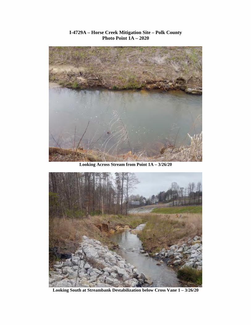
I-4729A – Horse Creek Mitigation Site – Polk County Photo Point 1A – 2020
Looking Across Stream from Point 1A – 3/26/20
Looking South at Streambank Destabilization below Cross Vane 1 – 3/26/20
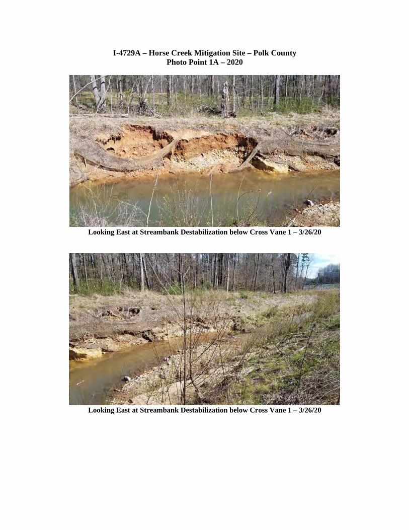
I-4729A – Horse Creek Mitigation Site – Polk County Photo Point 1A – 2020
Looking East at Streambank Destabilization below Cross Vane 1 – 3/26/20
Looking East at Streambank Destabilization below Cross Vane 1 – 3/26/20

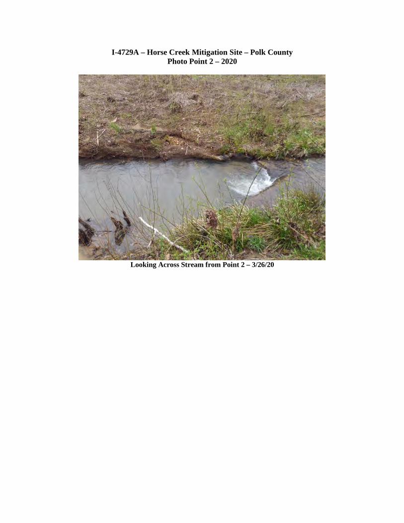
I-4729A – Horse Creek Mitigation Site – Polk County Photo Point 2 – 2020
Looking Upstream – 3/26/20
Looking Downstream – 3/26/20
I-4729A – Horse Creek Mitigation Site – Polk County Photo Point 2 – 2020
Looking Across Stream from Point 2 – 3/26/20
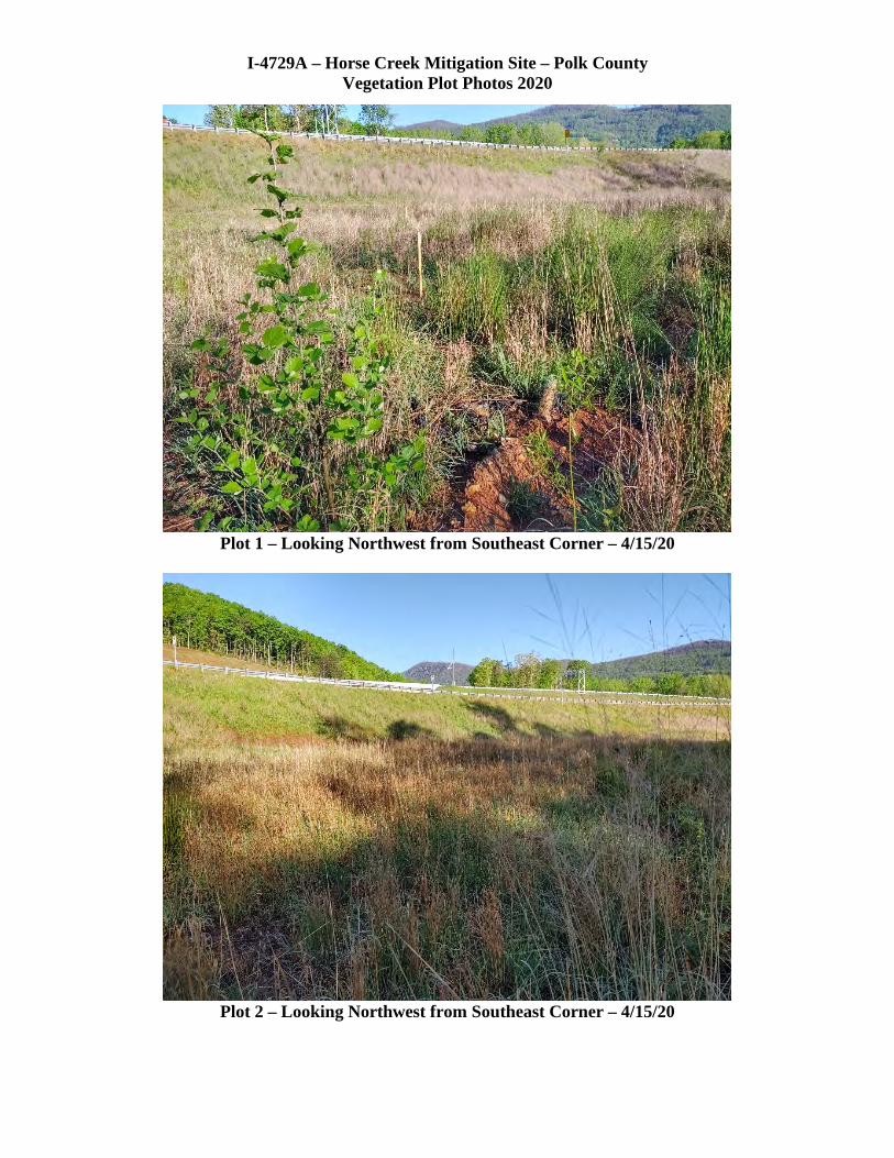
I-4729A – Horse Creek Mitigation Site – Polk County Vegetation Plot Photos 2020
Plot 1 – Looking Northwest from Southeast Corner – 4/15/20
Plot 2 – Looking Northwest from Southeast Corner – 4/15/20

I-4729A Additional Stream Photos – April 2020 Sequenced from Upstream to Downstream
Looking Downstream from Culvert Outlet
Looking South Downstream through End of Destabilized Streambank

I-4729A Additional Stream Photos – April 2020 Sequenced from Upstream to Downstream
Continue Looking South – Downstream
Continue Looking South – Downstream

I-4729A Additional Stream Photos – April 2020 Sequenced from Upstream to Downstream
Continue Looking South – Downstream to End of Relocation
Looking North (Upstream) from End of Channel Relocation
Rip Rap on Left is “Plug” of Old Stream Channel
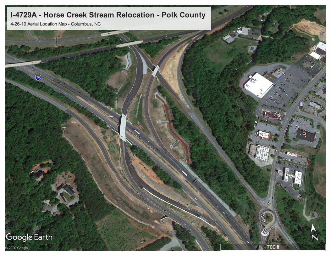
I-4729A - Horse Creek Stream Relocation - Polk County 4-26-19 Aerial Location Map - Columbus, NC
700 ftN
➤➤
N© 2020 Google
© 2020 Google
© 2020 Google