ANNUAL REPORT 2015-16 · WADIA INSTITUTE OF HIMALAYAN GEOLOGY ANNUAL REPORT 2015-16 (An Autonomous...
130
(An Autonomous Institute of Dept. of Science & Technology, Govt. of India) WADIA INSTITUTE OF HIMALAYAN GEOLOGY DEHRA DUN 2015-16 ANNUAL REPORT Premaxilla Nasopharyngeal meatus Sphenopalatine foramen Sagittal sinus Cerebral neocortex Olfactory bulbs Palatine A B C Nasal Lacrimal tubercle Maxilla Lacrimal canal Jugal Lacrimal Palatine Frontal Sagittal crest Parietal Premaxilla Frontoparietal Supraorbital Nasal Infraorbital foramen Lacrimal Incisive foramen Jugal Sagittal crest Fronto- Parietal parietal suture Maxilla Bosses suture Maxilla
Transcript of ANNUAL REPORT 2015-16 · WADIA INSTITUTE OF HIMALAYAN GEOLOGY ANNUAL REPORT 2015-16 (An Autonomous...
(An Autonomous Institute of Dept. of Science & Technology, Govt. of India)
WADIA INSTITUTE OF HIMALAYAN GEOLOGY
DEHRA DUN
2015-16
ANNUAL REPORT
Premaxilla
Nasopharyngeal meatus
Sphenopalatine foramen
Sagittal sinusCerebralneocortex
Olfactory bulbs
Palatine
A
B
C
Nasal
Lacrimal tubercle
Maxilla
Lacrimal canal
Jugal
Lacrimal
Palatine
Frontal
Sagittal crest
Parietal
Premaxilla
Frontoparietal
Supraorbital
Nasal
Infraorbital foramen
Lacrimal
Incisive foramen
JugalSagittal crest
Fronto-
Parietal
parietalsuture
Maxilla
Bosses
suture
Maxilla

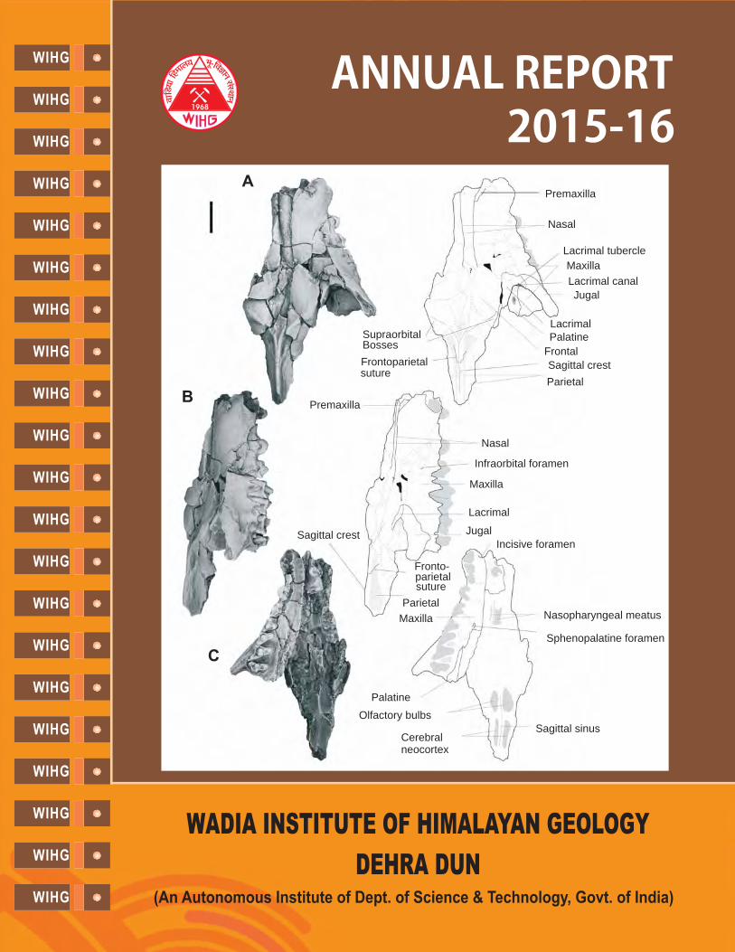
Cover photo:
(Courtesy: Kishor Kumar)
Skull of . Photographs (left) and interpretive drawings (right) of the partial skullwith complete right P2-M3, C and P1 alveoli, and left P1 in A, dorsal, B, lateral, and C, ventral views.Scale bar equals 10 mm.
Indohyaenodon raoi
WADIA INSTITUTE OF HIMALAYAN GEOLOGY
ANNUAL REPORT
2015-16
(An Autonomous Institute of Department of Science & Technology, Government of India)33, General Mahadeo Singh Road, Dehradun - 248 001
EPABX : 0135-2525100Fax : 0135-2625212 Email : [email protected]
Web : http://www.wihg.res.in
Contact :
The Director,
33, Gen. Mahadeo Singh Road, Dehradun - 248 001Phone : 0135-2525103, Fax : 0135-2625212 / 2525200Email : [email protected]: http://www.wihg.res.in
Wadia Institute of Himalayan Geology
1. Institute's Research Activities i
2. ThrustArea Themes
TAT-1 : Geodynamic Evolution of the Himalaya and Adjoining Mountains 1
TAT-2 : Indian Monsoon-Tectonic Interaction and Exhumation of the Himalaya 14
TAT-3 : Earthquake Precursors Studies and Geo-Hazard Evaluation 19
TAT-4 : Biodiversity - Environment Linkage 30
TAT-5 : Himalayan Glaciers: their role in Indian Monsoon variability and Hydrological changesin the Ganga Basin 39
3. Sponsored Projects 43
4. Research Publications 73
5. Seminar/Symposia/Workshop organized 81
6. Awards and Honours 83
7. Visits Abroad 83
8. Ph.D. Theses 84
9. Participations in Seminars/Symposia/Workshops/Meetings/Training Courses 85
10. Lectures by Institute Scientists 87
11. Membership 89
11. Publication & Documentation 90
12. Library 90
13. S.P. Nautiyal Museum 91
14. Technical Services 92
15. Celebrations 93
16. Distinguished Visitors to the Institute 96
17. Status of Implementation of Hindi 97
18. Miscellaneous Items 98
19. Staff of the Institute 99
21. Governing Body / Research Advisory Committee / Finance Committee / Building Committee 101Members
22. Statement of Accounts 105
CONTENTS
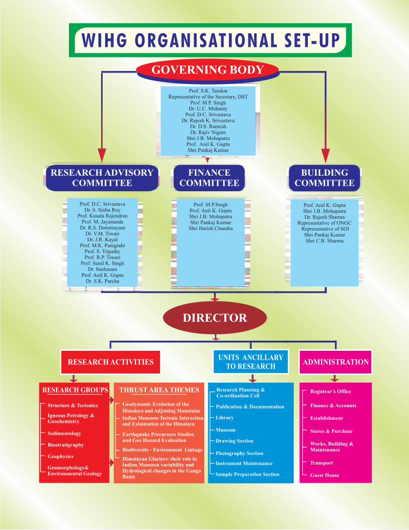
Registrar’s Office
Finance & Accounts
Establishment
Stores & Purchase
Works, Building &Maintenance
Transport
Guest House
Research Planning &Co-ordination Cell
Publication & Documentation
Library
Museum
Drawing Section
Photography Section
Instrument Maintenance
Sample Preparation Section
Structure & Tectonics
Igneous Petrology &Geochemistry
Sedimentology
Biostratigraphy
Geophysics
Geomorphology&Environmental Geology
RESEARCH GROUPS
Geodynamic Evolution of the
Himalaya and Adjoining Mountains
Indian Monsoon-Tectonic Interactionand Exhumation of the Himalaya
Earthquake Precursors Studiesand Geo Hazard Evaluation
Biodiversity - Environment Linkage
Himalayan Glaciers: their role inIndian Monsoon variability andHydrological changes in the GangaBasin
THRUST AREA THEMES
RESEARCH ACTIVITIESUNITS ANCILLARY
TO RESEARCHADMINISTRATION
Prof. M.P.SinghProf. Anil K. GuptaShri J.B. MohapatraShri Pankaj Kumar
Shri Harish Chandra
FINANCECOMMITTEE
Prof. D.C. SrivastavaDr. S. Sinha Roy
Prof. Kusala RajendranProf. M. Jayananda
Dr. R.S. DattatrayamDr. V.M. TiwariDr. J.R. Kayal
Prof. M.K. PanigrahiProf. S. TripathyProf. R.P. Tiwari
Prof. Sunil K. SinghDr. Snehmani
Prof. Anil K. GuptaDr. S.K. Parcha
RESEARCH ADVISORYCOMMITTEE
Prof. Anil K. GuptaShri J.B. MohapatraDr. Rajesh Sharma
Representative of ONGCRepresentative of SOIShri Pankaj KumarShri C.B. Sharma
BUILDINGCOMMITTEE
Prof. S.K. TandonRepresentative of the Secretary, DST
Prof. M.P. SinghDr. U.C. Mohanty
Prof. D.C. SrivastavaDr. Rajesh K. Srivastava
Dr. D.S. RameshDr. Rajiv Nigam
Shri J.B. MohapatraProf. Anil K. GuptaShri Pankaj Kumar
GOVERNING BODY
WIHG ORGANISATIONAL SET-UP
DIRECTOR

Annual Report 2015-16
INSTITUTE'S RESEARCH ACTIVITIES
i
The Wadia Institute ofHimalayan Geology has amandate to study scientificissues related to the Himalayaincluding its evolution,geodynamics and climate.The Institute plays a lead rolein geological and geophysicali n v e s t i g a t i o n s o f t h eHimalayan region to under-stand earthquake activity, the
glacial-monsoon linkages, the climate-tectonicinteractions and in-depth study of the crust-mantleboundary across the India-Eurasia plate.
An important step initiated during the year was toprepare a systematic glacier lake inventory based onsatellite images for the Uttarakhand Himalaya, whichincluded 1,266 lakes. The idea is to understand the stateand fate of glaciers, including the disaster potential(GLOF) in the region. Further, for the first time in thecountry, the tapping and using of the geothermal energyfor room heating was demonstrated in the Chumathangregion of Ladakh by the Institute scientists. A surveywas also carried out by Institute Scientists after theJammu & Kashmir flood, on the request of districtadministration, to demarcate the safer areas forrehabilitating people in the Udhampur districts. TheInstitute Scientists organized five days trainingprogramme for the officers of the Rail Vikas Nigam Ltd(RVNL) that has the responsibility of making 110 kmrail route (mostly through tunnels) in the Himalayanterrain between Rishikesh and Karanprayag (GarhwalHimalaya). The Institute had also brought out the bookentitled
.
With an objective to provide the necessaryinfrastructural facilities to produce internationallycompetitive data base research, instrumental facilitylike 'LA-MC-ICP-MS' has been added to the existinghigh end instrumental facilities of the Institute. Shri Y.S.Chowdary, Hon'ble Minister of State for S&T andMinistry of Earth Sciences inaugurated the unit onOctober 9, 2015. The continuous growth in theanalytical laboratory facilities, field equipments andinter-linkages with other academic institutions hasensured significant progress in all the on-going projects.An overview of the on-going activities in 5 Thrust AreaThemes (TAT) showed that major research activities in
'Siwalik Mammalian faunas of the foothills withreferences to biochronology, linkages and migration'
the thrust areas have progressed well towards theprojected goals. Significant achievements in each ofthe thrust areas for the year 2015-16 are highlightedbelow.
The receiver function analysis study reveals aprominent intra crustal low velocity layer (IC-LVL)beneath the Tethyan Himalaya, and inferred 4-8 %partial melt and/or aqueous fluid at mid-crustaldepth.
The magneto-telluric response at few stations alongthe Satluj River valley section, Himachal Pradeshindicates the presence of a smooth northward dippingconducting layer along the profile with a possibilityof break or jump below the zone of HimalayanSeismic Belt.
Monitoring the Frontal Thrust systems and otherallied major Thrusts in the Dehradun and Kangra re-entrants in the Northwest Himalaya through GPSmeasurements and Gravitational Potential energy(GPE) suggest that, in comparison with the Dehradunre-entrant, the horizontal stress component is twoorders of magnitude higher in the Kangra re-entrant,especially between the HFT and the JwalamukhiThrust.
A P-T pseudo section modeling approach of the MainCentral Thrust Zone (MCTZ) and Higher HimalayanCrystalline Sequence (HHCS) in the Alaknandavalley, NW Himalaya yields peak metamorphic
�
�
�
�
TAT - 1: Geodynamic Evolution of the Himalaya andAdjoining Mountains
Shri Y.S. Chowdary inaugurating the LA-MC-ICP-MS Lab.
INS
TIT
UT
E'S
R
ES
EA
RC
HA
CT
IVIT
IES
Annual Report 2015-16
ii
conditions of 6.3-7.5 kbar and 550-580°C in theMCTZ, and 8-10 kbar and 610-650°C in the basalpart of the HHCS. The results indicate continuity inthe P–T field gradient across the contact between theMCTZ and HHCS, and show an invertedmetamorphic sequence from biotite to garnet zones tothe basal part of the HHCS.
The inferred P-T evolution of the Sapi-Shergolblueschists in Ladakh, ca. 470°C and 19 kbar, ischaracterized by a clockwise hairpin loop along lowthermal gradients (8-9°C/km), and is consistent witha cold subduction zone system in an intra-oceanicsubduction setting.
The geochemical data of Nagaland-ManipurOphiolites of Indo-Myanmar Orogenic Belt, NEIndia show that they were initially generated in theseafloor spreading regime at the eastern margin of theIndian plate which was then thrusted over thecontinental margin of the Indian plate during itscollisional and subduction process with the Myanmarplate.
The U-Pb zircon geochronology application on therocks of Higher Himalayan Crystallines using thenewly installed LA-MC-ICPMS facility in theInstitute suggest that, the Vaikrita Thrust that isconsidered as MCT by many, is indeed a terrainboundary with contrasting detrital zircon ages andcharacteristics. Zircons from Munsiari Formation areindistinguishable from that of Inner Lesser Himalaya(Berinag Quartzite) suggesting affinity with LesserHimalaya.
Speleothem proxy records from Mawmluh Cave,Meghalaya reflect abrupt increase in Indian SummerMonsoon strength during the Bølling-Allerød andearly Holocene periods and pronounced weakeningduring the Heinrich andYounger Dryas cold events.
The sedimentation rate of the Rewalsar Lake,Himachal Pradesh was measured on the top 2 m core
samples using isotopes of Cs and Pb datingtechniques, which reveal that the lake hasexperienced an average sedimentation rate of 3.35cm/yr during the last ~50 yrs which is the highest incomparison to the other lakes in the NW Himalayanregion and is attributed to the enhanced humaninterference in the catchment area.
New data on Alaknanda-Mandakini and other Riversindicate that floods in the Himalaya largely occur
�
�
�
�
�
�
137 210
TAT-2: Indian Monsoon-Tectonic Interaction andExhumation of the Himalaya
during the warm and wet climatic phases, and that theIndian Summer Monsoon front may have penetratedinto the Ladakh during the post glacial climaticoptimum.
The sustained treeline rise in Mandakini Valley isrepresented by some cold/snow regime resistantplant species such as ,and and is indicativeof climate change implication, especially thecontinuous decrease in snow regime/snowprecipitation in alpine ecosystem.
Major ions, stable isotopes ( C ) and silica
measured in the samples in Indus River waterscovering Ladakh region, show that the alkalinity inthese rivers is linked with silicate weathering.
The paleoseismological investigations carried out atNalagarh in the Pinjaur Dun has revealed LatePleistocene earthquakes along the Nalagarh Thrustthat separates the Palaeogene rocks from the NeogeneSiwaliks. Similar studies carried out in NW FrontalHimalaya at Kala Amb shows two large earthquakesof 7.6 between 34.1 ka and 17 ka, and of
8 to 8.5 between 5.78 ka and 2 ka.
The synthesis of the seismic records of BBS stationsrun by WIHG suggests that the hypocenters of theearthquakes are mainly distributed at shallow depthof up to 20 km.
The frequency-dependent attenuation of andwaves in Garhwal Himalaya indicate that theGarhwal region falls under tectonically active areasof the world with dominancy of scatteringattenuation.
The slip distribution evaluation from waveformmodeling of earthquakes in the Garhwal-Kumaunregion of Himalaya on the fault plane show that thelarge slip regions cover a
The independent evidence of acanthomorphicacritarchs has been employed as a proxy forpaleogeographic reconstructions. The report of
from Infrakrol Formationsuggests that this fossiliferous horizon is coeval withthe Lower Doushantuo Formation (Member II) ofSouth China.
�
�
Betula utilis Sorbus acupariaRhododendron companulatum,
P S
Tianzhushania spinosa
δ13
VPDB
magnitude
magnitude
≥≥
very small area as comparedto the total area of fault plane.
�
TAT-3: Earthquake Precursors Studies and GeoHazard Evaluation
TAT-4: Biodiversity - Environment Linkage
�
�
�
�
INS
TIT
UT
E'S
R
ES
EA
RC
HA
CT
IVIT
IES
Annual Report 2015-16
iii
�
�
�
�
�
New fossils of the early Eocene hyaenodontidwere described from the
Cambay Shale Formation (western India), includingthe first known rostrum, upper dentition, andpostcrania, substantially expanding our knowledgeof the species and providing insights into itsfunctional morphology and relationships. The newphylogeny is consistent with either an African or anAsian origin for the group
An elephant skull, the cf. wasdiscovered from the late Pleistocene strata ofMarginal Ganga plain
The C values from both pedogenic nodules andgastropod shells from a part of the fossiliferous PinjorFormation exposed near village Nadah, Panchkulaclearly indicate the dominance of C
O values, in general, suggestpersistence of warm and humid climate conditions.
A shallow marine to near shore environmentalcondition followed by different stages of regressionand transgression is inferred on the basis of identifiedcalcified green algae in the carbonate beds from theOrdovician-Silurian successions of Pin valley of theSpiti Basin.
The recent discovery of from thephosphate beds of Birmania Formation nearJaisalmer, Rajasthan shows the fossiliferous nature ofthe basin, and indicates an Ediacaran age for theformation.
The study of Dokriani glacier reveal that the snout iscontinuously retreating with varying rates.Monitoring by GPS with reference to permanentsurvey point made on both the sides of the glacierfront showed that the total frontal retreat determinedwas 17 m for the year 2014-15 which iscomparatively less than previous year retreat of 21 m.
The calculation of ablation for debris-covered andclean ice of Dokriani Glacier using thirty stakesobserved over a period of 4 years suggests thatthinning glacier rapidly becomes debris-covered overthe ablation area, which reduces the rate of ice loss.
Study of two glaciers, namely Pensilungpa in SuruRiver basin and Durung-Drung in Zanskar Riverbasin, Ladakh having present snout at altitude of4,121 m and 4,674 m respectively, reveal glaciers
Indohyaenodon raoi
Elephas namadicus
.
Wengania exquisita
δ
vegetation in the
area at that time. The δ
13
184
�
�
�
TAT-5: Himalayan Glaciers: their role in IndianMonsoon variability and Hydrological changes in theGanga Basin
retreats by ~707 m and ~336 m as with an average rate
of ~15 ma and 7 ma respectively.
Hydrogeological studies undertaken around Tehrireservoir reveals that groundwater mainly occurs indisconnected bodies of aquifer and is availablethrough secondary porosity and permeability of therock formations. A map was prepared in which fourzones (high, moderate, low, and very low) ofpotential groundwater prospects are identified.
Landslide susceptibility map of the township ofMussoorie has been prepared integrating frequencyratio and weight of evidence modelling methods. It isobserved that there is higher potential for landslidesin the area covering terrace deposits, old landslidedeposits and along road cuts.
The Institute made its presence felt in Academia andunder the on-going research programs pursued duringthe year, the Institute has published 54 papers, witharound 67 papers being in press or communicated. Fiveresearch scholars were awarded Ph.D. degrees, whilethree theses were submitted for the award. Elevenscientists have also visited abroad to participate invarious seminar/symposia/ workshop/training courses.
The Institute had the privilege of organizing the 30Himalaya-Karakoram-Tibet Workshop (HKT-2015) atits premises in Dehra Dun during October 6-8, 2015,which was inaugurated by Hon'ble Governor ofUttarakhand, Shri. Krishna Kant Paul.Atotal number of264 participants including 46 foreign participantspresented their research work in the conference. As apart of the event, a four days post-workshop fieldexcursion tour along the Rishikesh-Joshimath-Malarisection was organized. The post-field workshop was ofgreat success as around 24 foreign delegates and 13Indian delegates participated in it. A kick off meeting ofthe Indo-Norwegian Project at National GeotechnicalFacility (NGF), Dehra Dun was also organised duringApril 24-25, 2015. Presentations were made during thismeeting by the participants, and a course of action forfuture research work was planned.
One of the Institute scientists, Dr. T.N. Jowharreceived the honour of becoming the
in the 103 IndianScience Congress held at Mysore University, Mysorefrom January 3-7, 2016. In the other aspects of academicpursuits, the Institute made the laboratory facilitiesaccessible to researchers from national institutions anduniversities. It continued the publication of '
-1 -1
th
rd
�
�
'Sessional
President for Earth System Sciences'
Himalayan
Academic Pursuits
INS
TIT
UT
E'S
R
ES
EA
RC
HA
CT
IVIT
IES
Annual Report 2015-16
Geology'
'SwacchataAbhiyan' 'FreeHeart Check-up Camp' 'Free Eye Test Camp'
, journal and brought out the volumes 36(2)and 37(1), along with newsletter 'Bhugarbh Vani'volume 5 (in four parts).
Institute has participated and displayed its scientificexhibits at various forums in different parts of India. TheInstitute employees participated in the
on October 2, 2015. It had also organizedand for its
employees in the Institute premises.
Hindi pakhwara was celebrated in the Instituteduring September 14-28, 2015. During this periodHindi essay competition and debate for school children
Other Highlights
and Institute employees was organized. The scientistsand staff of the Institute were time and again apprisedwith the various orders and constitutional provisions ofofficial Language. General orders, circulars and noticeswere issued in Hindi as well as in English. The AnnualReport of the Institute for the year 2014-15 waspublished in bilingual form (Hindi and English).Various incentive schemes for encouraging progressiveuse of Hindi were also implemented. The HindiMagazine volume 21 was also published.'Ashmika'
Anil K. GuptaDirector
iv
INS
TIT
UT
E'S
R
ES
EA
RC
HA
CT
IVIT
IES
Annual Report 2015-16
TAT - 1: GEODYNAMIC EVOLUTION OF THE HIMALAYAAND ADJOINING MOUNTAINS
TAT - 1.1Himalayan Deep Image Profiling (HIMDIP) alongdefined transects
()
The structural data generated across the HimalayanFrontal Thrust (HFT), Main Boundary Fault (MBF),Main Boundary Thrust (MBT), and Jutogh Thrust zoneswere analysed to understand the geometry andkinematics of eastern limb of the Nahan salient alongthe Tons-Giri River valley section, Himachal Himalaya.The HFT is a NNE-dipping structure with developmentof bedding-parallel shears, and gentle to very steep-dipping normal faults (dipping towards both north andsouth directions) recognized at base of hanging wall. Itis revealed that there was no influence of pre-existingsalient architecture on the subsurface geometry of theMain Himalayan Thrust (MHT) or detachment duringpropagation of the Himalayan mountain physiographicfront along the HFT. In the Giri river valley section,across the vertical to steeply-dipping MBF, the UpperTertiary footwall comprising reddish mudstone of theSiwalik rocks has been thrust over by the Lower Tertiaryhanging wall consisting of olive green calcareous shaleand slates of the Subathu Formation. A fault ridge hasdeveloped along the base of hanging wall of the MBF.The Giri river flows along top of the footwall of theMBF.
In another section, north of Nahan, the MBF dipsmoderately towards NW where rocks of the SubathuFormation are characterized by development of a largenumber of normal fault planes dipping gentle tomoderate towards NNE. This formation in particular isdeformed by the extensional tectonics that has widenedthe width of the Lower Tertiaries towards the apex of theNahan salient. Towards end point of the eastern limb ofthe Nahan salient, the MBF merges with the MBT nearthe inflection point between the Nahan salient andDehradun recess. Here the width of Lower Tertiaries iscondensed near branch point of the MBF. Across theMBT, the hanging wall massive and thickly beddedKrol limestone has thrust over the Subathu calcareousand carbonaceous shales with basic rocks at the top of
S.S. Bhakuni, Gautam Rawat, Naresh Kumar, DilipKumar Yadav and Devajit Hazarika
Structural analysis across eastern limb of Nahansalient
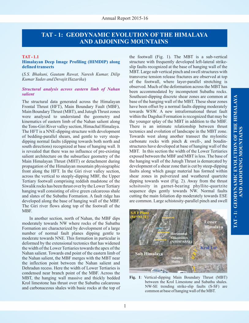
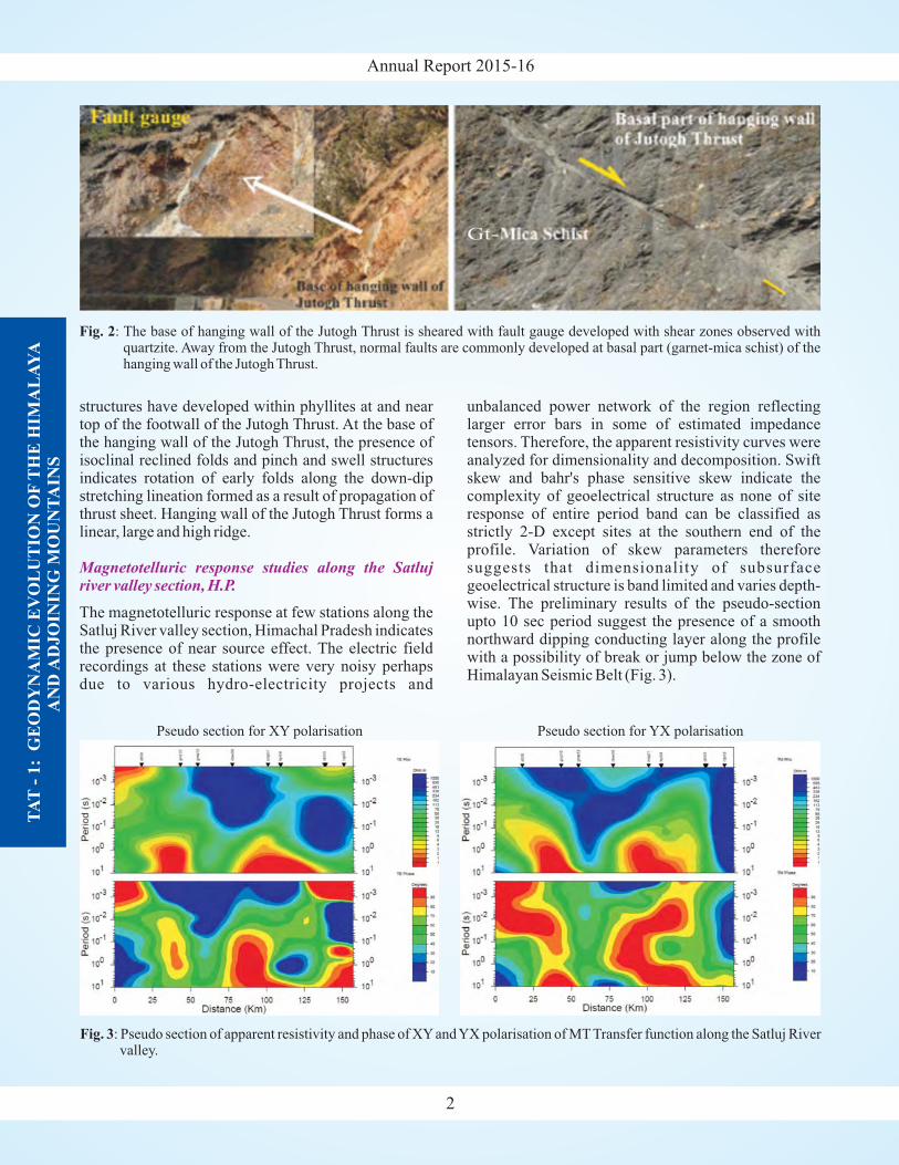
the footwall (Fig. 1). The MBT is a sub-verticalstructure with frequently developed left-lateral strike-slip faults recognized at the base of hanging wall of theMBT. Large sub vertical pinch and swell structures withtransverse tension release fractures are observed at topof the footwall, where layer-parallel stretching isobserved. Much of the deformation across the MBT hasbeen accommodated by incompetent Subathu rocks.Southeast-dipping discrete shear zones are common atbase of the hanging wall of the MBT. These shear zoneshave been offset by a normal faults dipping moderatelytowards WSW. A new intraformational thrust faultwithin the Dagshai Formation is recognized that may bethe younger splay of the MBT in addition to the MBF.There is an intimate relationship between thrusttectonics and evolution of landscape in the MBT zone.Towards west along another transect the myloniticcarbonate rocks with pinch & swell-, and boudin-structures have developed at base of hanging wall of theMBT. In this section the width of the Lower Tertiariesexposed between the MBF and MBT is less. The base ofthe hanging wall of the Jutogh Thrust is demarcated bydevelopment of a shear zone that is cut by steep-dippingfaults along which gauge material has formed withinshear zones in pulverized and weathered quartzitedipping towards west (Fig. 2). Away from the thrustschsitosity in garnet-bearing phyllite-quartzitesequence dips gently towards NW. Normal faultscutting the main foliation dip moderately towards ESEare common. Large schistosity-parallel pinch and swell
TA
T-
1:
GE
OD
YN
AM
IC E
VO
LU
TIO
N O
FT
HE
HIM
AL
AY
AA
ND
AD
JO
ININ
G M
OU
NT
AIN
S
1
Fig. 1: Vertical-dipping Main Boundary Thrust (MBT)between the Krol Limestone and Subathu shales.NW-SE trending strike-slip faults (S-SF) arecommon at base of hanging wall of the MBT.
Annual Report 2015-16
structures have developed within phyllites at and neartop of the footwall of the Jutogh Thrust. At the base ofthe hanging wall of the Jutogh Thrust, the presence ofisoclinal reclined folds and pinch and swell structuresindicates rotation of early folds along the down-dipstretching lineation formed as a result of propagation ofthrust sheet. Hanging wall of the Jutogh Thrust forms alinear, large and high ridge.
The magnetotelluric response at few stations along theSatluj River valley section, Himachal Pradesh indicatesthe presence of near source effect. The electric fieldrecordings at these stations were very noisy perhapsdue to various hydro-electricity projects and
Magnetotelluric response studies along the Satlujriver valley section, H.P.
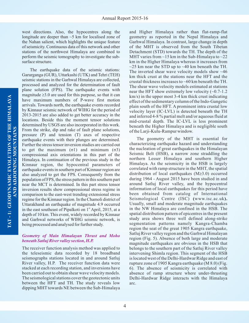
unbalanced power network of the region reflectinglarger error bars in some of estimated impedancetensors. Therefore, the apparent resistivity curves wereanalyzed for dimensionality and decomposition. Swiftskew and bahr's phase sensitive skew indicate thecomplexity of geoelectrical structure as none of siteresponse of entire period band can be classified asstrictly 2-D except sites at the southern end of theprofile. Variation of skew parameters thereforesuggests that dimensionality of subsurfacegeoelectrical structure is band limited and varies depth-wise. The preliminary results of the pseudo-sectionupto 10 sec period suggest the presence of a smoothnorthward dipping conducting layer along the profilewith a possibility of break or jump below the zone ofHimalayan Seismic Belt (Fig. 3).
TA
T-
1:
GE
OD
YN
AM
IC E
VO
LU
TIO
N O
FT
HE
HIM
AL
AY
AA
ND
AD
JO
ININ
G M
OU
NT
AIN
S
2
Pseudo section for XY polarisation Pseudo section for YX polarisation
Fig. 3: Pseudo section of apparent resistivity and phase of XY and YX polarisation of MT Transfer function along the Satluj Rivervalley.
Fig. 2: The base of hanging wall of the Jutogh Thrust is sheared with fault gauge developed with shear zones observed withquartzite. Away from the Jutogh Thrust, normal faults are commonly developed at basal part (garnet-mica schist) of thehanging wall of the Jutogh Thrust.

Annual Report 2015-16
Seismicity pattern in the Satluj River valley section, H.P.
Seismicity to micro-earthquakes level and higherintensity are assessed for the Kinnaur region, northwestHimalaya in and around the Satluj and Spiti river valleys(Fig. 4). The earthquake events in the magnitude rangeof 1.0 to 4.2 located using local velocity model aremostly concentrated within the upper part of the crust.The epicentre and hypocentres of the seismic events areplotted with filled red circles in figure 4 with geo-tectonic background. These seismic events are confinedwithin the Central Crystallines and to the south of theTibetan zone. The seismological data was integratedwith the available geological, geophysical, andgeomorphological aspects to understand thegeophysical processes of India-Eurasia collision zone.Most of the earthquake sources are associated with theMain Himalayan Thrust (MHT) or detachment and withlocal tectonics active above it.
The investigation suggests multi seismo-genesiszones that can be broadly divided into two parts. There
is high concentration of micro-earthquake seismicity in
the epicentre zone of M6.8 Kinnaur earthquake of 19January, 1975. The seismicity, focussed to the west ofthe Kaurik-Chango Fault Zone (KCFZ), is alignednearly N-S direction and is related with the seismo-genetic fault of the Kinnaur earthquake. This is in thenortheast part of the study region and in depth sectionthe hypocentres are located in the upper 20 km crustalpart. The seismicity is generated by the local tectonicfaults and concentrated above the MHT. In the southernpart of the study region, the seismicity is aligned nearlyNW-SE direction, which is along the Main HimalayanSeismic Belt (MHSB) coinciding with the trend of itssoutheast Garhwal region and northwest Kangra-Chamba region, Himachal Pradesh. The well locatedseismic events of northwest Kangra-Chamba region(Kumar et al., 2009) are plotted with filled magentacolour. In this part of the Nahan salient zone, the MainCentral Thrust (MCT) is curved and is convex towardsSW, however, the seismicity is not along the surfacetrace of this tectonic fault as observed towards east and
th
TA
T-
1:
GE
OD
YN
AM
IC E
VO
LU
TIO
N O
FT
HE
HIM
AL
AY
AA
ND
AD
JO
ININ
G M
OU
NT
AIN
S
3
Fig. 4: Epicentre and hypocentre locations in the Satluj River valley and northwest adjoining part (Geological mapafter Thakur & Rawat 1992).
Annual Report 2015-16
TA
T-
1:
GE
OD
YN
AM
IC E
VO
LU
TIO
N O
FT
HE
HIM
AL
AY
AA
ND
AD
JO
ININ
G M
OU
NT
AIN
S
4
west directions. Also, the hypocentres along thelongitude are deeper than ~5 km for localised zone ofthe Nahan salient, which highlights the unique featureof seismicity. Continuous data of this network and otherstations of the northwest Himalaya are combined toperform the seismic tomography to investigate the sub-surface structure.
The receiver function analysis method was applied tothe teleseismic data recorded by 18 broadbandseismographs stations located in and around SatlujRiver valley, H.P. The receiver function data werestacked at each recording station, and inversions havebeen carried out to obtain shear wave velocity models.The seismological stations cover the geotectonic unitsbetween the HFT and TH. The study reveals lowdipping MHT towards NE between the Sub-Himalaya
The earthquake data of the seismic stations:Garurganga (GUR), Uttarkashi (UTK) and Tehri (TEH)seismic stations in the Garhwal Himalaya are collected,processed and analyzed for the determination of faultplane solution (FPS). The earthquake events withmagnitude 3.0 are used for this purpose, so that it can
have maximum numbers of P-wave first motionarrivals. Towards north, the earthquake events recordedby Kinnaur seismic network of WIHG for the period of2013-2015 are also added to get better accuracy in thelocations. Beside this the moment tensor solutionsdetermined by USGS are also incorporated in this work.From the strike, dip and rake of fault plane solutions,pressure (P) and tension (T) axes of respectiveearthquake events with their plunges are determined.Further the stress tensor inversion studies are carried outto get
ed to get the FPS. Consequently from thepopulation of FPS, the stress pattern in this southern partnear the MCT is determined. In this part stress tensorinversion results show compressional stress regime incomparison to the east-west trending extensional stressregime for the Kinnaur region. In the Chamoli district ofUttarakhand an earthquake of magnitude 4.9 occurred
in the east southeast of Pipalkoti on 1 April, 2015, at adepth of 10 km. This event, widely recorded by Kinnaurand Garhwal networks of WIHG seismic network, isbeing processed and analysed for further study.
≥
the maximum (σ1) and minimum (σ3)compressional axis orientations in this part of theHimalaya. In continuation of the previous study in theKinnaur region, the hypocentral parameters ofearthquake events in southern part of Kinnaur region arealso analyz
st
Geometry of Main Himalayan Thrust and Mohobeneath Satluj River valley section, H.P.
and Higher Himalaya rather than flat-ramp-flatgeometry as reported in the Nepal Himalaya andGarhwal Himalaya. In contrast, large change in depthof the MHT is observed from the South TibetanDetachment (STD) towards the TH. The depth of theMHT varies from ~15 km in the Sub-Himalaya to ~22km in the Higher Himalaya whereas it increases from~25 km near the STD up to ~40 km beneath the TH.The inverted shear wave velocity models show ~46km thick crust at the stations near the HFT and thecrustal thickness increases to ~60 km beneath the TH.The shear wave velocity models estimated at stationsnear the HFT show extremely low velocity (~0.7-1.2km/s) in the upper most 3-4 km thick crust indicatingeffect of the sedimentary column of the Indo-Gangeticplain south of the HFT. A prominent intra crustal lowvelocity layer (IC-LVL) is detected beneath the THand inferred 4-8 % partial melt and/or aqueous fluid atmid-crustal depth. The IC-LVL is less prominentbeneath the Higher Himalaya and is negligible southof the Larji-Kulu-Rampur window.
The geometry of the MHT is essential forcharacterizing earthquake hazard and understandingthe nucleation of great earthquakes in the HimalayanSeismic Belt (HSB), a narrow zone straddling thenorthern Lesser Himalaya and southern HigherHimalaya. As the seismicity in the HSB is largelycorrelated with ramp structure in the MHT, the spatialdistribution of local earthquakes (M 3.0) occurred
during 1964 - August 2015 have been studied in andaround Satluj River valley, and the hypocentralinformation of local earthquakes for this period havebeen obtained from catalog of InternationalSeismological Centre (ISC) www.isc.ac.ukUsually, small and moderate magnitude earthquakesin the NW Himalaya are confined in the HSB. Thespatial distribution pattern of epicentres in the presentstudy area shows three well defined along-strikesegmentation patterns namely Kangra-Chambaregion the seat of the great 1905 Kangra earthquake,Satluj River valley region and the Garhwal Himalayanregion (Fig. 5). Absence of both large and moderatemagnitude earthquakes are obvious in the HSB thatbelongs to the southern part of the Satluj River valleyintervening Shimla region. This segment of the HSBis located west of the Delhi-Hardwar Ridge and east ofrupture zone of 1905 Kangra earthquake (M 8.0) (Fig.6). The absence of seismicity is correlated withabsence of ramp structure where under-thrustingDelhi-Hardwar Ridge interacts with the Himalayaarc.
≥
( ).

Annual Report 2015-16
TA
T-
1:
GE
OD
YN
AM
IC E
VO
LU
TIO
N O
FT
HE
HIM
AL
AY
AA
ND
AD
JO
ININ
G M
OU
NT
AIN
S
5
Fig. 5: Topographic map of the Northwest Himalaya with major tectonic features: (1) Himalayan Frontal Thrust (HFT), (2) MainBoundary Thrust (MBT), (3) Main Central Thrust (MCT), (4) South Tibetan Detachment (STD), (5) Larji-Kulu-RampurWindow (LKRW) (6) Leo Pargil (LP) Dome, (7) Vaikrita Thrust (VT), (8) Munsiari Thrust (MT). The red trianglesrepresent seismological studies used in the present study and blue triangle represents stations used by Hazarika et al.(2014). The inset in the top right corner shows distribution of teleseismic earthquakes (red filled circles) used for -wavereceiver function analysis.
P
Fig. 6: Distribution of earthquakes ( ) in the northwest Himalaya for the period of 1964-2015 (source: ISC catalogue) are shown
in relation to major tectonic features existing in the region. The tectonic features are same as mentioned in figure 5. ITSZrepresents Indus Tsangpo Suture Zone. The Delhi-Hardwar Ridge in the Indo-Gangetic Plains (IGP) is marked by dashed linesfollowingArora et al. (2012). The red star indicates epicentre of 1905 Kangra Earthquake (M 8.0).
M 3.0≥
Annual Report 2015-16
TAT-1.2Present day Uplift or Subsidence and GravitationalPotential energy change in NW-Himalaya and theNE Himalayan Syntaxis: Crust-mantle density inhomogeneity using Satellite Geodesy/Gravimetryand Seismology
(S. Rajesh, Sushil Kumar and V. Sriram)
We have been monitoring the Frontal Thrust systems andother allied major Thrusts in the Dehradun and Kangra re-entrants in the Northwest Himalaya through GPSmeasurements and processed the data by constrainingwith twenty five IGS stations in ITRF08 reference frame.Our results show that the HFT close to the Nahan salient isnot showing any surface deformation, although it showsSE trend. The magnitude of such deformation of HFTincreases towards the Dehradun re-entrant. In general, thebaseline length shortening rate increases with respect tothe LCK2 station towards south-east. This suggest thereexist along the arc movement of HFT from the east ofNahan salient towards SE. The baseline shortening ratebetween Dehradun and south of HFT is abysmally smallaround 0.06 mm/yr. Forward modeling of the velocitydata from HFT to north of MCT across the Dehradun re-entrant shows an overall 16 mm/yr shortening.At the westfrom Nahan salient the frontal velocities arepredominantly SW towards the Kangra re-entrant. Thus,the Nahan salient acts as a velocity divide in the surfacemovement of the southern plate boundary fault.
We interpret the observed GPS velocities along theArc of HFT in the Sub-Himalayan region on the basis of
TA
T-
1:
GE
OD
YN
AM
IC E
VO
LU
TIO
N O
FT
HE
HIM
AL
AY
AA
ND
AD
JO
ININ
G M
OU
NT
AIN
S
6
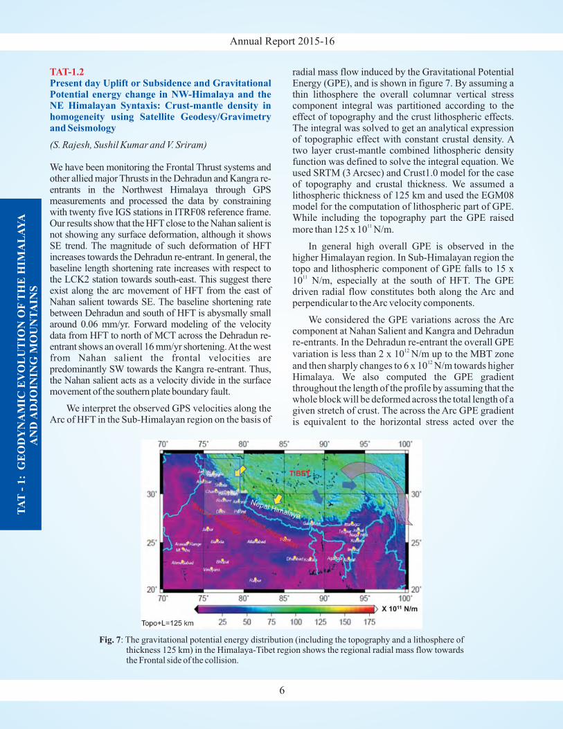
radial mass flow induced by the Gravitational PotentialEnergy (GPE), and is shown in figure 7. By assuming athin lithosphere the overall columnar vertical stresscomponent integral was partitioned according to theeffect of topography and the crust lithospheric effects.The integral was solved to get an analytical expressionof topographic effect with constant crustal density. Atwo layer crust-mantle combined lithospheric densityfunction was defined to solve the integral equation. Weused SRTM (3 Arcsec) and Crust1.0 model for the caseof topography and crustal thickness. We assumed alithospheric thickness of 125 km and used the EGM08model for the computation of lithospheric part of GPE.While including the topography part the GPE raised
more than 125 x 10 N/m.
In general high overall GPE is observed in thehigher Himalayan region. In Sub-Himalayan region thetopo and lithospheric component of GPE falls to 15 x
10 N/m, especially at the south of HFT. The GPEdriven radial flow constitutes both along the Arc andperpendicular to theArc velocity components.
We considered the GPE variations across the Arccomponent at Nahan Salient and Kangra and Dehradunre-entrants. In the Dehradun re-entrant the overall GPE
variation is less than 2 x 10 N/m up to the MBT zone
and then sharply changes to 6 x 10 N/m towards higherHimalaya. We also computed the GPE gradientthroughout the length of the profile by assuming that thewhole block will be deformed across the total length of agiven stretch of crust. The across the Arc GPE gradientis equivalent to the horizontal stress acted over the
11
11
12
12
Fig. 7: The gravitational potential energy distribution (including the topography and a lithosphere ofthickness 125 km) in the Himalaya-Tibet region shows the regional radial mass flow towardsthe Frontal side of the collision.
Annual Report 2015-16
overall length of the block and its magnitude varies
from 2 to 14 MN/m from the south of HFT to north ofMCT in the higher Himalaya. In Dehradun re-entrantthe HFT is experiencing a horizontal stress of 4.21
MN/m with respect to the reference and it increases to
23 MN/m between MCT and the MBT. Similarly, in theKangra re-entrant between the HFT and theJwalamukhi Thrust the horizontal stress component istwo orders of magnitude higher than the case ofDehradun re-entrant. Our analysis shows that plausiblythe Kangra HFT is one of the most stressed portions ofHFT in the NW Himalaya.
We studied the site effects in the Dehradun valleyand at its topographic boundary high near the MBT,where the site effect is controlled by the fluvial erosionand deposition and topographic slope instability,respectively. Results show a bimodal distribution of siteamplification characteristic of top soil near the MBT,where unique dual peak resonant frequencies (1.11 and1.38 Hz) and amplification factors (1.69 and 1.51) areobserved. This highlights that erosion due totopographic slope instability is prominent near theMBT. We also extracted the dynamical shear strain.Results show that the effective shear strain in the valley,which is a measure of plasticity of soft soil under strongmotion conditions of short and long term recurrenceinterval of a Great Magnitude earthquake is 20 to 30milli strain. This is reasonably higher than the plasticitylimit (10 milli strain) that lead to liquefaction.Moreover, the estimation of peak shear strain with depthunder different strong motion conditions at variousborehole locations in the valley is higher than thethreshold shear strain of 0.01%, this emphasize that thesoft soil in the Dehradun Valley is vulnerable forliquefaction.
The northern front of the Shillong Plateau had been takenup for GIS based study of geomorphic indices, such astopographic breaks supported by longitudinal profileanalysis, stream length gradient index (SL), ratio ofvalley floor width to valley height (V ), steepness index
(k ). In the Kulsi Basin, results indicate that the upstream
basin is more tectono-dynamic than the downstreamsegment. The Chandubi Lake is located where the riverenters the Brahmaputra alluvium and represents remnantof an old, wide paleo-channel of the Kulsi River. Thelake, which has been shrinking in size with time, alsohouses old submerged tree trunks from which samples
2
2
2
(Swapnamita C. Vaideswaran)
f
s
TAT-1.3Tectonics of the Shillong Plateau, northeastern India
TA
T-
1:
GE
OD
YN
AM
IC E
VO
LU
TIO
N O
FT
HE
HIM
AL
AY
AA
ND
AD
JO
ININ
G M
OU
NT
AIN
S
7
were collected. These samples were used for radiocarbondating. The results show inundation episodes in the lakearea around the years 160 50 AD, 970 50 AD, 1190 80
AD and 1520 30AD. Landsat satellite data from 1972 to
2003 shows migration in a segment of the riverrepresenting the last strand of the Kulsi paleo-channelwhich was seen to have been abandoned around 1991-92. The river shifted corresponding to high discharge inthe area between 1980 and 1990. The geomorphology ofthe area shows that the Chandubi Lake represents apaleochannel which has been inundated several times isevident from the Holocene dates of tree trunk samplesrefuting speculations that the lake was created by the1897 earthquake.
We have carried out outcrop-scale, petrographical andgeochemical analysis of one migmatites body presentwithin the Ladakh Batholith near Upshi, along the IndusSuture Zone. As, deformation and remobilization of theLadakh Magmatic Arc would result from the collisionbetween the Indian plate and LadakhArc, this migmatitesbody is of extreme importance as the timing of partialmelting (and source characterization) would provideinsight in the timing of continental collision as well asprobable assimilation of material from the Indiancontinental margin and the Ladakh Magmatic Arc. InitialU-Pb geochronology analysis of this migmatite show bi-modal age distribution of ~60 Ma and ~50 Ma. This resultwould suggest that the Ladakh Batholith crystallized at~60 Ma and got remobilized at ~50 Ma, which happens tobe the timing of accretion of the Indian continent with theLadakh Magmatic Arc. Our ongoing geochronologicalanalyses of this migmatites and intrusives will provide acomplete picture of the collision, accretion and post-collisional thickening/underthrusting along the Indo-Eurasian collisional zone.
The field-work has been carried out in the in Nidar,Tso-Morari and Nubra valleys, and samples ofultramafic rocks, eclogite, albitite and volcanics were
± ± ±±
(Koushik Sen and Barun K. Mukherjee)
(H.K. Sachan and Santosh Kumar Rai, Aditya Kharyaand Saurabh Singhal)
TAT-1.4
TAT-1.5
Tectonic evolution of Shyok Suture and KarakoramFault Zone rocks and their bearing on Tibet uplift
Fluid evolution and formation condition ofMigmatites of Karakoram region as well ofOphiolitic rocks of western Ladakh
Annual Report 2015-16
collected. The petrography, and the generation of themineral chemistry data of ultramafic rocks were done.The ultramafic rocks are comprised of olivine,orthopyroxene, clinopyroxene and Cr-spinel. TheXRF analysis of ultramafic rocks were also carried outto do thermodynamic modelling. Further inter-pretation of the data is in progress. We have separatedzircons from the eclogite rock for U-Pb dating. Themajor & trace element analysis of Nubra volcanics iscompleted.
New occurrence of albitite is first ever recognizedin Nubra valley of Ladakh region in the Trans-Himalaya
area within Indian Territory at 34 44' 46” N and 77 33'8” E before Panamik (in the wish pond, local name ofthe area). The albitite has been documented bypetrography, mineral chemistry, XRD and whole rockgeochemistry (i.e. major, trace and REE). The albitite inthis study is comprised of 80-90% albite andamphibole. Whereas apatite, zircon, and ilmenite occuras accessory minerals. The textural relationship ofwhole rock and geochemical data advocate for itsigneous origin. The albitite contain about 5-6 ppm Uand Th, which may possibly host of U-REEmineralization.
In Western Himalaya, the best occurrence ofblueschist is that of the Sapi-Shergol OphioliticMélange in Ladakh. This unit is dominated byvolcanoclastic sequences rich in mafic material withsubordinate interbedding of metasediments,characterized by very fresh lawsonite blueschist-faciesassemblages. We have petrologically investigatedlawsonite blueschist-facies metasediments Our resultsindicate that (i) the Sapi-Shergol blueschistsexperienced a cold subduction history along a low-thermal gradient, with peak conditions ca. 470°C and 19kbar of temperature and pressure, respectively.Additionally, in order to preserve lawsonite in thestudied lithologies, exhumation must have beencoupled with significant cooling, i.e., the resulting P-Tpath is characterized by a clockwise hairpin loop alonglow thermal gradients (8-9°C/km). The inferred P-Tevolution is consistent with a cold subduction zonesystem in an intra-oceanic subduction setting.Moreover, the estimated peak P-T conditions roughlycoincide with the maximum P-T estimates predicted bythermomechanical models for the metasedimentsexhumed in accretionary wedges, and with themaximum P-T conditions recorded by naturaloccurrences of blueschist accretionary complexesworldwide.
◦ ◦
TA
T-
1:
GE
OD
YN
AM
IC E
VO
LU
TIO
N O
FT
HE
HIM
AL
AY
AA
ND
AD
JO
ININ
G M
OU
NT
AIN
S
8
TAT-1.6Metamorphism, Migmatization and Magmatism inHigher Himalayan Crystalline: Geochemical andGeochronological constrain on LeucograniteGranite melt generation and emplacement
( )
Laser Ablation Multi-Collector ICPMS (LA-MC-ICPMS) facility was successfully installed in theInstitute to give optimum performance. Test runscarried out using standard solutions gave satisfactoryresults, and at times exceeded the specification undersolution mode. Following the proper tuning undersolution mode, U-Pb zircon geochronology applicationwas standardized, and about 150 zircon grains from 8samples were analysed at a spot size of 20 μm. Someinteresting trends of age relationships were found indefining the characteristics of HHC compared to LHSand MCT zone (Baijnath/Munshiari Fm) across theMCT. Following are the salient observation made fromthe new geochronologic data.
: The zircons fromBerinag Quartzite show variable ages, with oldercores of LateArchean (~2600 Ma), while the rims andsome of the cores cluster around Paleoproterozoic~1800 Ma. However, no younger zircons weredistinctly observed.
: The age ranges similar as that of LHS. Theyare marked by extensive Pb-loss. Two distinctivediscordia trends with upper intercepts of 1945 13 Ma
and 1850±8 Ma were observed. Both these trendshave a nearly common intercept at 27.9 8.2 Ma. The
upper intercept ages represent magmatic zircon ages,while the lower intercept age of 28 Ma represents amajor thermal event, and in all probabilities it mayrepresent peak tectonic activity along MCT.
: It marks the first appearance of Neo-proterozoic (871 18 Ma and 1043 26 Ma) magmatic
zircons. Older zircons mostly define an upperintercept age of 1900±18 Ma with a minor lateArchean (2648±8 Ma) is also observed.
: Three distinct zirconpopulation are identified. The characteristicNeoproterozoic component (871 7 Ma) becomes
more populous. Other two older component are ofPaleoproterozoic (1850 Ma), and a minor lateArchean 2600 Ma).
P.K. Mukherjee and Saurabh Singhal
Lesser Himalayan Sequence (LHS)
MCT zone/Lesser Himalayan Crystalline/Munshiari/Baijnath
At HHC-Joshimath Formation (Hanging wall ofMCT)
Suraithota Formation (HHC)
�
�
±
±
± ±
±
�
�
Annual Report 2015-16
The above results suggest that Vaikrita Thrust that isconsidered as MCT by many is indeed represent aterrain boundary with contrasting detrital zircon agesand characteristics. This also corroborates the work ofAhmed et al. (2000, GSA Bull) who found a contrastingNd-isotopic signature across Vaikrita Thrust, and isindeed the true MCT. Further, the Hf isotopic finger-printing studies are in progress, and combined with theabove zircon geochronologic data would provide muchbetter understanding of the nature and provenance ofHHC.
In the Lahaul-Spiti region of Himachal Pradesh the two-mica granite body, the Jaspa granite of lower Palaeozoicage, has intruded into the low-grade Haimanta Group ofrocks. The common mineral assemblage observed ingranite is ms-bt-pl-microcline-qtz with accessory ep, apand opaque. The Haimanta Group of TethyanHimalayan sequence rocks are composed of mineralassemblage such as, ms-bt-pl-qtz-ilm-ttn, grt-ms-bt-ep-pl-qtz and ms-bt-pl-qtz-ttn and ms-bt-ep-pl-qtz. Theanalysis of the garnet which is observed to develop inthe contact zone shows that, they are grossular tospessartine rich with end member composition in rangeof 35-44 mol. % of grossular, 23-26 mol.% ofspessartine, 30-38 mol. % of almandine, and 1-2 mol. %of pyrope. Biotite is Mg rich with X value in range of
0.55 to 0.60. Geothermometric calculations show themetamorphic temperature of ~450°C. Fluid inclusionstudies have been initiated on Jaspa granite and theenclaves present within it to compare the fluidparticipated in evolution and to constrain the . It isobserved that the fluid inclusions present in the granitesare more abundant than in enclaves, although they aresmall. The study showed two distinct fluid inclusiontypes: liquid rich saline aqueous inclusions with 80 to 90vol% are primary, which from our preliminary studiessuggest to represent the late stage of granite formation.Polyphase halite bearing inclusions are uncommon.Others are CO and coexisting CO -H O inclusions
which has also been confirmed by the micro Ramanspectroscopy which occur in clusters and at times intrails. Based on their occurrence, these inclusions areconsidered to characterize the post granitemetamorphism. The enclaves also consists of CO and
(S.S. Thakur, A.K. Singh, D.R. Rao and Rajesh Sharma)
P-T
Mg
2 2 2
2
TAT - 1.7Geochemical and crustal evolution of the Himalayanorogenic belt in Himachal NW Himalaya, and in theEastern Syntaxial Belt, NE India
NW Himalaya
TA
T-
1:
GE
OD
YN
AM
IC E
VO
LU
TIO
N O
FT
HE
HIM
AL
AY
AA
ND
AD
JO
ININ
G M
OU
NT
AIN
S
9
coexisting CO -H O inclusions. The fluid inclusions in
granite suggests that water rich saline fluid was presentduring granite crystallization. Further synthesis andinterpretation of the data of geothermobarometric andfluid inclusions data is in progress.
Studies have been carried out on the mafic xenolithswhich sporadically occur in the Lower PalaeozoicKinnaur Kailash Granite (KKG) of Sutlej valley, NWHimalaya. Amphiboles are common constituentminerals in these xenoliths. These mafic xenolithscontain mineral assemblage of opx-cpx-hbl-pl±qtz.Amphiboles (Cummingtonite and hornblende) andgarnets bearing corona around cpx and opx have beenobserved. The calculation of hornblende based onsubstitution mechanism shows that the amphiboles ofthe study area have equilibrated in the temperature andpressure ranges of 550-650ºC and 3.0-7.5 kbar,respectively. From the studies carried out it is suggestedthat, the retrograde hornblende were formed in themafic xenoliths during the cooling of the terrain. The
path shows that hornblende has undergone retrogradetrajectory. Further, the geochemical studies of
mafic xenoliths are processed and the results arecommunicated for publication.
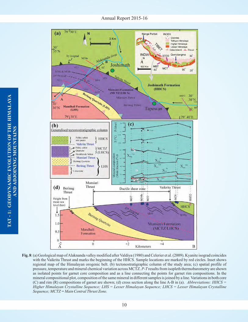
The studies on the MCT zone of the Alaknandavalley have also been taken-up during the year tounderstand the tectonometamorphic evolution ofMCTZ and its relation with HHCS. A continuousincrease in the inverted metamorphic field gradientacross the contact between the Main Central Thrust(MCT) and Higher Himalayan Crystalline Sequence(HHCS) with increasing structural level (Fig. 8) isestablished (Thakur et al., 2015, Contribution toMineralogy and Petrology). The Main Central Thrusthas been defined based on first appearance of kyanite,chemically homogeneous garnet and garnet withrandom inclusion trails. pseudosection modellingapproach has been used to understand the metamorphicevolution of the Main Central Thrust Zone (MCT)which suggest peak metamorphic condition inrange of 6.3-7.5 kbar and 550-582°C (Fig. 9). Acomparative study of the metamorphic history of theMCTZ rocks in NE Himalaya (Siyom valley, Nandiniand Thakur, 2011), Sutlej valley of NW Himalaya(Caddick et al. 2007) and Alaknanda valley in NWHimalaya show complex tectono-metamorphicevolution varies from one section to other. In NEHimalaya MCTZ has undergone peak metamorphism ofsillimanite-kfeldspar grade with clockwise path(Nandini and Thakur, 2011) whereas in Sutlej valley,NW Himalaya LHCS has undergone sillimanite grademetamorphism with clockwise path (Caddick et al.
2 2
P-T
P-TP-T
P-T
P-T
P-T
P-T
Annual Report 2015-16
TA
T-
1:
GE
OD
YN
AM
IC E
VO
LU
TIO
N O
FT
HE
HIM
AL
AY
AA
ND
AD
JO
ININ
G M
OU
NT
AIN
S
10
Fig. 8: (a) Geological map ofAlaknanda valley modified after Valdiya (1980) and Celerier et al. (2009). Kyanite isograd coincideswith the Vaikrita Thrust and marks the beginning of the HHCS. Sample locations are marked by red circles. Inset showsregional map of the Himalayan orogenic belt. (b) tectonostratigraphic column of the study area; (c) spatial profile ofpressure, temperature and mineral chemical variation across MCTZ. - results from isopleth thermobarometry are shownas isolated points for garnet core composition and as a line connecting the points for garnet rim compositions. In themineral compositional plot, composition of the same mineral in different samples is joined by a line. Variations in both core(C) and rim (R) compositions of garnet are shown; (d) cross section along the line A-B in (a).
P T
Abbreviations: HHCS =Higher Himalayan Crystalline Sequence; LHS = Lesser Himalayan Sequence; LHCS = Lesser Himalayan CrystallineSequence; MCTZ = Main Central Thrust Zone.
Annual Report 2015-16
TA
T-
1:
GE
OD
YN
AM
IC E
VO
LU
TIO
N O
FT
HE
HIM
AL
AY
AA
ND
AD
JO
ININ
G M
OU
NT
AIN
S
11
Fig. 9: pseudosection in the MnNCKFMASH system (+qtz +H O) at =1 for unfractionated bulk rock composition of the
MCTZ sample M37. (a) Stability fields of different mineral assemblages below the solidus are shown, solution modelsused in pseudosection calculation are given in the inset; (b) Isopleths of X in plagioclase; (c-f) Isopleths of X , X , X
and X in garnet, respectively. Thick violet line represents isopleth of the measured garnet composition. The stability field
of grt-bt-chl-pl-ms-qtz assemblage in the rock is shaded in (b) - (f). In (c), compositional isopleths of X , X and X
corresponding to the measured garnet core composition are plotted which intersect to form a triangle inside the stabilityfield of the above mineral assemblage. result from multi-equilibria thermobarometry is also plotted with error bar.
P-T a
P-T
2
an prp alm grs
sps
prp grs sps
H2O
Annual Report 2015-16
TA
T-
1:
GE
OD
YN
AM
IC E
VO
LU
TIO
N O
FT
HE
HIM
AL
AY
AA
ND
AD
JO
ININ
G M
OU
NT
AIN
S
12
Fig. 10: Galena mineralization in quartz vein present alongthe S2 schistosity inAmba Khala area.
2007). In contrast to this, in Alaknanda valley, NWHimalaya, MCTZ has undergone garnet grade progrademetamorphism (Thakur et al., 2015, Contribution toMineralogy and Petrology).
The Nagaland-Manipur Ophiolites (NMO) of Indo-Myanmar Orogenic Belt, NE India forms a part of theTethyan ophiolites and are considered as southwardextension of the Indus Tsangpo Suture ophiolites, whileothers considered it as a separate ophiolitic suite. Wehave carried out geochemical and petrological studiesof the NMO in order to compare the Tidding-Tutingophiolites that are exposed in the eastern syntaxial belt.The NMO are comprised of peridotites, cumulatemafic-ultramafic sequence, felsic intrusives, oceanicpelagic sediments along with minor podiformchromites. However, sheeted dykes which areconsidered as a significant component of ophiolites areabsent in the NMO. The geochemical studies ofperidotites and pyroxenites suggest different origin.
The studies showed that, the peridotites have Crnumber [Cr# = Cr/(Cr+Al)] in the range of 0.14 to 0.29,
Mg number [Mg# = Mg/(Mg+Fe )] in the range of0.71-0.76, show gradual decrease in REEconcentrations from HREE to MREE (Sm /Yb =
0.285-0.460) with slight increase in LREE (La /Sm =
0.721-2.201). The estimated equilibration temperature
range from 971 to 1156 C. The olivine-spinelequilibrium and Cr-spinel chemistry data suggest thatthese tectonite peridotites are residual mantle afterlimited extraction of basaltic melts and haveexperienced low degree of partial melting (<15%).Conversely, the pyroxenites show Cr number in therange of 0.27-0.48, Mg number in the range of 0.44-0.53, exhibit nearly flat MREE to HREE (Sm /Yb =
0.622-0.756) and depleted LREE (La /Sm = 0.380-
0.759). The estimated equilibration temperatures in
these rocks range from 890 to 931 C. The presence ofhighly magnesian opx and cpx in these pyroxenites inconjunction with their geothermometry suggests thatthey were formed at high pressure and temperature inthe form of deeply originated cumulates after magmaticfractionation from the basaltic melt.
The geochemical data together with field andpetrographical evidences indicate that both the tectoniteperidotites and cumulate pyroxenites are essentiallyspinel-bearing, and free from any plagioclase,suggesting their derivation from a deep source in themantle beyond the stability limit of plagioclase in a mid-oceanic ridge tectonic setting. We envisage that, the
2+
o
o
N N
N N
N N
N N
NE Himalaya
mantle section in the NMO was initially generated in theseafloor spreading regime at the eastern margin of theIndian plate which was then thrusted over thecontinental margin of the Indian plate during itscollisional and subduction process with the Myanmarplate (Singh et al. 2016, Geological Journal).
The field-work has been carried out in sulphidemineralized localities namely: Amba Khala(30°64’14” 78 07’45” ), in Sirmour Dist. (H.P.), andChamri (H.P.) and Amtiyar gad (30 57’37” ,77 55’16” ) in Tonse river valley in Uttrakhand. Themineralisation are localized to the shear zone. Sulphidemineralization of Amba Kala is hosted in slates andphyllites, and is enriched in galena with subordinatechalcopyrite. This mineralization is noticed in veinsalong the axial planes (Fig. 10). Textures shows fracturefillings by the su
S values ofsulphides from Askot and/or Kullu. Three types ofinclusions in gangue quartz are filled with biphaseaqueous, aqueous-carbonic and monophase low densitycarbonic fluid. At Amtiyar gad, the ore assemblageconsists of pyrite, galena, sphalerite and minorchalcopyrite. Galena shows banding of the cleavageplanes indicating post deposition deformation. Oretextures are complex with mutual replacement of galenaand sphalerite and exsolution between chalcopyrite andsphalerite. A hydrothermal nature is generally apparent,
(Rajesh Sharma)
N, ° E° N
° E
lphide minerals and replacement ofchalcopyrite by galena. Sulphur isotope analysis of
three samples indicate that δ S of galena varies from11.1 to 11.4 which do not clearly point to magmatic
sulphur, and are not comparable to δ
34
34
TAT-1.8Mineralization and Metallogeny in, northwestHimalaya: Emphasis on the role of complex fluids inmagmatic and mineralization processes
13
Annual Report 2015-16
TA
T-
1:
GE
OD
YN
AM
IC E
VO
LU
TIO
N O
FT
HE
HIM
AL
AY
AA
ND
AD
JO
ININ
G M
OU
NT
AIN
S
however, further work underway on ore chemical andmicrothermometry would be helpful in understandingorigin of these sulphides.
Barite is found associated with NeoproterozoicNagthat siliciclastic rocks at various places in SirmourDistrict, Himachal Pradesh and in the Tons valley ofLesser Himalaya. Field-work was also recently carriedin one of the mineralized location near Kaffota, H.P.Veins, lenticles and pockets of barite microscopicallyshow two types of grains, (i) the barite porphyroclastsrepresenting the original deposition of barite, and (ii)the fine polycrystalline aggregate formed afterrecrystallization of porphyroclasts. The fabric and fluidinclusion studies of barites were also carried out. Thestudies suggest that the fluid inclusions in barite grainsare saline aqueous. Type 1 aqueous inclusions in
undeformed porphyroclasts are earliest representinginitial barite deposition. These inclusions homogenizeat 112 to 208 ºC with salinity ranging from 3.71 to 11.9wt % eq NaCl. Their T vs salinity infer mixing of two
fluids in barite deposition during primary bariteformation stage, of which one may be basinal brine.Deformation features including bending of the grainsand granulation pattern of the barite suggests that thebarite deformation is linked with tectonics. A partial re-equilibration is inferred from fluid inclusion data. Thecharacteristic textures and morphology of re-equilibrated Type 4 fluid inclusions, and the position ofvarious isochors substantiate that the barite deformationand recrystallization is related to Himalayan tectonicsand exhumation.
h
13
Annual Report 2015-16
TA
T-
2:
IND
IAN
MO
NS
OO
N-T
EC
TO
NIC
IN
TE
RA
CT
ION
AN
DE
XH
UM
AT
ION
OF
TH
E H
IMA
LA
YA
14
TAT - 2: INDIAN MONSOON-TECTONIC INTERACTION ANDEXHUMATION OF THE HIMALAYA
TAT-2.1
(Pradeep Srivastava, Koushik Sen and Anil Kumar)
Developed a record of past floods from the Indus River(Ladakh, NW Himalaya), the Alaknanda-MandakiniRivers (Garhwal Himalaya), and the BrahmaputraRiver (NE Himalaya) from new paleoflood deposits,which are characterized by sand-silt couplets, massivesand beds, and organic debris flows. The chronology ofpaleoflood deposits, established by Optically
Stimulated Luminescence (OSL) and C AMS datingtechniques, indicates the following:
the Alaknanda-Mandakini Rivers experienced largefloods during the wet and warm Medieval Warm
14
�
Sediment production and sedimentation in DrierHimalaya: Patterns, time scales and palaeoclimaticin trans-inferences
Phase (MWP); pollen recovered from the paleoflooddeposits, located in the headwaters of MandakiniRiver, also showed presence of warmth loving treeand marshy taxa
the Indus River experienced at least 14 large floodsduring post-glacial climatic optimum, when flooddischarges were likely an order of magnitude higherthan those of modern floods (Fig. 11); and
the Brahmaputra River experienced a megafloodbetween 8-6 ka.
Magnetic susceptibility of flood sedimentsindicates that 10 out of 14 floods on the Indus Riveroriginated in the catchments draining the Ladakhbatholith, indicating the potential role of glacial lakeoutbursts (GLOFs) and/or landslide lake outbursts(LLOFs) in compounding flood magnitudes.
�
�
Fig. 11: Paleoflood deposits at Nimu and their chronology.
Annual Report 2015-16
Collectively, our new data indicate that floods inHimalaya largely occur during the warm and wetclimatic phases. Further, the evidence supports thenotion that the Indian Summer Monsoon front may havepenetrated into the Ladakh during the post glacialclimatic optimum.
The studies of two new sections of paleofloods inZanskar and Indus rivers are in progress.
Miocene taxa from Siwalik and Dharmsala horizonsof the Himalaya and the ones being recovered fromKutch, western India are similar; these terrestrial taxainhabited huge bioprovince that was capable ofsustaining folivorous beasts. Earlier studies based onrare and scattered occurrences of mammals suggestedthat only Early and basal Middle Miocene terrestrialmammals were represented in the region, but the newresearches extend the fossil register into the LateMiocene, with taxa such as
and beingrepresented at some localities such as Tapar andPasuda.
Hipparionine dental remains are typical component ofthe Siwalik Miocene assemblages and now these arealso known from Miocene horizons of central Kutch,Gujarat. These immigrant extinct horses evolved inNorth America and came to ancient world with theopening of land route in Miocene. In India they arewell known from Sub-Himalayan Siwalik Grouphorizons; their record from non-Siwalik Neogenehorizons of Kutch is significant as it relates thestratigraphies in Siwalik and Kutch non-marineforeland and coastal basins.
Outer western Himalayan early Miocene terrestrialfossils from Jammu and Kashmir and HimachalPradesh have been studied by number of teamsbecause of (i) the exposures being more accessible,and (ii) application of bulk maceration techniques indeveloping fossil assemblages as a rule. Our focus onpaleontological studies in the exposures of DharmsalaGroup in Kangra Valley in the Outer westernHimalaya has rewarded with enormous number ofmicroscopic cyprinid fish pharyngeals, charagyragonites, ostracods, etc besides dental remains oflarger animals including deinothere and crocodiles.
(a revised project approved by RAC).
(B.N. Tewari)
Hipparion, Parachleua-stochoerus salinus Tetraconodon indicus
�
�
�
TAT-2.2Fossil findings from Mohand Anticline andDharmsala Group of Himachal Pradesh
TAT-2.3River response to allogenic forcing and lateQuaternary landscape evolution: Punjab re-entrant
(N. Suresh and Rohtash Kumar)
In the Satluj valley, in all six levels of terraces (T1-T6)were identified between Ogli (north of MBT) and Ropar(south of MBT). Litho-sections were constructed andOSL samples were analysed from representative litho-units to establish the chrono-stratigraphy. The measuredlitho-sections show that the litho-units, in general, aredominated by gravel and sand, but the oldest andtopmost terrace (T6) is dominated by thick sequence ofmedium to very coarse sandy facies. To the north ofMBT, the topmost terrace is extensively developedaround Bali, Aut and Ogli areas. The terracedepositional sedimentary sequence is dominated bythick sequence (~70 m) of medium to coarse massivesand, locally faint trough cross-stratified and parallellaminated, and associated with locally 20 to 50 cm thicklacustrine facies. The bulk mineralogy by XRD showsdominance of quartz followed by feldspar, calcite andclay minerals (illite and chlorite). Quartzite bearinggravels are rare or absent.All this suggest that they werederived from the physical weathering of granite gneiss,exposed particularly north of MCT. The OpticallyStimulated Luminescence (OSL) chronology suggeststhat the thick sandy sequence was deposited between69±10 ka and 49±6 ka. Similar thick sandy sequence isalso observed in the paleo-exist of the Satluj River in theouter margin of Sub-Himalaya, near the vicinity ofHimalayan Frontal Thrust. These sandy facies are fineto medium grained, multistoried, and internally consistlow angle trough cross-stratifications and parallellamination. The quartz OSL ages suggest that they weredeposited between 70±5 ka and 50±4 ka. The depositionof thick sandy facies, traced for hundreds of kilometers,suggests that the sediments were produced underrelatively stable condition during late Quaternaryperiod, when extensive weathering and rapidexhumation of granite in the Higher Himalayancatchment. Its transport to the valley between 70 and 49ka resulted extensive aggradation and/or it representsextreme climatic events.
The subsequent lower terraces in the hanging wallof MBT are however dominated by gravel facies whichare clast to matrix supported, poorly sorted, finingupward and imbricated. They consist of quartzite,granite gneiss, volcanics and limestone and/or slateclasts. From this locality younger terraces formedaround 27±5 ka and 2.5±0.7 ka were also documented.In the Sub-Himalaya around 45 ka, thick sequence of
TA
T-
2:
IND
IAN
MO
NS
OO
N-T
EC
TO
NIC
IN
TE
RA
CT
ION
AN
DE
XH
UM
AT
ION
OF
TH
E H
IMA
LA
YA
15
Annual Report 2015-16
gravel facies, resting directly over the thick sandy unitsin the vicinity of the Himalayan Frontal Thrust, is alsodocumented. However, in the Inner Sub-Himalaya,immediate south of the MBT, a terrace surface formedafter 45±7 ka was identified. In addition, three youngerterraces formed around 26 ka, 11 ka and 6 ka were alsowell developed.
The major periods of aggradation coincided withQuaternary cold phase, and dissection with periods oflower sediment supply during warmer phases. Theclimatic change controls water and sediment supply,probably synchronous with river response. The streamincision and absence of sedimentation in the valleysuggests reduced sediment supply, however, withrelatively high stream power. As mentioned earlier, thesandy facies is observed in the wider valley and duringcatastrophic flooding, gravel load remains in the channel,whereas sandy load is deposited in the floodplains. Onthe other hand, sandy facies in the Outer Himalaya wasdeposited in the mountain front with decrease rivergradient on a wider channel area.
The studies thus suggest that, during late Pleistocenemajor extreme events was responsible for theirdevelopment. The deposition of thick sequence of gravelfacies around 45 ka might be correlated to the reportedmajor tectonic episode around 45 ka in the Himalaya. Theobserved two termination phases of deposition around 26ka and 11 ka have occurred in the reported increasedmonsoon phases (29-23 ka and <10 ka), and hence arecorrelated to climate change. The non-deposition ofsediments between 11 and 6 ka indicate prolongedincision phase, and are in agreement with less erosionalproducts in the mountain slopes due to increasedvegetation cover during the humid inter-glacial period.The stratigraphy of these terrace deposits together withchronology is under progress and will through light onthe evolution history with respect to Quaternary tectonicdeformations and climatic variations.
The project deals with the reconstruction of highresolution paleoclimate records from the north-westernHimalayan region and Ganga Plain, India. The LadakhHimalayan region, moreover, has scarcity inpaleoclimatic data, and to achieve this goal, followingwork has been carried out during the reporting year.
(Narendra Kumar Meena, Sudipta Sarkar, Anil K.Gupta and M. Prakasam)
TAT-2.4Late-Quaternary paleomonsoon study in Ladakh,North western Himalaya and Indo-Gangetic plain,India
A multi-proxy data set for Tso-Moriri Lake coreshas been developed. Grain size analysis of 75 samplesfrom ~3 meters lake cores has been performed using theLaser Particle Size Analyzer (LPSA) at WIHG,Dehradun, to study the down-depth grain-size variationand climate control. The bulk sediment analysis from22 samples from cores of about 1.5 meters below lakefloor was carried out using XRF at WIHG, Dehradun, tostudy distributions and variations of major oxides andtrace elements down the depth. In order to study theclay mineralogy down the ~3 meters of Tso-Moriri lakecores, XRD analysis was performed on 34 clay slides atWIHG. The extraction of organic phosphorus (OP) andinorganic phosphorus (IP) for 31 samples of Tso-MoririLake were carried out to understand the climaticsignatures encoded within the lake sediments followingstandard protocol. The data generated revealsinteresting events of paleoflood records during the~1700 years of paleoclimatic variations in the north-western Himalaya. The role of Indian SummerMonsoon (ISM) and Westerlies can also be understoodfrom these records.
The Rewalsar Lake cores have been analysed forreconstructing climate, sedimentation, and pollutionetc. from the mid-altitude region of the Himalaya. Grainsize analysis of 62 samples from ~5 meters lake core hasbeen performed by LPSA at WIHG to study the down-depth grain-size variation and climate control. It hasalso been observed that the Rewalsar Lake experienceda higher rate of the sedimentation history during the last~50 years as compared to the other north-westernHimalayan lakes. On the other hand, the geochemicalstudies also revealed low to moderate heavy metalpollution in the lake during the past ~50 years.
Around ~8 meter of Ganga River cliff section atRamnagar, Varanasi was studied for paleoclimaticreconstruction of the Ganga Plain. A multi-proxy dataset (grain size and magnetic mineralogy) were alreadygenerated during the previous years, while the data onmajor oxides and trace elements have been generatedduring this reporting year. The findings of this workindicate a gradually drier climatic condition during thelate Quaternary with intermittent wet phases.
Thirty days field work has been conducted toaccomplish various objectives related to the treelinedynamics, dendrochronological study and aerosols
(P.S. Negi and Jayendra Singh)
TAT-2.5Climate Variability and Treeline Dynamics inWestern Himalaya
TA
T-
2:
IND
IAN
MO
NS
OO
N-T
EC
TO
NIC
IN
TE
RA
CT
ION
AN
DE
XH
UM
AT
ION
OF
TH
E H
IMA
LA
YA
16
Annual Report 2015-16
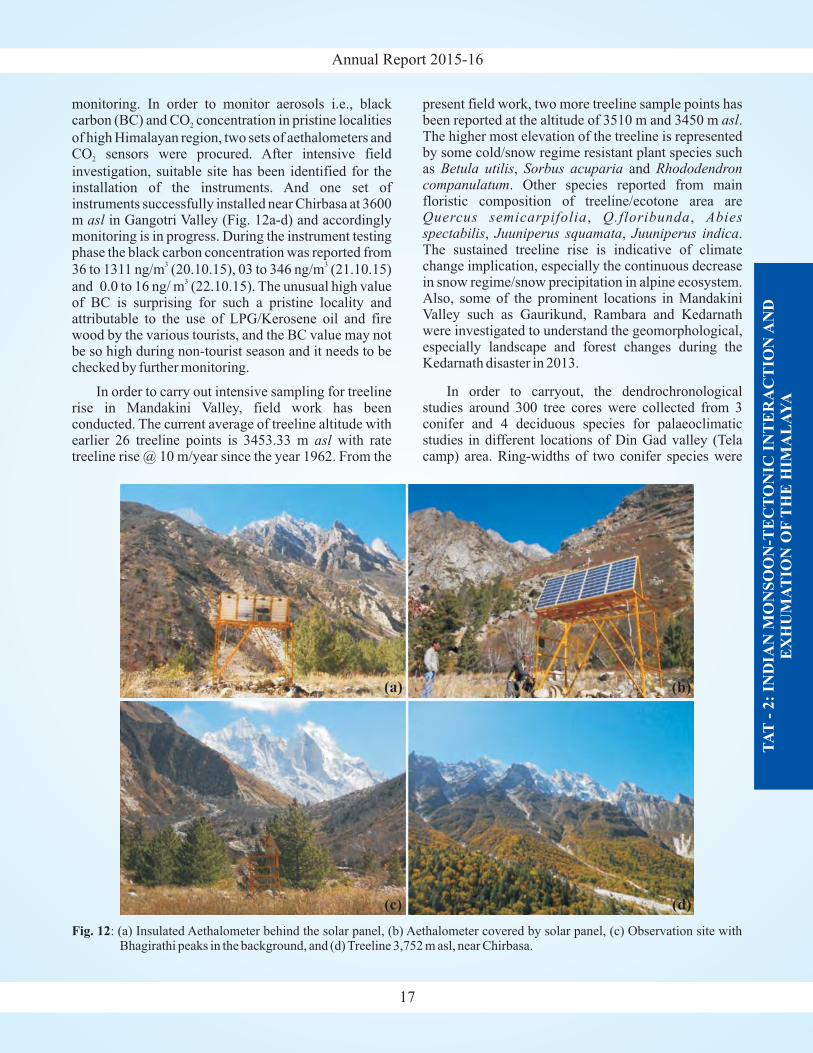
monitoring. In order to monitor aerosols i.e., blackcarbon (BC) and CO concentration in pristine localities
of high Himalayan region, two sets of aethalometers andCO sensors were procured. After intensive field
investigation, suitable site has been identified for theinstallation of the instruments. And one set ofinstruments successfully installed near Chirbasa at 3600m in Gangotri Valley (Fig. 12a-d) and accordinglymonitoring is in progress. During the instrument testingphase the black carbon concentration was reported from
36 to 1311 ng/m (20.10.15), 03 to 346 ng/m (21.10.15)
and 0.0 to 16 ng/ m (22.10.15). The unusual high valueof BC is surprising for such a pristine locality andattributable to the use of LPG/Kerosene oil and firewood by the various tourists, and the BC value may notbe so high during non-tourist season and it needs to bechecked by further monitoring.
In order to carry out intensive sampling for treelinerise in Mandakini Valley, field work has beenconducted. The current average of treeline altitude withearlier 26 treeline points is 3453.33 m with ratetreeline rise @ 10 m/year since the year 1962. From the
2
2
asl
asl
3 3
3
present field work, two more treeline sample points hasbeen reported at the altitude of 3510 m and 3450 m .The higher most elevation of the treeline is representedby some cold/snow regime resistant plant species suchas , and
. Other species reported from mainfloristic composition of treeline/ecotone area are
, ,, , .
The sustained treeline rise is indicative of climatechange implication, especially the continuous decreasein snow regime/snow precipitation in alpine ecosystem.Also, some of the prominent locations in MandakiniValley such as Gaurikund, Rambara and Kedarnathwere investigated to understand the geomorphological,especially landscape and forest changes during theKedarnath disaster in 2013.
In order to carryout, the dendrochronologicalstudies around 300 tree cores were collected from 3conifer and 4 deciduous species for palaeoclimaticstudies in different locations of Din Gad valley (Telacamp) area. Ring-widths of two conifer species were
asl
Betula utilis Sorbus acuparia Rhododendroncompanulatum
Quercus semicarpifolia Q.floribunda Abiesspectabilis Juuniperus squamata Juuniperus indica
TA
T-
2:
IND
IAN
MO
NS
OO
N-T
EC
TO
NIC
IN
TE
RA
CT
ION
AN
DE
XH
UM
AT
ION
OF
TH
E H
IMA
LA
YA
17
Fig. 12: (a) Insulated Aethalometer behind the solar panel, (b) Aethalometer covered by solar panel, (c) Observation site withBhagirathi peaks in the background, and (d) Treeline 3,752 m asl, near Chirbasa.
Annual Report 2015-16
measured with an accuracy of 0.001mm, andsuccessfully dated each growth ring to the level ofcalendar year for 41 tree cores ofAbies and 32 tree coresof Spruce. Ring-widths of 18 tree cores of one deciduousspecies were also measured and the dating of growthrings is in process. Tree-ring chronologies of these twoconifer species were prepared for further dendroclimaticstudies. Besides, annual growth rings of two coniferspecies was separated for stable isotope analyses. Ringwidths of 11 tree cores of deciduous species were alsomeasured and dated to the level of calendar year of theirformation. Ring width measurement ofsamples collected from Bhagirathi valley and Chorabariglacier valley are in process.
Major ions, stable isotopes ( C ) and silica
measured in the samples in Indus River waters coveringLadakh region, show that the alkalinity in these rivers islinked with silicate weathering. However, co-variationof [HCO +SO ] with [Ca+Mg] indicates that the
alkalinity in these rivers may be originated with silicateweathering mediated by H SO or dissolution of halites.
Thus it is presumed that, the silicate weathering serve asa dominant mechanism to produce the alkalinity in theseRivers. This observation is also supported by the factthat the silicates (granites, gneisses, schists etc) in theIndus valley comprise mainly of minerals includingquartz, plagioclase, alkali feldspar, biotite andmuscovite and dissolution of these can produce silicaand alkalinity together in solution. These results findsupport as the Indus River flows through the Indo-Tsangpo Suture zone characterised with tectonicactivity and highly fractured/sheared rocks which areprone to weathering. This work hints for the plausibilityof silicate weathering in the Indus catchment which maybe mediated with the H SO .
Analytical studies carried on the landformdevelopment of the Ramganga basin incorporate thequantitative analysis of its catchment in the GarhwalHimalaya Uttarakhand. The drainage parameters(linear, areal and relief) of the Ramganga Basin fromDudhatolidhar peak its origin point to Kalagarh fromwhere the River Ramganga enter into the plain arecovered. The impact of the morphological characters onthe terrain is reflected by the drainage basin of the area.
Betula utilis
(Santosh K. Rai, S.K. Bartarya, Anil K. Gupta andA.K.L. Asthana)
δ13
VPDB
3 4
2 4
2 4
TAT-2.6Geochemical and isotopic studies as tracers ofweathering and erosion processes in the NWHimalaya
TAT-2.7
TAT 2.8
High resolution Paleoclimate records from theHimalaya and adjoining regions
Variability of Indian Monsoon during theQuaternary period since MIS-3 using the highresolution speleothem records from Himalayanregions and sediment records from Ganga plainlakes
(Anil K. Gupta, Jayendra Singh, Santosh K. Rai andSuman Lata Rawat)
Pinuswallichaina
Cedrus deodara Pinusgerardiana
(Som Dutt, Anil Kumar, Anil K. Gupta, Suman LataRawat and Saurabh Singhal)
In order to reconstruct floristic composition and Indiansummer monsoon variability during the Holoceneperiod four sediment cores from the Ganga basin andtwo palaeolake profiles from the Pinder valley,Garhwal Himalaya have been collected and beinganalysed to generate multi-proxy records (pollen,grain size, loss on ignition and stable carbon isotope).In addition, ring-width chronology of
from Kinnaur region, Himachal Pradeshwas also prepared and climate signal of the ring widthchronology was identified for further reconstruction ofpast climate records. Besides, 100 tree cores of twoconifer species ( and
) were processed and annual growth-ringwidth of trees are being measured for the furtherclimate change studies.
In order to reconstruct the variability of Indian summermonsoon (ISM) in the Indian subcontinent during thelate Quaternary, the sub-sampling of some speleothems,collected from the NE Himalaya have been carried out.The results of one speleothem MWS-1 from Mawmluhcave, Meghalaya indicate a strong wet phase between33,500 and 32,500 years B.P. followed by a weak/dryphase from 26,000 to 23,500 years B.P. The weakestphase of ISM lies between 17,000 and 15,000 years B.P.These records also suggests abrupt increase in ISMstrength during the Bølling-Allerød and early Holoceneperiods and pronounced weakening during the HeinrichandYounger Dryas cold events.
The chronology of sediment core from RewalsarLake (Mandi, Himachal Pradesh) have been developed
by 15 AMS C ages. The preliminary results of grainsize variability suggest very high erosional events in thelake catchment around 2,900, 1,750 and 1,250 yearsB.P., which indicate the strong flood events.
14
TA
T-
2:
IND
IAN
MO
NS
OO
N-T
EC
TO
NIC
IN
TE
RA
CT
ION
AN
DE
XH
UM
AT
ION
OF
TH
E H
IMA
LA
YA
18
Annual Report 2015-16
19
TAT-3.1Seismological, seismotectonic and subsurfacerelated studies seismic hazard evaluation from theLadakh, Kinnaur, Kangra and Garhwal-Kumaunregions of the NW Himalaya
(Sushil Kumar, Ajay Paul, Dilip Kumar Yadav andDevajit Hazarika)
Strains resulting from the continued collision betweenIndia-Asia plates are manifested in number of largeearthquakes along the Himalayan arc. In the NWHimalaya, adjustments and activation of crustal blocks toaccumulating/decaying strains continuously triggermicro-earthquakes. The understanding of earthquakesource processes and the medium characterizationprovides the base tools for the assessment, mitigation andreduction of seismic hazards. Towards obtaining these
objectives a regional network of seismic stations arebeing operated in the NW Himalaya. Around 40 BroadBand Seismographs (Fig. 13), along with otherGeophysical equipments were operated in the NWHimalaya. The data is being acquired and analyzedcontinuously by the network. The earthquake events forperiod during April 2015 and March 2016 were analyzedfor understanding the spatio-temporal variations, sourcemechanisms, source parameters, Shear Wave Splitting(SWS) properties, 1D and 3D velocity structure,evaluation of strain energy budget and stress orientationsin the Garhwal-Kumaun region of Himalaya. Theepicentral location map indicates that Munsiari Thrust,which is located south of the Main Central Thrust, ismore active. From the slip distribution evaluation on thefault plane from waveform modeling of earthquakes, ithas been found that the large slip regions cover a very
TAT - 3: EARTHQUAKE PRECURSORS STUDIES ANDGEOHAZARD EVALUATION
TA
T-
3:
EA
RT
HQ
UA
KE
PR
EC
UR
SO
RS
ST
UD
IES
AN
DG
EO
HA
ZA
RD
EV
AL
UA
TIO
N
Fig.13: Broadband seismographs and accelerographs locations are shown with triangles and epicentral locations of localearthquakes triggered during 2015-16 are shown with black circles on the seismotectonic map of NW Himalaya.
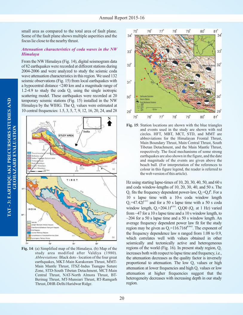
Annual Report 2015-16
20
TA
T-
3:
EA
RT
HQ
UA
KE
PR
EC
UR
SO
RS
ST
UD
IES
AN
DG
EO
HA
ZA
RD
EV
AL
UA
TIO
N
small area as compared to the total area of fault plane.Some of the fault plane shows multiple asperities and thefocus lie close to the nearby thrust.
From the NW Himalaya (Fig. 14), digital seismogram dataof 82 earthquakes were recorded at different stations during2004-2006 and were analyzed to study the seismic codawave attenuation characteristics in this region. We used 132seismic observations (Fig. 15) from local earthquakes witha hypocentral distance <240 km and a magnitude range of1.2-4.9 to study the coda Q using the single isotropic
scattering model. These earthquakes were recorded at 20temporary seismic stations (Fig. 15) installed in the NWHimalaya by the WIHG. The Q values were estimated at
10 central frequencies: 1.5, 3, 5, 7, 9, 12, 16, 20, 24, and 28
C
C
Attenuation characteristics of coda waves in the NWHimalaya
Hz using starting lapse-times of 10, 20, 30, 40, 50, and 60 sand coda window-lengths of 10, 20, 30, 40, and 50 s. The
Q fits the frequency dependent power-law, Q =Q f . For a
10 s lapse time with a 10-s coda window length
Q =47.42f and for a 50 s lapse time with a 50 s coda
window length, Q =204.1f . Q Q0 (Q at 1 Hz) varied
from ~47 for a 10 s lapse time and a 10 s window length, to~204 for a 50 s lapse time and a 50 s window length. Anaverage frequency dependent power law fit for the study
region may be given as Q =116.716f . The exponent of
the frequency dependence law n ranged from 1.08 to 0.9,which correlates well with values obtained in otherseismically and tectonically active and heterogeneousregions of the world (Fig. 16). In present study region, Q
increases both with respect to lapse time and frequency, i.e.,the attenuation decreases as the quality factor is inverselyproportional to attenuation. The low Q values or high
attenuation at lower frequencies and high Q values or low
attenuation at higher frequencies suggest that theheterogeneity decreases with increasing depth in our studyregion.
C C 0
C
C 0 C
C
C
C
C
n
1.012
0.934
0.9943
Fig. 14: (a) Simplified map of the Himalaya. (b) Map of thestudy area modified after Valdiya (1980).
Black dots - location of the four greatearthquakes, MKT-Main Karakoram Thrust, MMT-Main Mantle Thrust, ITSZ-Indus Tsangpo SutureZone, STD-South Tibetan Detachment, MCT-MainCentral Thrust, NAT-North Almora Thrust, BT-Berinag Thrust, MT-Munsiari Thrust, RT-RamgarhThrust, DHR-Delhi Haridwar Ridge.
Abbreviations:
Fig. 15: Station locations are shown with the blue trianglesand events used in the study are shown with redcircles. HFT, MBT, MCT, STD, and MMT areabbreviations for the Himalayan Frontal Thrust,Main Boundary Thrust, Main Central Thrust, SouthTibetan Detachment, and the Main Mantle Thrust,respectively. The focal mechanisms of some strongearthquakes are also shown in the figure, and the dateand magnitude of the events are given above thebeach ball. (For interpretation of the references tocolour in this figure legend, the reader is referred tothe web version of this article).
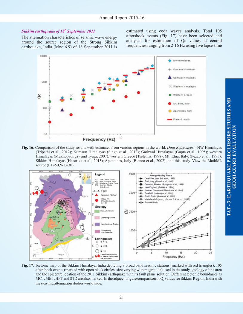
Annual Report 2015-16
21
TA
T-
3:
EA
RT
HQ
UA
KE
PR
EC
UR
SO
RS
ST
UD
IES
AN
DG
EO
HA
ZA
RD
EV
AL
UA
TIO
N
Sikkim earthquake of 18 September 2011th
The attenuation characteristics of seismic wave energyaround the source region of the Strong Sikkimearthquake, India (Mw: 6.9) of 18 September 2011 is
estimated using coda waves analysis. Total 105aftershock events (Fig. 17) have been selected andanalysed for estimation of Qc values at centralfrequencies ranging from 2-16 Hz using five lapse-time
Fig. 16: Comparison of the study results with estimates from various regions in the world. NW Himalayas(Tripathi et al., 2012); Kumaun Himalayas (Singh et al., 2012); Garhwal Himalayas (Gupta et al., 1995); westernHimalayas (Mukhopadhyay and Tyagi, 2007); western Greece (Tselentis, 1998); Mt. Etna, Italy, (Pezzo et al., 1995);Sikkim Himalayas (Hazarika et al., 2013); Apennines, Italy (Bianco et al., 2002); and this study. View the MathMLsource (LT=50,WL=30).
Data References:
Fig. 17: Tectonic map of the Sikkim Himalaya, India depicting 8 broad band seismic stations (marked with red triangles), 105aftershock events (marked with open black circles, size varying with magnitude) used in the study, geology of the areaand the epicentre location of the 2011 Sikkim earthquake with its fault plane solution. Different tectonic boundaries asMCT, MBT, HFT and STD are also marked. In the adjacent figure comparison of Q values for Sikkim Region, India with
the existing attenuation studies worldwide.c
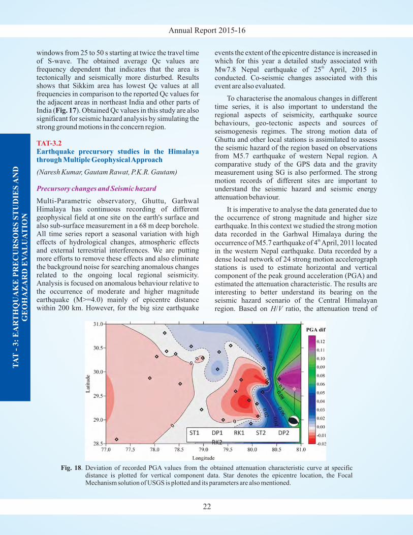
Annual Report 2015-16
22
TA
T-
3:
EA
RT
HQ
UA
KE
PR
EC
UR
SO
RS
ST
UD
IES
AN
DG
EO
HA
ZA
RD
EV
AL
UA
TIO
N
windows from 25 to 50 s starting at twice the travel timeof S-wave. The obtained average Qc values arefrequency dependent that indicates that the area istectonically and seismically more disturbed. Resultsshows that Sikkim area has lowest Qc values at allfrequencies in comparison to the reported Qc values forthe adjacent areas in northeast India and other parts ofIndia ( ). Obtained Qc values in this study are alsosignificant for seismic hazard analysis by simulating thestrong ground motions in the concern region.
Multi-Parametric observatory, Ghuttu, GarhwalHimalaya has continuous recording of differentgeophysical field at one site on the earth's surface andalso sub-surface measurement in a 68 m deep borehole.All time series report a seasonal variation with higheffects of hydrological changes, atmospheric effectsand external terrestrial interferences. We are puttingmore efforts to remove these effects and also eliminatethe background noise for searching anomalous changesrelated to the ongoing local regional seismicity.Analysis is focused on anomalous behaviour relative tothe occurrence of moderate and higher magnitudeearthquake (M>=4.0) mainly of epicentre distancewithin 200 km. However, for the big size earthquake
Fig. 17
(Naresh Kumar, Gautam Rawat, P.K.R. Gautam)
TAT-3.2Earthquake precursory studies in the Himalayathrough Multiple GeophysicalApproach
Precursory changes and Seismic hazard
events the extent of the epicentre distance is increased inwhich for this year a detailed study associated with
Mw7.8 Nepal earthquake of 25 April, 2015 isconducted. Co-seismic changes associated with thisevent are also evaluated.
To characterise the anomalous changes in differenttime series, it is also important to understand theregional aspects of seismicity, earthquake sourcebehaviours, geo-tectonic aspects and sources ofseismogenesis regimes. The strong motion data ofGhuttu and other local stations is assimilated to assessthe seismic hazard of the region based on observationsfrom M5.7 earthquake of western Nepal region. Acomparative study of the GPS data and the gravitymeasurement using SG is also performed. The strongmotion records of different sites are important tounderstand the seismic hazard and seismic energyattenuation behaviour.
It is imperative to analyse the data generated due tothe occurrence of strong magnitude and higher sizeearthquake. In this context we studied the strong motiondata recorded in the Garhwal Himalaya during the
occurrence of M5.7 earthquake of 4 April, 2011 locatedin the western Nepal earthquake. Data recorded by adense local network of 24 strong motion accelerographstations is used to estimate horizontal and verticalcomponent of the peak ground acceleration (PGA) andestimated the attenuation characteristic. The results areinteresting to better understand its bearing on theseismic hazard scenario of the Central Himalayanregion. Based on / ratio, the attenuation trend of
th
th
H V
Fig. 18. Deviation of recorded PGA values from the obtained attenuation characteristic curve at specificdistance is plotted for vertical component data. Star denotes the epicentre location, the FocalMechanism solution of USGS is plotted and its parameters are also mentioned.
Annual Report 2015-16
23
TA
T-
3:
EA
RT
HQ
UA
KE
PR
EC
UR
SO
RS
ST
UD
IES
AN
DG
EO
HA
ZA
RD
EV
AL
UA
TIO
N
strong seismic waves detected to be bimodal with onetrend for closer distance up to 100-120 km, while theother trend corresponds to regional distances. These twodifferent PGA trends have close bearing on the majortectonics and structural set-up of the region. The presentresults may improve the concept of ground motionmodel for evaluating seismic hazard evaluation for theHimalaya. The analysis highlight that the hetero-geneous region where the geological and tectonicelements are having drastic variation may causemaximum deviation in the source geometry (Fig. 18).Therefore if the strong motion effect varies dependingupon source mechanism for strong earthquakes then itmay also have consequences upon anomalous changesin different geophysical parameters.
During the year 2010, the earthquakes of magnitude M>3.5, within 150 km radius from MPGO Ghuttuoccurred in the first half period of the year (Table 1 andFig. 19). It is therefore considered best time frame toscrutinize different parameters of MPGO, which wereconsidered and reported as an earthquake precursors byresearchers worldwide. The study has its significance inunderstanding the evolution of seismogenic processes,in absence of difficulty of establishing one to onerelationship of these widely reported parameters to aparticular earthquake. Polarisation ratio and variabilityof fractal dimension considering earthquake process asSOC system. Initially, daily ULF data of local mid night
from19:00-20:00 hrs (UT) from 1 January, 2010 to 31December, 2010 is used to show the changes in first halfand second half of the year. Later to confirm thesechanges, the study extended to May 2009 to May 2011.
From the temporal variation of polarization ratio,presence of seismo-magnetic disturbances superposedupon background geomagnetic variations are inferred.Fractal dimension variability indicates that averagefractal dimension for first half of the year is increased as
st st
Seismo-Electromagnetic
compared to average fractal dimension of second half ofthe year and there is gradual increase in the fractaldimension before earthquakes. In order to see that thisfeature is not periodic, the fractal dimension variabilityis shown for a period of two years from (June 2009 toMay 2011) in figure 20.
Under-thrusting of the Indian tectonic plate beneathEurasian plate resulting gradual ongoing tectonicactivity produces a continuous stress which isresponsible for seismic hazard in the Himalaya andsurrounding regions. These seismic activities can beattributed to slip deficits where the Indian and Eurasiancontinent plates are locked during inter seismic periods.The geodetic measurements can help to discriminate thedistribution of the interlocking areas and the graduallyslipping areas beneath the Himalaya. With the objective
Crustal Deformation using GPS studies
Fig. 19: Location map of earthquakes listed in table 1.
Table 1: List of earthquakes within 150 km radius of MPGO Ghuttu observatory.
S. Date Julian Time Lat. Long. Depth Magnitude Epicentral PreparationNo. Day (UTC) (km) Distance (km) zone radius
(km)
1. 22.02.2010 53 17:23:43 30.0°N 80.1°E 02 4.7 143.29 104.952. 01.05.2010 121 22:36:25 29.9°N 80.1°E 10 4.6 148.27 95.063. 03.05.2010 123 17:15:08 30.4°N 78.4°E 08 3.5 35.65 31.994. 22.06.2010 173 23:14:08 29.6°N 79.7°E 18 4.7 138.67 104.955. 10.07.2010 191 03:16:20 29.9°N 79.6°E 10 4.1 108.33 57.94

Annual Report 2015-16
24
TA
T-
3:
EA
RT
HQ
UA
KE
PR
EC
UR
SO
RS
ST
UD
IES
AN
DG
EO
HA
ZA
RD
EV
AL
UA
TIO
N
of earthquake precursor and ongoing deformation studyin the Himalaya, we are using multi-geophysicalapproaches with GPS as one component of them. For thecontribution of GPS component in achieving the goal ofthe project and for estimating the strain pattern in the
Himalaya, we have established a network of permanentGPS stations in different parts of the Himalaya. Thecontinuous data from these stations is being acquired on1 sec and 30 sec sampling interval simultaneously.As thecrustal deformation is a main concern to the plateboundary phenomenon, it was observed by the earlierworkers that a convergence zone is taking place alongthe Himalaya. We are also working to see the effect ofTerrestrial Ground Water (TWS) on the Himalayanseismicity for which we combined the seismicity, GPSand TWS data simultaneously. The GPS velocity vectorsof NW Himalayan region obtained using local GPS dataof ~8 years (2006 to 2014) is shown in figure 21. Thestudy highlight two zones of deformation (covered byrectangles) where deformation in the Garhwal Himalayatowards southeast of the study region is more comparedto the adjoining northwest part.
The Logar Fault delineated at Logar village innorthwestern Kumaon Sub-Himalaya, verticallydisplaced the Quaternary alluvial fan and is considered
(G. Philip and N. Suresh)
TAT-3.3Active tectonics and paleoseismological studieswithin the zones of Himalayan Frontal Thrust andMain Central Thrust in Uttarakhand and HimachalHimalaya
Trench Excavation across Logar Fault
Fig. 21: The velocity field in the North-West Himalaya.
Fig. 20: (a) Fractal dimension variability during year 2010 fordays having Kp<3. (b) Variability of fractaldimension from June 2009 to May 2011. The redarrows indicate the earthquake within 150 radiusfrom MPGO Ghuttu.
Annual Report 2015-16
25
TA
T-
3:
EA
RT
HQ
UA
KE
PR
EC
UR
SO
RS
ST
UD
IES
AN
DG
EO
HA
ZA
RD
EV
AL
UA
TIO
N
to be a normal fault with minor strike slip component.The geomorphic features such as the abandoned coursesof tributaries indicate the pre-faulting scenario at Logar.A trench excavation survey was carried out at Bairasarivillage across the Logar Fault scarp for paleoseismicinvestigation. The distribution of various units in thetrench suggest deposition of sediments immediatelyafter the faulting. The samples collected from the topsurface of the south side-up scarp of the fan as well asthe bottom unit of the trench show the OSLage as ~20 kathat indicate the upper age of the fan before the faulting,and suggest rapid post faulting deposition of the units inthe trench.
The merging of Quaternary fault of the Logar megafan with the MBT is exposed at Logar Gad bridge. Thehighly jointed, sheared and fractured Tertiary rocksexposed along the Logar Fault in the river sectionconfirm the recent tectonic activity. The geomorphicsouth side up expression of the Logar Fault, which alsocoincides with the Himalayan mega thrust thereforesuggest succeeding tectonic activity along the MBT. Atthe same time the nature of faulting, the length of theQuaternary fault and shearing of the basement rockssuggests its genetic link with seismic related tectonicactivity in this region. The mappable length (~9.5 km)of the relatively a small Logar Fault indicate that it wasnot long enough to produce a great earthquake (Mw>8)and may be one of the several secondary hanging wallstructures initiated to accommodate rupture duringlarge magnitude Himalayan earthquakes. Tectonicactivity along the MBT substantiates high seismicpotential of the Sub-Himalaya and calls for moreextensive study of paleoearthquakes of this vastlypopulous mountainous region. Based on paleo-seismological investigations, large magnitude multiplepaleoearthquakes that have produced surface rupturealong the MBT strongly indicates that large magnitudeearthquakes greater than those events took place in thehistorical past is highly possible along the MBT.
The Bhauwala fault is one of the major E-W trendingfaults in the central Doon valley. The fault in theQuaternary Doon fan was identified on satellite imageby earlier workers. Based on further field work we havetraced the degraded fault scarp near Bhauwala. Tounderstand the nature of the fault and its relation withpaleoearthquake, a trench excavation survey has beencarried out across Bhauwala fault. However the trench(30x5x5 m) could not expose the fault plane sincefurther excavation was not possible due to limitations inthe availability of the land. Nevertheless the exposed
Trench Excavation across Bhauwala Fault
trench shows distinct deformation features due tofaulting. While the study is in progress, this fault in thevicinity of the MBT in northwestern Himalaya isconsidered to be the result of multiple reactivations ofthe faults after giant earthquakes.
Ground Penetrating Radar (GPR) and ElectricalResistivity Tomography (ERT) surveys were employedacross three different active fault systems in thenorthwestern frontal and Sub-Himalaya.
A 50 m GPR profile acquired along the river bedclearly differentiated two major lithological boundarycreated due to displacement at the HFT zone near KalaAmb. Electrical resistivity profiles performed with 2 mspacing show a general lateral increase of resistivityfrom north to south limited to shallow depth of around16 m. The profile obtained using Wenner configurationshowing both vertical and lateral variations inresistivity, show the north dipping low angle faults.
Geophysical surveys have also been carried outacross Bhauwala fault and Donga Fault in Doon valleyand Bharli Fault in the Trans-Yamuna segment of theNW Doon valley. The depth of GPR profiles acquiredacross fault scarp vary from 3 to 10 m depending on theantenna frequency and subsurface soil condition. With200/600 MHz dual frequency antenna, high resolutionsubsurface image with penetration depth up to 5 m wereobtained. The GPR section shows a prominent offset inall profiles especially in Bhauwala and Kala Amb atvariable depth feature. Delineation of subsurfacetectonic features using geophysical methods hascorroborated our surface observations and should helpus in integrating geological and geophysical means toestablish the active fault systems in the study areas.
Results of a paleoseismic trenching investigation on abackthrust in the northern margin of Janauri hill, atMehandpur (31°18'11.37"N, 76°18'31.47"E), Sub-Himalayan range of the Himachal Himalaya arepresented (Figs. 22 and 23). The active backthrustrevealed the last event took place after 0.8 0.03 ka ago
(R. Jayangondaperumal and Pradeep Srivastava)
±
Geophysical Surveys at HFT near Kala Amb, Doonvalley and Trans-Yamuna regions
Paleoseismic investigation in from Sub-Himalayanrange of Himachal Himalaya
TAT-3.4Timing, size, and lateral extent of earthquakeruptures along the Himalayan Frontal Thrust(TSLER-HFT)
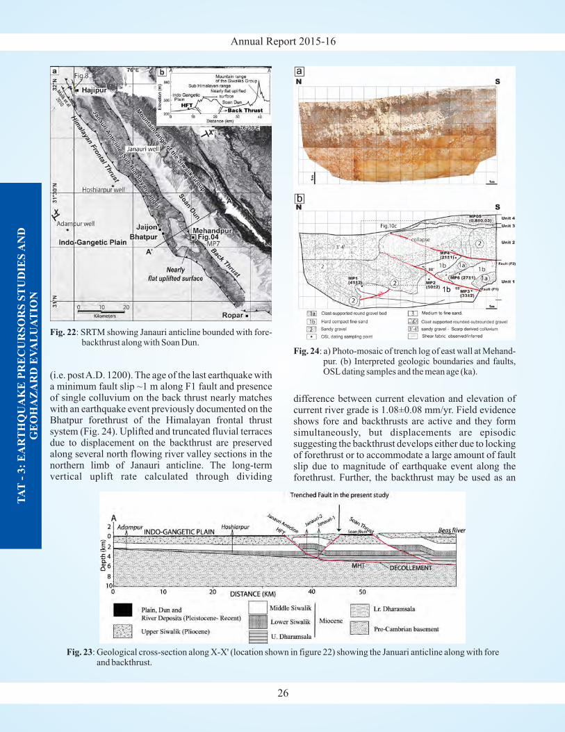
Annual Report 2015-16
26
TA
T-
3:
EA
RT
HQ
UA
KE
PR
EC
UR
SO
RS
ST
UD
IES
AN
DG
EO
HA
ZA
RD
EV
AL
UA
TIO
N
(i.e. postA.D. 1200). The age of the last earthquake witha minimum fault slip ~1 m along F1 fault and presenceof single colluvium on the back thrust nearly matcheswith an earthquake event previously documented on theBhatpur forethrust of the Himalayan frontal thrustsystem (Fig. 24). Uplifted and truncated fluvial terracesdue to displacement on the backthrust are preservedalong several north flowing river valley sections in thenorthern limb of Janauri anticline. The long-termvertical uplift rate calculated through dividing
difference between current elevation and elevation ofcurrent river grade is 1.08±0.08 mm/yr. Field evidenceshows fore and backthrusts are active and they formsimultaneously, but displacements are episodicsuggesting the backthrust develops either due to lockingof forethrust or to accommodate a large amount of faultslip due to magnitude of earthquake event along theforethrust. Further, the backthrust may be used as an
Fig. 23: Geological cross-section along X-X' (location shown in figure 22) showing the Januari anticline along with foreand backthrust.
Fig. 22: SRTM showing Janauri anticline bounded with fore-backthrust along with Soan Dun.
Fig. 24: a) Photo-mosaic of trench log of east wall at Mehand-pur. (b) Interpreted geologic boundaries and faults,OSLdating samples and the mean age (ka).
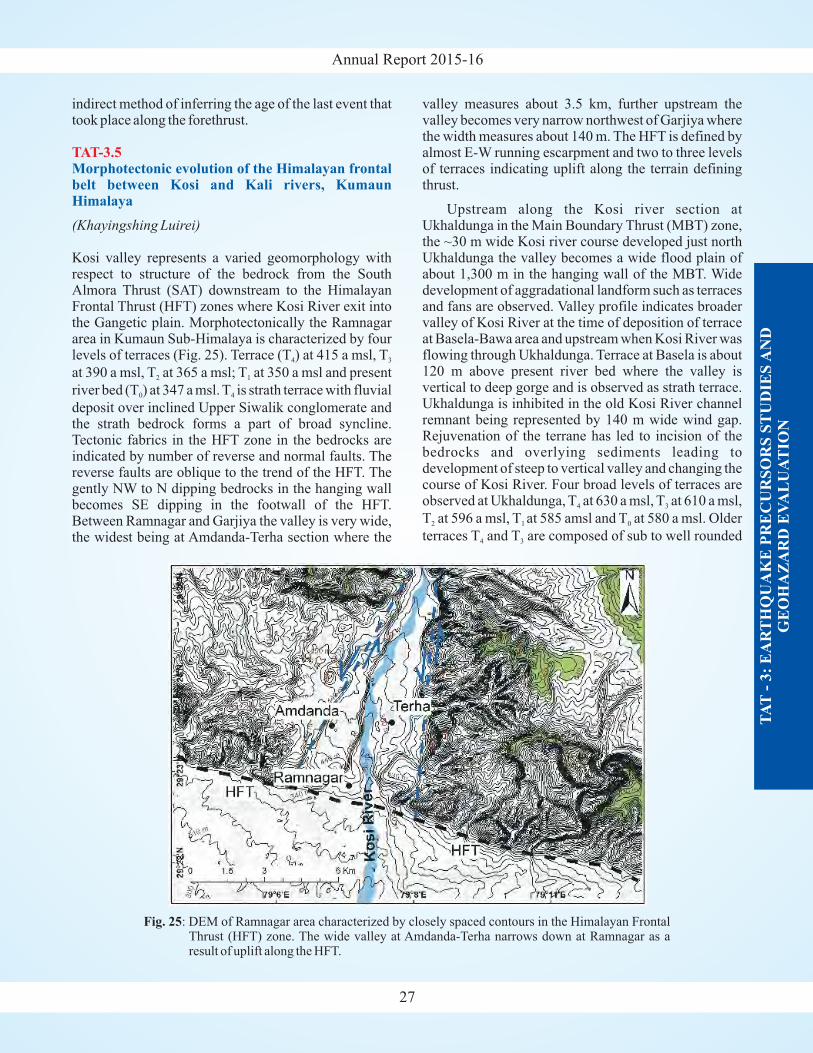
Annual Report 2015-16
27
TA
T-
3:
EA
RT
HQ
UA
KE
PR
EC
UR
SO
RS
ST
UD
IES
AN
DG
EO
HA
ZA
RD
EV
AL
UA
TIO
N
valley measures about 3.5 km, further upstream thevalley becomes very narrow northwest of Garjiya wherethe width measures about 140 m. The HFT is defined byalmost E-W running escarpment and two to three levelsof terraces indicating uplift along the terrain definingthrust.
Upstream along the Kosi river section atUkhaldunga in the Main Boundary Thrust (MBT) zone,the ~30 m wide Kosi river course developed just northUkhaldunga the valley becomes a wide flood plain ofabout 1,300 m in the hanging wall of the MBT. Widedevelopment of aggradational landform such as terracesand fans are observed. Valley profile indicates broadervalley of Kosi River at the time of deposition of terraceat Basela-Bawa area and upstream when Kosi River wasflowing through Ukhaldunga. Terrace at Basela is about120 m above present river bed where the valley isvertical to deep gorge and is observed as strath terrace.Ukhaldunga is inhibited in the old Kosi River channelremnant being represented by 140 m wide wind gap.Rejuvenation of the terrane has led to incision of thebedrocks and overlying sediments leading todevelopment of steep to vertical valley and changing thecourse of Kosi River. Four broad levels of terraces areobserved at Ukhaldunga, T at 630 a msl, T at 610 a msl,
T at 596 a msl, T at 585 amsl and T at 580 a msl. Older
terraces T and T are composed of sub to well rounded
4 3
2 1 0
4 3
indirect method of inferring the age of the last event thattook place along the forethrust.
Kosi valley represents a varied geomorphology withrespect to structure of the bedrock from the SouthAlmora Thrust (SAT) downstream to the HimalayanFrontal Thrust (HFT) zones where Kosi River exit intothe Gangetic plain. Morphotectonically the Ramnagararea in Kumaun Sub-Himalaya is characterized by fourlevels of terraces (Fig. 25). Terrace (T ) at 415 a msl, T
at 390 a msl, T at 365 a msl; T at 350 a msl and present
river bed (T ) at 347 a msl. T is strath terrace with fluvial
deposit over inclined Upper Siwalik conglomerate andthe strath bedrock forms a part of broad syncline.Tectonic fabrics in the HFT zone in the bedrocks areindicated by number of reverse and normal faults. Thereverse faults are oblique to the trend of the HFT. Thegently NW to N dipping bedrocks in the hanging wallbecomes SE dipping in the footwall of the HFT.Between Ramnagar and Garjiya the valley is very wide,the widest being at Amdanda-Terha section where the
(Khayingshing Luirei)
4 3
2 1
0 4
TAT-3.5Morphotectonic evolution of the Himalayan frontalbelt between Kosi and Kali rivers, KumaunHimalaya
Fig. 25: DEM of Ramnagar area characterized by closely spaced contours in the Himalayan FrontalThrust (HFT) zone. The wide valley at Amdanda-Terha narrows down at Ramnagar as aresult of uplift along the HFT.
Annual Report 2015-16
TA
T-
3:
EA
RT
HQ
UA
KE
PR
EC
UR
SO
RS
ST
UD
IES
AN
DG
EO
HA
ZA
RD
EV
AL
UA
TIO
N
28
pebbles and boulders of riverine and angular rockfragments of landslide and slope generated. T is a strath
terrace (the bed rock is composed of phyllite) and isoverlain by 2 to 3 m thick fluvial deposit showingstratification. The youngest terrace is made up mainly ofmedium grained sand. The MBT zone is defined bydepression or trough in Amgari-Parewa section; thedepressions are observed where black shales of LowerSiwalik form the top portion of the footwall. InUkhaldunga-Dabara the hanging wall of the MBT zoneis characterized by huge fan deposit. The fan depositexposed Gaunchhil Gadhera shows gently (1-2°)dipping towards the N while the lower younger terracedeposit is tilted by about 5-7° towards N.AtAmgari pre-Tertiary rocks are observed thrusting over landslidedebris along the MBT at the new road cut section. In thisarea across the MBT sudden change in slope isobserved, slope profile drawn across the MBT alsoindicate the same evidences. Similar observations arealso reported (Valdiya, 1988) from Patkot-Amgari area.Dhikala Thrust an intraformational thrust within theSiwalik is neotectonically active as indicated by upliftof the Syat surface in the Kotabagh area. The fault scarptrends NW-SE and the scarp measures about 50 m and isbest observed between Rurki and Selsiya. Streamlongitudinal profile of Kosi River from the hanging wallof the South Almora Thrust (SAT) down to the footwallof the Himalayan Frontal Thrust (HFT). Knick pointsare observed along the longitudinal profile at SAT, MBTand HFT. Stream length gradient (SL) index have highvalues at MBT and HFT. Steepness index (Ks) also hashigh values at MBT and HFT and the concavity ( )
value is 0.723.
Field work has been carried out in the Satluj valley,Yamuna valley and Mandakini valley for the extractionof field based inventory of active landslides during theyear 2015-16. The landslide inventory for the Satlujvalley has been prepared and compared with theprevious inventory for the year 1993 and 2006. It hasbeen noted that there is a radical increase in the spatialcoverage of landslides along with their frequency in the
2
Ɵ
(Vikram Gupta)
TAT-3.6Geoengineering studies and the petrophysicalcharacteristics of rocks in the selected transects ofUttarakhand and Himachal Himalaya
valley. This spatial increase in the landslides isdominantly confined, (i) along the Pawari LandslidesZone, and (ii) the area between Moorang-Pooh section.These areas were studied in details for their change ingeomorphological condition, landuse pattern,anthropogenic and environmental factors, along withthe extraction of the geotechnical characterization ofrocks and soils.
Pawari Landslide Zone (31º33'20''N; 78º16'49''E) is anold and chronic landslide and is active possibly prior to1962. The landslide zone is of strategic importance as,(i) numerous villages like Kothi, Kashmir, Khawangi,Telangi, Boktu along with Reckong Pio, the districtheadquarter of Kinnaur district, are located in the mainbody of the landslide zone, whereas Yuwarangi, Kalpa,Putka Dogri and Mewar Dogri are located in the crownportion of the landslide, and (ii) the toe portion of thelandslide passes through the National Highway (NH-05) which is a lifeline for the people living in the area.The landslide is endangering all the townships as wellthe national highway. The failure events of the landslideas recorded during 2004-2014 is depicted in thefollowing table indicating an increase in its frequency,particularly after 2009.
In order to evaluate the stability of this landslideslope and to understand its behavior in future, plainstrain Finite Element Modelling (FEM) along withShear Strength Reduction (SSR) technique has beenperformed in static as well as in pseudo-static conditions
on two slope sections using Phase (ver. 6.0) software.The sections were selected such that, the first section(located to the northern part of the landslide zone)outlines only rockmass, and in the second section(located in the central part of the landslide zone) therock mass was overlain by the debris cover. TheGeneralized Hoek-Brown (GHB) failure criterion forthe rockmass and the Mohr-Coulomb (M-C) failurecriterion for the debris were applied in the models. Theresults show that the central part of the landslide zonedevelops higher displacement than in other parts.Further displacement have been observed to beconfined in both the sections, in the toe portion of thelandslide as well in the elevation range between 2,000and 2,200 m above msl. These modelling results havewell be corroborated in the field, with the broken or
2
Pawari Landslide Zone
Years 2004 2005 2006 2007 2008 2009 2010 2011 2012 2013 2014
No. of slope 8 11 4 6 7 5 10 23 6 31 28failure events
Annual Report 2015-16
29
TA
T-
3:
EA
RT
HQ
UA
KE
PR
EC
UR
SO
RS
ST
UD
IES
AN
DG
EO
HA
ZA
RD
EV
AL
UA
TIO
N
bulged retaining walls and tilted trees. This demands anappropriate mitigation measures at the above mentionedlocations/elevation range.
The Moorang-Pooh section encompassing about 20 kmlong stretch along NH-05, in the present day climaticscenario, witnessed higher precipitation in the form ofrainfall which during previous years, had witnessed dry
Moorang-Pooh section
conditions. Thus, the slopes in this section which wereearlier dry and stable, however, with the onset of therainfall in the area, the slopes started to move. It isfurther envisaged that the slopes in the area willcontinue to slide, until the repose angle of the slopes willbe maintained. The concentrated landslides in theMoorang-Pooh section are thus mainly rain-induced,and is related mainly to the shift in the climatic pattern.

Annual Report 2015-16
TAT-4.1Geobiological study of the Neoproterozoic-earlyCambrian sequence of carbonate belt, LesserHimalaya including study of microbiota andmicrobiotic processes and their interpretation interms of palaeo-environment and correlation ofevolutionary trend with global bioevents
(Meera Tiwari and Santosh K. Rai)
Tianzhushania spinosa T. polysiphoniaPapillomembrana compta
Tianzhushania
Tianzhushania spinosa
Tianzhushania T. spinosa
Covering a time span from Ediacaran (base of pinkcarbonate of Blaini) to Early Cambrian (Tal Group), theKrol Belt in the Lesser Himalaya of India, occurs as aseries of synclines from Solan, Himachal Pradesh in thenorth-west to Nainital, Uttarakhand in the southeast.Biostratigraphic division of the belt have beenencumbered by the lack of radiometric constraints andabsence of reliable biostratigraphic markers. Variouslithostratigraphic division of this belt reveals manypalaeobiological entities namely cyanobacteria, algae,acritarchs trace fossils and sponge fossils. For the globalcorrelation of Ediacaran deposits Large Acantho-morphic Acritarchs (LAA) are used as significantbiostratigraphic tools. Recently, well-preserveda c a n t h o m o r p h i c a c r i t a r c h s i d e n t i f i e d a s
, andwere discovered from chert
nodules of Infrakrol Formation exposed in theNainital Syncline of Kumaun Lesser Himalaya. Abiostratigraphic correlation of the deposit ofDoushantuo Formation in south China and the KrolGroup suggests that the Infrakrol deposits arecorrelatable with the dominated lowerzone of Doushantuo Formation. LAA are reportedfrom Ediacaran period globally, including southChina, Australia, Eastern European Platform, Siberia,India and Svalbard. In spite of limitations caused byfacies control, taphonomic bias and taxonomicproblems, some of the well-documented and globallydistributed large acanthomorphic acritarchs are provedas potential tool for biostratigraphic subdivision andglobal correlation of Ediacaran strata, currentlyavailable evidence suggests that acanthomorphicacritarchs are most useful in lower-middle Ediacaranstratigraphic correlation. Like Yangtze Gorges area,
bearing horizon in InfrakrolFormation occurs within a few meter above the capcarbonateand justbelow Krol 'A' Formation.
and its type species arelarge acanthomorphs characterized by very thin
cylindrical processes without vesicle sculptures (Yinand Li, 1978). Van Waveren et al. (1993) suggested thatthe spiny outer wall of is comparable tothat of planktic copepod eggs thus indicating a pelagicnature of the form, whereas these structures are alsorepresented as animals resting eggs and embryos (Xiaoand Knoll, 2000; Yin et al., 2004, 2007). The thin-section examination of chert samples of InfrakrolFormation reveal the dominance of andsupport the notion that acanthomorphic acritarchs offera strong tool for regional and global correlation of theEdiacaran period. The recovered biota is a significantaddition to the record of earliest Ediacaranacanthomorphic acritarch from India.
Stratigraphic similarities and similar fossil recordnoted by previous workers (Jiang, 2014; Liu et al., 2013,2014; Shukla & Tiwari, 2014; Tiwari & Knoll, 1994;Tiwari & Pant, 2004) suggests a paleogeographicconnection between South China and India during theNeoproterozoic times. In the present study, theindependent evidence of acanthomorphic acritarchs hasbeen employed as a proxy for paleogeographicreconstructions. The report offrom Infrakrol Formation suggests that this fossiliferoushorizon is coeval with the Lower DoushantuoFormation (Member II) of South China.
The genus
also present in Doushantuo Formation of China. ZirconU-Pb ages from interbedded ash beds in DoushantuoFormation have yielded age between 635.2 0.6 Ma and
551.1 0.7 Ma (Condon et al., 2005). The Infrakrol
Formation is hence bracketed within the same agerange. The similarity in the mode of preservation alsoindicates similar palaeoenvironmental conditions thatwas suitable for the origin and early diversification ofthe metazoans just after the snowball Earth period. Theabundance of the form indicatesthat either this species was more in population or is moreresistant to degradation in comparison to other forms.The present record is very important to understand thephylogenetic diversity and evolution of earlymulticellular eukaryotes. The relationship of fossilrecord of Ediacaran and Cambrian period has to bestudied simultaneously to understand the thenprevailing favourable conditions that caused theCambrian explosion of life. The recovered Ediacaranacritarchs have proved to be potential independent
Tianzhushania
Tianzhushania
Tianzhushania spinosa
Papillomembrana compta
is
Tianzhushania spinosa
originated inthe Cryogenian Interglacial epoch with FAD older than635 18 Ma (Vidal and Moczydłowska, 1995) and±
±±
TAT - 4: BIODIVERSITY - ENVIRONMENT LINKAGE
30
TA
T-
4:
BIO
DIV
ER
SIT
Y-
EN
VIR
ON
ME
NT
LIN
KA
GE
Annual Report 2015-16
evidence for construction of both biozonation schemeand paleogeography.
The Zanskar basin constitutes the southern part of theLadakh Himalaya and geologically it represents thenorth-western extension of the Spiti basin. The Zanskarbasin comprises a sequence ranging in age fromProterozoic to Mesozoic. It provides a rich repository ofpre- and post-collision history which is preserved in thesedimentary sequences spanning in time period rangingin from Proterozoic to Eocene. The Higher Himalayancrystalline and all the sedimentary sequences arepresent in the Zanskar valley. The Tethyan sedimentarysequence were deposited in the passive continentalmargin. Zanskar basin has also preserved the Panjaltraps, the first sedimentary sequence following Permianrifting is represented by shallow water arenaceous,argillaceous and bioclastic rocks belong to KulungFormation under the progressively subsidizing passiveIndian Margin. The present studies were concentrated inthe Paleozoic succession of the Zanskar Basin the detailstudies of the succession ranging from Cambrian toPermian was carried out. The Paleozoic succession hereis litho-stratigraphically represented by Phe Formation,Karsha Formation, Kurgiakh Formation, ThapleFormation, Muth Formation and Lipak and PoFormation. The fauna was collected from the differentsections the detailed studies of the same is underprogress.
The Geochemical studies have been carried out in thesedimentary sequence of Lower Cambrian successionof Kunzum La Formation. The studies reflected that thesiliciclastic sediments are mainly enriched in clayminerals and a positive correlations of Co and Zn withAl O and K O is observed which indicates that Co and
Zn are to be the adsorbed constituents of clay minerals.The positive correlation between Ce/Ce* and Eu/Eu*suggests effect of diagenesis process on the REEconcentrations is high. The K O/Na O vs. SiO ;
SiO /Al O vs. K O/Na O plots suggests the sediments
of Lower Cambrian succession were deposited along
(S.K. Parcha)
2 3 2
2 2 2
2 2 3 2 2
TAT-4.2Bio-event stratigraphy of the Lower Paleozoicsuccessions of Himalaya in context with global eventstratigraphy
Stratigraphy of the Paleozoic succession of theZanskar region
Geochemical studies of the Lower Cambriansuccession of Kunzum La Formation
active continental margin to passive continental margin,and were derived from quartzose sedimentaryprovenance and to some extent from the felsic igneousprovenance. Chemical weathering evaluations (CIAandCIW) indicated moderate to strong weathering of sourcerock, and also reflects the change in climate towardswarm and humid conditions. The results derived fromthe Ni/Co and U/Th plot suggest well oxygenateddepositional environment and abundance of organicproductivity throughout the succession. Parcha andPandey (2011) also suggested dysaerobic to aerobicdepositional environment of Lower Cambrian on thepresence of trace fossil assemblage reported fromsiliciclastic rocks.
The Spiti Basin exposes well preserved Cambriansuccessions in the Tethys Himalaya. The present study isfocused on the trilobite assemblage reported from theMiddle Cambrian succession. The Middle Cambrian isthe most extensively fossiliferous succession in the SpitiBasin, particularly in the Parahio Valley. The trilobite inthis succession ranges from informal Stage 5 ofCambrian Series 3 and goes up to the Guzhangian Stageof Series 3. The Middle Cambrian trilobite fauna of theSpiti Basin broadly correlates with that of Chinesefauna, particularly by the presence of ,
and . Whereas, the sameforms as well as other forms are also correlated withAustralian, America and Kazakhstan for the presence of
, , and ,and with Iran for the presence of . The
is one of the key internationalstratigraphic marker species. The FAD of
(Reed) at present is considered as oneof the criteria proposed for defining the base of the (as-yet-unnamed) global Stage 5. The faunal studies revealsthat the fauna recovered from the different sections atgeneric level, is likely of cosmopolitan nature,representing deep to shallow water environmentsuggests that during the Middle Cambrian the SpitiBasin was gradually shallowing. The trilobite faunalrecords reveal that, with an exception a few species alarge part of Himalayan trilobite fauna shows affinitywith that of China,Australia and Iran.
Microbially induced sedimentary structures wereobserved in fine grained sandstone in Spiti Basin alongwith trace fossils. The presence of microbial matstructures along with trace fossils help to understand the
PagetiaKunmingaspis Oryctocephalus
Pagetia Opsidiscus Oryctocephalus PtychopariaHundwarella
Oryctocephalus indicusOrycto-
cephalus indicus
Faunal assemblages of the Cambrian succession fromthe Spiti Basin
Microbially induced sedimentary structure and tracefossils
TA
T-
4:
BIO
DIV
ER
SIT
Y-
EN
VIR
ON
ME
NT
LIN
KA
GE
31
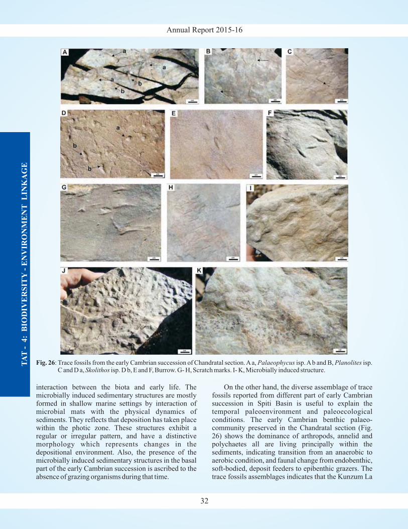
Annual Report 2015-16T
AT
- 4
:B
IOD
IVE
RS
ITY
- E
NV
IRO
NM
EN
TL
INK
AG
E
32
Fig. 26: Trace fossils from the early Cambrian succession of Chandratal section.Aa, isp.Ab and B, isp.C and D a, isp. D b, E and F, Burrow. G- H, Scratch marks. I- K, Microbially induced structure.
Palaeophycus PlanolitesSkolithos
interaction between the biota and early life. Themicrobially induced sedimentary structures are mostlyformed in shallow marine settings by interaction ofmicrobial mats with the physical dynamics ofsediments. They reflects that deposition has taken placewithin the photic zone. These structures exhibit aregular or irregular pattern, and have a distinctivemorphology which represents changes in thedepositional environment. Also, the presence of themicrobially induced sedimentary structures in the basalpart of the early Cambrian succession is ascribed to theabsence of grazing organisms during that time.
On the other hand, the diverse assemblage of tracefossils reported from different part of early Cambriansuccession in Spiti Basin is useful to explain thetemporal paleoenvironment and paleoecologicalconditions. The early Cambrian benthic palaeo-community preserved in the Chandratal section (Fig.26) shows the dominance of arthropods, annelid andpolychaetes all are living principally within thesediments, indicating transition from an anaerobic toaerobic condition, and faunal change from endobenthic,soft-bodied, deposit feeders to epibenthic grazers. Thetrace fossils assemblages indicates that the Kunzum La
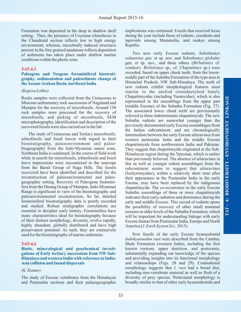
Annual Report 2015-16
Formation was deposited in the deep to shallow shelfsetting. Thus, the presence of Cruziana ichnofacies inthe Chandratal section reflects low to high energyenvironment, whereas, microbially induced structurespresent in the fine grained sandstone reflects depositionof sediments has taken place under shallow marineconditions within the photic zone.
Rocks samples were collected from the Cretaceous toMiocene sedimentary rock succession of Nagaland andManipur for the recovery of microfossils. Around 150rock samples were processed for the recovery ofmicrofossils, and picking of microfossils, SEMmicrophotography, identification and description of therecovered fossils were also carried out in the lab.
The study of Cretaceous and Tertiary microfossils,ichnofossils and fossil leaves with regard to theirbiostratigraphy, paleoenvironment and paleo-biogeography from the Indo-Myanmar suture zone,Northeast India is continued. In the course of field workwhile in search for microfossils, ichnofossils and fossilleave impressions were encountered in the outcropsfrom the Barail Group of Naga Hills. The fossilsrecovered have been identified and described for thereconstruction of paleoenvironmental and paleo-geographic setting. Recovery of Paleogene foramini-fera from the Disang Group of Manipur, Indo-MyanmarRange is significant in view of the biostratigraphy andpaleoenvironmental reconstruction. So far, detailedforaminiferal biostratigraphy data is poorly recordedand studied. Robust stratigraphic correlations areessential to decipher early history. Foraminifera havemany characteristics ideal for biostratigraphy becauseof their distinct morphology, diversity, evolve rapidly,highly abundant, globally distributed and have highpreservation potential. As such, they are extensivelyused for the biostratigraphy of marine sediments.
The study of Eocene vertebrates from the Himalayanand Peninsular sections and their palaeogeographic
(Kapesa Lokho)
(K. Kumar)
TAT-4.3
TAT-4.4
Paleogene and Neogene foraminiferal biostrati-graphy, sedimentation and paleoclimate change oftheAssam-Arakan Basin, northeast India
Biotic, mineralogical and geochemical investi-gations of Early tertiary successions from NW Sub-Himalaya and western India with reference to India-Asia collision and faunal dispersals
implications was continued. Fossils that received focusduring the year include those of rodents, creodonts andtapiroids among Mammalia, and snakes amongReptilia.
Two new early Eocene rodents,en. et sp. nov. and
gen. et sp. nov., and three others ( cf.sp., cf. sp.) were
recorded, based on upper cheek teeth, from the lower-middle part of the Subathu Formation of the type area inHimachal Pradesh, NW Sub-Himalaya. The teeth ofnew rodents exhibit morphological features mostsimilar to the unified ctenodactyloid familyChapattimyidae (including Yuomyidae), which is alsorepresented in the assemblage from the upper part(middle Eocene) of the Subathu Formation (Fig. 27).The associated lower cheek teeth are provisionallyreferred to three indeterminate chapattimyids. The newSubathu rodents are somewhat younger than thepreviously documented early Eocene assemblages fromthe Indian subcontinent, and are chronologicallyintermediate between the early Eocene ailuravines fromwestern peninsular India and the middle Eocenechapattimyids from northwestern India and Pakistan.They suggest that chapattimyids originated in the Sub-Himalayan region during the Ypresian, which is earlierthan previously believed. The absence of ailuravines inthis as well as younger rodent assemblages from thesubcontinent seems to suggest that ailuravines(Ischyromyidae), within a relatively short time aftertheir appearance in the Peninsular India in the earlyEocene, may have been replaced by the indigenouschapattimyids. The co-occurrence in the early EoceneSubathu assemblage of three or more chapattimyidsindicates their early radiation and dominance during theearly and middle Eocene. This record of rodents opensthe possibility of recovery of other small mammalremains in older levels of the Subathu Formation, whichwill be important for understanding linkage with earlyEocene faunas from Peninsular India, Europe and NorthAmerica ( 2015).
Subathumyssolanorius g Subathumys globulus
Birbalomyssondaari, Birbalomys Chapattimys
J. Earth System Sci.,
New fossils of the early Eocene hyaenodontidwere described from the Cambay
Shale Formation (western India), including the firstknown rostrum, upper dentition, and postcrania,substantially expanding our knowledge of the speciesand providing insights into its functional morphologyand relationships (Figs. 28 and 29). Craniodentalmorphology suggests that had a broad diet,including non-vertebrate material as well as flesh of adiversity of prey species. Postcranial morphology isbroadly similar to that of other early hyaenodontids and
Indohyaenodon raoi
I. raoi
TA
T-
4:
BIO
DIV
ER
SIT
Y-
EN
VIR
ON
ME
NT
LIN
KA
GE
33
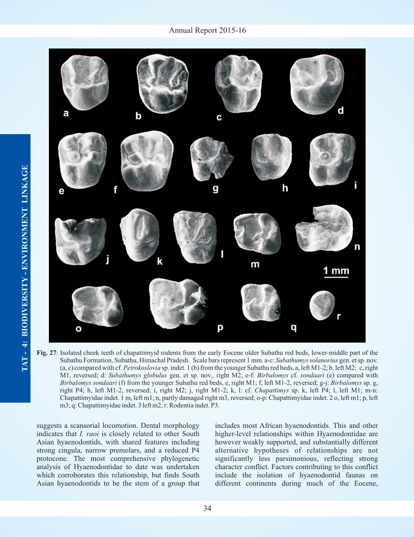
Annual Report 2015-16T
AT
- 4
:B
IOD
IVE
RS
ITY
- E
NV
IRO
NM
EN
TL
INK
AG
E
34
Fig. 27: Isolated cheek teeth of chapattimyid rodents from the early Eocene older Subathu red beds, lower-middle part of theSubathu Formation, Subathu, Himachal Pradesh. Scale bars represent 1 mm. a-c: gen. et sp. nov.(a, c) compared with cf. sp. indet. 1 (b) from the younger Subathu red beds, a, left M1-2; b, left M2; c, rightM1, reversed; d: gen. et sp. nov., right M2; e-f: cf. (e) compared with
(f) from the younger Subathu red beds, e, right M1; f, left M1-2, reversed; g-j: sp. g,right P4; h, left M1-2, reversed; i, right M2; j, right M1-2; k, l: cf. sp. k, left P4; l, left M1; m-n:Chapattimyidae indet. 1 m, left m1; n, partly damaged right m3, reversed; o-p: Chapattimyidae indet. 2 o, left m1; p, leftm3; q: Chapattimyidae indet. 3 left m2; r: Rodentia indet. P3.
Subathumys solanoriusPetrokoslovia
Subathumys globulus Birbalomys sondaariBirbalomys sondaari Birbalomys
Chapattimys
suggests a scansorial locomotion. Dental morphologyindicates that is closely related to other SouthAsian hyaenodontids, with shared features includingstrong cingula, narrow premolars, and a reduced P4protocone. The most comprehensive phylogeneticanalysis of Hyaenodontidae to date was undertakenwhich corroborates this relationship, but finds SouthAsian hyaenodontids to be the stem of a group that
I. raoiincludes most African hyaenodontids. This and otherhigher-level relationships within Hyaenodontidae arehowever weakly supported, and substantially differentalternative hypotheses of relationships are notsignificantly less parsimonious, reflecting strongcharacter conflict. Factors contributing to this conflictinclude the isolation of hyaenodontid faunas ondifferent continents during much of the Eocene,
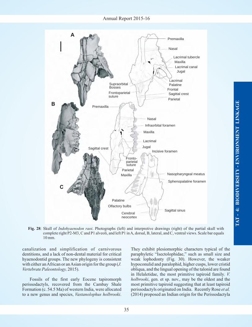
Annual Report 2015-16
TA
T-
4:
BIO
DIV
ER
SIT
Y-
EN
VIR
ON
ME
NT
LIN
KA
GE
35
canalization and simplification of carnivorousdentitions, and a lack of non-dental material for criticalhyaenodontid groups. The new phylogeny is consistentwith either anAfrican or anAsian origin for the group (
2015).J.
Vertebrate Paleontology,
Fossils of the first early Eocene tapiromorphperissodactyls, recovered from the Cambay ShaleFormation (c. 54.5 Ma) of western India, were allocatedto a new genus and species, .Vastanolophus holbrooki
They exhibit plesiomorphic characters typical of theparaphyletic “Isectolophidae,” such as small size andweak lophodonty (Fig. 30). However, the weakerhypoconulid and paralophid, higher cusps, lower cristidobliqua, and the lingual opening of the talonid are foundin Helaletidae, the most primitive tapiroid family.
, gen. et sp. nov., may be the oldest and themost primitive tapiroid suggesting that at least tapiroidperissodactyls originated on India. Recently Rose(2014) proposed an Indian origin for the Perissodactyla
V.holbrooki
et al.
Fig. 28: Skull of . Photographs (left) and interpretive drawings (right) of the partial skull withcomplete right P2-M3, C and P1 alveoli, and left P1 inA, dorsal, B, lateral, and C, ventral views. Scale bar equals10 mm.
Indohyaenodon raoi
Premaxilla
Nasopharyngeal meatus
Sphenopalatine foramen
Sagittal sinusCerebralneocortex
Olfactory bulbs
Palatine
A
B
C
Nasal
Lacrimal tubercle
Maxilla
Lacrimal canal
Jugal
Lacrimal
Palatine
Frontal
Sagittal crest
Parietal
Premaxilla
Frontoparietal
Supraorbital
Nasal
Infraorbital foramen
Lacrimal
Incisive foramen
JugalSagittal crest
Fronto-
Parietal
parietalsuture
Maxilla
Bosses
suture
Maxilla
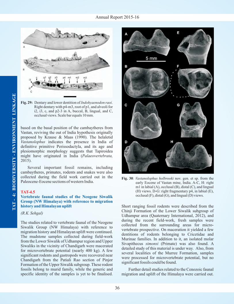
Annual Report 2015-16
based on the basal position of the cambaytheres fromVastan, reviving the out of India hypothesis originallyproposed by Krause & Maas (1990). The helaletid
indicates the presence in India ofdefinitive primitive Perissodactyla, and its age andplesiomorphic morphology suggests that Tapiroideamight have originated in India (2015).
Several important fossil remains, includingcambaytheres, primates, rodents and snakes were alsocollected during the field work carried out in thePaleocene-Eocene sections of western India.
The studies related to vertebrate faunal of the NeogeneSiwalik Group (NW Himalaya) with reference tomigration history and Himalayan uplift were continued.The mudstone samples collected during field-workfrom the Lower Siwalik of Udhampur region and UpperSiwaliks in the vicinity of Chandigarh were maceratedfor microvertebrate potential (nearly 400 kg). A fewsignificant rodents and gastropods were recovered nearChandigarh from the Patiali Rao section of PinjorFormation of the Upper Siwalik subgroup. These rodentfossils belong to murid family, while the generic andspecific identity of the samples is yet to be finalised.
Vastanolophus
Palaeovertebrata,
(R.K. Sehgal)
TAT-4.5Vertebrate faunal studies of the Neogene SiwalikGroup (NW Himalaya) with reference to migrationhistory and Himalayan uplift Short ranging fossil rodents were described from the
Chinji Formation of the Lower Siwalik subgroup ofUdhampur area (Quaternary International, 2012), andduring the recent field-work, fresh samples werecollected from the surrounding areas for micro-vertebrate prospective. On maceration it yielded a fewdentitions of rodents belonging to Cricetidae andMurinae families. In addition to it, an isolated molarSivapithecus (Primate) was also found. Adetailed study of this material is under way. Also, fromseveral localities of the Murree Formation, sampleswere processed for microvertebrate potential, but nosignificant fossils could be found.
Further detail studies related to the Cenozoic faunalmigration and uplift of the Himalaya were carried out.
simonsi
TA
T-
4:
BIO
DIV
ER
SIT
Y-
EN
VIR
ON
ME
NT
LIN
KA
GE
36
Fig. 30: nov. gen. et sp. from theearly Eocene of Vastan mine, India. A-C, H: rightm1 in labial (A), occlusal (B), distal (C), and lingual(H) views. D-G: right fragmentary p4, in labial (E),occlusal (F), distal (G), and lingual (D) views.
Vastanolophus holbrooki
Fig. 29: Dentary and lower dentition of .Right dentary with p4-m3, root of p1, and alveoli fori2, i3, c, and p2-3 in A, buccal, B, lingual, and C,occlusal views. Scale bar equals 10 mm.
Indohyaenodon raoi
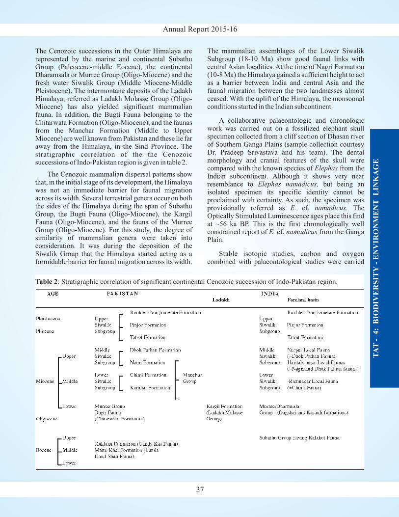
Annual Report 2015-16
The Cenozoic successions in the Outer Himalaya arerepresented by the marine and continental SubathuGroup (Paleocene-middle Eocene), the continentalDharamsala or Murree Group (Oligo-Miocene) and thefresh water Siwalik Group (Middle Miocene-MiddlePleistocene). The intermontane deposits of the LadakhHimalaya, referred as Ladakh Molasse Group (Oligo-Miocene) has also yielded significant mammalianfauna. In addition, the Bugti Fauna belonging to theChitarwata Formation (Oligo-Miocene), and the faunasfrom the Manchar Formation (Middle to UpperMiocene) are well known from Pakistan and these lie faraway from the Himalaya, in the Sind Province. Thestratigraphic correlation of the the Cenozoicsuccessions of Indo-Pakistan region is given in table 2.
The Cenozoic mammalian dispersal patterns showthat, in the initial stage of its development, the Himalayawas not an immediate barrier for faunal migrationacross its width. Several terrestrial genera occur on boththe sides of the Himalaya during the span of SubathuGroup, the Bugti Fauna (Oligo-Miocene), the KargilFauna (Oligo-Miocene), and the fauna of the MurreeGroup (Oligo-Miocene). For this study, the degree ofsimilarity of mammalian genera were taken intoconsideration. It was during the deposition of theSiwalik Group that the Himalaya started acting as aformidable barrier for faunal migration across its width.
The mammalian assemblages of the Lower SiwalikSubgroup (18-10 Ma) show good faunal links withcentral Asian localities. At the time of Nagri Formation(10-8 Ma) the Himalaya gained a sufficient height to actas a barrier between India and central Asia and thefaunal migration between the two landmasses almostceased. With the uplift of the Himalaya, the monsoonalconditions started in the Indian subcontinent.
A collaborative palaeontologic and chronologicwork was carried out on a fossilized elephant skullspecimen collected from a cliff section of Dhasan riverof Southern Ganga Plains (sample collection courtesyDr. Pradeep Srivastava and his team). The dentalmorphology and cranial features of the skull werecompared with the known species of from theIndian subcontinent. Although it shows very nearresemblance to but being anisolated specimen its specific identity cannot beproclaimed with certainty. As such, the specimen wasprovisionally referred as cf. . TheOptically Stimulated Luminescence ages place this findat ~56 ka BP. This is the first chronologically wellconstrained report of cf. from the GangaPlain.
Stable isotopic studies, carbon and oxygencombined with palaeontological studies were carried
Elephas
Elephas namadicus,
E. namadicus
E. namadicus
TA
T-
4:
BIO
DIV
ER
SIT
Y-
EN
VIR
ON
ME
NT
LIN
KA
GE
37
Table 2: Stratigraphic correlation of significant continental Cenozoic succession of Indo-Pakistan region.
Annual Report 2015-16T
AT
- 4
:B
IOD
IVE
RS
ITY
- E
NV
IRO
NM
EN
TL
INK
AG
E
out for the first time from a
C values from both pedogenic
part of the fossiliferousPinjor Formation exposed near village Nadah,Panchkula (Haryana). The analysis were done onpedogenic nodule (soil carbonate) and fossilized
gastropod shells. δ13
nodules and gastropod shells clearly indicate thedominance of C vegetation in the area at that time,
while O values, in general, suggest the persistence ofwarm and humid climate conditions.
4
δ18
38
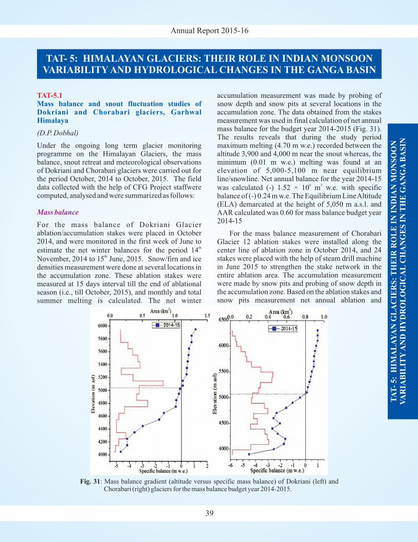
Annual Report 2015-16
39
TAT-5.1Mass balance and snout fluctuation studies ofDokriani and Chorabari glaciers, GarhwalHimalaya
(D.P. Dobhal)
Under the ongoing long term glacier monitoringprogramme on the Himalayan Glaciers, the massbalance, snout retreat and meteorological observationsof Dokriani and Chorabari glaciers were carried out forthe period October, 2014 to October, 2015. The fielddata collected with the help of CFG Project staffwerecomputed, analysed and were summarized as follows:
For the mass balance of Dokriani Glacierablation/accumulation stakes were placed in October2014, and were monitored in the first week of June to
estimate the net winter balances for the period 14
November, 2014 to 15 June, 2015. Snow/firn and icedensities measurement were done at several locations inthe accumulation zone. These ablation stakes weremeasured at 15 days interval till the end of ablationalseason (i.e., till October, 2015), and monthly and totalsummer melting is calculated. The net winter
th
th
Mass balance
accumulation measurement was made by probing ofsnow depth and snow pits at several locations in theaccumulation zone. The data obtained from the stakesmeasurement was used in final calculation of net annualmass balance for the budget year 2014-2015 (Fig. 31).The results reveals that during the study periodmaximum melting (4.70 m w.e.) recorded between thealtitude 3,900 and 4,000 m near the snout whereas, theminimum (0.01 m w.e.) melting was found at anelevation of 5,000-5,100 m near equilibriumline/snowline. Net annual balance for the year 2014-15
was calculated (-) 1.52 × 10 m w.e. with specificbalance of (-) 0.24 m w.e. The Equilibrium LineAltitude(ELA) demarcated at the height of 5,050 m a.s.l. andAAR calculated was 0.60 for mass balance budget year2014-15
For the mass balance measurement of ChorabariGlacier 12 ablation stakes were installed along thecenter line of ablation zone in October 2014, and 24stakes were placed with the help of steam drill machinein June 2015 to strengthen the stake network in theentire ablation area. The accumulation measurementwere made by snow pits and probing of snow depth inthe accumulation zone. Based on the ablation stakes andsnow pits measurement net annual ablation and
6 3
TAT- 5: HIMALAYAN GLACIERS: THEIR ROLE IN INDIAN MONSOONVARIABILITY AND HYDROLOGICAL CHANGES IN THE GANGA BASIN
TA
T-
5:
HIM
AL
AY
AN
GL
AC
IER
S:
TH
EIR
RO
LE
IN
IN
DIA
N M
ON
SO
ON
VA
RIA
BIL
ITY
AN
D H
YD
RO
LO
GIC
AL
CH
AN
GE
S I
NT
HE
GA
NG
AB
AS
IN
Fig. 31: Mass balance gradient (altitude versus specific mass balance) of Dokriani (left) andChorabari (right) glaciers for the mass balance budget year 2014-2015.
Annual Report 2015-16
TA
T-
5:
HIM
AL
AY
AN
GL
AC
IER
S:
TH
EIR
RO
LE
IN
IN
DIA
N M
ON
SO
ON
VA
RIA
BIL
ITY
AN
D H
YD
RO
LO
GIC
AL
CH
AN
GE
S I
NT
HE
GA
NG
AB
AS
IN
40
accumulation is calculated (Fig. 31). The results showsa negative mass balance with specific balanceamounting (-) 0.63 m w.e. The equilibrium line (ELA)was delineated at an elevation of 5,030 m and AARcalculated was 0.45 for the budget year 2014-15 (Table3).
The study reveals that both the glaciers possessingnegative mass balance trend but amount of net mass lossduring the period is less compared to the previous years.It is also observed that overall melting recorded wascomparatively less to the previous years owing to thehigher winter accumulation that delayed the earlyexpose of glacier surface. Moreover, summer monsoonwas quite prominent that increases the accumulation inthe higher altitude of glacier areas.
The snout of Dokriani glacier was monitored by GPSwith reference to permanent survey point made on boththe sides of the glacier front. The total frontal retreatdetermined was 17 m for the year 2014-15 (from Oct2014 to Oct 2015) which is comparatively less thanprevious years (21 m). The study reveals that the snoutof Dokriani glacier is continuously retreating withvarying rates. The progressive retreat of glacier snoutindicates that it has undergone marked change in theshape and position due to the debris entrainments. Thesnout of the Dokriani glacier is deep and narrowbounded by huge and vertical lateral moraines.
Snout Recession
Because of the unconsolidated sediments and fragilenature, they are always susceptible to debris flows inthe valley. The observed retreat rates varying annualcould be attributed to the sudden debris flow from thelateral moraines, which badly damaged frontal area ofthe glacier or accumulate a huge amount of debris inand around the glacier termini, results enhance or retardthe process of snout retreat. Such processes have alsobeen reported in other glaciers of the Himalaya. Thesnout recession of Chorabari glacier have not beenmonitored owing to loss of stable reference points andalso risky to approach after the lake outburst flood inthe area.
The glacial ELA is the position of the glacier wheremass accumulation is equal to mass loss. It is verysensitive to climate so that it could be used as a climateproxy to reconstruct the balance of glacier whether itwas positive or negative. It measures directly theclimate sensitivity in comparison to other glacialproperties such as length, area, loss of volume and haveless erroneous. An attempt is made to evaluate/reconstruct the mass balance trend of Dokriani glacierusing ELA and Accumulation Area Ratio (AAR). Thestudy is based on assumption that accumulation area ofthe glacier is of fixed proportion and takes the massbalance gradient into account. The AAR is estimatedwith Terminus to Head Wall Ratio (THAR) method,
Reconstruction of Equilibrium Line Altitude (ELA)and paleo-temperature reconstruction
Table 3: Summary of Mass balance and snout retreat of monitoring glaciers during the budget year, 2014-2015.
Glacier Net Balance Specific Mass Balance ELA AAR Snout Retreat Snout Position
(10 m w.e.) (m w.e.) (m asl) (m) (m asl)6 3
Dokriani -1.52 -0.24 5,050 0.60 17 3,955Chorabari -4.15 -0.63 5,030 0.45 - -
Table 4: Reconstruction of ELAusingAAR, THAR and associated temperature decline.
Stage Termi Head distance AAR AAR THAR THAR THAR AVER AVER MEAN std ELA TEMPnus (m asl) from (0.56) (0.72) (0.4) (0.5) (0.6) AGE AGE (m asl) (m) DEC-
(m asl) Snout AAR THAR LINE(km) (°C)
Δ
Stage I 2831 6400 8.3 4120 3760 4259 4616 4972 3940 4616 4278 478 210 0.96Stage II 3200 6400 4.5 4370 3980 4480 4800 5120 4175 4800 4488 442 224 1.03Stage III 3445 6400 1.7 4700 4300 4627 4923 5218 4500 4923 4711 299 150 0.69Stage IV 3646 6400 1.6 4520 4880 4748 5023 5298 4700 5023 4862 228 124 0.57Stage V 3733 6400 1.5 4790 5020 4800 5067 5333 4905 5067 4986 114 114 0.53
Present 4000 6400 0 4920
day
5080 4960 5200 5440 5000 5200 5100 141 N/A N/A
Annual Report 2015-16
TA
T-
5:
HIM
AL
AY
AN
GL
AC
IER
S:
TH
EIR
RO
LE
IN
IN
DIA
N M
ON
SO
ON
VA
RIA
BIL
ITY
AN
D H
YD
RO
LO
GIC
AL
CH
AN
GE
S I
NT
HE
GA
NG
AB
AS
IN
41
which assumes that the glacier can be approximated bysome constant ratio between the altitude of terminus andhead of glacier. The ELA and AAR were measured toeach of the glacial stages, identified and mapped in theglacial regime. Further, the terminus position, head ofthe wall and distance from the present snout positionwere measured for individual stage and AAR wascalculated by different methods. Reconstructed ELAwith the apparent temperature reconstruction, derivedthrough lapse rate of Dokriani glacier and associatedloss in volume for each glacial stage is given in the table4. The AAR of 0.56 and 0.72 has been applied for ELAreconstruction and THAR values of 0.5 and 0.6 has beenused for error reduction, and the reconstructions hasbeen checked for present day glacier. The studies of thereconstruction of mass balance trend of DokrianiGlacier and also ice mass lost from Stage I to presentday are still being continued.
The Gangotri catchment is highly glaciarised region asthe winter snow-line descends down to about 2,200 masl. Between 2,200 and 4,000 m the valley is composedof loose unconsolidated glacier material and is thesource of several hazards like rock-fall, debris flow andflood, particularly during the summer period when thesnow/ice melting is at its peak coupled with monsoonrains. Similarly, above 4,000 m asl (the present snout ofthe glacier) the area is highly snow covered with ~10-15 % permanent snow/ice cover and with number ofglacial lakes developed in the valley. In order to assessthe various hazards, inventory of avalanches and theirpath along with various mass movement activities havebeen prepared.
Geohydrological studies undertaken around TehriReservoir reveals that groundwater mainly occurs indisconnected bodies of aquifer and is available throughsecondary porosity and permeability of the rockformations. Three hydrogeological units may berecognized in the study area, (i) Fractured hard rocks,(ii) Fluvial and Colluvial deposits, and (iii) KarstAquifer.
(Vikram Gupta, D.P. Dobhal and Swapnamita C.Vaideswaran)
(S.K. Bartarya and S.K. Rai)
TAT-5.2
TAT-5.3
Assessment of potential hazards in the Glaciatedregions: its causes and consequences
Hydrogeology of Himalayan springs
The fracture-joints and lineaments serve as easyconduits for infiltrating water and its further movement.The major recharge events for the aquifers in the regionare the monsoon rains. For most of the springs, thedischarge increases with the onset of the monsoonshowers and declines in the post-monsoon season. Inthe study area, three types of springs are dominant
Fracture joint related springsColluvial springs and seepagesContact springs
Twenty one springs were chosen for the detailedstudy. Old landslide deposits being porous andpermeable hold good quantity of water proving to be agood localized aquifer. The hydrographs of the springsshow a periodic rhythm with the rainfall pattern. Thespring discharge is generally high in the monsoonmonths, thereby attaining a peak value. Few springsshow a good discharge in the pre-monsoon months, inspite of very less rainfall indicating the high storagenature of the underlying formation. On comparing theaverage annual discharge of the springs, it is found thatthe fracture joint related springs yield more water(average 17 LPM) in comparison to the colluvial type ofsprings (average 10 LPM). The average discharge of thefracture joint related spring vary between 13.8 LPM to20.51 LPM while the colluvial spring discharge varywith a minimum of 1.9 LPM to maximum of 18.6 LPM.
A groundwater prospecting map prepared showwhich four potential zones, (i) high, (ii) moderate, (iii)low, and (iv) very low zones. The high potential zonecovers nearly 1.7% area in the Bhagirathi andBhilangana valley. This zone is characterized by thepresence of fluvial terraces which exists generallyadjacent to the reservoir rim. The possibility ofoccurrence of groundwater in this zone is about 70-120LPM. The moderate potential zone comprise of twogeomorphic units which are alluvial fans and colluvialdeposit covering an area of 0.3 and 3% of arearespectively. The alluvial fans have the possibility ofoccurrence of groundwater of about 50-70 LPM whilethe expected discharge of colluvial deposits is about 20-50 LPM. The low potential zone is formed by theresidual hills which covers the maximum portion in thestudy area (87%). The recharge conditions in this zoneare low and the expected possibility of groundwater isabout 5-20 LPM. The fourth prospect zone is the verylow potential zone, and is characterized by thegeomorphic unit denudational hills. It covers 8.0 % ofthe study area, and is distributed in small pockets overthe entire study area. The water prospect of this zone isvery low about 5-10 LPM, and therefore it is not suitedfor groundwater exploration.
:
�
�
�
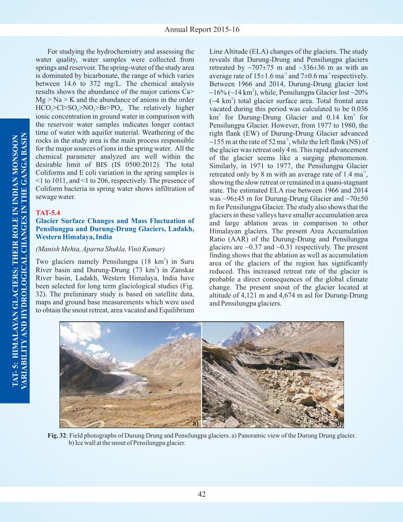
Annual Report 2015-16
TA
T-
5:
HIM
AL
AY
AN
GL
AC
IER
S:
TH
EIR
RO
LE
IN
IN
DIA
N M
ON
SO
ON
VA
RIA
BIL
ITY
AN
D H
YD
RO
LO
GIC
AL
CH
AN
GE
S I
NT
HE
GA
NG
AB
AS
IN
42
For studying the hydrochemistry and assessing thewater quality, water samples were collected fromsprings and reservoir. The spring-water of the study areais dominated by bicarbonate, the range of which variesbetween 14.6 to 372 mg/L. The chemical analysisresults shows the abundance of the major cations Ca>Mg > Na > K and the abundance of anions in the orderHCO >Cl>SO >NO >Br>PO . The relatively higher
ionic concentration in ground water in comparison withthe reservoir water samples indicates longer contacttime of water with aquifer material. Weathering of therocks in the study area is the main process responsiblefor the major sources of ions in the spring water. All thechemical parameter analyzed are well within thedesirable limit of BIS (IS 0500:2012). The totalColiforms and E coli variation in the spring samples is<1 to 1011, and <1 to 206, respectively. The presence ofColiform bacteria in spring water shows infiltration ofsewage water.
Two glaciers namely Pensilungpa (18 km ) in Suru
River basin and Durung-Drung (73 km ) in ZanskarRiver basin, Ladakh, Western Himalaya, India havebeen selected for long term glaciological studies (Fig.32). The preliminary study is based on satellite data,maps and ground base measurements which were usedto obtain the snout retreat, area vacated and Equilibrium
3 4 3 4
(Manish Mehta, Aparna Shukla, Vinit Kumar)
2
2
TAT-5.4Glacier Surface Changes and Mass Fluctuation ofPensilungpa and Durung-Drung Glaciers, Ladakh,Western Himalaya, India
Line Altitude (ELA) changes of the glaciers. The studyreveals that Durung-Drung and Pensilungpa glaciersretreated by ~707±75 m and ~336±36 m as with an
average rate of 15±1.6 ma and 7±0.6 ma respectively.Between 1966 and 2014, Durung-Drung glacier lost
~16% (~14 km ), while, Pensilungpa Glacier lost ~20%
(~4 km ) total glacier surface area. Total frontal areavacated during this period was calculated to be 0.036
km for Durung-Drung Glacier and 0.14 km forPensilungpa Glacier. However, from 1977 to 1980, theright flank (EW) of Durung-Drung Glacier advanced
~155 m at the rate of 52 ma , while the left flank (NS) ofthe glacier was retreat only 4 m. This rapid advancementof the glacier seems like a surging phenomenon.Similarly, in 1971 to 1977, the Pensilungpa Glacier
retreated only by 8 m with an average rate of 1.4 ma ,showing the slow retreat or remained in a quasi-stagnantstate. The estimated ELA rise between 1966 and 2014was ~96 45 m for Durung-Drung Glacier and ~70 50
m for Pensilungpa Glacier. The study also shows that theglaciers in these valleys have smaller accumulation areaand large ablation areas in comparison to otherHimalayan glaciers. The present Area AccumulationRatio (AAR) of the Durung-Drung and Pensilungpaglaciers are ~0.37 and ~0.31 respectively. The presentfinding shows that the ablation as well as accumulationarea of the glaciers of the region has significantlyreduced. This increased retreat rate of the glacier isprobable a direct consequences of the global climatechange. The present snout of the glacier located ataltitude of 4,121 m and 4,674 m asl for Durung-Drungand Pensilungpa glaciers.
-1 -1
2
2
2 2
-1
-1
± ±
Fig. 32: Field photographs of Durung Drung and Pensilungpa glaciers. a) Panoramic view of the Durung Drung glacier.b) Ice wall at the snout of Pensilungpa glacier.
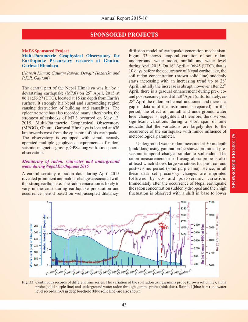
Annual Report 2015-16
MoES Sponsored ProjectMulti-Parametric Geophysical Observatory forEarthquake Precursory research at Ghuttu,Garhwal Himalaya
()
The central part of the Nepal Himalaya was hit by a
devastating earthquake (M7.8) on 25 April, 2015 at06:11:26.27 (UTC), located at 15 km depth from Earth'ssurface. It strongly hit Nepal and surrounding regioncausing destruction of building and causalities. Theepicentre zone has also recorded many aftershocks, thestrongest aftershocks of M7.3 occurred on May 12,2015. Multi-Parametric Geophysical Observatory(MPGO), Ghuttu, Garhwal Himalaya is located at 636km towards west from the epicentre of this earthquake.The observatory is equipped with simultaneouslyoperated multiple geophysical equipments of radon,seismic, magnetic, gravity, GPS along with atmosphericobservation.
A careful scrutiny of radon data during April 2015revealed prominent anomalous changes associated withthis strong earthquake. The radon emanation is likely tovary in the crust during earthquake preparation andoccurrence period based on well-accepted dilatancy-
Naresh Kumar, Gautam Rawat, Devajit Hazarika andP.K.R. Gautam
th
Monitoring of radon, rainwater and undergroundwater during Nepal Earthquake 2015
diffusion model of earthquake generation mechanism.Figure 33 shows temporal variation of soil radon,underground water radon, rainfall and water level
during April 2015. On 16 April at 06:45 (UTC), that is10 days before the occurrence of Nepal earthquake, thesoil radon concentration (brown solid line) suddenly
starts increasing with an increasing trend up to 28
April. Initially the increase is abrupt, however after 22April, there is a gradual enhancement during pre-, co-
and post-seismic period till 28 April (unfortunately, on
28 April the radon probe malfunctioned and there is agap of data until the instrument is repaired). In thisperiod, the effect of rainfall and underground waterlevel changes is negligible and therefore, the observedsignificant variations during a short span of timeindicate that the variations are largely due to theoccurrence of the earthquake with minor influence ofmeteorological parameter.
Underground water radon measured at 50 m depth(pink dots) using gamma probe shows prominent pre-seismic temporal changes similar to soil radon. Theradon measurement in soil using alpha probe is alsoutilised which shows large variations for pre-, co- andpost-seismic period (solid purple line). Hence, in allthese data set precursory changes are imprintedfollowed by co- and post-seismic variation.Immediately after the occurrence of Nepal earthquakethe radon concentration suddenly dropped and then highfluctuation is observed with a shift in base to lower
th
th
nd
th
th
SPONSORED PROJECTS
43
SP
ON
SO
RE
D P
RO
JE
CT
S
Fig. 33: Continuous records of different time series. The variation of the soil radon using gamma probe (brown solid line), alphaprobe (solid purple line) and underground water radon through gamma probe (pink dots). Rainfall (blue bars) and waterlevel records in 68 m deep borehole (blue solid line) are also shown.
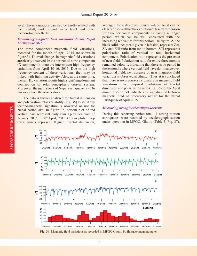
Annual Report 2015-16S
PO
NS
OR
ED
PR
OJE
CT
S
44
level. These variations can also be hardly related withthe rainfall, underground water level and othermeteorological effects.
The three component magnetic field variations,recorded for the month of April 2015 are shown infigure 34. Diurnal changes in magnetic field variationsare clearly observed. In the horizontal north component(X-component), there are intermittent high frequencyvariations from April 10-16, 2015. Due to the highfrequency content of these variations, they may belinked with lightning activity. Also, at the same time,the sum Kp variation is quite high, signifying dominantcontribution of solar ionospheric current system.Moreover, the main shock of Nepal earthquake is ~636km away from the observatory.
The data is further analysed for fractal dimensionand polarization ratio variability (Fig. 35) to see if anytectono-magnetic signature is observed or not forNepal earthquake. In figure 35, bottom plot of red
vertical bars represent daily sum Kp values from 1
January, 2015 to 30 April, 2015. Colour plots in topthree panels represent Higuchi fractal dimension,
st
th
Monitoring magnetic field variations during NepalEarthquake 2015
averaged for a day from hourly values. As it can beclearly observed that the evolution of fractal dimensionfor two horizontal components is having a longerperiod, which can be well correlated with theincreasing Kp values for this period. In figure 35, theblack solid lines (scale given in left side) represent Z/x,Z/y and Z/H ratio from top to bottom. Z/H representspolarisation ratio of vertical to total horizontalcomponent. Polarization ratio represents the presenceof near field. Polarization ratio for entire three monthsremained below 1, indicating that there is no period inthese months where vertical field have dominance overhorizontal field, i.e., absence of near magnetic fieldvariations is observed at Ghuttu. Thus, it is concludedthat there is no precursory signature in magnetic fieldvariations. The temporal evolutions of fractaldimension and polarization ratio (Fig. 36) for the Aprilmonth also do not indicate any signature of tectono-magnetic field of precursory nature for the NepalEarthquake ofApril 2015.
During this reporting period total 11 strong motionearthquakes were recorded by accelerograph stationunder operation in MPGO, Ghuttu (Table 5, Fig. 37).
Measuring strong local earthquake events
Fig. 34: Magnetic field variations as recorded in MPGO Ghuttu by fluxgate magnetometer.
Annual Report 2015-16
SP
ON
SO
RE
D P
RO
JE
CT
S
45
Fig. 35: Evolution of fractal dimension and polarisation ratio for a period from January 1, 2015 to April 30, 2015.
Fig. 36: Evolution of fractal dimension and polarisation ratio for the month of April, 2015.
Annual Report 2015-16
earthquakes are the main 2015 Nepal earthquake (Mw7.8) and its aftershocks. The Peak Ground Acceleration(PGA) values for all the earthquakes were estimatedwhich ranges from 0.31 to 6.6 mg. The PGA values areplotted with magnitude and epicentral distances of theearthquakes to observe the variation of PGAvalues withmagnitude and epicentral distance. Although PGAvalues increases with increase in magnitude of anearthquake, it largely depends on epicentral distance.During this period highest PGA value (~6.6 mg) wasobserved for an earthquake of magnitude 4.3. This wasthe nearest earthquake from MPGO Ghuttu withepicentral distance ~34 km. This PGA values obtainedduring this period will be input to ongoing catalog ofPGA values which will be finally utilized forconstructing PGA value map in and around MPGOGhuttu.
As the higher seismicity is being observed along theMCT, the MPGO has been established just south ofMCT in the Higher Himalaya. We are operating GPSstation (CORS) for continuous observations alongwith multi-geophysical instruments for the purpose ofearthquake precursory and crustal deformation study.To investigate the behaviour of deformation patternaround the MPGO, we analyzed the five years data ofGPS station Ghuttu through the latest version ofGAMIT software in ITFR08 reference frame. Theresults are obtained in terms of variation of horizontalas well as vertical deformation with time and velocityfield on 95% confidence level. During the processingof data of our local network, we also included the dataof IGS GPS stations, LHAZ is one of them. In thestudy, we estimated the deformation of Ghuttu station
GPS measurements for Crustal deformation
46
SP
ON
SO
RE
D P
RO
JE
CT
S
Out of 11 earthquakes, 8 earthquakes are localearthquakes (epicentral distance mostly within ~200km) of Uttrakhand and Himachal Pradesh and 3
Fig. 37: Plot showing variation of estimated PGA values withepicentral distance and magnitude for 11 earthquakes.The date of occurrence of the earthquakes is shown atthe bottom panel in X-axis.
Table 5: Hypocentral parameters of earthquakes recorded by accelerograph station of MPGO Ghuttu along withepicentral distance and estimated PGAvalues.
DD/MM/YY IME(UT) TIME(IST) LAT LONG Depth Magnitude Distance PGA Region
01-04-2015 21:23:54 02:53:54 30.2 79.4 10 5.1 73.184958 4.68 Chamoli
25-04-2015 06:11:25 11:41:25 28.1 84.6 10 7.9 629.00936 4.73 Nepal
26-04-2015 07:09:08 12:39:08 27.6 85.9 10 6.9 768.15628 2.58 Nepal
25-04-2015 06:45:20 12:15:20 28.1 84.8 10 6.6 646.56553 2.27 Nepal
23-05-2015 11:53:57 17:23:57 30.4 79.2 10 3.2 46.397143 0.78 Chamoli
18-07-2015 23:48:07 05:18:07 30.5 79.1 13 4.3 34.646794 6.6 Uttarakhand
29-09-2015 09:27:17 14:57:17 29.7 80.3 33 4.8 176.15792 2.34 Distt.Pithoragarh
24-10-2015 04:35:00 10:05:00 30.3 80 20 3.9 123.50071 0.31 Distt.Pithoragarh
29-11-2015 02:47:38 08:17:38 30.6 79.6 10 4 82.707313 2.13 Chamoli,Uttarakhand
29-12-2015 15:50:22 21:20:22 32.2 79.3 10 2.9 193.15646 0.59 Chamoli,Uttarakhand
04-02-2016 07:10:27 12:40:27 32.7 75.7 10 4.1 375.58234 0.8 HP-J&K Border Region
Annual Report 2015-16
'GHUT' with IGS station 'LHAZ'. The comparativeanalysis indicates convergence between GHUT andLHAZ with the rate of convergence ~15 mm/yr and~23 mm/yr respectively. In the effort, we have alsoexamined anomalous changes in the time series ofGHUT before, after and during the occurrence of localearthquakes for both cases when the earthquake lieswithin or out of strain radius, and tried to detect anyrelation of such changes with the occurredearthquake. For this purpose we considered sevenlocal earthquakes with magnitude range of 4.5 to 5.7that are selected on the basis of strain radius equationgiven by Dobrovolsky et al. (1979). In the analysis,we inferred the significant parameters that areresponsible for the anomalous behaviour in the GPStime series.
MoES sponsored projectSeismicity monitoring and evaluation of active faults inGarhwal Himalaya and adjoining Shimla Hills region
(Ajay Paul)
This project shoulders on the earlier MoES SponsoredProject
wherein a seismic networkof nine Broad Band Seismograph (BBS) were installed inJune/July 2007. Each station is equipped with Trillium-240 (broadband) seismometer of high dynamic range(>138 dB) and Taurus Data Acquisition system (DAS).The data acquired from all the stations are analysed at theCentral Recording Station (CRS) at Dehradun. Theremote stations are located 5 in Uttarakhand, 3 inHimachal Pradesh and 1 in Uttar Pradesh (Fig. 38).
'VSAT linked seismic network for seismic hazardstudies in Garhwal Himalaya'
Seismic Monitoring of Garhwal region
47
SP
ON
SO
RE
D P
RO
JE
CT
S
Fig. 38: Epicentral locations of the earthquakes plotted on the tectonic map of the region (modified after Valdiya 1980), recordedbetween July, 2007 to October, 2015 by the seismic network and the events used (no. 1-8) for waveform modelling in Paulet al., 2015 (listed in Table 6).
Annual Report 2015-16
The network has recorded a total of 33,251 eventsfrom the installation period i.e from July, 2007. Thisincludes 5,297 local events, 15,698 regional events and12,256 teleseismic events. 4,922 events have beendetected for the period April 2015 to October, 2015,which includes local (560), regional (2,822) andteleseismic (1,540) events. The hypocentral parametershave been evaluated using Seisan software. Theepicentre location map (Fig. 38) shows that theearthquakes are occurring in a narrow zone, south ofMCT. The magnitude ranges between 1.8 to 5.1 andmajority of events lie within 25 km depth.
The earthquakes of M >4.0 have been used to solvethe Moment Tensors (MT) to achieve their momentmagnitude, seismic moment and source fault mechanismslike strike, dip and rake using ISOLA (Isolated asperities)program. The results show that a majority of theearthquakes of M>4.0 have thrust mechanism. The resultsfurther suggest that the location of the cluster ofearthquakes in this region coincides with the mid-crustal-ramp structure in the detachment with 10-20° dip anglewhich connects the seismically active detachment in thesouth and aseismically slipping detachment in the north.This result supports the seismically active mid-crustal-ramp beneath the region (Garhwal Himalaya).
The slip heterogeneities have been evaluated on thesource faults for eight earthquake events (Table 6, Fig.
SP
ON
SO
RE
D P
RO
JE
CT
S
48
38) using geometric ray theory and green's functionapproach. It has been found that the earthquakes sourcehave more than one asperities. The area contributing toslip is small compared to the total area of the faultsurface.
Also, to understand the upper crustal anisotropy ofGarhwal region, shear wave splitting (SWS)measurements has been carried for the events M >2.2
near Chamoli region in Garhwal Himalaya for theperiod November 2014 to July 2015. During theanalysis of SWS measurements, a significant temporalvariation in delay time ( ) has been observed at Ghuttu(GTU) seismic station with respect to the moderateearthquake of magnitude M 4.9 which occurred in the
Chamoli region on 1st April, 2015 at 21:23:55 hrs(UTC). The preliminary observations of variation inSWS measurements at GTU station show the increase indelay time before the occurrence of the earthquake andit decreases gradually with time. This method is helpfulto monitor variations in the crack geometry and stressbuilding up in the region before an impending moderateto large earthquake.
A massive earthquake of Mw7.8 occurred on 25thApril 2015. The epicentre lies in Central Nepal (Fig.39). The epicentre of the main shock occurred
L
L
δt
Nepal Earthquake
Table 6: Details of source fault obtained from waveform modelling (Paul et al., 2015).
S. Earthquake parameter Event 1 Event 2 Event 3 Event 4 Event 5 Event 6 Event 7 Event 8No.
1 Date 10/07/10 22/02/10 2006/11 06/04/13 22/07/07 09/02/12 27/11/12 28/05/102 Origin time (UTC) 03:16:20 17.23.46 06:27:17 22:29:31 23:02:13 19:17:30 12:15:15 07:25:00
3 Latitude ( N) 30.213 30.123 30.535 30.615 30.833 30.892 30.852 31.18
4 Longitude ( E) 79.492 79.942 79.285 78.948 78.304 78.306 78.408 77.8715 Depth (km) 4 10 7 15 9 15 15 66 RMS 0.3 0.37 0.43 0.22 0.15 0.26 0.35 0.27 Magnitude 4.1 4.2 4.9 4.2 4.9 4.5 4.3 4.38 Fault type Thrust Normal Strike Thrust Thrust Normal Thrust Thrust9 Strike 360 180 179 20 60 180 99 2010 Dip 60 50 62 40 50 20 40 2011 Rake 90 -90 -11 90 59 -90 90 9012 Slip angle 85 95 141 91 121 101 81 4113 Average Slip (cm) 18 33 22 20 40 23 14 2514 Maximum Slip (cm) 175 175 140 165 195 175 175 17515 Station showed in figs (3&4) Adibadri Adibadri Chakrata Kotkhai Chakrata Chakrata Kotkhai Chakrata16 Length of the fault (km) 13 13 11 13 13 13 13 1317 Width of the fault (km) 6 11 5 7 9 12.5 9 9
In observed (sec) 9 sec 10 sec 15 sec 18 sec 6.5 sec 8 sec 13.5 sec 8 sec18 T
In synthesized (sec) 7.5 sec 12 sec 10 sec 17 sec 7 sec 7 sec 13.7 sec 8.3 sec19 Rupture 1.70 1.50 1.70 1.00 1.70 1.60 1.72 1.55
o
o
S-P
Annual Report 2015-16
approximately 50 miles from the capital, Kathmandunear Lamjung region which caused tremors in northernIndia as well. The broadband network in Garhwalrecorded the main shock (Fig. 40) and 45 aftershocksM>4.5 in next two days which includes two majoraftershocks of M6.6 and M6.7. On May 12, 2015another earthquake of magnitude M 7.3 was also
recorded which occurred to the eastern zone of themain shock with the same source mechanism as that of
W
SP
ON
SO
RE
D P
RO
JE
CT
S
49
main shock. Source parameter studies and itsimplications have been undertaken.
The work initiated with the compilation of a seismiccatalogue of the northwest Himalayan region. Seismicactivity of the NW Himalaya is extracted from the IMDwebsite for all events of magnitude greater than 3.0.Altogether about 144 earthquakes are collected thatoccurred during 2006-2014 of magnitude ranging from3.0 to 5.8 (epicentres shown in figure 41). To furtherimprove the location of these events, the extraction ofwaveform data of corresponding earthquake has beeninitiated for the Garurganga (Chamoli district) seismicstations. The epicentres of these events are mainlyconcentrated around Main Central Thrust and most ofthe epicentres lies to the north of this tectonic line. Theseevents are concentrated in the High Himalayan SeismicBelt where the density of past seismicity is high. Manyevents have high error and poorly constrained, mainly in
(G. Philip, Ajay Paul, S. Rajesh, N. Suresh, R. Jayan-gondaperumal, D.K. Yadav, Naresh Kumar, DevajitHazarika, P.K.R. Gautam from WIHG, Dehradun and P.K.Champati Ray, Suresh Kannaujiya from IIRS, Dehradun)
WIHG - ISRO/IIRS Project
Geodynamics and seismicity investigations in theNorthwest Himalaya
Monitoring of current seismicity in the gap areas
Fig. 39: Epicentral location of four great earthquakes i.e. 1897Shillong, 1905 Kangra, 1934 Bihar-Nepal Border,1950 Assam earthquake, along with Nepal earthquakeand the area location of Central Seismic Gap (CSG) forgreat earthquake (between 1905 and 1934). The reddotted box shows the network area (map modified afterSapkota et al., 2013).
Fig. 40: The recorded waveform of vertical component and
its spectrum for the 25 April 2015, Mw 7.8 Nepalearthquake recorded at seismic stationAdibadri.
th
Fig. 41: Distribution of seismic events for the period 2006 to2014 (M 3.0). The black, green, orange dots
represent magnitude range 3.0-4.0, 4.1-4.5, 4.6-5.0and the red stars represent magnitude range 5.1-6.0.
≥
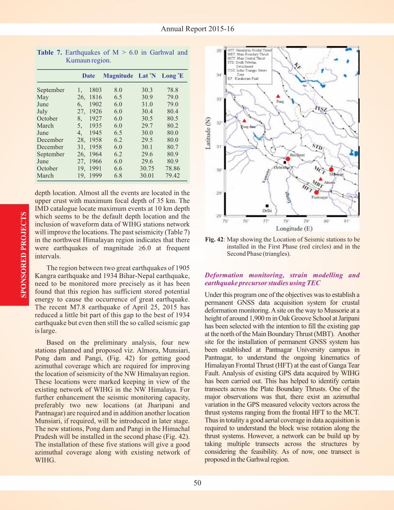
Annual Report 2015-16
depth location. Almost all the events are located in theupper crust with maximum focal depth of 35 km. TheIMD catalogue locate maximum events at 10 km depthwhich seems to be the default depth location and theinclusion of waveform data of WIHG stations networkwill improve the locations. The past seismicity (Table 7)in the northwest Himalayan region indicates that therewere earthquakes of magnitude 6.0 at frequent
intervals.
The region between two great earthquakes of 1905Kangra earthquake and 1934 Bihar-Nepal earthquake,need to be monitored more precisely as it has beenfound that this region has sufficient stored potentialenergy to cause the occurrence of great earthquake.The recent M7.8 earthquake of April 25, 2015 hasreduced a little bit part of this gap to the best of 1934earthquake but even then still the so called seismic gapis large.
Based on the preliminary analysis, four newstations planned and proposed viz. Almora, Munsiari,Pong dam and Pangi, (Fig. 42) for getting goodazimuthal coverage which are required for improvingthe location of seismicity of the NW Himalayan region.These locations were marked keeping in view of theexisting network of WIHG in the NW Himalaya. Forfurther enhancement the seismic monitoring capacity,preferably two new locations (at Jharipani andPantnagar) are required and in addition another locationMunsiari, if required, will be introduced in later stage.The new stations, Pong dam and Pangi in the HimachalPradesh will be installed in the second phase (Fig. 42).The installation of these five stations will give a goodazimuthal coverage along with existing network ofWIHG.
≥
Deformation monitoring, strain modelling andearthquake precursor studies using TEC
Under this program one of the objectives was to establish apermanent GNSS data acquisition system for crustaldeformation monitoring.Asite on the way to Mussorie at aheight of around 1,900 m in Oak Groove School at Jaripanihas been selected with the intention to fill the existing gapat the north of the Main Boundary Thrust (MBT). Anothersite for the installation of permanent GNSS system hasbeen established at Pantnagar University campus inPantnagar, to understand the ongoing kinematics ofHimalayan Frontal Thrust (HFT) at the east of Ganga TearFault. Analysis of existing GPS data acquired by WIHGhas been carried out. This has helped to identify certaintransects across the Plate Boundary Thrusts. One of themajor observations was that, there exist an azimuthalvariation in the GPS measured velocity vectors across thethrust systems ranging from the frontal HFT to the MCT.Thus in totality a good aerial coverage in data acquisition isrequired to understand the block wise rotation along thethrust systems. However, a network can be build up bytaking multiple transects across the structures byconsidering the feasibility. As of now, one transect isproposed in the Garhwal region.
SP
ON
SO
RE
D P
RO
JE
CT
S
50
Fig. 42: Map showing the Location of Seismic stations to beinstalled in the First Phase (red circles) and in theSecond Phase (triangles).
Table 7. Earthquakes of M > 6.0 in Garhwal andKumaun region.
Date Magnitude Lat N Long Eo o
September 1, 1803 8.0 30.3 78.8May 26, 1816 6.5 30.9 79.0June 6, 1902 6.0 31.0 79.0July 27, 1926 6.0 30.4 80.4October 8, 1927 6.0 30.5 80.5March 5, 1935 6.0 29.7 80.2June 4, 1945 6.5 30.0 80.0December 28, 1958 6.2 29.5 80.0December 31, 1958 6.0 30.1 80.7September 26, 1964 6.2 29.6 80.9June 27, 1966 6.0 29.6 80.9October 19, 1991 6.6 30.75 78.86March 19, 1999 6.8 30.01 79.42
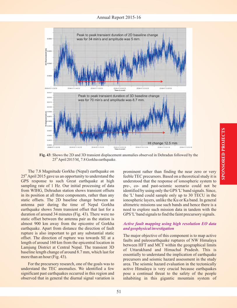
Annual Report 2015-16
The 7.8 Magnitude Gorkha (Nepal) earthquake on
25 April 2015 gave us an opportunity to understand theGPS response to such Great earthquake at highsampling rate of 1 Hz. Our initial processing of datafrom WIHG, Dehradun station shows transient offsetsin its position at all three components, rather than anystatic offsets. The 2D baseline change between anantenna pair during the time of Nepal Gorkhaearthquake shows 5mm transient offset that last for aduration of around 34 minutes (Fig. 43). There were nostatic offset between the antenna pair as the station isalmost 900 km away from the epicentre of Gorkhaearthquake. Apart from distance the direction of faultrupture is also important to get any substantial staticoffset. The direction of rupture was towards SE at alength of around 160 km from the epicentral location inLamjung District at Central Nepal. The transient 3Dbaseline length change of around 8.7 mm, which last formore than an hour (Fig. 43).
For the precursory research, one of the goals was tounderstand the TEC anomalies. We identified a fewsignificant past earthquakes occurred in this region andobserved that in general the diurnal signal variation is
th
prominent rather than finding the near zero or veryfeeble TEC precursors. Based on a theoretical study it isunderstood that the response of ionospheric system topre-, co- and past-seismic scenario could not beidentified by using only the GPS 'L' band signals. Since,the 'L' band could sample only up to 30 TECU in theionospheric layers, unlike the Ku or Ka band. In generalaltimetric missions use such bands and hence there is aneed to explore such mission data in tandem with theGPS 'L' band signals to find the faint precursory signals.
The major objective of this component is to map activefaults and paleoearthquake ruptures of NW Himalayabetween HFT and MCT within the geographical limitsof Uttarakhand and Himachal Pradesh. This isessentially to understand the implication of earthquakeprecursors and seismic hazard assessment in the studyarea. The seismic hazard evaluation in the tectonicallyactive Himalaya is very crucial because earthquakespose a continual threat to the safety of the peopleinhabiting in this gigantic mountain system of
Active fault mapping using high resolution EO dataand geophysical investigation
SP
ON
SO
RE
D P
RO
JE
CT
S
51
Fig. 43: Shows the 2D and 3D transient displacement anomalies observed in Dehradun followed by the
25 April 2015 M 7.8 Gorkha earthquake.th
w
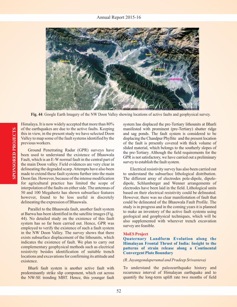
Annual Report 2015-16
Himalaya. It is now widely accepted that more than 80%of the earthquakes are due to the active faults. Keepingthis in view, in the present study we have selected DoonValley to map some of the fault systems identified by theprevious workers.
Ground Penetrating Radar (GPR) surveys havebeen used to understand the existence of BhauwalaFault, which is an E-W normal fault in the central part ofthe main Doon valley. Field evidences are very clear indelineating the degraded scarp.Attempts have also beenmade to extend these fault systems further into the mainDoon fan. However, because of the intense modificationfor agricultural practice has limited the scope ofinterpolation of the faults on either side. The antennas of50 and 100 Megahertz has shown subsurface featureshowever, found to be less useful in discretelydelineating the expression of Bhauwala.
Parallel to the Bhauwala fault, another fault systemat Barwa has been identified in the satellite images (Fig.44). No detailed study on the existence of this faultsystem has so far been carried out. Hence, GPR wasemployed to verify the existence of such a fault systemin the NW Doon Valley. The survey shows that thereexists subsurface displacement of the lithounits, whichindicates the existence of fault. We plan to carry outcomplementary geophysical methods such as electricalresistivity besides identification of suitable trenchlocations and excavations for confirming its attitude andexistence.
Bharli fault system is another active fault withpredominantly strike slip component, which cut acrossthe NW-SE trending MBT. Hence, this younger fault
system has displaced the pre-Tertiary lithounits at Bharlimanifested with prominent shutter ridgeand sag ponds. The fault system is considered to bedisplacing the Chandpur Phyllite and the present locationof the fault is prrsently covered with thick volume ofslided material, which belongs to the southerly slopes ofthe . Although the field requirements for theGPR is not satisfactory, we have carried out a preliminarysurvey to establish the fault system.
Electrical resistivity survey has also been carried outto understand the subsurface lithological distribution.The different array of electrodes pole-dipole, dipole-dipole, Schlumberger and Wenner arrangements ofelectrodes have been laid in the field. Lithological unitsbased on their electrical resistivity could be delineated.However, there was no clear manifestation of fault thatcould be delineated of the Bhauwala Fault Profile. Thestudy is in progress and in the coming years it is plannedto make an inventory of the active fault systems usinggeological and geophysical techniques, which will bealso supplemented with wherever trench excavationsurvey are feasible.
To understand the paleoearthquake history andrecurrence interval of Himalayan earthquake and toquantify the long-term uplift rate two months of field
(pre-Tertiary)
pre-Tertiary
(R. Jayangondaperumal and Pradeep Srivastava)
MoES ProjectQuaternary Landform Evolution along theHimalayan Frontal Thrust of India: Insight to thepatterns of strain release along a ContinentalConvergent Plate Boundary
SP
ON
SO
RE
D P
RO
JE
CT
S
52
Fig. 44: Google Earth Imagery of the NW Doon Valley showing locations of active faults and geophysical survey.
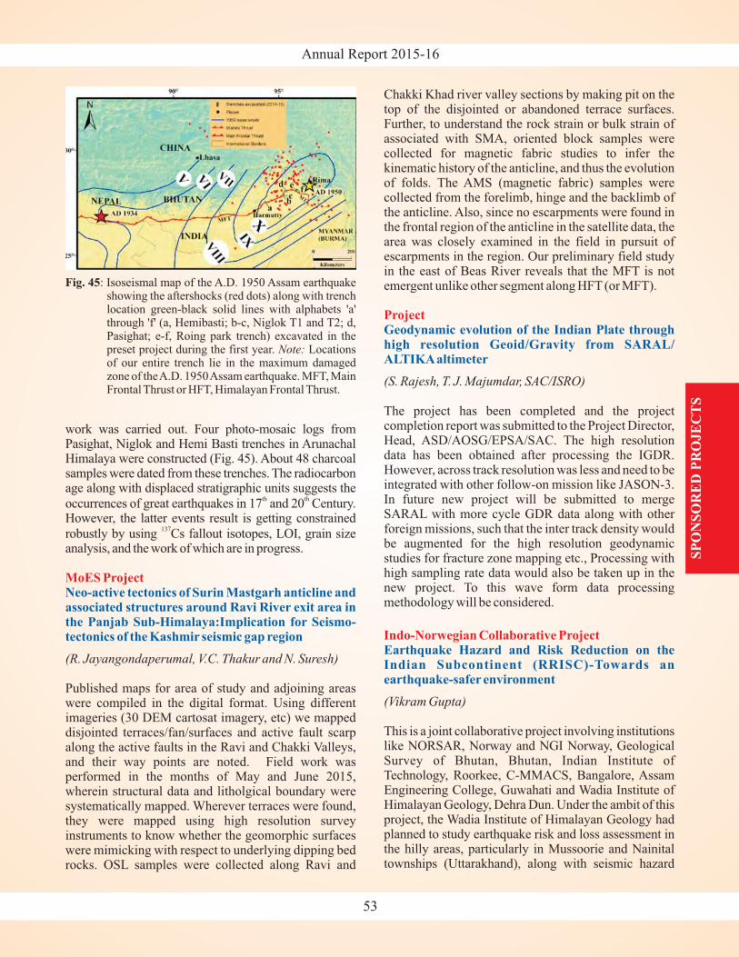
Annual Report 2015-16
work was carried out. Four photo-mosaic logs fromPasighat, Niglok and Hemi Basti trenches in ArunachalHimalaya were constructed (Fig. 45). About 48 charcoalsamples were dated from these trenches. The radiocarbonage along with displaced stratigraphic units suggests the
occurrences of great earthquakes in 17 and 20 Century.However, the latter events result is getting constrained
robustly by using Cs fallout isotopes, LOI, grain sizeanalysis, and the work of which are in progress.
Published maps for area of study and adjoining areaswere compiled in the digital format. Using differentimageries (30 DEM cartosat imagery, etc) we mappeddisjointed terraces/fan/surfaces and active fault scarpalong the active faults in the Ravi and Chakki Valleys,and their way points are noted. Field work wasperformed in the months of May and June 2015,wherein structural data and litholgical boundary weresystematically mapped. Wherever terraces were found,they were mapped using high resolution surveyinstruments to know whether the geomorphic surfaceswere mimicking with respect to underlying dipping bedrocks. OSL samples were collected along Ravi and
th th
137
(R. Jayangondaperumal, V.C. Thakur and N. Suresh)
MoES ProjectNeo-active tectonics of Surin Mastgarh anticline andassociated structures around Ravi River exit area inthe Panjab Sub-Himalaya:Implication for Seismo-tectonics of the Kashmir seismic gap region
Chakki Khad river valley sections by making pit on thetop of the disjointed or abandoned terrace surfaces.Further, to understand the rock strain or bulk strain ofassociated with SMA, oriented block samples werecollected for magnetic fabric studies to infer thekinematic history of the anticline, and thus the evolutionof folds. The AMS (magnetic fabric) samples werecollected from the forelimb, hinge and the backlimb ofthe anticline. Also, since no escarpments were found inthe frontal region of the anticline in the satellite data, thearea was closely examined in the field in pursuit ofescarpments in the region. Our preliminary field studyin the east of Beas River reveals that the MFT is notemergent unlike other segment along HFT (or MFT).
The project has been completed and the projectcompletion report was submitted to the Project Director,Head, ASD/AOSG/EPSA/SAC. The high resolutiondata has been obtained after processing the IGDR.However, across track resolution was less and need to beintegrated with other follow-on mission like JASON-3.In future new project will be submitted to mergeSARAL with more cycle GDR data along with otherforeign missions, such that the inter track density wouldbe augmented for the high resolution geodynamicstudies for fracture zone mapping etc., Processing withhigh sampling rate data would also be taken up in thenew project. To this wave form data processingmethodology will be considered.
This is a joint collaborative project involving institutionslike NORSAR, Norway and NGI Norway, GeologicalSurvey of Bhutan, Bhutan, Indian Institute ofTechnology, Roorkee, C-MMACS, Bangalore, AssamEngineering College, Guwahati and Wadia Institute ofHimalayan Geology, Dehra Dun. Under the ambit of thisproject, the Wadia Institute of Himalayan Geology hadplanned to study earthquake risk and loss assessment inthe hilly areas, particularly in Mussoorie and Nainitaltownships (Uttarakhand), along with seismic hazard
(S. Rajesh, T. J. Majumdar, SAC/ISRO)
(Vikram Gupta)
Project
Indo-Norwegian Collaborative Project
Geodynamic evolution of the Indian Plate throughhigh resolution Geoid/Gravity from SARAL/ALTIKAaltimeter
Earthquake Hazard and Risk Reduction on theIndian Subcontinent (RRISC)-Towards anearthquake-safer environment
SP
ON
SO
RE
D P
RO
JE
CT
S
53
Fig. 45: Isoseismal map of the A.D. 1950 Assam earthquakeshowing the aftershocks (red dots) along with trenchlocation green-black solid lines with alphabets 'a'through 'f' (a, Hemibasti; b-c, Niglok T1 and T2; d,Pasighat; e-f, Roing park trench) excavated in thepreset project during the first year. Locationsof our entire trench lie in the maximum damagedzone of theA.D. 1950Assam earthquake. MFT, MainFrontal Thrust or HFT, Himalayan Frontal Thrust.
Note:
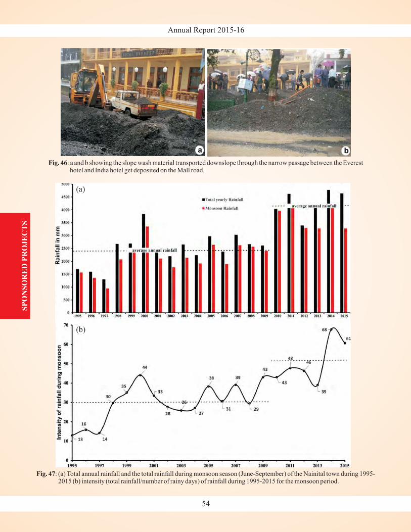
Annual Report 2015-16S
PO
NS
OR
ED
PR
OJE
CT
S
54
Fig. 46: a and b showing the slope wash material transported downslope through the narrow passage between the Everesthotel and India hotel get deposited on the Mall road.
Fig. 47: (a) Total annual rainfall and the total rainfall during monsoon season (June-September) of the Nainital town during 1995-2015 (b) intensity (total rainfall/number of rainy days) of rainfall during 1995-2015 for the monsoon period.
(a)
(b)
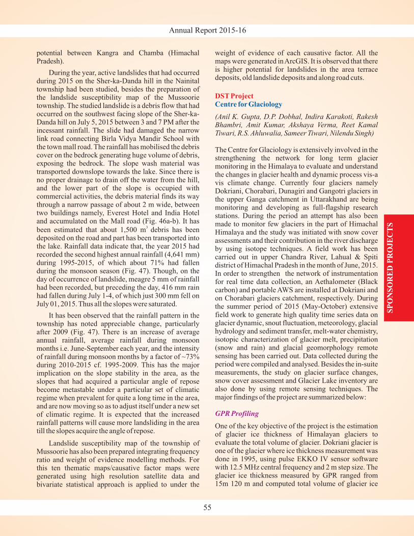
Annual Report 2015-16
potential between Kangra and Chamba (HimachalPradesh).
During the year, active landslides that had occurredduring 2015 on the Sher-ka-Danda hill in the Nainitaltownship had been studied, besides the preparation ofthe landslide susceptibility map of the Mussoorietownship. The studied landslide is a debris flow that hadoccurred on the southwest facing slope of the Sher-ka-Danda hill on July 5, 2015 between 3 and 7 PM after theincessant rainfall. The slide had damaged the narrowlink road connecting Birla Vidya Mandir School withthe town mall road. The rainfall has mobilised the debriscover on the bedrock generating huge volume of debris,exposing the bedrock. The slope wash material wastransported downslope towards the lake. Since there isno proper drainage to drain off the water from the hill,and the lower part of the slope is occupied withcommercial activities, the debris material finds its waythrough a narrow passage of about 2 m wide, betweentwo buildings namely, Everest Hotel and India Hoteland accumulated on the Mall road (Fig. 46a-b). It has
been estimated that about 1,500 m debris has beendeposited on the road and part has been transported intothe lake. Rainfall data indicate that, the year 2015 hadrecorded the second highest annual rainfall (4,641 mm)during 1995-2015, of which about 71% had fallenduring the monsoon season (Fig. 47). Though, on theday of occurrence of landslide, meagre 5 mm of rainfallhad been recorded, but preceding the day, 416 mm rainhad fallen during July 1-4, of which just 300 mm fell onJuly 01, 2015. Thus all the slopes were saturated.
It has been observed that the rainfall pattern in thetownship has noted appreciable change, particularlyafter 2009 (Fig. 47). There is an increase of averageannual rainfall, average rainfall during monsoonmonths i.e. June-September each year, and the intensityof rainfall during monsoon months by a factor of ~73%during 2010-2015 cf. 1995-2009. This has the majorimplication on the slope stability in the area, as theslopes that had acquired a particular angle of reposebecome metastable under a particular set of climaticregime when prevalent for quite a long time in the area,and are now moving so as to adjust itself under a new setof climatic regime. It is expected that the increasedrainfall patterns will cause more landsliding in the areatill the slopes acquire the angle of repose.
Landslide susceptibility map of the township ofMussoorie has also been prepared integrating frequencyratio and weight of evidence modelling methods. Forthis ten thematic maps/causative factor maps weregenerated using high resolution satellite data andbivariate statistical approach is applied to under the
3
weight of evidence of each causative factor. All themaps were generated inArcGIS. It is observed that thereis higher potential for landslides in the area terracedeposits, old landslide deposits and along road cuts.
The Centre for Glaciology is extensively involved in thestrengthening the network for long term glaciermonitoring in the Himalaya to evaluate and understandthe changes in glacier health and dynamic process vis-avis climate change. Currently four glaciers namelyDokriani, Chorabari, Dunagiri and Gangotri glaciers inthe upper Ganga catchment in Uttarakhand are beingmonitoring and developing as full-flagship researchstations. During the period an attempt has also beenmade to monitor few glaciers in the part of HimachalHimalaya and the study was initiated with snow coverassessments and their contribution in the river dischargeby using isotope techniques. A field work has beencarried out in upper Chandra River, Lahual & Spitidistrict of Himachal Pradesh in the month of June, 2015.In order to strengthen the network of instrumentationfor real time data collection, an Aethalometer (Blackcarbon) and portable AWS are installed at Dokriani andon Chorabari glaciers catchment, respectively. Duringthe summer period of 2015 (May-October) extensivefield work to generate high quality time series data onglacier dynamic, snout fluctuation, meteorology, glacialhydrology and sediment transfer, melt-water chemistry,isotopic characterization of glacier melt, precipitation(snow and rain) and glacial geomorphology remotesensing has been carried out. Data collected during theperiod were compiled and analysed. Besides the in-suitemeasurements, the study on glacier surface changes,snow cover assessment and Glacier Lake inventory arealso done by using remote sensing techniques. Themajor findings of the project are summarized below:
One of the key objective of the project is the estimationof glacier ice thickness of Himalayan glaciers toevaluate the total volume of glacier. Dokriani glacier isone of the glacier where ice thickness measurement wasdone in 1995, using pulse EKKO IV sensor softwarewith 12.5 MHz central frequency and 2 m step size. Theglacier ice thickness measured by GPR ranged from15m 120 m and computed total volume of glacier ice
(Anil K. Gupta, D.P. Dobhal, Indira Karakoti, RakeshBhambri, Amit Kumar, Akshaya Verma, Reet KamalTiwari, R.S. Ahluwalia, Sameer Tiwari, Nilendu Singh)
DST ProjectCentre for Glaciology
GPR Profiling
SP
ON
SO
RE
D P
RO
JE
CT
S
55
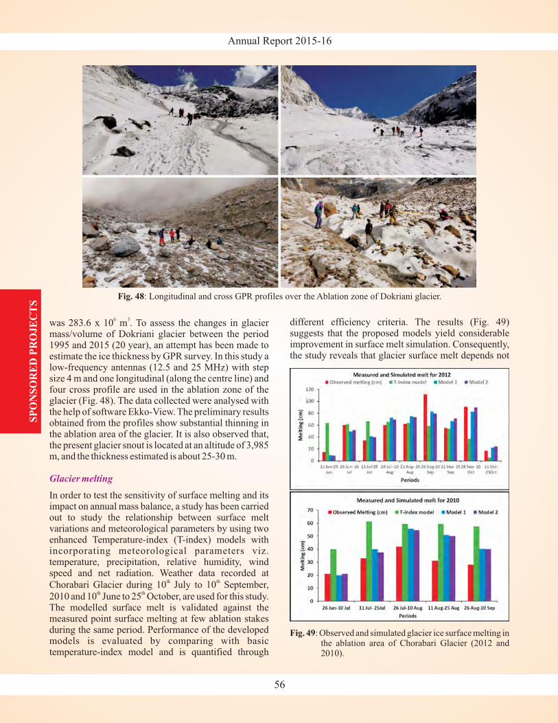
Annual Report 2015-16
was 283.6 x 10 m . To assess the changes in glaciermass/volume of Dokriani glacier between the period1995 and 2015 (20 year), an attempt has been made toestimate the ice thickness by GPR survey. In this study alow-frequency antennas (12.5 and 25 MHz) with stepsize 4 m and one longitudinal (along the centre line) andfour cross profile are used in the ablation zone of theglacier (Fig. 48). The data collected were analysed withthe help of software Ekko-View. The preliminary resultsobtained from the profiles show substantial thinning inthe ablation area of the glacier. It is also observed that,the present glacier snout is located at an altitude of 3,985m, and the thickness estimated is about 25-30 m.
In order to test the sensitivity of surface melting and itsimpact on annual mass balance, a study has been carriedout to study the relationship between surface meltvariations and meteorological parameters by using twoenhanced Temperature-index (T-index) models withincorporating meteorological parameters viz.temperature, precipitation, relative humidity, windspeed and net radiation. Weather data recorded at
Chorabari Glacier during 10 July to 10 September,
2010 and 10 June to 25 October, are used for this study.The modelled surface melt is validated against themeasured point surface melting at few ablation stakesduring the same period. Performance of the developedmodels is evaluated by comparing with basictemperature-index model and is quantified through
6 3
th th
th th
Glacier melting
different efficiency criteria. The results (Fig. 49)suggests that the proposed models yield considerableimprovement in surface melt simulation. Consequently,the study reveals that glacier surface melt depends not
SP
ON
SO
RE
D P
RO
JE
CT
S
56
Fig. 49: Observed and simulated glacier ice surface melting inthe ablation area of Chorabari Glacier (2012 and2010).
Fig. 48: Longitudinal and cross GPR profiles over the Ablation zone of Dokriani glacier.
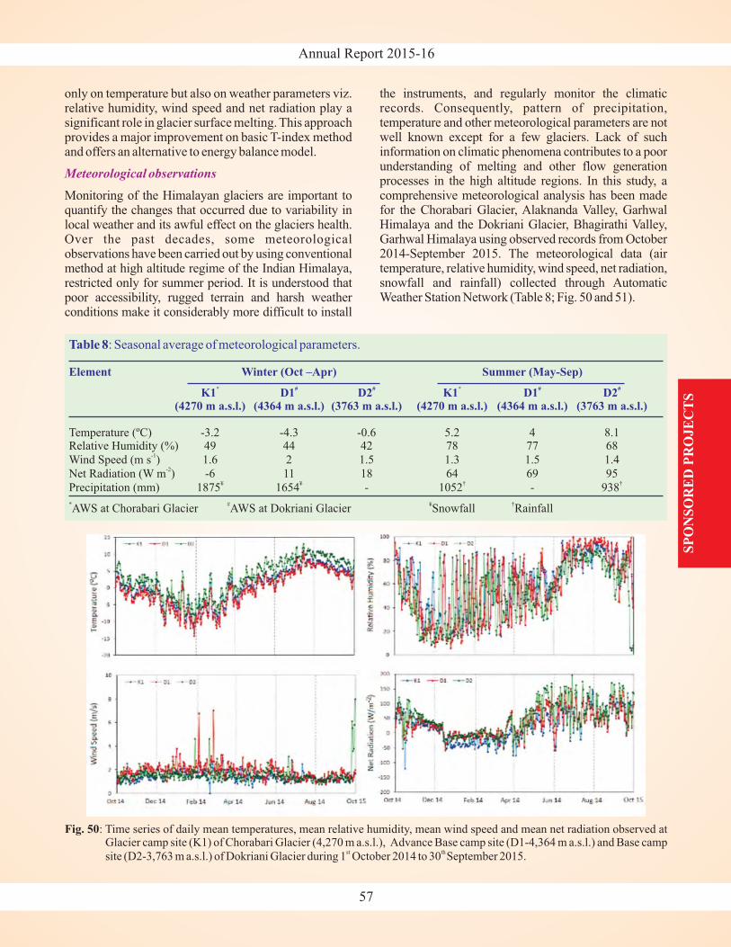
Annual Report 2015-16
only on temperature but also on weather parameters viz.relative humidity, wind speed and net radiation play asignificant role in glacier surface melting. This approachprovides a major improvement on basic T-index methodand offers an alternative to energy balance model.
Monitoring of the Himalayan glaciers are important toquantify the changes that occurred due to variability inlocal weather and its awful effect on the glaciers health.Over the past decades, some meteorologicalobservations have been carried out by using conventionalmethod at high altitude regime of the Indian Himalaya,restricted only for summer period. It is understood thatpoor accessibility, rugged terrain and harsh weatherconditions make it considerably more difficult to install
Meteorological observations
the instruments, and regularly monitor the climaticrecords. Consequently, pattern of precipitation,temperature and other meteorological parameters are notwell known except for a few glaciers. Lack of suchinformation on climatic phenomena contributes to a poorunderstanding of melting and other flow generationprocesses in the high altitude regions. In this study, acomprehensive meteorological analysis has been madefor the Chorabari Glacier, Alaknanda Valley, GarhwalHimalaya and the Dokriani Glacier, Bhagirathi Valley,Garhwal Himalaya using observed records from October2014-September 2015. The meteorological data (airtemperature, relative humidity, wind speed, net radiation,snowfall and rainfall) collected through AutomaticWeather Station Network (Table 8; Fig. 50 and 51).
SP
ON
SO
RE
D P
RO
JE
CT
S
57
Fig. 50: Time series of daily mean temperatures, mean relative humidity, mean wind speed and mean net radiation observed atGlacier camp site (K1) of Chorabari Glacier (4,270 m a.s.l.), Advance Base camp site (D1-4,364 m a.s.l.) and Base camp
site (D2-3,763 m a.s.l.) of Dokriani Glacier during 1 October 2014 to 30 September 2015.st th
Table 8: Seasonal average of meteorological parameters.
Element Winter (Oct –Apr) Summer (May-Sep)
K1 D1 D2 K1 D1 D2(4270 m a.s.l.) (4364 m a.s.l.) (3763 m a.s.l.) (4270 m a.s.l.) (4364 m a.s.l.) (3763 m a.s.l.)
* # # * # #
Temperature (ºC) -3.2 -4.3 -0.6 5.2 4 8.1Relative Humidity (%) 49 44 42 78 77 68
Wind Speed (m s ) 1.6 2 1.5 1.3 1.5 1.4
Net Radiation (W m ) -6 11 18 64 69 95
Precipitation (mm) 1875 1654 - 1052 - 938
AWS at Chorabari Glacier AWS at Dokriani Glacier Snowfall Rainfall
-1
-2
¥ ¥ † †
* # ¥ †
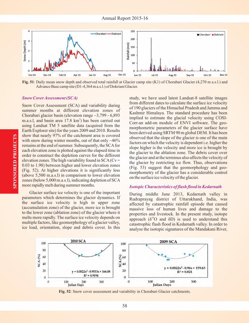
Annual Report 2015-16
Snow CoverAssessment (SCA)
Snow Cover Assessment (SCA) and variability duringsummer months at different elevation zones ofChorabari glacier basin (elevation range ~3,799 - 6,893
m.a.s.l, and basin area 17.8 km ) has been carried outusing Landsat TM 5 satellite data (acquired from theEarth Explorer site) for the years 2009 and 2010. Resultsshow that nearly 97% of the catchment area is coveredwith snow during winter months, out of that only ~46%remains at the end of summer. Subsequently, the SCAforeach elevation zone is plotted against the elapsed time inorder to construct the depletion curves for the differentelevation zones. The high variability found in SCA(Cv =0.03 to 1.98) between higher and lower elevation zones(Fig. 52). At higher elevations it is significantly less(above 5,500 m.a.s.l) in comparison to lower elevationzones (below 5,000 m.a.s.l), indicating depletion of SCAmore rapidly melt during summer months.
Glacier surface ice velocity is one of the importantparameters which determines the glacier dynamics. Ifthe surface ice velocity is high in upper zone(accumulation zone) of the glacier, more ice is broughtto the lower zone (ablation zone) of the glacier where itmelts more rapidly. The surface ice velocity depends onmultiple factors, like geomorphology of a glacier valley,ice load, orientation, slope and debris cover. In this
2
study, we have used latest Landsat-8 satellite imagesfrom different dates to calculate the surface ice velocityof 190 glaciers of the Himachal Pradesh and Jammu andKashmir Himalaya. The standard procedure has beenimplied to estimate the glacial velocity using COSI-Corr-an add-on module of ENVI software. The geo-morphometric parameters of the glacier surface havebeen derived using SRTM 90 m global DEM. It has beenobserved that the slope of the glacier is one of the mainfactors on which the velocity is dependent i.e. higher theslope higher is the velocity and more ice is brought bythe glacier to the ablation zone. The debris cover overthe glacier and at the terminus also affects the velocity ofthe glacier by restricting ice flow. Thus, observations(Fig. 53) suggest that the geomorphology and geo-morphometry of the glacier has a considerable controlon the surface ice velocity of the glacier.
During middle June 2013, Kedarnath valley inRudraprayag district of Uttarakhand, India, wasaffected by catastrophic rainfall episode that causedmassive loss of human lives and damage to theproperties and livestock. In the present study, isotope
approacIn order to
analyse the isotopic signatures of the Mandakani River,
h (δ O and δD) is used to understand thiscatastrophic flash flood in Kedarnath valley.
18
Isotopic Characteristics of flash flood in KedarnathSP
ON
SO
RE
D P
RO
JE
CT
S
58
Fig. 52: Snow cover assessment and variability in Chorabari Glacier catchments.
Fig. 51: Daily mean snow depth and observed total rainfall at Glacier camp site (K1) of Chorabari Glacier (4,270 m a.s.l.) andAdvance Base camp site (D1-4,364 m a.s.l.) of Dokriani Glacier.
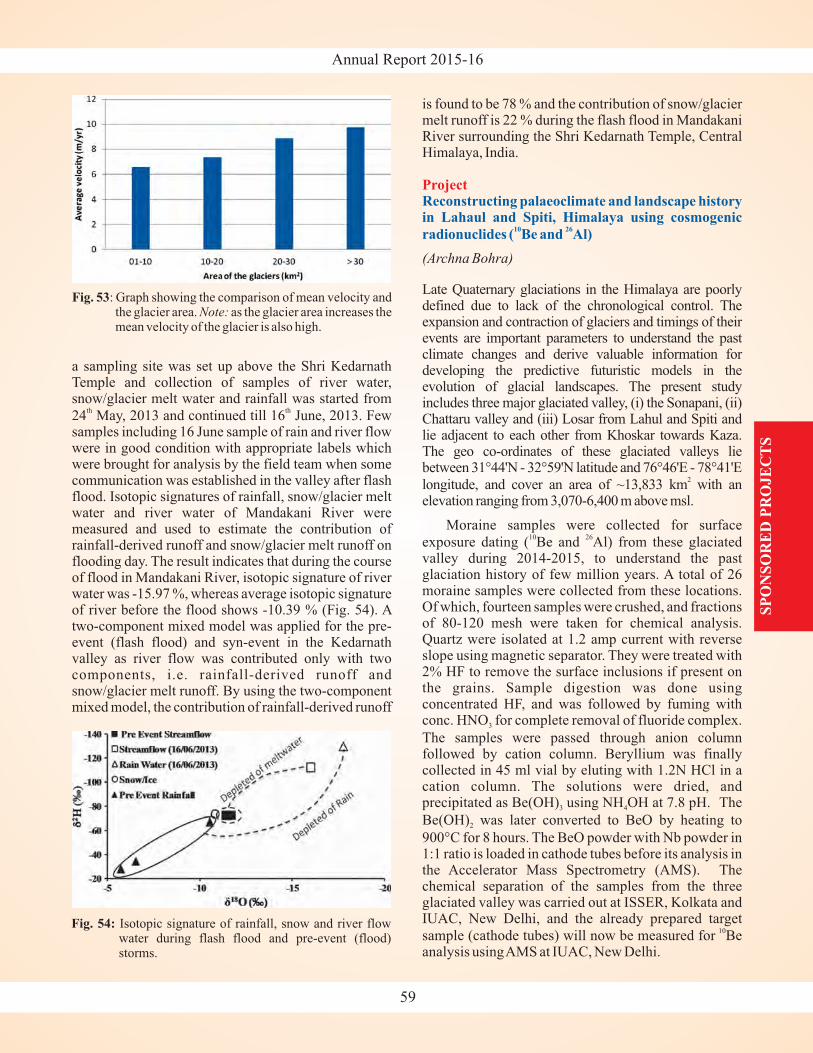
Annual Report 2015-16
a sampling site was set up above the Shri KedarnathTemple and collection of samples of river water,snow/glacier melt water and rainfall was started from
24 May, 2013 and continued till 16 June, 2013. Fewsamples including 16 June sample of rain and river flowwere in good condition with appropriate labels whichwere brought for analysis by the field team when somecommunication was established in the valley after flashflood. Isotopic signatures of rainfall, snow/glacier meltwater and river water of Mandakani River weremeasured and used to estimate the contribution ofrainfall-derived runoff and snow/glacier melt runoff onflooding day. The result indicates that during the courseof flood in Mandakani River, isotopic signature of riverwater was -15.97 %, whereas average isotopic signatureof river before the flood shows -10.39 % (Fig. 54). Atwo-component mixed model was applied for the pre-event (flash flood) and syn-event in the Kedarnathvalley as river flow was contributed only with twocomponents, i.e. rainfall-derived runoff andsnow/glacier melt runoff. By using the two-componentmixed model, the contribution of rainfall-derived runoff
th th
is found to be 78 % and the contribution of snow/glaciermelt runoff is 22 % during the flash flood in MandakaniRiver surrounding the Shri Kedarnath Temple, CentralHimalaya, India.
Late Quaternary glaciations in the Himalaya are poorlydefined due to lack of the chronological control. Theexpansion and contraction of glaciers and timings of theirevents are important parameters to understand the pastclimate changes and derive valuable information fordeveloping the predictive futuristic models in theevolution of glacial landscapes. The present studyincludes three major glaciated valley, (i) the Sonapani, (ii)Chattaru valley and (iii) Losar from Lahul and Spiti andlie adjacent to each other from Khoskar towards Kaza.The geo co-ordinates of these glaciated valleys liebetween 31°44'N - 32°59'N latitude and 76°46'E - 78°41'E
longitude, and cover an area of ~13,833 km with anelevation ranging from 3,070-6,400 m above msl.
Moraine samples were collected for surface
exposure dating ( Be and Al) from these glaciatedvalley during 2014-2015, to understand the pastglaciation history of few million years. A total of 26moraine samples were collected from these locations.Of which, fourteen samples were crushed, and fractionsof 80-120 mesh were taken for chemical analysis.Quartz were isolated at 1.2 amp current with reverseslope using magnetic separator. They were treated with2% HF to remove the surface inclusions if present onthe grains. Sample digestion was done usingconcentrated HF, and was followed by fuming withconc. HNO for complete removal of fluoride complex.
The samples were passed through anion columnfollowed by cation column. Beryllium was finallycollected in 45 ml vial by eluting with 1.2N HCl in acation column. The solutions were dried, andprecipitated as Be(OH) using NH OH at 7.8 pH. The
Be(OH) was later converted to BeO by heating to
900°C for 8 hours. The BeO powder with Nb powder in1:1 ratio is loaded in cathode tubes before its analysis inthe Accelerator Mass Spectrometry (AMS). Thechemical separation of the samples from the threeglaciated valley was carried out at ISSER, Kolkata andIUAC, New Delhi, and the already prepared target
sample (cathode tubes) will now be measured for Beanalysis usingAMS at IUAC, New Delhi.
(Archna Bohra)
2
10 26
10
3
3 4
2
ProjectReconstructing palaeoclimate and landscape historyin Lahaul and Spiti, Himalaya using cosmogenic
radionuclides ( Be and Al)10 26
SP
ON
SO
RE
D P
RO
JE
CT
S
59
Fig. 54: Isotopic signature of rainfall, snow and river flowwater during flash flood and pre-event (flood)storms.
Fig. 53: Graph showing the comparison of mean velocity andthe glacier area. as the glacier area increases themean velocity of the glacier is also high.
Note:
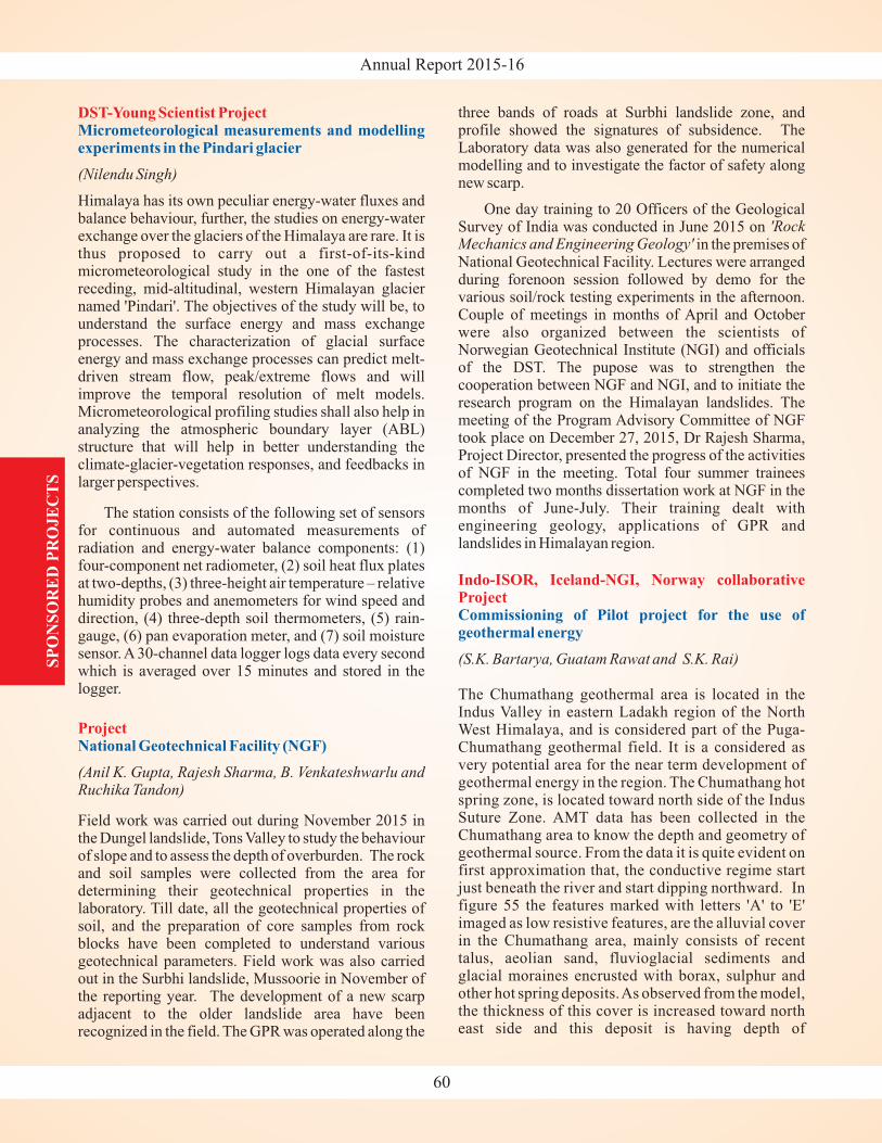
Annual Report 2015-16
DST-Young Scientist Project
Project
Micrometeorological measurements and modellingexperiments in the Pindari glacier
National Geotechnical Facility (NGF)
(Nilendu Singh)
(Anil K. Gupta, Rajesh Sharma, B. Venkateshwarlu andRuchika Tandon)
Himalaya has its own peculiar energy-water fluxes andbalance behaviour, further, the studies on energy-waterexchange over the glaciers of the Himalaya are rare. It isthus proposed to carry out a first-of-its-kindmicrometeorological study in the one of the fastestreceding, mid-altitudinal, western Himalayan glaciernamed 'Pindari'. The objectives of the study will be, tounderstand the surface energy and mass exchangeprocesses. The characterization of glacial surfaceenergy and mass exchange processes can predict melt-driven stream flow, peak/extreme flows and willimprove the temporal resolution of melt models.Micrometeorological profiling studies shall also help inanalyzing the atmospheric boundary layer (ABL)structure that will help in better understanding theclimate-glacier-vegetation responses, and feedbacks inlarger perspectives.
The station consists of the following set of sensorsfor continuous and automated measurements ofradiation and energy-water balance components: (1)four-component net radiometer, (2) soil heat flux platesat two-depths, (3) three-height air temperature – relativehumidity probes and anemometers for wind speed anddirection, (4) three-depth soil thermometers, (5) rain-gauge, (6) pan evaporation meter, and (7) soil moisturesensor. A 30-channel data logger logs data every secondwhich is averaged over 15 minutes and stored in thelogger.
Field work was carried out during November 2015 inthe Dungel landslide, Tons Valley to study the behaviourof slope and to assess the depth of overburden. The rockand soil samples were collected from the area fordetermining their geotechnical properties in thelaboratory. Till date, all the geotechnical properties ofsoil, and the preparation of core samples from rockblocks have been completed to understand variousgeotechnical parameters. Field work was also carriedout in the Surbhi landslide, Mussoorie in November ofthe reporting year. The development of a new scarpadjacent to the older landslide area have beenrecognized in the field. The GPR was operated along the
three bands of roads at Surbhi landslide zone, andprofile showed the signatures of subsidence. TheLaboratory data was also generated for the numericalmodelling and to investigate the factor of safety alongnew scarp.
One day training to 20 Officers of the GeologicalSurvey of India was conducted in June 2015 on
in the premises ofNational Geotechnical Facility. Lectures were arrangedduring forenoon session followed by demo for thevarious soil/rock testing experiments in the afternoon.Couple of meetings in months of April and Octoberwere also organized between the scientists ofNorwegian Geotechnical Institute (NGI) and officialsof the DST. The pupose was to strengthen thecooperation between NGF and NGI, and to initiate theresearch program on the Himalayan landslides. Themeeting of the Program Advisory Committee of NGFtook place on December 27, 2015, Dr Rajesh Sharma,Project Director, presented the progress of the activitiesof NGF in the meeting. Total four summer traineescompleted two months dissertation work at NGF in themonths of June-July. Their training dealt withengineering geology, applications of GPR andlandslides in Himalayan region.
The Chumathang geothermal area is located in theIndus Valley in eastern Ladakh region of the NorthWest Himalaya, and is considered part of the Puga-Chumathang geothermal field. It is a considered asvery potential area for the near term development ofgeothermal energy in the region. The Chumathang hotspring zone, is located toward north side of the IndusSuture Zone. AMT data has been collected in theChumathang area to know the depth and geometry ofgeothermal source. From the data it is quite evident onfirst approximation that, the conductive regime startjust beneath the river and start dipping northward. Infigure 55 the features marked with letters 'A' to 'E'imaged as low resistive features, are the alluvial coverin the Chumathang area, mainly consists of recenttalus, aeolian sand, fluvioglacial sediments andglacial moraines encrusted with borax, sulphur andother hot spring deposits.As observed from the model,the thickness of this cover is increased toward northeast side and this deposit is having depth of
'RockMechanics and Engineering Geology'
(S.K. Bartarya, Guatam Rawat and S.K. Rai)
Indo-ISOR, Iceland-NGI, Norway collaborativeProjectCommissioning of Pilot project for the use ofgeothermal energy
SP
ON
SO
RE
D P
RO
JE
CT
S
60
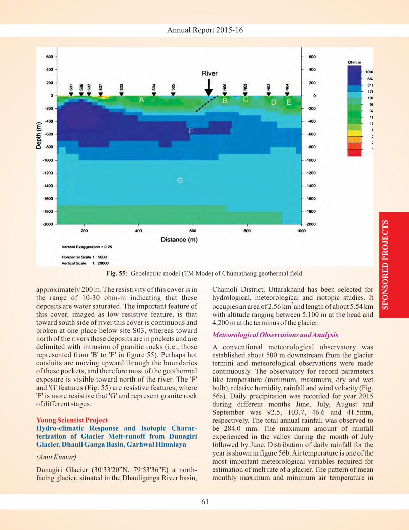
Annual Report 2015-16
SP
ON
SO
RE
D P
RO
JE
CT
S
approximately 200 m. The resistivity of this cover is inthe range of 10-30 ohm-m indicating that thesedeposits are water saturated. The important feature ofthis cover, imaged as low resistive feature, is thattoward south side of river this cover is continuous andbroken at one place below site S03, whereas towardnorth of the rivers these deposits are in pockets and aredelimited with intrusion of granitic rocks (i.e., thoserepresented from 'B' to 'E' in figure 55). Perhaps hotconduits are moving upward through the boundariesof these pockets, and therefore most of the geothermalexposure is visible toward north of the river. The 'F'and 'G' features (Fig. 55) are resistive features, where'F' is more resistive that 'G' and represent granite rockof different stages.
Dunagiri Glacier (30 33'20”N, 79 53'36''E) a north-facing glacier, situated in the Dhauliganga River basin,
(Amit Kumar)
o o
Young Scientist ProjectHydro-climatic Response and Isotopic Charac-terization of Glacier Melt-runoff from DunagiriGlacier, Dhauli Ganga Basin, Garhwal Himalaya
Chamoli District, Uttarakhand has been selected forhydrological, meteorological and isotopic studies. It
occupies an area of 2.56 km and length of about 5.54 kmwith altitude ranging between 5,100 m at the head and4,200 m at the terminus of the glacier.
A conventional meteorological observatory wasestablished about 500 m downstream from the glaciertermini and meteorological observations were madecontinuously. The observatory for record parameterslike temperature (minimum, maximum, dry and wetbulb), relative humidity, rainfall and wind velocity (Fig.56a). Daily precipitation was recorded for year 2015during different months June, July, August andSeptember was 92.5, 103.7, 46.6 and 41.5mm,respectively. The total annual rainfall was observed tobe 284.0 mm. The maximum amount of rainfallexperienced in the valley during the month of Julyfollowed by June. Distribution of daily rainfall for theyear is shown in figure 56b.Air temperature is one of themost important meteorological variables required forestimation of melt rate of a glacier. The pattern of meanmonthly maximum and minimum air temperature in
2
Meteorological Observations andAnalysis
Fig. 55: Geoelectric model (TM Mode) of Chumathang geothermal field.
61
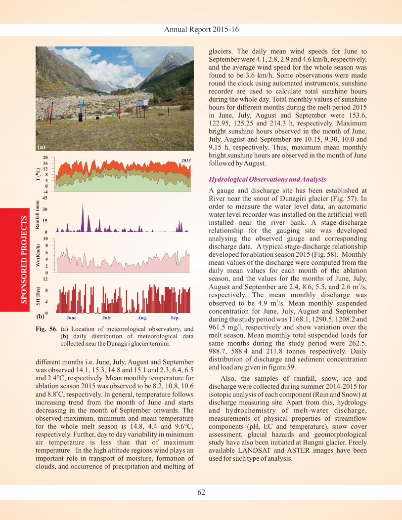
Annual Report 2015-16S
PO
NS
OR
ED
PR
OJE
CT
S
different months i.e. June, July, August and Septemberwas observed 14.1, 15.3, 14.8 and 15.1 and 2.3, 6.4, 6.5and 2.4°C, respectively. Mean monthly temperature forablation season 2015 was observed to be 8.2, 10.8, 10.6
and 8.8 C, respectively. In general, temperature followsincreasing trend from the month of June and startsdecreasing in the month of September onwards. Theobserved maximum, minimum and mean temperaturefor the whole melt season is 14.8, 4.4 and 9.6 ,respectively. Further, day to day variability in minimumair temperature is less than that of maximumtemperature. In the high altitude regions wind plays animportant role in transport of moisture, formation ofclouds, and occurrence of precipitation and melting of
o
°C
glaciers. The daily mean wind speeds for June toSeptember were 4.1, 2.8, 2.9 and 4.6 km/h, respectively,and the average wind speed for the whole season wasfound to be 3.6 km/h. Some observations were maderound the clock using automated instruments, sunshinerecorder are used to calculate total sunshine hoursduring the whole day. Total monthly values of sunshinehours for different months during the melt period 2015in June, July, August and September were 153.6,122.95, 125.25 and 214.3 h, respectively. Maximumbright sunshine hours observed in the month of June,July, August and September are 10.15, 9.30, 10.0 and9.15 h, respectively. Thus, maximum mean monthlybright sunshine hours are observed in the month of Junefollowed byAugust.
A gauge and discharge site has been established atRiver near the snout of Dunagiri glacier (Fig. 57). Inorder to measure the water level data, an automaticwater level recorder was installed on the artificial wellinstalled near the river bank. A stage-dischargerelationship for the gauging site was developedanalysing the observed gauge and correspondingdischarge data. A typical stage-discharge relationshipdeveloped for ablation season 2015 (Fig. 58). Monthlymean values of the discharge were computed from thedaily mean values for each month of the ablationseason, and the values for the months of June, July,
August and September are 2.4, 8.6, 5.5, and 2.6 m /s,respectively. The mean monthly discharge was
observed to be 4.9 m /s. Mean monthly suspendedconcentration for June, July, August and Septemberduring the study period was 1168.1, 1290.5, 1208.2 and961.5 mg/l, respectively and show variation over themelt season. Mean monthly total suspended loads forsame months during the study period were 262.5,988.7, 588.4 and 211.8 tonnes respectively. Dailydistribution of discharge and sediment concentrationand load are given in figure 59.
Also, the samples of rainfall, snow, ice anddischarge were collected during summer 2014-2015 forisotopic analysis of each component (Rain and Snow) atdischarge measuring site. Apart from this, hydrologyand hydrochemistry of melt-water discharge,measurements of physical properties of streamflowcomponents (pH, EC and temperature), snow coverassessment, glacial hazards and geomorphologicalstudy have also been initiated at Bangni glacier. Freelyavailable LANDSAT and ASTER images have beenused for such type of analysis.
3
3
Hydrological Observations andAnalysis
(a)
(b)
Fig. 56. (a) Location of meteorological observatory, and(b) daily distribution of meteorological datacollected near the Dunagiri glacier termini.
62
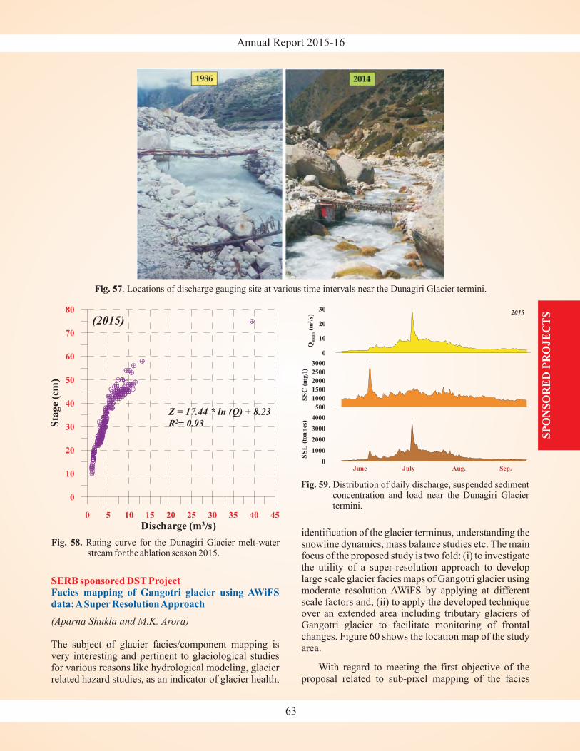
Annual Report 2015-16
SP
ON
SO
RE
D P
RO
JE
CT
S
SERB sponsored DST ProjectFacies mapping of Gangotri glacier using AWiFSdata:ASuper ResolutionApproach
(Aparna Shukla and M.K. Arora)
The subject of glacier facies/component mapping isvery interesting and pertinent to glaciological studiesfor various reasons like hydrological modeling, glacierrelated hazard studies, as an indicator of glacier health,
identification of the glacier terminus, understanding thesnowline dynamics, mass balance studies etc. The mainfocus of the proposed study is two fold: (i) to investigatethe utility of a super-resolution approach to developlarge scale glacier facies maps of Gangotri glacier usingmoderate resolution AWiFS by applying at differentscale factors and, (ii) to apply the developed techniqueover an extended area including tributary glaciers ofGangotri glacier to facilitate monitoring of frontalchanges. Figure 60 shows the location map of the studyarea.
With regard to meeting the first objective of theproposal related to sub-pixel mapping of the facies
Fig. 57. Locations of discharge gauging site at various time intervals near the Dunagiri Glacier termini.
Fig. 58. Rating curve for the Dunagiri Glacier melt-waterstream for the ablation season 2015.
Fig. 59. Distribution of daily discharge, suspended sedimentconcentration and load near the Dunagiri Glaciertermini.
63
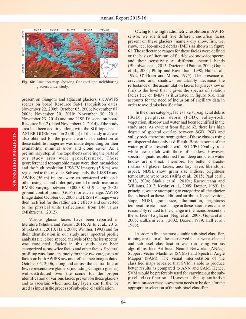
Annual Report 2015-16S
PO
NS
OR
ED
PR
OJE
CT
S
present on Gangotri and adjacent glaciers, six AWIFSscenes on board Resource Sat-1 (acquisition dates:November 22, 2005; October 05, 2006; November 07,2008; November 30, 2010; November 30, 2011;November 23, 2014) and one LISS IV scene on boardResource Sat-2 (dated November 02 , 2014) of the studyarea had been acquired along with the SOI toposheets.ASTER GDEM version 2 (30 m) of the study area wasalso obtained for the present work. The selection ofthese satellite imageries was made depending on theiravailability, minimal snow and cloud cover. As apreliminary step, all the toposheets covering the parts ofour study area were georeferenced. Thesegeoreferenced topographic maps were then mosaickedand the high resolution LISS IV imagery (5.8 m) wasregistered to this mosaic. Subsequently, the LISS IV andAWiFS (56 m) images were co-registered with eachother using second order polynomial transformation atRMSE varying between 0.0003-0.0019 using 20-25ground control points (GCPs) for each image. AWIFSImage dated October 05, 2006 and LISS IV image werethen rectified for the radiometric effects and convertedto the physical units (reflectance) from DN values(Mishra et al., 2012).
Various glacial facies have been reported inliterature (Shukla and Yousuf, 2016; Alifu et al., 2015;Shukla et al., 2010; Hall, 2008; Winther, 1993) and fortheir identification in our study area, spectral profileanalysis (i.e. close spaced analysis of the facies spectra)was conducted. Facies in this study have beencategorized as snow/ice facies and other facies. Spectralprofiling was done separately for these two categories offacies on both AWIFS raw and reflectance images datedOctober 05, 2006, along and across the central line offew representative glaciers (including Gangotri glacier)well-distributed over the scene for the properidentification of various facies present on these glaciersand to ascertain which ancillary layers can further beused as input in the process of sub-pixel classification.
Owing to the high radiometric resolution of AWIFSsensor, we identified five different snow/ice faciespresent on these glaciers namely dry snow, firn, wetsnow, ice, ice-mixed debris (IMD) as shown in figure61. The reflectance ranges for these facies were definedon the basis of literature of field-based snow-ice spectraand their sensitivity at different spectral bands(Bhardwaj et al., 2015; Dozier and Painter, 2004; Guptaet al., 2004; Philip and Ravindran, 1998; Hall et al.,1992; O' Brian and Munis, 1975). The presence ofcrevasses and shadows remarkably decrease thereflectance of the accumulation facies (dry/wet snow orfirn) to the level that it gives the spectra of ablationfacies (ice or IMD) as illustrated in figure 61e. Thisaccounts for the need of inclusion of ancillary data inorder to avoid misclassification.
In the other category, facies like supraglacial debris(SGD), periglacial debris (PGD), valley-rock,vegetation, shadow and water had been identified in thestudy area. As evident from figure 62, there is a highdegree of spectral overlap between SGD, PGD andvalley rock, therefore segregation of these classes usingmultispectral data only is difficult. Besides some of thewater profiles resemble with SGD/PGD/valley rockwhile few match with those of shadow. However,spectral signatures obtained from deep and clean waterbodies are distinct. Therefore, for better characte-rization of glacier facies, ancillary layers like slope,aspect, NDSI, snow grain size indices, brightnesstemperature were used (Alifu et al., 2015; Paul et al.,2013, 2004; Shukla et al., 2010a; Racoviteanu andWilliams, 2012; Keshri et al., 2009; Dozier, 1989). Inprinciple, we are attempting to categorize all the glacierfacies based on these additional attributes like elevation,slope, NDSI, grain size, illumination, brightnesstemperature etc. since change in these parameters can bereasonably related to the change in the facies present onthe surface of a glacier (Negi et al., 2008; Gupta et al.,2005; Kulkarni et al., 2002; Dozier, 1989, Hall et al.,1988).
In order to find the most suitable sub-pixel classifier,training areas for all these observed facies were selectedand sub-pixel classification was run using variousalgorithms like Artificial Neural Networks (ANNs),Support Vector Machines (SVMs) and Spectral AngleMapper (SAM). The visual interpretation of theclassified maps revealed that SVM is able to producebetter results as compared to ANN and SAM. Hence,SVM would be preferably used for carrying out the sub-pixel classification. However, the quantitativeestimation/accuracy assessment needs to be done for theappropriate selection of the sub-pixel classifier.
Fig. 60: Location map showing Gangotri and neighboringglaciers under study.
64
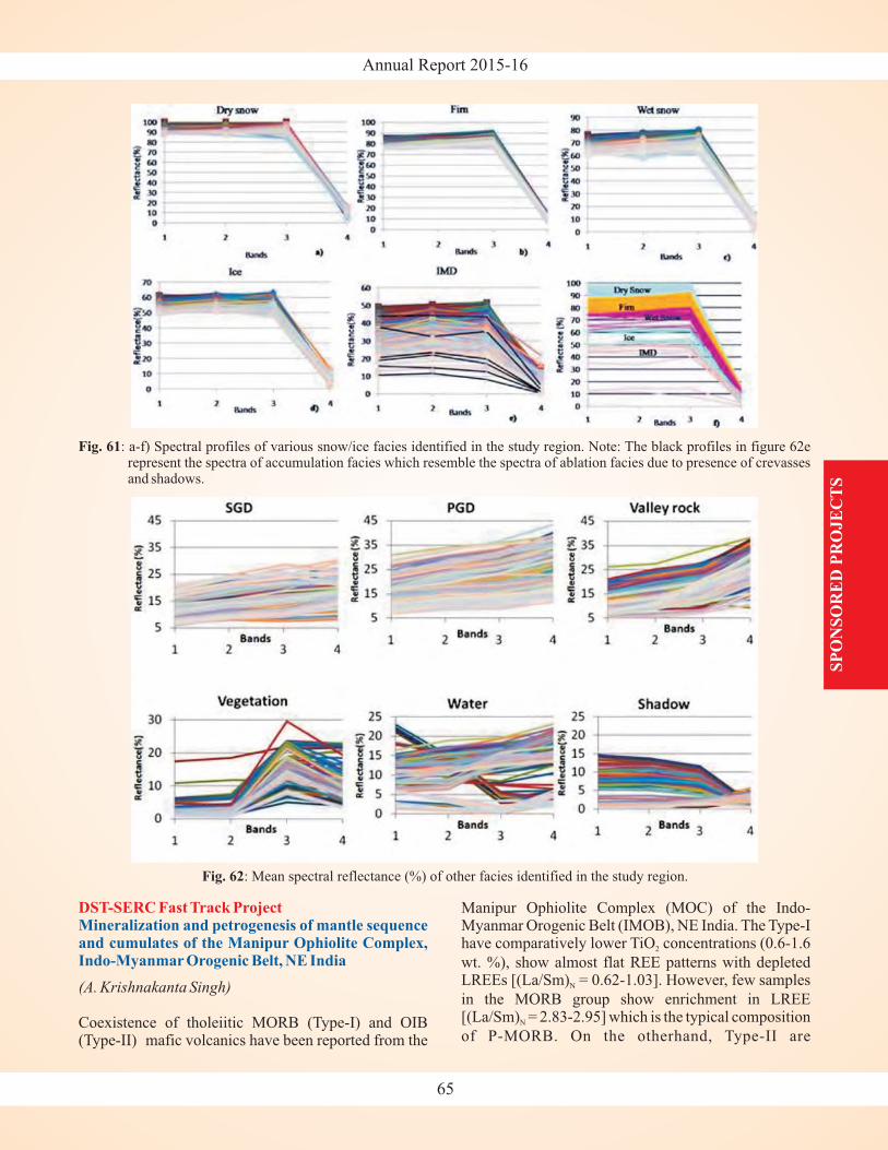
Annual Report 2015-16
SP
ON
SO
RE
D P
RO
JE
CT
S
DST-SERC Fast Track ProjectMineralization and petrogenesis of mantle sequenceand cumulates of the Manipur Ophiolite Complex,Indo-Myanmar Orogenic Belt, NE India
(A. Krishnakanta Singh)
Coexistence of tholeiitic MORB (Type-I) and OIB(Type-II) mafic volcanics have been reported from the
Manipur Ophiolite Complex (MOC) of the Indo-Myanmar Orogenic Belt (IMOB), NE India. The Type-Ihave comparatively lower TiO concentrations (0.6-1.6
wt. %), show almost flat REE patterns with depletedLREEs [(La/Sm) = 0.62-1.03]. However, few samples
in the MORB group show enrichment in LREE[(La/Sm) = 2.83-2.95] which is the typical composition
of P-MORB. On the otherhand, Type-II are
2
N
N
65
Fig. 61: a-f) Spectral profiles of various snow/ice facies identified in the study region. Note: The black profiles in figure 62erepresent the spectra of accumulation facies which resemble the spectra of ablation facies due to presence of crevassesand shadows.
Fig. 62: Mean spectral reflectance (%) of other facies identified in the study region.
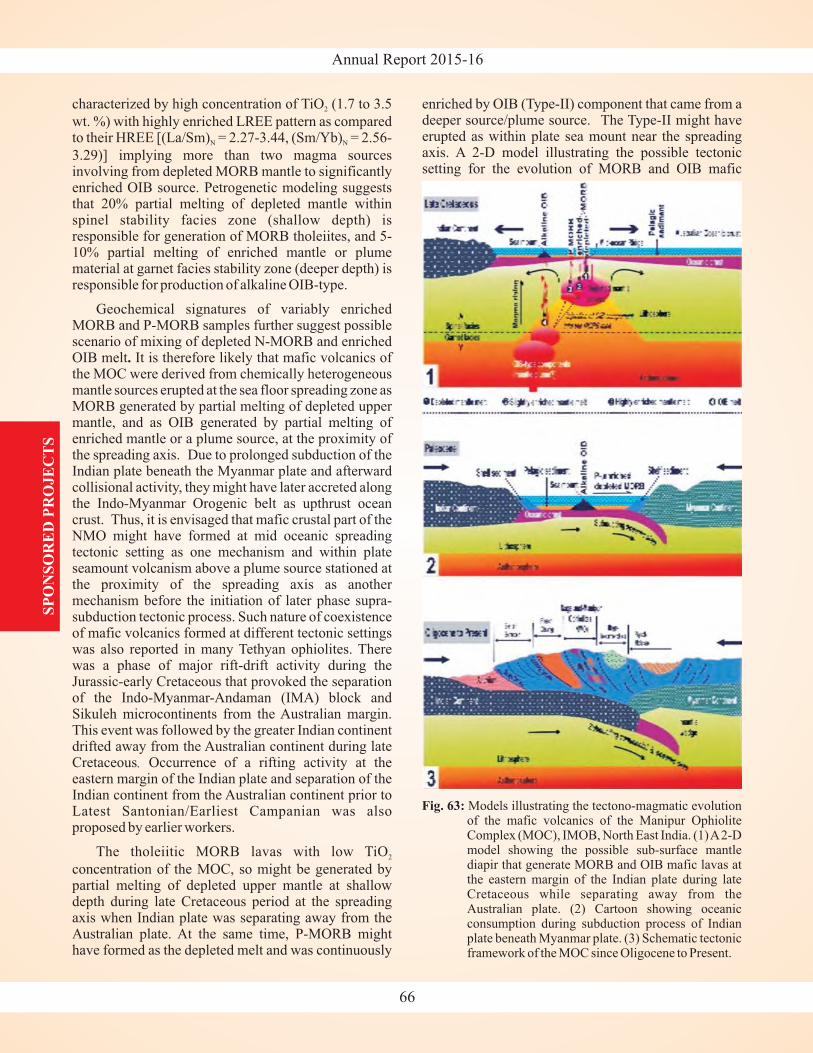
Annual Report 2015-16S
PO
NS
OR
ED
PR
OJE
CT
S
characterized by high concentration of TiO (1.7 to 3.5
wt. %) with highly enriched LREE pattern as comparedto their HREE [(La/Sm) = 2.27-3.44, (Sm/Yb) = 2.56-
3.29)] implying more than two magma sourcesinvolving from depleted MORB mantle to significantlyenriched OIB source. Petrogenetic modeling suggeststhat 20% partial melting of depleted mantle withinspinel stability facies zone (shallow depth) isresponsible for generation of MORB tholeiites, and 5-10% partial melting of enriched mantle or plumematerial at garnet facies stability zone (deeper depth) isresponsible for production of alkaline OIB-type.
Geochemical signatures of variably enrichedMORB and P-MORB samples further suggest possiblescenario of mixing of depleted N-MORB and enrichedOIB melt It is therefore likely that mafic volcanics ofthe MOC were derived from chemically heterogeneousmantle sources erupted at the sea floor spreading zone asMORB generated by partial melting of depleted uppermantle, and as OIB generated by partial melting ofenriched mantle or a plume source, at the proximity ofthe spreading axis. Due to prolonged subduction of theIndian plate beneath the Myanmar plate and afterwardcollisional activity, they might have later accreted alongthe Indo-Myanmar Orogenic belt as upthrust oceancrust. Thus, it is envisaged that mafic crustal part of theNMO might have formed at mid oceanic spreadingtectonic setting as one mechanism and within plateseamount volcanism above a plume source stationed atthe proximity of the spreading axis as anothermechanism before the initiation of later phase supra-subduction tectonic process. Such nature of coexistenceof mafic volcanics formed at different tectonic settingswas also reported in many Tethyan ophiolites. Therewas a phase of major rift-drift activity during theJurassic-early Cretaceous that provoked the separationof the Indo-Myanmar-Andaman (IMA) block andSikuleh microcontinents from the Australian margin.This event was followed by the greater Indian continentdrifted away from the Australian continent during lateCretaceous Occurrence of a rifting activity at theeastern margin of the Indian plate and separation of theIndian continent from the Australian continent prior toLatest Santonian/Earliest Campanian was alsoproposed by earlier workers.
The tholeiitic MORB lavas with low TiO
concentration of the MOC, so might be generated bypartial melting of depleted upper mantle at shallowdepth during late Cretaceous period at the spreadingaxis when Indian plate was separating away from theAustralian plate. At the same time, P-MORB mighthave formed as the depleted melt and was continuously
2
N N
2
.
.
enriched by OIB (Type-II) component that came from adeeper source/plume source. The Type-II might haveerupted as within plate sea mount near the spreadingaxis. A 2-D model illustrating the possible tectonicsetting for the evolution of MORB and OIB mafic
66
Fig. 63: Models illustrating the tectono-magmatic evolutionof the mafic volcanics of the Manipur OphioliteComplex (MOC), IMOB, North East India. (1)A2-Dmodel showing the possible sub-surface mantlediapir that generate MORB and OIB mafic lavas atthe eastern margin of the Indian plate during lateCretaceous while separating away from theAustralian plate. (2) Cartoon showing oceanicconsumption during subduction process of Indianplate beneath Myanmar plate. (3) Schematic tectonicframework of the MOC since Oligocene to Present.
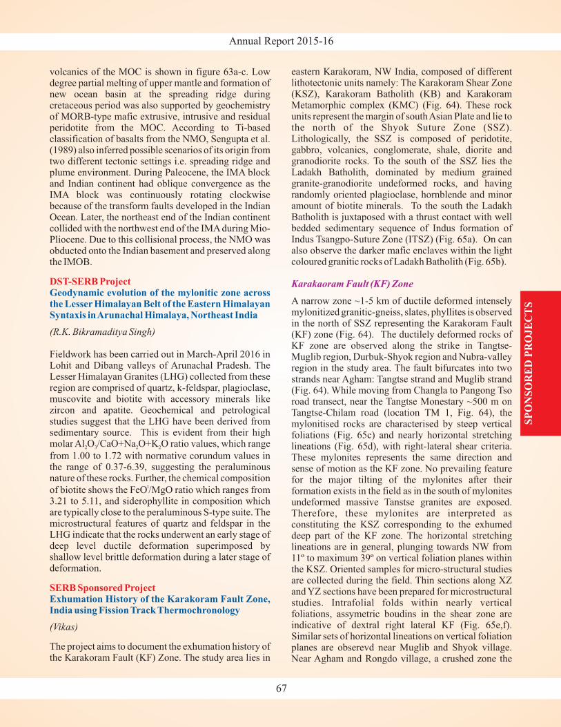
Annual Report 2015-16
SP
ON
SO
RE
D P
RO
JE
CT
S
volcanics of the MOC is shown in figure 63a-c. Lowdegree partial melting of upper mantle and formation ofnew ocean basin at the spreading ridge duringcretaceous period was also supported by geochemistryof MORB-type mafic extrusive, intrusive and residualperidotite from the MOC. According to Ti-basedclassification of basalts from the NMO, Sengupta et al.(1989) also inferred possible scenarios of its origin fromtwo different tectonic settings i.e. spreading ridge andplume environment. During Paleocene, the IMA blockand Indian continent had oblique convergence as theIMA block was continuously rotating clockwisebecause of the transform faults developed in the IndianOcean. Later, the northeast end of the Indian continentcollided with the northwest end of the IMA during Mio-Pliocene. Due to this collisional process, the NMO wasobducted onto the Indian basement and preserved alongthe IMOB.
(R.K. Bikramaditya Singh)
(Vikas)
Fieldwork has been carried out in March-April 2016 inLohit and Dibang valleys of Arunachal Pradesh. TheLesser Himalayan Granites (LHG) collected from theseregion are comprised of quartz, k-feldspar, plagioclase,muscovite and biotite with accessory minerals likezircon and apatite. Geochemical and petrologicalstudies suggest that the LHG have been derived fromsedimentary source. This is evident from their highmolar Al O /CaO+Na O+K O ratio values, which range
from 1.00 to 1.72 with normative corundum values inthe range of 0.37-6.39, suggesting the peraluminousnature of these rocks. Further, the chemical composition
of biotite shows the FeO /MgO ratio which ranges from3.21 to 5.11, and siderophyllite in composition whichare typically close to the peraluminous S-type suite. Themicrostructural features of quartz and feldspar in theLHG indicate that the rocks underwent an early stage ofdeep level ductile deformation superimposed byshallow level brittle deformation during a later stage ofdeformation.
The project aims to document the exhumation history ofthe Karakoram Fault (KF) Zone. The study area lies in
2 3 2 2
t
DST-SERB Project
SERB Sponsored Project
Geodynamic evolution of the mylonitic zone acrossthe Lesser Himalayan Belt of the Eastern HimalayanSyntaxis inArunachal Himalaya, Northeast India
Exhumation History of the Karakoram Fault Zone,India using Fission Track Thermochronology
eastern Karakoram, NW India, composed of differentlithotectonic units namely: The Karakoram Shear Zone(KSZ), Karakoram Batholith (KB) and KarakoramMetamorphic complex (KMC) (Fig. 64). These rockunits represent the margin of southAsian Plate and lie tothe north of the Shyok Suture Zone (SSZ).Lithologically, the SSZ is composed of peridotite,gabbro, volcanics, conglomerate, shale, diorite andgranodiorite rocks. To the south of the SSZ lies theLadakh Batholith, dominated by medium grainedgranite-granodiorite undeformed rocks, and havingrandomly oriented plagioclase, hornblende and minoramount of biotite minerals. To the south the LadakhBatholith is juxtaposed with a thrust contact with wellbedded sedimentary sequence of Indus formation ofIndus Tsangpo-Suture Zone (ITSZ) (Fig. 65a). On canalso observe the darker mafic enclaves within the lightcoloured granitic rocks of Ladakh Batholith (Fig. 65b).
A narrow zone ~1-5 km of ductile deformed intenselymylonitized granitic-gneiss, slates, phyllites is observedin the north of SSZ representing the Karakoram Fault(KF) zone (Fig. 64). The ductilely deformed rocks ofKF zone are observed along the strike in Tangtse-Muglib region, Durbuk-Shyok region and Nubra-valleyregion in the study area. The fault bifurcates into twostrands near Agham: Tangtse strand and Muglib strand(Fig. 64). While moving from Changla to Pangong Tsoroad transect, near the Tangtse Monestary ~500 m onTangtse-Chilam road (location TM 1, Fig. 64), themylonitised rocks are characterised by steep verticalfoliations (Fig. 65c) and nearly horizontal stretchinglineations (Fig. 65d), with right-lateral shear criteria.These mylonites represents the same direction andsense of motion as the KF zone. No prevailing featurefor the major tilting of the mylonites after theirformation exists in the field as in the south of mylonitesundeformed massive Tanstse granites are exposed.Therefore, these mylonites are interpreted asconstituting the KSZ corresponding to the exhumeddeep part of the KF zone. The horizontal stretchinglineations are in general, plunging towards NW from11º to maximum 39º on vertical foliation planes withinthe KSZ. Oriented samples for micro-structural studiesare collected during the field. Thin sections along XZand YZ sections have been prepared for microstructuralstudies. Intrafolial folds within nearly verticalfoliations, assymetric boudins in the shear zone areindicative of dextral right lateral KF (Fig. 65e,f).Similar sets of horizontal lineations on vertical foliationplanes are obserevd near Muglib and Shyok village.Near Agham and Rongdo village, a crushed zone the
Karakaoram Fault (KF) Zone
67
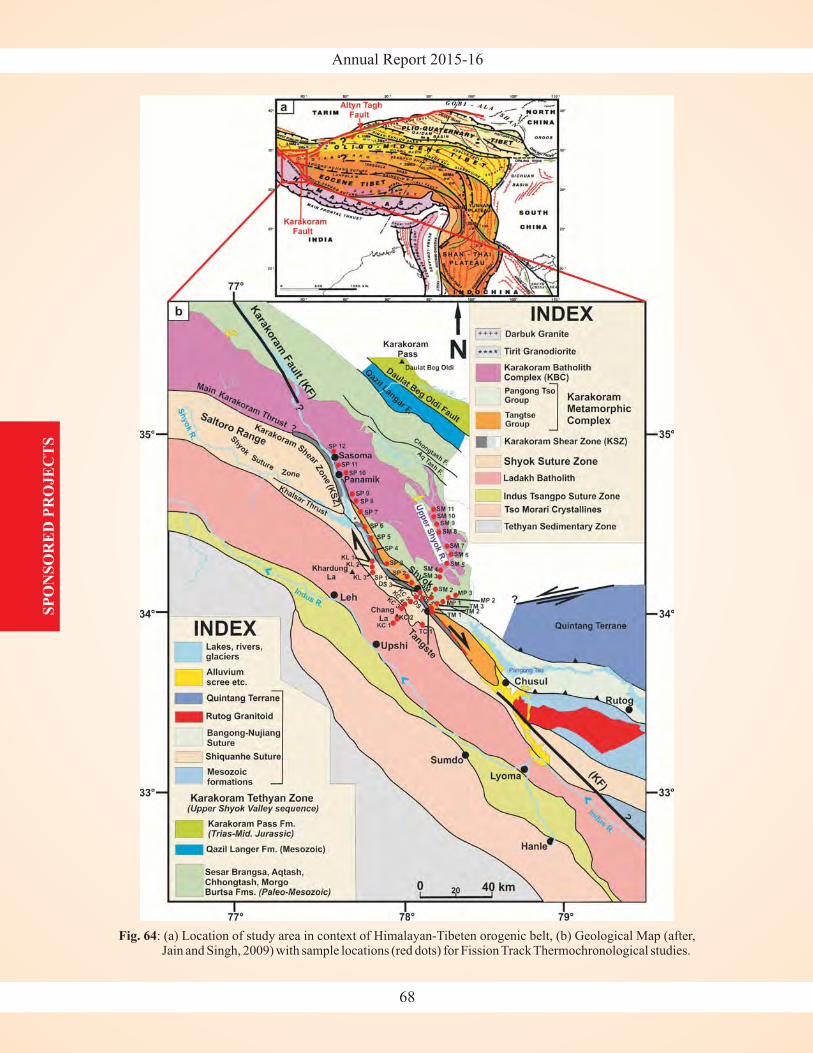
Annual Report 2015-16S
PO
NS
OR
ED
PR
OJE
CT
S
Fig. 64: (a) Location of study area in context of Himalayan-Tibeten orogenic belt, (b) Geological Map (after,Jain and Singh, 2009) with sample locations (red dots) for Fission Track Thermochronological studies.
68
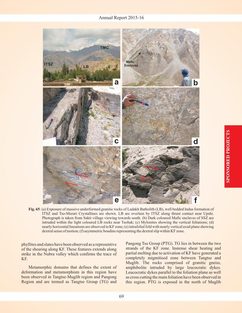
Annual Report 2015-16
SP
ON
SO
RE
D P
RO
JE
CT
S
Fig. 65: (a) Exposure of massive underformed granitic rocks of Ladakh Batholith (LB), well bedded Indus formation ofITSZ and Tso-Morari Crystallines are shown. LB are overlain by ITSZ along thrust contact near Upshi.Photograph is taken from Sakti village viewing towards south. (b) Dark coloured Mafic enclaves of SSZ areintruded within the light coloured LB rocks near Tsoltak; (c) Mylonites showing the vertical foliations; (d)nearly horizontal lineations are observed in KF zone; (e) intrafolial fold with nearly vertical axial plane showingdextral sense of motion; (f) asymmetric boudins representing the dextral slip within KF zone.
Pangong Tso Group (PTG). TG lies in between the twostrands of the KF zone. Instense shear heating andpartial melting due to activation of KF have generated acompletely migmitised zone between Tangtse andMuglib. The rocks comprised of granitic gneiss,amphibolite intruded by large leucocratic dykes.Leucocratic dykes parallel to the foliation plane as wellas cross cutting the main foliation have been observed inthis region. PTG is exposed in the north of Muglib
phyllites and slates have been observed as a representiveof the shearing along KF. These features extends alongstrike in the Nubra valley which confirms the trace ofKF.
Metamorphic domains that defines the extent ofdeformation and metamorphism in this region havebeen observed in Tangtse-Muglib region and PangongRegion and are termed as Tangtse Group (TG) and
69
Annual Report 2015-16S
PO
NS
OR
ED
PR
OJE
CT
S
strand while along the Muglib-Lukung-Phobrang roadtransect. The rocks consists of amphibolite, slate andalternate bands of marble and schist.
During this year, field work to collect structuraldata and samples for apatite and zircon fission trackthermochronological studies has been carried out in thetransects of Changla-Tangtse-Pangon Tso, Darbuk-Shyok, and S yok-Panamik-Sasoma (Fig. 64). A totalof around 80 samples are collected. In the first phase,analysis of 64 samples from Changla-Durbuk-Shyok,Tangtse-Muglib and Shyok-Murgo (upper Shyok)sections have been taken-up for Fission Track datingstudies (Fig. 64). Crushing and washing of samples,Magnetic Barrier Separation, Heavy Liquid Separation,and picking of good quality grains of apatite and zirconhave been completed. However, fission track datingstudy is under progress.
Birmania Basin, a small oval-shaped basin, roughlytrending north-south, located in the centre of the TharDesert, near Jaisalmer, western Rajasthan is the studyarea for the ongoing project. Considered to be anisolated remnant of the Marwar Basin, it is underlain bythe Malani Igneous rocks (780-680 Ma) andunconformably overlain by the Lathi Formation(Jurassic). It comprises of ~900 m thick sequence ofsiliciclastic, carbonate and phosphorites facies. Thesedimentary rocks of Birmania Basin are broadlygrouped into two formations, the lower RandhaFormation made up of medium to coarse siliciclasticrocks, and the upper Birmania Formation. The contactbetween the two is not visible owing to large sandcovered tracts. Birmania Formation is calcareous in thelower part with light to dark grey, resinous bands, lensesand large nodules of chert occurring deeply embeddedwithin the calcareous rocks. The upper part of BirmaniaFormation is calcareous with siliceous content. Dark,bands of phosphorite occur along with calcareoussandstone and shale.
Carbon isotopic studies carried out in this basin(Maheshwari et al., 2007) revealed the pattern to besimilar to the well-established, global Precambrian-Cambrian isotopic curves. Hence, an Ediacaran-EarlyCambrian age was assigned to this basin which had beenconsidered unfossiliferous. The recent discovery of
from the phosphate beds of
h
(Rajita Shukla)
Wengania exquisita
ProjectPalaeobiology of the Birmania Basin, Rajasthan andits correlation with the Krol-Tal belt of LesserHimalaya
Birmania Formation shows the fossiliferous nature ofthe basin, and indicates an Ediacaran age for theformation. During the present study an assemblage ofcyanobacterial and algal filamentous forms has beenrecorded from the cherts of the lower part of BirmaniaFormation. In the wake of these records, the age ofBirmania Basin is being reassessed.
Petrographic and geochemical analysis of cherts,carbonates, phosphorites and siliciclastics from theRandha and Birmania formations and Krol Group isalso being carried out. This will aid in definiteidentification of the rocks, understanding thedepositional environment and comparing the two basinsfor biostratigraphic correlation.
Samples were collected from Ordovician to Devoniansuccession of Pin Valley. Of which, the samples fromthe Ordovician section were analyzed to studydifferent microfossils assemblage. The Ordoviciansedimentary succession is typical of carbonateplatform facies. The microscopic studies revealabundant accumulation of calcareous algae along with,bryozoans and other unidentified microfauna. Amongthese the widely spread forms are the green calcareousalgae and bryozoans. The algal assemblages wereconsist mainly of the order Dasycladales that weremost numerous in the Ordovician-Siluriansuccessions. Calcareous algae are relatively commonbiotic constituent in marine carbonate units and playedan important role in rock-building, and are theimportant constituents of the reef complexes inOrdovician period. These benthic marine chlorophytegroups, indicates shallower part of the infra-littoralstage, and constitute as useful parameter to define thedepositional environment of the sequence. Theirrelative abundance was probably controlled bysubstrate and rates of deposition. Calcareous algalremains are widespread in various facies in Ordoviciancarbonate complexes and provide useful informationabout the paleoenvironments, which can complementinterpretations based on other biota and depositionaltextures. The most frequent dasycladacean algalrecognized in the carbonate facies is and
; these forms are usually accompanied by. The various genera of bryozoans
identified are as
(Shivani Pandey)
VermiporellaDasyporellaMoniliporella
Calloporella, Cyphotrypa, Dekayai,
Young Scientist DST sponsored ProjectBiostratigraphy and depositional history of theupper Cambrian - lower Ordovician succession ofPin section in the Spiti Basin, Tethys Himalaya
70
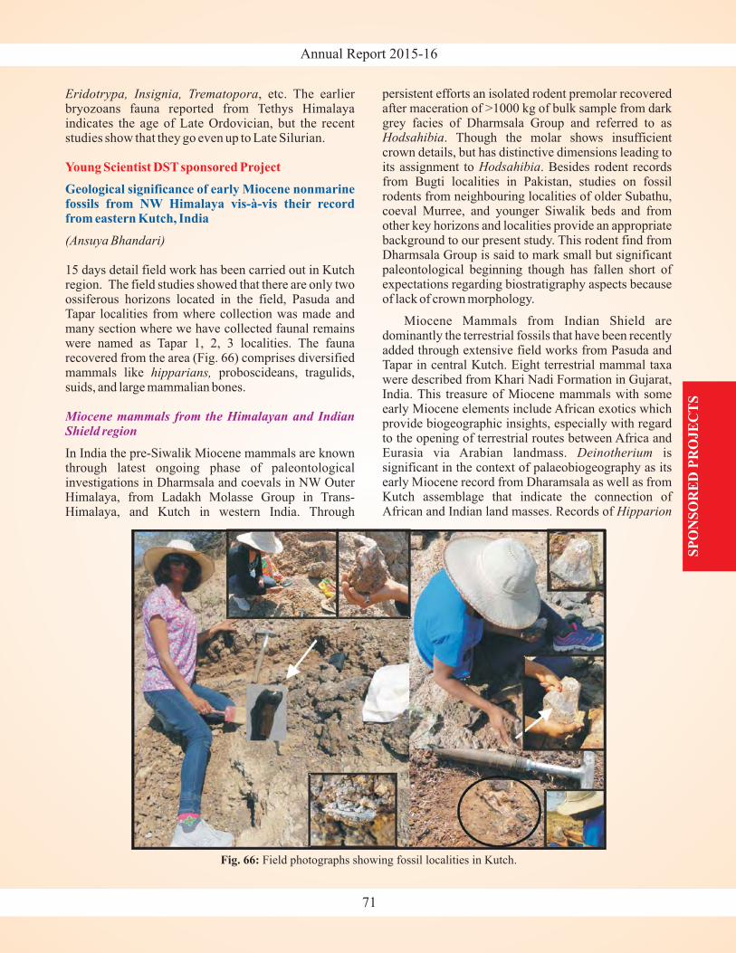
Annual Report 2015-16
SP
ON
SO
RE
D P
RO
JE
CT
S
Eridotrypa, Insignia, Trematopora
(Ansuya Bhandari)
hipparians,
, etc. The earlierbryozoans fauna reported from Tethys Himalayaindicates the age of Late Ordovician, but the recentstudies show that they go even up to Late Silurian.
15 days detail field work has been carried out in Kutchregion. The field studies showed that there are only twoossiferous horizons located in the field, Pasuda andTapar localities from where collection was made andmany section where we have collected faunal remainswere named as Tapar 1, 2, 3 localities. The faunarecovered from the area (Fig. 66) comprises diversifiedmammals like proboscideans, tragulids,suids, and large mammalian bones.
In India the pre-Siwalik Miocene mammals are knownthrough latest ongoing phase of paleontologicalinvestigations in Dharmsala and coevals in NW OuterHimalaya, from Ladakh Molasse Group in Trans-Himalaya, and Kutch in western India. Through
Young Scientist DST sponsored Project
Geological significance of early Miocene nonmarinefossils from NW Himalaya vis-à-vis their recordfrom eastern Kutch, India
Miocene mammals from the Himalayan and IndianShield region
persistent efforts an isolated rodent premolar recoveredafter maceration of >1000 kg of bulk sample from darkgrey facies of Dharmsala Group and referred to as
. Though the molar shows insufficientcrown details, but has distinctive dimensions leading toits assignment to . Besides rodent recordsfrom Bugti localities in Pakistan, studies on fossilrodents from neighbouring localities of older Subathu,coeval Murree, and younger Siwalik beds and fromother key horizons and localities provide an appropriatebackground to our present study. This rodent find fromDharmsala Group is said to mark small but significantpaleontological beginning though has fallen short ofexpectations regarding biostratigraphy aspects becauseof lack of crown morphology.
Miocene Mammals from Indian Shield aredominantly the terrestrial fossils that have been recentlyadded through extensive field works from Pasuda andTapar in central Kutch. Eight terrestrial mammal taxawere described from Khari Nadi Formation in Gujarat,India. This treasure of Miocene mammals with someearly Miocene elements include African exotics whichprovide biogeographic insights, especially with regardto the opening of terrestrial routes between Africa andEurasia via Arabian landmass. issignificant in the context of palaeobiogeography as itsearly Miocene record from Dharamsala as well as fromKutch assemblage that indicate the connection ofAfrican and Indian land masses. Records of
Hodsahibia
Hodsahibia
Deinotherium
Hipparion
Fig. 66: Field photographs showing fossil localities in Kutch.
71
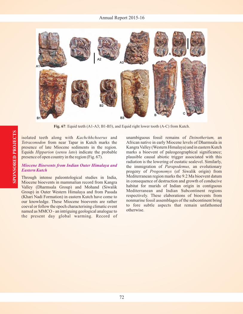
Annual Report 2015-16S
PO
NS
OR
ED
PR
OJE
CT
S
isolated teeth along with andfrom near Tapar in Kutch marks the
presence of late Miocene sediments in the region.Equids ( ) indicate the probablepresence of open country in the region (Fig. 67).
Through intense paleontological studies in India,Miocene bioevents in mammalian record from KangraValley (Dharmsala Group) and Mohand (SiwalikGroup) in Outer Western Himalaya and from Pasuda(Khari Nadi Formation) in eastern Kutch have come toour knowledge. These Miocene bioevents are rathercoeval or follow the epoch characterising climatic eventnamed as MMCO - an intriguing geological analogue tothe present day global warming. Record of
KachchhchoerusTetraconodon
Hipparion sensu lato
Miocene Bioevents from Indian Outer Himalaya andEastern Kutch
unambiguous fossil remains of anAfrican native in early Miocene levels of Dharmsala inKangra Valley (Western Himalaya) and in eastern Kutchmarks a bioevent of paleogeographical significance;plausible causal abiotic trigger associated with thisradiation is the lowering of eustatic sealevel. Similarly,the immigration of an evolutionaryprogeny of (of Siwalik origin) fromMediterranean region marks the 9.2 Ma bioevent datumin consequence of destruction and growth of conducivehabitat for murids of Indian origin in contiguousMediterranean and Indian Subcontinent regionsrespectively. These elaborations of bioevents fromnonmarine fossil assemblages of the subcontinent bringto fore subtle aspects that remain unfathomedotherwise.
Deinotherium,
Parapodemus,Progonomys
Fig. 67: Equid teeth (A1-A3; B1-B3), and Equid right lower tooth (A-C) from Kutch.
72

Annual Report 2015-16
Paper Published
1. Acharya, S.S., Panigrahi, M.K., Gupta, A.K. &Tripathy, S. 2015: Response of trace metal redoxproxies in continental shelf environment: EasternArabian Sea scenario. Continental Shelf Research,106, 70-84.
2. Acharya, S.S., Panigrahi, M.K., Kurian, J., Gupta,A.K. & Tripathy, S. 2016: Speciation of phosphorusin the continental shelf sediments in the EasternArabian Sea. Continental Shelf Research, 115, 65-75.
3. Agrawal, S., Srivastava, P., Meena, N.K., Rai, S.,Bhushan, R., Misra, D.K. & Gupta, A.K.
N) isotopes and MagneticSusceptibility record of late Holocene climatechange from a lake profile of the northeastHimalaya. Journal of Geological Society of India,86, 696-705.
4. Asthana, A.K.L., Gupta, A.K., Luirei, K., Bartarya,S.K., Rai, S.K. & Tiwari, S.K. 2015: A QuantitativeAnalysis of the Ramganga Drainage basin andstructural control on drainage pattern in the faultzones, Uttarakhand. Journal of Geological Societyof India, 86(1), 9-22.
5. Bhakuni, S.S. & Luirei, K. 2016: Normal faults neartop of footwall of Ramgarh Thrust along Kosi Rivervalley, Kumaun Lesser Himalaya. Current Science,110(4), 640-648.
6. Bhandari, A., Pickford, M. & Tiwari, B.N. 2015:Basal Late Miocene Mammal Fauna from centralKachchh. Munchner GeowissenschflicheAbhandlungen, 43(A), 1-40.
7. Bohra, A. 2016. Applications of CRN datingtechnique with reference to Indian Himalaya: ACompilation. Himalayan Geology, 37(1), 54-66.
8. Bohra, A. & Kotlia, B.S. 2015: Tectono-climaticsignatures during the Late Quaternary in the YunamBasin, Baralacha Pass (Upper Lahaul Valley, India),derived from multi-proxy records. QuaternaryInternational, 371,111-121.
9. Chaudhary, S., Shukla, U.K., Sundriyal, Y.P.,Srivastava, P. & Jalal, Poonam 2015: Formation ofpaleovalleys in the Central Himalaya during thevalley aggradation. Quaternary International, 371,254-267.
2015:
Stable (δ C and δ13 15
10. Das, S., Mukherjee, B.K., Basu, A.R. & Sen, K.2015: Peridotitic minerals of the Nidar Ophiolite inthe NW Himalaya: sourced from the depth ofmantle transition zone and above. GeologicalSociety of London, 412, 271-286.
11. Dosseto, A., Vigier, N., Joannes-Boyau, R., Moffat,I., Singh, T. & Srivastava, P. 2015: Rapid responseof silicate weathering rates to climate change in theHimalaya. Geochemical Perspectives Letters, 1,10-19.
12. Dutt, S., Gupta, A.K., Clemens, S.C., Cheng, H.Singh, R.K., Kathayat, G. & Edwards, R.L. 2015:Abrupt changes in Indian Summer Monsoonstrength during 33,800 to 5500 years B.P.Geophysical Research Letters, 42(13),5526-5532
13. Ganguly, S., Tiwari, S., Bhan, U., Mittal, S. & Rai,S. 2015: Melting of Sea Ice Inexplicable for RecentGlobal Eustatic Sea Level Rise. Journal of EarthScience and Climate Change, 6, 245.
14. Gupta, A.K., Yuvaraja, A., Prakasam, M., Clemens,S.C. & Velu, A. 2015: Evolution of the South Asianmonsoon wind system since the late MiddleMiocene. Palaeogeography, Palaeoclimatology,Palaeoecology, 438, 160-167.
15. Gupta, S. & Kumar, K. 2015: Early Eocene rodents(Mammalia) from the Subathu Formation of typearea (Himachal Pradesh), NW sub-Himalaya,India: palaeobiogeographic implications. Journalof Earth System Science, 124(6), 1201-1221.
16. Gupta, V. & Sharma, Ruchika 2015: KinematicRockfall HazardAssessment along a TransportationCorridor in the Upper Alaknanda valley, GarhwalHimalaya, India. Bulletin of Engineering Geologyand Environment, 74(2), 315-326.
17. Gupta, V., Bhasin, R., Kaynia, A., Tandon, RuchikaS. & Venkateshwarlu, B. 2016: Landslide hazard inthe Nainital Township, Kumaun Himalaya, India -the case of Sept 2014 landslide in Nainital, KumaunHimalaya. Natural Hazards, 80(2), 863-877.
18. Gupta, V., Nautiyal, Hemlata, Kumar, V., Jamir, I. &Tandon, Ruchika S. 2016: Landslide hazardsaround Uttarkashi township, Garhwal Himalayaafter the tragic flash flood in June 2013. NaturalHazards, 80(3), 1689-1707.
RESEARCH PUBLICATIONS
73
RE
SE
AR
CH
PU
BL
ICA
TIO
NS
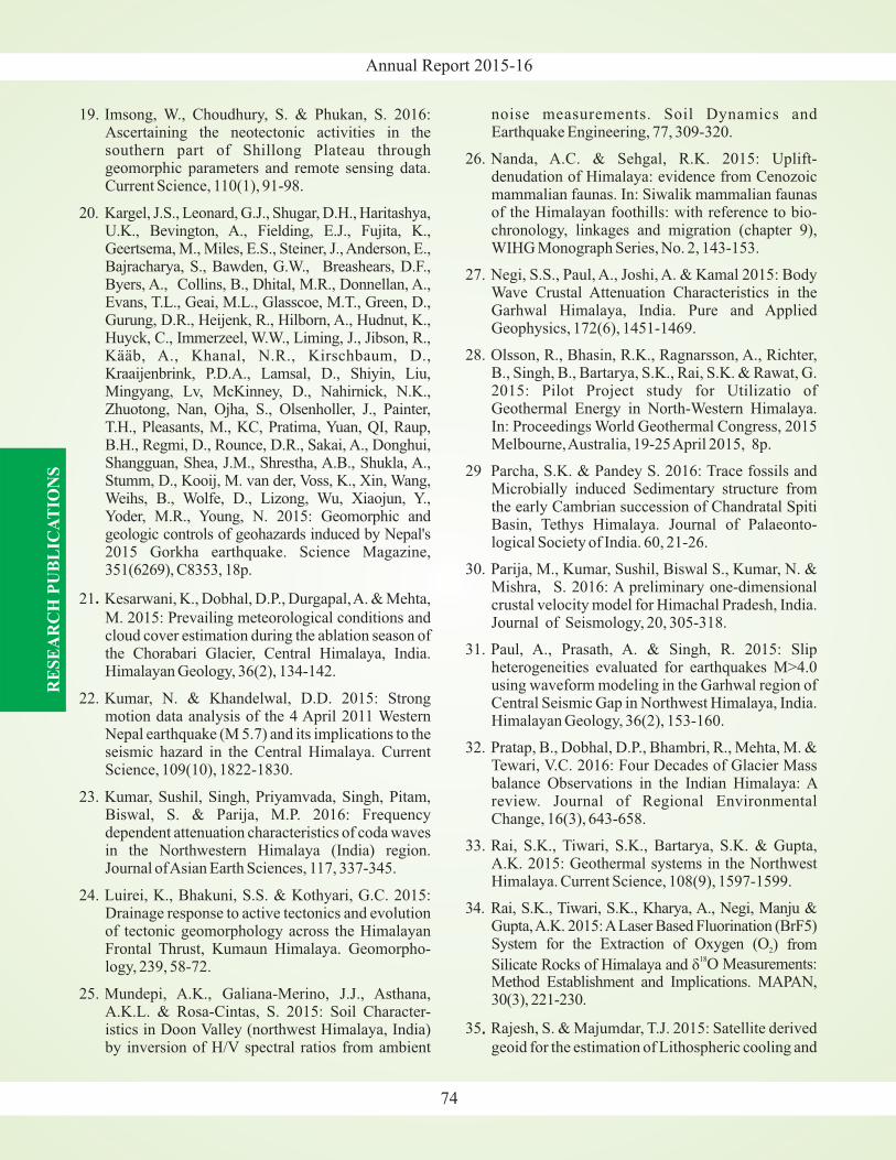
Annual Report 2015-16
19. Imsong, W., Choudhury, S. & Phukan, S. 2016:Ascertaining the neotectonic activities in thesouthern part of Shillong Plateau throughgeomorphic parameters and remote sensing data.Current Science, 110(1), 91-98.
20. Kargel, J.S., Leonard, G.J., Shugar, D.H., Haritashya,U.K., Bevington, A., Fielding, E.J., Fujita, K.,Geertsema, M., Miles, E.S., Steiner, J., Anderson, E.,Bajracharya, S., Bawden, G.W., Breashears, D.F.,Byers, A., Collins, B., Dhital, M.R., Donnellan, A.,Evans, T.L., Geai, M.L., Glasscoe, M.T., Green, D.,Gurung, D.R., Heijenk, R., Hilborn, A., Hudnut, K.,Huyck, C., Immerzeel, W.W., Liming, J., Jibson, R.,Kääb, A., Khanal, N.R., Kirschbaum, D.,Kraaijenbrink, P.D.A., Lamsal, D., Shiyin, Liu,Mingyang, Lv, McKinney, D., Nahirnick, N.K.,Zhuotong, Nan, Ojha, S., Olsenholler, J., Painter,T.H., Pleasants, M., KC, Pratima, Yuan, QI, Raup,B.H., Regmi, D., Rounce, D.R., Sakai, A., Donghui,Shangguan, Shea, J.M., Shrestha, A.B., Shukla, A.,Stumm, D., Kooij, M. van der, Voss, K., Xin, Wang,Weihs, B., Wolfe, D., Lizong, Wu, Xiaojun, Y.,Yoder, M.R., Young, N. 2015: Geomorphic andgeologic controls of geohazards induced by Nepal's2015 Gorkha earthquake. Science Magazine,351(6269), C8353, 18p.
21 Kesarwani, K., Dobhal, D.P., Durgapal,A. & Mehta,
M. 2015: Prevailing meteorological conditions andcloud cover estimation during the ablation season ofthe Chorabari Glacier, Central Himalaya, India.Himalayan Geology, 36(2), 134-142.
22. Kumar, N. & Khandelwal, D.D. 2015: Strongmotion data analysis of the 4 April 2011 WesternNepal earthquake (M 5.7) and its implications to theseismic hazard in the Central Himalaya. CurrentScience, 109(10), 1822-1830.
23. Kumar, Sushil, Singh, Priyamvada, Singh, Pitam,Biswal, S. & Parija, M.P. 2016: Frequencydependent attenuation characteristics of coda wavesin the Northwestern Himalaya (India) region.Journal ofAsian Earth Sciences, 117, 337-345.
24. Luirei, K., Bhakuni, S.S. & Kothyari, G.C. 2015:Drainage response to active tectonics and evolutionof tectonic geomorphology across the HimalayanFrontal Thrust, Kumaun Himalaya. Geomorpho-logy, 239, 58-72.
25. Mundepi, A.K., Galiana-Merino, J.J., Asthana,A.K.L. & Rosa-Cintas, S. 2015: Soil Character-istics in Doon Valley (northwest Himalaya, India)by inversion of H/V spectral ratios from ambient
.
noise measurements. Soil Dynamics andEarthquake Engineering, 77, 309-320.
26. Nanda, A.C. & Sehgal, R.K. 2015: Uplift-denudation of Himalaya: evidence from Cenozoicmammalian faunas. In: Siwalik mammalian faunasof the Himalayan foothills: with reference to bio-chronology, linkages and migration (chapter 9),WIHG Monograph Series, No. 2, 143-153.
27. Negi, S.S., Paul, A., Joshi, A. & Kamal 2015: BodyWave Crustal Attenuation Characteristics in theGarhwal Himalaya, India. Pure and AppliedGeophysics, 172(6), 1451-1469.
28. Olsson, R., Bhasin, R.K., Ragnarsson, A., Richter,B., Singh, B., Bartarya, S.K., Rai, S.K. & Rawat, G.2015: Pilot Project study for Utilizatio ofGeothermal Energy in North-Western Himalaya.In: Proceedings World Geothermal Congress, 2015Melbourne,Australia, 19-25April 2015, 8p.
29 Parcha, S.K. & Pandey S. 2016: Trace fossils andMicrobially induced Sedimentary structure fromthe early Cambrian succession of Chandratal SpitiBasin, Tethys Himalaya. Journal of Palaeonto-logical Society of India. 60, 21-26.
30. Parija, M., Kumar, Sushil, Biswal S., Kumar, N. &Mishra, S. 2016: A preliminary one-dimensionalcrustal velocity model for Himachal Pradesh, India.Journal of Seismology, 20, 305-318.
31. Paul, A., Prasath, A. & Singh, R. 2015: Slipheterogeneities evaluated for earthquakes M>4.0using waveform modeling in the Garhwal region ofCentral Seismic Gap in Northwest Himalaya, India.Himalayan Geology, 36(2), 153-160.
32. Pratap, B., Dobhal, D.P., Bhambri, R., Mehta, M. &Tewari, V.C. 2016: Four Decades of Glacier Massbalance Observations in the Indian Himalaya: Areview. Journal of Regional EnvironmentalChange, 16(3), 643-658.
33. Rai, S.K., Tiwari, S.K., Bartarya, S.K. & Gupta,A.K. 2015: Geothermal systems in the NorthwestHimalaya. Current Science, 108(9), 1597-1599.
34. Rai, S.K., Tiwari, S.K., Kharya, A., Negi, Manju &Gupta,A.K. 2015:ALaser Based Fluorination (BrF5)System for the Extraction of Oxygen (O
O Measurements:Method Establishment and Implications. MAPAN,30(3), 221-230.
35 Rajesh, S. & Majumdar, T.J. 2015: Satellite derived
geoid for the estimation of Lithospheric cooling and
2) from
Silicate Rocks of Himalaya and δ18
.
74
RE
SE
AR
CH
PU
BL
ICA
TIO
NS
Annual Report 2015-16
basal heat flux anomalies over the Northern IndianOcean Lithosphere. Journal of Earth SystemScience (Springer), 124(8), 1677-1691.
36 Rajesh, S., Majumdar, T.J. & Krishna, K.S. 2015:
Lithospheric stretching and the long wavelengthfree-air gravity anomaly of the Eastern Continental
Margin of India and the 85 E Ridge, Bay of Bengal.Indian Journal of Geo-Marine Sciences, 44(6), 1-12.
37. Rana, R.S., Kumar, K., Zack, S., Sole, F., Rose,K.D., Missiaen, P., Singh, L., Sahni, A. & Smith, T.2015: Craniodental and postcranial morphology ofIndohyaenodon raoi from the early Eocene of India,and its implications for ecology, phylogeny, andbiogeography of hyaenodontid mammals. Journalof Vertebrate Paleontology, 35(5), e965308, 22p.
38. Rawat, S., Gupta, A.K., Sangode, S.J., Srivastava,P. & Nainwal, H.C. 2015: Late Pleistocene-Holocene vegetation and Indian summer monsoonrecord from the Lahaul, Northwest Himalaya,India. Quaternary Science Reviews, 114, 167-181.
39. Rawat, S., Gupta, A.K., Srivastava, P., Sangode,S.J. & Nainwal, H.C. 2015: A 13,000 year record ofenvironmental magnetic variations in the lake andpeat deposits from Chandra valley, Lahaul:Implications to Holocene monsoonal variability inthe NW Himalaya. Palaeogeography Palaeo-climatology Palaeoecology, 440, 116-127.
40. Samanta, S., Dalai, T.K., Pattanaik, J.K., Rai, S.K.& Mazumdar, A. 2015: Dissolved inorganic carbon
(DIC) and its δ C in the Ganga (Hooghly) Riverestuary, India: Evidence of DIC generation viaorganic carbon degradation and carbonatedissolution. Geochimica et Cosmochimica Acta,165, 2340-2355.
41. Sarkar, S., Prakasam, M., Banerji, U.S., Bhushan,R., Meena, N.K. & Gaury, P.K. 2016: Rapidsedimentation history of Rewalsar Lake, LesserHimalaya, India during the last fifty years -
Estimated using Cs and Pb dating techniques: Acomparative study with other North-WesternHimalayan Lakes. Himalayan Geology, 37(1), 1-7.
42. Sen, K., Chaudhury, R. & Pfänder, J. 2015: Ar- Arage constraint on deformation and brittle-ductiletransition of the Main Central Thrust and the SouthTibetan Detachment zone from Dhauliganga valley,Garhwal Himalaya, India. Journal of Geodynamics,88, 1-13.
43. Shukla, A. & Ali, I. 2016: A hierarchical knowledgebased classification for glacier terrain mapping - A
.
o
13
137 210
40 39
case study from Kolahoi glacier Annals ofGlaciology 57(71), 1-10.
44. Singh, D.S., Gupta, A.K., Sangode, S.J., Clemens,S.C., Prakasam, M., Srivastava, P. & Prajapati, S.K.2015: Multiproxy record of monsoon variabilityfrom the Ganga Plain during 400-1200 A.D.Quaternary International, 371, 157-163.
45. Singh, H., Prasad, M., Kumar, K. & Singh, S.K.2015: Early Eocene macroflora and associatedpalynofossils from the Cambay Shale Formation,Western India: phytogeographic and palaeoclimaticimplications. Palaeoworld, 24(4), 293-323.
46. Singh, I. B., Sahni, A., Jain, A.K., Upadhya R.,Parcha, S.K., Parmar, V., Agarwal, K. K., Shukla,S., Kumar, S., Singh, M.P., Ahmad, S., Jigyasu,D.K., Arya R. & Pandey, S., 2015: Post India-Asiacollision sedimentation (Indus Basin) in Ladakh,India: Implications for the evolution of the northernmargin of Indian Plate. Journal of PalaeontologicalSociety of India, 60(2), 97-142.
47. Singh, N., Patel, N.R., Singh, J., Raja, P., Soni, P. &Parihar, J.S. 2016: Carbon exchange in someinvasive species in the Himalayan foothills.Tropical Ecology, 57(2), 263-270.
48. Smith, T., Sole, F., Missiaen, P., Rana, R.S., Kumar,K., Sahni,A. & Rose, K.D. 2015: First early Eocenetapiroid from India and its implication for thepalaeobio-geographic origin of perissodactyls.Palaeovertebrata, 39(2), e5.
49. Sundriyal, Y.P., Shukla, A.D., Rana, N.,Jayangondaperumal, R., Srivastava, P., Chamyal,L.S., Sati, S.P. & Juyal, N. 2015: Terrain responseto the extreme rainfall event of June 2013: Evidencefrom the Alaknanda and Mandakini River Valleys,Garhwal Himalaya, India. Episodes, 38, 179-188.
50. Tandon, Ruchika S. & Gupta, V. 2015: Estimationof strength characteristics of different Himalayanrocks from Schmidt hammer rebound, point loadindex and compressional wave velocity. Bulletin ofEngineering Geology and Environment, 74(2),521-533.
51. Tandon, Ruchika S., Gupta, V. & Sen, K.K. 2015:Seismic properties of naturally deformed quartzitesof the Alaknanda valley, Garhwal Himalaya, India.Journal of Earth System Science, 124(6), 1159-1175.
52. Thakur, V.C. & Jayangondaperumal, R. 2015: Seis-mogenic active fault zone between 2005 Kashmirand 1905 Kangra earthquake meizoseismal regions
75
RE
SE
AR
CH
PU
BL
ICA
TIO
NS

Annual Report 2015-16
and earthquake hazard in eastern Kashmir seismicgap. Current Science, 109(3), 610-617.
53. Tiwari, S.K., Singh, Raj K., Singh, J., Gupta, A.K.,Bartarya, S.K. & Rai, S.K. 2015: Impact of limestonemining activities on major ion geochemistry of KremMarkhyrdop water, Meghalaya, India. HimalayanGeology, 36(1) 74-80.
54. Yadava,A.K., Yadav, R.R., Misra, K.G., Singh, J. &Singh, D. 2015: Tree ring evidence of late summerwarming in Sikkim, northeast India. QuaternaryInternational, 371, 175-180.
1. Ahluwalia, R.S., Rai, S.P., Gupta, A.K., Dobhal,D.P., Tiwari, R.K., Garg, P.K. & Kesharwani, K. :Towards the understanding of the flash floodthrough isotope approach in Kedarnath valley inJune 2013, Central Himalaya, India. NaturalHazards (In Press).
2. Bartarya, S.K., Thakur, D. & Choubey, V.M. :
Effects of Aquifer Characteristics on RnConcentration in Groundwater of the NWHimalayan region. Groundwater (Communicated).
3. Bhakuni S.S., Philip, G. & Suresh, N. : Analysis ofstructural elements across Nalagarh lobe, NWHimalaya: implication to thrusting across tectonicedge of NW limb of Nahan salient, HimachalPradesh. International Journal of Earth Sciences(Under revision).
4. Bhambri, R., Mehta, M., Dobhal D.P., Gupta A.K.,Pratap, B., Kesarwani K. & Verma A. : Devastationin the Kedarnath (Mandakini) Valley, Garhwal
Himalaya during 16 -17 June, 2013: A remotesensing and ground based assessment. NaturalHazards (In Press).
5. Chauhan, Dinesh S., Sharma, Rajesh & Rao, D.R. :Lazulite from a new occurrence near Main CentralThrust in Kumaun Himalaya, India: Fluid inclusion,EPMAand Raman spectroscopy focusing lazulite inhigh tectonized zone. Mineralogical Magazine(Communicated).
6. Chauhan, P., Chauniyal, D.D., Singh, N. & Tiwari,R.K. : Quantitative geo-morphometric and landcover-based micro-watershed prioritization in theTons river basin of the lesser Himalaya. Environ-mental Earth Sciences (In Press).
222
th th
Papers: In Press/Accepted/Under revision/Communicated
7. Chauhan, P., Singh, Nilendu, Chauniyal, D.D.,Ahluwalia, Rajeev & Singhal, Mohit : Differentialbehaviour of a lesser Himalayan watershed inextreme rainfall regimes. Journal of Earth SystemScience (Communicated).
8. Chauhan, V., Khandelwal, D.D. & Kumar, N. : Acomparative study of gravity and crustaldeformation data through SuperconductingGravimeter and GPS in the North-West Himalayanregion. Episodes (Accepted).
9. Gautam P.K.R., Kumar, N. & Dabral, C.P.:Continuous GPS time series analysis of MPGOGhuttu, Central Himalaya, India. Journal ofGeosciences (Under review).
10. Gautam, P.K.R., Arora, S., Kannaujiya, S., Singh,Anjali, Goswami, A. & Champati, P.K. :Comparative evaluation of ground water storageusing GRACE-GPS data in highly urbanized regionin Uttara Pradesh, India. SWRM (Under review).
11. Ghosh, R., Sehgal, R.K., Srivastava, P., Shukla,U.K., Nanda, A.C. & Singh, D.S. : Discovery ofElephas cf. namadicus from the late Pleistocenestrata of marginal Ganga plain. Journal of theGeological Society of India (In press).
12. Groppo, C., Rolfo, F., Sachan, H.K. & Rai, S.K. :Petrology of blueschist from the westernHimalaya(Ladakh, NW India): Exploring thecomplex behaviour of a lawsonite-bearing systemin a paleo-accretionary setting. Lithos (In Press).
13. Gupta, V., Bhasin, R., Kaynia, A.M., Kumar, Vipin,Saini, A.S., Tandon, Ruchika S. & Pabst, Thomas :Finite Element Analysis of failed slope by ShearStrength Reduction technique: a case study forSurabhi Resort Landslide, Mussoorie township,Garhwal Himalaya. Geomatics, Natural Hazardsand Risk (In Press).
14. Gupta, V., Jamir, I., Kumar, V. & Devi, M. :Geomechanical characterisation of slopes forassessing rockfall hazards between Janki Chatti andYamunotri Temple, Yamuna valley, HigherHimalaya, India Engineering Geology (Communi-cated).
15. Gupta, V., Tandon R.S., Venkateshwarlu, B.,Bhasin, R.K. & Kaynia A.M. : Accelerated massmovement activities due to increased rainfall in theNainital township, Kumaun Lesser Himalaya,India. Current Science (Communicated).
16. Hazarika, D., Paul, Arpita, Wadhawan, Monika,Kumar, N. & Sen, K. : Seismotectonics of the trans-
76
RE
SE
AR
CH
PU
BL
ICA
TIO
NS
Annual Report 2015-16
Himalaya, Eastern Ladakh, India: constraints fromMoment Tensor Solutions of local earthquake data.Tectonophysics (Under review).
17. Hazarika, D., Wadhawan, Monika, Paul, Arpita &Kumar, N. : Geometry of the Main HimalayanThrust and Moho beneath Satluj valley, NorthwestHimalaya: constraints from receiver functionanalysis. Journal of Geophysical Research (Underreview).
18. Imsong, W., Choudhury, S. & Phukan, S. :Morphodynamics of the Kulsi River basin in NorthShillong Plateau exhibiting evidences of episodicinundation and channel migration in the LateHolocene Epoch. Quaternary International(Communicated).
19. Jayangondaperumal, R., Kumahara, Y., Thakur,V.C., Dubey, S., Kumar,Anil, Srivastava, P., Dubey,A.K. & Joevivek, V. : Great earthquake surfaceruptures along backthrust of the Janauri anticline,NW Himalaya. JAES (In Press).
20. Karakoti, I., Kesarwani, K., Mehta, M. & Dobhal,D.P. : Extended T-index models for glacier surfacemelting: a case study from Chorabari Glacier,Central Himalaya. Theoretical and AppliedClimatology (Springer) (In Press).
21. Karakoti, I., Kesarwani, K., Mehta, M. & DobhalD.P.: Modeling of Meteorological Parameters forthe Chorabari Glacier valley, Central Himalaya,India. Current Science (Communicated).
22 Kesarwani, K., Dobhal, D.P., Durgapal, A., Mehta,
M. & Karakoti, I.: Surface energy balance and massfluctuation on the debris-covered ablation zone ofChorabari Glacier, Central Himalaya, India.Annalsof Glaciology (Communicated).
23. Kharya, A., Sachan, H.K., Tiwari, S.K., Singhal, S.,Singh, P. Chandra, Rai, S.K., Kumar, Sushil, Mehta,M. & Gautam, P.K.R.: New occurrence of Albititefrom Nubra valley, Ladakh: Characterization frommineralogy and whole rock geochemistry. CurrentScience (Communicated).
24. Kothyari, G.C. & Luirei K.: Late Quaternarytectonics and fluvial aggradation in monsoondominated Saryu River valley: Central KumaunHimalaya. Geomorphology (Under revision).
25. Kumar, A., Srivastava, P., Meena, N.K. : LatePleistocene aeolian activity in the cold desert ofLadakh: a record from sand ramps. QuaternaryInternational (Accepted).
.
26. Kumar, A., Srivastava, P.: Late Pleistocene-Holocene record of aggradation and incision ofIndus River, Ladakh, NW Himalaya: Role ofpaleoclimate and tectonics. Quaternary Research(Communicated).
27. Kumar, Amit, Gokhale, A.A., Shukla, T. & Dobhal,D.P.: Hydro-climatic influence on particle sizedistribution of suspended sediments evacuatedfrom debris-covered Chorabari Glacier, upperMandakini Catchment, Central Himalaya.Geomorphology (Communicated).
28. Kumar, Amit, Verma, A., Gokhale, A.A., Misra, A.,Sundriyal, Shipika & Dobhal, D.P.: GoverningHydro-meteorological Processes at Debris-coveredHimalayan Glacier:ACase Study from Data ScarceRegion of Indian Himalaya. Hydrological sciencesJournal (Communicated).
29. Kumar V., Gupta, V., Jamir, I. : Hazard Evaluationof Progressive Pawari Landslide Zone, SatlujValley, Higher Himalaya, India. Natural Hazard(Communicated).
30. Kumar, N., Chauhan, V., Dhamodharan, S., Rawat,G., Hazarika, D. & Gautam, P.K.R. : Prominent pre-cursory signatures observed in soil and water radondata at MPGO, Ghuttu for Mw7.8 NepalEarthquake. Current Science (Under revision).
31. Kumar, P., Joshi, A. & Kumar, Sushil : Determinationof site effect and anelastic attenuation at Kathmandu,Nepal Himalaya region and its use in estimation ofsource parameters of 25 April 2015 Nepal earthquakeMw=7.8 and its aftershocks including the 12 May2015 Mw=7.3 event. Quaternary International(Communicated).
32. Kumar, Sushil, Shekhar, C., Biswal, Shubhasmita,Parija, M.P. & Chabak, S.K.: Fractal analysis ofaftershock sequence of the 2015 Nepal earthquake(Mw=7.8): A wavelet-1 based approach. Pure andApplied Geophysics (Communicated).
33. Kumar, Sushil: Application of the H/V SpectralRatio technique using the noise data to estimate thesite response characteristics of ground motion inSikkim region, India. Journal of Seismology(Communicated).
34. Kumar, Sushil: Seismic coda attenuation after theMw=6.9 Sikkim (India) earthquake of 18September 2011. Bulletin of Seismological SocietyofAmerica (Under review).
35. Lokho, K., Singh, B.P., Whiso, K. & Ezung, O.C.:Ichnofabric analysis of the Laisong Formation
77
RE
SE
AR
CH
PU
BL
ICA
TIO
NS
Annual Report 2015-16
(Oligocene) Barail Group of Nagaland, NortheastIndia: paleoenvironmental significance. ActaGeologica Sinica (Communicated).
36. Lokho, K., Srivastava, G. & Mehrotra, R.C.: Plantremains from the Paleogene sediments of Indo-Myanmar suture zone and their biogeographicsignificance. Current Science (Communicated).
37. Luirei, K., Bhakuni, S.S., Kothyari, G.C., Tripathi,K. & Pant, P.D. : Quaternary extensional andcompressional tectonics revealed from Quaternarylandforms along Kosi River valley, outer KumaunLesser Himalaya, Uttarakhand. International Journalof Earth Sciences (Geol Rundsch) (In Press).
38. Luirei, K., Bhakuni, S.S., Kothyari, G.C. & Suresh,N. : Tectonic landforms as geomorphic evidences ofQuaternary deformation across the HimalayanFrontal Thrust, Kumaun Himalaya. Zeitschrift fürGeomorphologie (Communicated).
39. Luirei, K. & Bhakuni, S.S. : Soft-sedimentdeformation structures in Middle Siwalik rocksnear south of Main Boundary Thrust of SE Kumaunsub-Himalaya, Nainital District, Uttarakhand.Himalayan Geology (Communicated).
40. Meena, N.K., Prakasam, M., Sarkar, S., Diwate, P.,Bhushan, R. & Banerji, U.S. : Last five decadeheavy metal pollution records in the Rewalsar Lake,Himachal Pradesh, India. Environmental EarthSciences (Communicated).
41. Mrinalinee, D.R.K., Bhakuni, S.S., Bora, P.K.,Phukan, M.R. & Duarah, R. : Tectonic forcing ofdrainages and geomorphic features developedacross Himalayan mountain frontal part of westernlimb of Siang Antiform, Arunachal Himalaya.Environmental Earth Sciences (In Press).
42 Mundepi,A.K. & Rajesh, S.: Micro-tremor Induced
Gravity and Seismic Response Spectra of Himalayaand the Indo-Gangetic plain. Natural Hazards(Springer) (Under review).
43. Negi, P.S. : Significance of Western Disturbances(extra-tropical storms) to snow-precipitation andfirnline altitudes in the Western Himalaya Globaland Planetary Change (Under review).
44. Parida, B.R., Oinam, B., Pathak, P., Singh, Nilendu :Satellite based rainfall estimates for analyzingextreme events: a case study from Uttarakhand,India, Hydrological Sciences (Communicated).
45. Paul, A. & Singh, R.: Redefining the CentralSeismic Gap in Himalaya with reference to recent
.
Nepal Earthquakes of 25 April 2015 Mw7.9 and
12 May 2015 Mw7.3. Journal of Asian EarthSciences (Under review).
46. Pebam, J., Adlakha, V., Jain, A.K., Patel, R.C., Lal,N. & Singh, S.: Tectonic control over erosion andevolution of landscape in Arunachal Himalaya.Geology (Communicated).
47. Philip, G., Suresh, N. & Jangondaperumal, R.:Strain release by normal faulting in the hangingwall of the Himalayan mega thrust: activity alongthe Main Boundary Thrust at Logar Gad in thenorthwestern sub Himalaya, India. QuaternaryInternational (Communicated).
48. Prabhakar, N., Bhattacharya, A. & Mukherjee, P.K.:The origin of chloritoid - 3-mica pseudomorphgrowth in staurolite - muscovite schist, Bangriposi(Eastern India). Journal of Meta-morphic Geology(Accepted).
49. Raja, P., Singh, Nilendu, Srinivas, C.V., Singhal,Mohit, Singh, Maharaj & Chauhan, Pankaj :Analyzing water-energy exchange dynamics in theThar desert. Climate Dynamics (Communicated).
50. Raja, P., Srinivas, C.V., Hari Prasad, K.B.R.R. &Singh, Nilendu : Land Surface ProcessesSimulation Over Thar Desert in Northwest India.Pure andApplied Geophysics (In Press).
51 Rajesh, S., Mundepi, A.K. & Kumar, N.: Quanti-
fying the site amplification and liquefaction ofQuaternary deposits in the Dehradun valley near theMain Boundary Thrust in the Northwest Himalaya,India. Quaternary International (Communicated).
52. Rawat, G., Chauhan, V. & Dhamodharan, S. :Fractal dimension variability in ULF magnetic fieldwith reference to local earthquakes at MPGO,Ghuttu. Geomatics, Natural Hazards and Risk (InPress).
53. Sharma, S., Bartarya, S.K. & Marh, B.S. : Postglacial landform evolution in the middle Satluj rivervalley, India: Implications towards understandingthe climate tectonic coupling Journal of EarthSystem Science (Accepted).
54. Sharma, S., Chand, P., Bisht, P., Shukla, A.D.,Bartarya, S.K. Sundriyal, Y.P. & Juyal, N. :Ascertaining the Role of Indian Summer Monsoonsand Mid-latitude Westerlies in Driving theGlaciation in Sarchu Plain, Zanskar Himalayaduring the late Quaternary. Journal of QuaternaryScience (Under review).
th
th
.
78
RE
SE
AR
CH
PU
BL
ICA
TIO
NS

Annual Report 2015-16
55. Sharma, S., Marh, B.S. & Bartarya, S.K. : Role ofpre-existing valley topography in the post glacialfluvial landform evolution in the middle Satlujvalley, Western Himalaya, India. QuaternaryInternational (Communicated).
56. Shukla, A. & Qazi, B.Y. : Evaluation of Multi-source Data for Glacier Terrain Mapping: A NeuralNetApproach. Geocarto Internationa, (In Press).
57. Shukla, A. & Qadir, J. : Differential response ofglaciers with varying debris cover extents:Evidences from changing glacier parameters.International Journal of Remote Sensing (In Press).
58. Singh, A.K., Nayak, R., Khogenkumar, S.,Subramanyam, K.S.V., Thakur, S.S., Singh, R.K.B.& Satyanarayan, M. : Genetic and tectonicimplications of cumulate pyroxenites and tectoniteperidotites from the Nagaland-Manipur ophiolites,Northeast India: constraints from mineralogical andgeochemical characteristics. Geological Journal (InPress).
59. Singh, Nilendu, Parida, B.R., Chauhan, Pankaj,Gupta, A.K., Tiwari, R.K. & Soni, Prafulla :Respiratory fluxes and net carbon exchange in anenergy-limited western Himalayan coniferecosystem. JGR-Biogeosciences (Communicated).
60. Srivastava, P., Kumar, A., Chaudhary, S., Meena,N.K., Rawat, S., Sundriyal, Y.P., Kumar, N.,Jayangondaperumal, R., Bhist, P., Sharma, D.,Juyal, N., Wasson, R.J. & Zieglar, A: Records ofpaleofloods in Himalaya. Geomorphology(Communicated).
61. Thakur, S.S., Patel, S.C. & Singh, A.K. : A P-Tpseudosection modelling approach to understandmetamorphic evolution of the Main Central ThrustZone in the Alaknanda valley, NW Himalaya.Contribution to Mineralogy and Petrology (InPress).
62. Thakur, V.C & Jayangondaperumal, R.: Seismo-tectonic variation between Central and NorthwestHimalaya: implication for major to giantearthquakes hazard. Journal ofAsian Earth Sciences(Under revision).
63. Tiwari, S.K., Bartarya, S.K., Rai, S.K., Gupta, A.K.& Asthana, A.K.L. : Isotopic and Geochemicalstudies of ground water from Ramganga andMiddle Ganga plain: Implication to pollution andmetal contamination. Environmental Earth Science(Under review).
64. Tiwari, S.K., Rai, S.K., Bartarya, S.K., Gupta, A.K.
& Negi, Manju : C , O)
and geochemical characteristics of geothermalsprings of Ladakh and Himachal (India): Evidencefor CO discharge in northwest Himalaya.
Geothermics (Under revision).
65. Tiwari, S.K., Sundriyal, Sipika, Kumar, Amit,Gupta, A.K. & Yadav, Jairam: Evolution of hydro-geochemical processes and solute sources study ofDokriani (Bamak) Glacier meltwater, UttarakhandHimalaya, India. Quaternary International(Communicated).
66. Yadav, D.K., Hazarika, D. & Kumar, N. : Seismicityand stress inversion study in the Kangra-Chambaregion of North-west Himalaya. Natural Hazards(In Press).
67. Yadava, A.K., Bräuning, A., Singh, J., Yadav, R.R. :Boreal spring precipitation variability in the coldarid western Himalaya during the last millennium,regional l inkages, and socio-economicimplications. Quaternary Science Reviews(Communicated).
1. Bhakuni, S.S. 2015: A Report on Geological andBioengineering Investigation of Sukhatal area ofNainital, Uttarakhand, India, submitted toIrrigation Department, Uttarakhand.
2. Singh, Nilendu & Singh, Joyeeta 2016: The reportof participation in the workshop "Ecosystemcarbon/water cycling research in the changingclimate", 23-25 April, NIES, Tsukuba, Japan, AsiaFlux Newsletter, March 2016, Issue No. 39.
3. Bartarya, S.K & Gupta, V. 2015: Geological SurveyReport on the creeping of slopes in the KailakhanMIL Area, Nainital. Submitted to MES, Ranikhet,21p.
4. Rawat, G. & Bartarya, S.K. 2015: Report on AMTstudies on Chumathang geothermal field as part ofIndo-Norway project on utilization of geothermalenergy, submitted to DST Govt. of India and NGI,Norway 12p.
5. Gupta, V. along with Members the Expert Teamdrawn from various organisations. 2015: Reporttitled “LandslideAssessment and Technical supportto Nepal”, submitted to the National DisasterManagementAuthority (NDMA), New Delhi.
6. Gupta V., along with Members of the Joint ExpertCommittee drawn from various organisations.
13 18Stable isotopes (δ δD, δDIC
2
Technical Reports
79
RE
SE
AR
CH
PU
BL
ICA
TIO
NS
Annual Report 2015-16
2015: Report on collateral damages on the selectedrim area villages due to the filling and drawdown ofthe Tehri Reservoir, submitted to the Govt ofUttarakhand.
1. Bhakuni, S.S., Sen, K., Thakur, S.S., Rawat, G.,Mukherjee, P.K. & Tiwari, Meera 2015: ExcursionGuide: Rishikesh-Joshimuth-Malari transact.
Special publication No.4 (30 HKT). Wadia Instituteof Himalayan Geology, Dehradun, 48p.
2. Bhambri, R., Mehta, M., Dobhal, D.P. & Gupta,A.K. 2015: Glacier lake inventory of Uttarakhand.
th
Special Publications of the Institute
Special Publication, Wadia Institute of HimalayanGeology, Dehradun, 78p.
3. Jayangondaperumal, R., Thakur, V.C. & Tiwari,Meera 2015: Excursion Guide: Himalayan Frontal
Folds-Thrust Belts. Special Publication No. 3 (30HKT). Wadia Institute of Himalayan Geology,Dehradun, 13p.
4. 30 Himalayan-Karakoram-Tibet Workshop,Dehradun, India, October 6-8, 2015, AbstractVolume.
324p.
th
th
Wadia Institute of Himalayan Geology,Dehradun,
80
RE
SE
AR
CH
PU
BL
ICA
TIO
NS
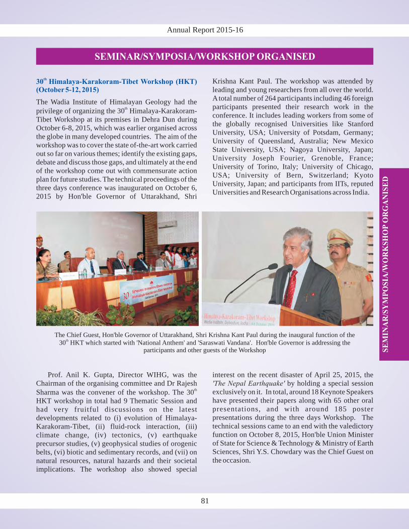
Annual Report 2015-16
SE
MIN
AR
/SY
MP
OS
IA/W
OR
KS
HO
PO
RG
AN
ISE
D
SEMINAR/SYMPOSIA/WORKSHOP ORGANISED
30 Himalaya-Karakoram-Tibet Workshop (HKT)(October 5-12, 2015)
th
The Wadia Institute of Himalayan Geology had the
privilege of organizing the 30 Himalaya-Karakoram-Tibet Workshop at its premises in Dehra Dun duringOctober 6-8, 2015, which was earlier organised acrossthe globe in many developed countries. The aim of theworkshop was to cover the state of-the-art work carriedout so far on various themes; identify the existing gaps,debate and discuss those gaps, and ultimately at the endof the workshop come out with commensurate actionplan for future studies. The technical proceedings of thethree days conference was inaugurated on October 6,2015 by Hon'ble Governor of Uttarakhand, Shri
th
Krishna Kant Paul. The workshop was attended byleading and young researchers from all over the world.A total number of 264 participants including 46 foreignparticipants presented their research work in theconference. It includes leading workers from some ofthe globally recognised Universities like StanfordUniversity, USA; University of Potsdam, Germany;University of Queensland, Australia; New MexicoState University, USA; Nagoya University, Japan;University Joseph Fourier, Grenoble, France;University of Torino, Italy; University of Chicago,USA; University of Bern, Switzerland; KyotoUniversity, Japan; and participants from IITs, reputedUniversities and Research Organisations across India.
81
Prof. Anil K. Gupta, Director WIHG, was theChairman of the organising committee and Dr Rajesh
Sharma was the convener of the workshop. The 30HKT workshop in total had 9 Thematic Session andhad very fruitful discussions on the latestdevelopments related to (i) evolution of Himalaya-Karakoram-Tibet, (ii) fluid-rock interaction, (iii)climate change, (iv) tectonics, (v) earthquakeprecursor studies, (v) geophysical studies of orogenicbelts, (vi) biotic and sedimentary records, and (vii) onnatural resources, natural hazards and their societalimplications. The workshop also showed special
th
interest on the recent disaster of April 25, 2015, theby holding a special session
exclusively on it. In total, around 18 Keynote Speakershave presented their papers along with 65 other oralpresentations, and with around 185 posterpresentations during the three days Workshop. Thetechnical sessions came to an end with the valedictoryfunction on October 8, 2015, Hon'ble Union Ministerof State for Science & Technology & Ministry of EarthSciences, Shri Y.S. Chowdary was the Chief Guest onthe occasion.
'The Nepal Earthquake'
The Chief Guest, Hon'ble Governor of Uttarakhand, Shri Krishna Kant Paul during the inaugural function of the30 HKT which started with 'National Anthem' and 'Saraswati Vandana'. Hon'ble Governor is addressing the
participants and other guests of the Workshop
th
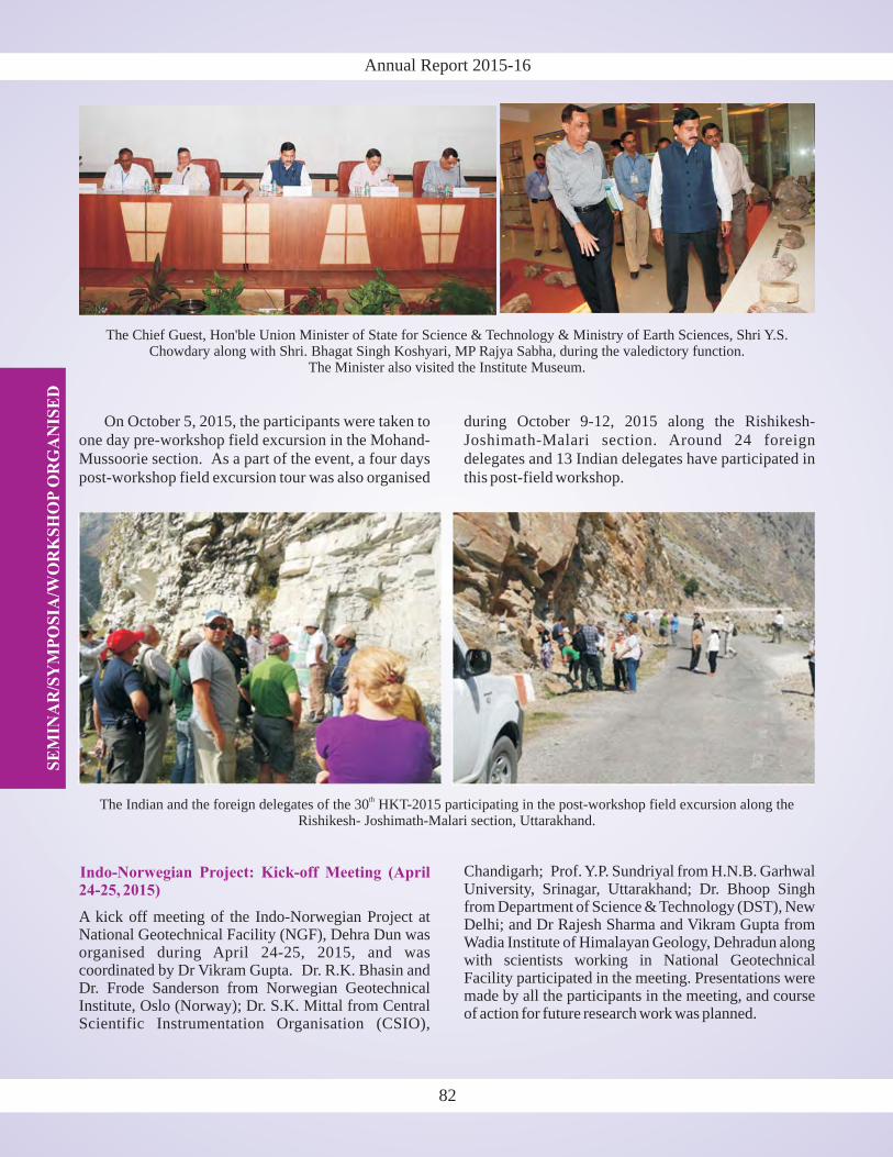
Annual Report 2015-16S
EM
INA
R/S
YM
PO
SIA
/WO
RK
SH
OP
OR
GA
NIS
ED
On October 5, 2015, the participants were taken toone day pre-workshop field excursion in the Mohand-Mussoorie section. As a part of the event, a four dayspost-workshop field excursion tour was also organised
during October 9-12, 2015 along the Rishikesh-Joshimath-Malari section. Around 24 foreigndelegates and 13 Indian delegates have participated inthis post-field workshop.
Indo-Norwegian Project: Kick-off Meeting (April24-25, 2015)
A kick off meeting of the Indo-Norwegian Project atNational Geotechnical Facility (NGF), Dehra Dun wasorganised during April 24-25, 2015, and wascoordinated by Dr Vikram Gupta. Dr. R.K. Bhasin andDr. Frode Sanderson from Norwegian GeotechnicalInstitute, Oslo (Norway); Dr. S.K. Mittal from CentralScientific Instrumentation Organisation (CSIO),
Chandigarh; Prof. Y.P. Sundriyal from H.N.B. GarhwalUniversity, Srinagar, Uttarakhand; Dr. Bhoop Singhfrom Department of Science & Technology (DST), NewDelhi; and Dr Rajesh Sharma and Vikram Gupta fromWadia Institute of Himalayan Geology, Dehradun alongwith scientists working in National GeotechnicalFacility participated in the meeting. Presentations weremade by all the participants in the meeting, and courseof action for future research work was planned.
The Indian and the foreign delegates of the 30 HKT-2015 participating in the post-workshop field excursion along theRishikesh- Joshimath-Malari section, Uttarakhand.
th
82
The Chief Guest, Hon'ble Union Minister of State for Science & Technology & Ministry of Earth Sciences, Shri Y.S.Chowdary along with Shri. Bhagat Singh Koshyari, MP Rajya Sabha, during the valedictory function.
The Minister also visited the Institute Museum.
AW
AR
DS
AN
D H
ON
OU
RS
/V
ISIT
SA
BR
OA
D
83
Annual Report 2015-16
AWARDS AND HONOURS
�
�
Dr. T.N. Jowhar was Sessional President forEarth System Sciences in the 103 IndianScience Congress held at Mysore University,Mysore from January 3-7, 2016.
Drs. P.K. Mukherjee, P.P. Khanna and N.K.Saini received the 'Best Paper Award-2015' fortheir paper
published in Geostandards and GeoanalyticalResearch.
rd
'Rapid determination of trace andultra-trace level elements in diverse silicaterocks in pressed powder pellet targets by LA-ICP-MS using a Matrix- Independent Protocol'
�
�
Dr. Naresh Kumar is the Guest Editor ofSpecial Issue of the Quaternary InternationalJournal on . He isalso the regular Associate of the InternationalCentre for Theoretical Physics (ICTP), Italy.
Dr. Sushil Kumar was nominated the Convener& Session Chair on the theme
in theInternational workshop AOGS-2015 held inSingapore duringAugust 2-7, 2015.
'Himalaya Active Tectonics'
'Understandingof Active Tectonics in the Asian Region andLarge Earthquake Generation'
�
�
�
�
�
�
Dr. Nilendu visited Tsukuba, Japan to participateand present his work in a workshop on the
duringApril 23-25, 2015.
Dr. Bikramaditya Singh visited National TaiwanUniversity, Taipei, Taiwan as a Postdoctoral Fellowfor six months from May 6 to November 5, 2015.
Dr. Vikram Gupta visited Nepal during June 3-7, 2015as a member of the Expert team of National DisasterMitigation Authority (NDMA), New Delhi to assesslandslide scenario and to discuss the technical supportto Nepal after the Nepal Earthquake.
Dr.Aparna Shukla visited Milan, Italy to participateand present her work in the 'International
during July 26-31, 2015.
Dr. Suman Lata Rawat visited Nagoya, Japan toparticipate and present her work in the
onduring
July 25 toAugust 2, 2015.
Dr. Sushil Kumar visited Singapore to participateand present his work in the International 'AOGS-2015' Workshop duringAugust 2-7, 2015.
'Ecosystem Carbon/Water Cycling Research in theChanging Climate'
Geoscience and Remote Sensing Symposium,(IGARSS-2015)'
XIX INQUACongress 'Quaternary perspective on climatechange, natural hazards and civilization'
�
�
�
�
�
Dr. Archna Bohra visited Lanzhou University,China to participate and present her work in the
)' duringAugust 4-7, 2015.
Dr. Santosh K Rai visited Germany for training onat Thermo Fisher,
Bremen during October 19-30, 2015.
Dr. A.K. Singh visited National Taiwan University(NTU), Taiwan to deliver an invited lecture, and tovisit lab during October 24 to November 8, 2015.
Sh. Prakasam M. visited Trieste, Italy to participateand present his work in International Workshop on
, held duringNovember 16-24, 2015.
Dr. Akshaya Verma visited ICIMOD, Kathmandu,Nepal to attend the 2 Regional Training on
organised by ICIMOD, Nepal and FutureWater, Netherlands during December 14-18, 2015.
'13International Paleolimnology Symposium (IPS-2015
'Neptune Plus (LA-MC-ICPMS)'
'Decadal Climate Variability and Predictability:Challenge and Opportunity'
'Glacio-Hydrological Modelling using the SPHYModel'
th
nd
83
VISITS ABROAD
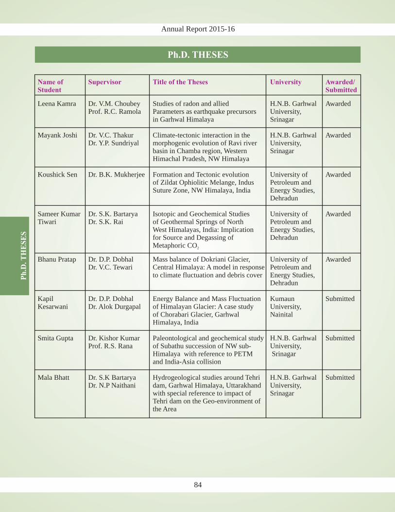
Annual Report 2015-16P
h.D
.T
HE
SE
S
Ph.D. THESES
Name of Supervisor Title of the Theses University Awarded/Student Submitted
Leena Kamra Dr. V.M. Choubey Studies of radon and allied H.N.B. Garhwal AwardedProf. R.C. Ramola Parameters as earthquake precursors University,
in Garhwal Himalaya Srinagar
Mayank Joshi Dr. V.C. Thakur Climate-tectonic interaction in the H.N.B. Garhwal AwardedDr. Y.P. Sundriyal morphogenic evolution of Ravi river University,
basin in Chamba region, Western SrinagarHimachal Pradesh, NW Himalaya
Koushick Sen Dr. B.K. Mukherjee Formation and Tectonic evolution University of Awardedof Zildat Ophiolitic Melange, Indus Petroleum andSuture Zone, NW Himalaya, India Energy Studies,
Dehradun
Sameer Kumar Dr. S.K. Bartarya Isotopic and Geochemical Studies University of AwardedTiwari Dr. S.K. Rai of Geothermal Springs of North Petroleum and
West Himalayas, India: Implication Energy Studies,for Source and Degassing of DehradunMetaphoric CO
Mass balance of Dokriani Glacier, University ofCentral Himalaya: A model in response Petroleum and
Energy Studies,Dehradun
Himalaya, India
H.N.B. Garhwal SubmittedUniversity,
Himalaya Srinagarand India-Asia collision
Submitted
Tehri dam on the Geo-environment ofthe Area
Kumaun
2
Bhanu Pratap Dr. D.P. DobhalDr. V.C. Tewari
to climate fluctuation and debris cover
Kapil Dr. D.P. Dobhal Energy Balance and Mass Fluctuation SubmittedKesarwani Dr. Alok Durgapal of Himalayan Glacier: A case study University,
of Chorabari Glacier, Garhwal Nainital
Smita Gupta Dr. Kishor Kumar Paleontological and geochemical studyProf. R.S. Rana of Subathu succession of NW sub-
with reference to PETM
Mala Bhatt Dr. S.K Bartarya Hydrogeological studies around Tehri H.N.B. GarhwalDr. N.P Naithani dam, Garhwal Himalaya, Uttarakhand University,
with special reference to impact of Srinagar
Awarded
84

Annual Report 2015-16
PARTICIPATIONS IN SEMINARS/SYMPOSIA/ WORKSHOPS/MEETINGS/ TRAINING COURSES
National Conference onat Lucknow duringApril 23-24, 2015.
PAMC Meeting at NGRI Hyderabad during May 5-7,2015 for ongoing project presentation.
SERB-DST meeting at VFSTR University, Vadlamudi,Guntur District, Andhra Pradesh during June 29-30.2015 for ongoing project presentation.
Scientific Exchange Workshop on
at New Delhi during July 2-3, 2015.
at National Centre for Antarcticand Ocean Research (NCAOR) Goa during July 13-17,2015.
Workshop onorganized by Central Water Commission at New Delhion July 28, 2015.
Workshop onat Hotel
Pacific, Dehradun onAugust 4, 2015.
Workshop onat New Delhi
duringAugust 10-12, 2015.
Workshop on atDelhi University, Delhi during September 9-10, 2015.
'Palaeogene of the Indian Sub-Continent'
'Vulnerability, Risksand Hazards & Adaptation in the Indian HimalayanRegion'
'XII-International Symposium on Antarctic EarthSciences (ISAES2015)'
'Management of Glacier Lake Outburst'
'Regional Multi-stakeholder HimalayanSustainable Development Forum (HSDF)'
'Indian Himalayan Climate AdaptationProgramme (IHCAP) Phase-II Planning'
'First Himalayan Conclave-2015'
Participant: Kapesa Lokho
Participant: R. Jayangondaperumal
Participant: Archana Bohra
Participant: D.P. Dobhal
Participant: Kapil Kesarwani
Participant: Rakesh Bhambri
Participant: D.P. Dobhal
Participant: D.P. Dobhal
Participant: D.P. Dobhal
Workshop onat UttarakhandAcademy ofAdministration,
Nainital during September 28-30, 2015.
at MoES, New Delhi during September29-30, 2015 for ongoing project presentation.
30 Himalaya Karakoram Tibet workshop at WadiaInstitute of Himalayan Geology, Dehradun duringOctober 6-8, 2015.
International Conference on
at India Habitat Centre, New Delhi duringNovember 6-8, 2015.
International Workshop onat NIH,
Roorkee during November 16-17, 2015.
atNew Delhi during November 20-24, 2015.
Conference on at Kashipuron November 29, 2015.
Brain storming session onat GSI,
Northern Region, Lucknow during December 3-4, 2015.
' ' at IITDelhi during December 4-8, 2015.
'Earthquake Resistance ConstructionTechnology'
'PAC Meeting'
'Global environmentalchange in the Himalayas: Controversies, Impacts, andFutures'
'Changes in Water Resourceand Adaption Options in the Himalayan Basins'
'XXIII International Grassland Conference (IGC)'
'Environmental Pollution'
'36 IGC: A UniqueOpportunity for Advancement in Geosciences'
India International Science Festival (IISF-2015)
th
th
Participant: Dilip K. Yadav
Participant: R. Jayangondaperumal
Participants: Scientists and Research Scholars of theInstitute
Participant: Rakesh Bhambri
Participant: D.P. Dobhal
Participant: Nilendu Singh
Participant: P.S. Negi
Participant: D.P. Dobhal
Participants: Rajesh Sharma, S.K. Parcha, Ajay Paul,M. Prakasam and Chhavi Pandey
85
PA
RT
ICIP
AT
ION
S I
N S
EM
INA
R/S
YM
PO
SIA
/W
OR
KS
HO
P/
ME
ET
ING
S/
TR
AIN
ING
CO
UR
SE
S
Annual Report 2015-16
National Conference onat Lucknow duringApril 23-24, 2015.
PAMC Meeting at NGRI Hyderabad during May 5-7,2015 for ongoing project presentation.
SERB-DST meeting at VFSTR University, Vadlamudi,Guntur District, Andhra Pradesh during June 29-30.2015 for ongoing project presentation.
Scientific Exchange Workshop on
at New Delhi during July 2-3, 2015.
at National Centre for Antarcticand Ocean Research (NCAOR) Goa during July 13-17,2015.
Workshop onorganized by Central Water Commission at New Delhion July 28, 2015.
Workshop onat Hotel
Pacific, Dehradun onAugust 4, 2015.
Workshop onat New Delhi
duringAugust 10-12, 2015.
'Palaeogene of the Indian Sub-Continent'
'Vulnerability, Risksand Hazards & Adaptation in the Indian HimalayanRegion'
'XII-International Symposium on Antarctic EarthSciences (ISAES2015)'
'Management of Glacier Lake Outburst'
'Regional Multi-stakeholder HimalayanSustainable Development Forum (HSDF)'
'Indian Himalayan Climate AdaptationProgramme (IHCAP) Phase-II Planning'
Participant: Kapesa Lokho
Participant: R. Jayangondaperumal
Participant: Archana Bohra
Participant: D.P. Dobhal
Participant: Kapil Kesarwani
Participant: Rakesh Bhambri
Participant: D.P. Dobhal
Participant: D.P. Dobhal
Participant: D.P. Dobhal
Participant: Dilip K. Yadav
Participant: R. Jayangondaperumal
Participants: Scientists and Research Scholars of theInstitute
Participant: Rakesh Bhambri
Participant: D.P. Dobhal
Participant: Nilendu Singh
Workshop on atDelhi University, Delhi during September 9-10, 2015.
Workshop onat UttarakhandAcademy ofAdministration,
Nainital during September 28-30, 2015.
at MoES, New Delhi during September29-30, 2015 for ongoing project presentation.
30 Himalaya Karakoram Tibet workshop at WadiaInstitute of Himalayan Geology, Dehradun duringOctober 6-8, 2015.
International Conference on
at India Habitat Centre, New Delhi duringNovember 6-8, 2015.
International Workshop onat NIH,
Roorkee during November 16-17, 2015.
atNew Delhi during November 20-24, 2015.
Conference on at Kashipuron November 29, 2015.
'First Himalayan Conclave-2015'
'Earthquake Resistance ConstructionTechnology'
'PAC Meeting'
'Global environmentalchange in the Himalayas: Controversies, Impacts, andFutures'
'Changes in Water Resourceand Adaption Options in the Himalayan Basins'
'XXIII International Grassland Conference (IGC)'
'Environmental Pollution'
th
86
PA
RT
ICIP
AT
ION
S I
N S
EM
INA
R/S
YM
PO
SIA
/W
OR
KS
HO
P/
ME
ET
ING
S/
TR
AIN
ING
CO
UR
SE
S
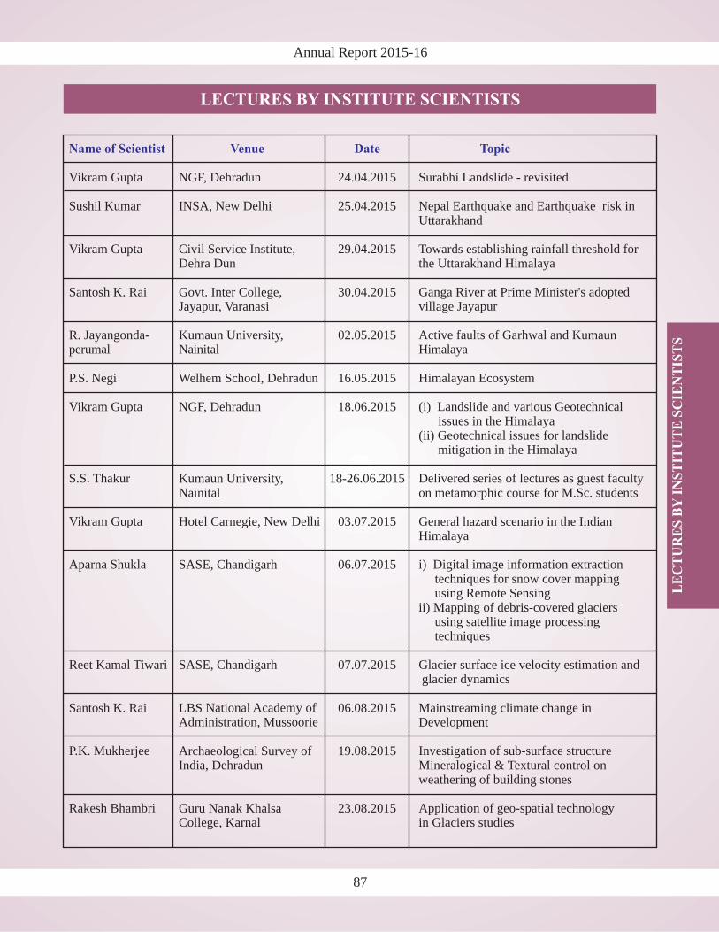
Annual Report 2015-16
LECTURES BY INSTITUTE SCIENTISTS
87
LE
CT
UR
ES
BY
INS
TIT
UT
E S
CIE
NT
IST
S
Name of Scientist Venue Date Topic
Vikram Gupta NGF, Dehradun 24.04.2015 Surabhi Landslide - revisited
Sushil Kumar INSA 25.04.2015 Nepal Earthquake and Earthquake
Vikram Gupta Civil Service Institute, 29.04.2015 Towards establishing rainfall thresholdDehra Dun the Uttarakhand Himalaya
Santosh K. Rai Govt. Inter College, 30.04.2015Jayapur, Varanasi
R. 02.05.2015
P.S. Negi Welhem School, 16.05.2015
Vikram Gupta NGF, Dehradun 18.06.2015
Kumaun University, 18-26.06.2015Nainital on metamorphic course for
Hotel Carnegie, 03.07.2015 General hazard scenario in the IndianHimalaya
SASE, Chandigarh 06.07.2015
07.07.2015
Santosh K. Rai LBS 06.08.2015 Mainstreaming climate change inDevelopment
Archaeological Survey of 19.08.2015India, Dehradun Mineralogical & Textural control on
weathering of building stones
Guru Nanak Khalsa 23.08.2015
, New Delhi risk inUttarakhand
for
Ganga River at Prime Minister's adoptedvillage Jayapur
Jayangonda- Kumaun University, Active faults of Garhwal and Kumaunperumal Nainital Himalaya
Dehradun Himalayan Ecosystem
(i) Landslide and various Geotechnicalissues in the Himalaya
(ii) Geotechnical issues for landslidemitigation in the Himalaya
S.S. Thakur Delivered series of lectures as guest facultyM.Sc. students
Vikram Gupta New Delhi
Aparna Shukla i) Digital image information extractiontechniques for snow cover mappingusing Remote Sensing
ii) Mapping of debris-covered glaciersusing satellite image processingtechniques
Reet Kamal Tiwari SASE, Chandigarh Glacier surface ice velocity estimation andglacier dynamics
National Academy ofAdministration, Mussoorie
P.K. Mukherjee Investigation of sub-surface structure
Rakesh Bhambri Application of geo-spatial technologyCollege, Karnal in Glaciers studies
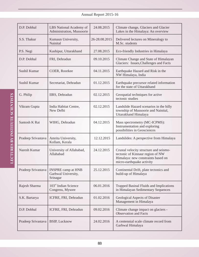
Annual Report 2015-16L
EC
TU
RE
S B
YIN
ST
ITU
TE
SC
IEN
TIS
TS
8388
D.P. Dobhal
Kumaun University, 26-28.08.2015Nainital M.Sc. students
P.S. Negi Kashipur, Uttarakhand 27.08.2015
D.P. Dobhal FRI, Dehradun 09.10.2015 Climate Change and State ofGlaciers: Issues,
COER, Roorkee 04.11.2015
IIRS, Dehradun 02.12.2015
Amrita University, 12.12.2015
Naresh Kumar University of Allahabad, 24.12.2015 Crustal velocity structure andAllahabad tectonic of Kinnaur region of
Himalaya: new constraints basedmicro-earthquake activity
Pradeep Srivastava INSPRE camp at HNB 25.12.2015 Continental Drift, plate tectonics andGarhwal University, build-up of Himalaya
LBS National Academy of 24.08.2015 Climate change, Glaciers and GlacierAdministration, Mussoorie Lakes in the Himalaya: An overview
S.S. Thakur Delivered lectures on Mineralogy to
Eco-friendly Industries in Himalaya
HimalayanChallenges and Facts
Sushil Kumar Earthquake Hazard and Risk in theNW Himalaya, India
Sushil Kumar Secretariat, Dehradun 01.12.2015 Earthquake precursor related informationfor the state of Uttarakhand
G. Philip Geospatial techniques for activetectonic studies
Vikram Gupta India Habitat Centre, 02.12.2015 Landslide Hazard scenarios in the hillyNew Delhi township of Mussoorie and Nainital,
Uttarakhand Himalaya
Santosh K Rai WIHG, Dehradun 04.12.2015 Mass spectrometry (MC-ICPMS):Instrumentation and exploringpossibilities in Geosciences
Pradeep Srivastava Landslides: A perspective from HimalayaKollam, Kerala
seismo-NW
on
Srinagar
Rajesh Sharma 103 Indian Science 06.01.2016 Trapped Basinal Fluids and ImplicationsCongress, Mysore in Himalayan Sedimentary Sequences
S.K. Bartarya ICFRE, FRI, Dehradun 01.02.2016 Geological Aspects of DisasterManagement in Himalaya
D.P. Dobhal ICFRE, FRI, Dehradun 09.02.2016 Climate change impact on glaciers -Observation and Facts
Pradeep Srivastava BSIP, Lucknow 24.02.2016 A centennial scale climate record fromGarhwal Himalaya
rd
Annual Report 2015-16
ME
MB
ER
SH
IPMEMBERSHIP
89
Sharma, Rajesh : Member, Scientific Committee for the 'VI Asian Current Research on Fluid Inclusions', IIT-Bombay, Mumbai
Mukherjee, P.K. : Member, Technical Committee: National Geochronology Centre at IUGS, New Delhi
Kumar, Sushil : Member, Seismological Society ofAmerica (SSA), CaliforniaMember, Japan Geoscience Union Tokyo, JapanMember, Indian Society of Earthquake Technology, IITR, RoorkeeMember,American Geophysical Union, California
Dobhal, D.P. : Member, Expert Committee on the theme:for the 36 International Geological Congress (IGC-2020) in IndiaMember, Programme Advisory Committee (PAC), Earth and Atmospheric Sciences underSERB, DST, New Delhi
Gupta, Vikram : Member, National Green Tribunal (NGT) to look after the construction activities in Shimla,Himachal Pradesh
Shukla, : Member, Executive Council of Indian Society of Remote Sensing-Dehradun Chapter (ISRS-DC) for the term 2016-2018
'Glaciology, Climate Change and Societal issues'th
Aparna
Prakasam, M. : Member,American Geophysical Union, California
Vikram Gupta HNB Garhwal University, 27.02.2016 Landslide hazards in the MandakiniSrinagar valley, Garhwal Himalaya
G. Philip IIRS, Dehradun 08.03.2016 Geospatial techniques in the study ofactive faults
Vikram Gupta University of Petroleum of 12.03.2016 Series of lectures on the “Various Geo-Energy Studies, Dehradun technical issues and Engineering
Geology”
R. Jayangonda- NGRI, Hyderabad 28.03.2016 Active fault mapping and its characteri-perumal zation along the Himalayan Frontal
Thrust of India: Insight to the patterns ofstrain release along a ContinentalConvergent Plate Boundary
Sushil Kumar Tibetan Homes School 31.03.2016 Disasters and its management strategiesHappy Valley, Mussoorie in Uttarakhand
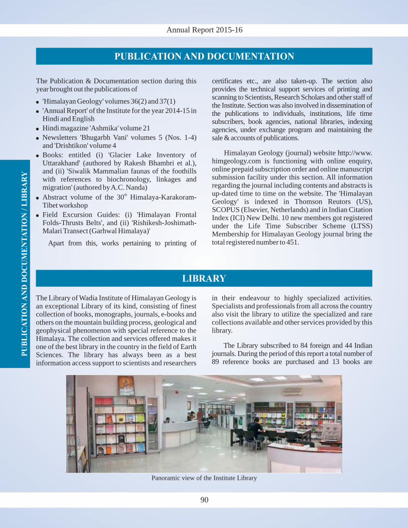
Annual Report 2015-16P
UB
LIC
AT
ION
AN
D D
OC
UM
EN
TA
TIO
N /
LIB
RA
RY
PUBLICATION AND DOCUMENTATION
The Publication & Documentation section during thisyear brought out the publications of
'Himalayan Geology' volumes 36(2) and 37(1)
'Annual Report' of the Institute for the year 2014-15 inHindi and English
Hindi magazine 'Ashmika' volume 21
Newsletters 'Bhugarbh Vani' volumes 5 (Nos. 1-4)and 'Drishtikon' volume 4
Books: entitled (i) 'Glacier Lake Inventory ofUttarakhand' (authored by Rakesh Bhambri et al.),and (ii) 'Siwalik Mammalian faunas of the foothillswith references to biochronology, linkages andmigration' (authored byA.C. Nanda)
Abstract volume of the 30 Himalaya-Karakoram-Tibet workshop
Field Excursion Guides: (i) 'Himalayan FrontalFolds-Thrusts Belts', and (ii) 'Rishikesh-Joshimath-Malari Transect (Garhwal Himalaya)'
Apart from this, works pertaining to printing of
�
�
�
�
�
�
�
th
certificates etc., are also taken-up. The section alsoprovides the technical support services of printing andscanning to Scientists, Research Scholars and other staff ofthe Institute. Section was also involved in dissemination ofthe publications to individuals, institutions, life timesubscribers, book agencies, national libraries, indexingagencies, under exchange program and maintaining thesale & accounts of publications.
Himalayan Geology (journal) website http://www.himgeology.com is functioning with online enquiry,online prepaid subscription order and online manuscriptsubmission facility under this section. All informationregarding the journal including contents and abstracts isup-dated time to time on the website. The 'HimalayanGeology' is indexed in Thomson Reutors (US),SCOPUS (Elsevier, Netherlands) and in Indian CitationIndex (ICI) New Delhi. 10 new members got registeredunder the Life Time Subscriber Scheme (LTSS)Membership for Himalayan Geology journal bring thetotal registered number to 451.
90
The Library of Wadia Institute of Himalayan Geology isan exceptional Library of its kind, consisting of finestcollection of books, monographs, journals, e-books andothers on the mountain building process, geological andgeophysical phenomenon with special reference to theHimalaya. The collection and services offered makes itone of the best library in the country in the field of EarthSciences. The library has always been as a bestinformation access support to scientists and researchers
in their endeavour to highly specialized activities.Specialists and professionals from all across the countryalso visit the library to utilize the specialized and rarecollections available and other services provided by thislibrary.
The Library subscribed to 84 foreign and 44 Indianjournals. During the period of this report a total number of89 reference books are purchased and 13 books are
LIBRARY
Panoramic view of the Institute Library
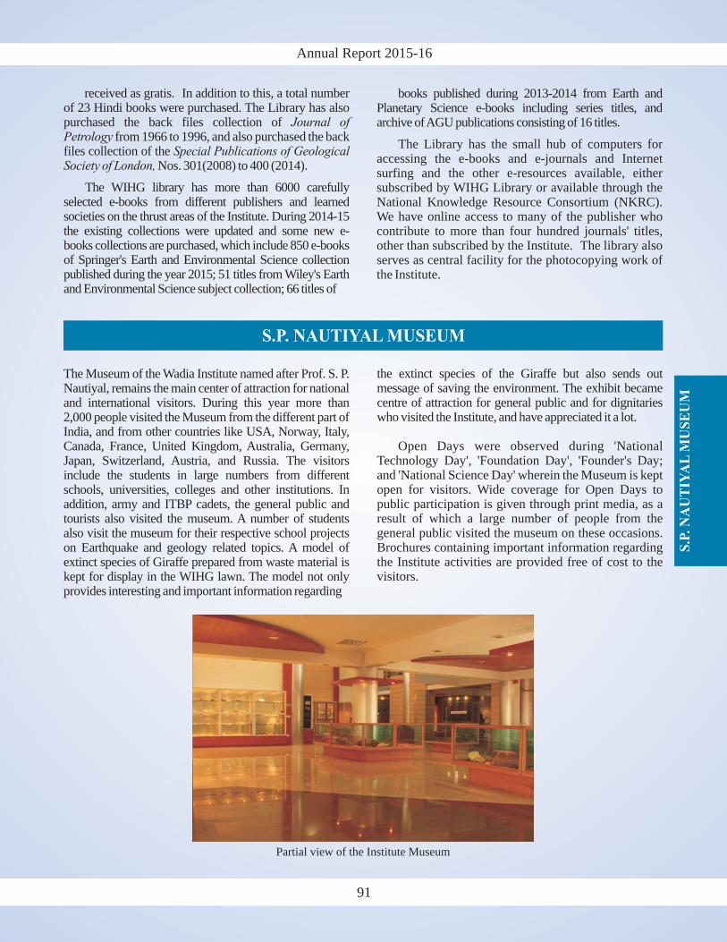
S.P
. N
AU
TIY
AL
MU
SE
UM
Annual Report 2015-16
S.P. NAUTIYAL MUSEUM
The Museum of the Wadia Institute named after Prof. S. P.Nautiyal, remains the main center of attraction for nationaland international visitors. During this year more than2,000 people visited the Museum from the different part ofIndia, and from other countries like USA, Norway, Italy,Canada, France, United Kingdom, Australia, Germany,Japan, Switzerland, Austria, and Russia. The visitorsinclude the students in large numbers from differentschools, universities, colleges and other institutions. Inaddition, army and ITBP cadets, the general public andtourists also visited the museum. A number of studentsalso visit the museum for their respective school projectson Earthquake and geology related topics. A model ofextinct species of Giraffe prepared from waste material iskept for display in the WIHG lawn. The model not onlyprovides interesting and important information regarding
the extinct species of the Giraffe but also sends outmessage of saving the environment. The exhibit becamecentre of attraction for general public and for dignitarieswho visited the Institute, and have appreciated it a lot.
Open Days were observed during 'NationalTechnology Day', 'Foundation Day', 'Founder's Day;and 'National Science Day' wherein the Museum is keptopen for visitors. Wide coverage for Open Days topublic participation is given through print media, as aresult of which a large number of people from thegeneral public visited the museum on these occasions.Brochures containing important information regardingthe Institute activities are provided free of cost to thevisitors.
91
received as gratis. In addition to this, a total numberof 23 Hindi books were purchased. The Library has alsopurchased the back files collection of
from 1966 to 1996, and also purchased the backfiles collection of the
Nos. 301(2008) to 400 (2014).
The WIHG library has more than 6000 carefullyselected e-books from different publishers and learnedsocieties on the thrust areas of the Institute. During 2014-15the existing collections were updated and some new e-books collections are purchased, which include 850 e-booksof Springer's Earth and Environmental Science collectionpublished during the year 2015; 51 titles from Wiley's Earthand Environmental Science subject collection; 66 titles of
Journal ofPetrology
Special Publications of GeologicalSociety of London,
books published during 2013-2014 from Earth andPlanetary Science e-books including series titles, andarchive ofAGU publications consisting of 16 titles.
The Library has the small hub of computers foraccessing the e-books and e-journals and Internetsurfing and the other e-resources available, eithersubscribed by WIHG Library or available through theNational Knowledge Resource Consortium (NKRC).We have online access to many of the publisher whocontribute to more than four hundred journals' titles,other than subscribed by the Institute. The library alsoserves as central facility for the photocopying work ofthe Institute.
Partial view of the Institute Museum
Annual Report 2015-16T
EC
HN
ICA
LS
ER
VIC
ES
programme, and superannuation function of theInstitute staff etc. Apart from this around 700 snapswere clicked for rock and fossil specimens. The colourprinting of around 300 digital images was arranged fromthe market. No new cameras/lenses or any otherphotographic materials were purchased during thereporting year as a majority of scientists already havecameras issued permanently to them for use in the fieldand laboratory. The remaining scientists and researchscholars are provided cameras from a pool as and whenthey require it.
The Drawing Section catered to the cartographic needsof the Scientists and Research Scholars of the Instituteincluding the sponsored projects. During the reportingyear, the section has provided 32 geological/structural/geomorphological maps/seismicity diagrams for thescientists and research scholars of the Institute, alongwith the tracing of fourteen topographic sheets/aerialphoto maps, as well as two geological columns havebeen prepared. The section has also provided seminarID badges, thematic captions during different activitiesand functions of the Institute including writing work onthe photo identity cards of the employees of theInstitute.
The sample preparation laboratory providedthin/microprobe/polished sections to the requirementsof the Institute Scientists and Research Scholars. Duringthis year, the laboratory provided 1,047 thin andpolished sections to various users for carrying outmicroscopic, fluid inclusion and EPMA studies. Thelaboratory also processed crushing/grinding of 1,449rock samples for carrying out major, trace and REEanalysis by ICPMS, XRF and XRD methods.
Drawing Section
Sample Preparation Laboratory
Photography Section
During the year around 5,800 digital images wereclicked to cover the various functions, includingFoundation Day, Founders Day, National Science Day,National Technology Day, New Year's Day,Seminars/Symposia (e.g., HKT-2015), cultural
92
TECHNICAL SERVICES
Analytical Services
The number of samples analysed by various instrumentslike, XRF, ICP-MS, SEM-EDX, XRD, OSL, StableIsotope Mass Spectrometer and EPMA is given in tablebelow.
I
XRF 629 898 1527
ICP-MS 645 603 1248
SEM-EDX 393 563 956
XRD 632 188 820
OSL 74 18 92
LA-MC-ICPMS 293 0 293(Zircon geochronology)
Stable Isotope Mass Spectrometer 1314 640 1954
EPMA 53 23 76
Paleomagnetic Lab:AFD & Spinner Magnetometer 630 - 650
Magnetic Susceptibility Meter 630 - 630
Impulse Magnetizer 188 - 108
Anhystric Remanent Magnetizer 630 - 650
Kappa bridge (KLY-3S) 630 630 296
#
#In EPMA, Thin Sections were analysed which includes
analysis of various minerals and taking large number ofpoint analysis from different parts of the individual mineralgrains.
nstrument Samples analysed
WIHGUsers Users
Outside Total
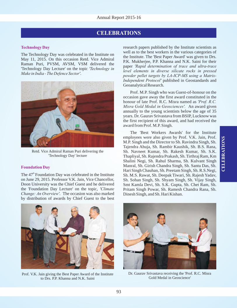
Annual Report 2015-16
CE
LE
BR
AT
ION
S
CELEBRATIONS
Technology Day
The Technology Day was celebrated in the Institute onMay 11, 2015. On this occasion Retd. Vice AdmiralRaman Puri, PVSM, AVSM, VSM delivered the'Technology Day Lecture' on the topic 'Technology inMake in India - The Defence Sector'.
research papers published by the Institute scientists aswell as to the best workers in the various categories ofthe Institute. The 'Best Paper Award' was given to Drs.P.K. Mukherjee, P.P. Khanna and N.K. Saini for theirpaper
published in Geostandards andGeoanalytical Research.
Prof. M.P. Singh who was Guest-of-honour on theoccasion gave away the first award constituted in thehonour of late Prof. R.C. Misra named as
An award givenannually to the young scientists below the age of 35years. Dr. Gaurav Srivastava from BSIP, Lucknow wasthe first recipient of this award, and had received theaward from Prof. M.P. Singh.
The 'Best Workers Awards' for the Instituteemployees were also given by Prof. V.K. Jain, Prof.M.P. Singh and the Director to Sh. Ravindra Singh, Sh.Tajendra Ahuja, Sh. Rambir Kaushik, Sh. B.S. Rana,Sh. Navneet Kumar, Sh. Rakesh Kumar, Sh. S.K.Thapliyal, Sh. Rajendra Prakash, Sh. Tirthraj Ram, KmShalini Negi, Sh. Rahul Sharma, Sh. Kulvant SinghManral, Sh. Girish Chandra Singh, Sh. Santu Das, Sh.Hari Singh Chauhan, Sh. Preetam Singh, Sh. R.S.Negi,Sh. M.S. Rawat, Sh. Deepak Tiwari, Sh. Rajesh Yadav,Sh. Sohan Singh, Sh. Shyam Singh, Sh. Vijay Singh,Smt Kamla Devi, Sh. S.K. Gupta, Sh. Chet Ram, Sh.Pritam Singh Powar, Sh. Ramesh Chandra Rana, Sh.Dinesh Singh, and Sh. Hari Kishan.
'Rapid determination of trace and ultra-tracelevel elements in diverse silicate rocks in pressedpowder pellet targets by LA-ICP-MS using a Matrix-Independent Protocol'
'Prof. R.C.Misra Gold Medal in Geosciences'.
93
Foundation Day
The 47 Foundation Day was celebrated in the Instituteon June 29, 2015. Professor V.K. Jain, Vice Chancellor,Doon University was the Chief Guest and he deliveredthe 'Foundation Day Lecture' on the topic,
. The occasion was also markedby distribution of awards by Chief Guest to the best
th
'ClimateChange: An Overview'
Dr. Gaurav Srivastava receiving the 'Prof. R.C. MisraGold Medal in Geoscience'
Prof. V.K. Jain giving the Best Paper Award of the Instituteto Drs. P.P. Khanna and N.K. Saini
Retd. Vice Admiral Raman Puri delivering the'Technology Day' lecture
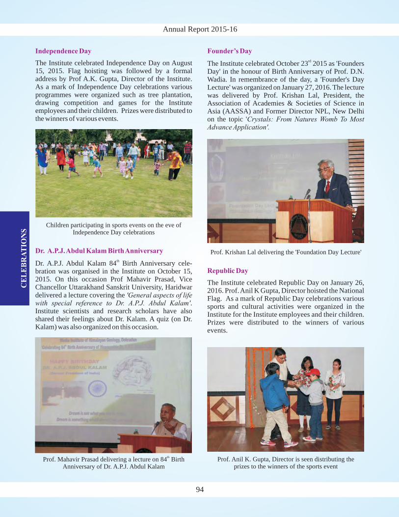
Annual Report 2015-16C
EL
EB
RA
TIO
NS
94
Independence Day
The Institute celebrated Independence Day on August15, 2015. Flag hoisting was followed by a formaladdress by Prof A.K. Gupta, Director of the Institute.As a mark of Independence Day celebrations variousprogrammes were organized such as tree plantation,drawing competition and games for the Instituteemployees and their children. Prizes were distributed tothe winners of various events.
Dr. A.P.J.Abdul Kalam BirthAnniversary
Dr. A.P.J. Abdul Kalam 84 Birth Anniversary cele-bration was organised in the Institute on October 15,2015. On this occasion Prof Mahavir Prasad, ViceChancellor Uttarakhand Sanskrit University, Haridwardelivered a lecture covering the
.Institute scientists and research scholars have alsoshared their feelings about Dr. Kalam. A quiz (on Dr.Kalam) was also organized on this occasion.
th
'General aspects of lifewith special reference to Dr. A.P.J. Abdul Kalam'
Founder’s Day
The Institute celebrated October 23 2015 as 'FoundersDay' in the honour of Birth Anniversary of Prof. D.N.Wadia. In remembrance of the day, a 'Founder's DayLecture' was organized on January 27, 2016. The lecturewas delivered by Prof. Krishan Lal, President, theAssociation of Academies & Societies of Science inAsia (AASSA) and Former Director NPL, New Delhion the topic '
rd
Crystals: From Natures Womb To MostAdvance Application'.
Prof. Mahavir Prasad delivering a lecture on 84 BirthAnniversary of Dr. A.P.J. Abdul Kalam
th
Children participating in sports events on the eve ofIndependence Day celebrations
Prof. Krishan Lal delivering the 'Foundation Day Lecture'
Republic Day
The Institute celebrated Republic Day on January 26,2016. Prof.Anil K Gupta, Director hoisted the NationalFlag. As a mark of Republic Day celebrations varioussports and cultural activities were organized in theInstitute for the Institute employees and their children.Prizes were distributed to the winners of variousevents.
Prof. Anil K. Gupta, Director is seen distributing theprizes to the winners of the sports event
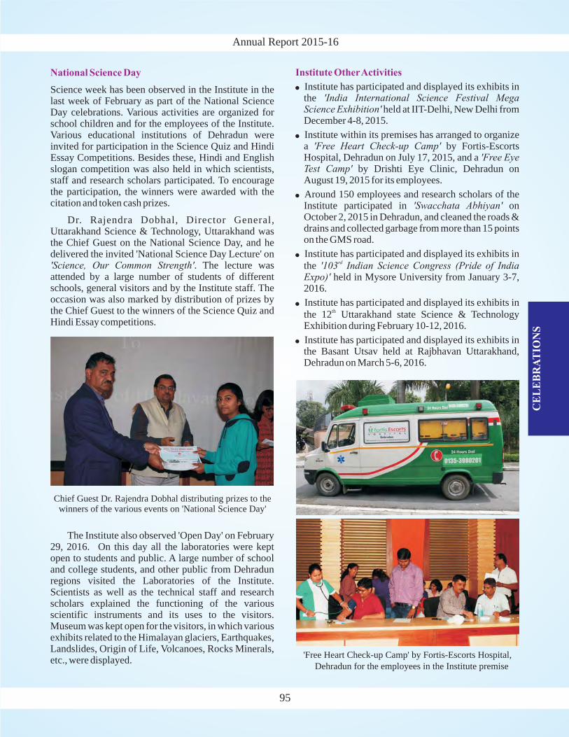
Annual Report 2015-16
CE
LE
BR
AT
ION
S
National Science Day
Science week has been observed in the Institute in thelast week of February as part of the National ScienceDay celebrations. Various activities are organized forschool children and for the employees of the Institute.Various educational institutions of Dehradun wereinvited for participation in the Science Quiz and HindiEssay Competitions. Besides these, Hindi and Englishslogan competition was also held in which scientists,staff and research scholars participated. To encouragethe participation, the winners were awarded with thecitation and token cash prizes.
Dr. Rajendra Dobhal, Director General,Uttarakhand Science & Technology, Uttarakhand wasthe Chief Guest on the National Science Day, and hedelivered the invited 'National Science Day Lecture' on
. The lecture wasattended by a large number of students of differentschools, general visitors and by the Institute staff. Theoccasion was also marked by distribution of prizes bythe Chief Guest to the winners of the Science Quiz andHindi Essay competitions.
'Science, Our Common Strength'
The Institute also observed 'Open Day' on February29, 2016. On this day all the laboratories were keptopen to students and public. A large number of schooland college students, and other public from Dehradunregions visited the Laboratories of the Institute.Scientists as well as the technical staff and researchscholars explained the functioning of the variousscientific instruments and its uses to the visitors.Museum was kept open for the visitors, in which variousexhibits related to the Himalayan glaciers, Earthquakes,Landslides, Origin of Life, Volcanoes, Rocks Minerals,etc., were displayed.
Institute OtherActivities
�
�
�
�
�
�
Institute has participated and displayed its exhibits inthe
held at IIT-Delhi, New Delhi fromDecember 4-8, 2015.
Institute within its premises has arranged to organizea by Fortis-EscortsHospital, Dehradun on July 17, 2015, and a
by Drishti Eye Clinic, Dehradun onAugust 19, 2015 for its employees.
Around 150 employees and research scholars of theInstitute participated in onOctober 2, 2015 in Dehradun, and cleaned the roads &drains and collected garbage from more than 15 pointson the GMS road.
Institute has participated and displayed its exhibits inthe
held in Mysore University from January 3-7,2016.
Institute has participated and displayed its exhibits inthe 12 Uttarakhand state Science & TechnologyExhibition during February 10-12, 2016.
Institute has participated and displayed its exhibits inthe Basant Utsav held at Rajbhavan Uttarakhand,Dehradun on March 5-6, 2016.
'India International Science Festival MegaScience Exhibition'
'Free Heart Check-up Camp''Free Eye
Test Camp'
'Swacchata Abhiyan'
'103 Indian Science Congress (Pride of IndiaExpo)'
rd
th
95
Chief Guest Dr. Rajendra Dobhal distributing prizes to thewinners of the various events on 'National Science Day'
'Free Heart Check-up Camp' by Fortis-Escorts Hospital,
Dehradun for the employees in the Institute premise
Annual Report 2015-16D
IST
ING
UIS
HE
DV
ISIT
OR
ST
OT
HE
IN
ST
ITU
TE
96
DISTINGUISHED VISITORS TO THE INSTITUTE
�
�
�
�
�
�
�
Dr. Krishan Kant Paul, Hon'ble Governor ofUttarakhand, Uttarakhand
Shri Y. S. Chowdary, Hon'ble Minister of State forMinistry of Science & Technology and Ministry ofEarth Sciences
ViceAdmiral (Rtd.) Raman Puri
Professor Krishan Lal, President, the Association ofAcademies and Societies of Science in Asia(AASSA) and Former Director NPL, New Delhi
Prof. David Rowley from the University of Chicago,USA
Prof. Julia de Sigoyer from the University Grenoble,France
Prof. Patrick O'Brien from the University ofPotsdam, Germany
�
�
�
�
�
�
Prof. Simon Klemperer from the StanfordUniversity, USA
Prof. Tina Niemi from the University of Missouri,USA
Prof. Jonathan Aitcheson from the University ofQueensland,Australia
Prof. Rodolfo Carosi from the University of Torino,Italy
Prof. Harutaka Sakai from the Kyoto University,Japan
Prof. Jean-Luc Epard from the University ofLaussane, Switzerland
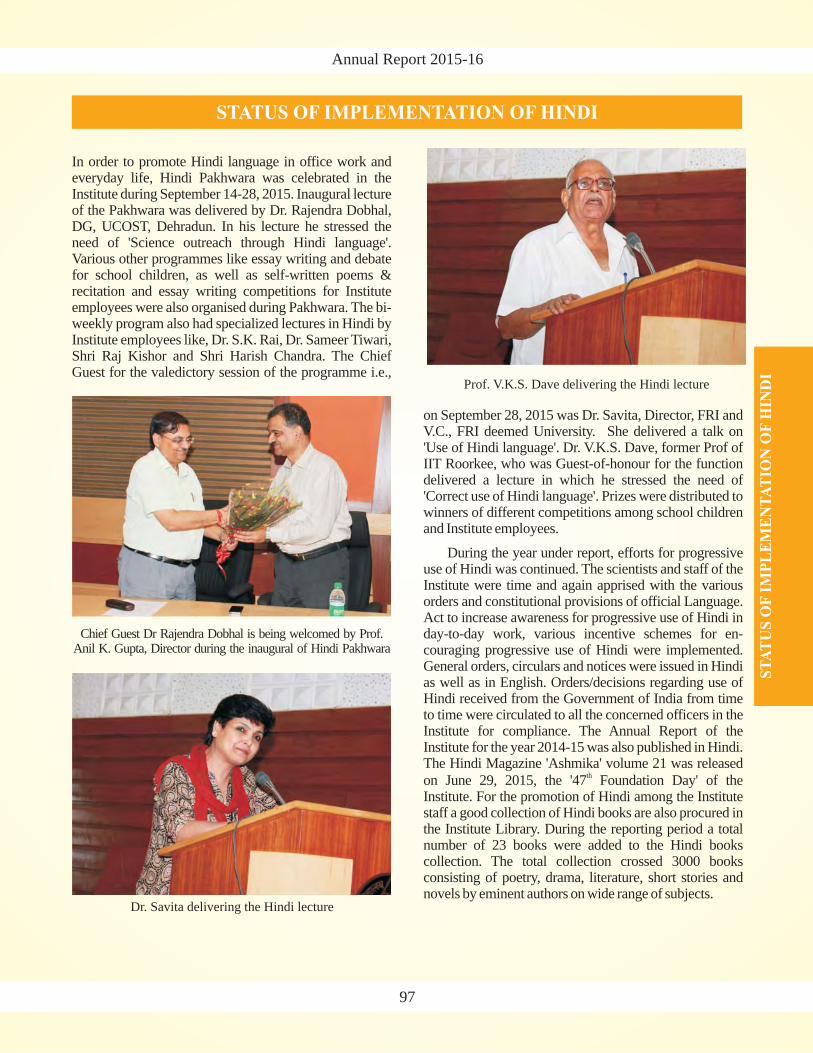
Annual Report 2015-16
ST
AT
US
OF
IMP
LE
ME
NT
AT
ION
OF
HIN
DI
STATUS OF IMPLEMENTATION OF HINDI
In order to promote Hindi language in office work andeveryday life, Hindi Pakhwara was celebrated in theInstitute during September 14-28, 2015. Inaugural lectureof the Pakhwara was delivered by Dr. Rajendra Dobhal,DG, UCOST, Dehradun. In his lecture he stressed theneed of 'Science outreach through Hindi language'.Various other programmes like essay writing and debatefor school children, as well as self-written poems &recitation and essay writing competitions for Instituteemployees were also organised during Pakhwara. The bi-weekly program also had specialized lectures in Hindi byInstitute employees like, Dr. S.K. Rai, Dr. Sameer Tiwari,Shri Raj Kishor and Shri Harish Chandra. The ChiefGuest for the valedictory session of the programme i.e.,
on September 28, 2015 was Dr. Savita, Director, FRI andV.C., FRI deemed University. She delivered a talk on'Use of Hindi language'. Dr. V.K.S. Dave, former Prof ofIIT Roorkee, who was Guest-of-honour for the functiondelivered a lecture in which he stressed the need of'Correct use of Hindi language'. Prizes were distributed towinners of different competitions among school childrenand Institute employees.
During the year under report, efforts for progressiveuse of Hindi was continued. The scientists and staff of theInstitute were time and again apprised with the variousorders and constitutional provisions of official Language.Act to increase awareness for progressive use of Hindi inday-to-day work, various incentive schemes for en-couraging progressive use of Hindi were implemented.General orders, circulars and notices were issued in Hindias well as in English. Orders/decisions regarding use ofHindi received from the Government of India from timeto time were circulated to all the concerned officers in theInstitute for compliance. The Annual Report of theInstitute for the year 2014-15 was also published in Hindi.The Hindi Magazine 'Ashmika' volume 21 was releasedon June 29, 2015, the '47 Foundation Day' of theInstitute. For the promotion of Hindi among the Institutestaff a good collection of Hindi books are also procured inthe Institute Library. During the reporting period a totalnumber of 23 books were added to the Hindi bookscollection. The total collection crossed 3000 booksconsisting of poetry, drama, literature, short stories andnovels by eminent authors on wide range of subjects.
th
97
Chief Guest Dr Rajendra Dobhal is being welcomed by Prof.Anil K. Gupta, Director during the inaugural of Hindi Pakhwara
Prof. V.K.S. Dave delivering the Hindi lecture
Dr. Savita delivering the Hindi lecture
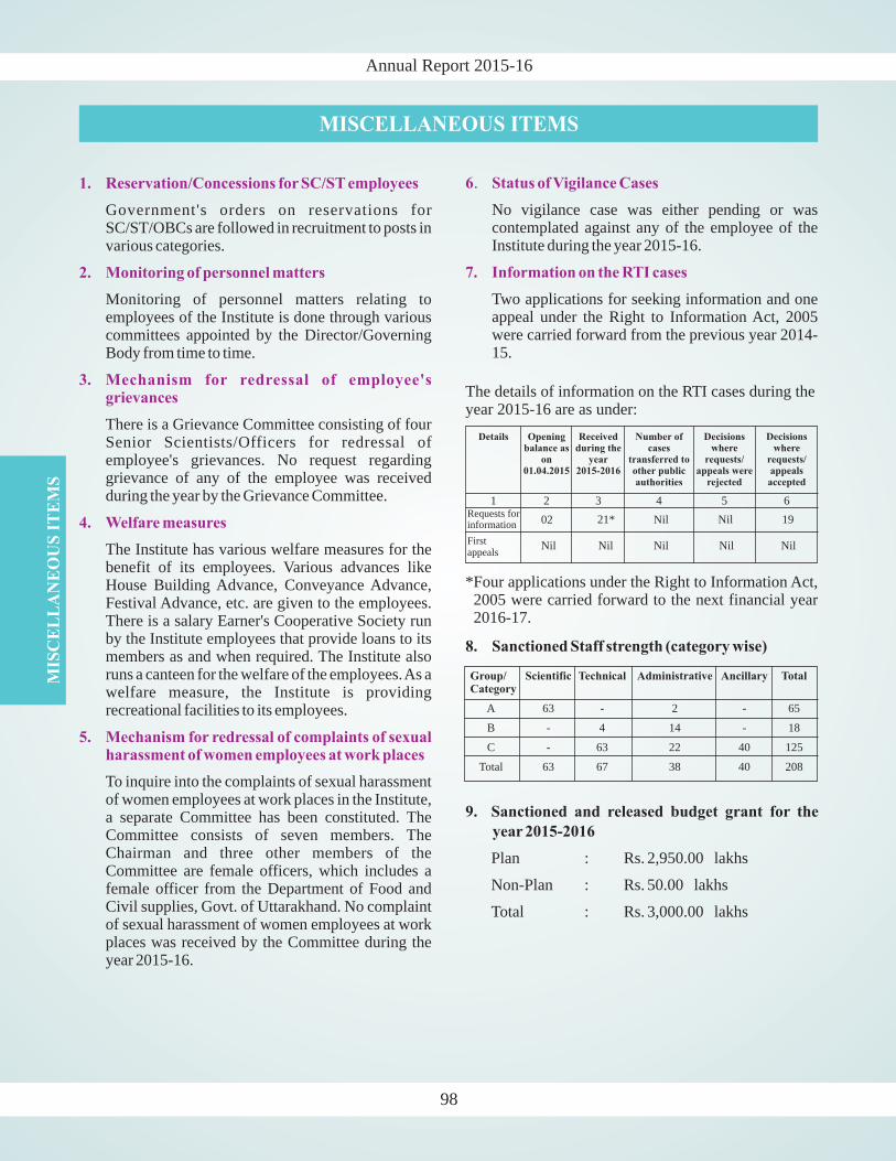
Annual Report 2015-16
MISCELLANEOUS ITEMS
1. Reservation/Concessions for SC/ST employees
2. Monitoring of personnel matters
3. Mechanism for redressal of employee'sgrievances
4. Welfare measures
5. Mechanism for redressal of complaints of sexualharassment of women employees at work places
Government's orders on reservations forSC/ST/OBCs are followed in recruitment to posts invarious categories.
Monitoring of personnel matters relating toemployees of the Institute is done through variouscommittees appointed by the Director/GoverningBody from time to time.
There is a Grievance Committee consisting of fourSenior Scientists/Officers for redressal ofemployee's grievances. No request regardinggrievance of any of the employee was receivedduring the year by the Grievance Committee.
The Institute has various welfare measures for thebenefit of its employees. Various advances likeHouse Building Advance, Conveyance Advance,Festival Advance, etc. are given to the employees.There is a salary Earner's Cooperative Society runby the Institute employees that provide loans to itsmembers as and when required. The Institute alsoruns a canteen for the welfare of the employees.As awelfare measure, the Institute is providingrecreational facilities to its employees.
To inquire into the complaints of sexual harassmentof women employees at work places in the Institute,a separate Committee has been constituted. TheCommittee consists of seven members. TheChairman and three other members of theCommittee are female officers, which includes afemale officer from the Department of Food andCivil supplies, Govt. of Uttarakhand. No complaintof sexual harassment of women employees at workplaces was received by the Committee during theyear 2015-16.
6 Status of Vigilance Cases
7. Information on the RTI cases
.
No vigilance case was either pending or wascontemplated against any of the employee of theInstitute during the year 2015-16.
Two applications for seeking information and oneappeal under the Right to Information Act, 2005were carried forward from the previous year 2014-15.
The details of information on the RTI cases during theyear 2015-16 are as under:
Requests forinformation 02 21* Nil Nil 19
Firstappeals
Nil Nil Nil Nil Nil
Details Openingbalance as
on01.04.2015
Receivedduring the
year2015-2016
Number ofcases
transferred toother publicauthorities
Decisionswhere
requests/appeals were
rejected
Decisionswhere
requests/appealsaccepted
1 2 3 4 5 6
*Four applications under the Right to Information Act,2005 were carried forward to the next financial year2016-17.
8. Sanctioned Staff strength (category wise)
9. Sanctioned and released budget grant for the
year 2015-2016
Plan : Rs. 2,950.00 lakhs
Non-Plan : Rs. 50.00 lakhs
Total : Rs. 3,000.00 lakhs
MIS
CE
LL
AN
EO
US
IT
EM
S
98
Group/Category
Scientific Technical Administrative Ancillary Total
A 63 - 2 - 65
B - 4 14 - 18
C - 63 22 40 125
Total 63 67 38 40 208

Annual Report 2015-16
STAFF OF THE INSTITUTE AS ON 01.04.2016
Scientific Staff
1. Prof. Anil Kumar Gupta Director
2. Dr. Rohtash Kumar Scientist 'G' (Retired on 31.07.15)
3. Dr. P.P. Khanna Scientist 'G' (Retired on 31.07.15)
4. Dr. (Mrs.) Meera Tiwari Scientist 'G'
5. Dr. N.K. Saini Scientist 'G' (Retired on 31.07.15)
6. Dr. Rafikul Islam Scientist 'G' (Retired on 30.04.15)
7. Dr. S.K. Ghosh Scientist 'G' (Retired on 30.06.15)
8. Dr. Kishor Kumar Scientist 'G'
9. Dr. Rajesh Sharma Scientist 'G'
10. Dr. G. Philip Scientist 'G'
11. Dr. B.N. Tiwari Scientist 'G'
12. Dr. D. Rameshwar Rao Scientist 'G'
13. Dr. P.K. Mukharjee Scientist 'G'
14. Dr. Keser Singh Scientist 'G' (Retired on 30.06.15)
15. Dr. S.K. Bartarya Scientist 'F'
16. Dr. T.N. Jowhar Scientist 'F' (Retired on 30.11.15)
17. Dr. S.K. Parcha Scientist 'F'
18. Dr. H.K. Sachan Scientist 'F'
19. Dr. Sushil Kumar Scientist 'F'
20. Dr. A.K. Mahajan Scientist 'E'
21. Dr. D.P. Dobhal Scientist 'E' (On Deputation)
22. Dr. Vikram Gupta Scientist 'E'
23. Dr. Suresh N. Scientist 'E'
24. Dr. Pradeep Srivastava Scientist 'E'
25. Shri V. Sriram Scientist 'E'
26. Dr. Ajay Paul Scientist 'E'
27. Dr. S.S. Bhakuni Scientist 'D'
28. Dr. P.S. Negi Scientist 'D'
29. Dr. A.K.L. Asthana Scientist 'D'
30. Dr. R. Jayangondaperumal Scientist 'D'
31. Dr. A.K. Singh Scientist 'D'
32. Dr. (Mrs.) Kapesa Lokho Scientist 'D'
33. Dr. Khaying Shing Luirei Scientist 'D'
34. Dr. Gautam Rawat Scientist 'D'
35. Dr. R.K. Sehgal Scientist 'D'
36. Dr. Jayendra Singh Scientist 'D'
37. Dr. B.K. Mukherjee Scientist 'D'
38. Dr. Santosh Kumar Rai Scientist 'D'
39. Dr. Rajesh S. Scientist 'C'
40. Dr. Naresh Kumar Scientist 'C'
41 Dr.(Mrs) Swapnamita Ch. Scientist 'C'
42. Dr. Devajit Hazarika Scientist 'C'
43. Dr. Narendra K. Meena Scientist 'C'
44. Dr. Dilip Kumar Yadav Scientist 'C'
45. Dr. Param K.R. Gautam Scientist 'C'
46. Dr. Kaushik Sen Scientist 'C'
47. Dr. Satyajeet S. Thakur Scientist 'C'
48. Dr. Manish Mehta Scientist 'C'
49. Dr. (Ms.) Aparna Shukla Scientist 'C'
(On Lien)
(Lien vacancy)
50. Dr Sudipta Sarkar Scientist 'B'
51. Sh. M. Prakasam Scientist 'B'
52. Dr. Vikas Scientist 'B'
53. Sh. Som Dutt Scientist 'B'
54. Sh. Anil Kumar Scientist 'B'
55. Sh. Saurabh Singhal Scientist 'B'
56. Dr. Narendra Kumar Scientist 'B'
57. Sh. Vinit Kumar Scientist 'B’
58. Dr. Aditya Kharya Scientist 'B’
59. Dr. Paramjeet Singh Scientist 'B’
60. Dr.(Ms) Suman Lata Rawat Scientist 'B’
61. Dr. Indu Shekhar Scientist 'B’
62. Dr. (Mrs) Chhavi P. Pandey Scientist 'B’
63. Dr. Parveen Kumar Scientist 'B’
1. Shri Saeed Ahmad Sr. Librarian
2. Shri B.B. Sharma Sr. Tech. Officer(Ret.on 30.06.15)
3. Shri M.M.S. Rawat Sr. Technical Officer
4. Shri Sanjeev K. Dabral Sr. Technical Officer
5. Shri Chandra Shekhar Sr. Technical Officer
6. Shri Samay Singh Sr. Technical Officer
7. Shri S.C. Kothiyal Sr. Tech. Officer(Ret.on 31.01.16)
8. Shri H.C. Pandey Technical Officer
9. Shri Ravindra Singh Technical Officer
10. Shri Rakesh Kumar Technical Officer
11. Shri N.K. Juyal Technical Officer
12. Shri C.B. Sharma Assistant Engineer
13. Shri T.K. Ahuja Jr. Technical Officer
14. Shri S.S. Bhandari Librarian
15. Shri Rambir Kaushik Asstt. Pub. & Doc. Officer
16. Shri Gyan Prakash Asstt. Pub. & Doc. Officer
17. Shri Bharat Singh Rana Librarian
18. Dr. Jitendra Bhatt Sr. Tech. Assistant
19. Shri Pankaj Chauhan Sr. Tech. Assistant (On Deputation)
20. Shri Lokeshwar Vashistha Sr. Lab. Technician
21. Dr. S.K. Chabak Sr. Lab. Technician
22. Shri R.M. Sharma Sr. Lab. Technician
23. Shri C.P. Dabral Sr. Lab. Technician
24. Shri S.K. Thapliyal Sr. Lab. Assistant
25. Shri Shiv Pd. Bahuguna Sr. Lab. Assistant
26. Shri Sashidhar Pd. Balodi Sr. Lab. Assistant
27. Shri Rajendra Prakash Sr. Lab. Assistant
28. Shri A.K. Gupta Sr. Lab. Assistant
29. Shri Tirath Raj Sr. Lab. Assistant
30. Shri Balram Singh Sr. Elect-cum-Pump Optr.
31. Shri Nand Ram Elect-cum-Pump.Optr.
32. Smt. Sarita Tech. Assistant
33. Sh. Rakesh Kumar Tech. Assistant
34. Km. Sakshi Maurya Tech. Assistant
Technical Staff
99
ST
AF
FO
FT
HE
IN
ST
ITU
TE
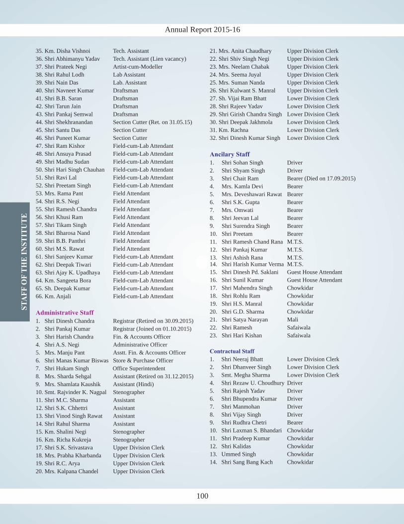
Annual Report 2015-16
35. Km. Disha Vishnoi Tech. Assistant
36. Shri Abhimanyu Yadav Tech. Assistant (Lien vacancy)
37. Shri Prateek Negi Artist-cum-Modeller
38. Shri Rahul Lodh Lab Assistant
39. Shri Nain Das Lab. Assistant
40. Shri Navneet Kumar Draftsman
41. Shri B.B. Saran Draftsman
42. Shri Tarun Jain Draftsman
43. Shri Pankaj Semwal Draftsman
44. Shri Shekhranandan Section Cutter (Ret. on 31.05.15)
45. Shri Santu Das Section Cutter
46. Shri Puneet Kumar Section Cutter
47. Shri Ram Kishor Field-cum-Lab Attendant
48. Shri Ansuya Prasad Field-cum-Lab Attendant
49. Shri Madhu Sudan Field-cum-Lab Attendant
50. Shri Hari Singh Chauhan Field-cum-Lab Attendant
51. Shri Ravi Lal Field-cum-Lab Attendant
52. Shri Preetam Singh Field-cum-Lab Attendant
53. Mrs. Rama Pant Field Attendant
54. Shri R.S. Negi Field Attendant
55. Shri Ramesh Chandra Field Attendant
56. Shri Khusi Ram Field Attendant
57. Shri Tikam Singh Field Attendant
58. Shri Bharosa Nand Field Attendant
59. Shri B.B. Panthri Field Attendant
60. Shri M.S. Rawat Field Attendant
61. Shri Sanjeev Kumar Field-cum-Lab Attendant
62. Shri Deepak Tiwari Field-cum-Lab Attendant
63. Shri Ajay K. Upadhaya Field-cum-Lab Attendant
64. Km. Sangeeta Bora Field-cum-Lab Attendant
65. Sh. Deepak Kumar Field-cum-Lab Attendant
66. Km. Anjali Field-cum-Lab Attendant
1. Shri Dinesh Chandra Registrar (Retired on 30.09.2015)
2. Shri Pankaj Kumar Registrar (Joined on 01.10.2015)
3. Shri Harish Chandra Fin. & Accounts Officer
4. Shri A.S. Negi Administrative Officer
5. Mrs. Manju Pant Asstt. Fin. & Accounts Officer
6. Shri Manas Kumar Biswas Store & Purchase Officer
7. Shri Hukam Singh Office Superintendent
8. Mrs. Sharda Sehgal Assistant (Retired on 31.12.2015)
9. Mrs. Shamlata Kaushik Assistant (Hindi)
10. Smt. Rajvinder K. Nagpal Stenographer
11. Shri M.C. Sharma Assistant
12. Shri S.K. Chhettri Assistant
13. Shri Vinod Singh Rawat Assistant
14. Shri Rahul Sharma Assistant
15. Km. Shalini Negi Stenographer
16. Km. Richa Kukreja Stenographer
17. Shri S.K. Srivastava Upper Division Clerk
18. Mrs. Prabha Kharbanda Upper Division Clerk
19. Shri R.C. Arya Upper Division Clerk
20. Mrs. Kalpana Chandel Upper Division Clerk
Administrative Staff
21. Mrs. Anita Chaudhary Upper Division Clerk
22. Shri Shiv Singh Negi Upper Division Clerk
23. Mrs. Neelam Chabak Upper Division Clerk
24. Mrs. Seema Juyal Upper Division Clerk
25. Mrs. Suman Nanda Upper Division Clerk
26. Shri Kulwant S. Manral Upper Division Clerk
27. Sh. Vijai Ram Bhatt Lower Division Clerk
28. Shri Rajeev Yadav Lower Division Clerk
29. Shri Girish Chandra Singh Lower Division Clerk
30. Shri Deepak Jakhmola Lower Division Clerk
31. Km. Rachna Lower Division Clerk
32. Shri Dinesh Kumar Singh Lower Division Clerk
1. Shri Sohan Singh Driver
2. Shri Shyam Singh Driver
3. Shri Chait Ram Bearer (Died on 17.09.2015)
4. Mrs. Kamla Devi Bearer
5. Mrs. Deveshawari Rawat Bearer
6. Shri S.K. Gupta Bearer
7. Mrs. Omwati Bearer
8. Shri Jeevan Lal Bearer
9. Shri Surendra Singh Bearer
10. Shri Preetam Bearer
11. Shri Ramesh Chand Rana M.T.S.
12. Shri Pankaj Kumar M.T.S.
13. Shri Ashish Rana M.T.S.14. Shri Harish Kumar Verma M.T.S.
15. Shri Dinesh Pd. Saklani Guest House Attendant
16. Shri Sunil Kumar Guest House Attendant
17. Shri Mahendra Singh Chowkidar
18. Shri Rohlu Ram Chowkidar
19. Shri H.S. Manral Chowkidar
20. Shri G.D. Sharma Chowkidar
21. Shri Satya Narayan Mali
22. Shri Ramesh Safaiwala
23. Shri Hari Kishan Safaiwala
1. Shri Neeraj Bhatt Lower Division Clerk
2. Shri Dhanveer Singh Lower Division Clerk
3. Smt. Megha Sharma Lower Division Clerk
4. Shri Rezaw U. Choudhury Driver
5. Shri Rajesh Yadav Driver
6. Shri Bhupendra Kumar Driver
7. Shri Manmohan Driver
8. Shri Vijay Singh Driver
9. Shri Rudhra Chetri Bearer
10. Shri Laxman S. Bhandari Chowkidar
11. Shri Pradeep Kumar Chowkidar
12. Shri Kalidas Chowkidar
13. Ummed Singh Chowkidar
14. Shri Sang Bang Kach Chowkidar
Ancilary Staff
Contractual Staff
100
ST
AF
FO
FT
HE
IN
ST
ITU
TE

Annual Report 2015-16
GOVERNING BODY/RESEARCH ADVISORY COMMITTEE/FINANCE COMMITTEE/BUILDING COMMITTEE MEMBERS
Governing Body
l. Name Address StatusS
(during 2015-16)
1. Prof. S.K. Tandon Block-A, House No. 566-C ChairmanSushant Lok, Phase-I,Gurgaon-122009
2. Representative of the Dept. of Science & Technology MemberSecretary, DST Technology Bhavan, New Mehrauli Road
New Delhi - 110016
3. Prof. M.P. Singh 124, Chandganj Extension Member(Opp. CN-7, Sector-B),AliganjLucknow-226024 (UP)
4. Dr. U.C. Mohanty School of Earth, Ocean and Climate Sciences MemberIndian Institute of Technology-BhubaneswarBhubaneswar-751007
5. Prof. D.C. Srivastava Head, Department of Earth Sciences MemberIndian Institute of Technology-RoorkeeRoorkee-247667
6. Dr. Rajesh K. Srivastava Faculty of Science, Department of Geology MemberBanaras Hindu University (BHU)Varanasi-221005 (UP)
7. Dr. D.S. Ramesh Director MemberIndian Institute of GeomagnetismPlot No. 5, Sector 18, New PanvelNavi Mumbai-410218 (Maharashtra)
8. Dr. Rajiv Nigam Chief Scientist MemberCSIR-National Institute of OceanographyGOA-403 004
9. Shri J.B. Mohapatra Joint Secretary and Financial Adviser MemberDepartment of Science and TechnologyTechnology Bhawan, New Mehrauli RoadNew Delhi-110 016
10. Prof. Anil K. Gupta Director MemberWadia Institute of Himalayan Geology SecretaryDehradun - 248001
11. Shri Pankaj Kumar Registrar Non-MemberWadia Institute of Himalayan Geology Asstt. SecretaryDehradun - 248001
101
GO
VE
RN
ING
BO
DY
/RE
SE
AR
CH
AD
VIS
OR
YC
OM
MIT
TE
E/
FIN
AN
CE
CO
MM
ITT
EE
/BU
ILD
ING
CO
MM
ITT
EE
ME
MB
ER
S
Annual Report 2015-16
Research Advisory Committee
Sl. Name Address Status
(during 2015-16)
1. Chairman
2. Member
3. Member
4. Member
5. H.No. 6-3-1099/1/3, Flat No. 504 Member
6. Member
7. Member
8. Member
9.
Prof. D.C. Srivastava HeadDepartment of Earth SciencesIndian Institute of Technology-RoorkeeRoorkee-247667
Dr. S. Sinha Roy (Ex-Deputy D.G., GSI)Birla Institute of Scientific ResearchStatue CircleJaipur-302001
Prof. Kusala Rajendran Centre for Earth SciencesIndian Institute of ScienceBangalore-560012
Prof. M. Jayananda Geology DepartmentCentre for Advanced StudiesDelhi University,Delhi-110007
Dr. R.S. DattatrayamAditya Classic Apartments,Nest to Katriya Hotel, SomajigudaHyderabad-500082
Dr. V.M. Tiwari ScientistNational Geophysical Research InstituteUppal Road, Hyderabad-500007
Dr. J.R. Kayal 73-B, Thakur Pukur RoadKolkata-700063
Prof. M.K. Panigrahi Department of Geology & GeophysicsIndian Institute of Technology-KharagpurKharagpur-721302
Prof. S. Tripathy Deputy Director & Head MemberSchool of Earth Ocean and Climate SciencesIndian Institute of Technology-BhubaneswarA-2702, Toshali Bhavan, Satya NagarBhubaneswar-751007
10. Prof. R.P. Tiwari Dean MemberSchool of Engineering & TechnologyMizoram UniversityAizawl-796009
102
GO
VE
RN
ING
BO
DY
/RE
SE
AR
CH
AD
VIS
OR
YC
OM
MIT
TE
E/
FIN
AN
CE
CO
MM
ITT
EE
/BU
ILD
ING
CO
MM
ITT
EE
ME
MB
ER
S
Annual Report 2015-16
103
Finance Committee
Sl. Name Address Status
(during 2015-16)
Chairman
3. Additional Secretary & Financial Adviser MemberDept. of Science & TechnologyTechnology Bhavan, New Mehrauli RoadNew Delhi - 110016
Secretary
1. Prof. M.P. Singh
2. Prof.Anil K. Gupta Director MemberWadia Institute of Himalayan Geology33, General Mahadeo Singh RoadDehradun - 248001
4. Shri Pankaj Kumar Registrar MemberWadia Institute of Himalayan Geology33, General Mahadeo Singh RoadDehradun - 248001
5. Shri Harish Chandra Finance & Accounts Officer MemberWadia Institute of Himalayan Geology33, General Mahadeo Singh RoadDehradun - 248001
124, Chandganj Extension(Opp. CN-7, Sector-B),AliganjLucknow-226024 (UP)
Shri J.B. Mohapatra
11. Prof. Sunil K. Singh Geosciences Division MemberPhysical Research LaboratoryNavrangpura, Ahmedabad-380009
12 Dr. Snehmani Joint Director MemberSnow and Avalanche Study EstablishmentHim Parisar, Sector - 37AChandigarh-160036
13. Prof. Anil K. Gupta Director
Dehradun-248001
14. Dr. S.K. Parcha Scientist `F' Member Secretary
Dehradun-248001
MemberWadia Institute of Himalayan Geology
Wadia Institute of Himalayan Geology
Sl. Name Address Status
GO
VE
RN
ING
BO
DY
/RE
SE
AR
CH
AD
VIS
OR
YC
OM
MIT
TE
E/
FIN
AN
CE
CO
MM
ITT
EE
/BU
ILD
ING
CO
MM
ITT
EE
ME
MB
ER
S
Annual Report 2015-16
Building Committee
Sl. Name Address Status
(during 2015-16)
1. Prof. Anil K. Gupta Director ChairmanWadia Institute of Himalayan Geology33, General Mahadeo Singh RoadDehradun - 248001
2. Additional Secretary & FinancialAdviser MemberDept. of Science & TechnologyTechnology Bhavan, New Mehrauli RoadNew Delhi - 110016
3. Dr. Rajesh Sharma Scientist 'G' MemberWadia Institute of Himalayan Geology33, General Mahadeo Singh RoadDehradun - 248001
4. Representative of Tel Bhawan MemberONGC Oil & Natural Gas Corporation
Dehradun - 248001
5. Representative of MemberSurvey of India
Dehradun - 248001
6. Shri Pankaj Kumar Registrar MemberWadia Institute of Himalayan Geology33, General Mahadeo Singh RoadDehradun - 248001
7. Shri C.B. Sharma Assistant Engineer Member SecretaryWadia Institute of Himalayan Geology33, General Mahadeo Singh RoadDehradun - 248001
Shri J.B. Mohapatra
Surveyor General's OfficeSurvey of India, Hathibarkala,
104
GO
VE
RN
ING
BO
DY
/RE
SE
AR
CH
AD
VIS
OR
YC
OM
MIT
TE
E/
FIN
AN
CE
CO
MM
ITT
EE
/BU
ILD
ING
CO
MM
ITT
EE
ME
MB
ER
S
Annual Report 2015-16
105
STATEMENT OF ACCOUNTSSTATEMENT OF ACCOUNTS

ST
AT
EM
EN
T O
F A
CC
OU
NT
S
Annual Report 2015-16
107
ST
AT
EM
EN
T O
F A
CC
OU
NT
S
Annual Report 2015-16
107
Annual Report 2015-16S
TA
TE
ME
NT
OF
AC
CO
UN
TS
Annual Report 2015-16
ST
AT
EM
EN
T O
F A
CC
OU
NT
S
108 109
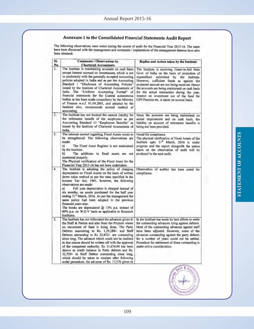
Annual Report 2015-16
ST
AT
EM
EN
T O
F A
CC
OU
NT
S
Annual Report 2015-16
ST
AT
EM
EN
T O
F A
CC
OU
NT
S
108 109
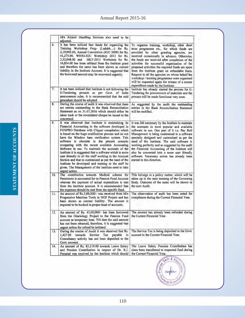
Annual Report 2015-16S
TA
TE
ME
NT
OF
AC
CO
UN
TS
Annual Report 2015-16
ST
AT
EM
EN
T O
F A
CC
OU
NT
S
110 111
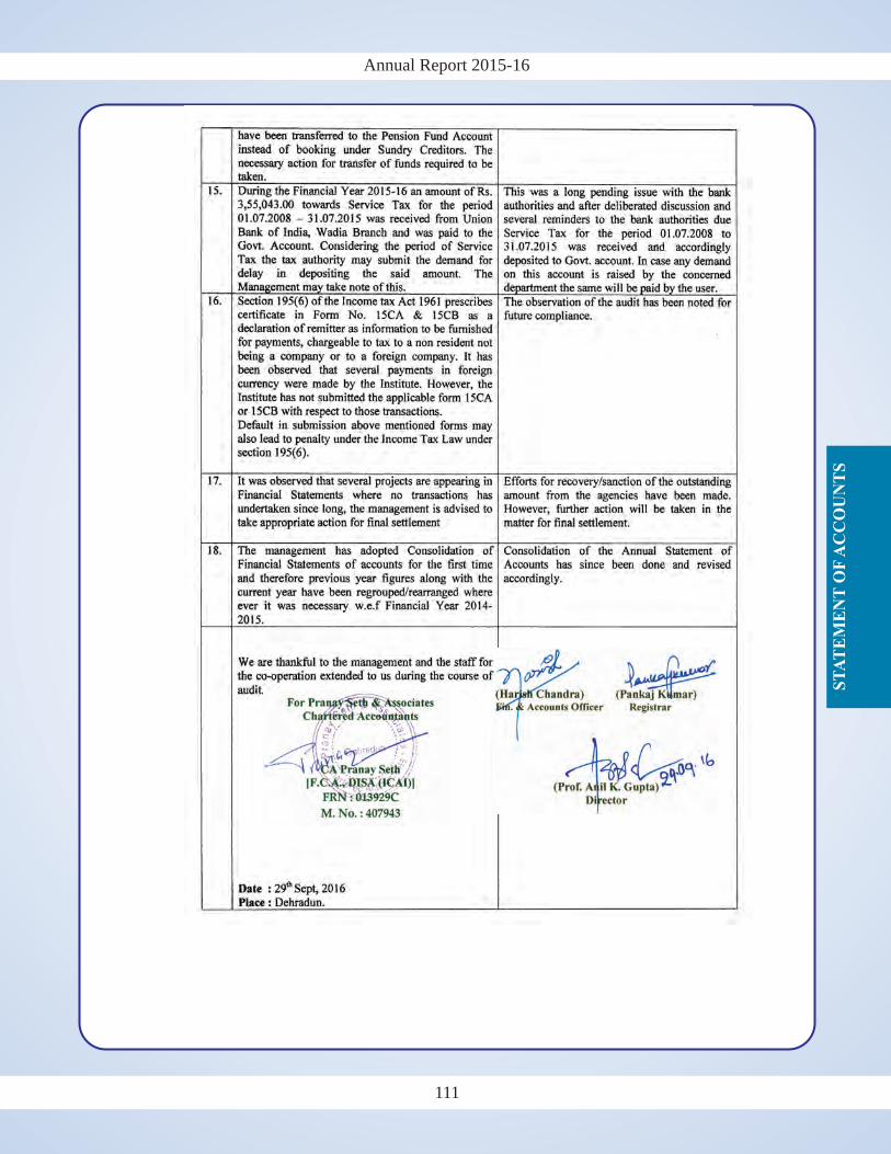
Annual Report 2015-16
ST
AT
EM
EN
T O
F A
CC
OU
NT
S
Annual Report 2015-16
ST
AT
EM
EN
T O
F A
CC
OU
NT
S
110 111
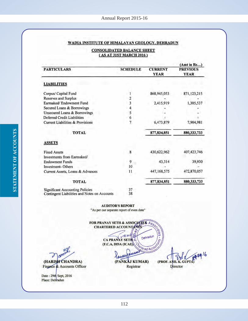
Annual Report 2015-16S
TA
TE
ME
NT
OF
AC
CO
UN
TS
Annual Report 2015-16
ST
AT
EM
EN
T O
F A
CC
OU
NT
S
112 113
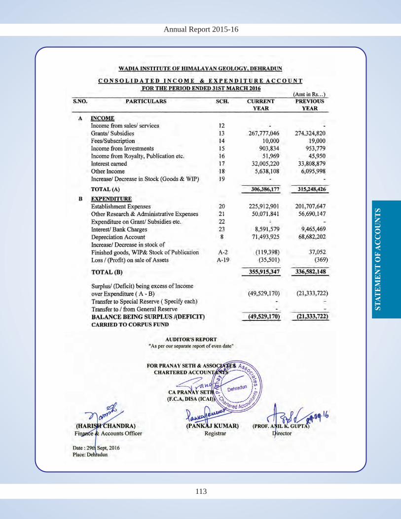
Annual Report 2015-16
ST
AT
EM
EN
T O
F A
CC
OU
NT
S
Annual Report 2015-16
ST
AT
EM
EN
T O
F A
CC
OU
NT
S
112 113
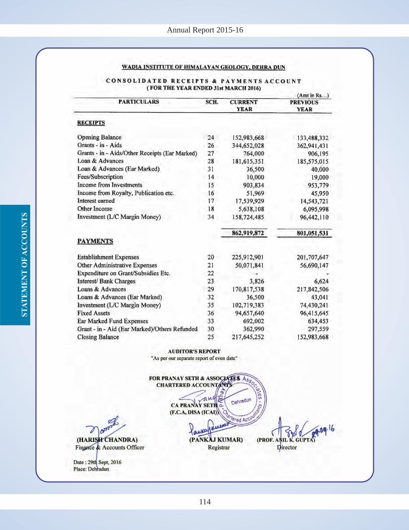
Annual Report 2015-16S
TA
TE
ME
NT
OF
AC
CO
UN
TS
Annual Report 2015-16
ST
AT
EM
EN
T O
F A
CC
OU
NT
S
114 115
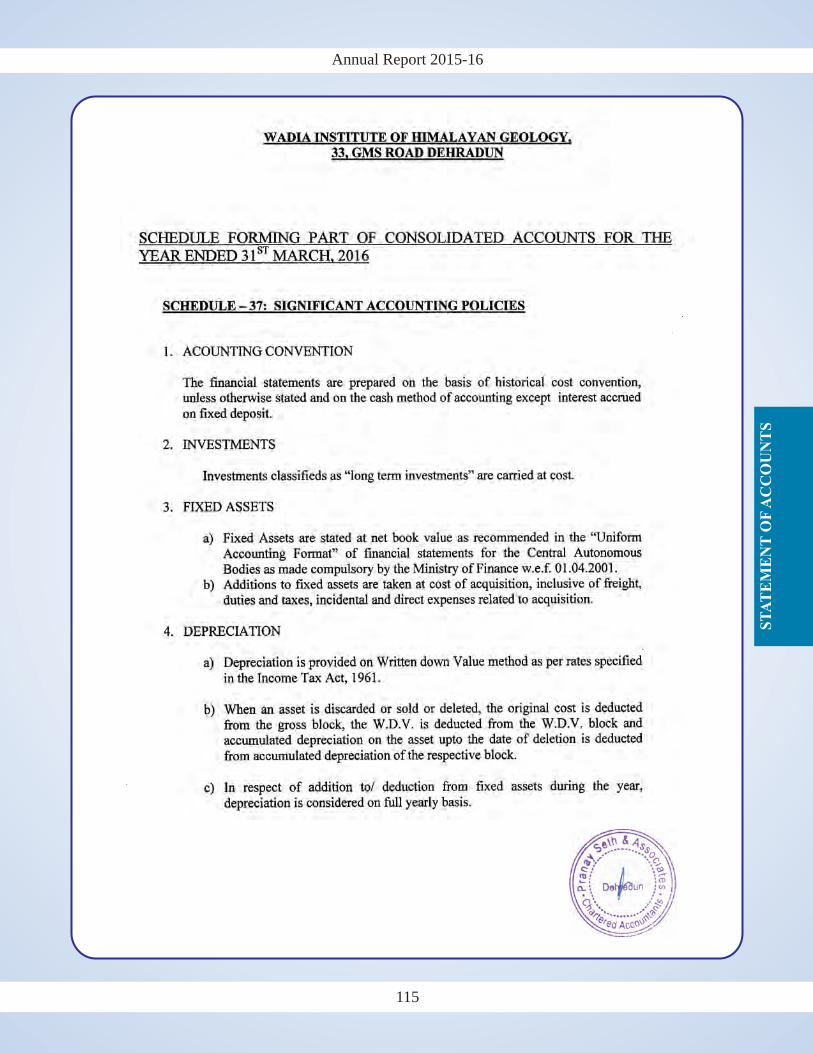
Annual Report 2015-16
ST
AT
EM
EN
T O
F A
CC
OU
NT
S
Annual Report 2015-16
ST
AT
EM
EN
T O
F A
CC
OU
NT
S
114 115
Annual Report 2015-16S
TA
TE
ME
NT
OF
AC
CO
UN
TS
Annual Report 2015-16
ST
AT
EM
EN
T O
F A
CC
OU
NT
S
116 117
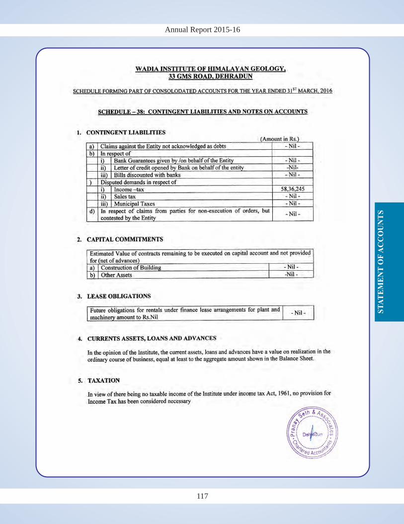
Annual Report 2015-16
ST
AT
EM
EN
T O
F A
CC
OU
NT
S
Annual Report 2015-16
ST
AT
EM
EN
T O
F A
CC
OU
NT
S
116 117
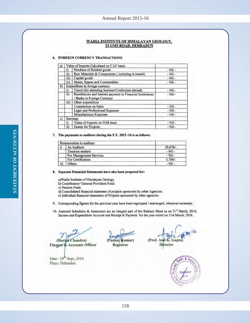
Annual Report 2015-16S
TA
TE
ME
NT
OF
AC
CO
UN
TS
118
OLD PUBLICATIONS
NEW PUBLICATIONS
1. Nanda, A.C. 2015: Siwalik mammalian faunas of the Himalayan foothills with reference to biochronology, linkages and migration. Wadia Institute of Himalayan Geology, Dehradun, WIHG Nonograph Series No. 2, 341p.
2. Bhambri, R., Mehta, M., Dobhal, D.P. & Gupta, A.K. 2015: Glacier Lake Iniventory of Uttarakhand. Wadia Institute of Himalayan Geology, Dehradun, 78p.
WADIA INSTITUTE OF HIMALAYAN GEOLOGY, DEHRADUN
Rs.1200/- (India), US$ 100/- (Abroad)
SIWALIK MAMMALIAN FAUNAS OF THE HIMALAYAN FOOTHILLS
With reference to biochronology, linkages and migration
Wadia Institute of Himalayan Geology33, General Mahadeo Singh RoadDehradun 248 001
Avinash C
. Nanda
Price: Rs. 500/- (India), US$ 50/- (Abroad)
GLACIER LAKE INVENTORY
OF
UTTARAKHAND
Wadia Institute of Himalayan Geology
Rs.180/- (India), US$ 50/- (Abroad) Rs.205/- (India), US$ 40/- (Abroad) Rs.180/- (India), US$ 15/- (Abroad) Rs.45/- (India), US$ 8/- (Abroad)
Rs.200/- (India), US$ 15/- (Abroad)
Procurement details:
Cheque/Bank Draft:
Corresponding address:The Director
Wadia Institute of Himalayan Geology, 33, GMS Road, Dehradun 248001, India
orAsstt. Publication & Doc. Officer
Wadia Institute of Himalayan Geology, 33, GMS Road, Dehradun 248001, India
Phone: +91-0135-2525430, Fax: 0135-2625212Email: [email protected],
Web: http://www.himgeology.com
Should be in favour of the 'Director, WIHG, Dehradun, India'
PUBLISHED PUBLICATIONS

Volume 37 (2016)
Volume 34 (2013) to Volume 36 (2015)*
Volume 18 (1997) to Volume 27 (2006)*
Volume 28 (2007) to Volume 29 (2008)
Volume 30 (2009) to Volume 32 (2011)*
Glacier Lake Inventory of Uttarakhand(by Rakesh Bhambri et al. 2015
Siwalik Mammalian Faunas of the Himalayan FoothillsWith reference to biochronology, linkages and migration
Rs. 500.00US $ 50.00
Rs. 1200.00US $ 100.00
Volume 33 (2012)
(by Avinash C. Nanda)