Andershaw to Coalburn 132kV Overhead Line Non … · The Andershaw to Coalburn 132kV Overhead Line...
26
April 2009 Andershaw to Coalburn 132kV Overhead Line Non Technical Summary
Transcript of Andershaw to Coalburn 132kV Overhead Line Non … · The Andershaw to Coalburn 132kV Overhead Line...

April 2009
Andershaw to Coalburn 132kV Overhead Line Non Technical Summary


This document has been prepared by Faber Maunsell Limited (“Faber Maunsell”) for the sole use of our client (the “Client”) and in accordance with generally accepted consultancy principles, the budget for fees and the terms of reference agreed between Faber Maunsell and the Client. Any information provided by third parties and referred to herein has not been checked or verified by Faber Maunsell, unless otherwise expressly stated in the document. No third party may rely upon this document without the prior and express written agreement of Faber Maunsell.
Published by: ScottishPower Ltd 1 Atlantic Quay Glasgow G2 8SP
Produced for SP Transmission Ltd (a ScottishPower Company) by Faber Maunsell with specialist input from EDAW and SP PowerSystems Ltd (a ScottishPower Company).
SP Transmission Ltd, Registered Office: 1 Atlantic Quay, Glasgow, G2 8SP. Registered in Scotland No. SC189126. © Copyright ScottishPower Ltd (April 2009) All rights reserved. No part of this publication may be reproduced, stored in a retrieval system, or transmitted in any form or by any means electronic, mechanical, photocopying or otherwise without prior written permission of the publisher.


Preface
The Andershaw to Coalburn 132kV Overhead Line Environmental Statement is published as a single document comprising three volumes:
Volume 1 Non-Technical Summary
Volume 2 Environmental Statement
Volume 3 Appendices
The ES sets out the findings of the Environmental Impact Assessment (EIA) undertaken for the proposed overhead line connection between Andershaw Windfarm and Coalburn Substation following the requirements of the Electricity Works (Environmental Impact Assessment) (Scotland) Regulations 2000. This document is a standalone copy of Volume 1, the Non Technical Summary (NTS). Further copies of all these reports may be obtained from:
SP Energy Networks Environmental Planning 3 Prenton Way Prenton Merseyside CH43 3ET Tel: 0151 609 2568 Copies of the Environmental Statement may be obtained from SP Transmission (tel: 0151 609 2568) at a charge of £120 for a hard copy and £10 for a DVD. Copies of a short standalone Non Technical Summary are available free of charge (not including Postage and Packaging). Copies of the documents will be available for public viewing at the following locations: Council Offices: Libraries: Other Locations: South Lanarkshire Council Lanark Library Lesmahagow Library St Brides Hall Clydesdale Planning & Building Standards area office 16 Hope Street 48 Abbeygreen Braehead South Vennel Lanark Lesmahagow Douglas Lanark ML11 7LZ ML11 0EF ML11 0QW ML11 7JT

Any representations to the application should be made by completing the online representation form on The Scottish Government, Energy Consents website at
http://www.scotland.gov.uk/Topics/Business-Industry/Energy/Energy-Consents/Support-object
Or by email to The Scottish Government, Energy Consents Unit mailbox at:
Or by post to:
The Scottish Government, Energy Consents Unit, 2nd Floor, Meridian Court, 5 Cadogan Street, Glasgow, G2 6AT
Representations should be dated and should clearly state the name (in block capitals) and full return email or postal address of those making representation. All representations to the Scottish Government will be copied in full to the planning authority, and made available to the public on request, unless individuals request otherwise.

1. Introduction 1
2. Scheme Description 3
3. Environmental Impact Assessment 6
3.1 Introduction 6
3.2 Planning Policy Context 6
3.3 Land Use, Access & Recreation 6
3.4 Landscape & Visual Amenity 7
3.5 Ecology & Nature Conservation 9
3.6 Ornithology 10
3.7 Cultural Heritage & Archaeology 11
3.8 Ground Conditions & the Water Environment 11
3.9 Mitigation 12
4. Summary & Conclusions 14
4.1 Summary of EIA Results 14
4.2 SPT’s Statutory Duties 14
Contents

Andershaw to Coalburn 132kV Overhead Line Non Technical Summary
1
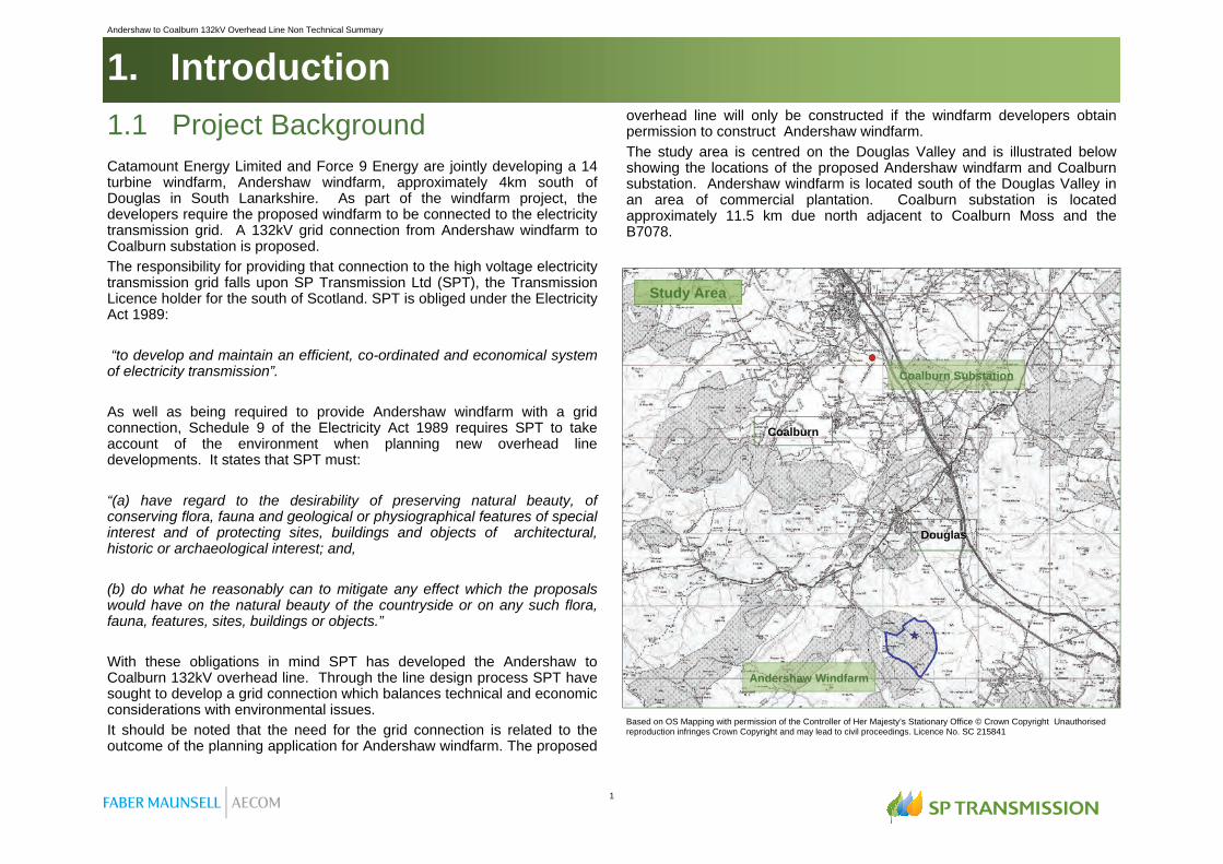
1.1 Project Background Catamount Energy Limited and Force 9 Energy are jointly developing a 14 turbine windfarm, Andershaw windfarm, approximately 4km south of Douglas in South Lanarkshire. As part of the windfarm project, the developers require the proposed windfarm to be connected to the electricity transmission grid. A 132kV grid connection from Andershaw windfarm to Coalburn substation is proposed. The responsibility for providing that connection to the high voltage electricity transmission grid falls upon SP Transmission Ltd (SPT), the Transmission Licence holder for the south of Scotland. SPT is obliged under the Electricity Act 1989: “to develop and maintain an efficient, co-ordinated and economical system of electricity transmission”. As well as being required to provide Andershaw windfarm with a grid connection, Schedule 9 of the Electricity Act 1989 requires SPT to take account of the environment when planning new overhead line developments. It states that SPT must: “(a) have regard to the desirability of preserving natural beauty, of conserving flora, fauna and geological or physiographical features of special interest and of protecting sites, buildings and objects of architectural, historic or archaeological interest; and, (b) do what he reasonably can to mitigate any effect which the proposals would have on the natural beauty of the countryside or on any such flora, fauna, features, sites, buildings or objects.” With these obligations in mind SPT has developed the Andershaw to Coalburn 132kV overhead line. Through the line design process SPT have sought to develop a grid connection which balances technical and economic considerations with environmental issues. It should be noted that the need for the grid connection is related to the outcome of the planning application for Andershaw windfarm. The proposed
overhead line will only be constructed if the windfarm developers obtain permission to construct Andershaw windfarm. The study area is centred on the Douglas Valley and is illustrated below showing the locations of the proposed Andershaw windfarm and Coalburn substation. Andershaw windfarm is located south of the Douglas Valley in an area of commercial plantation. Coalburn substation is located approximately 11.5 km due north adjacent to Coalburn Moss and the B7078.
Glespin
Based on OS Mapping with permission of the Controller of Her Majesty’s Stationary Office © Crown Copyright Unauthorised reproduction infringes Crown Copyright and may lead to civil proceedings. Licence No. SC 215841
Andershaw Windfarm
Coalburn Substation
Douglas
Coalburn
Study Area
1. Introduction

2
Andershaw to Coalburn 132kV Overhead Line Non Technical Summary
1.2 EIA of the Scheme
In accordance with the Electricity Act 1989, SPT has submitted a Section 37 application to the Scottish Government for permission to construct and operate the 132kV transmission line. The requirements to undertake a statutory Environmental Impact Assessment (EIA) as part of Section 37 application are set out in the Electricity Works (Environmental Impact Assessment) (Scotland) Regulations 2000. Whilst the requirement to undertake a statutory EIA can be established through Screening the proposal with the Scottish Government, SPT, mindful of their responsibilities to people and the environment, as well as their statutory duties; consider it appropriate to undertake an EIA for this overhead line development.
1.3 The Environmental Statement As part of the Section 37 application SPT have prepared and submitted an Environmental Statement (ES) which describes the findings of the EIA. It identifies the adverse and/or beneficial environmental impacts of the scheme and the measures that will be taken to avoid, reduce or offset those impacts. The topics considered within the EIA and the approach to undertaking the assessment were established following receipt of a Scoping Opinion from the Scottish Government. This document also provided the views of South Lanarkshire Council, SNH, SEPA and Historic Scotland. Those topics identified for consideration within the EIA included: Land Use, Access & Recreation; Landscape & Visual Amenity; Ecology & Nature Conservation; Ornithology; Cultural Heritage & Archaeology; Ground Conditions & the Water Environment.

Andershaw to Coalburn 132kV Overhead Line Non Technical Summary
3
2.1 Development of the Scheme The proposed overhead line connection between Andershaw windfarm and Coalburn substation has been identified following a detailed routeing study which considered the environmental, technical and economic constraints to overhead line development within the area. The study involved a number of key stages including consideration of a number of alternative connection routes.
During the routeing study a number of constraints and opportunities were identified including areas and designated sites which were to be avoided and existing wayleaves through woodland which could be used. Alternative routes that were considered in the development of the scheme are illustrated below.
KEY STAGES IN THE PROJECT Identification of a Preferred Route: Environmental constraints, in particular landscape and visual issues, were a principal consideration in the development and appraisal of a number of route options. The appraisal resulted in the identification of the Preferred Route. Consultation and Scoping the Preferred Route: The results of the routeing study were reported on within a Consultation Document. The Preferred Route was then subject to consultation with statutory and non-statutory consultees including SNH and SEPA. At the same time public consultation was undertaken; exhibition boards were put in place in St Brides Hall in Douglas and Coalburn Leisure Centre and SPT met with Douglas Community Council. During the consultation period a Scoping Opinion was requested from the Scottish Government in order to identify the scope of, and approach to the EIA of the overhead line. Development of the Proposed Route: Following the consultation period and receipt of consultation and scoping re-sponses the Preferred Route was reviewed. The review included the prepa-ration of a technical line design. This was then adopted as the Proposed Overhead Line. EIA of the Proposed Route: An EIA of the Proposed Overhead Line was then undertaken in support of the Section 37 application.
Alternative Grid Connections
Based on OS Mapping with permission of the Controller of Her Majesty’s Stationary Office © Crown Copyright Unauthorised reproduction infringes Crown Copyright and may lead to civil proceedings. Licence No. SC 215841
2. Scheme Description
Route of the Proposed Overhead Line
Based on OS Mapping with permission of the Controller of Her Majesty’s Stationary Office © Crown Copyright Unauthorised reproduction infringes Crown Copyright and may lead to civil proceedings. Licence No. SC 215841
Andershaw Windfarm
Coalburn Substation
Andershaw to Coalburn 132kV Overhead Line Non Technical Summary
5
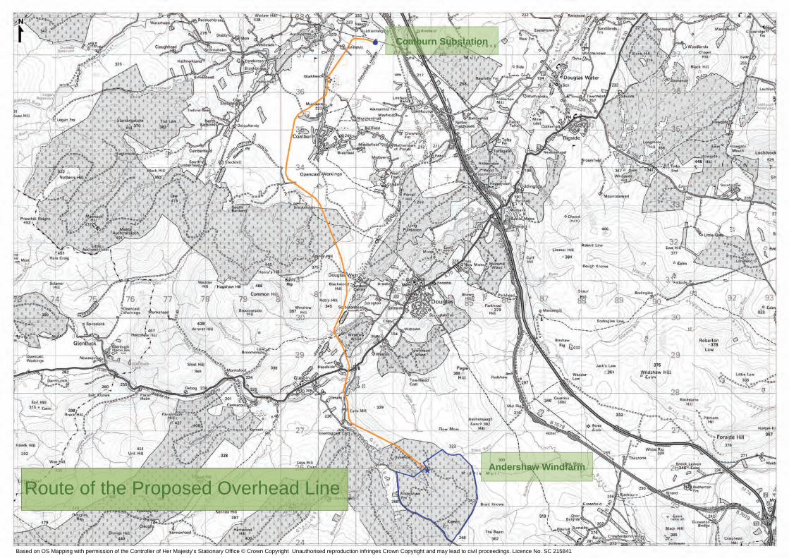
2.2 Proposed Route The proposed overhead line route is illustrated on the adjacent page. It is approximately 15km length; of which 14.5km is carried on an overhead line with remaining section being an underground cable into Coalburn substation. The proposed connection runs in a generally northern direction from the proposed Andershaw windfarm broadly north towards the A70 and Douglas Water. It crosses the Douglas Valley north towards Hagshaw Hill windfarm and continues through the former opencast coal mine at Dalquhandy to the west of Coalburn. The scheme crosses Muirburn and Coalburn Road and is routed north where it connects to the recently constructed substation 2km north of Coalburn.
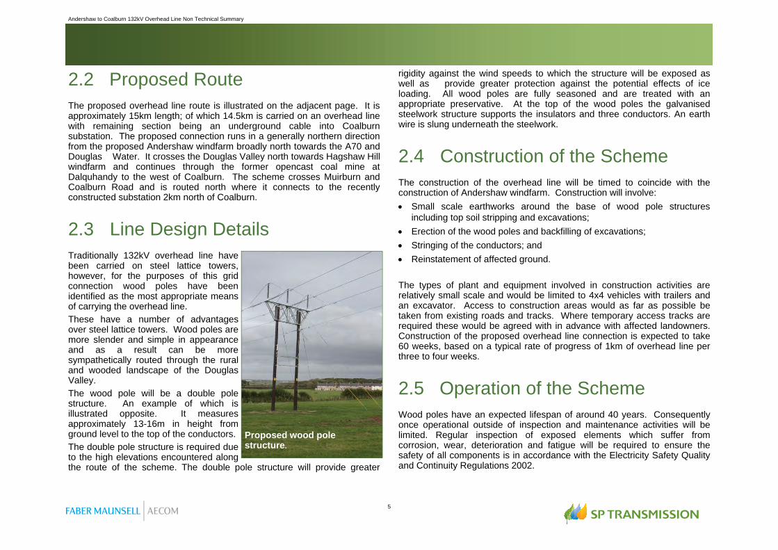
2.3 Line Design Details Traditionally 132kV overhead line have been carried on steel lattice towers, however, for the purposes of this grid connection wood poles have been identified as the most appropriate means of carrying the overhead line. These have a number of advantages over steel lattice towers. Wood poles are more slender and simple in appearance and as a result can be more sympathetically routed through the rural and wooded landscape of the Douglas Valley. The wood pole will be a double pole structure. An example of which is illustrated opposite. It measures approximately 13-16m in height from ground level to the top of the conductors. The double pole structure is required due to the high elevations encountered along the route of the scheme. The double pole structure will provide greater
rigidity against the wind speeds to which the structure will be exposed as well as provide greater protection against the potential effects of ice loading. All wood poles are fully seasoned and are treated with an appropriate preservative. At the top of the wood poles the galvanised steelwork structure supports the insulators and three conductors. An earth wire is slung underneath the steelwork.
2.4 Construction of the Scheme The construction of the overhead line will be timed to coincide with the construction of Andershaw windfarm. Construction will involve: Small scale earthworks around the base of wood pole structures
including top soil stripping and excavations; Erection of the wood poles and backfilling of excavations; Stringing of the conductors; and Reinstatement of affected ground. The types of plant and equipment involved in construction activities are relatively small scale and would be limited to 4x4 vehicles with trailers and an excavator. Access to construction areas would as far as possible be taken from existing roads and tracks. Where temporary access tracks are required these would be agreed with in advance with affected landowners. Construction of the proposed overhead line connection is expected to take 60 weeks, based on a typical rate of progress of 1km of overhead line per three to four weeks.
2.5 Operation of the Scheme Wood poles have an expected lifespan of around 40 years. Consequently once operational outside of inspection and maintenance activities will be limited. Regular inspection of exposed elements which suffer from corrosion, wear, deterioration and fatigue will be required to ensure the safety of all components is in accordance with the Electricity Safety Quality and Continuity Regulations 2002.
Proposed wood pole structure.

6
Andershaw to Coalburn 132kV Overhead Line Non Technical Summary
3.1 Introduction EIA is the process of compiling, evaluating and presenting all of the significant environmental effects of a proposed development. This is an iterative process that allows the developer to identify potential environmental effects and develop mitigation measures which aim to avoid, reduce or offset the negative impacts of the development. The following sub-sections provide a summary of the findings of the assessment of each of the topics covered in the ES. The assessment describes negative and positive effects on a rising scale, typically none, minor, moderate or major.
3.2 Planning Policy Context The application to construct and operate the proposed overhead line will be made to the Scottish Ministers under Section 37 of the Electricity Act 1989. The Ministers will consider the Section 37 application in the context of a range of policies at national, regional and local level including National
Planning Policy Guidance (NPPGs), Scottish Planning Policies (SPPs), the Glasgow and Clyde Valley Joint Structure Plan and the South Lanarkshire Local Plan (finalised 2006). Policies that will be particularly pertinent include those which relate to the protection of the built and natural environment as well as others relating to the development of renewable energy schemes.
3.3 Land Use, Access & Recreation Current and potential future land use within the study area has been established through site surveys and a review of maps, aerial photographs and current planning applications. The predominant land uses within 250m of the proposed overhead line are related with agriculture and commercial forestry. Agricultural use tends to be limited to rough grazing particularly on upland and moorland areas whilst on the lower valley slopes improved arable land is present. In the wider area opencast coal mining and associated activities are dominant; three active mines are present (Glentaggart, Broken Cross and Poniel) with a fourth proposed at Mainshill Wood. The proposed overhead line directly crosses six of the identified land use categories including commercial plantation, land used for rough grazing, improved agricultural land and the former opencast site at Dalquhandy. A key element in mitigating potentially negative effects on land use has been to avoid routeing over those areas identified as being particularly sensitive or valuable. However, the primary effects on land use relating to the land take associated with the proposed overhead line are unavoidable. In addition, there could also be a potential reduction to land use functions resulting from temporary severance or reduction in access. The landtake, particularly once the overhead line is operational, is minimal. In order to ensure construction impacts are reduced, working areas will be minimised and access maintained as far as practicable. Impacts on existing land use have been assessed as Minor Adverse and are therefore Not Significant. The land use assessment also considered the effects of tree removal within commercial plantation. The proposed overhead line will require widening of existing wayleaves in mature plantation and creation of wayleaves in recently planted areas. The precise areas to be felled would be determined prior to construction, however, it is estimated up to 12ha of plantation would
KEY TO IMPACTS Major: These are highly significant impacts because of their large scale and/or the importance of the area affected. Moderate: These are significant impacts because of their scale and/or the importance of the area affected. Minor: While noticeable these impacts are not significant. None: Impacts rated as none result in no detectable change to the environment.
3. Environmental Impact Assessment

Andershaw to Coalburn 132kV Overhead Line Non Technical Summary
7
require to be felled or lopped. In the context of the existing plantation coverage in the area this is a negligible amount. Windthrow risk within the identified wayleaves will be assessed where appropriate and mitigation measures implemented, therefore impacts are assessed as being Minor Adverse and therefore Not Significant.
3.4 Landscape & Visual Amenity The landscape within the study area has undergone intensive modification by opencast coal mining, renewable energy development, forestry and agricultural activities. It is also crossed by a network of transmission and distribution overhead lines strung on wood poles and higher voltage lines on large steel lattice towers. The range and form of development have altered the landscape to varying degrees and resulted in a decline in landscape quality and condition in some areas. However, there are also some valued and higher quality landscapes within the study area. The scheme is routed within 1.5km of the Southern Uplands Regional Scenic Area (RSA) and crosses through the western part of Douglas Area of Great Landscape Value (AGLV). There are no national landscape designations such as National Scenic Areas or Registered Historic Parks and Gardens within the study area. The proposed overhead line would pass through three Regional Landscape Character Types as identified in the Glasgow and Clyde Valley Landscape Character Assessment; Plateau Moorland (green), Plateau Farmland (purple) and Upland River Valley (yellow). However, given the relatively small extents of the study area and the scale of proposed scheme, eight local landscape character areas, which provide a more detailed landscape resource baseline have also been identified. These are: Upland Moorland with Commercial Forestry; Upland Moorland; Opencast Mining; Restored Opencast Mining; River Valley Pasture; Upland Moorland with Windfarm
Lowland Moorland; and Undulating Pasture.
With regard to impacts on landscape designations the proposed overhead line would not result in any significant effects on the Southern Uplands RSA. Where the scheme crosses the floor of the Douglas Valley within the AGLV there would be a Significant impact on a limited area. However, overall effects on the AGLV are considered to be Not Significant.
Regional Landscape Character Types
Based on OS Mapping with permission of the Controller of Her Majesty’s Stationary Office © Crown Copyright Unauthorised reproduction infringes Crown Copyright and may lead to civil proceedings. Licence No. SC 215841
8
Andershaw to Coalburn 132kV Overhead Line Non Technical Summary
Routeing of the line has sought to achieve the best fit with the landscape using landform and vegetation whilst recognising the engineering and technical constraints of the construction and operation of an overhead line. Micrositing of wood poles could further reduce impacts of the scheme by ensuring that structures are placed where they would not cause unnecessary detrimental effects. The landscape and visual impact assessment indicates that there would be significant adverse impacts upon the landscape of some parts of the study area and the Douglas Water AGLV would be affected to a degree. There would also be significant adverse effects on the visual amenity afforded from some locations. However it is considered that the visual amenity of the study area in general would not deteriorate to a significant degree and the overall impact upon the population of the study area is therefore limited.
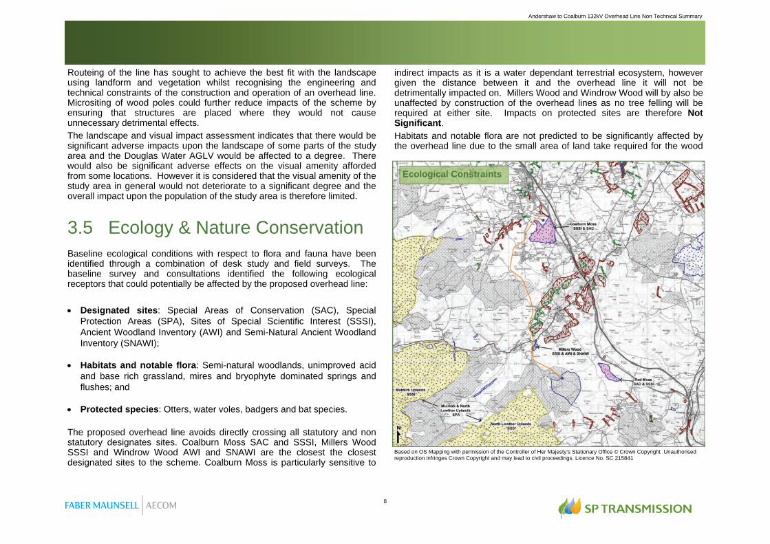
3.5 Ecology & Nature Conservation Baseline ecological conditions with respect to flora and fauna have been identified through a combination of desk study and field surveys. The baseline survey and consultations identified the following ecological receptors that could potentially be affected by the proposed overhead line: Designated sites: Special Areas of Conservation (SAC), Special
Protection Areas (SPA), Sites of Special Scientific Interest (SSSI), Ancient Woodland Inventory (AWI) and Semi-Natural Ancient Woodland Inventory (SNAWI);
Habitats and notable flora: Semi-natural woodlands, unimproved acid
and base rich grassland, mires and bryophyte dominated springs and flushes; and
Protected species: Otters, water voles, badgers and bat species. The proposed overhead line avoids directly crossing all statutory and non statutory designates sites. Coalburn Moss SAC and SSSI, Millers Wood SSSI and Windrow Wood AWI and SNAWI are the closest the closest designated sites to the scheme. Coalburn Moss is particularly sensitive to
indirect impacts as it is a water dependant terrestrial ecosystem, however given the distance between it and the overhead line it will not be detrimentally impacted on. Millers Wood and Windrow Wood will by also be unaffected by construction of the overhead lines as no tree felling will be required at either site. Impacts on protected sites are therefore Not Significant. Habitats and notable flora are not predicted to be significantly affected by the overhead line due to the small area of land take required for the wood
Ecological Constraints
Based on OS Mapping with permission of the Controller of Her Majesty’s Stationary Office © Crown Copyright Unauthorised reproduction infringes Crown Copyright and may lead to civil proceedings. Licence No. SC 215841

Andershaw to Coalburn 132kV Overhead Line Non Technical Summary
9
Significant impacts on landscape character are predicted on the following landscape character types and area: Upland River Valley LCT; River Valley Pasture LLCA ;and Undulating Pasture LLCA Impacts on the Upland River Valley LCT and River Valley Pasture LLCA are confined to the same area of the Douglas Valley where it is spanned by the proposed overhead line. As part of the visual assessment, a Zone of Theoretical Visibility (ZTV) has been produced. The ZTV illustrates the areas, based on elevation and the height of the wood pole, where the overhead line would be visible from. It indicates that the scheme would theoretically be visibility across most areas within 2-3km of the scheme, however, beyond 5km theoretical visibility would become more fragmented and dispersed. Visibility would be restricted by a combination of conifer plantation, deciduous woodlands and hedgerow vegetation throughout the study area. Buildings, landform and local variations in topography would also limit
visibility of the overhead line. Actual visibility of the scheme would therefore be less than that illustrated by the ZTV. The visual assessment considered the effects of the overhead line from ten viewpoints identified as being representative of the scheme. The assessment concluded that there would be Significant impacts upon three viewpoints at the following locations: Earl’s Mill (illustrated below); A70 near Hazelside; and Muirburn immediately north of Coalburn. The route of the proposed transmission line was selected based on the results of an options study which examined the environmental and land use constraints present between Andershaw and Coalburn. Landscape and visual interests were two of the primary environmental constraints that influenced the selection of the preferred route and the development of the proposed overhead line route. The routeing study was therefore the principal means by which the permanent and operational effects of the overhead line have been mitigated. Whilst the scheme will give rise to some adverse impacts it is considered to result in the least damaging impacts when compared to alternatives examined as part of the routeing study.
Photomontage view of the proposed overhead line at Earl’s Mill.
10
Andershaw to Coalburn 132kV Overhead Line Non Technical Summary
poles and the limited areas of botanical importance or interest affected. Within sensitive areas it is recommended that an ecologist is present on site during construction to advise on micrositing wood poles and/or temporary access routes. Given the small footprint of the wood poles the area of habitat/flora affected is considered to be minimal and effects are therefore Not Significant. Ecological surveys were undertaken along the proposed route of the overhead line. No otter holts, water vole burrows, badger setts or bat roosts were identified during the survey period, however, badgers were found to be present in the area, otters are using watercourses spanned by the scheme and scattered broadleaf trees in the vicinity of the overhead line route carry medium bat roosting potential. Potential impacts on otters, water voles, badgers and bats have been identified as Not Significant, however, pre-construction surveys and checks will be required to be undertaken prior to construction. These will seek to establish any change to the baseline conditions in the intervening period and will identify where construction areas, access routes and micrositing of wood poles may be necessary.
3.6 Ornithology The existing ornithological interests within the area have been established through consultation and field surveys for both breeding birds and wintering birds. Sites designated for their bird interests are present within the area. At its closest point the proposed overhead line is within 2km of the Muirkirk and North Lowther Uplands Special Protection Area (SPA). This regularly supports breeding populations of European importance of Annex 1 species including Golden Plover, Hen Harrier and Merlin. Field surveys undertaken include Breeding Bird Surveys (Bibby et al., 2000 and Brown and Shepherd 1993). Species identified during the breeding surveys included hen harriers, curlew, snipe and lapwing. Wintering Bird Surveys (Survey Methods for Use in Assessment of the Impacts of Proposed Onshore Wind Farms on Bird Communities (SNH, 2005)). During the wintering bird surveys species including golden plover, merlin and hen harrier and peregrine were identified.
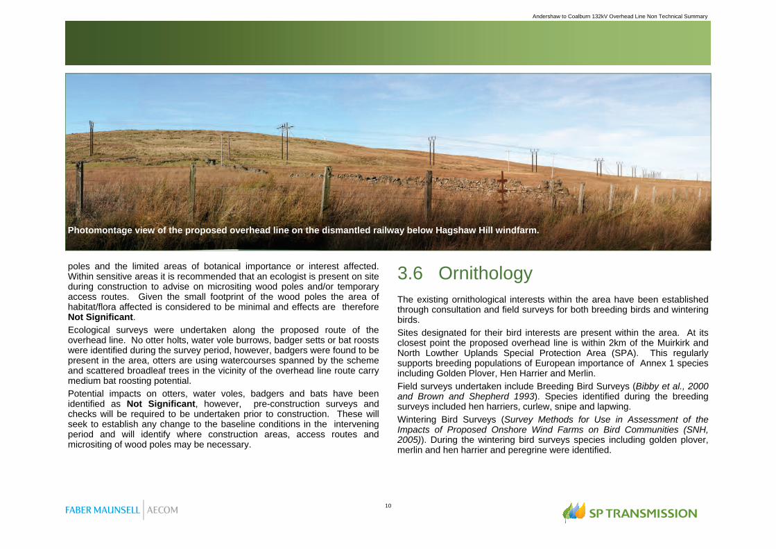
Photomontage view of the proposed overhead line on the dismantled railway below Hagshaw Hill windfarm.

Andershaw to Coalburn 132kV Overhead Line Non Technical Summary
11
Results of field surveys were supplemented with information from various groups including the British Trust for Ornithology and the South Strathclyde Raptor Study Group. With respect to breeding bird species the potential impacts primarily relate to construction, in particular the timing of it. A pre-construction survey will be undertaken to identify the presence of breeding bird species. As much as possible construction works will take place outwith the breeding season (March to August). Where this is not possible a suitably qualified ecologist will advise on appropriate working areas and methods. Where Schedule 1 Species are known to breeding construction activities will be programmed to avoid working within their vicinity. Taking into account mitigation both construction and operation impacts on breeding birds are considered to be at worst Minor Adverse and are therefore Not Significant. Wintering birds have the potential to be impacted on during the construction period and once the overhead line is operational. Three types of impact could result disturbance, displacement or collision. Both disturbance and displacement are predicted to create temporary Minor Adverse impacts on wintering birds in vicinity of construction works. Operational impacts are restricted to collision. There is a risk that birds could collide with wood poles and conductor wires, however, the design of the wood pole structures has sought to minimise this risk. Wintering bird surveys have been undertaken and the collision risk is considered to minimal. Should pre-construction surveys or post construction monitoring indicate that there is an increased risk of collision bird diverters or flappers would be attached to overhead lines where appropriate. Collision effects are considered to be Minor Adverse and are therefore Not Significant.
3.7 Cultural Heritage & Archaeology The proposed overhead line is routed through an area which, although of some archaeological and historic interest, contains sites that are of low or negligible heritage value. Twelve sites of interest could be impacted upon during construction of the proposal, however, it is possible that these sites have already been removed or lost particularly in active or former opencast coal mines and in areas of commercial plantation. Where known archaeological or heritage features are present wood pole structures will be microsited to avoid such interests. The span of the wood pole structures, typically 60 – 80m, will mean that some features are spanned by the
overhead line and avoided. Where sites are affected, an archaeological watching brief will be maintained during construction heritage features affected would be recorded. The impact on each of the twelve sites is assessed in the worst case as Minor Adverse and Not Significant. Even when considered in cumulative terms, the direct physical effect on the cultural heritage resource is not considered significant. In the long term the proposals will have no direct or indirect physical impacts on cultural heritage resources. Through the routeing of the overhead line it has been possible to avoid impacting on Scheduled Monuments, such as that at Auchensaugh Hill, and the listed buildings comprising the Douglas Conservation Area. The grid connection will have a negligible impact upon the historic setting of individual sites, and on the historic landscape as a whole. Overall permanent effects on cultural heritage and archaeology are therefore Not Significant.
3.8 Ground Conditions & the Water Environment The prevailing ground conditions, geology and soils, exert a considerable influence over the landscape of the area as well as land use. The geology of the region comprises a number of coal seams some of which have been extensively worked. The majority of the soils are poorly draining and seasonally waterlogged and include blanket peat, peaty gleys and non-calcareous gleys. This restricts the agricultural capability of the land, particularly in upland areas where rough grazing is prevalent. The principal watercourse within the study area is the Douglas Water which flows generally north east through the Douglas Valley. The overhead line will span this watercourse and is routed over and close to some of its tributaries including the Glespin Burn. The majority of watercourses along the scheme are small burns draining the upland areas or drains located on agricultural land. Water quality is monitored in the Douglas Water and the Glespin Burn and is classified by SEPA as “Good” and “Excellent” respectively. The SEPA Flood Risk map for Scotland has been reviewed as section of the Douglas Water where it meets the Glespin Burn are identified as being susceptible to flooding. The solid and drift geology underlying the overhead line is considered to be of very low sensitivity to this form of development, however, economically

12
Andershaw to Coalburn 132kV Overhead Line Non Technical Summary
important coal seams are present in the wider area. In designing the route of the overhead line consultation was undertaken with Scottish Coal so that areas containing economically important coal deposits could be identified and avoided. Impacts on soils are limited to disturbance of the land and the permanent footprint of the wood poles. In order to ensure no long lasting impacts on soils all land affected during construction will be reinstated. There will be a permanent loss of a small amount of soils but this is considered to be negligible. Consequently impacts on ground conditions are considered to be Not Significant. Potential impacts on the water environment relate mainly to reductions in surface or groundwater quality during construction. Whilst the overhead line spans or is routed close to a number of watercourses wood poles will be located so that during construction and operation the risk of polluting watercourses is reduced. The risk of pollution will be further mitigated
through careful working practices and adherence to Pollution Prevention Guidelines (PPGs). Impacts would be Not Significant. In the long term the impacts of the wood poles on surface water runoff and flood risk are, due to the minimal foot print of the wood poles, considered to be Not Significant.
3.9 Mitigation A standard hierarchical approach to identifying mitigation, summarised below, has been used to address the potentially significant adverse effects that the proposed overhead line may have on the environment.
Through the development of the overhead line it has been possible to avoid or prevent a number of potential environmental impacts occurring from the outset. This approach to developing the route and design of the proposed overhead line is in itself the important form of mitigation. It has been through the routeing process that it has been possible to develop a grid connection that avoids designated sites as well as landscapes and other
Douglas Water flowing through the Douglas Valley south of Windrow Wood.
APPROACH TO MITIGATION AVOID: In the first instance, mitigation should seek to avoid the adverse effect at source for example, by locating the scheme away from a sensitive receptor. REDUCE: If the effect is unavoidable, mitigation should seek to reduce the significance of the impact. OFFSET: If the effect can neither be avoided nor reduced, mitigation should seek to offset the impact through the implementation of compensatory mitigation.

Andershaw to Coalburn 132kV Overhead Line Non Technical Summary
13
areas considered to be sensitive to the development of an overhead line. Similarly in designing the proposed overhead line the selection of the wood pole model instead of a traditional steel tower is a key component of the project’s mitigation. The wood pole structures are smaller in scale and can be routed more sympathetically through the rural area using landform and vegetation to reduce the scheme’s impacts. Through the EIA process further mitigation measures have been identified which have informed the overhead line design and which will underpin the construction of the scheme. A detailed schedule of the mitigation measures that have informed the design of the scheme and that will be implemented prior to, during and post construction is contained within the Environmental Statement. All aspects of construction of the scheme would be in accordance with relevant legislation and best practice. Key mitigation measures include: The preparation of an Environmental Management Plan (EMP) which will
identify all the mitigation measures to implemented as part of the project. The preparation of Construction Method Statement which will describe
the activities to be undertaken including soil stripping, vegetation removal, excavations and land reinstatement.
Prior to construction commencing ecological surveys will be undertaken to ensure that there has been no change to the baseline conditions. These will also, where appropriate, inform the locations of construction areas, access routes and the micrositing of wood poles.
Training of construction staff on the requirements of the EMP and highlighting sensitive areas along and adjacent to the overhead line.
Construction programming to take account of sensitive seasonal constraints as much as possible.
Minimising working areas in order to reduce the disturbance of land, flora and fauna.
Use of excess soils from excavations around wood poles in the reinstatement, to an adequate level, of all affected land.
Adherence to best practice guidance to control and manage the risk of pollution including the development of temporary drainage measures based on Sustainable Urban Drainage Systems (SUDS) techniques.

14
Andershaw to Coalburn 132kV Overhead Line Non Technical Summary
4.1 Summary of EIA Results In accordance with their duties as the Transmission Licence holder, SPT has developed an overhead line that, on balance, results in a minimal environmental impact but which is also is technically and economically feasible. The results of the EIA are summarised below:
Generally the scheme has, on balance, a minimal impact. Sensitive routeing and design as well as careful and considerate construction mean that the majority of environmental impacts can be successfully avoided or mitigated and consequently will not be significant. However, it is recognised that landscape and visual impacts are inherent with development of this type and whilst the overhead line design has sought to achieve best fit within the landscape and minimise visual impacts, limited significant effects, particularly where the scheme crosses the Douglas Valley, are predicted. Due to its location at the centre of the study
area, impacts on the Douglas Valley AGLV have been unavoidable. Diverting the route to the east or west would require a significant increase in the length of the route. In the case of diverting to the east, the route would be much closer to populated areas at Rigside whilst to the west it would bring route in much closer proximity to the Muirkirk and Lowther Uplands SPA. To reduce the impact on the AGLV the proposed route is located on the AGLV’s western margins avoiding the more sensitive areas north of Douglas. The area in which significant effects on landscape and visual resources are predicted to occur is confined to a limited section of the Douglas Valley south of Hazelside where the proposed overhead line spans the A70 and is routed north up the Douglas Valley. Whilst in this locality the effects are considered to be significant, in the context of the area as a whole the grid connection is not predicted to result in an overall deterioration in visual amenity.
4.2 SPT’s Statutory Duties As stated at the outset SPT are obliged by the terms of their transmission licence “to develop and maintain an efficient, co-ordinated and economical system of electricity transmission” whilst also complying with their responsibilities to the natural environment as set out in Schedule 9 of the Electricity Act 1989. Given the limited number and localised nature of the significant environmental effects predicted to result from the construction and operation of the proposed 132kV grid connection between Andershaw windfarm and Coalburn substation SPT have fulfilled their statutory licence obligations. That is to say, the proposed grid connection is: Technically feasible; Economically viable; and Causes minimum disturbance to people and the environment.
Does the Proposed Overhead Line result in Significant Environmental Impacts ?
Construction Operation
Land Use, Access & Recreation
No No
Landscape & Visual Amenity
No Yes
Ecology & Nature Conservation
No No
Ornithology No No
Cultural Heritage & Archaeology
No No
Ground Conditions & the Water Environment
No No
Discipline
4. Summary & Conclusions


SP Energy Networks Environmental Planning
3 Prenton Way Prenton
Merseyside CH43 3ET
SP Transmission Ltd, Registered Office: 1 Atlantic Quay, Glasgow, G2 8SP. Registered in Scotland No. SC189126. © Copyright ScottishPower Ltd (April 2009) All rights reserved. No part of this publication may be reproduced, stored in a retrieval system, or transmitted in any form or by any means electronic, mechanical, photocopying or otherwise without prior written permission of the publisher.