and Traditional Farmsteads - Basingstoke and Deane … Farm... · Farm Diversification and...
76
Farm Diversification and Traditional Farmsteads SPD Page Farm Diversification and Traditional Farmsteads Supplementary Planning Document June 2007 11766 - 0107
-
Upload
phunghuong -
Category
Documents
-
view
216 -
download
0
Transcript of and Traditional Farmsteads - Basingstoke and Deane … Farm... · Farm Diversification and...
Farm Diversification and Traditional Farmsteads SPD Page �
Farm Diversificationand Traditional Farmsteads
Supplementary Planning DocumentJune 2007 11766 - 0107

Page � Farm Diversification and Traditional Farmsteads SPD
Acknowledgements Basingstoke and Deane Borough Council would like to thank Jeremy Lake of English Heritage, whose guidance, advice and support on the issue of Traditional Farmsteads is gratefully acknowledged. We would also like to thank Bob Edwards of Forum Heritage Services for his help with local farmstead character and with regard to the document’s photographs and supporting illustrations.

Farm Diversification and Traditional Farmsteads SPD Page �
Contents� Introduction 5
1.1 Purpose 5
1.2 Context 6
1.3 Objectives 7
1.4 Diversification Options 7
� Local Planning Policy Context 9
� Key Planning Considerations �0
3.1 Sustainability 10
3.2 Access and Traffic Activity 11
3.3 Rights of Way 13
3.4 Biodiversity 13
3.5 Landscape 14
3.6 Environmental Impact Assessment 15
3.7 Amenity 15
3.8 Advertising 15
3.9 Permitted Development Rights 16
3.10 Disused Farms 16
3.11 Residential Development 17
3.12 Summary 17
4 Farm Diversification Scheme Types �9
4.1 Industrial, Commercial, Offices 19
4.2 Equine Enterprises 21
4.3 Retail 22
4.4 Tourism 23
4.5 Leisure and Recreation 24
4.6 Disturbance Sports 25
4.7 Food Processing 26
4.8 Energy 27
5 Traditional Farmsteads �0
5.1 Definition of traditional farmsteads 30
5.2 Traditional farmstead types and the rural landscape 31
5.3 Traditional farmsteads in Basingstoke and Deane 32
5.4 Understanding farmstead character 45
5.5 Traditional farmstead assessment checklist 47
6 Summary 4�

Page 4 Farm Diversification and Traditional Farmsteads SPD
7 Appendices 43
A National, Regional, County and District Context 43 B Local Plan Policies 46C Sustainability Checklist 50D Permitted Development Rights (Disturbance sports) 56E Permitted Development Rights (Agricultural operations) 57F Traditional Farmsteads Plan Types 62G Traditional Farmstead - Historical Context 63H Traditional Farmsteads and Landscape 65I Farmstead Character Statements (by landscape character area) 68
8 Bibliography 73
9 Glossary 75

Farm Diversification and Traditional Farmsteads SPD Page 5
�. Introduction�.� Purpose
1.1.1The purpose of this Supplementary Planning Document (SPD) is to provide guidance on the planningissues to be considered in farm diversification schemes and traditional farmsteads and farmbuildings. The SPD has been produced to give guidance to all those involved in, or affected by, suchschemes. This includes people applying for planning permission, local communities and planningofficers and Councillors involved in determining planning applications. The SPD supplements andsupports policy EC7 (Farm Diversification) of the Basingstoke and Deane Borough Adopted LocalPlan, 1996-2011, which is reproduced in full overleaf.
1.1.2 Changing trends in the agricultural industry have increasingly led farmers to explore different ways of supplementing their farm incomes through non-agricultural diversification. The key objective of this farm diversification guidance is to retain agricultural enterprises, while supporting other appropriate forms of commercial income to supplement the primary agricultural businesses and potentially improve their viability.
1.1.3The SPD is structured around two main themes: farm diversification and traditional farmsteadsSection Two outlines the local planning policy context. Section Three outlines the key planning considerations for a farm diversification scheme, and includes a sustainability checklist for applicants and officers. Section Four provides advice on the schemes that may constitute farm diversification and highlights what planning issues may need to be addressed for each scheme. Section Five outlines the issues that may need to be addressed when a farm diversification scheme involves the use of a traditional (pre-1940) farmstead or farm building(s). This includes a second checklist that has been devised in conjunction with English Heritage. Section Six summarises the SPD and emphasises the need for pre-application discussion with officers.
1.1.4 This document sits within a hierarchy of planning guidance at national, regional, county and district level. Section Two outlines the local planning policy context. The guidance at each level is summarised in Appendix A.

Page 6 Farm Diversification and Traditional Farmsteads SPD
Policy EC7: Farm DiversificationDevelopment which forms part of a farm diversification scheme will be permitted provided:
It benefits the economy of the rural area of which it is part; and
The buildings are appropriate in scale, form, impact, character and siting to their rural location. Wherever possible new or replacement buildings should be located within or adjoining an existing group of buildings; and
It does not generate traffic of a type or amount inappropriate for the rural roads affected by the proposal or require improvements to these roads which could be detrimental to their character.
�.� Context
1.2.1 Diversification is important for farmers who need an extra source of income in addition to agricultural production. Changes in agriculture have resulted in a decline in farm-related jobs, and an increase in the stock of land and buildings no longer required for agriculture. These changes have coincided with declining farm incomes and increased environmental pressures. These trends, and continuing uncertainties surrounding the future direction of the European Union Common Agricultural Policy (CAP), have led to farmers to consider diversifying their businesses.
1.2.2 The relevant national planning guidance, Planning Policy Statement 7 (PPS7), states that local planning authorities should:
“be supportive of well-conceived farm diversification schemes for business purposes that contribute to sustainable development objectives and help to sustain the agricultural enterprise, and are consistent in their scale with their rural location – this applies equally to farm diversification schemes around the fringes of urban areas”
1.2.3 Accordingly, any proposals for diversification schemes in the Borough should reflect the advice given in PPS7. They should be properly thought through, and be appropriate in scale to their location.
1.2.4 Diversification schemes should contribute towards sustainable development objectives. They should maintain and/or enhance the built and natural environment, and satisfy the three criteria set out in Local Plan Policy EC7. Section Three outlines how applicants can address these issues prior to submission of an application.
Farm Diversification and Traditional Farmsteads SPD Page 7
1.2.5 The first criterion of Policy EC7 gives support to schemes that can improve the viability of farming through:
• helping to support, rather than replace, farming activities on the rest of the farm
• stimulating new economic activity and improving the relative sustainability of rural areas, including the rural-urban fringe
• supporting the use of farming practices that are sensitive to the environment
1.2.6 To comply with second criterion of Policy EC7, relating to the design and location of buildings, reference should be made to the relevant policies of the Adopted Local Plan. These are outlined in Section Two. For guidance on how to comply with the third criterion of Policy EC7, reference should be made to section 3.2 of this document (Access and Traffic).
�.� Objectives
1.3.1 The SPD has seven key objectives which reflect National Planning Guidance and the Basingstoke and Deane Adopted Local Plan.
• to facilitate sustainable development, appropriate for its location • to improve the sustainability of rural areas through the provision of appropriate facilities and
services • to maintain and enhance the distinctiveness of the rural landscape
• to strengthen the rural economy through improving the viability of agriculture
• to maintain and enhance the amenity value of rural areas
• to re-use existing traditional buildings • to maintain and enhance nature conservation and biodiversity
�.4 Diversification Options
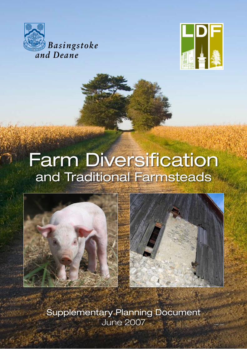
1.4.1 Farm diversification schemes can be divided into those which consist of non-agricultural commercial activity, and secondly, schemes related to new forms of agriculture.
© Bob Edwards
Page 8 Farm Diversification and Traditional Farmsteads SPD
1.4.2 This SPD focuses on schemes in the first category. Support will be given to new forms of agriculture where proposals accord with relevant local plan policies, particularly E1 (Development Control). Some proposals may include elements of both forms of diversification, such as a new farm shop supporting the conversion of a farm to organic produce.
1.4.3 There are many different ways farmland can be used for agriculture, and some, such as the planting of energy crops, are not subject to planning control. However, in such cases there may be a need for planning permission for supporting infrastructure, and any such planning application should comply with any relevant local plan policies.
1.4.4 Some schemes can work in conjunction with existing agricultural activities and provide additional income, but require planning permission. Examples include:
• converting agricultural buildings to workshops, storage facilities, offices, food processing units or retail outlets
• commercial development related to animals such as catteries and kennels
• farm-based tourism such as bed and breakfast or camping sites
• renewable energy sources such as biomass
• leisure pursuits including fishing, shooting or motor-sport
• equine related commercial activities such as stabling or horse riding-centres
1.4.5 One method of demonstrating how a diversification scheme can support the existing agricultural business is to prepare a Farm Business Plan or a Whole Farm Plan (WFP). Although WFPs are not statutorily required when an applicant submits a farm diversification proposal, they can provide useful supporting material to assist in determining the application. For example, by incorporating the proposed scheme into an integrated business plan/whole farm plan, applicants can demonstrate how their proposals will:
• assist the future viability of the farm
• contribute to the local economy and environmental management
• benefit the rural community
• contribute to mitigation of climate change

Farm Diversification and Traditional Farmsteads SPD Page 9
�. Local Planning Policy Context2.1.1 The factors taken into account in farm diversification proposals will depend on the type, scale and location of the scheme. All applications should address the three criteria set out in Policy EC7 and any other relevant policies in the Adopted Local Plan. Each application must also show how the proposal contributes to sustainable development objectives. These are outlined in paragraph 3.1.1.
2.1.2 Applicants need to address, where appropriate, the relevant policies of the Adopted Local Plan. In addition to Policy EC7, these are likely to include:
• E1: Development Control
• E2: Buildings of Architectural Interest
• E6: Landscape Character
• E7: Nature and Biodiversity Conservation
• E8: Water Environment
• EC6: The re-use of Buildings in the Countryside
• EC8: Rural Tourism
• C1: Section 106 Contributions
• A6: Renewable Energy
These policies have been reproduced in Appendix B. The full Adopted Local Plan can be accessed via the Borough website.
2.1.3 Applicants should also consider the potential future growth of their business and any potential long-term adverse impacts on the local community and the wider environment. Government guidance is that the relationship between the potential expansion of the proposed diversification scheme and the potential effects on its surroundings shall be a material consideration when determining applications.
2.1.4 Additional guidance on the suitability of proposals can be found in a number of existing and emerging documents. Please contact the Forward Planning and Transport Team of the Borough Council for further information on these documents. Additional information, including an up to date list of useful sources and links, can also be found on the Council’s website:http://www.basingstoke.gov.uk/planning/ldf/supplementary+planning+documents.htm

Page �0 Farm Diversification and Traditional Farmsteads SPD
�. Key Planning ConsiderationsThis section outlines the factors that may need to be addressed by the applicant in a planning application. Which ones apply in a particular case will depend on the nature of the proposal. They include:
• Sustainability
• Access and Traffic
• Rights of Way
• Biodiversity
• Landscape
• Environmental Impact Assessment
• Amenity
• Advertising
• Permitted Development Rights
• Disused Farms
• Residential Development
�.� Sustainability
3.1.1 The preparation of this SPD has been informed by a Sustainability Appraisal (SA), which provides a detailed analysis of the potential sustainability implications of farm diversification. The SA includes a number of sustainability objectives to which proposals may contribute. These objectives are to:
• improve land-use efficiency through prioritising the use of previously developed land for development over greenfield land, and through the retention and re-use of existing buildings
• ensure the prudent and efficient use of resources, including construction waste
• promote renewable energy sources and recycling
• promote high-quality, sustainable design and construction methods
• maintain and improve water quality and move towards achieving sustainable water resources
• reduce noise, air, light pollution
• preserve, enhance and manage the historic and archaeological heritage
• protect, enhance and manage biodiversity, wildlife habitats and distinctive local landscapes
• address the causes of climate change, including minimising emissions of greenhouse gases

Farm Diversification and Traditional Farmsteads SPD Page ��
• support appropriate farm diversification schemes that help sustain agricultural operations, and maintain farm-based income and employment
• encourage sustainable tourism that benefits rural businesses
• help facilitate a sustainable, diverse and stable rural economy
• reduce rural poverty and deprivation
• reduce the need for travel, especially by private vehicle
• improve accessibility to services and facilities
• improve the health and well-being of the Borough
3.1.2 To assist both applicants and officers in assessing the relative sustainability of proposals a sustainability checklist is included within the SA (Section 6) and is provided in Appendix C of this SPD.
3.1.3The sustainability checklist asks a series of questions relating to the sustainability appraisal (SA) objectives to help establish the proposal’s sustainability merits. The checklist is intended for use at the pre-application stage of a new farm diversification proposal.
3.1.4 The main purpose of the checklist is to help understand the sustainability implications and impacts of a scheme on the wider community. It should be seen as a prompt to ensure that different elements of a proposal are considered within a wider context. It should not be considered exhaustive as, depending on individual circumstances, there may be other sustainability issues to consider. It is essentially a tool to help inform judgements and identify areas for improvement with regard to the sustainability of proposals.
3.1.6 It can be used in conjunction with the checklist for traditional farmsteads (see Section 5), when a diversification proposal includes relevant structures.
3.1.7 The emerging Design and Sustainability Supplementary Planning Document will address further issues relating to the sustainability of all development proposals. Issues that will be included within the document are:
• resource efficiency
• materials re-use
• re-use of buildings
• recycling
�.� Access and Traffic
3.2.1 The issue of vehicular access and traffic generation is very important for farm diversification proposals. This is reflected in the third criterion of Policy EC7, which states that development as part of a diversification scheme will be permitted if:
Page �� Farm Diversification and Traditional Farmsteads SPD
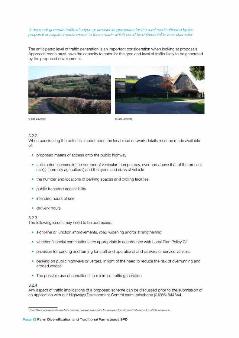
‘it does not generate traffic of a type or amount inappropriate for the rural roads affected by the proposal or require improvements to these roads which could be detrimental to their character’
The anticipated level of traffic generation is an important consideration when looking at proposals. Approach roads must have the capacity to cater for the type and level of traffic likely to be generated by the proposed development.
3.2.2When considering the potential impact upon the local road network details must be made available of:
• proposed means of access onto the public highway
• anticipated increase in the number of vehicular trips per day, over and above that of the present use(s) (normally agricultural) and the types and sizes of vehicle
• the number and locations of parking spaces and cycling facilities
• public transport accessibility
• intended hours of use
• delivery hours
3.2.3 The following issues may need to be addressed:
• sight-line or junction improvements, road widening and/or strengthening
• whether financial contributions are appropriate in accordance with Local Plan Policy C1
• provision for parking and turning for staff and operational and delivery or service vehicles
• parking on public highways or verges, in light of the need to reduce the risk of overrunning and eroded verges
• The possible use of conditions1 to minimise traffic generation
3.2.4 Any aspect of traffic implications of a proposed scheme can be discussed prior to the submission of an application with our Highways Development Control team; telephone (01256) 844844.
� ‘Conditions’ are rules set as part of a planning consent, and might – for example – formally restrict the hours for vehicle movements
© Bob Edwards © Bob Edwards

Farm Diversification and Traditional Farmsteads SPD Page ��
3.2.5 The sustainability of proposals can be improved by the use of a Travel Plan, in cases of significant traffic generation. Advice on Travel Plans is available by contacting the Borough Council’s Transport Strategy team; telephone (01256) 844844.
�.� Rights of Way
3.3.1 Rights of way are very important for access and recreation and should be protected and enhanced. Opportunities to maintain or improve the rights of way network for recreational users (walkers, cyclists, horse-riders) should not be compromised by farm diversification scheme proposals, particularly through use of routes by inappropriate vehicles.
3.3.2 It is important to note that there is separate legislation covering rights of way, including specific processes that must be followed before any rights of way can be closed or diverted. As outlined in paragraph 2.1.4, links to information such as this can be found on the Borough’s website.
�.4 Biodiversity
3.4.1 The Council has a duty to consider the protection and enhancement of biodiversity when determining planning applications. This includes any impacts on sites designated for nature conservation value, and more widely on protected species and habitats. Reflecting the relevant planning guidance, in PPS9: Biodiversity and Geological Conservation, and Local Plan Policy E7 (Nature/Biodiversity Conservation), diversification proposals will be expected to avoid negative impacts on:
• Designated sites such as Sites of Special Scientific Interest (SSSI) or Sites of Importance for Nature Conservation (SINC)
• Key habitat types including ancient/species-rich hedgerows, veteran trees, rivers and ponds2
• Protected and Priority Species 3
3.4.2Where proposals involve conversion or re-roofing of farm buildings, advice on protected species such as bats and barn owls must be sought from a professional ecologist or specialist wildlife consultant. Where a proposal affects protected species, a licence may be required, in addition to planning consent. An ecologist or wildlife consultant will be able to advise on the need for this and assist with the procedures. The Council will consult with Natural England on any planning applications that have implications for protected species or Sites of Special Scientific Interest (SSSI).
3.4.3 Reports of survey results and any proposed mitigation, compensation or enhancement measures should be submitted with the planning application.
3.4.4 Additional planning advice on these issues will be available in a separate, emerging Landscape and Biodiversity SPD, which is due for publication in spring 2008. If you require additional information on biodiversity and/or landscape, please contact the Borough Council’s Senior Biodiversity Officer; telephone (01256) 844844). A register of professional ecologists and wildlife consultants is maintained by the Institute of Ecology and Environmental Management and links to this can be found through the Borough website as outlined in paragraph 2.1.4.
� See Adopted Local Plan for the full list of key habitats
� See Adopted Local Plan for the full list of protected species

Page �4 Farm Diversification and Traditional Farmsteads SPD
�.5 Landscape
3.5.1 A significant proportion of the borough consists of nationally important designated landscapes. The North Wessex Downs Area of Outstanding Natural Beauty (AONB) covers some 80 square miles of the Borough and is highly protected for its landscape and scenic beauty. Schemes within the AONB should complement the AONB through high quality design that respects its setting and an appropriate scale and location in accordance with Policy E6 of the Adopted Local Plan. All rural landscapes are likely to have some intrinsic value, and diversification proposals should maintain or enhance the character of the local landscape and use native species appropriate to the location.
3.5.2 While particular weight will be given to landscape issues, especially any that might affect the AONB, the viability of farming is recognised as a key facet of maintaining and enhancing the character of rural areas including the AONB. The AONB executive is a useful source of ideas and recommendations for farm diversification and related matters. For contact details, see the link on the Council’s website shown in paragraph 2.1.4.
3.3.3 Particular attention should be paid to the appearance of proposals from publicly accessible locations and to important views across the landscape which should not be harmed by diversification proposals. Diversification proposals will be expected to avoid significant adverse impacts on:
• the character of the local landscape, including its scenic quality
• the sense of remoteness and tranquillity in an area
• trees of significance in the wider landscape
• field patterns and boundary features (eg hedgerows)
• historic features such as sunken lanes, ancient tracks, earth banks and designated archaeological sites
• sites of historic importance
Pre-application advice on what issues would need to be addressed is available.
© Bob Edwards
Farm Diversification and Traditional Farmsteads SPD Page �5
3.5.4 Additional information on the role of traditional farmsteads and farm-buildings in the landscape is provided in section Five. If you require additional information on biodiversity and/or landscape, please contact the Borough Council’s Senior Biodiversity Officer; telephone (01256) 844844.
�.6 Environmental Impact Assessment 3.6.1 Environmental Impact Assessment (EIA) ensures that any potential environmental effects of new development or change in land-use are fully considered when determining planning applications.
3.6.2 An EIA is not usually required for small-scale development. However, it is mandatory for certain developments, including large-scale agricultural operations where animal numbers are above a certain threshold. Smaller livestock and fish farming units usually require an EIA only if they are deemed to have significant environmental effects. Applicants should also be aware that developments that could fall within Permitted Development4 may require an EIA and therefore would need planning permission. The Council can advise on whether an EIA is required.
�.7 Amenity
3.7.1 Amenity refers to the conditions enjoyed by residents and others in terms of the daylight they receive, noise levels, pollution etc. which can significantly affect quality of life. The amenity of neighbours is a material consideration in planning decisions. Changes of use or scale can give rise to issues about noise, air pollution, water pollution, light pollution, dust, odour and hours of work. Applicants should consider these matters when developing their proposals.
�.8 Advertising
3.8.1 Diversification schemes that depend on attracting customers or visitors to a particular location will generally need signs to advertise the business and its location. Applicants should take into account the national guidance on advertising, in Planning Policy Guidance 19: Outdoor Advertisement Control (PPG19). To reflect this advice, applicants should consider what impact an advertisement, including any possible cumulative effects advertising has on its surroundings. For example, if the proposed site falls within the North Wessex Downs Area of Outstanding Natural Beauty (AONB) any proposed advertising will be closely scrutinised to ensure that the proposals do not harm the area’s special character.
3.8.2Other issues that may need to be addressed include:
• the visual impact of a proposal on the surrounding area.
• where the site falls within a designated Conservation Area, whether the proposed advertising would preserve or enhance its character and appearance
• poster advertising is generally out of place in the countryside and is not normally allowed
� For further information on Permitted Development Rights see section �.9 below

Page �6 Farm Diversification and Traditional Farmsteads SPD
3.8.3 Outside the planning system, other regulations apply to signage that might be desirable for the success of a diversification scheme, for example the ‘brown signs’ that inform tourists and other road users about local commercial facilities. In Basingstoke & Deane permission for, and provision of, these is provided by Hampshire Highways, links to which can be found on the Borough website at the address given in paragraph 2.1.4.
�.9 Permitted Development Rights
3.9.1 General planning permission (known as ‘permitted development rights’) exists for certain types of minor development. The types of permitted development most relevant to farm diversification include:
• temporary uses of land
• agricultural buildings below a certain size
• forestry buildings and forestry roads
• caravan sites and related buildings in some circumstances
3.9.2 Permitted development rights are not available for farm or forestry dwellings, or livestock units sited near residential and similar buildings. Applicants are advised that before making use of agricultural permitted development rights, they should check whether the Local Planning Authority (LPA) requires prior approval for certain details of the proposed development. For example, in the case of an agricultural building this will cover its siting, design and external appearance. Appendix E describes what is permitted development in relation to agricultural buildings and operations.
3.9.3 The government’s online planning and building control resource, the Planning Portal (http://planningportal.gov.uk/) provides advice on different aspects of agricultural planning permission that may be of relevance to farm diversification schemes. These include the demolition of agricultural structures, listed buildings, and fences, walls and gates.
�.�0 Disused Farms
3.10.1 Farm diversification is a means for farmers to supplement their agricultural income and improve the viability of their holdings. Proposals for diversification should therefore be used to support an ongoing agricultural operation if they are to be assessed against Policy EC7. Accordingly, if the proposal is sited on a disused farm and has no link to a neighbouring agricultural operation, the application should be assessed against relevant Local Plan policies other than EC7.

Farm Diversification and Traditional Farmsteads SPD Page �7
�.�� Residential Development
3.11.1 The Adopted Local Plan (ALP) places restrictions on rural residential development through policies D6, D7, D8, D9 and EC6. Although a farm diversification scheme is not a justification in itself for new residential dwellings in the countryside, the supporting text of Policy D7 (Essential Residential Accommodation in the Countryside), states that residential accommodation which directly supports a farm diversification scheme may be considered appropriate.
3.11.2 While the re-use of existing buildings for agricultural or commercial development is the preferred option, in some instances the conversion of an agricultural building to residential use may be more appropriate, depending on the type of building and the locale. Residential development on its own, would not constitute a non-agricultural or commercial farm diversification scheme, and therefore should be assessed against other local plan policies than EC7.
�.�� Summary
3.12.1 The Council is supportive of the principle of farm diversification but schemes will need to demonstrate that:
• The scale, location, design and nature of the proposed use is not detrimental, either individually or cumulatively with other proposed development, to the character of the locality
• The proposed activity is compatible with agricultural operations on the farm and neighbouring agricultural holdings
• The proposal does not unacceptably impact on the amenities of neighbouring residents nor generate traffic inappropriate for the surrounding rural road network
• The proposal does not cause an unacceptable level of pollution (noise, light, air or water), or an unacceptable impact on water quality
• The proposal does not involve a significant, irreversible loss of the best and most versatile agricultural land nor adversely affect designated sites of biodiversity or landscape value such as the North Wessex Downs Area of Outstanding Natural Beauty (AONB)
• The proposed access and level of traffic generated by the proposal is within the capacity of existing approach roads, and would not be
• detrimental to the amenity of the locality, or prejudice highway and pedestrian safety
• The proposal does not result in demonstrable harm to the landscape, nature conservation interests, cultural heritage features and/or the use and enjoyment of public rights of way
• The proposal wherever possible, re-uses existing farm buildings in a sympathetic manner
• The scale, location and design of the proposal is not detrimental to the character of a traditional farmstead, or to an individual farm building of traditional construction
• Services such as water, electricity and sewerage can be provided

Page �8 Farm Diversification and Traditional Farmsteads SPD
3.12.2 As previously stated, pre-application discussion with Borough Council officers is recommended. The officers’ advice can be more helpful if applicants provide as much relevant information as possible, particularly relating to the issues listed above. Further details of the Council’s approach to giving pre-application advice can be found on the Council website

Farm Diversification and Traditional Farmsteads SPD Page �9
4. Diversification Scheme TypesA variety of possible commercial activities may be associated with farm diversification. The following sections provide examples of potential scheme types, summarise key issues that will need to be addressed for each common type of proposal, and highlight relevant planning guidance. Although we cannot list every potential diversification scheme, and will welcome innovative proposals, the more usual proposals to come forward include:
• Industrial, commercial, offices
• Equine enterprises
• Retail
• Tourism
• Leisure and recreation
• Disturbance sports
• Food processing
• Energy
The following sections summarise the key issues that will need to be addressed for each common type of proposal. Wherever possible the main issues have been identified, further issues may arise during pre-application discussions or through the application process and applicants are advised to make their own checks.
4.� Industrial, Commercial, Offices (Use Class Orders B�/B�/B8)
4.1.1 When a building or site is re-used, national and Local Plan policy encourages employment development in appropriate rural locations, in preference to residential development. New industrial and commercial uses can provide additional employment and services in rural locations, improving the sustainability of the area.
4.1.2 Although the conversion of a rural building to commercial use has the potential to retain its original character and appearance, careful consideration must be given to the capability of buildings to accommodate workshops and related industrial uses without major rebuilding.
4.1.3 These types of diversification scheme potentially cover a wide range of activities.
Examples of Industrial and/or Commercial uses
⋅• the sub-letting of land or buildings
⋅• kennels and catteries
⋅• long-term storage of materials
⋅• re-use of buildings for light-industrial use such as workshops, garages, information technology or research and development
⋅• small office-based businesses such as consultancy
Page �0 Farm Diversification and Traditional Farmsteads SPD
4.1.4 Key planning issues that need to be addressed potentially include:
Key Planning Issues
⋅• their form, bulk and general design should be in keeping with their surroundings
⋅• are buildings capable of conversion without major rebuilding?
⋅• the visual impact of new buildings, parking and outside storage
⋅• the type and amount of traffic generated
⋅• access to and from the site
⋅• the availability of land for car parking and vehicle turning areas
⋅• impacts on neighbouring properties: noise, light, dust, air or water
⋅• hours of operation
⋅• the impact on nature conservation including protected species
Planning Guidance/ Local Plan Policies
⋅• PPS7: Sustainable Development in Rural Areas, paragraphs 17-20, 30-31
4.1.5 Proposals for rural offices and studios should have regard to paragraph 17 of PPS7, which outlines the Government’s policy of supporting the re-use of appropriately located and suitably constructed rural buildings.
4.� Equine Enterprises (Use Class Order D�)
4.2.1 Horse related businesses are important to the local economy and the provision of equestrian facilities has become a common form of farm diversification. In line with Policy EC6, the council requires a high standard of design, construction and the care of land, to ensure that equestrian facilities do not have an adverse effect on the countryside. Reflecting Local Plan Policy EC6 (the re-use of existing buildings), consideration should be given to the adaptation, or conversion, of existing buildings before new build. Any proposals for extensions to existing buildings should be small-scale and harmonise with the scale, height, form, and design of the original building.
Examples of Equine Enterprises
⋅• livery stables
⋅• riding arenas – indoors and outdoors
⋅• stud farms
⋅• training stables and gallops
⋅• point-to-point courses
⋅• cross-country courses

Farm Diversification and Traditional Farmsteads SPD Page ��
Key Planning Issues
⋅⋅• neighbour amenity
⋅⋅• landscaping and intrusive fencing
⋅⋅• design and visual impact of new buildings
⋅⋅• access and car-parking facilities
⋅⋅• scale of business
⋅⋅• storage and disposal of manure
⋅⋅• floodlighting
⋅⋅• impact on grasslands of high nature conservation value
Planning Guidance/ Local Plan Policies
⋅⋅• PPS7: Sustainable Development in Rural Areas, paragraph 32
⋅⋅• PPG17: Planning for Open Space, Sport and Recreation
4.2.2 Proposals should follow the Council’s Countryside Design SPG (April 2002), and the relevant policies of the Adopted Local Plan. The proposed design should be in keeping with the surroundings, and not adversely affect landscape character or the visual attractiveness of the countryside. Landscaping may be required, to help minimise the visual impact of new development. All new planting or existing vegetation relied on for screening new development, must be protected from potential damage by livestock and machinery. Fencing and other boundaries should be consistent with a rural setting. The location and position of all external light sources should be submitted as part of any planning application.
4.2.3Outdoor arenas that are well-designed, located, and landscaped can in most cases be accommodated within the landscape, without causing harm.
4.2.4 Field shelters provide protection from extreme weather conditions. In certain cases, planning permission for a shelter may not be required. They should be unobtrusive in the landscape and preferably in a well screened location. Conditions requiring landscaping to be provided may be attached to a planning consent where there is a need to overcome the visual impact of a shelter.
Page �� Farm Diversification and Traditional Farmsteads SPD
4.2.5 Stables should be sited some distance away from any residential dwellings not directly related to the stables. This will help negate any harmful impacts from smells, noise and nuisance. Applicants should also take into consideration routes between stables and local networks such as bridleways and country lanes and whether they are suitable for equestrian uses bearing in mind other users of the route.
4.2.6 Jumps and other equipment associated with arenas can also be visually intrusive. Conditions may be applied requiring these to be stored when not in use. Additionally, agriculturally unimproved grassland, which is of high nature conservation value, may be degraded by heavy grazing by horses. Equally, areas of grassland dedicated to gallops may contribute to conservation value.
4.� Retail (Use Class Order A�)
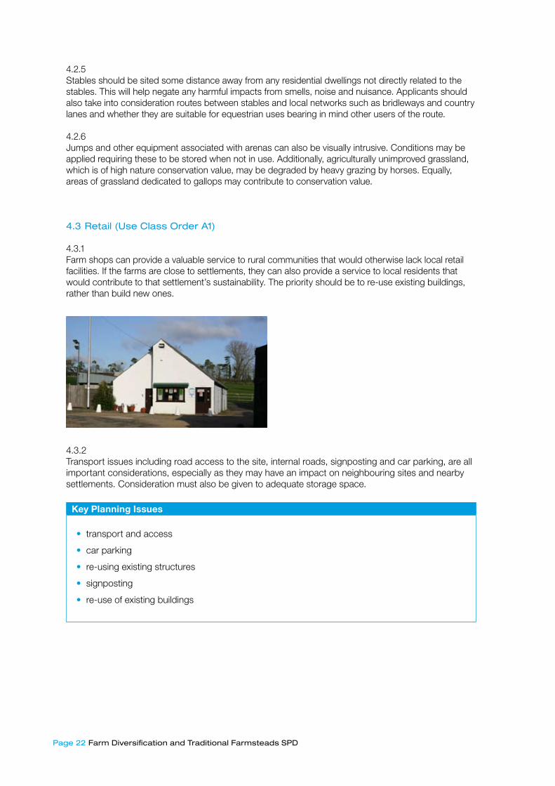
4.3.1 Farm shops can provide a valuable service to rural communities that would otherwise lack local retail facilities. If the farms are close to settlements, they can also provide a service to local residents that would contribute to that settlement’s sustainability. The priority should be to re-use existing buildings, rather than build new ones.
4.3.2 Transport issues including road access to the site, internal roads, signposting and car parking, are all important considerations, especially as they may have an impact on neighbouring sites and nearby settlements. Consideration must also be given to adequate storage space.
Key Planning Issues
⋅• transport and access
⋅• car parking
⋅• re-using existing structures
⋅• signposting
⋅• re-use of existing buildings
Farm Diversification and Traditional Farmsteads SPD Page ��
4.4 Tourism Accommodation (Use Class Orders C�/D�)
4.4.1 Local Plan Policy EC8 (Rural Tourism) supports proposals for tourist development. Farmers can benefit from tourism as an important additional source of income. Camping, caravanning, bed and breakfast, and holiday cottages provide a variety of accommodation options. Diversification can also include a wide range of activities, such as activity centres, arts and crafts shops and wildlife farms. Tourism proposals should reflect national and local guidance on the re-use of buildings in the countryside.
4.4.2 Camping and caravan sites usually require planning permission. Applications for small-scale sites are subject to Policy EC8 and also need to show that there is a proven need for this type of development and that it can be sited unobtrusively and landscaped to minimise its impact. Consideration must be given to the impact on neighbouring properties, in terms of the visual impact, traffic congestion at peak-times, noise and safety. The provision of services, including fire safety, water supply and sewerage facilities, must also be taken into account.
Key Planning Issues: Camping and Caravans
⋅• volume of traffic generated
⋅• impacts on neighbours
⋅• location and visual impact
⋅• service provision
⋅• health and safety regulations
4.4.3 The need for planning permission for bed and breakfast accommodation depends mainly on the scale of the proposal. For some small-scale proposals, a planning application may not be needed. It is advisable to contact Council planning officers before submitting an application.
4.4.4 The preferred option is for the re-use of existing buildings for bed and breakfast, hotels and other serviced accommodation. Account should be taken of access to the farm, and car-parking facilities for visitors, as well as any potential health and safety conflicts with the existing farm business.
Key Planning Issues: Bed & Breakfast
⋅⋅• health and safety regulations
⋅⋅• access to the farm
⋅⋅• car parking facilities
⋅⋅• signage
⋅⋅• conflicts with existing agricultural businesses
⋅⋅• impact on the rural landscape
⋅⋅• permitted development rights
Planning Guidance/ Local Plan Policies
⋅⋅• PPS7: Sustainable Development in Rural Areas, paragraphs 17-18, 30-31, 34-40

Page �4 Farm Diversification and Traditional Farmsteads SPD
4.5 Leisure and Recreation (Use Class Order D�)
4.5.1 Government guidance PPS7 states that favourable consideration should be given to proposals for farm diversification involving sports and recreational activities. Many different recreational uses could be included on a farm diversification scheme such as fishing, activity centres, golf etc. Guidance on equestrian and disturbance sports is set out separately. Regardless of the activity all schemes must be designed and sited with sensitivity to their rural location.
4.5.2 Planning permission is required for fishing on a commercial basis for more than 28 days in a year. Golf courses and golf-related facilities are generally considered large-scale developments, mainly due to changes to the landscape and traffic generation. Normally, because of their scale, golf courses would not be considered as a farm diversification proposal.

Farm Diversification and Traditional Farmsteads SPD Page �5
Examples of possible leisure and recreation based farm diversification
⋅⋅• Golf driving ranges
⋅⋅• Fishing
⋅⋅• Sports that utilise large open spaces
Key Planning Issues
⋅• noise pollution
⋅• environmental degradation
⋅• transport and traffic generation
⋅• car parking facilities
⋅• hours of operation
⋅• permitted development rights
⋅• ancillary buildings and storage
⋅• floodlighting
Relevant Planning Guidance/ Local Plan Policies
⋅• PPG17: Planning for Open Space, Sport and Recreation, paragraphs 25-29
⋅• PPS7: Sustainable Development in Rural Areas, paragraph 34
4.6 ‘Disturbance’ Sports (Use Class Order Sui-Generis)
4.6.1 Sites for activities that can be classified as ‘disturbance’ sports must be chosen with great care, to avoid disturbing local residents and existing businesses. Government guidance states that noisy or other intrusive activities should be restricted to locations where they will have minimal, or no, impact on residents or other recreational users. Consultation with the Council’s environmental health officers on noise and related issues may be necessary before submitting an application.
4.6.2 Consideration must be given to sensitive environmental habitats, such as Sites of Special Scientific Interest (SSSIs). Possible effects could include damage to, or destruction of, protected species, ancient woodlands and sites of historic or archaeological importance.
4.6.3 A distinction can be made between permanent facilities, and those activities that rely almost entirely on the occasional use of land not owned by those taking part. Various sports are carried out under the provisions of the GDPO. This allows for the temporary change of use of land for the purposes of motor-sport, clay-pigeon shooting and ‘war-game’ activities such as paint-balling for 28 days a year. Applications falling in this category would not in isolation, form part of a farm diversification scheme, due to their temporary nature.
Page �6 Farm Diversification and Traditional Farmsteads SPD
Examples of ‘Disturbance Sports’
⋅⋅• motorsports such as quad-biking, motocross, rallying, go-karting and grass-track racing
⋅⋅• military vehicle driving, including tanks, amphibious vehicles, jeeps
⋅⋅• paintballing
⋅⋅• war games
⋅⋅• game shooting
⋅⋅• clay pigeon shooting
Key Planning Issues
⋅• noise pollution
⋅• environmental degradation
⋅• transport and traffic generation
⋅• car parking facilities
⋅• hours of operation
⋅• permitted development rights
⋅• ancillary buildings and storage
Planning Guidance/ Local Plan Policies
⋅• PPG17: Planning for Open Space, Sport and Recreation
4.7 Food Processing and/or Direct Marketing (Use Class Order B�/B8)
4.7.1 The need for planning permission depends partly on the size of the proposed operation. Units solely built for storage of on-site produce may not require planning permission. Larger scale, factory type units that involve out-sourced produce or raw materials will need planning permission. Issues to consider include the following:
Key Planning Issues
⋅• their form, bulk and general design should be in keeping with their surroundings
⋅• any impact on the countryside and biodiversity needs to be taken into account
⋅• the desirability of preserving buildings of historic or architectural importance needs to be taken into account
⋅• implications of hygiene and worker-welfare standards
⋅• transport and access

Farm Diversification and Traditional Farmsteads SPD Page �7
4.8 Energy
4.8.1 A variety of renewable energy schemes could be accommodated within a farm diversification proposal. Planning policies on land-based renewable energy generation in England are set out in PPS22 (Renewable Energy) and the companion guide ‘Planning for Renewable Energy’, which sets out a range of renewable energy technologies and. Potential schemes could include:
• dry biomass
• energy from waste, including wet biomass (anaerobic digestion)
• wind turbines/farms
Proposals should have regard to Policy A6 (Renewable Energy) in the Adopted Local Plan. Additional information on renewable energy development other than those addressed here will be included in the emerging SPD on Design and Sustainability.
(�) Biomass
4.8.2 Biomass fuels are categorised as either dry or wet. Energy conversion of dry biomass usually involves heat, whereas the conversion of wet biomass generally involves digestion or fermentation. Wet biomass technologies such as anaerobic digestion are considered under ‘Energy from Waste’. Dry biomass differs from most other sources of renewable energy. The fuel is grown, rather than harnessed, and emits carbon dioxide when burned. However, unlike fossil fuels, biomass is considered ‘carbon neutral’, because the carbon released on combustion is that absorbed during the crop growth.
4.8.3 The principal dry biomass fuel sources are:
Examples of dry biomass fuel sources
⋅• forestry – excess products from existing forestry operations
⋅• energy crops, such as energy grasses, coppice willow and poplar
⋅• primary processing co-product – sawdust, slabwood
⋅• industrial clean wood waste, such as pallets
⋅• standard crops and bi-products – cereal, straw
⋅• excess animal matter – poultry litter
⋅• bio-degradeable fraction of Municipal Solid Waste (MSW)
4.8.4 The power plant and associated impacts are of relevance to planners, not the production of the fuel source. However, the impacts of growing and collecting the fuel are key to ensuring the successful development of a facility. Many of the environmental issues associated with the fuel supply for example, impact on landscape, ecology, archaeology, and land-use could be covered by an Environmental Impact Assessment (EIA) if required.

Page �8 Farm Diversification and Traditional Farmsteads SPD
4.8.5 An EIA may be undertaken by other bodies in connection with a scheme – for instance the Forestry Commission (FC) for all applications submitted in England under the Energy Crops Scheme. Those developments that must be screened to determine whether they are EIA development are listed under Schedule 2 of the Town and Country Planning (Environmental Impact Assessment) (England and Wales) Regulations 1999.
4.8.6 Such development may fall into one of two categories:
• industrial installations for the production of electricity, steam and hot water, where the development exceeds 0.5 hectare
• industrial installations for carrying gas, steam and hot water, where the area of works exceeds 1 hectare
4.8.7 If a project exceeds the threshold for a category of development, the LPA must determine whether there are likely to be significant effects on the environment. Further details on EIA procedures and links to information on EIAs can be found through links on the Council’s website (see paragraph 2.1.4).
4.8.8 When considering a diversification application involving dry biomass, six key issues should be considered5:
Key Planning Issues: Biomass
⋅• visual intrusion: generally the processing plants are industrial features
⋅• noise from traffic and plant operations
⋅• effects on health, local ecology or conservation from airborne and water-borne emissions
⋅• traffic to, and from, the site in order to transport biomass
⋅• carbon mitigation
4.8.9 It is likely that several or more of these issues would be subject to conditions should a subsequent application be permitted. Additional authorisations/compliance may be required in the following areas: building regulations; abstraction licence; pollution control systems; ambient air quality and clean air act.
(�) Energy from Waste
4.8.10 Anaerobic digestion (AD) is a method of waste treatment that produces a gas with high methane content from organic materials, such as agricultural, household and industrial residues, and sewage sludge
4.8.11 (feedstocks). The gas is then used to produce heat, electricity or both. AD is the process by which farm slurry is processed. Reflecting PPS22, a diversification application involving dry biomass should consider four key issues:6
� Planning for Renewable Energy: A Companion Guide to PPS��, DCLG pp.89-9�� Planning for Renewable Energy: A Companion Guide to PPS��, DCLG pp.�0�
Farm Diversification and Traditional Farmsteads SPD Page �9
Key Planning Issues: Energy from Waste
⋅• site selection, transport and traffic ⋅• feedstocks and product storage⋅• odour⋅• emissions to air, ground and watercourses⋅• Environmental Impact Assessment (EIA)
4.8.12 Many AD plants will need to be located close to the waste source. Small ‘digesters’ on farms can usually be accommodated within the existing complex of farm buildings. They would be viewed as an integral part of a farm, rather than a diversification scheme. However, the traffic implications of Centralised Anaerobic Digestion facilities (CAD plants), which handle large quantities of agricultural waste, sewage sludge or MSW, potentially raise more complex locational and traffic issues.
4.8.13 The most acceptable sites are likely to be those located beside existing industrial or wastewater treatment works. Transport movements at on-farm digesters are unlikely to add significantly to the impact of normal farm activities. CADs will also generally draw traffic, but impact can be minimised by carefully considering fuel supply logistics. This will reduce the distances travelled between the feed-stocks, storage tanks, the digester and local markets.
4.8.14 The best site for a sewage digestion plant will usually be close to a wastewater treatment plant. Landfill gas (LFG) plants should be located away from housing and other sensitive land uses, for reasons of safety and amenity.
4.8.15 A scheme specifying a certain feedstock may have a condition imposed to use only that feedstock. In these circumstances, the feedstock cannot be changed without the prior approval of the LPA. Anyone considering storage of farm slurry should refer to the Control of Pollution Regulations (1991). 4.8.16 The AD of farm waste should reduce the likelihood of pollution of controlled waters. Atmospheric emissions from AD, gas vents, engine exhausts and flare stacks are unlikely to present any significant environmental issue. In addition to the standard details provided, it is required that the following information is included in a planning application for a biomass plant:
• photomontage of digester, plant building(s) and chimney stack with clear indication of building material
• information on grid connection works, including transformer and transmission lines
• ecological impact assessment and proposed mitigation
• model of emissions dispersion
Relevant Planning Guidance/ Local Plan Policies
⋅⋅• PPS22: Renewable Energy
⋅⋅• Planning for Renewable Energy: A companion guide to PPS22
⋅⋅• Adopted Local Plan Policy A6: Renewable Energy

Page �0 Farm Diversification and Traditional Farmsteads SPD
5. Traditional Farmstead Appraisal Framework
5.� Definition of Traditional Farmsteads
5.1.1 As the most numerous type of vernacular building in the countryside, farm buildings, particularly traditional farmsteads, are key elements in the richly varied character of our countryside. Many farm diversification schemes involve the re-use of farmstead buildings of all dates. These can range from medieval barns and nineteenth century cattle housing to wide-span multi-purpose sheds in concrete, steel and asbestos which were built from the 1950s. Examples of all these buildings have been made redundant, but it is particularly the case with traditional farm buildings. Farm buildings form the largest group of structures on the Council’s register of Buildings at Risk. As a consequence, farm diversification can offer a lifeline for farm buildings that are often redundant, or partially redundant, and in a poor state of repair.
5.1.2 For applicants and planners alike, adapting these buildings, while retaining their essential character and respecting the fact farm buildings are sensitive to change, can be challenging. It is important, when considering the options for change, to take a rounded view of all the buildings on the farmstead, and their adaptability and capacity for change.
5.1.3 The opportunities presented through non-agricultural diversification are be welcomed as a chance to offer them a use for the long-term. A farm diversification scheme is an opportunity to justify investment in these buildings by giving them a new use. Likewise, the improvement of traditional farmsteads and buildings is not necessarily dependent on incorporating a non-agricultural diversification scheme – this guidance is also intended to assist those seeking solely to conserve a traditional building for agricultural or, when appropriate, residential use.
5.1.4Farmsteads can be defined as groups of buildings that perform some or all of the following functions:
• accommodation for farmers
• the storage and processing of crops (barns, granaries)
• the storage of vehicles, implements and fodder
• the accommodation and management of livestock (stables, pigsties, dovecots)
© Bob Edwards

Farm Diversification and Traditional Farmsteads SPD Page ��
Each farmstead is unique, as the following factors vary from site to site:
• the setting of the farmstead in the landscape
• publicly accessible views into the farmstead
• the size, range, date and condition of the buildings within the group
• the extent of modern farming operations and the placement of post-1950 buildings Traditional farm buildings are defined as those dating from before 1940 that are built using traditional methods and materials.
5.� Traditional farmsteads types and the rural landscape
5.2.1 Traditional farmsteads make a fundamental contribution to helping define local distinctiveness and a sense of place. Traditional farmsteads, or individual buildings of traditional character, are important both in their own right, and also in terms of the contribution they make to the character of the countryside and local distinctiveness. Therefore they are worthy of retention and protection.
5.2.2 The great diversity in England’s farmstead types and the building materials used has evolved in part, from the huge variations in the national geology and farming practices, which is reflected in Hampshire. Individual farm buildings are the best illustration of the long history of settlement and the contribution of agriculture to the evolution of the English landscape. The buildings of the farmstead, including evidence of change of use, indicate the development of agricultural practices and changes in farm size. For example, in Basingstoke and Deane, the pattern of settlement is defined by whether farmsteads were historically clustered in villages or dispersed across the landscape. For further information on landscape and farmstead character in the regional context, visit the Historic Environment Local Management (HELM) website where a regional character statement for the South East of England can be found. As stated in paragraph 2.14, website details can be found on the farm diversification page of the Borough website.
5.2.3The way farm buildings are arranged to form farmsteads can also be locally characteristic. This includes the sub-division of yards and other working areas around the farmstead, which can also be indicative of how the farmstead operated and reflects, for example, the management of livestock. Farmstead plan types include: linear steadings, dispersed plans, loose courtyards and regular plans. These farmstead types are illustrated overleaf and their plan type shown in Figure One (page 38).
© Bob Edwards © Bob Edwards

Page �� Farm Diversification and Traditional Farmsteads SPD
Linear steadings where the house and farm buildings are built in-line: they are very rare in this area (below left). Plans a and b (Figure One)
Dispersed plans where there is no evidence for planning in the layout of the buildings and are commonly found in areas of ancient enclosure (above right). Plan c (Figure One)
Loose courtyards, where detached structures – primarily threshing barns, granaries, stabling and cattle shelters – are arranged around a yard where cattle could be wintered, developed in and around the Hampshire Downs from the 16th century (below left). Plan d (Figure One)
Regular plans where linked ranges can form L-, U-, and E- plans or completely enclose all four sides of the yard, typically date from the nineteenth century and sit in landscapes subject to regular enclosure from the late eighteenth century (above right). Plans e, f, g and h (Figure One)
5.2.4 Appendix F provides additional detail on the different farmstead types outlined above.
5.� Traditional Farmsteads in Basingstoke and Deane
5.3.1 English Heritage has identified the key features of the borough, and those which make it distinctive in a regional and national context. These include:
• High concentration of isolated farmsteads, mostly of medieval origin, in the anciently-enclosed landscapes of the north, and a sparse distribution of isolated farmsteads in the downlands of the south
• Other farmsteads of medieval origin concentrated in hamlets and villages
• The early development of large-scale commercial farming based on the production of corn from the late 15th and 16th centuries, especially in the chalk downlands but also further north to a smaller scale. Cattle rearing and dairying was important in some small areas, and small-scale agriculture on the heathland to the north-west
© Bob Edwards

Farm Diversification and Traditional Farmsteads SPD Page ��
Figure One: Traditional Farmstead Plan Types
• High numbers of pre-1750 buildings, especially barns, which are rare by national standards. These are especially concentrated in the claylands of the north
• Farmstead groups focused on the production of corn including large barns, stabling, cartsheds and granaries, typically set around inward-facing courtyards
• A rich mix of materials, namely in the use of timber frame and long straw thatch combined with cob, plain tile, weatherboard, brick and flint
• Hipped and half-hipped roofs
Appendix G provides further details on the local traditional farmstead context.
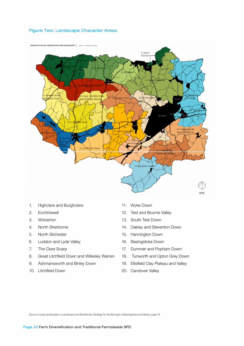
5.3.2The landscape character of Basingstoke and Deane is divided into two distinct areas: Hampshire Downs and North Hampshire Lowland and Heath. The landscape character is also reflected in the type of farming and farmstead. The map below illustrates the distinction between the two character areas relating to farmstead distribution. For further detail on the two character areas, how landscape relates to farmsteads, building materials and building types, please refers to Appendix H. For further detail by local character area please refer to Appendix I.
© Bob Edwards
Page �4 Farm Diversification and Traditional Farmsteads SPD
Figure Two: Landscape Character Areas
1. Highclere and Burghclere
2. Ecchinswell
3. Wolverton
4. North Sherborne
5. North Silchester
6. Loddon and Lyde Valley
7. The Clere Scarp
8. Great Litchfield Down and Willesley Warren
9. Ashmansworth and Binley Down
10. Litchfield Down
11. Wyke Down
12. Test and Bourne Valley
13. South Test Down
14. Oakley and Steventon Down
15. Hannington Down
16. Basingstoke Down
17. Dummer and Popham Down
18. Tunworth and Upton Grey Down
19. Ellisfield Clay Plateau and Valley
20. Candover Valley
Source: Living Landscapes: a Landscape and Biodiversity Strategy for the Borough of Basingstoke and Deane, page ��
Farm Diversification and Traditional Farmsteads SPD Page �5
5.4 Understanding Farmstead Character
5.4.1 When using farmstead buildings, a successful farm diversification scheme should consider the building’s character, significance and the sensitivity to change of the group as a whole, and of all the buildings within it. This will assist in determining, for example, the extent to which a traditional grouping can be adapted and used in relationship to post-1950 sheds built on the perimeter, the capacity that a large barn has for selling farm produce or the role of minor ancillary buildings. To properly manage change within a farmstead it is necessary to fully establish and understand these issues before any proposal for change is made, with regard to:
• landscape
• farmstead and building types
• materials, construction, style and condition
5.4.2 The key planning considerations for any proposed diversification scheme whether or not involving a traditional farmstead or an individual traditional building, are set out earlier in this document. However, when considering a proposal involving traditional farmsteads, the following issues must also be addressed:
• orientation
• boundaries
• public/private space
• the relationship with other buildings within the plan
• historic use and movement
• the site’s relationship to it surroundings
• the issue of materials, detailing, design and style
5.4.3 An application for new development, change of use, or listed building consent will have a greater chance of success if the key issues are identified and considered at the pre-application stage, and it is well prepared and justified. As stated earlier with regard to farm diversification schemes, Conservation Officers will be willing to enter into pre-application discussions with applicants as appropriate.
5.4.4 There are three preliminary stages that must be addressed when dealing with historic farm buildings: the extent of any planning designation(s) on and around the proposed site, surveying the site and archaeological investigation.
5.4.5 The traditional farmstead may be subject to a number of designations. For example:
• is the building or farmstead listed or within the curtilage of a listed building • is it in a Conservation Area or Area of Outstanding Natural Beauty • is it located in a site designated for nature conservation or of importance to biodiversity
Page �6 Farm Diversification and Traditional Farmsteads SPD
Guidance provided earlier in the SPD and in other relevant planning documents produced by the Borough will clarify these issues.
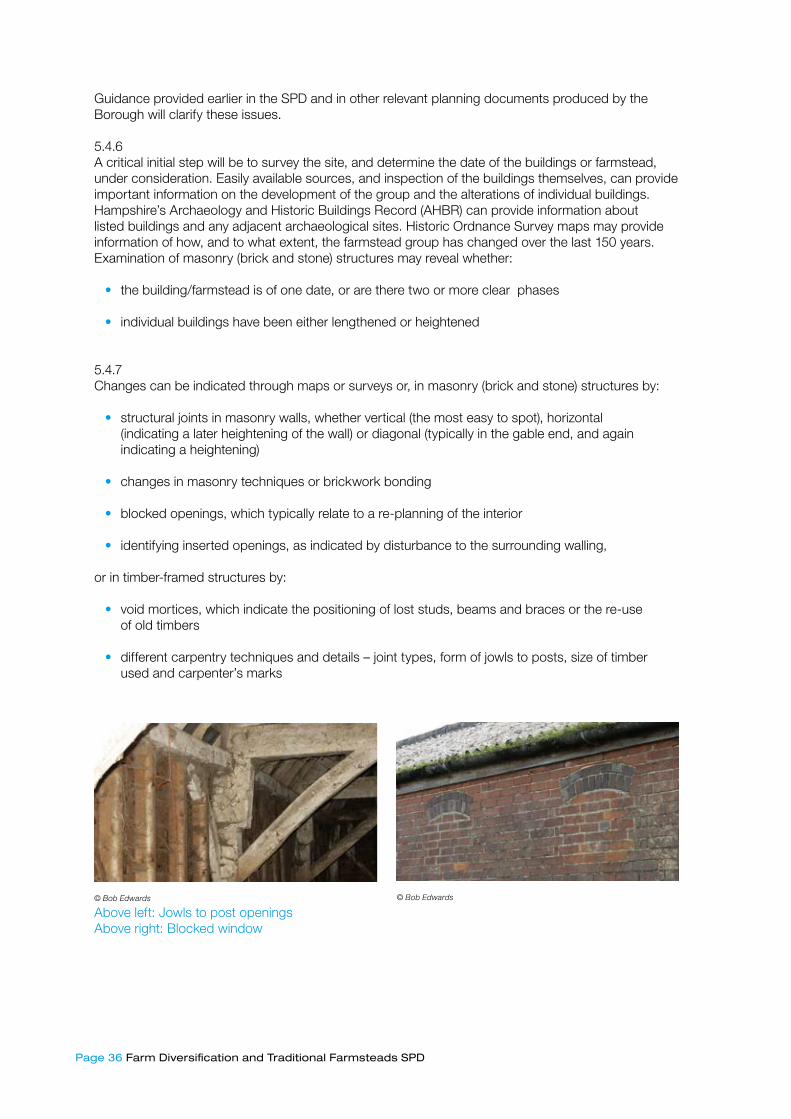
5.4.6 A critical initial step will be to survey the site, and determine the date of the buildings or farmstead, under consideration. Easily available sources, and inspection of the buildings themselves, can provide important information on the development of the group and the alterations of individual buildings. Hampshire’s Archaeology and Historic Buildings Record (AHBR) can provide information about listed buildings and any adjacent archaeological sites. Historic Ordnance Survey maps may provide information of how, and to what extent, the farmstead group has changed over the last 150 years. Examination of masonry (brick and stone) structures may reveal whether:
• the building/farmstead is of one date, or are there two or more clear phases
• individual buildings have been either lengthened or heightened
5.4.7 Changes can be indicated through maps or surveys or, in masonry (brick and stone) structures by:
• structural joints in masonry walls, whether vertical (the most easy to spot), horizontal (indicating a later heightening of the wall) or diagonal (typically in the gable end, and again indicating a heightening)
• changes in masonry techniques or brickwork bonding
• blocked openings, which typically relate to a re-planning of the interior
• identifying inserted openings, as indicated by disturbance to the surrounding walling,
or in timber-framed structures by:
• void mortices, which indicate the positioning of lost studs, beams and braces or the re-use of old timbers
• different carpentry techniques and details – joint types, form of jowls to posts, size of timber used and carpenter’s marks
Above left: Jowls to post openingsAbove right: Blocked window
© Bob Edwards © Bob Edwards

Farm Diversification and Traditional Farmsteads SPD Page �7
5.4.8 A small number of farmsteads and buildings will require archaeological investigation. It is important to gain an initial understanding of the archaeological potential of the farmstead which will either inform and support the development of the scheme, or ensure that archaeological data is recorded before it is damaged or destroyed by the development. To discuss the archaeological potential of a site contact the conservation officer in the first instance. The applicant will be guided as to where to seek advice.
5.4.9 The range and form of buildings on a farmstead, and how they are oriented and relate to access routes, open areas and their wider landscape setting, will be a major influence on schemes for re-use and new development.
5.5 Traditional Farmstead Assessment Checklist
5.5.1 To properly manage change within a prescribed framework, it is necessary to fully understand the character, and sensitivity to change of the site at the building, farmstead and landscape scale. Each site will be unique, and therefore will have different capabilities for change, such as a diversification scheme, as the following will vary from site to site:
• the setting of the farmstead in the landscape
• publicly accessible views into the farmstead
• the completeness of the traditional farmstead group
• the size, range, date and condition of the buildings within the group
• their relationship to access routes and open areas
• the extent of modern farming operations will vary from site to site
These factors will constrain or enable individual sites to change in different ways, and will be a major influence on proposed schemes for re-use.
5.5.2 The framework provided below has been adapted from work produced by English Heritage to help applicants considering changes to traditional farm buildings and farmsteads. It identifies the issues that should be considered in order to understand the character of the site and its sensitivity to change, and inform determination of its sensitivity to change and the options for development and sustainable re-use.
Page �8 Farm Diversification and Traditional Farmsteads SPD
When to use it?5.5.3 The framework is a tool to aid a thorough assessment of the site in terms of:
(A) the wider landscape setting(B) the relationship between the farmstead and the farmland (C) the more detailed aspects of individual buildings and their functions
The assessment should be undertaken at the earliest stages, before any assumptions are made about which areas of the farmstead or which buildings in particular are to be reused as part of the diversification proposal. The main purpose of the framework is to establish where the capacity for change is through an understanding of character, value and sensitivity.
Why use it?5.5.4 The framework has been devised in order to assist determination of which areas or buildings have the greatest capacity to accommodate the necessary changes to facilitate new uses. It is intended to inform discussion at the earliest possible stage, the identification of difficult issues and the need for further professional help. By using the checklist, the character is established and then judgements are made regarding value and sensitivity. When evaluated as a whole, it will become clear which buildings are most suited for adaptation to new, and which are most sensitive to change. Post 1950s sheds can be better suited to commercial and industrial operations that require flexible working spaces than traditional buildings, but some buildings of very high value – such as medieval barns – are capable of some form of new use if carried out with due care and attention to the character and sensitivity to change of the building. Small-scale ancillary structures, such as pigsties, are the most difficult to adapt to new uses but may survive within the context of unusually complete traditional farmstead groups. In some instances, however, there may be an argument for demolishing unsightly buildings and concentrating the new uses in the traditional farm buildings, thereby giving them a new lease of life.
Who should use it?5.5.6 The checklist is to be used by anyone making the initial assessment of the farmstead; this could be the farmer, or an agent or advisor. Once the initial assessment has been completed, but before any further decisions are made, a local conservation officer should be approached. The assessment can then form the basis of discussions and the applicant can be advised as to whether any further investigations or research is necessary to inform the design process.

Farm Diversification and Traditional Farmsteads SPD Page �9
Traditional Farmstead Assessment Framework
A. Landscape1.Character 2. Value and Sensitivity to Change
How does the farmstead as a whole relate to the surrounding physical and cultural landscape? Please consider:
• Geology and soils, landform and topography
⋅ • Patterns of settlement, ranging from village-based to isolated farms
⋅ • Patterns of fields and their enclosures, ranging from small-scale and irregular to large-scale and regular enclosures
⋅ • Routes and tracks
⋅ • Woodland and other land cover
⋅ • Any specific and identified archaeological features, as noted on county Historic Environment Records
To what extent has the landscape been subject to boundary loss and other changes? What are the most, or least, prominent elevation(s) in the landscape?
⋅ • Are there any mitigating features? Eg. screening offered by landform, vegetation, other buildings
• Are there public rights of way close to or through the farmstead?
• Are there important views in or out of the farmstead?
• Are there associations with art, literature, people or events?
B. Farmstead Types1.Character 2. Value and Sensitivity to Change
What is the overall plan form of the farmstead? (please see Appendix F. It is important to consider the farmstead as a whole, including the impact of post-1950s yards and buildings. Please consider:
• The scale and planning or arrangement of the steading, including its relationship to the farmhouse and its garden
⋅ • Access to within and around the steading – including the entry points of routes and tracks
⋅ • The different use of open spaces, subdivisions and areas of circulation within and around the farmstead – gardens, orchards, ponds, cattle yards, yards for managing stock and for stacking corn, hay etc.
⋅ • Boundaries around and within the site
⋅ • The orientation of buildings, how these relate to landscape, and what elevations are inward or outward facing
How does the historic type of farmstead, and the patterns of movement and access around and within it, inform an understanding of constraints and opportunities within the site?
• How complete and significant is it?
⋅ • In reflecting the character and development of local and regional farming and building traditions
⋅ • As an example of a planned steading, in the forefront of technological and agricultural developments
⋅⋅ • How complete or fragmentary is the relationship between the farmstead itself and the landscape around it – as a result of boundary loss and the extent of post-1950 development?

Page 40 Farm Diversification and Traditional Farmsteads SPD
C. Building Types1.Character 2. Value and Sensitivity to Change
What functions or distinct building types, make up the farmstead? For example: barns, granaries, cow houses or multifunctional buildings.
How have they altered or changed over time?
Please consider:
External form and detail
• Size
• Number of storeys
• Opening – including doors, windows, ventilation holes and slits
Internal layout and detail
• Existing floors and partitions
• Location of any lost floors or partitions
• Internal fittings (traditional stalling and surfaces, historic features such as grain bins and machinery)
What uses are accommodated in the buildings now?
For the key characteristics of Hampshire farm buildings refer to Historic Farm Buildings in Hampshire (Hampshire County Council)
Individual Buildings: Scale, Function and Completeness:
• What is the scale of individual buildings and ranges, and how are their functions as farm buildings externally and internally expressed – through doors and windows, as open, floored or subdivided spaces? Consider existing and former (now blocked or disguised) openings
• What historical features – window and door fittings, internal fittings, carpentry and floor surfaces remain, and what has been lost? Is there any evidence for lost floors and partitions?
• How complete or fragmentary are individual buildings as examples of their date and type?
• How complete or fragmentary are individual buildings as examples of their date and type?
• Are there buildings of limited or no re-use potential? (eg. pig sties)
• Are they rare in a regional or national context, as examples of their date or type (eg. medieval barns)?
• Are there buildings of high significance? (for example, a medieval barn)

Farm Diversification and Traditional Farmsteads SPD Page 4�
D. Materials, construction, style and condition
1.Character 2. Value and Sensitivity to Change
The type of construction will be a major factor in any conversion proposal and the range of materials used is likely to influence the materials used in a new development
Applicants should consider the following:
• The form of wall construction – is it original to the building?
• Roof construction and covering
• The overall form of the building – consider the dominance of the wall and/or roof
• Architectural detail and treatment (brick bonds, masonry treatment, renders, detail to lintels, arches, eaves and verges, window and door-styles, paint colours
To what extent does the building/farmstead reflect the use of building materials and constructional techniques historically characteristic of the area?
• Are the building materials still available?
• What is the condition of the building(s)?
This is the key factor in determining the feasibility and likely costs of repair and restoration, and the impact this will have on the fabric of the building.
Condition ranges from:
• Good, well-maintained – minimal intervention required
• Fair: minor maintenance issues
• Poor – structural damage but stable
• Very poor: (structural cracks and damage to roof) – high level of intervention required. (Extensive rebuilding of a building to enable conversion may not be acceptable)
5.5.7 Once the assessment of character, value and sensitivity has been completed and the more suitable areas for adaptation have been identified it is recommended that the applicant meets with a conservation officer or planning officer for initial advice.
Page 4� Farm Diversification and Traditional Farmsteads SPD
6. Summary • Before submitting an application, please contact us about your proposals. We will be happy to
give advice on whether you need planning permission, what planning policies might be relevant, and if any particular issues need to be addressed. For further information on pre-application advice, please view our website (see paragraph 2.1.4 for link).
• Consider the wider effect of your proposals on the local community, the landscape and the environment
• Consult with third parties who may be affected by the proposals. This could include neighbours, parish councils and other businesses in the area
• Consider the amount of additional professional advice you need. This would include advice from land agents, surveyors, solicitors and planning consultants, in determining the feasibility of your proposal and preparing a planning application
• When a diversification scheme involves a traditional farmstead or an individual traditional farm building ensure that the issues of historic character, significance and sensitivity are properly understood before proposals are formulated. Early consultation with a conservation officer is recommended (see paragraph 5.5.4).
• Check if you are eligible for any free help, such as the planning consultancy advice administered through Defra (see paragraph 2.1.4 for links).
• If an application is refused, Council officers will be happy to discuss the proposals again, to see if concerns can be overcome

Farm Diversification and Traditional Farmsteads SPD Page 4�
Appendix ANational, Regional, County and District Planning Policy Context
The SPD document has been written within the context of a hierarchy of planning guidance at the national, regional, county and district scales. The guidance at each level is briefly outlined below.
�. National Guidance: Planning Policy Statement (PPS) 7: Sustainable Development in Rural Areas
A1.1 A key message of PPS7 is that proposals should be based on sustainable development principles. The government’s objectives for rural areas relevant to this PPS are fourfold:
• To raise the quality of life and the environment in rural areas including through the promotion of sustainable economic growth and diversification.
• To promote more sustainable patterns of development
• To promote the development of the English regions by improving their economic performance to enable them to reach their full potential. This can be achieved by developing competitive, diverse and thriving rural enterprise to provide a range of jobs and underpin strong economies.
• To promote sustainable, diverse and adaptable agricultural sectors.
A1.2 Paragraph 30 of PPS7 states that the government recognises that diversification into non-agricultural activities is vital to the continuing viability of many farms. Accordingly, Local Planning Authorities (LPAs) should provide criteria that can be applied to farm diversification projects (hence this SPD).
A1.3 LPA’s should be supportive of well-conceived farm diversification schemes or business proposals that:
• contribute to sustainable development objectives
• help to sustain the agricultural enterprise
• are consistent in their scale with their rural location.
This applies equally to farm diversification schemes around the fringes of urban areas.
A1.4 Paragraph 31 says that a supportive approach to farm diversification should not result in excessive expansion and encroachment of building development into the countryside. Consideration should always be given to the amenity of any nearby residents or rural businesses.
A1.5 PPS 7 also outlines the government’s support for the re-use of appropriately located and suitably constructed, existing buildings in the countryside that meet sustainable development objectives. The re-use of buildings for economic development purposes is the preferred option, although residential conversions may sometimes be more appropriate, depending on local circumstances.

Page 44 Farm Diversification and Traditional Farmsteads SPD
�. Regional GuidanceDraft South East Plan, Policy RE�: Employment and Land Provision; Regional Economic Strategy
A2.1 The Draft South East Plan is a new type of planning document, called a Regional Spatial Strategy. When adopted, it will replace the County structure plans of South East England, including Hampshire. Policy RE2 of the plan states that Local Development Documents (LDDs), such as this SPD should be supportive of rural industries, including the diversification of farms.
A2.2 The Regional Economic Strategy (RES) acknowledges the structural changes that have occurred in agriculture. These include the reform of the Common Agricultural Policy, and the move away from subsidy regimes to single farm payments. The support required by farming in light of these changes, and the opportunity that new technologies can provide, is reflected in the RES key priorities for the rural South East1.
�. CountyHampshire County Structure Plan �996-�0�� (Review)
A3.1 Policy EC3 of the Hampshire County Structure Plan relates to the economic development of rural areas:
“The following types of development will normally be permitted, having regard to the countryside policies of the plan:
(a) within and adjoining rural settlements
i. use by businesses of existing buildings
ii. workshops, industries and businesses appropriate in scale and location to the settlement or site
(b) outside rural settlements
iii. use by businesses of existing buildings provided that the buildings have not become so derelict that they could be brought back into use only by complete or substantial reconstruction
iv. buildings associated with agriculture, horticulture or forestry”
A3.2 Paragraph 154 outlines the aim of the policy, which is to support development that is essential to meet the needs of the rural economy. Farm diversification is a crucial element in helping to support agriculture and associated activities. It enables alternative sources of income to sustain the core business of farming, and helps provide employment opportunities to meet local needs. The supporting text also acknowledges that the continuing viability of farming may depend on a diversification of activities to support the existing agricultural uses. Therefore, the conversion and re-use of existing buildings, adapted for a new enterprise, may be appropriate. However, their rural character must be retained, and their historic or architectural importance not damaged.
� Regional Economic Strategy (RES), The Rural South East, pp.�7

Farm Diversification and Traditional Farmsteads SPD Page 45
A3.3 Paragraph 155 outlines the potential need for agri-industrial development due to new non-food crops and changing methods of processing. These may include the storage and processing of agricultural and forestry products, or the production of renewable energy from the processing of biomass. When considering such schemes, specific proposals must respect the character of the landscape and its capacity to absorb the development. The impact of the proposals on the character of the landscape should be minimised by careful attention to design, scale, form, location and orientation.
4. DistrictRural Strategy
A4.1 The Rural Strategy was adopted by the Borough Council in October 1999 and covers the entire Borough outside Basingstoke Town. The strategy reflected national guidance in order to assist the Council and other stakeholders in maintaining, and where possible improving, the social, economic and environmental well-being of the Borough’s rural areas. Through a number of themes and objectives, the Strategy has been the principal platform for addressing rural issues in the past.

Page 46 Farm Diversification and Traditional Farmsteads SPD
Appendix B
Local Plan Policies
Policy E�: Development Control
Proposals for new development will be permitted provided that they are of a high standard of design, make efficient use of land, respect the amenities of neighbouring occupiers, and do not result in inappropriate traffic generation or compromise highway safety. All development proposals should therefore:
i. Respond to the local context of buildings in terms of design, siting, density and spacing, reinforce attractive qualities of local distinctiveness and enhance areas of poor design; extensions should respect their host building.
ii. Provide a comprehensive landscaping scheme, where appropriate, enabling the development to successfully integrate with the landscape and surrounds, and not result in the loss of or have a potentially adverse impact on protected trees; and
iii. Not generate traffic of a type or amount inappropriate for roads, properties or settlements in the locality, and provide safe and convenient access for all potential users, integrating into existing movement networks and open spaces; and
iv. Provide a co-ordinated and comprehensive scheme that does not prejudice the development of adjoining land; and
v. Incorporate features to minimise the energy consumed in the construction and future use of the building, conserve water and minimise water use; and
vi. Create attractive public spaces, which are safe, minimise opportunities for crime, facilitate public enjoyment, and foster the legibility of the built environment; and
vii. Minimise the potential for pollution of air and soil and not create noise or light which harms living and working conditions or the public’s enjoyment of the built and natural environment.
Policy E�: Buildings of Historic or Architectural Interest
Proposals for development that would affect a listed building, structure or its setting will be determined against the following guidelines:
• The demolition of a listed building or structure will only be permitted in exceptional circumstances.
• Alterations and extensions that preserve the character and/or setting of a listed building and any features of architectural or historic interest will be permitted.
• Developments within the curtilage of or adjacent to a listed building which do not detrimentally affect their setting will be permitted.
• Development will not be permitted if it would harm a building or feature of local historic or architectural interest or adversely affect its setting

Farm Diversification and Traditional Farmsteads SPD Page 47
Policy E6: Landscape Character Planning permission will only be granted where it is demonstrated that the proposals will be sympathetic to the landscape character and quality of the area concerned.
Development proposals should contribute to the regeneration, restoration, repair or conservation of any landscape likely to be affected. In particular they should respect, and improve the following:
i. the particular qualities of the relevant Landscape Character Area as defined in the Basingstoke and Deane Landscape Assessment; and
ii. visual amenity and scenic quality; and iii. the setting of a settlement, including important views to, across and out of settlements; and iv. the local character of buildings and settlements, including important open areas; and v. trees, hedgerows, water features and other landscape elements and features; and vi. historic landscapes, features and elements
Consideration will also be given to the impact that development would have on sense of place, sense of remoteness or tranquillity, and the quiet enjoyment of the landscape from public rights of way.
The designation of the North Wessex Downs AONB reflects the national importance of that landscape. In addition to the other requirements of this Policy, applications for development in the AONB will be determined in accordance with the policy in PPS7 also having regard to the setting of the AONB.
Policy E7: Nature/Biodiversity Conservation
Development or a change of land use will be permitted where it will not have an adverse effect on protected species or the conservation status of priority species, harm the nature conservation interest of a statutory or non-statutory wildlife nature conservation site or lead to the loss or deterioration of a key habitat type or harm the integrity of linkages between such sites and habitats.
Proposals will be expected to conserve and, where possible, enhance the biodiversity of the receiving environment, taking into account the aims and targets of the UK and Local Biodiversity Action Plans. Where appropriate, planning conditions and obligations will be used to secure these requirements. In particular, the opportunity will be taken to secure the creation and management of features of the landscape that, by virtue of their linear and continuous structure or their function as ‘stepping stones’, are of major importance for the migration, dispersal and genetic exchange of wild species.
The weight given to the protection of nature conservation interests will depend on the national or local significance and any statutory designation or protection applying to the site, habitat or species concerned. Where the public interest in favour of a proposal is deemed to outweigh harm to biodiversity, the local planning authority will require the use of the best practicable mitigation/compensation measures, which will be secured through planning conditions and planning obligations, as appropriate.
Applications for development must include adequate information to enable a proper assessment of the implications for biodiversity. It should be noted that adverse effects on nature conservation interests are not necessarily limited to the proposal site. Adjacent land, including that outside the local plan boundary, must also be considered.

Page 48 Farm Diversification and Traditional Farmsteads SPD
Policy E8: Water Environment
Development will not be permitted if it would increase the number of people or property at risk of flooding, or be likely to increase the risk or severity of flooding elsewhere. Proposals will be assessed according to the sequential risk-based approach set out in Table 1 of PPG25. These areas believed to be at high risk are defined on the Proposals Maps as floodplains; applications within such areas must be accompanied by a flood risk assessment.
Development will not be permitted if it would increase the risk of flooding elsewhere, as a result of changing the surface water run-off, unless that risk can be overcome through measures to be implemented by the developer.
Developments likely to increase surface water run-off should incorporate sustainable urban drainage systems (SUDS). Developers will be required to ensure that arrangements are in place for the long term management and maintenance of the SUDS.
Development will not be permitted if it would affect the water environment and, as a consequence hydrology and thus adversely impact upon the biodiversity of an area either locally or at a distance.
Development will not be permitted if it would affect or impact upon groundwater quality.
Policy EC6: The re-use of Buildings in the Countryside
Proposals for the re-use of buildings in the countryside will be permitted provided that:
i. They reuse or sympathetically adapt a suitable building; and ii. Commercial or community re-use (where re-use is not proposed for these purposes) is shown not
to be possible; andiii. The site is in a sustainable location.
Policy EC8: Rural Tourism
Proposals for tourist development within the countryside that improves or extends the range of tourist facilities, including tourist accommodation will be permitted provided that this:
i. would result from the conversion of a suitable rural building; or
ii. forms part of a farm diversification scheme; or is an extension to existing facilities, of a scale appropriate to its location
Policy C�: Section �06 Contributions
Development will be permitted only where there are, or will be, adequate infrastructure and community facilities. Where provision is inadequate, developers will be required to provide the infrastructure and community facilities necessary to allow the development to proceed. The Council will negotiate to secure planning obligations to ensure that such infrastructure and facilities are provided in time to meet the needs arising from the development.
Farm Diversification and Traditional Farmsteads SPD Page 49
Policy A6: Renewable Energy
Proposals will be permitted to generate energy from renewable sources provided that:
i. the proposal, including any associated transmission lines, buildings and access roads, has no significant adverse impact on the historic and natural landscape, landscape character, townscape or nature conservation interests, and the proposal has no adverse impact on the amenity of the area in respect of noise, dust, odour and traffic generation; and
ii. provision is made for the removal of the facilities and reinstatement of the site should it cease to be operational
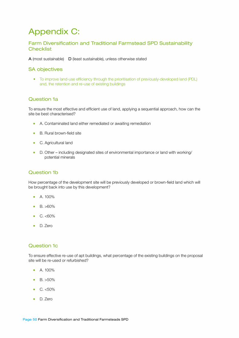
Page 50 Farm Diversification and Traditional Farmsteads SPD
Appendix C: Farm Diversification and Traditional Farmstead SPD Sustainability Checklist
A (most sustainable) ⋅ D (least sustainable), unless otherwise stated
SA objectives
• To improve land-use efficiency through the prioritisation of previously-developed land (PDL) and, the retention and re-use of existing buildings
Question �a
To ensure the most effective and efficient use of land, applying a sequential approach, how can the site be best characterised?
• A. Contaminated land either remediated or awaiting remediation
• B. Rural brown-field site
• C. Agricultural land
• D. Other – including designated sites of environmental importance or land with working/potential minerals
Question �b
How percentage of the development site will be previously developed or brown-field land which will be brought back into use by this development?
• A. 100%
• B. >60%
• C. <60%
• D. Zero
Question �c
To ensure effective re-use of apt buildings, what percentage of the existing buildings on the proposal site will be re-used or refurbished?
• A. 100%
• B. >50%
• C. <50%
• D. Zero
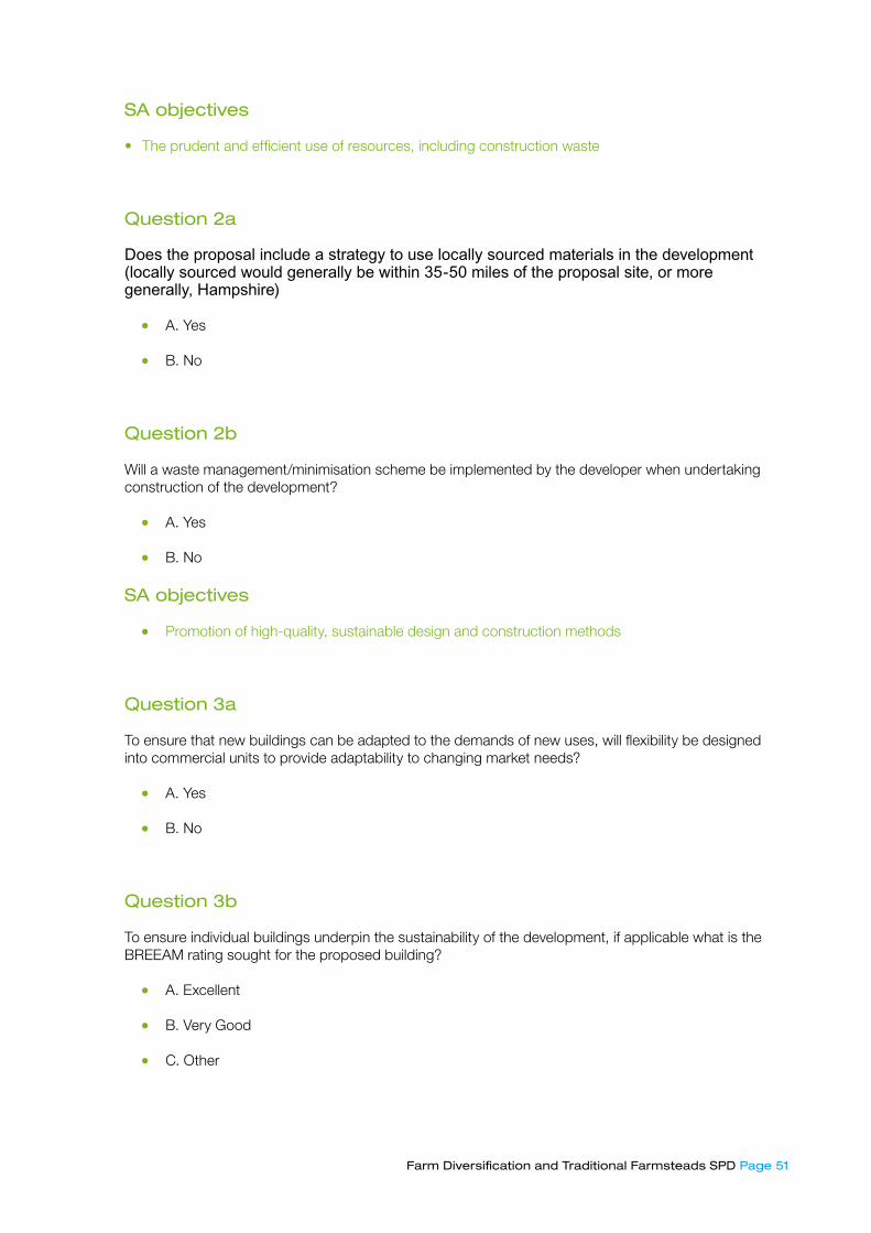
Farm Diversification and Traditional Farmsteads SPD Page 5�
SA objectives
• The prudent and efficient use of resources, including construction waste
Question �a
Does the proposal include a strategy to use locally sourced materials in the development (locally sourced would generally be within 35-50 miles of the proposal site, or more generally, Hampshire)
• A. Yes
• B. No
Question �b
Will a waste management/minimisation scheme be implemented by the developer when undertaking construction of the development?
• A. Yes
• B. No
SA objectives
• Promotion of high-quality, sustainable design and construction methods
Question �a
To ensure that new buildings can be adapted to the demands of new uses, will flexibility be designed into commercial units to provide adaptability to changing market needs?
• A. Yes
• B. No
Question �b
To ensure individual buildings underpin the sustainability of the development, if applicable what is the BREEAM rating sought for the proposed building?
• A. Excellent
• B. Very Good
• C. Other
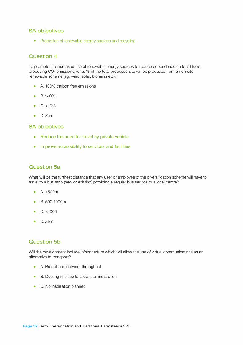
Page 5� Farm Diversification and Traditional Farmsteads SPD
SA objectives
• Promotion of renewable energy sources and recycling
Question 4
To promote the increased use of renewable energy sources to reduce dependence on fossil fuels producing CO² emissions, what % of the total proposed site will be produced from an on-site renewable scheme (eg. wind, solar, biomass etc)?
• A. 100% carbon free emissions
• B. >10%
• C. <10%
• D. Zero
SA objectives
• Reduce the need for travel by private vehicle
• Improve accessibility to services and facilities
Question 5a
What will be the furthest distance that any user or employee of the diversification scheme will have to travel to a bus stop (new or existing) providing a regular bus service to a local centre?
• A. >500m
• B. 500-1000m
• C. <1000
• D. Zero
Question 5b
Will the development include infrastructure which will allow the use of virtual communications as an alternative to transport?
• A. Broadband network throughout
• B. Ducting in place to allow later installation
• C. No installation planned

Farm Diversification and Traditional Farmsteads SPD Page 5�
Question 5c
Will provision be made for off-road HGV and smaller delivery vehicles loading on public highways?
• A. Provision for HGV and smaller delivery vehicles
• B. Provision for smaller delivery vehicles only
• C. Provision for neither
SA objectives
• Preserve, enhance and manage the Borough’s Historic and Archaeological heritage
• Protect, enhance and manage biodiversity, wildlife habitats and distinctive local landscapes
Question 6a
To ensure that the development responds to local character whilst reinforcing its own identity, will the appearance of the development be visually appropriate, taking into consideration local character studies, and will it complement local character? Please indicate which aspects the proposal could reasonably be said to address.
• A. Building materials and colour complement local character
• B. Building style and form enhancing local character
• C. Proposed roofscapes visually respect the developments location within the wider landscape context
• D. Continuity of local building details such as windows and doors
• E. Contemporary approach which reflects the local vernacular
Question 6b
Will the proposed lighting be designed to minimise light pollution and disruption to neighbours?
• A. Yes
• B. No
Question 6c
Where appropriate, does the proposal address the protection of relevant heritage and archaeologically important features and their settings, which could be affected by the development?
• A. Yes
• B. No

Page 54 Farm Diversification and Traditional Farmsteads SPD
Question 6d
Where appropriate, does the proposal address the protection of important or sensitive habitats identified either through designations (eg. SSSI), local biodiversity action plans (LBAP) or support for a species identified in the Biodiversity Action Plan?
• A. Yes, for more than one habitat or species
• B. Yes, for one habitat or species
• C. None identified
Question 6e
How will the development meet the required water demands placed upon the site in a sustainable manner?
• A. Best practice including grey-water recycling, plus B (below)
• B. Water demand minimised and rainwater harvested for re-use on the site
• C. Sufficient capacity in existing supply
Question 6f
To ensure that sites and developments take due account of flood risk, and where it is present to take appropriate measures, is the development sited (and designed) in accordance with the sequential test set out in PPS25?
• A. Site is within Zone 1 on Environment Agency flood map
• B. Site is within Zone 2 – no suitable Zone 1 sites available
• C. Site is within Zone 3a – no suitable Zone 1 or Zone 2 sites available
• D. Zone 3b sites
SA objectives
• Be supportive of well-conceived farm diversification schemes that help sustain agricultural operations, and maintain farm-based income and employment
• Encourage and promote sustainable tourism that benefits rural businesses
• Help facilitate a sustainable, diverse, stable local rural economy
Farm Diversification and Traditional Farmsteads SPD Page 55
Question 7a
Will the development include a range of size of business premises, for example, incubator units and flexible space, to encourage both start up and expanding business?
• A. Yes
• B. No
Question 7b
What is the potential for the proposed development to create additional permanent jobs either through new business or for maintenance of the development?
• A. A net increase in jobs that draw upon the local skills base or where training opportunities may be provided to help local workers to develop skills
• B. Net % increase in jobs in the area
• C. No net increase in jobs

Page 56 Farm Diversification and Traditional Farmsteads SPD
Appendix D Permitted Development Rights (Disturbance Sports)
Permitted development The use of any land for any purpose for not more than 28 days in total in any calendar year, of which not more than 14 days in total may be for the purposes referred to in paragraph B.2, and the provision on the land of any moveable structure for the purposes of the permitted use. Development not permitted
B.� Development is not permitted by Class B if—
(a) the land in question is a building or is within the curtilage of a building,
(b) the use of the land is for a caravan site,
(c) the land is, or is within, a site of special scientific interest and the use of the land is for—
(i) a purpose referred to in paragraph B.2(b) or other motor sports;
(ii) clay pigeon shooting; or
(iii) any war game,
Or the use of the land is for the display of an advertisementInterpretation of Class B
B.� The purposes mentioned in Class B above are—
(a) the holding of a market;
(b) motor car and motorcycle racing including trials of speed, and practising for these activities.
B.3 In Class B, “war game” means an enacted, mock or imaginary battle conducted with weapons which are designed not to injure (including smoke bombs, or guns or grenades which fire or spray paint or are otherwise used to mark other participants), but excludes military activities or training exercises organised by or with the authority of the Secretary of State for Defence.

Farm Diversification and Traditional Farmsteads SPD Page 57
Appendix E Permitted Development Rights (Agricultural Operations)
The following form the Permitted Development Rights for Agricultural Buildings and Operations. They are reproduced from The Town and Country Planning (General Permitted Development) Order 1995, Part 6, pages 21-23.
Class A: Development on units of 5 hectares or more
Permitted Development:
A. The carrying out on agricultural land comprised in an agricultural unit of 5 hectares or more in area of –
(a) works for the erectiom, extension or alteration of a building; or
(b) any excavation or engineering operations,
which are reasonably necessary for the purposes of agriculture within that unit
Development not permitted:
A1 Development is not permitted by Class A if: a) the development would be carried out on a separate parcel of land forming part of the unit
which is less than 1 hectare in area;
b) it would consist of, or include, the erection, extension or alteration of a dwelling;
c) it would involve the provision of a building, structure or works not designed for agricultural purposes;
d) the ground area which would be covered by:
(i) any works or structure (other than a fence) for accommodating livestock or any plant or machinery arising from engineering operations; or
(ii) any building erected or extended or altered by virtue of Class A would exceed 465 square metres, calculated as described in paragraph D.2 below;
e) the height of any part of any building, structure or works within 3 kilometres of the perimeter of an aerodrome would exceed 3 metres;
f) the height of any part of any building, structure or works not within 3 kilometres of the perimeter of an aerodrome would exceed 12 metres;
g) any part of the development would be within 25 metres of a metalled part of a trunk road or classified road;
h) it would consist of, or include, the erection or construction of, or the carrying out of any works to, a building, structure or an excavation used to be used for the accommodation of livestock or for the storage of slurry or sewage sludge where the building, structure or excavation is, or would be, within 400 metres of the curtilage of a protected building; or
i) it would involve excavations or engineering operations on or over article 1(6) land which are connected with fish farming.

Page 58 Farm Diversification and Traditional Farmsteads SPD
Conditions
A2 (1) Development is permitted by Class A subject to the following conditions:
a) where development is carried out within 400 metres of the curtilage of a protected buildings, any building, structure, excavation or works resulting from the development shall not be used for the accommodation of livestock except in the circumstances described in paragraph D.3 below or for the storage of slurry or sewage sludge;
b) where the development involves:
(i) the extraction of any mineral from the land (including removal from any disused railway embankment); or
(ii) the removal of any mineral from a mineral-working deposit the mineral shall not be moved off the unit;
c) waste materials shall not be brought on to the land from elsewhere for deposit except for use in works described in Class A(a) or in the provision of a hard surface any materials so brought shall be incorporated forthwith into the building or works in question.
A2 (2) Subject to paragraph (3), development consisting of:
a) the erection, extension or alteration of a building;
b) the formation or alteration of a private way;
c) the carrying out of excavations or the deposit of waste material (where the relevant area, as defined in paragraph D.4 below, exceeds 0.5 hectare); or
d) the placing or assembly of a tank in any waters, is permitted by Class A subject to the following conditions:
( i) the developer shall, before beginning the development, apply to the local planning authority for a determination as to whether the prior approval of the authority will be required to the siting, design and
( ii) external appearance of the building, the siting and means of construction of the private way, the siting of the excavation or deposit or the siting and appearance of the tank, as the case may be;
(iii) the application shall be accompanied by a written description of the proposed development and of the materials to be used and a plan indicating the site together with any fee required to be paid;
(iv) the development shall not be begun before the occurrence of one of the following:
( v) (aa) where the local planning authority give the applicant notice that such prior approval is required the applicant shall display a site notice by site display on or near the land on which the proposed development is to be carried out, leaving the notice in position for not less than 21 days in the period of 28 days from the date on which the local planning authority gave the notice to the applicant;
Farm Diversification and Traditional Farmsteads SPD Page 59
(b) where the site notice is, without any fault or intention of the applicant, removed, obscured or defaced before the period of 21 days referred to in sub-paragraph (aa) has elapsed, he shall be treated as having complied with the requirements of that sub-paragraph if he has taken reasonable steps for protection of the notice and, if need be, its replacement;
(vi) the development shall, except to the extent that the local planning authority otherwise agree in writing, be carried out:
(a) where prior approval is required, in accordance with the details approved; (b) where prior approval is not required, in accordance with the details submitted with the
application; and
(vii) the development shall be carried out:
(a) where approval has been given by the local planning authority, within a period of five years from the date on which approval was given;
(b) in any other case, within a period of five years from the date on which the local planning authority were given the information referred to in sub-paragraph (d) (ii)
A2 (3) The conditions in paragraph (2) do not apply to the extension or alteration of a building if the building is not on article 1(6) land except in the case of a significant extension or significant alteration.
A2 (4) Development consisting of the significant extension or the significant alteration of a building may only be carried out once by virtue of Class A(a)
Class B: Development on units of less than 5 hectares
Permitted Development:
B. The carrying out on agricultural land comprised in an agricultural unit of not less than 0.4 but less than 5 hectares in area of development consisting of:
a. the extension or alteration of an agricultural building;
b. the installation of additional or replacement plant or machinery;
c. the provision, rearrangement or replacement of a sewer, main, pipe, cable or other apparatus;
d. the provision, rearrangement or replacement of a private way;
e. the provision of a hard surface;
f. the deposit of waste; or
g. the carrying out of any of the following operations in connection with fish farming, namely, reparing ponds and raceways; the installation of grading machinery, aeration equipment or flow meters and any associated channel; the dredging of ponds; and the replacement of tanks and nets;
h. where the development is reasonably necessary for the purposes of agriculture within the unit.
Page 60 Farm Diversification and Traditional Farmsteads SPD
Development not permitted:
B1 Development is not permitted by Class B if: a) the development would be carried out on a separate parcel of land forming part of the unit
which is less than 0.4 hectare in area;
b) the external appearance of the premises would be materially affected;
c) any part of the development would be within 25 metres of a metalled part of a trunk road or classified road;
d) it would consist of, or involve, the carrying out of any works to a building or structure used or to be used for the accommodation of livestock or the storage of slurry or sewage sludge where the building or structure is within 400 metres of the curtilage of a protected building; or
e) it would relate to fish farming and would involve the placing or assembly of a tank on land or in any waters or the construction of a pond in which fish may be kept or an increase (otherwise than by the removal of silt) in the size of any tank or pond in which fish may be kept.
B2 Development is not permitted by Class B (a) if:
a) the height of any building would be increased;
b) the cubic content of the original building would be increased by more than 10%;
c) any part of any new building would be more than 30 metres from the original building;
d) the development would involve the extension, alteration or provision of a dwelling;
e) any part of the development would be carried out within 5 metres of any boundary of the unit; or f) the ground area of any building extended by virtue of Class B(a) would exceed 465 square
metres
B3 Development is not permitted by Class B (b) if:
• the height of any additional plant or machinery within 3 kilometres of the perimeter of an aerodrome would exceed 3 metres;
• the height of any additional plant or machinery not within 3 kilometres of the perimeter of an aerodrome would exceed 12 metres;
• the height of any replacement plant or machinery would exceed that of the plant or machinery being replaced; or
• the area to be covered by the development would exceed 465 square metres calculated as described in paragraph D.2 below.
B4 Development is not permitted by Class B (e) if the area to be covered by the development would exceed 465 square metres

Farm Diversification and Traditional Farmsteads SPD Page 6�
Conditions
B5 Development permitted by Class B and carried out within 400 metres of the curtilage of a protected building is subject to the condition that any building which is extended or altered, or any works resulting from the development, shall not be used for the accommodation of livestock except in the circumstances described in paragraph D.3 below or for the storage of slurry or sewage slurry.
B6 Development consisting of the extension or alteration of a building situated on article 1(6) land or the provision, rearrangement or replacement of a private way on such land is permitted subject to:
• the condition that the developer shall, before beginning the development, apply to the local planning authority for a determination as to whether the prior approval of the authority will be required to the siting, design and external or altered or the siting and means of construction of the private way; and
• the conditions set out in paragraphs A.2(2)(ii) to (iv) above
B7 Development is permitted by Class B(f) subject to the following conditions:
• that waste materials are not brought on to the land from elsewhere for deposit unless they are for use in works described in Class B(a), (d) or (e) and are incorporated forthwith into the building or works in question; and
• that the height of the surface of the land will not be materially increased by the deposit
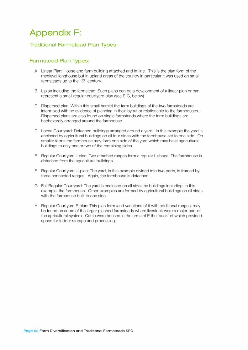
Page 6� Farm Diversification and Traditional Farmsteads SPD
Appendix F: Traditional Farmstead Plan Types
Farmstead Plan Types:
A Linear Plan: House and farm building attached and in-line. This is the plan form of the medieval longhouse but in upland areas of the country in particular it was used on small farmsteads up to the 19th century.
B L-plan including the farmstead: Such plans can be a development of a linear plan or can represent a small regular courtyard plan (see E-G, below).
C Dispersed plan: Within this small hamlet the farm buildings of the two farmsteads are intermixed with no evidence of planning in their layout or relationship to the farmhouses. Dispersed plans are also found on single farmsteads where the farm buildings are haphazardly arranged around the farmhouse.
D Loose Courtyard: Detached buildings arranged around a yard. In this example the yard is enclosed by agricultural buildings on all four sides with the farmhouse set to one side. On smaller farms the farmhouse may form one side of the yard which may have agricultural buildings to only one or two of the remaining sides.
E Regular Courtyard L-plan: Two attached ranges form a regular L-shape. The farmhouse is detached from the agricultural buildings.
F Regular Courtyard U-plan: The yard, in this example divided into two parts, is framed by three connected ranges. Again, the farmhouse is detached.
G Full Regular Courtyard: The yard is enclosed on all sides by buildings including, in this example, the farmhouse. Other examples are formed by agricultural buildings on all sides with the farmhouse built to one side.
H Regular Courtyard E-plan: This plan form (and variations of it with additional ranges) may be found on some of the larger planned farmsteads where livestock were a major part of the agricultural system. Cattle were housed in the arms of E the ‘back’ of which provided space for fodder storage and processing.
Farm Diversification and Traditional Farmsteads SPD Page 6�
Appendix G Traditional Farmsteads – Historical Context
G1.1 The landscape of the Borough can be divided into two main areas – the chalk downs of the south and the clay lands of the north. This basic geological division resulted in the development of landscapes with distinctive settlement patterns and agricultural character. On the chalk large estates were established by the Saxon period at least often with, in the west of the Borough, long narrow land units stretching from river valleys where villages were sited up to the higher downs. Many of these Saxon estates are still represented by parish boundaries. Open fields typically occupied the lower slopes with open downland on the higher ground. In the eastern downs river valleys are less dominant and so the settlement pattern consists of small villages and hamlets scattered across a landscape that consists of smaller areas of early enclosure by agreement intermixed with later, regular parliamentary-type enclosure.
G1.2 Sheep and corn farming dominated the chalklands from the medieval period with common arable fields on the lower slopes and open sheep walks on the downs. The large flocks of sheep were valuable for their wool and for maintaining soil fertility – they were ‘folded’ on the fallow fields each night where they dropped their manure. This system of farming largely continued up to the nineteenth century but whilst the basis of farming remained constant considerable changes occurred from the sixteenth century at least that had a major impact on the landscape and which have been described as an ‘agricultural revolution’. These changes included the introduction of watermeadows, increased uses of artificial grasses, the leasing of large estates to yeoman farmers often resulting in the enclosure by agreement of common fields and downland with a resultant demise of small peasant farmers who either sold or leased out their small pieces to the larger farmers.
G1.3 The increased prosperity of a few large farmers allowed them to alter existing houses, often re-fronting them in brick, or build new, large farmhouses and barns. The timber-framed and long straw thatched barns, often aisled and sometimes two or three to a farm, together with stables and a granary, were typically arranged around a yard (a loose courtyard plan) where cattle could be wintered. Yard areas on Hampshire loose courtyard steadings were usually undivided although sometimes there may be a boundary to one side dividing the yard from the house. Where a new farmhouse was built it was typically set away from the farmyard rather than forming one side of the yard. Smaller farm buildings and boundary walls could be built of cob and were typically thatched. The small farm buildings of the family farmers, who were unable to continue farming without the common flock manuring their fields, were generally not replaced but many of their houses survive.
G1.4 The pace of enclosure and ploughing up of the downland increased in the late eighteenth - early nineteenth century when the Napoleonic War forced up wheat prices. Commentators such as William Cobbett condemned such practice, questioning the value of ploughing the poor downland soils. Large regular fields were created on the downs and in some cases new farmsteads, often regular courtyards of linked brick and flint buildings, were erected to serve the new holdings (although timber-framed barns also continued to be built). Some of the larger farmstead were also accompanied by cottages for farm labourers. The nineteenth century was a turbulent century for agricultural with wheat prices falling at the end of the Napoleonic War before rising again mid-century. However, a series of poor harvests, the effects of cheap imports of grain from America and a collapse in wool prices in the 1870s resulted in an agricultural depression that didn’t lift until the First World War. The low wheat and wool prices forced some chalkland farmers to look to dairying, producing liquid milk which was one of the few profitable areas of farming, supplying the growing urban areas of Southampton and Portsmouth as well as the London market. A few large estates invested in new dairy buildings, sometimes using concrete walling, whilst on other farmsteads barns were converted. However, many farmers intensified wheat production, replacing sheep flocks with the new artificial fertilizers that were available which in turn allowed more downland to be ploughed up.

Page 64 Farm Diversification and Traditional Farmstead
G1.5 On the clays of the north of the Borough is a landscape of a markedly different scale and character. Settlement is predominantly dispersed with hamlets and isolated farmsteads connected by a network of small, twisting lanes and set amongst small, often irregular fields and with considerable woodland. There is evidence that the clearance of woodland to create farms was underway in the Saxon period and probably continued in the period up to the fourteenth century. It is probable that many of the scattered farmsteads were created by that date but this was also a dynamic landscape with farmsteads being created, others being reduced to a cottage and some removed from the landscape entirely. Loose courtyard plans were also typical of this area but the buildings, usually timber-framed and thatched with some brick and tile barns, were smaller and rarely was more than one barn required. The small irregular inter-mixed fields of different farmers were gradually re-organised creating ring-fenced holdings sometimes with a new, more regular field pattern replacing the irregular assarted fields. Amalgamation of holdings sometime led to the re-organisation of the remaining farmsteads, often creating regular courtyard plans where the management of cattle in smaller yard areas was a feature.
G1.6 Despite the contrast in character with the chalklands sheep and corn was still the principal agricultural system although it operated on a very different scale and cattle were of greater importance. Farms in this area were small, some too small to support a family and so by-employment was common – working in woodland industries, carting or brick-making. It was also common to over-winter the sheep of some of the downland farmers. On the poorer, sandier soils there were fewer farms although often farmsteads were located close to the edges of areas of heath where they could exploit both the grazing offered by the common and the slightly better quality soils surrounding. These areas of poorer land were largely left to large estates to enclose and attempt to improve in the nineteenth century, sometimes creating new regular courtyard plan farmsteads which typically included brick-built cattle housing.
G1.7 Within both areas the late twentieth century has witnessed the further amalgamation of holdings removing many farmsteads from agriculture and concentrating farming operations at a few farmsteads where large new sheds and silos often engulf or have replaced earlier farm buildings. However, there are many working farms that retain traditional farm buildings that offer opportunities for diversification.

Farm Diversification and Traditional Farmstead Page 65
Appendix HTraditional Farmsteads Plan Types
Hampshire Downs North Hampshire Lowland and Heath
Summary
This area shares many characteristics with other downland landscapes of southern England where farmsteads had developed into their present form by the 19th century. Very large arable based holdings, by national standards, were provided with large barns for crop processing and storage, which make the farmsteads of this area particularly prominent in the landscape. The concentration of farmsteads in villages and hamlets and the large holding size has resulted in a relatively low density of farmsteads in the landscape.
Although this area has a markedly different character to the chalk landscapes to the south, large parts of this area supported a sheep-corn system of agriculture. Small farm size and a generally dispersed settlement pattern resulted in a high density of farmsteads in the landscape.
Farmsteads in the Landscape
A generally elevated chalk landscape dissected by sheltered valleys and combes dominated by sheep and corn farming from the 13th century to the later 19th century, now comprising extensive tracts of predominantly open arable farmland. Numerous ancient semi-natural woodlands and ancient hedgerows, particularly on areas of clay. Generally, medium to large or very large fields predominantly created through enclosure by agreement from the 17th century. The earliest enclosures, relating to former common fields are generally found adjacent to the settlements and on the valley sides where larger rectilinear fields are characteristic. Enclosure of the once extensive downland increased during the late 18th and early 19th centuries resulting in the large-scale, regular fields of the open arable areas in particular.
A generally low-lying, undulating landscape crossed by many small streams. A well-wooded area with both pasture and arable land in the Mixed Farmland and Woodland and Pasture and Woodland: Heath Associated areas. Some extensive areas of heathland remain in the eastern part of the area. Field boundaries, created by thorough assarting of the formerly extensive woodland from the Saxon period onwards are typical; extensive enclosure by agreement from 17th century along the stream valleys and generally more regular boundaries associated with post-1750 enclosure (some parliamentary), often taking in areas of heathland or common.
Farmsteads of medieval origin located in villages and hamlets where they are very prominent features, often presenting largely blank external elevations to the village street. Farmsteads often lay on the edge of the settlement, where they can be seen in relationship to long linear fields – the result of enclosure of common fields - extending up valley slopes.
Settlement pattern of generally small villages intermixed with many isolated farmsteads and small hamlets. Nucleated villages are found in greater number in the eastern part of the area. Many isolated farmsteads are of medieval or 17th century origin, some fringing areas of heath or common. Where subsequent encroachment on the common has occurred 19th century farmsteads have sometimes been created, leaving the earlier phase of common-edge farms set back from the common.
Page 66 Farm Diversification and Traditional Farmstead
On the downland the majority of isolated farmsteads were created or largely re-built post-1750, but some medieval farms (often the result of settlement shrinkage) remain. Here the farmsteads are set in rolling chalk downland and are often prominent in long views across the landscape.
A farmstead, usually manorial, is often found in close proximity to a medieval church representing an early church/manor relationship. Generally farmsteads are less prominent in the small villages than in some other character areas but the isolated farmsteads, often set close to the roads and lanes, make an important contribution to the character of the landscape.
Building Materials
The majority of farm buildings of pre-19th century date are timber-framed and weather boarded although brick was used from the 18th century where it was available locally. Mid- to late 19th century buildings are commonly of brick and flint or brick or with tile or slate half-hipped or gabled roofs. Some smaller farm buildings constructed in cob. Late 19th and early 20th examples of the use of concrete walling, typically on large estate-owned farmsteads.
The majority of farm buildings of pre-mid-19th century date are timber-framed although brick was used from the 16th century, initially as an indicator of wealth and status. From the 18th century increasing use of brick for farm buildings is seen, particularly for stables and some barns. By the mid-19th century most farm buildings are of brick with tile or slate half-hipped or gabled roofs. Slates may be laid ‘economically’ especially on estate owned farms. In the east of the character area, 19th century brick-built farmsteads are important in informing the development of agricultural practice and some of the large estates.
Straw thatch was the traditional roofing material for most farm buildings and is particularly important to the character of settlements in the western part of the area. Plain clay tile has also been used since medieval times for some buildings. Walls in and around farmsteads are typically of flint and brick or cob with distinctive thatch or tile capping.
Straw thatch was the traditional roofing material for most farm buildings although tile has been used since medieval times for some barns. Occasionally tiles of different colour tone or shape were used to create patterns on roofs.
Farmstead Plan, Building & Dating
Loose courtyard plans, established by the 19th century, are the predominant plan form. Large farmsteads may have buildings on all sides of the yard whereas smaller holdings will have buildings on one or two sides of the yard only. Regular planned farmsteads of later 19th century date often associated with large estates. The largest planned farmsteads are generally rare in Hampshire: but the few E-plans in the county are concentrated in this area. Dispersed and linear plans are almost entirely absent from the Hampshire Downs.
Loose courtyard plans established by the 19th century, often as a result of incremental growth in the number of farm buildings reflecting increasing extent and intensity of arable production. Many estate farmsteads have regular courtyard plans of U-plan or, in the east of the area full courtyards with buildings to all four sides of the yard. Although dispersed and linear plans are not common in Hampshire they are found on smaller farms more frequently in the lowland and heath character areas than in the chalk land landscapes.
Farm Diversification and Traditional Farmstead Page 67
Many pre mid-19th century farmsteads dominated by one or more large threshing barns commonly of 5 or 6 bays. The earliest barns date from the 15th century but the majority are of 18th and early 19th century date and are typically timber-framed and aisled. Aisled construction of barns leads to a low eaves line that emphasises the mass of the roof against a relatively small wall area. Mid-19th century barns built with brick and flint or brick and are often split-level combination barns.
Granaries are typically of 18th or 19th century date, timber-framed and set on straddle stones. Free-standing granaries are an ‘iconic’ building type but limited potential for alternative uses has meant that many have been lost or are falling into disrepair. On 19th century farmsteads granaries usually form part of a combination building such as being located over a cart-shed or part of a barn.
Granaries are typically of 18th or 19th century date, timber-framed and set on straddle stones. Free-standing granaries are an ‘iconic’ building type but limited potential for alternative uses has meant that many have been lost or are falling into disrepair. On 19th century farmsteads granaries usually form part of a combination building such as being located over a cart-shed or part of a barn.
Buildings for cattle are not always present. Where found they consist of open-fronted shelter sheds facing into the yard and are normally 19th century additions to earlier complexes. Some cattle shelters are built against the yard elevation of the barn. Late 19th planned farmsteads will normally include contemporary cattle housing.
Buildings for cattle are often found and normally consist of single storey open-fronted shelter sheds facing into the yard or built against the yard side of the barn and are usually 19th century additions to earlier complexes. Shelter sheds are sometimes confused with cart-sheds but the location within the farmstead will usually indicate the original function.
A small number of late 18th or early 19th century out-farms survive on the downs where crops could be processed in the barn and cattle housed in shelter shed. Occasionally a cottage for a farm worker stood nearby. Many out-farms have been lost whilst some were developed into farmsteads.
A number of stud farms can be found in the area south of Newbury. Stable ranges, tack rooms and feed stores may be found as well as individual boxes for stallions or sick horses, dating from the 19th century. Few are listed.

Page 68 Farm Diversification and Traditional Farmstead
Appendix I Farmstead Character Statements (by Landscape Character Area)
Highclere and Burghclere
I1.1 The presence of the Bishop of Winchester’s medieval deer park at Highclere, subsequently enlarged to create the large landscape park that survives today, and the relatively poor heathy soils of much of the area which remained unenclosed until the nineteenth century limited the development and survival of farmsteads in this area. The generally small size of farmsteads and low quality land meant that most farmers were unable to provide good quality buildings that were capable adaptation. Many of the farmsteads existing in the late nineteenth century have been lost or significantly altered. Only a small number of farmsteads, located on small areas of better land, retain historic buildings but amongst these are some significant farmsteads such as Seven Stones Farm which has a medieval house with a barn connected in-line – a rare example of this arrangement in Hampshire. In the south-east corner of the character area the quality of the soils improves and this is reflected in the survival of a number of farmsteads with medieval to eighteenth century buildings. In the north of this area there are a number of stud farms, some which have purpose-built nineteenth century stabling.
I1.2 The farmsteads of this area are mostly isolated or are grouped in loose clusters although in the west there are a number of hamlets containing one or two farmsteads. Loose courtyard plans are typical but there are a few dispersed plans and a parallel plan, both types that are usually associated with small farms and dispersed settlement.
Ecchinswell, Wolverton, North Sherborne, Loddon and Lyde Valley
I2.1 Although these areas are differentiated by an increased level of woodland cover in the Wolverton character area, in relation to farmsteads they have similar character in that there is a relatively high density of farmsteads that retain buildings dating from the eighteenth century or earlier. This pattern is characteristic of areas of ancient enclosure where small, irregular fields created by assarting – the clearance of woodland from the Saxon period up to the fourteenth century – are typically associated with small farms where free-holders or tenants on secure leases could construct reasonable quality buildings. As farm sizes did not increase markedly these buildings continued to have sufficient capacity and so were not replaced as often happened on chalkland farms. In the area north of Basingstoke fields associated with assarting give way to a landscape of fields of early, informal enclosure the northern part of which appears to have been associated with a largely dispersed settlement pattern of farmsteads and hamlets rather than the enclosure of the open fields of a village.
I2.2 Compared to the Highclere and Burghclere area to the west, farmsteads show a significantly better rate of survival with many substantially retaining their character. Small loose courtyards, commonly with buildings to two sides of a yard, are the dominant plan form although the number of U-plan steadings increases in the Loddon Valley area. A particular feature of the Loddon Valley is the presence of moated sites, some of which are still associated with farmsteads. Timber-framing is the characteristic construction method although in the eastern part of the area some relatively early brick barns are found.
I2.3 Through much of this area there are a number of large estates. Whilst the buildings of these estate farmsteads are often little different to the other farm buildings in the area, some have an estate identity even where the buildings including earlier timber-framed barns and stables, for example,

Farm Diversification and Traditional Farmstead Page 69
through the use of a particular profile roofing tile. On late nineteenth century estate buildings the use of slates laid ‘economically’ ie. leaving spaces between each slate in the row, so saving on the number of slate required, is commonly seen.
North Silchester
I3.1 Farmsteads do not feature as a characteristic element in this area of heath dominated soils.
Clere Scarp
I4.1 The Clere Scarp marks the junction between the chalk and the clay in the west of the Borough with an area of greensand at the foot of the scarp. There are several farmsteads retaining seventeenth century buildings along the spring line in the western part of the character area. Several of these farmsteads were located on or close to the edge of large areas of waste that would have provided common grazing. The area of greensand provided a focus for settlement (there are two deserted villages sites, Old Burghclere and Sydmonton) and open arable fields with the common field strips of Ecchinswell and Sydmonton were focused on the greensand. Located within the midst of Ecchinswell’s open fields was Nuthanger Farm, a ring-fenced holding of medieval origin. The area south of the greensand ridge and the scarp contains few farmsteads.
I4.2 Burghclere was a manor of the Bishops of Winchester and Manor Farm retains the 8 bay timber-framed aisled barn built in 1450-1 and large barns or groups of timber-framed barns are found on other farmsteads in the area. Brick was also used for barn construction as at Zell House Farm where the aisled barn was a multi-functional building. Both longstraw thatch and plain clay was used for roofing with slate of some mid to late nineteenth century buildings. Timber-framed granaries and buildings for cattle were once found on most farms in the area but granaries have been lost on several farmsteads.
I4.3 Loose courtyard plans are typical although where later brick ranges of shelter sheds or stables have been added they often form linked ranges creating L- or U-plan steadings with an older barn.
Great Litchfield Down and Willisley Warren
I5.1 This is largely an area of eighteenth and nineteenth century enclosure of higher ground creating large, regular fields with straight boundaries. Most of the enclosure was carried out by agreement rather than by Parliamentary Act. Within the new fields a few new farmsteads were built, often with large regular courtyard plans of brick and flint buildings with tile or slate roofs but overall the density of farmsteads is low compared to surrounding areas. The late date of these farmsteads means that none are listed but these farmsteads are highly characteristic of this landscape.
I5.2 In the western part of the character area less regular fields probably created in an earlier phase of enclosure by agreement are found surrounding the probably shrunken settlement of Lower Woodcott.

Page 70 Farm Diversification and Traditional Farmstead
Ashmansworth and Binley Down
I6.1 This area of chalkland differs from most of the western part of the Hampshire Downs in that historic settlements tend to be located on the ridges in the north of the area whilst in the south hamlets and individual farmsteads are located in the small dry valleys and combs cutting into the dip slope. The fields of the area are mainly the result of enclosure by agreement with some suggested areas of assarting in the south and west of Ashmansworth. Farmsteads retaining earlier buildings, usually loose courtyards, tend to be located within the settlements and dry valleys with timber-framed and thatched (or originally thatched) barns but many farmsteads only have brick and flint buildings, often in regular courtyards or having linked ranges of buildings. On the higher downland few farmsteads have buildings that have been dated from before the nineteenth century although it is possible that some earlier buildings survive.
Litchfield Down and South Test Downs
I7.1 In terms of farmstead character these areas have similar characteristics to the Great Litchfield Down and Willisley Warren character area to the north. There is a low density of farmsteads in the landscape and most do not retain pre-nineteenth century buildings. The field patterns are largely regular in form suggesting late enclosure of downland and open fields. The few farmsteads that have earlier buildings, typically loose courtyards but sometimes with ranges attached to the barn, are in hamlets such as Cole Henley and Tufton or at the head of a comb and associated with areas of informal enclosure. I7.2 The majority of farm buildings in this area are of brick and flint or brick and often consist of multi-functional ranges creating regular courtyards rather than detached buildings serving a single use. Timber-framing is evident on several of the farmsteads with greater time-depth.
Wyke Down
I8.1 Unlike most downland areas in the Hampshire Downs, this area of higher ground appears to have been associated with isolated farmsteads from the Saxon period – the recurring name ‘Wyke’ indicating a dairy farm. There are a small number of farms in this area, mostly with relatively large farmsteads. Whilst sheep and corn may have replaced dairying in the medieval period, the depression of the late nineteenth century encouraged some landowners, particularly large estates, to look to dairying to maintain their income. In some cases such a change required new buildings and at two of the farmsteads in this area there are examples of regular courtyard plans with concrete walled buildings dating from this period. At others the characteristic timber-framed threshing barn is found as part of a loose courtyard plan.
Test and Bourne Valley
I9.1 In the western part of the Hampshire Downs historic settlement is concentrated in the river valleys with farmsteads mainly located in villages. This pattern is most strongly represented by the Bourne Valley where St Mary Bourne and Stoke contain farmsteads retaining seventeenth century or earlier buildings. The upper part of the Test Valley is less strongly defined by linear villages such as St Mary Bourne, instead being dominated by the medieval market towns of Overton and Whitchurch. However, historic farmsteads are still concentrated in the valley. These older farmsteads typically consist of loose courtyard groups of timber-framed houses and farm buildings, often thatched or formerly thatched. Cob buildings are found on some farmsteads, and cob boundary walls are especially characteristic of the area.
Farm Diversification and Traditional Farmsteads SPD Page 7�
Oakley and Steventon Downs & Dummer and Popham Downs
I10.1 These landscapes have few isolated farmsteads – most are concentrated in villages and hamlets such as North Waltham, Dummer, Steventon and the shrunken settlement at Popham. Many of these farmsteads retain eighteenth century or earlier buildings, typically being timber-framed houses and barns arranged in loose courtyards although there are some farmsteads that were provided with new, often large, regular courtyards of brick or brick and flint buildings in the nineteenth century, probably replacing timber-framed structures.
Hannington Down
I11.1 The farmsteads with the greatest time-depth in the Hannington Down character area are mainly found within the small villages and hamlets that are scattered across the area, mostly surrounded by areas of informal enclosure by agreement. On several of these farmsteads however, it is the house that reflects the early history of the site rather than surviving farm buildings. Coherent loose courtyard farmstead groups are particularly important. There are a few isolated farmsteads within areas that are predominantly regular enclosure that have eighteenth century buildings indicating that parts of the downland were enclosed by that date at least. With most of the principal early farms located in settlements, some of the distant fields were served by outfarms and field barns. Whilst by the late nineteenth century they were not numerous, sufficient survive to suggest that they form part of the farmstead character of the area.
Basingstoke Down
I12.1 This character area, divided into two parts north-west and south-east of Basingstoke, is mainly open arable. Cliddesden in the south-eastern part of the area is the only settlement of note and there are relatively few farmsteads across both parts of the character area. The farmsteads that exist are nearly all dated to the nineteenth century on the basis that there are no recorded pre-nineteenth century buildings on these farmsteads which are mainly loose courtyard plans. Generally, the farmsteads of the area have survived with little change since the late nineteenth century.
Tunworth and Upton Grey Down
I13.1 The farmsteads of this area show greater time depth than the farmstead of most of the western Downland character areas. Here there are numerous farmsteads with eighteenth century or earlier buildings surviving, particularly in the eastern part of the area. This distribution was certainly influenced by the large park of Hackwood House which occupies a large part of the western section of the character area whilst in the east there are several small villages and hamlets, most of which have manor farms retaining early buildings, typically timber-framed barns that are, or were, thatched with longstraw. Plans are typically loose courtyards, often with a barn and attached range forming an L-plan element, and there are a few regular courtyard U-plan farmsteads.
Ellisfield Clay Plateau and Valley
I14.1 This is a relatively small-scale, intimate well-wooded landscape, unlike most of the other chalkland areas, presumably because of the capping of clay with flints. Settlement consists of a scatter of hamlets and isolated farmsteads with many farmsteads retaining seventeenth and eighteenth century buildings, mostly timber-framed farmhouses, barns and a few granaries set in loose courtyard arrangements.
Page 7� Farm Diversification and Traditional Farmsteads SPD
Candover Valley
I15.1 The Candover Valley is similar in terms of farmstead character to the other river valley area, the Test and Bourne Valley. With the exception of Bradley, historic settlement was focused along the valley of a small chalk stream and from these villages the surrounding fields and downs were farmed. Even after enclosure of the open fields and downs few farmsteads were built out in the newly enclosed areas. Accordingly, historic farmsteads are found within the villages, two of which have experienced considerable shrinkage – at one it was recorded that the village was de-populated for the purpose of creating sheep pastures. This pattern of farm amalgamation from the sixteenth century or before resulted in the removal of small farmsteads and the re-building of those that survived to increase their capacity.
I15.2 Timber-framing and weather-boarding are the typical materials for barns and sheds, usually found in loose courtyards, some with an L-plan element.

Farm Diversification and Traditional Farmsteads SPD Page 7�
BibliographyThe following documents, articles and journals may be of use for those considering a farm diversification scheme or those seeking additional information on the subject.
National Planning Guidance
PPS1: Creating Sustainable Communities, Department of Communities and Local Government, February 2005, http://www.communities.gov.uk/index.asp?id=1143805
PPS7: Sustainable Development in Rural Areas, Department of Communities and Local Government, August 2004, http://www.communities.gov.uk/index.asp?id=1143824
PPS9: Biodiversity & Geological Conservation, Department of Communities and Local Government, August 2005, http://www.communities.gov.uk/index.asp?id=1501970
The Implementation of National Planning Policy Guidance (PPG7) in Relation to the Diversification of Farm Businesses, Department of Communities and Local Government, October 2001
PPG13: Transport, Department of Communities and Local Government, March 2001, http://www.communities.gov.uk/index.asp?id=1144015
PPG15: Planning and the Historic Environment, Department of Communities and Local Government, September 1994, http://www.communities.gov.uk/index.asp?id=1144041
PPG16: Archaeology and Planning, Department of Communities and Local Government, November 1990, http://www.communities.gov.uk/index.asp?id=1144057
PPG17: Planning for Open Space, Sport and Recreation, Department of Communities and Local Government, July 2002, http://www.communities.gov.uk/index.asp?id=11440
Good Practice Guide on Planning for Tourism, Department of Communities and Local Government, May 2006, http://www.communities.gov.uk/index.asp?id=1500045
PPS22: Renewable Energy, Department of Communities and Local Government, August 2004, http://www.communities.gov.uk/index.asp?id=1143908
PPS22: Renewable Energy – Companion Guide, Department of Communities and Local Government, August 2004, http://www.communities.gov.uk/index.asp?id=1143908
PPG25: Development and Flood Risk, Department of Communities and Local Government, July 2001, http://www.communities.gov.uk/index.asp?id=1144113
Other National Documents
A Farmer’s Guide to the Planning System, Department for Environment, Food and Rural Affairs (DEFRA), July 2002, http://www.defra.gov.uk/farm/environment/land-use/pdf/planning-guide.pdf
The Rural Strategy, Food and Rural Affairs (DEFRA), July 2004, http://www.defra.gov.uk/rural/pdfs/strategy/rural_strategy_2004.pdf
Towards a New Vernacular: Promoting high quality, sustainable new developments in the Countryside, Countryside Agency, 2004, http://www.countryside.gov.uk/Publications/articles/Publication_tcm2-20983.asp

Page 74 Farm Diversification and Traditional Farmsteads SPD
Farming the Historic Landscape: Caring for Farm Buildings, Food and Rural Affairs (DEFRA), http://www.english-heritage.org.uk/upload/pdf/Farming_the_historic_landscape__Caring_for_Historic_Parkland.pdf
Living Buildings in a Living Landscape: Finding a future for Traditional Farm Buildings, The University of Gloucester, English Heritage, Countryside Agency, July 2006,
Design of rural workplace buildings – Advice from the Countryside Agency, Countryside Agency, 2000, http://www.countryside.gov.uk/Publications/articles/Publication_tcm2-4202.asp
Understanding Historic Buildings: a guide to good recording practice, English Heritage, 2005http://www.countryside.gov.uk/Publications/articles/index.asp
Regional Planning Guidance
Draft South East Plan, South East England Regional Assembly (SEERA), http://www.southeast-ra.gov.uk/southeastplan/index.html
Other Regional Documents
Farm Diversification Grant Scheme, South East England Development Agency (SEEDA), http://www.seeda.co.uk/publications/social_inclusion/docs/farm_grant.pdf
County Planning Guidance
Hampshire County Structure Plan 1996-2011 (Review, www.hants.gov.uk
Basingstoke and Deane Planning Guidance
Basingstoke and Deane Adopted Local Plan (1996-2011), http://www.basingstoke.gov.uk/planning/localplan/rdd.htm
Sustainable Design and Construction Supplementary Planning Guidance, http://www.basingstoke.gov.uk/NR/rdonlyres/2BE8EC44-C808-4019-B9A0-CA5E52B1ECBB/0/adopted_sust_design_and_construction_spg.pdf
Countryside Design and Construction Supplementary Planning Guidance, April 2002, http://www.basingstoke.gov.uk/NR/rdonlyres/1130BE89-3798-46A8-A9F9-55106CFE1D66/0/countrysidedesignsummary.pdf
Historic Environment: Listed Buildings Supplementary Planning Guidance, February 2003, http://www.basingstoke.gov.uk/NR/rdonlyres/4FFA0F92-0341-42FA-BC7D-039D9B5E46A1/0/spg_listed_buildings.pdf
Historic Environment: Conservation Areas Supplementary Planning Guidance, February 2003, http://www.basingstoke.gov.uk/NR/rdonlyres/7C54764A-50E9-42C1-96D3-020B1BAF5EA9/0/spg_conservation_areas.pdf
Historic Environment: Buildings of Local Interest Supplementary Planning Guidance, February 2003, http://www.basingstoke.gov.uk/NR/rdonlyres/6B31D83D-4784-4884-B880-8C767ED78C63/0/spg_buildings_of_local_interest.pdf
Farm Diversification and Traditional Farmsteads SPD Page 75
Glossary of Planning TermsThe following terms and abbreviations may be of use for those considering a farm diversification scheme or those seeking additional information on the subject:
Annual Monitoring Report (AMR)The AMR is part of the Local Development Framework (LDF), and will assess the implementation of the Local Development Scheme (LDS) and the extent to which policies in Local Development Documents (LDD) are being successfully implemented.
Community StrategyDocument prepared by the Local Strategic Partnership (LSP) with the aim of creating a Borough where people want to live and work. This document sets out the overall principles involved in providing such an environment, while the Local Plan/Local Development Framework adds the necessary land-use and infrastructure.
Department of Communities and Local Government (DCLG)The Government Department that is responsible for planning. Formerly known as the Office of the Deputy Prime Minister (ODPM)
Local Development Document (LDD) The collective term for Development Plan Documents (DPDs), Supplementary Planning Documents (SPDs) and the Statement of Community Involvement (SCI)
Local Development Framework (LDF) The collective name of the portfolio of Local Development Documents (LDD). It consists of Development Plan Documents (DPDs), Supplementary Planning Documents (SPDs), a Statement of Community Involvement (SCI), the Local Development Scheme (LDS) and Annual Monitoring Report. Together, these documents will provide the framework for delivering the spatial planning strategy for a local planning authority area. Local Development Scheme (LDS) Partnership between the Borough Council and other key local organisations and service providers, such as local Police forms, health care bodies and local colleges who work closely to develop ways of involving local people in shaping the future of their neighbourhood in how services are provided.
Local Planning Authority (LPA) Basingstoke and Deane Borough Council as the Local Planning Authority (LPA) are responsible for the statutory requirement of producing a Local Plan/Local Development Framework and Planning Applications.
Regional Spatial Strategy (RSS): Draft South East PlanThe Regional Spatial Strategy (RSS) that includes Hampshire is the Draft South East Plan, which sets out the region’s policies in relation to the development and use of land and forms part of the development plan for local planning authorities.
Regional Economic Strategy (RES)The Regional Economic Strategy (RES) is the document that sets out the shape of future economic development of the South East.
Statement of Community Involvement (SCI)This document sets out how the Council will involve the community and other stakeholders in the planning process including the development of planning policy and the determination of planning applications. It is a local development document forming part of the Local Development Framework.
Page 76 Farm Diversification and Traditional Farmsteads SPD
Supplementary Planning Documents (SPDs)Provide supplementary information in respect of the policies in Development Plan Documents. They do not form part of the Development Plan and are not subject to independent examination.
Sustainability Appraisal (SA) A tool for appraising policies to ensure they reflect sustainable development objectives (ie. social, environmental and economic factors) and are required to be undertaken for all local development documents.
Strategic Environmental Assessment (SEA)A generic term used to describe environmental assessment as applied to policies, plans and programmes. The European ‘SEA’ Directive (2001/42/EC) requires a formal ‘environmental assessment of certain plans and programmes, including those in the field of planning and land use’.