and expressways Carreteras ConvenCionales · procedió a la conexión del puente con la red de...
37
CONVENTIONAL ROADS AND EXPRESSWAYS CARRETERAS CONVENCIONALES Y VÍAS RÁPIDAS
Transcript of and expressways Carreteras ConvenCionales · procedió a la conexión del puente con la red de...

Conventional roads and expressways
Carreteras ConvenCionales y vías rápidas


Carreteras convencionales y vías rápidas
Introducción
Índice de obras
Carreteras
3
7
15
Index
Introduction
Index of works
Roads
Índice
Conventional roads and expressways15

A Serra de Ourtes bypass, A CoruñaVariante en A Serra de Outes, A Coruña

IntROduCCIón
introduCtion

Han pasado muchos años desde que, en 1985, se constituye Construcciones Paraño, S.A. hoy S.A. de Obras y Servicios, COPASA. Desde su fundación, esta Compañía está presente en la construcción de infraestructuras viarias. Urbanas e interurbanas. Carreteras municipales, provinciales, autonómicas o estatales han sido, desde el primer minuto, obras objeto de ejecución por parte de COPASA en todas sus vertientes, tanto acondicionamientos de vías existentes como construcción de vías de nuevo trazado, ya fueran carreteras, autopistas o autovías.
It is a long time since Construcciones Paraño, PLC, today PLC de Obras y Servicios, COPASA, was incorporated in 1985. Since its foundation, this Company is present in the construction of public road infrastructure, urban and inter-urban. From minute one, COPASA has undertaken works invol-ving municipal, provincial, regional or state roads in whatever form, ranging from fitting-out of existing roads to construction of newly designed roads, either roads, motorways or highways.
Introduction
Introducción
4

With the benefit of hindsight, we shudder to think about the millions of tons of bituminous mixtures executed, the enormous amount of cubic metres of concrete used or the millions of cubic metres of excavated soil and rock or embankments. Many years have gone by and COPASA continues to compete in the front line, expanding its markets, both domestic and international, with works abroad already, giving continuity to its know how and achievements anywhere in the world.Apart from infrastructure construction, COPASA is also present, through subsidiaries, in auxiliary tasks such as production of aggregates or bituminous products.All in all, we are present and would like to continue being present in people’s most important form of transport, i.e. road transport, and we hope this report serves as an example of the jobs undertaken and gives the reader a full picture of the Company’s sense of commitment.
Desde la perspectiva que otorga el tiempo transcu-rrido, estremece pensar en los millones de toneladas de mezclas bituminosas ejecutadas, la ingente cantidad de metros cúbicos de hormigón vertidos o los millones de metros cúbicos de tierra y roca excavados o terraplenados. Han pasado muchos años y en la actualidad COPASA continúa compitiendo en primera línea, ampliando sus mercados, tanto nacionales como in-ternacionales, ya con realizaciones fuera de España, dando continuidad a su saber hacer, a su buen hacer, en cualquier parte del mundo.Aparte de la construcción de las infraestructuras, COPASA está presente también, a través de empre-sas participadas, en labores auxiliares tales como producción de áridos o de productos bituminosos.En definitiva, estamos y queremos seguir estando presentes en la más importante forma de transporte de las personas en el mundo como es el transporte por carretera y esperamos que este informe, este do-cumento, sirva de ejemplo de nuestras realizaciones y pueda ilustrar al lector respecto del compromiso de la Compañía.
5
Curro intersection, PontevedraEnlace de Curro, Pontevedra

ÍndICE dE ObRAS
index of works

8
Carreteras ConvenCionales y vías rápidas
Conventional roads and expressways
Monforte – LaLín expressway. stretch: escairón east – BaceLares, Lugo
CORREdOR dE AltA VElOCIdAd MOnfORtE – lAlÍn. tRAMO: ESCAIRón EStE – bACElARES, lugO
Client: Regional government of galicia. Ministry of territorial Policy, Public Works and Housing
Cliente: Xunta de galicia. Consellería de Política territorial, Obras Públicas e Vivenda
new esteiro – ferroL road, a coruña
nuEVA CARREtERA EStEIRO – fERROl, A CORuñA
Client: Ministry of development. Spanish Highways Agency
Cliente: Ministerio de fomento. dirección general de Carreteras
padrón – riBeira expressway. stretch: rianxo – Boiro, a coruña
VÍA RáPIdA PAdRón – RIbEIRA. tRAMO: RIAnXO – bOIRO, A CORuñA
Client: Regional government of galicia. Ministry of land Planning and Public Works
Cliente: Xunta de galicia. Consellería de Ordenación do territorio e Obras Públicas
pontevedra – sanxenxo expressway. stretch: sanxenxo – Meaño, pontevedra
VÍA RáPIdA POntEVEdRA – SAnXEnXO. tRAMO: SAnXEnXO – MEAñO, POntEVEdRA
Client: Regional government of galicia. Ministry of land Planning and Public Works
Cliente: Xunta de galicia.Consellería de Ordenación do territorio e Obras Públicas
new road froM viLanova to the iLLa de arousa Bridge, pontevedra
nuEVA CARREtERA dESdE VIlAnOVA Al PuEntE dE lA IllA dE AROuSA, POntEVEdRA
Client: Regional government of galicia. Ministry of land Planning and Public Works
Cliente: Xunta de galicia. Consellería de Ordenación do territorio e Obras Públicas

9
uRbAnIzACIón zOnA PORtuARIA dE RAOS En SAntAndER, CAntAbRIA
Client: Ministry of development. Santander Port Authority
Cliente: Ministerio de fomento. Autoridad portuaria de Santander
VIA RáPIdA SAnXEnXO – O gROVE, POntEVEdRA
Client: Regional government of galicia. Ministry of territorial Policy, Public Works and Housing
Cliente: Xunta de galicia. Consellería de Política territorial, Obras Públicas e Vivenda
CARREtERA Ou-810 CORtEgAdA – POntEbARXAS. VIAduCtO SObRE El RÍO dEVA, OuREnSE
Client: Regional government of galicia. Ministry of territorial Policy, Public Works and Housing
Cliente: Xunta de galicia. Consellería de Política territorial, Obras Públicas e Vivenda
CARREtERA C-543 VIdAn – A ROCHA. SAntIAgO dE COMPOStElA., A CORuñA
Client: Regional government of galicia. Ministry of territorial Policy, Public Works and Housing
Cliente: Xunta de galicia. Consellería de Política territorial, Obras Públicas e Vivenda
COnEXIón dE CAMbAdOS COn REd VIARIA dE AltA CAPACIdAd dE SAlnéS, POntEVEdRA
Client: Regional government of galicia. Ministry of territorial Policy, Public Works and Housing
Cliente: Xunta de galicia. Consellería de Política territorial, Obras Públicas e Vivenda
deveLopMent of the port area of raos in santander, cantaBria
sanxenxo – o grove expressway, pontevedra
ou-810 road, cortegada – ponteBarxas. viaduct over the river deva, ourense
c-543 road, vidan – a rocha. santiago de coMposteLa, a coruña
road Link Between caMBados and the saLnés high capacity road network, pontevedra
CARREtERA dE ACCESO dEdE lA PO-400 y PuEntE SObRE El RÍO MIñO En ARbO, POntEVEdRA
Client: Regional government of galicia. Ministry of territorial Policy, Public Works and Housing
Cliente: Xunta de galicia. Consellería de Política territorial, Obras Públicas e Vivenda
access road froM the po-400 and Bridge over the river Miño in arBo, pontevedra
page / pág. 16
page / pág. 18

10
c-503 road froM Jerez to cortes, cádiz
CARREtERA C-503 dE JEREz A CORtES, CádIz
Client: Ministry of the Environment.general directorate of Waterworks
Cliente: Ministerio de Medio Ambiente. dirección general de Obras Hidráulicas
caMBados – viLagarcía de arousa expressway, pontevedra
VIA RáPIdA CAMbAdOS – VIlAgARCÍA dE AROuSA, POntEVEdRA
Client: Regional government of galicia. Ministry of territorial Policy, Public Works and Housing
Cliente: Xunta de galicia. Consellería de Política territorial, Obras Públicas e Vivenda
c-641 road Bypass in as pontes de garcía rodríguez, a coruña
VARIAntE dE lA CARREtERA C-641 En AS POntES dE gARCÍA ROdRÍguEz, A CORuñA
Client: Regional government of galicia. Ministry of territorial Policy, Public Works and Housing
Cliente: Xunta de galicia. Consellería de Política territorial, Obras Públicas e Vivenda
construction of south Bridge (nicoLás casteLLanos) and its access roads, paLencia
COnStRuCCIón PuEntE SuR (nICOláS CAStEllAnOS) y SuS VÍAS dE ACCESO, PAlEnCIA
Client: Palencia City Council
Cliente: Ayuntamiento de Palencia
north ring road of santa poLa, aLicante
ROndA nORtE dE SAntA POlA, AlICAntE
Client: Santa Pola town Council
Cliente: Ayuntamiento de Santa Pola
Le-715 road froM BerLanga deL Bierzo to fresnedo, Leon
CARREtERA lE-715 dE bERlAngA dEl bIERzO A fRESnEdO, lEón
Client: Regional government of Castille and leon. Ministry of development
Cliente: Junta de Castilla y león. Consejería de fomento
page / pág. 20

11
VARIAntE dE A SERRA dE OutES, A CORuñA
Client: Regional government of galicia. Ministry of the Environment, land and In-frastructures
Cliente: Xunta de galicia. Consellería de Política territorial, Obras Públicas e Vivenda
VARIAntE bARRIO dE nuEStRA SEñORA y AMbASAguAS dE CuRuEñO, lEón
Client: Regional government of Castille and leon. Ministry of development
Cliente: Junta de Castilla y león. Consejería de fomento
CARREtERA AC-142. tRAMO: gOEntE C-641 – AS POntES, A CORuñA
Client: Regional government of galicia. Ministry of territorial Policy, Public Works and Housing
Cliente: Xunta de galicia.Consellería de Política territorial, Obras Públicas e Vivenda
VARIAntE dE CAldAS dE REIS, POntEVEdRA
Client: Ministry of development. Spanish Highways Agency
Cliente: Ministerio de fomento. dirección general de Carreteras
a serra de outes Bypass, a coruña
Barrio de nuestra señora and aMBasaguas de curueño Bypass, Leon
ac-142 road. stretch: goente c-641 – as pontes, a coruña
caLdas de reis Bypass, pontevedra
access road to the high speed raiL station in segovia.
ACCESO A lA EStACIón dE AltA VElOCIdAd dE SEgOVIA
Client: Ministry of development. AdIf
Cliente: Ministerio de fomento. AdIf
Bridge over the river eBro in Miranda de eBro, Burgos
PuEntE SObRE El RÍO EbRO En MIRAndA dE EbRO, buRgOS
Client: Regional government of Castille and leon. Ministry of development
Cliente: Junta de Castilla y león. Consejería de fomento.
page / pág. 22
page / pág. 24
page / pág. 26
page / pág. 28

12
intersection in curro with the highways to sanxenxo and viLagarcía de arousa, with the ap-9 Motorway and the po-531 road, pontevedra
EnlACE En CuRRO dE lAS AutOVÍAS A SAnXEnXO y VIlAgARCÍA dE AROuSA, dE lA AutOPIStA AP-9 y lA CARREtERA PO-531, POntEVEdRA
Client: Regional government of galicia. Ministry of the Environment, land and In-frastructures
Cliente: Xunta de galicia. Consellería de Medio Ambiente, territorio e Infraestruturas
ortigueira Bypass, a coruña
VARIAntE dE ORtIguEIRA, A CORuñA
Client: Regional government of galicia. Ministry of the Environment, land and In-frastructures
Cliente: Xunta de galicia. Consellería de Medio Ambiente, territorio e Infraestruturas
page / pág. 30
page / pág. 32


Road AC-142 goente – As Pontes, A Coruña
Carretera AC-142 goente – As Pontes, A Coruña

CARREtERAS
roadsConventional roads and expressways
CARREtERAS COnVEnCIOnAlES y VÍAS RáPIdAS

Client: Regional government of galicia. Ministry of territorial Policy, Public Works and Housing
Cliente: Xunta de galicia. Consellería de Política territorial, Obras Públicas e Vivenda
Esta obra se constituyó en el primer paso fijo entre dos paí-ses de la Unión Europea íntegramente promovido por una comunidad autónoma. La obra consistió en la construcción de un puente sobre el río Miño, con una longitud total de 252 m y una altura sobre el cauce de aproximadamente 35 m así como de un vial de acceso desde la carretera PO-400 hasta el puente. Del mismo modo, en territorio portugués se procedió a la conexión del puente con la red de carreteras mediante un nuevo vial de 600 m de longitud.
This consisted of constructing the first fixed crossing bet-ween two countries in the European Union to be entirely developed by an autonomous community. The works consisted of the construction of a bridge over the river Miño, with a total length of 252 m and approximately 35 m above the waterway, and an access road from the PO-400 road to the bridge. Additionally, in Portugal, the bridge was connected to the road network via a new road which is 600 m long.
Carretera de acceso desde la PO-400 y puente sobre el río Miño en Arbo, Pontevedra
Access road from the PO-400 and bridge over the river Miño in Arbo, Pontevedra
16

La construcción de este puente ha constituido la conse-cución de una unión física largamente reivindicada por vecinos y alcaldes de ambas localidades fronterizas; no obstante, hasta antes de la construcción del puente Manuel Fraga Iribarne existía un servicio de barqueros que trans-portaba a las gentes de una orilla a otra. Por ello, resulta innegable la gran importancia de esta obra desde el punto de vista socio económico, así como desde el punto de vista de las comunicaciones, conectando Portugal con la nueva autovía de las Rías Baixas a través del nuevo puente y de la carretera PO-5003.
The construction of this bridge means that physical link which has been widely demanded by the residents and ma-yors of both of the border towns has finally been achieved; however, until the Manuel Fraga Iribarne Bridge was cons-tructed, there was a boat service which transported people from one side of the river to the other. It is therefore impos-sible to deny the huge importance of this construction from a socioeconomic perspective, and in terms of road links, as it connects Portugal to the new Rías Baixas highway via the new bridge and the PO-5003 road.
17
Client: Regional government of galicia. Ministry of territorial Policy, Public Works and Housing
Cliente: Xunta de galicia. Consellería de Política territorial, Obras Públicas e Vivenda
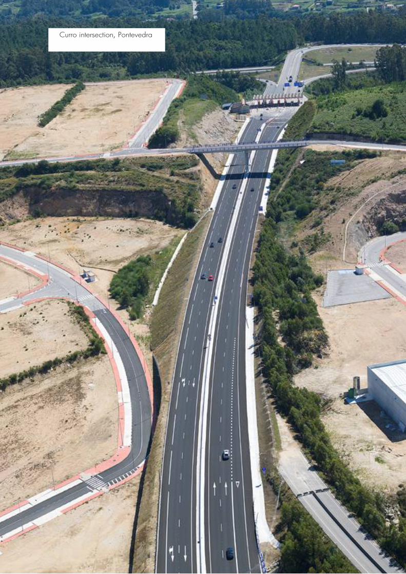
Con una longitud total de 2,12 km, la construcción de este tramo de carretera supone un ahorro de 6 km en el trayecto entre Cortegada y la frontera portuguesa, facilitándose de este modo el acercamiento entre los habitantes de ambos países. De igual forma, constituye, sin lugar a dudas, una gran ventaja para los habitantes de la comarca, tanto desde el punto de vista comercial como social e incluso turístico, ya que unas mejores comunicaciones viarias han supuesto una mayor afluencia de gentes en busca del descanso que encontrarán en los balnearios existentes en la zona.
With a total length of 2.12 km, the construction of this stretch of road reduces the distance between Cortegada and the Portuguese border by 6 km, thus bringing the inhabitants of both countries closer together. Similarly, it is undoubte-dly hugely beneficial for the inhabitants of the region, from a commercial, social and even touristic perspective, since the improved road links have resulted in a greater influx of people in search of the rest they will find in the area’s spas.
Carretera Ou-810 Cortegada – Pontebarxas. Viaducto sobre el río deva, Ourense
Ou-810 road, Cortegada – Pontebarxas. Viaduct over the river deva, Ourense

From a technical perspective, the most important feature of this work is the viaduct, with a composite structure of concrete and steel which crosses the river Deva, with three spans of 84 + 120 + 84 m and approximately 65 m above the river.
Desde el punto de vista técnico, la particularidad más importante de esta obra es el viaducto, con estructura mixta de hormigón y acero que salva el río Deva mediante tres vanos de 84 + 120 + 84 m, con una altura sobre el río de aproximadamente 65 m.
19

Client: Ministry of the Environment. general directorate of Waterworks
Cliente: Ministerio de Medio Ambiente. dirección general de Obras Hidráulicas
Carretera CA-503 de Jerez a Cortes, Cádiz
CA-503 road from Jerez to Cortes, Cádiz
20

The water supply pipeline to Algar is also being laid, using cast iron piping with a diameter of 300 mm, starting from the siphon at Rojitán and running parallel to the planned route for the road, then continuing along the route which leads to the new lift station.
También se ejecuta la conducción de abasteci-miento a Algar, con tubería de fundición de 300 mm de diámetro, que parte del sifón de Rojitán y discurre paralela al trazado de la vía proyec-tada, para continuar a lo largo del camino que conduce hasta la nueva estación elevadora.
Las obras corresponden a la variante de trazado de la carretera CA-503, la conexión con la CA-521 de acceso a Algar y la conducción de abastecimiento de agua potable a este término municipal.El trazado proyectado tiene una longitud total de 3.670 m. En dicho trazado se contempla la realización de cuatro estructuras, entre las que destaca el puente sobre el embalse de Guadalcacín con dos vanos extremo de 50 m y cinco vanos interiores de 70 m se trata de una estructura mixta acero-hormigón, siendo el tablero empujado desde un único estribo. A la salida del viaducto se construye un falso túnel en una longitud de 148 m, con objeto de eliminar el impacto paisajístico que se produciría al realizar un desmonte de tal dimensión.
These works consist of the bypass of the CA-503 road, the link to the CA-521 to Algar and the pipeline which supplies this municipality with drinking water.The planned route is a total 3,670 m in length. On this route it is planned to construct four structures, including the bridge over the Guadalcacín Reservoir with two end spans of 50 m and five inner spans of 70 m. It is a steel-concrete composite structure, with the deck being supported on a single abutment. At the end of the viaduct a 148 m-long cut-and-cover tunnel is being constructed, in order to eliminate the impact a clearing of such dimensions would have on the landscape.
21

Client: Ministry of development. Spanish Highways Agency
Cliente: Ministerio de fomento. dirección general de Carreteras
El proyecto consiste en la ejecución de las obras de una variante de la localidad de Caldas de Reis, en la provincia de Pontevedra.La longitud total de la variante es de algo más de 4 km. En el conjunto de las obras destacan dos grandes viaductos con una longitud conjunta de 1.044,50 m. El viaducto sobre el río Bermaña tiene una longitud total de 588.5 m, un total de nueve vanos y un ancho de 14,50 m, ejecutado mediante autocimbra. El viaducto sobre el río Umia tiene una longitud total de 456 m, luz máxima de 150 m y un ancho de 13,50 m, ejecutado mediante carros de voladizos sucesivos.
This project consists of constructing a bypass for the town of Caldas de Reis, in the province of Pontevedra.The bypass is just over 4 km long. From the overall works, it is worth highlighting two large viaducts which have a combined length of 1,044.50 m. The viaduct over the river Bermaña has a total length of 588.5 m, and a total of nine spans and a width of 14.50 m, constructed using a movable scaffolding system. The viaduct over the river Umia is 456 m long, with a maximum span of 150 m and a width of 13.50 m, constructed using the progressive cantilever method.
Variante de Caldas de Reis, Pontevedra
Caldas de Reis bypass, Pontevedra
22

La obra cuenta con 7 pasos superiores con una longitud total de 206 m. Seis de ellos son pórticos con pilas en V, y uno de ellos salva un vano de 24 m de luz mediante vigas doble T, apoyadas en estribos flotantes sobre muros de escollera. Cuenta, también, con cuatro pasos inferiores con una longitud total de 85 m. Son pórticos de hormigón armado.
7 flyovers have been constructed with a total length of 206 m. Six of these are portal frames with pillars in a V-shape, and one of them crosses over a span of 24 m using double-T beams, supported on floating abutments on breakwaters. Four underpasses have also been constructed, with a total length of 85 m. They are reinforced concrete portal frames.

La variante proyectada consiste en una calzada de 7 m, arcenes de 1 m de anchura y bermas de 0,50 m, y tiene una longitud total de 2,3 km. La ejecución de la variante ha supuesto también la construcción de un nuevo puente sobre el río Curueño, consistente en una estructura de vigas artesa prefabricadas en tres vanos isostáticos de 25 m de luz, con una anchura de tablero de 12 m. El resto de las estructuras la constituyen cuatro marcos prefabricados. Dos de ellos garantizan el paso de peatones, ciclistas, vehículos agrícolas y ganado entre las poblaciones, mientras que los otros dos permiten el paso de fauna, en cumplimiento de las medidas correctoras indicadas en la declaración de impacto ambiental.
El objeto de la obra es evitar la travesía de las poblaciones de Barrio de Nuestra Señora y Am-basaguas de Curueño, al norte de la provincia de Léon, mejorando así las comunicaciones entre las localidades de puente Villarente (N-601) y Boñar.
The planned bypass consists of a single 7 m carria-geway, shoulders which are 1 m wide and verges which are 0.50 m, and its total length is 2.3 km. The construction of the bypass has also made it necessary to build a new bridge over the river Curueño, consis-ting of a prefabricated structure with box girders with three 25 m statically determinate spans of 25 m, with a deck width of 12 m. The rest of the structures con-sist of four prefabricated frames. Two of these allow pedestrians, cyclists, farm vehicles and cattle to pass between the villages, while the other two allow fauna to pass, in accordance with the corrective measures stipulated in the environmental impact statement.
The purpose of this construction is to avoid passing through the villages of Barrio de Nuestra Señora and Ambasaguas de Curueño, to the north of the province of Léon, thus improving the links between the villages of Puente Villarente (N-601) and Boñar.
24

Client: Regional government of Castille and leon. Ministry of development
Cliente: Junta de Castilla y león. Consejería de fomento
Las intersecciones se resuelven mediante dos glorietas y la travesía fue dotada de una nue-va red de riego, red de pluviales y alumbrado público.
The intersections consist of two roundabouts and the crossing was equipped with a new irrigation system, drainage system and street lighting.
Variante barrio de nuestra Señora y Ambasaguas de Curueño, león
barrio de nuestra Señora and Ambasaguas de Curueño bypass, leon

El trazado está condicionado por la “Ensenada do Engano”, en la que desemboca el río Tines y en la que se proyecta un viaducto compuesto por once vanos de 41+70x9+50 m de luz, con una longitud total de 721 m. Consta de un tablero de 11 m de ancho que se resuelve con una sección cajón de canto constante de 3,20 m. La construcción se realizó mediante cimbra autolanzable de apoyo superior que permite una escasa ocupación de la ría de forma que la afección a las labores pesqueras y de marisqueo sea mínima.
El proyecto consiste en la ejecución de las obras de una variante de la localidad de A Serra de Outes, en la provincia de A Coruña. La longitud total de la variante es de 4,8 km, y cuenta con una sección tipo formada por calzada de 7 m de ancho con sendos arcenes de 1,50 m y bermas de 1 m. Además de los enlaces de inicio y fin con la carretera C-550, se proyecta un enlace a distinto nivel que dará acceso a la nueva vía desde el núcleo urbano de Cruceiro de Roo y de los núcleos rurales cercanos.
This project consists of constructing a bypass for the town of A Serra de Outes, in the province of A Coruña. The total length of the bypass is 4.8 km, and it has a typical road section comprising a carriageway with a width of 7 m, with both shoulders being 1.50 m and the verges being 1 m. In addition to the intersections at the start and end of the C-550 road, an intersection at a different level is planned to provide access to the new road from the town of Cruceiro de Roo and the nearby rural villages.
The route has been determined by the “Engano Cove”, to which the river Tines flows and on which it is planned to build a viaduct consisting of eleven spans of 41+70x9+50 m, with a total length of 721 m. It has a deck with a width of 11 m, consisting of a box section with a constant thickness of 3.20 m. It was constructed using upper-bearing movable formwork, making it possible to occupy a negligible amount of estuary-space, thus ensuring that there was little impact on fishing and shell-fishing activities.

Client: Regional government of galicia. Ministry of the Environment, land and Infrastructures
Cliente: Xunta de galicia. Consellería de Medio Ambiente, territorio e Infraestruturas
A lo largo del trazado se proyecta otro puente, sobre el río Bendimón, de estructura prefabricada, además de 4 pasos inferiores, 2 pasos superiores y un muro anclado.La obra se completa con la res-tauración paisajística del entorno, reposiciones de servicios y variantes de carreteras y caminos locales.
Variante de A Serra de Outes, A Coruña
A Serra de Outes bypass, A Coruña
Another bridge is planned on this route, over the river Bendimón, with a prefabricated structure, plus 4 un-derpasses, 2 flyovers and a retaining wall.The works will be completed with the restoration of the surrounding lands-cape, restoring services, bypasses and local roads.
27

El ancho total del tablero, de 21,50 m, aloja una calzada de 13 m, dos aceras de 2,50 m y un carril bici de 2,50 m separado de la calzada por otra acera de 1 m. Finalmente, y para dar continuidad a los servicios del futuro polígono industrial se dispusieron conducciones de abasteci-miento, saneamiento y energía eléctrica, tanto en zanja, bajo la sombra del tablero, como aéreas, colgadas del mismo en el cruce del río Ebro.
La obra objeto del contrato se encuentra ubicada en el municipio de Miranda de Ebro, en la provincia de Burgos, y consistió en la construcción de un nuevo puente sobre el río Ebro para dar acceso a Ircio Ac-tividades, polígono industrial de nueva construcción.La estructura tiene una longitud de 630 m repartidos en 18 vanos, presentando los primeros catorce y el úl-timo vanos una estructura conformada por 4 vigas ar-tesa prefabricadas y los tres vanos restantes estructura mixta resuelta mediante cuatro cajones longitudinales de canto variable de acero, que cruza el cauce del río. El esquema de luces en el viaducto es en sus catorce primeros vanos de vigas tipo artesa de 24,50 m más 13 vanos de 32 m. En su tramo mixto la estructura presenta tres vanos de 45, 75 y 45 m, respectivamente. El último vano tiene una longitud de 24,50 m.
The total deck width, of 21.50 m, consists of a 13 m carria-geway, two 2.50 m walkways, and a 2.50 m bicycle lane which is separated from the carriageway by a 1 m walkway. Finally, to ensure the continuity of services for the future industrial estate, water supply and drainage pipelines and electric power lines were installed, both in trenches, directly underneath the deck, and overhead, suspended from the bridge where it crosses the river Ebro.
The works which are the purpose of this contract are located in the town of Miranda de Ebro, in the pro-vince of Burgos, and they consisted of building a new bridge over the river Ebro to provide access to Ircio Actividades, a newly-built industrial estate.The structure is 630 m long and distributed over 18 spans, with the first fourteen spans and the final span consisting of 4 prefabricated box girders, and the three remaining spans, which cross over the waterway of the river, having a composite structure and using four steel longitudinal girders of variable thickness. The first fourteen arches of the viaduct are distributed between 24.50 m box girders and thirteen 32 m spans. The section with the composite structure has three spans, of 45, 75 and 45 m respectively. The final span is 24.50 m long.

Client: Regional government of Castille and leon. Ministry of development
Cliente: Junta de Castilla y león. Consejería de fomento
Puente sobre el río Ebro en Miranda de Ebro, burgos
bridge over the river Ebro in Miranda de Ebro, burgos
29

La carretera, de 7,4 km de longitud, discurre prác-ticamente en su totalidad a media ladera sobre el núcleo de población de Ortigueira, con desmontes de hasta 48 m y terraplenes de 35 m. Consta de tres enlaces a distinto nivel tipo diamante, cuatro pasos superiores, dos inferiores, un área de descanso y dos viaductos, uno de 105 m para salvar la glorieta de Ortigueira Norte y el otro de 330 m para salvar el río Baleo.
En concreto, este tramo mejora la accesibilidad de toda la zona norte de la provincia de A Coruña. Esta nueva vía constituye una alternativa a la vía AC-846 Ferrol – San Ciprián a su paso por el núcleo de Orti-gueira, donde la existencia de una elevada intensidad de tráfico afecta en gran medida al vial urbano, oca-sionando importantes problemas de seguridad vial.
La actuación descrita forma parte de la vía de alta capacidad de la Costa Norte, de nuevo trazado, que pretende vertebrar las comunicaciones en el norte de las provincias de A Coruña y Lugo y los núcleos de población de la costa, incluyendo las comarcas de Ferrolterra, Ortegal y Las Mariñas.
along a hillside in the town of Ortigueira, with cuts of up to 48 m and fills of 35 m. It has three diamond junctions at different levels, four flyovers and two underpasses, a rest area and two viaducts; one of 105 m to cross over the Ortigueira Norte roundabout and the other of 330 m to cross over the river Baleo.The carriageway section consists of a deck of two
entire northern area of A Coruña. This new road is an alternative to the AC-846 road between Ferrol and San Ciprián where it passes the town of Ortigueira, where high traffic density has a huge effect on the lo-cal road, causing significant problems for road safety.The road, which is 7.4 km long, runs almost entirely
The above works are part of the high capacity road of the Costa Norte, a new route intended to link together the roads in the north of the provinces of A Coruña and Lugo and the towns on the coast, including the areas of Ferrolterra, Ortegal and Las Mariñas.In short, this section improves accessibility for the

Client: Regional government of galicia. Ministry of the Environment, land and Infrastructures
Cliente: Xunta de galicia. Consellería de Medio Ambiente, territorio e Infraestruturas
En cuanto a la sección de la calzada, se trata de una plataforma de dos carriles de 3,50 m y dos arcenes de 2,50 m, existiendo asimismo carril adicional de adelantamiento en una longitud de 3,1 km.
3.50 m lanes and two 2.50 m shoulders, with an additional overtaking lane over a length of 3.1 km.
Variante de Ortigueira, A Coruña
Ortigueira bypass, A Coruña
31

Las obras definidas en el proyecto consisten en la ejecución de un enlace que dé solución a la interco-nexión de los tráficos de los tres ejes principales que confluyen en la zona de actuación: la autovía AG-41, autovía do Salnés, la futura autovía Pontevedra – Vi-lagarcía y la autopista del Atlántico AP-9. Además, a través de este enlace se resuelve la conexión con estos ejes principales tanto de los tráficos locales como de los tráficos generados por las nuevas zonas industriales desarrolladas en los terrenos colindantes. Tanto la autovía del Salnés como la futura autovía Pontevedra – Vilagarcía se diseñan con una sección tipo formada por dos calzadas con dos carriles de 3,50 m cada una, arcén exterior de 2,50 m e interior de 1 m. Se dispone además una mediana de 3 m.
The works defined for this project consist of cons-tructing an intersection to interconnect the traffic from the three main roads which converge in the area of activity: the AG-41 highway, do Salnés highway, the new Pontevedra – Vilagarcía highway and the AP-9 Atlantic motorway. Furthermore, this intersection connects these main roads with the local traffic and the traffic generated by the new industrial areas developed on the neighbouring land. Both the Salnés highway and the future Pontevedra – Vilagar-cía highway have been designed with a typical road section consisting of two carriages with two 3.50 m lanes, an outer shoulder of 2.50 m and an inner shoul-der of 1 m. They also have a 3 m central reservation.
El diseño del enlace se estructura en tres niveles principales: • En un nivel inferior se encuentra el eje Salnés, diseñado como autovía, que comunica la autovía del Salnés AG-41 con el peaje de la autopista AP-9. • En el nivel intermedio se dispone un gran intercambiador formado por un colector circular de 200 m de diámetro. Este ramal permite realizar los ocho movimientos necesarios entre los dos ejes principales.
The intersection is divided into three main levels: • On the lower level is the Salnés road, designed as a highway, which links the AG-41 Salnés highway with the toll road of the AP-9 motorway. • On the middle level there is a large interchange consisting of a circular collector road with a diameter of 200 m. This slip road makes it pos-sible to complete the eight manoeuvres which are necessary between the two main roads.
32

Client: Regional government of galicia. Ministry of the Environment, land and Infrastructures
Cliente: Xunta de galicia. Consellería de Medio Ambiente, territorio e Infraestruturas
• En un nivel superior se diseña el eje Curro – Baión. Para dar conti-nuidad a la tipología utilizada en la carretera PO-531 entre Pontevedra y Vilagarcía, la parte inicial se diseña con una sección tipo compuesta de una sola calzada con dos sentidos de circulación. Será a partir del paso sobre el intercambiador cuando la sección comenzará a cambiar hacia
• On the upper level the intersection for the Curro – Baión road has been designed. To ensure continuity of the type of road used on the PO-531 between Pontevedra and Vilagarcía, the initial part has been designed with a typical road section which consists of a single carriageway with two-directional traffic. After it passes over the interchange this section will become a highway-type road.
Enlace en Curro de las autovías a Sanxenxo y Vilagarcía de Arousa, de la autopista AP-9 y la carretera PO-531, Pontevedra
Intersection in Curro with the highways to Sanxenxo and Vilagarcía de Arousa, with the AP-9 motorway and the PO-531 road, Pontevedra

EdItIOn / EdICIón: March / marzo 2013 (En_ES 1E)
EdIt / EdItA: S.A. de Obras y Servicios, COPASA
gRAPHIC dESIgn / dISEñO gRáfICO: SAgtA
Reproduction is prohibited of all or part of this production, by any means or process, without having to do
with the prior express written permission of the owners / Queda prohibida la reproducción total o parcial
de esta publicación, por cualquier medio o procedimiento, sin para ello contar con la autorización previa,
expresa y por escrito de los titulares


![[re]imaging urban expressways](https://static.fdocuments.net/doc/165x107/568bd9e31a28ab2034a8ba1b/reimaging-urban-expressways.jpg)