Analyzing fee and free spatial data sharing policies in ... · Analyzing fee and free spatial data...
118
Analyzing fee and free spatial data sharing policies in public sector in Uganda By Uwayezu Ernest March, 2010
Transcript of Analyzing fee and free spatial data sharing policies in ... · Analyzing fee and free spatial data...

Analyzing fee and free spatial data sharing policies in
public sector in Uganda
By
Uwayezu Ernest
March, 2010


Analyzing fee and free spatial data sharing policies in public
sector in Uganda
By
Uwayezu Ernest
Thesis submitted to the International Institute for Geo-information Science and Earth Observation in
partial fulfilment of the requirements for the degree of Master of Science in Geo-information Science
and Earth Observation, Specialisation: Land administration.
Thesis Assessment Board:
Chairman: Prof. Dr. Ing. P.Y. Georgiadou
External examiner: Ir. B. van Loenen
Supervisor: Ir. W.T. de Vries
Second supervisor: Dr. G. Miscione
Member: Ir. M.C. Bronsveld
INTERNATIONAL INSTITUTE FOR GEO-INFORMATION SCIENCE AND EARTH OBSERVATION
ENSCHEDE, THE NETHERLANDS

Disclaimer
This document describes work undertaken as part of a programme of study at the International
Institute for Geo-information Science and Earth Observation. All views and opinions expressed
therein remain the sole responsibility of the author, and do not necessarily represent those of the
institute.
v
Abstract
Public organizations in Uganda have adopted different spatial data sharing policies. Recommendations
on the development of SDI in Uganda invite public organizations to harmonize spatial data sharing
policies. The study uses isomorphism theory to investigate if those organizations tend to harmonize
spatial data sharing policies. The theory is applied in public administration sciences, and used in
explaining how organizations adopt and diffuse similar behaviour when they cope with environment
influences pushing them to adopt similar practices. The study uses interpretative techniques in
analyzing data obtained from field work and existing literature on spatial data sharing in Uganda. It
assesses if spatial data sharing policies followed by public organizations in Uganda change over time
and reflect any pattern of isomorphism namely coercive, normative and mimetic.
Findings show that there are two different policies followed by public organizations in Uganda in
spatial data sharing. Some organizations follow the pricing policy and initially charge fees in sharing
spatial data with public and private organizations and individuals, while others follow free access
policy and share spatial data for free charge. Organizations which follow pricing policy face coercive
forces resulting from the regulations and requirements pushing them to charge fees in spatial data
sharing. Since 2000, those organizations have adopted new behaviour and started to share spatial data
for free with other government organizations. Change in the behaviour reflects the normative process
and relates to an increased awareness about appropriate ways for the cooperation in spatial data
sharing between government organizations. Furthermore, normative forces shape in similar way the
behaviour of organizations which have adopted free access policy. Sharing spatial data for free allows
the optimal use of spatial data for meeting organizations goals
KEYWORDS: Public organizations, spatial data sharing policy, free, fees, isomorphism theory,
Uganda

vi
Acknowledgements
I would like to thank all people who have directly or indirectly contributed to my studies at ITC and
this research work from the initial stage up to the end.
I would like to express my sincere gratitude the ITC directorate for MSc sponsorship, which made
possible my studies in Land Administration. I deserve special acknowledgement to my supervisors Ir.
Walter de Vries and Dr. Gianluca Miscione who guided me in this research, by providing invaluable
and constructive criticisms and suggestions for the achievement of my work. My sincere gratitude goes
to all ITC staffs, for sharing their experience and knowledge throughout my studies.
I would also like to express my thanks to staffs from public organizations in Uganda for spending their
time to respond to my questions trough filling survey questionnaire or interviews and having provided
me useful data and information for writing this thesis.
Finally, thanks go also to all my colleagues, especially Chinzorig Batbileg, Ganesh Prasad Bhatta,
Gertrude Sackey, Henry Makumbi, Moses Mbah Ndubu, Rathnamali Rubasinghe, Samwel Sanga,
Steve Fitka Bilshakka, Thi Minh Tam Do, and my fellow from Rwanda for their cooperation and
encouragement during my study at ITC.

vii
Table of contents
Abstract ....................................................................................................................................................v
Acknowledgements ................................................................................................................................ vi
Table of contents................................................................................................................................... vii
List of figures...........................................................................................................................................x
List of tables........................................................................................................................................... xi
List of Appendices ................................................................................................................................ xii
List of Acronyms ................................................................................................................................. xiii
1. Introduction .......................................................................................................................................1
1.1. Background of the problem .......................................................................................................1
1.2. Research problem ......................................................................................................................2
1.3. Research objectives ...................................................................................................................3
1.3.1. Main objective ...................................................................................................................3
1.3.2. Specific objectives.............................................................................................................3
1.4. Research hypotheses..................................................................................................................3
1.5. Research questions ....................................................................................................................3
1.5.1. Main research question......................................................................................................3
1.5.2. Sub-research questions ......................................................................................................3
1.6. Justification of the research.......................................................................................................4
1.7. Study area ..................................................................................................................................5
1.8. Research methodology...............................................................................................................5
1.8.1. Primary data collection......................................................................................................5
1.8.2. Literature review................................................................................................................5
1.9. Research matrix .........................................................................................................................5
1.10. Conceptual framework...........................................................................................................7
1.11. Thesis structure......................................................................................................................7
2. Public organizations cooperation in spatial data sharing ..................................................................9
2.1. Introduction ...............................................................................................................................9
2.2. Defining concept related to spatial data sharing .......................................................................9
2.2.1. Spatial data sharing relationships ....................................................................................12
2.2.2. Terms in spatial data sharing cooperation .......................................................................12
2.2.2.1. Free access versus access for fees ...............................................................................13
2.2.2.2. Sharable spatial data ....................................................................................................13
2.2.2.3. Process to access spatial data ......................................................................................14
2.2.3. Defining spatial data sharing legislation, policy and practices .......................................14
2.2.3.1. Spatial data sharing legislation....................................................................................14
2.2.3.2. Spatial data sharing policy...........................................................................................15

viii
2.2.3.3. Spatial data sharing practices ..................................................................................... 15
2.3. Spatial data sharing legislation and policy in Uganda............................................................ 15
2.3.1. Spatial data sharing legislation in Uganda...................................................................... 15
2.3.2. Spatial data sharing policy in Uganda ............................................................................ 17
2.4. Spatial data sharing practices and isomorphism..................................................................... 18
2.4.1. Definition of Isomorphism.............................................................................................. 18
2.4.1.1. Coercive processes...................................................................................................... 19
2.4.1.2. Mimetic processes ...................................................................................................... 19
2.4.1.3. Normative processes ................................................................................................... 21
2.5. Conclusion .............................................................................................................................. 25
3. Methodology of data collection...................................................................................................... 26
3.1. The case study......................................................................................................................... 26
3.2. Operationalisation of organizations behaviour in spatial data sharing in the perspective of
isomorphism theory ............................................................................................................................ 27
3.3. Primary data collection methods ............................................................................................ 29
3.3.1. Questionnaire .................................................................................................................. 29
3.3.2. Structured and unstructured interviews .......................................................................... 30
3.4. Secondary data collection ....................................................................................................... 30
3.5. Observations ........................................................................................................................... 32
3.6. Preparation of data analysis .................................................................................................... 32
3.7. Limitation of fieldwork........................................................................................................... 33
3.8. Conclusion .............................................................................................................................. 34
4. Nature of spatial data sharing in Uganda........................................................................................ 35
4.1. Introduction............................................................................................................................. 35
4.2. Spatial Datasets holding and ownership................................................................................. 35
4.2.1. Department of Survey and mapping ............................................................................... 35
4.2.2. Directorate of Water Resources Management................................................................ 36
4.2.3. National water and Sewerage Corporation ..................................................................... 37
4.2.4. Kampala Water ............................................................................................................... 37
4.2.5. Kampala City Council .................................................................................................... 37
4.2.6. Entebbe Town Council ................................................................................................... 38
4.2.7. Mukono Town Council ................................................................................................... 38
4.2.8. Mukono district/Department of Lands............................................................................ 38
4.2.9. Mukono district/ Department of Water Development .................................................... 39
4.3. Inter-organizations cooperation in spatial data sharing.......................................................... 39
4.4. Spatial data sharing partners................................................................................................... 40
4.5. Sources of budget for spatial data handling............................................................................ 43
ix
4.6. Spatial data access policy ........................................................................................................43
4.6.1. Spatial data access for free versus access for fees...........................................................43
4.6.2. Open access versus restrict access...................................................................................45
4.6.3. Format of shared spatial data...........................................................................................46
4.6.4. Spatial data sharing relationships ....................................................................................47
4.6.5. Internal coordination of spatial data sharing activities....................................................47
4.7. Trends of change in spatial data sharing policy ......................................................................48
4.8. Inter-organization consultation on spatial data sharing policy................................................51
4.9. Awareness and opinions on national spatial data sharing policy ............................................52
4.10. General observations on spatial data provision ...................................................................53
4.11. Conclusion ...........................................................................................................................54
5. Spatial data sharing policies and practices in Uganda ....................................................................56
5.1. Duality of spatial data sharing policies ...................................................................................56
5.1.1. Pricing policy...................................................................................................................56
5.1.2. Disparities in data prices .................................................................................................58
5.1.3. Free access policy............................................................................................................58
5.1.4. Conclusion on disparity in data sharing policies.............................................................58
5.2. Government legislation on information sharing and organizations practices .........................59
5.3. Discussion regarding isomorphism trends and change in spatial data sharing policies ..........62
5.3.1. Isomorphism trends in adopting similar standards in spatial data collection..................62
5.3.2. Isomorphism trends in adopting spatial data sharing policy ...........................................62
5.3.3. Isomorphism trends and changes in spatial data sharing practices .................................63
5.4. Conclusion ...............................................................................................................................66
6. Evaluation of isomorphism trends in spatial data sharing in Uganda .............................................67
6.1. Introduction .............................................................................................................................67
6.2. Isomorphic behaviourin inter-organizations data sharing practices ........................................67
6.2.1. Coercive isomorphism.....................................................................................................67
6.2.2. Normative isomorphism ..................................................................................................68
6.2.3. Summary of findings on isomorphism process................................................................70
6.3. Conclusion ...............................................................................................................................73
7. Conclusions and recommendations .................................................................................................74
7.1. Conclusions .............................................................................................................................74
7.2. Validation of research hypotheses..........................................................................................78
7.3. Recommendations....................................................................................................................79
7.3.1. For the promotion of spatial data sharing in Uganda ......................................................79
7.3.2. For further research ................................................................................................................... 79
REFERENCES ............................................................................................................................................ 80

x
List of figures
Figure 4-1: Spatial data sharing network....................................................................................42 Figure 4-2: Terms of access to organizations spatial data..........................................................44 Figure 4-3: Access and restriction to spatial data in digital format............................................45 Figure 4-4: Perception on spatial data access policy between government organizations .........51
Figure 5-1: Change in spatial data sharing practices between government organizations .........64

xi
List of tables
Table 1-1 Research matrix ...........................................................................................................6 Table 2-1: Definition of concepts ..............................................................................................10 Table 2-2: Description of spatial data sharing concepts in the context of inter-organizations data sharing relations .................................................................................................................11
Table 2-3: Legislation on access to information in Uganda ......................................................16 Table 2-4: Summary on GI policy status in Uganda ..................................................................17 Table 2-5: Summary on isomorphism processes .......................................................................21 Table 2-6: Summary on institutional theory and isomorphism processes from existing literature....................................................................................................................................................22 Table 2-7: Assumptions on isomorphism behaviour in spatial data sharing .............................24 Table 3-1: Distribution of visited organizations ........................................................................27 Table 3-2: Spatial data sharing practices and isomorphism trends............................................28 Table 3-3: Sources of secondary data ........................................................................................31
Table 4-1: Reported beginning of spatial data sharing with other organizations .....................40 Table 4-2: Partners in data sharing ............................................................................................41 Table 4-3: Context of GI activities and sources for budget .......................................................43 Table 4-4: Price for analogue spatial data.................................................................................44 Table 4-5: Price for digital spatial data......................................................................................44 Table 4-6: Format of shared spatial data products according to organization policy and spatial data collection techniques ..........................................................................................................46 Table 4-7: Spatial data sharing relations....................................................................................47
Table 4-8: Officer coordinating information sharing.................................................................48 Table 4-9: Perception on level of individual decision on data provision...................................48 Table 4-10: Frequencies of responses about change in spatial data sharing policy..................49 Table 4-11: Comparison between spatial data sharing policy and practices after 2000 ............50 Table 4-12: Opinions on inter-organization agreement on spatial data sharing policy .............51 Table 4-13: Frequency of responses on organization’s decision to spatial data policy and GI activities .....................................................................................................................................52 Table 4-14: Perception about environment influence on organization decision on spatial data access policy ..............................................................................................................................53
Table 5-1: Drivers for adopting a pricing policy........................................................................57 Table 5-2: Government directives on access to information and organizations practices .........60 Table 5-3: Changes and convergence in behaviour of organizations in spatial data sharing practices .....................................................................................................................................65 Table 6-1: Patterns of normative isomorphism in spatial data sharing in Uganda ....................68 Table 6-2: Patterns of isomorphism in spatial data sharing policies in Uganda ........................71

xii
List of Appendices
Appendix 1: Location of the study area ....................................................................................84 Appendix 2: Survey questionnaire .............................................................................................85 Appendix 3: List of respondent ..................................................................................................88 Appendix 4: Airborne geophysical digital data dissemination policy........................................91 Appendix 5: Cooperation agreement between the Uganda Meteorological Department (UMD) and Water Resources Monitoring and Assessment Department (WRMAD).............................95 Appendix 6: Types of spatial data collected by each organization and spatial data acquired from other organizations ............................................................................................................99
Appendix 7: Data and information generated from WRMAD and prices................................101 Appendix 8: Prices for spatial data provided by Survey and Mapping Department ................102 Appendix 9: A GIS technician at DWRM prints a map for a customer...................................103 Appendix 10: DECREE ON SPATIAL DATA INFRASTRUCTURE ...................................104

xiii
List of Acronyms
DWD Directorate of Water Development
DWRM Directorate of Water Resources Management
EIS Environnent Information Network
GI Geographic Information
GIS Geographic Information System
GSDI Global Spatial Data Infrastructure
IGN-France Institut Géographique National de France
KCC Kampala City Council
KW Kampala Water
LD Lands Department
MEMD Ministry of Energy and Mineral Development
MLHUD Ministry of Lands, Housing and Urban Development
MoU Memorandum of Understanding
NARO National Agricultural Research Organization
NEMA National Environment Management Authority
NFA National Forest Authority
NSDI National Spatial Data Infrastructure
NWSC National Water and Sewerage Corporation
RCMRD Regional Centre for Mapping of Resources for Development
resp.12 respondent number 12
SDI Spatial Data Infrastructure
SMP Survey and Mapping Department
TC Town Council
UBOS Uganda Bureau Of Statistics
UMD Uganda meteorological department
UNICEF United Nations Children's Emergency Fund
UShs Uganda Shillings
WDD Water Development Department
WRMAD Water Resources Monitoring and Assessment Department


ANALYZING BEHAVIOUROF PUBLIC ORGANIZATIONS IN SPATIAL DATA SHARING IN UGANDA
1
1. Introduction
Spatial data are collected at an expensive cost and their values come from their optimal use (Onsrud and
Rushton 1995). The increased awareness about the cost of spatial data has lead to formulation of
strategies avoiding duplication in spatial data collection and providing mechanisms allowing different
producers and users to share those resources. Omran and van Etten (2007) define spatial data sharing as
transactions in which individuals, organizations or parts of organizations obtain access from other
individuals, organizations or parts of organizations to spatial data. Spatial data sharing arrangements may
or may not include payment (Omran and van Etten 2007). Those two alternative options induce spatial
data produsers to develop different spatial data provision approaches, some including pricing condition
while others share spatial data without that condition (van Loenen 2009). According to institutional
theories, within any organizational fields, organizations adopt different practices and procedures in their
early stages of development when there are no institutional norms pushing for homogenization of their
practices. Organizational fields are defined as those organizations that, in the aggregate, constitute a
recognized area of institutional life: key suppliers, producers, regulatory agencies, and other
organizations that produce similar services or products (DiMaggio and Powell 1983; Powell and
DiMaggio 1991). Within the field of spatial data industry, different practices may be observed when
some organizations pose payment conditions on spatial data access whereas others do not. However, over
time the practices that are initially different may become similar by adoption of and compliance to norms
that are socially deemed to be legitimate (Powell and DiMaggio 1991; Dacin 1997; Gosain 2004).
This research focuses on spatial data sharing from the angle of isomorphism theory, to analyse the
dynamic aspects of spatial data sharing policies in public organizations in Uganda. The literature on
spatial data sharing in Uganda, states that due to lack of formal coordination of inter-organizations
cooperation, public organizations have individually and differently developed spatial data sharing
policies and practices (Karatunga 2002; Musinguzi 2004; Chaminama 2009). The study draws on
isomorphism theory to examine if there is a tendency for homogenizing spatial data sharing policies or
practices and tries to find out what could be its main drivers.
1.1. Background of the problem
In Uganda there is a governmental awareness to foster the development of a Spatial Data Infrastructure
in order to solve the problems related to spatial data availability, access and sharing, duplicity in spatial
data collection, and diverse spatial data standards (Karatunga 2002). In the process of implementation of
SDI, some organizations have come up with their own practices and different approaches in provision
and exchange of spatial data.
Previous studies have pointed out that spatial data sharing has been initiated through different
arrangements and different forms of spatial data exchange between public organizations exist.
Organizations like Survey and Mapping Department (SMD) include payment conditions in spatial data
provision, while others, the National Environment Management Authority (NEMA), National Forest

ANALYZING BEHAVIOUROF PUBLIC ORGANIZATIONS IN SPATIAL DATA SHARING IN UGANDA
2
Authority (NFA), Uganda Bureau of Statistics (UBOS), and Ministry of Local Government (MLG) do
not include pricing in data provision and share spatial data for free (Nasirumbi 2006; Nyemera 2008;
Chaminama 2009). Other studies mentioned that there are few formalized institutional structures to share
spatial data and every organization has its own way of delivering spatial data (Karatunga 2002).
However, different spatial data producers and users are invited to align their spatial data sharing
practices to policies related to the development of SDI and to solve the institutional disparities observed
in spatial data sharing in East African countries (GSDI 2007). Previous studies do not explain if there is
an actual tendency for those organizations to increasingly cooperate in harmonized way. Therefore this
research refers to the isomorphism theory lens in examining the extent to which those organizations
harmonize spatial data sharing policies.
1.2. Research problem
SDI and spatial data sharing policies prescribe harmonization of access to governmental spatial data. In
European countries for instance, INSPIRE directives propose access and use of spatial data in
harmonized ways (European Commission 2007). In the United States, the policy on National Spatial
Data Infrastructure (NSDI) recommends harmonized free access to spatial data held by government
agencies (Maitra 1998). In Australia, SDI policy suggests a common provision of fundamental spatial
data free of charge, over internet or with a marginal cost of transfer if spatial data are distributed as
packaged product (Interdepartmental Committee on Spatial Data Access and Pricing 2001). In East
African countries, spatial data users’ community recommends harmonization of spatial data sharing
practices and conformity to SDI policies (GSDI 2007).
In Uganda, where spatial data sharing arrangements have been initiated individually in the public sector,
and with regard to theses few aforementioned cases narrating what spatial data sharing policies
recommend, it is not known whether those arrangements tend to be harmonized. Terms on spatial data
access are different because spatial data sharing practices have been developed out of the control of the
mandates that ought to coordinate spatial data sharing cooperation between public organizations in
Uganda (Musinguzi 2004). However, the decree on the development of SDI in Uganda recommends the
adoption of common policies on spatial data access (Nyemera 2008). There is a need for an investigation
aiming to explain how spatial data sharing policies were adopted and examine if spatial data sharing
policies or practices are converging to homogeneity. Such investigation can help in understanding if
public organizations solve the institutional disparities existing in spatial data provision observed in
Uganda (GSDI 2007; Nyemera 2008; Chaminama 2009). With regard to antecedents that influence
public organizations to decide on spatial data sharing policy, this research seeks to examine whether
spatial data sharing practices are harmonized and thereby converge to similarity. The factors that may
push public organizations in Uganda to homogenize their practices in spatial data sharing will be
analyzed to assess whether those organizations propagate isomorphism behaviour.

ANALYZING BEHAVIOUROF PUBLIC ORGANIZATIONS IN SPATIAL DATA SHARING IN UGANDA
3
1.3. Research objectives
1.3.1. Main objective
The main objective of the research is to examine if spatial data sharing policies in public sector in
Uganda change over time and if they reflect a certain pattern of isomorphism.
1.3.2. Specific objectives
- To determine the nature of spatial data sharing policies adopted by public organizations in Uganda
and the factors influencing their choice.
- To investigate if spatial data sharing policies are initially different and if they converge to look alike
over time.
- To interpret if the changes in spatial data sharing policies relate to any isomorphism process namely
coercive, normative and mimetic.
1.4. Research hypotheses
The research tends to test the following hypotheses in finding the answers to abovementioned research
objectives:
- Spatial data sharing policies, initiated individually by public organizations in Uganda, tend to look
similar over time by compliance to the national spatial data sharing directives.
- Professional communities of staff interested in SDI development are the cause for changes in spatial
data provision as normative pressures affect organizations practices.
- Public organizations in Uganda adopt over time similar approaches in cooperation for spatial data
provision by imitation of each other practices.
1.5. Research questions
The research intends to answer the following research questions:
1.5.1. Main research question
- How do spatial data sharing policies adopted by public organizations in Uganda reflect isomorphism
trends?
1.5.2. Sub-research questions
- What is spatial data sharing legislation in Uganda?
- What are spatial data sharing policies followed by public organizations in Uganda?
- Do spatial data sharing policies change and tend to look similar over time?

ANALYZING BEHAVIOUROF PUBLIC ORGANIZATIONS IN SPATIAL DATA SHARING IN UGANDA
4
- Do organizations show any isomorphic behaviour in adopting spatial data sharing policy?
- Do organizations behaviour in data sharing policies relate to any isomorphism process like coercive,
normative or mimetic?
1.6. Justification of the research
Previous studies about geo-information management in Uganda underlined the need for harmonization in
spatial data sharing policies because the disparities observed among spatial data sharing practices limit
both the cooperation between public organizations and access to public information. This study refers to
isomorphism theory to investigate if those organizations show any behaviour vis-à-vis the recommended
harmonization of spatial data sharing policies. The theory is applied in public administration sciences,
and used in explaining organizational change, behaviour and inter-organisational relationships when they
cope with uncertainty or constraints existing within their environment. It is also used to explain how,
through cooperation, organizations conform to procedures and legitimate rules and thereby become
similar (DiMaggio and Powell 1983; Powell and DiMaggio 1991; Renshler 2007).
The aspects of organizational behaviour in spatial data sharing need to be more addressed because “the
technical issues of spatial data sharing are well studied and largely resolved, but institutional and
individual behaviour aspects are less well studied and require more attention” (Harvey and Tulloch
2006). There is a need for a research aiming at explaining the nature of current spatial data sharing
practices between different public organizations in Uganda because those practices are questionable and
not clearly elucidated. In Uganda, there are no established inter-organisational collaboration frameworks
in spatial data sharing and there are no uniform conditions on spatial data access and provision
(Musinguzi 2004).
This study is a continuation of on-going research; like “Analysis of public sector cooperation and
geoinformation sharing: a resource dependence perspective (Chaminama 2009), “Towards strategy of
spatial data infrastructure development with focus on the private sector involvement: a case study in
Uganda” (Nasirumbi 2006); in the field of geo-information management and public administration which
seeks to investigate the dynamic aspects of spatial data sharing practices in Uganda. Understanding of
the inter-organizational relations in spatial data sharing can contribute in evaluating the extent to which
such relations promote or obstruct the dissemination of geoinformation. The results of the research will
be of general interest in the field of geoinformation management. At national level, they will give the
picture of current practices in spatial data sharing, which are considered among the ingredients for the
development and success of SDI when those practices are in line with SDI policies. In this context, it is
argued that cooperation and partnerships between government organizations are among factors for the
development of SDI (Nebert 2004). If the study finds out that spatial data sharing policies create
uncertainty on spatial data access, it will reveal the challenges that decision makers should deal with in
line with the dissemination of public information.

ANALYZING BEHAVIOUROF PUBLIC ORGANIZATIONS IN SPATIAL DATA SHARING IN UGANDA
5
1.7. Study area
The study area for this research is Uganda. Primary data and secondary data for the research were
collected in public organizations distributed in the three zones: Kampala city, Entebbe city and Mukono
town (appendix 1).
1.8. Research methodology
1.8.1. Primary data collection
Primary data about spatial data sharing policies and practices between public organisations in Uganda
were collected through interviews, surveys by questionnaires, and direct observations. The interviews
and surveys by questionnaires were addressed to the staff of organisations that are located in study areas
and operate in the different sectors, namely public administration, land registration and management,
water resources management and utilities. The staffs to whom the survey questionnaire and interview
were administrated are the managers, heads of the departments, GIS specialists and technicians.
The interviews were based on structured and open-ended questions and unstructured questions to enable
respondents to narrate spatial data sharing policies and practices in their respective organizations. There
was also passive observation in organizations offices like GIS laboratories to observe how people
process the request related to spatial data sharing.
1.8.2. Literature review
Books, scientific articles and conference papers served to review the literature related to spatial data
sharing worldwide, cooperation of public organisations in Uganda in spatial data sharing, public
administration structure in Uganda and the theory of isomorphism with focus on drivers of change in
organizational practices. The literature also helped in interpretation of data that were collected about the
cooperation of public organizations in Uganda and to examine if they show any trend of isomorphism.
The literature review focused on themes that are detailed in the research matrix below.
1.9. Research matrix
The table below shows the research matrix which indicates how the research was operationalised. It
contains the type of required data, data source, methods for data collection and analysis in relation with
the research questions and objectives.

ANALYZING BEHAVIOUROF PUBLIC ORGANIZATIONS IN SPATIAL DATA SHARING IN UGANDA
6
Table 1-1 Research matrix
Research
objective
Research question Methods and data sources Expected data
1. To determine
the nature of spatial data sharing policies
adopted by public organizations in Uganda and the factors
influencing their choice
1. What is spatial
data sharing legislation in Uganda?
2. What are spatial data sharing policies adopted by public organizations in
Uganda?
- Review of the literature about
spatial data sharing policies in general context. - Review of the literature about
spatial data sharing in Uganda - Interviews, survey by questionnaire, and observations
- Review on spatial data sharing
legislation, policies and practices - Description of cooperation in spatial data sharing in the public
sector in Uganda - Types of spatial data sharing policies that are followed by public organizations in Uganda: similarities
and difference in spatial data provision approaches, formal and informal spatial data sharing relations, motivations to adopt any
spatial data provision approaches. 2. To investigate if spatial data sharing policies are initially
different and if they converge to look alike over
time.
3. Do spatial data sharing policies change and tend to look similar over
time? 4. Do organizations show any isomorphic
behaviour in adopting spatial data sharing policies?
- Review of documents related to spatial data sharing that are available in public organizations in Uganda - Interviews, survey by questionnaire - Review of literature on isomorphism theory and drivers of change in organizations practices
- Spatial data sharing practices at different dates: spatial data provision approaches, conditions placed on spatial data access and provision,
partners in spatial data sharing, - Influential factor on spatial data provision approaches like law,
directives on spatial data sharing.
3.To interpret if
the changes in spatial data sharing policies relate to any
isomorphism process namely coercive,
normative and mimetic
5. Do organizations
behaviour in spatial data sharing policies relate to any isomorphism process
like coercive, normative or mimetic?
- Compilation and clustering of
collected data - A comparative analysis of spatial data sharing practices in the past to those in the present. - Qualitative and interpretative data analysis: comparison of spatial data sharing practices -Interpreting factors of change in spatial data sharing practices with regards to different forces leading to isomorphism. - Validation of hypotheses on basis of results from data analysis
- A table grouping organizations
according to spatial data sharing practices. - Description of the current spatial data sharing practices when compared
to the past based on the feedback on questions 3 and 4. - List of organizations for which
spatial data sharing is similar and those for which practices are dissimilar - A text explaining factors of change
in spatial data sharing practices in Uganda and correlation of those factors with isomorphism forces. - Presentation of research findings:
explaining changes in spatial data sharing practices, conclusion and recommendations

ANALYZING BEHAVIOUROF PUBLIC ORGANIZATIONS IN SPATIAL DATA SHARING IN UGANDA
7
The study uses qualitative and quantitative research methods to explore the nature and trends of spatial
data sharing policies in public sector in Uganda. The unit of analysis is organizations behaviour in
decision making on spatial data sharing policies. Quantitative methods help to collect numerical data
about the organisations that at any time in their institutional life show similar behaviour so that they
share spatial data according to similar policy. Qualitative methods allow to collect data that help to
explain how and why organization adopt such policy in spatial data sharing, so that the reasons for
adopting any spatial data sharing policy can be explained. The combination of qualitative and
quantitative data help to determine how many organisations adopt similar spatial data sharing policy or
how many have over time aligned spatial data sharing policy to others and for which reasons.
1.10. Conceptual framework
The study addresses the dynamic aspects of spatial data sharing policies and trends. It investigates if
there are factors pushing organizations to adopt any type of spatial data sharing policy and addresses
individual behaviour in explaining if over time those organizations tend to harmonize the spatial data
sharing policies. Individual’s behaviour means influence of persons (actors) on organizations decisions
and reflects organizational behaviour in the adoption of any spatial data sharing approaches (Omran
2007). The research examines if organizations tend to harmonize spatial data sharing policies and if the
factors of harmonization relate to any of the mechanisms that propagate isomorphism, namely coercive,
mimetic or normative processes.
1.11. Thesis structure
Chap.1. Introduction
The chapter provides an overview of the research, the background of the study, research problem,
objectives, research questions and the methodology that is used.
Chap.2. Public organizations cooperation in spatial data sharing
The chapter makes an overview of the concept of spatial data sharing legislation, policies; forms spatial
data sharing relationships, and terms of spatial data sharing practices. It also explains the theory of
isomorphism which is central point for this research
Chap.3. Methodology of data collection
The chapter explains the methodology that is used in data collection and how isomorphism theory was
operationalized in survey and interview questionnaire.
ANALYZING BEHAVIOUROF PUBLIC ORGANIZATIONS IN SPATIAL DATA SHARING IN UGANDA
8
Chap.4. Nature of spatial data sharing in Uganda
The chapter gives an overview of spatial data sharing policies and practices in public organizations in
Uganda: types and format of sharable spatial data, conditions placed on access to spatial data, beginning
of spatial data sharing, and antecedents guiding policies adoption in relation with sharing spatial data for
fee or for free. The results of fieldwork are presented in this chapter to show the degree of similarities or
dissimilarities observed between organizations that constitute the unity of analysis for the research.
Chap.5. Spatial data sharing policies and practices in Uganda
The chapter analyses the results presented in chapter 4 to find out if spatial data sharing practices
between public organizations reflect any isomorphism process.
Chap.6. Evaluation of isomorphism trends in spatial data sharing in Uganda
The chapter presents findings from the interpretation of results in chapter 5. A correlation between these
findings and the forces that push organizations to behave similar in order to make conclusion on trends
of isomorphism in spatial data sharing between public organizations in Uganda.
Chap.7. Conclusions and recommendations
The chapter presents general conclusion on research findings, summary of answers to research questions
and recommendations for further research.

ANALYZING BEHAVIOUROF PUBLIC ORGANIZATIONS IN SPATIAL DATA SHARING IN UGANDA
9
2. Public organizations cooperation in spatial data sharing
2.1. Introduction
This chapter makes an overview of the concepts related to spatial data sharing and isomorphism process.
It is structured as follow: Firstly, it provides the definitions of spatial data sharing and other related
concepts, and discusses the forms of spatial data sharing relations and terms placed on spatial data
access. Secondly, it provides the definitions of spatial data sharing legislation and policies, and presents
an overview of spatial data sharing policy in Uganda. Finally, the chapter presents general review of
isomorphism theory which constitutes the lens of the study in the perspective of understanding how
organizations change in their behaviour and look alike.
The chapter aims at answering the following sub-research question:
- What is the spatial data sharing legislation in Uganda?
2.2. Defining concept related to spatial data sharing
This section compiles (table 2-1) the definitions of the concepts related to spatial data, spatial data
sharing and other related concepts like spatial data transaction, and spatial data access which are used in
this thesis. These definitions are provided to narrow the domain of the study. They are compiled from the
existing literature on spatial data sharing mainly: (de Omran 2007), (Harvey and Tulloch 2006), (Tulloch
and Harvey 2005), (Montalvo 2003), and (Onsrud 1995).

ANALYZING BEHAVIOUROF PUBLIC ORGANIZATIONS IN SPATIAL DATA SHARING IN UGANDA
10
Table 2-1: Definition of concepts
Concept Definition
Spatial data Spatial data is the data that relates to the geographic location of features and their boundaries on
earth, such as natural or man-made features. It describes both the location of a geographic
feature and its attributes. Geodata or geospatial data is also a term that is used to denote spatial
data, and means data relating to a set of physical locations which may be area, line or point, that
is referenced to the earth’s surface.
Geographic
information
Geographic information is information that derives from spatial data and is used
interchangeably with spatial data.
Spatial data
sharing
The act of the making available and distributing the same spatial data for and to other users
without any alteration of original spatial data held by the producer.
Spatial data sharing is defined as the (normally) electronic transfer of spatial data between two
or more organizational units where there is independence between the holder of the spatial data
and the prospective user. The participants may be separate organizations or may be
departments within the same organization (Tulloch and Harvey 2005).
Spatial Data sharing, when it occurs, is most often merely a means to pass geographic
information to another agency (Harvey and Tulloch 2006).
Spatial data sharing is the process of providing spatial data to, or accessing spatial data from
someone or someplace outside one’s organizational unit. It means the transactions relationships
in which access to the spatial data is enabled under certain terms and conditions (de Montalvo
2003; Omran 2007).
Spatial data
transaction
Spatial data transaction is a process of spatial data sharing between spatial data supplier and
spatial data recipient, in which spatial data supplier receives something in return from spatial
data recipient. Spatial data are accessed under certain conditions, like payment or barter.
Organization B negotiates with organization A for access to its spatial data.
Spatial data
access
Organization B obtains spatial data from organization A. Spatial data are obtained at
organizational level through traditional methods of data transfer as copy or through modern
technology on website or by connecting to spatial database.
Spatial data transaction and spatial data access which are instances of spatial data sharing are as well
described, following the existing literature. Table 2-2 conceptualizes those concepts in the context of
inter-organizations cooperation: their occurrence, their impacts on organizations relations, and
observable facts resulting from the cooperation.

AN
ALY
ZIN
G B
EH
AV
IOU
RO
F P
UB
LIC
OR
GA
NIZ
AT
ION
S IN
SP
AT
IAL
DA
TA
SH
AR
ING
IN
UG
AN
DA
11
Ta
ble
2-2
: D
escr
ipti
on
of
spati
al
da
ta s
hari
ng c
on
cep
ts i
n t
he
con
text
of
inte
r-org
an
izati
on
s d
ata
sh
ari
ng r
elati
on
s
C
hara
cte
rist
ics
an
d e
ffec
ts
Con
cep
t
Occ
urr
en
ce
Imp
lica
tion
on
in
ter-
organ
izati
on
rel
ati
on
s
Ob
serv
ab
le p
ract
ices
an
d f
act
s
Sp
atia
l d
ata
shar
ing
Per
man
ent
Irre
gula
r: o
n d
eman
d
- E
xis
ten
ce
of
spat
ial
dat
a sh
arin
g
rela
tio
nsh
ips
bet
wee
n
ind
ivid
ual
s,
org
aniz
atio
ns,
or
bet
wee
n o
rgan
izat
ion
s an
d i
nd
ivid
ual
s
-Vo
lun
tary
or
involu
nta
ry p
artn
ersh
ips
bet
wee
n o
rgan
izat
ion
s
- S
pat
ial
dat
a ar
e sh
ared
wit
hin
the
fram
ewo
rk o
f an
in
ter-
org
aniz
atio
nal
all
ian
ce
- C
oo
per
atio
n i
n s
pat
ial
dat
a co
llec
tion
an
d d
evel
op
men
t o
f co
mm
on
dat
abas
e
- C
oll
abo
rati
on m
ay b
e re
gula
ted
by c
om
mo
n r
ule
s, a
do
pte
d t
hro
ugh
co
mm
on
co
nse
nsu
s or
pro
po
sed a
nd
en
forc
ed b
y a
reg
ula
tory
bod
ies
-Inte
r-o
rgan
izat
ion c
oo
per
atio
n m
ay r
esu
lt i
n i
nte
r-dep
end
ence
: o
rgan
izat
ions
may
bec
om
e
oft
en
vuln
erab
le
to
mo
re
po
wer
ful
org
aniz
atio
ns
in
a h
iera
rch
ical
sy
stem
, an
d
then
coll
abo
rati
on
may
res
ult
in
th
e lo
ss o
f au
tono
my a
nd
, co
nse
qu
entl
y, d
om
inat
ion
an
d p
ow
er
over
ano
ther
on
sp
atia
l d
ata
use
or
redis
trib
uti
on
- D
epen
den
ce o
r in
ter-
dep
end
ence
on
eac
h o
ther
or
ano
ther
GI
acti
vit
ies.
- H
arm
on
izat
ion
of
spat
ial
dat
a st
and
ard
s.
- U
se o
f sp
atia
l d
ata
by o
ther
use
rs a
s w
ell
as t
he
pro
duce
rs
- S
pat
ial
dat
a tr
ansf
er b
etw
een
org
aniz
atio
ns
unit
s an
d
acro
ss o
rgan
izat
ion
s, o
r o
nli
ne
acce
ss
- S
pat
ial
dat
a re
du
ndan
cy,
use
of
dat
aset
s b
y d
iffe
ren
t
use
rs
- S
pat
ial
dat
a pro
vid
er a
nd
sp
atia
l dat
a re
cipie
nt
- F
orm
al o
r in
form
al s
pat
ial
dat
a sh
arin
g r
elat
ion
s
- L
egis
lati
on
, ac
ts, ru
les
and p
oli
cy f
or
man
agem
ent
of
spat
ial
dat
a sh
arin
g r
elat
ion
- N
etw
ork
of
spat
ial
dat
a u
sers
- C
oo
rdin
atin
g b
od
y f
or
spat
ial
dat
a co
llec
tio
n,
and
dis
sem
inat
ion.
Sp
atia
l d
ata
tran
sact
ion
- R
egu
lar:
on
sch
edu
le a
s
per
iod
ic p
urc
has
e o
r su
pp
ly
of
spat
ial
dat
a
- F
req
uen
t an
d i
rreg
ula
r:
wh
en n
eed
ed
- E
con
om
ical
ly b
ased
sp
atia
l d
ata
shar
ing r
elat
ion
s
- F
orm
al o
r in
form
al s
pat
ial
dat
a sh
arin
g c
on
trac
t
- P
rofi
t -m
akin
g v
entu
re
- N
ego
tiat
ion
bet
wee
n s
pat
ial
dat
a p
rod
uce
r an
d u
sers
-Ter
ms
on
sp
atia
l d
ata
acce
ss:
fees
or
exch
ange
- A
gre
emen
t o
n s
pat
ial
dat
a ac
cess
- P
rice
s li
st f
or
spat
ial
dat
a
- A
uth
ori
zed
spat
ial
dat
a ac
cess
- S
pat
ial
dat
a su
pp
lier
an
d b
uyer
Sp
atia
l d
ata
acce
ss
Reg
ula
r: o
n s
ched
ule
Irre
gu
lar:
on d
eman
d
- F
orm
al o
r in
form
al r
elat
ion
s
- V
olu
nta
ry,
inci
den
tal
and
ad
ho
c re
lati
on
s
- C
op
y a
nd
acq
uis
itio
n o
f sp
atia
l d
ata
fro
m p
rodu
cer
- O
pen
acc
ess
to s
pat
ial
dat
a in
bo
th a
nal
ogu
e an
d d
igit
al
form
at,
- R
estr
icte
d a
cces
s t
o a
ny o
f b
oth
sp
atia
l d
ata
form
ats,
- F
orm
al o
r in
form
al s
pat
ial
dat
a ac
cess
po
lici
es

ANALYZING BEHAVIOUROF PUBLIC ORGANIZATIONS IN SPATIAL DATA SHARING IN UGANDA
12
2.2.1. Spatial data sharing relationships
Sharing of spatial data presupposes the existence of the relationships among individuals, organizations
and/or governmental units (Onsrud 1995). These relationships can occur in formal or informal ways
depending on the procedures that are followed in the process of spatial data sharing (Nedovic -Budic ,
Pinto et al. 2004), and in practice, informal sharing is more predominant than formalized spatial data
sharing (Harvey and Tulloch 2006).
Informal relationships result from individual relationships between staffs from different organizations
and have been regarded as the predominant mechanisms to share spatial data and information across
organizations boundaries (Giordano, Béchamps et al. 1998; Harvey and Tulloch 2006). Spatial data are
shared on basis of individual contacts (Tulloch and Harvey 2005).
Formal relationships are established through formal documentation, like inter-organisations agreements,
memoranda of understanding, and data licenses, written rules, procedures, and policies for database
sharing with regard to standards, development, maintenance, ownership, and use (Giordano, Béchamps et
al. 1998; Nedovic-Budic, Pinto et al. 2004). The most common documents that are used to formalize
interorganizational GIS activities are memoranda of understanding and intergovernmental agreements
(Nedovic-Budic and Pinto 1999). Formal relations are greatly appreciated since they regulate spatial data
sharing relationships and foster interorganizational cooperation for the development of geoinformation
activities as they can be based on the contributions of the specific organizations to the joint GIS database
development or spatial data exchange activities (Nedovic-Budic, Pinto et al. 2004). These relations occur
only at the final stages of establishing sharing or cooperation agreements. They manifest administrative
procedures and/or legal requirements and rules regulating inter-organizations spatial data sharing
relationships (Harvey and Tulloch 2003). The successful spatial data sharing relations combine formal
and informal relationships which facilitate the largest distribution of spatial data.
2.2.2. Terms in spatial data sharing cooperation
Spatial data sharing take place in variety of forms and under a range of different terms guiding access to
spatial data. The terms include among other data format that vary from paper maps to tabular
information, as well as digital spatial data (Onsrud and Rushton 1995), the amount of dataset or number
of GIS layer that can be provided to users, the users who can access spatial data: individual users, public
or private organizations, financial conditions under which spatial data are released, that may or may
include barter, financial payment, payment in kind or no payment (de Montalvo 2003; Omran 2007). The
frequent terms guiding in spatial data sharing cooperation, are free access versus access for fees, sharable
spatial data, and process to access spatial data.

ANALYZING BEHAVIOUROF PUBLIC ORGANIZATIONS IN SPATIAL DATA SHARING IN UGANDA
13
2.2.2.1. Free access versus access for fees
There are financial requirements, involving the payment or no payment of fees to access spatial data.
This result in observing two approaches on spatial data access: free access and access for fees.
Free access approach assumes spatial data is available for all users, at a price not exceeding the cost of
reproduction and distribution, with as few restrictions to use as possible (van Loenen 2006; van Loenen
2009) or on a non-discriminatory basis. Accepted restrictions include information concerning national
security, trade secrets, and information relating to an individual’s privacy (van Loenen 2009). Public and
private organizations have access to geoinformation on equal terms, at the cost of dissemination or cost
of reproduction like the cost of printing a map or preparation and printing a map; license fees, a marginal
cost of spatial data or merely for free without any payment for data reproduction (de Montalvo
2003).The primary meaning of sharing is that spatial data are freely provided for no return (Omran
2007).
Access for fees approach makes profits from the sale of spatial data to support the development and
maintenance of datasets. The cost of collection, maintenance and dissemination of geoinformation is
covered through the sale of spatial data or information (de Montalvo 2003). The price of geoinformation
dissemination may also include a return on investment (van Loenen 2009).
This approach relies on the principles which provide that organizations have to generate income from the
collection, creation and maintenance of the spatial datasets. Compared to free access approach, the
access for fees approach implies that spatial data are shared at a higher price than the cost of their
reproduction and dissemination. There may be also use restrictions which are often imposed through
contracts and licenses. This approach may also be associated with the competition behaviourbetween
spatial data producers, being public or private organizations towards the provision of geographic
information to users (Onsrud and Rushton 1995; de Montalvo 2003) and spatial data is visible
commodity that can be distributed, bought, and sold (Sieber 2007).
2.2.2.2. Sharable spatial data
The users of spatial data can access it in different ways and different formats. They can have access to
a part of database like a file of the database or a dataset or a copy of the whole database in vector and
or raster format. They can have access to spatial data in hard copy of data, like a printed map or the
map in soft copy. Spatial data users can also access a copy of all available spatial data in any format,
like a map, vector and or raster data. In this case, there is no restriction about the format of data that be
provided (Onsrud and Rushton 1995; de Montalvo 2003).

ANALYZING BEHAVIOUROF PUBLIC ORGANIZATIONS IN SPATIAL DATA SHARING IN UGANDA
14
2.2.2.3. Process to access spatial data
There are different processes for access to spatial data, following the nature of cooperation between
spatial data provider and spatial data users. Spatial data can be accessed and provided by subscription,
upon a request, or following the terms prescribed in a memorandum of understating on spatial data
sharing. Under subscription mode, spatial data can be accessed upon an authorized subscription: the
users can download spatial data from the database of producers. Spatial data can also be accessed on
request, and the most used process is a written request or personal contact to spatial data provider
when the need arises. In this case there is an officer who receives the request and authorizes the
provision of data. In the case of memorandum on spatial data sharing, partners agree to exchange
spatial data periodically, on regular update of each other database. In other cases, spatial data are
provided to users on a regular period, on basis of data provision contract (Onsrud and Rushton 1995;
de Montalvo 2003)
2.2.3. Defining spatial data sharing legislation, policy and practices
This section provides the definitions of the concepts of spatial data sharing legislations, policies and
practices, used in this study. Theses definitions are compiled from different sources like (Nancy 1995;
Onsrud 1995; de Montalvo 2003; Harvey and Tulloch 2003; Harvey and Tulloch 2006) and the Oxford
English Dictionary Online (2005).
2.2.3.1. Spatial data sharing legislation
Spatial data sharing legislation is law which was promulgated or enacted by a legislature or a
government body. It comprises of a set of institutions that are enforced and shape the behaviour of
organizations and people, within the country, in spatial data sharing relations. It is established to
regulate and facilitate spatial data sharing cooperation, and provides common principles and rules on
access and use of spatial data for the benefits of the community and general users. The legislation
addresses the questions relating to copyright, ownership, privacy, legal obligation weighing on the spatial
data provider and users. It specifies within the public body the officer, tasked to ensure the functions
related to spatial data provision and defines the ways that officer exercises its power. At national level,
the legislation indicates a body, its functions and powers, responsible for coordinating activities related
spatial data sharing including gathering and managing, to enable spatial data accessible for all users for
the common interests.

ANALYZING BEHAVIOUROF PUBLIC ORGANIZATIONS IN SPATIAL DATA SHARING IN UGANDA
15
2.2.3.2. Spatial data sharing policy
A policy is typically described as a deliberate plan of action to guide decisions and achieve rational
outcomes. It serves in guiding actions toward those which or who are most likely to achieve a desired
outcome. The term may apply to government, private sector organizations and groups, and individuals.
There are different examples of policy like presidential order, organization policy, and parliament rules
of order. Policy can also be interpreted as political, management, financial, and administrative
mechanisms arranged to reach the explicit goals.
In spatial data sharing, the policy is like a regulation framed or adopted by an organization, group of
organizations or people for governing its or their conduct and that of its or their members in spatial
data sharing between organizations or individuals. As the legislation, the policy prescribes the legal
process and conditions on spatial data access for data users, the actor responsible for data provision
and his/her power, the legal obligation of spatial data recipient on the use and the distribution of spatial
data.
2.2.3.3. Spatial data sharing practices
Spatial data sharing practices refer to the actual application or implementation of the legislation or the
policy related to spatial data sharing as being the realization/execution of or in contrast to that legislation
or policy. Spatial data sharing practices reflect the behaviour of organizations and people in compliance
or no compliance with spatial data legislation or policy.
2.3. Spatial data sharing legislation and policy in Uganda
Based on above section providing the definitions of general concepts related to spatial data sharing and
describing common aspects of spatial data sharing cooperation between organizations, this section gives
an overview of spatial data sharing in Uganda, according to the exiting literature. The main focus is
spatial data sharing legislation and policies.
2.3.1. Spatial data sharing legislation in Uganda
In Uganda, there is no specific legal framework for spatial data sharing (Kalande and Ondulo 2006;
Nyemera 2008). At national level, the article 41 of the Constitution of the Republic of Uganda provides
for “the public right of access to information in the possession of the State or any other organ or agency
of the State except where the release of information is likely to prejudice the security or sovereignty of
the State or interfere with the right to privacy of any other persons” (The Republic of Uganda 1995). The
Access to Information Act (2005) gives effect to Article 41 of the Constitution, defines a legal process
by which government information is accessed by the citizens and the procedures that are followed to
access to data as presented in table 2-3. The table gives an overview of what is prescribed by the law
on the issues related to data access such the types of data stated in the law, the authority who is

ANALYZING BEHAVIOUROF PUBLIC ORGANIZATIONS IN SPATIAL DATA SHARING IN UGANDA
16
accountable to handle the matters related to data provision, procedures to access to data and terms that
might be posed on access.
Table 2-3: Legislation on access to information in Uganda
Aspect Statement and prescription
( according to the Access to Information Act , 2005)
Application - The Act applies to all information and records of government ministries, departments,
local governments, statutory corporations and bodies, commissions and other
government organs and agencies, unless specifically exempted by the Act.
- Information includes written, visual, aural and electronic information.
- Record means any recorded information, in any format, including an electronic format
in the possession or control of a public body, whether or not that body created it.
Information officers The act proposes that there must be an information officer, and the Chief Executive of
each public body that shall be responsible for ensuring the accessibility of records of the
public body.
Form of request The act states that the users must make request for access to a record or information in
writing in the prescribed form to the information officer of the public body in control of
the required record or information.
Decision on request
and notice
- The information officer determines whether to grant the request, and notify the person
requesting the access of the decision.
- When the access is granted, the information officer states the fee, if any, to be paid
upon access.
- When the request for access is refused, the information officer states adequate reasons
for the refusal.
Refusal of access -The request for access is refused when the release of the information is likely to
prejudice the security or sovereignty of the State or interfere with the right to the privacy
of any other person.
-The request for data access may also be refused if the information was supplied in
confidence by a third party and if it can not be supplied at the moment of the request
because it will be published in the future for the whole public.
Access and forms of
access
- When an access fee is payable, data are accessed upon payment of that fee.
- When no access fee is payable, the access is given in the applicable forms as indicated
in the request for access.
The record can be accessed in the following forms:
- Copy of the record in written or printed form, by supplying a or by making
arrangements for the inspection of the record;
- Visual images or printed transcriptions of images or copies;
- Electronic or machine readable form, in a printed copy or electronic copy.
Fees for access The fee for access shall be a fee representing the actual cost of retrieval and
reproduction of the information.
Source: (The Republic of Uganda 2005)
All types of information or data is shared with the public and between government and private
organizations according to the procedures included in that act, following the principle of public freedom
to access to information held by organs of the state. In general the Act applies to information and records

ANALYZING BEHAVIOUROF PUBLIC ORGANIZATIONS IN SPATIAL DATA SHARING IN UGANDA
17
of all government bodies at the national, regional and local level. The fundamental tenet of the act is the
provision of timely, accessible and accurate information for the promotion of transparent, accountable
and participatory governance.
2.3.2. Spatial data sharing policy in Uganda
There is no national law on spatial data sharing. Government organizations in Uganda have initiated
spatial data sharing individually, from many years before the issue of the Access to Information Act.
Most of organizations have developed unwritten informal policies that they follow, while few
organizations like MEMD ( appendix 4), NEMA, NFA, UBOS have the written policies guiding spatial
data sharing and dissemination (Muhwezi 2004, Tukugize 2005, Nasirumbi 2006, Christoph Schwarte,
2008). Those policies prescribe the process to get access to spatial data, the format of accessible spatial
data, copyright issues and the price of spatial data and the procedures of payment in the case spatial data
access is for fees as presented in the table 2-4.
Table 2-4: Summary on GI policy status in Uganda
Aspect Status
Spatial data sharing
policy
There is no central policy on spatial data sharing in Uganda. Each
organization has its own policy on spatial data sharing.
Data custodians Organization has custodianship of data that it produces
Data access and forms of
access
Data are accessed at organization office
Data are provided in forms of paper maps or digital data on request.
Form of request Data users make request for access to spatial data through office visit, e-
mail or written letter. Some organizations have data requisition form on
which the persons requesting for data have to fill in and specify the types
of data requested.
Free access versus access
for fees
There are two approaches on data access:
Free access: organizations charge nominal fees for data reproduction or
provide data free of charge, without any payment.
Access for fees: some organizations charge fees for spatial data based on
cost recovery approaches based on total cost of data
Coordination mechanism There is no coordination for spatial data sharing. Act of Parliament of
1998 mandated UBOS, to coordinate the activities aiming at the
development of GIS and SDI in Uganda, but UBOS has not played its role
due different constraints, such as lack of budgets and consensus on SDI
role.
Copyright and licensing
issues
Copyright on spatial data is covered by the Uganda copy right law of 1964
under the international copyright law. Spatial data sharing between
organizations is made through MoU (appendix 5). There are no licensing
agreements.
Source: (Muhwezi 2004; Tukugize 2005; Kalande and Ondulo 2006; Nasirumbi 2006; Nyemera 2008)

ANALYZING BEHAVIOUROF PUBLIC ORGANIZATIONS IN SPATIAL DATA SHARING IN UGANDA
18
Data sharing by its nature is a human behaviour and therefore is explored from a human behavioural
context (de Montalvo 2003). An understanding of human behaviour in spatial data sharing framework is
mostly researched from the angle of organizational motives and willingness to share spatial data (de
Montalvo 2003; McDougall, Rajabifard et al. 2006; McDougall, Rajabifard et al. 2007; Omran and van
Etten 2007). The behaviour of organization can also be explored towards organizations policies and
practices related to spatial data sharing. Organizations may adopt similar behaviour in adopting policies
or practices on data sharing. Such behaviour can be investigated from the angle of isomorphism theory
which is discussed in the following sections.
2.4. Spatial data sharing practices and isomorphism
Isomorphism theory addresses the research question of why organizations behave homogeneously, and
adopt very similar structures, strategies and practices. This theory is used to explain the adoption and
diffusion of organizational practices among organizations within an organizational field (DiMaggio and
Powell 1983; Powell and DiMaggio 1991). Organizational practices are defined as an organization's
routine use of knowledge for conducting a particular function that has evolved over time under the
influence of the organization's history, people, interests, and actions. Organizational practices come to
reflect the shared knowledge of the organization and tend to be accepted and approved by organizational
members (Kostova and Roth 2002). A central tenet of the isomorphism is that when organizations share
the same environment they employ similar practices and thus become similar with each other (Kostova
and Roth 2002).
This study uses isomorphism theory to explore the behaviour of organizations in spatial data sharing
because through data sharing cooperation, organizations may face similar environment influences,
pushing them to adopt similar strategies or practices to achieve their goals. Following the aspects of
spatial data sharing discussed in table 2-2, inter-organization cooperation in spatial data sharing can be
cause for organizations to adopt similar spatial data sharing practices or policies which can be explained
by isomorphism theory.
2.4.1. Definition of Isomorphism
Isomorphism is a constraining process that forces one unit in a population to resemble other units that
face the same set of environmental conditions. There exist two types of isomorphism, competitive and
institutional (DiMaggio and Powell 1983). Competitive isomorphism involves pressures towards
similarity resulting from market competition (Mizruchi and Fein 1999). These pressures exist when
organizations adopt similar practices to achieve better what they do or to minimize the competitive risk
of losing a market. Organizations may adopt the same practices because not doing so would disadvantage
them relative to the competition and erode their edge in the marketplace (Guler, Guillén et al. 2002).
Institutional isomorphism induces organizational change for political and institutional legitimacy as well
as market position (Mizruchi and Fein 1999). A fundamental outcome of institutional isomorphism is
organizational legitimacy, which guarantees acceptance of the organization by its external environment

ANALYZING BEHAVIOUROF PUBLIC ORGANIZATIONS IN SPATIAL DATA SHARING IN UGANDA
19
(Powell and DiMaggio 1991). In this study we focus on institutional isomorphism as the aim is to
investigate if organizations show isomorphic behaviour towards adoption of common work practices
according to the societal expectations and not for competition.
The theorists of isomorphism process assert that within the same organizational field, organizations
follow an evolutionary path from diversity to homogeneity. There exist three processes of institutional
isomorphism: mimetic, coercive and normative forces. These processes are rooted in different
conceptions of how behaviour diffuses (Mizruchi and Fein 1999), and are often intertwined, but they
tend to stem from different conditions so that they ca be described separately.
2.4.1.1. Coercive processes
Coercive isomorphism takes place when organizations are submitted to external pressures, formal or
informal, originating from other organizations of which they are dependent or owing to the cultural
expectations of the society in which the organization is inserted. The common mechanism through which
coercive isomorphism happens, is the action of the government on organizations, by compliance to laws,
norms and demands concerning production patterns, and organizational behaviour (Freitas and
Guimarães 2007). Coercive isomorphism also results from regulations, law requirements, rules and
standards imposed outside the governmental arena, such as less explicit pressures coming from the
stakeholders constituting the community surrounding the organization (Salvato 1999). Other argument
state that coercive isomorphism arises from asymmetric power relationships. Change is imposed by an
external source such as a powerful constituent (e.g., customer, supplier, and competitor), certification
body, politically powerful referent groups, or a powerful stakeholder (Powell and DiMaggio 1991).
There are two ways through which coercive pressures affect organizations. Top down pressures is
manifest through a condition for funding or approval for lower level jurisdictions providing regulated
services. Improvement of these services is centrally decided on and locally applied. Top down pressures
related to coercion exerted by authority, and push organization to conform to national standards, and are
driven by requirements from the legislature or central administrative office. Bottom up coercion is
linked with cultural expectations in the society within the organizations function. It shapes organizations
by increasing its efficiency in services delivery and increases organizations legitimacy when they
conform to the ways the society thinks that they should look (Roy and Séguin 2000). The mechanism of
coercive forces in institutional theory highlights the impact of political rather than technical influences
on organizational change.
2.4.1.2. Mimetic processes
Mimetic isomorphism occurs when environment forces compel organizations to copy or emulate other
organizations’ practices, activities, processes or structures. They reflect the adoption of innovations that
are deemed to be successful or to enhance legitimated practices that are seen as desirable. Those
pressures exert their effects when organizations face uncertainty about the outputs of their own practices
or processes (DiMaggio and Powell 1983; Powell and DiMaggio 1991). In situations in which a clear
course of action is unavailable, organizational leaders may decide that the best response is to mimic a
peer that they perceive to be successful (Mizruchi and Fein 1999). There exist three fundamental modes

ANALYZING BEHAVIOUROF PUBLIC ORGANIZATIONS IN SPATIAL DATA SHARING IN UGANDA
20
for imitation: frequency based imitation, trait based imitation, and outcome based imitation (Haunschild
and Miner 1997; Salvato 1999).
In frequency-based imitation, organizations tend to imitate actions that have been taken by large numbers
of other organizations. This imitation occurs because the desire for legitimacy leads organizations to
adopt legitimate practices or because the practices are frequently used, as they are taken for granted and
are then adopted without thinking. “It is the purest form of mimetic isomorphism, because it is the sheer
number of other users that forms the decision base for an organization and determines the desirability of
a structure, practice or decision”(Lu 2002).
In trait-based imitation, organizations imitate practices that have been used by some subset of other
organizations. It is based on social influence because it is the traits themselves that influence
organization decision, independent of whether the practices used by organizations with these traits
produce any benefits (Haunschild and Miner 1997). Organizations adopt practices of legitimate
organizations and that legitimacy is inferred from traits like large size and success. This type of imitation
is a selective mimetic process, in which an organization models itself after a subset of organizations. The
subset is based on identifiable characteristics such as success. Successful organizations are more likely to
be imitated than non-successful, because successful organizations are highly visible and success is a trait
that organizations strive to achieve (Lu 2002).
In outcome-based imitation, organizations use the outcomes that occur after other organizations use a
practice to determine whether they should adopt it. Practices that produced positive outcomes for others
will be imitated; those that produced negative outcomes will be avoided. Like trait-based imitation,
outcome-based imitation is a selective mimetic process that results from perceived outcome of the
practice, and is linked more closely to technical processes. In outcome-based imitation, an organization
looks to the success of decisions or practices adopted by other organizations. It then imitates the
decisions or the practices that generate successful outcomes (Lu 2002).
The process of imitation can occur through information exchange and inter-organization cooperation.
Organization may initiate contact with another because the agents of the first perceive those of the
second to possess important information about technologies, production skills, socio-economic
connection, and market opportunity that might enable the initiator to accomplish and achieve its tasks
more efficiently (Kenis and Knoke 2002). Mimetic isomorphism results from efficient response to
uncertainty and drives from a social constructionist role, called obligatory action, described as follow:
“once enough social actors do things a certain way, that particular course of actions becomes taken for
granted or institutionalized and thereafter, other social actors will undertake that course of action”
(Haveman 1993).

ANALYZING BEHAVIOUROF PUBLIC ORGANIZATIONS IN SPATIAL DATA SHARING IN UGANDA
21
2.4.1.3. Normative processes
Normative isomorphism results from the effect of professional standards and the influence of
professional communities on organization. These communities describe the ways that organizations are
expected to conform to standards of professionalism and techniques and processes that are considered as
legitimate by relevant professional groupings (Powell and DiMaggio 1991). From the influences of the
professional communities, organizational decision makers learn appropriate techniques and adjust their
practices accordingly (Calhoun, Gerteis et al. 2002). Professionalization leads to organizational
isomorphism when “members of professions receive similar training which socializes them into similar
worldviews, and members of professions interact through professional and trade associations, which
further diffuses ideas among them”(Mizruchi and Fein 1999). Norms and standards are communicated
through workshops, seminars, training sessions, trade magazines, and through personnel moving from
office to office (Galaskiewicz and Wasserman 1989). In that case, members of a profession or
occupational community share a common understanding and knowledge base (Guler, Guillén et al.
2002). Normative isomorphism can also result from the necessity of conformity to norms that apply in
organizational fields and derives from a desire to comply, for example in order to avoid conflict
(Brandsen, Munckhof et al. 2007).
Table 2-5: Summary on isomorphism processes
Issues Coercive isomorphism Mimetic isomorphism Normative isomorphism
Sources of
isomorphism
forces
-Law and legal requirements
from government/regulator or
father organization.
- Coercive isomorphism is
linked to environment
surrounding organizational
field.
Copy or emulate other
organizations’ practices,
activities, processes or
structures: - Imitation of
peers - Imitation of
successful organization
- Mimetic processes are
internal to organizational
field.
-Learning/adoption of
appropriate process/
standards. Professionalization
- Normative processes are
internal to organizational
field.
Drivers of
isomorphism
-Political and legal power
-Resource dependency
- Uncertainty about the
outputs of own practices or
processes.
Social construction beliefs
and professional network
Flow of
influential
forces
Top down: through a condition
for funding or approval for low
level agency.
Bottom up and horizontal:
due to cultural expectations
in the society within the
organization functions.
Bottom up and horizontal:
due to cultural expectations
in the society within the
organization functions.
Isomorphism shapes organizations behaviour in different domains. In order to understand to which
extend organizations practices look similar and how isomorphism shapes organizations practices, the
effects of isomorphism processes were investigated in the existing literature. Table 2-6 presents the
summary on finding from the most cited articles.

AN
ALY
ZIN
G B
EH
AV
IOU
RO
F P
UB
LIC
OR
GA
NIZ
AT
ION
S IN
SP
AT
IAL
DA
TA
SH
AR
ING
IN
UG
AN
DA
22
Ta
ble
2-6
: S
um
mary o
n i
nst
itu
tio
nal
theory a
nd
iso
mo
rph
ism
pro
cess
es f
rom
exis
tin
g l
iteratu
re
Main
focu
s
Ref
eren
ce
Sta
tem
ent
an
d c
entr
al
arg
um
ents
Norm
ativ
e is
om
orp
his
m a
nd
str
ateg
ic
iso
morp
his
m
(Dee
phouse
19
96
) T
her
e is
si
mil
arit
y o
f a
foca
l o
rgan
izat
ion's
str
ateg
y t
o t
he
stra
tegie
s of
oth
er o
rgan
izat
ions
in t
he
sam
e in
dust
ry.
Org
aniz
atio
ns
bec
om
e si
mil
ar t
hro
ugh c
onfo
rmis
m t
o w
ork
str
ateg
ies
def
ined
by g
over
nm
ent.
O
rgan
izat
ions
ado
pt
pre
scri
bed
str
ateg
ies,
fo
r in
crea
sing t
hei
r le
git
imac
y, d
ue
to t
he
contr
ol
exer
ted
by r
egula
tors
.
Co
erci
ve
iso
mo
rphis
m a
nd a
do
pti
on o
f
ISO
sta
nd
ard
s (G
ule
r, G
uil
lén e
t
al.
200
2)
Sub
sid
iary
o
rgan
izat
ions
ado
pt
ISO
st
andar
ds
dif
fuse
d an
d im
pose
d by par
ent
org
aniz
atio
ns.
W
hen
st
andar
ds
are
dif
fuse
d i
n g
over
nm
ent
po
licy
, th
ey a
re a
dop
ted
by c
onfo
rmis
m t
o t
he
po
licy
of
the
countr
y w
ithin
the
firm
op
erat
es.
Sta
ndar
ds
are
also
co
mm
unic
ated
thro
ugh t
he
net
work
tra
de
and o
nce
som
e org
aniz
atio
ns
foll
ow
the
stan
dar
ds,
oth
er
org
aniz
atio
ns
foll
ow
by i
mit
atio
n.
Mim
etic
, no
rmat
ive,
and
co
erci
ve
iso
morp
his
m i
n p
ub
lic
sect
or
(Fru
mkin
and
Gal
askie
wic
z 20
04
) P
ub
lic
sect
or
org
aniz
atio
ns
are
subje
ct t
o m
imet
ic,
norm
ativ
e, a
nd c
oer
cive
pre
ssure
s as
wel
l as
org
aniz
atio
ns
in t
he
busi
nes
s an
d n
on-p
rofi
t se
ctors
. C
oer
cive
pre
ssure
s af
fect
publi
c o
rgan
izat
ions
thro
ugh g
over
nm
ent
rule
s an
d c
ontr
ol
of
org
aniz
atio
ns’
act
ivit
ies.
No
rmat
ive
isom
orp
his
m a
ffec
ts p
ubli
c o
rgan
izat
ions
thro
ugh a
do
pti
on o
f si
mil
ar s
truct
ure
s as
pro
po
sed b
y t
he
centr
al g
over
nm
ent.
Mim
etic
pro
cess
aff
ects
org
aniz
atio
ns
thro
ugh i
nte
r-o
rgan
izat
ions
linkag
e, w
hen
they
cop
y e
ach o
ther
pra
ctic
es.
Co
erci
ve,
mim
etic
, o
r no
rmat
ive
forc
es
in a
dop
tio
n o
f qual
ity m
anag
emen
t
pra
ctic
e.
(Kost
ova
and
Ro
th
20
02)
Co
erci
ve
iso
mo
rphis
m a
ffec
t su
bsi
dia
ries
corp
ora
tio
n w
hen
pra
ctic
es f
avo
red
by p
aren
t o
rgan
izat
ions
are
enfo
rced
thro
ugh
regula
tory
sy
stem
by
loca
l in
stit
uti
ons.
P
ract
ices
ad
op
ted
by
par
ent
org
aniz
atio
ns
are
inte
rnal
ized
an
d
imp
lem
ente
d b
y s
ubsi
dia
ry o
rgan
izat
ion,
by t
rust
and i
mit
atio
n.
By i
den
tifi
cati
on,
sub
sid
iary
fir
ms
bec
om
e is
om
orp
hic
by a
do
pti
on o
f pra
ctic
es f
rom
par
ent
org
aniz
atio
ns,
thro
ugh m
imet
ic a
nd
no
rmat
ive
confo
rmit
y t
o q
ual
ity m
anag
emen
t
pra
ctic
es p
rop
agat
ed f
rom
hig
h l
evel
.
Imit
atio
n a
nd c
orp
ora
te a
cquis
itio
ns
( H
aunsc
hil
d 1
99
3)
Hori
zonta
l an
d ver
tica
l re
lati
onsh
ips
tyin
g o
rgan
izat
ions
wit
h e
ach o
ther
are
cau
ses
for
imit
atio
n a
nd
ad
op
tio
n o
f
corp
ora
te a
cquis
itio
ns
of
oth
er o
rgan
izat
ions.
Imit
atio
n i
n t
he
inves
tmen
t b
anker
(H
aunsc
hil
d a
nd
Min
er 1
997
)
Fre
quen
cy a
nd t
rait
-bas
ed i
mit
atio
ns
are
obse
rved
in i
nves
tmen
t b
anker
. B
oth
sal
ient
outc
om
es a
nd
unce
rtai
nty
lin
ked
wit
h u
nre
liab
le t
echnic
al i
nfo
rmat
ion a
re i
nfl
uen
tial
fac
tors
fo
r outc
om
e im
itat
ion i
n i
nves
tmen
t.

ANALYZING BEHAVIOUROF PUBLIC ORGANIZATIONS IN SPATIAL DATA SHARING IN UGANDA
23
Table 2-6 presents findings from different papers on the effect of isomorphism on organizations
behaviour. In common, those papers show that coercive and normative forces affect organizations
through regulations and norms prescribed by the government or the parent organizations. The
organizations facing those forces implement and follow the norms or regulations for the quest of
legitimacy. The process of imitation occurs through inter-organization networks, when organizations
learn, share, exchange, and adopt norms of behaviour as prescribed by regulators. Imitation is also driven
by perceived uncertainty about the outcome of organization’s practices. Organizations copy and emulate
strategies or practices used by the great number of other organizations and which are more successful, or
considered to be more experienced in the domain. Table 2-6 is an illustration of the theoretical concepts
of isomorphism introduced in previous paragraph, and shows how three processes of isomorphism affect
organizations in different domain of activities, like corporation and global economy, public sector
services delivery, and manufacturing at both national and international levels. The question is then
whether isomorphism process can be expected in spatial data sharing since there are no studies showing
how the mechanisms of isomorphism shape the behaviour of organizations in that domain.
Scholars show the extent to which organizations cooperate in spatial data sharing to avoid data
duplication and how spatial data sharing creates the relations of inter-dependence between data providers
and data recipients (Onsrud and Rushton 1995), (de Montalvo 2003; Nedovic -Budic , Pinto et al. 2004)
Those relations can affect behaviour of organizations through adoption of similar data sharing policy.
Spatial data recipients can be required to conform to certain norms when they use data from the
providers, like adoption of similar spatial data sharing policy on data redistribution or similar norms on
spatial data confidentiality. When spatial data sharing relations are regulated, States or regulating bodies
contribute to the homogenizations of organizations activities through diffusion of laws or directives to
follow. If organizations cooperate in network, they can adopt similar practices on spatial data sharing.
That is, isomorphism can be expected in spatial data sharing if any of these mechanisms exists.
Assumptions on isomorphism processes in spatial data sharing are summarized table 2-7.
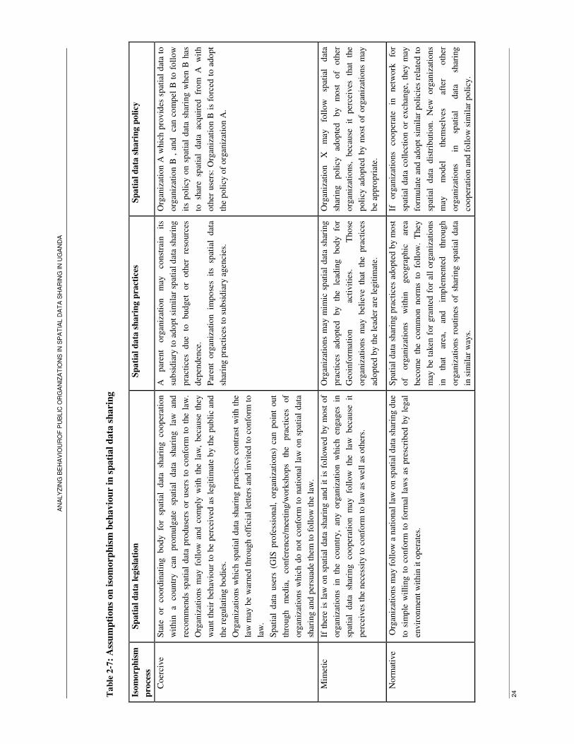
AN
ALY
ZIN
G B
EH
AV
IOU
RO
F P
UB
LIC
OR
GA
NIZ
AT
ION
S IN
SP
AT
IAL
DA
TA
SH
AR
ING
IN
UG
AN
DA
24
Ta
ble
2-7
: A
ssu
mp
tion
s on
iso
morp
his
m b
eh
av
iou
r i
n s
pati
al
da
ta s
harin
g
Isom
orp
his
m
pro
cess
Sp
ati
al
da
ta l
egis
lati
on
S
pa
tial
da
ta s
hari
ng
pra
ctic
es
Sp
ati
al
da
ta s
ha
rin
g p
oli
cy
Coer
cive
Sta
te
or
coord
inat
ing
bod
y
for
spat
ial
dat
a sh
arin
g
coop
erat
ion
wit
hin
a
countr
y
can
pro
mulg
ate
spat
ial
dat
a sh
arin
g
law
an
d
reco
mm
end
s sp
atia
l dat
a p
roduse
rs o
r use
rs t
o c
onfo
rm t
o t
he
law
.
Org
aniz
atio
ns
may
foll
ow
and
com
ply
wit
h t
he
law
, bec
ause
they
wan
t th
eir
beh
avio
ur
to b
e per
ceiv
ed a
s le
git
imat
e b
y t
he
pub
lic
and
the
regula
ting b
odie
s.
Org
aniz
atio
ns
whic
h s
pat
ial
dat
a sh
arin
g p
ract
ices
co
ntr
ast
wit
h t
he
law
may
be
war
ned
thro
ugh o
ffic
ial
lett
ers
and
invit
ed t
o c
onfo
rm t
o
law
.
Spat
ial
dat
a use
rs (
GIS
pro
fess
ional
, o
rgan
izat
ions)
can
po
int
out
thro
ugh
med
ia,
confe
rence
/mee
ting/w
ork
shop
s th
e p
ract
ices
of
org
aniz
atio
ns
whic
h d
o n
ot
confo
rm t
o n
atio
nal
law
on s
pat
ial
dat
a
shar
ing a
nd p
ersu
ade
them
to
fo
llow
the
law
.
A
par
ent
org
aniz
atio
n
may
co
nst
rain
it
s
sub
sid
iary
to a
do
pt
sim
ilar
sp
atia
l d
ata
shar
ing
pra
ctic
es
due
to
budget
or
oth
er
reso
urc
es
dep
enden
ce.
Par
ent
org
aniz
atio
n
imp
ose
s it
s sp
atia
l dat
a
shar
ing p
ract
ices
to
sub
sid
iary
agen
cies
.
Org
aniz
atio
n A
whic
h p
rovid
es s
pat
ial
dat
a to
org
aniz
atio
n B
, a
nd
ca
n c
om
pel
B t
o f
oll
ow
its
poli
cy o
n s
pat
ial
dat
a sh
arin
g w
hen
B h
as
to
shar
e sp
atia
l d
ata
acq
uir
ed
fro
m
A
wit
h
oth
er u
sers
: O
rgan
izat
ion B
is
forc
ed t
o a
do
pt
the
poli
cy o
f org
aniz
atio
n A
.
Mim
etic
If
ther
e is
law
on s
pat
ial
dat
a sh
arin
g a
nd i
t is
foll
ow
ed b
y m
ost
of
org
aniz
atio
ns
in
the
countr
y,
any
org
aniz
atio
n w
hic
h en
gag
es in
spat
ial
dat
a sh
arin
g
coo
per
atio
n
may
fo
llow
th
e la
w
bec
ause
it
per
ceiv
es t
he
nec
essi
ty t
o c
onfo
rm t
o l
aw a
s w
ell
as o
ther
s.
Org
aniz
atio
ns
may
mim
ic s
pat
ial
dat
a sh
arin
g
pra
ctic
es
ado
pte
d
by
the
lead
ing
bo
dy
for
Geo
info
rmat
ion
acti
vit
ies.
T
ho
se
org
aniz
atio
ns
may
b
elie
ve
that
th
e pra
ctic
es
adop
ted
by t
he
lead
er a
re l
egit
imat
e.
Org
aniz
atio
n
X
may
fo
llow
sp
atia
l d
ata
shar
ing
po
licy
ad
op
ted
b
y
mo
st
of
oth
er
org
aniz
atio
ns,
b
ecau
se
it
per
ceiv
es
that
th
e
poli
cy a
dop
ted b
y m
ost
of
org
aniz
atio
ns
may
be
appro
pri
ate.
No
rmat
ive
Org
aniz
atio
ns
may
foll
ow
a n
atio
nal
law
on s
pat
ial
dat
a sh
arin
g d
ue
to s
imp
le w
illi
ng t
o c
onfo
rm t
o f
orm
al l
aws
as p
resc
rib
ed b
y l
egal
envir
onm
ent
wit
hin
it
op
erat
es.
Spat
ial
dat
a sh
arin
g p
ract
ices
ado
pte
d b
y m
ost
of
org
aniz
atio
ns
wit
hin
geo
gra
phic
ar
ea
bec
om
e th
e co
mm
on n
orm
s to
foll
ow
. T
hey
may
be
taken
for
gra
nte
d f
or
all
org
aniz
atio
ns
in
that
ar
ea,
and
im
ple
men
ted
thro
ugh
org
aniz
atio
ns
routi
nes
of
shar
ing s
pat
ial
dat
a
in s
imil
ar w
ays.
If
org
aniz
atio
ns
coop
erat
e in
net
work
fo
r
spat
ial
dat
a co
llec
tion o
r ex
chan
ge,
they
may
form
ula
te a
nd a
do
pt
sim
ilar
po
lici
es r
elat
ed t
o
spat
ial
dat
a d
istr
ibuti
on.
New
o
rgan
izat
ions
may
m
odel
th
emse
lves
af
ter
oth
er
org
aniz
atio
ns
in
spat
ial
dat
a sh
arin
g
coop
erat
ion a
nd f
oll
ow
sim
ilar
po
licy
.

ANALYZING BEHAVIOUROF PUBLIC ORGANIZATIONS IN SPATIAL DATA SHARING IN UGANDA
25
2.5. Conclusion
The chapter focused on definition of the concept related to spatial data sharing: spatial data sharing
legislation, policies; spatial data sharing practices and inter-organizations spatial data sharing
relationships. It also presented an overview of isomorphism theory, the tenet point for this research and
the extent to which the mechanism of isomorphism affects organizations behaviour in different domains
of activities. In relation to the question posed in introduction, “What is the spatial data sharing legislation
in Uganda?” the chapter provides the following answer: There is not a national legislation on spatial data
sharing in Uganda. There is a national law guiding access to data or information held by government
bodies for all citizens. The law prescribes the legal procedures for the citizens to get access data and
information held by government body. Data can be accessed in both analogue and digital format, at
organization office and are provided on written request. Access may be refused if its provision is likely
to prejudice the security or sovereignty of the State or it is subject to compromise the confidentiality or
privacy of any other person. In this chapter, the study shows that public organizations follow individual
spatial data sharing. Some organizations pose payment conditions on spatial data access, while others do
not and share spatial data with other users for free charge. Organizations are custodian of spatial data
they collect, and share those data on demand.

ANALYZING BEHAVIOUROF PUBLIC ORGANIZATIONS IN SPATIAL DATA SHARING IN UGANDA
26
3. Methodology of data collection
The collection of primary and secondary data needed to answer the research questions and to achieve
research objectives as presented in chapter 1. This chapter describes the research methods including
survey questionnaire, structured and unstructured interviews, observations and secondary data
collection. The questionnaire (appendix 2) and interviews were administrated to stakeholders (appendix
3) participating in data collection and provision. The field work aimed at finding data that will help to
answer the following questions:
- What are spatial data sharing policies followed by public organizations in Uganda?
- Do spatial data sharing policies change and tend to look similar over time?
Both primary and secondary data were collected, and are presented in chapter 4. Data are analyzed
following interpretative approach, to derive from respondents’ responses indicators of isomorphism
trends in spatial data sharing in Uganda.
3.1. The case study
The case study in which I investigate organizational behaviour in spatial data sharing comprises of public
organizations at national and local levels in Uganda, in different locations to test whether organizations
located in different areas my show similar or dissimilar isomorphism behaviour when comparing one
zone to another or national level and local level.
I visited 3 organizations located in Kampala city, 3 organizations located in Entebbe city and 3
organizations located in Mukono town. Those organizations participate in the collection and sharing
spatial data. The research tends to examine if the target organizations shows different or similar
isomorphic behaviour comparing the vertical cooperation between organizations operating at national
level and organizations operating at national level. This may be possible in the case of coercive
isomorphism which stems from political influence and may come from national level to local level and
mimetic isomorphism which may be observed when organizations located in the same area collude by
adoption of each others practices. The distribution of organizations which were visited in each area is
given in the table 3-1.

ANALYZING BEHAVIOUROF PUBLIC ORGANIZATIONS IN SPATIAL DATA SHARING IN UGANDA
27
Table 3-1: Distribution of visited organizations
Location Number Name of Organization Operation
level
Sector of activities
1 National Water and Sewerage
Corporation ( NWSC)
National Utility: water supply
and sewerage
2 Kampala water ( KW) Local Utility: water supply
and sewerage
Kampala
3 Kampala City Council ( KCC) Local Political and public
administration
4 Survey and mapping Department
(SMD) under the Ministry of Lands,
Housing and Urban Development
National Land administration,
survey and mapping
5 Directorate of Water Resources
Management ( DWRM)
National
Water resources
management
Entebbe
6 Entebbe town council Local Political and public
administration
7 Mukono town council Local Political and public
administration
8 Mukono district/ Department of Lands Local Land registration
Mukono
9 Mukono district/ Department of Water
Development
Local Water resources
management
According to table 3-1, these organizations operate in different sectors (public administration, water
supply, land administration, water resources management) with regard to their missions. This aspect
allows the research to investigate whether isomorphism affect similarly or dissimilarly organizations
within the same sector or if organizations from different sectors may adopt similar practices,
independently from their peers.
3.2. Operationalisation of organizations behaviour in spatial data sharing in the perspective of isomorphism theory
Interview and survey questionnaire were designed following the perspective of isomorphism theory. The
investigation tried to find out whether the behaviour of visited organizations show any patterns of
isomorphism, commonly coercive mimetic, or normative.
The key areas covered in survey and interview included organizational policy and approaches which are
followed in spatial data sharing: free access or access for fees. It was investigated for instance if
organization charges fees or do not charge fees because other organizations do so, or due to any national
law or directives; if the policy on spatial data sharing that was adopted at initial stage had changed any
time in the course of spatial data sharing cooperation and then any organization has recently adopted a
different policy, or if organizations adopt other organizations practices and regulations related to spatial

ANALYZING BEHAVIOUROF PUBLIC ORGANIZATIONS IN SPATIAL DATA SHARING IN UGANDA
28
data provision. These questions reflect the process of organization’s environment that shape
organizations’ behaviour according to isomorphism theory (Powell and DiMaggio 1991; Dacin 1997).
The indicators of isomorphism behaviour in spatial data sharing which were addressed in data collection
are presented in the table 3-2.
Table 3-2: Spatial data sharing practices and isomorphism trends
Concept
under study
Indicator Source of evidence Criteria for interpretation
Spatial data
sharing policy
Questionnaire, Interview,
Memorandum of understanding, client charter, data dissemination
policy
- Degree to which organizations adopt
similar pricing or no pricing policies - Degree to which organizations place similar price on GI products
- If there organizations follow any laws or directives to decide on spatial data sharing policies
Change in conditions placed
on access to data: from fee to frees or vice versa
Questionnaire, Interview, Memorandum of
understanding
- Degree to which organizations spatial data sharing policies change
and are aligned to each other - If there are any laws or directives that invite organizations to change data sharing policies
Format of shared
data: maps, vector, raster
Questionnaire, Interview,
Memorandum of understanding
Degree to which organizations
provide similar GI products
Sources of budget allocated in Geoinformation activities
Questionnaire, Interview, organizations budget plan
- Degree to which GI related budgets are allocated at organizational level - Degree to which GI related budgets are allocated at government level
Coordinator of
data sharing activities
Questionnaire, Interview,
internal regulations,
Degree to which spatial data sharing
activities are coordinated
Inter-organization consultation on GI development
Questionnaire, Interview, cooperation agreement
- Degree to which organization face similar uncertainty on GI projects - Degree to which organization
cooperate in GI activities - Degree to which organization adopt each other spatial data sharing practices
Isomorphism behaviour
Forms of data sharing
relationships: formal or informal
Questionnaire, Interview, Memorandum of
understanding
- Degree to which spatial data sharing relations are formalized or not
formalized
ANALYZING BEHAVIOUROF PUBLIC ORGANIZATIONS IN SPATIAL DATA SHARING IN UGANDA
29
3.3. Primary data collection methods
Three techniques were used in collection of primary data for this study: a survey questionnaire,
structured and unstructured interviews, and observations. The survey questionnaire and interviews were
addressed to the commissioners, heads of the departments, project manager, GIS specialist, surveyors
and GIS technician of the departments participating in data collection and dissemination within the
visited organizations.
The study considers those categories of staff to be the key informants for the following reasons: the
managers and heads of departments are the influential actors in decision making about the cooperation of
their organizations with others. They participate in formulation of agreements on spatial data sharing,
decide on spatial data sharing policies and play a key role in policy adoption or enforcement of directives
related to spatial data sharing with other organizations or individual users.
GIS specialists/technicians and surveyors participate in spatial data collection and dissemination. They
have information about the conditions placed on spatial data access by external users. They are among
people who participate in forum and workshops about spatial data dissemination, and may have an
influence on decision making about spatial data sharing with other organizations.
3.3.1. Questionnaire
A survey questionnaire was designed using two methods: survey monkey and Microsoft word offices.
These two options were provided for the preference of the respondents and to let them respond by filling
in printed hand out or by online questionnaire. It was realized that, among the target respondents, there
wasn’t any people who requested the online questionnaire. For almost all the respondents, the
questionnaire was personally administered. At any moment I arrived in the office of the target
respondents, they requested the questionnaire and filled it immediately. In some cases, respondents read
the question, provided the responses and I made note of the responses and so on. This technique helped
in the collection of distributed questionnaires because they were returned once the respondents had
finished filling in questionnaires. Moreover, they could ask some clarifications for any question which
was not clear.

ANALYZING BEHAVIOUROF PUBLIC ORGANIZATIONS IN SPATIAL DATA SHARING IN UGANDA
30
3.3.2. Structured and unstructured interviews
As the research focus on organization behaviour, the structured interview was the most used technique to
collect the perception, opinions of individuals in order to have evidence explaining how they interpret
their organizations practices about spatial data sharing. The interview had also helped to perceive the
respondents feelings and ideas on the questions concerning environment influences their organizations
may face when they formulate policies related to spatial data sharing. The questions which were asked
during the survey questionnaire were incorporated in the interview questionnaire. Beside that, the
interview comprised additional questions aiming at understanding the antecedents of spatial data sharing
policy, environmental forces that may persuade organizations to adopt any spatial data sharing practices,
to investigate if there are mechanisms of isomorphism that affect public organizations in Uganda in
spatial data sharing.
Unstructured interview was used in different cases:
- In collecting further evidence from the decision makers and senior officers on any points which were
not clarified during the interview with technical staffs. In that case, the common questions which were
clearly answered from the survey questionnaire and structured interview were not asked as some
managers seemed to be very busy and only accepted short interview.
- For validation on data collected from interview: as I had to go several times to the same organization,
I passed in the office of the respondent that I contacted previously. We had a short discussion through
which I reported the summary of what he/she told me in previous meeting to confirm the information I
collected from him/her. Such discussions were done with the respondents I met during the three first
weeks of the field work.
- I also used phone calls to ask additional details about some responses that seemed to be incomplete or
not clear when I was writing summary of the interviews and when I was back to school, interpreting field
data.
3.4. Secondary data collection
Other source of evidence for the case studies consisted of documents, available either in the archives of
organizations or on web site. Some of these documents describe the framework of organizations
activities in general, others relate to partnerships in spatial data sharing, like clients charter for spatial
data products MoU on spatial data sharing, and spatial data sharing policy. The main documents which
were collected are presented in table 3-3.

AN
ALY
ZIN
G B
EH
AV
IOU
RO
F P
UB
LIC
OR
GA
NIZ
AT
ION
S IN
SP
AT
IAL D
AT
A S
HA
RIN
G IN
UG
AN
DA
31
Tab
le 3
-3:
Sou
rces
of
secon
da
ry d
ata
Do
cum
ent
Con
ten
ts
Asp
ects
w
hic
h
a
re
ad
dre
ssed
Co
nst
itu
tio
n o
f th
e R
epub
lic
of
Ugan
da
In i
ts a
rtic
le 4
1,
th
e co
nst
itu
tio
n p
rom
ulg
ates
th
e ri
ght
of
citi
zen
to
info
rmat
ion
wh
ich i
s in
the
po
sses
sio
n o
f
stat
e o
f an
y g
over
nm
ent
agen
cy a
nd
cas
es i
n w
hic
h a
ny m
ay b
e ap
pli
ed
Pu
bli
c ri
ght
for
acce
ss t
o i
nfo
rmat
ion
hel
d b
y go
ver
nm
ent
bo
dy
Th
e ac
cess
to
in
form
atio
n
Fo
llo
win
g
the
arti
cle
41
o
f th
e co
nst
itu
tio
n,
the
act
pro
vid
es
the
rights
o
f th
e pu
bli
c to
go
ver
nm
ent
info
rmat
ion
, des
crib
es t
he
pro
ced
ure
s fo
r o
bta
inin
g a
cces
s to
in
form
atio
n.
Pro
ced
ure
s fo
r ac
cess
an
d p
rovis
ion
of
info
rmat
ion
to
th
e pu
bli
c
Dec
ree
on
SD
I
Dir
ecti
ves
th
at
pu
bli
c o
rgan
izat
ion
s sh
ould
fo
llo
w
in
spat
ial
dat
a h
and
lin
g
and
sp
atia
l dat
a sh
arin
g
coo
per
atio
n f
or
the
dev
elo
pm
ent
of
SD
I.
Dir
ecti
ves
o
n
spat
ial
dat
a sh
arin
g
bet
wee
n p
ub
lic
org
aniz
atio
ns
Min
iste
rial
Poli
cy S
tate
men
t fo
r L
ands,
Hou
sin
g a
nd U
rban
Dev
elo
pm
ent
20
08/2
009
Th
e p
oli
cy s
tate
men
t p
rese
nts
the
bu
dget
an
d r
even
ues
fo
r th
e yea
rs 2
00
8-2
00
9,
incl
ud
ing t
he
bu
dget
fo
r th
e
acti
vit
ies
rela
ted t
o L
and
s su
rvey
ing a
nd
map
pin
g D
epar
tmen
t. T
he
pla
n c
om
pri
ses
the
exp
ecte
d b
ud
get
fo
r
surv
ey
and
m
appin
g
acti
vit
ies
and
re
ven
ues
w
hic
h w
ill
be
reco
ver
ed
fro
m
the
sale
of
geo
info
rmat
ion
pro
du
cts.
Cau
se
for
ado
pti
ng
pri
cin
g
po
licy
tow
ards
spat
ial
dat
a sh
arin
g.
Lan
d
Sec
tor
Str
ateg
ic P
lan
20
01
-20
11
Uti
lisi
ng U
gan
da
’s L
and R
esou
rces
for
Su
stai
nab
le D
evel
opm
ent
Th
e L
and S
ecto
r S
trat
egic
P
lan p
rovid
es th
e o
per
atio
nal
, in
stit
uti
on
al an
d fi
nan
cial
fr
amew
ork
fo
r th
e
imp
lem
enta
tio
n o
f se
cto
r w
ide
refo
rms
and
lan
d
Man
agem
ent.
It
p
rovid
es
stra
tegy
for
the
dev
elo
pm
ent
of
Lan
d
info
rmat
ion
and
p
resc
rib
es
ho
w
lan
d
Info
rmat
ion
co
nst
itute
s on
e o
f th
e so
urc
es o
f la
nd s
ecto
r th
rough
sal
e o
f in
form
atio
n.
Cau
se f
or
sale
of
lan
d r
elat
ed d
ata.
DR
WM
-Pro
file
o
f w
ater
R
eso
urc
es
Mo
nit
ori
ng a
nd
Ass
essm
ent
dep
artm
ent
Th
e p
rofi
le d
escr
ibes
th
e ac
tivit
ies
of
the
Res
ou
rces
Mo
nit
ori
ng a
nd
Ass
essm
ent
Dep
artm
ent,
in
clud
ing t
he
coll
ecti
on
an
d d
isse
min
atio
n o
f sp
atia
l d
ata
rela
ted
to
wat
er r
eso
urc
es.
It s
pec
ifie
s th
e ty
pe
of
coll
ecte
d
spat
ial
and
acc
ess
fees
.
Dat
a p
rod
uce
d
and
d
isse
min
ated
b
y
Org
aniz
atio
n
and
p
oli
cy
o
n
dat
a
shar
ing
Adm
inis
trat
ive
no
te:
Rev
isio
n o
f m
ap
pri
ces
Th
e n
ote
pro
vid
es t
he
pri
ces
of
map
s in
bo
th h
ard
an
d d
igit
al f
orm
ats
fro
m 1
996
, at
th
e S
urv
ey a
nd
map
pin
g
dep
artm
ent.
Po
licy
o
f th
e d
epar
tmen
t in
re
lati
on
wit
h a
cces
s to
sp
atia
l d
ata.
Mem
ora
nd
um
of
un
der
stan
din
g
Th
e m
emo
rand
um
of
un
der
stan
din
g b
etw
een
th
e U
MD
an
d W
RM
D e
xpla
in t
he
conte
xt
of
coo
per
atio
n
bet
wee
n t
ho
se d
epar
tmen
ts i
n s
pat
ial
dat
a co
llec
tion
, ex
chan
ge
and
dis
sem
inat
ion
Fo
rmal
izat
ion
of
inte
r-o
rgan
izat
ion
s
rela
tio
nsh
ips
in s
pat
ial
dat
a sh
arin
g
Air
bo
rne
geo
ph
ysi
cal
dig
ital
d
ata
dis
sem
inat
ion p
oli
cy
Th
e d
ocu
men
t d
escr
ibes
geo
ph
ysi
cal
dig
ital
dat
a, c
oll
ecte
d b
y t
he
Dep
artm
ent
of
Geo
logic
al S
urv
ey a
nd
Min
es
of
the
Min
istr
y o
f E
ner
gy
and
M
iner
al
Dev
elo
pm
ent
and
po
licy
o
n
the
dis
sem
inat
ion
of
geo
info
rmat
ion.
Dat
a d
isse
min
atio
n p
oli
cy;
dat
a ac
cess
pro
cess
an
d d
ata
pri
ces.
ANALYZING BEHAVIOUROF PUBLIC ORGANIZATIONS IN SPATIAL DATA SHARING IN UGANDA
32
3.5. Observations
During the fieldwork, I observed individuals’ attitudes, reactions and feelings during the interviews. The
respondents showed negative attitude or laughed when asked questions related to policy or law on spatial
data sharing. They frankly highlighted that organizations make their own decisions on how to share
spatial data, and underlined that there is no national law or directives to follow when they were asked if
their organizations follow any laws or directives in spatial data sharing. They openly negated copying
other organizations practices in spatial data sharing, for instance, when asked question if they share
spatial data according to policy adopted by other organizations. Those questions were posed for
collecting evidence on isomorphism trends, in relation with indicators presented in table 3-2 like “spatial
data sharing policy, inter-organization consultation on GI development”. A part those negative attitudes,
respondents showed positive feeling for adopting similar spatial data standards, and felt that the use of
common standards is a necessity for the development of GI. Some respondents seemed hesitant to
respond to some questions for which they could have a precise answer. They contacted their colleagues
before responding to such question or skipped it, and advised me to ask the question to the manager.
Those observations were noted in field notes and were taken into account in data analysis.
3.6. Preparation of data analysis
The preliminary of field data analysis consisted on the summarizing the respondents answers from
survey questionnaire and interview. When the summaries were compiled, field data were organized in
tabular form and grouped according to themes that were addressed in the questionnaire. It is on the basis
of those data that a qualitative and interpretative analysis was done, for deriving the similarities or
dissimilarities between organizations that constitute the case study for this research.
The analysis started from the coding of collected data, according to the meaning of answers. I developed
the themes following the meanings of answers, and gave label each answer. The responses were then
classified under the main themes, mainly data access policy, beginning of cooperation in data sharing,
data format, coordination of data sharing, regulation on data provision, etc. The frequencies of responses
were counted under each theme.
Coded data were analyzed manually. The use of computer software was not possible due to time
constrain and for not being familial with the software for qualitative analysis. The presentation of result
in form of graphs was made with use of excel. Other method like literal reporting of answers was used
in quoting the respondent’s answers.

ANALYZING BEHAVIOUROF PUBLIC ORGANIZATIONS IN SPATIAL DATA SHARING IN UGANDA
33
3.7. Limitation of fieldwork
During the fieldwork, I faced some problems, which obstructed the work plan. These problems are
related to unavailability of the target respondents.
- Most of time, I could not find the respondents in their offices when I wanted to make first contacts
with them. I found the office closed, and their colleagues suggested me to wait for their arrival as they
were expected to come to work. Some times, it happened that the staff did not come and I had to change
the schedule and try to make contact with other target respondents which were not on schedule of the
day. In the afternoon, in the most of visited organizations, there were very few staffs in the office. This
implied that I could not expect to find many respondents in the afternoon.
- Once, I came in the offices of the target respondents, few of them tried to find time and respond to
my survey questionnaire or interview. However, most of the other respondents fixed an appointment and
invited me to go back in their office. When I went back to the respondent office, I found that the
respondent was very busy and I had to wait for him till he/she was available. This happened for some of
the respondent from Kampala City Council and Entebbe town council and affected my daily timetable as
I could not visit all offices I had planed to visit on the same day.
- It happened that the respondent postponed the appointment for another day. It was the case with the
respondents from Mukono lands department who, when I arrived at the office on time and day of
appointment, postponed the appointment for a next day, arguing that they were very busy with routine
work. As I had to walk from Kampala to Mukono, the day was not successfully used due to
unavailability of the target respondents.
- Another limitation of the work progress was related to requirement of the target respondents. When I
arrived in the office of any of the manager, he sent me to technical staffs, expecting that they could give
me all information I was looking for. He proposed me to go back to his office in case there were some
details that I could not find from the technical staffs. In that case it took me a long time before I could
meet the managers as I could not immediately find the technical staffs who were not regularly in the
office.
The irregularity of the target respondents in their offices, affected the field work because I could not
organize a focus group discussion as it was planned. I expected to use this technique for validation of
data collected through interviews. Interviews were conducted even during the days reserved for focus
group discussion. Collected data were validated through unstructured interviews, by revisiting
respondents in their offices as explained in sub-section 3.3.2.
I did not also observe the activities related to spatial data sharing in the offices where staffs were
irregular. I expected to observe how organizations share spatial data with the users, but the observations
were not possible in KCC, Entebbe TC, Mukono TC, Mukono LD and Mukono WDD because staffs of
those organizations were most of time not available in the offices. Once interviews were ended, they left
the offices so that I did collect evidence on the process and procedures of spatial data sharing in relation
to indicator of “spatial data sharing policy” as indicated in table 3-2.

ANALYZING BEHAVIOUROF PUBLIC ORGANIZATIONS IN SPATIAL DATA SHARING IN UGANDA
34
3.8. Conclusion
Field data collection was done using different methods including questionnaire, face to face interviews,
and observations. The fieldwork was an opportunity to collect some documents that are used as
complement to primary data and help in understanding and explaining organizations activities in spatial
data sharing. The results from data collection are presented in next chapter that allows providing the
answers to the research questions announced in the introduction of this chapter.

ANALYZING BEHAVIOUROF PUBLIC ORGANIZATIONS IN SPATIAL DATA SHARING IN UGANDA
35
4. Nature of spatial data sharing in Uganda
4.1. Introduction
This chapter provides the results from fieldwork on spatial data sharing policies and practices, in public
sector in Uganda. It aims at answering the following research questions:
1. What are spatial data sharing policies followed by public organizations in Uganda?
2. Do spatial data sharing policies change and tend to look similar over time?
The chapter starts with the overview of spatial data sharing activities within visited organizations. The
emphasis is on the types of spatial data sharing policies or practices and the types of collected spatial
data which allows organizations to engage in spatial data sharing cooperation. In this chapter, spatial data
sharing policies refer as the informal or formal rules or the guidelines developed at organization level.
Those rules or guidelines prescribe the conditions on spatial data access, restrictions posed on spatial
data access, the prices for spatial data, sharable spatial data products, and the officer who copes with the
activities related to spatial data sharing. The term spatial data sharing practices is used to denote the
ways organizations implement their policies in daily activities of spatial data sharing. The chapter
presents also trends of changes in spatial data sharing practices based on the ways spatial data sharing
policies are implemented.
4.2. Spatial Datasets holding and ownership
The survey was conducted within 9 organizations. All visited organizations hold different spatial datasets
of which they are custodian and maintain. 2 of those organizations collect spatial data in the context of
their mandate and mission, to provide spatial data to the public. 7 organizations collect and use spatial
data as input for the achievement of their missions. In this section, the study presents an overview on
spatial data collected by each organization.
4.2.1. Department of Survey and mapping
The Department of Survey and Mapping operates at national level, under the ministry of Land, Housing
and Urban development. It is responsible for topographic and thematic mapping and survey activities in
the whole country. It coordinates the activities of mapping, provides standards for data collection, and
insures data quality control (Moyin, Bemigisha et al. 2000). The department of survey and mapping is
among key players in the initiative of establishing SDI in Uganda (Swedish consortium 2001; Karatunga
2002). Its main functions are: to formulate the national surveys policies strategies and plans, to direct the
implementation of all mapping programs, to coordinate and supervise national survey activities in
compliance to the national policies standards and legislation, to review and initiate national mapping

ANALYZING BEHAVIOUROF PUBLIC ORGANIZATIONS IN SPATIAL DATA SHARING IN UGANDA
36
standards, to regulate and control the printing, updating and distribution of national maps (Karatunga
2002; Musinguzi 2004; Nasirumbi 2006).
The department collects and holds the following spatial data: topographic data, (elevation, contour
lines), hydrographic data (lakes and rivers) geodetic data, man made structures such as buildings,
transport infrastructure (roads, railways and ferries) and cadastral data. It holds aerial photographs
and satellite images for the whole countries as provided by international organizations like IGN-France
and RCMRD. The department use GIS software like Arc View 3.2a since 1995 and Arc GIS 9.2 since
2005 in data collection, processing and maintenance, and in the development of the National
Cartographic Database.
The use of GIS software was introduced in spatial data collection in the context of the project aiming
at development of EIS, under initiative of NEMA. The aim of the project was to set up mechanisms for
the collection and dissemination of environmental information, serving in the management of natural
resources and environmental conservation. The project was backed by the government, as provided in
the national environment action plan of 1994 and national environmental management policy adopted
in 1995 by the government of Uganda (Moyin, Bemigisha et al. 2000; Schwarte 2008). The use of GIS
software resulted from the need for capturing and maintaining spatial data in digital format enabling
spatial data exchange and integration. It is in this context, SMD as well as others organizations
involved in collection of spatial data related to natural resources started to use GIS.
4.2.2. Directorate of Water Resources Management
The Water Resources Management Department of the Directorate of Water Resources Management is
responsible for the monitoring, assessment, planning and regulation of water resources in the country, at
national level. It collects and holds spatial data on rainfall, hydrology, and water bodies (river, lakes,
water points, and borehole). It disseminates spatial data and information about River flows and levels,
lake bathometric information (levels, cross section and depth), groundwater records (location,
overburden thickness, water strikes, borehole yields, static water level, lithology and hydro chemical
data), groundwater resources maps (groundwater potential, technology options, groundwater coverage,
hydrogeological characteristics maps, hydro chemical characteristics, water quality maps, and surface
water maps (DWRD 2004). The department has used GIS software (Arc View 3.2a and Arc GIS 9.1) in
data collection, processing and maintenance from 1999 when a GIS unity was created under sponsorship
of European Union and DFID. From 1980, spatial data were collected manually. The introduction of GIS
derived from the need for the department to develop a system using modern technology for handling
efficiently spatial data related to water resources after the training of staffs in GIS, and to provide
spatial data which were requested by different stakeholders involved in natural resources and
environment management and protection.
ANALYZING BEHAVIOUROF PUBLIC ORGANIZATIONS IN SPATIAL DATA SHARING IN UGANDA
37
4.2.3. National water and Sewerage Corporation
The National Water and Sewerage Corporation (NWSC) is responsible for water supply and sanitation in
urban areas at national level, except for Kampala city. It collects and maintains spatial data related to
water and sewerage infrastructures: water pipe lines systems with house connections, valve, washout,
water tank, and sewerage canals. Since 1988 until 2008, NWSC had used AutoCAD in processing and
maintenance of those spatial data. It has started to use GIS software (Arc View 9.2) from 2008, and is
developing a Management Information System that facilitates an effective management of its
infrastructures. The use of GIS software at NWSC was introduced by the head of engineering
department, following the lessons learnt from Kampala Water. At Kampala water, the use of GIS
software was found more efficient and friendly, compared to Auto CAD which was used since several
years for spatial data handling.
4.2.4. Kampala Water
Like National Water and Sewerage Corporation, Kampala Water collects and holds spatial water supply
and sanitation at local level, in Kampala city. It collects and maintains similar spatial data as NWSC like
pipe lines systems with valve, washout, water tanks, customers’ premises and sewerage canals. Spatial
data are collected with use of modern survey equipments, GPS, satellite images, and GIS software (Arc
View 9.2). GIS has been implemented since 2007. From 1988, the software that was used is AutoCAD.
The use of GIS software was introduced by the head of GIS unity, upon the completion of training in
GIS. Through that training, he realized that GIS software is easier to use in handling and maintaining
important amount of spatial data than AutoCAD and allows the integration of different spatial datasets
which are produced with use of GIS technologies. It is in that context the unity decided to shift from
Auto CAD to Arc GIS 9.2.
4.2.5. Kampala City Council
The departments of engineering and land management and planning of Kampala City Council, use spatial
data in their daily activities related to city planning, management, infrastructures maintenance and land
registration. The two departments are mandated to fulfil those activities since 1994, through the process
of decentralization as adopted by the government of Uganda. Before 1994, these activities related to city
planning, management, infrastructures maintenance and land registration in Kampala City were fulfilled
by the Ministry of Land, Housing and Urban development. Since the decentralization then, the
departments collect and hold spatial data related to public infrastructures like roads, buildings, water,
electricity and land parcels. At the initial stage of data collection, they used traditional methods (drawing
with use of paper and pencil) in spatial data collection. Since 2003, they are using GIS software (Arc
View 3.2a and Arc GIS 9.0) in all activities related to mapping, and have been converting spatial data
from analogue to digital format. In 2003, the heads of these departments decided to adopt the use of GIS
technology to devolve the technical problems related to the integration of spatial data in digital format,

ANALYZING BEHAVIOUROF PUBLIC ORGANIZATIONS IN SPATIAL DATA SHARING IN UGANDA
38
acquired from other organizations like SMD with their own spatial data which were in analogue format.
At that time, the City had financed the training of staffs in GIS and requisitioned GIS equipments.
4.2.6. Entebbe Town Council
The Department of Physical planning was created in 1986 under Entebbe City Council, for insuring the
planning and management of the city and infrastructures development. Since that year, the department
collects and holds spatial data related to roads, land use and cells boundaries. Since 2004, the department
use GIS software (Arc View 3.2a), for maintaining spatial data in digital format. The use of GIS software
was introduced by the head of department, after the training of the staffs of the department in GIS.
4.2.7. Mukono Town Council
Department of physical planning of Mukono Town Council collects spatial data related to public
infrastructures such as roads, schools, hospitals, and land parcels boundaries since 1980, when
the town council was created. Spatial data are used in town planning and management, mainly in
designing settlement and infrastructures plans. The department does not use any modern technology like
GIS for spatial data collection, processing and maintenance. Its uses traditional methods in spatial data
collection like theodolites and spatial data are manually processed on paper with pencil. Thus spatial
data are produced and presented in form of structure plans, including parcels boundaries, roads and
socio-economic infrastructures boundaries. The staffs of that department aspire at using GIS software in
their activities, but the department lacks financial means to set up a GIS.
4.2.8. Mukono district/Department of Lands
Department of lands of Mukono district collects and holds spatial data related to land parcels
boundaries and ownerships, since 1962 when the district was created. Spatial data are collected
with use of tradition methods like theodolites and manually processed on paper with pencils, in
the context of sporadic adjudication for land registration. Theses data are presented in form of
cadastral plans in hard copy. Like the staffs from Mukono Town Council, the staffs of Mukono
Land Department would like to develop a computerized system with GIS software, but the
program is still a challenge due to lack of funds.

ANALYZING BEHAVIOUROF PUBLIC ORGANIZATIONS IN SPATIAL DATA SHARING IN UGANDA
39
4.2.9. Mukono district/ Department of Water Development
The Department of Water development of Mukono district does not have a system for data processing. It
cooperates with the Water Resources Management Department, under DWRM in spatial data collection.
After the collection, spatial data are processed and maintained at the Water Resources Management
Department. The Department of Water development of Mukono district acquires spatial data in form of
analogue maps from Water Resources Management Department, and shares those maps with any people
who need to use them.
4.3. Inter-organizations cooperation in spatial data sharing
The cooperation and partnerships for spatial sharing between public organizations in Uganda started
many years ago. The practices of spatial data sharing started at the same time organizations started
mapping or GIS activities as indicated in previous section. From field data, respondents argued that once
the organization started to collect spatial data, the cooperation for spatial data sharing started voluntarily.
Either the public or other organizations need to use those spatial data, or organization itself felt the need
to use spatial data from other organizations to fulfil its mission. Some respondents reported that they use
topographic map provided by SMD as basic spatial data in the activities of spatial data collection. That
is, as their organizations embarked on spatial data collection, the cooperation with SMD became a
necessity.
Organizations operating in the field of land management, including land registration have initially
embarked on spatial data sharing at early stages when compared with other organizations. These
organizations are SMD and Mukono LD, which started to share spatial data in 1960s when the
government of Uganda initialized the process of land registration and mapping (The Republic of Uganda
1964). Most of other organizations started to collect and share spatial data in 1980s, with respect to dates
they were created or they introduced mapping/survey unities within their structures. The beginning of
inter-organization cooperation in spatial data sharing is presented in the table 4-1.

ANALYZING BEHAVIOUROF PUBLIC ORGANIZATIONS IN SPATIAL DATA SHARING IN UGANDA
40
Table 4-1: Reported beginning of spatial data sharing with other organizations
Organization name Beginning of
data sharing
Antecedents for engagement in spatial data sharing
SMD 1962 Beginning of land registration in Uganda: collection of cadastral data
Mukono LD 1962 Beginning of land registration in Uganda: collection of cadastral data
Mukono TC 1980 Creation of the town council
The department of physical planning started to use spatial data in city
planning
Entebbe TC 1986 Creation of the department for physical and planning under the town
council
The department started to use spatial data in city planning
NWSC 1988 Creation of engineering department hosting survey unity
KW 1988 Creation of GIS unity
KCC 1994 Decentralization of city planning and land management functions
KCC started to collect spatial data for city planning
DWRM 1980 Creation of mapping unity within DWRM
Mukono WDD 1994 Creation of the Department of Water development
Beginning of spatial data collection for water resources monitoring
4.4. Spatial data sharing partners
All visited organizations share spatial data with any users, government or private organizations and
individuals. The degree to which each organization participates in spatial data sharing cooperation was
measured on basis of the number of other organizations it shares spatial data with. Table 4-2 shows the
partners in spatial data sharing of each organization in the study.

ANALYZING BEHAVIOUROF PUBLIC ORGANIZATIONS IN SPATIAL DATA SHARING IN UGANDA
41
Table 4-2: Partners in data sharing
N°
Organization
name
Provides spatial data to Uses spatial data from
1 SMD DWRM, NWSC, KW, KCC, Entebbe TC,
Mukono TC, Mukono LD
DWRMC, NWS, KCC, KW
2 DWRM SMD, NWSC, KCC, Entebbe TC. Mukono
WDD
SMD, NWSC, Entebbe TC
3 NWSC SMD, DWRM, KW, Entebbe TC, Mukono TC SDM, DWRM, Mukono TC,
KCC
4 KW SMD, NWSC, KCC. DWRM, SMD, NWSC, KCC
5 KCC SMD, KW, NWSC. DWRM, SMD, KW, NWSC
6 Entebbe T C DRWM, NWSC. SMD, DWRM, NWSC
7 Mukono TC NWSC, Mukono LD. NWSC, SMD, Mukono LD,
Mukono WDD.
8 Mukono L D Mukono TC, NWSC SMD, Mukono TC 9 Mukono WDD Mukono TC DWRM
The table above shows the most spatial data providers and recipients in the unity of analysis. SMD,
NWSC and DWRM are the key spatial data providers compared the numbers of data recipients they
provide in spatial data. Those organizations are among organizations mandated to collect and
disseminate spatial data at national level (Musinguzi 2004, Muhwezi 2004, Karatunga 2002). SMD as
well as KCC, Mukono TC, NWSC, and DWRM are main spatial data users since they are the most
organizations that use spatial data from other organizations. Organizations at local level, like Mukono
LD and Mukono WDD are the least spatial data providers and users. The flow of spatial data between all
organizations under study is shown by figure 4-1.

ANALYZING BEHAVIOUROF PUBLIC ORGANIZATIONS IN SPATIAL DATA SHARING IN UGANDA
42
Figure 4-1: Spatial data sharing network
The figure 4-1 shows that the potential spatial data provider is SMD. SMD provides spatial data to 88%
of organizations in the study. It plays key role in data provision, and this may result in relation of
dependence for other organizations, because if the function of SMD as main spatial data provider
vanishes, activities of other organizations may be paralyzed.
SMD is also one of the potential users of spatial data. It receives spatial data from 57% organizations in
the network. That is, SMD is not only spatial data provider, but also spatial data user, and then benefits
from the cooperation with other organizations.
Each of the organizations presented in the figure 4-1, cooperates with more other organizations than the
partners presented in that figure. Those organizations use satellite images provided by RCMRD,
administrative boundaries and demographic data provided by UBOS, forest covers provided by NFA, and
land use data provided by the Ministry of agriculture to mention some of them. Appendix 6 shows the
types of spatial data collected by each organization and spatial data acquired from other organizations.
SMD
KW
KCC
Mukono
WDD
NWSC
DWRM
Mukono
LD
Mukono
TC
Entebbe
TC
: Two way relations
Organization A provides to and receives spatial
data from organization B
: One way relation
Organization A provides spatial data to organization B

ANALYZING BEHAVIOUROF PUBLIC ORGANIZATIONS IN SPATIAL DATA SHARING IN UGANDA
43
4.5. Sources of budget for spatial data handling
56% of visited organizations use mainly their own funds in the activities related to spatial data
collection, maintenance and dissemination. 44% of organizations use the budget from the central
government, with some contribution from donors. Only 22% of organizations produce spatial data in the
context of their mission to collect and disseminate geoinformation. 78% of organizations participate in
activities related to spatial data handling for collecting and producing spatial data that are used as tools
for meeting their goals.
Table 4-3: Context of GI activities and sources for budget
N° Organization
name
Context of GI activities Source of GI Budget
1 SMD Mandate to collect and disseminate
geoinformation: topographic data and cadastral
data, and to provide mapping standards
Government and donors
2 DWRM Mandate to collect and disseminate
geoinformation for water resources
management.
Government and donors
3 NWSC Use of spatial data in the management of water
and sewerage infrastructures
Organization budget: internally
generated revenue
4 KW Use of spatial data in the management of water
and sewerage infrastructures
Organization budget: internally
generated revenue
5 KCC Use of spatial data in town planning Organization budget: internally
generated revenue
6 Entebbe TC Use of spatial data in town planning Organization budget: internally
generated revenue
7 Mukono TC Use of spatial data in town planning Organization budget: internally
generated revenue
8 Mukono L D Use of spatial data in lands registration process Government budget
9 Mukono WDD Use of spatial data in the management of water
resources
Government budget
4.6. Spatial data access policy
4.6.1. Spatial data access for free versus access for fees
There are two types of spatial data access policies that are followed by public organizations in spatial
data sharing in Uganda. 33% of visited organizations charge fees for access to spatial data while 67%
share spatial data with the users for free as shown by the figure 4-2.
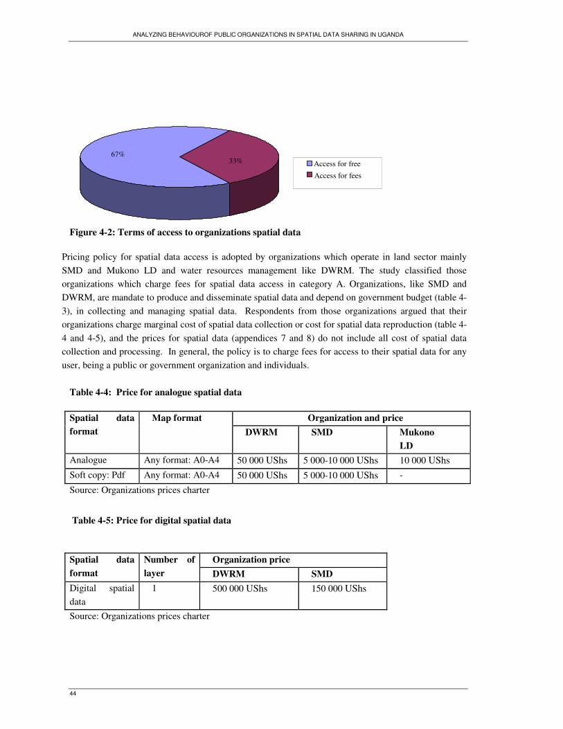
ANALYZING BEHAVIOUROF PUBLIC ORGANIZATIONS IN SPATIAL DATA SHARING IN UGANDA
44
Figure 4-2: Terms of access to organizations spatial data
Pricing policy for spatial data access is adopted by organizations which operate in land sector mainly
SMD and Mukono LD and water resources management like DWRM. The study classified those
organizations which charge fees for spatial data access in category A. Organizations, like SMD and
DWRM, are mandate to produce and disseminate spatial data and depend on government budget (table 4-
3), in collecting and managing spatial data. Respondents from those organizations argued that their
organizations charge marginal cost of spatial data collection or cost for spatial data reproduction (table 4-
4 and 4-5), and the prices for spatial data (appendices 7 and 8) do not include all cost of spatial data
collection and processing. In general, the policy is to charge fees for access to their spatial data for any
user, being a public or government organization and individuals.
Table 4-4: Price for analogue spatial data
Organization and price Spatial data
format
Map format
DWRM SMD Mukono
LD
Analogue Any format: A0-A4 50 000 UShs 5 000-10 000 UShs 10 000 UShs
Soft copy: Pdf Any format: A0-A4 50 000 UShs 5 000-10 000 UShs -
Source: Organizations prices charter
Table 4-5: Price for digital spatial data
Organization price Spatial data
format
Number of
layer DWRM SMD
Digital spatial
data
1 500 000 UShs 150 000 UShs
Source: Organizations prices charter
67% 33% Access for free
Access for fees

ANALYZING BEHAVIOUROF PUBLIC ORGANIZATIONS IN SPATIAL DATA SHARING IN UGANDA
45
Organizations like NWSC, KW, KCC, Entebbe TC, Mukono TC, and Mukono WDD which follow
free access policy were classified in category B. This category comprise organizations operating in
different domains of activities at both national and local level, like water supply and sewerage
services, public administration, and water resources management. They use internally generated
revenues in collecting spatial data which are used as tools for meeting their missions. In contrast to
organizations in category A, organizations in category B are not mandated to disseminate spatial data,
although they share their spatial data with any users who need to use them.
4.6.2. Open access versus restrict access
Access is a fundamental issue in the exchange of spatial data. In all organizations, spatial data are
accessed at office and shared on demand. Figure 4-3 shows that 78% of organizations provide full open
access to spatial data. Organizations that have developed GIS, like SMD, KCC, and DWRM provide
spatial in both analogue and digital formats. 22% of organizations create restriction on spatial data in
digital format. Those are KW and NWSC. They do not provide spatial data in digital format. Staffs from
those organizations stated that it is organization policy to restrict access to spatial data in digital format.
The pretext is that if spatial data are provided in digital format, the users may manipulate the datasets
and in return providing wrong information to the public. They argued that, they share spatial data with
other organizations and individuals to let the location of water and sewerage infrastructures. Before the
provision of spatial data in the form of maps, they make sure the map shows the correct location of
infrastructures and guide different companies and individuals in construction so that they prevent the
damage of water and sewerage infrastructures in their work. Following this idea, they feel that if the
users refer to a wrong map, there are risks for damaging the infrastructures and the consequences come
to KW and NWSC which have to support the cost for the reparation of those infrastructures. The
arguments are clear, but the reason for not sharing spatial data in digital format is not relevant as in the
field of geoinformation, spatial data providers can adopt different mechanisms preventing the
manipulation of spatial data, like the provision of user license or agreement on keeping the spatial dataset
unmodified, and then prevent the spatial data recipient to misuse it. The users who can comply with
those conditions can have access to their spatial data. It appears like that KW and NWSC do not provide
access to spatial data. Users can only access printed maps. Such practice does not promote spatial data
sharing cooperation and use of geoinformation in the real context of GIS industry.
Figure 4-3: Access and restriction to spatial data in digital format
22
78Open access without restriction
Open access with restriction
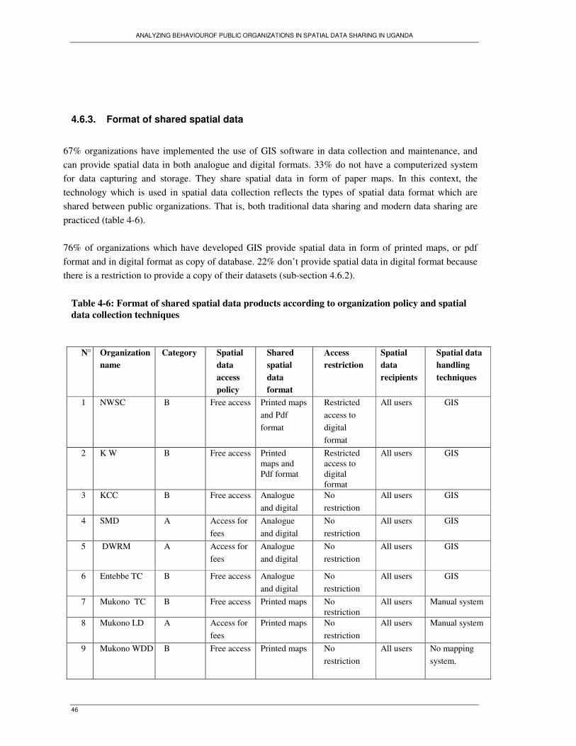
ANALYZING BEHAVIOUROF PUBLIC ORGANIZATIONS IN SPATIAL DATA SHARING IN UGANDA
46
4.6.3. Format of shared spatial data
67% organizations have implemented the use of GIS software in data collection and maintenance, and
can provide spatial data in both analogue and digital formats. 33% do not have a computerized system
for data capturing and storage. They share spatial data in form of paper maps. In this context, the
technology which is used in spatial data collection reflects the types of spatial data format which are
shared between public organizations. That is, both traditional data sharing and modern data sharing are
practiced (table 4-6).
76% of organizations which have developed GIS provide spatial data in form of printed maps, or pdf
format and in digital format as copy of database. 22% don’t provide spatial data in digital format because
there is a restriction to provide a copy of their datasets (sub-section 4.6.2).
Table 4-6: Format of shared spatial data products according to organization policy and spatial
data collection techniques
N° Organization
name
Category Spatial
data
access
policy
Shared
spatial
data
format
Access
restriction
Spatial
data
recipients
Spatial data
handling
techniques
1 NWSC B Free access Printed maps
and Pdf
format
Restricted
access to
digital
format
All users GIS
2 K W B Free access Printed maps and
Pdf format
Restricted access to
digital format
All users GIS
3 KCC B Free access Analogue
and digital
No
restriction
All users GIS
4 SMD A Access for
fees
Analogue
and digital
No
restriction
All users GIS
5 DWRM A Access for
fees
Analogue
and digital
No
restriction
All users GIS
6 Entebbe TC B Free access Analogue
and digital
No
restriction
All users GIS
7 Mukono TC B Free access Printed maps No restriction
All users Manual system
8 Mukono LD A Access for
fees
Printed maps No
restriction
All users Manual system
9 Mukono WDD B Free access Printed maps No
restriction
All users No mapping
system.

ANALYZING BEHAVIOUROF PUBLIC ORGANIZATIONS IN SPATIAL DATA SHARING IN UGANDA
47
4.6.4. Spatial data sharing relationships
All organizations have developed informal spatial data sharing relations with their partners. Spatial data
are provided to users on demand basis. The request for spatial data provision is made through written and
verbal request. Personal contact to the officer who authorizes the provision of spatial data is the most
used way for making data request. Most of all organizations do not have partners that they provide
spatial data on a schedule basis. Only one organization in the study, DWRM has signed a memorandum
of understanding with the UMD on spatial data collection, processing, analysis, dissemination and
exchange. Spatial data are exchanged upon completion of collection and processing of spatial dataset.
DWRM has a formal cooperation with UMD, but shares spatial data with other users through informal
relations as well as other organizations.
Table 4-7: Spatial data sharing relations
Data sharing relationships Organization number
Informal data sharing relationships 8
Formal and informal data sharing relationships 1
Total 9
4.6.5. Internal coordination of spatial data sharing activities
In all visited organizations, the activities of spatial data sharing are coordinated at organization level.
There are internal regulations that are followed in spatial data provision to the users. Depending on the
structure of organization, the officers who coordinate the provision of spatial data are heads of
department, commissioners, and head of survey unity, chief administrative officer, or town clerk. Town
Clerk is the Technical Head of the Council while the commissioner is like the head of department. There
are few cases in which respondents cited the director general to participate in spatial data sharing process
(table 4-8). Official documents like data dissemination policy (appendix 4), memorandum of
understanding on data exchange (appendix 5) and local government act, provide that the request for
spatial data is addressed to the commissioner or head of department or the town clerk as officers who
deal with information dissemination and participate in decision making on data sharing.

ANALYZING BEHAVIOUROF PUBLIC ORGANIZATIONS IN SPATIAL DATA SHARING IN UGANDA
48
Table 4-8: Officer coordinating information sharing
The request for spatial data is generally made through physical contact with the officer (table 4-8) who
coordinates spatial data sharing and who decides on spatial data provision. At national level, whenever
the request for spatial data is addressed to the director general, it is sent to and handled at the department
level. At local level the request for spatial data is addressed to the town clerk. After approval of the
request, the officer instructs the technical staff in possession of spatial data to provide it to the customer.
The work procedure is similar in all organizations although there are cases some technical staffs can
provide spatial data without the approval of the head of department or unity. 71% of respondents believe
that the authorization of the officer is prerequisite to release spatial data, because once the request for
spatial data is approved, they receive instructions to provide it to the recipients. 29% of them perceive
that they can make their decision on spatial data sharing as shown by table 4-9.
Table 4-9: Perception on level of individual decision on data provision
N° Decision Percentage of respondent
1 Dependence on decision of
officer
71%
2 Individual decision 29%
4.7. Trends of change in spatial data sharing policy
The study investigated if public organizations in Uganda tend to change spatial data sharing policy and
align with each other spatial data sharing policy. Through interviews, respondents were asked whether
organizations charging fees for spatial data sharing have ever changed the policy and provided spatial
data for free or vice versa. 100 % of respondents reported that their organizations have not changed
spatial data sharing policy. The policy has remained the same over time as shown in table 4-10.
Officer Frequency of
responses
Head of department 37%
Commissioner 35%
Town clerk or chief administrative officer 18%
Head of survey unity 6%
Director general or permanent secretary 4%
Total 100%

ANALYZING BEHAVIOUROF PUBLIC ORGANIZATIONS IN SPATIAL DATA SHARING IN UGANDA
49
Table 4-10: Frequencies of responses about change in spatial data sharing policy
Response Percentage of respondents
Our organization has not changed spatial data
sharing data policy
33%
The policy has always been the same 67%
Total 100%
Table 4-10 shows that organizations have not changed their policies in spatial data sharing. However,
through the discussion on the ways visited organizations cooperate with other government organizations,
staffs reported that public organizations do not pay fees in spatial data sharing practices. That is, spatial
data sharing practices contrast with the spatial data sharing policy in theory.
Organizations in category A, namely SMD, DWRM and Mukono LD initially follow pricing policy.
They charge fees for spatial data access for all users, including government bodies. However, staffs from
organizations in category A, and other organizations in category B, like KCC, Mukono LD, and KCC
reported that since 2000, those organizations do not pose the payment conditions to other government
organizations when they cooperate in spatial data sharing. Respondents from those organizations stated
that, when the request for spatial data is from the top management level like from the minister or
permanent secretary, spatial data are provided for free. Moreover, spatial data are provided for free if
there is a formal agreement like a memorandum of understanding or informal agreement on spatial data
exchange between the managers from spatial data provider and spatial data recipient.
In the discussion held with staffs from the Department of Geological Survey and Mines, under the
Ministry of Energy and Mineral Development, they stated that since 1999, the department shares spatial
data with other government bodies for free. However, the policy on spatial data dissemination provides
that spatial data are distributed to users upon payment of a nominal reproduction cost reflected in the
price list. Only research organizations receive spatial data free of charge (appendix 3). Current practices
of sharing spatial data for free reflect change in behaviour of organizations towards spatial data sharing.
They result from the awareness to free exchange of spatial data between government organizations as
stated by interviewees. The general argument is that government bodies should share spatial data for free
if they are used for the public interest.
Changes in organizations behaviour towards spatial data sharing are discussed an existing literature on
spatial data sharing in Uganda. In his report on development of environmental information systems in
Uganda, Moyin, Y. et al., (2000) pointed out that, since 2000, government organizations which generally
had to charge fees for spatial data sharing with other government organizations, have started to share
spatial data for free with those organizations and other organizations that are non-commercial. In 2000,
under NEMA initiative, an Environment Information Network (EIN) was established. It comprises
organizations producing main spatial datasets like agricultural, meteorological, topographical and other
spatial data related to forests, soil and biodiversity. Organizations constituting the network, are namely

ANALYZING BEHAVIOUROF PUBLIC ORGANIZATIONS IN SPATIAL DATA SHARING IN UGANDA
50
Department of Agricultural Planning, Department of Land and Surveys, Department of
Meteorology, Kawanda Agricultural Research Institute, NARO, Makerere Institute of Environment and
Natural Resources, National Biomass Study, Forest Department, and have signed a MoU on free data
exchange (Karatunga 2002).The aim of the network was to exchange information in compatible formats
at minimal cost, to solve problems related to spatial data access, and to promote the management of
natural resources and environment (Schwarte 2008). The constitution of the network was a decisive step
for those organizations to start sharing spatial data for free with each other, while initially spatial data
were shared upon payment of access fees.
Through interviews, respondents from SMD agued that their organization shares spatial data for free
with other members in the network from the time they started to cooperate under EIN. These arguments
confirm the ideas of Schwarte (2008) who stated that organizations which initially have pricing policy in
spatial data sharing and had to charge fees for access to spatial data have started to share spatial data for
free charge since the time the EIN was created. Working under a framework is recognized is a driver for
change in organizations behaviour and adoption of similar practices. When organizations are tied through
network, they adopt and share similar norms and thereby behave alike. Organizations network constitute
a normative template facilitating the diffusion of appropriate norms that organizations have to follow in
discourse of their missions (Frumkin and Galaskiewicz 2004). It is in this context that public
organizations in Uganda which are tied by EIN have adopted new norms related to spatial data sharing.
Table 4-11 shows changes in spatial data sharing practices since the time public organizations in Uganda
started to cooperate under EIN.
Table 4-11: Comparison between spatial data sharing policy and practices after 2000
Organization
name
Official spatial
data sharing policy
for all users
Term on spatial
data access in
practice
( for government
organizations)
Driver of change in term on
spatial data access
Beginning of
practices
DWRM Access for fees Free charge - Cooperation under EIN
- Informal agreement on spatial
data exchange; MOU; Official
request from top management
2001
SMD Access for fees Free charge - Cooperation under EIN
- Informal agreement on spatial
data exchange; MOU; Official
request from top management
2000
Mukono LD Access for fees Free charge - Informal agreement on spatial
data exchange
- Official request from top
management
2003

ANALYZING BEHAVIOUROF PUBLIC ORGANIZATIONS IN SPATIAL DATA SHARING IN UGANDA
51
Table 4-11 shows changes in spatial data sharing practices. These changes are driven by awareness on
free exchange of spatial data between government organizations. They are made possible by decision
makers who informally contact each other and agree on free exchange of spatial data. Stakeholders
perceive that it is not relevant to charge fees on spatial data access for government organizations. They
support free access policy when government organizations cooperate between each other, as shown by
figure 4-4. In the opinions of most of respondents (88%), spatial data access should be free when sharing
involves government agencies, and fees should be charged for private users. Only 12% of respondents
support charging fees for spatial data access when sharing spatial data with other governments.
Figure 4-4: Perception on spatial data access policy between government organizations
4.8. Inter-organization consultation on spatial data sharing policy
The survey investigated if organizations contact each other when they formulate spatial data sharing
policy or when they handle any matters related to spatial data sharing. 78 % of respondents reported
that their organizations do not contact other organizations when they decide on the policy to share spatial
data with external users as reported in table 4-12:
Table 4-12: Opinions on inter-organization agreement on spatial data sharing policy
Opinions Respondent number
( appendix 2)
“Our organization does not look at other organizations practices. There is
not any body that gives advice or directives on the ways to share data with
external users”
27
“Our organization does not copy practices of other organizations.
Government organizations have their procedures in data sharing”
29
“We do not have to discover what other organizations do when they share
data, before we provide our data to public”
30
“I do not think that we have to contact other organizations about data
sharing”
34
12
88Free access
Access for fees
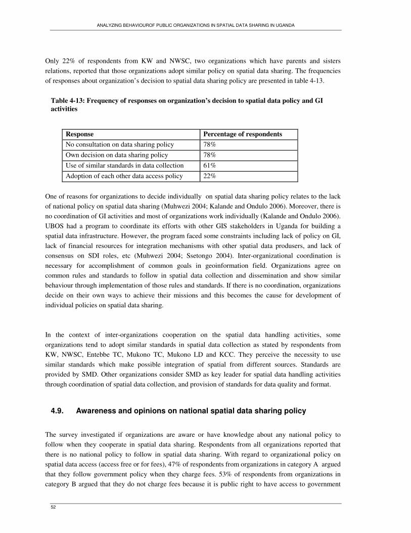
ANALYZING BEHAVIOUROF PUBLIC ORGANIZATIONS IN SPATIAL DATA SHARING IN UGANDA
52
Only 22% of respondents from KW and NWSC, two organizations which have parents and sisters
relations, reported that those organizations adopt similar policy on spatial data sharing. The frequencies
of responses about organization’s decision to spatial data sharing policy are presented in table 4-13.
Table 4-13: Frequency of responses on organization’s decision to spatial data policy and GI
activities
Response Percentage of respondents
No consultation on data sharing policy 78%
Own decision on data sharing policy 78%
Use of similar standards in data collection 61%
Adoption of each other data access policy 22%
One of reasons for organizations to decide individually on spatial data sharing policy relates to the lack
of national policy on spatial data sharing (Muhwezi 2004; Kalande and Ondulo 2006). Moreover, there is
no coordination of GI activities and most of organizations work individually (Kalande and Ondulo 2006).
UBOS had a program to coordinate its efforts with other GIS stakeholders in Uganda for building a
spatial data infrastructure. However, the program faced some constraints including lack of policy on GI,
lack of financial resources for integration mechanisms with other spatial data produsers, and lack of
consensus on SDI roles, etc (Muhwezi 2004; Ssetongo 2004). Inter-organizational coordination is
necessary for accomplishment of common goals in geoinformation field. Organizations agree on
common rules and standards to follow in spatial data collection and dissemination and show similar
behaviour through implementation of those rules and standards. If there is no coordination, organizations
decide on their own ways to achieve their missions and this becomes the cause for development of
individual policies on spatial data sharing.
In the context of inter-organizations cooperation on the spatial data handling activities, some
organizations tend to adopt similar standards in spatial data collection as stated by respondents from
KW, NWSC, Entebbe TC, Mukono TC, Mukono LD and KCC. They perceive the necessity to use
similar standards which make possible integration of spatial from different sources. Standards are
provided by SMD. Other organizations consider SMD as key leader for spatial data handling activities
through coordination of spatial data collection, and provision of standards for data quality and format.
4.9. Awareness and opinions on national spatial data sharing policy
The survey investigated if organizations are aware or have knowledge about any national policy to
follow when they cooperate in spatial data sharing. Respondents from all organizations reported that
there is no national policy to follow in spatial data sharing. With regard to organizational policy on
spatial data access (access free or for fees), 47% of respondents from organizations in category A argued
that they follow government policy when they charge fees. 53% of respondents from organizations in
category B argued that they do not charge fees because it is public right to have access to government

ANALYZING BEHAVIOUROF PUBLIC ORGANIZATIONS IN SPATIAL DATA SHARING IN UGANDA
53
information as stipulated in national constitution. This category does not attach any economic value to
spatial data, and uses it for the achievement of its activities. Spatial data is considered as a public good
to share for free for social benefit. It is used as input to organization missions as stated by one of
respondent who said that “data are not used as source of revenue, there are used as input for any work”
(resp.12). Table 4-14 presents the summary of the respondents’ perceptions about environment influence
on organization decision on spatial data sharing policy.
Table 4-14: Perception about environment influence on organization decision on spatial data
access policy
Opinion on environment influence on
formulation data access policy
Organization
number
Number of
respondents
Percentage of
respondents
Government policy for charging fees 3 21 47%
Public right and national constitution for
free data access
6 24 53%
No national policy on spatial data sharing 9 45 100%
4.10. General observations on spatial data provision
This section presents the summary of observations made in visited offices during the field work.
The first observation was made at Kampala water office, on 5th October 2009, when a staff from
technical department was being provided a water network map showing the location of water
infrastructures in Nakulabye zone, in Kampala city. This case concerned the internal spatial data sharing
between GIS section and technical department. The staff who was looking for the map came in the office
of GIS unity, talked to a GIS staff and asked him to print a map of the aforementioned zone. The GIS
staff visualized on computer screen the portion of Kampala water network, showing the extension of the
water infrastructures of the target zone. He asked the staff if he could identify on the map the water
infrastructures he was looking for. They agreed that the zone is well selected and the map showed the
requested information. The GIS staff printed then the map and handed it to the user.
After that observation, I had a short discussion with the GIS staff on the way KW provides the water
maps to the users. He reported that the provision of maps follows the same processes. If the users come
in the office, they explain what map they want. The map is visualized before the printing process, so that
the staff makes sure if the map contains the information the users need. If there is any missing
information, it can be added if it is available. If the maps are requested through phones calls or written
letter, the requesters give details about the type of information they need and GIS staffs prepare the maps
according to the details provided in the request.
The second observation was made at Entebbe, in the DRWM, in the office of GIS, at 10:12 Am, of 14th
October 2009, when a GIS staff was preparing a rainfall map of Uganda (appendix 9). The map was
being provided to external customer. The customer was a consultant in underground water assessment

ANALYZING BEHAVIOUROF PUBLIC ORGANIZATIONS IN SPATIAL DATA SHARING IN UGANDA
54
studies, for UNICEF, at Kampala office. He came in GIS office at DWRM and presented to the GIS
technician the receipt from bank, proving the payment for two sheets of maps. After the presentation of
the receipt, the GIS technician printed two maps, AO formats, for the customer. The customer checked
the maps, and found out some typing errors. He asked the staff to correct the errors. After the correction,
the maps were reprinted and handed out to the customer.
I asked to the GIS technician some questions about the process for the payment; because I realized that
the customer came in the office with the receipt for collecting the maps that were already prepared. The
staff told me that the customer had passed in the office the day before. She reported that when people
need spatial data, they go to the office, make request and give details about what types of spatial data
they want. The staffs give them information about payment process. The customers go and pay
prescribed fees to the bank and come back to the office to collect the requested spatial data. If the
requested spatial data are available, they are immediately delivered. If they are not in requested formats,
the staffs agree with the users on time the requested data can be provided. The staff told me that the ways
she processed the requests from that customer is similar to the ways she handles the requests for any
spatial data from other customers.
The final observations related to the aspect of the offices of the visited organizations. Organizations like
KW, NWSC, DWRM, SMD, and KCC have implemented a GIS, and their GIS units are well equipped
with new computers, small printers and plotters that are used for printing the maps at different formats.
There were different printed maps hanging on the walls of the offices. This aspect directly shows at what
extend those organizations are using information technology in spatial data capturing and management.
But that was not the case at Mukono TC, and Mukono LD where staffs are still using traditional
equipments. Maps are manually produced with paper and pencils. These observations show differences
in term of use of GIS technology in spatial data handling as discussed in section 4.2 of this chapter.
4.11. Conclusion
The aim of this chapter was to find the answers to the following questions:
1. What are spatial data sharing policies followed by public organizations in Uganda?
2. Do spatial data sharing policies change and tend to look similar over time?
Question 1: Findings show that public organizations follow two policies in spatial data sharing. Some
adopt pricing policy and charge fees for access to spatial data. Others adopt free access policy and
provide spatial data for free. Free access is the most adopted policy. In all organizations, spatial data are
shared on demand basis, in both analogue and digital format depending on the capacity of organizations
to produce spatial data in analogue or digital formats, in relation with the technology which is used in
spatial data capturing. However, there are few organizations which have restriction on access to spatial
data in digital format. Spatial data are accessed at organization offices and informal spatial data sharing
relationships are the most types of relations that characterize organizations cooperation in spatial data
sharing.

ANALYZING BEHAVIOUROF PUBLIC ORGANIZATIONS IN SPATIAL DATA SHARING IN UGANDA
55
Question 2: The study finds that the current spatial data sharing policies remain similar compared to
initial stages, but in practices there are changes in spatial data sharing. From early 2000s, organizations
which follow pricing policy show new behaviour and have started to share spatial data for frees with
other government organizations. However, the policy was initially to charge fees for all users of data,
being government or private and individuals. The new behaviour reflects changes in spatial data sharing
practices. Public organizations in Uganda tend to share spatial data for free, and charging fees for spatial
data access is currently applied for private organizations and individual users.
ANALYZING BEHAVIOUROF PUBLIC ORGANIZATIONS IN SPATIAL DATA SHARING IN UGANDA
56
5. Spatial data sharing policies and practices in Uganda
The results of fieldwork presented in previous chapter provided some indicators of current behaviour of
organizations in spatial data sharing cooperation and changes in spatial data sharing practices. These
indicators describe spatial data sharing practices, and help to find out if public organizations in Uganda
show similar or dissimilar behaviour, and if their behaviour reflects any isomorphism trend. The aim of
this chapter is to find an answer to the following research question: Do organizations show any
isomorphic behaviour in adopting spatial data sharing policies?
The chapter is structured as follows: the first section explains which influential factors affect
organizations behaviour in adopting spatial data sharing policy. The second section describes spatial data
sharing practices in relation to the national law on access to information. The final section presents the
analysis of isomorphism trends observed in spatial data sharing practices.
5.1. Duality of spatial data sharing policies
Two spatial data sharing policies were distinguished in the previous chapter. Table 4-6 shows that some
organizations share spatial data for free, whereas others share spatial data for fees. Various factors
pushing organizations to adopt any spatial data sharing policy are explained according to stakeholders’
opinions. Some organizations charge fees for access to spatial data in compliance to rules and
regulations guiding their activities within the sector they operate, while other organizations do not follow
any regulations and consider spatial data as a resource to share for free and input for the achievement of
their missions.
5.1.1. Pricing policy
Pricing policy is adopted by organizations under category A as presented in previous chapter. According
to survey responses, there are different reasons for charging fees in spatial data sharing. Organizations in
category A, like SMD and Mukono LD, operating in land sector, charge fees in spatial data sharing in
compliance to the registration of titles acts and land sector strategic plan which prescribe that the public
have to pay fees for access to land information and cadastral data ( table 5-1). Other motives for charging
fees related to the revenue generation purpose, in relation with the requirements from the Ministry of
Finance. Respondents from SMD and DWRM stated that their organizations charge fees for access to
spatial data because they report every year to the Ministry of Finance how much money they collect from
the services they provide to the public. One respondent from DRWM argued that the Ministry expects
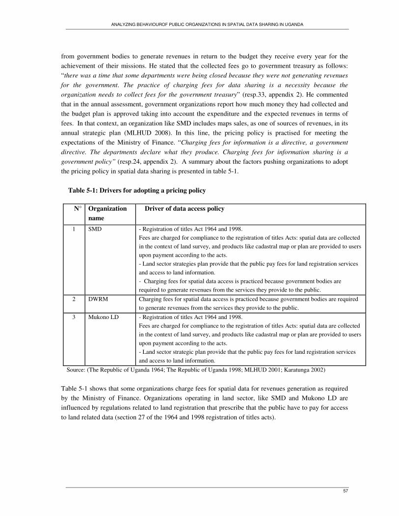
ANALYZING BEHAVIOUROF PUBLIC ORGANIZATIONS IN SPATIAL DATA SHARING IN UGANDA
57
from government bodies to generate revenues in return to the budget they receive every year for the
achievement of their missions. He stated that the collected fees go to government treasury as follows:
“there was a time that some departments were being closed because they were not generating revenues
for the government. The practice of charging fees for data sharing is a necessity because the
organization needs to collect fees for the government treasury” (resp.33, appendix 2). He commented
that in the annual assessment, government organizations report how much money they had collected and
the budget plan is approved taking into account the expenditure and the expected revenues in terms of
fees. In that context, an organization like SMD includes maps sales, as one of sources of revenues, in its
annual strategic plan (MLHUD 2008). In this line, the pricing policy is practised for meeting the
expectations of the Ministry of Finance. “Charging fees for information is a directive, a government
directive. The departments declare what they produce. Charging fees for information sharing is a
government policy” (resp.24, appendix 2). A summary about the factors pushing organizations to adopt
the pricing policy in spatial data sharing is presented in table 5-1.
Table 5-1: Drivers for adopting a pricing policy
N° Organization
name
Driver of data access policy
1 SMD - Registration of titles Act 1964 and 1998.
Fees are charged for compliance to the registration of titles Acts: spatial data are collected
in the context of land survey, and products like cadastral map or plan are provided to users
upon payment according to the acts.
- Land sector strategies plan provide that the public pay fees for land registration services
and access to land information.
- Charging fees for spatial data access is practiced because government bodies are
required to generate revenues from the services they provide to the public.
2 DWRM Charging fees for spatial data access is practiced because government bodies are required
to generate revenues from the services they provide to the public.
3 Mukono LD - Registration of titles Act 1964 and 1998.
Fees are charged for compliance to the registration of titles Acts: spatial data are collected
in the context of land survey, and products like cadastral map or plan are provided to users
upon payment according to the acts.
- Land sector strategic plan provide that the public pay fees for land registration services
and access to land information.
Source: (The Republic of Uganda 1964; The Republic of Uganda 1998; MLHUD 2001; Karatunga 2002)
Table 5-1 shows that some organizations charge fees for spatial data for revenues generation as required
by the Ministry of Finance. Organizations operating in land sector, like SMD and Mukono LD are
influenced by regulations related to land registration that prescribe that the public have to pay for access
to land related data (section 27 of the 1964 and 1998 registration of titles acts).

ANALYZING BEHAVIOUROF PUBLIC ORGANIZATIONS IN SPATIAL DATA SHARING IN UGANDA
58
5.1.2. Disparities in data prices
Organizations which follow pricing policy in spatial data sharing do not adopt similar prices for spatial
data products. Tables 4-4 and 4-5 show that there are disparities in data prices when comparing the price
for the same type of GI product from one organization to another. There are different reasons for
organizations to adopt different prices:
- Prices for spatial data are individually determined taking into consideration the cost of data, the cost for
data processing and staff, and the cost involved in data provision (like printing of maps). As shown in
table 4-12, 78% of respondents stated that the decision on data sharing is made individually. As
organizations that charge fees for data access do not consult each other, they thereby set different prices
for similar spatial data.
- There is no national pricing policy for spatial data. Organizations follow individually and internally
developed written or unwritten policies on spatial data sharing, although the policy may incidentally be
similar for different organizations. Previous studies highlight the necessity for the formulation of the
national policy on spatial data sharing (Musinguzi 2004; Kalande and Ondul bo 2006; Kayondo
Ndandiko 2007, Nyemera 2008). The national Access to Information Act states that the ministry tasked
with its implementation will determine the prices for data where access to information requires the
payment of fees, but in the practice, there are no national prices to follow (Schwarte 2008).
5.1.3. Free access policy
67% of the visited organizations (figure 4.2) have adopted free access policies. Those organizations were
classified in category B. Respondents from those organizations consider spatial data as a resource to
share with other stakeholders, and a freely sharable good for the public. In their opinions, spatial data are
provided for free because the information is for the public. Free access to spatial data is a mechanism
allowing its optimal use for the public interest and meeting organizations goals. They perceive that their
organizations provide spatial data for free as stated by the national constitution which prescribes that the
public have the right to access to government information.
5.1.4. Conclusion on disparity in data sharing policies
Public organizations in Uganda adopt different policies in spatial data sharing for different reasons. Most
of organizations, in category B share spatial data for free in respect to government constitution that
provides freedom of the public to have access to information held by government bodies. Other
organizations, in category A, charge fees for spatial data access and make it available to all users upon
payment of prescribed fees. The practice for charging fees is backed by the government since the
national law on access to information provides that fee can be charged for access to data depending on

ANALYZING BEHAVIOUROF PUBLIC ORGANIZATIONS IN SPATIAL DATA SHARING IN UGANDA
59
the types of requested data. However, the law does not define the prices for access to data held by any
public organizations. This law needs amendment and should include pricing list for data that the public
have to pay for, so that organizations could follow similar pricing list for data access. In the field of
geoinformation, there is an organization like SMD that plays key roles in coordinating spatial data
handling activities (section 4.2.1). This organization should set standards prices for spatial data at
national level for solving disparities observed in spatial data prices. This may be effective because, in
relation to its mandate, it controls other organizations in GI activities and it is the main provider for
spatial data (figure 4-1). If SMD sets standards prices for spatial data, other organizations may follow
those prices as well they adopt and conform to data standards it provides (table 4-13).
5.2. Government legislation on information sharing and organizations practices
The study finds that the procedures related to spatial data provision look alike and are coordinated in a
similar way within all organizations. They are followed as informal rules as the procedures proposed in
the national law on public access to information as presented in the table 5-2. The table compares the
practices of organizations in spatial data sharing and what the government law prescribes as the
procedures and legal matters guiding the access to data held by a government body.

ANALYZING BEHAVIOUROF PUBLIC ORGANIZATIONS IN SPATIAL DATA SHARING IN UGANDA
60
Table 5-2: Government directives on access to information and organizations practices
Theme Government directives
( “The access to information Act, 2005”)
Organization practices and policy on
ground
Right of
access
Section 5:
(1) Every citizen has a right of access to
information and records in the possession of
the State or any public body, except where the
release of the information is likely to prejudice
the security or sovereignty of the State or
interfere with the right to the privacy of any
other person
All organizations share spatial data on their
possession with all users: public and private
organizations, and individuals.
Form of
request
Section 11:
(1) A request for access to a record or
information shall be in writing in the
prescribed form to the information officer of
the public body in control of the record or
information required and shall provide
sufficient details to enable an experienced
employee of the body to identify the record or
information
In all organizations, spatial data are provided
on demand, through written and verbal request
for data. Verbal request is the most used way
to request for data.
Payment for
access
Section 20
(1) Where a person has been notified under
section 16(1) that the request for access has
been granted, that person shall be given access,
subject to subsections (3) and (10);
(a) where an access fee is payable, upon
payment of that fee
Organizations that charge fees provide spatial
data to the users, upon payment of requested
fees. The payment is made at organization‘s
cashier or at bank account.
Free access (b) where no access fee is payable,
immediately, be given access in the applicable
forms referred to in subsection (2) as the
person indicated in the request for access
All organizations provide spatial data
immediately upon the approval of the request
by the officer who authorizes the provision of
spatial data as long as the requested spatial
data are available.
Chargeable
fees
Section 47:
Fees for access are cost of retrieval and
reproduction of the information
Charged fees are cost for spatial data
reproduction fees or minimal cost for spatial
data collection.
Information
officer
Chief Executive of each public body In all organizations, there is an officer who
authorizes the provision of spatial data to the
users: commissioner or head of department;
chief administrative officer of district; town
clerk; head of department or GIS/survey unity.

ANALYZING BEHAVIOUROF PUBLIC ORGANIZATIONS IN SPATIAL DATA SHARING IN UGANDA
61
Theme Government directives
(“The access to information Act, 2005”)
Organization practices and
policy on ground
Forms of access and
data format
Data are supplied in printed records, in copy of images,
sounds, in electronic copy of record
(2) The forms of access to a record in respect of which
a request of access has been granted are:
(a) if the record is in written or printed form, by
supplying a copy of the record or by making
arrangements for the inspection of the record;
(b) if the record is not in written or printed form:
(i) in the case of a record from which visual images or
printed transcriptions of those images are capable of
being reproduced by means of equipment which is
ordinarily available to the public body concerned, by
making arrangements to view those images or be
supplied with copies or transcriptions of them;
…….
(iii)in the case of a record which is held on computer,
or in electronic or machine readable form, and from
which the public body concerned is capable of producing
a printed copy of:
(aa) the record, or a part of it; or
(ab) information derived from the record, by using
computer equipment and expertise ordinarily available to
the public body, by supplying such a copy;
(iv) in the case of a record available or capable of
being made available in computer readable form, by
supplying a copy in that form; or
(v) in any other case, by supplying a copy of the
record.
Spatial data are provided in both
analogue and digital format.
All organizations can share spatial
data in analogue format.
67% of organizations which hold
spatial data in vector and raster
formats provide them in digital
format as copy of database.
37% of organizations restrict the
provision of spatial data in digital
format for the security of their
database. This behaviour does not
conflict with the law as it states that
data access can be refused if there
are motives for the holder to refuse
the access to data.
Source: (The Republic of Uganda 2005)
The comparison was made to examine the extent to which organizations in the study behave according to
the national law on data access or if their behaviour in spatial data sharing practices conflicts with the
law. Tables 5-2 shows that, the behaviour of public organizations in Uganda in spatial data sharing
practices relates to the national law on access to information held by government body. Organizations
provide spatial data for free or fees, define similar procedures on data access as prescribed by the law,
and data are provided in both analogue and digital format as stated in the law. The law does not also
conflict with other regulations like the registration of titles Acts, followed by organizations operating in
land sector, like SMD and Mukono LD, when they charge fees for spatial data access. In general
organizations behave according to the national law. It seems as if the law constitutes a legal back for
organizations practices in spatial data sharing since it was enacted in 2005, while all organizations
engaged in spatial data sharing before 2000.

ANALYZING BEHAVIOUROF PUBLIC ORGANIZATIONS IN SPATIAL DATA SHARING IN UGANDA
62
5.3. Discussion regarding isomorphism trends and change in spatial data sharing policies
The results presented in chapter 4, show that there are indicators of isomorphism trends in spatial data
handling and sharing in public sector in Uganda. These trends relate to adoption of spatial data
standards which enable the integration of spatial data from different sources, organization decision on
spatial data sharing policies and changes in spatial data sharing practices.
5.3.1. Isomorphism trends in adopting similar standards in spatial data collection
Table 4-13, shows how by 61% of respondents reported that their organizations cooperate with SMD and
use similar spatial data standards in data collection. This behaviour is a response to uncertainty most of
organizations using spatial data in Uganda had faced from several years as pointed out by previous
studies. Those studies mentioned the use of different standards as one of barrier for spatial data sharing
in Uganda because, there were no standards to follow at initial stage of GIS development. Some of
efforts so far made, are the development of spatial data standards in 2000, under World Bank, for the
development of SDI, and public organizations were invited to follow those standards (Karatunga 2002).
Staffs from KW, NWSC, Entebbe TC, Mukono TC, Mukono LD and KCC, stated having started to
collect spatial data according to national standards as provided by the leading agency of the survey
activities at national level. This change in organization behaviour seems to be a response to government
recommendation, as stated in SDI decree which invites spatial data produsers, to use similar standards
for solving the problems that may impede the development of SDI, as follow: “use of common technical
standards, including a common geodetic reference frame, so that data from numerous databases can be
brought together to create new products and solve new problems, both nationally and locally (appendix
10).
5.3.2. Isomorphism trends in adopting spatial data sharing policy
Findings presented in table 5-1 show that organizations in category A face different influences pushing
them to charge fees in spatial data sharing. Organizations operating in land sector, namely SMD and
Mukono decide on spatial data sharing in compliance to registration of titles acts of 1964 and 1998 and
land sector strategic plan of 2001. The registration of titles acts and land sector strategic plan prescribe
the norms those organizations have to follow in the activities related to land registrations and
dissemination of land information. The general rule is that the users have to pay fees for access to land
information or cadastral data. It is in this context those organizations have adopted the practice for
charging fees to any users of spatial data they collect, being public or private organization and
individuals.
ANALYZING BEHAVIOUROF PUBLIC ORGANIZATIONS IN SPATIAL DATA SHARING IN UGANDA
63
Moreover, SMD and DWRM which operates in water resources management, comply with the
expectation from the Ministry of Finance to generate fees that go to the public treasury. Generating fees
for the public treasury is a requirement for all government organizations in Uganda. The fund was
created to receive the revenues or monies raised or received by government bodies for the purpose of or
on behalf of, or in trust for the Government (The Republic of Uganda 1995). SMD and DWRM
have adopted similar strategies through charging fees in spatial data sharing for complying with
the expectations of the government. They engaged in spatial data sharing at different years (table 4-1),
but adopt similar norms on spatial data access to comply with the requirement of the Ministry of
Finance.
Another aspect of isomorphism trend in relation with organization decision on spatial data sharing was
identified within organizations in category B, which have adopted, at different times (table 4-1), similar
spatial data sharing policy. Those organizations share similar beliefs for sharing spatial data for free
(sub-section 5.1.3). There are not any environmental influences pushing them to adopt any spatial data
sharing policy, but follow the same principle in deciding on spatial data sharing policy. The fundamental
principle is the public right to government information. Free access to spatial data is believed to be a
mechanism to allow optimal use of spatial data for the public interest and meeting organizations goals.
In the category B, the study found a particular case which reflects also a trend of isomorphism. Table 4-
13 shows that there are organizations that consult each other and make similar decision on spatial data
sharing policy. This is the case for KW which is a sister organization for NWSC and adopt similar
spatial data sharing policy as NWSC. Respondents from both organizations reported that the decision
on spatial data sharing is made through inter-departmental meeting, grouping heads of departments and
unities in charge of collection and management of spatial data from both organizations. They agree on
similar policy and strategy to follow in spatial data sharing since they face similar environmental
constraints. As explained in sub-section 4.6.2, both organizations pose restriction on access to spatial
data in digital format, because they fear that if they provide the copy of spatial dataset, the recipients
may manipulate it and provide in return the false information to the public. That is why they adopt
similar behaviour in sharing only spatial data in form of maps.
5.3.3. Isomorphism trends and changes in spatial data sharing practices
Table 4-11 shows that organizations in category A, which follow pricing policy in spatial data sharing,
have adopted new behaviour in data sharing practices since 2000. Initially, those organizations charge
fees for data access to all users, government and private organizations and individuals. Before 2000,
government organizations as well as private organizations and individual had to make a request for
spatial data and pay access fees, before they could be provided the requested data. In current practices,
government organizations make a request for spatial data or spatial data provider and recipient make an
agreement on spatial data exchange, and then spatial data are provided without any payment conditions.
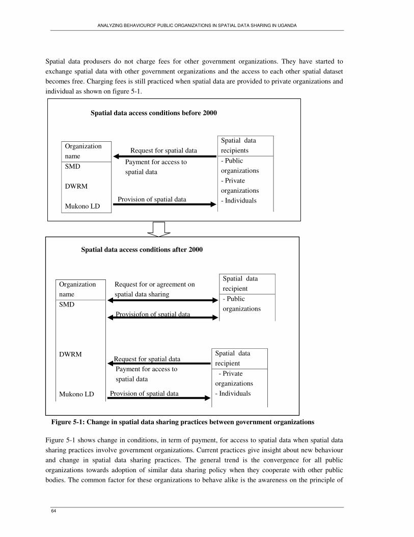
ANALYZING BEHAVIOUROF PUBLIC ORGANIZATIONS IN SPATIAL DATA SHARING IN UGANDA
64
Spatial data produsers do not charge fees for other government organizations. They have started to
exchange spatial data with other government organizations and the access to each other spatial dataset
becomes free. Charging fees is still practiced when spatial data are provided to private organizations and
individual as shown on figure 5-1.
Figure 5-1: Change in spatial data sharing practices between government organizations
Figure 5-1 shows change in conditions, in term of payment, for access to spatial data when spatial data
sharing practices involve government organizations. Current practices give insight about new behaviour
and change in spatial data sharing practices. The general trend is the convergence for all public
organizations towards adoption of similar data sharing policy when they cooperate with other public
bodies. The common factor for these organizations to behave alike is the awareness on the principle of
Organization
name
SMD
DWRM
Mukono LD
Spatial data
recipient
- Public
organizations
Request for or agreement on
spatial data sharing
Payment for access to
spatial data
Spatial data access conditions after 2000
Spatial data
recipient
- Private
organizations
- Individuals
Provisiofon of spatial data
Provision of spatial data
Request for spatial data
Organization
name
SMD
DWRM
Mukono LD
Spatial data
recipients
- Public
organizations
- Private
organizations
- Individuals
Request for spatial data
Payment for access to
spatial data
Provision of spatial data
Spatial data access conditions before 2000
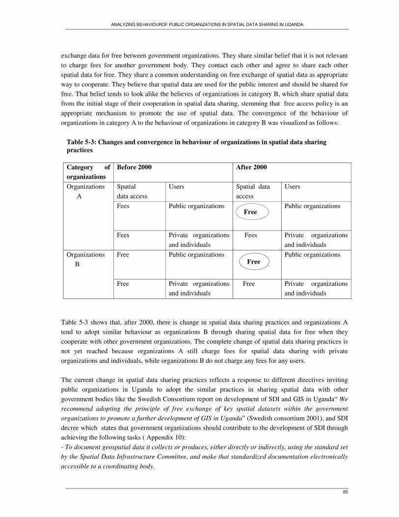
ANALYZING BEHAVIOUROF PUBLIC ORGANIZATIONS IN SPATIAL DATA SHARING IN UGANDA
65
exchange data for free between government organizations. They share similar belief that it is not relevant
to charge fees for another government body. They contact each other and agree to share each other
spatial data for free. They share a common understanding on free exchange of spatial data as appropriate
way to cooperate. They believe that spatial data are used for the public interest and should be shared for
free. That belief tends to look alike the believes of organizations in category B, which share spatial data
from the initial stage of their cooperation in spatial data sharing, stemming that free access policy is an
appropriate mechanism to promote the use of spatial data. The convergence of the behaviour of
organizations in category A to the behaviour of organizations in category B was visualized as follows:
Table 5-3: Changes and convergence in behaviour of organizations in spatial data sharing
practices
Table 5-3 shows that, after 2000, there is change in spatial data sharing practices and organizations A
tend to adopt similar behaviour as organizations B through sharing spatial data for free when they
cooperate with other government organizations. The complete change of spatial data sharing practices is
not yet reached because organizations A still charge fees for spatial data sharing with private
organizations and individuals, while organizations B do not charge any fees for any users.
The current change in spatial data sharing practices reflects a response to different directives inviting
public organizations in Uganda to adopt the similar practices in sharing spatial data with other
government bodies like the Swedish Consortium report on development of SDI and GIS in Uganda“ We
recommend adopting the principle of free exchange of key spatial datasets within the government
organizations to promote a further development of GIS in Uganda” (Swedish consortium 2001), and SDI
decree which states that government organizations should contribute to the development of SDI through
achieving the following tasks ( Appendix 10):
- To document geospatial data it collects or produces, either directly or indirectly, using the standard set
by the Spatial Data Infrastructure Committee, and make that standardized documentation electronically
accessible to a coordinating body.
Category of
organizations
Before 2000 After 2000
Spatial
data access
Users Spatial data
access
Users
Fees Public organizations
Public organizations
Organizations
A
Fees Private organizations
and individuals
Fees Private organizations
and individuals
Free Public organizations
Public organizations Organizations
B
Free Private organizations
and individuals
Free Private organizations
and individuals
Free
Free

ANALYZING BEHAVIOUROF PUBLIC ORGANIZATIONS IN SPATIAL DATA SHARING IN UGANDA
66
- To define their contribution to the National Key Data Set and distribute them freely to other
government agencies on request.
Based on change observed in current spatial data sharing practices, public organizations tend to behave
according to SDI decree and other directives regarding spatial data sharing, rather than according to
regulations or other requirements which had compelled them to charge fees for spatial data access.
5.4. Conclusion
Public organizations in Uganda, adopt two approaches on spatial data sharing. Some organizations
follow pricing policy and share spatial data for fees; others follow free access policy and provide spatial
data for free charge. Charging fees for data access is not illegal practice since the national law on access
to information prescribes that access to data held by government body may be provided upon payment of
fees if required by data holder. The challenge is still the promulgation of standard prices to harmonize
different spatial data prices that are individually set at organizational level. A part from disparities
observed in spatial data prices, public organizations in Uganda show similar behaviour in spatial data
sharing policies and practices. The answer to the question posed in the introduction of this chapter “Do
organizations show any isomorphic behaviour in adopting spatial data sharing policies?” is the
following:
- Organizations A face similar environmental influences pushing them to charge fees for spatial data
access, while organizations B share similar belief on free access to spatial data and decide to share
spatial data for free. Within the category B, the study finds that there are organizations namely KW and
NWSC that adopt similar strategy and make similar decision in sharing spatial data only in form of maps
and then restrict the access to spatial data in digital format.
- The study finds that organizations A which initially follow pricing policy in data sharing show new
behaviour that reflects change in data sharing practices. They are currently providing spatial data for
frees when sharing involves government organizations. The practice to charge fees for spatial data is
currently applied in sharing spatial data with private organizations and individuals.
In additional to that trends related to spatial data sharing policies, the study finds other isomorphism
trends in the activities of spatial data handling in Uganda:
- 67% of organizations have recently started to produce and maintain spatial data according to the
national standards, whereas they were using individual and different standards in collecting spatial data.
The use of different standards was claimed to be a barrier for the development of GIS in Uganda, so that
SDI decree recommended in 2000, the use of similar standards to overcome that barrier. The study
concludes that the adoption of similar standards in spatial data handling is a response to SDI
recommendation.

ANALYZING BEHAVIOUROF PUBLIC ORGANIZATIONS IN SPATIAL DATA SHARING IN UGANDA
67
6. Evaluation of isomorphism trends in spatial data sharing in Uganda
6.1. Introduction
This chapter draws a correlation between the findings from data analysis in chapter 5 and the theoretical
framework developed in chapter 2 to examine if public organizations in Uganda show any isomorphic
behaviour in spatial data sharing cooperation. The focal point of the isomorphism is that organizations
facing the same environment influences adopt similar practices and then become isomorphic with each
other. The chapter attempts to answer the following question: Do organizations behaviour in spatial data
sharing policies relate to any isomorphism process like coercive, normative or mimetic?
6.2. Isomorphic behaviourin inter-organizations data sharing practices
Findings presented in chapter 5, show that public organizations in Uganda show similar patterns in
making decision on spatial data sharing policies and other activities related to spatial data handling. The
question is then if those patterns reflect any of or all three processes of isomorphism, mimetic, coercive
and normative.
6.2.1. Coercive isomorphism
Section 2.4.1.1 discussed how coercive forces affect organizations practices through formal or informal
laws guiding organizations behaviour in relation to what they are mandated to do and how they have to
do it, and then become isomorphic. The results of the study, presented in section 5.4.3, show that
organizations like SMD, Mukono LD and DWRM which follow the pricing policy in spatial data
sharing, face similar coercive forces, compelling them to charge fees for spatial data access. These forces
result from land regulations and the requirement from the Ministry of Finance. They shape the behaviour
of these organizations in a similar way; following top down relations (table 2-5) as coercive forces affect
organizations practices.
On one hand, organizations operating in land sector, at both national level like SMD and local level, like
Mukono LD conform to titles registration acts and land sector strategic plan of Uganda. They charge fees
for spatial data sharing for compliance to those regulations and principles guiding the activities of land
sector within they operate. The titles registration acts and land sector strategic plan state that the users

ANALYZING BEHAVIOUROF PUBLIC ORGANIZATIONS IN SPATIAL DATA SHARING IN UGANDA
68
have to pay fees for access to land information and cadastral data. It is in that context of conformism that
those organizations adopted pricing policy in spatial data sharing. In a nutshell, they become isomorphic
though adoption of similar pricing policy by compliance to norms prescribed by the regulations.
On other hand, SMD and DWRM adopt pricing policy to comply with expectation from the Ministry of
Finance, for generating fees from the services they provide to the public. This requirement shapes the
behaviour of those organizations following top down relations and relates more to resource dependency
than legal requirement. Isomorphism theory asserts that organizations may show certain behaviour,
originating from other organizations of which they are dependent. In relation with the source of budget,
this study found that SMD, and DWRM depend on government funds for collecting and handling spatial
data (table 4-3). As government funds are allocated through the Ministry of Finance, the study found that
those organizations comply with the requirements from the Ministry of Finance as a consequence of
resource dependency. They charge fees for maintaining funding relations, rather than a voluntary
decision. Sub-section 5.1.1 and 5.3.2 discussed how SMD and DWRM are bound to collect fees which
go to the public treasury because their budget is approved on basis of the expected revenues. It is like
that those organizations face top down pressures for collecting fees. For those organizations, selling
spatial data is one of way to generate fees for meeting the requirement from the budget provider.
6.2.2. Normative isomorphism
Figures 5-1 and 5-2 show that there are changes in spatial data sharing practices between public
organizations. Organizations A (SMD, Mukono LD, and DWRM) which had to charge fees for access to
spatial data have started to share spatial data for free with other government organizations. Table 6-1
shows that change in the behaviour of organizations A relates to different influential factors.
Table 6-1: Patterns of normative isomorphism in spatial data sharing in Uganda
Isomorphism
pattern
Mechanism of
isomorphism Drivers or influential factors
Change in spatial
data access terms:
access for fees to
access for free
Organizations which
follow pricing policy
have adopted new
behaviour for sharing
spatial data for free when
they cooperate with other
government bodies.
- Organizations network (EIN) that allows organizations to
cooperate, and agree on rational norms to spatial data sharing
- Awareness on free data access between government bodies,
consultation between spatial data users and informal
agreement on spatial data exchange.
- SDI decree and Swedish consortium report which
recommends public organizations to exchange spatial data for
free.
Changes in spatial data sharing practices in Uganda have also been observed since public organizations
operating at national level, started to cooperate under EIN (section 4.7), through which they agreed to
exchange spatial datasets for free. It is in this context SMD and DWRM adopted new norms to follow in
spatial data sharing with other government organizations. Cooperation under network is a normative

ANALYZING BEHAVIOUROF PUBLIC ORGANIZATIONS IN SPATIAL DATA SHARING IN UGANDA
69
mechanism that shapes the behaviour of organizations because they choose the appropriate norms to
follow in their activities (table 2-5), and then become similar.
Further more, changes in spatial data sharing practices were observed at both national and local levels,
and relate to increased awareness of decision makers on free spatial data sharing policy. Heads of
departments and survey unities at SMD, DWRM and Mukono LD reported that the officers, coordinating
the activities related to spatial data collection and sharing, meet and agree on sharing spatial data for
free. They feel that spatial data should be shared for free between public bodies. Increased awareness on
free exchange of spatial data is the other factor for public organizations in Uganda to start sharing each
other spatial data for free. These awareness and change in the behaviour of organizations are the
responses to the recommendations of SDI decree and Swedish consortium report which invite public
organizations in Uganda to share spatial data for free. SDI decree and Swedish consortium report have
exerted normative effect on behaviour of organizations since 2000, when changes in spatial data sharing
practices have been observed (sub-section 5.4.4). The study found that, after 2000 organizations in
category B adopted new behaviour in similar way and started to conform to expectations of SDI decree
and spatial data users who expected public organizations (table 2-5) to share spatial data for free and
then promoting the use of geoinformation in public sector.
Another example of mechanism leading to normative isomorphism in spatial data sharing in Uganda is
the ways organizations share similar beliefs towards adopting spatial data sharing policy. Organizations
in category B show similar behaviour in making decision on spatial data sharing policy. They have
common belief that sharing data for free is appropriate way to promote the access and the use of spatial
data for users. Table 4-1 shows that Organizations in that category like KW, NWSC, Entebbe TC,
Mukono TC, Mukono WDD and KCC have started to share spatial data at different years, and adopted
similar policy on spatial data access. This convergence reflects an isomorphism process, resulting from
the common social belief affecting the behaviour of those organizations assuming that sharing spatial
data for free increases the optimal use of data and helps organizations to meet their goals. Moreover,
they state that they conform to the National constitution providing the freedom of the public to have
access on government data.
Within category B, the study observed another instance of normative isomorphism. Organizations like
NWSC and KW operating in water and sewerage services, at both national and local levels
respectively, have adopted similar norms in spatial data sharing. They share similar beliefs and
perceptions about the misuse of their datasets, and pose similar restriction on access to spatial data.
Section 5.3.2 discussed the motives for those organizations to restrict access to spatial data in digital
format, and explained that the decision on spatial data sharing policy is made through inter-department
meetings. The study found that those organizations share common understanding and opinions, and
then adopt similar strategy to cope with the environmental constraints that they face.
Public organizations in Uganda show also isomorphism behaviour in spatial data handling activities
through adoption and use of similar standards in spatial data collection. Section 5.4.2 discussed how
organizations like KW, NWSC, Entebbe TC, Mukono TC, Mukono LD and KCC have started to collect

ANALYZING BEHAVIOUROF PUBLIC ORGANIZATIONS IN SPATIAL DATA SHARING IN UGANDA
70
spatial data following national standards. Adoption of similar spatial data standards is an indicator of
change in organizations behaviour. The use of individual spatial data standards had characterized GI
activities in Uganda, and was barrier for the development of SDI. By adopting national standards, these
organizations which were using different standards, converge in similar direction and become
isomorphic. This case reflects the way change in organizations practices follow the principle of
normative process asserting that organizations change behaviour and look similar by learning and
adopting appropriate standards (table 2-5).
6.2.3. Summary of findings on isomorphism process
There are forces that affect the behaviour of public organizations in Uganda in spatial data sharing.
Those forces shape the behaviour of organizations which change in similar ways, and thereby become
isomorphic. On the one hand, isomorphism was observed in decision making towards spatial data sharing
policies, and in activities related to spatial data handling on the other hand. Table 6-2 shows that there
are the convergences of different organizations operating in different domains at both national and local
levels towards similar directions.

AN
AL
YZ
ING
BE
HA
VIO
UR
OF
PU
BLIC
OR
GA
NIZ
AT
ION
S IN
SP
AT
IAL D
AT
A S
HA
RIN
G IN
UG
AN
DA
71
Tab
le 6
-2:
Pa
ttern
s of
iso
morp
his
m i
n s
pati
al
data
sh
arin
g p
oli
cie
s in
Ugan
da
Iso
morp
his
m
pa
tter
n
Tre
nd
of
isom
orp
his
m
Org
an
izati
on
b
eha
vio
ur
an
d
sou
rces
of
infl
uen
ces
Ca
teg
ory
o
f
org
an
iza
tion
s
O
rga
niz
ati
on
na
me
Sec
tor
of
act
ivit
y
O
per
ati
on
lev
el
Com
pli
ance
to
:
- R
egis
trat
ion
of
titl
es
Act
s:
char
ge
fees
fo
r ac
cess
to
la
nd
info
rmat
ion
- L
and
sect
or
stra
tegie
s pla
n
pro
vid
ing
the
sale
of
land
info
rmat
ion
SM
D;
Mukono
LD
Lan
d a
dm
inis
trat
ion,
surv
ey a
nd
map
pin
g
Nat
ional
and l
oca
l
Coer
cive
isom
orp
his
m
Ado
pti
on o
f pri
cing p
oli
cy i
n
spat
ial
dat
a sh
arin
g
- R
equir
emen
t fr
om
the
Min
istr
y
of
Fin
ance
fo
r gen
erat
ing f
ees
for
the
pub
lic
trea
sury
A
SM
D;
DW
RM
-Lan
d
adm
inis
trat
ion,
surv
ey a
nd
map
pin
g
-Wat
er
reso
urc
es
man
agem
ent
N
atio
nal
Norm
ativ
e
isom
orp
his
m
Ado
pti
on
of
free
ac
cess
poli
cy i
n s
pat
ial
dat
a sh
arin
g
1.
Shar
ed s
oci
al b
elie
fs o
n p
ub
lic
right
to
hav
e ac
cess
to
gover
nm
ent
info
rmat
ion
2.
Co
nfo
rmis
m
to
Nat
ional
const
ituti
on
pro
vid
ing
the
free
do
m
of
the
pub
lic
to
hav
e
acce
ss t
o g
over
nm
ent
dat
a.
B
KC
C;
KW
; N
WS
C;
Ente
bbe
TC
; M
uko
no
TC
; M
uko
no
WD
D
- P
oli
tica
l an
d p
ubli
c
adm
inis
trat
ion
- W
ater
su
pp
ly
and
sew
erag
e se
rvic
es
Nat
ional
and l
oca
l
Norm
ativ
e
isom
orp
his
m
Res
tric
tio
n
on
acce
ss
to
spat
ial
dat
a in
dig
ital
fo
rmat
1.
Sim
ilar
bel
iefs
ab
out
the
mis
use
of
spat
ial
dat
aset
s
2.
Inte
r-dep
artm
ent
mee
tings
to
dec
ide
on
spat
ial
dat
a sh
arin
g
poli
cy.
B
NW
SC
KW
Wat
er
sup
ply
an
d
sew
erag
e se
rvic
es
Nat
ional
and l
oca
l
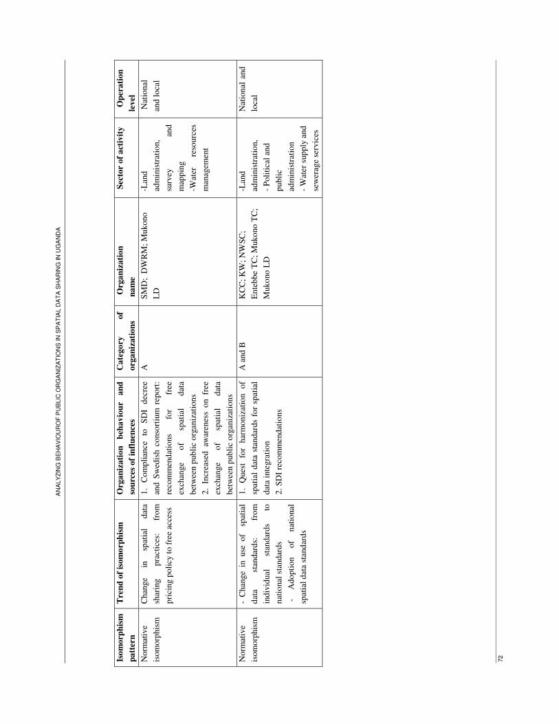
AN
AL
YZ
ING
BE
HA
VIO
UR
OF
PU
BLIC
OR
GA
NIZ
AT
ION
S IN
SP
AT
IAL D
AT
A S
HA
RIN
G IN
UG
AN
DA
72
Iso
morp
his
m
pa
tter
n
Tre
nd
of
isom
orp
his
m
Org
an
izati
on
b
ehav
iou
r an
d
sou
rces
of
infl
uen
ces
Ca
tego
ry
of
org
an
izati
on
s
O
rga
niz
ati
on
na
me
Sec
tor
of
act
ivit
y
O
per
ati
on
level
Norm
ativ
e
isom
orp
his
m
Chan
ge
in
spat
ial
dat
a
shar
ing
pra
ctic
es:
fro
m
pri
cing p
oli
cy t
o f
ree
acce
ss
1.
Com
pli
ance
to
S
DI
dec
ree
and
Sw
edis
h c
onso
rtiu
m r
epo
rt:
reco
mm
end
atio
ns
for
free
exch
ange
of
spat
ial
dat
a
bet
wee
n p
ub
lic
org
aniz
atio
ns
2.
Incr
ease
d aw
aren
ess
on fr
ee
exch
ange
of
spat
ial
dat
a
bet
wee
n p
ub
lic
org
aniz
atio
ns
A
SM
D;
DW
RM
; M
ukono
LD
-Lan
d
adm
inis
trat
ion,
surv
ey
and
map
pin
g
-Wat
er
reso
urc
es
man
agem
ent
Nat
ional
and l
oca
l
Norm
ativ
e
isom
orp
his
m
- C
han
ge
in u
se o
f s
pat
ial
dat
a st
andar
ds:
fr
om
ind
ivid
ual
st
andar
ds
to
nat
ional
sta
ndar
ds
-
Ado
pti
on
of
nat
ional
spat
ial
dat
a st
and
ard
s
1.
Ques
t fo
r har
moniz
atio
n
of
spat
ial
dat
a st
andar
ds
for
spat
ial
dat
a in
tegra
tio
n
2.
SD
I re
com
men
dat
ions
A a
nd
B
KC
C;
KW
; N
WS
C;
Ente
bbe
TC
; M
uko
no
TC
;
Muko
no
LD
-Lan
d
adm
inis
trat
ion,
- P
oli
tica
l an
d
publi
c
adm
inis
trat
ion
- W
ater
sup
ply
and
sew
erag
e se
rvic
es
Nat
ional
and
loca
l
ANALYZING BEHAVIOUROF PUBLIC ORGANIZATIONS IN SPATIAL DATA SHARING IN UGANDA
73
6.3. Conclusion
The aim of this chapter was to find an answer to the question: Do organizations behaviour in spatial data
sharing policies relate to any isomorphism process like coercive, normative or mimetic?
Findings show that there are coercive and normative forces that shape the behaviour of organizations in
adopting spatial data sharing policy.
1. Coercive forces push organizations in category A, operating in both land sector and water resources
management to adopt pricing policy in spatial data as follows:
- In land sector, organizations operating at national and local level behave according to the registration
of titles Acts and land sector strategic plan which prescribe that the users of land information and land
related data have to pay access fees.
- Organizations that operate in Land sector and water resources management at national level depend on
budget from the central government. They adopt pricing policy in spatial data sharing due to the
requirements of the Ministry of Finance which compel them to sell spatial data for the collection of fees
that they are required to generate for the public treasury.
2. Normative forces shape the behaviour of organizations in three ways:
- Organizations in category B show similar behaviour and adopt free access policy in spatial data
sharing because they believe that sharing spatial data for free is the appropriate way to promote the
optimal use of spatial data. They perceive that they conform to national constitution which provides the
freedom of the public to have access to information held by government body.
- Organizations operating in water supply and sewerage services show similar behaviour in posing
restriction on access to spatial data in digital format. They perceive similar environment constraint and
then adopt similar strategy in spatial data sharing.
- Organizations in category A which initially follow pricing policy, have adopted a new behaviour and
started to share spatial data for free since 2000, when they cooperate with other government bodies. They
tend to behave as organizations in category B, due to increased awareness on sharing spatial data for free
between government bodies as prescribed by SDI decree and other recommendations aiming at
promoting the development of SDI in Uganda.
- Other case of normative process was observed within organizations which adopt similar standards in
spatial data collection to solve the complexity resulting from the use of different spatial data standards.

ANALYZING BEHAVIOUROF PUBLIC ORGANIZATIONS IN SPATIAL DATA SHARING IN UGANDA
74
7. Conclusions and recommendations
7.1. Conclusions
The objective of this study was to examine if spatial data sharing policies followed by public
organizations in Uganda change over time and reflect a certain pattern of isomorphism. The main
research question to attain the research objective was the following: How do spatial data sharing
policies adopted by public organizations in Uganda reflect isomorphism trends?
Findings show that public organizations in Uganda have individually and differently adopted spatial data
sharing policies and practices. Some organizations adopted pricing policy and charge fees for sharing
spatial data with public and private organizations and individuals, while other follow free access policy
and share spatial data for free. Organizations which have adopted pricing policy in spatial data sharing,
have changed behaviour and follow the principle of free exchange of spatial data when cooperating with
other government organizations. Change in behaviour results from increased awareness about
appropriate ways of cooperation between government organizations as recommended by SDI decree,
Swedish consortium report, and the inter-organizations network which constituted the mechanism for
change in spatial data sharing practices.
In relation to the factors influencing public organizations in Uganda in making decision on spatial data
sharing policies, the study find that organizations adopting pricing policy in spatial data sharing face
coercive forces related to the registration of titles Acts and land sector strategic plan which push
organizations operating in land sector to charge fees for spatial data access. There are also the
requirements from the Ministry of finance which compel organizations operating in land and water
resources management sectors at national level to charge fees in spatial data for collecting fees that go
the public treasury. This pressure affects specifically organizations which depend on the government
budget for spatial data handling.
Findings show that the behaviour of organizations which share spatial data for free relates to normative
isomorphism. Staffs from those organizations share similar belief and assert that free access policy
allows the optimal use of spatial data for the public interest and meeting the organizations goals. They
state that they conform to national constitution which provides the freedom of the public to have access
to information held by government body.
In relation to main research objective and question, sub-research objectives and questions were
formulated. Findings to these sub-research objectives and questions are presented as follows:

ANALYZING BEHAVIOUROF PUBLIC ORGANIZATIONS IN SPATIAL DATA SHARING IN UGANDA
75
Specific objective 1: To determine the nature of spatial data sharing policies adopted by public
organizations in Uganda and the factors influencing their choice
Q 1: What is spatial data sharing legislation in Uganda?
The research did not find any national legislation on spatial data sharing in Uganda, although there is a
national law guiding access to data or information held by government bodies for all citizens. The law
(chapter 2, sub-section 2.3.2, and table 7-1) prescribes the legal procedures for the citizens to get
access data and information held by government body. Data are accessed in any format, both analogue
and digital, at organization office. Data are provided on written request addressed to the information
officer who makes decision on request before the release of data. Access may be refused if its
provision is likely to prejudice the security or sovereignty of the State or if it is subject to compromise
the confidentiality or privacy of any other person. Data are immediately provided upon the approval of
requested if access is for free or after the payment of prescribed fees if access is for fees. These are
procedures and norms that government organizations follow in data sharing as well as the citizens.
The law on access to government data or information was issued in 2005, but government
organizations in Uganda have engaged in spatial data sharing cooperation since many years before the
issue of the law (table 4-1). They have developed individual and informal spatial data access policies
providing the procedures and conditions on access to spatial data under their possession. Findings
show that those organizations have adopted similar procedures related to spatial data access and
provision. The procedures look alike the processes on access to data held by government body as
prescribed by the national law (tables 5-2 and 5-3). The study assumes that Access to information act
formalizes organizations practices on spatial data provision since they do not conflict with the act.
Q2: What are spatial data sharing policies adopted by public organizations in Uganda?
Government organizations in Uganda have individually developed spatial data sharing policy. Some
organizations provide spatial data for free while other charge fees for spatial data access. The study
classified organizations that follow pricing policy in category A. Organizations operating in land sector,
charge fees in spatial data sharing for compliance to the registration of titles acts and land sector
strategic plan which prescribe that the public have to pay fees for access to land information and
cadastral data. Other motives for charging fees related to revenue generation purpose, in relation with the
requirements from the Ministry of Finance. This factor affects also organizations operating in land as
well as organizations operating in water resources management at national level.
Organizations which follow free access policy were classified in category B. They consider spatial data
as a resource to share for free and a tool for meeting organizations goals. Those organizations share
spatial data with other organizations and individuals for conformism to the national constitution which
prescribes that the public have the right to access to government information.
In both categories, spatial data are shared in both analogue and digital format, although there are some
organizations which restrict access to spatial data in digital format. There are informal procedures which

ANALYZING BEHAVIOUROF PUBLIC ORGANIZATIONS IN SPATIAL DATA SHARING IN UGANDA
76
are followed for spatial data access and provision. Spatial data are provided on verbal or written request,
upon approval of officer coordinating activities related to spatial data dissemination.
Specific objective 2: To investigate if spatial data sharing policies are initially different and if they
converge to look alike over time
Q 3: Do spatial data sharing policies change and tend to look similar over time?
Currently, there are instances of change in spatial data sharing policies compared to initial stages.
Organizations in category A, which follow pricing policy on spatial data access are adopting new
behaviour, and have started to share spatial data for free with other government organizations since 2000.
This change shows the convergence of the behaviour of organizations in category A to the behaviour of
organizations in category B. Organizations in category A share spatial data with other government bodies
for free, and then tend to adopt a similar policy as well as organizations in category B. However, there
is not a complete convergence, because organizations in category A still charge fees when the
cooperation involves private organizations and individuals.
Q 4: Do organizations show any isomorphic behaviour in adopting spatial data sharing policy?
Organizations in category A, which charge fees for spatial data access, face similar environment
influences. They make similar decision on spatial data sharing policy following regulations and
requirements pushing them to charge fees for spatial data access. Organizations in category B, which
share spatial data for free show similar beliefs and perceive that information is a freely sharable good for
the public. They perceive that they behave according to the national constitution, which provides the
freedom of the citizens to access information held by government organization. Within this category, the
study found another isomorphism trend between organizations operating in water and sewerage services
which pose restriction on access to spatial data in digital format.
Organisations which initially follow pricing policy in spatial data sharing show new behaviour reflecting
change in spatial data sharing practices. They have currently started to share spatial data for free with
other government organizations, while they had to charge fees for spatial data access to all users,
including government organizations.
Other isomorphism trends relate to adoption and use of similar standards in producing and
maintaining spatial data and solving then the complexity resulting from the use of different standards
in spatial data handling. This trend was observed within organizations operating in land sector,
political and public administration, and water supply and sewerage services at both national and local
levels.
ANALYZING BEHAVIOUROF PUBLIC ORGANIZATIONS IN SPATIAL DATA SHARING IN UGANDA
77
Specific objective 3: To interpret if the changes in spatial data sharing policies relate to any
isomorphism process namely coercive, normative and mimetic
Q5: Do organizations behaviour in spatial data sharing policies relate to any isomorphism process
like coercive, normative or mimetic?
The study identified two types of isomorphism process, coercive and normative in spatial data sharing in
Uganda.
1. Coercive isomorphism:
- Organizations in category A, operating in both land sector, at national and local level adopt similar
behaviour and conform to the registration of titles Acts and land sector strategic plan which
prescribe that the users of land information and land related data have to pay access fees. They
charge fees in spatial data sharing as stated by the regulations guiding their activities.
- Organizations operating in land sector and water resources management at national level adopt
pricing policy in spatial data due to resources dependency. They depend on budget from the central
government for the collection and management of spatial data. The budget provider which is the
Ministry of Finance expects from those organizations to generate fees that go the public treasury,
from the services they provide to the public. Those organizations charge fees in spatial data sharing
for compliance to that requirement from the Ministry of Finance and for maintaining the financial
relations.
2. Normative isomorphism:
- Organizations in category B, which share spatial data for free show similar behaviour, in making
decision on spatial data sharing policy. In opinions of staffs from those organizations, free access
policy promotes the use of spatial data for achievement of organizations mission. Furthermore, they
adopt free access policy to conform to the national constitution which provides the freedom of the
public to have access to information held by government body.
- Since 2000, organizations in category A have adopted new behaviour, and share spatial data free as
well as organizations in category B, when they cooperate with other government organizations. They
consider free exchange of spatial data as the appropriate way to cooperate with other government
organizations.
- Other instance of normative isomorphism relates to the similar behaviour of organizations from
different sectors of activities which have adopted the use of similar standards in spatial data collection
for solving the problems affecting spatial data integration due to the use of individual and different
spatial data standards.

ANALYZING BEHAVIOUROF PUBLIC ORGANIZATIONS IN SPATIAL DATA SHARING IN UGANDA
78
7.2. Validation of research hypotheses
The study formulated three hypotheses in investigation on isomorphism trend in spatial data sharing in
public sector in Uganda. Findings on research questions help to draw conclusions on research hypotheses
as follows:
Hypothesis 1: Spatial data sharing policy, initiated individually by public organizations in Uganda, tend
to look similar over time by compliance to the national spatial data sharing directives.
There are no national directives that guide activities of public organizations in spatial data sharing in
Uganda. A national law on spatial data dissemination is inexistent. The law is still needed for guiding
organizations’ activities in spatial data sharing. If there was law, organizations would be expected to
show defiant or conforming behaviour to the law. The study finds that there is a national law guiding and
prescribing the legal procedures for the citizens to get access to government data and information, and
the current spatial data sharing policies or practices do not defy the national law on data access. The
study assumes that the law constitutes a legal back of individual spatial data sharing policies adopted by
public organizations in spatial data sharing.
Hypothesis 2: Professional communities of staff interested in SDI development are the cause of changes
in data provision as normative pressures affect organizations practices.
Public organizations which charge fees for access to spatial data are currently adopting new behaviour
and share spatial data for free with other government organizations. This behaviour is observed from
2000, when stakeholders like the heads of departments, survey unities and other officers, coordinating
the activities related to spatial data collection and sharing, started to meet through and make agreement
on sharing spatial data for free. They behaviour is a response to different directives aiming at the
development of SDI, like DI decree and Swedish consortium report that recommend public organizations
to adopt similar spatial data sharing policy and to share spatial data for free with other government
organizations.
Hypothesis 3: Public organizations in Uganda adopt over time similar approaches in cooperation for
spatial data provision by imitation of each other practices.
There is no evidence that show that public organizations in Uganda copy or emulate spatial data sharing
practices of other organizations. Organizations under study negated to mimic other organizations spatial
data sharing practices (tables 4-12 and 4-13).
To sum up, the study examined whether public organizations in Uganda tend to harmonize policies
related to spatial data sharing. Findings show that organizations which charge fees on spatial data access
are showing new behaviour and tend to adopt similar practices in sharing spatial data for free with other
government bodies. The change in the behaviour of organizations relates to normative process.
Following the current trend, it can be predicted that, public organizations in Uganda will adopt similar
spatial data sharing policy as other countries at international level like the USA, European countries,

ANALYZING BEHAVIOUROF PUBLIC ORGANIZATIONS IN SPATIAL DATA SHARING IN UGANDA
79
Australia, Canada and South Africa where policies on spatial data sharing provide free flow of
geoinformation between government organizations.
7.3. Recommendations
Based on the findings, this study makes two recommendations categorized into two: promotion of spatial
data sharing in Uganda and further researches.
7.3.1. For the promotion of spatial data sharing in Uganda
The government of Uganda could promulgate spatial data sharing law which states clearly the terms on
spatial data access for both government bodies and private users. The law should include the standards
prices for spatial data in the case the users have to pay fees for access to spatial data held by government
body. The law should aim at solving the disparities observed in spatial data prices, practiced by different
organizations in Uganda. The government may also declare a coordinating body of spatial data
dissemination and which should insure the implementation of the law.
7.3.2. For further research
In this study, isomorphism behaviour was investigated in the context of spatial data sharing policies.
Another study should be extended to other aspects like the use of common spatial data standards in
spatial data handling. This aspect was partially discussed in this study. A further research should aim at
investigating the standards public organizations in Uganda were using at initial stage of their activities
related to spatial data collection and when they have started to follow national standards.
Spatial data sharing is an international practice and harmonization of spatial data sharing policies is a
common trend worldwide. The theory of isomorphism can be used in examining how public
organizations in other countries of Africa or elsewhere harmonize spatial data sharing policies. A
research on such issue in different countries may help in assessing if any of the processes of
isomorphism is more prominent in a country rather than in another or whether isomorphism forces affect
public organizations in different countries in similar ways.

ANALYZING BEHAVIOUROF PUBLIC ORGANIZATIONS IN SPATIAL DATA SHARING IN UGANDA
80
REFERENCES
Brandsen, T., L. Munckhof, et al. (2007). The dynamics of co-management: state-nonprofit
partnerships across policy fields.
Calhoun, C., J. Gerteis, et al. (2002). Contemporary sociological theory, Blackwell Pub.
Chaminama, N. (2009). Analysis of public sector cooperation and geoinformation sharing: a resource
dependence perspective. Enschede, ITC: 83.
Dacin, M. T. (1997). "Isomorphism in Context: The Power and Prescription of Institutional Norms."
The Academy of Management Journal 40(1): 46-81.
de Montalvo, U. (2003). Mapping the determinants of spatial data sharing, Ashgate Pub Ltd.
Deephouse, D. (1996). "Does isomorphism legitimate?" The Academy of Management Journal 39(4):
1024-1039.
DiMaggio, P. J. and W. W. Powell (1983). "The Iron Cage Revisited: Institutional Isomorphism and
Collective Rationality in Organizational Fields." American Sociological Review 48(2): 147-160.
DWRD (2004). Profile of water resources monitoring and assessment department.
DWRM (2009). Annual workplan July 2009 to June 2010.
European Commission (2007). "Directive 2007/2/EC of the European Parliament and of the Council of
14 March 2007 establishing an Infrastructure for Spatial Information in the European Community
(INSPIRE)." L 108 Vol. 50.
Freitas, C. and T. Guimarães (2007). "Isomorphism, institutionalization and legitimacy: operational
auditing at the court of auditors." Revista de Administração Contemporânea 11: 153-175.
Frumkin, P. and J. Galaskiewicz (2004). "Institutional isomorphism and public sector organizations."
Journal of Public Administration Research and Theory 14(3): 283.
Galaskiewicz, J. and S. Wasserman (1989). "Mimetic processes within an interorganizational field: an
empirical test." Administrative Science Quarterly 34(3).
Giordano, L., M. Béchamps, et al. (1998). "Examining data sharing among state governmental health
agencies." Washington, DC: Public Health Foundation. Retrieved October 10: 2005.
Gosain, S. (2004). "Enterprise information systems as objects and carriers of institutional forces: the
new iron cage?" Journal of the Association for Information Systems 5(4): 151-182.
GSDI (2007). Spatial Data Infrastructure-Africa Newsletter. 6.
Guler, I., M. Guillén, et al. (2002). "Global competition, institutions, and the diffusion of
organizational practices: The international spread of ISO 9000 quality certificates." Administrative
Science Quarterly: 207-232.
Harvey, F. and D. Tulloch (2003). How do local governments share and coordinate geographic
information.
Harvey, F. and D. Tulloch (2006). "Local-government data sharing: Evaluating the foundations of
spatial data infrastructures." International Journal of Geographical Information Science 20(7): 743-768.
Haunschild, P. (1993). "Interorganizational imitation: the impact of interlocks on corporate acquisition
activity." Administrative Science Quarterly 38(4).

ANALYZING BEHAVIOUROF PUBLIC ORGANIZATIONS IN SPATIAL DATA SHARING IN UGANDA
81
Haunschild, P. and A. Miner (1997). "Modes of interorganizational imitation: the effects of outcome
salience and uncertainty." Administrative Science Quarterly 42(3).
Haveman, H. (1993). "Follow the leader: Mimetic isomorphism and entry into new markets."
Administrative Science Quarterly 38(4): 593-627.
Interdepartmental Committee on Spatial Data Access and Pricing (2001). A proposal for a
Commonwealth policy on spatial data access and pricing
Kalande, W. and J. Ondulo (2006). Geoinformation Policy in East Africa.
Karatunga, M. A. (2002). The Uganda Spatial Data Infrastructure Framework. SDI Ad-Hoc Experts
Group Meeting. Addis Ababa, Ethiopia.
Kayondo Ndandiko, M. L. (2007). Balancing information requirements with data availability : a case
of transport planning, Kampala, Uganda. Enschede, ITC: 127.
Kenis, P. and D. Knoke (2002). "How organizational field networks shape interorganizational tie-
formation rates." The Academy of Management Review 27(2): 275-293.
Kostova, T. and K. Roth (2002). "Adoption of an organizational practice by subsidiaries of
multinational corporations: institutional and relational effects." The Academy of Management Journal
45(1): 215-233.
Loenen, B. (2006). Developing geographic information infrastructures: the role of information
policies, Delft University Press.
Loenen, B. v. (2009). "Developing geographic information infrastructures: the role of access policies."
International Journal of Geographical Information Science 23(2): 195-212.
Lu, J. (2002). "Intra-and inter-organizational imitative behavior: institutional influences on Japanese
firms' entry mode choice." Journal of International Business Studies 33(1): 19-38.
Maitra, J. B. (1998 ). "The national spatial data infrastructure in the United States: Standards,
Metadata, Clearinghouse, and Data Access." Retrieved 13 June 2009, from
http://www.gisdevelopment.net/policy/gii/gii0002.htm.
McDougall, K., A. Rajabifard, et al. (2006). A mixed method approach for evaluating spatial data
sharing partnerships for SDI development. GSDI 9 - International Conference for Global Spatial Data
Infrastructure. Santiago, Chile, Global Spatial Data Infrastructure Association.
McDougall, K., A. Rajabifard, et al. (2007). A mixed-method approach for evaluating spatial data
sharing partnerships for spatial data infrastruture development. Research and theory in advancing spatial
data infrastructure concepts. H. Onsrud. Redlands, California, ESRI Press: 55-73.
Mizruchi, M. and L. Fein (1999). "The Social Construction of Organizational Knowledge: A Study of
the Uses of Coercive, Mimetic, and Normative Isomorphism." Administrative Science Quarterly 44(4).
MLHUD (2001). "Land Sector Strategic Plan 2001-2011 ".
MLHUD (2008). "Ministerial Policy Statement for Lands, Housing and Urban Development."
Moyin, Y., J. R. Bemigisha, et al. (2000). Best practice for environmental information systems EIS :
the case of Uganda, final report November 2000. Lund, DUMECO: 125.
Muhwezi, B. (2004). Solving complexity in implementation of SDI in Uganda,
Musinguzi, M. e. a. (2004). Opportunities and challenges for SDI development in developing countries
- a case study of Uganda. Proc. 12th Int. Conf. on Geoinformatics − Geospatial Information Research:
Bridging the Pacific and Atlantic. University of Gävle, Sweden.
Nasirumbi, S. (2006). Towards strategy of spatial data infrastructure development with focus on the
private sector involvement : a case study in Uganda. Enschede, ITC: 98.

ANALYZING BEHAVIOUROF PUBLIC ORGANIZATIONS IN SPATIAL DATA SHARING IN UGANDA
82
Nebert, D. D. (2004). Developing Spatial Data Infrastructures: The SDI Cookbook.
Nedovic-Budic, Z. and J. Pinto (1999). Understanding interorganizational GIS activities: a conceptual
framework, URISA.
Nedovic-Budic, Z. and J. Pinto (2000). "Information sharing in an interorganizational GIS
environment." Environment and Planning B 27(3): 455-474.
Nedovic -Budic , Z., J. Pinto, et al. (2004). "GIS database development and exchange: interaction
mechanisms and motivations." URISA journal 16(1): 15-29.
Nyemera, B. W. (2008). Evaluation of redundancy in the geo - information community in Uganda.
Enschede, ITC: 123.
Omran, E. E. and J. van Etten (2007). "Spatial-Data Sharing: Applying social-network analysis to
study individual and collective behaviour." International Journal of Geographical Information Science
21(6): 699-714.
Omran, E. S. E. (2007). Spatial data sharing: from theory to practice Wageningen University: 162.
Onsrud, H. (1995). "The role of law in impeding and facilitating the sharing of geographic
information." Sharing Geographic Information (New Brunswick, NJ: Center for Urban Policy Research):
292-306.
Onsrud, H. J. and G. R. Rushton (1995). Sharing geographic information. New Brunswick, The State
University of New Jersey, Center for Urban Policy Research.
Powell, W. W. e. and P. J. e. DiMaggio (1991). The new institutionalism in organizational analysis.
Chicago and London, The University of Chicago Press.
Renshler, E. K. (2007). An examination of NCAA Division I operating budgets: the influence of
athletic team salience and organizational isomorphism, The Ohio State University, : 208.
Roy, C. and F. Séguin (2000). "The institutionalization of efficiency oriented approaches for public
service improvement." Public Productivity & Management Review: 449-468.
Salvato, C. (1999). "Boards of directors in family firms: Mimicry or resource dependence reduction."
Innovation and economic development: The role of entrepreneurship and SMEs. Naples: Edizioni
Scientifiche Italiane.
Schwarte, C. (2008). Access to environmental information in Uganda, Iied.
Sieber, R. (2007). "Spatial data access by the grassroots." Cartography and Geographic Information
Science 34(1): 47-62.
Ssetongo, P. M. (2004). Towards a Strategy of Harmonisation, Alignment and Building of a Results
Based Decision Making process in Uganda’s Public Service Management System. African Regional
Workshop on Harmonization, Alignment and Results for Enhanced Development Effectiveness. Dares
salaam, Tanzania.
Swedish consortium (2001). "Design and development of geographic information system. Uganda
EFMP II/PHRD/00/05-GIS."
The Republic of Uganda (1964). Registration of titles Act.
The Republic of Uganda (1995). "Constitution of the Republic of Uganda ".
The Republic of Uganda (1998). Land Act.
The Republic of Uganda (2000). Local Government Act, Cap.243.
The Republic of Uganda (2005 ). Access to Information Act, 2005
Tukugize, C. (2005). Evaluation of geoinformation market environment in East Africa. Enschede, ITC:
96.

ANALYZING BEHAVIOUROF PUBLIC ORGANIZATIONS IN SPATIAL DATA SHARING IN UGANDA
83
Tulloch, D. and F. Harvey (2005). "When data sharing becomes institutionalized: Best practices in
local government GI relationships." URISA Journal Still under peer review.
van Loenen, B. (2009). "Developing geographic information infrastructures: the role of access
policies." International Journal of Geographical Information Science 23(2): 195-212.
Websites
http://www.mukonotc.go.ug last accessed on 18/11/2010
http://www.kcc.go.ug last accessed on 17/12/2010
http://www.mlhud.go.ug last accessed on 21/12/2010
http://www.mwe.go.ug last accessed on 05/01/2010
http://www.molg.go.ug last accessed on 12/01/2010
http://www.uganda-mining.go.ug last accessed on 29/01/2010
http://www.grida.no/publications last accessed on 04/02/2010
http://www.nwsc.co.ug last accessed on 07/02/2010

AN
AL
YZ
ING
BE
HA
VIO
UR
OF
PU
BLIC
OR
GA
NIZ
AT
ION
S IN
SP
AT
IAL D
AT
A S
HA
RIN
G IN
UG
AN
DA
84
Ap
pen
dix
1:
Locati
on
of
the s
tud
y a
rea
Ref
eren
ce:
Bro
ere,
M.
and
Ver
maa
s, P
. (2
005
).

ANALYZING BEHAVIOUROF PUBLIC ORGANIZATIONS IN SPATIAL DATA SHARING IN UGANDA
85
Appendix 2: Survey questionnaire
SURVEY QUESTIONNAIRE FOR THE STUDY ON:
Analyzing behaviour of public organizations in spatial data sharing in Uganda
Name of surveyor: UWAYEZU Ernest Questionnaire number: ………..
Tel: 0784513502 E-mail: [email protected]
Section 1: Profile of Respondents
Name of respondent……………………………………………………………………………………….
Organization…………………………………Position or Job title:………………………………………
Address………………………………………………….E-
mail………………………………………….
Tel…………………………………………………Fax…………………………………………………
…Date of interview:……………………………….. Time for interview:
Section 2: Questions
1. What types of spatial data does your organization collect or produce? ……………………………………………………………………………………………………………
…………………………………………………………………………………………………………………………………………………………………………………………………………………………………………………………………………………………………………………………………………………
2. If your organization provides these spatial data in any form to someone else from another
government organization, do you generally expect money in return? No: Yes: - Is there any law or directive to provide data for free or fees? ……………………………………………………………………………………………………………
…………………………………………………………………………………………………………………
2.1 What are the people who have to pay when your organization provides them spatial data?
………………………………......................................................................................................................... 2.2 If your organization needs payment for providing spatial data to other government organization,
when did the practice of request for payment start? ……………………………….........................................................................................................................
The purpose of this survey is to find out how public organizations cooperate in geo-information sharing in
Uganda. This fieldwork is part of the thesis research project above and a requirement for the MSc Degree in
Land Administration at ITC. We are committed to keep privacy of all the information provided by the
respondents and the information will be used for study purpose only.
ANALYZING BEHAVIOUROF PUBLIC ORGANIZATIONS IN SPATIAL DATA SHARING IN UGANDA
86
2.3. If your organization does not need payment for providing spatial data to other government organization, when did this practice of no payment start?
…………………………………………......................................................................................................
2.4. What were the conditions to provide spatial data before that date? ……………………………………………………………………………………………………………
…………………………………………………………………………………………………………………………………………………………………………………………………………………
3. Has your organization ever changed conditions placed on data access: shifting from free access to
access for fees or vice versa? No: Yes:
If yes, what are the reasons?
………………………………………………………………………………………………………………………………………………………………………………………………………………………………………………………………………………………………………………………………
4. If other government organizations provide your organization any spatial data, do they expect a payment for this data? No: Yes:
4.1. If ever you have to pay for other government organizations spatial data, when did this practice (of
having to pay) start? ………………………………………………………………………………………………………….. 5. From where does your organization get funds to collect or produce spatial data? ……………………………………………………………………………………………………………
………………………………………………………………………………………………………………………………………………………………………………………………………………………………
6. How does your organization allocate funds to lower level organizations to ensure spatial data production?
……………………………………………………………………………………………………………………………………………………………………………………………………………………………………………………………………………………………………………………………………………
7. For what sort of spatial data or Geoinformation products do you need to pay when you get them from other organizations?
……………………………………………………………………………………………………………………………………………………………………………………………………………………………………………………………………………………………………………………………………………
8. With what sort of organizations do you need to pay for their spatial data or related products?
(Please, tick the correct answer) - Government organizations: - Semi-government organizations: - Private organization: - Other (to be specified): 9. Who in your organization makes decisions about sharing spatial data with other organizations?
ANALYZING BEHAVIOUROF PUBLIC ORGANIZATIONS IN SPATIAL DATA SHARING IN UGANDA
87
……………………………………………………………………………………………………………………………………………………………………………………………………………………………………………………………………………………………………………………………………………
10. Has your organization defined Geo-information products or related services to be provided to other
organizations? Yes: No: If yes, which ones?
………………………………………………………………………………………………………………………………………………………………………………………………………………………………
If not, why not? ………………………………………………………………………………………………………………………………………………………………………………………………………………………………………………………………………………………………………………………………………………
11. Have you ever contacted people from other organizations when you have to make decision about
providing spatial data or Geoinformation products to other organization? Yes: No: 11.1. If yes, for which matters do you contact them? (Please, briefly explain)
……………………………………………………………………………………………………………
………………………………………………………………………………………………………………
…………………………………………………………………………………………
12. Do you think that providing spatial data and services to citizens is a core activity of your
organization? Yes: No: 13. In your organization, is the provision of spatial data to third parties similar to the provision of non-
spatial data to third parties? Yes: No: If no, what are the reasons? (Please, briefly explain) ……………………………………………………………………………………………………………
………………………………………………………………………………………………………………………………………………………………………………………………………………..
14. Can any staff in your organization provide spatial data or related products to someone from
another organization without prior approval of the boss? Yes: No: If no, what are the reasons? (Please, briefly explain): ……………………………………………………………………………………………………………
…………………………………………………………………………………………………………………………………………………………………………………………………………………
Thanks for the cooperation
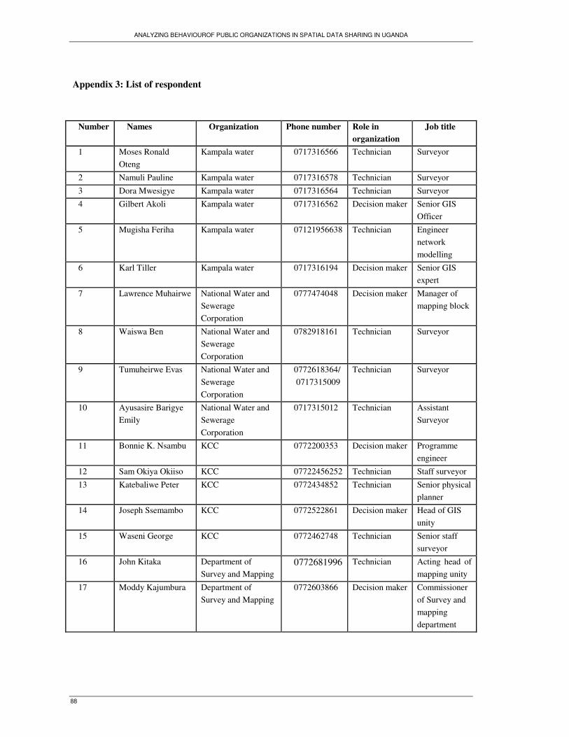
ANALYZING BEHAVIOUROF PUBLIC ORGANIZATIONS IN SPATIAL DATA SHARING IN UGANDA
88
Appendix 3: List of respondent
Number Names Organization Phone number Role in
organization
Job title
1 Moses Ronald
Oteng
Kampala water 0717316566 Technician Surveyor
2 Namuli Pauline Kampala water 0717316578 Technician Surveyor
3 Dora Mwesigye Kampala water 0717316564 Technician Surveyor
4 Gilbert Akoli Kampala water 0717316562 Decision maker Senior GIS
Officer
5 Mugisha Feriha Kampala water 07121956638 Technician Engineer
network
modelling
6 Karl Tiller Kampala water 0717316194 Decision maker Senior GIS
expert
7 Lawrence Muhairwe National Water and
Sewerage
Corporation
0777474048 Decision maker Manager of
mapping block
8 Waiswa Ben National Water and
Sewerage
Corporation
0782918161 Technician Surveyor
9 Tumuheirwe Evas National Water and
Sewerage
Corporation
0772618364/
0717315009
Technician Surveyor
10 Ayusasire Barigye
Emily
National Water and
Sewerage
Corporation
0717315012 Technician Assistant
Surveyor
11 Bonnie K. Nsambu KCC 0772200353 Decision maker Programme
engineer
12 Sam Okiya Okiiso KCC 07722456252 Technician Staff surveyor
13 Katebaliwe Peter KCC 0772434852 Technician Senior physical
planner
14 Joseph Ssemambo KCC 0772522861 Decision maker Head of GIS
unity
15 Waseni George KCC 0772462748 Technician Senior staff
surveyor
16 John Kitaka Department of
Survey and Mapping
0772681996 Technician Acting head of
mapping unity
17 Moddy Kajumbura Department of
Survey and Mapping
0772603866 Decision maker Commissioner
of Survey and
mapping
department

ANALYZING BEHAVIOUROF PUBLIC ORGANIZATIONS IN SPATIAL DATA SHARING IN UGANDA
89
18 Asizua Fax Department of
Survey and Mapping
0414320304 Technician Cartographer
19 Ebunyu Wilson
Ogaro
Department of
Survey and Mapping
0772516125 Decision maker Principal land
Officer
20 Dr. Yafesi Okia Department of
Survey and Mapping
0772563152 Decision maker Principal staff
surveyor
21 Mrs Kaliisa
Kabahuma Beatrice
Department of
Survey and Mapping
0772314411 Technician Principal
Cartographer
22 Kabundama Richard Department of
Survey and Mapping
0772464497 Technician Cartographer
23 Okitela Crispin Department of
Survey and Mapping
0712425171 Technician Senior
Cartographer
24 Richard Oput Ministry of Lands,
Housing & Urban
Development
0772412702 Decision
maker
Land Tenure
Reform Project
coordinator
25 Mukiibi Joseph Entebbe Municipality
Council
0772586260 Technician Municipality
engineer
26 Kadama Ruuwa
Margaret
Entebbe Municipality
Council
0712836993 Technician Physical
planner
27 Caroline Wafula DWRM 0755890250 Technician Head of GIS
unity
28 Pule Johnson DWRM 0772441677 Technician Senior
Hydrologist
29 Ssekamuli Benjamin DWRM 0772894236 Technician Hydrologist
30 Eva Lwanga DWRM 0772409378 Technician Senior
Hydrologist
31 Kataratambi David DWRM 0712937855 Technician Acting Senior
water officer
32 Richard Musota DWRM 0772520966
Technician water officer
33 Kyosingira Wilson
Fred
DWRM 0772441265 Decision maker Assistant
commissioner
water resources
34 Leodinous
Mwebembezi
DWRM 0772427656 Decision maker
Principal
Water Officer
35 Migadde Robert
Ndugwa
Mukono Town
Council
0776212972 Technician Town physical
planner
36 Sserunjogi Josiah Mukono Town
Council
0772507118 Officer Senior Town
Engineer

ANALYZING BEHAVIOUROF PUBLIC ORGANIZATIONS IN SPATIAL DATA SHARING IN UGANDA
90
37 Mutaawe Musa Mukono Town
Council
0712860525 Technician Physical
planner
assistant
38 Bbuye Martin Mukono District 0772591893 Technician District
physical
planner
39 Musiitwa George Mukono District/
Lands Department
0772521180 Technician District staff
surveyor
40 Kyedde Wilberforce Mukono District/
Lands Department
0772303932 Technician Cartographer
41 Kiyini James Mukono District/
Lands Department
0772494204 Technician Cartographer
42 Kalule James Mukono District/
Water Development
department
0772655252 Officer District water
officer
43 Kavuma Vincent Mukono District/
Water Development
department
Not provided Technician Assistant water
officer
44 Buteraba Eunice Mukono District/
Water Development
department
0772560867 Technician Assistant water
officer
45 Grace Nassuma Ministry of Energy
and Mineral
Development
0414300118 Technician Principal
documentation
Officer
46 Agnes Alaba
Kuterema
Ministry of Energy
and Mineral
Development
Not provided Technician Principal Staff
Cartographer

ANALYZING BEHAVIOUROF PUBLIC ORGANIZATIONS IN SPATIAL DATA SHARING IN UGANDA
91
Appendix 4: Airborne geophysical digital data dissemination policy
The Republic of Uganda
MINISTRY OF ENERGY AND MINERAL DEVELOPMENT
AIRBORNE GEOPHYSICAL DIGITAL DATA DISSEMINATION
POLICY
Introduction
The High Resolution Airborne Geophysical Survey Programme involving magnetic, radiometric
and electromagnetic surveys that is aimed at assisting and promoting mineral exploration
commenced in December 2006.
The large volume of data and the increasing number of requests by mineral investors and other
interested parties for data windowed to their areas of interest has necessitated the development of a
data dissemination policy which will eventually be transformed into a dedicated online data storage
and management system including a customised viewing, handling and archiving system.
The airborne geophysical management system shall store all grid and line archives in a consistent
format that guarantees data integrity and facilitates data distribution. Where areas of interest
encompass more than one survey, grid data are supplied as individual survey grids and also as
windowed supergrids. Supergrids are compilations from all available high-resolution and regional
data and are upgraded regularly as new survey data become available.
The current high resolution surveys followed the regional airborne geophysical surveys for mineral
exploration that was funded by United Nations Development Programme (UNDP) in 1961 and
Government of Uganda in in1980 and achieved almost 50% national coverage. These surveys were
typically flown with 1 km line spacing, 10 km ties and 120 m ground clearance. All magnetic data of
the regional programme were subsequently compiled into one consistent data set merged during the
African Magnetic Mapping Project in 1992. Therefore in addition to the new high resolution
airborne geophysical data, the regional airborne geophysical data including magnetic and
radiometric data are also available for dissemination.
Due to industry demand, the Ministry of Energy and Mineral Development (MEMD) and
Department of Geological Survey and Mines (DGSM) may decide to release certain airborne
geophysical data in preliminary form. These data will have been fully processed by Fugro Airborne
Surveys, and reviewed independently by DGSM’s quality control experts. The final products may
contain minor adjustments, and will include additional channels and grids. Any purchase of
preliminary data will include a copy of the final data for the same area when those products are
released.

ANALYZING BEHAVIOUROF PUBLIC ORGANIZATIONS IN SPATIAL DATA SHARING IN UGANDA
92
Objectives of Establishing Airborne Geophysical Data Dissemination Policy
To put in place efficient, effective and transparent tools for disseminating airborne geophysical
data of Uganda so as to attract mineral investment in the Country.
Policy Goal: Increase mineral sector investments as a result of wide dissemination of Airborne
geophysical data to potential investors.
Strategic Tools for Disseminating Airborne Geophysical Data
The following comprises the Strategic Tools for Managing Airborne Geophysical Data:
1. Both the old regional geophysical data and the new high resolution data including all data types
shall be part of the data archive for dissemination.
2. Data shall be distributed to interested parties upon completing a data requisition form (Annex 1)
and payment of a nominal reproduction cost reflected in the price list in Annex 2.
3. Whether an entity (company or individual) has a mineral right or not, he/she is entitled to
acquire any data of his/her interest covering any part of the country.
4. Research Institutions shall receive the data free of charge but on condition that they use the data
only for the purpose they acquired it. They shall also provide feedback in form of the copies of their
thesis or research paper.
5. Before data is handed over, a data Confidentiality Agreement between the
individuals/company/organisation who takes the data and the Department of Geological Survey and
Mines shall be signed. The data confidentiality agreement (Annex 3) shall be adhered to by all those
taking the data.
6. The funds shall accrue to a Fund to be established within Ministry of Energy and Mineral
Development to support the promotion of the mining industry.
7. In some cases data may be released in preliminary form after being fully processed and
reviewed independently by DGSM’s quality control experts. The final products may contain minor
adjustments, and will include additional channels and grids. Any purchase of preliminary data will
include a copy of the final data for the same area when those products are released.

ANALYZING BEHAVIOUROF PUBLIC ORGANIZATIONS IN SPATIAL DATA SHARING IN UGANDA
93
Airborne Geophysical Digital Data Sales – Pricing Schedule
Data Format
Grid data are delivered in Oasis Montaj Geosoft grid file format.
Line data are delivered in Oasis Montaj Geosoft format and ASCII file format and a format
description file accompanies each data file.
Data Windowing
Data shall generally be sold on the basis of standard topographical map sheets. However, data can
also be windowed to any boundary on request.
Payments
All process stated below are exclusive of shipping charges
PROCEDURES FOR ACQUISITION OF AIBORNE GEOPHYSICAL DATA
1. First get a copy of the airborne Geophysical Data Dissemination Policy.
2. Geophysicist calculates the Total line Km and Amount to be paid.
3. Fill the data requisition form specifying which data is required.
4. Geophysicist fills the Pro forma Invoice indicating the amount to be paid.
5. Obtain Bank Advice Forms (BAF’S) from Accounts Section
6. The filled Bank Advice Forms (BAF’S) are taken to Diamond Trust Bank (DTB)- Kampala
Road and money paid to MEMD Bank account.
7. Present the URA Bank Payment receipt and the stamped Copy of the BAF to DGSM Accounts
section and a copy to Geophysics Section
8. The receipt is entered in the Hard cover book in Accounts for Accountability
9. The Customer then signs a Confidentiality and Copyright Agreement
10. Lastly, the hard or digital copy of the requested data is handed over to the customer with any
guidance that may be required from the Geophysicist.
11. DGSM shall not be liable to any data taken without a Geophysicist’s endorsement.
Magnetics and Radiometrics
Complete digital magnetic and radiometric data (line data) are sold for Ug Shs 30 (1 US $ =Shs
1800/=) per line-kilometre. In case of grids only the price is calculated on the area covered by the
data at Ug Shs 150 per km2 for each grid (magnetic and radiometric).

ANALYZING BEHAVIOUROF PUBLIC ORGANIZATIONS IN SPATIAL DATA SHARING IN UGANDA
94
Geotiffs
Digital Geotiffs are produced from the Supergrids, which are compilations of all high resolution
and regional data available. Geotiffs are based on the standard 1:50.000 topographical map sheets
and are sold at Ug Shs 10,000 per sheet, for magnetics and Ug Shs 10,000 for radiometrics.
Electromagnetics
Electromagnetic data are sold for Ug Shs 300 per line-kilometre including grid and line data.
Regional Geophysical Data
The regional airborne geophysical surveys for mineral exploration which was funded by UNDP
from 1960s and achieved almost 50% coverage in the early 1980’s. These surveys were typically
flown with 1 km line spacing, 10 km ties and 120 m ground clearance. These magnetic and
radiometric surveys have been merged and compiled into consistent data grids. Therefore in addition
to the new high resolution airborne geophysical data, the regional airborne geophysical data
including magnetic and radiometric data are also available for dissemination. The entire data set is
sold for Ug Shs 1,500,000.
Contacts:
1. Joshua. T. Tuhumwire
Phone: +256 (0)414 320559 or +256(0)312262902
Commissioner, Department of Geological Survey and Mines
Email: [email protected]
2. Edwards Katto Phone: 256 414 323432 or +256 (0)414 320656
Project Coordinator, Email: [email protected]
Sustainable Management of Mineral Resources Project

ANALYZING BEHAVIOUROF PUBLIC ORGANIZATIONS IN SPATIAL DATA SHARING IN UGANDA
95
Appendix 5: Cooperation agreement between the Uganda Meteorological Department (UMD)
and Water Resources Monitoring and Assessment Department (WRMAD)

ANALYZING BEHAVIOUROF PUBLIC ORGANIZATIONS IN SPATIAL DATA SHARING IN UGANDA
96

ANALYZING BEHAVIOUROF PUBLIC ORGANIZATIONS IN SPATIAL DATA SHARING IN UGANDA
97
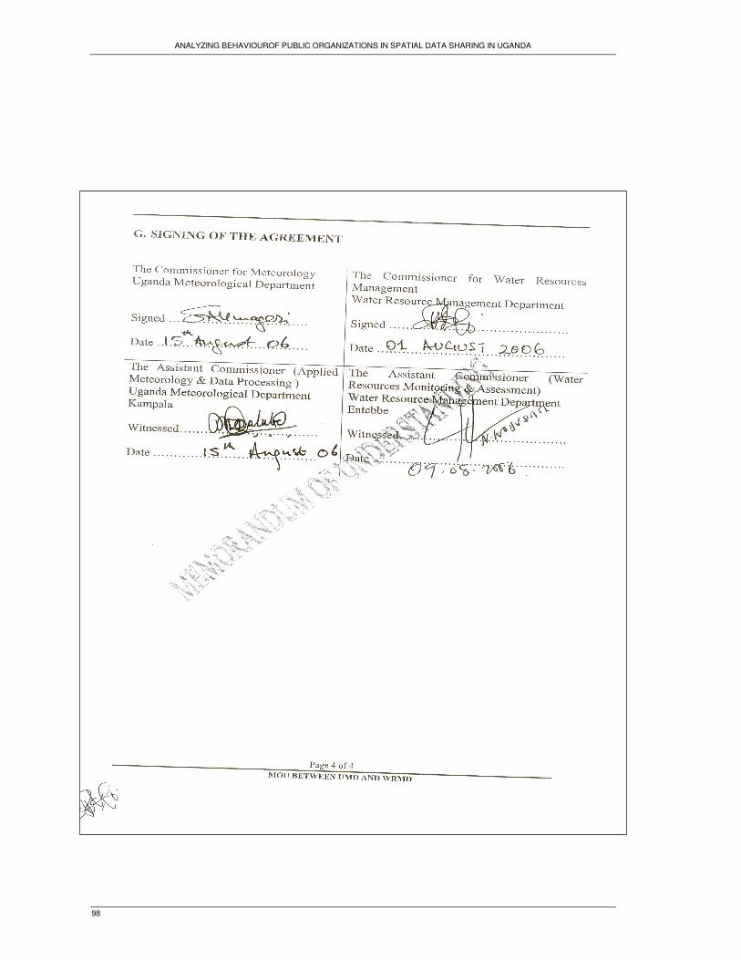
ANALYZING BEHAVIOUROF PUBLIC ORGANIZATIONS IN SPATIAL DATA SHARING IN UGANDA
98

ANALYZING BEHAVIOUROF PUBLIC ORGANIZATIONS IN SPATIAL DATA SHARING IN UGANDA
99
Appendix 6: Types of spatial data collected by each organization and spatial data acquired from
other organizations
Spatial data acquired from other organizations Organization
name
Spatial data captured by
organization
Type of spatial data Spatial data provider
Aerial photographs IGN-France
Satellite images RCMRD
Tourist sites location Ministry of Tourism,
Trade and Industry,
Roads, buildings, and land parcels
boundaries
KCC
Forestry boundaries NFA
Cells boundaries Electoral commission
Water infrastructures data NWSC and KW
Water bodies boundaries (river,
lakes), water points and
catchments.
DRWM
SMD Topographic data (contour
lines), hydrographical data
(lakes and rivers) geodetic,
buildings,
transport infrastructure
(roads, railways) and
cadastral data.
Statistical and population data UBOS
Topographic data, cadastral data;
aerial photographs; satellite images
SMD
Land cover and irrigation sites Ministry of agriculture
Forest cover NFA
Geological data Ministry for Mines and
Energy
Water and sewerage infrastructures
data
NWSC
DWRM Rainfall, hydrology spatial
data, water bodies (river,
lakes, water points, boreholes,
and catchments.
Roads, land use Entebbe TC
Satellite images RCMRD
Aerial photographs, cadastral data,
topographic data, building and
roads
SMD
Building and roads KCC
Public infrastructures : roads,
schools, and land parcels
boundaries
Mukono TC
Cadastral data Mukono LD
Water bodies boundaries (river,
lakes), water points
DRWM
Water and sewerage infrastructures
data
NWSC
NWSC Water and sewerage
infrastructures spatial data:
water pipe lines systems
valve, washout, water tank,
and sewerage canals,
customers locations and
premise
Satellite images RCMRD
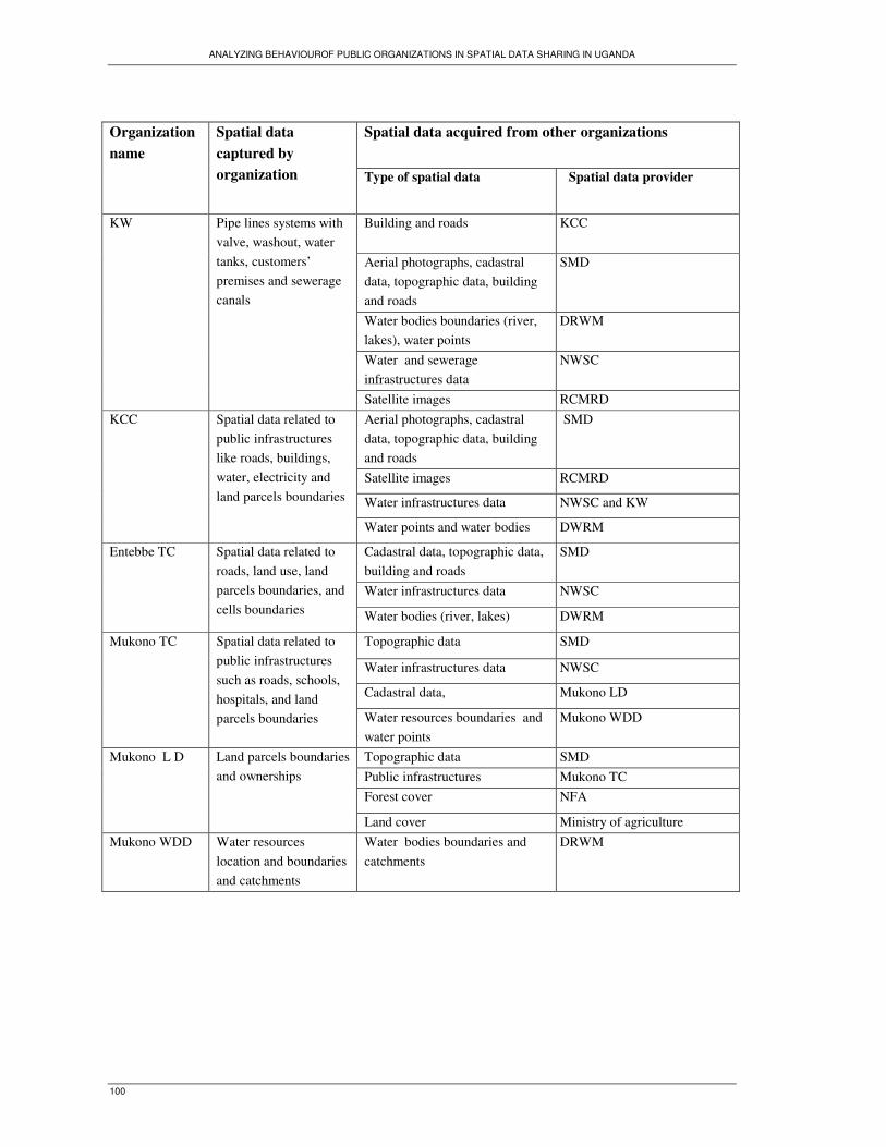
ANALYZING BEHAVIOUROF PUBLIC ORGANIZATIONS IN SPATIAL DATA SHARING IN UGANDA
100
Spatial data acquired from other organizations Organization
name
Spatial data
captured by
organization Type of spatial data Spatial data provider
Building and roads
KCC
Aerial photographs, cadastral
data, topographic data, building
and roads
SMD
Water bodies boundaries (river,
lakes), water points
DRWM
Water and sewerage
infrastructures data
NWSC
KW Pipe lines systems with
valve, washout, water
tanks, customers’
premises and sewerage
canals
Satellite images RCMRD
Aerial photographs, cadastral
data, topographic data, building
and roads
SMD
Satellite images RCMRD
Water infrastructures data NWSC and KW
KCC Spatial data related to
public infrastructures
like roads, buildings,
water, electricity and
land parcels boundaries
Water points and water bodies DWRM
Cadastral data, topographic data,
building and roads
SMD
Water infrastructures data NWSC
Entebbe TC Spatial data related to
roads, land use, land
parcels boundaries, and
cells boundaries Water bodies (river, lakes) DWRM
Topographic data SMD
Water infrastructures data NWSC
Cadastral data, Mukono LD
Mukono TC Spatial data related to
public infrastructures
such as roads, schools,
hospitals, and land
parcels boundaries Water resources boundaries and
water points
Mukono WDD
Topographic data SMD
Public infrastructures Mukono TC
Forest cover NFA
Mukono L D Land parcels boundaries
and ownerships
Land cover Ministry of agriculture
Mukono WDD Water resources
location and boundaries
and catchments
Water bodies boundaries and
catchments
DRWM

ANALYZING BEHAVIOUROF PUBLIC ORGANIZATIONS IN SPATIAL DATA SHARING IN UGANDA
101
Appendix 7: Data and information generated from WRMAD and prices

ANALYZING BEHAVIOUROF PUBLIC ORGANIZATIONS IN SPATIAL DATA SHARING IN UGANDA
102
Appendix 8: Prices for spatial data provided by Survey and Mapping Department

ANALYZING BEHAVIOUROF PUBLIC ORGANIZATIONS IN SPATIAL DATA SHARING IN UGANDA
103
Appendix 9: A GIS technician at DWRM prints a map for a customer

ANALYZING BEHAVIOUROF PUBLIC ORGANIZATIONS IN SPATIAL DATA SHARING IN UGANDA
104
Appendix 10: DECREE ON SPATIAL DATA INFRASTRUCTURE
Land and geographic information or spatial information describes information that can be related to a
position on the earth's surface whether that be on the land, sea or in the air. There are few areas of the
economy which do not rely either directly or indirectly on this kind of information for planning,
maintaining or rationalising activities.
The Government of Uganda views land and geographic information as an infrastructure, with the same
rationale and characteristics as roads, communications and other infrastructure. Uganda shall have the
spatial data infrastructure needed to support their economic growth, and their social and environmental
interests, backed by national standards, guidelines, and policies on community access to that data.
Everyone can collect the spatial information that they need at the national, regional and local level, but
this leads to costly duplication of data and inconsistency. It also results in data that cannot be
integrated with other data and used as a basis for spatial modelling and analysis to produce value added
information. In other words, excessive costs, inefficiencies, confusion and decision making based on
poor information.
The Government of Uganda believes that this country does not have the resources to waste on such
duplicated efforts.
Therefore the implicated organisations should reach agreement on what fundamental datasets are
required in the national interest, to what standards they should be collected and maintained, which
agencies should have custodianship of those data, and what the national priorities are for collection of
those data. The implicated organisations shall establish a Spatial Data Infrastructure Committee, and
commit to:
� Institutional cooperation that provides mechanisms for sharing experience, technology transfer
and coordination of the development of the national fundamental datasets;
� Use of common technical standards, including a common geodetic reference frame, so that
data from numerous databases can be brought together to create new products and solve new
problems, both nationally and locally
� Adoption of common policies on data access, pricing, privacy, confidentiality and
custodianship;
� Implementation of inter-governmental agreements on data sharing of Key Data Sets
� Contribution to freely accessible directory of available data sets containing descriptions and
administrative information that accords with agreed standards for metadata.
Within one year of the issue of this decree each of the institutions shall have accomplished:
� To document geospatial data it collects or produces, either directly or indirectly, using the
standard set forth by the Spatial Data Infrastructure Committee, and make that standardized
documentation electronically accessible to a coordinating body.
� To define their contribution to the National Key Data Set and distribute them freely to other
government agencies on request.


![[6-1] Analyzing Spatial Relationships - Selection by Location](https://static.fdocuments.net/doc/165x107/577d25b41a28ab4e1e9f6a98/6-1-analyzing-spatial-relationships-selection-by-location.jpg)