ANALYSIS OF POLICY EFFECTIVENESS ON … OF POLICY EFFECTIVENESS ON FOREST FIRES IN RIAU, INDONESIA...
43
ANALYSIS OF POLICY EFFECTIVENESS ON FOREST FIRES IN RIAU, INDONESIA by Perthalia Rosul Dr. Brian Murray, Adviser May 2015 Masters project submitted in partial fulfillment of the requirements for the Master of Environmental Management degree in the Nicholas School of the Environment of Duke University 2015
-
Upload
truongminh -
Category
Documents
-
view
219 -
download
0
Transcript of ANALYSIS OF POLICY EFFECTIVENESS ON … OF POLICY EFFECTIVENESS ON FOREST FIRES IN RIAU, INDONESIA...

ANALYSIS OF POLICY EFFECTIVENESS ON FOREST FIRES IN RIAU, INDONESIA
by
Perthalia Rosul
Dr. Brian Murray, Adviser
May 2015
Masters project submitted in partial fulfillment of the
requirements for the Master of Environmental Management degree in
the Nicholas School of the Environment of
Duke University
2015

2

3
I would like to thank my adviser, Dr. Brian Murray, for his guidance and valuable advice; this
project would not be possible without his support. I would like to also thank the interviewees
and my colleagues from different ministries and agencies in Indonesia who were willing to share
their knowledge and expertise during this project.

4
This report analyzes how effective Indonesia’s forest fire policy is in Riau province, how it is being implemented, and ultimately recommends ways to improve the policy. A recent forest fires policy in Indonesia was established in 2007 as a comprehensive plan of action to deal with land and forest fires. It is basically a package plan containing various measures for each of six elements: monitoring, prevention, fire suppression, dissemination of information, law and regulation, and international cooperation.
This project draws attention to the fact that forest fires are a common phenomenon in
Indonesia, happening almost annually in the western part of the country. Fires are deliberately
set as a means of clearing land. However, large fire events have been aggravated in times when
weather patterns favor prolonged drought caused by the El Nino Southern Oscillation (ENSO).
Riau is one of the provinces in Indonesia that experiences this regularly; one of the recent series
of fires occurred in January-March 2014.
I compared the status quo of existing socio-economic damage from the 2014 fire and related it
to a counterfactual scenario of how different the damages would have been without the policy,
so that I could infer the effectiveness of the policy. My methodology involved conducting
interviews with 14 forest fire experts in the country (from the national government, provincial
government, and NGOs), as well as literature reviews.
The set of interviews I conducted suggested that some elements of the plan of action might have had some influence on limiting the severity of damage and losses from the 2014 fire. The experts in general were convinced that the 2014 forest fire would have burnt 10 - 60 % more area, and that the overall damage and losses would have been worse had the policy not been enacted. The evaluation of expenditure and benefit also suggests that the benefit most likely outweighed the cost of implementing the policy by up to 20 times. A number of shortcomings of the policy were also addressed.
This report makes several key points and recommendations:
The budget for policy implementation is insufficient and needs to be increased The government should invest more in zero burning land clearing equipment and spend
less on fire suppression. There needs to be a special agency overseeing policy implementation with the authority
above all of the ministries and agencies involved in the policy. Information on the plan of action should be made widely available to different parties to
enable better policy assessment.

5
Figure 1 Map of Indonesia and Riau 10
Figure 2 Peatland distribution map in Riau 12
Figure 3 Hotspot counts in Riau Province (2010-2014) based on districts 13
Figure 4 Distribution of hotpots in Riau’s districts 14
Figure 5 Distribution map of firespots in Riau 15
Figure 6 Methodology 27
Figure 7 Trend of hotspot counts in Riau in the past decade 28
Table 1 Interviewee typologies 22
Table 2 Description of interview questions posed and rationale 24
Table 3 Summary of counterfactual responses 29
Table 4 Summary of counterfactual calculations 31
Table 5 Partial cost for implementation of the plan of action 31

6
I. INTRODUCTION
Land and Forest Fires in Indonesia
Indonesia has the third largest forested area in the world, after Brazil and the Republic of Congo
(Aiken, 2004). Moreover, Indonesia’s peatland area is the fourth largest in the world with a total of 20
million hectares (Mubekti, 2011). Although the country is blessed with abundant forest resources and
biodiversity, it has a long history of peatland and forest fires. Studies have shown fires have been a regular
feature of the country’s landscape for as long as the area was inhabited (Barber & Schweithelm, 2000).
Sediment and charcoal analysis indicate that forests have burned periodically throughout the past 17,000
years (Glover & Jessup, 1999). Inhabitants have done this mostly to facilitate hunting activities and
clearing land plots for shifting agriculture practices (Glover & Jessup, 1999).
Better historic records on forest fires in Indonesia and some other Southeast Asian countries go
back to the 17th century, when fires started to break out in Borneo and parts of Thailand (Aiken, 2004;
Herawati & Santoso, 2011; Nguitragool, 2011). Large fire events seem to happen more frequently now,
particularly since the 1980s (Herawati & Santoso, 2011; D. Taylor, Saksena, & Kucera, 1999). These fires
occur almost every dry season and when the El Niño Southern Oscillation (ENSO) created anomalous
weather patterns which prolonged drought (Jim, 1999; Gaveau et al, 2014). El Niño is a term to describe
the variation of the sea surface temperature, which leads to a global change in temperature and
precipitation (Herring, 2009; Pidwirny, 2006). Fires are more extensive on the islands of Sumatra and
Kalimantan, usually during the dry season between March and September (Gellert, 1998).
Most of these massive fires occur when climate conditions and meteorological parameters are
favorable. Studies have revealed how the weather anomaly of El Niño plays an important role in
aggravating the risk of forest fires in Indonesia. El Niño events coincides with many of the years when
Indonesia’s most massive fires occur, and El Niño is believed to aggregate the severity of the fire (Field,
Werf, & Shen, 2009; Langner & Siegert, 2008; Wooster, Perry, & Zoumas, 2012). El Niño used to occur
every 2-7 years, with varied magnitudes and lengths of occurrence (Herring, 2009; Pidwirny, 2006).
However, in more recent decades, its occurrence has become more frequent and less predictable, which
some believe to be influenced by global warming (Field et al., 2009; Haberle, Hope, & Kaar, 2001; David
Taylor, 2009). The event causes increased temperatures in Indonesia, which lead to prolonged drought
during dry seasons throughout the country, making land and forest more susceptible to fire. According to
Langner and Siegert (2008), areas impacted by fire during droughts induced by severe El Niño events were
triple that of typical weather conditions. The study also confirmed that the most serious impacts were
experienced in peat forest ecosystems. Some of Indonesia’s most severe forest fire events happened

7
during extreme El Niños in 1982-1983, 1994, 1997-1998, and 2006 (Glover & Jessup, 1999; Langner &
Siegert, 2008; David Taylor, 2009), although in other years, lower intensity, less widespread fires still
occurred almost annually in Indonesia during weaker El Niño phenomena (Field et al., 2009; Wooster et
al., 2012).
El Niño, however, is not the only cause of land and forest fires in Indonesia. Forest fire incidents
depend not only on how dry it is and the amount of potential fuel in the forest, but also on the likelihood
that fuel will ignite, which in Indonesia is related mostly to human activity (Glover & Jessup, 1999). Fires
have long been deliberately set by humans as a means of land-clearing for agriculture purposes (Aiken,
2004; Gellert, 1998; Vayda, 2006). Fire is the cheapest and fastest tool for land clearing and has been
practiced widely in Southeast Asia and in the rest of the world for hundreds of years (Tan, 1999). The early
slash-and-burn farmers relied heavily on the use of fire to practice shifting cultivation for 5,000 years
(Haberle et al., 2001; Tan, 1999; David Taylor, 2009). These farmers would burn plots of lands before
utilizing them, and finally leave them to move to other areas to resume farming. According to a high level
official at Indonesia’s National Disaster Management Agency (BNPB), burning would only cost around
200,000 to 300,000 rupiah (around US$ 20 to 30) per hectare, while modern equipment may cost 4 to 5
million rupiah (around US$ 400 to 500) per hectare (BNPB, 2014).
However, the trend in slash-and-burn agriculture has shifted from creating small plots and leaving
them for long intervals to creating larger plots for longer intervals, which is caused mostly for the creating
of plantations for agriculture products (Barber & Schweithelm, 2000; Glover & Jessup, 1999). This
arrangement does not give sufficient time for the vegetation to recover between rotations, hence land
and forest are becoming degraded and are more prone to fire (Barber & Schweithelm, 2000; Glover &
Jessup, 1999). The more recent human-induced fires in Indonesia may be linked to the government’s goal
during the Suharto regime in the 1980s to increase economic growth by becoming the largest exporter
of wood pulp in the world (Jim, 1999). At that time, Indonesia began a period of rapid development and
commenced a large expansion of plantations for palm oil and timber to promote economic growth
(Gellert, 1998). To accomplish this vision, the highly centralized government took complete control over
national forests, which account for 75% of the country’s land (Aiken, 2004). The national government
assigned the Ministry of Forestry to manage land concessions and to designate areas for commercial
purposes (Gellert, 1998). Deliberately setting fires for clearing land, combined with extreme drought,
consequently resulted in uncontrollable fires and spreading massive haze from the carbon that was
released (Glover & Jessup, 1999).

8
However, large, destructive, and uncontrollable fire events are not desirable in any country,
because the domestic and trans-boundary effects cause immense damage and liability. In 1982 for
example, fires burned 3.5 million hectares in East Kalimantan alone, damaging 70 percent of commercial-
size trees with a loss of standing timber and growing stock valued at more than US$ 5 billion (Gellert,
1998; Malingreau, Stephens, & Fellows, 1985). The fire went out of control and continued for three
months, caused thick smoke to spread to Malaysia and Singapore. The media reported that flights in the
Singapore airport had to be rescheduled or re-routed to avoid the haze for quite some time, and that
boats were not able to dock at ports (Lamb, 1984).
Unfortunately, poor national records and lack of data make it difficult to gather comprehensive
documentation on every fire event in Indonesia. Little information was available on the monetary value
of damage and the losses created by previous fires, until one of the most devastating forest fire events in
Indonesia occurred in 1997-1998. The period was one of the warmest years caused by El Niño , known as
‘the year the world caught fire’ (Glover & Jessup, 1999). Many publications reported how the Southeast
Asia region had probably never seen extreme fire like what happened in 1997-1998, hence, this
environmental disaster alarmed scientists and officials to investigate the causes and costs of the massive
fire in the country (Vishvanathan, 1997). Since then, global attention has increased on these fires,
especially because they pose a serious threat to the ecosystem and to human health.
Indonesian citizens suffered major economic losses and social damage during the 1997-1998 fire.
The fire burned 9.7 million hectares of forests (BAPPENAS & ADB, 1999), which caused immediate damage
to agricultural crops and plantations, farmlands, peat forests, as well as protected areas and primary
forests in Sumatra and Kalimantan (Barber & Schweithelm, 2000; Jim, 1999; Tacconi, 2003). The loss of
forest products, which included timber and non-timber products, harmed the forest products industry
specifically, and impacted the regional economy as a whole (Tacconi, 2003). Due to the ecological damage,
ecosystem functions and habitats were also destroyed, which caused a loss of tropical flora and many
endangered species such as Orangutans (Pongo pygmaeus) and Sumatran Tigers (Panthera tigris
sumatrae) (Jim, 1999; WWF & EEPSEA, 2003). According to WWF and EEPSEA, fire-related damages on
timber, agriculture, direct and indirect forest benefits, and biodiversity resulted in a loss of about US$ 2.8
billion (2003).
In addition, haze-related damages to human health and the environment were also immense. The
massive fire emitted a great amount of carbon dioxide (CO₂), creating a thick haze that spread to
neighboring countries (Jim, 1999; Vayda, 2006; Vishvanathan, 1997; WWF & EEPSEA, 2003). Page et al

9
(2002) estimated that the 1997 fire emitted 13 to 40 % of the annual global fossil fuel emissions, which
was a huge contribution to global warming that year.
This fire event also had a significant impact on human health. As air pollution increased to
hazardous levels, smoke increased respiratory and eye problems for people, and even increased
premature deaths to vulnerable groups (Cotton, 1999; Glover & Jessup, 1999; Jim, 1999; Tan, 1999).
Almost US$ 1 billion was spent for short-term health treatment; an additional expenditure on long-term
health effects was probably large, but difficult to quantify (Glover & Jessup, 1999; WWF & EEPSEA, 2003).
In the more recent fire events, air pollution exceeded the hazardous level and increased risks of
respiratory problems (Aiken, 2004; Frankenberg, McKee, & Thomas, 2005).
In addition, the haze created poor visibility, which disrupted transportation. The airlines industry
lost a great deal of profit as flights were cancelled for weeks in Indonesia, Singapore, and Malaysia with a
total value of US$ 25 million for the three countries, and tourism activities decreased significantly, with
the three countries suffering from tourism-related losses of up to US$ 257 million (WWF & EEPSEA, 2003).
Business and school activities were also halted to avoid exposure to high levels of pollution. Businesses
suffered from forgone profits caused by lost workdays due to the temporary shut-down of operations
(Barber & Schweithelm, 2000).
Studies have revealed some alarming numbers on the total economic loss from this
environmental disaster of 1997-1998. Indonesia’s Environment Ministry’s environmental emergency
project estimated losses from the 1997 fire event alone amounted to US$ 2.4 billion, while WWF and
EEPSEA estimated total cost of US$ 4.5 billion(Barber & Schweithelm, 2000; WWF & EEPSEA, 2003).
BAPPENAS and ADB estimated a total cost of US$ 9.3 billion for the entire 1997-1998 fire, whereas the
WRI estimated losses at US$ 8-10 billion (BAPPENAS & ADB, 1999; Barber & Schweithelm, 2000).
Unfortunately, comprehensive studies on fires after 1997-1998 in Indonesia is yet to be present.
Land and Forest Fires in Riau
One of the provinces experiencing regular fires in Indonesia is Riau. The province is located in the
eastern part of Sumatra, one of Indonesia’s five largest islands. The administration of Riau is divided into
ten districts (kabupaten): Bengkalis, Indragiri Hilir, Indragiri Hulu, Kampar, Kuantan Singingi, Pelalawan,
Rokan Hilir, Rokan Hulu, Siak, and Meranti, and the two municipals (kota) of Dumai and Pekanbaru. The
province has a population of 6.1 million people, concentrated in the provincial capital Pekanbaru (BPS-
Riau, 2013).

10
Figure 1. Map of Indonesia & Riau Source: Indonesia National Forest Monitoring, Ministry of Forestry
Riau is one of Indonesia’s richest provinces, generating substantially more forest products
compared to other provinces (BPS, 2011b; Mubyarto, 1997). Since the Suharto regime in the 1980s, the
province has been a target of forest product expansion, including rubber, pulpwood, and palm oil
(Mubyarto, 1997). In recent years, Sumatra, particularly Riau, has become the center for large-scale
plantations of palm oil and timber (Lee et al., 2013; Yulianti, Hayasaka, & Sepriando, 2013), which has
contributed to Indonesia being the world’s largest palm oil producer and the world’s biggest crude palm
oil exporter, surpassing Malaysia (World Bank, 2011, 2014). Now, Riau’s GDP is among the top four
provinces contributing to the nation’s total GDP (World Bank, 2014), most of which originates from the
agriculture and forestry sectors (BPS, 2011a).
Consequently, the continued expansion of oil palm and exploitation of forest resources have
resulted in Riau becoming one of the provinces with the highest deforestation rates in the country (Lee et
al, 2013). Lee et al. (2013) reported a loss of 70 % of peatland areas and 52 % of lowland forest during
2000 - 2010. The same study correlated these losses with the intensive annual fire events from 2000-2012.
About 50 % of Riau’s 8.7 million hectare forests is peatland (Kemendagri, 2013; Mubekti, 2011).
The majority of these peatlands fall into the category of ‘deep’ and ‘very deep’, often more than 2 meters
Riau
Province
I N D O N E S I A
AUSTRALIA

11
in depth (Mubekti, 2011). Peatlands are ‘wetlands with a thick water-logged carbon-rich soil layer’
(Wetlands International, 2014). Due to its high carbon density, peatland becomes highly flammable during
dry seasons, and once fire has started they can be very difficult to extinguish (Nguitragool, 2011; Usup,
Hashimoto, Takahashi, & Hayasaka, 2004). Furthermore, a senior official from the Ministry of Forestry
stated that extinguishing these peatland fires would be impossible without aerial suppression support and
weather modification methods.1
Among Indonesia’s 33 provinces, Riau has had the highest hotspot count every year for the past
decade, including 2014 (Sizer, Leach, et al., 2014). Hotspot is a term used to describe a location that
releases high-temperatures (radiation) captured by a thermal detector from satellites and sent to a
receiving station (Freiburg, 2000; NASA, 2000). Different satellites have different specific threshold values
in Kelvin to determine whether the average surface temperature can be translated into a fire occurrence,
along with other indicators of confidence. Therefore, hotspot images do not always appear to be firespots,
depending on the interpretation and ground verification. The Indonesian government uses two types of
sources: (1) NOAA-182 (National Oceanic and Atmospheric Administration) satellite program and (2)
MODIS sensors on the Aqua and Terra satellites3.
More than 50 % of Indonesia’s hotspots in 2014 were located in Riau, especially in the coastal
peatland (Sizer, Leach, et al., 2014; World Bank, 2014). This is corroborated by Yulianti et al (2013), who
claimed that most of the fire prone areas with more than 100 hotspot counts each year were found along
the coastline of the eastern part of Sumatra, especially in Riau. The western part of Riau is largely
composed of lands without peat, while the eastern part of the province along the coast line is covered by
a significant amount of relatively deep peatlands of more than 400 cm (the darker blue color).
Consequently, the government included the province as one of the most fire-prone areas in the plan of
action dealing with land and forest fires.
1 Interviewed December 2014. 2 Gary Davis. History of the NOAA Satellite Program, http://www.osd.noaa.gov/download/JRS012504-GD.pdf. 3 About MODIS (Moderate Resolution Imaging Spectroradiometer), http://modis.gsfc.nasa.gov/about/.

12
Figure 2. Peatland distribution map in Riau. Most of the deeper peatlands are located along the eastern part of the province.
Source: Fires Global Forest Watch – Peatlands land cover for Indonesia
II. JANUARY-MARCH 2014 LAND AND FOREST FIRES
After forest fires occurred in Riau in mid-June 2013, the province experienced another fire in early
2014. According to the NOAA-18 satellite, most of the hotspots that were detected originated from Riau
(2,259 hotspots) between January and March 25th, 2014, followed by West Kalimantan (1,059 hotspots),
and North Sumatra (499 hotspots) (BNPB, 2014). BNPB’s report stated that satellite imaging from NOAA
18 recorded the peak number of hotspots at 2,208 and 1,398 in February and March 2014, respectively.
However, reports on hotspots in Riau seem to vary among different institutions, because the Ministry of
Forestry recorded 2,621 hotspots for the same period of time and WRI recorded 2,739 hotspots, possibly
due to different satellite imagery that was used to analyze them.

13
*: 2014 hotspot counts were for the whole year (January to December).
Figure 3. Hotspot counts in Riau province 2010-2014 based on districts. Source: Ministry of Forestry and Riau’s Natural Resource Conservation Agency database (2014)
In the early 2014 fires, the highest hotspot counts in Riau occurred in six districts: Bengkalis (26%),
Pelalawan (14%), Siak (12%), Indragiri Hilir (12%), Rokan Hilir (11%), and Kepulauan Meranti (9%). These
districts combined account for 84 % of the total hotspots in Riau. In terms of area, these six districts
together comprise about 65 % of the total Riau area. This means that a huge percentage of almost all
hotspots in early 2014 were located across a substantial area of Riau.
0200400600800
1,0001,200
HOTSPOT COUNTS (2010-2014)BASED ON DISTRICTS IN RIAU PROVINCE
2010 2011 2012 2013 2014

14
Figure 4. Distribution of Hotspots in Riau’s Districts (January-March 2014) Source: Ministry of Forestry, 2014
To obtain information on occurrences of fires in Riau during the event, I retrieved data from the
Global Forest Watch Fires website, using archives of NASA active fires with only high confidence data on
fires from January to March 2014. The distribution of hotspots seemed to be concentrated along the high
peatland areas or coastline in the eastern area (Figure 5), confirming some claims that 75 % of the
hotspots occurred in peatland (Qodriyatun, 2014). A number of hotspots were also seen scattered in the
mid-part of the province. Moreover, based on WRI’s study, most of the fires occurred in plantation areas
(Sizer, Anderson, et al., 2014; Sizer, Leach, et al., 2014).
Bengkalis26%
Dumai9%
Indragiri Hilir12%
Indragiri Hulu3%Kampar
2%Kepulauan
Meranti9%
Kota Pekanbaru0%
Kuantan Singingi1%
Pelalawan14%
Rokan Hilir11%
Rokan Hulu1%
Siak12%
Percentage of Hotspots ContributionJan - Mar 2014 per Districts in Riau
Bengkalis Dumai Indragiri Hilir Indragiri HuluKampar Kepulauan Meranti Kota Pekanbaru Kuantan SingingiPelalawan Rokan Hilir Rokan Hulu Siak

15
Figure 5. Distribution map of firespots in Riau (1 Jan - 31 March 2014). Fires are mostly concentrated in the eastern districts near the coastline.
Source: Global Forest Watch Fires using archive of NASA active fires for Indonesia with only high confidence fires
According to BNPB, fire suppression efforts for this particular fire had absorbed more than half of
its anticipated disaster relief fund for forest fires in 2014, amounting to 167 billion rupiah (around US$ 17
million) (2014). These funds were mainly used to rent Russia’s aircraft for aerial suppression operations,
including weather modification and artificial rain, as well as fuels and other logistic needs for fire brigades.
The magnitude of impacts of the 2014 fire was substantial. Due to the poor visibility and
hazardous air pollution index for days, schools and businesses were shut down for several weeks, airlines
could not operate, around 58,000 individuals were estimated to suffer from acute respiratory infections,
and losses from economic activity was estimated to shrink Riau’s GDP by almost 3 % (WRI, 2014). The
head of BNPB stated that losses amounted to 15 trillion rupiah (BNPB, 2014).
The World Bank (2014) incorporated a study on Riau’s land and forest fire event in its July 2014
Indonesia Economic Quarterly, in which it estimated total damage and loss of US$ 935 million (around
10.3 trillion Rupiah). The World Bank’s study revealed that approximately 176,000 hectares was burned
during the event; some 68,500 hectares were in industrial forests and 30,000 hectares were in palm oil

16
plantations. The World Bank quantified damages from ten sectors to develop these estimates. Forestry,
agriculture, and manufacturing came at the top of the list, followed by trade, transportation, tourism,
mining, health, humanitarian expenses and fire-fighting costs, and environment.
III. RECENT POLICY CHANGES IN LAND AND FOREST FIRES
Forest fire policies and land management have evolved considerably since the massive fire in
1997/1998. The Government established Indonesia’s Comprehensive Plan of Action (PoA) in Dealing with
Forest Fires in 2007. The Plan of Action is a compilation of different policy elements with the objective to
control fires and hotspots. It consists of a list of diverse measures from prevention efforts to suppression
operation.
The Comprehensive Plan of Action in Dealing with Forest Fires has become the ‘umbrella policy’
involving a collaboration between the national and provincial government to integrate efforts to deal with
the issue (Litta, 2012). The plan of action brought together more than fifteen ministries, agencies, and
high-ranking officials to address the issue according to their respective area and mandate. This is officially
acknowledged in the Presidential Instruction 16/2011 on land and forest fires control.
The plan of action was initiated right after the ASEAN (Association of Southeast Asian Nation)
ministerial meeting in 2006. The ten member states of ASEAN, including Indonesia, have been conducting
regular meetings twice a year since the massive fire in 1997/1998. The meetings are called ‘technical
working group and ministerial steering committee on transboundary haze pollution’, held by high-ranking
officials and environment ministers. The objectives of these meetings are to ensure that haze and fire
outlooks are shared among countries as well as providing a venue for policy discussions and cooperation
related to forest fires. Delegates from each country share information on the latest weather parameters,
forecasts of meteorological conditions, as well as updates on fire and haze occurrences in their respective
countries. Since the establishment of the plan of action, the meeting set a special agenda for Indonesia to
inform the implementation of its plan of action.
The formulation of Plan of Action was started by identifying 35 fire-prone districts in 8 provinces
across the country. By identifying these areas, attention is concentrated on districts where fire is very

17
likely to occur yearly. The objective of the plan of action was to reduce hotspots by at least 20 % each
year, based on the 2006 hotspot counts (Department of Environment of Malaysia, 2010)4.
In general, the plan of action includes improving related laws and regulations, projects on
improving sustainable land management, campaigns for zero burning practices, public awareness
enhancement programs, improving emergency response tactics, human resources, and institutional
capacities programs. It also provides a venue for coordination from different levels of government
ministries and agencies. The policy has six elements: (1) monitoring, (2) prevention, (3) fire suppression,
(4) education and public awareness, (5) law and regulation, and (6) international cooperation. Based on
information from different government websites, interviews I conducted with government officials, and
experience in forest fire-related issues, the following explains Indonesia’s plan of action.
In monitoring, the Indonesian Government develops its haze trajectory forecast using the 3 days
forecasting model. They also develop fire-prone area maps. Even though the national government has
been familiar with the FDRS (Fire Danger Rating System) technology for quite some time, they now make
it available to the public through BMKG’s website, and they are determined to improve its predictive
ability to 7 days in advance. FDRS is a system to analyze weather parameters and relate it to the potential
of how easily fires can occur and how difficult it would be to extinguish them. Immediate on-site
evaluations, patrols, and ground checks after hotspots were detected from the satellite were also
mandatory at the local government level, which is now cooperating with companies and local NGOs.
Hotspots counts are being closely monitored from NOAA 18 and MODIS satellites, with a real time update
shared within the Indofire System5. This system was effectively launched in 2009 as a joint project among
the Ministry of Forestry, the Ministry of Environment, LAPAN, and the Government of Australia, to detect
and monitor land and forest fires; this serves as an early warning system for immediate response.
Information on hotspots, weather anomalies, and related information is being shared through the hotspot
monitoring mailing list (SiPongi), which is comprised of different government institutions throughout the
country, companies, NGOs, community groups, and other stakeholders.
In preventive efforts, updated information of hotspot counts is distributed to all stakeholders,
including number of hotspots, future trends, areas where hotspots are detected, location of detected
hotspots based on spatial use and type of land, total cumulative number of hotspots compared to target
4 Haze Action Online. 2006. Indonesia-Singapore Collaboration. http://haze.asean.org/?page_id=234; APEC-EGS. 2009. ASEAN Ministerial Meetings on Transboundary Haze Pollution. http://egs.apec.org/more-articles/159-asean-ministerial-meetings-on-transboundary-haze-pollution. 5 Indofire. Indofire Map Service. http://indofire.landgate.wa.gov.au/ and http://www.indofire.org/

18
of hotspots reduction. The government also establishes and activates fire control command bases and
builds firebreaks in fire-prone areas. The number of operation bases (DAOPS) has been increased to 33
across fire-prone provinces where Manggala Agni is fully vigilant. Manggala Agni is the forest fire control
brigade unit under the Directorate General for Forest Protection and Nature Conservation, the Ministry
of Forestry. Investments in technological aspects for fire detection and control have also been made. The
national government provides local governments and communities with portable pumps and facilitate
canal blocking in peatland areas. They also develop provincial level fire-prevention implementation
models and projects on sustainable peatland management.
The policy in fire suppression has also evolved and become more comprehensive and
coordinated. The rapid response brigade under BNPB was launched in 2009 by the Coordinating Ministry
of People’s Welfare. It was established for disaster emergency response in Indonesia (including forest and
land fires) to include management, technical, and logistic support for disaster relief. The brigade consists
of members from various institutions - including armed forces, police, SAR, Indonesia Red Cross, and
additional Manggala Agni Tactical Response (satuan manggala agni reaksi taktis/SMART). As of April 2012,
Manggala Agni has more than 1,243 personnel and SMART has 437. Through experience, the Indonesian
Government realized that merely implementing ground fire-suppression efforts would be difficult and
insufficient to put out fires immediately. Aerial efforts, therefore, have always operated fully through
weather modification technology (artificial rain operations) and water bombing.
Dissemination of information through public awareness zero-burning campaigns and human
resource capacity building has also been conducted continuously since the policy took effect. This aspect
is basically being done for three large groups. In the first group (local communities), the policy launched
programs and projects involving seminars to encourage communities not to use fire for land clearing. For
community empowerment, the community fire brigade was established and professionally trained
(Masyarakat Peduli Api), and now has almost 9,000 members. Campaigns on zero burning practices to
local farmers and the community are complemented with training on how to make compost, charcoal,
and briquettes out of raw materials from land clearing waste. In the second group (provincial and local
government) capacity development for the Manggala Agni rapid response personnel and for local
governments on monitoring hotspots in fire-prone districts are held, assisted by the national government.
For the third group (companies), the policy mandates the development of fire control brigades in
concession areas, zero burning campaigns, and laws on plantation, environment, and forestry.
The plan of action has also become grounds for improvement in law and regulation. The first is
Law (Undang Undang) Number 32/2009 on environmental protection and management. Undang Undang

19
is the highest type of law in Indonesia’s hierarchy of laws after the Constitution. The law highlights issues
related to preserving the environment, mitigating environmental pollution, utilizing natural resources
wisely, and promoting sustainable development. This law also prohibits burning and enforces zero burning
policy for land clearing. When the policy was established in 2007, the government started to formulate a
new regulation that directly addressed land and forest fire control. The Presidential Instruction (Inpres)
Number 16/2011 on the improvement of land and forest fire control was then officially enforced. Now it
is the most updated regulation in the hope of enhancing fire control efforts. The focus of this regulation
is to give a strong mandate to all related governmental institutions to improve and coordinate with each
other in prevention, suppression, and post-disaster operations. The regulation also instructs agencies on
how to improve community involvement and law enforcement.
Under the plan of action, Indonesia conducted a number of actions of international cooperation
under a special MoU (memorandum of understanding) through bilateral agreements or through the
framework of ASEAN. Different projects have been conducted across the 8 fire-prone provinces. In Riau,
among others, there is the Indonesia-Malaysia Collaboration in Rokan Hilir to prevent land and forest fires
and the Indonesia-Japan effort in Siak to enhance community capacity on fire control. These projects
involve training on zero burning techniques and capacity building for farmers, building canal blocks and
water storage wells, rehabilitation of degraded peatlands, and firefighting training.
IV. RESEARCH OBJECTIVES
The combination of natural and anthropogenic causes of forest fires, as well as the massive
destruction it causes, have made forest fires a multifaceted issue extensively studied in the past,
encompassing causes, impacts, and possible solutions. While there has been ample literature on forest
fires in Indonesia, studies were focused specifically on the 1997/1998 episode and very few studies have
analyzed how the policy influenced this more recent forest fire.
Numerous studies have reported how Indonesia is lacking measures and efforts related to forest
fires (Aiken, 2004; Barber & Schweithelm, 2000; Cotton, 1999; Gellert, 1998; Jim, 1999; Vishvanathan,
1997), while others mention that the enacted regulations have failed to reduce, eliminate, or address the
root causes of fires and, thus, fires keep occurring (Greenpeace, 2014; Herawati & Santoso, 2011).
Numerous articles and media, both national and international, have also mentioned how policies were
unable to stop the annual fires. Because previous research devoted less attention on how influential
recent policies are, it remains unclear what difference this policy makes on recent forest fire events.

20
However, measuring policy effectiveness merely by assessing whether fire happened or not every
year would not be an appropriate approach. Viewing the problem from the two ends of the spectrum,
whether fire occurs or fire does not occur at all, would contribute little to understanding the process
needed to reach the ultimate goal of eliminating land and forest fires in Riau. Therefore, this study offers
a way to look at how the policy is effective, not merely by judging one single parameter (the occurrence
of fire), but rather by looking to what extent damage was avoided by implementing the policy.
The primary purpose of the study is to analyze how effective the policy on forest fire is by
estimating what the 2014 fire damages would have been without the policy. I am interested in
understanding whether government intervention (policies) influenced the outcome (damage and losses)
of the forest fire in early 2014 in Riau. By comparing the status quo of existing socio-economic damages
and relating them to a counterfactual scenario of what the damages would have been without the policies,
we can infer the effectiveness of the policies.
Specific questions to be investigation by this project are the following:
1. How did the policy process unfold?
By interviewing experts, I aim to extract qualitative data to get a sense of how the policy process
evolves.
2. How would the 2014 forest fires in Riau Province have been different without the policies?
I aim to answer this by conducting a counterfactual analysis of the burned area in the 2014 fire
event.
V. METHODS
Analytical Model
To assess the effectiveness and how significant the forest policy is, I compared the level of damage
in the 2014 fires (actual) with a counterfactual scenario where the policy had not been enacted. For the
status quo event, data were collected on the damages and costs of the January-March 2014 fire such as
forest and land area burned, fire-fighting cost, loss in transportation, health, and other relevant sectors
caused by the fire. The World Bank’s earlier study (2014) provided this information. I used the actual
hectares of area burned during the fire and the total dollar value of damage and losses to represent the
actual level of severity on the early 2014 fire with the policy being enacted. The World Bank’s study made

21
a distinction between ‘damage’ and ‘losses’ based on the assessment methodology they used.6 According
to the assessment guidance, damage is considered as “total or partial destruction of physical assets” in
the area in which the disaster occurred. This reflects the monetary value needed to estimate
reconstruction or replacement needs. Losses is considered as “changes in economic flows arising from the
disaster”, which among other things involves the decrease of revenues and production, and expenditures
for emergency needs. Both damages and losses reflect the economic impact of a disaster.
The counterfactual scenario is developed to be compared to the status quo (actual). This was
accomplished by conducting interviews with 14 forest fire experts from government officials of ministries
or agencies and NGOs relevant to the policy assessment. The interview was designed to understand how
the fire would have been different had the policy not been in effect. Interviewees were asked to express
how the total hectares of area burned would have been different had the policy not been enacted. From
these responses, I extrapolated to obtain the number of counterfactual hectares of area burned without
the policy. With this number, I estimated the counterfactual total dollar value of damage and loss.
With the same units of damage and losses from the status quo and the counterfactual scenario, I
was able to compare the two, calculate the difference, and estimate how much damage and loss in terms
of monetary value was avoided by having the policy in the province. I further analyzed this number relative
to several economic measures to get a sense of how effective the policy is.
Counterfactuals are “conditional statements” (Nolan, 2011) based on an expected outcome if the
factual causes had not materialized. Counterfactual analysis involves asking hypothetical questions of
‘how would A be if C happened (or not happened). For example ‘if the banks had not been liquidated, the
Suharto regime would not have fallen’. The hypothetical question here is what would have happened to
the Suharto regime had the banks not been liquidated in the first place. Therefore, we would be interested
in understanding and weighing whether liquidating the banks was the right policy to enact. Although the
hypothetical question of what would have happened if the policy was not enacted can be challenging to
address, contemplating counterfactuals and posing conditional statements can be helpful when we
consider future options, even though a particular event actually happened (Nolan, 2011). In this study, I
use interviews with subject experts to develop a counterfactual scenario of how extensive fire damage
would have been without policies in place.
6 The UN ECLAC (Economic Commission for Latin America and the Caribbean) developed a methodology to assess damage and losses called the DaLA methodology in calculating the overall economic valuation ("Damage, Loss and Needs Assessment (DaLA) Guidance Notes," 2010).

22
Subject Selection for Expert Interviews
Prior to selecting the interviewees, I identified 14 organizations, government agencies and
ministries, as well as NGOs that are working directly, are closely related, and/or have interests in the issue.
Due to my previous experience working on forest fire issues in Indonesia through one of the government’s
ministries, I worked closely with officials from various ministries and people who are responsible for this
particular issue. I was able to contact my network and ask their willingness to participate in the study.
Therefore, the selected interviewees are those who are competent to talk about the areas in which I am
interested.
I interviewed 14 government officials who are fire-related experts, both at the national and
provincial level, and fire-experts from several NGOs. All interviewees were based in Indonesia and were
Indonesian nationals. All of the experts from the national government who were interviewed were directly
involved in acquiring, analyzing, and providing fire-related information on the eight fire-prone provinces
in the country, including Riau, for the higher-level decision-maker in their respective institutions. They
have worked on fire-related issues in the country for at least 6 years of their career.
All of the experts from the provincial government who were interviewed are directly involved in
on-the-ground inspections and/or operations and responsible to convey information to the higher-level
decision-maker in their respective agencies. All of the provincial-level government experts who were
interviewed have worked on fire-related issues in Riau for at least 7 years. Fire experts from the NGO
group were involved in examining and analyzing fire-related issues in Indonesia (either at the Riau level
or at the national level) for at least 4 years.
Table 1. Interviewee typologies
State Government Ministry of Forestry*
Ministry of Environment*
National Agency for Disaster Management (BNPB)
National Development Planning Board (BAPPENAS)
National Meteorology, Climatology, and Geophysics Agency (BMKG)
Agency for the Assessment and Application of Technology (BPPT)
National Aeronautics and Space Agency (LAPAN)
Provincial Government Riau Disaster Mitigation Agency (BPBD Riau)
Riau Administration's Environment Agency (BLHD Riau)
Riau Natural Resource Conservation Agency (BKSDA Riau)
Meteorology and Geophysics Agency of Riau (BMG Riau)

23
NGO Foundation for Disaster and Risk Mitigation (YPRB)
World Wildlife Fund (WWF)
World Resources Institute (WRI)
*: President Joko Widodo's administration has merged the Ministry of Forestry and the Ministry of Environment into one institution (the Ministry of Environment and Forestry) by the Presidential Regulation signed on 21 January 2015.
I conducted a semi-structured interview using a set of questions based on queries in which I am
interested, which would lead to answers to my general research questions. Each interviewee participated
in a 30-45 minute interview, where they were asked about forest fire-related issues. Because almost all
of the interviewees resided in Indonesia, I used either an international phone call or Skype during the
most convenient time for the interviewees.
However, due to the absence or unstable internet connection in some of the interviewee’s areas
and/or the availability of a Skype account, international phone calls became the preferable means of
communication (especially for those located in Riau). However, this eliminated the ability for the
interviewees and I to look visually at maps and, therefore, we had to rely on describing and explaining
verbally the areas/districts/subdistricts we intended to discuss.
Research Questions/Hypotheses
Research questions were designed to explore the counterfactual scenario: what would have
happened if the policies had not been in place. In addition, its intent was also to be able to explore the
policy process on land and forest fires in Riau to be able to understand the broader context of the policy.
Therefore, my general research questions were divided into two aspects:
1. How did the policy process evolve in Riau?
2. How would the 2014 forest fires in Riau have been different without the comprehensive plan of
action on forest fires?
To answer these questions, my semi-structured interview design was focused on five general
areas: pre- and post-policy differences in general, differences in specific elements of the policy, provincial
government motivations and commitment, assessment of the counterfactual scenario, and assessment of
the policy focus in Riau.

24
Table 2. Description of interview questions posed and rationale for asking them
Pre- and post-policy differences (in general)
Do you think there is a difference in policies on forest fires in Riau before and after the Plan of Action on forest fires was enacted in 2008? In what ways do you think they are different?
This question was intended to clarify whether there was a moment of recognition for the interviewees that there were differences on how policies were in Riau before and after the PoA took place.
Pre- and post-policy differences (specifics on
preventive, fire suppression, and early warning systems)
In what ways do you think preventive efforts, early warning systems, and fire suppression efforts of forest fires in Riau are different before and after 2008?
Would the local people in Riau have had worse or better access to technology needed for monitoring measures without the policy? In what ways?
These open-ended questions were intended to gain comprehension of how each aspect was being conducted differently in Riau after the policies took place.
Provincial government motivations and commitment
Do you think there are any differences in the approach to which the provincial government handles fires after the policy was established? If yes, to what extent? If no, why do you think so?
This question is specifically to understand what has changed in the approach of Riau officials after the policy was in place.
Assessment on counterfactual
According to the report, there were about 176,000 hectares area burned in Riau during the January-March 2014 forest fires. How do you think this would have been different without the policy? How much more (or less) area do you think would have been burned without the Plan of Action of 2008? (interviewees were given a range of options): no difference, 0-10% higher, 11-25% higher, 26-50% higher, 50-75% higher, more than 75% higher) Can you show (or tell) me in the firespot map, which areas do you think could have been burned in the 2014 fire in addition to the affected areas had the policy not been in place? Which districts? Which part of it? Why?

25
This question is an important part of the interview, intended to develop a whole counterfactual scenario of how much worse or better the fire would have been. It allows the interviewer to get a better understanding on how big the areas are that were avoided by the fires due to the policies and in which districts they are located.
Assessment on policy focus (de facto and de jure)
Indonesia’s Comprehensive Plan of Action is basically categorized into monitoring and prevention, suppression, early warning, regulation, and transboundary cooperation. Which aspect do you think is the most important to be focused on in the context of Riau Province?
Which aspect do you think is dominating the policy context in Riau Province?
Which aspect do you think is most significant in making changes in the way that forest fires are being treated after 2008 in Riau?
This question allows the interviewees to reflect on the gaps between policies they believe should have received more attention and policies that are being focused on in reality. This question can allow us to conclude whether there is a 'consensus' and common understanding among fire-experts on what the decision-makers should focus on regarding fires.
Data Collection
Interviews were recorded on a phone recorder and transcribed. I translated the interviews from
Indonesian into English, because Bahasa Indonesia is my native language. Furthermore, it is more accurate
for me to do the translating, because I was the interviewer and, therefore, had a better understanding of
the context of the discussion. Consent was given orally at the beginning of the interview. I anticipated that
a response bias may have resulted due to the interviewees’ association with the institutions in which they
worked; some of them worked in the institutions that played a major role in the development of the action
plans. However, in my introduction I explained that their responses and identity would be kept
confidential, thus, they were free to express and convey their most objective judgments and honest
opinions on the questions posed.
My qualitative data was comprised of transcripts from recorded interviews conducted from
December 2014 to January 2015, government documents (laws, regulations, instructions, etc), other
literature review, as well as knowledge from my 2-years of working for the Ministry of Foreign Affairs at
the Environment and Disaster Management desk under the ASEAN departments. For quantitative data, I
collected relevant information on Riau land and forest fires from government and other organization

26
reports and statistics agencies. My study uses data of damages and losses from the 2014 Riau forest fires
from a recent study by the World Bank in its July 2014 Indonesia Economic Quarterly report (World Bank,
2014). Both quantitative and qualitative data were collected concurrently to bring together the strengths
of both forms of research to validate results. Both will also be merged during the analysis phase.
Data Analysis
For the first research question on the evolution of the policy process in Riau, I extracted
information from the compiled transcripts of interviews in NVivo software. I conducted coding and theme
relations based on nodes I drew from the general focus questions. By analyzing each theme from nodes,
I was able to get qualitative information to answer how the early 2014 fire in Riau is different from the
previous years before the plan of action was established.
For the second research question on the effects of the policy, I developed a counterfactual
scenario from the 4th general area in Table 3. To be able to do this, the interviewees were to make a
judgment about how much additional area in Riau would have burned had the plan of action not taken
place in the province. They were given a range of options: no difference, 0-10% higher, 11-25% higher,
26-50% higher, 50-75% higher, or more than 75% higher than the existing level of damages and losses.
Further, they were asked to provide the rationale for their answers by showing which areas of the districts
were spared from land and forest fires due to the policies that were in place.
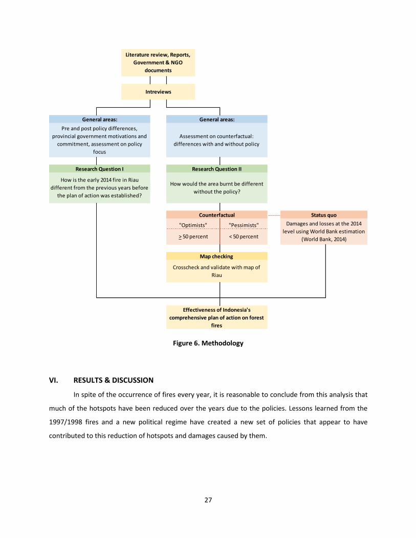
I further analyzed the discussion results and crosschecked them with a couple of maps. The first
map was the Global Forest Watch Fires using the archives of NASA active fires for Indonesia from February
to March 2014, with the option of only high confidence fires7. From this map I was able to look at the
hotspots distribution in Riau during the event across districts. The second is the Eyes on the Forest map,
which is a joint project between WWF, Walhi Riau, Jikalahari, and WARSI8. From this map, I included
several layers such as government protected areas, pulpwood concessions, and peat soil distribution to
be able to capture where the areas of concern and fires overlapped.
7 Global Forest Watch Fires. Accessed in December 18, 2014. http://fires.globalforestwatch.org/#v=map&x=102.51&y=1.17&l=8&lyrs=Overlays_Layer%2F3&dirty=true 8 Eyes on the Forets. Accessed in December 22, 2014. http://maps.eyesontheforest.or.id/
27
Figure 6. Methodology
VI. RESULTS & DISCUSSION
In spite of the occurrence of fires every year, it is reasonable to conclude from this analysis that
much of the hotspots have been reduced over the years due to the policies. Lessons learned from the
1997/1998 fires and a new political regime have created a new set of policies that appear to have
contributed to this reduction of hotspots and damages caused by them.
------- Status quo
Damages and losses at the 2014
level using World Bank estimation
(World Bank, 2014)
Effectiveness of Indonesia's
comprehensive plan of action on forest
fires
> 50 percent < 50 percent
Map checking
Crosscheck and validate with map of
Riau
"Optimists" "Pessimists"
Research Question I Research Question II
How is the early 2014 fire in Riau
different from the previous years before
the plan of action was established?
How would the area burnt be different
without the policy?
Counterfactual
Literature review, Reports,
Government & NGO
documents
Intreviews
General areas:
Pre and post policy differences,
provincial government motivations and
commitment, assessment on policy
focus
General areas:
Assessment on counterfactual:
differences with and without policy

28
Figure 7. Trend of hotspot counts in Riau in the past decade. The 2014 data reflect hotspot counts for the entire year, January to December 2014
Source: Ministry of Forestry database (2014)
I attempt to investigate the validity of this hypothesis by answering how the 2014 fire in Riau
would have been different without the policy. Nevertheless, there are many variables contributing to the
severity of land and forest fire occurrences. Among these are the different sources of ignition, weather
conditions such as the degree of dryness and other weather anomalies (whether it is an El Niño year or
not), and the level of combustible biomass (Herawati & Santoso, 2011). Because each of these variables
contributes to fires in Riau, the fires each year are relatively unique, thus, cannot be compared directly to
each other. Hence, comparing outcomes between one year and another and attributing it to a policy
change would be an incorrect approach. Therefore, it is more appropriate to look at a particular event in
a particular year and examine what could have happened differently had no policy been enacted.
Counterfactual – burned areas
One important aspect of the interview was to extract information on the interviewee’s expert
judgments of how different the fire would have been without the plan of action. Table 4 summarizes the
level of each interviewee’s judgment of additional burnt area in percentage if the plan of action was not
enacted. It shows the level of how much the policy contributed to the influence of the fire in early 2014,
and the resulting level of damages and losses.
22,630
11,526
4,169 3,943
7,756
1,7073,536
4,686 5,1824,328
0
5,000
10,000
15,000
20,000
25,000
2005 2006 2007 2008 2009 2010 2011 2012 2013 2014
Ho
tsp
ot
cou
nts
Year
Trend of Hotspot Counts in Riauin the past decade

29
Because the responses were significantly varied within the reference ranges that I initially
provided, I decided to divide them into two groups: (1) those who responded with relatively high
percentages (equal to and higher than 50%) of how much larger fires would have been without the policy,
thus exhibiting high optimism on the policies contribution to lower damages and losses (High), and (2)
those who responded with zero to low percentages (lower than 50%), exhibiting low optimism on the
policy’s effectiveness (Low). For each group, I calculated the mean by averaging the responses to get a
single percentage. This resulted in 10% for the Low group and 60% for the High group. I used these
numbers to further calculate the estimation of possible damage and losses ‘avoided’ in the early 2014 fire,
based on the World Bank’s estimation of the actual damage and losses9 (World Bank, 2014).
Table 3. Summary of counterfactual responses. These numbers represent the percentage of how much the interviewees think more area would have been burnt if the plan of action was not enacted.
Participants Institution Estimated
additional burnt area
Group
Interviewee 1 NGO 50% High
Interviewee 2 State Government 5% Low
Interviewee 3 State Government 50% High
Interviewee 4 NGO 10% Low
Interviewee 5 State Government 25% Low
Interviewee 6 State Government 10% Low
Interviewee 7 State Government 75% High
Interviewee 8 State Government 75% High
Interviewee 9 Provincial Government 60% High
Interviewee 10 Provincial Government 70% High
Interviewee 11 Provincial Government 50% High
Interviewee 12 Provincial Government 50% High
Interviewee 13 State Government 10% Pessimists
Interviewee 14 NGO 0% Pessimists
9 The World Bank’s (2014) assessment of damage and losses was conducted using the standard Damage and Losses Assessment (DaLA) methodology developed by the UN ECLAC https://www.gfdrr.org/Track-III-TA-Tools. The assessment analyzed impact on each sector such as productive sectors (agriculture, trade, industry, tourism), social sectors (health and education), and environment. DaLA methodology distinguishes damage and losses in calculating the overall economic valuation ("Damage, Loss and Needs Assessment (DaLA) Guidance Notes," 2010). Damage is considered as “total or partial destruction of physical assets” in the area in which disaster happens. This reflects the monetary value needed to estimate reconstruction needs. Losses is considered as “changes in economic flows arising from the disaster” which among others involves the decrease of revenues and production, and expenditures for emergency needs. This typically reflects the socio-economic impact of a disaster.

30
Summary:
High 8 participants Average: 60%
Low 6 participants Average: 10%
The interview results suggest on average there could have been 10 - 60 % more area burnt in the
early 2014 fires without the policy. More interviewees estimated there could have been more area burnt
in 2014 without the policy, ranging from 50 to 75% more hectares, than lower levels of burnt areas. There
is one interviewee who argued that there would be no difference. However, there is no clear signal as to
which group of interviewees was correct due to the small number of respondents. Therefore, I included
the responses of both groups (low and high) as a range.
The World Bank estimated the early 2014 fire caused total damage and losses of about 935 million
US dollars, which is 2 % of Riau’s GDP in 201310. This is roughly equivalent to 153 US dollars per capita in
the province (7,783 US Dollar). As a comparison, Riau’s budget for health in 2013 was 0.1 % of its GDP for
the same year11. This means that the cost of one Riau forest fire event in 2014 could have been used to
increase its health budget by almost 20 times.
I multiplied the World Bank damage estimates by the counterfactual percentage range (low and
high) to see how much more cost could have incurred without the policy. We can estimate that the
government intervention saved at least 21.2 million US dollars (low) in additional damage and losses, up
to 455 million US dollars (high). In terms of Riau per capita, this would mean that the policy could save
Riau about 3.5 to 75 US dollars per capita from extra damage and losses. Thus, although the fire cost 935
million US dollars, it could have been worse.
10 Riau’s GDP in 2013 is IDR 522 trillion or about US$ 47 billion (BPS, 2014). 11 Riau’s health budget in 2013 is IDR 555 billion or about US$ 50 million (BPS, 2014; Fitra, 2013).

31
Table 4. Summary of counterfactual calculations
*: World Bank (2014)
Table 5. Partial cost for implementation of the plan of action. The numbers are compared to the damages and losses from the early 2014 fire from the World Bank’s
estimates and the counterfactual scenario range.
Source: BNPB and Ministry of Finance, 2015.
8,702,366 ha 8,702,366 ha
176,000* ha
Low (10% higher than status quo) 176,000 (1.10) = 193,600 ha
High (60% higher than status quo) 176,000 (1.60) = 281,600 ha
Value of damage and losses 935,000,000* US$
Damage 7,300,000* US$
Losses 862,000,000* US$
21,230,000 US$
Damage 7,300,000 (1.10) = 8,030,000 US$
Losses 862,000,000 (1.10) = 948,200,000 US$
Total 956,230,000 US$
455,880,000 US$
Damage 7,300,000 (1.60) = 11,680,000 US$
Losses 862,000,000 (1.60) = 1,379,200,000 US$
Total 1,390,880,000 US$
Counterfactual
Level of damages and losses if the policy
was not in place
Total area in Riau
Area burnt
Counterfactual area burnt
Status quo
(Level of damages and
losses Feb-March 2014 in
Riau with the policy been
enacted since 2007)
Estimated savings from policy (Low)
Estimated savings from policy (High)
(Million Rupiah) (Thousands US Dollars) (US Dollars)
Cost of the plan of action from two government institutions in 2014
BNPB (National Disaster Management Agency) 164,000.00 14,909.00
Ministry of Forestry
Forest fires control and management 46,564.00 4,233.00
Forest fires investigation & security 35,576.00 3,234.00
Total BNPB & MoF expenditure 246,140.00 22,376.00
Total benefits
Low 21,230.00
High 455,880.00
Rate for conversion 1 USD = Rp 11,000

32
The calculation in Table 4 is based on two assumptions:
1. There is a linear proportional relationship between burnt area and damage and losses. Implicitly,
this means 10 % more burnt areas would have resulted in 10 % more damage and loss from longer
fire episodes, longer time to extinguish, longer haze, and disturbed economic activity throughout
the province.
2. There is a uniform soil carbon content across different districts. In reality, there are various levels
of peat soil depth all over the province ranging from less than 1 meter to more than 3 meters,
with different land use conversions (Mubekti, 2011). This would affect the estimates of carbon
and carbon release, the amount of haze that resulted from the burning, and the number of
cancelled days due to the haze and low visibility which would affect the total loss due to reduced
economic activity in the province.
The comparison between the cost to implement the plan of action in 2014 and the counterfactual
damage and losses might suggest two things. For the minimum range, the cost to implement the plan of
action would most likely outweigh the benefits of saving 3.5 US dollars per capita by a relatively small
value (0.19 cents). At the maximum range, the cost information indicates the benefit significantly
outweighed the cost by almost 20 times. However, the total cost is only comprised of the budgets from
two institutions, the Ministry of Forestry and BNPB. Because they are leading institutions for many
measures in the policy list, they have the most substantial budget represented by this policy. However,
because the plan of action is comprehensive and involves many government agencies, the rest of the
budget and other resources would be distributed among institutions associated with their field.
Consequently, the cost of policy implementation is most likely higher than what is being exhibited here
(Table 5).
Given the wide range of possible savings from implementing the plan of action, it remains unclear
how much the benefit exceeds the cost. However, we can conclude that the benefits (monetary value
saved from a more severe fire) would most likely offset the cost to prevent a more severe fire. Therefore,
there is a reason to believe some elements of the policy actually might have had some influence in
controlling the severity of fires in early 2014, thus allowing the province to avoid worse damage and losses.
The interviewees came from diverse home institutions with varied types of involvement,
proximity, and knowledge of the plan of action. Thus, each of them provided unique information
corresponding to their relationship with Riau fires. Of all interviewees, the provincial government and
local NGO revealed more detailed information on existing policies in specific districts, even at the

33
subdistrict level. They were able to make their own assessment about what the landscape and physical
condition would have looked like without policy intervention due to their direct contact in the province
on a daily basis for years. They were able to visualize specific subdistricts and villages that might have
been affected, and often related them to existing policies and the nature of its terrain. In general, the
discussions allowed me to better make a compilation of areas that might have suffered from additional
area burns.
Although the interviews were designed to extract expert judgments of how different the fire
would have looked like, counterfactual analysis is rather independent from whether its result is true or
false (Ballart & Riba, 2000). The fact that these experts were able to argue and try to depict areas that
could have been affected gives us a ray of light as to what extent government intervention might have
influenced a particular district or subdistrict. Furthermore, it also gives an indication of which districts the
policy might have had a more effective impact and by which exact element of the policy. Therefore,
regardless of the correctness of a counterfactual scenario, the analysis would still be valuable because it
is mind-expanding, drives debate, helps mitigate bias, and helps to make decisions in the future (Nolan,
2011).
Relevant Information on the Policy Process
Besides exploring the counterfactual scenario on the 2014 fire event in Riau, interviews with
forest fire experts have also given me a better understanding about how significant the policy is and what
kind of significance it portrays compared to the regime without any relevant policy enactment. From the
interviews, the experts were able to reveal a number of interesting themes and ideas about the policy
implementation, particular weaknesses and strengths, and the experts’ assessment on specific elements
of the plan of action.
The experts in general have a common understanding that the government has produced a ‘full-
package’ policy, engaging all related ministries and provincial authorities. The impact is crucial in
synergizing and integrating featured programs from each institution and concentrate them on fire-prone
areas. However, they agree that having the plan of action on paper alone is not sufficient, and that other
relevant aspects are also crucial to the success of solving the issue. The first is a strong commitment from
all related institutions. The second is an oversight unit to ensure that the policies are being implemented
and enforced.
Several interviewees think that most changes are forced and initiated by the national government,
which is probably driven by international pressure and NGOs. Thus, because it is motivated externally and

34
rather enforced from the national government, it would be challenging to get Riau’s full commitment to
resolve the problem. As an interviewee from the Riau province mentioned, “The plan of action was a
starting point for the Riau government to sign commitments at the provincial level to tackle and deal with
forest fires more seriously. Otherwise I am less optimistic that the provincial government would do
anything significant” (Interviewee 8).
However, the policy is still a good stepping stone to a shifting regime of fire policy, because before
early 2000 studies have mentioned the policies related to this were either very limited, minimal, or non-
existent. The momentum after 1997-1998 was a sobering wake-up call for the authorities, although it took
several years to produce something concrete. From the provincial policies, at least, this is reflected in its
intermediate provincial development plans (Rencana Pembangunan Jangka Menengah Daerah / RPJMD)
2009-2013 on environment development. One of the aspects is the emphasis on sustainable peatland
management by promoting non-burning methods for land clearing. Furthermore, it sets off agreements
(memorandum of understanding) for sustainable peatland management between the Ministry of
Environment and the Governor of Riau, the regents of Siak, Pelalawan, Bengkalis, Indragiri Hilir, Rokan
Hilir, and the mayor of Dumai – all the heads of areas that are well-known to be fire-prone.
Two areas of improvement resulting from the policy
The interviewees, especially those from the government, revealed at least two elements on how
significant the plan of action is in changing the attitude and culture of decisions related to pre- and post-
fire events in Riau:
1. Improved capacity and access of technology and data.
The plan of action is said to be effective in transferring knowledge and capacity from the national
government to Riau in terms of monitoring capacity and technology. Earlier hotspots information had
limited access among officials, but now they can be accessed publicly and help expedite decision-making.
The Riau government is now also able to access and monitor hotspots from the national mailing list
(SiPongi) and analyze hotspots coordinate’s data that are received from satellite images to detect
locations of the hotspots origins. They can now easily retrieve information related to weather from the
national agencies’ websites. “The most distinct thing after the plan of action is implemented in Riau is how
there has been increased awareness from all government officials in taking advantage from data and
science-related information. It is more inclusively distributed, and so responses were relatively faster.”
(Interviewee 13).

35
The Fire Danger Rating System (FDRS), which was initially only possessed by a couple of national
agencies, also can be utilized inclusively. “I do not think there are any bombastic breakthroughs on early
warning system – we’ve had the FDRS for a while, but the way this information is disseminated and
distributed down to the local level has really helped. National ministries are now reaching out and
communicating better with the provincial government in fire-prone areas” (Interviewee 5).
2. Improved emergency response (fire suppression).
Prior to the enactment of the plan of action, responses towards potentially massive fire events
were sporadic and uncoordinated. A number of interviewees expressed how there was no single
command and each institution tried to outdo others. With the plan of action in place, efforts to deal with
forest fires were more coordinated and systematic. Responses were also adjusted to the level of alert
status of the disaster12.
In the era before 2007-2008, fire suppression efforts had not been carried out comprehensively,
because there had been many limitations on the institutions responsible. Now, fire suppression efforts
and emergency response were held more comprehensively and involve all different agencies. This is due
to a more defined mandate and clear national law to support such activity. “There’s also a sense of pride,
you know, that now we are able to do all suppression efforts by ourselves – we utilize all national capacities
without any national assistance. All the water bombing, weather modification efforts, cloud seeding… and
supported by Manggala Agni (fire brigade)… all are by our very own people, budget, and leadership”
(Interviewee 7).
Areas for improvement
The experts realized that the policy, however, still needed improvement. I was able to extract
information on a number of weaknesses mentioned by the experts about the plan of action or areas that
could use improvement.
1. The lack of specific policy details.
The package plan attempts to include every aspect related to land and forest fires, but ends up
being too broad, hence missing small practical details. Therefore, the province has little reference for
12 Whenever the alert level is “disaster alert” (siaga darurat), the commandant in charge is from the provincial government – (usually the regional secretary or Sekretaris Daerah) or the Head of Riau Disaster Mitigation Agency (BPBD). But whenever the status goes up to “disaster emergency response” (tanggap darurat bencana), then the commandant in charge is the Head of the National Agency for Disaster Management (BNPB) by mobilizing and utilizing all of the national resources available.

36
criteria to execute certain actions. For example, there is no exact threshold or clear criteria to announce
certain levels when the fire gets out of control. “There’s no clear reference... How to proceed in certain
kinds of magnitude of hotspots for instance? What kind of situation determines the kind of task force the
government should be sending? When the satellite imagery shows 10 hotspots and 100 hotspots, do we
execute similar actions? Those are questions that should be answered…” (Interviewee 2).
2. Different tools or system used among government institutions.
Different agencies also use different systems or tools for monitoring. For instance, the Ministry of
Forestry uses NOAA-18 satellite program and the BMKG uses MODIS Agua/Terra satellites. According to
the experts, the two satellites can result in significantly different images, because they have different
threshold levels for determining fire occurrence. MODIS is thought to be more reliable and has varied
indicators to support its confidence level of fire occurrence. Although, none of the interviewees really had
an idea why NOAA-18 satellite is still being used by the Ministry of Forestry. The use of these different
systems, therefore, resulted in different hotspot counts and different references when making actions,
which can be confusing for the provincial government.
3. The policy does not include incentives for a zero burning policy.
The policy is said to be lacking economic incentives for a zero burning policy. As long as there is
still an advantage from the efficiency of using fire, people will not be motivated to stop using burning for
land clearing.
Caveats of the analysis
During my attempt to gather detailed information about the plan of action, I became aware of
the limited availability of this information to the public. Besides not being fully well-documented, there is
yet to be a single government institution to comprehensively disclose it through its official website or
other forms of government reports. I obtained most information about the plan of action through
interviews with government officials, my professional experience being engaged at ASEAN meetings, and
documents related to the meetings. Due to the nature of these documents and confidentiality issues,
however, they cannot be used as identifiable references in this report. Furthermore, the policy is
described better through reports made by ASEAN and some neighboring countries (Singapore and
Malaysia) due to their involvement in a number of projects under the plan of action. This issue became
more obvious during the interviews where government officials were more familiar with the plan of action
and, thus, were able to provide detailed judgments about it. The same situation did not apply to most

37
NGO interviewees, although they are aware of a number of the programs and projects under the plan of
action.
This condition reveals a possible flaw of the policy. The policy’s lack of disclosure and the public’s
limited knowledge make it challenging to be assessed and evaluated by different stakeholders. This limits
the ability for the policy to receive further input for improvement and limited opportunities for
cooperation with non-government parties. A comprehensive and well-documented policy would enable
external parties to help identify what other areas they can engage with to complement existing programs
or projects. Because forest fire is a big issue that needs all the resources it can get, the government would
benefit from cooperation and involvement with all parties. Furthermore, a poorly documented and vague
policy is bad publicity for the government and sends a false message to the public that the government is
not doing anything meaningful. Because they are criticized constantly for annual forest fires, one good
strategy would be to reveal efforts on which they have been working.
In addition, the set of interviews I conducted indicates that fire suppression measures and
monitoring efforts might have had greater significance in influencing the level of damage and losses in the
early 2014 fire, because they were highlighted more than other elements of the policy. The experts came
from different institutional backgrounds and could have highlighted other elements of the policy which
relates more to their work. Given the fact that most of them emphasize on only fire suppression and
monitoring efforts suggested that these elements seem to be really efficient to the experts. However, a
number of experts pointed out how focusing on fire suppression and devoting substantial budget for it is
not a good investment and would not bring significant long term impacts. They expressed how the
government should have put more focus on preventive efforts, for then they could have saved much of
the suppression budget and resources if there had been no fires to begin with.
VII. CONCLUSION
The previous analysis led me to several conclusions. First, based on the interviews I conducted
with 14 forest fire experts (7 state officials, 4 provincial officials, and 3 NGOs), on average, they were
convinced that had the policy not been enacted, the 2014 forest fire would have burnt 10 - 60 % more
area and increased the overall damage and losses. There is one interviewee who argued that with or
without the policy nothing would have changed. This reveals, although the policy is yet to prevent 100 %
of the massive fire occurrences in the country, experts from my set of interviews were somewhat
optimistic that the policy did limit the level of damage and losses. Moreover, most of them gave particular
emphasis to the success of the fire suppression element of the plan of action. This might suggest that

38
other elements of the policy either could be improved to ensure hotspots reduction, or be reevaluated to
determine if they were actually a significant element of the policy.
Second, based on the percentage range of counterfactual area burnt, the benefits (monetary
value saved from a more severe fire) most likely outweighed the cost of implementing the policy action.
The total expenditure from the leading institutions was about 22 million US dollars, which was about half
of Riau’s health budget in 2013. On the other hand, the potential benefit ranged from 21.2 (low) to 455
(high) million US dollars. In the high scenario, the benefit of having the policy in 2014 outweighed the cost
by about 20 times, which is 9 times Riau’s health budget in 2013. This corroborates the reason to believe
that some elements of the policy might have had some influence in controlling the severity of fires in early
2014. If the government continues to perfect its policy measures, the cost of implementing the policy
might no longer be relevant compared to the benefits Riau obtains from having the policy in place.
Third, based on the interviews and my literature review, the plan of action, which was enacted
about eight years ago, still has its shortcomings and needs regular evaluation. This is necessary to ensure
that each of the programs under the policy package is well-defined in terms of its goals, clear in what and
how to achieve it, and supported by detailed instructions for provincial actions. Otherwise, the policy will
only be a vague directive and will leave the provincial government confused and misled.
VIII. POLICY RECOMMENDATIONS
Based on the above conclusions, there are several policy recommendations related that might
help resolve some of its weaknesses. First, for the magnitude and impact of this kind of large fire, a budget
of 22 million US dollars for the policy is minuscule. The policy expenditure is 2.3 % of the total damage
and losses, which gives us a sobering fact of how little the government spends compared to the
consequences suffered by the people of Riau. The policy cost is also only 0.05 % of Riau’s regional GDP.
This means that even if Riau decided to spend that much, it is a small number; such an expenditure would
be reasonable, given that it is a rich province that relies significantly on the extraction of natural resources.
With additional budget support for the policy measures, more can be done to increase the likelihood that
Riau can avoid more severe fire damage and losses.
Second, because weather anomalies and other climate parameters play a significant role in
aggravating fires in the province, there are two approaches for land clearing management in the province.
The first is that the government should invest in zero-burning practices by subsidizing machinery for land
clearing to small farmers and small-medium companies. Therefore, Riau could decrease its ignition risk
from deliberate burning. The second is to use a ‘prescribed burning’ policy. This way, the government has

39
to specifically regulate farmers and plantations about when and where to burn to lower the risk of fires
spreading and escalating beyond the targeted area. This means that prescribed burning can only be
allowed under a specified and predetermined wind speed and direction, relative humidity, air
temperature, atmosphere stability, precipitation, and other weather parameters to avoid fires from
getting out of control. The government can completely ban fire when an El Niño event is predicted to hit
the country.
Third, the policy package is comprehensive enough, but ensuring that it is really translated into
sound implementation is a challenge, because all of the agencies are more or less related horizontally in
the bureaucracy. Therefore, the policy should be complemented with a special agency or unit that has the
jurisdiction and authority to oversee the entire execution of the policy, and which has a higher
administrative rank relative to other ministries with the authority to issue forms of punishment or reward.
Forth, the information about the plan of action would be best if it is made in a more transparent
way and made publicly available. Simply by making the plan accessible through websites or government
reports would educate the public better on what efforts are being sought and how the public can support
these means. It should also stimulate ideas among external parties who would be willing to contribute to
reducing the risk of large fire events in Riau and better assess future efforts that are needed. Because
land and forest fire issues are major environmental problems in the country, the government would most
likely benefit from all the help they can get to solve this issue.***

40
Aiken, S. R. (2004). Runaway Fires, Smoke-Haze Pollution, and Unnatural Disasters in Indonesia. Geographical Review, 94(1), 55-79. doi: 10.2307/30033953
Ballart, X., & Riba, C. (2000). Forest Fires: Evaluation of Government Intervention Measures. Policy Sciences, 35(4), 361.
BAPPENAS, & ADB. (1999). Causes, Extent, Impact and Costs of 1997/1998 Fires and Drought Planning for Fire Prevention and Drought Management Project (Vol. Final report, Annex 1 and 2). Jakarta: National Development Planning Agency (BAPPENAS)
Asian Development Bank (ADB). Barber, C. V., & Schweithelm, J. (2000). Trial by Fire: Forest Fires and Forestry Policy in Indonesia's Era of
Crisis and reform: World resources Institute BNPB. (2014). Ketangguhan Bangsa Dalam Menghadapi Bencana Gema BNPB, 5(1). BPS-Riau. (2013). Laporan hasil sensus pertanian 2013 (pencacahan lengkap). BPS. (2011a). . BPS. (2011b). Luas kawasan hutan dan perairan menurut provinsi (ha) from
http://www.bps.go.id/webbeta/frontend/linkTabelStatis/view/id/1716 BPS. (2014). Produk Domestik Regional Bruto Atas Dasar Harga Berlaku Menurut Provinsi, 2000 - 2013
(Miliar Rupiah) Cotton, J. (1999). The "Haze" over Southeast Asia: Challenging the ASEAN Mode of Regional
Engagement. Pacific Affairs, 72(3), 331-351. Damage, Loss and Needs Assessment (DaLA) Guidance Notes. (2010). 2(Conducting Damage and Loss
Assessments after Disasters). Department of Environment of Malaysia. (2010). Malaysia-Indonesia Collaboration in preventive
measures to deal with land and forest fires in the Riau Province, Sumatra, Republic of Indonesia (2008-2009). Department of Environment of Malaysia.
Field, R. D., Werf, G. R. v. d., & Shen, S. S. P. (2009). Human amplification of drought-induced biomass burning in Indonesia since 1960. Nature Geoscience, 2. doi: 10.1038/NGEO443
Fitra. (2013). Dukung judicial review APBD Riau 2013. from https://www.change.org/p/ma-dukung-judicial-review-apbd-riau-2013
Frankenberg, E., McKee, D., & Thomas, D. (2005). Health Consequences of Forest Fires in Indonesia Springer on behalf of the Population Association of America, 42(1), 109-120.
Freiburg, U. (2000). GFMC Selected Examples for Imagery Information Sources: an imagery interpretation aid
Gellert, P. K. (1998). A Brief History and Analysis of Indonesia's Forest Fire Crisis. Indonesia(65), 63-85. doi: 10.2307/3351404
Global Forest Watch Fires Map. (2014). http://fires.globalforestwatch.org Glover, D., & Jessup, T. (1999). Indonesia's Fires and Haze: The Cost of Catastrophe: The Institute of
Southeast Asian Studies (ISEAS) & International Development Research Centre. Greenpeace. (2014). Sumatra: Going up in smoke [Press release] Haberle, S. G., Hope, G. S., & Kaar, S. v. d. (2001). Biomass burning in Indonesia and Papua New Guinea:
natural and human induced fire events in the fossil record. Palaeogeogr Palaeoclimatol Palaeoecol, 171, 259-268.

41
Herawati, H., & Santoso, H. (2011). Tropical forest susceptibility to and risk of fire under changing climate: a review of fire nature, policy and institutions in Indonesia. Forest Policy and Economics, 13, 227-233.
Herring, D. (2009). What is El Niño? . NASA's Earth Observatory. 2015 Jim, C. Y. (1999). The Forest Fires in Indonesia 1997-98: Possible Causes and Pervasive Consequences.
Geography, 84(3), 251-260. doi: 10.2307/40573309 Kemendagri. (2013). Buku induk kode dan data wilayah administrasi per provinsi, kabupaten/kota, dan
kecamatan seluruh Indonesia. Retrieved from http://www.kemendagri.go.id/media/filemanager/2013/05/28/b/u/buku_induk_kode_data_dan_wilayah_2013.pdf.
Lamb, R. (1984). Indonesia's Tragic Tropical Forest Blaze. Ambio: The South Pacific, 13(5-6), 381-382. Langner, A., & Siegert, F. (2008). Spatiotemporal fire occurence in Borneo over a period of 10 years.
Global Change Biology, 15, 48-62. doi: 10.111/j.1365-2486.2008.01828.x Lee, J. S. H., Abood, S., Ghazoul, J., Barus, B., Obidzinski, K., & Koh, L. P. (2013). Environmental impacts of
large-scale oil palm enterprises exceed that of smallholdings in Indonesia. Conservation Letters, 7(1), 25-33. doi: 10.1111/conl.12039
Litta, H. (2012). Regimes in Southeast Asia: an analysis of environmental cooperation. (Ph.D), Universitat Berlin.
Malingreau, J. P., Stephens, G., & Fellows, L. (1985). Remote sensing of forest fires: Kalimantan and North Borneo in 1982-1983. Ambio, 14(6), 314-321.
Mubekti. (2011). Studi pewilayahan dalam rangka pengelolaan lahan gambut berkelanjutan di provinsi Riau. Jurnal Sains dan Teknologi Indonesia, 13(2), 88-94.
Mubyarto. (1997). Riau: Progress and Poverty. Bijdragen tot de Taal-, Land- en Volkenkunde, Deel 153, 4de Afl, 542-556.
NASA. (2000). Global Fire Monitoring: NASA and NOAA Missions for Monitoring Global Fires. from http://earthobservatory.nasa.gov/Features/GlobalFire/fire_5.php
Nguitragool, P. (2011). Negotiating the Haze Treaty. Asian Survey, 51(2), 356-378. Nolan, D. (2011). Why historians (and everyone else) should care about counterfactuals. Philos Stud,
163, 317-335. doi: 10.1007/s11098-011-9817-z Pidwirny, M. (2006). Fundamentals of Physical Geography El Niño, La Niña and the Southern Oscillation
Retrieved from http://www.physicalgeography.net/fundamentals/7z.html
Qodriyatun, S. N. (2014). Kebijakan Penanganan Kebakaran Hutan dan Lahan. Info Singkat Kesejahteraan
Sosial, VI(6)(II). Sizer, N., Anderson, J., Stolle, F., Minnemeyer, S., Higgins, M., Anderson, J., & Lawalata, J. (2014). Fires in
Indonesia Spike to Highest Levels Since June 2013 Haze Emergency Retrieved from http://www.wri.org/blog/2014/03/fires-indonesia-spike-highest-levels-june-2013-haze-emergency
Sizer, N., Leach, A., Minnemeyer, S., Higgins, M., Stolle, F., Anderson, J., & Lawalata, J. (2014). Preventing forest fires in Indonesia: Focus on Riau Province, peatland, and illegal burning. Retrieved from http://www.wri.org/blog/2014/04/preventing-forest-fires-indonesia-focus-riau-province-peatland-and-illegal-burning
Tacconi, L. (2003). Fires in Indonesia: Causes, Costs and Policy Implications. (Occasional Paper No. 38). Tan, A. K.-J. (1999). Forest Fires of Indonesia: State Responsibility and International Liability. The
International and Comparative Law Quarterly, 48(4), 826-855. doi: 10.2307/761736 Taylor, D. (2009). Biomass burning, humans and climate change in Southeast ASia. Biodivers Conserv, 19,
1025-1042. doi: 10.1007/s10531-009-9756-6

42
Taylor, D., Saksena, P., & Kucera, K. (1999). Environmental change and rain forests on the Sunda shelf of Southeast Asia: drought, fire, and the biological cooling of biodiversity hotspots. Biodivers Conserv, 8, 1159-1177.
Usup, A., Hashimoto, Y., Takahashi, H., & Hayasaka, H. (2004). Combustion and thermal characteristics of peat fire in tropical peatland in Central Kalimantan. Tropics, 14(1), 1-19. doi: https://www.jstage.jst.go.jp/article/tropics/14/1/14_1_1/_pdf
Vayda, A. P. (2006). Causal Explanation of Indonesian Forest Fires: Concepts, Applications, and Research Priorities. Human Ecology, 34(5), 615-635. doi: 10.2307/27654144
Vishvanathan, S. (1997). Politics of Indonesia's Forest Fires. Economic and Political Weekly, 32(41), 2587-2588. doi: 10.2307/4405945
Wetlands International. (2014). Peatlands. from http://www.wetlands.org/Whatarewetlands/Peatlands/tabid/2737/Default.aspx
Wooster, M. J., Perry, G. L. W., & Zoumas, A. (2012). Fire, drought, and El Niño relationships on Borneo (Southeast Asia) in the pre-MODIS era (1980-2000). Biogeosciences, 9, 317-340. doi: 10.5194/bg-9-317-2012
World Bank. (2011). The World Bank Group Framework and IFC Strategy for Engagement in the Palm Oil Sector.
World Bank. (2014). Indonesia Economic Quarterly July 2014: Hard Choices: The World Bank. WWF, & EEPSEA. (2003). The Indonesian Fires and Haze of 1997: The Economic Toll (pp. 1-9). Ottawa,
Canada: Economy and Environment Program for Southeast Asia (EEPSEA)
World Wide Fund for Nature (WWF). Yulianti, N., Hayasaka, H., & Sepriando, A. (2013). Recent trends of fire occurrence in Sumatra (analysis
using MODIS hotspot data): A comparison with fire occurrence in Kalimantan Open Journal of Forestry, 3(4), 129-137.

43
Appendix 1. Ministries, agencies and officials responsible for improving land and forest fires control in the Presidential Instruction Number 16/2011
1. The Coordinating Ministry for People’s Welfare Kemenko Kesra
2. The Ministry of Forestry Kementerian Kehutanan
3. The Ministry of Environment Kementerian Lingkungan Hidup
4. The Ministry of Agriculture Kementerian Pertanian
5. National Disaster Management Agency BNPB
6. The Agency for Meteorology, Climatology and Geophysics BMKG
7. The Agency for Aerospace LAPAN
8. The National Development Planning Agency BAPPENAS
9. Chief Police Polri
10. National Commander of Armed Forces TNI
11. The Ministry of Research and Technology BPPT
12. The Ministry of Home Affairs Kementerian Dalam Negeri
13. The Ministry of Foreign Affairs Kementerian Luar Negeri
14. Attorney General Jaksa Agung
15. Governors and Mayors Gubernur dan Bupati