ANABSTRACT OF THE THESIS OF - Oregon State University
58
AN ABSTRACT OF THE THESIS OF Erick McAdam for the degree of Master of Science in Sustainable Forest Management presented on December 7, 2015. Title: Using Remote Sensing and Process‐based Growth Modeling to Predict Forest Productivity Across Western Oregon Abstract approved: ______________________________________________________ Thomas Hilker Accurate measurement of forest productivity is fundamental to understand the carbon balance of forested ecosystems. Recent changes in climate highlight the importance of developing methods to measure forest productivity so that sound economic and environmental decision can be made. Efforts to measure forest productivity across the landscape using remote sensing suffer from limitations inherent in individual sensors. We combine approaches to estimate forest productivity on Douglas‐fir plantations using optical passive remote sensing to estimate stand ages, single‐pass LiDAR sampling to estimate structural properties, and a process‐based growth model (3PG) to assess variation in soil properties across western Oregon. Our results indicate that it is possible to estimate both
Transcript of ANABSTRACT OF THE THESIS OF - Oregon State University

AN ABSTRACT OF THE THESIS OF
Erick McAdam for the degree of Master of Science in Sustainable Forest Management
presented on December 7 2015
Title Using Remote Sensing and Process‐based Growth Modeling to Predict Forest
Productivity Across Western Oregon
Abstract approved ______________________________________________________
Thomas Hilker
Accurate measurement of forest productivity is fundamental to understand the
carbon balance of forested ecosystems Recent changes in climate highlight the importance
of developing methods to measure forest productivity so that sound economic and
environmental decision can be made Efforts to measure forest productivity across the
landscape using remote sensing suffer from limitations inherent in individual sensors We
combine approaches to estimate forest productivity on Douglas‐fir plantations using optical
passive remote sensing to estimate stand ages single‐pass LiDAR sampling to estimate
structural properties and a process‐based growth model (3PG) to assess variation in soil
properties across western Oregon Our results indicate that it is possible to estimate both
site index and difficult‐to‐obtain soil properties across the landscape using two types of
remote sensing instruments in combination with modeling While we believe that the
approach is sound we found that the quality of extrapolated climatic data very much affects
the derived values of soil properties assessed by modeling In contrast estimates of
maximum leaf area index with LiDAR proved a reliable independent means to assess site
productivity because plantations reach maximum values in less than two decades after
establishment
copyCopyright by Erick McAdam
December 7 2015
All Rights Reserved
Using Remote Sensing and Process‐based Growth Modeling to Predict Forest Productivity
across Western Oregon
by
Erick McAdam
A THESIS
submitted to
Oregon State University
in partial fulfillment of the requirements for the
degree of
Master of Science
Presented December 7 2015
Commencement June 2016
Master of Science thesis of Erick McAdam presented on December 7 2015
APPROVED
Major Professor representing Sustainable Forest Management
Head of the Department of Forest Engineering Resources and Management
Dean of the Graduate School
I understand that my thesis will become part of the permanent collection of Oregon State
University libraries My signature below authorizes release of my thesis to any reader upon
request
Erick McAdam Author
ACKNOWLEDGEMENTS
I would like to thank my primary adviser Thomas Hilker for his moral and economic
support patience and always being available when I needed help Thanks to Hailemariam
Temesgen for his generosity in providing much needed funds during the last several months at
Oregon State University I would also like to give special thanks to Richard Waring for his
guidance sharing his knowledge pushing me to do more model runs and his constant
encouragement throughout this process Also many thanks to all my committee members for
being so accommodating and for their helpful advice To all my friends in Corvallis for
always being there to distract me My time in Oregon would not have been as enjoyable
without you Lastly I would like to express my gratitude to my family for their continued
support throughout my stay in Oregon
TABLE OF CONTENTS
Page
Introduction helliphelliphelliphelliphelliphelliphelliphelliphelliphelliphelliphelliphelliphelliphelliphelliphelliphelliphelliphelliphelliphelliphelliphelliphelliphelliphelliphelliphelliphelliphelliphelliphelliphelliphelliphelliphelliphelliphelliphelliphelliphelliphelliphelliphellip1
Literature Review helliphelliphelliphelliphelliphelliphelliphelliphelliphelliphelliphelliphelliphelliphelliphelliphelliphelliphelliphelliphelliphelliphelliphelliphelliphelliphelliphelliphelliphelliphelliphelliphelliphelliphelliphelliphelliphelliphelliphelliphelliphellip4
Materials and Methods helliphelliphelliphelliphelliphelliphelliphelliphelliphelliphelliphelliphelliphelliphelliphelliphelliphelliphelliphelliphelliphelliphelliphelliphelliphelliphelliphelliphelliphelliphelliphelliphelliphelliphelliphelliphelliphellip10
Study area helliphelliphelliphelliphelliphelliphelliphelliphelliphelliphelliphelliphelliphelliphelliphelliphelliphelliphelliphelliphelliphelliphelliphelliphelliphelliphelliphelliphelliphelliphelliphelliphelliphelliphelliphelliphelliphelliphelliphelliphellip10
Results helliphelliphelliphelliphelliphelliphelliphelliphelliphelliphelliphelliphelliphelliphelliphelliphelliphelliphelliphelliphelliphelliphelliphelliphelliphelliphelliphelliphelliphelliphelliphelliphelliphelliphelliphelliphelliphelliphelliphelliphelliphelliphelliphelliphelliphelliphelliphellip24
Appendix helliphelliphelliphelliphelliphelliphelliphelliphelliphelliphelliphelliphelliphelliphelliphelliphelliphelliphelliphelliphelliphelliphelliphelliphelliphelliphelliphelliphelliphelliphelliphelliphelliphelliphelliphelliphelliphelliphelliphelliphelliphelliphelliphelliphelliphelliphellip46
Landsat disturbance and stand age estimation helliphelliphelliphelliphelliphelliphelliphelliphelliphelliphelliphelliphelliphelliphelliphelliphelliphelliphelliphellip10
Estimates of site growth potential using site index helliphelliphelliphelliphelliphelliphelliphelliphelliphelliphelliphelliphelliphelliphelliphelliphelliphellip12
Climate data helliphelliphelliphelliphelliphelliphelliphelliphelliphelliphelliphelliphelliphelliphelliphelliphelliphelliphelliphelliphelliphelliphelliphelliphelliphelliphelliphelliphelliphelliphelliphelliphelliphelliphelliphelliphelliphelliphellip14
LiDAR data helliphelliphelliphelliphelliphelliphelliphelliphelliphelliphelliphelliphelliphelliphelliphelliphelliphelliphelliphelliphelliphelliphelliphelliphelliphelliphelliphelliphelliphelliphelliphelliphelliphelliphelliphelliphelliphelliphelliphelliphellip19
Growth modeling helliphelliphelliphelliphelliphelliphelliphelliphelliphelliphelliphelliphelliphelliphelliphelliphelliphelliphelliphelliphelliphelliphelliphelliphelliphelliphelliphelliphelliphelliphelliphelliphelliphelliphelliphelliphellip20
Model parameterization helliphelliphelliphelliphelliphelliphelliphelliphelliphelliphelliphelliphelliphelliphelliphelliphelliphelliphelliphelliphelliphelliphelliphelliphelliphelliphelliphelliphelliphelliphelliphellip22
Discussion helliphelliphelliphelliphelliphelliphelliphelliphelliphelliphelliphelliphelliphelliphelliphelliphelliphelliphelliphelliphelliphelliphelliphelliphelliphelliphelliphelliphelliphelliphelliphelliphelliphelliphelliphelliphelliphelliphelliphelliphelliphelliphelliphelliphelliphellip32
Conclusion helliphelliphelliphelliphelliphelliphelliphelliphelliphelliphelliphelliphelliphelliphelliphelliphelliphelliphelliphelliphelliphelliphelliphelliphelliphelliphelliphelliphelliphelliphelliphelliphelliphelliphelliphelliphelliphelliphelliphelliphelliphelliphelliphelliphellip37
Literature cited helliphelliphelliphelliphelliphelliphelliphelliphelliphelliphelliphelliphelliphelliphelliphelliphelliphelliphelliphelliphelliphelliphelliphelliphelliphelliphelliphelliphelliphelliphelliphelliphelliphelliphelliphelliphelliphelliphelliphelliphelliphelliphellip39
LIST OF FIGURES
Figure Page
1 Map of western Oregon showing site classes and approximate stand locations (red dots)
helliphelliphelliphelliphelliphelliphelliphelliphelliphelliphelliphelliphelliphelliphelliphelliphelliphelliphelliphelliphelliphelliphelliphelliphelliphelliphelliphelliphelliphelliphelliphelliphelliphelliphelliphelliphelliphelliphelliphelliphelliphelliphelliphelliphelliphelliphelliphelliphelliphelliphelliphelliphellip13
2 Map of total annual precipitation for western Oregon showing stand locations as red
spotshelliphelliphelliphelliphelliphelliphelliphelliphelliphelliphelliphelliphelliphelliphelliphelliphelliphelliphelliphelliphelliphelliphelliphelliphelliphelliphelliphelliphelliphelliphelliphelliphelliphelliphelliphelliphelliphelliphelliphelliphelliphelliphelliphelliphelliphelliphelliphelliphellip15
3 Map of mean daily short wave radiation for western Oregon showing stand locations as
red spotshelliphelliphelliphelliphelliphelliphelliphelliphelliphelliphelliphelliphelliphelliphelliphelliphelliphelliphelliphelliphelliphelliphelliphelliphelliphelliphellip16
4 Map of mean annual maximum temperatures for western Oregon showing stand
locations as blue spots helliphelliphelliphelliphelliphelliphelliphelliphelliphelliphelliphelliphelliphelliphelliphelliphelliphelliphelliphelliphelliphelliphelliphelliphelliphelliphelliphelliphelliphelliphelliphelliphelliphelliphelliphelliphellip17
5 Map of mean annual minimum temperatures for western Oregon showing stand locations
as blue spotshelliphelliphelliphelliphelliphelliphelliphelliphelliphelliphelliphelliphelliphelliphelliphelliphelliphelliphelliphelliphelliphelliphelliphelliphelliphelliphelliphelliphelliphelliphelliphelliphelliphelliphelliphelliphelliphelliphelliphelliphelliphelliphellip18
6 Visualization of surface normalized LiDAR point cloud of different forest in our sampling
areahelliphelliphelliphelliphelliphelliphelliphelliphelliphelliphelliphelliphelliphelliphelliphelliphelliphelliphelliphelliphelliphelliphelliphelliphelliphelliphelliphelliphelliphelliphelliphelliphelliphelliphelliphelliphelliphelliphelliphelliphelliphelliphelliphelliphelliphelliphelliphelliphellip24
7 Landsat‐derived map of perceived disturbances from 1983‐2012 in western Oregon hellip26
8 Number of recorded 30x30m disturbances by year in the state of Oregonhelliphelliphelliphelliphelliphelliphellip27
9 Relationship between 3PG modeled v LiDAR‐ derived estimates of LA helliphelliphelliphelliphelliphelliphelliphellip28
10 Derived age‐height relationship for 111 stands sampled helliphelliphelliphelliphelliphelliphelliphelliphelliphelliphelliphelliphelliphelliphellip30
11 Derived soil fertility rankings (FR) from inverting the 3‐PG model while assuming that the available soil water storage capacity was fixed at 300mm and that stand leaf area index (LAI) was equivalent to that estimated by LIDARhelliphelliphelliphelliphelliphelliphelliphelliphelliphelliphelliphelliphelliphelliphelliphelliphelliphelliphelliphelliphelliphelliphelliphelliphelliphelliphellip31
12 A Observed LiDAR LAI plotted against estimated stand age using McArdle et al (1949)
lower to upper height limits for each site classhelliphelliphelliphelliphelliphelliphelliphelliphelliphelliphelliphelliphelliphelliphelliphelliphelliphelliphelliphelliphelliphelliphelliphelliphellip32
13 Site index classification in western Oregon using McArdle et al (1949) yield tables helliphellip35
14 LiDAR LAI v age using the lower limit of the next higher site class height category as the
upper limit of the lower site classhelliphelliphelliphelliphelliphelliphelliphelliphelliphelliphelliphelliphelliphelliphelliphelliphelliphelliphelliphelliphelliphelliphelliphelliphelliphelliphelliphelliphelliphelliphelliphelliphellip36
LIST OF TABLES
Table Page
1 McArdle et al (1949) site index at 50 years height ranges (meters)helliphelliphelliphelliphelliphelliphelliphelliphelliphelliphelliphellip12
2 LiDAR information for each DOGAMI delivery corresponding to stand locationshelliphelliphelliphellip19
3 3‐PG Model Parameters helliphelliphelliphelliphelliphelliphelliphelliphelliphelliphelliphelliphelliphelliphelliphelliphelliphelliphelliphelliphelliphelliphelliphelliphelliphelliphelliphelliphelliphelliphelliphelliphelliphelliphelliphelliphellip23
4 Forest Stand Sampling Statistics helliphelliphelliphelliphelliphelliphelliphelliphelliphelliphelliphelliphelliphelliphelliphelliphelliphelliphelliphelliphelliphelliphelliphelliphelliphelliphelliphelliphelliphelliphelliphellip29
LIST OF APPENDIX FIGURES
Figure Page
A1 Differences in mean annual precipitation (mm) projected by ClimateWNA in comparison to the
PRISM modelhelliphelliphelliphelliphelliphelliphelliphelliphelliphelliphelliphelliphelliphelliphelliphelliphelliphelliphelliphelliphelliphelliphelliphelliphelliphelliphelliphelliphelliphelliphelliphelliphelliphelliphelliphelliphelliphelliphelliphelliphelliphelliphelliphelliphellip46
A2 Range in PRISM maximum and minimum temperatures across western Oregon for the months of
April to Septemberhelliphelliphelliphelliphelliphelliphelliphelliphelliphelliphelliphelliphelliphelliphelliphelliphelliphelliphelliphelliphelliphelliphelliphelliphelliphelliphelliphelliphelliphelliphelliphelliphelliphelliphelliphelliphelliphelliphelliphelliphellip47
A3 ClimateWNA maximum and minimum temperature ranges for the months of April to September
across western Oregonhelliphelliphelliphelliphelliphelliphelliphelliphelliphelliphelliphelliphelliphelliphelliphelliphelliphelliphelliphelliphelliphelliphelliphelliphelliphelliphelliphelliphelliphelliphelliphelliphelliphelliphelliphelliphelliphelliphelliphellip48
INTRODUCTION
Net primary productivity is considered an important indicator of ecosystem health and an
essential component in understanding the global carbon cycle (Pan et al 2014) Because of its
importance in evaluating ecosystem function and the urgency to understand how ecosystems will react
to global climate change there has been increased interest in finding ways to accurately measure and
predict NPP at different temporal and spatial scales (Field Randerson amp Malmstroumlm 1995a Goetz et
al 1999 Nemani et al 2003 Randerson Chapin Harden Neff amp Harmon 2002) Changes in the rates
of projected height growth and in the amount of foliage accumulated by vegetation are two measures
that are worth investigating
One of the main limitations researchers face when monitoring NPP is the paucity in repeated
measurements necessary to accurately estimate it Traditional methods of monitoring terrestrial
primary production have relied either on inventory plots or on growth curves derived from ground‐
based measurement of tree heights which are later used to create growth and yield tables and to
classify areas with different growth potentials (Skovsgaard amp Vanclay 2008) Although these methods
are considered to be accurate they require continuous measurement over long periods making them
difficult to implement over large areas as well as costly Also because they make use of statistical
relations to convert specific tree measurements to volumes and total biomass traditional approaches
describe a sitersquos growth potential rather than actual growth unless tree densities and ages are recorded
Even then the assumption of a stable environment may be invalid under intense management practices
and a changing climate
Recent developments in remote sensing allow researchers to address some of the challenges
associated with the need to make repeated measurements of tree height stand wood volume and leaf
1
area density For more than four decades satellite‐borne sensors have used the sunrsquos energy to provide
a reflected spectral image from which land‐cover types and disturbances can be mapped (Landgrebe
1997) These passive sensors are unable however to penetrate dense vegetation To accomplish the
latter requires pulsed energy generated from light‐emitted lasers (Light Detection and Ranging ‐ LiDAR)
(Wulder Bater Coops Hilker amp White 2008) or from long‐wave radio waves (RADAR) (Imhoff Story
Vermillion Khan amp Polcyn 1986) Although LiDAR is not yet available from satellite‐borne instruments
with adequate resolution aircraft ndashmounted instruments provide the appropriate resolution where
coverage is available for both tree heights and leaf area density
In addition to height measurements from remote sensing modeling approaches have provided
new insights into forest growth and the factors limiting it at a given time If uniformly‐aged forests grow
at locations where the environmental conditions are well known it is possible to use process‐based
models to estimate growth at regular intervals (Weiskittel Hann Kershaw amp Vanclay 2011) Because
physiological processes are directly affected by climate and soil properties process models can identify
the relative importance of different climatic variables as well as soil properties affecting the storage of
water and nutrients Oftentimes parameterization of such models is however challenging as
traditional inventory based observations cannot provide vegetation parameters in spatially continuous
fashion across the landscape
To overcome some of the limitations in estimating vegetation growth this thesis combines
estimates of height and vegetation cover obtained from remote sensing with the insights provided from
a process‐based growth model in a study of more than 100 plantations of Douglas‐fir scattered over
much of western Oregon While we believe our efforts represent an improvement over conventional
methods we are aware that repeated coverage and reliable meteorological data are essential to
advance the approach To compensate for the lack of repeated measurements we established a
2
chronological sequence of different aged Douglas‐fir plantations In doing this we made a number of
assumptions ( 1) that we were able to classify each stand correctly according to its site index (2) that
extrapolated climatic data provides a reliable estimates of monthly averaged precipitation incident
solar radiation and temperature extremes 3) that the date of stand establishment following harvesting
was correctly identified 4) that estimates of leaf area density and stand heights were accurately
measured and (5) that stands were not thinned or otherwise manipulated since their establishment
We simplified our analysis by also assuming that climatic conditions have remained stable for the short
period over which we collected data on plantation growth (27 years)
3
LITERATURE REVIEW AND BACKGROUND
Forests cover more than one third of the global land area and are important for climate
regulation and carbon sequestration (FAO 2015 Muning et al 2011) There is uncertainty of how
changing climate will affect forest productivity which is directly linked to biomass production and
carbon storage (Kohl et al 2015) Understanding the mechanisms by which forests interact with the
atmosphere to produce biomass and therefore the influence that forest have on the earthrsquos energy and
water balance are important if we are to predict future climate scenarios (Randerson et al 2002 Steffer
Nobel amp Canadell 1998) Recent changes in climatic conditions highlight the value of developing
accurate models to account for gains and losses in carbon storage by forests (Law amp Waring 2015)
Likewise knowing the current state of carbon storage and understanding the components of carbon
fluxes creates a baseline against which foresters and decision makers can compare policies that are
designed to be both economically and ecologically sound (Gibbs Brown Niles amp Foley 2007)
The total carbon balance of forests can be separated into carbon uptake (or gross primary
productivity GPP) and carbon loss through plant and soil respiration The difference between GPP and
plant respiration is net primary productivity (NPP) an estimate of annual net accumulation of biomass
above and below‐ground Above‐ground tree biomass can be estimated by periodically measuring stem
diameter and height growth on inventory plots and using measurement and allometric equations to
convert dimensional measurements to volume and mass Accounting for below‐ground biomass in roots
and leaf turnover rates is much harder A disturbance by fire erosion or removal of plant material can
cause the carbon balance of an ecosystem to go negative (Kira amp Shidei 1967) Although empirical stem
growth models based on biometric analyses are commonly used in forestry these rarely consider the
effect of different management practices and climate on growth (Battaglia amp Sands 1998 Constable amp
Friend 2000)
4
More recently Light Detection and Ranging (LiDAR) a remote sensing technique were pulsed
laser light is reflected off of tree canopies and the ground has been used as an inventory tool to
measure attributes of forests that are of interests to managers (Korhonen Korpela Heiskanen amp
Maltamo 2011 Lim Treitz Wulder St‐Onge amp Flood 2003 van Leeuwen amp Nieuwenhuis 2010
Wulder et al 2012) LiDAR facilitates measurements of the three‐dimensional distribution of
vegetation components and sub‐canopy architecture thereby providing high spatial resolution
topographic elevation data and accurate estimates of vegetation height cover density and other
aspects of canopy structure (Hilker et al 2008 Lefsky et al 2005) Measurement errors for individual
tree heights (of a given species) are typically in the order of less than 10 m (Persson Holmgren amp
Soumlderman 2002) and less than 05 m for plot‐based estimates of maximum and mean canopy height
with full canopy closure(Naesset amp Okland 2002) LiDAR systems can be classified into discrete return
and full waveform sampling systems Full waveform LiDAR systems compensate for a coarse spatial
resolution (10 ndash 100 m) with a finer and fully digitized vertical resolution providing full sub‐meter
vertical profile (Coops et al 2007) Discrete return systems on the other hand typically record only up to
five returns per laser footprint (Lim et al 2003) at a footprint size of about 02m (Coops et al 2007)
These systems are optimized for the derivation of sub‐meter accuracy terrain surface heights (Schenk
Seo amp Csatho 2001)
LiDARrsquos advantage over passive remote sensing techniques lays in its ability to penetrate dense
forest canopies and to give accurate estimates of tree heights canopy leaf area and volume as well as
variations in micro‐topography over large areas (Coops et al 2007 Magnussen amp Boudewyn 1998
Naesset 1997 Xiaoye Liu 2008) However using LiDAR alone to measure above‐ground growth requires
repeated observations (Dubayah et al 2010) Repeated surveys with LiDAR are uncommon because
5
currently suitable sensors are only designed to be flown on fixed winged aircraft Once suitable
satellite‐borne LiDAR is available data from repeat surveys will be much easier to acquire (REF)
Because of the paucity of repeat measurements even on the ground foresters often describe
growth potential instead of actual stand growth to characterize site quality and to avoid the need for
repeated measurements One common measure of potential productivity is site index (SI) which
classifies forest land into growth categories based on the average total height of dominant and co‐
dominant trees typically referenced to age 50 or 100 In Oregon a five‐class system is commonly used
with site 1 (S1) represented the highest and site 5 (S5) the lowest category (Mcardle Meyer amp Bruce
1949) SI incorporates all the environmental factors that affect growth but does not distinguish the
constraints imposed by any single variable While a valuable and widely applied method site index may
not predict actual growth rates for a variety of reasons (Skovsgaard amp Vanclay 2008) First of all site
index is assumed to be invariable over time which assumes no change in soil properties climate
conditions or management practices (Monserud amp Rehfeldt 1990 Monserud et al 2008 Valentine
1997) Also SI classification requires the presence of identifiable tree species of similar ages that have
grown without overhead competition or injury throughout their lives (Ford amp Bassow 1989) Changes
in SI can go unnoticed unless frequent assessments are made Lastly forest inventory observations are
typically spatially discrete scaling across the landscape presents additional challenges
As an alternative to site indices stand growth can also be estimated using process‐based growth
models Such models make growth predictions based on detailed knowledge of environmental factors
and physiological processes that include light interception by the canopy photosynthesis leaf stomatal
responses respiration carbon allocation leaf turnover soil water and nutrient dynamics (Weiskittel et
al 2011) Process‐based growth models have the potential to estimate productivity in areas where
forests are absent and to quantify the effect of disease and drought For these reasons process‐based
6
models have gained popularity in recent years (Almeida et al 2004 Constable amp Friend 2000)
However testing the validity of process‐based models requires a much larger set of measurements
than those required to validate SI (Battaglia amp Sands 1998) When extrapolating across landscapes
reliable climatic and soils data are particularly difficult to obtain limiting the use of process‐based
growth models in many situations
Efforts to parameterize growth models across the landscape using passive optical remote sensing
often rely on satellite derived estimates of incident photosynthetically active radiation (PAR) the fraction
of PAR absorbed by the forest canopy (fAPAR) precipitation and temperature (Coops amp Waring 2001a
2001b Goetz et al 1999 Powell et al 2010) Some of the main limitations with this approach are well
known problems associated with passive optical remote sensing namely instrument saturation at high
leaf area index (LAI) (McLeod amp Running 1988 Franklin et al 1997) coarse spatial resolution (Powell et
al 2010) and inaccuracy in extracting forest attributes (Waring Coops amp Landsberg 2010)
While single method forest growth estimation has many advantages there are also significant
limitations associated with each approach More recently researchers have favored a multiple method
approach to forest growth estimation taking advantage of the strengths of each approach while
minimizing their limitations (Field Randerson amp Malmstroumlm 1995b Moran Maas amp Pinter 1995)
LiDAR has been used as a complement for other forms of passive optical remote sensing and process‐
process based growth modeling because it is able to accurately measure the vertical structure of forest
canopies While it is possible to extract forest height from optical passive remote sensors LiDAR offers
independent validation of forest attributes such as stand height and leaf area index (LAI) useful for the
estimation of forest productivity and biomass estimation (Koetz et al 2007)
Previous attempts to estimate growth using the multiple method approach have used a
combination of satellite optical remote sensing full waveform LIDAR and process‐based growth models
7
(MA Lefsky Turner Guzy amp Cohen 2005) While this approach allows for increased spatial coverage
provided that LiDAR coverage is available throughout the region of interest model parameterization is
independent of the remotely sensed data Instead temporally separated LiDAR surveys are used to
estimate periodic increases in above ground biomass which are later compared to the growth model
predictions However the large footprint size of the waveform LiDAR instrument (5‐10 meters) may be
too coarse to correctly estimate tree‐level biomass and other attributes necessary for accurate growth
estimation at different spatial scales (Popescu Wynne amp Nelson 2003) Similarly statistical techniques
have been used to aid in the parameterization of process‐based growth models across areas where little
or no data is available This approach combines a tree‐level forest growth model (Forest Vegetation
Simulator (FVS)) ground measurement of forest attributes and nearest neighbor imputation (kNN) to
create ldquovirtualrdquo forest inventories from which growth projections can be made (kNN)(Falkowski et al
2010) Haumlrkoneumln et al (2013) approached the problem of growth estimation using airborne LiDAR a
simplified process‐based growth model and climate data to predict growth Scots Pine plots in Finland
While the quality of the LiDAR data they used was low the growth model parameterized using LiDAR
derived forest attributes performed better than well‐known empirical growth models and
underperformed as compared to growth predictions of the same process‐based model parameterized
using ground data The predictions of the LiDAR‐parameterized growth model in this study were
contingent on the correct soil fertility parameters and LAI estimation While LiDAR LAI estimates are
relatively easy to obtain reasonably good even without ground validation (Korhonen et al 2011) soil
properties are difficult to obtain at the spatial scale required for appropriate process‐based model
growth predictions (Coops Waring amp Hilker 2012)
More recent methods of growth estimation use the multiple method approach involve Landsat
forest disturbance detection to estimate stand ages IKONOS stereo imagery in combination with
airborne LiDAR to estimate forest stand heights and Forest Inventory and Analysis National Program
8
ground data to develop regression predictions of above ground biomass as a function of LiDAR first
returns (Neigh et al 2016) While this approach may produce estimates of growth across large areas it
only measures the difference between two points in time and may not be useful in making predictions
of growth over time
9
MATERIALS AND METHODS
Study area
Western Oregon is characterized by two major mountain ranges separated by an extensive
valley system Outside the valley system the majority of the area is covered by coniferous forests
dominated in large part by successional and old growth Douglas‐fir forests which vary in productivity
from 3 to 35 Mg ha‐1 year ‐1 (Jarvis amp Leverenz 1983) The climate of the region varies greatly but is
characterized by wet mild winters and warm dry summers Mean monthly minimum temperatures
range from ‐5degC in the high Cascade Mountains to 5degC in the coastal areas whereas mean maximum
temperatures range from 20degC along the Oregon coast to 30degC in the southern parts of the region
Total annual precipitation is highly variable across the region with the lowest values recorded in the
southern portion (500mm year‐1) and up to 5000mm year‐1 in some coastal regions and higher
elevations in the Cascades (Franklin amp Dyrness 1988) Of the more than 12 million hectares of forested
land in Oregon more than 60 are publically owned Commercial timber companies own about 24
million hectares of forestland in Oregon while thousands of small private owners account for some 19
million more The US Department of Agriculturersquos Forest Service (58 million hectares) and the US
Department of the Interiorrsquos Bureau of Land Management (15 million hectares) are by far the largest
managers of Oregonrsquos public forestlands Typical rotation for managed forests is between 30‐40 years
but varies by ownership
(httporegonforestsorgsitesdefaultfilespublicationspdfFederal_Forestlandspdf)
Landsat Disturbance Index and Stand age estimation
Landsat Thematic Mapper (TM) data for this project were acquired from USGS Earth Resources
Observation and Science (EROS) Center Science Processing Architecture (ESPA)
10
(httpsespacrusgsgov) spanning observations from 1983‐2012 (path 46 rows 28‐31) The images
were stacked according to pathrow and later merged into monthly mosaic composites of the best
available pixels All images were atmospherically corrected using the LEDAPS algorithm (Masek et al
2013) LEDAPS (Landsat Ecosystem Disturbance Adaptive Processing System) processes Landsat imagery
to surface reflectance using atmospheric correction routines developed for the Terra MODIS instrument
(Vermote et al 1997) The algorithm provides calibration TOA reflectance cloud masking and an
atmospheric correction preprocessing chain This atmospheric correction incorporates routines
previously applied to the Terra MODIS instrument Additional cloud screening was performed using
fmask (Zhu amp Woodcock 2012) Finally images were composited for each year using best available
pixels observed between June and September of each year This period was chosen to minimize
seasonal changes in composited images and to allow change detection on an annual basis
Stand ages for most of the managed forested area were estimated from the 30 year Landsat
archive by assuming that the date of a recorded disturbance was close to the date of reforestation (as is
required by law in the Oregon Forest Practices Act) We estimated stand level disturbances using Healyrsquos
et al (2005) disturbance index (DI) This index is a transformation of the Tasseled Cap algorithm
calculated using three variables (brightness greenness and wetness) from Landsat TMETM+ data
Disturbance was quantified as the normalized spectral distance of any given pixel from a nominal
ldquomature forestrdquo class and is usually an indication of a clear cut leading to stand replacement The
perceived date of disturbance was mapped at 30m resolution at yearly intervals over the entire study
area
11
Estimates of site growth potential using Site index and stand selection
Stands were selected in regions where LiDAR coverage and detected disturbances within the
past 30 years overlapped In order to estimate stand age only detected disturbances as a result of
harvests (clear cuts) were considered Ortho‐rectified aerial images were used to as used to assess
stand height homogeneity and to exclude stand where detected disturbance were likely the result of
recent fire Areas designated by a single disturbance date were considered the origin of a new
plantation and therefore a stand Adjacent areas separated by 100 m or less where the year of
disturbance was the same were considered a single stand Using a map of site index at 50 years from
Latta Temesgen amp Barrett (2009) we assigned each forest stand to one of 5 different site index regions
in western Oregon using McArdle Meyer amp Bruce (1949) site index classification (Table 1) (Figure 1)
Table 1 McArdle et al (1949) site index at 50 years height ranges (meters) Site index 1 (S1) represents the best site while site index 5 (S5) the worst
S1 S2 S3 S4 S5
Lower Limit 40 34 28 21 lt17 Upper Li mi t gt40 38 32 26 19
12
Figure1 Map of western Oregon showing site classes and approximate stand locations (red dots) Grey shaded areas represent current LiDAR coverage for the state of Oregon available through DOGAMI (httpwwworegongeologyorgsubprojectsolc)
13
Climate data
Long‐term weather observations (1981‐2010) across the region were obtained from Climate‐
WNA (Western North America) (http httpcfcgforestryubccaprojectsclimate‐
dataclimatebcwnaClimateWNA) Climate‐WNA is based on the Parameter‐elevation Regressions on
Independent Slopes Model (PRISM) which accounts for variations in precipitation and temperature
associated with mountainous terrain through interpolation of a digital terrain model described by Wang
et al (2012) ClimateWNA outputs climate layers at 1 Km resolution (Figure 2‐5)
Mean monthly daytime vapor pressure deficits (VPDs) were estimated by assuming that the
saturated water vapor during the day would be equivalent to that held at the monthly mean minimum
temperature (Kimball Running amp Nemani 1997) The maximum mean VPD was calculated each month
as the difference between the saturated vapor pressure at the mean maximum and minimum
temperatures Mean daytime VPD was calculated at two thirds of the maximum value The number of
days per month with subfreezing temperatures (le2 degC) was estimated from empirical equations with
mean minimum temperature Monthly estimates of total incoming short‐wave radiation were obtained
by combining the synoptic and zonal variation captured by the North American Regional Re‐Analysis
(NARR) with topographically‐driven variation based on Fu and Rich (2002) similar to the approach
applied by Schroeder et al (2009)
14
Figure 2 Map of total annual precipitation for western Oregon showing stand locations as red spots
15
Figure3 Map of mean daily short wave radiation for western Oregon showing stand locations as red spots
16
Figure4 Map of mean annual maximum temperatures for western Oregon showing stand locations as blue spots
17
Figure5 Map of mean annual minimum temperatures for western Oregon showing stand locations as blue spots
18
LiDAR data
Airborne Laser Scanning (LiDAR) data were acquired from the Oregon Department of Geology
and Mineral Industries (DOGAMI) The institution was instrumental in forming the Portland Lidar
Consortium a collaboration that brought together 17 agencies ranging from national agencies to
municipalities to acquire 5500 km2 of public domain observations This dataset consists out of numerous
acquisitions by various vendors and was acquired over multiple years providing coverage for the
majority of forested areas in western Oregon (httpwwworegongeologyorgsubprojectsolc) (Table
2)
Table 2 LiDAR information for each DOGAMI delivery corresponding to stand locations
Acquis i tion Avg Point DOGAMI Del ivery Location Survey Alti tute Pulse Rate
Date Dens i tysq meter
OLC YAMBO Centra l Coast Range 2010 94 900m and 1300m gt105kHz OLC NORTH COAST North Coast 2009 85 NA NA OLC CENTRAL COAST Centra l Coast Range 2012 115 900m and 1400m gt105kHz OLC GREEN PETER West Cascades 2012 98 900m 105kHz OLC SOUTH COAST South Coast 2008 88 NA NA OLC WILLAMETTE West Cascades 2009 78 NA NA OLC ROGUE Klamath Mounta ins 2012 gt8 900m and 1300m 52kHz
Existing LiDAR acquisitions were clipped to the extent of the delineated stands minus a 30m
buffer to minimize edge effects and to prevent trees in neighboring stands to affect stand height
estimates Ground returns were identified using FUSIONLDV software (Mc Gaughey 2007) and a
continuous surface model was generated at 1m spatial resolution for each selected stand To determine
stand height we used the surface normalized LiDAR point cloud to run the CloudMetrics function in
FUSIONLDV CloudMetrics computes a series of descriptive statistics for an input LiDAR dataset
including stand heights and height percentiles a metric that is closely related to height distributions
19
(Magnussen amp Boudewyn 1998 Naesset 1997) For the purpose of this study stand heights were
defined as the 95th height percentile of the LiDAR point cloud
Besides stand heights we used LiDAR data also to estimate leaf area index (LAI) a parameter
that is strongly related to plant growth and soil water balance (McLeod amp Running 1988 Running amp
Grier 1977 RH Waring 1983) LiDAR LAI estimation followed methods previously described by
several authors (Nicholas C Coops et al 2007 Lovell Jupp Culvenor amp Coops 2003 Riantildeo Meier
Allgoumlwer Chuvieco amp Ustin 2003) The probability of gap function (Eq 1) sums the total number of hits
(z) above 2m (z) and divides them by the total number of independent hits (N)
1 ೕሼ௭ ሺݖሻ ൌ 1 െ
|௭ೕவ௭ሽ
ே ሻሻ ሻݖሺൌ ሺെlogሺ ሻݖሺ2 ܮ
The total cumulative foliage area index (LAI) for the height interval from z to stand height is
given by equation 2 The value of c is an empirical factor that depends on footprint size lidar return
density and vegetation type under investigation In order to derive c we compared the LiDAR estimates
of LAI to ground measurements taken by Waring et al (Pers Communication) in three different location
in the Coast Range A value of c = 6 was identified in this study
Growth modeling
Vegetation growth over time and sensitivity of changes in climate were evaluated using a
physiological growth model Different techniques are available In this study we choose 3PG
(Physiological Principles Predicting Growth) is a simplified process‐based growth model developed by
Landsberg and Waring (1997) The model is optimized for growing conditions in the Pacific North‐West
of the United States It predicts stand growth in even aged Douglas‐fir plantations but it can be
20
parameterized for other economically important timber species (Riantildeo et al 2003) There are several
simplifying assumptions included in the model 3PG assumes that monthly mean climatic data
adequately captures trends in forest growth NPP and autotrophic respiration are approximately equal
fractions of gross photosynthesis across diverse ecosystem types ( Landsberg amp Sands 2011 Waring et
al 1998) and that the percentage of NPP allocated to roots increases from 25 to 80 as soil fertility
decreases ( Landsberg amp Waring 1997) The model estimates the fraction of incoming visible radiation
absorbed by the canopy as an exponential function of increasing LAI (Eq 3)
(‐kLAI)3 apar = 1‐ exp
where apar is the absorbed photosynthetically active radiation (MJ m‐2 month‐1) k is the light
extinction coefficient for conifers (05) and LAI is the (projected) leaf area index Predicted LAI and
apar set limits on monthly estimates of gross photosynthesis canopy evaporation and transpiration
growth allocation and litter production
A series of modifiers ( f ) ranging between 0 (complete restriction) to 1 (no restriction) impose
restrictions on stomatal conductance photosynthesis and transpiration The combined effect of these
modifiers on GPP are expressed through their product as presented in a wide range of equation 4
4 PG= PEff apar f(T) f(F) f(D) f(ϴs) f(N) f(CO2)
where PG is gross photosynthesis (MG C m‐2 month‐1) PEff is photosynthetic light‐use efficiency
(mol C mol photon‐1) apar is the photosynthetically active radiation absorbed by the canopy T
represents limitations imposed by deviation from optimum temperature (Topt) F is the proportion of
days below ‐2 oC per month D is daytime vapor pressure deficit constraints in kPa ϴs is the restriction
21
on canopy stomatal conductance (Gc) due to rooting zone soil water deficits N represents nutritional
restrictions and CO2 refers to the effect of varying atmospheric carbon dioxide (ppm) on PEff (J
Landsberg amp Sands 2011)
The outputs of the 3‐PG model include a number of stand characteristics of interest to
ecologists and land managers The most important outputs are stem density diameter at breast height
(DBH) standing volume basal area LAI NPP GPP and transpiration (Landsberg amp Waring 1997)
Model Parameterization
The model was parameterized for Douglas‐fir using previously published parameters ( Coops
Gaulton amp Waring 2011 Waring amp McDowell 2002Waring Coops amp Running 2011) (Table 3)
Previous studies on forest sites west of the Oregon Cascades have shown an inverse relationship
between soil fertility and available soil water Sites with favorable temperatures and reliable water
supply throughout the growing season show greater sensitivity to nutritional limitations whereas
nutritional constrains are more likely to affect growth on sites with higher vapor pressure deficits
freezing temperatures and summer drought(Runyon et al 1994) For this reason we parameterized 3‐
PG with maximum ASW offset at 300mm which proved to be sufficient in most cases to prevent
drought‐imposed restrictions on GPP throughout the growing season (Waring et al 2008 Coops et al
2012)
To assess the soil fertility rating (FR) at each stand we inverted the 3PG model using a multiple
forward mode technique similar to Peddle et al (2004) by adjusting FR in increments of 005 starting
at 01 until the simulated LAI came within 01 of that recorded at the designated stand age by LiDAR on
each stand Based on previous studies of soil fertility ( Waring amp Youngberg 1972) it would be
22
unreasonable to assume that low fertility would be able support the leaf densities observed in this
study For this reason soil fertility values during model inversion were not allowed to take values below
01
Table 3 3PG parameters used in this study
Functions and Variable Source
parameter values
Max fraction of NPP to roots 08 Landsberg amp Waring (1997) Max l i tter fa l l rate (1mo) 2 per month Landsberg amp Waring (1997)
Tmin=2degC Temperatue l imits on l i ght
Topt=18degC Landsberg amp Waring (1997) convers ion
Tmax=40degC
Production day lost per frost 1 Canopy quantum efficiency 0055 molCmolPAR Landsberg amp Waring (1997) Ratio NPPGPP 047 Landsberg amp Waring (1997) LAI for max canopy 5 Landsberg amp Waring (1997) Max canopy conductance 0012ms Landsberg amp Waring (1997) Age at canopy cover 15 Landsberg amp Waring (1997) Wood dens ity 300kgtree Landsberg amp Waring (1997) Speci fi c leaf area 55 Landsberg amp Waring (1997) Stomata l response to VPD 005 Landsberg amp Waring (1997) Soi l s torage capaci ty (ASW) 300mm This s tudy Soi l ferti l i ty ranking (FR) Variable This s tudy
Convertion of solar 23 Landsberg amp Waring (1997)
radiation to PAR (molMJ)
23
RESULTS
Figure 6 demonstrates a visualization of a LiDAR based height model retrieved for one sample
plot area (plus surrounding environment for illustration purposes) The figure at the top illustrates tree
heights that is vegetation heights normalized to the ground elevation the figure at the bottom
illustrates a scene including both ground and tree heights as height above GPS ellipsoid The height
levels are illustrated in different colors and shades In both images differences in forest structure are
easily recognizable as are landscape features including roads
Figure 6 Visualization of surface normalized LiDAR point cloud of different forest in our sampling area Clear stand delineations based on height can be observed on the top image Dark blue represents ground returns while red represent trees in heights height categories Image below represent a digital terrain model where dark green represents low elevation and purple represent highest elevation
24
Figure 7 shows the Landsat estimated disturbances across western Oregon between 1983 and
2012 The number of disturbances gt 1 ha detected with Landsat imagery in the state of Oregon
between 1983 and 2012 ranged fromlt 10000 to ~1 million ha annually except in 2002 when the Biscuit
Fire (Thompson Spies amp Ganio 2007) in southwestern Oregon burnt across 2 million hectares (Figure
7‐8) Similarly total disturbance rates varied between 700 and 1200 km2 for most years with the
exception of 2002‐2003 as a result of the biscuit fire (Thompson et al 2007) which destroyed large
forested areas in south‐western Oregon (also visible as green area in the south of the map presented in
Figure 7) Also visible in the histogram is the impact of the economic crisis in 2008 During ldquonormalrdquo
years disturbances presented can mostly be interpreted as the result of harvesting activities across the
Coast Range and the parts of the Cascades as well as naturally occurring fires It should be noted in
Figure 8 that the Landsat record utilized in this study started only in 1984 As a result disturbances
detected during the first years may not be as reliable and should be interpreted with care as limited
visibility due to cloud cover may have prevented a clear view of ldquobaselinerdquo disturbances at the beginning
of the time series
25
Figure 7 Landsat‐derived map of perceived disturbances from 1983‐2012 in western Oregon
26
Figure 8 Number of recorded 30x30m disturbances by year in the state of Oregon Bars represent number of observations on 30x30 meter pixels 10000
Our goal to derive values of FR that resulted in a close match of simulated LAI with those
assessed with LiDAR (r2 = 091) were met (Figure 9) LiDAR estimates of LAI ranged between 05 and 97
While the relationship of predicted vs observed LAI was near perfect for stands in site class 2 there was
somewhat less agreement on S3 and S4 On sites where the LiDAR‐derived estimates of LAI were below
3 the 3‐PG model overestimated LAI value This is particularly apparent in S4 stands which showed the
most departure from the expected 11 relationship between predicted vs observed values
27
Figure 9 Relationship between 3PG modeled v LiDAR‐ derived estimates of LAI Colors differentiate site classes with blue red and green representing S2 S3 and S4 respectively
The area sampled for S2 and S3 stands both encompassed more than 400 ha whereas that for
S4 stand area totaled only 223 ha (Table 4) The sampling on S2 and S3 stands also included a larger
28
range in size than S4 The smaller area sampled in S4 reflects our decision to avoid very young stands as
a result the majority of stands contained trees of older age classes
Table 4 Sampling statistics of selected forest stands by site class
Count Mean (ha) Min (ha) Max (ha) Sum (ha) S2 37 111 11 342 4122 S3 47 114 15 406 5394 S4 27 82 22 245 2233
Total all stands 11749
Although no direct ground validation of estimated LIDAR stand heights was available we
assumed that LiDAR provided measurement accuracies in the range of previously published literature
(about 15m) (Naesset 1997) Both of these assumptions will be discussed in more detail subsequently
but appear to apply generally and particularly for the highest site class where a linear relation between
estimated age and tree height accounts for 61 of the recorded variation The limits to measuring
height with LIDAR probably account in part for the reduced correlation on less productive sites (Figure
10)
29
Figure 10 Derived age‐height relationship for 111 stands sampled Height was estimated using the 95th percentile of LiDAR returns and age was determined as the number of years since disturbance assessed with sequential sets of Landsat imagery
Estimates of soil fertility ranking (FR) derived by inverting the 3‐PG model to match LiDAR‐
derived LAI showed progressively less variation and lower mean values going from the most productive
to least productive sites (Figure 11) The largest mean and standard deviation variation in FR were
recorded at the highest site class (S2) (023 =ݔ SD plusmn 01) and the least in the lowest (S4) (01 =ݔ SD plusmn
001) The maximum FR derived for the S2 S3 and S4 were 05 04 respectively No value of FR lt 01
was permitted in this analysis
30
Figure11 Derived soil fertility rankings (FR) from inverting the 3‐PG model while assuming that the available soil water storage capacity was fixed at 300mm and that stand leaf area index (LAI) was equivalent to that estimated by LIDAR
Observed LAI values at the better site class categories stands were consistently higher than
those recorded at the next lowest site class category albeit the large variations observed in some age
classes for S2 and S3 stands (Figure 12) Although the strength of these relationships were weak (S2 r2 =
015 S3 r2 = 026 and S4 r2 = 017) the expected trend of greater LAI at better site class categories was
observed a result consistent with previous observations of LAI on a productivity gradient (Runyon et al
1994)
31
Figure 12 Observed LiDAR LAI plotted against estimated stand age using McArdle et al (1949) lower to upper height limits for each site class Error bars represent standard deviations
DISCUSSION
We used single‐flight coverage by LiDAR in combination with sequential annual Landsat
composites to assess the ages and heights of 111 Douglas‐fir plantations as well as their leaf area
indices With LAI serving as a reference we estimated values of soil fertility derived with a process‐
based growth model driven with WNA ndashderived climatic data Although some of the stands selected
contained trees of more than one age class our LiDAR analysis sought to exclude those not representing
the dominant age class Sometimes harvesting activities appeared to follow fire‐induced mortality
32
particularly on site class 4 As a result more errors in the estimation of stand age are likely on the less
productive sites for which fewer samples were also acquired
Landsat‐derived stand ages combined with LiDAR measures of heights allowed us to estimate
site indices from age and stand height Because our sampling precluded ground‐based estimates of
stand height and ages we used published height ‐age relationships from forestry yield tables to assign
stands to different site classes The best results were obtained on the most productive sites that the
maximum annual height growth on these sites come close to the accuracy of LiDAR plusmn 15m (Naesset
1997) The high variability in heights within all site classes may indicate artifacts associated with our
sampling design We assumed that differences in LiDAR point densities would not affect estimates of
stand heights in fixed area cells and that the associated quantile estimator reflected the true height
value for each cell LiDAR point density is cited as an important aspect for stand height estimation since
the probability of hitting the highest point in grid cell decreases when LiDAR point densities are low
(Magnussen amp Boudewyn 1998)
By assuming that soil water storage capacity was 300 mm drought effects were not expressed
in this analysis It was therefore a simple process to adjust FR to closely match the LiDAR estimates of
LAI Although we expected higher FR values on all site classes based on bioassays of soils in
southwestern Oregon ( Waring amp Youngberg 1972) the general trend of higher FR values with
improving site classes was observed (Figure 9) Previous attempts to derive soil fertility by inverting the
3‐PG model produced estimates of soil fertility in the coast range gt05 (Coops et al 2012) The lack of
agreement between predicted vs observed estimates of LAI at the low ranges of LAI in site classes 3 and
4 are likely at least partially the result of excluding values of FR generated below 01
33
Based on a comparison with other climate data sources we found that WNA point‐source data
generated larger temperature extremes than those derived from the PRISM model in our study area
which results in higher values in calculated incident radiation (Coops Waring amp Moncrieff 2000) and
predicted GPP than reported at a number of field sites across western Oregon as well as measured
incident radiation (Runyon et al 1994) Differences in projected monthly temperature extremes may
account for more than 90 of the variation in solar radiation generated by climate models (Coops et al
2000) (See Appendix A) and selecting lower values would result in increasing the derived estimates of
FR Estimates of monthly precipitation also varied but were generally sufficient to not create drought
conditions with maximum ASW set at 300 mm
While LiDAR remote sensing is able to provide independent estimates of LAI for forest stands
excluding understory vegetation we expected stronger relationships between stand age and LAI within
each site class Previous studies have found weak relationships when comparing age and LAI (Bryars et
al 2013) due to variation in microclimatic conditions as well as the effect of competition between
young trees and other vegetation The 3PG model provided estimates of the maximum LAI given a stable
climate it does however not account for competition On the other hand at intensively managed
plantations competition is minimized so that maximum LAI for any site class may be achieved before
age 15 years (Waring pers communication) In contrast the yield tables (McArdle et al 1961) from
which site indices were derived are based on measurements from stands that established naturally
following disturbance
Misclassification of mapped site classes may also account for some variation in the observed
pattern of height growth with age We assumed mid‐point site classes in our analysis but upper and
lower limits of height overlap with adjacent classes in McArdle et al (1961) (Figure 13) A difference of
two meters in height at a given age is often sufficient to shift the classification of a stand to a lower or
34
higher class While changing the site classification of some stands may improve the relationship
between LAI and age (Figure 14) unaccounted for factors may have affected LAI estimation and
weakened the expected relationships among site classes Because we were limited to areas with LiDAR
coverage the distance between our estimated site classes may not have been appropriate to make a
clear differentiations Obviously the best solution would be to acquire consecutive LiDAR coverage at
all sites and thereby determine actual height growth over a known interval In addition stand height
heterogeneity may have played a considerable role in assigning LAI values to forest stands For instance
inaccuracies in assigned stand boundaries would allow trees of different height classes to be assigned to
the same stand Future efforts to select even aged forest stand should concentrate on stand height
homogeneity if correct LAI estimation is desired
Figure 13 Site index classification in western Oregon using McArdle et al (1949) yield tables Red markers represent stand locations Areas are classified using the lower mid and upper limits of height at age 50 which differ from the mid values by 5‐7 in height Dark blue light blue yellow orange represent S1 S2 S3 S4 respectively
35
Figure 14 LiDAR LAI v age using the lower limit of the next higher site class height category as the upper limit of the lower site class By eliminating the 2 meter height gap between site classes it may be possible to improve the relationship between LAI and age Error bars represent standard deviations
The derived relationship between LiDAR and 3‐PG estimates of LAI suggests that once canopies
have closed this variable alone is a useful index of productivity Part of the reason for the lack of strong
relationships between fertility rate and SI may be incompatibilities of measurements and definitions For
instance the approach used in this paper provides an indirect way to derive soil properties that are
otherwise difficult to quantify for deeply rooted trees occupying landscapes with well‐developed soil
horizons Once space‐borne LiDAR is available repeat coverage will become more widely available but
challenges will remain in scaling height and LAI measurements across landscapes
36
Other factors which may have limited the accuracy of our results include using errors in climate
data such as mean monthly solar radiation estimates daily minimum and maximum temperatures For
instance we found considerable variations in solar radiation estimates as compared to those from
ground station measurements Further efforts to estimate growth in Douglas‐fir plantations using 3‐PG
must include a close examination of climate inputs to ensure that soil fertility and growth estimates are
consistent with previously published estimates of soil fertility across Oregon
CONCLUSION
Using single‐flight LiDAR coverage and sequential annual Landsat composites to assess both leaf
area index and stand ages in combination with a process‐based growth model may improve site growth
potential estimation across different climatic regions Although not without challenges driven mainly by
limited data availability and variations in vegetation growth unrelated to soil properties our approach
represents an improvement on traditional methods of assigning site growth potential in that it more
explicitly accounts for climatic effects included in the growth model (here 3PG) The need for better
management approaches to understand effects of climate change on one hand but also an operational
capacity to derive site based growth potential on the other hand requires modeling approaches that are
relatively easy to implement but account for a wide variety of growing and climate scenarios We
believe our approach addresses some of these challenges Future studies will have to address the effect
of different management regimes on forest growth as well as differences in species distribution In
addition information on age thinning and brush control histories may further improve estimates of soil
fertility and site growth potential
37
This study utilized mean leaf area as observed from LiDAR to infer soil fertility rates and
therefore stand growth potential Future research may benefit from the combination of multiple stand
parameters remotely sensed as well as retrieved from ground observations to allow for improved
model parameterization Furthermore Forest stands were selected based on stand disturbance date
and using aerial photos to exclude disturbances other than clear cuts While this method is relatively
quick and may address the problems associated with disturbance detection of recent fires it cannot
detect or exclude stands recently defoliated by insects or other disturbances Our study assumed a
homogenous stand structure as one LAI value was assigned per stand While this approach has the
advantage that it allows a more direct comparison to current inventory metrics heterogeneous
vegetation types such as naturally regenerated stands or mixed vegetation types may not be
measured using a simple approach like the one described In summary this study should be interpreted
as a demonstration of a possible approach to more accurately define vegetation growth potential but a
technique as demonstrated would have to be more refined to replace or complement conventional
inventory methods
38
LITERATURE CITED
Almeida A C Landsberg J J Sands P J Ambrogi M S Fonseca S Barddal S M amp Bertolucci F L
(2004) Needs and opportunities for using a process‐based productivity model as a practical tool in
Eucalyptus plantations Forest Ecology and Management 193(1‐2) 167ndash177
doi101016jforeco200401044
Battaglia M amp Sands P J (1998) Process‐based forest productivity models and their application in
forest management Forest Ecology and Management 102(1) 13ndash32 doi101016S0378‐
1127(97)00112‐6
Bryars C Maier C Zhao D Kane M Borders B Will R amp Teskey R (2013) Fixed physiological
parameters in the 3‐PG model produced accurate estimates of loblolly pine growth on sites in
different geographic regions Forest Ecology and Management 289 501ndash514
doi101016jforeco201209031
Constable J V amp Friend A (2000) Suitability of process‐based tree growth models for addressing
tree response to climate change Environmental Pollution 110(1) 47ndash59 doi101016S0269‐
7491(99)00289‐4
Coops N C Gaulton R amp Waring R H (2011) Mapping site indices for five Pacific Northwest conifers
using a physiologically based model Applied Vegetation Science 14(2) 268ndash276
doi101111j1654‐109X201001109x
Coops N C Hilker T Wulder M A St‐Onge B Newnham G Siggins A amp Trofymow J A (Tony)
(2007) Estimating canopy structure of Douglas‐fir forest stands from discrete‐return LiDAR Trees
21(3) 295ndash310 doi101007s00468‐006‐0119‐6
Coops N C amp Waring R H (2001a) Estimating forest productivity in the eastern Siskiyou Mountains of
southwestern Oregon using a satellite driven process model 3‐PGS Canadian Journal of Forest
Research 31(1) 143ndash154 doi101139cjfr‐31‐1‐143
Coops N C amp Waring R H (2001b) The use of multiscale remote sensing imagery to derive regional
estimates of forest growth capacity using 3‐PGS Remote Sensing of Environment 75(3) 324ndash334
doi101016S0034‐4257(00)00176‐0
Coops N C Waring R H amp Hilker T (2012) Prediction of soil properties using a process‐based forest
growth model to match satellite‐derived estimates of leaf area index Remote Sensing of
Environment 126 160ndash173 doi101016jrse201208024
Coops N C Waring R H amp Moncrieff J B (2000) Estimating mean monthly incident solar radiation
on horizontal and inclined slopes from mean monthly temperatures extremes International
Journal of Biometeorology 44(4) 204ndash211 doi101007s004840000073
Dubayah R O Sheldon S L Clark D B Hofton M A Blair J B Hurtt G C amp Chazdon R L (2010)
39
Estimation of tropical forest height and biomass dynamics using lidar remote sensing at La Selva
Costa Rica Journal of Geophysical Research 115 G00E09 doi1010292009JG000933
Falkowski M J Hudak A T Crookston N L Gessler P E Uebler E H amp Smith A M S (2010)
Landscape‐scale parameterization of a tree‐level forest growth model a k‐ nearest neighbor
imputation approach incorporating LiDAR data Canadian Journal of Forest Research 40(2) 184ndash
199 doi101139X09‐183
FAO (2015) Global Forest Resources Assessment 2015 Retrieved from
httpwwwfaoorgforestryfra2005en
Field C B Randerson J T amp Malmstroumlm C M (1995a) Global net primary production Combining
ecology and remote sensing Remote Sensing of Environment 51(1) 74ndash88 doi1010160034‐
4257(94)00066‐V
Field C B Randerson J T amp Malmstroumlm C M (1995b) Global net primary production Combining
ecology and remote sensing Remote Sensing of Environment 51(1) 74ndash88 doi1010160034‐
4257(94)00066‐V
Ford E D amp Bassow S L (1989) Modeling the dependence of forest growth on environmental
influences In Biomass Production by Fast‐Growing Trees (pp 209ndash229) Springer
Franklin J F amp Dyrness C T (1988) Natural vegetation of Oregon and Washington Corvallis Oregon
State University Press
Fu P amp Rich P M (2002) A geometric solar radiation model with applications in agriculture and
forestry Computers and Electronics in Agriculture 37(1‐3) 25ndash35 doi101016S0168‐
1699(02)00115‐1
Gibbs H K Brown S Niles J O amp Foley J A (2007) Monitoring and estimating tropical forest carbon
stocks making REDD a reality Environmental Research Letters 2(4) 045023 doi1010881748‐
932624045023
Goetz S J Prince D Goward N Thawley M M Small J amp Johnston A (1999) Mapping net
primary production and related biophysical variables with remote sensing Application to the
BOREAS region Journal of Geophysical Research 104 27719ndash27734
Harkonen S Tokola T Packlen P Korhonen L amp Makela A (2013) Predicting forest growth based
on airborne light detection and ranging data climate data and a simplified process‐based model
Canadian Journal of Forest Research 43 364ndash375
Hilker T Coops N C Hall F G Black T A Chen B Krishnan P hellip Huemmrich K F (2008) A
modeling approach for upscaling gross ecosystem production to the landscape scale using remote
sensing data Journal of Geophysical Research 113(G3) G03006 doi1010292007JG000666
Imhoff M Story M Vermillion C Khan F amp Polcyn F (1986) Forest canopy characterization and
40
vegetation penetration assessment with space‐borne radar Geoscience and Remote Sensing IEEE
Transactions on (4) 535ndash542
Jarvis P G amp Leverenz J W (1983) Productivity of temperate deciduous and evergreen forests In
Physiological plant ecology IV (pp 233ndash280) Springer
Kimball J S Running S W amp Nemani R (1997) An improved method for estimating surface humidity
from daily minimum temperature Agricultural and Forest Meteorology 85(1‐2) 87ndash98
doi101016S0168‐1923(96)02366‐0
Kira T amp Shidei T (1967) Primary production and turnover of organic matter in different forest
ecosystems of the western pacific Japanese Journal of Ecology 17(2) 70ndash87 Retrieved from
httpciniiacjpnaid110001882793en
Koetz B Sun G Morsdorf F Ranson K J Kneubuumlhler M Itten K amp Allgoumlwer B (2007) Fusion of
imaging spectrometer and LIDAR data over combined radiative transfer models for forest canopy
characterization Remote Sensing of Environment 106(4) 449ndash459 doi101016jrse200609013
Kohl M Lasco R Cifuentes M Jonsson O Korhonen K T Mundhenk P hellip Stinson G (2015)
Changes in forest production biomass and casbon result from the 2015 UN FAO Global Forest
Resource Assessment Forest Ecology and Management 352 21ndash34
doi101016jforeco201505036
Korhonen L Korpela I Heiskanen J amp Maltamo M (2011) Airborne discrete‐return LIDAR data in
the estimation of vertical canopy cover angular canopy closure and leaf area index Remote
Sensing of Environment 115(4) 1065ndash1080 doi101016jrse201012011
Landgrebe D (1997) The Evolution of Landsat Data Photogrammetric Engineering amp Remote Sensing
63(7) 859ndash867 Retrieved from
httpciteseerxistpsueduviewdocdownloaddoi=1011804072ampamprep=rep1ampamptype=pd
f
Landsberg J J amp Waring R H (1997) A generalised model of forest productivity using simplified
concepts of radiation use efficiency carbon balance and partitioning Forest Ecology and
Management 95(3) 209ndash228 doi101016S0378‐1127(97)00026‐1
Landsberg J amp Sands P (2011) Physiolocical Ecology of Forest Production (First) London Academic
Press
Latta G Temesgen H amp Barrett T M (2009) Mapping and imputing potential productivity of Pacific
Northwest forests using climate variables Canadian Journal of Forest Research 39(6) 1197ndash1207
doi101139X09‐046
Law B E amp Waring R H (2015) Carbon implications of current and future effects of drought fire and
management on Pacific Northwest forests Forest Ecology and Management 355 4ndash14
41
doi101016jforeco201411023
Lefsky M A Harding D J Keller M Cohen W B Carabajal C C Del Bom Espirito‐Santo F hellip de
Oliveira R (2005) Estimates of forest canopy height and aboveground biomass using ICESat
Geophysical Research Letters 32(22) L22S02 doi1010292005GL023971
Lefsky M A Turner D P Guzy M amp Cohen W B (2005) Combining lidar estimates of aboveground
biomass and Landsat estimates of stand age for spatially extensive validation of modeled forest
productivity Remote Sensing of Environment 95(4) 549ndash558 Retrieved from
httpwwwsciencedirectcomsciencearticlepiiS0034425705000258
Lim K Treitz P Wulder M St‐Onge B amp Flood M (2003) LiDAR remote sensing of forest structure
Progress in Physical Geography 27(1) 88ndash106 doi1011910309133303pp360ra
Lovell J L Jupp D B Culvenor D S amp Coops N C (2003) Using airborne and ground‐based ranging
lidar to measure canopy structure in Australian forests Canadian Journal of Remote Sensing 29(5)
607ndash622 doi105589m03‐026
Magnussen S amp Boudewyn P (1998) Derivations of stand heights from airborne laser scanner data
with canopy‐based quantile estimators Canadian Journal of Forest Research 28(7) 1016ndash1031
doi101139cjfr‐28‐7‐1016
Masek J G Vermote E F Saleous N Wolfe R Hall F G Huemmrich K F hellip Lim T K (2013)
LEDAPS Calibration Reflectance Atmospheric Correction Preprocessing Code Version 2 ORNL
Distributed Active Archive Center doi103334ORNLDAAC1146
Mc Gaughey R J (2007) FUSIONLDV software for LIDAR data analysis and visualization USDA Forest
Service Pacific Northwest Research Station 28ndash30
Mcardle R E Meyer W H amp Bruce D (1949) The Yield of Douglas Fir in the Pacific Northwest US
Department of Agriculture Technical Bulleltin No 201 (201) 82 Retrieved from
httpnaldcnalusdagovdownloadCAT40000043PDF
McLeod S D amp Running S W (1988) Comparing site quality indexes and productivity in ponderosa
pine stands of western Montana Canadian Journal of Forest Research 18 346ndash352
Monserud R A amp Rehfeldt G E (1990) Genetic and environmental components of variation of site
index in inland Dougls‐fir Forest Science 36(1) 1ndash9 doiS
Monserud R A Yang Y Huang S amp Tchebakova N (2008) Potential change in lodgepole pine site
index and distribution under climatic change in Alberta Canadian Journal of Forest Research 38(2)
343ndash352 doi101139X07‐166
Moran M S Maas S J amp Pinter P J (1995) Combining remote sensing and modeling for estimating
surface evaporation and biomass production Remote Sensing Reviews 12(3‐4) 335ndash353
doi10108002757259509532290
42
Muning R Thiaw I Thopmson J Ganz D Girvetz E amp Rivington M (2011) Sustaining Forests
Investing in our common future UNEP Policy Series ‐ Ecosystem Management
Naesset E (1997) Determination of mean tree height of forest stands using airborne laser scanner
data ISPRS Journal of Photogrammetry and Remote Sensing 52(2) 49ndash56 doi101016S0924‐
2716(97)83000‐6
Naesset E amp Okland T (2002) Estimating tree height and tree crown properties using airborne
scanning laser in a boreal nature reserve Remote Sensing of Environment 79(1) 105ndash115
doi101016S0034‐4257(01)00243‐7
Neigh C S R Masek J G Bourget P Rishmawi K Zhao F Huang C hellip Nelson R F (2016)
Regional rates of young US forest growth estimated from annual Landsat disturbance history and
IKONOS stereo imagery Remote Sensing of Environment 173 282ndash293
doi101016jrse201509007
Nemani R R Keeling C D Hashimoto H Jolly W M Piper S C Tucker C J hellip Running S W
(2003) Climate‐driven increases in global terrestrial net primary production from 1982 to 1999
Science (New York NY) 300(5625) 1560ndash3 doi101126science1082750
Pan S Tian H Dangal S R S Ouyang Z Tao B Ren W hellip Running S (2014) Modeling and
monitoring terrestrial primary production in a changing global environment Toward a multiscale
synthesis of observation and simulation Advances in Meteorology 2014
Peddle D R Johnson R L Cihlar J amp Latifovic R (2004) Large area forest classification and
biophysical parameter estimation using the 5‐Scale canopy reflectance model in Multiple‐Forward‐
Mode Remote Sensing of Environment 89(2) 252ndash263 doi101016jrse200208001
Persson A Holmgren J amp Soumlderman U (2002) Detecting and measuring individual trees using an
airborne laser scanner Photogrammetric Engineering and Remote Sensing 68(9) 925ndash932
Popescu S C Wynne R H amp Nelson R F (2003) Measuring individual tree crown diameter with lidar
and assessing its influence on estimating forest volume and biomass Canadian Journal of Remote
Sensing 29(5) 564ndash577 doi105589m03‐027
Powell S L Cohen W B Healey S P Kennedy R E Moisen G G Pierce K B amp Ohmann J L
(2010) Quantification of live aboveground forest biomass dynamics with Landsat time‐series and
field inventory data A comparison of empirical modeling approaches Remote Sensing of
Environment 114(5) 1053ndash1068 doi101016jrse200912018
Randerson J T Chapin F S Harden J W Neff J C amp Harmon M E (2002) Net ecosystem
production A comprehensive measure of net carbon accumulation by ecosystems Ecological
Applications 12(4) 937ndash947 doi1018901051‐0761(2002)012[0937NEPACM]20CO2
Riantildeo D Meier E Allgoumlwer B Chuvieco E amp Ustin S L (2003) Modeling airborne laser scanning
43
data for the spatial generation of critical forest parameters in fire behavior modeling Remote
Sensing of Environment 86(2) 177ndash186 doi101016S0034‐4257(03)00098‐1
Running S W amp Grier C G (1977) Leaf Area of Mature Northwestern Coniferous Forests Relation
to Site Water Balance Ecology 58(4) 893ndash899
Runyon J Waring R H Goward S N amp Welles J M (1994) Environmental Limits on Net Primary
Production and Light‐Use Efficiency Across the Oregon Transect Ecological Applications 4(2) 226ndash
237
S E Franklin M B Lavigne M J Deuling M A W amp E R H J Franklin S E Lavigne M B Deuling
M J Wulder M A Jr E R H hellip Hunt E R (1997) Estimation of forest Leaf Area Index using
remote sensing and GIS data for modelling net primary production International Journal of Remote
Sensing 18(16) 3459ndash3471 doi101080014311697216973
Schenk T Seo S amp Csatho B (2001) Accuracy study of airborne laser scanning data with
photogrammetry International Archives of Photogrammetry and Remote Sensing 34(part 3) W4
Schroeder T A Hember R Coops N C amp Liang S (2009) Validation of Solar Radiation Surfaces from
MODIS and Reanalysis Data over Topographically Complex Terrain Journal of Applied Meteorology
and Climatology 48(12) 2441ndash2458 doi1011752009JAMC21521
Skovsgaard J P amp Vanclay J K (2008) Forest site productivity a review of the evolution of
dendrometric concepts for even‐aged stands Forestry 81(1) 13ndash31 doi101093forestrycpm041
Steffer W Nobel I amp Canadell J (1998) The terrestrial carbon cycle implication for the Kyoto
protocol Science 280 1393ndash1394
Thompson J R Spies T A amp Ganio L M (2007) Reburn severity in managed and unmanaged
vegetation in a large wildfire Proceedings of the National Academy of Sciences of the United States
of America 104(25) 10743ndash8 doi101073pnas0700229104
Valentine H (1997) Height growth site index and carbon metabolism Silva Fennica 31(3) 251ndash263
Retrieved from httpheldahelsinkifihandle19758524
van Leeuwen M amp Nieuwenhuis M (2010) Retrieval of forest structural parameters using LiDAR
remote sensing European Journal of Forest Research 129(4) 749ndash770 doi101007s10342‐010‐
0381‐4
Vermote E F El Saleous N Justice C O Kaufman Y J Privette J L Remer L hellip Tanre D (1997)
Atmospheric correction of visible to middle‐infrared EOS‐MODIS data over land surfaces
Background operational algorithm and validation NASA Publications 31
Waring R H (1983) Estimating forest growth and efficiency in relation to canopy leaf area Advances in
Ecological Research 13 327ndash354 doi101016S0065‐2504(08)60111‐7
44
Waring R H Coops N C amp Landsberg J J (2010) Improving predictions of forest growth using the 3‐
PGS model with observations made by remote sensing Forest Ecology and Management 259(9)
1722ndash1729 doi101016jforeco200905036
Waring R H Coops N C amp Running S W (2011) Predicting satellite‐derived patterns of large‐scale
disturbances in forests of the Pacific Northwest Region in response to recent climatic variation
Remote Sensing of Environment 115(12) 3554ndash3566 doi101016jrse201108017
Waring R H Landsberg J J amp Williams M (1998) Net primary production of forests a constant
fraction of gross primary production Tree Physiology 18(2) 129ndash134
doi101093treephys182129
Waring R H amp McDowell N (2002) Use of a physiological process model with forestry yield tables to
set limits on annual carbon balances Tree Physiology 22 179ndash188
Waring R H amp Youngberg C T (1972) Evalutating forest sites for potential growth response of trees
to fertilizer Northwest Science 46(1) 67 ndash 75 Retrieved from
httpwwwfslorstedu~waringPublicationspdfWaring and Youngberg 1972pdf
Weiskittel A R Hann D Kershaw J A J amp Vanclay J K (2011) Forest Growth and Yield Modeling
Somerset NJ USA John Wiley amp Sons Retrieved from
httpsiteebrarycomliboregonstatedocDetailactiondocID=10575545
Wulder M A Bater C W Coops N C Hilker T amp White J C (2008) The role of LiDAR in sustainable
forest management The Forestry Chronicle 84(6) 807ndash826 doi105558tfc84807‐6
Wulder M A White J C Nelson R F Naeligsset E Oslashrka H O Coops N C hellip Gobakken T (2012)
Lidar sampling for large‐area forest characterization A review Remote Sensing of Environment
121 196ndash209 doi101016jrse201202001
Xiaoye Liu (2008) Airborne LiDAR for DEM generation some critical issues Progress in Physical
Geography 32(1) 31ndash49 doi1011770309133308089496
Zhu Z amp Woodcock C E (2012) Object‐based cloud and cloud shadow detection in Landsat imagery
Remote Sensing of Environment 118 83ndash94 doi101016jrse201110028
45
APPENDIX A
Figure A1 Differences in mean annual precipitation (mm) projected by ClimateWNA in comparison to the PRISM model in western Oregon Red dots represent stand locations
46
Figure A2 Range in PRISM maximum and minimum temperatures across western Oregon for the months of April (4) to September (9) Temperatures are in oC
47
Figure A3 ClimateWNA maximum and minimum temperature ranges for the months of April to September across western Oregon Temperatures are in oC
48
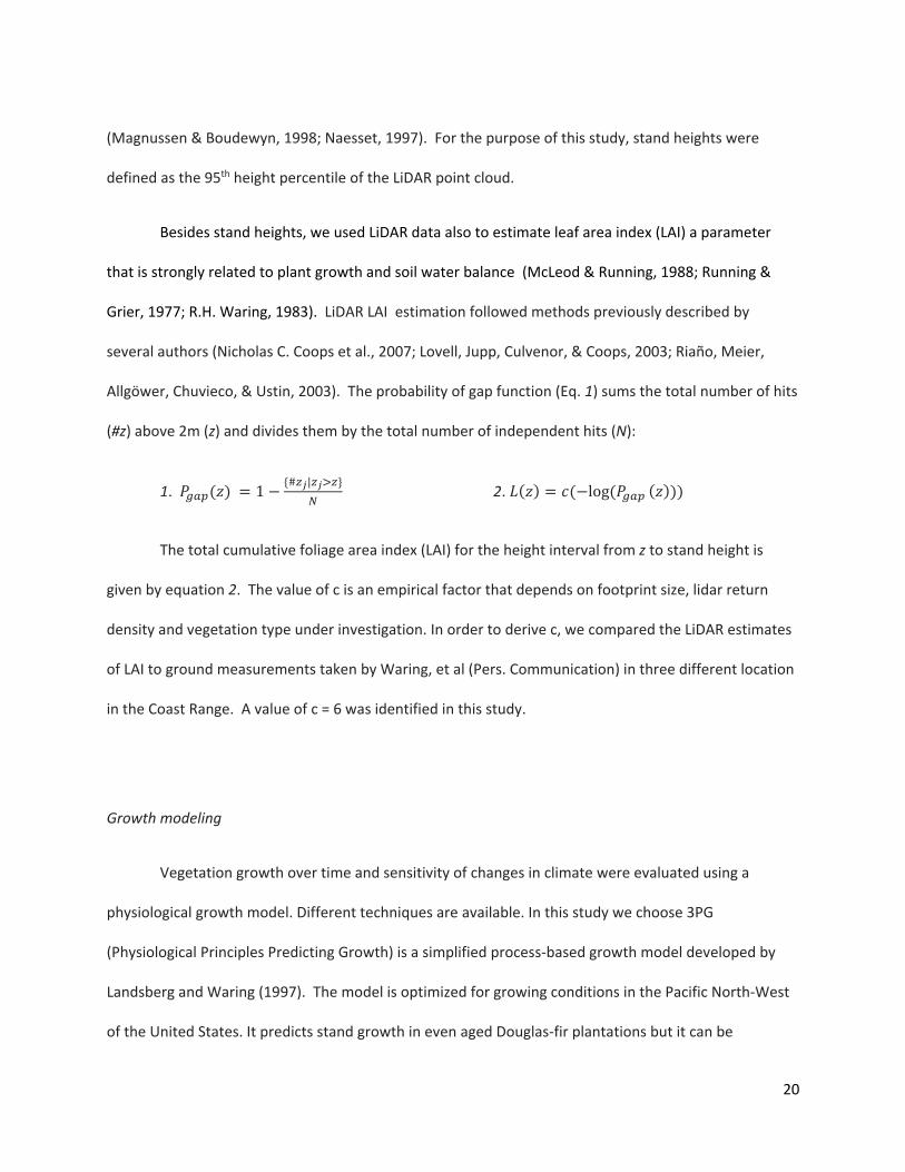