An ordinance amending the Unified Development Ordinance ...AN ORDINANCE NO. 07-43 An ordinance...
14
AN ORDINANCE NO. 07-43 An ordinance amending the Unified Development Ordinance (UDO) for Columbus, Georgia so as to establish an overlay district for Highway 80. THE COUNCIL OF COLUMBUS, GEORGIA HEREBY ORDAINS: SECTION 1. Chapter 2 of the Unified Development Ordinance is hereby amended by adding a new Section 2.5.19 to read as follows: Section 2.5.19 US Highway 80 Overlay District Ordinance A. Purpose and Intent. The purposes of this section are to: 1. 2. 3. 4. 5. 6. 7. 8. Improve and enhance the aesthetic qualities of development within the arterial road Corridor of US Highway 80 through the implementation of land use regulations, and within which amenity features are encouraged. Manage the location and intensity of development within the arterial road corridor and to concentrate development in focus areas. Ensure safe access by vehicles and pedestrians to destinations in the corridor in a manner that does not conflict with access to individual developments or the roadway’s primary purpose. Encourage the minimization of visual clutter along the City‘s major roadways. Provide a quality and sustainable living environment for the citizens of Columbus. Create effective transitions between different uses, by planting trees, shrubs, groundcover and other landscaping material in open space areas. Add a valuable amenity to the urban environment by providing shade, cooling the air through evaporation, restoring oxygen to the atmosphere, reducing glare and noise levels, and providing an ecological habitat for song birds and other animal and plant species. Exercise greater control over the aesthetic and functional characteristics of development along major thoroughfares and roadways that serve as major entrances to the community, where higher development standards can effectively enhance the City’s image as a desirable place to live, work and shop. B. Definitions. Amenity: Pedestrian shelters, gazebos, decorative paving, pathways and sidewalks, trees, landscaping, retention ponds when designed according to the specifications of this Ordinance, signage when scaled to the pedestrian and constructed of materials and sizes specified in this Ordinance and other aesthetic features and characteristics approved by the City. Corridor: All lands that are undeveloped and/or any developed lands that are redeveloped on the date of adoption of this ordinance which are located wholly or partially within 1,000 feet of the right-of-way of US Highway 80 (from Warm Springs Road, east to the Talbot county line) with a 1000-foot depth at each intersection, or as shown on the official zoning, land use, or corridor maps. Focus areas: An area of land within the Corridor, at the intersection of the Corridor and any other intersecting public road. Unless more specifically shown on the corridor overlay map, a focus area shall be generally limited to a square parcel of land extending 1,000 feet from the intersection to which it pertains, in both directions along the road rights-of-way. The focus area
Transcript of An ordinance amending the Unified Development Ordinance ...AN ORDINANCE NO. 07-43 An ordinance...

AN ORDINANCE NO. 0 7 - 4 3
An ordinance amending the Unified Development Ordinance (UDO) for Columbus, Georgia so as to establish an overlay district for Highway 80.
THE COUNCIL OF COLUMBUS, GEORGIA HEREBY ORDAINS:
SECTION 1.
Chapter 2 of the Unified Development Ordinance is hereby amended by adding a new Section 2.5.19 to read as follows:
Section 2.5.19 US Highway 80 Overlay District Ordinance A. Purpose and I n t e n t . The purposes of this section are to:
1.
2.
3 .
4.
5.
6.
7 .
8 .
Improve and enhance the aesthetic qualities of development within the arterial road Corridor of US Highway 80 through the implementation of land use regulations, and within which amenity features are encouraged. Manage the location and intensity of development within the arterial road corridor and to concentrate development in focus areas. Ensure safe access by vehicles and pedestrians to destinations in the corridor in a manner that does not conflict with access to individual developments or the roadway’s primary purpose. Encourage the minimization of visual clutter along the City‘s major roadways. Provide a quality and sustainable living environment for the citizens of Columbus. Create effective transitions between different uses, by planting trees, shrubs, groundcover and other landscaping material in open space areas. Add a valuable amenity to the urban environment by providing shade, cooling the air through evaporation, restoring oxygen to the atmosphere, reducing glare and noise levels, and providing an ecological habitat for song birds and other animal and plant species. Exercise greater control over the aesthetic and functional characteristics of development along major thoroughfares and roadways that serve as major entrances to the community, where higher development standards can effectively enhance the City’s image as a desirable place to live, work and shop.
B . D e f i n i t i o n s .
Amenity: Pedestrian shelters, gazebos, decorative paving, pathways and sidewalks, trees, landscaping, retention ponds when designed according to the specifications of this Ordinance, signage when scaled to the pedestrian and constructed of materials and sizes specified in this Ordinance and other aesthetic features and characteristics approved by the City.
Corridor: All lands that are undeveloped and/or any developed lands that are redeveloped on the date of adoption of this ordinance which are located wholly or partially within 1,000 feet of the right-of-way of US Highway 80 (from Warm Springs Road, east to the Talbot county line) with a 1000-foot depth at each intersection, or as shown on the official zoning, land use, or corridor maps.
Focus areas: An area of land within the Corridor, at the intersection of the Corridor and any other intersecting public road. Unless more specifically shown on the corridor overlay map, a focus area shall be generally limited to a square parcel of land extending 1,000 feet from the intersection to which it pertains, in both directions along the road rights-of-way. The focus area
C.
includes approximately twenty-three acres at each quadrant and can be larger or smaller by mutual agreement of the City and other interested parties.
Applicability.
1.This Ordinance shall apply to all properties lying wholly or partially within the US Highway 80 Corridor as shown on the official zoning map and the overlay district map, which is hereby adopted and made a part of this Ordinance. No clearing or other disturbance of land shall occur, and no building, structure or use shall be established, except in compliance with the provisions of this Ordinance and the Unified Development Ordinance.
2. These standards shall apply to all redevelopment activities. Redevelopment is defined as one or more of the following:
(A) Demolition of an existing building and rebuilding on the site.
(B) Expansion of the gross square footage of building’s or a site’s physical development by 50% or greater, from the date of the Ordinance inception
D. Encouraged Uses.
Mixed uses such as commercial, civic spaces, institutional uses and residences (including residential use in the same building with commercial), and office or other uses, are especially encouraged within Focus Areas.
E. Design Requirements/Access.
1. Transporta tion/Infrastructure.
(A) Vehicular Access to Site. Within the Corridor, the subdivision of lots along an arterial road shall not be allowed if designed so that each lot has its own individual access to the major road unless approved by the Director of Engineering. Each pod of development, or if subdivided, each lot (including out parcels), must be connected with on-site access to a frontage road or interconnecting driveway, rather than directly to the arterial road.
(B) Private Roadway/Driveways. All private access to US Highway 80 shall be right-in/right-out and at intervals no closer than 300 feet as measured from the center-of-access to center-of-access roadway/driveways. Two-way access may be allowed at existing median breaks or at new median breaks at intervals of 1,320 feet only with the approval of the Georgia Department of Transportation and the Director of Engineering for the Columbus Consolidated Government.
Interparcel Access. All land parcels, excluding single-family residential, fronting the Corridor right-of-way shall have interparcel connectivity via either a frontage road or a travel way that is delineated from parking areas such that short trips between developments can be made without use of the major road within the corridor. Within a focus area, development shall interconnect with the road or travel way network of any adjacent development or site within the focus area unless the Director of Engineering determines such connection would constitute an undue hardship.
(D) Medians. Private roads and entrances to developments connecting with the arterial road in the Corridor or serving development in a Focus Area shall include center medians. Such roadway designs will be based upon projected traffic volume and the number of parking spaces. Medians are desired because they improve traffic safety and can be planted to enhance the overall appearance of the Focus Area, as well as provide refuge for pedestrians.

(E) Sidewalks. Sidewalks shall be required as established under Chapter 7, Article 10 of the Unified Development Ordinance and shall be adjacent to all non-limited access public rights-of-way.
(F) Pedestrian Access. Pedestrian access should be provided to individual developments from any sidewalk, unless topography prohibits construction of facilities meeting Americans with Disabilities Act (ADA) requirements. Where medians are required, pedestrian access shall be provided across the median as approved by the Director of Engineering.
2 . Re ta i l Developments. For retail developments totaling 200,000 square feet or more of gross leasable area; or uses that result in a building of 100,000 square feet or more of gross leasable area whether by new construction or by expansion of existing uses, such developments shall comply with the Retail Developments of Community Significance section of this Unified Development Ordinance.
3. U t i l i t y Location. All new utility lines serving a development constructed after the effective date of this ordinance shall be located underground.
4. Landscaping Requirements.
(A) General. All developments shall be landscaped, screened, and buffered in accordance with Articles 5 and 6 of Chapter 4 of the Unified Development Ordinance. In addition to these requirements, twenty (20) Tree Density Unit per acre for all non-residential development shall be required.
(B) A minimum fifteen-foot wide landscaped strip shall be provided adjacent to all road rights-of-way in developments, with the exception of RE10, RE5, RE1, RT, SFR1, SFR2, SFR3, and SFR4 developments. Parking, merchandise displays, and off-street loading are prohibited in the landscaped strip.
(C) A minimum ten-foot wide landscaped strip shall be provided between primary developments and adjacent out parcels in accordance with Section 4 . 5 . 8 of the Unified Development Ordinance.
(D) A minimum of one (1) large-maturing tree per forty (40) linear feet of frontage shall be planted in the fifteen-foot wide landscaped strip as required above. Clustering of trees may be permitted if approved by the City Arborist.
(E) Trash areas shall be located at a minimum of 100 feet from any public road right-of-way.
5. Parking/Yard, Height and Setback .
(A) Location of Parking Areas. Buildings should be located at the corner of sites closest to the road intersection, so that the parking areas are screened by the building from view of any public road, and so that the travel path from public sidewalks is shortened. Parking must be located in a way that is not visually dominant. Parking between buildings and an arterial road is discouraged, but if necessary, requirements of section 2 . 5 . 1 9 . E. 5 . (D) (Screening of Parking Areas) must be met. If parking is located in the side or rear yards, any screening may be clustered and need not cover 100% of frontage.
(B) Up to 25% of the required parking spaces for any development may be reduced in total area, width, or depth for designated small vehicle parking. Each small vehicle parking space
shall not be less than eight feet in width and seventeen feet in depth.
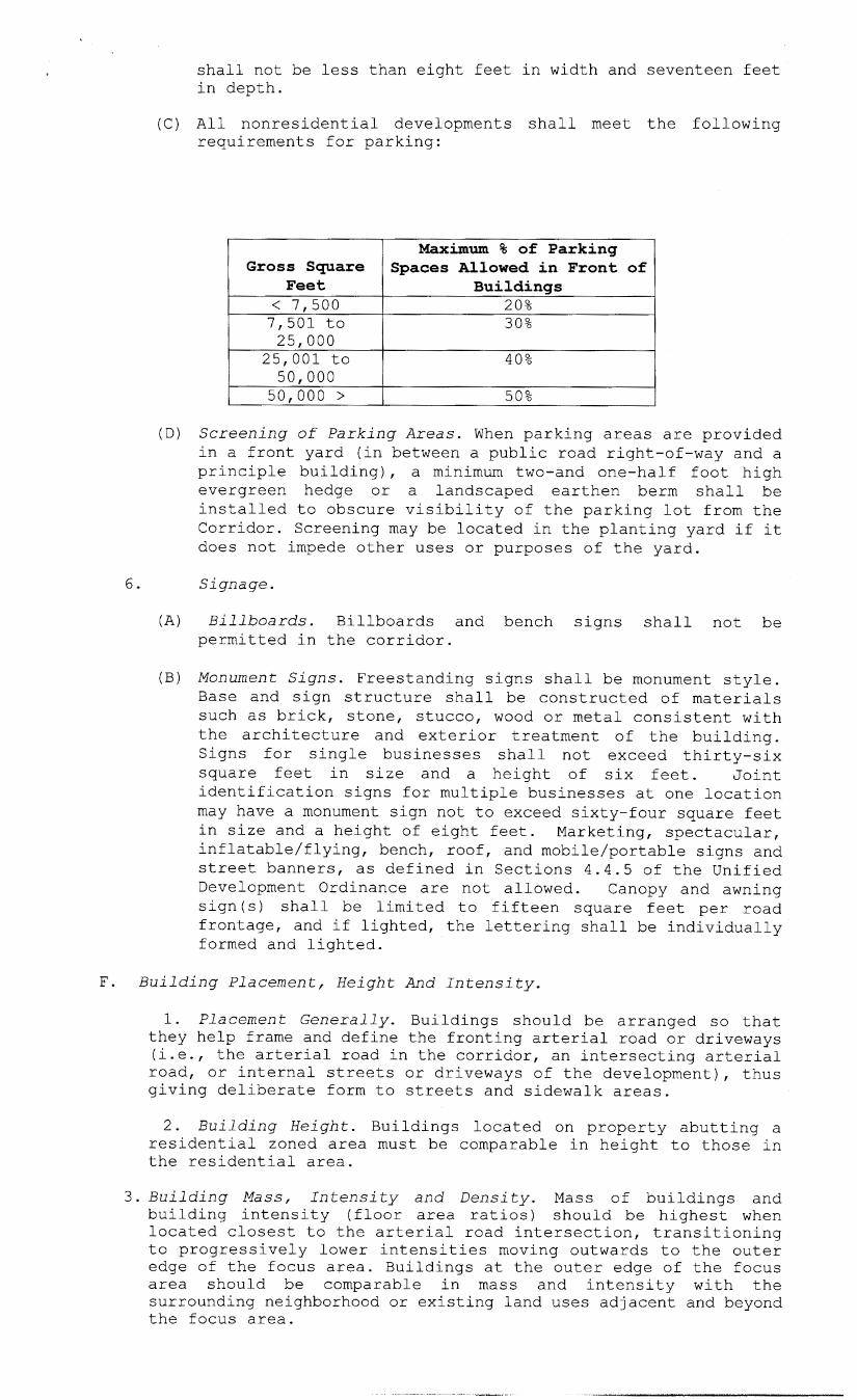
Gross Square Feet
(C) All nonresidential developments shall meet the following requirements for parking:
Maximum % of Parking Spaces Allowed in Front of
Buildinss < 7,500 7,501 to
- 20% 30%
25,000 25,001 to 50,000 50,000 >
(D) S c r e e n i n g of P a r k i n g A r e a s . When parking areas are provided in a front yard (in between a public road right-of-way and a principle building), a minimum two-and one-half foot high evergreen hedge or a landscaped earthen berm shall be installed to obscure visibility of the parking lot from the Corridor. Screening may be located in the planting yard if it does not impede other uses or purposes of the yard.
40%
50%
6 . S i g n a g e .
(A) B i l l b o a r d s . Billboards and bench signs shall not be permitted in the corridor.
(B) Monument S i g n s . Freestanding signs shall be monument style. Base and sign structure shall be constructed of materials such as brick, stone, stucco, wood or metal consistent with the architecture and exterior treatment of the building. Signs for single businesses shall not exceed thirty-six square feet in size and a height of six feet. Joint identification signs for multiple businesses at one location may have a monument sign not to exceed sixty-four square feet in size and a height of eight feet. Marketing, spectacular, inflatable/flying, bench, roof, and mobile/portable signs and street banners, as defined in Sections 4.4.5 of the Unified Development Ordinance are not allowed. Canopy and awning sign(s) shall be limited to fifteen square feet per road frontage, and if lighted, the lettering shall be individually formed and lighted.
F. B u i l d i n g P l a c e m e n t , H e i g h t And I n t e n s i t y .
1. P l a c e m e n t G e n e r a l l y . Buildings should be arranged so that they help frame and define the fronting arterial road or driveways (i.e., the arterial road in the corridor, an intersecting arterial road, or internal streets or driveways of the development), thus giving deliberate form to streets and sidewalk areas.
2. B u i l d i n g H e i g h t . Buildings located on property abutting a residential zoned area must be comparable in height to those in the residential area.
3 . B u i l d i n g M a s s , I n t e n s i t y a n d Density. Mass of buildings and building intensity (floor area ratios) should be highest when located closest to the arterial road intersection, transitioning to progressively lower intensities moving outwards to the outer edge of the focus area. Buildings at the outer edge of the focus area should be comparable in mass and intensity with the surrounding neighborhood or existing land uses adjacent and beyond the focus area.

G. Provisions For S p e c i f i c Uses.
1. Communication Towers. Communication towers shall only be allowed under the provisions for a Concealed Support Structure as defined under the Unified Development Ordinance.
2 . Fences and Walls. Where provided and where visible from the right of way of a public road, fences and walls shall be composed of iron, stone, masonry, or concrete. Landscaping should be used to minimize or soften the appearance from the public right-of-way. Chain link fencing shall not be permitted except in side or rear yards of residential developments and shall be screened with vegetation to a height of six (6) feet.
3. Drive-Through F a c i l i t i e s . Drive-through facilities shall be located to the rear or side of the building and shall not abut an amenity zone or face the Corridor arterial roadway.
H. G a s S ta t ion Pump Is lands.
Gas station pump islands must be mostly obscured from view from the Highway, either through location or by plantings or other methods. Pump islands shall only house gas pumps, windshield-cleaning materials, and trash receptacles. Canopies for gas pumps must have architectural style and detail such as gabled or hip roofs with a three to twelve roof pitch or higher. All support columns must be brick, brick veneer, or stone construction. Buildings located at establishments selling gasoline must comply with section 2.5.19.K ( A r c h i t e c t u r e ) . Canopies shall only display logo identification signs. No other advertising is allowed.
I. Outside Display and Storage and Service Areas.
1. Exterior storage structures or uses, including the parking or storage of service vehicles, trailers, equipment, containers, crates, pallets, merchandise, materials, fork lifts, trash, recyclables, and all other items shall be permitted only where clearly depicted and labeled on the approved site plan. Such outdoor storage uses and areas shall be appropriately screened as required by this ordinance. The following standards are intended to reduce the impacts of outdoor storage, loading and operations areas on adjacent land uses, and to protect the outdoor area of the subject property.
(A) Areas for truck parking and loading shall be screened by a combination of structures and evergreen landscaping to minimize visibility from adjacent streets and residential district lines.
(B) Outdoor storage, loading, and operations shall be attractively screened from adjacent parcels and streets.
(C) Outdoor storage, trash collection and/or compaction, loading or other such uses shall be located in the rear of the lot. If, because of lot configuration, the Director of Inspections and Code determines that such placement is not feasible, then the side yard may be used, but in no case shall such area(s) be located within fifteen feet of any public street, public sidewalk, or on-site pedestrian way.
(D) Seasonal merchandise such as Christmas trees, Halloween pumpkins, bedding plants, etc. may be displayed in any outdoor area up to four times per calendar year for a cumulative total not to exceed eight weeks per year.
(E) Areas for the storage and sale of all other merchandise shall be permanently defined and screened with walls or fences. Materials, colors, and design of screening walls or fences shall conform to those used in the principal structure. If such areas are to be covered, then the covering shall conform to the colors on the building.

( F ) No products containing toxic chemicals, such as fertilizers, insecticides, herbicides, cement, etc., shall be stored in any uncovered outside location where they might enter the stormwater drainage system in the event of any spillage, breakage, or tearing of the container.
J. Stormwater Detention Facilities.
Open storm drainage and detention areas visible from the corridor should be landscaped and incorporated into the design of the development as an attractive amenity. Wet-bottom basins are encouraged.
K. Architecture.
The following requirements shall not apply to single family residential developments.
1. Architectural design shall comply with the following performance guidelines:
(A) Building facades visible from roadways or public parking areas shall be of architectural treatments of glass and/or brick, stone or stucco. Tilt-up or pre-cast concrete or alternate material may be used subject to review and approval of the Planning Director.
(B) Metal-sided or portable buildings shall be prohibited.
(C) Roofing materials for pitched or mansard roofs shall be of colors compatible with the building and subject to approval and limited to the following materials:
1) Metal standing seam. 2) Tile, slate or stone. 3) Wood shake. 4) Shingles with a slate, tile or metal appearance. 5) Other materials subject to approval.
(D) All rooftop mechanical equipment shall be screened by parapets, upper stories, or other areas of exterior walls or roofs so as to not be visible from public streets adjacent to or within 1,000 feet of the subject property, or at least equal to the height of the equipment to be screened, whichever is less. Fences or similar rooftop screening devices may not be used to meet this requirement.
2. Any accessories provided, such as railings, benches, trash shall complement the building receptacles and/or bicycle racks,
design and style.
3.Architectural design of all buildings shall comply with the following additional performance guidelines:
(A) To lend the appearance of multi-tenant occupancy, facades of multi-tenant buildings shall be varied in depth or parapet height.
(B) Distinct architectural entry identification for individual tenants' entrances shall be provided for suites exceeding 10,000 square feet of leasable area.
(C) All out parcel buildings within a proposed development shall be of a architectural character comparable to the primary structure as determined by the Planning Department.
(D) Walls visible from roadways or public parking areas shall incorporate changes in building material/color or varying edifice detail such as trellises, false windows or recessed panels reminiscent of window, door or colonnade openings, landscaping or storefront every 150 linear feet.

(E) Roof parapets shall be articulated to provide visual diversity. Parapets shall include articulations or architectural features at least every 100 linear feet. The minimum height of articulations or features shall be three feet, and may be provided in height offset or facade projections such as porticoes or towers.
(F) Articulation of building design shall continue on all facades visible to the general public.
(G) Building elevation plans shall be subject to review and approval of the Planning Director, or his/her designee, prior to the issuance of a Building Permit. Designs, which are inconsistent with these performance guidelines, may be denied.
H. L a n d U s e And P l a n R e v i e w .
The Planning Director shall evaluate all proposed development activities in the US Highway 80 Corridor. No development permit, land use permit, or building permit shall be issued unless the proposed development, land use, building, or structure is in compliance with this ordinance.
SECTION 2.
All ordinances or parts of ordinances in conflict with this ordinance are hereby repealed.
Introduced at a regular meeting of the Council of Columbus, Georgia held on the l g t h day of June, 2007 introducga secondr+ regular meeting of said Council held on the 2007, and adopted at said meeting by the affirmative vote of -,&Q
members of said Council.
/p day of
Councilor Councilor Councilor Councilor Councilor Councilor Councilor Councilor Councilor
Allen Antho Baker Barne Davis Hende Hunte McDan Puah
rson vo
Councilor Wogdson voting ABSENT .
- W . Y . WETH
MAYOR

84 d6- /4 -67( /2 ) ; p.' &d AN ORDINANCE p,ae ~ 7 - / 0 - ~ ~ ~ 7 ) *w NO. ca-&kbFP&a )
An ordinance amending the Unified Development Ordinance (UDO) for Columbus, Georgia so as to establish an overlay district for Highway 80.
THE COUNCIL OF COLUMBUS, GEORGIA HEREBY
SECTION 1.
Chapter 2 of the Unified Development Ordinance is herebf-amended by adding a new Section 2.5.19 to read as follows:
Section 2.5.19 US Highway 80 Overlay District Ordinance A. Purpose and I n t e n t . The purposes of this section are to:
1. Improve and enhance the aesthetic qualities of development within the arterial road Corridor of US Highway 80 through the implementation of land use regulations, and within which amenity features are encouraged.
2. Manage the location and intensity of development within the arterial road corridor and to concentrate development in focus areas.
3. Ensure safe access by vehicles and pedestrians to destinations in the corridor in a manner that does not conflict with access to individual developments or the roadway's primary purpose.
4. Encourage the minimization of visual clutter along the City's major roadways.
5. Provide a quality and sustainable living environment for the citizens of Columbus.
6. Create effective transitions between different uses, by planting trees, shrubs, groundcover and other landscaping material in open space areas.
7.Add a valuable amenity to the urban environment by providing shade, cooling the air through evaporation, restoring oxygen to the atmosphere, reducing glare and noise levels, and providing an ecological habitat for song birds and other animal and plant species.
8.Exercise greater control over the aesthetic and functional characteristics of development along major thoroughfares and roadways that serve as major entrances to the community, where higher development standards can effectively enhance the City's - image as a desirable place to live, work and shop.
B . Def i n i t i ons .
Amenity: Pedestrian shelters, gazebos, decorative paving, pathways and sidewalks, trees, landscaping, retention ponds when designed according to the specifications of this Ordinance, signage when scaled to the pedestrian and constructed of materials and sizes specified in this Ordinance and other aesthetic features and characteristics approved by the City.
Corridor: All lands that are undeveloped and/or any developed lands that are redeveloped on the date of adoption of this ordinance which are located wholly or partially within 1,000 feet of the right-of-way of US Highway 80 (from Warm Springs Road, east to the Talbot county line) with a 1000-foot depth at each intersection, or as shown on the official zoning, land use, or corridor maps.
Focus a r e a s : An area of land within the Corridor, at the intersection of the Corridor and any other intersecting public road. Unless more specifically shown on the corridor overlay map, a focus area shall be generally limited to a square parcel of land extending 1,000 feet from the intersection to which it pertains, in both directions along the road rights-of-way. The focus area

i'ncludes approximately twenty-three acres at each quadrant and can be larger or smaller by mutual agreement of the City and other interested parties.
C. Applicability.
1.This Ordinance shall apply to all properties lying wholly or partially within the US Highway 80 Corridor as shown on the official zoning map and the overlay district map, which is hereby adopted and made a part of this Ordinance. No clearing or other disturbance of land shall occur, and no building, structure or use shall be established, except in compliance with the provisions of this Ordinance and the Unified Development Ordinance.
2. These standards shall apply to all redevelopment activities. Redevelopment is defined as one or more of the following:
(A) Demolition of an existing building and rebuilding on the site.
(B) Expansion of the gross square footage of building's or a site's physical development by 50% or greater, from the date of the Ordinance inception
D. Encouraged Uses.
Mixed uses such as commercial, civic spaces, institutional uses and residences (including residential use in the same building with commercial), and office or other uses, are especially encouraged within Focus Areas.
E. Design Requirements/Access.
1. Transportation/Infrastructure.
(A) Vehicular Access to Site. Within the Corridor, the subdivision of l o t s along an arterial road shall not be allowed if designed so that each lot has its own individual access to the major road unless approved by the Director of Engineering. Each pod of development, or if subdivided, each lot (including out parcels), must be connected with on-site access to a frontage road or interconnecting driveway, rather than directly to the arterial road.
(B) Private Roadway/Driveways. All private access to US Highway 80 shall be right-in/right-out and at intervals no closer than 300 feet as measured from the center-of-access to center-of-access roadway/driveways. Two-way access may be allowed at existing median breaks or at new median breaks at intervals of 1,320 feet only with the approval of the Georgia Department of Transportation and the Director of Engineering for the Columbus Consolidated Government.
Interparcel Access. All land parcels, excluding single-family residential, fronting the Corridor right-of-way shall have interparcel connectivity via either a frontage road or a travel way that is delineated from parking areas such that short trips between developments can be made without use of the major road within the corridor. Within a focus area, development shall interconnect with the road or travel way network of any adjacent development or site within the focus area unless the Director of Engineering determines such connection would constitute an undue hardship.
(D) Medians. Private roads and entrances to developments connecting with the arterial road in the Corridor or serving development in a Focus Area shall include center medians. Such roadway designs will be based upon projected traffic volume and the number of parking spaces. Medians are desired because they improve traffic safety and can be planted to enhance the overall appearance of the Focus Area, as well as provide refuge for pedestrians.

( E ) Sidewalks. Sidewalks shall be required as established under Chapter 7, Article 10 of the Unified Development Ordinance and shall be adjacent to all non-limited access public rights-of-way.
(F) Pedestrian Access. Pedestrian access should be provided to individual developments from any sidewalk, unless topography prohibits construction of facilities meeting Americans with Disabilities Act (ADA) requirements. Where medians are required, pedestrian access shall be provided across the median as approved by the Director of Engineering.
2 . Re ta i l Developments. For retail developments totaling 200,000 square feet or more of gross leasable area; or uses that result in a building of 100,000 square feet or more of gross leasable area whether by new construction or by expansion of existing uses, such developments shall comply with the Retail Developments of Community Significance section of this Unified Development Ordinance.
3 . U t i l i t y Location. All new utility lines shall be located underground.
4. Landscaping Requirements.
(A) General. All developments shall be landscaped, screened, and buffered in accordance with Articles 5 and 6 of Chapter 4 of the Unified Development Ordinance. In addition to these requirements, twenty (20) Tree Density Unit per acre for all non-residential development shall be required.
(B) A minimum fifteen-foot wide landscaped strip shall be provided adjacent to all road rights-of-way in developments, with the exception of RE10, RE5, RE1, RT, SFR1, SFR2, SFR3, and SFR4 developments. Parking, merchandise displays, and off-street loading are prohibited in the landscaped strip.
( C ) A minimum ten-foot wide landscaped strip shall be provided between primary developments and adjacent out parcels in accordance with Section 4.5.8 of the Unified Development Ordinance.
(D) A minimum of one (1) large-maturing tree per forty (40) linear feet of frontage shall be planted in the fifteen-foot wide landscaped strip as required above. Clustering of trees may be permitted if approved by the City Arborist.
(E) Trash areas shall be located at a minimum of 100 feet from any public road right-of-way.
5. Parking/Yard, Height and Setback.
(A) Location of Parking Areas. Buildings should be located at the corner of sites closest to the road intersection, so that the parking areas are screened by the building from view of any public road, and so that the travel path from public sidewalks is shortened. Parking must be located in a way that is not visually dominant. Parking between buildings and an arterial road is discouraged, but if necessary, requirements of section 2.5.19 .E. 5. (D) (Screening of Parking Areas) must be met. If parking is located in the side or rear yards, any screening may be clustered and need not cover 100% of frontage .
(B) Up to 25% of the required parking spaces for any development may be reduced in total area, width, or depth for designated small vehicle parking. Each small vehicle parking space shall not be less than eight feet in width and seventeen feet

’ in depth.
(C) All nonresidential developments shall meet the following requirements for parking:
Gross Square Feet
< 7,500 7,501 to
Maximum % of Parking Spaces Allowed in Front of
Buildings 20% 30%
25,000 25,001 to 40% 50,000 50,000 >
(D) S c r e e n i n g of P a r k i n g A r e a s . When parking areas are provided in a front yard (in between a public road right-of-way and a principle building), a minimum two-and one-half foot high evergreen hedge or a landscaped earthen berm shall be installed to obscure visibility of the parking lot from the Corridor. Screening may be located in the planting yard if it does not impede other uses or purposes of the yard.
50%
6 . S i g n a g e .
(A) B i l l b o a r d s . Billboards and bench signs shall not be permitted in the corridor.
(B) Monument S i g n s . Freestanding signs shall be monument style. Base and sign structure shall be constructed of materials such as brick, stone, stucco, wood or metal consistent with the architecture and exterior treatment of the building. Signs for single businesses shall not exceed thirty-six square feet in size and a height of six feet. Joint identification signs for multiple businesses at one location may have a monument sign not to exceed sixty-four square feet in size and a height of eight feet. Marketing, spectacular, inflatable/flying, bench, roof, and mobile/portable signs and street banners, as defined in Sections 4.4.5 of the Unified Development Ordinance are not allowed. Canopy and awning sign(s) shall be limited to fifteen square feet per road frontage, and if lighted, the lettering shall be individually formed and lighted.
F. B u i l d i n g P l a c e m e n t , H e i g h t And I n t e n s i t y .
1. P l a c e m e n t G e n e r a l l y . Buildings should be arranged so that they help frame and define the fronting arterial road or driveways (i.e., the arterial road in the corridor, an intersecting arterial road, or internal streets or driveways of the development), thus giving deliberate form to streets and sidewalk areas.
2. B u i l d i n g H e i g h t . Buildings located on property abutting a residential zoned area must be comparable in height to those in the residential area.
3 . B u i l d i n g M a s s , I n t e n s i t y a n d Density. Mass of buildings and building intensity (floor area ratios) should be highest when located closest to the arterial road intersection, transitioning to progressively lower intensities moving outwards to the outer edge of the focus area. Buildings at the outer edge of the focus area should be comparable in mass and intensity with the surrounding neighborhood or existing land uses adjacent and beyond the focus area.

G . Pr’ovisions For S p e c i f i c Uses.
1. Communication Towers. Communication towers shall only be allowed under the provisions for a Concealed Support Structure as defined under the Unified Development Ordinance.
2 . Fences and W a l l s . Where provided and where visible from the right of way of a public road, fences and walls shall be composed of iron, stone, masonry, or concrete. Landscaping should be used to minimize or soften the appearance from the public right-of-way. Chain link fencing shall not be permitted except in side or rear yards of residential developments and shall be screened with vegetation to a height of six (6) feet.
3. Drive-Through F a c i l i t i e s . Drive-through facilities shall be located to the rear or side of the building and shall not abut an amenity zone or face the Corridor arterial roadway.
H. G a s S ta t ion Pump Is lands .
Gas station pump islands must be mostly obscured from view from the Highway, either through location or by plantings or other methods. Pump islands shall only house gas pumps, windshield-cleaning materials, and trash receptacles. Canopies for gas pumps must have architectural style and detail such as gabled or hip roofs with a three to twelve roof pitch or higher. All support columns must be brick, brick veneer, or stone construction. Buildings located at establishments selling gasoline must comply with section 2.5.19.K ( A r c h i t e c t u r e ) . Canopies shall only display logo identification signs. No other advertising is allowed.
I. Outside Display and Storage and Service Areas.
1. Exterior storage structures or uses, including the parking or storage of service vehicles, trailers, equipment, containers, crates, pallets, merchandise, materials, fork lifts, trash, recyclables, and all other items shall be permitted only where clearly depicted and labeled on the approved site plan. Such outdoor storage uses and areas shall be appropriately screened as required by this ordinance. The following standards are intended to reduce the impacts of outdoor storage, loading and operations areas on adjacent land uses, and to protect the outdoor area of the subject property.
(A) Areas for truck parking and loading shall be screened by a combination of structures and evergreen landscaping to minimize visibility from adjacent streets and residential - district lines.
(B) Outdoor storage, loading, and operations shall be attractively screened from adjacent parcels and streets.
(C) Outdoor storage, trash collection and/or compaction, loading or other such uses shall be located in the rear of the lot. If, because of lot configuration, the Director of Inspections and Code determines that such placement is not feasible, then the side yard may be used, but in no case shall such area(s) be located within fifteen feet of any public street, public sidewalk, or on-site pedestrian way.
(D) Seasonal merchandise such as Christmas trees, Halloween pumpkins, bedding plants, etc. may be displayed in any outdoor area up to four times per calendar year for a cumulative total not to exceed eight weeks per year.
(E) Areas for the storage and sale of all other merchandise shall be permanently defined and screened with walls or fences. Materials, colors, and design of screening walls or fences shall conform to those used in the principal structure. If such areas are to be covered, then the covering shall conform to the colors on the building.

(F) No products containing toxic chemicals, such as fertilizers, insecticides, herbicides, cement, etc., shall be stored in any uncovered outside location where they might enter the stormwater drainage system in the event of any spillage, breakage, or tearing of the container.
J. Stormwater Detention Facilities.
Open storm drainage and detention areas visible from the corridor should be landscaped and incorporated into the design of the development as an attractive amenity. Wet-bottom basins are encouraged.
K. Architecture.
The following requirements shall not apply to single family residential developments.
1. Architectural design shall comply with the following performance guidelines:
(A) Building facades visible from roadways or public parking areas shall be of architectural treatments of glass and/or brick, stone or stucco. Tilt-up or pre-cast concrete or alternate material may be used subject to review and approval of the Planning Director.
(B) Metal-sided or portable buildings shall be prohibited.
(C) Roofing materials for pitched or mansard roofs shall be of colors compatible with the building and subject to approval and limited to the following materials:
1) Metal standing seam. 2) Tile, slate or stone. 3) Wood shake. 4) Shingles with a slate, tile or metal appearance. 5) Other materials subject to approval.
(D) All rooftop mechanical equipment shall be screened by parapets, upper stories, or other areas of exterior walls or roofs so as to not be visible from public streets adjacent to or within 1,000 feet of the subject property, or at least equal to the height of the equipment to be screened, whichever is less. Fences or similar rooftop screening devices may not be used to meet this requirement.
2. Any accessories provided, such as railings, benches, trash receptacles and/or bicycle racks, shall complement the building design and style.
3.Architectural design of all buildings shall comply with the following additional performance guidelines:
(A) To lend the appearance of multi-tenant occupancy, facades of multi-tenant buildings shall be varied in depth or parapet height.
(B) Distinct architectural entry identification for individual tenants' entrances shall be provided for suites exceeding 10,000 square feet of leasable area.
(C) All out parcel buildings within a proposed development shall be of a architectural character comparable to the primary structure as determined by the Planning Department.
(D) Walls visible from roadways or public parking areas shall incorporate changes in building material/color or varying edifice detail such as trellises, false windows or recessed panels reminiscent of window, door or colonnade openings, landscaping or storefront every 150 linear feet.

(E) Roof parapets shall be articulated to provide visual diversity. Parapets shall include articulations or architectural features at least every 100 linear feet. The minimum height of articulations or features shall be three feet, and may be provided in height offset or facade projections such as porticoes or towers.
(F) Articulation of building design shall continue on all facades visible to the general public.
(G) Building elevation plans shall be subject to review and approval of the Planning Director, or his/her designee, prior to the issuance of a Building Permit. Designs, which are inconsistent with these performance guidelines, may be denied.
H. Land Use And P l a n R e v i e w .
The Planning Director shall evaluate all proposed development activities in the US Highway 80 Corridor. No development permit, land use permit, or building permit shall be issued unless the proposed development, land use, building, or structure is in compliance with this ordinance.
SECTION 2.
All ordinances or parts of ordinances in conflict with this ordinance are hereby repealed.
_ - _ _ _ _ _ _ _ _ _ _ _ _ -
Introduced at a regular meeting of the Council of Columbus, Georgia held on the l g t h day of June, 2007 introduced a second time at a regular meeting of said Council held on the 2007, and adopted at said meeting by the affirmative vote of members of said Council.
day of I
Councilor Allen voting Councilor Anthony voting Councilor Baker voting Councilor Barnes voting Councilor Davis voting Councilor Henderson voting Councilor Hunter voting Councilor McDaniel voting Councilor Pugh voting Councilor Woodson voting
TINY B. WASHINGTON JIM WETHERINGTON CLERK MAYOR