An Open Source Hardware & Software online raingauge for ...
7
An Open Source Hardware & Software online raingauge for real-time monitoring of rainwater harvesting in Sri Lanka Y. Chemin 1,2 , N. Sanjaya 1,2 , P.K.N.C. Liyanage 1 1 International Water Management Institute, 2 University of Moratuwa, Faculty of Architecture Abstract The rainwater harvesting network is in need of volumetric estimation of rainfall-runoff contributed to recharge of the aquifers. Regular reporting of high quality rainfall events and intensity is still a challenge to be addressed in Sri Lanka. A combination of Open Source Hardware (OSHW) and Free & Open Source Software (FOSS) is being used to created a royalty-free, cheap raingauge design, with full control of on-board data collection and statistics. Actual state-of-development has gone through the generic weather station prototype delivery to Irrigation Department for tank management and is in testing phase. A local manufacturer has delivered an all-in-one integrated board based on the prototype provided. Local manufacture of the sensors (tipping-bucket and other wind sensors) is under experimentation. Introduction Sri Lanka has already displayed its share of signs of climate change with global temperature warming over past century. Many researchers have concluded that no significant systematic trend of annual rainfall is evident in Sri Lanka but the pattern of the rainfall has been changed (De Costa, 2008 ; Basnayake, 2011 ; Chandrapala, 1996 ; Jayatillake et. al, 2005 ; Domroes, 1996 ; Manawadu and Fernando, 2008). During the last decade, Sri Lanka has experienced number of extreme rainfall events and severe drought in crop growing periods. Farmers are continuously complaining to planners about the uncertainty and inadequacy of rainfall. The country has seen flash floods, ponding, landslides and urban floods due to high intensity rainfalls frequently. Also, some provinces have seen by far and large the difficulties to manage erratic and insufficient rainfall for agriculture. The impact of the rainfall event depends on how it unfolds as much as on the final rainfall tally. 40mm of rainfall in 24 hours in an urban area (city) may not become a disaster, and is beneficial to rural areas as it permits proper infiltration to the crops root zone. But if the same rainfall amount falls within an hour it can change the entire economic environment of that city, or in agricutltural areas, it could be lost as runoff. Open design is the development of physical products, machines and systems through use of publicly shared design information (https://en.wikipedia.org/wiki/Open_Design ). Open Source HardWare (OSHW) is a direct consequence of the Open Design philosophy (Pearce, 2013a). It permits to share blueprints of open designs in formats ready for circuitry manufacturing tools. Such is the Arduino micro- controler. As the makers of Arduino describe it: “ Arduino is an open-source electronics prototyping platform based on flexible, easy-to-use hardware and software. It's intended for artists, designers, hobbyists and anyone interested in creating interactive objects or environments ” (www.arduino.cc ). Recently, a Sri Lankan version of Arduino was created under the name of “Lakduino” (Fig. 1 ; www.lakduino.com ), is manufactured and distributed in Sri Lanka. In the same line, many add-on board have been open designed to plug on Arduino and provide specialised functionalities. These add-on board are called “shields” in the Arduino jargon. Shields may provide sensors, GPS radio or communication devices, are stackable. They can be plugged on top of each other to provide the required types of combination of i.e. sensors, location services and online reporting.
Transcript of An Open Source Hardware & Software online raingauge for ...
An Open Source Hardware & Software online raingaugefor real-time monitoring of rainwater harvesting in Sri Lanka
Y. Chemin1,2 , N. Sanjaya1,2 , P.K.N.C. Liyanage1
1International Water Management Institute, 2University of Moratuwa, Faculty of Architecture
Abstract
The rainwater harvesting network is in need of volumetric estimation of rainfall-runoff contributed torecharge of the aquifers. Regular reporting of high quality rainfall events and intensity is still a challengeto be addressed in Sri Lanka. A combination of Open Source Hardware (OSHW) and Free & Open Source Software (FOSS) is beingused to created a royalty-free, cheap raingauge design, with full control of on-board data collection andstatistics. Actual state-of-development has gone through the generic weather station prototype delivery to IrrigationDepartment for tank management and is in testing phase. A local manufacturer has delivered an all-in-oneintegrated board based on the prototype provided. Local manufacture of the sensors (tipping-bucket andother wind sensors) is under experimentation.
Introduction
Sri Lanka has already displayed its share of signs of climate change with global temperature warmingover past century. Many researchers have concluded that no significant systematic trend of annual rainfallis evident in Sri Lanka but the pattern of the rainfall has been changed (De Costa, 2008 ; Basnayake, 2011; Chandrapala, 1996 ; Jayatillake et. al, 2005 ; Domroes, 1996 ; Manawadu and Fernando, 2008). Duringthe last decade, Sri Lanka has experienced number of extreme rainfall events and severe drought in cropgrowing periods. Farmers are continuously complaining to planners about the uncertainty and inadequacyof rainfall. The country has seen flash floods, ponding, landslides and urban floods due to high intensityrainfalls frequently. Also, some provinces have seen by far and large the difficulties to manage erratic andinsufficient rainfall for agriculture. The impact of the rainfall event depends on how it unfolds as much ason the final rainfall tally. 40mm of rainfall in 24 hours in an urban area (city) may not become a disaster,and is beneficial to rural areas as it permits proper infiltration to the crops root zone. But if the samerainfall amount falls within an hour it can change the entire economic environment of that city, or inagricutltural areas, it could be lost as runoff.
Open design is the development of physical products, machines and systems through use of publiclyshared design information (https://en.wikipedia.org/wiki/Open_Design). Open Source HardWare(OSHW) is a direct consequence of the Open Design philosophy (Pearce, 2013a). It permits to shareblueprints of open designs in formats ready for circuitry manufacturing tools. Such is the Arduino micro-controler. As the makers of Arduino describe it: “Arduino is an open-source electronics prototypingplatform based on flexible, easy-to-use hardware and software. It's intended for artists, designers,hobbyists and anyone interested in creating interactive objects or environments” (www.arduino.cc).Recently, a Sri Lankan version of Arduino was created under the name of “Lakduino” (Fig. 1 ;www.lakduino.com), is manufactured and distributed in Sri Lanka.
In the same line, many add-on board have been open designed to plug on Arduino and provide specialisedfunctionalities. These add-on board are called “shields” in the Arduino jargon. Shields may providesensors, GPS radio or communication devices, are stackable. They can be plugged on top of each other toprovide the required types of combination of i.e. sensors, location services and online reporting.
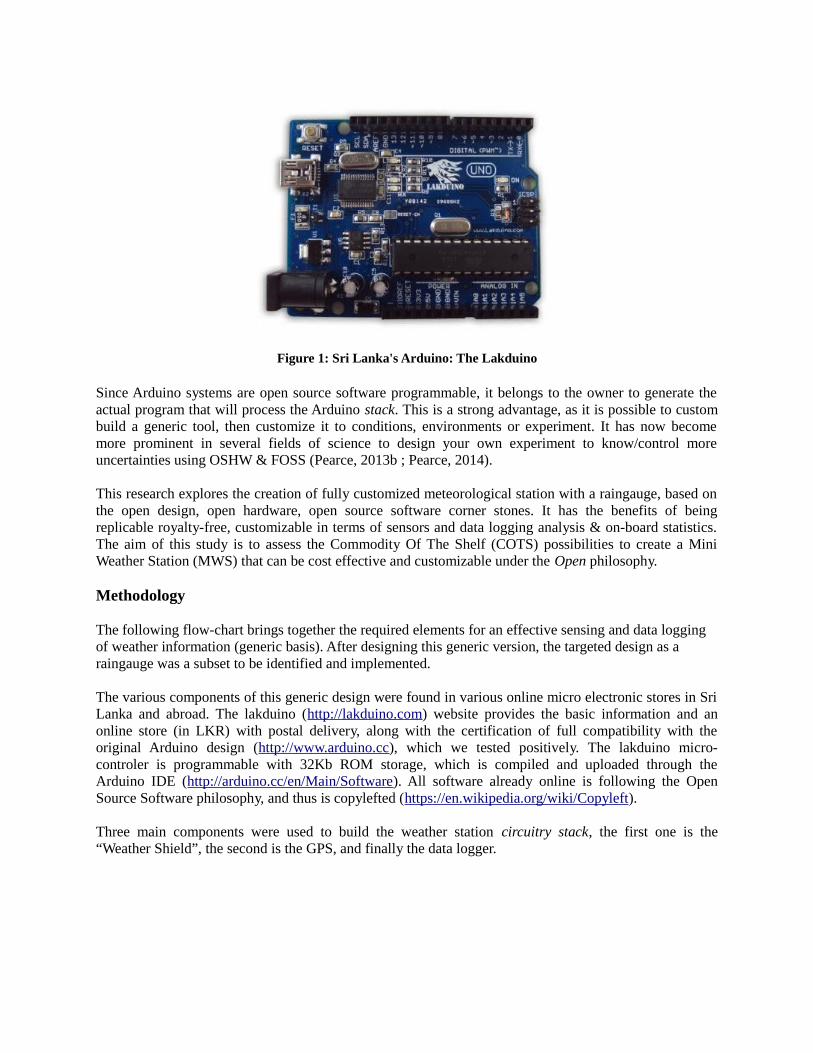
Figure 1: Sri Lanka's Arduino: The Lakduino
Since Arduino systems are open source software programmable, it belongs to the owner to generate theactual program that will process the Arduino stack. This is a strong advantage, as it is possible to custombuild a generic tool, then customize it to conditions, environments or experiment. It has now becomemore prominent in several fields of science to design your own experiment to know/control moreuncertainties using OSHW & FOSS (Pearce, 2013b ; Pearce, 2014).
This research explores the creation of fully customized meteorological station with a raingauge, based onthe open design, open hardware, open source software corner stones. It has the benefits of beingreplicable royalty-free, customizable in terms of sensors and data logging analysis & on-board statistics.The aim of this study is to assess the Commodity Of The Shelf (COTS) possibilities to create a MiniWeather Station (MWS) that can be cost effective and customizable under the Open philosophy.
Methodology
The following flow-chart brings together the required elements for an effective sensing and data logging of weather information (generic basis). After designing this generic version, the targeted design as a raingauge was a subset to be identified and implemented.
The various components of this generic design were found in various online micro electronic stores in SriLanka and abroad. The lakduino (http://lakduino.com) website provides the basic information and anonline store (in LKR) with postal delivery, along with the certification of full compatibility with theoriginal Arduino design (http://www.arduino.cc), which we tested positively. The lakduino micro-controler is programmable with 32Kb ROM storage, which is compiled and uploaded through theArduino IDE (http://arduino.cc/en/Main/Software). All software already online is following the OpenSource Software philosophy, and thus is copylefted (https://en.wikipedia.org/wiki/Copyleft).
Three main components were used to build the weather station circuitry stack, the first one is the“Weather Shield”, the second is the GPS, and finally the data logger.

Weather “Shield” + GPS Lakduino Micro-Controler OpenLog Data Logger
OSHW & FOSS Weather Station
- Rainfall- Wind Speed- Wind Direction- Humidity
- Temperature- Light- Pressure- Lat, Long, Alt
Figure 2: Generic design of a OSHW + FOSS weather station
The “Weather Shield” is an add-on board to the Arduino, and plugs directly on top of it. It ismanufactured and distributed by Sparkfun (http://www.sparkfun.com), an online store of smallelectronics. On the board are temperature, humidity, light and atmospheric pressure sensors. Twoadditional plugs provide connectivity to a wind/rain weather kit (also from the same online store). The setonce soldered, and mounted, can be programmed through the Arduino board to return the data from allsensors to the session terminal. The data is returned to the terminal in Comma Separated Values form(CSV ; file extension *.csv ; https://en.wikipedia.org/wiki/Comma-separated_values).
The GPS is a small form factor radio geolocation system, also from the same online store as the “WeatherShield” and the weather kit. It plugs directly on the “Weather Shield” through a small cable connector.Programming is simple through a specialised library that can be downloaded from a url in the same onlinesite. Besides providing an accurate GMT time for each weather sensors reading, the GPS permits togeolocate the readings, without the need of external GPS at each installation. This is useful when usingthe raingauge station on a rotation experience to cover more sampling areas or evaluating the best gridnetwork with less number of stations.
The data logger is an OpenLog Design (https://github.com/sparkfun/OpenLog/wiki) and receives a microSD card, tested with up to 16Gb. Internally, it is using a fat16/fat32 file manipulation library for Arduinofrom Bill Greiman (https://code.google.com/p/sdfatlib/). The data coming from the Arduino program isprinted to the terminal screen, and this same print of data is recorded as text files in the micro SD, withoutany configuration required.

Results
A generic meteorological weather station was designed and prototyped to fit several research andmonitoring requirements within Sri Lanka. The first prototype is shown in Figure 3 and was delivered toIrrigation Department in Anuradhapura for testing in June 2014 after a first trial run and discussion withthem where specific rainfall statistics were identified.
Figure 3: Left side: circuits (red circle) & power. Right side: wind sensors & raingauge
Specialized programming for the requirement of surface water flow from the irrigation department hasbeen done in the form of 5 minutes statistics of rainfall intensity, with a detection flag for rainfall eventdetection and duration (Figure 4). The aim of the required customized analysis is to corner the rainfalltypes and their influence on the runoff pattern for improving tank management. Such programming isnow available as a basis for the raingauge development for high intensity evaluation and monitoring ofrainfall-runoff events and modeling.
The raingauge data programmed is analysed below (Figure 5). There is a rain detection flag (RainFlag,values are 0 or 1) operating on a 5 minutes time interval. Three statistical aggregations of Rainfall arecomputed, 5 minutes (Rain5 ; not shown), hourly (RainH) and daily (RainD ; not shown).

//Interrupt routines (these are called by the hardware interrupts, not by the main code)//============================void rainIRQ()//Count rain gauge bucket tips as they occur//Activated by the magnet and reed switch in the rain gauge, attached to input D2 {
raintime = millis(); // grab current timeraininterval = raintime rainlast; // calculate interval between this and last event if (raininterval > 10) // ignore switchbounce glitches less than 10mS after initial{
dailyrainin += 0.011*25.4; //Each dump is 0.011" of water rainHour[minutes] += 0.011*25.4; //Increase this minute's amount rain5m[minutes_5m] +=0.011*25.4; // increase this 5 mnts amout rainlast = raintime; // set up for next event
}//Rain or not (1 or 0)if(rainin_5m >0){
Rainindi=1;//RainFlag is ON}if(rainin_5m == 0){
Rainindi=0;//RainFlag is OFF}
}
Figure 4: Example of a specifically designed rainfall event code
Figure 5: Raingauge Data Analysis

Discussion
Climatic monitoring observations of Sri Lanka use daily rain gauge accumulation, not rainfall intensity ofduration. As a result authorized institutions are weak to predict upcoming issues and build up awareness.Daily accumulations are not enough to capture the rate of individual intensity of rainfall because highaccumulation can result from a short period of high intensity rainfall, a higher frequency of lower rainfallor combination of these two. There is an arising need for a higher frequency data, to improve statistics forresearch and accelerate the accumulation of knowledge on extreme weather events. The edge of theinterval of data recording is below 30 minutes: 10 minutes or 5 minutes.
Rainwater harvesting depends upon the frequency and amount of rainfall. Therefore detailed statistics ofrainfall is essential in the initial stages of the rainwater harvesting system. For instance, the annual rainfalland monthly rainfall is not enough in sizing (storage capacity) a rainfall harvesting system especially withthe extreme rainfall pattern due to climate change. The size of the rainwater harvesting system should bedifferent area to area depending of the rainfall pattern, intensity and frequency of the unique locations.
For several weeks, the data was re-evaluated and feed-back converted into structural and softwarechanges. Among the structural changes required is the shape of the raingauge cup, not designed for heavyrainfall, and prone to splashing, reducing the total rainfall recorded. We are in contact with a localmanufacturer of micro-electronics to address those changes and increase the percentage of the weatherstation being made in Sri Lanka.
The requirement to have an efficient monitoring system of rainwater harvesting is for the network ofraingauge to be online reporting to a central repository, preferrably open to the public. It turns out that on-going development of the circuits include tests with GSM modules. Online upload of rain data could bedone 4 times per day, with each upload reporting hourly rainfall in a ftp site, ready to be used for GISpreparation and modeling, offline or online too.
Conclusion
This research endeavours to demonstrate that Open Design, Open Source Hardware and Free & OpenSource Software can be used to taylor build a raingauge meteorological station, with Commodity Off TheShelf elements. The advantages are multiple, the cost is several times less than market options, it recordswhat is of interest to the user only, and prepares analysis on-the-fly as programmed. Availability of partsof the COTS elements is now increasing locally as we speak. Full local manufacture of the wholeraingauge is underway, along with an online reporting capability in testing phase.
References
Basnayake, B.R.S.B. (2011) Climate Change in Sri Lanka, Department of Metrology, Sri Lanka [availableat http://www.meteo.gov.lk/index.php?option=com_content&view=article&id=73& Itemid=82&lang=en] [viewed on 20/05/2012].
Chandrapala, L. (1996) Long term trends of rainfall and temperature in Sri Lanka. Climate Variability andAgriculture, Y.P. Abrol, S. Gadgil and G.B. Pant, Eds., Narosa Publishing House, New Delhi, 153-162.
De Costa, 2008, Basnayake, 2011, Chandrapala, 1996, Jayatillake et. al, 2005 and Domroes, 1996,Manawadu and Fernando, 2008).

De Costa, W.A.J.M. (2008) Climate change in Sri Lanka: myth or reality? Evidence from long-termmeteorological data, Journal of National Science Foundation of Sri Lanka, 36 Special Issue.
Domroes, M., (1996) Rainfall variability over Sri Lanka, Climate variability and Agriculture, 394-410.
Jayatillake, H.M., Chandrapala, L., Basnayake, B.R.S.B. and Dharmaratne, G.H.P. (2005) WaterResources and climate change Proceedings Workshop on Sri Lanka National Water Development Report,eds. Wijesekera, N.T.S., Imbulana, K.A.U.S. and Neupane, B., World Water Assessment Programme,Paris, France.
Manawadu, L. and Fernando, N. (2008) Climate Change in Sri Lanka, [Available athttp://archive.cmb.ac.lk/research/bitstream/70130/1100/1/Manawadu_CLIMATE%20CHANGES%20IN%20SRI%20LANKA.pdf] [viewed on 26/05/2012].
Pearce, J.M. (2013a) Share, and We All Grow Richer. The Analytical Scientist. Issue 213, Article 301.
Pearce, J.M. (2013b) Open-source hardware for research and education. Physics Today. Vol. 66(11). pp. 8-9
Pearce, J.M. (2014) Open-Source Lab - How to Build Your Own Hardware and Reduce Research Costs.1st Edition. Elsevier (Eds). ISBN: 9780124104624
Acknowledgement
The authors would like to acknowledge the CGIAR Research Program on Water, Land and Ecosystems (WLE) & the CGIAR Research Program on Climate Change, Agriculture and Food Security (CCAFS).