AN INTRODUCTION TO THE HISTORICAL ECOLOGY OF THE …
8
May 2008 SONOMA CREEK WATERSHED A tool for developing an action plan for the Critical Coastal Areas program AN INTRODUCTION TO THE HISTORICAL ECOLOGY OF THE K. Ridolfi Sonoma Creek This publication is intended as an introduction to how historical ecology can help local residents and resource managers understand current conditions and develop strategies for environmental recovery in the Sonoma Creek watershed. The watershed has experienced substantial physical and ecological change due to the history of human activity and development. Understanding this history can help identify opportunities to restore natural watershed function within the contemporary landscape. This document highlights areas of interest for potential restoration including historical freshwater wetlands and stream channels in the watershed. The highlighted opportunity areas will guide the stakeholders of the Sonoma Creek watershed participating in the Critical Coastal Areas (CCA) Program pilot study to identify and prioritize actions that will improve watershed health. The CCA Program seeks to improve water quality along the California coast through the implementation of management measures to reduce the effects of diffuse sources of pollution such as urban and agricultural runoff. Scattered throughout local and regional archives, historical information represents a valuable and often untapped resource for watershed management. Can an understanding of the historical landscape help us guide future landscape modifications? Can this understanding help re-establish native habitats and ecosystem function? How did natural and cultural processes create the historic ecosystems that still persists as fragments in the current landscape? For more information on the CCA program, please visit http://www.coastal.ca.gov/nps/cca-nps.html. Authors Design and layout Thanks to www.sfei.org www.sonomaecologycenter.org
Transcript of AN INTRODUCTION TO THE HISTORICAL ECOLOGY OF THE …

May 2008
S O N O M A C R E E K WAT E R S H E DA tool for developing an action plan for the Critical Coastal Areas program
AN INTRODUCTION TO THE HISTORICAL ECOLOGY OF THE
K. Ridolfi Sonoma Creek
This publication is intended as an introduction to how
historical ecology can help local residents and resource
managers understand current conditions and develop
strategies for environmental recovery in the Sonoma Creek
watershed. The watershed has experienced substantial
physical and ecological change due to the history of
human activity and development. Understanding this
history can help identify opportunities to restore natural
watershed function within the contemporary landscape.
This document highlights areas of interest for potential
restoration including historical freshwater wetlands
and stream channels in the watershed. The highlighted
opportunity areas will guide the stakeholders of the
Sonoma Creek watershed participating in the Critical
Coastal Areas (CCA) Program pilot study to identify and
prioritize actions that will improve watershed health.
The CCA Program seeks to improve water quality along
the California coast through the implementation of
management measures to reduce the effects of diffuse
sources of pollution such as urban and agricultural runoff.
Scattered throughout local and regional archives, historical information represents a valuable and often untapped
resource for watershed management. Can an understanding of the historical landscape help us guide future landscape
modifications? Can this understanding help re-establish native habitats and ecosystem function? How did natural and
cultural processes create the historic ecosystems that still persists as fragments in the current landscape?
For more information on the CCA program, please visit http://www.coastal.ca.gov/nps/cca-nps.html.
Authors Design and layout Thanks to
www.sfei.org www.sonomaecologycenter.org
SONOMA CREEK WATERSHED
1 Freshwater Wetlands
PerennialWetlands (Page 4)
Seasonal Wetlandsand Swales (Page 5)
2Stream Channels
Sonoma Creek and tributaries (Page 6-7)
Carriger Creek
Rodgers Creek
Felder Creek
Graham Creek
Winkle Creek
Dowdall Creek
OPPORTUNIT Y A R EA S
Calabazas Creek
Agua Caliente Creek
Nathanson Creek
Sonoma Creek
Stuart Creek
Hooker Creek
Yulupa Creek
Arroyo Seco
Sonoma Creek
2 May 2008

Sonoma Creek Watershed: Past and Present“Sonoma is a fountain of fountains,” wrote Father Jose Altimira in July of 1823, as he explored
the North Bay, looking for the best place to build a mission. He found more water in Sonoma
Valley than anywhere else, recording in detail the many creeks, ponds, springs, and wetlands
that he came across. Even in dry years, the priest’s native guides informed him, “the perma-
nent small waters are innumerable.” Four years later, and a month further into the dry season,
French traveler Auguste Duhaut-Cilly (1827) gave a similar picture, describing Sonoma Valley as
“a plain of great extent . . . everywhere watered and crossed by streams of fresh water.” Histori-
cal maps and aerial photographs confirm these early observations.
Since 1823, human activity has changed the watershed in many ways.
The net effect has been to dramatically increase the speed with which
water moves through the watershed, creating a “Freeway to the Bay”
for storm runoff. This condition has contributed to major water issues
currently facing the Sonoma Valley watershed: channel incision, bed
and bank erosion, high sediment load, flooding and associated property
damage, groundwater depletion, loss of wetlands, instream habitat, and
recreational opportunities.
Sonoma es un manantial a manantiales.
- Altimira 1823
Sonoma is a fountain of fountains.
Shaping the Future: Opportunity AreasOver the last two centuries, the
relationships between the tributaries,
wetlands, groundwater, and the main stem
of Sonoma Creek have been substantially
altered. Historical ecology provides a tool
for developing action plans for Critical
Coastal Areas. Historical ecology research
provides both technical information and an educational perspective
that can help us recognize and respond to environmental change. While
this preview shows some of the types of analysis that could be useful
for the Sonoma Creek Watershed CCA, much more historical information
about the local landscape is available and remains to be compiled. For
more information about historical ecology methods and resources,
please go to www.sfei.org/HEP.
Wetland Restoration Opportunity Areas [page 4-5]:
and other areas
locations
Stream Channel Restoration Opportunity Areas [page 6-7]:
Image courtesy K. Ridolfi
3 May 2008
HISTORICAL CONDITIONS MODERN CONDITIONS

Perennial WetlandsEarly maps and accounts (Anonymous 1837;
Peabody 1851, Boggs 1861) describe a large
marsh complex near the upper end of the
watershed covering about 400 acres. Known as
the Kenwood Marsh (right A: 1851, B: 1942 , C:
2005), these wetlands stretched five miles
from the watershed boundary (Pythian
Road), through present-day Kenwood, to
near Dunbar School in Glen Ellen. In fact, this
marsh was part of a larger wetland complex
extending to present-day Santa Rosa. This
suggests that a subsurface connection existed,
and may still exist, between the Sonoma
Creek and Santa Rosa Creek watersheds.
Groundwater was exceptionally high
throughout this part of Sonoma Valley. Parts
of the Kenwood Marsh probably held surface
water throughout the year. By catching runoff
from winter storms and releasing it over
many months, the Kenwood Marsh acted as a
sponge, reducing downstream flooding and
increasing the flow of Sonoma Creek during
the summer dry season.
Smaller wetlands existed in many other parts
of the watershed. On the eastern side of what
is now the city of Sonoma, Altimira described
six or seven small ponds, “some between
willows and others amidst tules.” An elder
remembered “vernal pools all over the place”
in this especially wet area, which extended
several miles from the base of the hills near Lachryma Montis (Vallejo’s home) southeast all the
way to tidewater at Sonoma Slough. Another elder recalled two artesian ponds on property
his family has owned since 1860, that could be drained for irrigation and would refill overnight.
Altimira also described ponds in the southwestern part of the valley at a former village site his
native informant called pulpula. This Coast Miwok word has been translated as “ponds.”
4 May 2008
A B
Present-day Kenwood
Present-day Kenwood
1851 1942
Historically, Sonoma Valley’s abundant wetlands
ranged from seasonal swales and vernal pools to
directly by tributaries flowing out of the hills and onto
the valley floor. These pages discuss perennial wetlands
(below) and seasonal wetlands (right).
Freshwater Wetlands SONOMA CREEK WATERSHED1

5 May 2008
Seasonal WetlandsSeasonal wetlands such as swales and vernal pools dotted the valley floor. Altimira’s
description of “innumerable small waters” may refer to these features, which apparently
still held surface water during his visit in the dry season. On aerial photographs from
1942, swales show up as network of linear dark patches [above left]. These probable
seasonal wetlands were especially common on the western side of the valley from
Boyes Blvd. south to Watmaugh Road. Complex networks of these features show up on
the alluvial fans of Rodgers and Carriger Creeks.
A 1967 soil survey (Miller) describes the Huichica loams, common in Sonoma Valley as
having “a hummocky, or ‘hog wallow’ micro relief”, a description consistent with vernal
pool habitats. A
number of seasonal
wetlands still exist in
Sonoma Valley today.
C
WETLAND
RESTORATION
Freshwater wetland loss is
estimated to be greater than
95% in the watershed. Benefits
of restoration include: flood
reduction, water quality
improvement, habitat restoration,
groundwater recharge,
recreation, and aesthetic value.
Kenwood
Arnold Drive
Watmaugh Road
Arnold Drive
Watmaugh Road
2005
1942 2005
8 April 2008 DRAFT REPORT
Stream ChannelsS O N O M A C R E E K WAT E R S H E D
6 May 2008
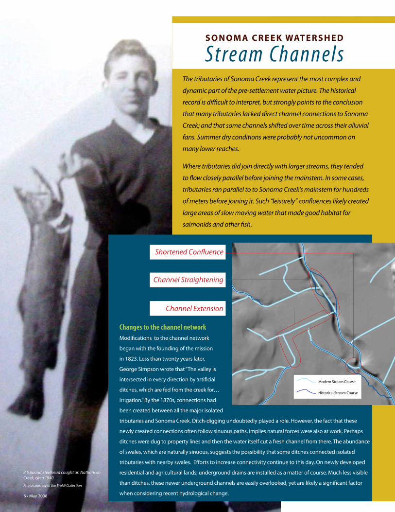
2
Changes to the channel network
Modifications to the channel network
began with the founding of the mission
in 1823. Less than twenty years later,
George Simpson wrote that “The valley is
intersected in every direction by artificial
ditches, which are fed from the creek for…
irrigation.” By the 1870s, connections had
been created between all the major isolated
tributaries and Sonoma Creek. Ditch-digging undoubtedly played a role. However, the fact that these
newly created connections often follow sinuous paths, implies natural forces were also at work. Perhaps
ditches were dug to property lines and then the water itself cut a fresh channel from there. The abundance
of swales, which are naturally sinuous, suggests the possibility that some ditches connected isolated
tributaries with nearby swales. Efforts to increase connectivity continue to this day. On newly developed
residential and agricultural lands, underground drains are installed as a matter of course. Much less visible
than ditches, these newer underground channels are easily overlooked, yet are likely a significant factor
when considering recent hydrological change.
The tributaries of Sonoma Creek represent the most complex and
dynamic part of the pre-settlement water picture. The historical
that many tributaries lacked direct channel connections to Sonoma
Creek; and that some channels shifted over time across their alluvial
fans. Summer dry conditions were probably not uncommon on
many lower reaches.
tributaries ran parallel to to Sonoma Creek’s mainstem for hundreds
of meters before joining it. Such “leisurely” confluences likely created
large areas of slow moving water that made good habitat for
salmonids and other fish.
Shortened Confluence
Channel Extension
Channel Straightening
Historical Stream Course
Modern Stream Course

7 May 2008
Discontinuous tributaries Maps of Sonoma Valley made before 1875
consistently show tributary channels which
seem to end on the valley floor (left) before
reaching the mainstem of Sonoma Creek,
especially in the El Verano area and above
the Kenwood Marsh (O’Farrell 1848; Peabody
1851; Bowers 1867). Altimira describes a
creek, which did “not flow beyond the base
of the hills, but instead [ended] on the plain.”
He compares it to a nearby creek which “runs
until it joins the Arroyo Sonoma.” Similarly
discontinuous tributaries may have included
Rodgers, Carriger, Hanna, Winkle, Fisher,
Champlin, Stuart, Nathanson, and Kunde
creeks as well as numerous smaller ones.
In the Kenwood area, Sonoma Creek itself
was described as ‘spreading out and losing
itself in the valley,’ “forming a kind of willow
thicket and marsh or lagoon.” (Boggs 1861).
This evidence suggests that the mainstem
Sonoma Creek may have lacked a direct
channel between the outlet of the Kenwood
Marsh complex and Adobe Canyon. One
interpretation of this phenomenon is that
these creeks descended from the hills and
spread out into a system of distributaries,
sinking under the surface as they crossed their
alluvial fans. This historical pattern of isolated
tributaries with channels ending on alluvial
fans has been documented for other Bay Area
watersheds including Napa River and Coyote
Creek (Grossinger et al. 2006, 2007). Under
winter conditions on saturated soils, sheet
flows from these creeks probably spread out
over much of the valley floor. Water from
winter storms was slowly shunted down the
valley, raising water levels of wetlands and
lakes and replenishing groundwater as it
moved toward the bay (Micheli 2003).
Shortened confluences
A more subtle modification has been the shortening of confluence channels.
Historical confluences typically made sharply acute angles, the two streams
flowing almost side by side for some distance before they came together.
Today, most confluences are
close to perpendicular. In
this case, channel length has
been decreased to promote
faster drainage.
In some cases it appears this
was done to increase the
usable land on a piece of
property. The confluence of
Agua Caliente and Sonoma
Creeks appears to have
been intentionally moved
upstream to eliminate the
need for a culvert on Verano
Avenue.Historical Confluence
Historical Stream Course
Modern Stream Course
Sonoma Creek
Sonoma C
reek
Agua Caliente
Creek

8 May 2008
Building a HISTORICAL ECOLOGY Project
Sources are drawn together for synthesis and analysis along the themes of historical vegetation types,
channel geometry, seasonality, and land use. We georeference early maps and aerial photography in a geographic information system (GIS), which allows historical evidence to be compared to modern conditions. We also extract and organize pertinent quotes from early land surveys and narrative sources and, where possible, place them on maps of the past and present. This process of comparing multiple, independent sources of historical and modern information facilitates a detailed and accurate depiction of environmental change.
The analysis is brought together into broadly accessible tools, including illustrated reports, websites (such as wetlandtracker.org), and maps. These present trends in habitat types and extent, discuss conceptual models and areas of interest for future environmental improvements, and
provide direct access to many of the most significant historical data sources.
We rely heavily on GIS to synthesize the data into layers that represent historical landscape characteristics. Mapped features may include channels, perennial and seasonal wetlands, coastal features, woodlands and savanna, and other habitats — each coded independently with their supporting sources
and relative certainty level. A variety of methods are used to compare past and present landscapes, describing changes in habitat form and distribution. These depictions of habitat change are used by ecologists and other environmental scientists to describe changes in ecological functions, such as wildlife support. As a reliable map of the pre-modification landscape is developed, it begins to reveal the relationships between native habitats and physical gradients such as topography, salinity, and hydrology, providing a basis for identifying adaptive restoration and management strategies for the contemporary landscape.
Understanding the historical landscape and how it has changed over time can help address many of the challenges associated with managing and planning for the future of local watersheds. Historical ecology can help set priorities for restoring natural functions to local creeks, identify natural ways to reduce flood
hazards, and reveal previously unrecognized conservation opportunities. The historical analysis often reveals ways to restore native habitats within our developed landscape for recreational benefits as well as wildlife conservation. Historical ecology can also reveal management constraints resulting from historical landscape changes, providing a more realistic basis for planning the future.
III - 18
CO
YO
TE
C
RE
EK
W
AT
ER
SH
ED
H
IS
TO
RIC
AL
E
CO
LO
GY
S
TU
DY
P A R T I I I / / H I S T O R I C A L L A N D S C A P E C O N D I T I O N S A T T H E L O C A L S C A L E
III - 19
SA
N F
RA
NC
IS
CO
E
ST
UA
RY
IN
ST
IT
UT
E //
F
IN
AL
R
EP
OR
T
LOWER PENITENCIA CREEKUS Deputy Surveyor Edward Twitchell (1859: 160-161)
explicitly describes the transition from fl uvial to tidal
feature as he surveys north along the Penitencia Creek
boundary of the Rancho los Tularcitos, encounter-
ing “the mouth of the Creek and head of the main
slough.” [U]pstream of this point, Penitencia Creek
fl owed in a highly sinuous, thickly wooded channel,
presumably perennial because of the interception of
the high groundwater table. Thompson’s 1857 sum-
(Westdahl and Morse 1896-97), during which time even
greater mass wasting of hillsides is documented due to
agriculture (Gardner et al. 1958), also seems to make
a rapid change from tidal marsh to arable land during
the previous two or three decades less likely. Farmers
described having to plow these fresh deposits into the
“natural soils” (Parker 1863: 212-213) to improve fertil-
ity, a scenario more likely to have been successful in the
transitional salitroso lands rather than Bay-mud based
tidal marsh.
THE TIDAL MARSH-ALKALI MEADOW
ECOTONE
Saltgrass (Distichlis spp.) dominated alkali meadows at
the landward edge of the tidal marsh and extended
well beyond regular tidal infl uence, creating a broad
ecotone. Defi ning the boundary between tidal marsh
and terrestrial habitats here is challenging because of
the gradual transition along this very fl at topographic
gradient and the absence of 1850s-era US Coast Survey
data. However, a number of indicators are available,
including remnant sloughs visible in Westdahl and
Morse (1896-97)and aerial photography (1939). Other
historical map information is available as well; for exam-
ple, Herrmann (1874c) notes “SWAMP LAND” beginning
along Coyote Creek at the boundary we show.
Day (1854:490-491) describes alkali meadows several
times in his survey in the vicinity of Milpitas, reporting
clay soils “rather wet in winter with some alkali” and
“strongly tinctured with alkali.” The alkali meadows
were characterized by native grasses, wetland plants,
and an array of presently rare plants associated with
vernal pools and alkali fl ats (see description in PART II).
Soil conditions precluded agriculture quite dramatically,
forming distinct land use boundaries (FIGURE III-7).
PENITENCIA POND
The mysterious Penitencia Pond was also located in
this vicinity, two miles downstream from Milpitas and
near where “the Penitencia and Coyote join” (Fer-
nandez 1860: 150, Gallagher 1860). Both witnesses
locate the “lake (laguna)” (Fernandez 1860: 150) near
the downstream sausal. The feature appears to have
been a muted tidal lagoon. A landmark in the Rincon
de los Esteros grant testimony, it also happened to be
intersected by the Mt. Diablo Meridian and a Township
boundary between Five and Six South.
Day (1854: 490) notes that the “tide slough [is] now dry,
but often wet.” This feature was surprisingly wide: Day
(1854: 490-491) requires fi ve chains (330 feet) to cross
the “dry bed of salt slough” near the present-day Calera
confl uence. He and other surveyors are able to cross the
slough except when it is fl ooded, indicating relatively
solid substrate and less frequent tidal inundation. In
1866, Thompson approaches the Penitencia Laguna
along the Township line from the West and describes
entering and leaving the willows and the “Tuley [sic]
swamp.” The sausal is fi ve chains wide (330 feet) and
the presence of willows and tule suggests brackish tidal
infl uence.
FIGURE III-7. BOTTOMLAND BOUNDARY IN MILPITAS. The 1800 view (lower left) shows dry grassland occupying Coyote Creek’s broad natural levee on the left and alkali meadow, with a perennial freshwater marsh, in the bottomlands to the right. These boundaries are based upon the 1940-41 soil survey (Gardner et al. 1958; lower right), which also generally indicates the small marsh with two wetland symbols. Farmers have developed the well-drained, coarse alluvial deposits in 1939 (upper left; AAA 1939), but poor drainage and salt effects in the bottomland soils have precluded agriculture, forming a distinct land use boundary. The shape of the freshwater marsh is indicated by darker, saturated soils. Highway 880 and the Montague Expressway offramp can be seen presently (2002; upper right; Imagery Copyright 2005 AirPhotoUSA, LLC, All Rights Reserved).
1939 2002
1800 1941
1896
1943
2005
1866
Research begins with the acquisition of historical materials from a broad range of institutions, including local museums and historical societies, city and county archives, and regional libraries. Journals, diaries, oral histories, interviews and newspaper articles about the landscape and notable environmental features
document historical conditions. Early maps, surveys, and aerial photography provide the locations of historical features, such as streams, wetlands, and plant communities, as well as remaining property boundaries and roads that are valuable links to the contemporary landscape. Other important sources include landscape photography, sketches, and paintings.