An Introduction to Geology - Pearson Education · 2019-02-20 · geology Geology Today Today the...
34
To assist you in learning the important concepts in this chapter, you will find it helpful to focus on the following questions: • How does physical geology differ from historical geology? • What is the fundamental difference between uniformitarianism and catastrophism? • What is relative dating? What are some principles of relative dating? • How does a scientific hypothesis differ from a scientific theory? • What are Earth’s four major “spheres”? • Why can Earth be regarded as a system? • What is the rock cycle? Which geo- logic interrelationships are illustrat- ed by the cycle? • How did Earth and the other plan- ets in our solar system originate? • What criteria were used to establish Earth’s layered structure? • What are the major features of the continents and ocean basins? • What is the theory of plate tecton- ics? How do the three types of plate boundaries differ? 1 XXIV Focus on Learning An Introduction to Geology Volcanic eruption of Mt. Etna in late 2006. Mt. Etna towers above Catania, Sicily’s second largest city, and has one of the world’s longest documented records of historical volcanism. (Photo by Marco Fulle) LUTGMC01_xxiv-033hr.qxd 30-11-2007 10:42 Page xxiv
Transcript of An Introduction to Geology - Pearson Education · 2019-02-20 · geology Geology Today Today the...

To assist you in learning theimportant concepts in this chapter,you will find it helpful to focus on thefollowing questions:• How does physical geology differ
from historical geology?• What is the fundamental difference
between uniformitarianism andcatastrophism?
• What is relative dating? What aresome principles of relative dating?
• How does a scientific hypothesisdiffer from a scientific theory?
• What are Earth’s four major“spheres”?
• Why can Earth be regarded as asystem?
• What is the rock cycle? Which geo-logic interrelationships are illustrat-ed by the cycle?
• How did Earth and the other plan-ets in our solar system originate?
• What criteria were used to establishEarth’s layered structure?
• What are the major features of thecontinents and ocean basins?
• What is the theory of plate tecton-ics? How do the three types ofplate boundaries differ?
1
XXIV
Focu
s on
Lea
rnin
g
An Introduction to Geology
� Volcanic eruption of Mt. Etna in late 2006. Mt. Etnatowers above Catania, Sicily’s second largest city, and hasone of the world’s longest documented records of historicalvolcanism. (Photo by Marco Fulle)
LUTGMC01_xxiv-033hr.qxd 30-11-2007 10:42 Page xxiv

The spectacular eruption of a volcano, the terror brought by anearthquake, the magnificent scenery of a mountain valley,
and the destruction created by a landslide all are subjects for the geologist.The study of geology deals with many fascinating and practical questions about our physical
environment. Will there soon be another great earthquake in California? What was the Ice Age like? Will there be another? Will oil be found if a well is drilled at this location?
LUTGMC01_xxiv-033hr.qxd 30-11-2007 10:42 Page 1

� Figure 1.1 Rocks contain information about theprocesses that produce them. This large exposure ofigneous rock in California’s Sierra Nevada was once amolten mass found deep within Earth. Geologistsstudy the processes that create and modify mountainssuch as these. (Photo by St. Clair, Felix)
2 I CHAPTER 1 AN INTRODUCTION TO GEOLOGY
The Science of GeologyThe subject of this text is geology, from theGreek geo, “Earth,” and logos, “discourse.”It is the science that pursues an under-standing of planet Earth. Geology is tradi-tionally divided into two broadareas—physical and historical. Physicalgeology examines the materials composingEarth and seeks to understand the manyprocesses that operate beneath and uponits surface (Figure 1.1). The aim ofhistorical geology, on the other hand, is tounderstand the origin of Earth and its de-velopment through time. Thus, it strives toestablish a chronological arrangement ofthe multitude of physical and biologicalchanges that have occurred in the geologic past. The study of physical geology logi-cally precedes the study of Earth history because we must first understand howEarth works before we attempt to unravel its past. It should also be pointed outthat physical and historical geology are divided into many areas of specializa-tion. Table 1.1 provides a partial list. Every chapter of this book represents oneor more areas of specialization in geology.
To understand Earth is challenging because our planet is a dynamicbody with many interacting parts and a complex history. Throughout itslong existence, Earth has been changing. In fact, it is changing as you readthis page and will continue to do so into the foreseeable future. Some-times the changes are rapid and violent, as when landslides or volcaniceruptions occur. Just as often, change takes place so slowly that it goesunnoticed during a lifetime. Scales of size and space also vary greatlyamong the phenomena that geologists study. Sometimes they mustfocus on phenomena that are submicroscopic, and at other timesthey must deal with features that are continental or global in scale.
Geology is perceived as a science that is done in the out ofdoors, and rightly so. A great deal of geology is based on measure-ments, observations, and experiments conducted in the field. Butgeology is also done in the laboratory where, for example, thestudy of various Earth materials provides insights into manybasic processes. Moreover, the development of sophisticatedcomputer models allows for the simulation of many of ourplanet’s complex systems. Frequently, geology requires an un-derstanding and application of knowledge and principlesfrom physics, chemistry, and biology. Geology is a sciencethat seeks to expand our knowledge of the natural worldand our place in it.
Different Areas of Geologic Study*Archaeological Geology PaleoclimatologyBiogeosciences PaleontologyEngineering Geology PetrologyGeochemistry Planetary GeologyGeomorphology Sedimentary GeologyGeophysics SeismologyHistory of Geology Structural GeologyHydrogeology TectonicsMineralogy VolcanologyOcean Sciences
*This is a partial list of interest sections and specialties of associated societies affiliated with the GeologicalSociety of America (www.geosociety.org) and the American Geophysical Union (www.agu.org), two pro-fessional societies to which many geologists belong.
Table 1.1
LUTGMC01_xxiv-033hr.qxd 30-11-2007 10:42 Page 2

� Figure 1.2 On January 13, 2001, a magnitude 7.6 earthquakecaused considerable damage in El Salvador. The damage pictured herewas caused by a landslide that was triggered by the earthquake. Asmany as 1000 people were buried under 8 meters (26 feet) of landslidedebris. Geologists seek to understand the processes that create such
events. (Photo by Reuters/STR/Getty Images Inc.-Hulton Archive Photos)
Geology, People, and the EnvironmentThe primary focus of this book is to develop anunderstanding of basic geological principles, butalong the way, we will explore numerous impor-tant relationships between people and the naturalenvironment. Many of the problems and issuesaddressed by geology are of practical value topeople.
Natural hazards are a part of living on Earth.Every day they adversely affect millions of peopleworldwide and are responsible for staggeringdamages. Among the hazardous Earth processesstudied by geologists are volcanoes, floods, earth-quakes, and landslides. Of course, geologic haz-ards are simply natural processes. They becomehazards only when people try to live where these processesoccur. Figure 1.2 illustrates this point as does the chapter-
opening photo.Resources represent another impor-
tant focus of geology that is of greatpractical value to people. They in-
clude water and soil, a great va-riety of metallic and
nonmetallic minerals, Each year an average American requireshuge quantities of Earth materials. Imag-ine receiving your annual share in a singledelivery. A large truck would pull up toyour home and unload 12,965 lbs. ofstone, 8945 lbs. of sand and gravel, 895lbs. of cement, 395 lbs. of salt, 361 lbs. ofphosphate, and 974 lbs. of other non-metals. In addition, there would be 709lbs. of metals, including iron, aluminum,and copper.
Did you know?
LUTGMC01_xxiv-033hr.qxd 30-11-2007 10:42 Page 3

as well. For example, river flooding is nat-ural, but the magnitude and frequency offlooding can be changed significantly byhuman activities such as clearing forests,building cities, and constructing dams(Figure 1.4). Unfortunately, natural sys-tems do not always adjust to artificialchanges in ways that we can anticipate.Thus, an alteration to the environmentthat was intended to benefit society some-times has the opposite effect.
Historical Notes about GeologyThe nature of our Earth—its materials andits processes—has been a focus of studyfor centuries. Writings about fossils, gems,earthquakes, and volcanoes date back tothe Greeks, more than 2300 years ago.Certainly, the most influential Greekphilosopher was Aristotle. Unfortunately,Aristotle’s explanations about the naturalworld were not derived from keen obser-vations and experiments, as is modern sci-ence. Instead, they were arbitrarypronouncements based on the limitedknowledge of his day. He believed thatrocks were created under the “influence”of the stars and that earthquakes occurredwhen air in the ground was heated bycentral fires and escaped explosively!When confronted with a fossil fish, he ex-plained that “a great many fishes live inthe earth motionless and are found when
4 I CHAPTER 1 AN INTRODUCTION TO GEOLOGY
and energy (Figure 1.3). Together theyform the very foundation of modern civi-lization. Geology deals not only with theformation and occurrence of these vital re-sources but also with maintaining sup-plies and with the environmental impactof their extraction and use.
Complicating all environmental issuesis rapid world population growth andeveryone’s aspiration to a better standardof living. Earth, with an estimated popula-tion in 2007 of 6.6 billion people, is nowgaining about 100 million people eachyear. This means a ballooning demand forresources and a growing pressure for peo-ple to dwell in environments having sig-nificant geologic hazards.
Not only do geologic processes havean impact on people, but we humans candramatically influence geologic processes
� Figure 1.3 A modern offshore oil productionplatform in the North Sea. (Photo by Peter Bowater/PhotoResearchers, Inc.)
It took until about the year 1800 for theworld population to reach 1 billion. Sincethen, the planet has added nearly 6 bil-lion more people.
Did you know?
excavations are made.” Although Aristo-tle’s explanations may have been ade-quate for his day, they unfortunatelycontinued to be expounded for many cen-turies, thus thwarting the acceptance ofmore up-to-date ideas.
CatastrophismIn the mid-1600s James Ussher, AnglicanArchbishop of Armagh, Primate of all Ire-land, published a major work that had im-mediate and profound influences. Arespected scholar of the Bible, Ussher con-structed a chronology of human and Earthhistory in which he determined that Earthwas only a few thousand years old, hav-ing been created in 4004 B.C. Ussher’s trea-tise earned widespread acceptance amongEurope’s scientific and religious leaders,and his chronology was soon printed inthe margins of the Bible itself.
During the seventeenth and eigh-teenth centuries the doctrine ofcatastrophism strongly influenced peo-ple’s thinking about Earth. Briefly stated,catastrophists believed that Earth’s land-scapes had been shaped primarily bygreat catastrophes. Features such asmountains and canyons, which today weknow take great periods of time to form,were explained as having been producedby sudden and often worldwide disastersproduced by unknown causes that nolonger operate. This philosophy was anattempt to fit the rates of Earth processesto the then current ideas on the age ofEarth.
� Figure 1.4 The flooding Trinity River west of downtown Dallas, Texas, on June 28, 2007. The channelin which the river is usually confined is outlined by trees on either bank. (Photo by G. J. McCarthy/Dallas MorningNews/Corbis)
LUTGMC01_xxiv-033hr.qxd 30-11-2007 10:42 Page 4

geol
ogy
Geology TodayToday the basic tenets of uniformitarianism arejust as viable as in Hutton’s day. We realize morestrongly than ever that the present gives us in-sight into the past and that the physical, chemi-cal, and biological laws that govern geologicalprocesses remain unchanged through time. How-ever, we also understand that the doctrine shouldnot be taken too literally. To say that geologicalprocesses in the past were the same as those oc-
curring today is not to suggest that they al-ways had the same relative
importance or op-erated at pre-
cisely thesame
� Figure 1.5 James Hutton(1726–1797), a founder ofmodern geology. (Photo courtesy ofThe Natural History Museum, London)
� This peak is part of the
Himalayan system.
(Photo by Art Wolfe)
*H. E. Brown, V. E. Monnett, and J. W. Stovall, Introduction to Geology(New York: Blaisdell, 1958).
Shortly after Archbishop Ussher deter-mined an age for Earth, another biblicalscholar, Dr. John Lightfoot of Cambridge,felt he could be even more specific. Hewrote that Earth was created “. . . on the26th of October 4004 B.C. at 9 o’clock inthe morning.” (As quoted in William L.Stokes, Essentials of Earth History, Pren-tice Hall, Inc. 1973, p. 20.)
Did you know?The relationship between catastrophism and the age ofEarth has been summarized nicely:
That the earth had been through tremendous adventures andhad seen mighty changes during its obscure past was plainlyevident to every inquiring eye; but to concentrate thesechanges into a few brief millenniums required atailor-made philosophy, a philosophy whosebasis was sudden and violent change.*
The Birth of Modern GeologyAgainst this backdrop of Aristotle’s viewsand an Earth created in 4004 B.C., a Scottishphysician and gentleman farmer named JamesHutton published Theory of the Earth in 1795(Figure 1.5). In this work Hutton put forth afundamental principle that is a pillar of geologytoday: uniformitarianism. It states that thephysical, chemical, and biological laws that operatetoday also operated in the geologic past. In otherwords, the forces and processes that we ob-serve shaping our planet today have been atwork for a very long time. Thus, to under-stand ancient rocks, we must first understand present-day processes and their re-sults. This idea is commonly stated as the present is the key to the past.
Prior to Hutton’s Theory of the Earth, no one had effectively demonstrated thatgeological processes can continue over extremely long periods of time. Huttonpersuasively argued that forces that appear small could, over long spans of time,produce effects just as great as those resulting from sudden catastrophic events.Hutton carefully cited verifiable observations to support his ideas.
For example, when he argued that mountains are sculpted and ultimately de-stroyed by weathering and the work of running water, and that their wastes arecarried to the oceans by processes that can be observed, Hutton said, “We have achain of facts which clearly demonstrates . . . that the materials of the wastedmountains have traveled through the rivers”; and further, “There is not one stepin all this progress . . . that is not to be actually perceived.” He then went onto summarize this thought by asking a question and immediately provid-ing the answer: “What more can we require? Nothing but time.”
HISTORICAL NOTES ABOUT GEOLOGY I 5
LUTGMC01_xxiv-033hr.qxd 30-11-2007 10:42 Page 5

6 I CHAPTER 1 AN INTRODUCTION TO GEOLOGY
� Figure 1.6 Over millions of years, weathering, gravity, and the erosional work of the ColoradoRiver and the streams that flow into it have created Arizona’s Grand Canyon. Geologic processes oftenact so slowly that changes may not be visible during an entire human lifetime. The relative ages of therock layers in the canyon can be determined by applying the law of superposition. The youngest rocksare on top, and the oldest are at the bottom. (Photo by Marc Muench/Muench Photography, Inc.)
rate. Moreover, some important geologic processes are not currently observable, but evi-dence that they occur is well established. For example, we know that Earth has experi-enced impacts from large meteorites even though we have no human witnesses. Suchevents altered Earth’s crust, modified its climate, and strongly influenced life on theplanet.
The acceptance of uniformitarianism meant the acceptance of a very long history forEarth. Although processes vary in their intensity, they still take a very long time to createor destroy major landscape features (Figure 1.6). For example, geologists have estab-lished that mountains once existed in portions of present-day Minnesota, Wisconsin, andMichigan. Today the region consists of low hills and plains. Over great expanses of time,erosional processes that wear land away gradually destroyed these peaks. The rockrecord contains evidence that shows Earth has experienced many such cycles of moun-tain building and erosion.
In the chapters that follow, we will be examining the materials that compose ourplanet and the processes that modify it. It is important to remember that although many
features of our physical landscape mayseem to be unchanging in terms of thedecades over which we observe them, theyare nevertheless changing, but on timescales of hundreds, thousands, or evenmany millions of years. Concerning theever changing nature of Earth throughgreat expanses of geologic time, James
Hutton made a statement that was to be-come his most famous. In concluding hisclassic 1788 paper, published in theTransactions of the Royal Society of Edin-burgh, he stated, “The result, therefore, ofour present enquiry is, that we find novestige of a beginning, no prospect ofan end.”
Geologic TimeAlthough Hutton and others recognizedthat geologic time is exceedingly long,they had no methods to accurately deter-mine the age of Earth. However, in 1896radioactivity was discovered. Using ra-dioactivity for dating was first attemptedin 1905 and has been refined ever since.Geologists are now able to assign fairlyaccurate dates to events in Earth history.For example, we know that the dinosaursdied out about 65 million years ago.Today the age of Earth is put at about 4.5billion years.
The concept of geologic time is new tomany nongeologists. People are accus-tomed to dealing with increments of time
Estimates indicate that erosional process-es are lowering the North American conti-nent at a rate of about 3 cm per1000 years. At this rate, it would take100 million years to level a 3000-meter-(10,000-foot-) high peak.
Did you know?
LUTGMC01_xxiv-033hr.qxd 30-11-2007 10:42 Page 6

not, of course, their numerical ages. Todaysuch a proposal appears to be elementary,but 300 years ago it amounted to a majorbreakthrough in scientific reasoning by es-tablishing a rational basis for relative timemeasurements.
� Figure 1.7 These climbers have set up camp inCalifornia’s Sierra Nevada. The rocks here formedover a span of tens of millions of years. Theprocesses that produced these mountains andcreated this scenery also represent manymillions of years. Geologists must routinelydeal with ancient materials andevents that occurred in thedistant geologic past. (Photoby Galen Rowell/CORBIS)
GEOLOGIC TIME I 7
that are measured in hours, days, weeks,and years. Our history books often exam-ine events over spans of centuries, buteven a century is difficult to appreciatefully. For most of us, someone or some-thing that is 90 years old is very old, and a1000-year-old artifact is ancient.
By contrast, those who study geologymust routinely deal with vast time peri-ods—millions or billions (thousands ofmillions) of years (Figure 1.7). Whenviewed in the context of Earth’s 4.5-billion-year history, a geologic eventthat occurred 100 million years ago maybe characterized as “recent” by a geolo-gist, and a rock sample that has beendated at 10 million years may be called“young.” An appreciation for the magni-tude of geologic time is important in thestudy of geology because many processesare so gradual that vast spans of time areneeded before significant changes occur.
During the nineteenth century, longbefore the discovery of radioactivity,which eventually allowed for the estab-lishment of reliable numerical dates, a ge-ologic time scale was developed usingprinciples of relative dating.Relative dating means that eventsare placed in theirproper
sequence or order without knowing theirage in years. This is done by applyingprinciples such as the law of superposi-tion, which states that in layers of sedi-mentary rocks or lava flows, the youngestlayer is on top, and the oldest is on thebottom (assuming that nothing has turnedthe layers upside down, which sometimeshappens). Arizona’s Grand Canyon pro-vides a fine example where the oldestrocks are located in the inner gorge whilethe youngest rocks are found on the rim(Figure 1.6). So the law of superpositionestablishes the sequence of rock layers but
If you were to count to 4.5 billion at therate of one number per second and con-tinued 24 hours a day, 7 days a week, andnever stopped, it would take about 150years to complete the task!
Did you know?
LUTGMC01_xxiv-033hr.qxd 30-11-2007 10:42 Page 7

B.
A.
8 I CHAPTER 1 AN INTRODUCTION TO GEOLOGY
this situation exists because the basis forestablishing the time scale was not theregular rhythm of a clock, but the chang-ing character of life forms through time.Specific dates were added long after thetime scale was established. A glance atFigure 1.9 also reveals that the Phanero-zoic eon is divided into many more units
� Figure 1.8 Fossils are important tools for thegeologist. In addition to being very important inrelative dating, fossils can be usefulenvironmental indicators. A. A fossil fish ofEocene age from the Green River Formation inWyoming. (Photo by John Cancalosi/DRK Photo) B. Fossilferns from the coal-forming Pennsylvanian Period,St. Clair, Pennsylvania. (Photo by Breck P. Kent)
Eon
Era Period Epoch
Phanerozoic
Pro
tero
zoic
Arc
hean
Cen
ozoi
cM
esoz
oic
Pal
eozo
ic
Quaternary
Tertiary
Cretaceous
Jurassic
Triassic
Permian
Pennsylvanian
Car
bon
ifero
us
Mississippian
Devonian
Silurian
Ordovician
Cambrian
145.5 m.y.
199.6 m.y.
251 m.y.
299 m.y.
318 m.y.
359 m.y.
416 m.y.
444 m.y.
488 m.y.
542 m.y.
Holocene
Pleistocene
Pliocene
Miocene
Oligocene
Eocene
Paleocene
1.8 m.y.
65.5 m.y.
Pre
cam
bria
n
Neo
gene
Pal
eoge
ne
542 m.y.
2500 m.y.
4500 m.y.
� Figure 1.9 The geologic time scale divides the vast 4.5-billion-year history of Earth into eons, eras,periods, and epochs. We presently live in the Holocene epoch of the Quaternary period. This period ispart of the Cenozoic era, which is the latest era of the Phanerozoic eon. Numbers on the time scalerepresent time in millions of years before the present. These dates were added long after the time scalehad been established using relative dating techniques. The Precambrian accounts for more than 88percent of geologic time.
Fossils, the remains or traces of pre-historic life, were also essential to the de-velopment of a geologic time scale (Figure1.8). Fossils are the basis for the principleof fossil succession, which states that fos-sil organisms succeed one another in adefinite and determinable order, andtherefore any time period can be recog-nized by its fossil content. This principlewas laboriously worked out over decadesby collecting fossils from countless rocklayers around the world. Once estab-lished, it allowed geologists to identifyrocks of the same age in widely separatedplaces and to build the geologic time scaleshown in Figure 1.9.
Notice that units having the same des-ignations do not necessarily extend for thesame number of years. For example, theCambrian period lasted about 56 millionyears, whereas the Silurian periodspanned only about 28 million years. Aswe will emphasize again in Chapter 18,
than earlier eons even though it encom-passes only about 12 percent of Earth his-tory. The meager fossil record for theseearlier eons is the primary reason for thelack of detail on this portion of the timescale. Without abundant fossils, geologistslose a very important tool for subdividinggeologic time.
LUTGMC01_xxiv-033hr.qxd 30-11-2007 10:42 Page 8

rock
s
THE NATURE OF SCIENTIFIC INQUIRY I 9
The Nature of Scientific InquiryAs members of a modern society, we areconstantly reminded of the benefits de-rived from science. But what exactly is thenature of scientific inquiry? Developingan understanding of how science is doneand how scientists work is an importanttheme that appears throughout this book.You will explore the difficulties in gather-ing data and some of the ingenious meth-ods that have been developed toovercome these difficulties. You will alsosee many examples of how hypotheses areformulated and tested, as well as learnabout the evolution and development ofsome major scientific theories.
All science is based on the assumptionthat the natural world behaves in a consis-tent and predictable manner that is com-prehensible through careful, systematicstudy. The overall goal of science is to dis-cover the underlying patterns in natureand then to use this knowledge to makepredictions about what should or shouldnot be expected, given certain facts or cir-cumstances. For example, by knowinghow oil deposits form, geologists are ableto predict the most favorable sites for ex-ploration and, perhaps as important, howto avoid regions having little or nopotential.
The development of new scientificknowledge involves some basic logicalprocesses that are universally accepted. Todetermine what is occurring in the naturalworld, scientists collect scientific “facts”through observation and measurement(Figure 1.10). Because some error is in-evitable, the accuracy of a particularmeasurement or observation is alwaysopen to question. Nevertheless, these dataare essential to science and serve as thespringboard for the development of scien-tific theories.
HypothesisOnce facts have been gathered and princi-ples have been formulated to describe anatural phenomenon, investigators try toexplain how or why things happen in themanner observed. They often do this byconstructing a tentative (or untested) ex-planation, which is called a scientific
hypothesis or model. (The term model, although often used synonymously with hy-pothesis, is a less precise term because it is sometimes used to describe a scientific theoryas well.) It is best if an investigator can formulate more than one hypothesis to explain agiven set of observations. If an individual scientist is unable to devise multiple mod-els, others in the scientific community will almost always develop alternativeexplanations. A spirited debate frequently ensues. As a result, extensive re-search is conducted by proponents of opposing models, and the results aremade available to the wider scientific community in scientific journals.
Before a hypothesis can become an accepted part of scientific knowl-edge, it must pass objective testing and analysis. (If a hypothesis cannot betested, it is not scientifically useful, no matter how interesting it mightseem.) The verification process requires that predictions be made based onthe model being considered and that the predictions be tested bycomparing them against objective observations of nature.Put another way, hypotheses must fitobservations other than thoseused to formulate themin the first place.
� Figure 1.10This geologist is taking a lavasample from a “skylight” in alava tube near Kilauea Volcano,Hawaii. (Photo by G. Brad Lewis/GettyImages, Inc.—Stone Allstock)
� Arizona'sMonument Valley.(David Muench)
LUTGMC01_xxiv-033hr.qxd 30-11-2007 10:43 Page 9

10 I CHAPTER 1 AN INTRODUCTION TO GEOLOGY
Those hypotheses that fail rigorous testingare ultimately discarded. The history ofscience is littered with discarded hypothe-ses. One of the best known is the Earth-centered model of the universe—aproposal that was supported by the ap-parent daily motion of the Sun, Moon,and stars around Earth. As the mathemati-cian Jacob Bronowski so ably stated, “Sci-ence is a great many things, but in the endthey all return to this: Science is the ac-ceptance of what works and the rejectionof what does not.”
theory. In everyday language we may say“That’s only a theory.” But a scientific the-ory is a well-tested and widely acceptedview that the scientific community agreesbest explains certain observable facts.
Theories that are extensively docu-mented are held with a very high degreeof confidence. Theories of this stature thatare comprehensive in scope have a specialstatus. They are called paradigms becausethey explain a large number of interrelat-ed aspects of the natural world. For exam-ple, the theory of plate tectonics is aparadigm of the geological sciences thatprovides the framework for understand-ing the origin of mountains, earthquakes,and volcanic activity. In addition, platetectonics explains the evolution of thecontinents and the ocean basins throughtime—a topic we will consider later in thischapter.
Scientific MethodsThe processes just described, in which sci-entists gather facts through observationsand formulate scientific hypotheses andtheories is called the scientific method. Con-trary to popular belief, the scientificmethod is not a standard recipe that scien-tists apply in a routine manner to unravelthe secrets of our natural world. Rather, it
is an endeavor that involves creativity andinsight. Rutherford and Ahlgren put it thisway: “Inventing hypotheses or theories toimagine how the world works and thenfiguring out how they can be put to thetest of reality is as creative as writing po-etry, composing music, or designingskyscrapers.”*
There is no fixed path that scientistsalways follow that leads unerringly to sci-entific knowledge. Nevertheless, manyscientific investigations involve the fol-lowing steps: (1) collection of scientificfacts (data) through observation andmeasurement (Figure 1.11); (2) develop-ment of one or more working hypothesesor models to explain these facts; (3) devel-
*F. James Rutherford and Andrew Ahlgren, Sciencefor All Americans (New York: Oxford UniversityPress, 1990), p. 7.
A scientific law is a basic principle that de-scribes a particular behavior of naturethat is generally narrow in scope and canbe stated briefly—often as a simple math-ematical equation.
Did you know?
In 1492 when Columbus set sail, many Eu-ropeans thought that Earth was flat andthat Columbus would sail off the edge.However, more than 2000 years earlier,ancient Greeks realized that Earth wasspherical because it always cast a curvedshadow on the Moon during a lunareclipse. In fact, Eratosthenes (276–194 B.C.)calculated Earth’s circumference andobtained a value close to the modernmeasurement of 40,075 km (24,902 mi).
Did you know?
� Figure 1.11 Paleontologists study ancientlife. Here scientists are excavating the remains ofAlbertasaurus, a large carnivore similar toTyrannosaurus rex, which lived during the lateCretaceous Period. The excavation site is near RedDeer River, Alberta, Canada. The aim of historicalgeology is to understand the development ofEarth and its life through time. Fossils areessential tools in that quest. (Photoby Richard T. Nowitz/ScienceSource/PhotoResearchers, Inc.)
TheoryWhen a hypothesis has survived extensivescrutiny and when competing modelshave been eliminated, a hypothesis maybe elevated to the status of a scientific
LUTGMC01_xxiv-033hr.qxd 30-11-2007 10:43 Page 10

Terminus ofglacier in 1874
Terminusin 1874
TerminusTerminusin 1878in 1878
Terminusin 1878
Terminusin 1878
TerminusTerminusin 1882in 1882
1878 position1878 positionof stakesof stakes
1882 position1882 positionof stakesof stakes
Terminusin 1882
Terminusin 1882
Original positionof stakes (1874)
1878 positionof stakes
1878 positionof stakes
1882 positionof stakes
1882 positionof stakes
1874 positionof stakes
� Figure 1.12 Ice movementand changes in the terminus atRhône Glacier, Switzerland. Inthis classic study of a valleyglacier, the movement ofstakes clearly shows thatglacial ice moves and thatmovement along the sidesof the glacier is slowerthan movement in thecenter. Also notice that eventhough the ice front wasretreating, the ice within theglacier was advancing.
THE NATURE OF SCIENTIFIC INQUIRY I 11
opment of observations and experimentsto test the hypotheses; and (4) the accept-ance, modification, or rejection of the hy-potheses based on extensive testing.
Other scientific discoveries may resultfrom purely theoretical ideas that standup to extensive examination. Some re-searchers use high-speed computers tosimulate what is happening in the “real”world. These models are useful whendealing with natural processes that occuron very long time scales or take place inextreme or inaccessible locations. Stillother scientific advancements have beenmade when a totally unexpected happen-ing occurred during an experiment. Theseserendipitous discoveries are more thanpure luck; for as Louis Pasteur stated, “Inthe field of observation, chance favorsonly the prepared mind.”
Scientific knowledge is acquiredthrough several avenues, so it might bebest to describe the nature of scientific in-quiry as the methods of science rather thanthe scientific method. In addition, itshould always be remembered that eventhe most compelling scientific theories arestill simplified explanations of the naturalworld.
Do Glaciers Move? An Application of the Scientific MethodThe study of glaciers provides an earlyapplication of the scientific method. Highin the Alps of Switzerland and France,small glaciers exist in the upper portionsof some valleys. In the late eighteenthand early nineteenth centuries, people
who farmed and herded animals in thesevalleys suggested that glaciers in theupper reaches of the valleys had previous-ly been much larger and had occupieddownvalley areas. They based their expla-nation on the fact that the valley floorswere littered with angular boulders andother rock debris that seemed identical tothe materials that they could see in andnear the glaciers at the heads of the valleys.
Although the explanation of these observation seemed logical, others did not acceptthe notion that masses of ice hundreds of meters thick were capable of movement. Thedisagreement was settled after a simple experiment was designed and carried out to testthe hypothesis that glacial ice can move.
Markers were placed in a straight line completely across an alpine glacier. The posi-tion of the line was marked on the valley walls so that if the ice moved, the change in po-sition could be detected. After a year or two the results were clear. The markers on theglacier had advanced down the valley, proving that glacial ice indeed moves. In addi-tion, the experiment demonstrated that ice within a glacier does not move at a uniformrate, because the markers in the center advanced farther than did those along the mar-gins. Although most glaciers move too slowly for direct visual detection, the experimentsucceeded in demonstrating that movement nevertheless occurs. In the years that fol-lowed, this experiment was repeated many times with greater accuracy using more mod-ern surveying techniques. Each time, the basic relationships established by earlierattempts were verified.
The experiment illustrated in Figure 1.12 was carried out at Switzerland’s RhôneGlacier later in the nineteenth century. It not only traced the movement of markers with-in the ice but also mapped the position of the glacier’s terminus. Notice that even thoughthe ice within the glacier was advancing, the ice front was retreating. As often occurs inscience, experiments and observations designed to test one hypothesis yield new infor-mation that requires further analysis and explanation.
The volume of ocean water is so largethat if Earth’s solid mass were perfectlysmooth (level) and spherical, the oceanswould cover Earth’s entire surface to auniform depth of more than 2000 m(1.2 mi)!
Did you know?
LUTGMC01_xxiv-033hr.qxd 30-11-2007 10:43 Page 11

12 I CHAPTER 1 AN INTRODUCTION TO GEOLOGY
Earth’s Spheres
An Introduction toGeology: A View of Earth
A view such as the one in Figure 1.13Aprovided the Apollo 8 astronauts as well asthe rest of humanity with a unique per-spective of our home. Seen from space,Earth is breathtaking in its beauty andstartling in its solitude. Such an image re-minds us that our home is, after all, aplanet—small, self-contained, and in someways even fragile.
As we look more closely at our planetfrom space, it becomes apparent thatEarth is much more than rock and soil. Infact, the most conspicuous features inFigure 1.13A are not continents butswirling clouds suspended above the sur-face and the vast global ocean. These fea-tures emphasize the importance of waterto our planet.
The closer view of Earth from spaceshown in Figure 1.13B helps us appreciatewhy the physical environment is tradi-tionally divided into three major parts: thewater portion of our planet, the hydro-sphere; Earth’s gaseous envelope, the at-mosphere; and, of course, the solid Earth,or geosphere. It needs to be emphasizedthat our environment is highly integratedand is not dominated by rock, water, or
ESSENTIALS OF GEOLOGY
A. B.
air alone. Rather, it is characterized bycontinuous interactions as air comes incontact with rock, rock with water, andwater with air. Moreover, the biosphere,which is the totality of all plant and ani-mal life on our planet, interacts with eachof the three physical realms and is anequally integral part of the planet. Thus,Earth can be thought of as consisting offour major spheres: the hydrosphere, at-mosphere, geosphere, and biosphere.
The interactions among Earth’s fourspheres are incalculable. Figure 1.14 pro-vides us with one easy-to-visualize exam-ple. The shoreline is an obvious meetingplace for rock, water, and air. In this scene,ocean waves that were created by the dragof air moving across the water are break-ing against the rocky shore. The force ofthe water can be powerful, and the ero-sional work that is accomplished can begreat.
� Figure 1.13 A. View that greeted the Apollo 8 astronauts as their spacecraft emerged from behindthe Moon. (NASA Headquarters) B. Africa and Arabia are prominent in this classic image of Earth takenfrom Apollo 17. The tan cloud-free zones over the land coincide with major desert regions. The band ofclouds across central Africa is associated with a much wetter climate that in places sustains tropical rainforests. The dark blue of the oceans and the swirling cloud patterns remind us of the importance of theoceans and the atmosphere. Antarctica, a continent covered by glacial ice, is visible at the South Pole.(NASA/Science Source/Photo Researchers, Inc.)
LUTGMC01_xxiv-033hr.qxd 30-11-2007 10:43 Page 12

EARTH’S SPHERES I 13
� Figure 1.14 The shoreline is one obviousexample of an interface—a common boundarywhere different parts of a system interact. In thisscene, ocean waves (hydrosphere) that werecreated by the force of moving air (atmosphere)break against California’s rocky Big Sur shore(geosphere). The force of the water can bepowerful, and the erosional work that isaccomplished can be great. (Photo by Carr Clifton)
HydrosphereEarth is sometimes called the blue planet. Watermore than anything else makes Earth unique. Thehydrosphere is a dynamic mass of liquid that iscontinually on the move, evaporating from theoceans to the atmosphere, precipitating back tothe land, and running back to the ocean again.The global ocean is certainly the most prominentfeature of the hydrosphere, blanketing nearly 71percent of Earth’s surface to an average depth ofabout 3800 meters (12,500 feet). It accounts forabout 97 percent of Earth’s water. However, thehydrosphere also includes the freshwater foundunderground and in streams, lakes, and glaciers.Moreover, water is an important component of allliving things.
Although these latter sources constitute just atiny fraction of the total, they are much more im-portant than their meager percentage indicates. Streams, glaciers, and groundwater areresponsible for creating many of our planet’s varied landforms, as well as the freshwaterthat is so vital to life on land.
AtmosphereEarth is surrounded by a life-giving gaseous envelope called the atmosphere. When wewatch a high-flying jet plane cross the sky, it seems that the atmosphere extends up-ward for a great distance (Figure 1.15). However, when compared to the thickness (ra-dius) of the solid Earth (about 6400 kilometers or 4000 miles), the atmosphere is a veryshallow layer. One-half lies below an altitude of 5.6 kilometers (3.5 miles), and 90 per-cent occurs within just 16 kilometers (10 miles) of Earth’s surface. Despite its modestdimensions, this thin blanket of air is an integral part of the planet. It not only providesthe air that we breathe but also acts to protect us from the Sun’s intense heat and dan-gerous ultraviolet radiation. The energy exchanges that continually occur between theatmosphere and the surface and between the atmosphere and space produce the effectswe call weather and climate.
If, like the Moon, Earth had no atmosphere, our planet wouldnot only be lifeless but many of the processes
and interactions that make the surface sucha dynamic place could not operate. With-
out weathering and erosion, the face ofour planet might more closely resem-
ble the lunar surface, which has notchanged appreciably in nearly
3 billion years.
� Figure 1.15 Thisjet is flying high inthe atmosphere at analtitude of more than9000 meters (30,000feet). More thantwo-thirds of theatmosphere is belowthis height. Tosomeone on theground, theatmosphere seems toextend for a greatdistance. However,when compared tothe thickness (radius)of the solid Earth,the atmosphere is avery shallow layer.(Photo by WarrenFaidley/Weatherstock)
BiosphereThe biosphere includes all life on Earth.Ocean life is concentrated in the sunlitsurface waters of the sea. Most life onland is also concentrated near the surface,with tree roots and burrowing animalsreaching a few meters underground andflying insects and birds reaching a kilome-ter or so above Earth. A surprising varietyof life forms are also adapted to extremeenvironments. For example, on the oceanfloor where pressures are extreme and nolight penetrates, there are places wherevents spew hot, mineral-rich fluids thatsupport communities of exotic life forms(Figure 1.16). On land, some bacteriathrive in rocks as deep as 4 kilometers
� Figure 1.16 Tube worms up to3 meters (10 feet) in length areamong the organisms found in theextreme environment ofhydrothermal vents along the crestof the oceanic ridge, wheresunlight is nonexistent. Theseorganisms obtain their food frominternal microscopic bacteria-likeorganisms, which acquire theirnourishment and energy throughthe process of chemosynthesis.(Photo by Al Giddings Images, Inc.)
LUTGMC01_xxiv-033hr.qxd 30-11-2007 10:43 Page 13

14 I CHAPTER 1 AN INTRODUCTION TO GEOLOGY
GeosphereLying beneath the atmosphere and theoceans is the solid Earth, or geosphere.The geosphere extends from the surface tothe center of the planet, a depth of 6400kilometers, making it by far the largest ofEarth’s four spheres. Much of our study ofthe solid Earth focuses on the more acces-sible surface features. Fortunately, manyof these features represent the outwardexpressions of the dynamic behavior ofEarth’s interior. By examining the mostprominent surface features and their glob-al extent, we can obtain clues to the dy-namic processes that have shaped ourplanet. A first look at the structure ofEarth’s interior and at the major surfacefeatures of the geosphere will come laterin the chapter.
Soil, the thin veneer of material atEarth’s surface that supports the growthof plants, may be thought of as part of allfour spheres. The solid portion is a mix-ture of weathered rock debris (geosphere)and organic matter from decayed plantand animal life (biosphere). The decom-posed and disintegrated rock debris is theproduct of weathering processes that re-quire air (atmosphere) and water (hydro-sphere). Air and water also occupythe open spaces between the solid particles.
Earth as a SystemAnyone who studies Earth soon learns that our planet is a dynamic body with many sep-arate but interacting parts or spheres. The hydrosphere, atmosphere, biosphere, andgeosphere and all of their components can be studied separately. However, the parts arenot isolated. Each is related in some way to the others to produce a complex and continu-ously interacting whole that we call the Earth system.
Earth System ScienceA simple example of the interactions among different parts of the Earth system occursevery winter as moisture evaporates from the Pacific Ocean and subsequently falls asrain in the hills of southern California, triggering destructive landslides. A case study inChapter 8 explores such an event (see p. 189). The processes that move water from thehydrosphere to the atmosphere and then to the solid Earth have a profound impact onthe plants and animals (including humans) that inhabit the affected regions. Figure 1.17provides another example.
Scientists have recognized that to more fully understand our planet, they must learnhow its individual components (land, water, air, and life forms) are interconnected. This en-deavor, called Earth system science, aims to study Earth as a system composed of numer-ous interacting parts, or subsystems. Rather than looking through the limited lens of onlyone of the traditional sciences—geology, atmospheric science, chemistry, biology, and soforth—Earth system science attempts to integrate the knowledge of several academic fields.Using this interdisciplinary approach, we hope to achieve the level of understanding neces-sary to comprehend and solve many of our global environmental problems.
WHAT IS A SYSTEM? Most of us hear and use the term system frequently. We may serv-ice our car’s cooling system, make use of the city’s transportation system, and participate
Primitive life first appeared in the oceansabout 4 billion years ago and has beenspreading and diversifying ever since.
Did you know?
(2.5 miles) and in boiling hot springs.Moreover, air currents can carry microor-ganisms many kilometers into the atmos-phere. But even when we consider theseextremes, life still must be thought of asbeing confined to a narrow band verynear Earth’s surface.
Plants and animals depend on thephysical environment for the basics of life.However, organisms do not just respondto their physical environment. Indeed, thebiosphere powerfully influences the otherthree spheres. Without life, the makeupand nature of the geosphere, hydrosphere,and atmosphere would be very different.
� Figure 1.17 The path of a debris flow through a densely populated area of Tegucigalpa, Honduras,in the fall of 1998 is clearly visible in this aerial view. The landslide was triggered by heavy rains fromHurricane Mitch. (Photo by Michael Collier)
LUTGMC01_xxiv-033hr.qxd 30-11-2007 10:43 Page 14

WeatheringWeathering
Key
Hydrologiccycle
Interactionsof cycles
Rock cycle
Solarenergy
Deposition
Condensation
Evaporation
Precipitation
Weathering
Erosion
Melting
Earth’sinternal heat
Water cycleand
rock cycleinteract
Rock cycle
Hydrologic cycle
EARTH AS A SYSTEM I 15
in the political system. A news report might inform us of an approaching weathersystem. Further, we know that Earth is just a small part of a larger system known asthe solar system which in turn is a subsystem of the even larger system called the MilkyWay Galaxy.
Loosely defined, a system can be any size group of interactingparts that form a complex whole. Most natural systems are drivenby sources of energy that move matter and/or energy from oneplace to another. A simple analogy is a car’s cooling system,which contains a liquid (usually water and antifreeze) thatis driven from the engine to the radiator and back again.The role of this system is to transfer heat generated bycombustion in the engine to the radiator, where mov-ing air removes it from the system. Hence, the termcooling system.
Systems like a car’s cooling system are self-con-tained with regard to matter and are called closedsystems. Although energy moves freely in and out ofa closed system, no matter (liquid in the case of ourauto’s cooling systems) enters or leaves the system.(This assumes you do not get a leak in your radiator.)By contrast, most natural systems are open systemsand are far more complicated than the foregoing ex-ample. In an open system both energy and matterflow into and out of the system. In a weather systemsuch as a hurricane, factors such as the quantity ofwater vapor available for cloud formation, theamount of heat released by condensing water vapor,and the flow of air into and out of the storm can fluc-tuate a great deal. At times the storm may strengthen; at other times it may remain stableor weaken.
FEEDBACK MECHANISMS. Most natural systems have mechanisms that tend toenhance change, as well as other mechanisms that tend to resist change and thus stabi-lize the system. For example, when we get too hot, we perspire to cool down. This cool-ing phenomenon works to stabilize our body temperature and is referred to as anegative feedback mechanism. Negative feedback mechanisms work to maintain thesystem as it is or, in other words, to maintain the status quo. By contrast, mechanismsthat enhance or drive change are called positive feedback mechanisms.
Most of Earth’s systems, particularly the climate system, contain a wide variety ofnegative and positive feedback mechanisms. For example, substantial scientific evidenceindicates that Earth has entered a period of global warming. One consequence of globalwarming is that some of the world’s glaciers and ice caps have begun to melt. Highly re-flective snow- and ice-covered surfaces are gradually being replaced by brown soils,green trees, or blue oceans, all of which are darker, so they absorb more sunlight. There-fore, as Earth warms and some snow and ice melt, our planet absorbs more sunlight. Theresult is a positive feedback that contributes to the warming.
On the other hand, an increase in global temperature also causes greater evaporationof water from Earth’s land–sea surface. One result of having more water vapor in the airis an increase in cloud cover. Because cloud tops are white and highly reflective, moresunlight is reflected back to space, which diminishes the amount of sunshine reachingEarth’s surface and thus reduces global temperatures. Further, warmer temperaturestend to promote the growth of vegetation. Plants in turn remove carbon dioxide (CO2)from the air. Since carbon dioxide is one of the atmosphere’s greenhouse gases, its removalhas a negative impact on global warming.*
In addition to natural processes, wemust also consider the human element.Extensive cutting and clearing of the trop-ical rain forests and the burning of fossilfuels (oil, natural gas, and coal) result inan increase in atmospheric CO2. Such ac-tivity appears to have contributed to theincrease in global temperature that ourplanet is experiencing. One of the daunt-ing tasks for Earth system scientists is topredict what the climate will be like in thefuture by taking into account many vari-ables, including technological changes,population trends, and the overall impactof the numerous competing positive andnegative feedback mechanisms.
The Earth SystemThe Earth system has a nearly endlessarray of subsystems in which matter is re-cycled over and over again (Figure 1.18).One example that you will learn about inChapter 6 traces the movements of carbonamong Earth’s four spheres. It shows us,for example, that the carbon dioxide in the
*Greenhouse gases absorb heat energy emitted by Earth and thus help keep the atmosphere warm.
� Figure 1.18 Each part of the Earth system is related to every other part to produce acomplex interacting whole. The Earth system involves many cycles, including the hydrologiccycle and the rock cycle. Such cycles are not independent of each other. There are manyplaces where they interface.
LUTGMC01_xxiv-033hr.qxd 30-11-2007 10:43 Page 15

16 I CHAPTER 1 AN INTRODUCTION TO GEOLOGY
from the rock we started with). Thischanging of one rock into another couldnot have occurred without the movementof water through the hydrologic cycle.There are many places where one cycle orloop in the Earth system interfaces withand is a basic part of another.
ENERGY FOR THE EARTH SYSTEM. TheEarth system is powered by energy fromtwo sources. The Sun drives externalprocesses that occur in the atmosphere,hydrosphere, and at Earth’s surface.Weather and climate, ocean circulation,and erosional processes are driven byenergy from the Sun. Earth’s interior isthe second source of energy. Heat remain-ing from when our planet formed, andheat that is continuously generated bydecay of radioactive elements, power theinternal processes that produce volcanoes,earthquakes, and mountains.
THE PARTS ARE LINKED. The parts of theEarth system are linked so that a changein one part can produce changes in any orall of the other parts. For example, when avolcano erupts, lava from Earth’s interiormay flow out at the surface and block anearby valley. This new obstruction influ-ences the region’s drainage system by cre-
ating a lake or causing streams to changecourse. The large quantities of volcanicash and gases that can be emitted duringan eruption might be blown high into theatmosphere and influence the amount ofsolar energy that can reach Earth’s sur-face. The result could be a drop in air tem-peratures over the entire hemisphere.
Where the surface is covered by lavaflows or a thick layer of volcanic ash, exist-ing soils are buried. This causes the soil-forming processes to begin anew totransform the new surface material into soil(Figure 1.19). The soil that eventually formswill reflect the interactions among manyparts of the Earth system—the volcanic par-ent material, the type and rate of weather-ing, and the impact of biological activity. Ofcourse, there would also be significantchanges in the biosphere. Some organismsand their habitats would be eliminated bythe lava and ash, whereas new settings forlife, such as the lake, would be created. Thepotential climate change could also impactsensitive life forms.
The Earth system is characterized byprocesses that vary on spatial scales fromfractions of millimeters to thousands ofkilometers. Time scales for Earth’sprocesses range from milliseconds to bil-
Scientists have determined that since1906 global average surface temperaturehas increased by about 0.7°C (1.3°F). Bythe end of the twenty-first century, glob-ally averaged surface temperature is pro-jected to increase by an additional 1.7 to3.9°C (3 to 7°F).
Did you know?
CYCLES IN THE EARTH SYSTEM. A morefamiliar loop or subsystem is thehydrologic cycle. It represents the unendingcirculation of Earth’s water among thehydrosphere, atmosphere, biosphere, andgeosphere. Water enters the atmosphereby evaporation from Earth’s surface andby transpiration from plants. Water vaporcondenses in the atmosphere to formclouds, which in turn produce precipita-tion that falls back to Earth’s surface.Some of the rain that falls onto the landsinks in to be taken up by plants orbecome groundwater, and some flowsacross the surface toward the ocean.
Viewed over long time spans, therocks of the geosphere are constantlyforming, changing, and reforming(Figure 1.18). The loop that in-volves the processes by whichone rock changes to another iscalled the rock cycle and will bediscussed at some length in thefollowing section. The cycles ofthe Earth system, such as the hy-drologic and rock cycles, are notindependent of one another. Tothe contrary, there are manyplaces where they interface. Aninterface is a common boundarywhere different parts of a systemcome in contact and interact. Forexample, in Figure 1.18, weather-ing at the surface gradually disin-tegrates and decomposes solidrock. The work of gravity andrunning water may eventuallymove this material to anotherplace and deposit it. Later,groundwater percolating throughthe debris may leave behind min-eral matter that cements thegrains together into solid rock (arock that is often very different
� Figure 1.19 When Mount St. Helens erupted in May 1980, the area shown here was buried by avolcanic mudflow. Now plants are reestablished and new soil is forming. (Jack Dykinga Photography)
air and the carbon in living things and incertain sedimentary rocks is all part of asubsystem described by the carbon cycle.
LUTGMC01_xxiv-033hr.qxd 30-11-2007 10:43 Page 16

B.
A.
C.
� Figure 1.21 A. This fine-grained rock, called basalt, is part of alava flow from Sunset Crater in northern Arizona. It formed whenmolten rock erupted at Earth’s surface hundreds of years ago andsolidified. (Photo by David Muench) B. This rock is exposed in the walls ofsouthern Utah’s Zion National Park. This layer, known as the NavajoSandstone, consists of durable grains of the glassy mineral quartzthat once covered this region with mile after mile of drifting sanddunes. (Photo by Tom Bean/DRK Photo) C. This rock unit, known as theVishnu Schist, is exposed in the inner gorge of the Grand Canyon. Itsformation is associated with environments far below Earth’s surfacewhere temperatures and pressures are high and with ancientmountain-building processes that occurred in Precambriantime. (Photo by Tom Bean/DRK Photo)
17
A.
B.
lions of years. As we learn about Earth, it becomes increasingly clear that de-spite significant separations in distance or time, many processes are connect-ed, and a change in one component can influence the entire system.
Humans are part of the Earth system, a system in which the living andnonliving components are entwined and interconnected. Therefore, our ac-tions produce changes in all of the other parts. When we burn gasoline andcoal, build breakwaters along the shoreline, dispose of our wastes, and clearthe land, we cause other parts of the system to respond, often in unforeseenways. Throughout this book you will learn about many of Earth’s subsys-tems: the hydrologic system, the tectonic (mountain-building) system, andthe rock cycle, to name a few. Remember that these components and we hu-mans are all part of the complex interacting whole we call the Earth system.
The Rock Cycle: One of Earth’s Subsystems
An Introduction to Geology:The Rock Cycle
Rock is the most common and abundant material on Earth. To a curious trav-eler, the variety seems nearly endless. When a rock is examined closely, wefind that it consists of smaller crystals or grains called minerals. Minerals arechemical compounds (or sometimes single elements), each with its own com-position and physical properties. The grains or crystals may be microscopi-
cally small or easily seen with the unaided eye.The nature and appearance of a rock is stronglyinfluenced by the minerals that compose it. In
addition, a rock’s texture—the size,shape, and/or arrangement of itsconstituent minerals—also has asignificant effect on its appear-ance. A rock’s mineral composi-tion and texture, in turn, are areflection of the geologic process-es that created it (Figure 1.20).
The characteristics of therocks in Figure 1.21 providedgeologists with the clues theyneeded to determine the process-es that formed them. This is trueof all rocks. Such analyses arecritical to an understanding ofour planet. This understandinghas many practical applications,as in the search for basic mineraland energy resources and thesolution of environmentalproblems.
Geologists divide rocks intothree major groups: igneous, sedi-
mentary, and metamorphic. In Figure1.21, the lava flow in northern Arizona
is classified as igneous, the sandstone inUtah’s Zion National Park is sedimentary, and the schist exposed at thebottom of the Grand Canyon is metamorphic.
ESSENTIALS OF GEOLOGY
� Figure 1.20 Texture and mineralcomposition are important rock properties.A. Gneiss and B. Granite porphyry. (Photos byE. J. Tarbuck)
LUTGMC01_xxiv-033hr.qxd 30-11-2007 10:43 Page 17

18 I CHAPTER 1 AN INTRODUCTION TO GEOLOGY
In the preceding section, you learnedthat Earth is a system. This means that ourplanet consists of many interacting partsthat form a complex whole. Nowhere isthis idea better illustrated than when we
examine the rock cycle (Figure 1.22). Therock cycle allows us to view many of theinterrelationships among different parts ofthe Earth system. Knowledge of the rockcycle will help you more clearly under-
stand the idea that each rock group islinked to the others by the processes thatact upon and within the planet. You canconsider the rock cycle to be a simplifiedbut useful overview of physical geology.
Magma forms whenrock melts deepbeneath Earth’s
surface.When magmaor lava coolsand solidifies,igneous rock
forms.
Uplift,weathering,
transportation,and
deposition
Sediment is compacted andcemented to form sedimentary rock.
When sedimentaryrock is buried deep
in the crust, heatand pressure (stress)cause it to become
metamorphicrock.
MagmaMagma
IgneousIgneousRockRock
SedimentSedimentSedimentarySedimentaryRockRock
MetamorphicMetamorphicRockRock
Heat andpressure
Weathering breaksdown rock that is transported and
deposited assediment.
Uplift,weathering,
transportation,and
deposition
LavaLava
Melting
Heat
Weathering/transport
Mel
ting
Crystallization
Met
amor
phis
m
Lithification
� Figure 1.22 Viewed over long spans, rocksare constantly forming, changing, and reforming.The rock cycle helps us understand the origin ofthe three basic rock groups. Arrows representprocesses that link each group to the others.
LUTGMC01_xxiv-033hr.qxd 30-11-2007 10:43 Page 18

EARLY EVOLUTION OF EARTH I 19
What follows is a brief introduction to the rock cycle. Learn the rock cyclewell; you will be examining its interrela-tionships in greater detail throughout this book.
The Basic CycleWe begin at the top of Figure 1.22. Magma is molten material that forms in-side Earth. Eventually magma cools andsolidifies. This process, calledcrystallization, may occur either beneaththe surface or, following a volcanic erup-tion, at the surface. In either situation, theresulting rocks are called igneous rocks(ignis = fire).
If igneous rocks are exposed at thesurface, they will undergo weathering, inwhich the day-in and day-out influencesof the atmosphere slowly disintegrate anddecompose rocks. The materials that re-sult are often moved downslope by gravi-ty before being picked up and transportedby any of a number of erosional agents,such as running water, glaciers, wind, orwaves. Eventually these particles and dis-solved substances, called sediment, aredeposited. Although most sediment ulti-mately comes to rest in the ocean, othersites of deposition include river flood-plains, desert basins, swamps, and sanddunes.
Next the sediments undergolithification, a term meaning “conversioninto rock.” Sediment is usually lithifiedinto sedimentary rock when compactedby the weight of overlying layers or whencemented as percolating groundwater fillsthe pores with mineral matter.
If the resulting sedimentary rock isburied deep within Earth and involved inthe dynamics of mountain building or in-truded by a mass of magma, it will besubjected to great pressures and/or in-tense heat. The sedimentary rock willreact to the changing environment andturn into the third rock type,metamorphic rock. When metamorphicrock is subjected to additional pressure changes or to still higher temper-atures, it will melt, creating magma,
which will eventually crystallize into ig-neous rock, starting the cycle all over again.
Although rocks may seem to be un-changing masses, the rock cycle shows thatthey are not. The changes, however, taketime—great amounts of time. In addition,the rock cycle is operating all over theworld, but in different stages. Today newmagma is forming under the island ofHawaii, while the Colorado Rockies areslowly being wom down by weathering and erosion. Some of this weathered debris willeventually be carried to the Gulf of Mexico, where it will add to the already substantialmass of sediment that has accumulated there.
Alternative PathsThe paths shown in the basic cycle are not the only ones that are possible. To the con-trary, other paths are just as likely to be followed as those described in the preceding sec-tion. These alternatives are indicated by the blue arrows in Figure 1.22.
Igneous rocks, rather than being exposed to weathering and erosion at Earth’s sur-face, may remain deeply buried. Eventually these masses may be subjected to the strongcompressional forces and high temperatures associated with mountain building. Whenthis occurs, they are transformed directly into metamorphic rocks.
Metamorphic and sedimentary rocks, as well as sediment, do not always remainburied. Rather, overlying layers may be stripped away, exposing the once buried rock.When this happens, the material is attacked by weathering processes and turned intonew raw materials for sedimentary rocks.
Where does the energy that drives Earth’s rock cycle come from? Processes driven byheat from Earth’s interior are responsible for forming igneous and metamorphic rocks.Weathering and the movement of weathered material are external processes powered byenergy from the Sun. External processes produce sedimentary rocks.
Early Evolution of EarthRecent earthquakes caused by displacements of Earth’s crust, along with lavas eruptedfrom active volcanoes, represent only the latest in a long line of events by which ourplanet has attained its present form and structure. The geologic processes operating inEarth’s interior can be best understood when viewed in the context of much earlierevents in Earth history.
Origin of Planet EarthThe following scenario describes the most widely accepted views of the origin of oursolar system. Although this model is presented as fact, keep in mind that like all scientif-ic hypotheses, this one is subject to revision and even outright rejection. Nevertheless, itremains the most consistent set of ideas to explain what we observe today.
Our scenario begins about 14 billion years ago with the Big Bang, an incomprehensi-bly large explosion that sent all matter of the universe flying outward at incrediblespeeds. In time, the debris from this explosion, which was almost entirely hydrogen andhelium, began to cool and condense into the first stars and galaxies. It was in one of thesegalaxies, the Milky Way, that our solar system and planet Earth took form.
Earth is one of eight planets that, along with several dozen moons and numeroussmaller bodies, revolve around the Sun. The orderly nature of our solar system leads
The light-year is a unit for measuring dis-tances to stars. Such distances are so largethat familiar units such as kilometers ormiles are cumbersome to use. One light-year is the distance light travels in oneEarth year—about 9.5 trillion km (5.8 tril-lion mi)!
Did you know?
LUTGMC01_xxiv-033hr.qxd 30-11-2007 10:43 Page 19
20 I CHAPTER 1 AN INTRODUCTION TO GEOLOGY
A.
B.
C.
D.
E.
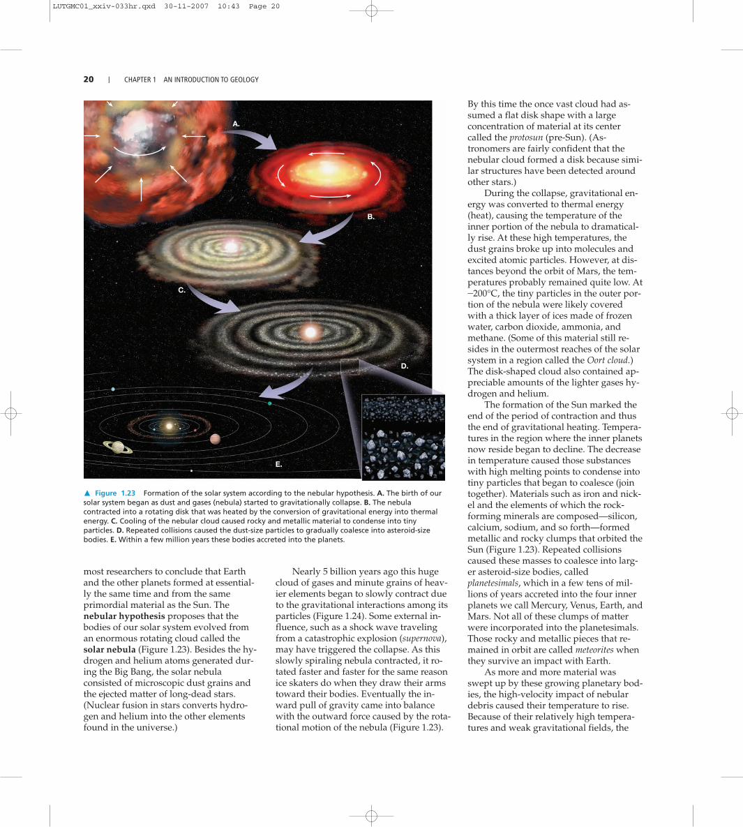
� Figure 1.23 Formation of the solar system according to the nebular hypothesis. A. The birth of oursolar system began as dust and gases (nebula) started to gravitationally collapse. B. The nebulacontracted into a rotating disk that was heated by the conversion of gravitational energy into thermalenergy. C. Cooling of the nebular cloud caused rocky and metallic material to condense into tinyparticles. D. Repeated collisions caused the dust-size particles to gradually coalesce into asteroid-sizebodies. E. Within a few million years these bodies accreted into the planets.
most researchers to conclude that Earthand the other planets formed at essential-ly the same time and from the sameprimordial material as the Sun. Thenebular hypothesis proposes that thebodies of our solar system evolved froman enormous rotating cloud called thesolar nebula (Figure 1.23). Besides the hy-drogen and helium atoms generated dur-ing the Big Bang, the solar nebulaconsisted of microscopic dust grains andthe ejected matter of long-dead stars.(Nuclear fusion in stars converts hydro-gen and helium into the other elementsfound in the universe.)
Nearly 5 billion years ago this hugecloud of gases and minute grains of heav-ier elements began to slowly contract dueto the gravitational interactions among itsparticles (Figure 1.24). Some external in-fluence, such as a shock wave travelingfrom a catastrophic explosion (supernova),may have triggered the collapse. As thisslowly spiraling nebula contracted, it ro-tated faster and faster for the same reasonice skaters do when they draw their armstoward their bodies. Eventually the in-ward pull of gravity came into balancewith the outward force caused by the rota-tional motion of the nebula (Figure 1.23).
By this time the once vast cloud had as-sumed a flat disk shape with a largeconcentration of material at its centercalled the protosun (pre-Sun). (As-tronomers are fairly confident that thenebular cloud formed a disk because simi-lar structures have been detected aroundother stars.)
During the collapse, gravitational en-ergy was converted to thermal energy(heat), causing the temperature of theinner portion of the nebula to dramatical-ly rise. At these high temperatures, thedust grains broke up into molecules andexcited atomic particles. However, at dis-tances beyond the orbit of Mars, the tem-peratures probably remained quite low. At-200°C, the tiny particles in the outer por-tion of the nebula were likely coveredwith a thick layer of ices made of frozenwater, carbon dioxide, ammonia, andmethane. (Some of this material still re-sides in the outermost reaches of the solarsystem in a region called the Oort cloud.)The disk-shaped cloud also contained ap-preciable amounts of the lighter gases hy-drogen and helium.
The formation of the Sun marked theend of the period of contraction and thusthe end of gravitational heating. Tempera-tures in the region where the inner planetsnow reside began to decline. The decreasein temperature caused those substanceswith high melting points to condense intotiny particles that began to coalesce (jointogether). Materials such as iron and nick-el and the elements of which the rock-forming minerals are composed—silicon,calcium, sodium, and so forth—formedmetallic and rocky clumps that orbited theSun (Figure 1.23). Repeated collisionscaused these masses to coalesce into larg-er asteroid-size bodies, calledplanetesimals, which in a few tens of mil-lions of years accreted into the four innerplanets we call Mercury, Venus, Earth, andMars. Not all of these clumps of matterwere incorporated into the planetesimals.Those rocky and metallic pieces that re-mained in orbit are called meteorites whenthey survive an impact with Earth.
As more and more material wasswept up by these growing planetary bod-ies, the high-velocity impact of nebulardebris caused their temperature to rise.Because of their relatively high tempera-tures and weak gravitational fields, the
LUTGMC01_xxiv-033hr.qxd 30-11-2007 10:43 Page 20

EARTH’S INTERNAL STRUCTURE I 21
inner planets were unable to accumulatemuch of the lighter components of thenebular cloud. The lightest of these, hy-drogen and helium, were eventuallywhisked from the inner solar system bythe solar winds.
At the same time that the inner plan-ets were forming, the larger, outer planets(Jupiter, Saturn, Uranus, and Neptune),along with their extensive satellite sys-tems, were also developing. Because oflow temperatures far from the Sun, thematerial from which these planets formedcontained a high percentage of ices—water, carbon dioxide, ammonia, andmethane—as well as rocky and metallicdebris. The accumulation of ices accountsin part for the large size and low densityof the outer planets. The two most mas-sive planets, Jupiter and Saturn, had asurface gravity sufficient to attract andhold large quantities of even the lightestelements—hydrogen and helium.
Formation of Earth’s Layered StructureAs material accumulated to form Earth(and for a short period afterward), thehigh-velocity impact of nebular debrisand the decay of radioactive elementscaused the temperature of our planet tosteadily increase. During this time of in-tense heating, Earth became hot enoughthat iron and nickel began to melt. Melt-ing produced liquid blobs of heavy metalthat sank toward the center of the planet.This process occurred rapidly on the scaleof geologic time and produced Earth’sdense iron-rich core.
The early period of heating resulted inanother process of chemical differentiation,whereby melting formed buoyant massesof molten rock that rose toward the surface,where they solidified to produce a primi-tive crust. These rocky materials were en-riched in oxygen and “oxygen-seeking”elements, particularly silicon and alu-minum, along with lesser amounts of calci-um, sodium, potassium, iron, andmagnesium. In addition, some heavy met-als such as gold, lead, and uranium, whichhave low melting points or were highly sol-uble in the ascending molten masses, werescavenged from Earth’s interior and con-centrated in the developing crust. Thisearly period of chemical segregation estab-
� Figure 1.24 Lagoon Nebula. It is in glowing clouds like these that gases and dust particles becomeconcentrated into stars. (Courtesy of National Optical Astronomy Observatories)
lished the three basic divisions of Earth’s interior—the iron-rich core; the thin primitive crust;and Earth’s largest layer, called the mantle, which is located between the core and crust.
An important consequence of this early period of chemical differentiation is thatlarge quantities of gaseous materials were allowed to escape from Earth’s interior, ashappens today during volcanic eruptions. By this process a primitive atmosphere gradu-ally evolved. It is on this planet, with this atmosphere, that life as we know it came intoexistence.
Following the events that established Earth’s basic structure, the primitive crust waslost to erosion and other geologic processes, so we have no direct record of its makeup.When and exactly how the continental crust—and thus Earth’s first landmasses—cameinto existence is a matter of ongoing research. Nevertheless, there is general agreement that the continental crust formed gradually over the last 4 billion years. (The oldest rocks yet discovered are isolated fragments found in the Northwest Territories of Canada that have radiometric dates of about 4 billion years.) In addition, asyou will see in subsequent chapters, Earth is an evolving planet whose continents(and ocean basins) have continually changed shape and even location during much of this period.
Earth’s Internal StructureAn Introduction to Geology: Earth’s Layered Structure
In the preceding section, you learned that the segregation of material that began earlyin Earth’s history resulted in the formation of three layers defined by their chemicalcomposition—the crust, mantle, and core. In addition to these compositionally distinct
ESSENTIALS OF GEOLOGY
LUTGMC01_xxiv-033hr.qxd 30-11-2007 10:43 Page 21

Outer core(liquid)
Innercore
(solid)
Continentalcrust
Oceaniccrust
Lithosphere(solid and brittle
100 km thick)
Asthenosphere (solid, but mobile)
660 km
Lithosphere
Core(iron + nickel)
Atmosphere(gas)
Hydrosphere(liquid)
410 km
Uppermantle
Lower mantle(solid)
Mantle(high density rock)
Crust(low density rock7–70 km thick)
Upp
er m
antle
(s
olid)
Layering byPhysical Properties
Layering byChemical Composition
6371 km
2890
km
2890 km
660
km 5150
k
m
� Figure 1.25 Views of Earth’s layered structure. The rightside of the large cross section shows that Earth’s interior isdivided into three different layers based on compositionaldifferences—the crust, mantle, and core. The left side of thelarge cross section depicts layers of Earth’s interior based onphysical properties—the lithospere, asthenosphere, outer core, andinner core. The block diagram to the left of the large cross sectionshows an enlarged view of the upper portion of Earth’s interior.
22 I CHAPTER 1 AN INTRODUCTION TO GEOLOGY
layers, Earth can be divided into layersbased on physical properties. The physicalproperties used to define such zones in-clude whether the layer is solid or liquidand how weak or strong it is. Knowledgeof both types of layered structures is es-sential to our understanding of basic geo-logic processes, such as volcanism,earthquakes, and mountain building(Figure 1.25).
Earth’s CrustThe crust, Earth’s relatively thin, rockyouter skin, is of two different types—con-tinental crust and oceanic crust. Bothshare the word “crust,” but the similarityends there. The oceanic crust is roughly 7kilometers (5 miles) thick and composedof the dark igneous rock basalt. By con-
trast, the continental crust av-erages 35 to 40 kilometers (25 miles)thick but may exceed 70 kilometers(40 miles) in some mountainous regionssuch as the Rockies and Himalayas.Unlike the oceanic crust, which has arelatively homogeneous chemicalcomposition, the continental crust consists of many rock types. Although the upper crust has an averagecomposition of a granitic rock calledgranodiorite, it varies considerably fromplace to place.
Continental rocks have an averagedensity of about 2.7 g/cm3, and some havebeen discovered that are 4 billion yearsold. The rocks of the oceanic crust areyounger (180 million years or less) anddenser (about 3.0 g/cm3) than continentalrocks.*
*Liquid water has a density of 1 g/cm3; therefore, the density of basalt is three times that of water.
Earth’s MantleMore than 82 percent of Earth’s volume iscontained in the mantle, a solid, rockyshell that extends to a depth of nearly2900 kilometers (1800 miles). The bound-ary between the crust and mantle repre-sents a marked change in chemicalcomposition. The dominant rock type inthe uppermost mantle is peridotite, whichis richer in the metals magnesium andiron than the minerals found in either thecontinental or oceanic crust.
THE UPPER MANTLE. The upper mantleextends from the crust-mantle boundarydown to a depth of about 660 kilometers(410 miles). The upper mantle can be
LUTGMC01_xxiv-033hr.qxd 30-11-2007 10:43 Page 22

THE FACE OF EARTH I 23
divided into two different parts. The topportion of the upper mantle is part of thestiff lithosphere, and beneath that is theweaker asthenosphere.
The lithosphere (sphere of rock) con-sists of the entire crust and uppermostmantle and forms Earth’s relatively cool,rigid outer shell. Averaging about 100kilometers in thickness, the lithosphere ismore than 250 kilometers thick below theoldest portions of the continents(Figure 1.25). Beneath this stiff layer to adepth of about 350 kilometers lies a soft,comparatively weak layer known as theasthenosphere (“weak sphere”). The topportion of the asthenosphere has atemperature/pressure regime that resultsin a small amount of melting. Within thisvery weak zone the lithosphere is mechanically detached from the layerbelow. The result is that the lithosphere isable to move independently of the as-thenosphere, a fact we will consider laterin the chapter.
It is important to emphasize that thestrength of various Earth materials is afunction of both their composition and ofthe temperature and pressure of their en-vironment. You should not get the ideathat the entire lithosphere behaves like abrittle solid similar to rocks found on thesurface. Rather, the rocks of the litho-sphere get progressively hotter andweaker (more easily deformed) with in-creasing depth. At the depth of the upper-most asthenosphere, the rocks are closeenough to their melting temperature(some melting may actually occur) thatthey are very easily deformed. Thus, theuppermost asthenosphere is weak becauseit is near its melting point, just as hot waxis weaker than cold wax.
THE LOWER MANTLE. From a depth of660 kilometers to the top of the core, at adepth of 2900 kilometers (1800 miles), isthe lower mantle. Because of an increasein pressure (caused by the weight of therock above) the mantle graduallystrengthens with depth. Despite theirstrength however, the rocks within thelower mantle are very hot and capable ofvery gradual flow.
The composition of the core is thought tobe an iron-nickel alloy with minoramounts of oxygen, silicon, and sulfur—el-ements that readily form compounds withiron. At the extreme pressure found in thecore, this iron-rich material has an averagedensity of nearly 11 g/cm3 and approaches14 times the density of water at Earth’scenter.
The core is divided into two regionsthat exhibit very different mechanical strengths. The outer core is a liquid layer 2270 kilo-meters (1410 miles) thick. It is the movement of metallic iron within this zone that gener-ates Earth’s magnetic field. The inner core is a sphere having a radius of 1216 kilometers(754 miles). Despite its higher temperature, the iron in the inner core is solid due to theimmense pressures that exist in the center of the planet.
The Face of EarthAn Introduction to Geology: Features of the Continents and Floor of the Ocean
The two principal divisions of Earth’s surface are the continents and the ocean basins(Figure 1.26). A significant difference between these two areas is their relative levels. Thecontinents are remarkably flat features that have the appearance of plateaus protrudingabove sea level. With an average elevation of about 0.8 kilometer (0.5 mile), continents lieclose to sea level, except for limited areas of mountainous terrain. By contrast, the aver-age depth of the ocean floor is about 3.8 kilometers (2.4 miles) below sea level.
The elevation difference between the continents and ocean basins is primarily the re-sult of differences in their respective densities and thicknesses. Recall that the continentsaverage 35–40 kilometers in thickness and are composed of granitic rocks having a densi-ty of about 2.7 g/cm3. The basaltic rocks that comprise the oceanic crust average only 7kilometers thick and have an average density of about 3.0 g/cm3. Thus, the thicker andless dense continental crust is more buoyant than the oceanic crust. As a result, continen-tal crust floats on top of the deformable rocks of the mantle at a higher level than oceaniccrust for the same reason that a large, empty (less dense) cargo ship rides higher than asmall, loaded (denser) one.
Major Features of the ContinentsThe largest features of the continents can be grouped into two distinct categories: 1) ex-tensive, flat stable areas that have been eroded nearly to sea level and 2) uplifted regionsof deformed rocks that make up present-day mountain belts. Notice in Figure 1.27 thatthe young mountain belts tend to be long, narrow features at the margins of continents,and the flat, stable areas are typically located in the interior of the continents.
MOUNTAIN BELTS. The most prominent topographic features of the continents are linearmountain belts. Although the distribution of mountains appears to be random, this is notthe case. When the youngest mountains are considered (those less than 100 million yearsold), we find that they are located principally in two major zones. The circum-Pacific belt(the region surrounding the Pacific Ocean) includes the mountains of the western Americ-as and continues into the western Pacific in the form of volcanic island arcs. Island arcsare active mountainous regions composed largely of volcanic rocks and deformed
ESSENTIALS OF GEOLOGY
We have never sampled the mantle orcore directly. The structure of Earth’s inte-rior is determined by analyzing seismicwaves from earthquakes. As these wavesof energy penetrate Earth’s interior, theychange speed and are bent and reflectedas they move through zones having dif-ferent properties. Monitoring stationsaround the world detect and record thisenergy.
Did you know?Earth’s Core
LUTGMC01_xxiv-033hr.qxd 30-11-2007 10:43 Page 23

24 I CHAPTER 1 AN INTRODUCTION TO GEOLOGY
PhilippineTrench
AleutianTrench
KurileTrench
Japan Trench
Mariana Trench
Java (Sunda)Trench
Kermadec Trench
CentralAmericaTrench
Tonga Trench
East
Pac
ific
Ris
e
Juan deFucaRidge
Hawaiian Is.
Em
peror
Seam
ounts
RyukyuTrench
NorthAmerica
Arctic Ocean
Pacific Ocean
Australia
BeringAbyssal
Plain
Eltanin Fracture Zone
BellingshausenAbyssal Plain
N.A. Cordillera
Appalachians
Dividing R
angeG
reat
SouthTasman
Rise
Ontong-JavaPlateau
ManikikiPlateau
Line Islands Ridge
HawaiianRidge
Hess RiseShatskyRise
ShirshovRidge
BowersRidge Alaska
Seamounts
GalapagosRise
Alpine Fault
San AndreasFault
Basin andRange
Province
Peru-Chiletrench
� Figure 1.26 Majorsurface features of thegeosphere.
sedimentary rocks. Examples include theAleutian Islands, Japan, the Philippines,and New Guinea (Figure 1.26).
The other major mountainous belt ex-tends eastward from the Alps throughIran and the Himalayas and then dipssouthward into Indonesia. Careful exami-nation of mountainous terrains revealsthat most are places where thick se-quences of rocks have been squeezed andhighly deformed, as if placed in a gigantic
vise. Older mountains are also found onthe continents. Examples include the Ap-palachians in the eastern United Statesand the Urals in Russia. Their once loftypeaks are now worn low, the result of mil-lions of years of erosion.
THE STABLE INTERIOR. Unlike the youngmountain belts, which have formed withinthe last 100 million years, the interiors ofthe continents have been relatively stable
(undisturbed) for the last 600 millionyears or even longer. Typically, theseregions were involved in mountain-building episodes much earlier in Earth’shistory.
Within the stable interiors are areasknown as shields which are expansive,flat regions composed of deformed crys-talline rock. Notice in Figure 1.27 that theCanadian Shield is exposed in much ofthe northeastern part of North America.
LUTGMC01_xxiv-033hr.qxd 30-11-2007 10:43 Page 24

THE FACE OF EARTH I 25
Age determinations for various shieldshave shown that they are truly ancient re-gions. All contain Precambrian-age rocksthat are over 1 billion years old, withsome samples approaching 4 billion yearsin age (see Figure 1.9 to review the geo-logic time scale). These oldest-knownrocks exhibit evidence of enormous forcesthat have folded and faulted them and al-tered them with great heat and pressure.Thus, we conclude that these rocks were
once part of an ancient mountain systemthat has since been eroded away to pro-duce these expansive, flat regions.
Other flat areas of the stable interiorexist in which highly deformed rocks, likethose found in the shields, are covered bya relatively thin veneer of sedimentaryrocks. These areas are called stable plat-forms. The sedimentary rocks in stableplatforms are nearly horizontal exceptwhere they have been warped to form
large basins or domes. In North America amajor portion of the stable platforms is lo-cated between the Canadian Shield andthe Rocky Mountains (Figure 1.27).
Major Features of the Ocean BasinsIf all water were drained from the oceanbasins, a great variety of features wouldbe seen, including linear chains of
Puerto-RicoTrench
South SandwichTrench
Mid-Atlantic Ridge
Mid-Indian Rid
ge
Southwest Indian Ridge
Southeast Indian Ridge
Greenland
Eurasia
Africa
SouthAmerica
Arctic
Mid-Ocean Ridge
GibbsFracture
Zone
Demerara
Abyssal Plain
St. PaulFracture
Zone
AtlanticOcean
Weddell Abyssal Plain
Red SeaRift
IndianOcean
Alps
Caldedonian Belt
Himalaya Mountains
Ura
ls
Antarctica
SeychellesBank
Chagos-LaccadiveRidge
KerguelenRidge
BrokenRidge
Ninety EastRidge
WalvisRidge
Rio GrandeRise
North Scotia Ridge
South ScotiaRidge
Java (Sunda)Trench
EastAfrican
RiftValley
Andes Mountains
LUTGMC01_xxiv-033hr.qxd 30-11-2007 10:43 Page 25

26 I CHAPTER 1 AN INTRODUCTION TO GEOLOGY
volcanoes, deep canyons, plateaus, and large expanses of monotonously flat plains. Infact, the scenery would be nearly as diverse as that on the continents (see Figure 1.26).
During the past 60 years, oceanographers using modern sonar equipment have grad-ually mapped significant portions of the ocean floor. From these studies they have de-fined three major regions: continental margins, deep-ocean basins, and oceanic (mid-ocean)ridges.
CONTINENTAL MARGINS. The continental margin is that portion of the seafloor adja-cent to major landmasses. It may include the continental shelf, the continental slope, andthe continental rise.
Although land and sea meet at the shoreline, this is not the boundary between thecontinents and the ocean basins. Rather, along most coasts a gently sloping platform,called the continental shelf, extends seaward from the shore. Because it is underlain bycontinental crust, it is considered a flooded extension of the continents. A glance atFigure 1.26 shows that the width of the continental shelf is variable. For example, it isbroad along the East and Gulf coasts of the United States but relatively narrow along thePacific margin of the continent.
The boundary between the continents and the deep-ocean basins lies along thecontinental slope, which is a relatively steep dropoff that extends from the outer edge ofthe continental shelf to the floor of the deep ocean (Figure 1.26). Using this as the divid-ing line, we find that about 60 percent of Earth’s surface is represented by ocean basinsand the remaining 40 percent by continents.
In regions where trenches do not exist, the steep continental slope merges into amore gradual incline known as the continental rise. The continental rise consists of athick accumulation of sediments that moved downslope from the continental shelf to thedeep-ocean floor.
DEEP-OCEAN BASINS. Between the continental margins and oceanic ridges lie the deep-ocean basins. Parts of these regions consist of incredibly flat features called abyssalplains. The ocean floor also contains extremely deep depressions that are occasionally
more than 11,000 meters (36,000 feet)deep. Although these deep-ocean trench-es are relatively narrow and representonly a small fraction of the ocean floor,they are nevertheless very significant fea-tures. Some trenches are located adjacentto young mountains that flank the conti-nents. For example, in Figure 1.26 thePeru–Chile trench off the west coast ofSouth America parallels the Andes Moun-tains. Other trenches parallel linear islandchains called volcanic island arcs.
Dotting the ocean floor are sub-merged volcanic structures calledseamounts, which sometimes form long
Himalaya Mountains
Canadianshield
Greenlandshield
Brazilianshield
Africanshield
Indian shield
Alps
Balticshield
Australianshield
Key
Shields
N.A. Cordillera
Andes Mountains
Appalachians
Caldedonian Belt
Himalaya Mountains
Dividing Range
Ura
ls
Great
Orinocoshield
Angarashield
Stable platforms (shields covered by sedimentary rock)
Young mountain belts (lessthan 100 million years old)
Old mountain belts
� Figure 1.27 This map shows the general distribution of Earth’s mountain belts, stable platforms, and shields.
Ocean depths are often expressed infathoms. One fathom equals 1.8 m or 6 ft,which is about the distance of a person’soutstretched arms. The term is derivedfrom how depth-sounding lines werebrought back on board a vessel by hand.As the line was hauled in, a worker count-ed the number of arm lengths collected.By knowing the length of the person’soutstretched arms, the amount of linetaken in could be calculated. The lengthof one fathom was later standardized to 6 ft.
Did you know?
LUTGMC01_xxiv-033hr.qxd 30-11-2007 10:43 Page 26

PacificPacificplateplate
PhilippinePhilippineplateplate
Antarctic plateAntarctic plate
NazcaNazcaplateplate
AntarcticAntarcticplateplate
Scotia plateScotia plate
NorthNorthAmericanAmerican
plateplate
SouthSouthAmericanAmerican
plateplate
AfricanAfricanplateplate
EurasianEurasianplateplate
EurasianEurasianplateplate
Australian-IndianAustralian-Indianplateplate
NorthNorthAmerican plateAmerican plate
CocosCocosplateplate
CaribbeanCaribbeanplateplate
NorthAmerican
plate
SouthAmerican
plate
Africanplate
Eurasianplate
Eurasianplate
Australian-Indianplate
Pacificplate
Philippineplate
Antarctic plate
NorthAmerican plate
Nazcaplate
Antarcticplate
Arabianplate
Cocosplate
Caribbeanplate
Scotia plate
DYNAMIC EARTH I 27
narrow chains. Volcanic activity has alsoproduced several large lava plateaus, suchas the Ontong Java Plateau located north-east on New Guinea. In addition, somesubmerged plateaus are composed of con-tinental-type crust. Examples include theCampbell Plateau southeast of NewZealand and the Seychelles plateau north-east of Madagascar.
OCEANIC RIDGES. The most prominentfeature on the ocean floor is the oceanic ormid-ocean ridge. As shown in Figure1.26, the Mid-Atlantic Ridge and the EastPacific Rise are parts of this system. Thisbroad elevated feature forms a continuousbelt that winds for more than 70,000 kilo-meters (43,000 miles) around the globe ina manner similar to the seam of a base-ball. Rather than consisting of highlydeformed rock, such as most of the moun-tains on the continents, the oceanic ridgesystem consists of layer upon layer ofigneous rock that has been fractured anduplifted.
Understanding the topographic fea-tures that comprise the face of Earth iscritical to our understanding of the mech-anisms that have shaped our planet. Whatis the significance of the enormous ridgesystem that extends through all theworld’s oceans? What is the connection, ifany, between young, active mountainbelts and deep-ocean trenches? Whatforces crumple rocks to produce majesticmountain ranges? These are questionsthat will be addressed in some of the com-ing chapters as we investigate the dynam-ic processes that shaped our planet in thegeologic past and will continue to shape itin the future.
Dynamic EarthPlate Tectonics:Introduction
Earth is a dynamic planet! If we could goback in time a few hundred million years,we would find the face of our planet dra-matically different from what we see today.There would be no Mount St. Helens,Rocky Mountains, or Gulf of Mexico.Moreover, we would find continents hav-ing different sizes and shapes and locatedin different positions than today’s land-
ESSENTIALS OF GEOLOGY
masses. By contrast, over the past few bil-lion years the Moon’s surface has remainedessentially unchanged—only a few cratershave been added.
The Theory of Plate TectonicsWithin the past several decades a greatdeal has been learned about the workingsof our dynamic planet. This period hasseen an unequaled revolution in our un-derstanding of Earth. The revolutionbegan in the early part of the twentiethcentury with the radical proposal ofcontinental drift—the idea that the conti-nents moved about the face of the planet.This proposal contradicted the establishedview that the continents and ocean basinsare permanent and stationary features onthe face of Earth. For that reason, the no-tion of drifting continents was receivedwith great skepticism and even ridicule.More than 50 years passed before enoughdata were gathered to transform this con-troversial hypothesis into a sound theorythat wove together the basic processesknown to operate on Earth. The theorythat finally emerged, called the theory ofplate tectonics, provided geologists withthe first comprehensive model of Earth’sinternal workings.
According to the plate tectonics model,Earth’s rigid outer shell (lithosphere) is bro-ken into numerous slabs calledlithospheric plates or simply plates, whichare in continual motion (Figure 1.28). Asshown in Figure 1.29, seven major litho-spheric plates are recognized. They are theNorth American, South American, Pacific,African, Eurasian, Australian, and Antarc-tic plates. Intermediate-size plates includethe Caribbean, Nazca, Philippine, Arabian,Cocos, and Scotia plates. In addition, over adozen smaller plates have been identified,but are not shown in Figure 1.29. Note thatseveral large plates include an entire conti-nent plus a large area of seafloor (for exam-ple, the South American plate). However,none of the plates are defined entirely bythe margins of a single continent.
The lithospheric plates move relativeto each other at a very slow but continu-ous rate that averages about 5 centimeters(2 inches) a year. This movement is ulti-mately driven by the unequal distributionof heat within Earth. Hot material found deep in the mantle moves slowly upwardand serves as one part of our planet’s in-ternal convective system. Concurrently,cooler, denser slabs of lithosphere descendback into the mantle, setting Earth’s rigidouter shell in motion. Ultimately, the ti-
tanic, grinding movements ofEarth’s lithospheric plates gener-
ate earthquakes, create volca-noes, and deform large
masses of rock intomountains.
� Figure 1.28 Illustrationshowing some of Earth’slithospheric plates.
LUTGMC01_xxiv-033hr.qxd 30-11-2007 10:43 Page 27

Plate BoundariesLithospheric plates moveas coherent units relativeto all other plates. Al-though the interiors ofplates may experiencesome deformation, allmajor interactions amongindividual plates (andtherefore most deforma-tion) occur along theirboundaries. In fact, thefirst attempts to outlineplate boundaries weremade using locations ofearthquakes. Later workshowed that plates arebounded by three distincttypes of boundaries,which are differentiatedby the type of relativemovement they exhibit.These boundaries are de-picted at the bottom ofFigure 1.29 and are brieflydescribed here:
1. Divergentboundaries—whereplates move apart,resulting in upwellingof material from themantle to create newseafloor(Figure 1.29A).
2. Convergent bound-aries—where platesmove together, result-ing in the subduction (consumption)of oceanic lithosphere into the mantle(Figure 1.29B). Convergence can alsoresult in the collision of two continen-tal margins to create a major moun-tain system.
3. Transform fault boundaries—whereplates grind past each other withoutthe production or destruction of litho-sphere (Figure 1.29C).
28 I CHAPTER 1 AN INTRODUCTION TO GEOLOGY
▲ ▲ ▲ ▲ ▲ ▲
▲ ▲
▲
▲ ▲ ▲ ▲ ▲ ▲ ▲ ▲
▲ ▲ ▲ ▲
▲
▲ ▲
▲ ▲
▲ ▲
▲
▲ ▲
▲ ▲
▲ ▲
▲ ▲
▲ ▲
▲ ▲
▲
✟
✟
▲ ▲ ▲
▲ ▲
▲
▲
▲
▲
▲
▲
▲
▲
▲
▲
▲ ▲
▲ ▲
▲
North Americanplate
Juan de Fuca plate
Pacific plate
Nazcaplate
Cocosplate
Antarctic plate
Scotia plate
South Americanplate
Caribbeanplate
Eurasian plate
African plate
A. Divergent boundary B. Convergent boundary
Mid-Atlantic Ridge
Eas
t P
acifi
c Rise
Arabianplate
Asthenosphere
Oceaniclithosphere
Melting
Oceaniccrust
Trench
Continentallithosphere
Continentalvolcanic arc
Subducting oceanic lithosphere
EastAfrican
Rift
Southwest Indian Ridge
Emperor-HawaiianChain
KermadecArc
TongaArc
Aleutian Arc
Andes Mountains
Rocky Mountains
Appalachian Mts.
Alps
Canadian Shield
Basinand
Range
San AndreasFault
GalapagosRidge
Chile Ridge
AntillesArc
Iceland
Peru-ChileTrench
▲ ▲ ▲ ▲ ▲
� Figure 1.29 Mosaic of rigidplates that constitute Earth’souter shell. (After W. B. Hamilton, U.S.Geological Survey)
If you examine Figure 1.29, you cansee that each large plate is bounded by acombination of these boundaries. Move-ment along one boundary requires thatadjustments be made at the others.
DIVERGENT BOUNDARIES. Plate spread-ing (divergence) occurs mainly along theoceanic ridge. As plates pull apart, thefractures created are immediately filled
with molten rock that wells up from theasthenosphere below (Figure 1.30). Thishot material slowly cools to become solidrock, producing new slivers of seafloor.This happens again and again over mil-lions of years, adding thousands of squarekilometers of new seafloor.
This mechanism has created the floorof the Atlantic Ocean during the past 160million years and is appropriately called
LUTGMC01_xxiv-033hr.qxd 30-11-2007 10:43 Page 28

ConvergentConvergentboundaryboundary
DivergentDivergentboundaryboundary
Asthenosphere
Lithosphere
Sinkinglithosphere
Upwelling
SouthAmerica
Africa
AtlanticOcean
PacificOcean
Mid
-Atla
ntic
Rid
ge
Convergentboundary
Divergentboundary
Peru-ChileTrench
Andes Mts.� Figure 1.30 Convergentboundaries occur where two platesmove together, as along thewestern margin of SouthAmerica. Divergent boundariesare located where adjacentplates move away from oneanother. The Mid-Atlantic Ridgeis such a boundary.
DYNAMIC EARTH I 29
▲
▲
▲
▲ ▲
▲
▲ ▲
▲
▲
▲ ▲ ▲
▲
▲ ▲
▲
▲ ▲
▲
▲ ▲ ▲
▲ ▲ ▲ ▲
▲ ▲
▲ ▲ ▲ ▲ ▲ ▲ ▲
▲
▲ ▲
▲ ▲
▲ ▲
▲
▲ ▲
▲ ▲
▲ ▲ ▲
▲
▲
▲
▲
▲ ▲
▲
▲
▲
▲
▲
▲ ▲ ▲ ▲ ▲ ▲
▲ ▲ ▲ ▲ ▲ ▲ ▲ ▲ ▲ ▲ ▲
▲ ▲
▲ ▲
▲ ▲
▲
▲
▲ ▲ ▲
▲
▲
▲ ▲ ▲
▲ ▲
▲ ▲
▲ ▲
▲
▲
▲
▲
▲
Antarctic plate
Eurasian plate
Philippineplate
Australian-Indian plate
C. Transform fault boundary
Pacificplate
North Americanplate
Continentallithosphere
Mid-Indian Rid
ge
Baikal Rift
India
Himalayas
Alpine Fault
Japan Arc
Mariana Arc
Southeast Indian Ridge
Urals
seafloor spreading (Figure 1.30). Be-cause seafloor spreading is the domi-nant process associated withdivergent boundaries, these zonesare sometimes referred to asspreading centers. The rate of seafloorspreading varies considerably from one spreading center to another. Spreadingrates of only 2.5 centimeters (1 inch) per year are typical in the North Atlantic,whereas much faster rates (20 centimeters, 8 inches per year) have been measuredalong the East Pacific Rise. Even the most rapid rates of spreading are slow on thescale of human history. Nevertheless, the slowest rate of lithosphere production israpid enough to have created all of Earth’s ocean basins over the last 200 millionyears. In fact, none of the ocean floor that has been dated exceeds 180 millionyears in age.
Along divergent boundaries where molten rock emerges, the oceanic litho-sphere is elevated, because it is hot and occupies more volume than do coolerrocks. Worldwide, this elevated zone (the oceanic ridge) extends for over 70,000kilometers (43,000 miles) through all major ocean basins (see Figure 1.26). As newlithosphere is formed along the oceanic ridge, it is slowly yet continually dis-placed away from the zone of upwelling along the ridge axis. Thus, it begins tocool and contract, thereby increasing in density. This thermal contraction accountsfor the greater ocean depths that exist away from the ridge. In addition, coolingcauses the mantle rocks below the oceanic crust to strengthen, thereby adding tothe plate’s thickness. Stated another way, the thickness of oceanic lithosphere isage dependent. The older (cooler) it is, the greater its thickness.
CONVERGENT BOUNDARIES. Although new lithosphere is constantly beingadded at the oceanic ridges, the planet is not growing in size—its total surfacearea remains constant. To accommodate the newly created lithosphere, olderoceanic plates return to the mantle along convergent boundaries. As two platesslowly converge, the leading edge of one slab is bent downward, allowing it toslide beneath the other. The surface expression produced by the descending plateis a deep-ocean trench, like the Peru–Chile trench illustrated in Figures 1.26and 1.30.
Plate margins where oceanic crust is being consumed are called subductionzones. Here, as the subducted plate moves downward, it enters a high-tempera-ture, high-pressure environment. Some subducted materials, as well as more vo-luminous amounts of the asthenosphere located above the subducting slab, meltand migrate upward into the overriding plate. Occasionally this molten rock mayreach the surface, where it gives rise to explosive volcanic eruptions such asMount St. Helens in 1980. However, much of this molten rock never reaches the
surface; rather, it solidifies at depth and acts to thicken the crust.Whenever slabs of continental lithosphere and oceanic lithosphere converge, the conti-
nental plate being less dense remains “floating,” while the denser oceanic lithosphere sinks
The average rate at which plates moverelative to each other is roughly the samerate at which human fingernails grow.
Did you know?
LUTGMC01_xxiv-033hr.qxd 30-11-2007 10:43 Page 29

ic plate is subducted beneath continentallithosphere, an Andean-type mountainrange develops along the margin of thecontinent. However, if the subductingplate also contains continental litho-sphere, continued subduction eventuallybrings the two continents together (Figure1.31). Whereas oceanic lithosphere is rela-tively dense and sinks into the astheno-sphere, continental lithosphere is buoyant,which prevents it from being subductedto any great depth. The result is a collisionbetween the two continental blocks(Figure 1.31). Such a collision occurredwhen the subcontinent of India “rammed”into Asia and produced the Himalayas—the most spectacular mountain range onEarth (Figure 1.32). During this collision,the continental crust buckled, fractured,and was generally shortened and thick-ened. In addition to the Himalayas, sever-al other major mountain systems,including the Alps, Appalachians, andUrals, formed during continental colli-sions along convergent plate boundaries.
TRANSFORM FAULT BOUNDARIES.Transform fault boundaries are locatedwhere plates grind past each other with-out either generating new lithosphere orconsuming old lithosphere. These faultsform in the direction of plate movementand were first discovered in associationwith offsets in oceanic ridges (seeFigure 1.29).
Although most transform faults arelocated along oceanic ridges, some slicethrough the continents. Two examples arethe earthquake-prone San Andreas Faultof California (Figure 1.33) and the Alpine
30 I CHAPTER 1 AN INTRODUCTION TO GEOLOGY
A.Asthenosphere
B.
Continental crust
Continental crust
Forearcbasin
Continental volcanic arc
Asthenosphere
Formervolcanic
arc
Suture
Ophiolite(fragments ofoceanic crust)
Continentalcrust
Continentalcrust
Oceaniccrust
Subducting oceanic lithosphere
� Figure 1.31 Whentwo plates containingcontinental lithospherecollide, complexmountains are formed.The formation of theHimalayas represents a
relatively recentexample.
into the astheno-sphere (Figure 1.30).The classic conver-gent boundary ofthis type occursalong the westernmargin of SouthAmerica where theNazca plate descendsbeneath the adjacent continental block.Here subduction along the Peru–Chiletrench gave rise to the Andes Mountains,a linear chain of deformed rocks cappedwith numerous volcanoes—a number ofwhich are still active.
The simplest type of convergence oc-curs where oneoceanic
plate is thrust beneath another. Here sub-duction results in the production ofmagma in a manner similar to that in theAndes, except volcanoes grow from thefloor of the ocean rather than on a conti-nent. If this activity is sustained, it willeventually build a chain of volcanic struc-tures that emerge from the sea as avolcanic island arc. Most volcanic islandarcs are found in the Pacific Ocean, as ex-
emplified by the Aleutian,Mariana, and Tonga
islands.As we saw earli-
er, when an ocean-
� Figure 1.32 Mt.Everest in theHimalayas. Thistowering mountainchain is associated withplate convergence andbegan forming about 45million years ago asIndia collided withAsia. (Photo by Galen Rowell)
LUTGMC01_xxiv-033hr.qxd 30-11-2007 10:43 Page 30

■ Geology means “the study of Earth.” Thetwo broad areas of the science of geology are(1) physical geology, which examines the materi-
als composing Earth and the processes thatoperate beneath and upon its surface; and
(2) historical geology, which seeks to understand theorigin of Earth and its development through time.
■ The relationship between people and the natural environment is animportant focus of geology. This includes natural hazards, resources, andhuman influences on geologic processes.
■ During the seventeenth and eighteenth centuries, catastrophism influ-enced the formulation of explanations about Earth. Catastrophism statesthat Earth’s landscapes developed over short time spans primarily as aresult of great catastrophes. By contrast, uniformitarianism, one of thefundamental principles of modern geology advanced by James Hutton inthe late 1700s, states that the physical, chemical, and biological laws thatoperate today have also operated in the geologic past. The idea is oftensummarized as “The present is the key to the past.” Hutton argued thatprocesses that appear to be slow acting could, over long spans of time,produce effects that are just as great as those resulting from sudden cata-strophic events.
■ Using the principles of relative dating, the placing of events in theirproper sequence or order without knowing their age in years, scientistsdeveloped a geologic time scale during the nineteenth century. Relativedates can be established by applying such principles as the law of super-position and the principle of fossil succession.
■ All science is based on the assumption that the natural worldbehaves in a consistent and predictable manner. The process by whichscientists gather facts and formulate scientific hypotheses and theories iscalled the scientific method. To determine what is occurring in the naturalworld, scientists often (1) collect facts, (2) develop a scientific hypothesis,(3) construct experiments to test the hypothesis, and (4) accept, modify,or reject the hypothesis on the basis of extensive testing. Other discover-ies represent purely theoretical ideas that have stood up to extensiveexamination. Still other scientific advancements have been made when atotally unexpected happening occurred during an experiment.
■ Earth’s physical environment is traditionally divided into threemajor parts: the solid Earth, or geosphere; the water portion of our planet, the hydrosphere; and Earth’s gaseous envelope, the atmosphere.In addition, the biosphere, the totality of life on Earth, interacts witheach of the three physical realms and is an equally integral partof Earth.
CHAPTER IN REVIEW I 31
San Andreas FaultSan Andreas FaultSan Andreas Fault
� Figure 1.33 California’s San Andreas Fault isan example of a transform fault boundary. (Photo byMichael Collier)
Fault of New Zealand. Along the San Andreas Fault the Pacific plate is moving towardthe northwest, relative to the adjacent North American plate (see Figure 1.29). The move-ment along this boundary does not go unnoticed. As these plates pass, strain builds inthe rocks on opposite sides of the fault. Occasionally the rocks adjust, releasing energy inthe form of a great earthquake of the type that devastated San Francisco in 1906.
CHANGING BOUNDARIES. Although the total surface area of Earth does not change,individual plates may diminish or grow in area depending on the distribution of conver-gent and divergent boundaries. For example, the Antarctic and African plates are almostentirely bounded by spreading centers and hence are growing larger. By contrast, thePacific plate is being subducted along much of its perimeter and is therefore diminishingin area. At the current rate, the Pacific would close completely in 300 million years—butthis is unlikely because changes in plate boundaries will probably occur before that time.
New plate boundaries are created in response to changes in the forces acting on thelithosphere. For example, a relatively new divergent boundary is located in Africa, in aregion known as the East African Rift Valleys. If spreading continues in this region, theAfrican plate will split into two plates, separated by a new ocean basin. At other loca-tions plates carrying continental crust are moving toward each other. Eventually thesecontinents may collide and be sutured together. Thus, the boundary that once separatedthese plates disappears, and two plates become one.
As long as temperatures within the interior of our planet remain significantly higherthan those at the surface, material within Earth will continue to circulate. This internalflow, in turn, will keep the rigid outer shell of Earth in motion. Thus, while Earth’s inter-nal heat engine is operating, the positions and shapes of the continents and ocean basinswill change and Earth will remain a dynamic planet.
In the remaining chapters we will examine in more detail the workings of our dy-namic planet in light of the plate tectonics theory.
Chapter 1 An Introduction to Geologyin Review
LUTGMC01_xxiv-033hr.qxd 30-11-2007 10:43 Page 31

32 I CHAPTER 1 AN INTRODUCTION TO GEOLOGY
Key Terms
■ Although each of Earth’s four spheres can be studied separately,they are all related in a complex and continuously interacting whole thatwe call the Earth system. Earth system science uses an interdisciplinaryapproach to integrate the knowledge of several academic fields in thestudy of our planet and its global environmental problems.
■ A system is a group of interacting parts that form a complex whole.Closed systems are those in which energy moves freely in and out, butmatter does not enter or leave the system. In an open system, both ener-gy and matter flow into and out of the system.
■ Most natural systems have mechanisms that tend to enhancechange, called positive feedback mechanisms, and other mechanisms, callednegative feedback mechanisms, that tend to resist change and thus stabilizethe system.
■ The two sources of energy that power the Earth system are (1) theSun, which drives the external processes that occur in the atmosphere,hydrosphere, and at Earth’s surface, and (2) heat from Earth’s interiorthat powers the internal processes that produce volcanoes, earthquakes,and mountains.
■ The rock cycle is one of the many cycles or loops of the Earth systemin which matter is recycled. The rock cycle is a means of viewing manyof the interrelationships of geology. It illustrates the origin of the threebasic rock groups and the role of various geologic processes in trans-forming one rock type into another.
■ The nebular hypothesis describes the formation of the solar system.The planets and Sun began forming about 5 billion years ago from alarge cloud of dust and gases. As the cloud contracted, it began to rotateand assume a disk shape. Material that was gravitationally pulledtoward the center became the protosun. Within the rotating disk, smallcenters, called planetesimals, swept up more and more of the cloud’sdebris. Because of the high temperatures near the Sun, the inner planets
were unable to accumulate many of the elements that vaporize at lowtemperatures. Because of the very cold temperatures existing far fromthe Sun, the large outer planets consist of huge amounts of ices andlighter materials. These substances account for the comparatively largesizes and low densities of the outer planets.
■ Earth’s internal structure is divided into layers based on differencesin chemical composition and on the basis of changes in physical proper-ties. Compositionally, Earth is divided into a thin outer crust, a solidrocky mantle, and a dense core. Other layers, based on physical proper-ties, include the lithosphere, asthenosphere, lower mantle, outer core,and inner core.
■ Two principal divisions of Earth’s surface are the continents andocean basins. A significant difference is their relative levels. The elevationdifferences between continents and ocean basins is primarily the resultof differences in their respective densities and thicknesses.
■ The largest features of the continents can be divided into two cate-gories: mountain belts and the stable interior. The ocean floor is dividedinto three major topographic units: continental margins, deep-ocean basins,and oceanic (mid-ocean) ridges.
■ The theory of plate tectonics provides a comprehensive model ofEarth’s internal workings. It holds that Earth’s rigid outer lithosphereconsists of several segments called lithospheric plates that are slowly andcontinually in motion relative to one another. Most earthquakes, volcanicactivity, and mountain building are associated with the movements ofthese plates.
■ The three distinct types of plate boundaries are (1) divergent bound-aries, where plates move apart; (2) convergent boundaries, where platesmove together, causing one to go beneath another, or where plates col-lide, which occurs when the leading edges are made of continental crust;and (3) transform fault boundaries, where plates slide past one another.
abyssal plain (p. 26)asthenosphere (p. 23)atmosphere (p. 13)biosphere (p. 13)catastrophism (p. 4)closed system (p. 15)continental margin (p. 26)continental rise (p. 26)continental shelf (p. 26)continental slope (p. 26)convergent boundary (p. 28)core (p. 25)crust (p. 22)deep-ocean basin (p. 26)deep-ocean trench (p. 26)divergent boundary (p. 28)
Earth system science (p. 14)fossil (p. 8)fossil succession, principle of (p. 8)geology (p. 2)geosphere (p. 14)historical geology (p. 2)hydrosphere (p. 13)hypothesis (p. 9)igneous rock (p. 19)inner core (p. 23)interface (p. 16)lithosphere (p. 23)lithospheric plate (p. 27)lower mantle (p. 23)magma (p. 19)mantle (p. 22)
metamorphic rock (p. 19)model (p. 9)nebular hypothesis (p. 20)negative feedback mechanism
(p. 15)oceanic (mid-ocean) ridge (p. 27)open system (p. 15)outer core (p. 23)paradigm (p. 10)physical geology (p. 2)plate (p. 27)plate tectonics, theory of (p. 27)positive feedback mechanism
(p. 15)relative dating (p. 7)rock cycle (p. 18)
seafloor spreading (p. 29)seamount (p. 26)sediment (p. 19)sedimentary rock (p. 19)shield (p. 24)solar nebula (p. 20)stable platform (p. 25)subduction zone (p. 29)superposition, law of (p. 7)system (p. 15)theory (p. 10)transform fault boundary (p. 28)uniformitarianism (p. 5)
LUTGMC01_xxiv-033hr.qxd 30-11-2007 10:43 Page 32

COMPANION WEBSITE I 33
Questions for Review1. Geology is traditionally divided into two broad areas. Name and
describe these two subdivisions.
2. List at least three phenomena that could be regarded as geologichazards.
3. Briefly describe Aristotle’s influence on the science of geology.
4. How did the proponents of catastrophism perceive the age of Earth?
5. Describe the doctrine of uniformitarianism. How did the advocatesof this idea view the age of Earth?
6. About how old is Earth?
7. The geologic time scale was established without the aid of radiomet-ric dating. What principles were used to develop the time scale?
8. How is a scientific hypothesis different from a scientific theory?
9. List and briefly describe the four spheres that constitute our naturalenvironment.
10. How is an open system different from a closed system?
11. Contrast positive feedback mechanisms and negative feedbackmechanisms.
12. What are the two sources of energy for the Earth system?
13. Using the rock cycle, explain the statement “One rock is the rawmaterial for another.”
14. Briefly describe the events that led to the formation of our solarsystem.
15. List and briefly describe Earth’s compositional layers.
16. Contrast the lithosphere and the asthenosphere.
17. Describe the general distribution of Earth’s youngest mountains.
18. Distinguish between shields and stable platforms.
19. List the three basic types of plate boundaries, and describe the rela-tive movement each exhibits.
20. With which type of plate boundary is each of the following associat-ed: subduction zone, San Andreas Fault, seafloor spreading, andMount St. Helens?
http://www.prenhall.com/lutgens
The Essentials of Geology Website uses the resources and flexibility of the Internet toaid in your study of the topics in this chapter. Written and developed by geologyinstructors, this site will help improve your understanding of geology. Visitwww.prenhall.com/lutgens and click on the cover of Essentials of Geology 10e to find:
• Online review quizzes.• Critical thinking exercises.• Links to chapter-specific Web resources.• Internet-wide key-term searches.
CompanionWebsite
LUTGMC01_xxiv-033hr.qxd 30-11-2007 10:43 Page 33


![[Geology] Buckland W. 1836 - Geology and Mineralogy](https://static.fdocuments.net/doc/165x107/551dd45649795950198b4f64/geology-buckland-w-1836-geology-and-mineralogy.jpg)