An introduction to ArcGIS - laboratorio di...
52
Geomatics Laboratory - Politecnico di Milano, Como Campus http://geomatica.como.polimi.it An introduction to ArcGIS Adapted from the presentation by Marco Negretti Laura Carcano, Marco Minghini [email protected] [email protected]
-
Upload
nguyenhanh -
Category
Documents
-
view
218 -
download
0
Transcript of An introduction to ArcGIS - laboratorio di...

Geomatics Laboratory - Politecnico di Milano, Como Campus
http://geomatica.como.polimi.it
An introduction to
ArcGIS
Adapted from the presentation by Marco Negretti
Laura Carcano, Marco Minghini

ArcGIS overview
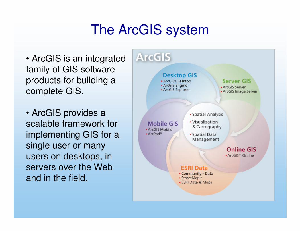
The ArcGIS system
• ArcGIS is an integrated
family of GIS software products for building a
complete GIS.
• ArcGIS provides a
scalable framework for implementing GIS for a
single user or many users on desktops, in
servers over the Web
and in the field.

ArcView, ArcEditor and ArcInfo
ArcIMS, ArcGIS Server
and ArcGIS Image Server
ArcPad and ArcGIS
Mobile for field
computing
Embeddable software components
for developers to extend GIS
desktops, build custom GIS
applications, add custom GIS
services and Web applications and
create mobile solutions
the four frameworks of GIS applications in ArcGIS
The ArcGIS system

A scalar and modular system
• ArcReader: visualisation
• ArcView: visualisation, analysis, basic editing
• ArcEditor: advanced editing
• ArcInfo: complete tool
• Extensions: advanced analysis
• ArcSDE: DB services
• ArcIMS: internet services
• ArcPAD: sw for PDAs
The ArcGIS system

ArcInfo
Available tools (ArcGIS 10)
• ArcMap ⇒ display, editing and analysis of maps
• ArcCatalog ⇒ tool used to access and manage data and metadata (embedded in
ArcMap or available as a separate module)

ESRI data format
coverage
• standard arc/info format
data are distributed in the directories of the single
coverages and in the common directory INFO
⇒ single coverages can’t be used alone
• arc/info PC format
each coverage contains all the data inside its own directory
⇒ single directories can be used alone
⇒ copy/paste/delete operations must be executed via ArcCatalog

this format stores in a single data set non-topological
geometry and attributes of a spatial entity (point, line or surface).
attributes geometryprojection metadata
spatial indexesindexes of non-spatial fields
.dbf .prj .shp
.shx, .sbn, .sbx.ain, .aih
.xml
ESRI data format
shape file

Mandatory files
* .shp — shape format; the feature geometry itself
* .shx — shape index format; a positional index of the feature geometry to allow
seeking forwards and backwards quickly
* .dbf — attribute format; columnar attributes for each shape, in dBase III format.
Optional files
* .prj — projection format; the coordinate system and projection information, a
plain text file describing the projection using well-known text format
* .sbn & .sbx — a spatial index of the features
* .fbn & .fbx — a spatial index of the features for shapefiles that are read-only
* .ain & .aih — an attribute index of the active fields in a table or a theme's
attribute table
* .ixs — a geocoding index for read-write shapefiles
* .mxs — a geocoding index for read-write shapefiles (ODB format)
* .atx — an attribute index for the .dbf file in the form of
shapefile.columnname.atx (ArcGIS 8 and later)
* .shp.xml — metadata in XML format
ESRI data format
shape file

Data model introduced with ArcGIS 8
• object- oriented data model
� standard GIS object
� complex objects, direct
modeling of reality
• XML- based data exchange
Two different implementations:
1. Personal Geodatabase
2. Enterprise Geodatabase
ESRI data format
geodatabase

The ESRI raster format has a structure on the file system that is
similar to the standard arc/info format used for the coverages:
each directory contains
data for a single raster map
an info directory for common data
⇒ copy/paste/delete operations must be executed via ArcCatalog
ESRI data format

An introduction to ArcMap

Layers
Geographic information is partitioned in layers, that can be managed distinctly and have different sources:
• coverage
• shape file
• geodatabase
• GRID
• images
• CAD
• ...
ESRI formats
other formats
vector
raster

ArcMap interfaceGUI (Graphic User Interface)
table of contents: complete list of layers
cartographic view
ArcCatalog
ArcToolbox

There can be multiple framesand for each of them it ispossible to define differentproperties (geographic region, reference system,...)
There can be one or more layers inside each frame
ArcMap: frames and layers
active frame
active layer
other frame
inactive layer
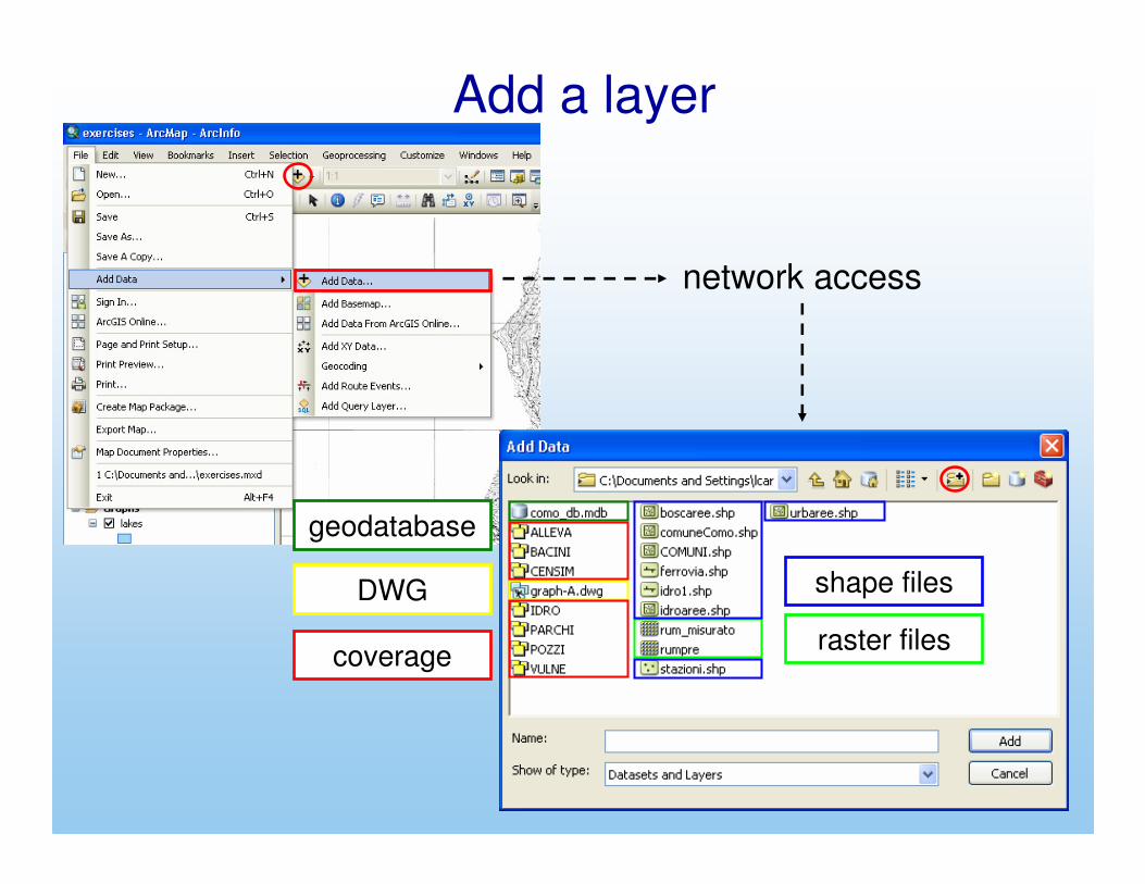
Add a layer
geodatabase
shape files
coverage
DWG
raster files
network access

Layer properties
right-click on the layer name

changing graphical properties
Layer properties: symbols
list of predefined symbols
color & width

Layer properties: symbolschanging graphical properties
composed style (overap of multiple lines)
characteristics of the composing element
resulting style

Layer properties: symbolsThe graphical customization can be applied also to areaelements…
list of predefined symbols
customization

Layer properties: symbols…and point elements.
list of predefined symbols
customization

Display the layer according to the attribute values
Layer properties: symbols
availablediscrimination criteria

Layer properties: symbols
Example: different symbols for different values
data field Predefined color scheme
buttons used to manage the list of symbols

Layer properties: symbols
Legend elements
double click to modify symbols
double click to insert/modify labels
to modify the hierarchyof elements

Layer properties: symbols
Example: different symbols for different ranges of values
data field
Predefined color scheme
number of classes

Layer properties: symbolsExample

Layout viewDisplay a print preview of the project

Layout view: customizationInsert a title
format:
• font
• dimension
• …

In a similar way it is possible to add and customize:
• a legend• a north arrow
• a scale bar• text and other graphical elements
Layout view: customization

Layout view: customization
To modify objects in the layout view:
• click on the object to select it (move, copy, paste, stretch,...)
• double click on the object to modify its properties
Layout view: customization
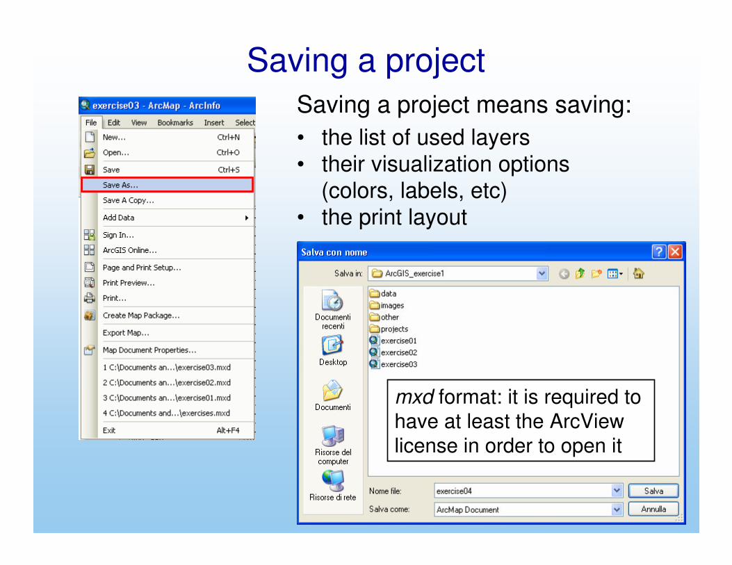
Saving a project means saving:
• the list of used layers
• their visualization options(colors, labels, etc)
• the print layout
mxd format: it is required to
have at least the ArcView
license in order to open it
Saving a project

The mxd file contains only references to maps, it
does not enclose cartographic contents in itself.
It is possible to choose between two kinds of reference, in
function of the intended use of the project - es:
c:\temp\progetto.mxd
c:\temp\carte\prova.shp
• absolute path:
c:\temp\carte\prova.shp
• relative path:
.\carte\prova.shp
Saving a project
position of the project file
position of the map
the map position doesnot depend on the position of the project file
the map position isdefined in function of the position of the project file

To define the reference type:
Saving a project
absolute path is set by default; putthe check to choose the relative path

It’s possible to export a project as an image or as a pdf document
Exporting a project
different options will beavailable in function of the chosen format

An introduction to ArcCatalog
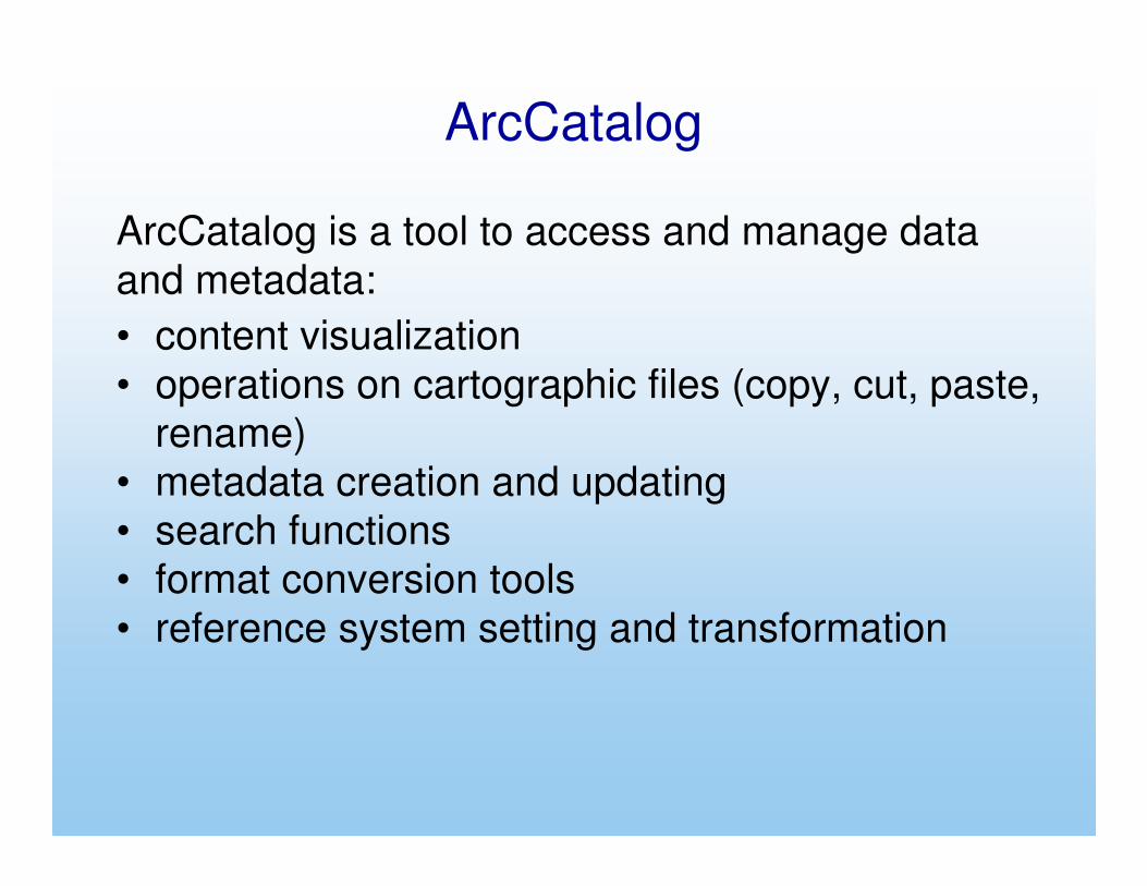
ArcCatalog
ArcCatalog is a tool to access and manage data
and metadata:
• content visualization
• operations on cartographic files (copy, cut, paste,
rename)
• metadata creation and updating
• search functions
• format conversion tools
• reference system setting and transformation

The ArcCatalog interfaceGUI (Graphic User Interface)
catalog view
catalog tree

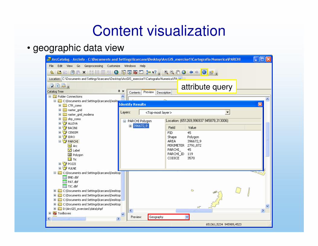
Content visualization
cartographic content displayed by ArcCatalog
actual content of the directory

• GIS Servers: management of the connection to ArcGIS Server and ArcIMS Server to access data distributed via internet
Content visualization

• Database Connection: management of the connection to spatial databases
Content visualization

• geographic data view
Content visualization

• navigation
(zoom in, zoom out,
pan, zoom extent)
Content visualization• geographic data view
navigation (zoom in, zoom out, pan, zoom extent)
Content visualization• geographic data view
attribute query

Content visualization• attribute table view

ArcCatalog makes available tools to manage the reference system associated to maps:
• associate a reference system to a map
• convert a map from a reference system to another one
Reference systems

Reference systemsassociate a reference system: vector maps
display the propertieswindow in ArcCatalog, then insert the reference system in the given field

Reference systems
associate a reference system: raster maps

Most geoprocessing tasks are accessed through ArcToolbox:
• format conversion
• data management and interoperability• analysis tools
• editing tools• statistical tools
ArcToolbox

ArcToolboxArcToolbox is embedded both in ArcMap and ArcCatalog:
ArcCatalog
ArcMap
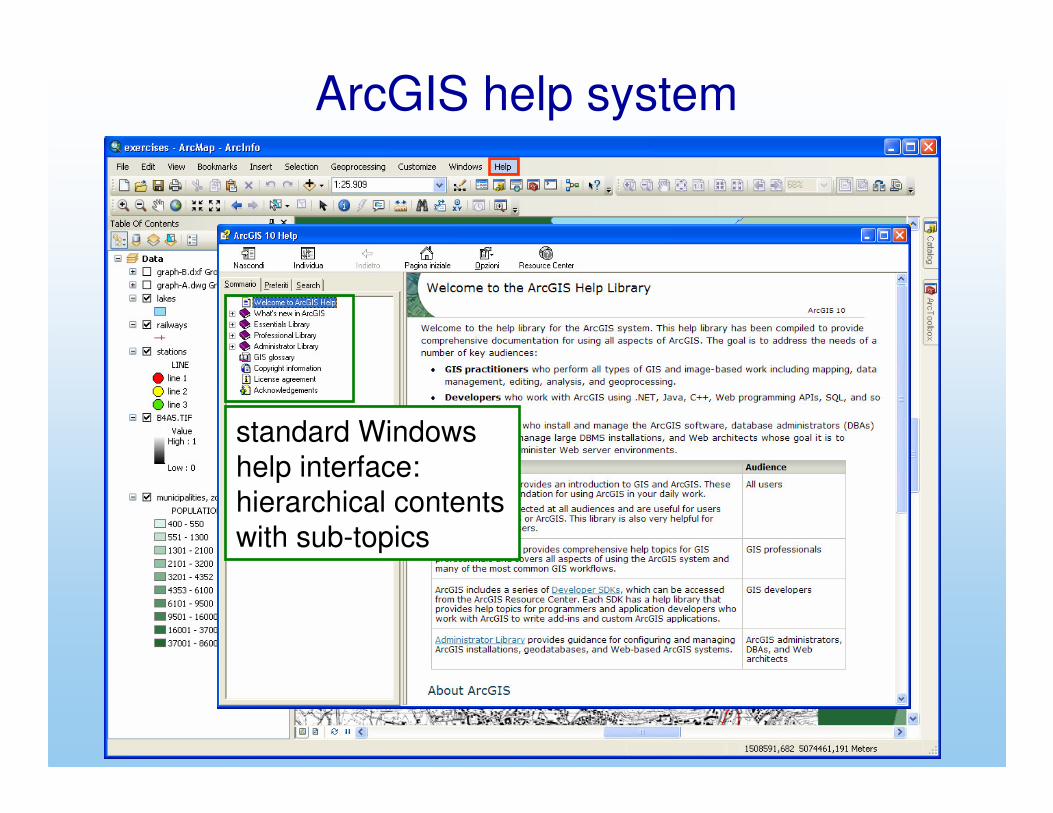
ArcGIS help system
standard Windows
help interface:
hierarchical contents
with sub-topics

ArcGIS help system
searchable database of topics