An Indicator Framework to Measure Effects of Brownields ... · An Indicator Framework to Measure...
6
ADVANCEMENT OF THE PRACTICE DIRECT FROM ATSDR An Indicator Framework to Measure Effects of Brownfelds Redevelopment on Public Health Laurel Berman, Tina Forrester, PhD PhD Editor’s Note: As part of our continuing effort to highlight innovative approaches to improving the health and environment of communities, the Journal is pleased to publish a bimonthly column from the U.S. Agency for Toxic Substances and Disease Registry (ATSDR). The ATSDR, based in Atlanta, Georgia, is a federal public health agency of the U.S. Department of Health and Human Services and shares a common offce of the Director with the National Center for Environmental Health at the Centers for Disease Control and Prevention (CDC). ATSDR serves the public by using the best science, taking responsive public health actions, and providing trusted health information to prevent harmful exposures and diseases related to toxic substances. The purpose of this column is to inform readers of ATSDR’s activities and initiatives to better understand the relationship between exposure to hazardous substances in the environment and their impact on human health and how to protect public health. We believe that the column will provide a valuable resource to our readership by helping to make known the considerable resources and expertise that ATSDR has available to assist communities, states, and others to assure good environmental health practice for all is served. The conclusions of this article are those of the author(s) and do not necessarily represent the views of ATSDR, CDC, or the U.S. Department of Health and Human Services. Laurel Berman is the national brownfelds coordinator with ATSDR’s Division of Community Health Investigation. She coordinates the ATSDR Brownfelds/Land Reuse Health Initiative. Tina Forrester is the acting director of the Division of Community Health Investigations of ATSDR. She was a founding member of the ATSDR Brownfelds/Land Reuse Health Initiative. I ntroduction Brownfelds and land reuse sites (brown- felds) are formerly used industrial, com- mercial, and residential properties stigma- tized by real or perceived contamination. The effects of blight and potential contamination associated with these sites can weigh heav- ily on communities. Communities with mul- tiple brownfelds tend to have multiple pub- lic health issues. The issues include reduced property values, increased potential for expo- sures to harmful chemicals, increased crime rates, substance abuse, lack of green space or areas for recreation, decreased access to healthy foods, poor air quality, contaminated soil or water, and elevated blood lead levels or asthma prevalence, among others. The Agency for Toxic Substances and Disease Registry’s (ATSDR’s) Brownfields/ Land Reuse Health Initiative offers techni- cal support and resources to communities to encourage the inclusion of public health in revitalization plans. The ATSDR Brownfelds/ Land Revitalization Action Model (Action Model) is one resource designed to integrate public health in redevelopment by creating community-driven health status indicators. Prior to developing the Action Model, ATSDR researched existing community assessment frameworks and found that these frameworks primarily focused on sus- tainable development, health promotion, and health status assessment. This review indicated that a community-driven empha- sis was lacking and revealed a need for a community-driven model inclusive of grass roots public health indicators to address the adverse effects of brownfelds in communi- ties. Because communities with multiple brownfields tend to be disproportionately affected economically, the need for an indi- cator framework that can be implemented with little to no funding sources or with no consultant facilitation is critical. Developing the Action Model in Milwaukee’s 30th Street Corridor The Menomonee Valley Benchmarking Initia- tive (DeSousa, Gramling, & Lemoine, 2007) is one of the most comprehensive projects that incorporates stakeholder-derived indi- Volume 76 • Number 1 50
Transcript of An Indicator Framework to Measure Effects of Brownields ... · An Indicator Framework to Measure...

A d vA n c e m e n t o f t h e PRACTICE
A d vA n c e m e n t o f t h e PRACTICE
D I R E C T F R O M AT S D R
An Indicator Framework to Measure Effects of Brownfields Redevelopment on Public Health
Laurel Berman, tina forrester, Phd Phd
edi tor ’s note : As part of our continuing effort to highlight innovative
approaches to improving the health and environment of communities, the
Journal is pleased to publish a bimonthly column from the U.S. Agency for
Toxic Substances and Disease Registry (ATSDR). The ATSDR, based in Atlanta,
Georgia, is a federal public health agency of the U.S. Department of Health and
Human Services and shares a common office of the Director with the National
Center for Environmental Health at the Centers for Disease Control and
Prevention (CDC). ATSDR serves the public by using the best science, taking
responsive public health actions, and providing trusted health information to
prevent harmful exposures and diseases related to toxic substances.
The purpose of this column is to inform readers of ATSDR’s activities and
initiatives to better understand the relationship between exposure to hazardous
substances in the environment and their impact on human health and how to
protect public health. We believe that the column will provide a valuable resource
to our readership by helping to make known the considerable resources and
expertise that ATSDR has available to assist communities, states, and others to
assure good environmental health practice for all is served.
The conclusions of this article are those of the author(s) and do not
necessarily represent the views of ATSDR, CDC, or the U.S. Department of
Health and Human Services.
Laurel Berman is the national brownfields coordinator with ATSDR’s
Division of Community Health Investigation. She coordinates the ATSDR
Brownfields/Land Reuse Health Initiative. Tina Forrester is the acting director
of the Division of Community Health Investigations of ATSDR. She was a
founding member of the ATSDR Brownfields/Land Reuse Health Initiative.
I ntroduction Brownfields and land reuse sites (brownfields) are formerly used industrial, com
mercial, and residential properties stigmatized by real or perceived contamination. The effects of blight and potential contamination
associated with these sites can weigh heavily on communities. Communities with multiple brownfields tend to have multiple public health issues. The issues include reduced property values, increased potential for exposures to harmful chemicals, increased crime
rates, substance abuse, lack of green space or areas for recreation, decreased access to healthy foods, poor air quality, contaminated soil or water, and elevated blood lead levels or asthma prevalence, among others.
The Agency for Toxic Substances and Disease Registry’s (ATSDR’s) Brownfields/ Land Reuse Health Initiative offers technical support and resources to communities to encourage the inclusion of public health in revitalization plans. The ATSDR Brownfields/ Land Revitalization Action Model (Action Model) is one resource designed to integrate public health in redevelopment by creating community-driven health status indicators.
Prior to developing the Action Model, ATSDR researched existing community assessment frameworks and found that these frameworks primarily focused on sustainable development, health promotion, and health status assessment. This review indicated that a community-driven emphasis was lacking and revealed a need for a community-driven model inclusive of grass roots public health indicators to address the adverse effects of brownfields in communities. Because communities with multiple brownfields tend to be disproportionately affected economically, the need for an indicator framework that can be implemented with little to no funding sources or with no consultant facilitation is critical.
Developing the Action Model in Milwaukee’s 30th Street Corridor The Menomonee Valley Benchmarking Initiative (DeSousa, Gramling, & Lemoine, 2007) is one of the most comprehensive projects that incorporates stakeholder-derived indi-
Volume 76 • Number 1 50

A d vA n c e m e n t o f t h e PRACTICE
Fond du Lac Ave
Juneau Ave
I-43
43rd Street
30th Street
CPaStC
orridor boundary rks
udy area (tracts)
N
ensus tracts
FIGURE 1
30th Street Corridor report Study area—tracts
cators to assess changes in a redeveloping area. In summer 2006, ATSDR met with the original project stakeholders and asked for their assistance in piloting the Action Model framework to determine measurable out
comes for the assessment of the effects of redevelopment on community health status. Later, we all worked together to implement the framework in the 30th Street corridor of Milwaukee, an urban corridor with a popula
tion of about 90,000 people (Figure 1). The project is described in the ATSDR (2008) report, “Building Healthy Communities: A Baseline Characterization of Milwaukee’s 30th Street Corridor.”
The ATSDR Action Model resulted in a grassroots framework implemented by a diverse group of stakeholders—the Development Community—without a large investment of resources. Key aspects of the Action Model include the following: • forming the Development Community, • completing a four-step framework to
establish baseline community health status, and • adding stewardship that ensures all indi
cators are tracked over time.
Forming the Development Community The Development Community consisted of anyone interested in redevelopment of the 30th Street corridor. Development Community members recommended who should be involved, which helped ATSDR to equitably include key stakeholders. The Development Community included many community groups, residents, the city of Milwaukee, the Milwaukee Health Department, the University of Wisconsin—Milwaukee, the Wisconsin Department of Natural Resources, the Wisconsin Department of Health Services, the U.S. Environmental Protection Agency (U.S. EPA), and ATSDR.
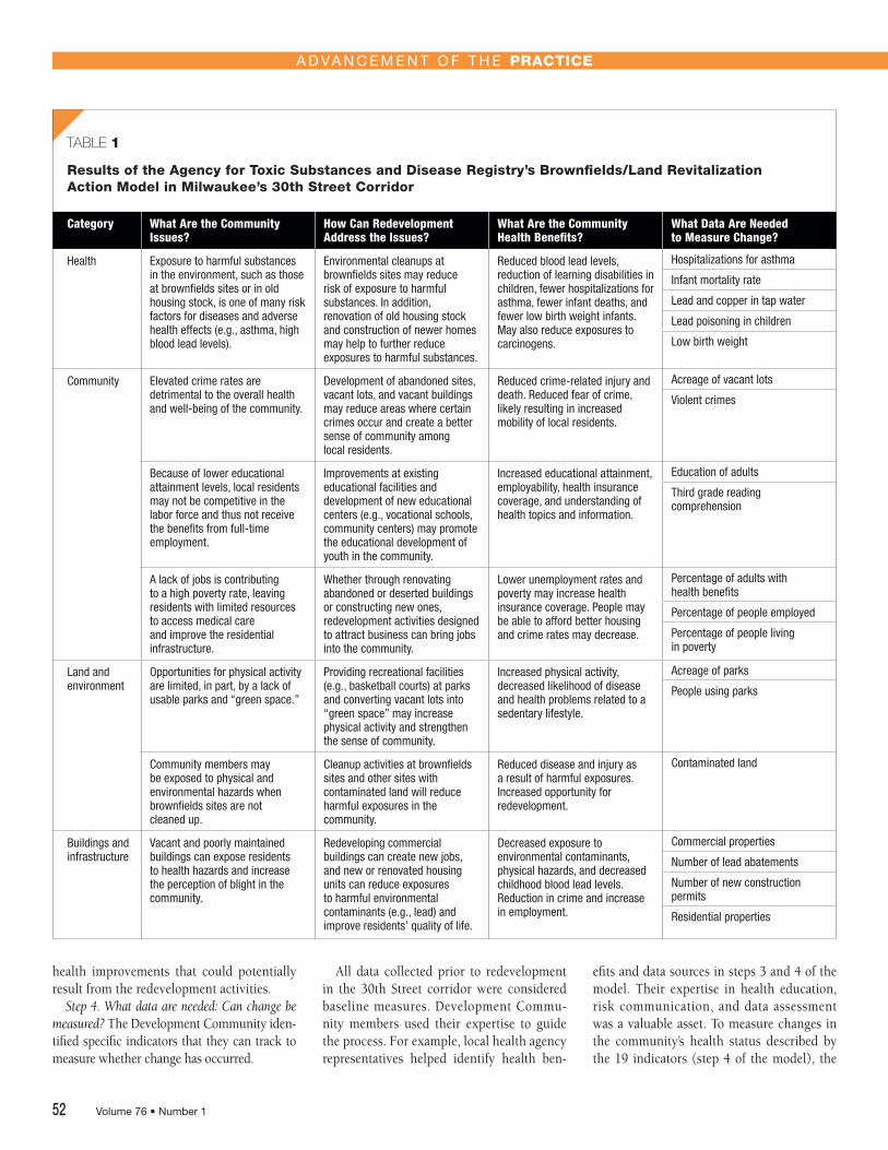
Implementing the Action Model Framework During public workshops, Development Community members brainstormed issues following four framework steps. These steps are summarized below and in Table 1.
Step 1. What are the issues in the community that may impact the health of the community? Members of the Development Community identified seven general issues of concern. These issues fell into four broader topics: health, community, land and environment, and buildings and infrastructure.
Step 2. How can redevelopment address the issues that impact health status? Members of the Development Community identified various ways that redevelopment activities in the 30th Street corridor might help to address these issues.
Step 3. What are the community health benefits? The Development Community listed
July/August 2013 • Journal of Environmental Health 51
A d vA n c e m e n t o f t h e Practice
results of the agency for toxic Substances and Disease registry’s Brownfields/Land revitalization action Model in Milwaukee’s 30th Street Corridor
Category What Are the Community Issues?
How Can Redevelopment Address the Issues?
What Are the Community Health Benefits?
What Data Are Needed to Measure Change?
Health Exposure to harmful substances in the environment, such as those at brownfields sites or in old housing stock, is one of many risk factors for diseases and adverse health effects (e.g., asthma, high blood lead levels).
Environmental cleanups at brownfields sites may reduce risk of exposure to harmful substances. In addition, renovation of old housing stock and construction of newer homes may help to further reduce exposures to harmful substances.
Reduced blood lead levels, reduction of learning disabilities in children, fewer hospitalizations for asthma, fewer infant deaths, and fewer low birth weight infants. May also reduce exposures to carcinogens.
Hospitalizations for asthma
Infant mortality rate
Lead and copper in tap water
Lead poisoning in children
Low birth weight
Community Elevated crime rates are detrimental to the overall health and well-being of the community.
Development of abandoned sites, vacant lots, and vacant buildings may reduce areas where certain crimes occur and create a better sense of community among local residents.
Reduced crime-related injury and death. Reduced fear of crime, likely resulting in increased mobility of local residents.
Acreage of vacant lots
Violent crimes
Because of lower educational attainment levels, local residents may not be competitive in the labor force and thus not receive the benefits from full-time employment.
Improvements at existing educational facilities and development of new educational centers (e.g., vocational schools, community centers) may promote the educational development of youth in the community.
Increased educational attainment, employability, health insurance coverage, and understanding of health topics and information.
Education of adults
Third grade reading comprehension
A lack of jobs is contributing to a high poverty rate, leaving residents with limited resources to access medical care and improve the residential infrastructure.
Whether through renovating abandoned or deserted buildings or constructing new ones, redevelopment activities designed to attract business can bring jobs into the community.
Lower unemployment rates and poverty may increase health insurance coverage. People may be able to afford better housing and crime rates may decrease.
Percentage of adults with health benefits
Percentage of people employed
Percentage of people living in poverty
Land and environment
Opportunities for physical activity are limited, in part, by a lack of usable parks and “green space.”
Providing recreational facilities (e.g., basketball courts) at parks and converting vacant lots into “green space” may increase physical activity and strengthen the sense of community.
Increased physical activity, decreased likelihood of disease and health problems related to a sedentary lifestyle.
Acreage of parks
People using parks
Community members may be exposed to physical and environmental hazards when brownfields sites are not cleaned up.
Cleanup activities at brownfields sites and other sites with contaminated land will reduce harmful exposures in the community.
Reduced disease and injury as a result of harmful exposures. Increased opportunity for redevelopment.
Contaminated land
Buildings and infrastructure
Vacant and poorly maintained buildings can expose residents to health hazards and increase the perception of blight in the community.
Redeveloping commercial buildings can create new jobs, and new or renovated housing units can reduce exposures to harmful environmental contaminants (e.g., lead) and improve residents’ quality of life.
Decreased exposure to environmental contaminants, physical hazards, and decreased childhood blood lead levels. Reduction in crime and increase in employment.
Commercial properties
Number of lead abatements
Number of new construction permits
Residential properties
TABLE 1
health improvements that could potentially result from the redevelopment activities.
Step 4. What data are needed: Can change be measured? The Development Community identified specific indicators that they can track to measure whether change has occurred.
Volume 76 • Number 1
All data collected prior to redevelopment in the 30th Street corridor were considered baseline measures. Development Community members used their expertise to guide the process. For example, local health agency representatives helped identify health ben
efits and data sources in steps 3 and 4 of the model. Their expertise in health education, risk communication, and data assessment was a valuable asset. To measure changes in the community’s health status described by the 19 indicators (step 4 of the model), the
52

A d vA n c e m e n t o f t h e Practice
TABLE 2
abbreviated Baraboo action Model
Environment
Issues Measures
River preservation Water quality
Pollution of the river Site inventory Storm water ordinances Pollution prevention practices Sewer system parameters
Sites Site inventory Status of sites Health consultations/technical assists
Landscape/vegetation Vegetation survey
Odor/rodents Odor survey Rodent control data
Habitat concerns Wildlife survey Environmentally friendly lighting Habitat preservation
Land Use/Reuse
Issues Measures
Neighborhood design Sidewalks survey Trails survey Green/open space Businesses/services Design techniques/standards Housing types: pre-1978 housing and commercial units Lead and asbestos remediation Demographics Community pride and satisfaction
Incompatible land uses Incompatible land use sites
Community-wide employment/business/ economic issues
Young families Births College-educated residents Tenants Businesses People shopping/dining Economic statistics School district and real estate data People using parks (young people in the area)
Riverfront access and linkages to complement and connect the downtown square development
River access Trails survey Recreational activities River walk and linkages
Safety/Security/Health
Issues Measures
Security of worksite during redevelopment Site access and extra patrol
Poor condition of sidewalks Sidewalks survey
Security of river trails Surveillance and accident log
Communication/Risk Communication
Issues Measures
Continued partnership between city, public health, state, and residents
Partnership activities—city and health outreach activities
Communication of hazards Partnership activities—number of lead-poisoned children
Development Community selected freely available data sources. These sources of information included community surveys and surveillance reports as well as local, state, and federal Web sites.
The data collection phase of the 30th Street corridor project was completed during summer 2007. ATSDR completed most of the data collection, with the assistance of Development Community members and student volunteers from the University of Wisconsin— Milwaukee. Establishing baseline conditions prior to redevelopment required roughly one full-time and one half-time worker over a period of two months. In other Action Model projects, this work is being shared among members of the Development Community.
The 30th Street corridor pilot project led to the development of community-driven indicators to assess changes in community health status for residents living in or adjacent to the corridor. The Development Community has opted to use the Action Model for redevelopment planning and for tracking indicators over 5–10 years. The project and resulting measurement indicators are described in ATSDR (2008).
Assessing the Utility of the Action Model: Baraboo and Kenosha, Wisconsin To assess the utility of the Action Model, ATSDR applied it in projects in Baraboo and Kenosha, Wisconsin. The Baraboo project was part of a U.S. EPA–funded brownfields assessment focused on riverfront redevelopment and included a community health monitoring component. We used the Action Model to establish baseline community health indicators. In Kenosha, we applied the Action Model to a community already undergoing redevelopment.
Baraboo, Wisconsin The Baraboo riverfront redevelopment will directly affect about 500 of Baraboo’s 12,000 residents. Through the brownfields assessment process, a Development Community had already formed, and more members joined when the Action Model was proposed during a public outreach session. Using the Action Model, the Baraboo Development Community identified 15 community issues within four public health themes: environment, land use/reuse, safety/security/health,
July/August 2013 • Journal of Environmental Health 53

Measurement Indicator
Measured Change Summary of Impacts
Site inventory and progress of pollution control, demolition, and remediation measures
Two of 10 brownfield sites relocated and underwent assessment and/ or remediation; one site removed physical hazards, such as an abandoned shed and an open trough filled with stagnant water; one site has been through assessment.
√ Greater than 20% reduction of brownfields sites, potential to reduce exposures to contamination or hazards
City ordinances to address storm water
A biofiltration pond has been constructed.
√ Improve river water quality
management
Sewer system parameters
Eleven cross connections from the sanitary to storm sewer systems have been repaired.
√ Prevent raw sewage from entering the river
Odor survey of people in a five-block radius of Veolia waste transfer facility regarding odors
The Veolia facility closed and relocated as of June 30, 2010. A site assessment indicated no residual contamination. Odors are no longer present. The lot has been covered with soil fill. Alfalfa to feed local livestock is being grown until the site is redeveloped.
√ Reduction of public health hazards and exposures associated with garbage
√ Growing alfalfa contributes to green space, reduces fugitive dust emissions, and provides economical, healthy feed for livestock
Sidewalks survey— number, condition, and extent of sidewalks
Trails survey
Many sidewalk flaws noted during the 2008 survey have been repaired as of June 2010.
Trail segments were completed, and flood-damaged sections were repaired. The trail was linked to the Ice Age Trail. Trail markers and dog waste receptacles were installed. A dog park was created near the trail.
√ Sidewalk maintenance improves recreational opportunities and aesthetics
√ Increased opportunities for recreation with associated health benefits
√ Dog waste receptacles prevent pet waste from impacting the river or people
Number and types of incompatible land uses
As of June 2010, two of eight incompatible facilities (Veolia and Alliant) were relocating away from the riverfront. As of June 2012, a third incompatible facility went through full assessment and closure.
√ Greater than 25% decrease in incompatible land uses, potential to reduce exposures to contaminants or hazards
Baraboo River access June 2010 observations showed heavy use of the river at Kiwanis Gazebo Park.
√ Increased opportunities for recreation and aesthetic enjoyment
Surveillance of recreational activities along Riverwalk Trail and linkages to the downtown square
August 2009, June 2010, and August 2010 observations indicated increased trail use. The redevelopment area is linked by sidewalks and parking lots, with ample access provided to the Riverwalk Trail.
√ Increased recreational amenities and a walkable community, with potential to reduce obesity and reduce reliance on automobiles
A d vA n c e m e n t o f t h e Practice
and communication/risk communication. The Development Community highlighted a range of community issues, such as river preservation and pollution, odor and rodents, neighborhood design, incompatible land uses, and riverfront access, among others. They suggested several redevelopment approaches to address the community issues and described corresponding community health benefits of these approaches. The Development Community created 33 indicators to measure changes in health status, including environmental data, site information, building and business information, park usage data, and many others. The city administrator volunteered to coordinate stewardship to ensure that the Action Model measures would be tracked over time. An abbreviated Action Model, showing the 15 community issues and corresponding 33 measurement indicators, is shown in Table 2. The Action Model project is presented in the report, “Community Health Monitoring: The Baraboo Ringling Riverfront Redevelopment (ATSDR, 2010).” A companion video about the Action Model process is available at www.atsdr.cdc.gov/sites/brownfields/ videos/html.
The Baraboo Development Community will use the Action Model as part of efforts to modify the master plan for redevelopment. The Development Community was actively involved in data collection efforts. Some of the measurement indicators will require tracking as frequently as every 6–12 months, while others will be tracked every 2–3 years or longer. Early outcomes from the Baraboo Action Model shown in Table 3 indicate positive changes in about one-third of the 33 community-derived indicators. An example of one such positive change is the 25% reduction in the number of incompatible use sites along the river. Another example is the installation of a stormwater biofiltration pond. Both of these changes can improve environmental quality and reduce potential exposures.
Kenosha, Wisconsin The Kenosha Brass site is a 29-acre urban brownfields site that was partially redeveloped in 2009. The city of Kenosha provided ATSDR with “before and after” data from 2001–2006, and we fit these data to the Action Model. The city targeted the
Volume 76 • Number 1
TABLE 3
Changes in Baraboo redevelopment Indicators
residential neighborhoods surrounding the Brass site. Community involvement efforts resulted in the construction of 20 affordable single family homes and the demolition of eight blighted properties. A full-service
grocery store, a bank, and a middle school have been constructed through this effort, and construction continues on a mixed-use building. The Action Model framework shown in Table 4 summarizes the city-pro
54

A d vA n c e m e n t o f t h e Practice
What Are the Community Issues?
How Can Redevelopment Address the Issues?
What Is the Corresponding Health Benefit?
What Measurement Is Required (Indicator)? Baseline, 2001
What Measurement Is Required (Indicator)? Midway Through Redevelopment, 2006
Need low- to moderate- Build low- to moderate- Prevent gentrification and loss Neighborhood diverse; Neighborhood diverse; income housing; some income homes around the of neighborhood; increase properties: properties: properties need minor Brass site; build mixed-use owner-occupancy; increase 60 buildings; 43 minor repairs; 73 buildings; 67 minor repairs; or major repair; need residential facilities on the site; property values, increase 17 major repairs; 31 owner 6 major repairs; 50 owner to increase homeowner provide no-interest loans for community pride occupied; occupied; 23 tenant occupied occupancy infrastructure repair 29 tenant occupied
Need a new grammar school Build a school on Brass site Access to education; walk to school
No school on site School is completed (2009)
High crime area Improve housing, remove blighted structures
Increased safety and security 328 crime calls 164 crime calls
Closest full-service grocery store 15 blocks away
Build a full-service grocery store on Brass site
Access to healthy food, potentially leading to improved health status
No grocery store within 15 blocks
Full-service grocery store opened on site, during development
TABLE 4
Kenosha Brass Site: agency for toxic Substances and Disease registry Brownfields/Land revitalization action Model assessment
vided data, along with community issues and the city’s redevelopment approaches.
Since the development of new homes and removal of blighted properties, home ownership in neighborhoods surrounding the Brass site increased, and crime rates dropped almost 50%. In addition, from 2001 to 2006, the average assessed value of residential property increased from about $70,000 to over $100,000 (Khaligian, 2006). The Kenosha example demonstrated that the Action Model can be used in situations in which redevelopment is well under way and not only in pre-development conditions.
The Utility of the Action Model The Action Model is useful for assessing the effects of brownfields on overall community health status. It creates community-driven indicators to measure these effects. The Action Model can be implemented in densely populated urban areas, such as Milwaukee’s 30th Street corridor or in more rural, smaller redevelopment projects such as the Baraboo riverfront. The Action Model was created to allow assessment of baseline community health status prior to redevelopment. It may also be useful for communities that are already redeveloping, like Kenosha, provided there is availability of such baseline characteristics as property values or crime statistics.
A diverse Development Community engaged in the Action Model framework creates a climate in which people work together to develop public health indicators and plan for healthy redevelopment. While it takes time, perhaps years, to see the effects of such efforts, the Action Model, through its focus on improving overall health status and creating partnerships, may provide ideas for change for communities adversely affected by brownfields.
Since its use in the Milwaukee and Baraboo projects, the ATSDR Brownfields/Land Revitalization Action Model has been used by communities in Detroit, Michigan; Minneapolis, Minnesota; East Cleveland, Ohio; Portland, Oregon; Blue Island, Illinois; Janesville, Ohio; and Rochester, Albany, and Utica, New York; among others. Projects undertaken in these communities are leading to the development of a common core set of brownfields/ land reuse public health indicators that may broadly be applied by other communities. More information about the Action Model is available at www.atsdr.cdc.gov/sites/brownfields/model.html.
Corresponding Author: Laurel Berman, National Brownfields Coordinator, Division of Community Health Investigation, Agency for Toxic Substances and Disease Registry, 77 W. Jackson Blvd., Rm. 433, M/S 4J, Chicago, IL 60604. E-mail: [email protected].
References Agency for Toxic Substances and Disease Reg
istry. (2008). Building healthy communities: A baseline characterization of Milwaukee’s 30th street corridor. Atlanta: Department of Health and Human Services. Retrieved from http:// www.atsdr.cdc.gov/sites/brownfields/docs/30 THStreetCorridorReportAUG2008.pdf
Agency for Toxic Substances and Disease Registry. (2010). Community health monitoring: The Baraboo ringling riverfront development. Atlanta: Department of Health and Human Services. Retrieved from http://www.atsdr. cdc.gov/sites/brownfields/docs/Final_ Baraboo_032911.pdf
DeSousa, C., Gramling, B., & Lemoine, K. (2007). Evaluating progress toward sustainable development in Milwaukee’s Menomonee river valley: Linking brownfield’s redevelopment with community quality-of-life. In M.J. Sirgy, D.R. Rahtz, & R. Phillips (Eds.), Community Qualityof-Life Indicators: Best Practices III. New York: Springer.
Khaligian, Z. (2006). Brass site neighborhood data. Kenosha, WI: City of Kenosha Department of Development.
July/August 2013 • Journal of Environmental Health 55