An Exploration of Opportunities to Restore Freshwater ... · Freshwater Connectivity Through...
90
Environmental Markets and Stream Barrier Removal An Exploration of Opportunities to Restore Freshwater Connectivity Through Existing Mitigation Programs
Transcript of An Exploration of Opportunities to Restore Freshwater ... · Freshwater Connectivity Through...
Environmental Markets and Stream Barrier Removal
An Exploration of Opportunities to Restore Freshwater Connectivity Through Existing Mitigation Programs

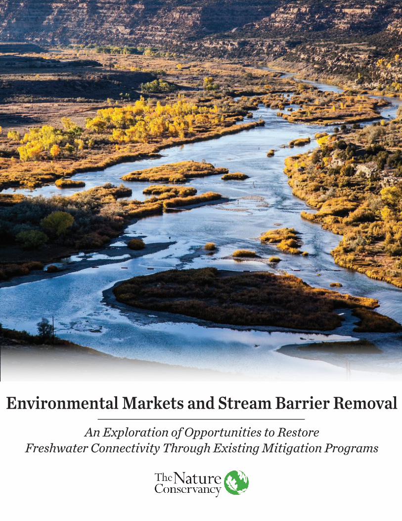
Cover: San Juan River, NM © Erika Nortemann
Please cite this document as: Wilkinson, Jessica et al. 2017. Environmental Markets and Stream Barrier Removal: An Exploration of Opportunities to Restore Freshwater Connectivity Through Existing Mitigation Programs. The Nature Conservancy: Arlington, VA.
© 2017 The Nature Conservancy

Environmental Markets and Stream Barrier Removal: An Exploration of Opportunities to Restore Freshwater Connectivity
Through Existing Mitigation Programs
The Nature Conservancy
Authors: Wilkinson, Jessica, Justus Raepple, Ryan Rossner, Amy Singler, Tara Moberg, Katie Kennedy, Sally Harold

TABLE OF CONTENTS
Acknowledgements 2Executive Summary 3Section I: Introduction, Methods and Key Terminology 5
Introduction 6Methods 6Key Terminology 7
Section II: Why Remove Aquatic Resource Barriers? 9The Ecological Effects of Barriers 10Ecological Effectiveness of Stream Restoration Practices 10Getting the Most Out of Barrier Removal Projects 12
Section III: Stimulating Demand for Barrier Removal Through Mitigation Markets 13General Mitigation Principles Affecting Barrier Removal Projects 14Clean Water Act 15Hydropower Licensing: Federal Power Act and Clean Water Act Section 401 19Rivers and Harbors Act of 1899 20Endangered Species Act 20Natural Resource Damange Programs 21State and Federal Transportation Programs 22Compensatory Mitigation Mechanisms 23Summary 24
Section IV: Quantifying Barrier Removal Benefits 25Description of Debiting and Crediting Methodologies 26Methods for Quantifying Functional Loss and Gain 27Adjustment Factors 28Characteristics of Good Methodologies 28Examples of Existing Methodologies 29
New England District Method 29Missouri Stream Mitigation Method 32North Carolina Dam Removal Guidance 33
Cross-Methodology Comparison 37Summary 40
Section V: Considerations and Challenges Associated with Barrier Removal 41Development of Crediting Methodologies 43Securing Long-Term Protection 45Economic Viability and Demand 47Generation of Large Quantities of Credits 48Proportionality and Appropriately Accounting for Stream Length Affected 48
Environmental Impacts from Dam Removals 49Ensuring Additionality 51Definition of Barrier Removal 52
Section VI: Conclusions and Recommendations 55Section VII: Appendices 59
Appendix I: Definitions 60Appendix II: Examples of Barrier Removal Projects 62Appendix III: Expert Elicitation - A Scientific Process for Development of Crediting Methodologies
64
Appendix IV: Quantification Tools: Foundational Metrics 68Endnotes 71

1
ACKNOWLEDGEMENTS
The Nature Conservancy extends sincere thanks to the professionals that reviewed and commented upon the final draft of this paper: Brooke Atwell, The Nature Conservancy; Taylor Bell, U.S. Army Corps of Engineers, New England District; Douglas R. Berka, U.S. Army Corps of Engineers, Kansas City District; Alison Bowden, The Nature Conservancy; Eddie Game, The Nature Conservancy; Brian Graber, American Rivers; Will Harmon, Stream Mechanics; Palmer Hough, U.S. Environmental Protection Agency, Headquarters; Kathy Jensen, The Nature Conservancy; Ruth Ladd, U.S. Army Corps of Engineers, New England District; Alex Mas, The Nature Conservancy; Bruce McKenney, The Nature Conservancy; Steve Morey, U.S. Fish and Wildlife Service, Pacific Region; Sara O'Brien, Willamette Partnership; David Olson, U.S. Army Corps of Engineers, Headquarters; David Owen, UC Hastings, College of the Law; Adam Riggsbee, RiverBank; Matt Shively, U.S. Army Corps of Engineers, St. Louis District; Mark Smith, The Nature Conservancy; Eric Somerville, U.S. Environmental Protection Agency, Region 4. Special thanks to Ryan Rossner, who joined The Nature Conservancy as an intern, and did much of the heavy lifting of background research and interviews and to Brooke Atwell for layout and formatting. Additional support was extended by Berkeley Consulting Group, whose team provided detailed market sizing figures. Finally, this report would not have been possible without the generosity of the numerous federal and state agency staff, non-profit conservation experts, private mitigation providers, academics, consultants, and others who made themselves available to the authors and shared their expertise, experiences, and opinions.
2The Nature Conservancy

Executive Summary
3
The aim of this paper is to explore opportunities provided by existing regulatory programs to improve stream health through the removal of barriers to aquatic connectivity, such as dams, culverts, road crossing, and other structures that obstruct stream channels. The paper concludes that a vibrant “environmental market” for barrier removal can be supported by existing regulatory programs and lays out recommendations for how to stimulate this market. The paper first summarizes federal regulatory programs that allow barrier removal projects to generate stream restoration credits, which can then be utilized to satisfy the compensatory mitigation obligations of projects that impact stream function. We identify those programs that appear most suitable for driving barrier removal projects and conclude that the federal wetland and stream mitigation program – on which approximately $3 billion is spent annually – holds the most immediate and greatest promise. We also identify a range of science-based and administrative challenges to the widespread use of barrier removal projects in the mitigation context and offer potential solutions. One of these challenges – a dearth of science-based tools to quantify the functional gains associated with stream barrier removal – is identified as the most significant deterrent. Despite this challenge, examples of methodologies to quantify the benefits of barrier removal projects exist. We highlight three such methodologies, as well as individual projects that were approved using these methods. Finally, we conclude by describing how the expert elicitation process can be used to overcome some of the challenges related to development of crediting methodologies for barrier removal in a robust and science-based manner. We discuss the use of such processes as a key to unlocking the potential environmental market for barrier removal.
4The Nature ConservancyCuddebackville Dam, NY © Mark Godfrey

Section IIntroduction | Methods | Key Terminology
5

1.0 INTRODUCTION
There is growing acknowledgement of the ecological benefits of selective removal of outdated dams and other barriers to free-flowing rivers in the United States. Removing such impediments can yield significant benefits, including water quality and habitat benefits.1 Such projects may also provide more durable and successful conservation outcomes than some traditional stream restoration techniques, such as stream channel reconfiguration projects. At the same time, many existing federal regulatory programs require or encourage impacts to aquatic resources and water quality to be offset through restoration projects that enhance aquatic resource functions. This paper explores these regulatory programs and their potential to encourage a market for barrier removal projects. We also provide examples of barrier removal projects that have been used to provide mitigation “credits.” Finally, we identify impediments to more frequent application of federal mitigation programs in driving barrier removal and conclude with recommendations for bolstering such market-based approaches.
1.1 METHODS
From May 2016 - February 2017, we undertook research in support of this study. During this time, we surveyed existing literature on barrier removal rates, the effects of barrier removal on streams, and researched potential mitigation markets most applicable for barrier removal projects. Over this period, we also conducted structured interviews with subject matter experts to identify examples of existing barrier removal projects that have generated compensatory mitigation credits and to determine how those credits were calculated. We used a snowballing approach to the research conducted in support of the paper; we started with an initial set of individuals to interview and documentation to review, both of which directed us to additional people to interview and literature to review. This informal snowballing approach was not intended to support a comprehensive review of all available information, but rather to provide the necessary background information for the paper. We relied upon the interviews to pinpoint challenges to more widespread adoption of barrier removal projects in compensatory mitigation programs. A summary of these issues, along with our recommendations for overcoming identified challenges can be found in the section “Considerations and Challenges Associated with Dam Removal.”
6The Nature ConservancyKlamath River, CA © Kevin Arnold

1.2 KEY TERMINOLOGY
Below we provide definitions for two terms used throughout the paper: barrier and compensatory mitigation. Appendix I includes a more comprehensive set of defined terms. Each defined term is presented in italics the first time it is used in the paper. Throughout this report, “barrier” is used to generally refer to structures that obstruct stream channels, thus altering the geomorphology of a river or stream, blocking passage of aquatic life, and potentially creating an impoundment (e.g., dams, low-head dams, culverts, road-crossings). While we appreciate that there are important ecological differences between different types of barriers,2 we don’t make a distinction between the types when exploring opportunities for their removal through existing regulatory programs. When the differences between the barrier types is relevant, we strive to make the distinction apparent. This paper utilizes the term “compensatory mitigation” to refer to the restoration, creation, enhancement, or preservation of natural resources to offset impacts pursuant to a regulatory program. Compensatory mitigation may come about as a condition for receiving a permit or license for activities that damage the environment. It may also be required to offset damages to the environment after-the-fact.
7
Sea Lamprey trying to get over a dam, Salmon River, CT © The Nature Conservancy

8The Nature Conservancy

Section IIWhy Remove Aquatic Resource Barriers?
9

2.0 WHY REMOVE AQUATIC RESOURCE BARRIERS?
American waterways bear the effects of more than 100 years of heavy and widespread alteration. According to the National Inventory of Dams, the United States’ rivers have over 87,000 dams of at least 25 feet or with an impounding capacity of 50 acre-feet or more.3 Estimates of smaller dams have placed the number upwards of two million, an estimate that does not include road crossings and poorly-sited culverts that similarly obstruct fish passage and sediment transport.4 While many river barriers serve important functions for local communities—such as providing flood control, transportation river crossings, water supply, or recreation—many barriers have outlived their design lifespan. Dams have a finite lifespan, generally considered to be 50 years, beyond which they may no longer serve their initial purpose without costly upgrades.5 The majority of America’s large dams were built during the “golden age” of dam building (approximately 1935-1965), and are nearing the end of their intended design life.6 Many of these structures were built to support local functions, such as powering mills and providing flood control, river crossing, and irrigation functions.7 However, it is estimated that half of the larger dams in the National Inventory of Dams no longer serve their intended purposes8 and many of these – over 27,000 or 30 percent of the nation’s larger dams – are classified as posing significant or high hazards to communities.9
2.1 THE ECOLOGICAL EFFECTS OF BARRIERS
Stream barriers, dams and the impoundments they create substantially alter river ecosystems. They fundamentally change river habitat, reduce habitat and population connectivity, and alter natural flow, temperature, sediment, and nutrient transport regimes.10 The physical obstruction caused by dams has been demonstrated to stop or slow the migration of various organisms.11 River impoundments have been implicated in species declines12 and in the most extreme cases, species extirpation.13 For those dams equipped with hydroelectric capacity, the operation of their turbines harm fish and other organisms, and the altered timing of water releases can affect water temperature and disrupt flow-dependent processes such as upstream migration and egg laying.14 In addition to these ecological effects, barriers—especially dams—can pose safety hazards and/or economic liabilities to their owners and surrounding communities, particularly when such structures are poorly maintained and are at risk of failure.15
2.2 ECOLOGICAL EFFECTIVENESS OF STREAM RESTORATION PRACTICES
Over the past two decades, significant funds, including mitigation dollars, have supported stream restoration projects. It is estimated that as much as $1 billion is spent on stream restoration every year.16 These projects typically involve restoration practices such as channel reconfiguration and meandering, reach-scale bank restoration, and construction of in-stream habitat structures.17 It is unclear however, if these types of stream restoration projects support improved ecological outcomes.18 There is both not enough monitoring
10The Nature ConservancyRoaring Brook, CT © The Nature Conservancy, Erika Bailey

to determine whether such projects are resulting in sustained ecological benefits and, more generally, limited research into whether these types of stream restoration practices are rooted in ecological science.19 There is also significant debate within and across the academic and practitioner communities about whether and to what extent these traditionalrestoration practices consistently result in functional improvements to stream hydraulics, geomorphology, physiochemical, or biological parameters, particularly in urban and agricultural watersheds.20
The use of barrier removal as a stream restoration practice has increased in recent decades. According to American Rivers, over 1,384 dams have been removed in the United States since 1912 - 72 in 2016 alone21 - and the U.S. leads the world in removing dams to provide environmental restoration and public safety benefits.22 Although our scientific understanding of the ecological effect of these projects is still somewhat limited, several in-depth studies have been released in recent years. These studies have found that after a barrier removal, stream functions are fully restored in less than ten years and frequently in less than five.23 They also highlight improvements to fish passage, quantity and diversity of fish species, water quality, sediment movement, and associated mammal and waterfowl habitat.24 In addition, the U.S. Geological Survey manages a database - the USGS Dam Removal Science Database - which currently catalogues scientific studies on the ecological outcomes of approximately 10 percent of all dam removal projects in the U.S.25
For stream restoration practices to be successful and sustainable, they should address the cause of the impairment.26 Many common stream restoration practices can be prone to failure because they do not address the root causes of the habitat degradation.27 Barrier removal projects, on the other hand, may be more predictable than other restoration techniques at delivering sustainable environmental outcomes because they restore self-sustaining processes, allowing the system to shift yet still function in response to changes within the system, and require minimal maintenance over time.28 Lastly, dam removal is one of the few reach-specific restoration practices that has demonstrated the potential for providing watershed scale restoration and enhancing watershed resilience in the face of anthropogenic changes.29
In sum, barrier removal projects, when properly sited and carefully managed, can be highly durable restoration actions that permanently increase habitat connectivity and improve natural river processes and functions important for the health of connected freshwater and estuary habitats. This is important to note, particularly when the ecological uplift provided by barrier removal projects is compared to the track record of some traditional stream restoration methods. As a result, in many cases, barrier removal projects may be a more desirable practice for generating mitigation credits than other stream restoration practices.
11

Box 1: Prioritizing Aquatic Connectivity Projects
Several state and regional efforts have been made or are underway to identify and prioritize barrier removal projects that can maximize benefits to aquatic health. Although the below list is not exhaustive, it provides a sense of the programs and decision support tools currently available:
• Chesapeake Fish Passage Prioritization: Designed to help managers identify potential fish passage projects that are most likely to produce ecological benefits in the Chesapeake watershed. Builds on a conceptual framework developed by the Northeast Aquatic Connectivity Project (NAC).31
• Critical Linkage Project (CAPS): A program that measures the relative potential to improve local aquatic connectivity through restoration, including dam removals and culvert upgrades.32
• Lake Champlain Basin Stream Crossing Prioritization: Identification and prioritization of road-stream crossings for ecological priority, relative flood risk and resilience, and aquatic organism passage in the Lake Champlain Basin.33
• New York Aquatic Connectivity and Barrier Removal Project: A collaborative effort to prioritize aquatic barriers that are the most detrimental to fish and communities.34
• Northeast Aquatic Connectivity Project: A collaborative effort that assessed and prioritized opportunities for strategic reconnection of aquatic habitats at multiple scales across 13 northeastern states.35
• Oregon Fish Passage Prioritization: The Oregon Department of Fish and Wildlife’s Fish Passage Program is required under state law to complete and maintain a statewide inventory of impediments to fish passage that is used to prioritize enforcement actions based on the needs of native migratory fish.36
• Southeast Aquatic Connectivity Assessment Project (SEACAP): Identifies opportunities to improve aquatic connectivity by prioritizing dams based on their potential ecological benefit if removed or bypassed.37
• Southeast Aquatic Resources Partnership (SARP): A collaborative effort to conserve and restore aquatic resources; has supported SEACAP and is working to expand that program to additional states.38
2.3 GETTING THE MOST OUT OF BARRIER REMOVAL PROJECTS
While the number of dams removed to restore natural river flow, function, and connectivity, has increased over the past two decades, most dam removal projects to date have been “opportunistic” – driven by individual opportunities and not through a process that prioritizes such projects to maximize conservation outcomes.30 In recent years, several state and regional efforts have been initiated to identify and prioritize habitat connectivity projects (see Box 1). Connecting these efforts with existing mitigation and restoration programs can help to maximize the conservation outcomes of these projects.
12The Nature Conservancy
Section IIIStimulating Demand for Barrier Removal
Through Mitigation Markets
13

3.0 STIMULATING DEMAND FOR BARRIER REMOVAL THROUGH MITIGATION MARKETS
Mitigation markets in the U.S. drive significant investments in habitat protection and restoration. It is estimated that at least $3.8 billion a year is directed toward compensatory mitigation projects through six federal regulatory programs every year.39
Below we explore a variety of U.S. national-level regulatory programs that create demand for aquatic resource restoration and provide estimates of how much funding for aquatic resource restoration could be harnessed to drive barrier removal projects. We also discuss some characteristics of these programs and the extent to which their operating rules may limit or encourage barrier removal projects. We also discuss some characteristics of these programs and the extent to which their operating rules may limit or encourage barrier removal projects. The reviewed programs include several provisions of the Clean Water Act, including the wetland and stream protection program, the Total Maximum Daily Load program, and the the state water quality certification program, the hydropower licensing program, the Rivers and Harbors Act of 1899, the Endangered Species Act, the National Resource Damage Assessment program, and state and federal transportation programs. There are several regional mitigation authorities and programs that have supported dam removal projects, such as the Northwest Power Act,40 the Bonneville Power Authority,41 that are not covered here. There also may be innovative state programs, which are not addressed outside of their brief mention in the section on state and federal transportation programs.
3.1 GENERAL MITIGATION PRINCIPLES AFFECTING BARRIER REMOVAL PROJECTS
There are several well-accepted principles that guide mitigation programs that may affect the applicability of such programs to barrier removal: proximity, like-for-like, and proportionality. One key principle reflected in a wide variety of compensatory mitigation programs is that of proximity. This principle establishes that offset projects should be carried out at an ecologically appropriate distance from the impacts.42 So, while it may be appropriate to offset impacts to wide-ranging species at a distance to the impact site, offsets should be located closer to the impact site for resources that provide more localized services, such as wetlands. The equivalence principle establishes that offsets should provide habitat, functions, values, and other attributes that are similar in kind (“like-for-like” or “in-kind”) to those affected by the project.43 It may not be appropriate, for example, to offset impacts to an upland species with a stream restoration project if the species does not rely on streams for any stages of its life cycle.
Finally, the amount of compensatory mitigation that is required – acres/linear feet and/or functional units – by compensatory mitigation programs generally must be proportional to
14The Nature ConservancyGauley River, WV © Kent Mason

the amount of environmental resources lost at the impact site. The Corps’ regulations for implementing Clean Water Act §404 program and the Rivers and Harbors Act of 1899 §10 program, discussed below, has established some bounds around this principle.44 Under the program, there must be a roughly proportional relationship between the impacts of the development and the amount of compensatory mitigation that is required.45 The courts have reaffirmed that in meeting the rough proportionality test, “No precise mathematical calculation is required…”46 So while agencies must demonstrate that the amount of compensation required has some relationship to the impacts, it need not be demonstrated through a scientifically precise measurement.
3.2 CLEAN WATER ACT
The federal Clean Water Act (CWA) includes several provisions that require compensatory mitigation and several that offer opportunities to support barrier removal as a compensatory mitigation activity. These include the §404 program, which regulates impacts to aquatic resources, such as wetlands and streams, the §303(d) Total Maximum Daily Load (TMDL) program, and the §401 state water quality certification program.
3.2.1 SECTION 404: The wetland and stream protection program
Section 404 of the Clean Water Act regulates the discharge of dredged or fill materials into waters of the United States. Developers whose projects will impact jurisdictional wetlands or streams must secure a permit from the U.S. Army Corps of Engineers (Corps). Before issuing a permit, the Corps works with the project proponent to first avoid and minimize impacts to the maximum extent practicable and then to provide compensation (compensatory mitigation or offsets) for remaining, unavoidable impacts. The standards and requirements that all compensatory mitigation projects must meet are outlined in a rule issued by the Corps and the U.S. Environmental Protection Agency (EPA) in 2008 (“2008 Corps/EPA Rule”).47 Below we outline several provisions of the rule that affect the applicability of the program to barrier removal.
The §404 wetland and stream program has been governed by a longstanding goal of achieving no net loss of aquatic resources. The amount of compensation required must be “sufficient to replace lost aquatic resource functions.”48 In recent years, the the Corps and EPA have encouraged local regulators to move away from using simple acreage or linear foot ratios to utilizing more sophisticated tools that seek to estimate the amount of habitat function (or condition) lost through permitted activities and the amount of functional lift provided by proposed compensatory projects. The 2008 rule, in fact, expresses a preference for use of such functional or condition assessment methods.49 However, because these approaches are not always available, regulators may revert to using a minimum one-to-one acreage or linear foot compensation ratio adjusted to account for risk, uncertainty, and other factors.50 Many Corps districts do still rely on acreage or linear foot ratios.51
15

The 2008 Corps/EPA Rule sought to improve siting of compensatory mitigation projects by requiring compensatory mitigation decisions to be based on a “watershed approach.”52 The rule includes a preference for compensatory mitigation to be carried out “in kind”53 (see “General Mitigation Principles Affecting Barrier Removal Projects”), but does also state that out-of-kind compensation is allowable if a watershed approach demonstrates that such projects will support the aquatic resource needs of the watershed.
Finally, the 2008 Corps/EPA Rule requires that the resources – aquatic habitats, riparian areas, buffers, and uplands – that constitute the compensatory mitigation project be provided with long-term protection. Since most §404 compensatory mitigation projects are at least partially land-based, the agencies generally require that projects be protected through real estate mechanisms, such as conservation easements or deed restrictions.54
Often non-aquatic resources, such as buffers, riparian areas, and uplands, may generate mitigation credits when such resources are “essential to maintaining the ecological viability of adjoining aquatic resources.”55 When such areas are part of the overall project, they too must be provided with long-term protections.56 There is flexibility, however, in the mechanism or mechanisms that are used to ensure long-term protection, particularly when projects are carried out in areas that present particular challenges, such as state-owned tidal lands.57 How the Corps has applied discretion in long-term protection mechanisms has been an obstacle for barrier removal projects and is discussed further below (see “Securing long-term protection”).
Many Corps districts and/or state agencies that operate wetland and stream mitigation programs develop and make available to the public guidance on how the agencies will calculate wetland and stream impacts and offsets.58 A 2016 study of 32 such guidance documents found that 15 identify dam removal and 13 identify culvert removal as acceptable methods for generating §404 stream mitigation credits.59 In other words, barrier removal is considered an acceptable compensatory mitigation practice by the agencies overseeing the §404 wetland and stream mitigation markets in much of the country.
The §404 program generates more demand for compensatory mitigation projects than any of the other regulatory programs reviewed here. A 2007 study estimated that approximately $2.9 billion a year is spent on wetland and stream compensatory mitigation projects through the program.60 We estimate that number to be between $1.6 and $3.2 billion a year for wetlands and streams and $230-442 million a year for streams alone.61
3.2.2 Section 303(d): The TMDL Program
The Clean Water Act requires states to adopt water quality standards and “designated uses” for their waters. Designated uses may include the protection and propagation of fish, shellfish and wildlife.62 Under §303(d), states must identify those waters that are unable to meet water quality standards. States are then required to prioritize these polluted waterbodies and must establish TMDLs, or a “pollution diet,” for each impaired waterbody.63 TMDL plans identify the amount of pollutants that can enter waterways without causing those waterbodies to fail to meet target water quality standards. Section
16The Nature Conservancy

303(e) of the act requires states to develop ongoing implementation plans to bring waterbodies into compliance with their TMDLs, but the provision lacks any mechanism for ensuring that states fulfill this obligation, which, in practice, leaves plan implementation up to the discretion of the states. While the TMDL Program has been used to create compensatory mitigation obligations, the mechanism could be used more frequently. In order to do so, a state or EPA would need to draft a TMDL that identifies barrier removal as a solution to address water quality violations and the state would need to utilize its authority to apply the TMDL limits through a regulatory program, such as water pollution control permits.64 When impounded rivers are required to meet the same water quality standards as free-flowing rivers, rather than lakes, they tend to fail to meet water quality standards for parameters such as dissolved oxygen and, in such cases, barrier removal may be identified as an appropriate mechanism to address water quality impairment.65
The TMDL program was used to support the removal of the Maxwell Pond Dam in New Hampshire in 2009 to address dissolved oxygen issues caused by impoundment of the Black Brook.66 Seven low-head dams were removed from the Olentangy River near the city of Delaware, Ohio, as part of the Ohio TMDL implementation program. The barrier removal projects were not, however, funded entirely through the TMDL program. The projects included contributions from the state’s Scenic Rivers Program and Surface Water Improvement Fund, grants from the U.S. Environmental Protection Agency, and funds
17
Salmon Migration © Ami Vitale
from the state CWA 401 program.67 The Ohio Environmental Protection Agency similarly removed the Munroe Falls Dam and modified the Kent Dam as part of the TMDL compliance plan for the Middle Cuyahoga River.68
3.2.3 Section 401: State water quality certification
Section 401 of the Clean Water Act provides states with the authority to “certify” all federally funded, licensed, and permitted activities to ensure that such activities that result in a discharge into navigable waters will comply with state water quality standards. States may use this authority to condition or deny these federal permits and licenses. The types of projects that states review under their §401 authority include those proposed for point source discharges (regulated by §402 of the CWA), permits for activities in navigable waters (§§9 and 10 of Rivers and Harbors Act), Federal Environmental Regulatory Commission (FERC) hydropower dam re-licensing proceedings (see “Hydropower Licensing: Federal Power Act and Clean Water Act Section 401” for additional discussion), and permits for discharge of dredge and fill material (see “Section 404”). If, for example, a state finds that a proposed federal navigation project will not comply with applicable state water quality standards, it may condition its certification on the provision of measures to avoid, minimize, or offset impacts so that it does comply with those standards.
On its face it may seem that there could be limitations to the use of §401 to remove barriers, since the provision is designed to address water quality issues. The connection between water quality standards and barriers is strong, however, in states that utilize biological indicators of water quality.69 In addition, a state Supreme Court ruling in Washington State, established that since the purpose of the Clean Water Act is to “restore and maintain the chemical, physical, and biological integrity of the Nation’s waters,”70 states can use §401 to protect streams when fish habitat, migration, and other biological factors are included as designated uses.71
Indeed, §401 certification has been used to support barrier removal projects and there may be significant opportunities to utilize this authority more frequently. State natural resource agencies could, for example, utilize their §401 authorities to require barrier removal as a condition of federal hydropower license renewal to offset the ongoing environmental impacts of hydropower dam operation (see discussion below).
18The Nature Conservancy

3.3 HYDROPOWER LICENSING: FEDERAL POWER ACT AND CLEAN WATER ACT SECTION 401
The hydropower licensing process presents opportunities to support barrier removal projects and deserves further exploration. Hydropower dams are an important part of America’s energy portfolio, representing approximately seven percent of the United States’ generating capacity,72 and provide a significant source of electricity to meet peak-energy demand. All private hydropower dams in the United States are regulated by the Federal Energy Regulatory Commission and most require a federal license to operate. Federally owned hydropower dams are exempt from the FERC licensing process. FERC’s licensing authority derives mainly from the Federal Power Act (“FPA”), which establishes the requirements for licensing hydropower dams, defines the evaluation standards FERC must use to review license applications, and outlines the boundaries between state and federal authorities. Among other requirements, the FPA requires FERC to determine whether the license application gives equal consideration to the “power” and “non-power” benefits of the river, including the protection of fish and wildlife, recreation opportunities and general environmental quality.73 Several provisions of the FPA and other statutes give federal agencies other than FERC, tribes, and states a significant role in shaping the conditions under which hydropower dams are licensed and such licenses are renewed. Section 401 of the Clean Water Act, discussed above, gives states the authority to impose conditions on federal hydropower licensees that result in discharges that affect the chemical, biological or physical condition of waters in their states. Section 18 of the FPA provides the National Marine Fisheries Service and the U.S. Fish and Wildlife Service with the authority to condition licenses to prescribe fish passage modifications including structural and operational changes necessary to maintain fisheries impacted by the project.74 Section 10( j) of the FPA provides federal and state fish and wildlife agencies with the authority to outline conditions for hydroelectric projects to protect, mitigate damages to, and enhance fish and wildlife resources, including spawning grounds and habitat. FERC does have the ability under this provision, however, to alter or reject 10( j) recommendations.75 Finally, §4e of the FPA provides conditioning authority to agencies and tribes with federal lands, such as National Forests and tribal lands, to ensure the license does not interfere with the protection and use of those lands.76
One example of the licensing process supporting barrier removal is the Muddy River Run relicensing agreement for a pumped storage project on the Susquehanna River in Pennsylvania. As a condition of its CWA §401 certification, the facility owner and operator negotiated a settlement with the Pennsylvania Department of Environmental Protection to allocate of $500,000 a year over the term of operating license for habitat and sediment improvement projects in the Susquehanna River watershed.77 To assist in managing these investments, the state is using a barrier removal decision support tool developed by The Nature Conservancy to help prioritize river restoration opportunities by understanding the ecological value of removal.78
19

FERC licensing and re-licensing decisions tend to follow a lengthy and complex process, with nearly every FERC license including at least some measures aimed at offsetting the impacts to streams from their operation. The process can take an estimated five to ten years, among the longest approval time of any energy type.79 Decisions on the amount and type of offsets that must be provided are generally made on a case-by-case basis. The offset decisions often lack, and operators have little predictability around, what activities and how much funding they will need to commit to adequately mitigate for impacts. In addition, mitigation settlements often do not establish a clear relationship between impacts and mitigation requirements, often resulting in dissatisfaction for both the operator and those advocating for the “non-power” value of the resource.80 The dam licensing process could be made more efficient through the development and application of guidance on how to quantify the impacts of hydropower and develop appropriate compensatory mitigation measures. Such an effort would provide owners and operators with greater predictability and could ensure that settlement dollars are used more effectively to address the impacts of the facilities’ operation.
3.4 RIVERS AND HARBORS ACT OF 1899
Under the Rivers and Harbors Act of 1899, the construction of any structure that obstructs or alters a navigable water is prohibited without a permit issued by the U.S. Army Corps of Engineers.81 This includes the construction of dams or other obstructions to navigable waters. The mitigation requirements governing the program are the same as those for the CWA §404 Program (see “Section 404”).82
3.5 ENDANGERED SPECIES ACT
The Endangered Species Act (ESA) was enacted to provide for the conservation of threatened and endangered species and the habitats on which they depend.83 The U.S. Fish and Wildlife Service (USFWS) and the National Marine Fisheries Service (NMFS or NOAA Fisheries) are tasked with administering the Act, and, along with other obligations, maintain the national “list” of threatened or endangered species. The Act provides for review and consideration of impacts to listed species and their impacts through two central provisions, Sections 7 and 10. Section 7 governs activities “authorized, funded, or carried out” by federal agencies. It emphasizes the minimization or avoidance of impacts and compensatory mitigation is only occasionally an outcome of such consultations.84 To our knowledge, no information currently exists that estimates the amount of compensatory mitigation that is carried out under Section 7 of the ESA. Section 10 of the Act guides activities carried out by private parties that may impact listed species. Under 1982 amendments to the Act, project proponents may be issued an “incidental take permit” (ITP) for the take of a species if the project proponent develops and secures approval for a Habitat Conservation Plan (HCP). HCPs are plans that outline “steps the applicant will take to minimize and mitigate such” impacts.85 If the Service
20The Nature Conservancy

determines that applicants will “minimize and mitigate” impacts “to the maximum extent practicable,” the Service will issue an ITP.86
Through §10 of the ESA, project proponents often carry out compensatory mitigation activities to offset impacts. The kinds of activities that are approved to compensate for permitted impacts must be “based on the species’ needs and the nature of the impacts adversely affecting the species.”87 In other words, if one of the threats to a listed aquatic species is impediments to aquatic passage, removal of barriers to connectivity may be deemed an appropriate activity.
To date, the USFWS has approved 946 HCPs. We identified 16 approved HCPs that address aquatic species.88 Very limited data, however, is publicly available on the amount and type of compensatory mitigation that is carried out through Section 10. Based on this limited data, we estimate that as much as $67.5 million per year may be spent on stream-related compensatory mitigation activities nationwide through the program.89
ESA can create demand for barrier removal projects, particularly in regions where limitations to aquatic passage have been identified as a threat to specific species. For example, in Maine and the Pacific Northwest, loss of habitat connectivity and direct mortality from operation of dams have been identified as threats to listed species of salmon and steelhead.90 Habitat impediments and habitat degradation from dams are also identified a threates to several species of endangered and threatened of sturgeon in the U.S.91 More predictable and consistent demand for barrier removal projects could be supported in key regions where these species are listed through the development by FWS and NMFS of mitigation guidance identifying barrier removal as an appropriate mitigation measure.
3.6 NATURAL RESOURCE DAMAGE PROGRAMS92
When an environmental harm occurs due to certain activities, such as chemical or oil spills or leaks, “responsible parties” may be liable for the cost of removal and remedial actions, as well as the cost to restore the natural environment. Responsible parties may be held liable for Natural Resource Damages (NRD) under one or more of the following federal laws, depending on the location and type of damage: Comprehensive Environmental Response, Compensation, and Liability Act (CERCLA), Oil Pollution Act (OPA), Clean Water Act (CWA), Park System Resource Protection Act (PSRPA), and National Marine Sanctuaries Act (NMSA).93
NRD laws allow for a variety of actions, including restoration, replacement, and protection of equivalent resources, to mitigate for damages caused to natural resources. There are examples of NRD settlements that have supported dam or barrier removals as restorative actions to compensate for damages. The Oughoughton Creek NRD case, for example, involved a series of dam removals in New Jersey and Pennsylvania to restore mussel populations.94 Dam removals have also been utilized as part of the “containment” (pre-restoration) phase of NRD projects, such as in the Kalamazoo River cleanup.95
21
From 2012-2015, we estimate that, on average, as much as $34 million per year may be available through NRD settlements for barrier removal projects.96 We believe, however, that NRD may not be a widely available tool for supporting barrier removal projects on a national scale. As with ESA, NRD funds are allocated in limited locations and only a subset of these settlements may support dam removal projects.
3.7 STATE AND FEDERAL TRANSPORTATION PROGRAMS
Impacts from transportation infrastructure projects are consistently one of largest or the largest source of unavoidable environmental impacts requiring compensatory mitigation under the CWA §404 program.97 There are several opportunities for transportation agencies - both state and federal - to think creatively about how to maximize the environmental outcomes of offset projects related to infrastructure projects. Resources from transportation projects are regulated primarily through many of the federal programs outlined above, including CWA §§404 and 401, ESA, and the Rivers and Harbors Act of 1899. Because they are such a significant source of mitigation demand, it is worth exploring how these programs can be designed to best address the impacts they cause to aquatic connectivity and how the conservation outcomes of the associated mitigation can best be maximized.
For over a decade, federal resource agencies have recognized the valuable role that landscape-scale planning and early engagement can play in supporting more efficient infrastructure decision-making and better environmental outcomes.98 One way transportation agencies have demonstrated the approach is by working with state agencies and other partners to establish programs that identify and prioritize barrier removal projects. State departments of transportation can utilize this data to ensure that when they use permittee-responsible mitigation or single-user mitigation banks to satisfy their compensatory mitigation obligations, the projects they carry out maximize conservation outcomes. So rather than undertake a channel reconfiguration project to offset the impacts of installation of a new culvert, they could instead undertake a stream barrier removal project that more effectively restores the stream and addresses watershed needs. The Oregon Department of Transportation has a particularly innovative program underway. The agency has worked with the Oregon Fish and Wildlife Service, Willamette Partnership, and The Nature Conservancy on a program to compensate for the unavoidable harms associated with non-compliant culverts. Through the development of a “Fish Passage Mitigation Bank,” high priority barriers can be removed and the functional uplift credits generated can be banked and purchased as “waivers” by non-compliant culvert owners. The project also involved the development of a “Net Benefit Analysis Tool,” which provides for a rigorous, quantitative assessment of the impact of permitted actions (debits) to fish passage and the benefits of mitigation (credits) within Oregon’s North Coast.99 The program is in the middle of a three-year pilot phase which includes conducting a limited number of banking transactions, rigorously testing and refining the Net Benefit Analysis Tool, and evaluating the potential for statewide implementation.
22The Nature Conservancy

3.8 COMPENSATORY MITIGATION MECHANISMS
There are three well-established mechanisms for delivering compensatory mitigation that are recognized in existing compensatory mitigation policy.100 Although these mechanisms are most closely aligned with the §404 wetland and stream program, they operate in the species and NRD contexts as well.
With the first mechanism, permittee-responsible mitigation, the permittee identifies and carries out the compensatory mitigation project and remains liable for the project’s success in achieving the ecological outcomes identified in the project’s objectives. The second two mechanisms, banks and in-lieu fee mitigation, are often referred to as third-party mitigation mechanisms because a party other than the permittee carries out the compensatory mitigation project, and permittees can purchase credits from those providers. When permittees purchase credits from banks or in-lieu fee programs, the liability for carrying out the project and for project success transfers to the third party. Mitigation banks are sponsored by private mitigation bankers, non-profit organizations, or government agencies that undertake a compensatory mitigation project to restore and protect aquatic resources in advance of and separate from any impact project. “Credits” are assigned to the compensatory mitigation project by the appropriate regulatory agency in proportion to the amount and type of uplift provided. These credits can then be sold to offset the impacts to similar aquatic resources (“debits”) that result from permitted impacts.
23
Penobscot, ME © Bridget Besaw

In-lieu fee programs are sponsored by non-profit conservation organizations or government agencies. They are approved by the appropriate regulatory agency and allow permittees to make a payment to the program in-lieu of carrying out compensatory mitigation activities themselves. Once the program has collected sufficient funds, the program sponsor carries out compensatory mitigation projects approved by the regulatory agency.
Both banks and in-lieu fee programs are generally preferred over permittee-responsible mitigation projects by regulators because they consolidate multiple, smaller impacts into larger, more ecologically significant restoration and protection projects. Banks are often preferred over in-lieu fee programs when they secure sites and complete restoration and protection activities in advance of project impacts, while in-lieu fee programs are generally associated with a lag time between when project impacts occur and restoration and protection activities are carried out. This “preference hierarchy” is outlined in the 2008 Corps/EPA Rule.101
3.9 SUMMARY
Of the regulatory programs reviewed here, we believe the §404 stream compensatory mitigation market holds the most promise for supporting barrier removal projects. The §404 market is comparably larger than the others reviewed here, is more closely linked to aquatic connectivity, and there is a precedent for barrier removal as a method for generating compensatory mitigation credits. Examples of such projects are provided in the following section. ESA, hydropower licensing, and CWA §401, however, also hold great promise for stimulating demand for barrier removal.
24The Nature Conservancy

Section IVQuantifying Barrier Removal Benefits
25

4.0 QUANTIFYING BARRIER REMOVAL BENEFITS
Among the regulatory programs reviewed, the §404 program provides the greatest potential to drive barrier removal projects. In addition, our outreach and interviews identified at least thirty-eight such projects that have been approved by the Corps to generate mitigation credits(see Appendix II). Although generating §404 credits for barrier removal projects is well-supported by existing policy, systematically approving such projects can be a challenge when Corps districts don’t have at their immediate disposal a readily implementable crediting method to quantify the benefits of such projects (see section “Considerations and Challenges Associated with Barrier Removal”). We identified three Corps districts that have adopted methods for quantifying the benefits of such projects. Below we outline these three methodologies and compare across these methods. We conclude this section by offering some guidelines on characteristics of good methodologies.
4.1 DESCRIPTION OF DEBITING AND CREDITING METHODOLOGIES
Crediting/debiting methodologies are tools that are developed to evaluate and quantify loss and gain in habitat function or condition. On the impact (debiting) side, these methodologies are used to quantify the loss of functions at an impact site and determine the amount of functional gain, or uplift, that project proponent is responsible for carrying out to meet a specified mitigation goal, such as no net loss. On the offset (crediting) side, these methodologies are used to estimate the amount of functional gain that will be achieved through proposed protection and restoration activities. Debiting and crediting methodologies generally take a quantitative measure, such as acres or linear feet, and multiply it by an estimate of the amount of function loss or gain at the site to yield a measure of functional acres lost/gained or functional linear feet lost/gained. These metrics are essentially proxies for more direct measures of habitat quality and function.102 Quantification tools generally take these functional measures and apply adjustment factors to account for or incentivize certain outcomes and to account for risk and uncertainty.
26The Nature Conservancy
Cuddebackville Dam on Neversink River, NY © Mark Godfrey
Wimer Dam Before Removal © Scott Wright, River Design Group

4.2 METHODS FOR QUANTIFYING FUNCTIONAL LOSS AND GAIN
Mitigation quantification tools generally seek to estimate functional loss and gain through one of several methods, discussed below. Strict categorization of these methodologies is challenging, as many are a combination of approaches. In very general terms, however, there are three broad categories of methodologies:
1. Functional methods: Functional capacity is defined as “the degree to which an area of aquatic resource performs a specific function” and functions are “the physical, chemical, and biological processes that occur in ecosystems.”103 Functional measurement methods seek to assess physical, chemical, and biological processes and generally include observation or measurement of a number of ecological indicators of function. Measuring functions is a time-consuming and expensive endeavor, and may require repeated measurements over time.
2. Condition methods: Condition is defined as “the relative ability of an aquatic resource to support and maintain a community of organisms having a species composition, diversity, and functional organization comparable to reference aquatic resources in the region.”104 Condition methods are usually more rapid approaches that use qualitative measures to estimate how closely impact and offset sites compare to high-quality reference sites.105 For example, a site that provides no habitat value would yield a score of 0.0 and one that provides identical habitat value to a high-quality reference site would receive a score of 1.0.
3. Ratio methods: Ratio methods apply a ratio to an aerial or linear measure based on the habitat type (debit side) and compensatory mitigation method (credit side). Ratios do not seek to measure functional loss and gain in comparison to a starting condition, but rather make assumptions about the amount of functional loss and gain expected as a result of the method of compensatory mitigation, such as restoration or preservation, or the type of habitat being affected. So, for example, because wetland restoration is the favored wetland compensatory mitigation method (it has a higher potential to provide gains in wetland acres and functions), compensation projects utilizing restoration may be awarded 1 credit for every 2 acres of a wetland restoration (2:1 ratio), while preservation projects (which generally do not result in gains in wetland acres and functions but instead help protect existing wetland acres and functions from future impacts) project may be credited 1 credit for every 15 acres of wetland preservation (15:1 ratio). How ratios are determined, however, can be based on best professional judgement or a science-based understanding of the uplift provided by different mitigation methods. For example, a ratio for restoration of a specific wetland type may be based on empirical evidence that the restoration technique has a predictable success rate.
27

4.3 ADJUSTMENT FACTORS
Adjustment factors are used with functional and condition assessment methods, and often with ratio measures, to account for risk and uncertainty and to support policy or management goals. For example, an offset project that is restoring habitat using a technique that has not been demonstrated to be successful (high risk) might have a discount factor applied to it so less credit is allocated to the project and more compensation must be carried out to offset impacts. An impact project that is being carried out in a prime location for a species, on the other hand, may have a multiplier assigned that increases the amount of compensation required to offset the impacts from the project, thereby disincentivizing impacts in these areas. These factors are often referred to as ratios, which can create considerable confusion as they are not an estimate of functional capacity/condition, such as the ratio method discussed above.
The factors outlined below are those that are often applied to functional, condition, or ratio measures. Adjustment factors on the debit (impact) side may include:
• Duration of impact• Timing of impact (e.g., relationship to breeding season)• Temporal loss (time until offset is carried out)• Time to maturity (time for target covered resources to reach maturity)• Proximity of offset site• Scarcity, vulnerability of habitat type• Importance of the site and other landscape factors (e.g., intactness, connectivity)
Adjustment factors on the credit (offset) side may include:
• Durability of offset (degree of confidence that the land protection mechanism will ensure that habitat functions will not be compromised over time)
• Compensatory method (e.g., restoration, enhancement, creation, preservation)• Likelihood of ecological success (habitat types that are more difficult to restore may
receive less credit)• Importance of the site and other landscape factors (e.g., intactness, connectivity)
4.4 CHARACTERISTICS OF GOOD METHODOLOGIES
Crediting/debiting methodologies vary considerably from one another. There is very sparse literature providing guidance on how to develop such tools and little to no analysis that has been carried out evaluating the relative ability of different approaches to accurately assess habitat functions or condition.106 Mitigation practitioners have, however informally, identified several characteristics of good crediting and debiting methodologies:
• Science-based and defensible• Yield a reasonably precise measure of function/condition• Developed with stakeholder input• Developed using a transparent method
28The Nature Conservancy

• Easy to implement• Support a roughly proportional relationship between impacts and offsets• Take landscape context into consideration
Existing mitigation policy and good practice dictate that the same methodology be used to determine debits and credits.107 Although this paper highlights examples of how credits have been defined for barrier removal projects and provides guidance on how to develop methodologies for the same, crediting methodologies cannot and should not be developed in isolation from debiting methodologies.
Many of the day-to-day and local decisions about compensatory mitigation under the §404 program are made by an Interagency Review Team (IRT) that is comprised of the Army Corps of Engineers and its sister federal and state agencies, although the Corps chairs the IRT and is the ultimate “decider” on §404-related issues. The state may co-chair the IRT when compensatory mitigation is used to satisfy state program requirements. As a result, debiting and crediting methodologies for application in the §404 program are generally developed with participation by IRT members. The methodology is usually incorporated into a district- or state-specific mitigation guidance document that is made available to the public. These regional guidance documents often also outline administrative requirements for impact and offset projects. For example, and relevant to the issues outlined in this paper, mitigation guidance may stipulate requirements for whether and how mitigation projects must be protected through real estate instruments, such as easements or deed restrictions, and how additional requirements must be met. Note that guidance documents are indeed intended as “guidance,” with project managers typically given latitude to provide flexibility in their application to specific projects.
4.5 EXAMPLES OF EXISTING METHODOLOGIES
Below we provide examples of crediting methodologies that have been applied to barrier removal projects across the country. We are not suggesting that these are model approaches, but rather offer them as examples of how barrier removal credits have been quantified in the past.
4.5.1 New England District Method
The New England District of the Corps covers the states of Connecticut, Maine, Massachusetts, New Hampshire, Rhode Island, and Vermont. To date there have been several examples of dam removal projects that have generated §404 credits in the district. These credits are generally used to offset impacts related to the installation of culverts or riprap, replacement of culverts, impacts associated with dam upgrades/repairs, and stream relocation projects.108
29

The New England District, like other Corps districts around the country, has developed locally applicable guidance on compensatory mitigation that outlines how the agency will quantify impacts and offsets in the region.109 The New England method is designed to account for the complexity of the impacted system, degree to which area (acres/linear feet) and functions are replaced, likelihood of success for the mitigation to meet performance standards, and the temporal loss of certain ecosystem functions.
Credit Quantification
The New England Guidelines include modules for different resource types, such as wetland and streams. Dam removal is included as a compensatory method in the Stream Module. Credits for dam removal are quantified through the following formula:
• Evaluated by Stream Visual Assessment Protocol 2
• Stream Condition assigns credit value for dam removal ranging from ‘Severely Degraded’ (1 credit) to ‘Good’ (2.5 credits)
• Measured by determining linear feet of streambed exposed after an impoundment is removed.
• Separately, the stream length made accessible above impoundment is determined.
The dam removal multiplier, as graded by stream condition
(Step 1), is multiplied by affected linear feet
(Step 2). Additional credit is then
added, in a separate calculation, for the
length of stream that is made accessible above
the impoundment.
Starting Stream Condition
Linear Feet Affected
Credits Generatedx =
STEP 1 STEP 2 STEP 3
Step 1 – Assess Stream Condition: Pre-mitigation stream condition is evaluated through a “Stream Visual Assessment Protocol Version 2”110 to determine whether a stream is “Severely Degraded” (multiplier of 1), “Poor” (multiplier of 1.5), “Fair” (multiplier of 2), or “Good” (multiplier of 2.5). This is a qualitative condition assessment tool that directs the user to visually assess chemical, physical, and biological features within a specified length of stream reach. More credits are awarded under this methodology for waterways already deemed in good condition, with the reasoning that the removal of barriers in already high-functioning systems will lead to a greater degree of functional uplift than in low-functioning systems.
Figure 1. Summary of Quantification Steps for New England District
30The Nature Conservancy

Step 2 – Calculate Linear Feet Affected: The number of linear feet affected by the mitigation project is assessed in linear feet and determined by measuring the length of channel exposed once an impoundment is removed. A separate estimate is made of the linear feet of stream above the impoundment that will be accessible following the barrier removal. Step 3 – Calculate Credits Generated: The outputs from Steps 1 and 2 are multiplied together (two calculations: one for the impoundment and one for the area above the impoundment; the two results are then added together) to obtain the total credits generated. Note that a mitigation project can generate credits for more than one type of restoration activity along the same stream length. For example, a project that includes the removal of a dam and the re-establishment of riparian buffer along a 100-foot stream length can generate credits for both activities.
Box 2: Lower Montsweag Dam Removal
Lower Montsweag Dam Removal, is one of more than 96 projects that have been funded, in part, by Maine’s in-lieu fee (ILF) program. The program, administered through the Maine Natural Resource Conservation Program, has awarded over $12 million in grants to help restore, enhance and preserve wetland and stream habitats. Including the Lower Montsweag Dam removal, 14 projects are stream barrier removal projects. To date, no barrier removal project has been fully funded through the ILF program. Credits for each project are pro-rated to account for the percent paid for by the program.
The New England District has developed a Stream Visual Assessment Protocol (SVAP) as a method to standardize condition assessment between projects. The District and TNC’s Maine Chapter are currently assessing a pilot approach to incorporate the majority of SVAP into a publicly accessible desktop analysis in order to accommodate complex measures of stream condition and functional uplift, while increasing consistency in application and reducing time and effort. Another innovation in this District is a multiplier method for stream credit generation that accounts for a project’s contribution to improved connectivity for migratory fish and between a stream and its floodplain.
Left: Lower Montsweag Brook Dam Removal was supported, in part, by an in-lieu fee program that uses state and federal mitigation funds to award competitive grants for projects that protect and restore natural resources in Maine.
31
4.5.2 Missouri Stream Mitigation Method
The Missouri Stream Mitigation Method (MSMM) was developed by the Corps, EPA, and the Missouri Departments of Natural Resources, Conservation, and Transportation.111 The method is considered a rapid protocol for determining stream compensatory mitigation debits and credits in situations where more rigorous or detailed studies are not considered practical or necessary. The MSMM builds off a method first developed by the Corps’ Charleston District, which has been adopted in several Corps districts.112 Under this approach, the number of credits generated by a project is determined by multiplying linear feet of mitigated stream length by a variety of factors, such as the type of stream restored, the assumed net benefit, the type of site protection mechanism used, and the time lag (if any) between the impact and offset.
Credit Quantification
In Missouri, credits for the removal of dams and low water crossings are quantified via the following formula:
Step 1 – Quantify Benefit Factors: A series of uplift and adjustment factors, or “benefit factors,” are applied to each of the stream lengths under consideration. These benefit factors include the amount of functional uplift provided by the project, the type of stream being affected (i.e., ephemeral, intermittent, perennial), whether the stream is a priority as defined in the methodology (e.g., Outstanding State Resource Waters or Priority Watersheds, as defined by the state), the type of site protection instrument used (e.g., conservation easement), and the timing of the project relative to impacts. These factors are then summed to provide a benefit factor multiplier. A benefit factor multiplier is independently calculated for each separate length of stream affected by the project. Step 2 – Calculate Stream Length Benefited: The upstream length is calculated by determining the point in the upstream bed equal in elevation to the top of the bridge deck and then measuring the distance from this point to the edge of the bridge deck midway across the stream channel. The downstream length is determined by measuring from the downstream edge of the bridge deck to the downstream scour hole and multiplying by two. Total stream length is upstream length added to downstream length. Step 3 – Calculate Credits Generated: The outputs from Steps 1 and 2 are multiplied together to obtain the credits generated. Credits for riparian buffers are calculated in a separate buffer worksheet that considers buffer width and the method of compensatory mitigation performed (e.g., restoration, enhancement, or preservation). The stream and buffer benefits are then summed to provide the total amount of stream credits generated. Projects that are carried out associated with perennial, “primary” priority streams with wide riparian buffers, all under permanent conservation easements with limited time lag between the impact and the offset receive the maximum number of credits.
32The Nature Conservancy

A series of uplift and adjustment factors are evaluated for the stream length in question, and added together. These include:113
1. Functional Benefits: A quantification of the types of functional benefits provided, such as sediment transport, water quality, hydrologic balance and biological support. The benefits provided are classified as Excellent, Good, or Moderate.
2. Stream Type: Ephemeral (least valuable), Intermittent, or Perennial (most valuable).
3. Priority Waters: Rating factor based on the importance of the stream to aquatic habitat and species.
4. Site Protection: Type of site protection instrument used along the stream length.
5. Credit Schedule: A factor designed to incentivize projects with aquatic resources functioning in advance of impacts.
Linear feet determined by adding the upstream portion (distance between height of dam/low water crossing to the upstream streambed interception point) with the downstream portion ( length of plunge pool, multiplied by two)
Determined by total stream length
multiplied by the sum of benefit factors.
Any associated riparian buffer
restoration activity is calculated via a
separate worksheet, which is then added to the total stream
length benefit.
Sum of Benefit Factors
Linear Feet Affected
Credits Generatedx =
STEP 1 STEP 2 STEP 3
Figure 2. Summary of Quantification Steps for Missouri Stream Mitigation Method
4.5.3 North Carolina Dam Removal Guidance
The Wilmington District of the Army Corps was one of - if not the first - Corps district to adopt systematic dam removal crediting guidance, rather than determining credits on a case-by-case basis. In 2004, the district adopted a crediting methodology for application in North Carolina.114 The guidance was updated in 2008 in collaboration with EPA, USFWS, the North Carolina Division of Water Quality, the North Carolina Wildlife
33

Resource Commission, and the North Carolina Division of Water Resources.115 The 2004 methodology was applied to two projects: the Lowell Mill Dam and Carbonton Dam. The 2008 guidance was used to approve a third project, Milburnie Dam Mitigation Bank, which was approved in March 2017.116
The crediting methodology outlined in the North Carolina Guidance differs from those reviewed above in that it was developed specifically for the purpose of assessing the functional benefits of dam removal. The other methodologies reviewed are stream crediting methodologies that have been adapted to quantify credits from barrier removal. The guidance includes criteria for potential dam removal sites, the credit calculation methodology, as well as rules governing performance standards and release of credits. The guidance document was written expressly for larger “run of the river” dams, such as those with channels of at least 20 feet, although it does acknowledge that the removal of small
Box 3: The Maries River Mitigation Bank
Established by the Missouri Department of Transportation (MoDOT) in 2010, the bank used MSMM to mitigate for unavoidable stream impacts under ESA §10 and CWA §404. Specifically, the bank was designed to improve the movement of sediment and stream flows and to restore connectivity for the Niangua darter- a federally listed endangered species. It generated 45,675 credits by replacing Stestak Slab, a concrete road crossing that created a stream barrier and upstream impoundment, with a multi-span crossing that improved the stream’s flow regime and restored passage for the endangered darter and other species. In the approval of this bank, MoDOT was given the discretion to use the credits to mitigate their unavoidable impacts, or to sell them to a third-party. Of note in the MSMM credit assessment, is the inclusion of weighted net benefit factors to measure functional uplift. The Maries River bank qualified for the highest net benefit factor for instream improvements by restoring flow across the entire stream channel in Niangua darter habitat (bankfull width), providing a good example of a project that meets the principles of proximity, like-for-like and proportionality.
Above: Federally endangered Niangua darter;
Below: Stestak Slab stream barrier before replacement
34The Nature Conservancy

dams could be considered to deliver project-specific mitigation opportunities if natural channel design methods are followed. The North Carolina Guidance was ultimately rescinded over a variety of concerns.117 One concern was that although the guidance incentives the protection of buffers that are awarded credits, it does not require their protection. Some saw this as inconsistent with the 2008 Corp/EPA Rule (see section “Securing long-term protection” for discussion). A further concern was that the methodology, which quantifies the linear feet of benefit accrued both in the mainstem and tributaries of the main river stem, results in more credits being awarded to projects than many stakeholders felt was warranted. Stakeholders were uneasy that this would lead to a net loss of aquatic resource function. Nevertheless, the Wilmington crediting approach warrants examination given the specificity with which it approaches dam removals.
Credit Quantification
The North Carolina Guidance quantifies credits according to the following methodology:
Step 1 – Calculate Potential Baseline Credits and Linear Feet Affected: The first step is to determine “Potential Baseline Credits,” which represents the theoretical maximum of credits that the dam removal can generate. A discount factor is then applied to account for the percentage of impacted riparian buffer linear feet protected with appropriate real estate instruments. The potential baseline credits also award value to perennial or intermittent tributaries within the impounded area, adjusted by the percentage of riparian buffer linear feet protected and the width of the buffer.
The number of linear feet affected is calculated by determining the distance between the dam and the upstream edge of the normal pool and the downstream elevation, as indicated by the elevation of the dam crest or the spillway, whichever is lower. Perennial or intermittent tributaries within the impoundment are also considered. Step 2 – Apply Adjustment Factors: The potential baseline credits available are discounted based on the extent to which three conservation criteria are addressed. Project are awarded 33 percent of total potential credits for addressing of water quality, 33 percent for restoring aquatic communities, and 33 percent for benefiting rare, endangered, or threatened species. Step 3 – Calculate Credits Generated: The outputs from Steps 1 and 2 are multiplied to determine the total credits generated. Step 4 – Apply Bonus Credits: “Bonus” credits are provided above the maximum Potential Baseline Credits if the project benefits upstream anadromous fish passage. Projects may be awarded up to 10 percent of this maximum credit ceiling for “Human Values” factors, such as activities that promote recreational use or scientific studies.
35
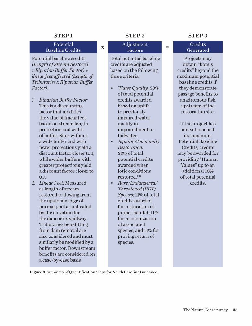
Potential baseline credits (Length of Stream Restored x Riparian Buffer Factor) + linear feet affected (Length of Tributaries x Riparian Buffer Factor): 1. Riparian Buffer Factor:
This is a discounting factor that modifies the value of linear feet based on stream length protection and width of buffer. Sites without a wide buffer and with fewer protections yield a discount factor closer to 1, while wider buffers with greater protections yield a discount factor closer to 0.7.
2. Linear Feet: Measured as length of stream restored to flowing from the upstream edge of normal pool as indicated by the elevation for the dam or its spillway. Tributaries benefitting from dam removal are also considered and must similarly be modified by a buffer factor. Downstream benefits are considered on a case-by-case basis
Total potential baseline credits are adjusted based on the following three criteria: • Water Quality: 33%
of total potential credits awarded based on uplift to previously impaired water quality in impoundment or tailwater.
• Aquatic Community Restoration: 33% of total potential credits awarded when lotic conditions restored.118
• Rare/Endangered/Threatened (RET) Species: 11% of total credits awarded for restoration of proper habitat, 11% for recolonization of associated species, and 11% for proving return of species.
Projects may obtain “bonus
credits” beyond the maximum potential
baseline credits if they demonstrate
passage benefits to anadromous fish upstream of the restoration site.
If the project has not yet reached
its maximum Potential Baseline
Credits, credits may be awarded for providing “Human
Values” up to an additional 10%
of total potential credits.
Potential Baseline Credits
Adjustment Factorsx =
STEP 1 STEP 2 STEP 3Credits
Generated
Figure 3. Summary of Quantification Steps for North Carolina Guidance
36The Nature Conservancy

4.6 CROSS-METHODOLOGY COMPARISON
Below we provide a comparison of key features of the barrier removal crediting methodologies reviewed above (Figure 4). A comparison of how well or accurately these methods assess stream function is beyond the scope of this paper. The comparison does, however, highlight some areas of commonality or areas where they diverge, which warrants consideration. For example, the methods differed in how they quantify the length of stream accruing benefits and in the administrative requirements for site protection. We also found that the mitigation guidelines reviewed treated secondary impacts differently. For example, the New England District and North Carolina reserve the right to consider wetland loss associated with a dam removal as an impact rather than part of a restoration project that yields a net benefit to aquatic resources (see “Environmental impacts from dam removals”). A review of these methods does, however, reveal that intentionally or not, they may incentivize particular types of projects. For example, the New England methodology gives more credit to barriers that are removed from high functioning streams than lower functioning streams. The methods also differ in the degree to which they incentivize projects that provide access to critical upstream habitat reaches, but provide limited functional aquatic improvements at the removal site.
Box 4: Lowell Mill Dam Removal
The North Carolina dam removal crediting guidance sets the standard for assessing the functional benefits of dam removal. Of particular note are the rules that govern performance standards which include the definition of, and monitoring for, success criteria. The Lowell Mill dam was removed and credited under this guidance. Their success criteria were (1) recolonization of rare and protected aquatic species, (2) improved water quality, (3) improved aquatic community and (4) restoration of anadromous fish passage. Through monitoring, they demonstrated success under all criteria including development of habitat for the federally endangered dwarf wedgemussel and Tar spinymussel, improved water quality and restoration of access for American shad to mainstem and tributary reaches upstream of the former impoundment.
Above: American shad
Below: Lowell dam which blocked migratory fish and imposed water quality limitations before removal
37
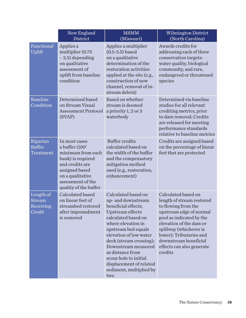
New England District
MSMM (Missouri)
Wilmington District (North Carolina)
Functional Uplift
Applies a multiplier (0.75 – 2.5) depending on qualitative assessment of uplift from baseline condition
Applies a multiplier (0.5-3.5) based on a qualitative determination of the restoration activities applied at the site (e.g., construction of new channel, removal of in-stream debris)
Awards credits for addressing each of three conservation targets: water quality, biological community, and rare, endangered or threatened species
Baseline Condition
Determined based on Stream Visual Assessment Protocol (SVAP)
Based on whether stream is deemed a priority 1, 2 or 3 waterbody
Determined via baseline studies for all relevant crediting metrics, prior to dam removal; Credits are released for meeting performance standards relative to baseline metrics
Riparian Buffer Treatment
In most cases a buffer (100’ minimum from each bank) is required and credits are assigned based on a qualitative assessment of the quality of the buffer
Buffer credits calculated based on the width of the buffer and the compensatory mitigation method used (e.g., restoration, enhancement)
Credits are assigned based on the percentage of linear feet that are protected
Length of Stream Receiving Credit
Calculated based on linear feet of streambed restored after impoundment is removed
Calculated based on up- and downstream beneficial effects; Upstream effects calculated based on where elevation in upstream bed equals elevation of low water deck (stream crossing); Downstream measured as distance from scour hole to initial displacement of related sediment, multiplied by two
Calculated based on length of stream restored to flowing from the upstream edge of normal pool as indicated by the elevation of the dam or spillway (whichever is lower); Tributaries and downstream beneficial effects can also generate credits
38The Nature Conservancy

New England District MSMM (Missouri)
Wilmington District (North Carolina)
Upstream Fish Access
Additional credit awarded for improving fish passage for up to 10 miles or up to the next barrier is reached; The additional stream reach does not have to be placed under easement or other protection instrument
Not explicitly addressed in crediting methodology
Upstream access credited based on an “anadromous fish passage” factor and can include both mainstem and tributaries
Tributary Evalutation Within Impoundment
Credit generated for exposed stream channel that is restored
Credit generated if tributary falls within crediting elevation zone
Perennial or intermittent tributaries within the impoundment are counted toward stream length as part of baseline credit determination
Site Protection Requirement
Except in unusual circumstances, a legally binding real estate protection instrument is required
A legally binding real estate protection instrument is typically required; Additional credit is awarded to sites that give the Corps third party rights of enforcement
Stream segments without protection are eligible for credit; Dam site itself must be protected by a conservation easement; Projects that protect stream segments are awarded additional credit
Secondary Impacts
Potential wetland impacts decided on case-by-case basis and can make projects ineligible
Not explicitly addressed in crediting methodology
Net increases in wetlands can generate mitigation credit, while net decreases trigger compensation requirements
Figure 4. Cross-Methodology Comparison
39

4.7 SUMMARY
Only one of the methodologies outlined above – the Wilmington District Method – seeks to quantify functional uplift through an assessment of the benefits anticipated to accrue to the project area above some baseline condition. The other two methods use proxies based on existing condition and the relative benefits of different restoration methods or anticipated ecological benefits. All the methods reviewed took different approaches to how they quantified the linear feet of stream to which credits are applied, if and how much credit was assigned to buffer restoration and protection, and landscape factors. All the methods reviewed appear easy to implement and seek to support a roughly proportional relationship between impacts and offsets and, to some degree, take into consideration a landscape context (e.g., the stream condition factor of the New England method, the “priority waters” factor in the MSMM, and the adjustment factors used in the North Carolina Guidance). None of the guidance documents we reviewed, however, were transparent about how the methodologies were developed, making it challenging to determine the basis for assigning values to the metrics.
40The Nature Conservancy
Matanuska-Susitna Basin, AK © Bridget Besaw
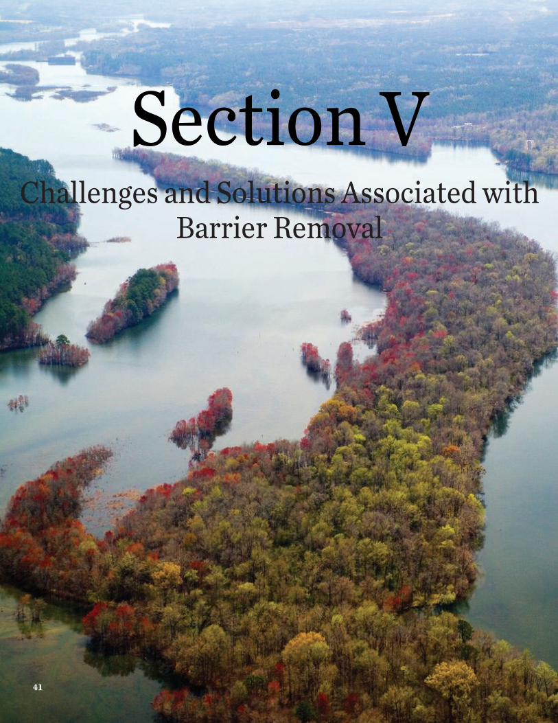
Section VChallenges and Solutions Associated with
Barrier Removal
41

Section VChallenges and Solutions Associated with
Barrier Removal
Figure 5. Existing mitigation banks with available stream credits. Image generated using the Regulatory In-Lieu Fee and Bank Information Tracking System (RIBITS), an online database of mitigation and conservation banking and in-lieu fee programs and projects across the country. See: https://ribits.usace.army.mil/. Data Pulled: August 1, 2017.
5.0 CHALLENGES AND SOLUTIONS ASSOCIATED WITH BARRIER REMOVAL
As discussed above, stream barrier removal projects are viewed as an acceptable method for generating compensatory mitigation credits under the §404 program. The practice has not, however, been widespread to date. Through our research and interviews, we identified several reasons why use of the practice remains rare and challenging. Until adoption of the Corps/EPA Compensatory Mitigation Rule in 2008, not much demand existed for stream mitigation credits in much of the country. The 2008 Rule clarified the agencies’ position that compensation could be required for impacts to streams authorized by §404/§10 permits. After the 2008 rule went into effect, demand for stream credits increased. In response, the number of mitigation banks providing stream mitigation credits in the U.S. has more than doubled since 2008. In 2008, there were 141 mitigation banks in 16 states that provided stream mitigation credits. By 2014, that number had increased by more than 200 percent to 313 banks.119
Although the stream mitigation market is a rapidly growing component of the §404 market, it is worth noting that stream mitigation demand is not evenly distributed across the
42The Nature ConservancySavannah River, GA © Mark Godfrey
country, if the supply of credits is any indication (Figure 5). A 2015 study found that the majority of banks offering stream credits are located in the southeastern and southcentral United States.120
Through interviews with a wide variety of professionals across the country (see section “Methods”), we identified several considerations associated with and challenges to the widespread use of barrier removal projects as a method for generating compensatory mitigation credits. These range from method-based challenges, namely, how to calculate barrier removal credits, to administrative challenges, many of which are unique to barrier removal projects, such as how to secure long-term protection for these sites. Below we discuss several of these considerations and challenges and offer potential solutions.
5.1 DEVELOPMENT OF CREDITING METHODOLOGIES
While many of the mitigation guidance documents issued locally by the Corps, states, and their partners acknowledge barrier removal as a potentially appropriate technique, not all include a methodology for how to estimate credits for such projects. Our research found that the absence of methods for quantifying credits for barrier removal projects presents a significant impediment to such projects becoming more widespread. Without existing, readily available and implementable methodologies, regulators are left having to estimate credits on a case-by-case basis, which can be time consuming and include protracted negotiations with project proponents. Alternatively, the Corps must develop a new crediting methodology in response to proposed projects, which is complicated and can be very time consuming.
The 2008 Corps/EPA rule has a strong preference for the development of functional or condition assessment approaches.121 Robust functional and condition assessment methodologies, however, rely upon the availability of a body of science on the effectiveness restoration techniques. The science of ecological restoration, particularly for riverine habitats, is comparatively young.122 Further, while best practices and commonly accepted metrics are emerging, there still exists a diversity of strongly held opinions about both the goals of stream restoration and the techniques that are most appropriate to restore aquatic ecosystems (see “Ecological Effectiveness of Stream Restoration Practices”).123 As a result, development of methodologies that have the buy-in of a diversity stakeholders has proven challenging, and the process for developing them is complicated and can take years. In addition, the mixed historical success of mitigation projects and the desire to minimize risk and uncertainty, lead ecosystem professionals to develop function and condition assessment tools that are highly and at times overly precise. We refer to this as the “precision trap.” Certainly, there are a wide array of variables that can be measured and methods for measuring variables that are highly precise. Yet, natural resource managers must make decisions about permits and compensatory mitigation projects under time and human resource constraints. The development and use of highly precise and numerous metrics for assessment may neither support efficient decision-making nor decrease the risk of mitigation project under-performance.
43

5.1.1 Potential Solutions
We believe the barrier removal market can best be supported through the development of tools to quantify credits for these projects in 2-3 Army Corps districts, which can then serve as models that can be adapted in other regions of the country. In the development of new barrier removal crediting methodologies, participants should strive to reflect the principles and guidelines outlined above (see Section “Characteristics of Good Methodologies”). Specifically, these resulting methodologies should be:
• Science-based and defensible: As noted elsewhere, the science surrounding stream restoration techniques is sparse (see “Ecological Effectiveness of Stream Restoration Practices”). The challenges posed by the limited availability of science and the complicated nature of developing these tools can, we believe be addressed by the Corps working with its sister agencies and key stakeholders to develop the tools using a stakeholder elicitation process, which we describe in Appendix III. This approach is particularly well suited to supporting to supporting decision-making in the face of complexity and/or information scarcity.124
• Yield a reasonably precise measure of function/condition: We believe that practitioners can avoid the precision trap by selecting a reasonable number of appropriate metrics for measuring ecological function and utilize adjustment factors to account for risk and uncertainty. Although it may be most appropriate to develop methodologies locally, there may be opportunities to adopt a foundational set of metrics that can be used as a starting point on a national level. Appendix IV lays out a potential set of foundational metrics.
• Developed using a transparent method: The developed crediting methods should be made available publicly and should be accompanied by supporting documentation that is transparent as possible about the process and assumptions that were used in their development. This will support future updates to the methodologies as additional findings on stream restoration techniques comes to light.
• Developed with stakeholder input: As outlined in Appendix III, the expert elicitation process can be designed to include knowledgeable experts across a variety of relevant disciplines. Crediting methodologies can also be circulated to a wider audience or the public for input.
• Easy to implement: Crediting methodologies should support efficient decision-making by regulators. Their application should not necessitate the measurement of highly precise and numerous metrics, extensive field work, or input from multiple highly specialized natural resource professionals.
• Support a roughly proportional relationship between impacts and offsets: See discussion below on proportionality.
44The Nature Conservancy
• Take landscape context into consideration: Methodologies should take into consideration landscape considerations to ensure that projects are sited in locations that can contribute to watershed-scale improvements. Over the last ten years, several tools have become available to better understand the ecological value of barrier removal within the landscape context (See Box 1).
5.2 SECURING LONG-TERM PROTECTION
As discussed above (see section “Section 404”), the 2008 Corps/EPA Rule requires that all the resources that constitute the compensatory mitigation project be provided with long-term protection.125 The rule does, however, provide considerable flexibility in how long-term protection is established, stating that long-term protection must be provided “through real estate instruments or other available mechanisms, as appropriate.”126 In practice, the Corps has demonstrated a strong preference for and often requires protection through a conservation easement or, in some cases, a deed restriction. If stream credits are generated through the removal of a barrier, the Corps is likely to require that the riparian area must be protected by, for example, a conservation easement if the riparian areas are deemed essential to ensure the long-term viability of the project that provided functional uplift.127
An inflexible or narrow interpretation of the site protection provisions of the 2008 Corps/EPA Rule has presented a challenge to barrier removal projects in several instances.128 Although these projects primarily entail in-stream work, when areas up- or down-stream from the project site or riparian areas along the stream are awarded credits, the Corps may require that the project sponsor secure easements or deed restrictions on all of these lands. The majority (64 percent) of dams in the National Inventory of Dams are privately owned129 and in many of these cases, the dam owner does not hold the rights to the riparian buffers on either side of the impoundment, the submerged lands, or riparian areas up- or down-stream from the project site. In addition, if credits are allocated for long linear distances or for upstream migratory access, obtaining conservation easements or other rights from multiple landowners can prove to be challenging, time-consuming, impractical, and costly.
5.2.1 Potential Solutions
In practice, the Corps has not allowed projects to generate credits from areas not under a site protection instrument, which has proved challenging for some barrier removal projects. This practice that has evolved out of crediting methodologies that use site protection as a factor in the calculation of credits, rather than any regulatory requirement.130 Although the 2008 Corps/EPA Rule does require long-term protection, it does provide flexibility in how that protection is secured. Although the rule lists protection tools such as conservation easements or deed restrictions as appropriate mechanisms, it does note that other mechanisms may be used, “as appropriate”131 and that real estate or legal instruments may not always be feasible to secure long-term protection.132 The preamble to the rule also recognizes the unique challenges associated with protection for stream projects:
45
For stream compensatory mitigation projects, appropriate means of site protection will be determined by district engineers, after considering the characteristics of the compensation activities and the real estate interests of the project proponent. For example, in-stream rehabilitation measures may not warrant long-term protection.133
In many, but not all cases, barrier removal projects have a higher likelihood of providing sustainable, long-term aquatic resource benefits than other stream restoration techniques, such as stream channel reconfiguration projects, even with conservation easements in place (see “Why Remove Aquatic Resource Barriers”). As such, we believe that regulatory agencies should develop policies and guidelines that encourage these types of restoration activities (see recommendation 2 in “Conclusions and Recommendations”). First and foremost, we recommend that the Corps utilize the flexibility provided in the rule to identify protection mechanisms that are appropriate to barrier removal projects. The purpose of the 2008 Rule’s long-term protection stipulation is to ensure that the conservation objectives of the compensatory mitigation project are not compromised by incompatible uses.134 We suggest that the major threats to reversing the benefits of a barrier removal project would be the construction of new stream barriers, such as dams or poorly constructed stream crossings. Since the Corps itself has control over the construction of such structures through its regulatory authorities, there may be opportunities for the agency itself to strongly discourage the construction of future impoundments in the restored area or ensure compounded mitigation for future impounding activities in the reach. This might be accomplished, for example, through establishment of a Memorandum of Agreement between the Corps and other appropriate parties, such as the local government or transportation agency, regarding future activities at the barrier removal site.135 The Corps’ ability to control the construction of future stream barriers is, for example, the rationale that New England district has relied upon for not requiring preservation in certain culvert replacement situations.
One of the other challenges related to long-term protection is whether the agencies require protection of riparian areas. The Corps may require riparian restoration, enhancement, or protection when it determines that doing so is essential to ensuring the long-term viability of a mitigation project.136 The rule also establishes that credit should only be assigned to these actions when they support ecological gains or protection of ecological functions.137 When the Corps does require the restoration and/or protection of riparian areas, and such areas support ecological gains or protect the benefits provided by barrier removal projects, one should expect the Corps to require that these resources be protected with easements or other tools and that credit be awarded to these resources.138 It is also reasonable to expect that if the ownership regime in the state allows landowners to own submerged lands, that the Corps require protection of the stream bed as well. If, however, mitigation project sponsors are not proposing riparian area protection or restoration (i.e., only in-stream barrier removal) and the Corps does not believe that doing so is necessary for the long-term viability of the project, then mitigation credits should be limited to gains in in-stream functions, such as improvements to in-stream habitat quality for species that inhabit
46The Nature Conservancy

flowing waters. This appears to be the approach taken in the Wilmington District, for example (see “North Carolina Dam Removal Guidance”). In these cases, we recommend that the Corps exert flexibility in how long-term protection of these projects is secured.
5.3 ECONOMIC VIABILITY AND DEMAND
Dam removal projects can be expensive, and unlike many wetland and stream projects, must be carried out at once rather than segmented into smaller projects. In areas where demand for stream mitigation credits is low, these projects become more difficult to fund with mitigation funding alone.
Box 5: Barrier Removal Project Examples and ILF Contributions
Maine• Flanders Stream barrier removal (2010) = $400,000; $50,000 ILF contribution • Jam Black Brook barrier removal (2011) = $243,200; $69,700 ILF contribution • Muscongus Brook barrier removal (2010) = $323,000; $150,000 ILF contribution • Outlet Stream/Masse dam removal (2015) = $462,200; $148,300 ILF contribution• Wallace Shore Road barrier removal (2013) = $125,236; $115,200 ILF contribution
Massachusetts• Off-Billington dam removal (2012) = $1,375,092; $128,000 ILF contribution
New Hampshire • Exeter Great Dam removal (2014) = $611,750; $100,000 ILF contribution • McQuesten Pond dams (2013) = $200,200; $65,400 ILF contribution• McQuesten Brook barrier removals (2015) = $900,000; $100,000 ILF contribution
Box 5. Estimates of barrier removal projects in the Corps’ New England District and funds contributed by in-lieu fee programs. It is important to note that New England is home to a significant number of small, low head dams and other barriers that may be less expensive to remove than larger dams in other regions of the country.
5.3.1 Potential Solutions
One potential solution is to allow stream barrier removal projects to be funded through a variety of funding sources, but limit the generation of credits only to the portion of the project funded by mitigation dollars. For instance, New England district pro-rates credits under such circumstances. Of course, mitigation guidance would need to provide direction on how to ensure that projects funded through multiple sources support the additionality principle (see discussion below).
47

5.4 GENERATION OF LARGE QUANTITIES OF CREDITS
One concern expressed through our interviews was the potential for individual barrier removal projects to generate significant quantities of credits that then flood the stream mitigation credit market with credits generated from a single habitat restoration technique. Corps districts may be reluctant to allow a wide variety of stream impact projects (e.g., fill, dredging, stream relocation, armoring, bulkheading, construction of bridge footings, etc.) over time to meet their mitigation demand through one stream barrier removal project. Districts and other stakeholders may have concerns over this leading to a loss of stream functions not well addressed by barrier removal.
5.4.1 Potential Solutions
One potential solution would be to place limits on permittees for the percentage of stream credits that can be met through barrier removal projects. The North Carolina Guidance, for example, stipulated that dam removal credits could be used for “no more than 75% of the required mitigation” within service area, with a potential exception for projects filling and impounding upstream waters.139 In this instance, the Corps maintained demand for stream mitigation credits generated through other restoration techniques but allowed impacts to utilize barrier removal credits if the impacts themselves created barriers to connectivity. In addition, if a watershed plan (see “Section 404”) has been developed for the area in which a barrier removal project exists and the plan indicates that the most significant threat that service area is stream connectivity, the Corps may be more amenable to allowing the project to offset a wider range of stream impact types.
5.5 PROPORTIONALITY AND APPROPRIATELY ACCOUNTING FOR STREAM LENGTH AFFECTED
Most district and state mitigation guidance documents use a linear foot measure to determine the areal extent of stream affected by compensatory mitigation projects, which is used to calculate how much credit to allocate to projects. Many barrier removal projects, particularly large ones, provide functional uplift to streams at significant distances up- and down- stream from the project site, including up into tributaries of the mainstem. How far upstream into tributaries to consider functional gains has been the source of significant debate. Allocating too many credits, particularly for benefits far upstream from barrier removal sites, it is argued, results in such projects being allocated an inappropriately large number of credits. Some stakeholders have expressed concerns that the practice results in a net loss to aquatic resources and that it is more challenging to guarantee functional gains far upstream and into tributaries.
48The Nature Conservancy

5.5.1 Potential Solutions
It is appropriate to include in credit calculations stream segments at a significant distance from the barrier removal if doing so is justified by the uplift provided by the project. If there is uncertainty over upstream segments or tributaries yielding the intended ecological outcomes, regulators may consider requiring conservative credit release schedules tied to monitoring results. For instance, if mitigation project proponents or the agencies are inclined to allocate credits to tributaries on the assumption that they will provide access to diadromous species after removal of a downstream barrier, the mitigation provider could be required to demonstrate available habitat and species presence before credits are released for tributary reaches. Similarly monitoring would be required for improvement to instream processes or habitat in tributaries. This way, tributaries only generate credits once they have successfully demonstrated the ability to yield functional uplift. This stipulation would ensure that the metrics monitored in the tributaries can be attributed to the dam removal and not to outside influences. In all cases, benefits would stop at the next upstream barrier.
5.6 ENVIRONMENTAL IMPACTS FROM DAM REMOVALS
Another factor complicating many barrier removal projects is the potential for short and long-term environmental impacts from these projects, particularly the potential for the loss of wetland acreage upstream from impoundments, change in habitat type, the release of sediments from behind impoundments, and allowing non-native species to gain access to areas from which they were excluded by the barrier. Dam removal projects may release sediment that has been contained behind impoundments downstream during construction and over time. The sediment may contain toxic chemicals from point- and nonpoint sources. Even “clean” sediment can impact habitat and species by burying habitat or increasing turbidity, although these impacts are recognized as temporary. Leaving a dam in place to manage contaminated sediment is not, however, a sustainable long-term solution, as dams require ongoing maintenance and are at risk of failure. Contaminated sediment trapped behind dams can also be mobilized during regular flow events, a risk that rises as dams age or when they are damaged. Dam removal projects may also include removal of contaminated sediment from the impoundment before the dam structure is removed to reduce adverse effects of dam removal activities. The artificial impoundments formed by barriers also create open water or wetland habitat upstream, which is often lost with barrier removal. In the past, the federal policy regarding no net loss of wetlands presented a challenge for dam removal projects. Since these projects often result in the reduction of wetland acreage above impoundments, at times the Corps required compensation for that lost acreage.
Finally, in some places dams create barriers that limit the spread of non-native invasive species. In the Great Lakes basin, for instance, maintaining barriers between the lakes and the rivers that flow into them is viewed as a potential solution to restricting the movement of non-native lamprey into the rivers. This argument is an important consideration to be
49

evaluated on a site-specific basis taking into account resource management decisions, and not an issue that we will address further in this study.
5.6.1 Potential Solutions
Sediment release during stream barrier removal can be managed to maximize benefits and minimize impacts to habitat and aquatic species. Often reaches downstream of dams and shorelines farther downstream are sediment-starved and prone to erosion from the effects of the dams trapping sediment. Release of sediment can restore habitat downstream. For instance, coarse-grained sediment with low toxicity levels can rebuild sand and cobble bars and macroinvertebrate substrate, and reestablish fish nesting sites previously lost due to a lack of appropriate bed material.140 In cases of contaminated sediment, the sediment is typically removed during the dam removal to prevent its release downstream. Regardless, project proponents are generally required by states through the §401 water quality program to develop a sediment management plan and amend projects to address these issues. In these cases, sediment issues need not be addressed separately as part of mitigation project design.
Recent updates to the Corps’ Nationwide Permit (NWP) program have established that when low-head dams are removed, if the project supports a net benefit increase in stream ecological functions and services, compensatory mitigation for wetland loss above the impoundment will not be required (see Box 6). Nonetheless, not all Corps districts choose to adopt the NWPs. Corps divisions can suspend or revoke one or more NWPs within a state, Corps district, or other geographic region. In these states, questions may remain about whether the loss of wetland acreage from barrier removals should
Box: 6 New Army Corps of Engineers Nationwide Permit for Low-Head Dam Removal
In January 2017, the Corps issued updates to its Nationwide Permits (NWP), including the new NWP for removal of low-head dams, NWP number 53. The permit is available across the nation unless a Corps division engineer suspends or revokes the NWP in a specific region such as a Corps district or a state. NWP 53 applies to low-head dams that are “built across a stream to pass flows from upstream over all, or nearly all, of the width of the dam crest on a continual and uncontrolled basis.” The permit is designed to apply generally to the smaller run of river dams - those most often removed in recent years - rather than those with a larger storage capacity. The permit states that because the removal of low-head dams generally results in a net increase in ecological functions and services, compensatory mitigation is not required unless the project does result in more than minimal adverse environmental effects.
Citation: U.S. Army Corps of Engineers, 2017. “Issuance and Reissuance of Nationwide Permits; Final Rule.” Federal Register. 82(4): 1860-2008.
50The Nature Conservancy
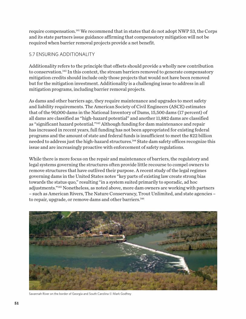
require compensation.141 We recommend that in states that do not adopt NWP 53, the Corps and its state partners issue guidance affirming that compensatory mitigation will not be required when barrier removal projects provide a net benefit.
5.7 ENSURING ADDITIONALITY
Additionality refers to the principle that offsets should provide a wholly new contribution to conservation.142 In this context, the stream barriers removed to generate compensatory mitigation credits should include only those projects that would not have been removed but for the mitigation investment. Additionality is a challenging issue to address in all mitigation programs, including barrier removal projects. As dams and other barriers age, they require maintenance and upgrades to meet safety and liability requirements. The American Society of Civil Engineers (ASCE) estimates that of the 90,000 dams in the National Inventory of Dams, 15,500 dams (17 percent) of all dams are classified as “high-hazard potential” and another 11,882 dams are classified as “significant hazard potential.”143 Although funding for dam maintenance and repair has increased in recent years, full funding has not been appropriated for existing federal programs and the amount of state and federal funds is insufficient to meet the $22 billion needed to address just the high-hazard structures.144 State dam safety offices recognize this issue and are increasingly proactive with enforcement of safety regulations. While there is more focus on the repair and maintenance of barriers, the regulatory and legal systems governing the structures often provide little recourse to compel owners to remove structures that have outlived their purpose. A recent study of the legal regimes governing dams in the United States notes “key parts of existing law create strong bias towards the status quo,” resulting “in a system suited primarily to sporadic, ad hoc adjustments.”145 Nonetheless, as noted above, more dam owners are working with partners – such as American Rivers, The Nature Conservancy, Trout Unlimited, and state agencies – to repair, upgrade, or remove dams and other barriers.146
51
Savannah River on the border of Georgia and South Carolina © Mark Godfrey
Increased (albeit insufficient) funding for dam maintenance and repair, increased state enforcement, and increased collaboration with private conservation organizations, have led some regulators to conclude that the removal of non-compliant structures do not provide additional conservation benefit. Our interviews found some agency staff that suggested that the owners of these structures would have removed them without the contribution of mitigation dollars and that the projects are therefore not eligible for mitigation credits.147
5.7.1 Potential Solutions
We agree that dams that are removed due to a specific removal order in most cases should not be eligible to receive mitigation credits. North Carolina’s rescinded guidance, for example, stipulated that dams that were already required to be removed by the North Carolina Division of Land Quality’s Dam Safety Program or any other state or federal agency would not be eligible for consideration as a compensatory mitigation project. Dam owners that are under an order to maintain or repair non-compliant structures, but choose rather to remove these structures should, we believe, be eligible to receive mitigation credits. Culvert removal and upgrade projects present a similar set of challenges. Many state and federal regulations already require non-compliant culverts to be upgraded when replaced.148 Enforcement of such provisions is highly inconsistent, however, particularly for older culverts that are already in place. While it seems clear cut that the removal of a non-compliant culvert and retirement of road crossings would be eligible for credits, it is less clear when it would be appropriate to allow culvert upgrades to generate mitigation credits, particularly when the owner is under an obligation to make repairs for public safety. We recommend that Corps districts and states incorporate into their local mitigation guidance documents guidelines on the circumstances under which it is appropriate for dam removal, culvert upgrades, and culvert replacement projects to generate compensatory mitigation credits. Agency guidance could, for example, state that such projects must give the agencies a “high level of confidence” that the compensatory mitigation measures are additional by demonstrating that the project under consideration is not one likely to be removed in a reasonable timeframe, such as 10 years.
5.8 DEFINITION OF BARRIER REMOVAL
Barrier removal projects are generally defined as those that eliminate an in-stream barrier, typically dams and culverts. Initially this may seem straightforward, however not all projects are created equal. In some states, regulated dams can meet compliance standards by removing only some portion of the structure. Although removing a portion of an in-stream barrier may be sufficient to meet safety standards and increase flows, such projects may fail to address habitat restoration goals. For example, if the full vertical and horizontal extent of a dam is not removed, river flow can be restricted leaving an upstream impoundment or creating a hydraulic barrier to species movement or high flows that scour downstream habitat. Over time the river may scour around any remaining structure and
52The Nature Conservancy
create a new barrier, thus reversing any gain and long-term benefit. Failing to clearly define what constitutes an adequate barrier removal project can cause confusion and lack of clarity in project design.
5.8.1 Proposed Solution
We recommend that regulatory agencies include in mitigation guidance a clear definition for barrier removal based on ecological principles separate from any state dam safety thresholds or road and highway standards. To be eligible for mitigation credits, we suggest that agencies require that the full vertical extent of the dam is removed regardless of adjacent structural issues or in-stream bed erosion concerns. Horizontal abutments should be removed to at least the lateral extent within the channel and banks. Similarly, for culvert upgrades to be considered for mitigation, the structures must meet a set of aquatic organism passage standards.
53

54The Nature Conservancy
Top: Fielder Dam Before © Scott Wright, River Design GroupBottom: Fielder Dam After © Scott Wright, River Design Group
Section VIConclusions and Recommendations
55
6.0 CONCLUSIONS AND RECOMMENDATIONS
There are as many as two million small stream barriers in the United States, including dams, poorly designed culverts, and stream crossings.149 These barriers create obstructions to fish passage and sediment transport and can have significant effects on stream ecology and species.150 In recent years, there has been a growing recognition of the environmental and economic benefits that can come from removing stream barriers.151 We offer the following recommendations for expanding demand for stream barrier removal projects through existing mitigation programs:
1. Develop the §404 market for barrier removal projects
Several existing federal mitigation programs may be able to drive a market for stream restoration credits generated from barrier removal projects. We conclude that the most promising of these is the federal wetland and stream mitigation program under §404 of the Clean Water Act. Several such projects have been undertaken and Army Corps offices support barrier removal as a mitigation practice.152 We recommend that the Corps, EPA, states and other interested parties seek opportunities to develop this market. Below we offer additional recommendations for how to do so. Several additional programs, in particular the Endangered Species Act, the hydropower licensing program, and the Clean Water Act §401 program, also hold great promise for stimulating demand for barrier removal. Barrier removal as a mitigation practice would be better supported under these provisions through the following actions. However, we recommend further exploration of these programs and identification of additional obstacles and solutions to stimulating these markets.
• Endangered Species Act: Development by U.S. Fish and Wildlife Service and National Marine Fisheries Service of mitigation guidance for specific species recognizing barrier removal as an appropriate mitigation measure and outlining methods for how credits will be calculated for such projects.
• Dam licensing: Development of science-based tools and guidance on how to quantify the impacts of dam operation and develop appropriate compensatory mitigation measures that yield functional gains that are similar in nature and roughly proportional to the impacts.
• Clean Water Act §401: State water quality programs could utilize their §401 authorities more frequently to require barrier removal as a condition of a variety of federal licenses and permits, including federal hydropower licenses.
56The Nature ConservancyPotomac River, WV © Kent Mason
2. Develop crediting methodologies to support barrier removal using an expert elicitation process
We reviewed a number of barriers to widespread adoption of barrier removal projects under §404. These include: the absence of widely accepted methods for measuring uplift and defining credits; securing long-term protection of sites; making barrier removal projects economically viable in low credit demand markets; the tendency of projects to generate large quantities of credits using a very specific restoration method; appropriately accounting for stream length affected; addressing environmental impacts; ensuring that projects are additional; and defining barrier removal. We believe that the most significant obstacle to more widespread use of the practice in the §404 stream mitigation market is the absence of methods for quantifying credits for barrier removal projects. We recommend addressing this issue by undertaking the development of new methodologies in 2-3 Army Corps districts, in partnership with appropriate stakeholders. We recommend that the new methods be developed utilizing an expert elicitation process (see Appendix III) and rely upon of a reasonable number of functional metrics and risk management adjustment factors as a starting point (see Appendix IV). This approach can support the development of quantification tools for barrier removal projects that incorporate key stakeholders, are informed by experts, science-based, defensible, transparent, easy to implement, and support an appropriately proportional relationship between permitted impacts and offsets using a reasonable number of metrics that do not require precise measurement (see “Characteristics of Good Methodologies”).
We believe that the other identified challenges should be addressed through the development by the Corps of guidance at the national or district level, as appropriate, to clarify how these challenges will be addressed. Creating predictability on these issues will, we firmly believe, create needed predictability on these issues will, we firmly believe, create needed predictability for mitigation providers and stimulate the supply of mitigation credits from barrier removal projects.
3. Improve the selection of high priority barrier removal projects utilizing existing landscape assessment tools
One recognized characteristic of a good mitigation is to take a landscape scale context into consideration. Many states and regions have catalogued barriers to aquatic connectivity and others have prioritized those projects that, if carried out, would maximize ecological outcomes based on their landscape context (see Box 1). We recommend that in those regions where such data and tools exist, these resources are utilized to identify appropriate projects and opportunities to optimize combinations of barrier removals.
57

We believe that the Clean Water Act §404 and other existing mitigation programs hold much promise in stimulating a market for barrier removal projects and directing compensatory mitigation dollars to projects that are durable, sustainable, and greatly enhance stream ecosystems. While there are few policy impediments to expanding the practice through mitigation markets, there are challenges presented by a small number of technical issues and the scarcity of examples to build from. Our hope is that this paper helps to jumpstart the discussion on utilizing mitigation programs to drive barrier removal projects and sets us on a path to more widespread adoption of the approach.
58The Nature Conservancy

Section VIIAppendices
59
APPENDIX I: DEFINITIONS
Additionality: “conservation benefits of a compensatory mitigation measure that improve upon the baseline conditions of the impacted resources and their values, services, and functions in a manner that is demonstrably new and would not have occurred without the compensatory mitigation measure” (FWS ESA CMP (2016), Appendix B).
Buffer: “an upland, wetland, and/or riparian area that protects and/or enhances aquatic resource functions associated with wetlands, rivers, streams, lakes, marine, and estuarine systems from disturbances associated with adjacent land uses” (Corps/EPA Rule (2008), §332.2).
Credit: “A unit of measure (e.g., a functional or areal measure or other suitable metric) representing the accrual or attainment of aquatic functions at a compensatory mitigation site. The measure of aquatic functions is based on the resources restored, established, enhanced, or preserved” (Corps/EPA Rule (2008), §332.2).
Debit: “A unit of measure (e.g., a functional or areal measure or other suitable metric) representing the loss of aquatic functions at an impact or project site. The measure of aquatic functions is based on the resources impacted by the authorized activity” (Corps/EPA Rule (2008), §332.2).
Expert: An individual that has substantive knowledge on a subject and the ability to accurately and clearly communicate judgements (e.g. probabilities). The individual should be conventionally considered to have specialized knowledge not available to all, developed through training and experience (Groves and Game 2015).
Performance standard: observable or measurable physical (including hydrological), chemical and/or biological attributes that are used to determine if a compensatory mitigation project meets its objectives” (Corps/EPA Rule (2008), §332.2).
Riparian areas: lands adjacent to streams, rivers, lakes, and estuarine-marine shorelines. Riparian areas provide a variety of ecological functions and services and help improve or maintain local water quality (Corps/EPA Rule (2008), §332.2).
60The Nature ConservancyShasta River, CA © Avi Hesterman

61

APPENDIX II: EXAMPLES OF BARRIER REMOVAL PROJECTS
The table below lists barrier removal projects that have been awarded credit under Section 404. It was compiled with input from the U.S. Environmental Protection Agency and American Rivers.
Project Name State Dam or Barrier Removal
EPA Region 11. Blackledge Falls Dam CT Dam2. Gravesleigh Pond Dam, Sackett Brook (Pittsfield, MA) MA Dam3. May Brook Dam, May Brook (Windsor, MA) MA Dam4. Town Brook – Billington MA Dam5. Upper Hathaway Dam, Hathaway Brook (Dalton, MA) MA Dam6. Windsor Reservoir Dam MA Dam7. Flanders Stream ME Barrier8. Jam Black Brook ME Barrier9. Mill Pond Tidal Restoration (Arrowsic, ME) ME Barrier10. Lower Montsweag Brook Dam (Wiscasset, ME) ME Dam11. Muscongus Brook ME Barrier12. Outlet Stream/Masse ME Dam13. Sherman Lake Dam, Marsh River (Newcastle, ME) ME Dam14. Wallace Shore Road ME Barrier15. Champlin Pond Dams #1 and #2, Clark Brook
(Rochester, NH)NH Dams
16. Exeter Great NH Dam17. McQuesten Pond NH Dam18. McQuesten Brook NH Barrier19. Stevens Brook Dam, Stevens Brook (Claremont, NH) NH Dam
EPA Region 220. Paris Dam, Sauquoit Creek NY Dam
EPA Region 321. Beaver Creek (Hagerstown, MD) MD Dam22. Bigby Run Dam, Bigby Creek PA Dam23. Black Rock Creek (Hagerstown, MD) MD Dam24. Mixel Dam, Doubling Gap Creek (Newville, PA) PA Dam25. Trafford Dam, Turtle Creek (Trafford Borough, PA) PA Dam
62The Nature Conservancy

26. Nicodemus Dam, tributary to West Branch Antietam Creek
PA Dam
27. Norristown Farm Park Dam, Stony Creek PA Dam28. Siebert Dam, Miller Run (Somerset County, PA) PA Dam29. Tonoloway Creek (Hancock, MD) MD Dam30. Rock Creek Ford #1 and #2, Rock Creek (Washington,
DC)DC Fords/Dams
EPA Region 431. Carbonton Dam, Deep River (Carbonton, NC) NC Dam32. Lowell Mill Dam, Neuse River (Kenly, NC) NC Dam33. Milburnie Dam, Neuse River (Wake County, NC) NC Dam34. Unnamed Dam, Marks Creek NC Dam
EPA Region 535. Panhandle Road Dam, Olentangy River (Troy
Township, OH)OH Dam
36. St. John’s Dam Pooled Stream Mitigation Area, Sandusky River
OH Dam
EPA Region 6 (no approved projects identified)EPA Region 7
37. Little Niangua Bank MO Dam38. Maries River Sestak Slab Mitigation Bank MO Barrier
EPA Region 8 (no information provided)EPA Region 9 (no approved projects identified)EPA Region 10 (no approved projects identified)
63
APPENDIX III: EXPERT ELICITATION - A SCIENTIFIC PROCESS FOR DEVELOPMENT OF CREDITING METHODOLOGIES
Even with imprecise and incomplete information on habitat function, quantification tools can be developed efficiently, reflect the best available scientific uncertainties, and steer decision-makers away from the “precision trap.” One demonstrated approach, which has a strong foundation in existing conservation decision-making science, is the expert elicitation process. As opposed to direct empirical observation, or model-driven extrapolation from empirical evidence, expert opinions rely on judgments elicited directly from individuals with specialist knowledge gained through unique training or experience.153 An approach to problem solving that relies on expert opinion is particularly relevant for applied conservation situations, where:
1. A body of knowledge is available to be integrated, but a singular empirical synthesis of a field is unavailable;
2. Direct empirical evidence is unavailable within allotted resource/time constraints; and/or
3. The skills required to evaluate direct empirical data, or create model extrapolations, are not present.
The expert elicitation approach allows decision-makers to address urgent conservation problems in the face of complexity and/or information scarcity.154 It provides a structured, step-wise process to utilize the published and unpublished knowledge of experts.155 The approach generally entails five central steps:156
1. Determine the intended purpose for the elicited judgements. The use case of the judgments will determine what type of information is necessary to collect, and the manner in which it should be collected.
2. Determine the key variables about which information to elicit. Elicitation should reveal both general knowledge surrounding these parameters, as well as uncertainty levels of the parameters.
3. Design the elicitation process. This entails determining the elicitation format and the roles of the elicitation team. The process should be structured to minimize sources of bias (e.g., overconfidence, anchoring, and dominance157) as well as maximize accuracy, utility, and transparency.
4. Perform the elicitation per the protocol established in Step 3.5. Encode the elicited information into quantitative statements that can be used for
your intended purpose as determined in Step 1.6. Documentation of the process, methods (including experts) and results.
Proposed SolutionThere are several ways to run an elicitation process (Step 3 above), each of which has its own strengths and weaknesses. Applications to ecological systems frequently employs the Delphi method, which seeks to address expert and group biases through eliciting a series of judgments anonymously with periods in-between for group reflection and discussion.158
64The Nature Conservancy

Originally designed by the RAND Corporation in 1948, the Delphi approach is a well-established method used to address a complex problem in the absence of ample science-based information by engaging a group of experts, gathering and evaluating their opinions, and do so collectively.159
It is used today in disciplines ranging from conservation decision-making, medicine, and social policy.160 Delphi uses an iterative process to define the problem, promote discussion, structure feedback, and report conclusions in a structured manner that makes clear participants’ perception of risks and uncertainties.161 The Delphi approach is often modified to address specific management situations.
The Delphi approach has been applied in the conservation context in a variety of situations, including identification of potential management strategies for whooping cranes,162 determining carrying capacity of the threatened Northern Spotted Owl, evaluating the impacts of European Union forest certification principles, and determining indicators for assessing vegetation condition in Australia.163 A modified Delphi approach has also been used to identify appropriate compensatory mitigation approaches and measures for offsetting impacts to golden eagles despite uncertainty due to lack of established mitigation methods for the species.164
Table 2. Modified Delphi approach used to identify compensatory mitigation methods and measures for offsetting impacts to golden eagles.165 This approach could guide development of crediting methodologies for barrier removal projects.
Generalized Steps for the Modified Delphi ApproachDetermine Intended Purpose
• Outline intended outcome: To create a framework that quantifies mitigation gains for golden eagle population in the state of Wyoming to compensate for wind development impacts as stipulated by the Bald and Golden Eagle Protection Act of 1940.
• Identify method for reaching intended outcome: Evaluated different abatement methods such as power pole retrofitting, increasing eagle prey abundance, and reducing blood lead levels to improve golden eagle survival. Chose to focus on lead poisoning abatement through avoided ingestion of spent game hunting ammunition due to (1) abundance of anthropogenic evidence of eagle mortality, (2) available methods of encouraging abatement methods, and (3) pool of potential actors to implement abatement methods.
Determine the Key Variables
• Expert selection: Invited a small group of knowledgeable experts across a wide variety of disciplines including eagle ecology, raptor lead poisoning, quantitative skills, regulatory requirements, and field conditions. Members of this group helped both to define the preliminary conceptual model, as well as later on were involved with finalizing the specific parameters as part of the formal elicitation process.
• Preliminary development of conceptual model including estimation of parameter values to use in prototype simulations.
• In-depth literature review prepared on eagles and lead poisoning to share with experts as background information.
• Determined variables requiring specific expert input due to lack of empirical data. These were determined to include: (1) average expected number of gut piles scavenged per eagle, (2) blood lead level increase per scavenge, and (3) mortality per maximum blood lead level.
65

Design the Elicitation Process
• Determined elicitation method by selecting the Speirs-Bridge four-point method for encoding expert judgments.166
• Determined elicitation process by selecting modified Delphi approach. This process entailed preceding elicitations with review and clarification of purpose,167 definitions, context and relevant information for predictions at hand. Responses were then elicited from the experts, followed by tightly facilitated group discussions. Elicitations were decided to be completed with a mixture of in-person and remote iterations.
Perform Elicitation
• Created deterministic spreadsheet model followed by expert review and discussion. • Created stochastic spreadsheet model prototype followed with expert review and
discussion.• Iterations to continue, ideally until experts are satisfied that the elicited values
represented the best available beliefs about the defined relationships. Given the challenge of satisfying across experts, the process may have two iterations, following by some formal approach to consensus.
Encode the Elicited Information
• Model revision, expansion and coding into MatLab.• Formal elicitation of expert judgments for parameter values.• Prototype simulations and sensitivity analysis followed by expert review and
discussion.• Repeated formal elicitation to update parameter values.• Final model runs and sensitivity analysis completed.• Final review.
The expert elicitation approach could be utilized to develop debiting and crediting methodologies and would likely need to be applied at four distinct stages of the tool development:
1. Identification of metrics (what to measure) to measure functional loss and gain (see also “Appendix IV” for possible metrics to consider);
2. Develop an estimated valuation for the metrics where data from empirical research is limited or absent;
3. Identify metrics (what to measure) to address administrative and/or policy goals;4. Provide quantitative estimates for the metrics for administrative and/or policy goals.
Although steps 1 and 3 could be developed nationally and tailored locally, steps 2 and 4 would most likely need to be developed with more local expert input. Alternatively, all four steps could be undertaken at the local level. In addition, the results from each step may benefit a comprehensive peer-review process. Based on the success of this approach in several conservation case studies, we believe this could be an efficient path for the Corps and other key stakeholders to develop crediting methodologies for barrier removal projects that reflect the best available science, are straight-forward and simple to implement, and do not bog down decision-makers in an expensive and time-consuming process.
66The Nature Conservancy

67

APPENDIX IV: QUANTIFICATION TOOLS: FOUNDATIONAL METRICS
We suggest that a small set of foundational metrics can serve as a starting point for further refinement at either a national or local level and can reasonably capture measurements of change to ecological function from stream-barrier removal projects. The quantitative measures assigned to these metrics should be adjusted to account for policy or management preferences and regional ecological differences. Adoption of a quantification tool with nation-wide applicability may not be either possible or desirable. Regional differences may be necessary to capture the variety of distribution, rarity, etc. of ecosystems and habitats across the country. It may, however, be possible to create a base system that can be tailored to address relatively minor regional differences.168
The foundational metrics should account for changes to river habitat and river processes and include: hydrology, hydraulics, geomorphology (material transport and deposition), physiochemical condition and processes, and biological pathways (trophic structures and landscape pathways).169 Many of the existing crediting methodologies capture these elements or more nuanced aspects of these elements (Table 3). It is noted that, depending on the baseline condition and the characteristics of the barrier being removed, not all functional categories or metrics would be applicable.
68The Nature Conservancy

Functional Category Change Metrics for Barrier RemovalHydrology. The pattern and distribution of stream discharge (volume/time) seasonally and inter-annually through the active river area.
• Flow regime – applicable to larger barriers, river length of hydrologic impairment restored170
Hydraulics. The mechanical properties of water moving through the channel.
• Hydraulics – area of lotic conditions restored which could be measured by depth and velocity profiles or physical habitat (a, b)
Geomorphology. Transport sediment and material to create diverse bed forms and dynamic equilibrium
• Bed form diversity , bed material characterization (grain size distribution) – area of channel with bed form processes restored (b, c)
• Downstream material transport – applicable to larger barriers, river length of material transport restored171
Physiochemical. Temperature and oxygen regulation; processing of organic matter and nutrients
• Improvement to previously impaired waterbody – length of impounded river and/or tailwater influence which may be determined by temperature and/or dissolved oxygen measurements (a)
Biology. Biodiversity and the life histories of aquatic and riparian life
• Longitudinal connectivity – river miles of connected habitat restored specific to a taxa group or species of focus (a, b, d)
• Lateral connectivity (riparian and floodplain) – area of re-connected riparian and floodplain in native cover (b)
• Invasive species – devaluing any barrier removal that results in the spread of invasive species
Table 3. Foundational metrics to estimate functional change from stream-barrier removal synthesized from the (a) North Carolina; (b) New England; (c) MSMM; and (d) Iowa methods and peer reviewed literature.
Adapted from: Harman, W., R. Starr, M. Carter, K. Tweedy, M. Clemmons, K. Suggs, C. Miller. 2012. “A Function-Based Framework for Stream Assessment and Restoration Projects.” U.S. Environmental Protection Agency, Office of Wetlands, Oceans and Watersheds: Washington, D.C. EPA 843-K-12-006.
69

70The Nature Conservancy
ENDNOTES
1 Bednarek, Angela T. 2005. “Undamming rivers: a review of the ecological impacts of dam removal.” Environmental Management. 27(6): 803-814; Doyle, Martin W., Emily H. Stanley, Cailin H. Orr, Andrew R. Selle, Suresh A. Sethi, and Jon M. Harbor. 2005. “Stream ecosystem response to small dam removal: Lessons from the Heartland.” Geomorphology. 71(1-2): 227-244.2 Poff, N. Leroy and David D. Hart. 2002. “How Dams Vary and Why It Matters for the Emerging Science of Dam Removal.” Bioscience. 7(52):659-668. 3 U.S. Army Corps of Engineers. 2008. “National Inventory of Dams: Methodology - State and Federal Agency Manual Version 4.0.” See: http://www.damsafety.org/media/Documents/STATE_INFO/STATE_DATA_CALL/NID_MethodologyManual.pdf. Last visited June 8, 2017.4 Owen, Dave and Colin Apse. 2015. “Trading Dams.” U.C. Davis Law Review. 48(3): 1043-1109; Tschantz, B.A. and K.R. Wright. 2011. “Hidden dangers and public safety at low-head dams.” Journal of Dam Safety. 9:8-17; Poff and (2002). A 1992 estimate places the total number of dams around 2.5 million: National Research Council. 1992. Restoration of Aquatic Ecosystems: Science, Technology, and Public Policy. Committee on Restoration of Aquatic Ecosystems: Science, Technology, and Public Policy. National Academy Press: Washington, DC. p. 26.5 Poff and Hart (2002); American Rivers, Friends of the Earth, Trout Unlimited. 1999. Dam Removal Success Stories: Restoring Rivers through Selective Removal of Dams That Don’t Make Sense. Washington, D.C.6 U.S. Army Corps of Engineers. National Inventory of Dams. http://nid.usace.army.mil/cm_apex/f?p=838:12 Last visited March 14, 2017.7 Lawson, Megan. 2016. Dam Removal: Case Studies on the Fiscal, Economic, Social, and Environmental Benefits of Dam Removal. Headwaters Economics. https://headwaterseconomics.org/wp-content/uploads/Report-Dam-Removal-Case-Studies.pdf.8 Lovett, Richard A. 2014. “Rivers on the run.” Nature. 511: 521-523.9 American Society of Civil Engineers (ASCE). 2017. 2017 Infrastructure Report Card: Dams. http://www.infrastructurereportcard.org/wp-content/uploads/2017/01/Dams-Final.pdf. Last visited March 17, 2017.10 Poff, N. LeRoy, J. David Allan, Mark B. Bain, James R. Karr, Karen L. Prestegaard, Brian D. Richter, Richard E. Sparks and Julie C. Stromberg. 1997. “The natural flow regime.” BioScience. 47(11): 769-784; Ward, J. “Riverine landscapes: Biodiversity patterns, disturbance regimes, and aquatic conservation.” Biological conservation 83.3 (1998): 269-278; Bunn, Stuart E. and Angela H. Arthington. 2002. “Basic principles and ecological consequences of altered flow regimes for aquatic biodiversity.” Environmental Management. 30(4): 492-507; Vörösmarty, Charles, Michel Meybeck, Balázs Fekete, Keshav Sharma, Pamela Green, and James P.M Syvitski. 2003. “Anthropogenic sediment retention: major global impact from registered river impoundments.” Global and Planetary Change. 39(1-2): 169–190; Olden, Julian D. and Robert J Naiman. 2010. “Incorporating thermal regimes into environmental flows assessments: modifying dam operations to restore freshwater ecosystem integrity.” Freshwater Biology. 55(1): 86–107.
71
11 Drinkwater, Kenneth F. and Kenneth T. Frank. 1994. “Effects of river regulation and diversion on marine fish and invertebrates.” Aquatic Conservation. 4(2): 135–151; Staggs, M., J. Lyons and K. Visser. 1995. “Habitat restoration following dam removal on the Milwaukee River at West Bend.” Wisconsin’s Biodiversity as a Management Issue: A Report to Department of Natural Resource Managers. Wisconsin Department of Natural Resources. pp. 202-203; Stanford, Jack A., J. V. Ward, William J. Liss, Christopher A. Frissell, Richard N. Williams, James A. Lichatowich, Charles C. Coutant. 1996. “A General Protocol for Restoration of Regulated Rivers.” River Research and Applications. 12 (4-5): 391–413.12 Travnichek, Vincent H. and Michael J. Maceina. 1994. “Comparison of Flow Regulation Effects on Fish Assemblages in Shallow and Deep Water Habitats in the Tallapoosa River, Alabama.” Journal of Freshwater Ecology. 9(3); Freeman, Mary, Zachary Bowen, Ken Bovee, and Elise Irwin. 2001. “Flow and habitat effects on juvenile fish abundance in natural and altered flow regimes.” Ecological Applications 11(1): 179-190; Vörösmarty, C. J., P. B. McIntyre, M. O. Gessner, D. Dudgeon, A. Prusevich, P. Green, S. Glidden, S. E. Bunn, C. A. Sullivan, C. Reidy Liermann, and P. M. Davies. 2010. “Global threats to human water security and river biodiversity.” Nature. 467: 555-561.13 Neves, R.J., A.E. Bogan, J.D. Williams S.A. Ahlstedt and P.W. Hartfield. 1997. “Status of aquatic mollusks in the southeastern United States: a downward spiral of diversity.” Aquatic Fauna in Peril: The Southeastern Perspective. Special Publication. 1: 44-86; Freeman, Mary C. 2005. “Status and conservation of the fish fauna of the Alabama River system.” American Fisheries Society Symposium. Vol. 45. American Fisheries Society.14 Petts, Geoffrey E. 1984. Impounded Rivers: Perspectives for Ecological Management. John Wiley: Chichester, UK.15 Rowland, J. 2016. Aging Dams and Clogged Rivers: An Infrastructure Plan for America’s Waterways. Center for American Progress; U.S. Environmental Protection Agency. “Frequently Asked Questions on Removal of Obsolete Dams.” EPA-840-F-16-001.16 Bernhardt, E.S., M. A. Palmer, J. D. Allan, G. Alexander, K. Barnas, S. Brooks, J. Carr, S. Clayton, C. Dahm, J. Follstad-Shah, et al. 2005. “Synthesizing U.S. River Restoration Efforts.” Science. 308: 636–637.17 Ibid.18 Ibid.19 Palmer, M.A. 2009. “Reforming watershed restoration: Science in need of application and applications in need of science.” Estuaries and Coasts. 32: 1; Wohl, E., P. L. Angermeier, B. Bledsoe, G. M. Kondolf, L. MacDonnell, D. M. Merritt, M. A. Palmer, N. L. Poff, and D. Tarboton. 2005. “River Restoration.” Water Resources Research. 41: 10; Palmer, M.A., H.L. Menninger, and E. Bernhardt. 2010. “River restoration, habitat heterogeneity and biodiversity: a failure of theory or practice?” Freshwater Biology. 55: 205–222; Doyle, M.W. and F. Douglass Shields. 2012. “Compensatory Mitigation for Streams Under the Clean Water Act: Reassessing Science and Redirecting Policy.” Journal of the American Water Resources Association. 48: 3.20 Harmon W. and M. Carter. 2016. A Function-Based Review of Stream Restoration Science. Environmental Law Institute: Washington, D.C. https://www.eli.org/sites/default/files/docs/research/schools/stream_mitigation_science_paper_2mar16.pdf.
72The Nature Conservancy

21 Thomas-Blate, Jessie. February 2017. Celebrating a Great Year for Dam Removal in 2016. American Rivers. https://www.americanrivers.org/2017/02/celebrating-great-year-dam-removal-2016/. 22 Stanley, Emily H. and W. Martin Doyle. 2003. “Trading Off: The Ecological Effects of Dam Removal.” Frontiers in Ecology and the Environment. 1(1): 15–22.23 Doyle, M. W. and Douglas Shields, F. 2012. “Compensatory Mitigation for Streams Under the Clean Water Act: Reassessing Science and Redirecting Policy.” Journal of the American Water Resources Association. 48(3): 494–509; Beasley, Chris A. and Joseph E. Hightower. 2000. “Effects of a Low-Head Dam on the Distribution and Characteristics of Spawning Habitat Used by Striped Bass and American Shad.” Transactions of The American Fisheries Society. 129(6): 1316-1330; Burdick, Summer M. and Joseph E. Hightower. 2006. “Distribution of Spawning Activity by Anadromous Fishes in an Atlantic Slope Drainage after Removal of a Low-Head Dam.” Transactions of The American Fisheries Society. 135(5): 1290-1300; Catalano, Matthew J., Michael A. Bozek, and Thomas D. Pellett. 2007. “Effects of dam removal on fish assemblage structure and spatial distributions in the Baraboo River, Wisconsin.” North American Journal of Fisheries Management. 27(2): 519-530; Kanehl P.D., J. Lyons, and J.E. Nelson. 1997. “Changes in the habitat and fish community of the Milwaukee river, Wisconsin, following removal of the Woolen Mills Dam.” North American Journal of Fisheries Management. 17: 387–398; Doyle, Martin W., Emily H. Stanley, Cailin H. Orr, Andrew R. Selle, Suresh A. Sethi, and Jon M. Harbor. 2005. “Stream ecosystem response to small dam removal: lessons from the Heartland.” Geomorphology. 71(1-2): 227-244.24 Bednarek, Angela. 2001. “Undamming Rivers: A Review of the Ecological Impacts of Dam Removal.” Environmental Management. 27(6): 803–814.25 Bellmore, J.R., K. M. Vittum, J.J. Duda, and Samantha Greene. 2015. “USGS Dam Removal Science Database (ver. 1.3, July 2015).” https://doi.org/10.5066/F7K935KT. Last visited June 19, 2017; Bellmore, J.R., J.J. Duda, L.S. Craig, S. L. Green, C.E. Torgersen, M. J. Collins, and K. M. Vittum. 2016. “Status and Trends of dam removal research in the US: WIREs Water.” http://doi.org/10.1002/wat2.1164. Last visited June 19, 2017; Duda, J.J., D.J. Wieferich, R.S. Bristol, J.R. Bellmore, V.B. Hutchinson, K. M. Vittum, L. Craig, and J.A. Warrick. 2016. “Dam Removal Information Portal (DRIP) – A map-based resource linking scientific studies and associated geospatial information about dam removals.” U.S. Geological Survey Open File Report 2016-1132, 14p.26 Beechie, Timothy J., David A. Sear, Julian D. Olden, George R. Pess, John M. Buffington, Hamish Moir, Philip Roni, and Michael M. Pollock. 2010. “Process-Based Principles for Restoring River Ecosystems.” BioScience. 60(3):209-222.27 Beechie, Timothy J., David A. Sear, Julian D. Olden, George R. Pess, John M. Buffington, Hamish Moir, Philip Roni, and Michael M. Pollock. 2015. “Process-based Principles for Restoring River Ecosystems.” BioScience. 60: 209-222.28 Beechie, et al. (2010).29 Magilligan, F.J., B.E. Graber, K. H. Nislow, J.W. Chipman, C.S. Sneddon, and C.A. Fox. 2016. “River restoration by dam removal- Enhancing connectivity at watershed scales.” Elementa. Vol. 4.30 Owen and Apse (2015).
73
31 Chesapeake Fish Passage Prioritization. http://maps.tnc.org/EROF_ChesapeakeFPP/. Last visited May 31, 2017; Conservation Gateway: Stream Connectivity. https://www.conservationgateway.org/ConservationByGeography/NorthAmerica/UnitedStates/edc/reportsdata/freshwater/stream/Pages/default.aspx. Last visited May 31, 2017.32 McGarigal K., B.W. Compton, E.B. Plunkett, W.V. Deluca, and J. Grand. 2017. “Designingsustainable landscapes: critical local linkages.” Report to the North Atlantic ConservationCooperative. U.S. Fish and Wildlife Service, Northeast Region. See also: North Atlantic Aquatic Connectivity Collaborative. https://streamcontinuity.org/index.htm. Last visited May 31, 2017.33 Lake Champlain Basin Stream Crossing Prioritization. http://nyanc-alt.org/gis/Champlain/. Last visited May 31, 2017.34 New York Aquatic Connectivity and Barrier Removal. https://wri.cals.cornell.edu/hudson-river-estuary/watershed-management/aquatic-connectivity-and-barrier-removal-culvert-dams. Last visited May 31, 2017.35 Northeast Aquatic Connectivity Project. http://rcngrants.org/content/northeast-aquatic-connectivity. Last visited May 31, 2017.36 Oregon Department of Fish and Wildlife, Fish Passage Program. http://www.dfw.state.or.us/fish/passage/. Last visited May 31, 2017.37 Southeast Aquatic Connectivity Assessment Project. http://maps.tnc.org/seacap/. Last visited May 31, 2017.38 Southeast Aquatic Resources Partnership. http://southeastaquatics.net/. Last visited May 31, 2017.39 Austin, Jay, Linda Breggin, Vivian Buckingham, Seema Kakade, Jim McElfish, Kathryn Mengerink, Roxanne Thomas, Jared Thompson, and Jessica Wilkinson. October 2007. “Mitigation of Impacts to Fish and Wildlife Habitat: Estimating Costs and Identifying Opportunities.” Washington, DC: Environmental Law Institute.40 Austin, et al. (2007).41 Bonneville Power Administration. May 2013. “Fact Sheet - PBA’s Fish and WIldlife Program: the Northwest working together.” https://www.bpa.gov/news/pubs/FactSheets/fs-201305-BPAs-Fish-and-Wildlife-Program-the-Northwest-working-together.pdf. Last visited May 31, 2017.42 McKenney, B. and J. M. Kiesecker. 2010. “Policy Development for Biodiversity Offsets: A Review of Offset Frameworks.” Environmental Management. 45: 165-176.43 McKenney, Bruce and Jessica Wilkinson. 2015. “Achieving Conservation and Development: 10 Principles for Applying the Mitigation Hierarchy.” The Nature Conservancy: Arlington, VA. https://www.nature.org/ourinitiatives/applying-the-mitigation-hierarchy.pdf?redirect=https-30144 Department of Defense and Environmental Protection Agency. April 10, 2008. “Compensatory Mitigation for Losses of Aquatic Resources. Final rule.” Federal Register. 73(70): 19594-19705. §320.4(r)(2). Codified at 33 CFR Part 332. [Hereinafter “Corps/EPA Rule (2008).”]45 “District engineers can only require an amount of compensatory mitigation that is roughly proportional with the permitted impacts, so that it is sufficient to offset those lost aquatic resource functions.” Dolan v. City of Tigard 512 U.S. 374 (U.S. Sup. Ct. 1994). See also Federal Register. 73(70): 19633.
74The Nature Conservancy

46 Dolan v. City of Tigard 512 U.S. 374 (U.S. Sup. Ct. 1994).47 Corps/EPA Rule (2008).48 Ibid, §332.3(f )(1).49 Ibid.50 Ibid, §332.3(f )(2).51 Olson, David. April 27, 2017. U.S. Army Corps of Engineers. Personal correspondence.52 Corps/EPA Rule (2008), §332.3(c). See also: Wilkinson, Jessica, Philip Womble, Eric Sweeney, Mark P. Smith, Nicholas Miller, Sally Palmer, and Katie Owens. 2014. Watershed Approach Handbook: Improving Outcomes and Increasing Benefits Associated with Wetland and Stream Restoration and Protection Projects. Environmental Law Institute and The Nature Conservancy.53 Corps/EPA Rule (2008), §332.3(e)(1).54 Ibid, §332.7(a)(1).55 Ibid, §332.8(o)(7).56 Ibid, §332.7(a)(1).57 Ibid, §332.7(a): “The aquatic habitats, riparian areas, buffers, and uplands that comprise the overall compensatory mitigation project must be provided long-term protection through real estate instruments or other available mechanisms, as appropriate.” See also Corps/EPA Rule (2008), Preamble p. 19646, which acknowledges that there may be situations in which mitigation providers may not be able to secure traditional real estate instruments, such as easements or deed restrictions. It provides the example of the restoration of oyster habitat or sea grass beds that are in state-owned tidal waters.58 Day-to-day permitting and compensatory mitigation decisions made by the Corps are made at the district level. The Corps operates 38 district offices. See: http://www.usace.army.mil/Contact/Office-Locator/.59 Environmental Law Institute. 2016. Assessing Stream Mitigation Guidelines at the Corps District and State Levels. Environmental Law Institute: Washington, D.C.60 Austin, et al. (2007).61 Anderson, Matt, et al. 2016. “Compensatory Banking Market Analysis.” Prepared for The Nature Conservancy by Berkeley Consulting.62 U.S. Environmental Protection Agency. “Impaired Waters and TMDLs.” https://www.epa.gov/tmdl/program-overview-impaired-waters-and-tmdls. Last visited May 30, 2017.63 U.S. Environmental Protection Agency. “Chesapeake Bay Total Maximum Daily Load (TMDL).” https://www.epa.gov/chesapeake-bay-tmdl. Last visited March 20, 2017.64 Owen, Dave. 2016. “After the TMDLs.” Vermont Journal of Environmental Law. 17(4): 845-870.65 U.S. Environmental Protection Agency. 2016. Frequently Asked Questions on Removal of Obsolete Dams. EPA Office of Water. EPA-840-F-16-001; Graber, Brian. American Rivers. May 3, 2017. Personal correspondence.66 New Hampshire Department of Environmental Services. April 2010. Impairments Removed (i.e., Delisted) from the 303(D) List of Threatened or Impaired Waters. https://www.des.nh.gov/organization/divisions/water/wmb/swqa/2010/documents/2010_final_sub_303d_delist.pdf. Last visited May 30, 2017.
75

67 Ohio Environmental Protection Agency. 2010. Restoring and Protecting the Olentangy River. Ohio EPA. http://www.epa.ohio.gov/portals/35/nps/319DOCS/OlentangyRiverSuccess2010.pdf.68 Tuckerman, Steve and Bill Zawiski. 2007. “Case studies of dam removal and TMDLs: Process and results.” Journal of Great Lakes Research. 33(2): 103-116; Ohio Environmental Protection Agency. Ohio Section 319 Success Story: Middle Cuyahoga Watershed Restoration Project. https://www.epa.gov/sites/production/files/2015-11/documents/oh_cuy.pdf; Ohio Environmental Protection Agency. Ohio Section 319 Success Story: Middle Cuyahoga Watershed Restoration Project. http://www.epa.ohio.gov/portals/35/nps/319DOCS/Munroe%20Falls%20Dam%20Removal%20Project.pdf.69 Owen, Dave. UC Hastings College of the Law, San Francisco. April 3, 2017. Personal correspondence.70 33 U.S.C. §1251(a).71 PUD No. 1. of Jefferson County v. Washington Department of Ecology, 511 US 700, 719-20 (1994). https://supreme.justia.com/cases/federal/us/511/700/case.html. Last visited May 30, 2017.72 Uría-Martínez, Rocío, Patrick W. O’Connor, and Megan M. Johnson. 2015. 2014 Hydropower Market Report. U.S. Department of Energy, Oak Ridge National Laboratory. http://www.energy.gov/sites/prod/files/2015/04/f22/2014%20Hydropower%20Market%20Report_20150424.pdf.73 16 U.S.C. § 801(a)(1) (Section 10(a)(1)); Interagency Task Force. 2000. Report on Agency Recommendations, Conditions, and Prescriptions Under Part I of the Federal Power Act. https://www.ferc.gov/industries/hydropower/indus-act/itf/fpa_final.pdf. Last visited May 30, 2017.74 16 U.S.C. § 811.75 16 U.S.C. § 803( j); Interagency Task Force (2000); U.S. Fish and Wildlife Service. 1998. Economic Analysis for Hydropower Project Relicensing: Guidance and Alternative Methods. Prepared for Division of Economics, U.S. Fish and Wildlife Service by Industrial Economics, Inc. Chapter 2. https://www.ferc.gov/industries/hydropower/indus-act/itf/fpa_final.pdf. Last visited May 30, 2017.76 16 U.S.C § 797(e); Interagency Task Force (2000).77 Pennsylvania Department of Environmental Protection. 2014. Water Quality Certification for Muddy Run Pumped Storage Project and Related Mitigation. FERC Project NO. P-2355-018. http://files.dep.state.pa.us/RegionalResources/SCRO/SCROPortalFiles/Community%20Info/WW/Muddy%20Run%20Project/Exelon%20Water%20Quality%20Certification.pdf. Last visited May 30, 2017; Because the settlement agreement includes mitigation outside of the direct area of impact of Muddy Run Pumped Storage facility, it is not recognized by FERC as relevant mitigation under the FPA, and therefore additional mitigation measures may be required under FPA when the operation is considered for relicensing.78 Martin, E. H. and C.D. Apse. 2013. Chesapeake Fish Passage Prioritization: An Assessment of Dams in the Chesapeake Bay Watershed. The Nature Conservancy, Eastern Division Conservation Science.
76The Nature Conservancy

79 Uria-Martinez, R., P.W. O’Connor, and M.M. Johnson. 2015. Hydropower Market Report. Prepared by Oak Ridge National Laboratory for the U.S. Department of Energy, Oakridge, TN.80 DeRolph, Christopher, Michael P. Schramm, and Mark S. Bevelhimer. 2016. “Predicting environmental mitigation requirements for hydropower projects through the integration of biophysical and socio-political geographies.” Science of the Total Environment. 566: 888-918.81 33 U.S.C. 403.82 Corps/EPA Rule (2008).83 16 U.S.C. 1531-1544, 87 Stat. 884.84 Austin, et al. (2007), p. 47; Owen, Dave. 2012. “Critical Habitat and the Challenge of Regulating Small Harms.” Florida Law Review. 64(1): pp 192-193.85 16 U.S.C. § 1539(a)(2)(A)(ii).86 Ibid, § 1539(a)(2)(B)(ii).87 U.S. Fish and Wildlife Service. December 27, 2016. “Endangered Species Act Compensatory Mitigation Policy.” Federal Register, 81(248): 95316-95349, §6.1.88 Hapgood, Wendy, Jordan Chan, et al. 2016. “Understanding the Species Mitigation Market in the United States.” Prepared for The Nature Conservancy by Columbia University’s Integrative Capstone Workshop in Sustainability Management.89 Anderson, et al. (2016). This estimate assumes the development of 5.25 stream-related HCPs per year and an annual compensatory mitigation expenditure of $12.9 million/year.90 Loss of habitat complexity and connectivity has been identified as a threat to Atlantic salmon. See: NOAA Fisheries. Atlantic salmon. http://www.fisheries.noaa.gov/pr/species/fish/atlantic-salmon.html. Last visited May 31, 2017. Increased mortality from dam operation and loss of this connectivity and complexity are considered threats to Pacific salmon species, including steelhead. See: NOAA Fisheries. Pacific Salmonids Major Threats and Impacts. http://www.nmfs.noaa.gov/pr/species/fish/salmon.html. Last visited May 31, 2017.91 NOAA Fisheries. Atlantic Sturgeon. http://www.fisheries.noaa.gov/pr/species/fish/atlantic-sturgeon.html. Last visited May 31, 2017; NOAA Fisheries. Gulf Sturgeon. http://www.fisheries.noaa.gov/pr/species/fish/gulf-sturgeon.html. Last visited May 31, 2017; NOAA Fisheries. Green Sturgeon. http://www.fisheries.noaa.gov/pr/species/fish/green-sturgeon.html. Last visited May 31, 2017; NOAA Fisheries. Shortnose Sturgeon. http://www.fisheries.noaa.gov/pr/species/fish/shortnose-sturgeon.html. Last visited May 31, 2017.92 For more on the NRDA program and process, see: Austin, et al. (2007).93 Austin, et al. (2007), p. 63.94 Pennsylvania Department of Environmental Protection. 2011. PPL Martins Creek Natural Resource Damage Assessment: Environmental Assessment and Restoration Plan. http://files.dep.state.pa.us/RegionalResources/NERO/NEROPortalFiles/MartinsCreek_PPL%20NRDA%20Report.pdf.95 U.S. Environmental Protection Agency. Superfund Site: Allied Paper, Inc./Portage Creek/Kalamazoo River, Kalamazoo, MI. https://cumulis.epa.gov/supercpad/cursites/csitinfo.cfm?id=0502325. Last visited March 20, 2017.
77

78The Nature Conservancy

96 Anderson, et al. (2016). NRDA settlements average $135 million from 2012-2015. Of these settlements, 77% of projects related to injured water resources, and 33% were estimated to impact freshwater stream resources. Applying these percentages, we reached the final estimate of $34 million. However, because settlements take years to negotiate, and vary widely from year to year, it is difficult to conclude that these dollars are dependably available on an annual basis. 97 Birnie, Katherine. “State of the Environmental Markets.” Presentation delivered at National Mitigation Banking Conference. May 11, 2016; Birnie reported that transportation projects constituted 35% or wetland impacts from 2012-2015, followed only by commercial residential, and industrial development at 38% and 30% of all stream impacts in the same time period, more than any other sector.98 Schwarzer, Julianne and Haley Peckett. September/October 2013. “Eco-Logical in Practice: Implementing an Ecosystem-Based Approach, Streamlining Environmental Processes for Transportation Projects.” TR News.99 The Nature Conservancy and the Willamette Partnership. 2014. ODFW ODOT Fish Passage Banking Pilot: Net Benefit Analysis Tool Technical Report. http://www.dfw.state.or.us/fish/passage/docs/mitigation/Net Benefit Analysis Tool_Technical Report_03.12.15.pdf.100 Corps/EPA Rule (2008); U.S. Fish and Wildlife Service. December 27, 2016. “Endangered Species Act Compensatory Mitigation Policy.” Fed. Reg. 81(248): 95316-95349. [Hereinafter “FWS ESA CMP (2016).”]101 Corps/EPA Rule (2008), §332.3(b).102 Willamette Partnership. April 2011. “Measuring Up: Synchronizing Biodiversity Measurement Systems for Markets and Other Incentive Programs.”103 Corps/EPA Rule (2008), §332.2.104 Ibid.105 “Reference sites” may be defined differently under different methodologies, but generally are sites that best typify the most highly functioning sites of that wetland type. They are also defined as “field sites that encompass the range of variability exhibited by wetlands in a regional subclass.” Smith, R. Daniel, Alan Ammann, Candy Bartoldus, and Mark M. Brinson. 1995. “An Approach for Assessing Wetland Functions Using Hydrogeomorphic Classification, Reference Wetlands, and Functional Indices.” U.S. Army Corps of Engineers, Waterways Experiment Station. Wetlands Research Program Technical Report WRP-DE-9.106 For example see: Willamette (2011); Price, Elizabeth W. and Dennis M. King. September 2004. Developing Defensible Wetland Mitigation Ratios. Prepared for NOAA, Office of Habitat Conservation. https://training.fws.gov/courses/csp/csp3112/resources/Mitigation/WetlandMitigationRatios.pdf.107 “Metrics used to calculate credits should be the same as those used to calculate debits for the same species or habitat type.” FWS ESA CMP (2016), §5.3.108 Ladd, Ruth. U.S. Army Corps of Engineers, New England District. Phone interview. June 8, 2016; Ladd, Ruth. U.S. Army Corps of Engineers, New England District. Personal correspondence. April 10, 2017.
79
109 U.S. Army Corps of Engineers, New England District. 2016. New England Compensatory Mitigation Guidance. http://www.nae.usace.army.mil/portals/74/docs/regulatory/Mitigation/2016_New_England_Compensatory_Mitigation_Guidance.pdf.110 U.S. Department of Agriculture, Natural Resources Conservation Service. December 2009. National Biology Handbook Subpart B—Conservation Planning: Stream Visual Assessment Protocol Version 2. https://www.nrcs.usda.gov/wps/PA_NRCSConsumption/download?cid=nrcseprd403210&ext=pdf.111 U.S. Army Corps of Engineers, U.S. Environmental Protection Agency, U.S. Fish and Wildlife Service, USDA-Natural Resources Conservation Service, Missouri Department of Natural Resources, Missouri Department of Conservation, and Missouri Department of Transportation. Revised April 2013. State of Missouri Stream Mitigation Method. http://www.mvm.usace.army.mil/Portals/51/docs/regulatory/May_2013_Missouri_Stream_Mitigation_Method.pdf.112 One study suggested that at least four districts have used the Charleston method as a guide when developing their own methodologies. See: Doyle, Martin W., Rebecca Lave, Morgan M. Robertson, and Julia Ferguson. 2013. “River Federalism.” Annals of the Association of American Geographers. 103.2: pp. 294-5.113 For the sake of brevity, “Location and Kind” factors are not included here.114 Riggsbee, Adam. RiverBank Ecosystems. May 5, 2017. Personal correspondence.115 U.S. Army Corps of Engineers, Wilmington District, U.S. Environmental Protection Agency, Region 4, U.S. Fish and Wildlife Service, North Carolina Division of Water Quality, North Carolina Wildlife Resources Commission, and North Carolina Division of Water Resources. June 19, 2008. Determining Appropriate Compensatory Mitigation Credit for Dam Removal Projects in North Carolina. [Hereinafter “North Carolina Guidance (2008).”]116 Riggsbee, Adam. RiverBank Ecosystems. May 5, 2017. Personal correspondence.117 Tugwell, Todd. U.S. Army Corps of Engineers, Wilmington District. Phone interview. June 27, 2016.118 The methodology notes that this factor can be estimated using the state’s Benthic Macroinvertebrate stream rating system or similar metric.119 U.S. Army Corps of Engineers, Institute for Water Resources. October 2015. The Mitigation Rule Retrospective: A Review of the 2008 Regulation Governing Compensatory Mitigation for Losses of Aquatic Resources. 2015-R-03. [Hereinafter “Corps IWR (2015).”]120 Ibid.121 Corps/EPA Rule (2008), §332.3(f )(1).122 Bernhardt, E.S. 2005. “Synthesizing U.S. river restoration efforts.” Science. (308):636-637.123 Wohl, E., S. N. Lane, and A. C. Wilcox. 2015. “The Science and Practice of River Restoration.” Water Resources Research. 51:5974-5997.124 Martin, T. G., M. A Burgman, F. Fidler, P. M. Kuhnert, S. Low-Choy, M. Mcbride, and K. Mengersen. 2011. “Eliciting Expert Knowledge in Conservation Science.” Conservation Biology. 26(1): 29–38.125 Corps/EPA Rule (2008), §332.7(a)(1).126 Ibid. Emphasis added.127 Ibid, §332.3(i).
80The Nature Conservancy
128 Shively, Matt. U.S. Army Corps of Engineers, St. Louis District. April 27, 2017. Personal correspondence.129 U.S. Army Corps of Engineers. “National Inventory of Dams (NID).” http://www.publications.usace.army.mil/Portals/76/Publications/EngineerPamphlets/EP_360-1-23.pdf?ver=2016-12-21-154355-163. Last visited June 1, 2017.130 Olson, David. April 27, 2017. U.S. Army Corps of Engineers. Personal correspondence.131 Corps/EPA Rule (2008), §332.7(a)(1).132 Ibid, Preamble p. 19696: “There are other examples of situations where it may not be feasible to require site protection through real estate or legal instruments for compensatory mitigation projects.”133 Ibid.134 Corps/EPA Rule (2008), §332.7(a)(2). “The real estate instrument, management plan, or other mechanism providing long-term protection of the compensatory mitigation site must, to the extent appropriate and practicable, prohibit incompatible uses (e.g., clear cutting or mineral extraction) that might otherwise jeopardize the objectives of the compensatory mitigation project.”135 Shively, Matt. U.S. Army Corps of Engineers, St. Louis District. April 27, 2017. Personal correspondence136 Corps/EPA Rule (2008), §§332.3(i), 332.8(0)(7).137 Neither the definition of “credit” in the 2008 rule nor the section on credit production (i.e., how to generate credits) link credit production to the site protection instrument. Both of these sections define credits and credit production solely based on ecological gains or protection of ecological functions. Ibid, §§332.2, 332.8(o)(3).138 Ibid, §332.3(i).139 North Carolina Guidance (2008), §2.140 Magilligan, Francis J. and Keith H. Nislow. “Changes in hydrologic regime by dams.” Geomorphology. 71.1 (2005): 61-78.141 U.S. Environmental Protection Agency. December 2016. Frequently Asked Questions on Removal of Obsolete Dams. Office Of Water. EPA-840-F-16-001. https://www.epa.gov/sites/production/files/2016-12/documents/2016_december_2_clean_final_dam_removal_faqs_0.pdf.142 McKenney, Bruce and Jessica Wilkinson. 2015. Achieving Conservation and Development: 10 Principles for Applying the Mitigation Hierarchy. The Nature Conservancy: Arlington, VA.143 ASCE (2017).144 ASCE (2017). 145 Owen and Apse (2015), p. 1062.146 Thomas-Blate (2017).147 State dam safety offices maintain databases that classify the condition and level of risk posed by dams in their states, as determined by engineers following inspections. While the categorizations vary from state to state, dam condition is generally ranked as “good,” “fair,” “poor,” or “unsafe.” In most states, owners are considered non-compliant and legally obligated to make repairs when their dam receives an unsafe or equivalent rating.
81

148 U.S. Army Corps of Engineers. 2017. 2017 Nationwide Permits, General Conditions, District Engineer’s Decision, Further Information, and Definitions. Nationwide Permit General Conditions 2, Aquatic Life Movements. http://www.usace.army.mil/Portals/2/docs/civilworks/nwp/2017/nwp2017_general_conditions.pdf?ver=2017-04-27-084727-000; U.S. Army Corps of Engineers, New England District. February 2015. General Permits for Massachusetts. “General Permit 10: Linear Transportation Projects Including Stream Crossings” and “General Condition 19: Aquatic Life Movements and Management of Water Flows” http://www.nae.usace.army.mil/Portals/74/docs/regulatory/StateGeneralPermits/MAGPs9March2015.pdf; U.S. Army Corps of Engineers, New England District. January 2015. Stream Crossing Best Management Practices. http://www.nae.usace.army.mil/Portals/74/docs/regulatory/StateGeneralPermits/NEGP/BMPStreamCrossings21Jan2015.pdf.149 Owen and Apse (2015); A 1992 estimate places the total number of dams around 2.5 million: National Research Council. 1992. Restoration of Aquatic Ecosystems: Science, Technology, and Public Policy. Committee on Restoration of Aquatic Ecosystems: Science, Technology, and Public Policy. National Academy Press: Washington, DC. p. 26.150 Poff and Hart (2002).151 Lawson (2016).152 ELI (2016).153 Groves, C.G., E.T. Game. 2015. “Conservation Planning: Informed Decisions for a Healthier Planet.” Roberts and Company Publishers Inc., Colorado, USA.154 Martin, T. G., M. A Burgman, F. Fidler, P. M. Kuhnert, S. Low-Choy, M. Mcbride, and K. Mengersen. 2011. “Eliciting Expert Knowledge in Conservation Science.” Conservation Biology. 26(1): 29–38.155 Knol, Anne B., Pauline Slottje, Jeroen P. van der Sluijs, and Erik Lebret. 2010. “The use of expert elicitation in environmental health impact assessment: a seven step procedure.” Environmental Health. 9(19).156 Martin, T. G., M. A Burgman, F. Fidler, P. M. Kuhnert, S. Low-Choy, M. Mcbride, and K. Mengersen. 2011. “Eliciting Expert Knowledge in Conservation Science.” Conservation Biology. 26(1): 29–38.157 For an exploration of these sources of bias, see: Burgman, Mark. 2016. Trusting Judgements: How to Get the Best Out of Experts. Cambridge University Press.158 Mukherjee, N., Hugé, J., Sutherland, W. J., McNeill, J., Van Opstal, M., Dahdouh-Guebas, F. and Koedam, N. 2015. “The Delphi technique in ecology and biological conservation: applications and guidelines.” Methods in Ecology and Evolution. 6: 1097–1109.159 Dalkey, N. and H. Olaf. 1963. “An experimental application of the Delphi method to the use of experts.” Management Science. 9(3):458-467. 160 Mukherjee, N., Hugé, J., Sutherland, W. J., McNeill, J., Van Opstal, M., Dahdouh-Guebas, F. and Koedam, N. 2015. “The Delphi technique in ecology and biological conservation: applications and guidelines.” Methods in Ecology and Evolution. 6: 1097–1109.161 Burgman, Mark. 2016. Trusting Judgements: How to Get the Best Out of Experts. Cambridge University Press.162 Runge, Michael C., Sarah J. Converse, and James E. Lyons. 2011. “Which uncertainty? Using expert elicitation and expected value of information to design an adaptive program.” Biological Conservation. 144: 1214–1223.
82The Nature Conservancy

163 Mukherjee et al. 2015.164 Cochrane, Jean Fitts, Eric Lonsdorf, Taber D. Allison, and Carol A. Sanders-Reed. 2015. “Modeling with uncertain science: estimating mitigation credits from abating lead poisoning in Golden Eagles.” Ecological Applications. 25(6): 1518–1533.165 Cochrane, Jean Fitts, et al. 2015, Appendix B.166 The Spier-Bridge four point elicitation method supplements the conventional three-point or three question method (lower limit, upper limit and best guess) with a fourth question to elicit the expert’s confidence. Speirs-Bridge, A., Fidler, F., McBride, M., Flander, L., Cumming, G. and Burgman, M. 2010. “Reducing overconfidence in the interval judgment of experts.” Risk Analysis. 30:512-523.167 Runge et al. 2011.168 Graber, Brian. American Rivers. May 3, 2017. Personal correspondence.169 Harman, W., R. Starr, M. Carter, K. Tweedy, M. Clemmons, K. Suggs, C. Miller. 2012. “A Function-Based Framework for Stream Assessment and Restoration Projects.” U.S. Environmental Protection Agency, Office of Wetlands, Oceans and Watersheds: Washington, D.C. EPA 843-K-12-006.170 Functional uplift to this measure would not be expected for small dams, rather for medium to large dam removals, or reservoirs that store a higher proportion of the river’s mean annual flow. The cumulative impairment to a river reach from upstream hydrologic alteration can be estimated as the ratio of total upstream reservoir storage (acre feet) to the mean annual flow of the river (acre feet); Vogel, R.M., J. Sieber, S.A. Archfield, M.P. Smith, C.D. Apse, and A. Huber-Lee, 2007. “Relations among storage, yield, and instream flow.” Water Resources Research. 43(5).171 Similar to estimating cumulative hydrologic impairment, Brune (1953) and Morris and Fan (1998) developed estimates for reservoir sediment trapping efficiency based on the relationship between reservoir size and mean annual flow. Functional uplift to this measure would be expected from medium to large dam removals for the reasons described above. Brune, G.M. 1953 Trap efficiency of reservoir. Transactions American Geophysical Union 34(3):407-418; Morris, G. L., and J. Fan. 1998. Reservoir Sedimentation Handbook: Design and Management of Dams, Reservoirs and Watersheds for Sustainable Use. McGraw-Hill Book Co.: New York.
83

84The Nature Conservancy
The Nature Conservancy
4245 North Fairfax Drive, Suite 100 Arlington, VA 22203-1606
Phone: 703-841-5300Website: www.nature.org
Back Cover: Stearns site after dam removal © Scott Wright, River Design Group