BATTLE AGAINST BOKOHARAM:Chad,Niger launch air,ground strikes in Nigeria
American International Journal of Contemporary Research Vol. 4, No. 9; September 2014
114
An Estimate of Oil Window in Nigeria Niger Delta Basin from Recent Studies
J.O. Adedapo
A. E. Ikpokonte
K. Schoeneich
Geology Department Ahmadu Bello University
Zaria, Nigeria
E. Kurowska University of Silesia
Department of Fundamental Geology Sosnowiec Poland
Abstract
Niger Delta sedimentary Basin is a large arcuate delta of the destructive dominated wave type that has been explored for oil and gas and exploited since 1958. During the following decades the temperature measurements in boreholes were an important element of the hydrocarbon prospecting. In this paper, subsurface temperatures measured from continuous temperature logs in six hundred and wells drilled to date were used for the study of natural subsurface temperature of rock formations after applying the appropriate temperature correction factors. Geothermal gradients are then calculated and best presented on maps, to show the flow direction of the subsurface heat. Then, the depths to temperature range of the oil and gas generation (windows) in the Delta were assessed and presented on the maps for temperatures of 65OC, 100OC and 150OC. Minimum geothermal gradient value of 1.2OC/100m is found at the central part of the basin while maximum value is 7.62OC/100m obtained at the northeastern part of the basin, very close to Abakaliki anticlinorium, Oban massif and Afikpo syncline showing regions of high heat. The mean background geothermal gradient value over the area is 3.29OC/100m; median is 2.53OC/100m. The interpretation of the minimum depths (2-4km) to temperatures (65OC to 120OC) contour maps constructed shows that about 80% of the total area of Niger Delta favour the generation of hydrocarbons generation. These results also show that higher temperatures (120-150OC) necessary for hydrocarbon gas generation are obtainable therein at shallower level in the north to northeastern and eastern parts of the basin. This study confirm the fact that temperature depth data can be used to further prospect for hydrocarbon in other parts of the sedimentary basin.
Keywords: heat flow, Oil-gas window, depths, maps, prospect
Introduction
Oil and gas window is a subsurface depth interval where oil and gas are generated. Hydrocarbon generation process is controlled by temperature and depth. Oil windows are often found in the 60-1200C range at 2-4 km depth while gas window is found at the 120-1500C interval at approximately 3-6km depth. The basic requirements for hydrocarbon generation are source rock, a porous and permeable reservoir rock, non-permeable cap rock and organic rich rock (usually shale) subjected to high temperature and pressure. At a geothermal gradient of about 600C/km, oil begins to form by thermogenic breakdown /cracking of the organic matter. The oil being formed is thereafter expelled from the source rock and migrates upwards through porous and permeable rocks or fractures to be stopped by an impermeable layer of rock called the cap rock. Hence the hydrocarbon gets trapped in a subsurface reservoir rock to be produced through an oil well. If not trapped, the hydrocarbon may migrate and therefore escape to the surface as petroleum seems. Shale makes excellent source or seal rocks within a petroleum pool. It makes good seal/cap rock when compacted to negligible porosity and permeability and it is these same qualities that make shale a poor reservoir rock.
© Center for Promoting Ideas, USA www.aijcrnet.com
115
However, when organic rich sediments is uplifted , they will stop generating hydrocarbons because of the low temperature but when reburied to a depth of 750 to 4500m, will definitely experience increased temperature. If this temperature at depth is in the range of 65 to 1500C, the sediments will start to generate hydrocarbons. This depth interval where hydrocarbon is being generated and preserved is called the oil and gas window.
Shale is also a viable gas reservoir rock because of its low porosity and permeability. The organic matter in shale is sourced from the deposition of marine organism buried in the absence of oxygen. These organisms are heated and become hydrocarbons. Kerogen is a complex fossilized organic matter/material found in oil shale and other sediments. ( Organic rich shale with at least 2% organic carbon). Shale gases are found in overmature oil prone source rock and when kerogen is heated beyond the oil window temperature it turns to gas. Gas is either stored as a free gas, absorbed or adsorbed gas. Free gas is stored in pore spaces between mineral grains; adsorbed gas is primarily bound to kerogen while absorbed gas is dissolved in other fluids such as oil and water.
All over the world, the origin of hydrocarbon is controversial. While earlier views stated that the source is from inorganic sources, modern theories subscribe to primary organic source but if based on the available data, the theory of organic origin is feasible for the hydrocarbon accumulation in the Niger Delta.
Hydrocarbon most commonly occur in sedimentary rocks deposited under reducing matter e.g marine algae or land plants that were deposited under reducing conditions and rapidly buried because of relatively and comparatively high sediments input. Biochemical decomposition combined with increasing pressure and temperature of burial over a considerable period of time converts the organic matter into petroleum and natural gas.[5, 11,12, 18]
Geological Setting and Hydrocarbons Occurrence
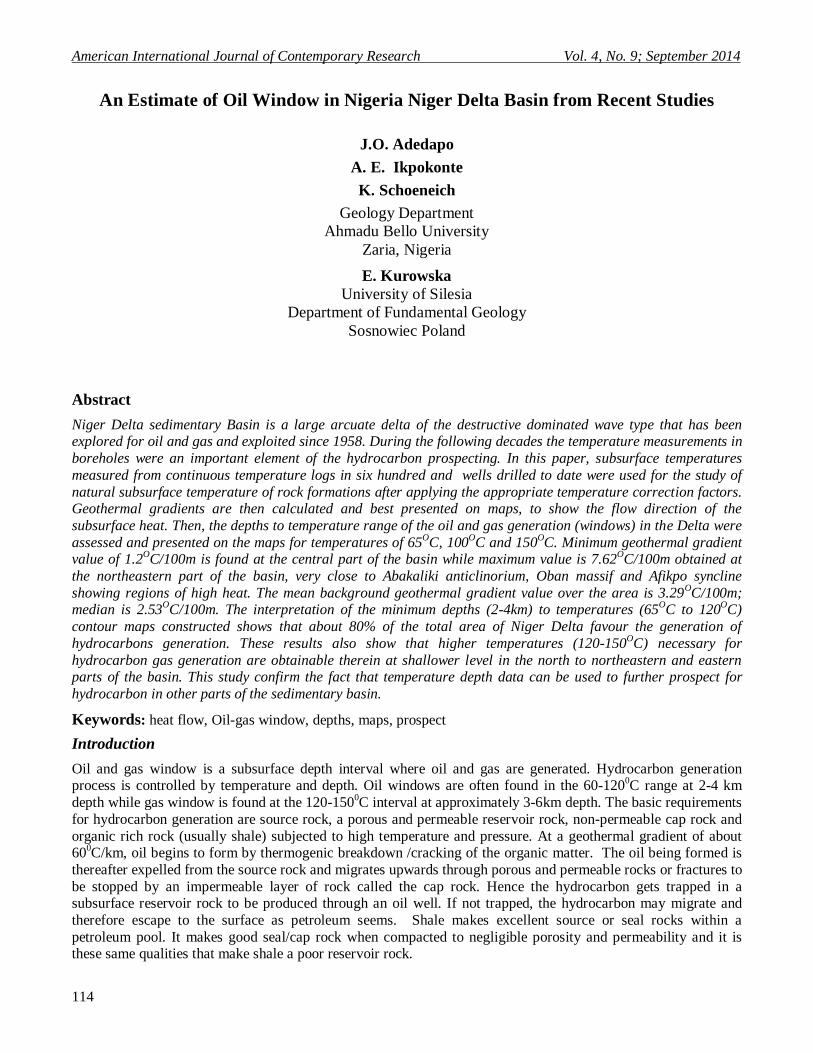
The Niger Delta is situated in the Gulf of Guinea in a rift triple junction related to the opening of the southern Atlantic started in the Late Jurassic to the Cretaceous. The delta proper began developing in the Eocene, accumulating sediments that now are over 10 kilometers thick. It is located in West Africa between latitude 30 and 60 N and longitude 50 and 80E (Figure 1 ). It is one of the world’s most prolific petroleum producing Tertiary deltas that accounts for about 5% of the world’s oil and gas reserves and for about 2.5% of the present day basin areas on Earth.[13]. To date, 34.5 billion barrels of recoverable oil and 93.8 trillion cubic feet of recoverable gas have been discovered. The Niger Delta Province contains only one identified petroleum system. [5] referred to it as the Tertiary Niger Delta (Akata –Agbada) Petroleum System. The primary source rock is the Upper Akata Formation, the marine-shale facies of the delta, with possibly contribution from interbedded marine shale of the lowermost Agbada Formation.
Figure 1: Geological Setting and Location of the Major Structural Units in Nigeria after Kurowska and Schoeneich (2010)
American International Journal of Contemporary Research Vol. 4, No. 9; September 2014
116
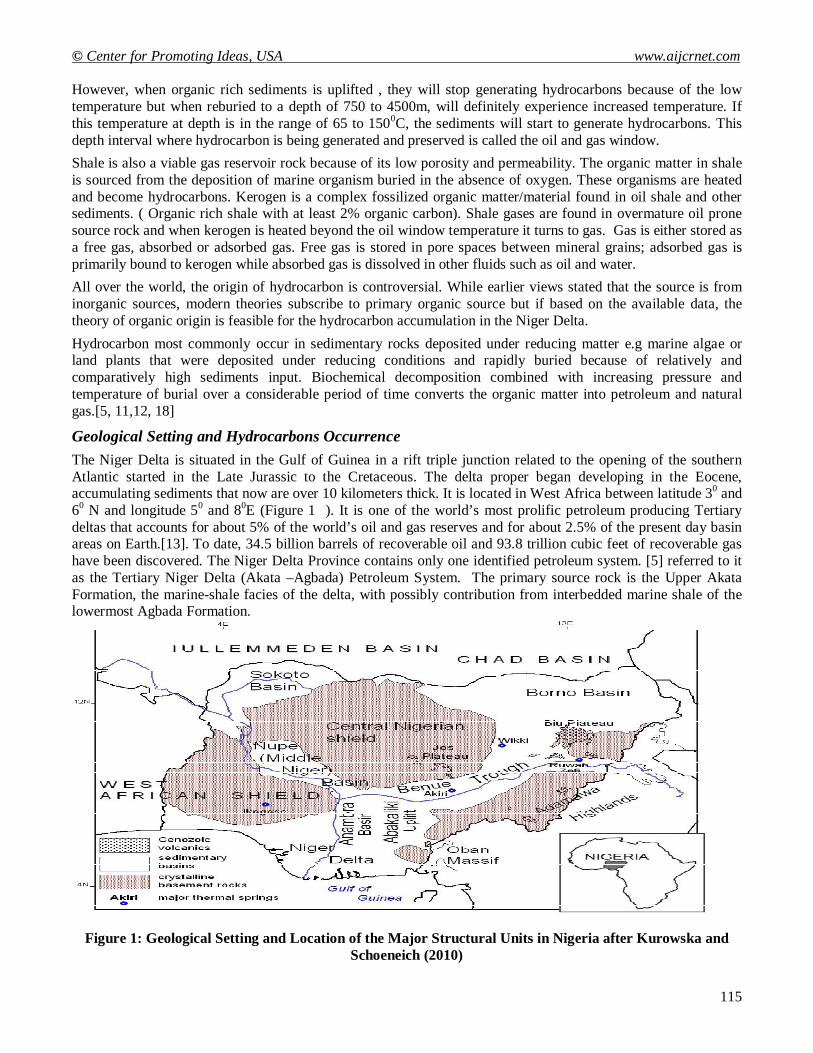
Oil is produced from sandstone facies within the Agbada Formation, however, turbidite sand in the Upper Akata Formation is a potential target in deep water offshore and possibly beneath currently producing intervals onshore. The Tertiary section of the Niger Delta is divided into three formations, representing prograding depositional facies that are distinguished mostly on the basis of sand-shale ratios. They are:
1) The Akata Formation situated at the base of the delta is of marine origin and composed of thick shale sequences (potential source rock), turbidite sand (potential reservoirs in deep water), and minor amounts of clay and silt. The process started in the Paleocene and through the Recent, the Akata Formation formed during lowstands when terrestrial organic matter and clays were transported to deep water areas characterized by low energy conditions and oxygen deficiency. The formation underlies the entire delta, and is typically overpressured. Turbidity currents likely deposited deep sea fan sands within the Upper Akata Formation during development of the delta. 2) The deposition of the overlying Agbada Formation, the major petroleum-bearing unit, began in the Eocene and continues into the Paleocene. The formation consists of paralic silica-clastics over 3700 meters thick and represents the actual deltaic portion of the sequence. The clastics accumulated in delta-front, delta-topset, and fluvio-deltaic environments. In the Lower Agbada Formation, shale and sandstone beds were deposited in equal proportions. However, the upper portion is mostly sand with only minor shale interbeds. 3) Overlying the Agbada formation is the Benin Formation, a continental Late Eocene to Recent deposit of alluvial and upper coastal plain sands that are up to 2000 m thick [13], Figure 2.
Figure 2: Lithostratigraphical cross section across the Niger Delta (after Jubril M.A. et al., 1991). Petroleum in the Niger Delta is produced from sandstone and unconsolidated sands predominantly in the Agbada Formation. Characteristics of the reservoirs in the Agbada Formation are controlled by depositional environment and by depth of burial.
Most known traps in Niger Delta fields are structural although stratigraphic traps are not uncommon. The structural traps developed during synsedimentary deformation of the Agbada paralic sequence. A variety of structural trapping elements exists, including those associated with simple rollover structures; clay filled channels, structures with multiple growth faults, structures with antithetic faults, and collapsed crest structures.
© Center for Promoting Ideas, USA www.aijcrnet.com
117
The primary seal rock in the Niger Delta is the interbedded shale within the Agbada Formation. The shale provides three types of seals—clay smears along faults, interbedded sealing units against which reservoir sands are juxtaposed due to faulting, and vertical seals.
There are two main migration histories proposed for the Niger Delta. For those who favours Agbada formation the hydrocarbon must have migrated from a short distance up dip to the adjacent sandstone while for the other which favour Akata formation as the source rock, it is expected that the hydrocarbon migration will be vertical from Akata formation in to Agbada formation (reservoir rock) . In addition we have two types of migration i.e. vertical and lateral. Fault migration through conductive fault zones have been recognized probably as the most effective way by which hydrocarbon and oil field waters may have migrated into the rollover anticlines. Other mechanism such as flank of a rollover may have contributed to hydrocarbon accumulation [18].
It is observed that the dominant trapping mechanism for hydrocarbon pool in the Niger Delta is the crescent shaped growth fault and associated rollover anticlines, the best reservoirs are located in the upthrown side of the growth fault where shale smearing assists in the formation of effective seals by juxtaposition of reservoir against shale. [7, 10 and 18]
Previous Works on Geothermal Conditions of Niger Delta
Geothermal gradient is the rate of increase in temperature with depth commonly expressed in 0C/100m or 0C/km. There were few academic/research publications on the geothermal gradient of Niger Delta and very few authors on the oil and gas windows in Niger Delta. [8] reported that geothermal map can be utilized as an exploration tool to predict the oil and gas window in a sedimentary basin. [9] reported that hydrocarbon generation takes place within the temperature interval of 65 to 1500C. Subsurface borehole temperature data obtained from oil wells were used to determine the geothermal gradient of this sedimentary basin either wholly or partly by some authors. Notably among them are [2] [3] and [8]. A geothermal gradient range of 0.82 to 4.60C has been reported for Niger delta by [1] while [3] reported a geothermal gradient range of 1.5 to 3.40C/100m for southeast of Niger Delta. [4, 9, 14, 15]
Geothermal energy reserve exploitable for space heating, agriculture and animal husbandry and electric power generation is yet to develop in the Niger Delta. Geothermal energy is environmentally friendly, clean and reversible.
This study is poised at revealing more target areas for hydrocarbon exploration in this sedimentary basin to aid meaningful decisions in hydrocarbon exploration with more emphasis on gas. This is done with the aid of observed relationship between geothermal gradient of the sedimentary basin and subsurface temperature distribution in the oil-gas window concept.
Materials and Methods
Temperature log of six hundred wells were the primary data obtained from the Department of Petroleum Resources, Lagos an arm of Nigerian National Petroleum Corporation (NNPC) and used for this work. Secondary informations were obtained from review of temperature distributions in the area. The temperature data were subjected to corrections, analysis and interpretation.
The procedure adopted in the measurement of temperature involves the use of the Schlumberger Auxiliary Measuring Sounde (AMS) with high sensitive sensor in the logging tool. The logging tool was lowered into the borehole and the temperature at various depth intervals determined in a process of continuous temperature logging. The instrument was lowered in a slow and continuous process so that the temperatures are not altered due to agitation of the fluid when the cable and the probe pass through it (continuous temperature logging). Thus the instrument measured the temperature of the formation at various depth intervals. This was carried out for all the wells in the area including the six hundred wells used for this research work. The temperature was measured 8 hours after drilling when circulation of drilling fluid has stopped to allow for temperature stabilization. It was measured in this way since subsurface temperature from open hole log is always lower than the true formation temperature. During the drilling of wells a substantial amount of drilling mud is circulated in the borehole to facilitate the drilling, evacuate the cuttings and stabilize the hole. Thus, the interaction of the mud, circulation and other drilling activities affects the thermal properties of the drilling fluid. Heat exchange between the hole and the mud, duration of drilling and non-equilibrium temperature at the time of measurements were reasons why collected bottom hole temperature data were subjected to corrections before they were used for any meaningful research work.
American International Journal of Contemporary Research Vol. 4, No. 9; September 2014
118
The short, 8 hours thermal recovery time is insufficient for full thermal recovery of the borehole making measured temperature to be lower than the true temperature of the rock formation. For full thermal recovery 72 hours of standing by time is needed (Source: Department of Petroleum Resources, Lagos).
The temperatures correction for the boreholes data in this research work were carried out by using three correction methods. They are: 1) American Association of Petroleum Geologist (AAPG) correction factor, GoM Waples et al. (2004) correction factor, Zeta utilities borehole correction factor .[16,17,18, 19 and 20]
Heat is accumulated at depth and transferred through rock complexes to the Earth’s surface, and so, by assuming a linear relationship of temperature and depth, the geothermal gradient was calculated.
Because of inaccuracy inherent in the estimation of sediment age, and the large number of data involved in this work covering a large area of study, we take the simple approach in estimating the depth to oil and gas window with a quick subsurface map presentation. This enhances more future exploration in the basin. Thus, assuming the linearity concept of geothermal gradient (ϻ) with depth (H);
ϻ = (Tr – Ts)/Hb 0C/m
Where Tr, Ts and Hb are the true subsurface formation temperature, mean annual surface temperature, and bottom hole depth respectively. Thus the true subsurface formation temperature at any depth H can be obtained thus
Tr = ϻH +Ts
In this work, depths (H) to oil and gas windows for temperatures of 65, 100, and 1500C for each of the six hundred boreholes under study were calculated assuming the mean annual surface temperature of 270C for the basin area.
Results
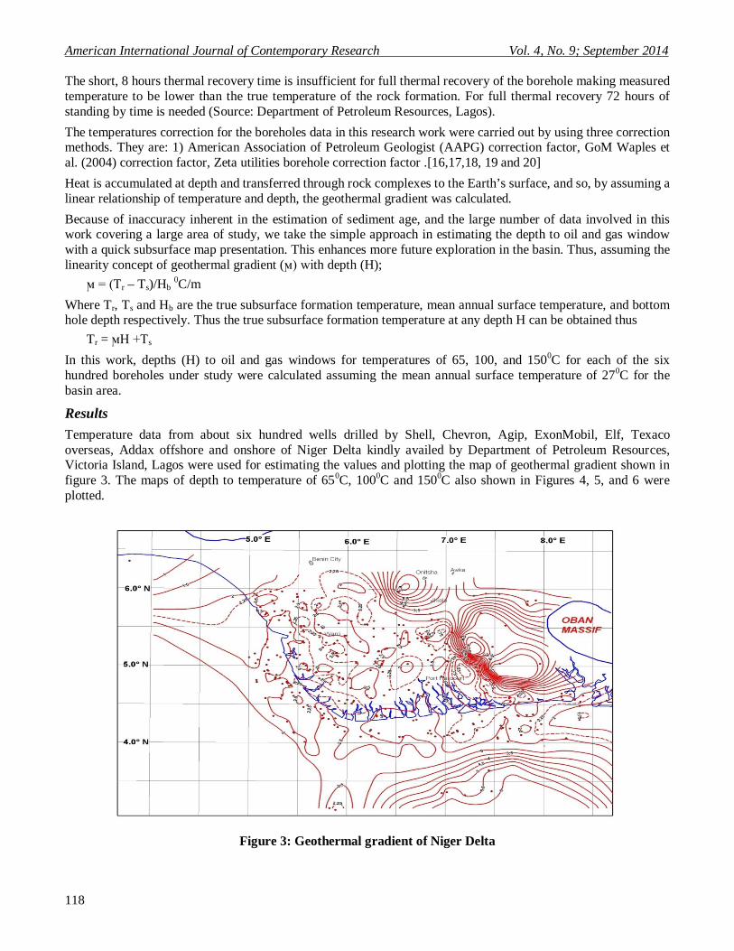
Temperature data from about six hundred wells drilled by Shell, Chevron, Agip, ExonMobil, Elf, Texaco overseas, Addax offshore and onshore of Niger Delta kindly availed by Department of Petroleum Resources, Victoria Island, Lagos were used for estimating the values and plotting the map of geothermal gradient shown in figure 3. The maps of depth to temperature of 650C, 1000C and 1500C also shown in Figures 4, 5, and 6 were plotted.
Figure 3: Geothermal gradient of Niger Delta

© Center for Promoting Ideas, USA www.aijcrnet.com
119
Figure 4: Depth Contours for 650C Temperature in Niger Delta
Figure 5: Depth Contours for 1000C Temperature in Niger Delta
Figure 6: Depth Contours for 1500C Temperature in Niger Delta
American International Journal of Contemporary Research Vol. 4, No. 9; September 2014
120
In Figure 3, the maximum geothermal value, 7.62 OC/100m, obtained occur in northeastern part of the basin close to the uplifted Cretaceous rocks of Abakaliki anticlinorium, outcropping in the north of Niger Delta basin while the minimum geothermal gradient obtained across the basin is 1.2OC/100m found at the central part. The mean geothermal value is 3.29OC/100m; median is 2.53OC/100m. The result obtained from this work is in conformity with [8]. He found that the gradients are lowest at the centre of the delta and increase northward and southward and suggested that the differences and high geothermal range value suggest that the rates at which various wells attain equilibrium may be caused by such factors as differences in borehole diameter and thermal conductivity of rocks. The geothermal range conforms to the range found in tectonically inactive areas [8].
The geothermal gradient anomaly (Figure 3) describes the pattern of occurrence and geometry of the isograd lines. Prominent in the Figure 3, the major anomalies occur in a linear to curvi-linear NW- trend that depicts a structural edge of the eastern to northeastern parts of the basin. These high geothermal anomalies occur in areas where known boreholes are not exploited for oil and gas but for the remaining areas where oil wells are producing there is no such anomaly.
Figure 4 shows where a temperature of 650C can be obtained at a minimum depth of 600m in the entire sedimentary Basin. This is obtainable at the south western, southeastern, northern and the central parts of the study area. The near-shore and western parts of the basin pose greater depths in the range of 1300m to 1900m to obtain the same temperature.
Figure 5 shows the areas and depths within the Niger Delta where the temperature of 1000C can be obtained. The minimum depth of 800 m is found at the southwestern and maximum depth of 4000m at the northeastern and northwestern parts of the delta. A general range of 2600m - 3400m is found widespread across the basin to obtain a temperature of 1000C within which lies the oil window at temperatures between 600C - 1200C.
Figure 6 is the depth to 1500C temperature map. It shows depth areas where the measured temperature will be 1500C. Across the whole delta 1500C will be measured at a minimum depth of 2000 m at the northern part of the basin close to the Basement Complex and a maximum depth of 6800 m at the eastern part of the basin close to Oban massif across the Calabar flank. Within this range, 2,000 m-6,800 m lies the gas window at temperature between 1200C - 1500C.
Conclusion
Minimum geothermal gradient value of 1.2OC/100m is found at the central part of the basin while maximum value is 7.62 OC/100m obtained at the north eastern part of the basin very close to Abakaliki anticlinorium, Oban massif and Afikpo syncline. The mean geothermal value is 3.29OC/100m; median is 2.53OC.
Figure 3 is the geothermal gradient map of Niger Delta. Figures 4 to 6 shows well locations and depths where the corresponding temperatures can be obtained.
Since oil windows are found in the 60-1200C at 2 to 4 km depth interval it can therefore be deduced from figures 4 to 6 that the centre part of the sedimentary basin and offshore favours the generation of oil because the temperature range of 65 to 1000C depth contours for the above mentioned areas do not exceed 4km. Of course, this area covers almost 85% of the whole Niger Delta. Also the greater part of the Basin with the exception of the northeastern, northwestern, southeastern and southwestern parts of the research area exhibits closed contours at depths interval of 3 to 6 km for 1500C. This is in conformity with the definition of gas windows. Therefore the Basin has as much oil window as gas window. This is in support of the established fact that the Niger Delta sedimentary Basin is a prolific hydrocarbon area. There are lots of significant producing oil and gas wells in the Basin.
Previous works in the area (1, 6, 8) actually revealed similar results as in this work mainly in the central parts of the basin onshore. The present work remarkably shows more of oil/gas window also but in the northeast and eastern parts of the basin close to the Oban Masif. Results of this work also show that the hydrocarbon generation window areas also extend to the offshore of the basin both to the southwest and southeast.
Thus, the result from this study and its interpretation shows that the oil and gas window concept can be used as an exploration tool in the search for hydrocarbons in similar sedimentary basins elsewhere in the world.
© Center for Promoting Ideas, USA www.aijcrnet.com
121
Acknowledgements
The authors sincerely acknowledge Dr. Lambert Aikhionbare who linked us with the Department of Petroleum Recourses. Lagos. We are extremely grateful to the Department of Petroleum Recourses Lagos (NNPC) for making the temperature/ depth data and Nigeria’s oil Block map available. Unalloyed thanks to Prof S.B. Ojo and Dr A.A. Adepelumi of the Geophysics Department, Obafemi Awolowo University, Ile- Ife who is a member of the geophysics chair of Shell Petroleum Development Company in Geophysics Department, Obafemi Awolowo University, Ile- Ife and other members who without them the geophysical data will not be available. Thanks and God bless you. Amen. References [1] Akpabio, I. O., Ejedawe J.E, Ebeniro J.O, Uko E.D, (2003): Geothermal gradients in Niger Delta Basin from
continuous temperature logs. Global Journal of Pure and Applied Science. 9(2): pp 265-271. [2] Avbovbo, A. A, 1978; Tertiary Lithostratigraphy Of Niger Delta. American Association of Petroleum
Geologist. Bulletin 62,295-300. [3] Avbovbo, A. A, 1978; Geothermal Gradients In The Southern Nigerian Basins. Bulletin of Canada Pet
Geology,(26)2. 268-274. [4] Davies M.G, Chapman D.S, Wagoner T.M.V, Armstrong P.A(2007): Thermal Conductivity Anisotropy of
Meta sedimentary and Igneous Rock. Journal Geophysics Res. 112, 5216. [5] Jubril, M. A. and Amajor L. C. 1991, The Afam clay member; a Lower Miocene incised channel in
the South-eastern Niger Delta: Marine Petroleum Geology. Vol. 8., pp. 163-173. [6] Kulke, H.,( 1995); Nigeria. In: Kulke, H.(Ed), Regional Petroleum Geology Of The World, Part II: Africa,
America, Australia and Antarctica. Gebru Borntraeger, Berlin, pp 143-172. [7] Kurowska, E. and Schoeneich. K (2010): Geothermal Exploration in Nigeria. Proceedings of World
Geothermal Congress, 2010. Bali, Indonesia, 25-29 April 2010. [8] Murrat, R. C. (1970): Stratigraphy and Palaeogeography Of The Cretaceous And Lower Tertiary In Southern
Nigeria. In African Geology. University of Ibadan Press Dec 1970 .pp 251-266. [9] Nwachukwu, S. O. (1976): Approximate Geothermal Gradients In The Niger Delta Sedimentary Basins. The
American Association of Petroleum Geology. Bulletin, Vol. 60, No 7, pp 1073-1077. [10] Ochuko. A (2011); Determination Of Geothermal Gradient And Heat Flow Distribution In Delta State,
Nigeria. Intern. Journal of the Physical Science. Vol. 6 (31) pp 7106-7111. [11] Onuoha K.M, (1999): Structural Features Of Nigeria’s Coastal Margin: An Assessment Based
on Age Data from Wells. Journal of Earth Sciences, Vol 29, No 3, pp485-499. [12] Piggot J.D (1985): Assessment os source rock maturity in frontier basin: Importance of Time, Temperature
and Tectonics. AAPG Bull. 69(8) pp 9-29. [13] Pusey, W.C, (1973): How to evaluate potential gas and source rocks: World oil, Vol 176, No 5, pp 71-75. [14] Reijers T.J.A. (1996): Selected Chapters On Geology: Sedimentary Geology And Sequence Stratigraphy In
Nigeria, Three Case Studies And A Field Guide. Shell Petroleum Development Corporation. Corporate Reprographic Services. Warri.
[15] Uko E,D, Amakiri A,R,C. Alagoa K,O(2002): Effects of lithology on geothermal gradient on the Southeast Niger Delta, Nigeria. Global .J. Pure and Applied Science 8(3): pp 325-337.
[16] United Nations Development Programme (UNDP) (2010): Contribution Of Energy Services To The Millennium Development Goals And To Poverty Alleviation In Latin America And The Caribbean, ECLAC Project Documents Collection.
[17] Waples, Douglas W., Pacheco. J and Vera. A. (2004);A Method For Correcting Log-Derived Temperatures In Deep Wells, Calibrated In The Gulf Of Mexico, Petroleum.Geosciences,Vol10.Pp39-245. http://zetaware.com/utilities/bht/waples_gom.htm
[18] Waples, D.W. and Ramly Mahadir. (2001); A statistical method for correcting log-derived temperatures. Petroleum Geoscience. Vol 7. Pp 231-240. http://zetaware.com/utilities/bht/waples_gom.htm
[19] Whiteman, A. (1982); Nigeria: Its Petroleum Geology, Resources and Potential. Graham and Trotman, London.
[20] ZetaWare Utilities- Borehole Temperature correction. http://zetaware.com/utilities/bht/timesince.htm