An Approach for RESTful Web Processing Services to ... Approach for RESTful Web Processing Services...
21
An Approach for RESTful Web Processing Services to Generate Recommendations for Agricultural Crop Production Sanjay Chaudhary DA-IICT
Transcript of An Approach for RESTful Web Processing Services to ... Approach for RESTful Web Processing Services...

An Approach for RESTful Web Processing Services to Generate Recommendations for Agricultural Crop Production
Sanjay Chaudhary
DA-IICT
Background
• Massive volumes of geospatial data being generated every day
• OGC has numerous standards for geo-processing • Challenges in using this data effectively in
geospatial research and applications. – How to help the user to find desirable data from the
large amount available – How the user can automatically extract useful
information from raw data and – How data and information can be made more widely
and readily accessible to the public
Introduction
• Open Geospatial Consortium (OGC) has published a series of geospatial Web services specifications.
• Representational State Transfer (REST) is a paradigm on the Web used for designing Web Services providing geographic data and maps; e.g. Google, GeoCommons
• At OGC, REST has received little attention [1].
• A service for processing of data based on REST has not been proposed yet.
• Designing such a service is linked to the question of how to represent processes as resources as identifying the resources is a key concept in REST.
Web Processing Services (WPS) • WPS interface specification provides an approach to publish and execute
geo-processes on the Web using XML-technology. • Instant and on-demand transformation from geo data to geo-information
on the Web [2]. • It provides service and process metadata and a means to execute the
desired process according to the parameter requirements of the specific client.
• The WPS interface specification features a communication mechanism for asynchronous message exchange to implement efficient client-server communication.
• Provides automated discovery of geo-processes via profiles. – These WPS profiles are common process descriptions, which can be
referenced by service providers in order to specify a designated process as being similar.
• Operations supported by WPS: GetCapabilities, DescribeProcess, Execute • Makes it convenient to reuse geospatial processing modules and to
construct executable service chains to analyze large data sets. • Service chaining to be achieved in order to have a workflow based
architecture
Web Processing Services (WPS) (cont)
• Geospatial mashups can be created through chaining of data access (WCS, WFS) and processing transforms/ algorithm models (WPS).
• WPS acts as a middleware that obtains geospatial data.
• WPS can also wrap other OGC based services, such as WMS, WFS and WCS [4].
Web Processing Services (WPS) (cont)
• OGC WPS specification provides the service interface definitions to specify a wide range of processing tasks as geospatial web services in order to distribute common GIS functionalities over the Internet [5].
• It can be accessed remotely and assembled in varied web integration scenarios.
• The OGC WPS provides access to calculations or models that operate on spatially-referenced data, which can be available locally, or delivered across a network using download services such as – WFS (Web Feature Services3), WCS (Web Coverage Services4) and SOS (Sensor
Observation Services5).
• While most OGC specifications and standards are devoted to geospatial data models and access, the OGC WPS specification is focused on processing heterogeneous geospatial data.
• The typical steps consist of – the identification of spatially-referenced data required, execution of the
process, and the management of the output process by client applications.
Challenges
Following are the challenges for the Spatial Data Infrastructures:
• Lack of spatial data. • Automated Discovery of services. • Lack of mechanisms by which geo-spatial information
can be communicated, assembled, integrated, and interpreted.
• Lack of semantic interoperability. • Inherent Complexity of systems. • Lack of standards and specifications for REST based
implementation.
REST Based Services
• Properties of REST: addressability, statelessness, connectedness (architectural styles) and a uniform interface [6].
• A Web Service, which implements these properties, is called RESTful.
• These properties are realized by using HTTP and URIs. • The resource is a central aspect of REST. • A resource is a specific entity in the system, which is represented by
a URI. • Designing the resource correctly regarding the granularity and the
purpose of the service is important. • All operations of a RESTful Web Services are represented by the
combination of a resource and HTTP[7]. • The vocabulary of HTTP describes some operational semantics,
which can be used to interact with the resources.
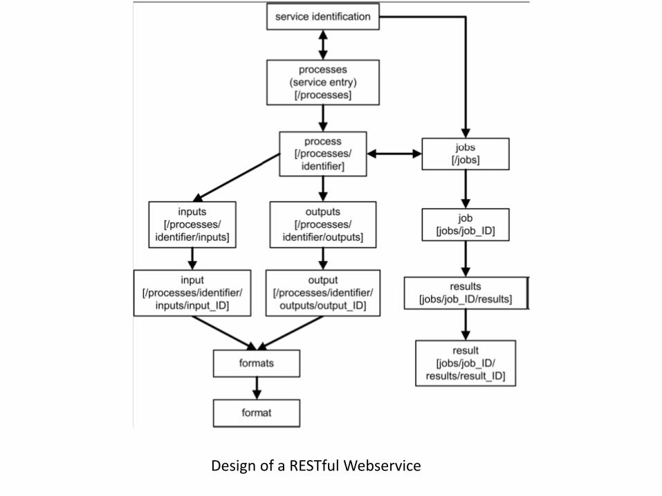
Design of a RESTful Webservice
REST Based Services
• The combination of HTTP and URIs is considered to be a clear advantage over these conventional Web Services: – as HTTP verbs contain semantics, which provide a common
understanding throughout the user community.
• In case of a RESTful Web Service, the user does not need to read additional specifications for a particular service.
• Therefore, RESTful Web Services can be considered to be light-weight regarding their interface.
• Moreover the OGC technical committee has started preparing the RFC for API design as a step towards RESTful approach [8].
Our Proposal Generate Recommendations for Agricultural Crop Production
• Motivation is to develop spatial data infrastructures
• A set of lightweight RESTful WPSs will be developed with the help of Open source software.
• These services can perform a set of geospatial data processing functions.
• A transparent workflow can be created using these WPS services to achieve our target result.
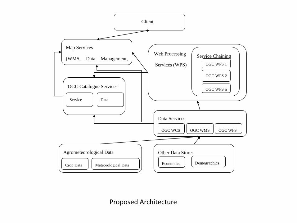
Client
(Web Browser )
Map Services
(WMS, Data Management,
Data Visualization)
OGC Catalogue Services
Service
Metadata
Data
Metadata
Data Services
OGC WFS OGC WMS OGC WCS
Web Processing
Services (WPS)
Service Chaining
OGC WPS n
OGC WPS 2
OGC WPS 1
Agrometeorological Data
Meteorological Data Crop Data
Other Data Stores
Demographics Economics
Proposed Architecture
Use Case - 1
• A map can be generated using a service mashups. • Generate LANDSAT map of are using a standard web mapping services. • Extract locations of Potato growing areas using image processing
algorithms. • These algorithms will be exposed as Web Processing services. • The data regarding locations of cold storages will be available through web
feature service. • Data and maps about the road networks will be available. • Overlay these maps. • Apply standard operations of buffer and intersection to find out the
suitable cold storages as per the nearest locations. • It can provide suggestions to farmers to identify nearest cold storages to
preserve their agro-produce and sell in future to get better price.
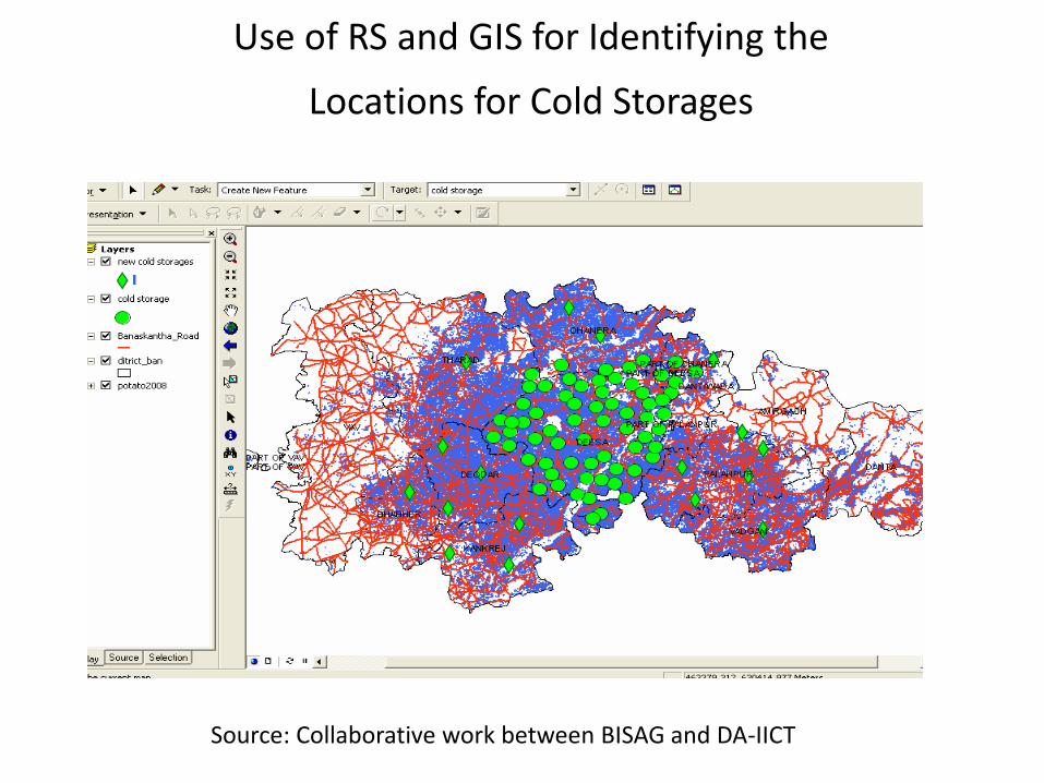
Use of RS and GIS for Identifying the
Locations for Cold Storages
Source: Collaborative work between BISAG and DA-IICT
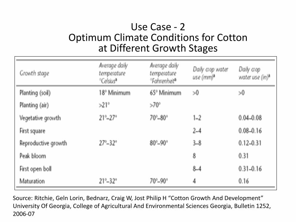
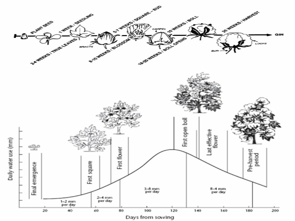
Use Case - 2 Optimum Climate Conditions for Cotton
at Different Growth Stages
Source: Ritchie, Geln Lorin, Bednarz, Craig W, Jost Philip H “Cotton Growth And Development” University Of Georgia, College of Agricultural And Environmental Sciences Georgia, Bulletin 1252, 2006-07
Use Case - 2
• We aim to provide recommendation system for crop production specifically targeted for cotton crop in North Gujarat region.
• Number of factors affect cotton production. • The farmers can protect their crops from adverse
climatic conditions, if proper recommendations are given on time. – For example, during flowering stage, if there is no rainfall
prediction then farmers can be recommended to plan for irrigation.
– On other hand, if there is a positive forecast of rainfall, farmers can be suggested to wait for few days as excessive humidity affects cotton adversely.
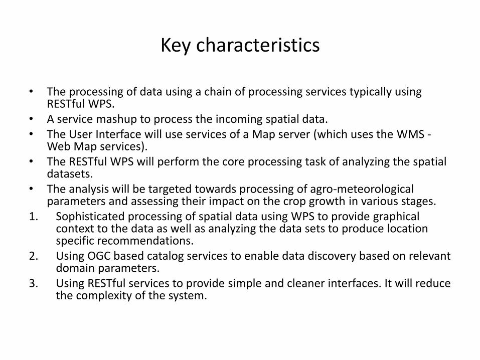
Key characteristics
• The processing of data using a chain of processing services typically using RESTful WPS.
• A service mashup to process the incoming spatial data. • The User Interface will use services of a Map server (which uses the WMS -
Web Map services). • The RESTful WPS will perform the core processing task of analyzing the spatial
datasets. • The analysis will be targeted towards processing of agro-meteorological
parameters and assessing their impact on the crop growth in various stages. 1. Sophisticated processing of spatial data using WPS to provide graphical
context to the data as well as analyzing the data sets to produce location specific recommendations.
2. Using OGC based catalog services to enable data discovery based on relevant domain parameters.
3. Using RESTful services to provide simple and cleaner interfaces. It will reduce the complexity of the system.
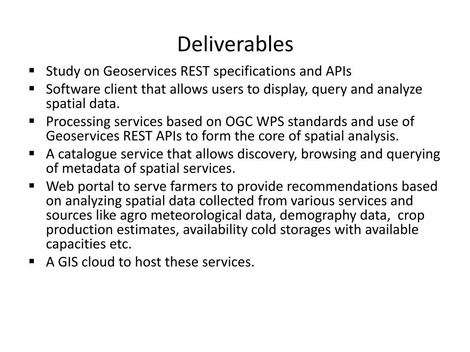
Deliverables Study on Geoservices REST specifications and APIs Software client that allows users to display, query and analyze
spatial data. Processing services based on OGC WPS standards and use of
Geoservices REST APIs to form the core of spatial analysis. A catalogue service that allows discovery, browsing and querying
of metadata of spatial services. Web portal to serve farmers to provide recommendations based
on analyzing spatial data collected from various services and sources like agro meteorological data, demography data, crop production estimates, availability cold storages with available capacities etc.
A GIS cloud to host these services.
References
1. Foerster, T., Brühl, A., & Schäffer, B. (2006). RESTful Web Processing Service. Source, 1-8. Retrieved from http://ifgi.uni-muenster.de/~tfoer_01/articles/AGILE2011_Foerster_etal_RESTful_WPS.pdf
2. Brauner, J., Foerster, T., Schaeffer, B. and Baranski, B. (2009). Towards a research agenda for geoprocessing services. In: AGILE 2009 : Proceedings of the 12th Agile internationational conference : Advances in GISscience pages 1-12
3. Deng-hui ZHANG, Lu YU, Bin XIE, Li-ping DI, “Open Geospatial Information Services Chaining Based on OGC Specifications and Processing Model” , Proceedings of the 2008 International Workshop on Education Technology and Training & 2008 International Workshop on Geoscience and Remote Sensing - Volume 02, pages 153-157
4. Peisheng Zhao; Liping Di; Weiguo Han; Zhengwei Yang; , "Building geospatial Web portal for use of national agricultural statistics in geographic context," Geoinformatics, 2009 17th International Conference on , vol., no., pp.1-4, 12-14 Aug. 2009
5. OpenGIS Web Processing Services 6. Carlos Granell, Laura D.az, Alain Tamayo, Joaqu.n Huerta, “Assessment of OGC Web Processing
Services for REST principles”, CoRR Feb 2012 7. Didier G. Leibovici , Suchith Anand , Jerry Swan, “Workflow Issues for Health mapping mashups of
OGC Web Services” 8. Clemens Portele : “Geoservices REST API SWG Closing Plenary Report” [Powerpoint Slides] 80th
OGC Technical Committee Austin, Texas (USA) March 21 2012

Thanking you for your attention