AN APPLICATION OF THE RUNGE ENERGY MODEL OF SOIL ...geo.msu.edu/extra/schaetzl/PDFs/Runge...
16
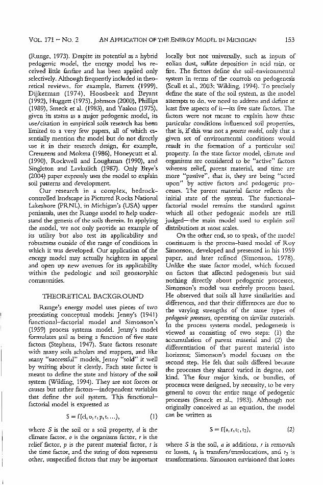
0038-075X/06/17102-152-166 Soil Science Copyright 0 2006 by Lippincott Williams & Wilkins, Inc. AN APPLICATION OF THE RUNGE "ENERGY MODEL" OF SOIL DEVELOPMENT IN MICHIGAN'S UPPER PENINSULA Randall J. Schaetzl 1 and Charles Schwenner 2 This paper examines some soils in Michigan's upper peninsula that do not "fit" with the zonal soils of the region. The typical upland soils in this part of the Pictured Rocks National Lakeshore (PRNL), when not constrained by bedrock or high water tables, are strongly developed Spodosols (Haplorthods). We used the energy model (Runge, 1973) as a conceptual guide to help explain the genesis of nearby soils, whose chemistry and morphology are very different. The energy model presupposes that soils are affected mainly by water available for leaching and organic matter production, as conditioned by parent material. In our study area, where water available for leaching is limited (or even negative), as on steep slopes shallow to bedrock with multiple springs and seeps, and where erosional processes are strong, horizonation in the classical sense does not form. Instead, shallow Histosols (Saprists) form above bedrock, even on 45% slopes. Oxyaquic Haplorthods developed on flat uplands, on the same bedrock, are strongly horizonated, as most of the water that impacts them is available for leaching and pedogenesis. In another example, soils that have formed above calcareous bedrock maintain such high pH values that their faunal assemblages are rich and diverse, and base cycling is strong, leading to thick 0 + A horizon sequences. These soils (Lithic Udipsamments) resemble Mollisols and exhibit few marks of podzolization. Conversely, nearby Oxyaquic Haplorthods above acid sandstone bedrock have limited faunal assemb- lages, slow organic matter decomposition, and horizonation indicative of strong podzolization. These examples highlight how conceptual models can be used to guide our understanding of soil genesis and distribution. (Soil Science 2006;171:152-166) Key words: Pedogenesis, conceptual models, podzolization, base cycling, bedrock influence. OILS are extremely complex natural phe- nomena. Only by using conceptual models can we better understand and explain the complexity of the pedogenic system and distin- guish signal from noise. Rather than being precise mathematical formulations that can be solved, conceptual pedogenic models help put soils information into perspective and provide insight into the system interrelation- 'Department of Geography, 314 Natural Science Building, Michigan State University, East Lansing, M[ 48824-1115. Dr. Randall J. Schaet.l is corresponding author. E-mail; [email protected] 2 USDA-Natural Resources Conservation Service, 201 Rublein Street, Marquette, MI 49855. Received Apr1 19, 2005; accepted Aug. 29, 2005. DO: 10.1097/01.ss.0000187 37 3 . 3 1026.04 ships, process linkages, and the nuances of pedo- genesis (Dijkerman, 1974; Johnson and Watson- Stegner, 1987; Smeck et al., 1983). They take the complex and make it simple; they are sim- plified descriptions of natural systems. History is full of examples by which the application of certain pedogenic models has influenced perceptions of soil genesis. It is equally full of examples in which models have been largely ignored. In the latter situation, had these models been used, the way in which the natural systems were perceived might have been very different. One pedogenic model that has perhaps received less than its due amount of distinction is the "energy model", developed by Ed Runge, a soil scientist then at the University of Illinois 152 February 2006 Vol. 171, No. 2 Printed in U.S.A.
Transcript of AN APPLICATION OF THE RUNGE ENERGY MODEL OF SOIL ...geo.msu.edu/extra/schaetzl/PDFs/Runge...
0038-075X/06/17102-152-166Soil ScienceCopyright 0 2006 by Lippincott Williams & Wilkins, Inc.
AN APPLICATION OF THE RUNGE "ENERGY MODEL" OF SOILDEVELOPMENT IN MICHIGAN'S UPPER PENINSULA
Randall J. Schaetzl1 and Charles Schwenner2
This paper examines some soils in Michigan's upper peninsula that donot "fit" with the zonal soils of the region. The typical upland soils inthis part of the Pictured Rocks National Lakeshore (PRNL), when notconstrained by bedrock or high water tables, are strongly developedSpodosols (Haplorthods). We used the energy model (Runge, 1973) as aconceptual guide to help explain the genesis of nearby soils, whosechemistry and morphology are very different. The energy modelpresupposes that soils are affected mainly by water available for leachingand organic matter production, as conditioned by parent material. Inour study area, where water available for leaching is limited (or evennegative), as on steep slopes shallow to bedrock with multiple springsand seeps, and where erosional processes are strong, horizonation in theclassical sense does not form. Instead, shallow Histosols (Saprists) form
above bedrock, even on 45% slopes. Oxyaquic Haplorthods developedon flat uplands, on the same bedrock, are strongly horizonated, as mostof the water that impacts them is available for leaching and pedogenesis.In another example, soils that have formed above calcareous bedrockmaintain such high pH values that their faunal assemblages are rich and
diverse, and base cycling is strong, leading to thick 0 + A horizonsequences. These soils (Lithic Udipsamments) resemble Mollisols andexhibit few marks of podzolization. Conversely, nearby OxyaquicHaplorthods above acid sandstone bedrock have limited faunal assemb-lages, slow organic matter decomposition, and horizonation indicativeof strong podzolization. These examples highlight how conceptualmodels can be used to guide our understanding of soil genesis anddistribution. (Soil Science 2006;171:152-166)
Key words: Pedogenesis, conceptual models, podzolization, basecycling, bedrock influence.
OILS are extremely complex natural phe-nomena. Only by using conceptual models
can we better understand and explain thecomplexity of the pedogenic system and distin-guish signal from noise. Rather than being
precise mathematical formulations that can besolved, conceptual pedogenic models helpput soils information into perspective andprovide insight into the system interrelation-
'Department of Geography, 314 Natural Science Building, Michigan State
University, East Lansing, M[ 48824-1115. Dr. Randall J. Schaet.l is corresponding
author. E-mail; [email protected]
USDA-Natural Resources Conservation Service, 201 Rublein Street, Marquette,
MI 49855.
Received Apr1 19, 2005; accepted Aug. 29, 2005.
DO: 10.1097/01.ss.000018737 3
.31026.04
ships, process linkages, and the nuances of pedo-genesis (Dijkerman, 1974; Johnson and Watson-
Stegner, 1987; Smeck et al., 1983). They take
the complex and make it simple; they are sim-plified descriptions of natural systems.
History is full of examples by which theapplication of certain pedogenic models hasinfluenced perceptions of soil genesis. It is
equally full of examples in which models havebeen largely ignored. In the latter situation, hadthese models been used, the way in which thenatural systems were perceived might have beenvery different.
One pedogenic model that has perhaps
received less than its due amount of distinctionis the "energy model", developed by Ed Runge,
a soil scientist then at the University of Illinois
152
February 2006Vol. 171, No. 2
Printed in U.S.A.
VAN APPLICATION OF THE ENERGY MODEL IN MICHIGAN
(Runge, 1973). Despite its potential as a hybridpedogenic model, the energy model has re-ceived little fanfare and has been applied onlyselectively. Although frequently included in theo-retical reviews, for example, Barrett (1999),Dijkerman (1974), Hoosbeek and Bryant(1992), Huggett (1975), Johnson (2000), Phillips(1989), Smeck et al. (1983), and Yaalon (1975),given its status as a major pedogenic model, itsuse/citation in empirical soils research has beenlimited to a very few papers, all of which es-sentially mention the model but do not directlyuse it in their research design, for example,Cremeens and Mokma (1986), Honeycutt et al.(1990), Rockwell and Loughman (1990), andSingleton and Lavkulich (1987). Only Brye's(2004) paper expressly uses the model to explainsoil patterns and development.
Our research in a complex. bedrock-controlled landscape in Pictured Rocks NationalLakeshore (PRNL), in Michigan's (USA) upperpeninsula, uses the Runge model to help under-stand the genesis of the soils therein. In applyingthe model, we not only provide an example ofits utility but also test its applicability androbustness outside of the range of conditions inwhich it was developed. Our application of theenergy model may actually heighten its appealand open up new avenues for its applicabilitywithin the pedologic and soil geomorphiccommunities.
THEORETICAL BACKGROUND
Runge's energy model uses pieces of twopreexisting conceptual models: Jenny's (1941)functional-factorial model and Simonson's(1959) process systems model. Jenny's modelformulates soil as being a function of five statefactors (Stephens, 1947). State factors resonatewith many soils scholars and mappers, and likemany "successful" models, Jenny "sold" it wellby writing about it clearly. Each state factor ismeant to define the state and history of the soilsystem (Wilding, 1994). They are not forces orcauses but rather factors-independent variablesthat define the soil system. This functional-factorial model is expressed as
S = f(cl, o,r,p,t ... ), (1)where S is the soil or a soil property, cl is theclimate factor, o is the organisms factor, r is therelief factor, p is the parent material factor, t isthe time factor, and the string of dots representsother, unspecified factors that may be important
locally but not universally, such as inputs ofeolian dust, sulfate deposition in acid rain, orfire. The factors define the soil-environmentalsystem in terms of the controls on pedogenesis(Scull et al., 2003; Wilding, 1994). To preciselydefine the state of the soil system, as the modelattempts to do, we need to address and define atleast five aspects of it-its five state factors. Thefactors were not meant to explain how theseparticular conditions influenced soil properties,that is, if this was not a process model, only that agiven set of environmental conditions wouldresult in the formation of a particular soilproperty. In the state factor model, climate andorganisms are considered to be "active" factorswhereas relief, parent material, and time aremore "passive", that is, they are being "actedupon" by active factors and pedogenic pro-cesses. The parent material factor reflects theinitial state of the system. The functional-factorial model remains the standard againstwhich all other pedogenic models are stilljudged-the main model used to explain soildistributions at most scales.
On the other end, so to speak, of the modelcontinuum is the process-based model of RoySimonson, developed and presented in his 1959paper, and later refined (Simonson, 1978).Unlike the state factor model, which focusedon factors that affected pedogenesis but saidnothing directly about pedogenic processes,Simonson's model was entirely process based.He observed that soils all have similarities anddifferences, and that their differences are due tothe varying strengths of the same types ofpedogenic processes, operating on similar materials.In the process systems model, pedogenesis isviewed as consisting of two steps: (1) theaccumulation of parent material and (2) thedifferentiation of that parent material intohorizons; Simonson's model focuses on thesecond step. He felt that soils differed becausethe processes they shared varied in degree, notkind. The four major kinds, or bundles, ofprocesses were designed, by necessity, to be verygeneral to cover the entire range of pedogenicprocesses (Smeck et al., 1983). Although notoriginally conceived as an equation, the modelcan be written as
S = f(a, r, t, t2), (2)
where S is the soil, a is additions, r is removalsor losses, t, is transfers/translocations, and t, istransformations. Simonson envisioned that losses
VOL. 171 -- No. 2 153

SCHAETZL AND SCHWENNERS
and additions are to the soil (pedon) as a whole,whereas translocatigns occur between horizonswithin a single pedon. These four sets of pro-cesses occur simultaneously in all soils; theirbalance and character govern the nature of thesoil (Simonson, 1978).
The process systems model was not devel-oped for, and has not found strong usage in, theinterpretation of soil spatial variability; for this
purliose, the functional-factorial model (Jenny,1941) is more appropriate. Users of Simonson'smodel have to haye some knowledge of
processes to effectively apply it to explain soilspatial variability.
Runge's (1973) model merges the strongprocess formulation of the Simonson model intoJenny's factorial framework. Runge emphasizedtwo priority factors fiom Jenny's model, climate
and relief He combined them into a singleintensity factor that he defined as the amount ofwater available for leaclhig (w), which was gov-emed by climate and topography, via precip-
itation and runon/runoff. Thus, the two factorscombine to form a process vector that is roughlycomparable to the potential for water to infil-trate and percolate through, that is, leach,
through the profile. Runge saw the tv factor as
an organizing vector that utilized gravitationalenergy to move water through the profile,organize the profile, decrease profile entropyand form horizons, that is, make it more
anisotropic and horizonated. Water that runsoff the surface, that is not available for leaching,represents gravitational energy that is lost to thesystem.
Runge also combined parent material andorganisms (assuming that the o factor wasprimarily concerne.d with flora) into a single
intensity factor called organic iiatter productioni (o),
or lack of mineralization. The rationale for the o
factor is somewhat indirect and complex.[Because plants are the main source of soilorganic matter (SOM), Runge assumed thattheir ability to grow and produce SOM wasgoverned largely by parent material. For exam-ple, in infertile parent material, little organicmatter can be produced. Thus, although a
number of environmental factors govem theamount of SOM production, Runge felt thatmany of them were captured by the parentmaterial factor. Unlike water available forleaching (tv), however, the a factor was seen asa renewing or rejuvenating vector. For example,as SOM coats mineral soil particles via melani-zation, it inhibits weathering. The prairie grasses
near Runge's Illinois home are also exdellentbase cyclers, and thus the more fertile the parentmaterial, the better these grasses grow and themore bases that can be cycled, thereby main-taining a high soil pH and inhibiting processeslike weathering and acidification. These exam-ples illustrate the point thýt the more humus-
rich the pr6file, the less weathered and the moreisotropic (less developed) it might be (Schaetzl,
1991). Consequently, Runge viewed parentmaterial and biota as worlýing in unison, as ano factor that offset the tv factor. [Both intensityfactors operate over time (t), as in Jenny's (1941)model.
[Runge's model relies heavily on gravita-tional energy that drives infiltrating water and inturn causes horizonation, as well as (indirectly)on radiant solar energy for organic matterproduction. Thus, it has come to be known asthe energy model (Smeck et al., 1983):
S = f(o,w, t), (3)
where S is the soil, a is organic matter pro-duction, w is water available for leaching, and t istime. Each of the two intensity factors (Lv and o)is conditioned by a number of capacity factors.For example, iv is conditioned by duration andintensity of rainfall, runoff vs. runon, soil perme-ability, and evapotranspirative demand, whereaso is conditioned by nutrient (especially P), airand water availability, soil fertility, available seedsources, and fire.
The energy model combines many of thepositive attributes of factor-based and process-based models; it is simple, easily comprehended,and process oriented. Applicable in a number ofsettings where sites with excess water due torunon tend to have more strongly developedand horizonated soils, it works best in stronglyleaching environments (Schaetzl, i990). (Rungenoted that it is probably limited in application tosoils on unconsolidated, permeable deposits likeloess or till.) For example, on the prairies ofSaskatchewan, Miller et al. (1985) reported on"depression-focused" recharge by snowmeltthat leads to greater leaching in those areas. Solawere thicker in these sites, where water availablefor leaching was greatest, (Pennock et al., 1987).In areas where a high water table limits wateravailable for leaching, soil development is alsoinhibited, further illustrating the efficacy of themodel. These and similar studies, for example,Anderson and [Burt (1978), Donald et al. (1993),and Manning et al. (2001), continue to find that
SOIL SCIENCE154

AN APPLICATION OF THE ENERGY MODEL IN MICHIGAN
infiltrating and percolating water are a source oforganizational pedogenic energy and in so doingvalidate the model. And yet despite its potentialapplicability in the explanation of soil spatialvariability, the model is seldom directly utilizedin empirical, pedogenic research.
The energy model is not without short-comings (Schaetzl and Anderson, 2004). Onecriticism of the model centers on the o factor. InRunge's Eastern Illinois surroundings, soils aremostly Mollisols in which humic-acid-rich, highpH organic matter retards weathering andinhibits horizon differentiation. However, inforested regions, especially forests with a con-iferous component, organic matter is acidic andvia the chelating action of filvic acids formed bytheir decomposition, horizonation is promoted.Even in such landscapes, however, the modelhas utility; Schaetzl (1990) reported on accel-erated soil development in pits formed by treeuprooting due to increased infiltration there.Pits also have higher organic matter contents butin the forests of Michigan the acidic SOM acts asan organizing vector.
STUDY AREA
Our study was conducted in the bedrock-controlled uplands of PRNL in Michigan'supper peninsula, near Lake Superior (Fig. 1).where thin glacial drift overlies Cambrian bed-rock (Haddox and Dott, 1990; Hamblin, 1958,1961; Reed and Daniels, 1987). The lowest rockunit in the study area is the quartz sandstone-dominated Munising Formation, which has twosandstone members: the acid, Chapel Rock andthe overlying, more resistant, acid Miner'sCastle. The white or buff-colored Chapel Rocksandstone is a well-sorted, medium-grainedsandstone that attains a thickness of 12-18 m(Hamblin, 1958). It is extremely "clean", com-posed almost entirely of quartz, chert, andquartzite grains, with only minor amounts offeldspar (Hamblin, 1958). Silica is the dominantcementing material. Zircon and tourmaline arewell represented in the heavy mineral fraction(Hamblin, 1958). The Miner's Castle sandstoneis also extremely quartz-rich but is less sorted thatthe Chapel Rock.
Overlying these sandstones is the lightbrown to white Trempeleau (aka Au Train)Formation, which consists of interbedded,medium-grained to fine-grained. dolomiticsandstones and sandy dolomites, with manylenses of sandstone (Dorr and Eschmann, 1970;
Hamblin, 1958). The Trempeleau Formation isthe most resistant bedrock in the region andforms the caprock for several waterfalls. Thus,the local bedrock sequence is one that beginswith acidic sandstones and develops increasingdominance by calcareous materials upward inthe stratigraphic column and southward in theregion (Fig. 1). Each of the bedrock units dipsgently to the south, toward the center of theMichigan structural basin (Blewett, 1994).
The bedrock is mantled by sandy glacialdrift (Albert, 1995; Blewett, 1994). In manyplaces near the study area, the drift is less than afew meters meter thick on uplands; local top-ography is strongly impacted by bedrock. Thearea was last glaciated by the Marquette advance,a short readvance whose proglacial sedimentsburied a forest near Marquette at approximately10,000 radiocarbon years B.P. (Clayton andMoran, 1982: Lowell et al., 1999). Most land-forms in the study area had probably formed by9300 years B.P. (Blewett, 1994).
The soils in Northern Michigan, by virtueof their coarse textures, cool snowy climate, andmixed conifdrous deciduous vegetation, areinfluenced by podzolization (Barrett, 2001-Messenger et al., 1972). Podzolization is espe-cially strong in this region (Schaetzl and Isard,1996), leading to the formation of soils withsome variant on O-A-E-Bhs-Bs-BC-C horizo-nation. Carbonates in the parent material mustbe weathered and leached from the pedogenicsystem before podzolization can proceed-a pre-condition that occurs rapidly in these stronglyleached, coarse-textured soils.
MATERIALS AND METHODS
Sites and Site Selectio Criteria
Maps and preliminary fieldwork had indi-cated that upland soils in the study area areshallow to calcareous bedrock and have mor-phologies that are not typical of Typic and EnticHaplorthods that have formed in deep sandydrift nearby. Using reconnaissance soil maps, wesurveyed the landscape to locate the map unitsthat might contain soils whose morphology/genesis seemed atypical for the region. Wehypothesized that the morphology of the shal-low-to-bedrock soils maxy be largely due to theirbedrock influence.
We sampled nine pedons in the PRNLstudy area; site selection was guided by recon-naissance soil maps provided by the AlgerCounty Soil Survey of the USDA-NRCS (of
VOL. 171 - No. 2 155
SCHAETZL AND SCHWENNERS C
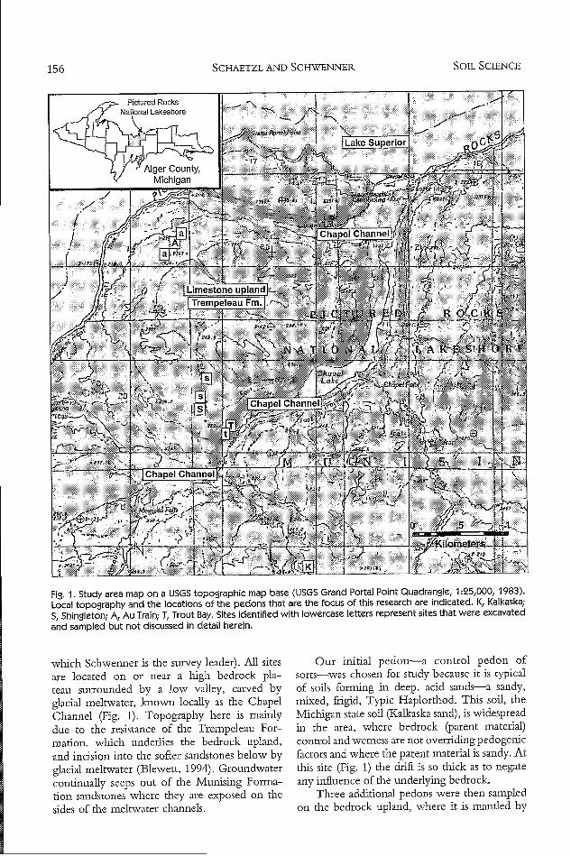
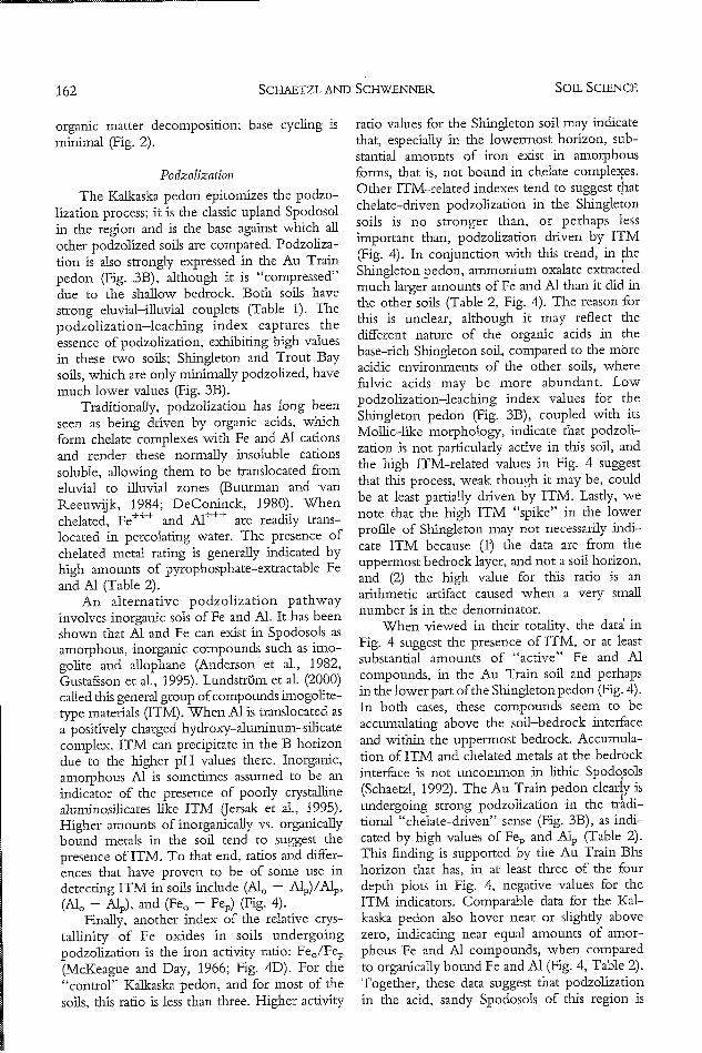
Fig. 1. Study area map on a USGS topographic map base (USGS Grand Portal Point Quadrangle, 1:25,000, 1983).
Local topography and the locations of the pedons that are the focus of this research are indicated. K, Kalkaska;
S, Shingleton; A, Au Train; T, Trout Bay. Sites identified with lowercase letters represent sites that were excavated
and sampled but not discussed in detail herein.
which Schwenner is the survey leader). All sitesare located on or near a high bedrock pla-teau surrounded by a low valley, carved byglacial meltwater, known locally as the ChapelChannel (Fig. 1). Topography here is mainlydue to the resistance of the Trempeleau For-mation, which underlies the bedrock upland,and incision into the softer sandstones below byglacial meltwater (Blewett, 1994). Groundwatercontinually seeps out of the Munising Forma-tion sandstones where they are exposed on thesides of the meltwater channels.
Our initial pedon-a control pedon ofsorts-was chosen for study because it is typicalof soils forming in deep, acid sands--a sandy,mixed, frigid, Typic Haplorthod. This soil, theMichigan state soil (Kalkaska sand), is widespread
in the area, where bedrock (parent material)control and wetness are not overriding pedogenicfactors and where the parent material is sandy. At
this site (Fig. 1) the drift is so thick as to negateany influence of the underlying bedrock.
Three additional pedons were then sampledon the bedrock upland, where it is mantled by
SOIL SCIENCE156
AN APPLICATION OF THE ENERGY MODEL IN MICHIGAN
thin (generally <3 m thick) drift over the sandydolomite of the Trempeleau Formation (Fig. 1).These pedons are were sampled within a mapunit of Shingleton sand, 0-2% slopes: sandy,mixed, frigid Lithic Haplorthods. Shingletonsoils do not display the typical A-E-Bs-CSpodosol horizonation; instead they have thick,dark A horizons. Some pedons within Shingle-ton map units have been sampled by NRCSpersonnel and classify as Hapludolls. Most alsolack an E horizon, perhaps due to intense earth-worm bioturbation. High pH values (6.0-7.5)within the sola attest to the presence of shallow,calcareous bedrock of the Trempeleau Forma-tion. These pedons were sampled because theyprovide a test of how the o factor of the energymodel might impact pedogenesis, particularlyregarding base status of the parent material andbase cycling.
Five additional pedons were sampled on andnear the flanks of the Chapel Channel, which isshallow to sandstone. Three pedons are on thefar northern edge of the study area, in a channelcut by meltwater into the acid Miner's Castlesandstone (Fig. 1). on the flat "tread- portion ofa strath terrace within the Chapel Channel.They are mapped in the moderately well-drained Au Train series (sandy, mixed, frigid,shallow Oxyaquic Haplorthods). Within thecontext of this study, Au Train soils are viewedas having taken an alternative pedogenic path-
way from that of Shingleton soils. Both seriesare strongly influenced by the nature of thebedrock below the thin drift cover. For both,the state factors are similar except for parentmaterial- Au Train soils have formed above acidsandstone bedrock whereas the Shingletonpedons overlie calcareous bedrock. From theperspective of the energy model, therefore, the ofactors (as regards base cycling characteristics) forthese two series are almost antipodal.
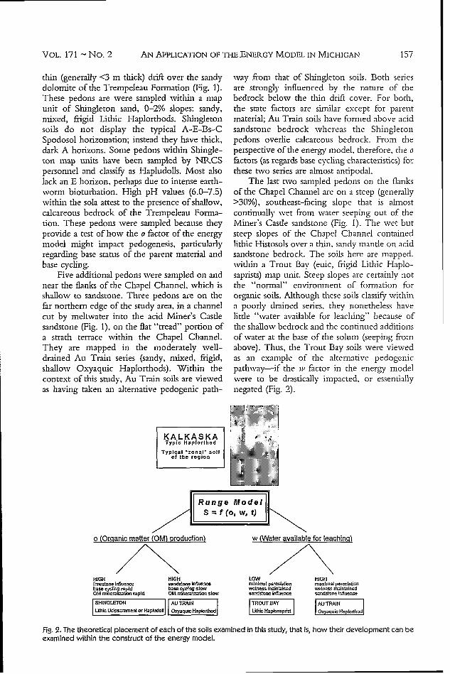
The last two sampled pedons on the flanksof the Chapel Channel are on a steep (generally>30%), southeast-facing slope that is almostcontinually wet from water seeping out of theMiner's Castle sandstone (Fig. 1). The wet butsteep slopes of the Chapel Channel containedlithic Histosols over a thin, sandy mantle on acidsandstone bedrock. The soils here are mapped.within a Trout Bay (euic, frigid Lithic Haplo-saprists) map unit. Steep slopes are certainly notthe "normal" environment of formation fororganic soils. Although these soils classify withina poorly drained series, they nonetheless havelittle "water available for leaching" because ofthe shallow bedrock and the continued additionsof water at the base of the solum (seeping fromabove). Thus, the Trout Bay soils were viewedas an example of the alternative pedogenicpathway-if the it, factor in the energy modelwere to be drastically impacted, or essentiallynegated (Fig. 2).
KALKASKA • 'Typic Haplorthod
Typical 'zonal* soilof the region
MOM4
o (Oranic matter (OM) production)
HIGH HIGHlyneslono influenco sanclstone -nlae'cebase cytrig rapid base cycI g slowOIA ndnaerakz=aimnapid Ol sI.e Z" msslo
SHINGLETON I AU TRAINLithIctdipsammentor Hooval OxyquicHapIcdW
w (Water available for leaching)
LOW HIGHminimal perolaion maximal percolationwetness ndained wetness maintainedsandstone Influence sae.dstofe Influence
TROUT SAY AU TRAINLbhic 1-1p!•osapfist IOxyaquIc Haplorthodl
Fig. 2. The theoretical placement of each of the soils examined in this study, that is, how their development can beexamined within the construct of the energy model.
VOL. 171 - No. 2 157

SCHAETZL AND SCHWENNERS
Field and Laboratory iVMethods
At each site, a pit was opened by hand, tobedrock or the C horizon, whichever wasdeeper, and the soil profile described accordingto standard procedures (Soil Survey DivisionStaff, 1993). Samples of about 1 kg were takenfrom the profile face, for each genetic horizon,and air-dried. Where possible, we also sampledthe bedrock. Coarse fragments (>2-mm diame-ter) were removed by sieving and discarded. SoilpH (2:1 soil/water on mineral samples, 8:1 onorganic samples) was measured with a model#IQ150 handheld pH meter (Dual pH Tech-nology, IQ Scientific Instruments); we reportonly the mean of two replicate pH analyses.Particle size analysis was performed by pipette(Soil Survey Laboratory Staff, 1996). Organicmatter content was determined by loss onignition (8 h at 430 'C) (Davies, 1974). Ele-mental composition of the fine earth fraction wasdetermined by X-ray fluorescence. Samples werefirst ground to silt size. Three grams of this finely
ground powder was then diluted by adding 9.0 gof lithium tetraborate (Li21B40 7) and 0.5 g ofammonium nitrate (NH4NO3) as an oxidizer.This mixture was then melted in a platinum cru-cible at 1000 'C of oxidizing flame for >20 minwhile being stilted on an orbital mixing stage.The melt was poured into platinum molds tomake glass disks, which were analyzed with anX-ray fluorescence spectrometer. XtRF majorelement (Si, Ti, Al, Fe, Mn, Mg, Ca, Na, K, P,Rb, Sr, and Zr) analyses were reduced by afundamental parameter data reduction method,whereas XRF trace element data were calcu-lated using standard linear regression techniques.
Using the elemental data as surrogates for
mineralogy, a soil weathering index was devel-oped based on the assumption that, with timeand increased weathering, elements derivedfrom resistant, immobile minerals such as zircon(Zr) and anatase, i-utile, and tourmaline (Ti)increase in abundance, relative to elementsderived mainly from weatherable minerals,which are assumed to be pedogenically mobile(Rube, 1956; Santos et al., 1986). The weath-ering index was calculated by
Weathering Index = [(Ti + Zr)/(Ca +- Mg +K+-Mn -Na+P)] x 100 (4)
In addition, an index designed to reflect thedegree to which soils have been podzolizedand/or leached was calculated as
Podzolization/Leaching index =
[(Si + Ti + Zr)/(Al + Fe)] X 100 (5)
Both of these indices are new to this studyand have not been used in previous research.
Podzolization is expressed chemically asgrain coatings in the B horizon, and lack ofthem in the E horizon. Therefore, we wanted toknow the amounts of the various types of Fe andAl compounds that exist as grain coatings(McKeague, 1967; McKeague and Day, 1966;Parfitt and Childs, 1988). All mineral horizonsamples were subjected to three extractants:sodium citrate-dithionite (CD), acidified ammo-nium-oxalate (AAO), and sodium pyrophos-phate (PP) (Ross and Wang, 1993). CDprimarily extracts "free" Fe and Al, denoted byFed and Aid, from pedogenic oxide minerals(Jackson et al., 1986). AAO extracts "active" Feand Al (Fe0 and Alo) from noncrystallinehydrous oxides. "Active" refers to oxides thatare small in size and have a high surface area anddegree of reactivity. PP extracts Fe and Al (Fepand Alp) from organically bound complexes and,to a lesser degree, noncrystalline hydrous oxides.The supernatants were analyzed for Fe and Alon a Thermo Jarrell Ash 61E inductivelycoupled plasma spectrometer (U.S. Environ-mental Protection Agency, 1986).
RESULTS AND DISCUSSION
The Kalkaska "control" pedon typifies thewell-developed, upland Spodosols of the GreatLakes region (Franzmeier and 'Whiteside, 1963;Schaetzl 2002), having formed in deep, coarse-textured, freely draining parent materials. TheKalkaska pedon exhibits typical O-A-E-Bhs-Bs-Bsm-BC-C horizonation and "sets the stand-ard" for podzolization-leaching values for thissuite of soils (Table 1, Fig. 3B). The energymodel's utility comes to the fore when oneattempts to explain the formation of the threeother pedons, all of which are within 4 km of theKalkaska soil but which differ markedly inmorphology and pedo-chemistry.
Water Available for Leadhing
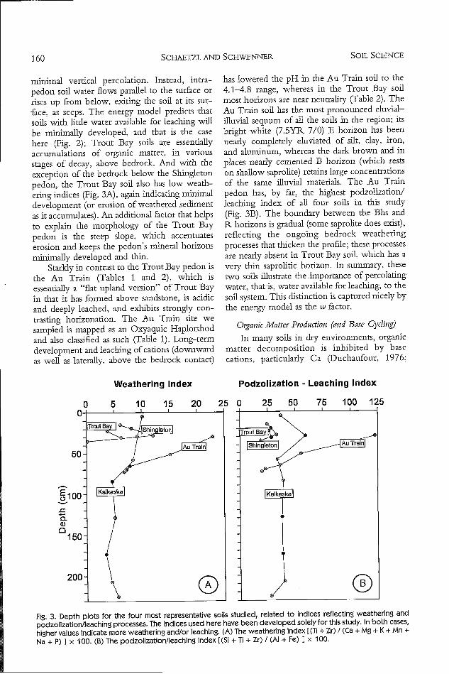
At the Trout Bay site, our sampled pedonclassified within that series, as a Lithic Haplo-saprist. This soil illustrates how horizonation isimpeded when percolation is restricted orminimized (Tables 1 and 2). From a theoreticalperspective, Trout Bay soils, which have formedon the steep side slopes of the Chapel Channel(Fig. 1), are nearly constantly wet but have
SOIL SCIENCE158
VAN APPLICATION OF THE ENERGY MODEL IN MICHIGAN
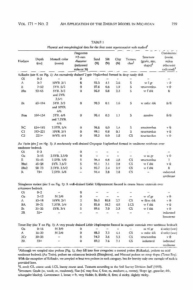
TABLE IPhysical and morphological data for the four most representative soils studied"
Fragments ConsistenceHo-Depth Munsell color 2-m Sand Silt Clay Texture Structure (ioist,
Depth diameter (grade, size, unless(cm) (moist) (estimated CA) C/) (A) class* shape)1 otherwise
volume %) inidicated)§
Kalkaska (site K on Fig. 1): An excessively drained Typic Haplorthod formed in deep sandy driftOi 0-3 - 0 . . . ...
A 3-7 10YR 3/1E 7-52 5YR 5/2Bhs 52-65 5YR 3/2
and 5YR2.3/1
Bs 65-104 5YR 3/3and 10YR
4/6Bsm 104-154 5YR 4/6
and 7.3YR4/6
BC 154-193 7.5YR 5/4Cl 193-221 10YR 5/4C2 221+ loYR 4/4
Au Train (site J on Fig.sandstone bedrock
Oi 0-3Oa 3-15E 15-45Bhsl 45-58Bhs2 58-73R 73+
000
93.3 4.197.6 0.696.9 0.8
2.61.92.3
98.3 0.1 1.6
SSS
w fgr
structurelessw f sbk
"v fr"vfr
ft.
w m&c sbk fr/fi
0 98.4 0.5 1.1 S massive
000
98.6 0.099.1 0.898.2 0.0
1.4
0.1
1.8
SS
CS
structurelessstructureless
structureless
fi/fr
vfr"vfr"v fr
1): A moderately well-drained Oxyaquic Haplorthod formed in sandstone residuum over
2.SYR 2.5/07.5YR 7/05YR 2.5/2
2.5YR 2.5/27.SYR 5/8
00555
- - - wm gr
96.4 0.8 2.8 CS structureless
95.1 2.1 2.8 CS w fsbk93.7 2.4 3.9 CS w f sbk94.4 2.8 2.8 CS -
vfr
f
frinduratedsandstone
Shingleton variant (site S on Fig. 1): A well-drained Lithic Udipsamment formed in coarse-loamy materials over
calcareous bedrock
Oi 0-2 - 0 . . . ...
Oa 2-12 N 2/0 0 - -. w vf gr v frA 12-18 lOYR 2/1 2 86.5 10.8 2.7 CS w f&-m sbk v fr
BA 18-21 7.5YR 3/4 5 85.8 10.2 4.0 LCS w fsbk v fr
Bs 21-35 5YR 3/4 5 89.6 7.0 3.3 CS w fsbk v fr
2R 35+ - - - - induratedlimestone
Trout Bay (site T on Fig. 1): A very poorly drained Lithic Haplosaprist formed in organic materials over sandstone bedrockOa 0-16 N 2/0 0 - - - - m vfgr sl stcky (wet)
A 16-30 N 2/0 0 88.3 7.3 4.4 CS w m&c sbk sl stcky (wet)
2Cr 30-33 - 0 94.2 2.6 3.3 CS structureless v fr
2R 33+ - 0 89.2 7.6 3.1 CS indurated induratedsandstone
'Although we sampled nine pedons (Fig. 1), they fall into four categories: a control pedon (Kalkaska), pedons on acidsandstone bedrock (Au Train), pedons on calcareous bedrock (Shingleton), and Histosol pedons on steep slopes (Trout Bay).With the exception of Kalkaska, we sampled at least two pedons in each category, but for brevity only one example of each isprovided here.*S, sand; CS, coarse sand; LCS, loamy coarse sand. Textures according to the Soil Survey Division Staff (1993).6Structure: Grade (w, weak; m, moderate); Size (vf, very fine; f, fine; m, medium; c, coarse); Shape (gr, granular; sbk,subangular blocky). Consistence: 1, loose; v fr, very friable; fr, friable; 6, firm; sl sticky, slightly sticky.
VOL. 171 - No. 2 159
SCHAETZL AND SCHWENNERS
minimal vertical percolation. Instead, intra-pedon soil water flows parallel to the surface orrises up from below, exiting the soil at its sur-face, as seeps. The energy model predicts thatsoils with little water available for leaching willbe minimally developed, and that is the casehere (Fig. 2); Trout Bay soils are essentiallyaccumulations of organic matter, in variousstages of decay, above bedrock. And with theexception of the bedrock below the Shingletonpedon, the Trout Bay soil also has low weath-ering indices (Fig. 3A), again indicating minimaldevelopment (or erosion of weathered sedimentas it accumulates). An additional factor that helpsto explain the morphology of the Trout Baypedon is the steep slope, which accentuateserosion and keeps the pedon's mineral horizonsminimally developed and thin.
Starkly in contrast to the Trout Bay pedon isthe Au Train (Tables 1 and 2), which isessentially a "flat upland version" of Trout Bayin that it has formed above sandstone, is acidicand deeply leached, and exhibits strongly con-trasting horizonation. The Au Train site wesampled is mapped as an Oxyaquic Haplorthodand also classified as such (Table 1). Long-termdevelopment and leaching of cations (downwardas well as laterally, above the bedrock contact)
has lowered the pH in the Au Train soil to the4.1-4.8 range, whereas in the Trout Bay soil
most horizons are near neutrality (Table 2). The
Au Train soil has the most pronounced eluvial-
illuvial sequum of all the soils in the region; itsbright white (7.5YR 7/0) E horizon has been
nearly completely eluviated of silt, clay, iron,and aluminum, whereas the dark brown and in
places nearly cemented B horizon (which restson shallow saprolite) retains large concentrationsof the same illuvial materials. The Au Trainpedon has, by far, the highest podzolization/leaching index of all four soils in this study
(Fig. 3B). The boundary between the IBhs andR horizons is gradual (some saprolite does exist),
reflecting the ongoing bedrock weatheringprocesses that thicken the profile; these processesare nearly absent in Trout Bay soil, which has a
very thin saprolitic horizon. In summary, these
two soils illustrate the importance of percolatingwater, that is, water available for leaching, to the
soil system. This distinction is captured nicely bythe energy model as the tv factor.
Organic Matter Production (aand Base Cycling)
In many soils in dry environments, organic
matter decomposition is inhibited by basecations, particularly Ca (Duchaufour, 1976;
Weathering Index Podzolization - Leaching Index
Fig. 3. Depth plots for the four most representative soils studied, related to indices reflecting weathering and
podzolization/leaching processes. The indices used here have been developed solely for this study. In both cases,
higher values indicate more weathering and/or leaching. (A) The weathering index [(Ti + Zr) / (Ca + Mg + K + Mn +
Na + P) I x 100. (B) The podzolization/leaching index [(Si + Ti + Zr) / (Al + Fe) ] x 100.
SOIL. SCIENCE160
AN APPLICATION OF THE ENERGY MODEL IN MICHIGAN
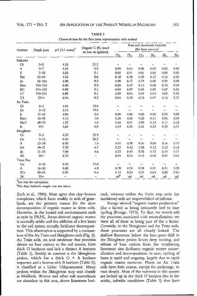
TABLE 2
Chemical data for the four most representative soils studied
Iron and aluninum contents
Horizon Depth (cm) pH (1:1 water)t Organic C (%, based (% from extracts'.
on loss on ignition)Fe, Feo Fed Alp A.o Aid
Kalkaska
O i 0 - 3 4 .3 5 2 1.2 - . . . ..
A 3-7 4.34 5.5 0.03 0.M4 0.06 0.02 0.02 0.02
E 7-52 5.03 0.1 0.01 0.0 1 0.01 0.00 0.00 0.00
Bhs 52-65 4.55 0.6 0.18 0.28 11.29 0.12 0.12 0.09
Bs 65-104 4.98 0.3 0.08 0.17 0.19 0.08 0.09 0.09
Bsm 104-154 6.00 0.2 0.05 0.110 0.13 0.08 0.10 0.09BC 154-193 6.89 0.1 0.04 0.07 (O.06 0.05 0.07 (1.06
CI 193-221 6.80 0.1 0.03 0.04 0.04 0.014 0.04 0.05C2 221+ 6.94 0.2 0.04 0.18 (1.25 0.07 0.15 0.13
Au Train
O i 0 - 3 4 .6 6 3 2 .0 - . . ...
O a 3 - 15 3 .7 4 19 .6 - . . . ..
E 15-45 4.80 0.1 1om0.00 1.00 0.00 0.110 0,00 0.00
Bhsl 45-58 4.15 1.0 01.26 (1.201 01.25 0.11 0.06 0.09Bhs2 58-73 4.27 D.) W41 03.51 1.50 0.12 11.11 0.12
R 73+ 4.67 (1.8 0.13 o1.22 0.31 10.24 0.33 1.)31
Shingleton
O i 0 -2 6 .2 3 2 7 .9 - . . . ..
Oa 2-12 6.03 26.2 . . . . . .A 12-18 6.95 1.6 o.07 11.38 0.34 0.06 0.14 0.12
BA 18-21 7.29 0.7 (0.23 0.42 01.58 0.13 01.12 0.12Bs 21-35 7.09 0.6 0.22 0.45 0.35 t). 12 0.16 0.11
2R 35+ 8.75 - 0.01 0.24 o(.15 0.00 0.01 0.01
Trout BayOa (1-16 6.701 15.8 - - - - - -
A 16-30 6.85 4.8 0.28 0.35 0.36 0.21 0.24 0.20
2Cr 30-33 6.9t) 11.4 ((.17 0.24 0.37 0.014 0.05 0.04
2R 33+ - - nd 2 nd nd nd nd nd
+See text for exceptions.
'No data; bedrock sample was not taken.
Zech et al., 19901). Most agree that clay-humuscomplexes, which form readily in soils of grass-lands, are the primary reason for the slowdecomposition of organic matter in these soils.However, in the humid soil environments suchas exist in PRNL, forest-derived organic matteris normally acidic and the addition of a few basesto the soil system actually facilitates decomposi-tion. This observation is supported by a compar-ison of the Au Train and Shingleton soils (Fig. 2).Au Train soils, on acid sandstone that providesalmost no base cations to the soil system, havethick 0 horizons and lack a distinct A horizon(Table 1). Starkly in contrast is the Shingletonpedon, which has a thick 0 + A horizonsequence and a humus-rich B horizon (Table 2);it classified as a Lithic Udipsamment. Manypedons within the Shingleton map unit classifyas Mollisols. Worms and other soil macrofaunaare abundant in this area, above limestone bed-
rock, whereas within Au Train map units (onsandstone) soils are impoverished of infauna.
Runge viewed "organic matter production"(the o factor) as being intimately tied to basecycling (Runge, 1973). To that, we would addthe processes associated with mineralization; weview all of these as being part of the o factor.Certainly, in the Shingleton and Au Train soils,these processes are all closely linked. Theshallow limestone below the base-poor drift inthe Shingleton pedon favors deep rooting, andrelease of base cations from the weatheringlimestone also facilitates organic matter miner-alization and decomposition; in sum, cycling ofbases is rapid and ongoing, largely due to rapidorganic matter turnover. Plants on Au Trainsoils have little reason, except for anchorage, toroot deeply. Most of the nutrients in this systemare locked up in the thick 0 horizon due to theacidic, infertile conditions (Table 2) that limit
VOL. 171 - No. 2 161
SCHAETZL AND SCHWENNERS
organic matter decomposition: base cycling isminimal (Fig. 2).
Podzolization
The Kalkaska pedon epitomizes the podzo-lization process; it is the classic upland Spodosolin the region and is the base against which all
other podzolized soils are compared. Podzoliza-tion is also strongly expressed in the Au Trainpedon (Fig. 313), although it is "compressed"due to the shallow bedrock. Both soils havestrong eluvial-illuvial couplets (Table 1). Thepodzolization-leaching index captures theessence of podzolization, exhibiting high valuesin these two soils; Shingleton and Trout Baysoils, which are only minimally podzolized, havemuch lower values (Fig. 313).
Traditionally, podzolizadon has long beenseen as being driven by organic acids, whichform chelate complexes with Fe and Al cationsand render these normally insoluble cationssoluble, allowing them to be translocated fromeluvial to illuvial zones (Buurman and vanReeuwijk, 1984; DeConinck, 1980). Whenchelated, Fe++ and Al+++ are readily trans-located in percolating water. The presence ofchelated metal rating is generally indicated byhigh amounts of pyrophosphate-extractable Feand Al (Table 2).
An alternative podzolization pathwayinvolves inorganic sols of Fe and Al. It has beenshown that Al and Fe can exist in Spodosols asamorphous, inorganic compounds such as imo-golite and allophane (Anderson et al., 1982,Gustafsson et al., 1995). Lundstr6m et al. (2000)called this general group of compounds imogolite-type materials (ITM). When Al is translocated asa positively charged hydroxy-aluminum-silicatecomplex, ITM can precipitate in the B horizondue to the higher pH values there. Inorganic,amorphous Al is sometimes assumed to be anindicator of the presence of poorly crystallinealuminosilicates like ITM (Jersak et al., 1995).Higher amounts of inorganically vs. organicallybound metals in the soil tend to suggest thepresence of ITM. To that end, ratios and differ-ences that have proven to be of some use indetecting ITM in soils include (Al, - Alp)/Alp,(Al. - Alp), and (Fe, - Fep) (Fig. 4).
Finally, another index of the relative crys-tallinity of Fe oxides in soils undergoingpodzolization is the iron activity ratio: Feo/Fep(McKeague and Day, 1966; Fig. 4D). For the"control" Kalkaska pedon, and for most of the
soils, this ratio is less than three. Higher activity
ratio values for the Shingleton soil may indicatethat, especially in the lowermost horizon, sub-stantial amounts of iron exist in amorphousforms, that is, not bound in chelate complexes.Other ITM-related indexes tend to suggest that
chelate-driven podzolization in the Shingletonsoils is no stronger than, or perhaps lessimportant than, podzohzation driven by ITM(Fig. 4). In conjunction with this trend, in theShingleton pedon, ammonium oxalate extractedmuch larger amounts of Fe and Al than it did inthe other soils (Table 2, Fig. 4). The reason forthis is unclear, although it may reflect thedifferent nature of the organic acids in thebase-rich Shingleton soil, compared to the moreacidic environments of the other soils, wherefulvic acids may be more abundant. Lowpodzolization-leaching index values for theShingleton pedon (Fig. 313), coupled with itsMollic-like morphology, indicate that podzoli-zation is not particularly active in this soil, andthe high ITM-related values in Fig. 4 suggestthat this process, weak though it may be, couldbe at least partially driven by ITM. Lastly, wenote that the high ITM "spike" in the lowerprofile of Shingleton may not necessarily indi-cate ITM because (1) the data are from theuppermost bedrock layer, and not a soil horizon,and (2) the high value for this ratio is anarithmetic artifact caused when a very smallnumber is in the denominator.
When viewed in their totality, the dad inFig. 4 suggest the presence of ITM, or at leastsubstantial amounts of "active" Fe and Alcompounds, in the Au Train soil and perhapsin the lower part of the Shingleton pedon (Fig. 4).In both cases, these compounds seem to beaccumulating above the soil-bedrock interfaceand within the uppermost bedrock. Accumula-tion of ITM and chelated metals at the bedrockinterface is not uncommon in lithic Spodosols(Schaetzl, 1992). The Au Train pedon cleariy isundergoing strong podzohzation in the tradi-tional "chelate-driven" sense (Fig. 313), as indi-cated by high values of Fep and Alp (Table 2).This finding is supported by the Au Train Bhshorizon that has, in at least three of the fourdepth plots in Fig. 4, negative -values for theITM indicators. Comparable data for the Kal-kaska pedon also hover near or slightly abovezero, indicating near equal amounts of amor-phous Fe and Al compounds, when comparedto organically bound Fe and Al (Fig. 4, Table 2).Together, these data suggest that podzo1izationin the acid, sandy Spodosols of this region is
SOIL SCIENCE162

AN APPLICATION OF THE ENERGY MODEL IN MICHIGAN
(Alo -Alp) I Alp
50
F100A•I0
150
200
Alo - Alp-0.02 0.02 0.06
Fig. 4. Depth plots, each intended to indicate the likelihood of "active" podzolization-linked materials, and/or ITM(imogolite-type materials), in the four soils studied. Higher values indicate a greater likelihood of ITM or Fe and Alcompounds associated with "active" podzolization. Symbols: Al. and Feo, ammonium oxalate-extractable Al andFe, respectively; Alp and Fep, sodium pyrophosphate-extractable Al and Fe, respectively.
governed primarily by organic chelate com-plexes rather than by ITM (Buurman and vanReeuwijk, 1984), but that weaker podzolizationin base-rich and organic-rich soils may involve ameasurable component of ITM.
1'1eathering
Using elemental composition as surrogatesfor mineral weathering, our data suggest thatweathering is most intense in soils that haveminimal organic matter production (biocycling)and maximal water available for leaching, assuggested by the energy model (Fig. 3A). TheAu Train soil, with abundant percolation and
minimal amounts of organic matter mineraliza-tion, has by far the highest weathering indices(Fig. 3A). Conversely, Trout Bay and Shingle-ton soils are much less weathered due to a com-bination of less water available for leaching andmore biocycling, both of which lead to higherpH values in the sola of these soils (Table 2,Fig. 3A).
SUMMARY AND CONCLUSIONS
Runge's energy model (Runge, 1973) isconsidered to be one of the major conceptual-theoretical models in pedology (Johnson and
VOL. 171 - No. 2 163
SCHAETZL AND SCHWENNERS
Watson-Stegner, 1987; Smeck et al., 1983). Andyet, it has found limited direct application in soilgeomorphology or soil genesis research and israrely used in mapping. In our study, wehighlight the utility of the energy model byusing it to help explain the differences in soilsthat have developed in close proximity, butwhich display widely different morphologiesand pedo-chemistry. In each case, the varyingpathways of pedogenesis that these soils havetaken can be primarily traced back to wateravailable for leaching or organic matter produc-tion, both of which are fundamental precepts ofthe energy model. (Erosion also plays a role inthe genesis of these soils, especially the Trout
Bay soil.) The model may be more relevant andapplicable in a wider context if the o factorincluded more dearly the processes of biocy-cling and organic matter mineralization.
ACKNOWLEDGMENTS
The authors thank the National Park Serv-ice and personnel at PRNL (especially LoraLoope and Bill Commins) for their support ofthis project. Walt Loope and Joe Hupy assistedwith the fieldwork, and much of the lab workwas done by Heather Aschoff. Parts of the thisproject were supported by a grant made to RS
by the NSF-Geography and Regional ScienceDivision.
REFERENCES
Albert, D.A. 1995. Regional landscape ecosystems ofMichigan, Minnesota, and Wiscomin; A workingmap and classification. USDA For. Serv. GenTech. Rept. NC-178. 250 pp.
Anderson, M. G., and T. P. Burt. 1978. The role oftopography in controlling through flow genera-tion. Earth Surf. Processes. 3:331-334.
Anderson, H. A., M. L. Berrow, V. C. Farmer, A.Hepburn, J. D. Russell, and A. D. Walker. 1982.A reassessment of podzol formation processes.J. Soil Sci. 33:125-136.
Barrett, L. R. 1999. Particulars in context: Maintain-ing a balance in soil geography. Ann. Assoc. Am.Geogr. 89:707-713.
Barrett, L. R. 2001. A strand plain soil developmentsequence in Northern Michigan, USA. Catena.44:163-186.
Blewett, W. L. 1994. Late Wisconsin history ofPictured Rocks National Lakeshore and vicin-ity. Pictured Rocks Resource Report. 94-01,p. 8.
Brye, K. R. 2004. Pedogenic interpretation of a loess-covered, Pleistocene-glaciated toposequence usingthe energy model. Soil Sci. 169:282-294.
Buurman, P., and L. P. van Reeuwijk. 1984. Proto-imogolite and the process of podzol formation: Acritical note. J. Soil Sci. 35:447-452.
Clayton, L., and S. R. Moran. 1982. Chronology ofLate Wisconsinan glaciation of middle NorthAmerica. Quat. Sci. Rev. 1:55-82.
Cremeens, D. L., and D. L. Mokma. 1986. Argillichorizon expression and classification in the soils oftwo Michigan hydrosequences. Soil Sci. Soc. Am.J. 50:1002-1007.
Davies, B. E. 1974. Loss-on-ignition as an estimate ofsoil organic matter. Soil Sci. Soc. Am. Proc.38:150-151.
DeConinck, F. 1980. Major mechanisms in formationof spodic horizons. Geoderma. 24:101-128.
Dijkerman, J. C. 1974. Pedology as a science: Therole of data, models and theories in the study ofnatural soil systems. Geoderma. 11:73-93.
Donald, R. G., D. W. Anderson, and J. W. B.Stewart. 1993. The distribution of selected soilproperties in relation to landscape morphology inforested Gray Luvisol soils. Can. J. Soil Sci.73:165-172.
Dorr, J. A.Jr., and D. F. Eschman. 1970. Geology ofMichigan. University of Michigan Press, AnnArbor, pp. 476.
Duchaufour, P. 1976. Dynamics of organic matter insoils of temperate regions: It's action on pedo-genesis. Geoderma. 15:31-40.
Franzmeier, D. P., and E. P. Whiteside. 1963. Achronosequence of podzols in Northern Michi-gan: II. Physical and chemical properties. Mich.State Univ. Agr. Exp. St. Quart. Bull. 46:21-36.
Gustafsson, J. P., P. Bhattacharya, D. C. Bain, A. R.Fraser, and W. J. McHardy. 1995. Podzolisationmechanisms and the synthesis of imogolite inNorthern Scandinavia. Geoderma. 66:167-184.
Haddox, C. A., and R. H. Dott. 1990. Cambrianshoreline deposits in Northern Michigan. J. Sedi-ment. Petrol. 60:697-716.
Hamblin, W. K. 1958. The Cambrian sandstones ofNorthern Michigan. PhD dissertation, State ofMichigan, Department of Conservation, Geo-logical Survey Division Publ. 51, pp. 146.
Hamblin, W. K. 1961. Paleogeographic evolution ofthe Lake Superior region from Late Keweenawanto Late Cambrian time. Geol. Soc. Amer. Bull.72:1-18.
Honeycutt, C. W., R. D. Heil, and C. V. Cole.1990. Climatic and topographic relations of threeGreat Plains soils: I. Soil morphology. Soil Sci.Soc. Am. J. 54:469-475.
Hoosbeek, M. RK, and R. B. Bryant. 1992. Towardsthe quantitative modeling of pedogenesis-A review. Geoderma. 55:183-210.
Huggett, R.J. 1975. Soil landscape systems: A modelof soil genesis. Geoderma. 13:1-22.
Jackson, M. L., C. H. Lim, and L. W. Zelazny. 1986.Oxides, hydroxides, and aluminosilicates. Inz:Methods of soil analysis: Part 1. Physical and
SOIL SCIENCE164
AN APPLICATION OF THE ENERGY MODEL IN MICHIGAN
mineralogical methods. A. KMute (ed.). SSSA BookSeries No. 9(1). SSSA and ASA, Madison, WI, pp.101-150.
Jenny, H. 1941. Factors of soil formation. McGraw-Hill, New York, p. 281.
Jersak, J., R. Amundson, and G. Brimhall Jr. 1995. Amass balance analysis of podzolization: Examplesfrom the Northeastern United States. Geoderma.66:15-42.
Johnson, D. L. 2000. Soils and soil-geomorphologytheories and models: The Macquarie connection.Ann. Assoc. Am. Geogr. 90:775-782.
Johnson, D. L., and D. Watson-Stegner. 1987. Evolu-tion model ofpedogenesis. Soil Sci. 143:349-366.
Lowell, T. V., G. J. Larson, J. D. Hughes, and G. H.Denton. 1999. Age verification of the LakeGribben forest bed and the Younger DryasAdvance of the Laurentide Ice Sheet. Can. J.Earth Sci. 36:383-393.
Lundstr6m, U. S., N. van Breemen, D. C. Bain, P. A.W. van Hees, R. Giesler, J. P. Gustafsson, H.Ilvesniemi, E. Karltun, P.-A. Melkerud, M.Olsson, G. Riise, 0. Wahlberg, A. Bergelin, K.Bishop, R. Finlay, A. G.Jongmans. T. Magnusson,H. Mannerkoski, A. Nordgren, L. Nyberg, M.Starr, and L. T. Strand. 2000. Advances in under-standing the podzohization process resulting froma multidisciplinary study of three coniferousforest soils in the Nordic Countries. Geoderma.94:335-353.
Manning, G., L. G. Fuller, R. G. Eilers, and I.Florinsky. 2001. Topographic influence on thevariability of soil properties within an undulatingManitoba landscape. Can. J. Soil Sci. 81:439-447.
McKeague, J. A. 1967. An evaluation of 0.1 Mpyrophosphate and pyrophosphate-dithionite incomparison with oxalate as extractants of theaccumulation products in podzols and some othersoils. Can. J. Soil Sci. 47:95-99.
McKeague, J. A., and J. H. Day. 1966. Dithionite-and oxalate-extractable Fe and Al as aids indifferentiating various classes of soils. Can. J. SoilSci. 46:13-22.
Messenger, A. S., E. P. Whiteside, and A. R. Wolcott.1972. Climate, time, and organisms in relation toPodzol development in Michigan sands: I. Sitedescriptions and microbiological observations. SoilSci. Soc. Am, Proc. 36:633-638.
Miller, J. J., D. F. Acton, and R.J. St. Amaud. 1985.The effect of groundwater on soil formation in amorainal landscape in Saskatchewan. Can. J. SoilSci. 65:293-307.
Parfitt, R. L., and C. W. Childs. 1988. Estimation offorms of Fe and Al: A review, and analysis ofcontrasting soils by dissolution and Moessbauermethods. Aust. J. Soil Res. 26:121-144.
Pennock, D. J., B. J. Zebarth, and E. DeJong. 1987.Landform classification and soil distribution inhummocky terrain, Saskatchewan, Canada. Geo-derma. 40:297-315.
165
Phillips, J. D. 1989. An evaluation of the state factormodel of soil ecosystems. Ecol. Model. 45:165-177.
Reed, R. C., and J. D. Daniels. 1987. Bedrockgeology of Northern Michigan. State of Michigan,Department of Natural Resources, GeologicalSurvey Division Map. 1:500,000.
Rockwell, T., and C. Loughman. 1990. Late Quater-nary rate of slip along the San Jacinto fault zonenear Anza, Southern California. J. Geophys. Res.95:8593--8605.
Ross, G. J., and C. Wang. 1993. Extractable Al, Fe,Mn, and Si. In: Soil sampling and methods ofanalysis. M. R. Carter (ed.). Canadian Society ofSoil Science, Boca Raton, FL, pp. 239-246.
Rube, R. V. 1956. Geomorphic surfaces and thenature of soils. Soil Sci. 82:441-445
Runge, E. C. A. 1973. Soil development sequencesand energy models. Soil Sci. 115:183-193.
Santos, M. C. D., R. J. St. Arnaud, and D. W.Anderson. 1986. Quantitative evaluation of pedo-genic changes in Boralfs (Gray Luvisols) of EastCentral Saskatchewan, Soil Sci. Soc. Am. J.50:1013-1019.
Schaetzl, R. J. 1990. Effects of treethrow micro-topography on the characteristics and genesis ofSpodosols, Michigan, USA. Catena. 17:111-126.
Schaetzl, R. J. 1991. Factors affecting the for-mation of dark, thick epipedons beneath forestvegetation, Michigan, USA. J. Soil Sci. 42:501-512.
Schaetzl. R.J. 1992. Beta spodic horizons in podzolicsoils (Lithic Haplorthods and Haplohumods).Pedologie. 42:271-287.
Schaerzl, R. J. 2002. A Spodosol-Entiso transition innorthern Michigan: climate or vegetation? SoilSci. Soc. Am.J. 66:1272-1284.
Schaetzl, R. J., and S. A. Isard. 1996. Regional-scalerelationships between climate and strength ofpodzolization in the Great Lakes region, NorthAmerica. Catena. 28:47-69.
Schaetzl, R. J., and S. N. Anderson. 2005. Soils:Genesis and Geomorphology. Cambridge Univer-sity Press, Cambridge.
Scull, P, J. Franklin, 0. A. Chadwick, and D.McArthur. 2003. Predictive soil mapping: Areview. Prog. Phys. Geogr. 27:171-197.
Simonson, R. W. 1959. Outline of a generalizedtheory of soil genesis. Soil Sci. Soc. Am. Proc.23:152-156.
Simonson, R. W. 1978. A multiple-process modelof soil genesis. In: Quaternary soils. W. C.Mahaney (ed.). Geo Abstracts, Norwich, England.pp. 1-25.
Singleton, G. A., and L. M. Lavkulich. 1987. A soilchronosequence on beach sands, VancouverIsland, British Columbia. Can. J. Soil Sci. 67:795-810.
Smeck, N. E., E. C. A. Runge, and E. E.MacKintosh. 1983. Dynamics and genetic model-ling of soil systems. In: Pedogenesis and Soil
VOL. 171 - No. 2
166 SCHAETZL AND SCHWENNERP
Taxonomy. L. P. Wilding, et al. (eds.). Elsevier,New York, pp. 51-81.
Soil Survey Division Staff. 1993. Soil survey manual.USDA Handbook No. 18. US GovernmentPrinting Office, Washington, DC, pp. 437.
Stephens, C. G. 1947. Functional synthesis in pedo-
genesis. Trans. Royal Soc. S. Aust. 71:168-181.
U.S. Environmental Protection Agency. 1986.
Method 6010. Inductively coupled plasma atomic
emission spectrometry. Test methods for eval-uating solid waste: Volume IA, 3rd ed., PA/SW-
846. National Technical Information Service.Springfield, VA.
SOIL SCIENCE
Wilding, L. P. 1994. Factors of soil formation:
Contributions to pedology. bn: Factors of soilformation: A fiftieth anniversary retrospective. Soil
Sci. Soc. Am. Spec. Publ. 33:15-30.Yaalon, D. H. 1975. Conceptual models in pedo-
genesis. Can soil-forming functions be solved?Geoderma: 14:189-205.
Zech, W., R. Hempfling, L. Haumaier, H.-R.
Schulten, and K. Haider. 1990. Humification in
subalpine Rendzinas: Chemical analyses, IRand 13NMR spectroscopy and pyrolysis-field
ionization mass spectrometry. Geoderma. 47:123-138.
COPYRIGHT INFORMATION
TITLE: An application of the runge “energy model” of soildevelopment in Michigan’s upper peninsula
SOURCE: Soil Sci 171 no2 F 2006WN: 0603200619007
The magazine publisher is the copyright holder of this article and itis reproduced with permission. Further reproduction of this article inviolation of the copyright is prohibited. To contact the publisher:http://www.buymicro.com/rf/dih/williams_and_wilkins.htm
Copyright 1982-2006 The H.W. Wilson Company. All rights reserved.